Embed Size (px)
Citation preview
PRELIMINARY – SUBJECT TO CHANGEPRELIMINARY ADMINISTRATIVE DRAFT DECEMBER 2013 1 NORTH-OF-THE-DELTA OFFSTREAM STORAGE PROJECT EIR/EISSAC/395320/111990001 (16-GMSP_PRELIM_ADMIN_DRAFT_DEC2013.DOCX)
16. Geology, Minerals, Soils, and Paleontology
16.1 Introduction
This chapter describes the geologic, minerals, soils, and paleontologic setting for the Extended, Secondary,
and Primary study areas. Descriptions and maps of these three study areas are provided in Chapter 1
Introduction.
The regulatory setting for geology, minerals, soils, and paleontological resources are discussed briefly in
this chapter, and are presented in greater detail in Chapter 4 Environmental Compliance and Permit
Summary.
This chapter focuses primarily on the Primary Study Area. Potential impacts in the Secondary and
Extended study areas were evaluated and discussed qualitatively. Potential local and regional impacts
from constructing, operating, and maintaining the alternatives were described and compared to applicable
significance thresholds. Mitigation measures are provided for identified significant or potentially
significant impacts, where appropriate. Because none were identified for minerals, no mitigation is
included in this chapter for that resource.
16.2 Environmental Setting/Affected Environment
16.2.1 Extended Study Area
16.2.1.1 Geology
Of the 48 contiguous states, California contains the highest and the lowest elevations only 80 miles apart,
plus a variety of rocks, structures, and mineral resources equaled by few areas in the world (Norris and
Webb, 1990).
California’s landscapes are extremely varied, ranging from the broad nearly flat floor of the Great Valley
to the jagged glaciated Sierra Nevada. Eleven geomorphic provinces1 are recognized (Figure 16-1): the
Sierra Nevada, the Klamath Mountains, the Cascade Range, the Modoc Plateau, the Basin and Range, the
Mojave Desert, the Colorado Desert, the Peninsular Ranges, the Transverse Ranges, the Coast Ranges,
and the Great Valley.
California’s geologic diversity, in part, is attributed to its location astride two major tectonic plates: the
North American Plate and the Pacific Plate. The active San Andreas Fault, heading north out of the Gulf of
California, westward along the Transverse Ranges, then northwestward within and west of the Coast
Ranges up to Cape Mendocino, separates the North American Plate from the Pacific Plate. Active faulting
is an important feature of California’s structural pattern. The San Andreas Fault has been crucial in
California’s geologic history since at least the Miocene epoch (approximately 23 million years ago [MYA]).
The ground surface at the fault has moved as much as 350 miles. Other important faults are the Calaveras
and Hayward in the San Francisco Bay area, the Nacimiento in the southern Coast Ranges, the San Jacinto
of the Peninsular Ranges, the Sierra Nevada in eastern California, and the Garlock, which separates the
Mojave Desert from the Sierra Nevada and the Basin and Range.
1 The geomorphic provinces are topographic-geologic groupings based primarily on landforms and late Cenozoic structural anderosional history.
This document is not released as a draft EIR pursuant to CEQA Guidelines § 15087. As such, DWR is not soliciting and will not respond to commentssubmitted on this document, although any comments received will be retained and may be considered during preparation of a future draft EIR.
Chapter 16: Geology, Minerals, Soils, and Paleontology
PRELIMINARY – SUBJECT TO CHANGENORTH-OF-THE-DELTA OFFSTREAM STORAGE PROJECT EIR/EIS 2 PRELIMINARY ADMINISTRATIVE DRAFT DECEMBER 2013
SAC/395320/111990001 (16-GMSP_PRELIM_ADMIN_DRAFT_DEC2013.DOCX)
The oldest rocks found in California are metamorphic rocks as much as 1.8 billion years old, which occur
in the San Gabriel and San Bernardino mountains and in the Mojave and Basin and Range provinces.
During the Paleozoic era (approximately 600 MYA), most of California was below sea level and thick
sequences of marine sediments were deposited. These sediments ranged from near-shore limestone in the
east to deeper-water deposits composed of volcanic detritus2 from offshore islands mixed with oceanic
crustal materials. Marine conditions continued into the Mesozoic era (beginning approximately
260 MYA) but with active subduction3 as the Pacific Plate plunged under the North American Plate. The
sea withdrew to the west and mountains developed in eastern California accompanied by some granitic
intrusive activity. With some pauses or interruptions, subduction continued through the latter part of the
Mesozoic era when granitic intrusions were again voluminous and very widespread.
Granitic rocks from the Mesozoic era are by far the most abundant igneous rocks in California and are
exposed in most provinces. Sedimentation continued offshore in deep marine basins from material stripped
off the rising mountains to the east and from volcanic material derived from a chain of offshore volcanic
islands; these sediments later become known as the Franciscan Complex. Marine sedimentation decreased
in the Cenozoic era (beginning approximately 70 MYA), confined primarily in and west of the San Joaquin
Valley and in scattered locations in Southern California. Subduction slowed considerably later in the
Cenozoic era, but compressive forces continued, raising the Coast Ranges and eventually closing off the
Central Valley from the Pacific Ocean. Beginning in the Eocene epoch and continuing to the Pleistocene,
the Central Valley inland basin gradually filled in with continental deposits. During the Pleistocene epoch4
(approximately 2.6 MYA), extensive glaciation sculpted the Sierra Nevada and other mountain ranges, and
large inland lakes developed west of the Sierra Nevada.
16.2.1.2 Minerals
California’s geology has resulted in a wealth of mineral resources, including industrial, metallic, and
nonmetallic minerals. These minerals are important to the state’s economy. California ranks second in the U.S.
in non-fuel mineral production; in 2005, over 30 non-fuel mineral commodities – valued at $3.7 billion – were
produced from 820 California mines (CGS, No Date).California’s major mineral resources include sand,
gravel, crushed stone, building stone, gold, silver, iron, evaporite5 minerals, and clay.
Sand and gravel are California’s most valuable industrial minerals. Most sand and gravel is mined from
alluvial deposits, which include sediment from streams and alluvial fans. Other important industrial
minerals are crushed stone and limestone.
Gold, silver, and iron are the major metallic minerals mined in California. The most productive gold
mining areas include the Sierra Nevada, the Klamath Mountains, and the Mojave Desert. Silver is mined
in the Sierra Nevada and iron is mined in the Mojave Desert region. Copper and zinc were mined
extensively in the past century, particularly in the Klamath Mountains and the Sierran foothills;
production has decreased substantially in recent decades.
Other economically important nonmetallic minerals include borates, which are mined in southern
California, and gypsum and clay minerals.
2 Volcanic detritus is loose fragments, such as sand or gravel, which has been worn away from rock.3 Subduction is a geologic process in which one edge of one crustal plate is forced below the edge of another.4 An epoch is the shortest division of geologic time.5 Evaporite is a nonclastic sedimentary rock composed primarily of minerals produced from a saline solution as a result of extensiveor total evaporation of the solvent. Examples include gypsum, anhydrite, rock salt, primary dolomite, and various nitrates andborates.
This document is not released as a draft EIR pursuant to CEQA Guidelines § 15087. As such, DWR is not soliciting and will not respond to commentssubmitted on this document, although any comments received will be retained and may be considered during preparation of a future draft EIR.
Chapter 16: Geology, Minerals, Soils, and Paleontology
PRELIMINARY – SUBJECT TO CHANGEPRELIMINARY ADMINISTRATIVE DRAFT DECEMBER 2013 3 NORTH-OF-THE-DELTA OFFSTREAM STORAGE PROJECT EIR/EISSAC/395320/111990001 (16-GMSP_PRELIM_ADMIN_DRAFT_DEC2013.DOCX)
Oil has been found in 18 counties in California, primarily in the San Joaquin Valley and Southern
California. Small amounts of oil are also produced in the northern California near Eureka. Natural gas is
generally formed with oil; however, natural gas is produced in the Sacramento Valley without any
recoverable oil resources.
Ultramafic6 rocks, possibly containing localized veins of asbestos, occur widely throughout California
(CGS, 2000a).
16.2.1.3 Soils
California has over 700 distinct soil series map units.7 California soil types vary extensively. In the
mountains of northern California, where precipitation is higher and vegetation abundant, soil depths are
generally deeper with a greater abundance of clay. At lower elevations, such as the Sacramento Valley,
rich alluvial soils predominate, supporting an extensive agricultural region. Soils within the southern
California coastal plains and adjacent mountains are more clastic (i.e., clay-poor) due to lower
precipitation and less vegetation. Soil development east of the Sierra Nevada and the desert portions of
Southern California is less extensive.
16.2.1.4 Paleontology
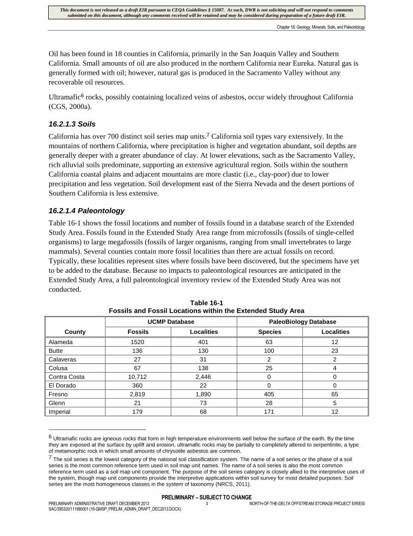
Table 16-1 shows the fossil locations and number of fossils found in a database search of the Extended
Study Area. Fossils found in the Extended Study Area range from microfossils (fossils of single-celled
organisms) to large megafossils (fossils of larger organisms, ranging from small invertebrates to large
mammals). Several counties contain more fossil localities than there are actual fossils on record.
Typically, these localities represent sites where fossils have been discovered, but the specimens have yet
to be added to the database. Because no impacts to paleontological resources are anticipated in the
Extended Study Area, a full paleontological inventory review of the Extended Study Area was not
conducted.
Table 16-1Fossils and Fossil Locations within the Extended Study Area
County
UCMP Database PaleoBiology Database
Fossils Localities Species Localities
Alameda 1520 401 63 12
Butte 136 130 100 23
Calaveras 27 31 2 2
Colusa 67 138 25 4
Contra Costa 10,712 2,446 0 0
El Dorado 360 22 0 0
Fresno 2,819 1,890 405 65
Glenn 21 73 28 5
Imperial 179 68 171 12
6 Ultramafic rocks are igneous rocks that form in high temperature environments well below the surface of the earth. By the timethey are exposed at the surface by uplift and erosion, ultramafic rocks may be partially to completely altered to serpentinite, a typeof metamorphic rock in which small amounts of chrysotile asbestos are common.7 The soil series is the lowest category of the national soil classification system. The name of a soil series or the phase of a soilseries is the most common reference term used in soil map unit names. The name of a soil series is also the most commonreference term used as a soil map unit component. The purpose of the soil series category is closely allied to the interpretive uses ofthe system, though map unit components provide the interpretive applications within soil survey for most detailed purposes. Soilseries are the most homogeneous classes in the system of taxonomy (NRCS, 2011).
This document is not released as a draft EIR pursuant to CEQA Guidelines § 15087. As such, DWR is not soliciting and will not respond to commentssubmitted on this document, although any comments received will be retained and may be considered during preparation of a future draft EIR.
Chapter 16: Geology, Minerals, Soils, and Paleontology
PRELIMINARY – SUBJECT TO CHANGENORTH-OF-THE-DELTA OFFSTREAM STORAGE PROJECT EIR/EIS 4 PRELIMINARY ADMINISTRATIVE DRAFT DECEMBER 2013
SAC/395320/111990001 (16-GMSP_PRELIM_ADMIN_DRAFT_DEC2013.DOCX)
Table 16-1Fossils and Fossil Locations within the Extended Study Area
County
UCMP Database PaleoBiology Database
Fossils Localities Species Localities
Kern 9,171 1,620 1,183 151
Kings 823 768 60 32
Los Angeles 8,964 1,690 1,069 127
Madera 214 8 27 1
Merced 287 169 41 8
Monterey 1,078 1,202 18 7
Napa 61 101 0 0
Nevada 430 60 247 9
Orange 1,041 938 1,142 123
Placer 31 38 1 1
Plumas 138 73 6 1
Riverside 1364 162 732 172
Sacramento 46 13 20 3
San Benito 677 390 1 1
San Bernardino 4,729 701 761 178
San Diego 7,693 1,743 1,866 260
San Joaquin 814 85 13 9
San Luis Obispo 1429 967 90 34
Santa Barbara 2,672 1,398 906 133
Santa Clara 59 81 67 8
Santa Cruz 2,062 450 220 54
Shasta 9,504 620 899 153
Solano 367 196 135 13
Stanislaus 924 175 82 21
Sutter 74 35 0 0
Tehama 390 284 456 79
Toulumne 221 45 0 0
Tulare 12 25 0 0
Ventura 4,585 982 1,890 200
Yolo 300 104 108 13
Note:
UCMP = University of California Museum of Paleontology at Berkeley
Source: UCMP, n.d.
16.2.2 Secondary Study Area
16.2.2.1 Geology
The Secondary Study Area occurs primarily in the eastern portion of the Coast Range Geomorphic
Province and the northwestern portion of the Great Valley Geomorphic Province (Figure 16-1).
Additionally, portions of the Klamath Mountains, Cascades, Modoc Plateau, Basin and Range, and the
Sierra Nevada geomorphic provinces are within the Secondary Study Area. These are described below.
This document is not released as a draft EIR pursuant to CEQA Guidelines § 15087. As such, DWR is not soliciting and will not respond to commentssubmitted on this document, although any comments received will be retained and may be considered during preparation of a future draft EIR.
Chapter 16: Geology, Minerals, Soils, and Paleontology
PRELIMINARY – SUBJECT TO CHANGEPRELIMINARY ADMINISTRATIVE DRAFT DECEMBER 2013 5 NORTH-OF-THE-DELTA OFFSTREAM STORAGE PROJECT EIR/EISSAC/395320/111990001 (16-GMSP_PRELIM_ADMIN_DRAFT_DEC2013.DOCX)
Coast Range Geomorphic Province
The Coast Range Geomorphic Province is characterized by a series of north-northwest trending ranges
and valleys; few are continuous for more than 100 miles. The province extends approximately 600 miles
from Point Arguello northward to the Klamath Range (Norris and Webb, 1990) and varies in width from a
few miles to 70 miles.
The Coast Ranges are complex and consist of many types of rocks ranging in age from Jurassic
(206 MYA) to Tertiary (present time). The Franciscan Formation is composed of metamorphosed
sedimentary and igneous rocks. It represents the basement rocks of the Coast Ranges to the west of the
project area. The general structural trend is northwest.
The eastern portion of the Coast Range is composed of a thick sequence of Upper Mesozoic
(65 to 145 MYA) sedimentary rocks known as the Great Valley Sequence (GVS). The section consists
principally of sedimentary rocks that are folded and faulted, and are not affected by other than mild
metamorphism. The GVS is divided into several formations that are generally based upon particle size.
Although the naming system for these formations has been subject to many revisions (e.g., Blake et al.,
1992; Dickinson and Rich, 1972; Rich, 1971; Ingersoll, 1979), for this study, the pertinent formations of
the GVS (from oldest to youngest) include the Stony Creek, Lodoga, Boxer, Venado, Cortina, and Yolo.
Quaternary (1.8 MYA to Present) units in the Coast Range include stream deposits consisting of clay, silt,
sand, gravel, cobbles, and boulders found in recent stream channels. Stream deposits are derived from the
older components of the Franciscan Complex and the GVS. Hillside deposits occur along slopes or at
their bases. It consists of soil, but contains a sizable fraction of angular rock fragments and some organic
material. Landslide deposits are similar to hillside deposits, but are more defined and generally deeper.
Landslide deposits tend to occur on steeper slopes.
Great Valley Geomorphic Province
The Great Valley Geomorphic Province is a nearly flat alluvial plain extending from the Tehachapi
Mountains in the south to the Klamath Mountains in the north; to the Sierra Nevada in the east and the
Coast Ranges in the west. The valley consists of the San Joaquin River drainage to the south of the
Sacramento-San Joaquin Delta, and the Sacramento River drainage to the north. This northwest-trending
trough has been filled with a thick (several miles deep) (Wahrhaftig and Birman, 1965) accumulation of
sediments eroded from the adjacent ancestral Sierra Nevada and Klamath Mountain ranges from the
Jurassic to the Present. It has a long stable eastern shelf supported by subsurface granite and a short
western flank with basin sediments. The western edge has eroded to form a series of northwest-trending
eastward-dipping ridges of sandstone and conglomerate separated by valleys underlain by siltstone and
mudstone.
Rock units on the surface in the Great Valley Geomorphic Province close to the Secondary Study Area
range in age from Miocene to Recent (23.8 MYA to Present).
The Lovejoy basalt is a dense and very hard extrusive volcanic rock (i.e., lava flow). The basalt originated
approximately 23 million years ago from an unknown volcanic center near the eastern margin of the
Sierra Nevada. Lovejoy exposures are found in the Orland Buttes on the west side of the Central Valley
and as far south as Vacaville. Extensive outcrops of the Lovejoy are located in the Oroville area.
The Tehama Formation occurs as thin, discontinuous, and deeply weathered stream-transported fan
deposits throughout the western edge of the Sacramento Valley that were derived from the erosion of the
Coast Ranges and Klamath Mountains. Eastward, the deposits thicken and merge, forming a broad thick
This document is not released as a draft EIR pursuant to CEQA Guidelines § 15087. As such, DWR is not soliciting and will not respond to commentssubmitted on this document, although any comments received will be retained and may be considered during preparation of a future draft EIR.
Chapter 16: Geology, Minerals, Soils, and Paleontology
PRELIMINARY – SUBJECT TO CHANGENORTH-OF-THE-DELTA OFFSTREAM STORAGE PROJECT EIR/EIS 6 PRELIMINARY ADMINISTRATIVE DRAFT DECEMBER 2013
SAC/395320/111990001 (16-GMSP_PRELIM_ADMIN_DRAFT_DEC2013.DOCX)
plain that contains pale green to tan semi-consolidated sand, tuffaceous8 sand, and silt with lenses of
gravel. The Tehama Formation is the primary groundwater aquifer of the Sacramento Valley west of the
Sacramento River. The Nomlaki Tuff Member occurs near the bottom of the Tehama Formation and has
been age-dated at approximately 3.3 million years. It consists of white, tan, or pink dacite pumice tuff and
lapilli tuff that is approximately 30 feet thick along the west side of the valley. Most of the tuff is believed
to have been deposited as an ash fall from a major volcanic eruption east of the project region.
The Red Bluff Formation occurs primarily in the northern portion of the Sacramento Valley, where it
overlies the Tehama Formation. Its largest area is in the vicinity of the City of Red Bluff where it is
approximately 50 feet thick. It consists largely of gravels with minor amounts of interbedded sands. The
upper surface usually consists of a hardpan soil. In the Red Bluff area, rock fragments are metamorphic
and igneous types, indicating that the sediments were transported from the north Coast Ranges and
Klamath Mountains. The formation was probably deposited during a period when glaciers were active in
the adjacent mountain areas. Streams draining the glacial areas were heavily choked with coarse debris
and suspended fine-grained material. The suspended clay and silt particles filled the voids after deposition
of the gravel so that most of the Red Bluff gravels are not very permeable. The Red Bluff remnants
represent an extensive Pleistocene (1.8 MYA to 11,600 years ago) nearly level erosional surface that once
covered much of the northern Sacramento Valley.
The Riverbank Formation consists of weathered reddish gravel, sand, and silt. It is differentiated from the
younger Modesto Formation by its terraces being higher topographically and by its more developed soil
profile. The upper layer is unconsolidated, but compact dark brown to red alluvium and forms the lower
of the Riverbank terraces. The lower layer is a red semi-consolidated gravel, sand, and silt. Its surface is
higher topographically and more dissected than the upper layer and has a stronger soil profile.
The Modesto Formation consists of the lowest distinct alluvial terraces lying above the Holocene
(11,600 years ago to Present) stream deposits. It includes tan and light gray gravelly sand, silt, and clay.
The upper layer is unconsolidated and unweathered, and it forms the lowest terraces approximately
ten feet thick over older alluvial deposits. The lower layer can be slightly weathered and forms terraces
that are higher than the upper layer. Soils on the lower layer contain clay and are red.
Recent stream channel deposits, floodplain, and flood basin deposits make up the remainder of rock types
that crop out in the Sacramento Valley. Stream channel and floodplain deposits consist of well-sorted
sand, gravel, and silt adjacent to the major streams. Flood basin deposits are the finest grained materials,
consisting mostly of clay and silt. The deposits are thin and poorly permeable. Flood basin deposits in the
project area occur in the Colusa Basin along the west side of the Sacramento River from approximately
Princeton southward.
The Tuscan and Laguna formations, important water-bearing formations beneath the Sacramento Valley,
crop out along the eastern portion of the Sacramento Valley. Further discussion of these formations is
included in Chapter 10 Groundwater Resources.
Klamath Mountains Geomorphic Province
The Klamath Mountain Geomorphic Province is divided into four north-south trending terranes9. From
east to west, these terranes are the Eastern Klamath, Central Metamorphic, Western Paleozoic and
8 Tuffaceous sand is a rock composed of compacted volcanic ash varying in size from fine sand to coarse gravel.9 Terranes are areas having a preponderance of a particular rock or rock groups.
This document is not released as a draft EIR pursuant to CEQA Guidelines § 15087. As such, DWR is not soliciting and will not respond to commentssubmitted on this document, although any comments received will be retained and may be considered during preparation of a future draft EIR.
Chapter 16: Geology, Minerals, Soils, and Paleontology
PRELIMINARY – SUBJECT TO CHANGEPRELIMINARY ADMINISTRATIVE DRAFT DECEMBER 2013 7 NORTH-OF-THE-DELTA OFFSTREAM STORAGE PROJECT EIR/EISSAC/395320/111990001 (16-GMSP_PRELIM_ADMIN_DRAFT_DEC2013.DOCX)
Triassic, and Western Jurassic. The terranes increase in age from west to east, except for the Central
Metamorphic Terrane, which is slightly older than the Eastern Klamath Terrane. The rock units generally
dip to the east, with the older eastern units overlying the younger western units. To varying degrees, these
rock units are exposed throughout the 40-mile reach of the mainstem Trinity River. Older gold-bearing
stream channel deposits, as well as recent channel deposits, occur along rivers and creeks.
Cascades Geomorphic Province
The Cascades Geomorphic Province, from southern British Columbia to south of Lassen Peak, is a
volcanic terrane ranging in age from Pliocene to Holocene. The province has been divided into the
Western Cascade series and the High Cascade series. The Western Cascade series consists of Miocene-
aged basalts, andesites, and dacite flows interlayered with rocks of explosive origin, including rhyolite
tuff, volcanic breccia, and agglomerate. This series is exposed at the surface in a belt 15 miles wide and
50 miles long from the Oregon border to the town of Mount Shasta. Early High Cascade rocks formed
very fluid basalt and andesite that extruded from fissures to form low shield volcanoes. Large composite
cones like Mount Shasta and Mount Lassen had their origins during the Pleistocene. Mount Lassen was
the only active volcano in California in the 20th century. Mount Shasta was last active in the 18th century
when steam and ash erupted from the summit cone (Norris and Webb, 1990).
Modoc Plateau Geomorphic Province
The Modoc Plateau Geomorphic Province consists of a high plain of irregular volcanic rocks of basaltic
origin. The numerous shield volcanoes and extensive faulting on the plateau give the area more relief than
may be expected for a plateau. The Modoc Plateau averages 4,500 feet in elevation and is considered a
small part of the Columbia Plateau, which covers extensive areas of Oregon, Washington, and Idaho.
Basin and Range Geomorphic Province
The Basin and Range Geomorphic Province, located east of the Modoc Plateau and the Sierra Nevada,
extends eastward into western Utah. It is characterized as north-south trending mountain ranges separated
by low wide alluvial valleys derived from eroded materials from the adjacent mountain ranges. In general,
the drainage is internal (i.e., no outlet to the sea) with saline lakes occupying low spots. One area, the
Sierra Valley, drains westward into the Middle Fork Feather River. Rocks range from metamorphic rocks
of pre-phanerozoic age (approximately 1.8 billion years ago to Recent) lakebed and stream deposits.
Paleozoic and early Mesozoic sedimentary and metamorphic rocks constitute the bulk of the bedrock. The
topography of the Basin and Range is a result of crustal extension within this part of the North American
Plate. The crust has been stretched up to 100 percent of its original width, and underneath the Basin and
Range, it is of the thinnest in the world.
Sierra Nevada Geomorphic Province
The Sierra Nevada Geomorphic Province is comprised principally of Cretaceous granitic pluton10,
remnants of Paleozoic and Mesozoic metavolcanic and metasedimentary rocks, and Cenozoic volcanic
and sedimentary rocks. The Paleozoic and Mesozoic metavolcanic and metasedimentary rocks were
intruded by the granitic plutons approximately 77 to 225 MYA, resulting in local uplift and deformation
of the overlying older rock. Regional uplift and rapid erosion of most of the overlying metamorphic rocks
closely followed intrusion of the plutons, exposing the underlying granitic rocks. Continued uplift and
10 Plutons are masses of igneous rock that have solidified below the surface of the earth.
This document is not released as a draft EIR pursuant to CEQA Guidelines § 15087. As such, DWR is not soliciting and will not respond to commentssubmitted on this document, although any comments received will be retained and may be considered during preparation of a future draft EIR.
Chapter 16: Geology, Minerals, Soils, and Paleontology
PRELIMINARY – SUBJECT TO CHANGENORTH-OF-THE-DELTA OFFSTREAM STORAGE PROJECT EIR/EIS 8 PRELIMINARY ADMINISTRATIVE DRAFT DECEMBER 2013
SAC/395320/111990001 (16-GMSP_PRELIM_ADMIN_DRAFT_DEC2013.DOCX)
erosion, accompanied by volcanic activity and alpine glaciation, resulted in the present pattern of deep-
walled valleys that characterize the Sierra Nevada.
16.2.2.2 Minerals
The mineral resources within the Secondary Study Area are the same as was described for the Extended
Study Area. The exceptions are iron and gypsum, which are mined in southern California, but are not
found in the Secondary Study Area.
The Stony Creek Fan in Glenn County has an estimated aggregate material availability of 160 million
cubic yards (DWR, 2002).
Ultramafic rocks, possibly containing localized veins of asbestos, occur in the Coast Ranges, Klamath
Mountains, and the Sierra Nevada (CGS, 2000a). Chromite was mined intermittently from ultramafic
rocks in Glenn County in the vicinity of the town of Chrome. Mining activity ceased in the 1940s.
16.2.2.3 Soils
Soils in the western portion (i.e., the Coast Range foothills) of the Secondary Study Area are a byproduct
of erosion of the underlying sedimentary rocks. Typical foothill soils are shallow to deep, generally well-
drained, and fine- to medium-textured. Soil depth on steep slopes is moderate to very thin; slightly
weathered sandstone and intensely weathered mudstones can be encountered within just a few inches of
the surface. Soil depth increases on the gentler slopes, generally reaching its maximum thicknesses along
valley bottoms. These deeper soils are more developed, moderately drained, and finer-grained; organicmaterial is more common in the low-lying deeper soils.
Soils in the central portion (i.e., the Sacramento Valley) of the Secondary Study Area are a byproduct of
the underlying weathered alluvial deposits. Most valley soils are alluvial silt loams, clays, and sands
deposited by the Sacramento River and tributaries draining the west side of the valley. These soils are
typically very deep to moderately deep, poorly drained, and fine-textured. The majority of the alluvial
soils on the valley floor has high agricultural productivity and is designated as Prime Agricultural11 soils.
Some soils are limited in their ability to support many forms of agriculture because of alkali problems
and/or drainage problems caused by the presence of a cemented hardpan or dense clay layer. These poorlydrained soils are particularly well suited for growing rice.
Soils in the northern and eastern portions of the Secondary Study Area (i.e., the Klamath, Cascades, and
Sierra Nevada) are a byproduct of the underlying metamorphic, volcanic, and intrusive rocks. In general,they are more clay-rich than the alluvial soils of the Sacramento Valley.
16.2.2.4 Paleontology
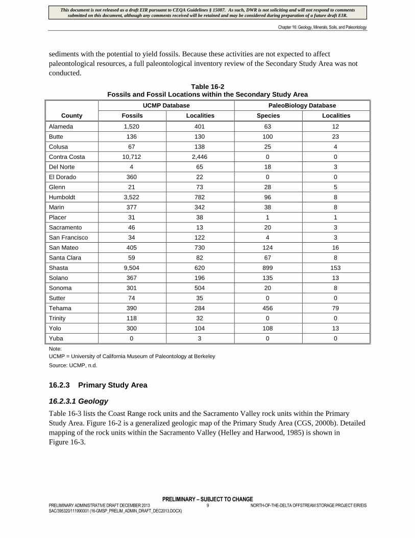
Table 16-2 shows the fossil locations and number of fossils found in the Secondary Study Area. As in the
Extended Study Area, the recovered fossils range from microfossils to the bones of large mammals.
Several counties contain more fossil localities than actual fossils because not all fossils from known
localities have been added to the database at this time (the localities have been listed, but the specimens
from those sites have yet to be entered into the database). Construction activities in the Secondary Study
Area are limited to the installation of a new pump at the Red Bluff Pumping Plant, and maintenance
activities are limited to the dredging of the intakes; neither operation will involve excavation into
11 Prime Agricultural means that the soil meets the physical and chemical criteria for Prime Farmland or Farmland of StatewideImportance, as determined by the USDA Natural Resources Conservation Service (NRCS).
This document is not released as a draft EIR pursuant to CEQA Guidelines § 15087. As such, DWR is not soliciting and will not respond to commentssubmitted on this document, although any comments received will be retained and may be considered during preparation of a future draft EIR.
Chapter 16: Geology, Minerals, Soils, and Paleontology
PRELIMINARY – SUBJECT TO CHANGEPRELIMINARY ADMINISTRATIVE DRAFT DECEMBER 2013 9 NORTH-OF-THE-DELTA OFFSTREAM STORAGE PROJECT EIR/EISSAC/395320/111990001 (16-GMSP_PRELIM_ADMIN_DRAFT_DEC2013.DOCX)
sediments with the potential to yield fossils. Because these activities are not expected to affect
paleontological resources, a full paleontological inventory review of the Secondary Study Area was not
conducted.
Table 16-2Fossils and Fossil Locations within the Secondary Study Area
County
UCMP Database PaleoBiology Database
Fossils Localities Species Localities
Alameda 1,520 401 63 12
Butte 136 130 100 23
Colusa 67 138 25 4
Contra Costa 10,712 2,446 0 0
Del Norte 4 65 18 3
El Dorado 360 22 0 0
Glenn 21 73 28 5
Humboldt 3,522 782 96 8
Marin 377 342 38 8
Placer 31 38 1 1
Sacramento 46 13 20 3
San Francisco 34 122 4 3
San Mateo 405 730 124 16
Santa Clara 59 82 67 8
Shasta 9,504 620 899 153
Solano 367 196 135 13
Sonoma 301 504 20 8
Sutter 74 35 0 0
Tehama 390 284 456 79
Trinity 118 32 0 0
Yolo 300 104 108 13
Yuba 0 3 0 0
Note:
UCMP = University of California Museum of Paleontology at Berkeley
Source: UCMP, n.d.
16.2.3 Primary Study Area
16.2.3.1 Geology
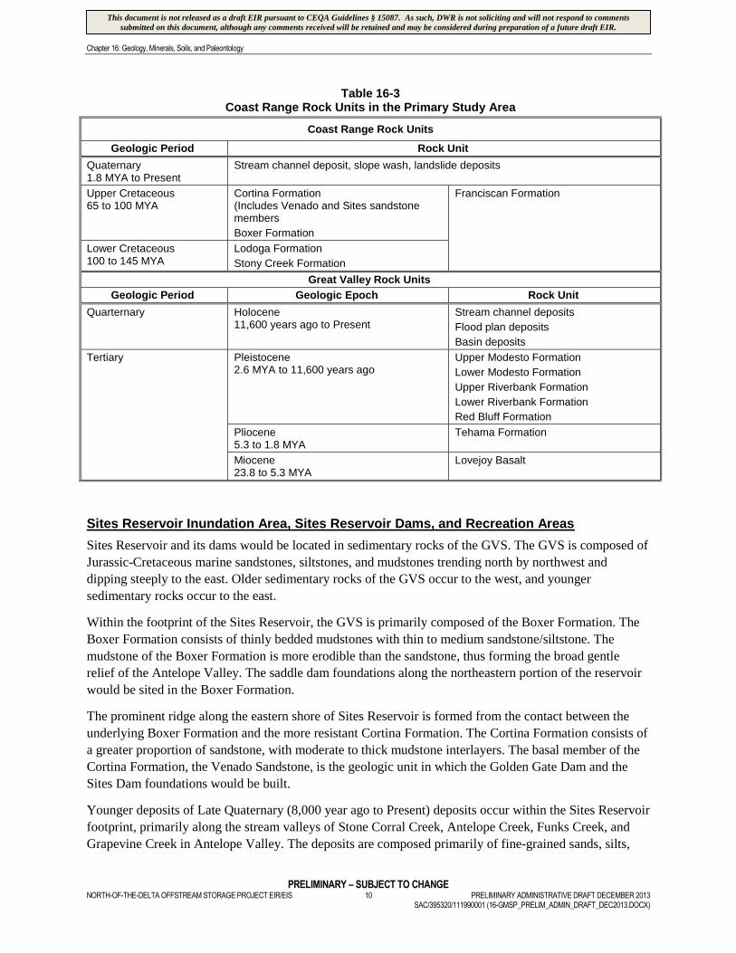
Table 16-3 lists the Coast Range rock units and the Sacramento Valley rock units within the Primary
Study Area. Figure 16-2 is a generalized geologic map of the Primary Study Area (CGS, 2000b). Detailed
mapping of the rock units within the Sacramento Valley (Helley and Harwood, 1985) is shown in
Figure 16-3.
This document is not released as a draft EIR pursuant to CEQA Guidelines § 15087. As such, DWR is not soliciting and will not respond to commentssubmitted on this document, although any comments received will be retained and may be considered during preparation of a future draft EIR.
Chapter 16: Geology, Minerals, Soils, and Paleontology
PRELIMINARY – SUBJECT TO CHANGENORTH-OF-THE-DELTA OFFSTREAM STORAGE PROJECT EIR/EIS 10 PRELIMINARY ADMINISTRATIVE DRAFT DECEMBER 2013
SAC/395320/111990001 (16-GMSP_PRELIM_ADMIN_DRAFT_DEC2013.DOCX)
Table 16-3Coast Range Rock Units in the Primary Study Area
Coast Range Rock Units
Geologic Period Rock Unit
Quaternary1.8 MYA to Present
Stream channel deposit, slope wash, landslide deposits
Upper Cretaceous65 to 100 MYA
Cortina Formation(Includes Venado and Sites sandstonemembers
Boxer Formation
Franciscan Formation
Lower Cretaceous100 to 145 MYA
Lodoga Formation
Stony Creek Formation
Great Valley Rock Units
Geologic Period Geologic Epoch Rock Unit
Quarternary Holocene11,600 years ago to Present
Stream channel deposits
Flood plan deposits
Basin deposits
Tertiary Pleistocene2.6 MYA to 11,600 years ago
Upper Modesto Formation
Lower Modesto Formation
Upper Riverbank Formation
Lower Riverbank Formation
Red Bluff Formation
Pliocene5.3 to 1.8 MYA
Tehama Formation
Miocene23.8 to 5.3 MYA
Lovejoy Basalt
Sites Reservoir Inundation Area, Sites Reservoir Dams, and Recreation Areas
Sites Reservoir and its dams would be located in sedimentary rocks of the GVS. The GVS is composed of
Jurassic-Cretaceous marine sandstones, siltstones, and mudstones trending north by northwest and
dipping steeply to the east. Older sedimentary rocks of the GVS occur to the west, and younger
sedimentary rocks occur to the east.
Within the footprint of the Sites Reservoir, the GVS is primarily composed of the Boxer Formation. The
Boxer Formation consists of thinly bedded mudstones with thin to medium sandstone/siltstone. The
mudstone of the Boxer Formation is more erodible than the sandstone, thus forming the broad gentle
relief of the Antelope Valley. The saddle dam foundations along the northeastern portion of the reservoir
would be sited in the Boxer Formation.
The prominent ridge along the eastern shore of Sites Reservoir is formed from the contact between the
underlying Boxer Formation and the more resistant Cortina Formation. The Cortina Formation consists of
a greater proportion of sandstone, with moderate to thick mudstone interlayers. The basal member of the
Cortina Formation, the Venado Sandstone, is the geologic unit in which the Golden Gate Dam and the
Sites Dam foundations would be built.
Younger deposits of Late Quaternary (8,000 year ago to Present) deposits occur within the Sites Reservoir
footprint, primarily along the stream valleys of Stone Corral Creek, Antelope Creek, Funks Creek, and
Grapevine Creek in Antelope Valley. The deposits are composed primarily of fine-grained sands, silts,
This document is not released as a draft EIR pursuant to CEQA Guidelines § 15087. As such, DWR is not soliciting and will not respond to commentssubmitted on this document, although any comments received will be retained and may be considered during preparation of a future draft EIR.
Chapter 16: Geology, Minerals, Soils, and Paleontology
PRELIMINARY – SUBJECT TO CHANGEPRELIMINARY ADMINISTRATIVE DRAFT DECEMBER 2013 11 NORTH-OF-THE-DELTA OFFSTREAM STORAGE PROJECT EIR/EISSAC/395320/111990001 (16-GMSP_PRELIM_ADMIN_DRAFT_DEC2013.DOCX)
and clays derived from the surrounding Boxer Formation. Larger fragments of igneous and metamorphic
rock occur in the deposits and are derived from upland areas west of the valley. They generally occur as
stream channel and floodplain deposits; minor colluvium deposits occur on higher gentler slopes away
from the streams. Floodplain deposits typically contain beds of sandy gravel and silty sand. Stream
channel deposits consist of sandy silt and gravel inset into either the floodplain or terrace deposits. In
general, the deposits are rather thin (less than 30 to 50 feet) with a maximum thickness reached adjacent
to the downcut stream channels on the eastern side of Antelope Valley.
The five recreation areas would be located on either the Boxer Formation or the Cortina Formation.
Sites Pumping/Generating Plant, Tunnel from Sites Pumping/Generating Plant to Sites
Reservoir Inlet/Outlet Structure, Sites Reservoir Inlet/Outlet Structure, Sites Electrical
Switchyard, and Field Office Maintenance Yard
The Sites Generating/Pumping Plant would be sited on the eastern slope of a prominent ridge composed
of sandstones and mudstones of the Cortina Formation. Quaternary alluvium covers the alignment trace of
the intake canal. The tunnel alignment would be in mostly Cortina Formation mudstones and sandstone,
except for its western opening which would be in mudstones of the Boxer Formation. The Inlet/Outlet
Structure would be sited in the Boxer Formation. The Sites Electrical Switchyard would be sited in
sandstone of the Cortina Formation. The Field Office Maintenance Yard would be sited primarily in
sandstone with occasional thin beds of mudstone of the Lodoga Formation.
Holthouse Reservoir Complex and Holthouse Reservoir Electrical Switchyard
Bedrock within and surrounding the existing Funks Reservoir is composed primarily of thinly bedded
mudstones of the Yolo Member of the Cortina Formation. Due west of Funks Reservoir, the Sites
member of the Cortina Formation is older geologically, and occurs as a more resistant ridge of thin to
medium bedded sandstone and siltstones. Typically, the mudstone members are more susceptible to
weathering and erosion, forming broad low valleys or swales between the more resistant sandstone. A
more resistant outcrop of sandstone occurs near the downstream portion of Funks Reservoir in the vicinity
of the existing Funks Dam. The Holthouse Reservoir Complex and Holthouse Reservoir Electrical
Switchyard would be sited in thinly bedded mudstones of the Yolo Member of the Cortina Formation.
Younger deposits of the Late Quaternary (8,000 year ago to Present) occur on top of the bedrock around
and inundated by Funks Reservoir; the Holthouse Reservoir Complex and Holthouse Reservoir Electrical
Switchyard would also be sited on these deposits.
Glenn-Colusa Irrigation District Canal
Geologic units along the alignment trace of the GCID Canal consist of (from youngest to oldest) the
Basin Deposits, Upper and Lower Modesto Formation, and Upper and Lower Riverbank Formation.
Descriptions of these geologic units are included in Section 16.2.2.1.
The GCID Canal headworks are located on the Lower Riverbank Formation. From approximately one
mile south of the headworks to Stony Creek, the Canal then crosses the Lower Modesto Formation.
Between Stony Creek and Willows, the Canal crosses the Upper and Lower Modesto Formation and the
Riverbank Formation, as well as basin deposits. From Willows south to the Funks Reservoir, the Canal
crosses primarily basin deposits and isolated deposits of Upper Modesto Formation and Upper Riverbank
Formation.
This document is not released as a draft EIR pursuant to CEQA Guidelines § 15087. As such, DWR is not soliciting and will not respond to commentssubmitted on this document, although any comments received will be retained and may be considered during preparation of a future draft EIR.
Chapter 16: Geology, Minerals, Soils, and Paleontology
PRELIMINARY – SUBJECT TO CHANGENORTH-OF-THE-DELTA OFFSTREAM STORAGE PROJECT EIR/EIS 12 PRELIMINARY ADMINISTRATIVE DRAFT DECEMBER 2013
SAC/395320/111990001 (16-GMSP_PRELIM_ADMIN_DRAFT_DEC2013.DOCX)
Tehama-Colusa Canal
Geologic units along the alignment of the T-C Canal consist of (from youngest to oldest) the Basin
Deposits, Upper and Lower Riverbank Formation, Upper and Lower Modesto Formation, Red Bluff
Formation, Tehama Formation, and Cortina Formation. Descriptions of these geologic units are included
in Section 16.2.2.1.
From Willow Creek to Funks Reservoir, the Canal crosses primarily deeply weathered mudstones,
siltstones, and minor thin beds of sandstone of the Cortina Formation between drainage divides and
younger alluvium or basin deposits at stream crossings.
Delevan Pipeline and Delevan Transmission Line
Geologic units along the alignment of the Delevan Pipeline consist of (from youngest to oldest) recent
Sacramento River stream deposits, Basin Deposits, Lower Riverbank Formation, Lower Modesto
Formation, and Cortina Formation. Descriptions of these geologic units are included in Section 16.2.2.1.
Terminal Regulating Reservoir, Glenn-Colusa Irrigation District Canal Connection to the
Terminal Regulating Reservoir, Terminal Regulating Reservoir Pipeline, Terminal
Regulating Reservoir Pipeline Road, Delevan Pipeline Electrical Switchyard, Terminal
Regulating Reservoir Pumping/Generating Plant, and Terminal Regulating Reservoir
Electrical Switchyard
Geologic units underneath and adjacent to the proposed location of the TRR, GCID Canal Connection to
the TRR, TRR Pipeline, TRR Pipeline Road, Delevan Pipeline Electrical Switchyard, TRR
Pumping/Generating Plant, and TRR Electrical Switchyard consist of Basin Deposits and the Lower
Riverbank Formation. Descriptions of these geologic units are included in Section 16.2.2.1.
Delevan Pipeline Intake Facilities and Delevan Pipeline Discharge Facility
Geologic units underneath the proposed location of the Delevan Pipeline Intake Facilities and Delevan
Pipeline Discharge Facility consist of recent Sacramento River stream deposits, Lower Modesto Formation,
and the Tehama Formation. Descriptions of these geologic units are included in Section 16.2.2.1. The
stream deposits and Lower Modesto Formation are relatively thin (less than 20 feet) and are underlain by
the more resistant Tehama Formation. The Tehama Formation is less readily erodible and defines the
western edge of the Sacramento River channel.
Road Relocations and South Bridge
Geologic units underneath the proposed location of the road relocations consist of the Boxer and Cortina
Formations of the GVS (Section 16.2.2.1). Additionally, these older deposits are occasionally overlain by
younger sedimentary deposits of Late Quaternary (8,000 year ago to Present).
Project Buffer
Geologic units underneath the portion of the Project Buffer that would surround Sites Reservoir and the
inlet/outlet facilities, as well as the Holthouse Reservoir Complex, consist primarily of the Boxer and
Cortina formations of the GVS (Section 16.2.2.1), with smaller portions of Basin Deposits, upper and
lower members of both the Riverbank and Modesto formations, and Red Bluff Formation.
Geologic units underneath the portion of the Project Buffer that would surround the TRR facilities consist
of Lower Riverbank Formation, Basin Deposits, and Red Bluff Formation.
This document is not released as a draft EIR pursuant to CEQA Guidelines § 15087. As such, DWR is not soliciting and will not respond to commentssubmitted on this document, although any comments received will be retained and may be considered during preparation of a future draft EIR.
Chapter 16: Geology, Minerals, Soils, and Paleontology
PRELIMINARY – SUBJECT TO CHANGEPRELIMINARY ADMINISTRATIVE DRAFT DECEMBER 2013 13 NORTH-OF-THE-DELTA OFFSTREAM STORAGE PROJECT EIR/EISSAC/395320/111990001 (16-GMSP_PRELIM_ADMIN_DRAFT_DEC2013.DOCX)
Geologic units underneath the portion of the Project Buffer that would surround the Delevan Pipeline
Intake/Discharge Facilities consist of Lower Modesto Formation and recent Sacramento River stream
deposits.
16.2.3.2 Minerals
With the exception of an inactive dimensional stone quarry to the east of the proposed Sites Dam location,
no known economic mineral resources occur in Primary Study Area. No locally important mineral
resources exist within the Primary Study Area (Glenn County, 1997 and Colusa County, 1989).
Natural gas production occurs widely in the Primary Study Area with large gasfields in the Sacramento
Valley, such as the Willows-Beehive Bend Field. Between 1948 and 1972, 10 exploratory wells were
drilled within the footprint of the proposed Sites Reservoir; all 10 wells were “dry holes” (i.e., produced
no natural gas). Approximately 10 exploratory wells (all “dry holes”) were also drilled near the alignment
of the Delevan Pipeline.
Ultramafic rocks possibly containing localized veins of asbestos are not found within the Primary Study
Area or in watersheds draining into the Primary Study Area (CGS, 2000a).
16.2.3.3 Soils
The soils in the Primary Study Area have been mapped by the U. S. Department of Agriculture, Soil
Conservation Service (now the NRCS), and are described in the soil surveys of Colusa and Glenn
counties (NRCS, 2006 and Begg, 1965). In addition, the NRCS provides soil data in GIS format andsoftware (Soil Data Viewer) for detailed analysis of soil properties.
The Primary Study Area includes two physiographic provinces: the Sacramento Valley and the CoastRange foothills (NRCS, 2006).
Floodplains extending along both sides of the Sacramento River slope gently away from the river to the Butte
Sink to the east and Colusa Basin to the west. Frequent overflows under natural conditions have deposited
loamy soils high in content of silt and fine sand. A levee system combined with Shasta Reservoir upstreamhelps to control Sacramento River waters so that floodplains are no longer flooded on a regular basis.
The soils on the floodplains along the Sacramento River are very fertile and are among the best soils in the
Sacramento Valley. Several sloughs originally disseminated from the Sacramento River into the Butte Sink
and Colusa Basin. Water flow was stopped by construction of levees on the Sacramento River. These sloughs,
particularly the Sycamore Slough, carried river sediments several miles from the river, creating the very
productive Vina soils. West from the floodplains along the Sacramento River, the Colusa Basin extends north
and south through the Primary Study Area. Overflows containing clayey sediments from the Sacramento
River and foothill streams regularly filled the Colusa Basin. Because of the construction of levees on the
Sacramento River, only sediments from the foothill streams now reach the basin. The basin is mostly leveled
for rice production. Salts in the clayey sediments from the foothill streams were deposited in the basin soils,
particularly Willows soils, and reclamation of the soils has been ongoing since early in the 20th century. Most
basin soils have been reclaimed to several feet. The very deep clay deposits that are characterized byextremely slow permeability and a shallow water table hamper further reclamation.
Alluvial fans exist along the west side of the Sacramento Valley. They originate at the base of the
foothills, at elevations of 200 to 400 feet, and gently descend to the east for several miles to the Colusa
Basin. Under natural conditions, streams from the foothills flooded these alluvial fans, depositing fertile
This document is not released as a draft EIR pursuant to CEQA Guidelines § 15087. As such, DWR is not soliciting and will not respond to commentssubmitted on this document, although any comments received will be retained and may be considered during preparation of a future draft EIR.
Chapter 16: Geology, Minerals, Soils, and Paleontology
PRELIMINARY – SUBJECT TO CHANGENORTH-OF-THE-DELTA OFFSTREAM STORAGE PROJECT EIR/EIS 14 PRELIMINARY ADMINISTRATIVE DRAFT DECEMBER 2013
SAC/395320/111990001 (16-GMSP_PRELIM_ADMIN_DRAFT_DEC2013.DOCX)
loamy soils. Many of the streams have been diverted from their natural channels, and levees have beenconstructed in some areas to control flooding.
Most of the foothill region is drained by streams flowing east to the Sacramento Valley. These streams
occasionally carry heavy volumes from high rainfall events, and cause flooding in the Sacramento Valley
along the west-side alluvial fans and in the Colusa Basin. Increased runoff has scoured and lowered the
stream channels of many foothill streams. Some streams have been diverted or channelized in the
Sacramento Valley. The foothill streams eventually find their way to the Colusa Basin and to the Colusa
Basin Drain. Occasionally, the flow exceeds the capacity of the south-flowing Colusa Basin Drain, andwidespread flooding occurs in the basin.
The Coast Range foothills range from approximately 200 to 2,500 feet in elevation. The lower foothills have
rolling slopes in many areas and have clayey soils and very few oak trees. In most foothill areas, the soils are
strongly sloping and are shallow or moderately deep over sandstone and mudstone of the Great ValleySequence. Most small valleys in the foothills have gently sloping clayey soils and some areas of loamy soils.
The NRCS has mapped 61 soil types within the Primary Study Area. Appendix 16A provides the soil map
unit name, the county in which it occurs, a map unit description, and several soil properties, such as
erosion potential, shrink/swell potential, corrosion of steel potential, and corrosion of concrete potential.Soil property values were derived using the NRCS Soil Data Viewer software.
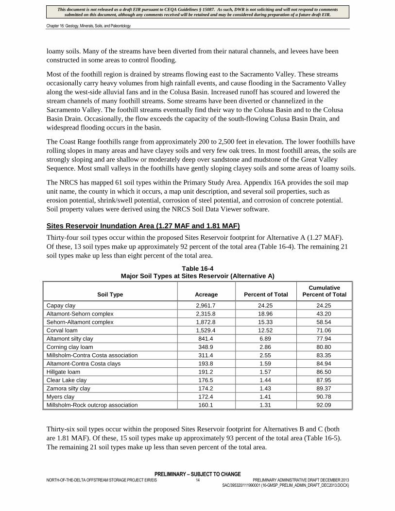
Sites Reservoir Inundation Area (1.27 MAF and 1.81 MAF)
Thirty-four soil types occur within the proposed Sites Reservoir footprint for Alternative A (1.27 MAF).
Of these, 13 soil types make up approximately 92 percent of the total area (Table 16-4). The remaining 21
soil types make up less than eight percent of the total area.
Table 16-4Major Soil Types at Sites Reservoir (Alternative A)
Soil Type Acreage Percent of TotalCumulative
Percent of Total
Capay clay 2,961.7 24.25 24.25
Altamont-Sehorn complex 2,315.8 18.96 43.20
Sehorn-Altamont complex 1,872.8 15.33 58.54
Corval loam 1,529.4 12.52 71.06
Altamont silty clay 841.4 6.89 77.94
Corning clay loam 348.9 2.86 80.80
Millsholm-Contra Costa association 311.4 2.55 83.35
Altamont-Contra Costa clays 193.8 1.59 84.94
Hillgate loam 191.2 1.57 86.50
Clear Lake clay 176.5 1.44 87.95
Zamora silty clay 174.2 1.43 89.37
Myers clay 172.4 1.41 90.78
Millsholm-Rock outcrop association 160.1 1.31 92.09
Thirty-six soil types occur within the proposed Sites Reservoir footprint for Alternatives B and C (both
are 1.81 MAF). Of these, 15 soil types make up approximately 93 percent of the total area (Table 16-5).
The remaining 21 soil types make up less than seven percent of the total area.
This document is not released as a draft EIR pursuant to CEQA Guidelines § 15087. As such, DWR is not soliciting and will not respond to commentssubmitted on this document, although any comments received will be retained and may be considered during preparation of a future draft EIR.
Chapter 16: Geology, Minerals, Soils, and Paleontology
PRELIMINARY – SUBJECT TO CHANGEPRELIMINARY ADMINISTRATIVE DRAFT DECEMBER 2013 15 NORTH-OF-THE-DELTA OFFSTREAM STORAGE PROJECT EIR/EISSAC/395320/111990001 (16-GMSP_PRELIM_ADMIN_DRAFT_DEC2013.DOCX)
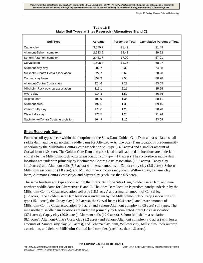
Table 16-5Major Soil Types at Sites Reservoir (Alternatives B and C)
Soil Type Acreage Percent of Total Cumulative Percent of Total
Capay clay 3,070.7 21.49 21.49
Altamont-Sehorn complex 2,633.9 18.43 39.92
Sehorn-Altamont complex 2,441.7 17.09 57.01
Corval loam 1,608.8 11.26 68.27
Altamont silty clay 902.7 6.32 74.58
Millsholm-Contra Costa association 527.7 3.69 78.28
Corning clay loam 357.3 2.50 80.78
Altamont-Contra Costa clays 324.6 2.27 83.05
Millsholm-Rock outcrop association 315.1 2.21 85.25
Myers clay 214.8 1.50 86.76
Hillgate loam 192.9 1.35 88.11
Altamont soils 192.5 1.35 89.45
Zamora silty clay 178.6 1.25 90.70
Clear Lake clay 176.5 1.24 91.94
Nacimiento-Contra Costa association 164.9 1.15 93.09
Sites Reservoir Dams
Fourteen soil types occur within the footprints of the Sites Dam, Golden Gate Dam and associated small
saddle dam, and the six northern saddle dams for Alternative A. The Sites Dam location is predominantly
underlain by the Millsholm-Contra Costa association soil type (14.3 acres) and a smaller amount of
Corval loam (1.0 acre). The Golden Gate Dam and associated small saddle dam locations are underlain
entirely by the Millsholm-Rock outcrop association soil type (41.0 acres). The six northern saddle dam
locations are underlain primarily by Nacimiento-Contra Costa association (15.2 acres), Capay clay
(11.0 acres) and Altamont soils (5.6 acres) with lesser amounts of Zamora silty clay (2.8 acres), Sehorn-
Millsholm association (1.0 acre), and Millsholm very rocky sandy loam, Willows clay, Tehama clay
loam, Altamont-Contra Costa clays, and Myers clay (each less than 0.5 acre).
The same fourteen soil types occur within the footprints of the Sites Dam, Golden Gate Dam, and nine
northern saddle dams for Alternatives B and C. The Sites Dam location is predominantly underlain by the
Millsholm-Contra Costa association soil type (18.1 acres) and a smaller amount of Corval loam
(1.2 acres). The Golden Gate Dam location is underlain by the Millsholm-Rock outcrop association soil
type (15.1 acres), the Capay clay (10.8 acres), the Corval loam (10.4 acres), and lesser amounts of
Millsholm-Contra Costa association (0.6 acre) and Sehorn-Altamont complex (0.05 acre) soil types. The
nine northern saddle dam locations are underlain primarily by Nacimiento-Contra Costa association
(37.1 acres), Capay clay (20.0 acres), Altamont soils (17.0 acres), Sehorn-Millsholm association
(8.1 acres), Altamont-Contra Costa clay (3.2 acres) and Sehorn-Altamont complex (3.0 acres) with lesser
amounts of Zamora silty clay (2.6 acres), and Tehama clay loam, Willows clay, Millsholm-Rock outcrop
association, and Sehorn-Millsholm-Gullied land complex (each less than 1.6 acres).
This document is not released as a draft EIR pursuant to CEQA Guidelines § 15087. As such, DWR is not soliciting and will not respond to commentssubmitted on this document, although any comments received will be retained and may be considered during preparation of a future draft EIR.
Chapter 16: Geology, Minerals, Soils, and Paleontology
PRELIMINARY – SUBJECT TO CHANGENORTH-OF-THE-DELTA OFFSTREAM STORAGE PROJECT EIR/EIS 16 PRELIMINARY ADMINISTRATIVE DRAFT DECEMBER 2013
SAC/395320/111990001 (16-GMSP_PRELIM_ADMIN_DRAFT_DEC2013.DOCX)
Soil cover at the proposed Sites and Golden Gate damsites is very thin and is derived from the
interbedded sandstone and siltstones of the Venado Sandstone. Soil cover at the seven (Alternative A) and
nine (Alternatives B and C) saddle damsites is moderately deep with gradual transition into the mudstones
and siltstones of the Boxer Formation.
Recreation Areas
The Recreation Areas would be underlain predominantly by Sehorn-Altamont complex (302.9 acres),
Millsholm-Contra Costa association (264.8 acres), Nacimiento-Contra Costa association (217.0 acres),
Millsholm-Contra Costa complex (129.1 acres), Altamont-Sehorn complex (119.5 acres), and Capay clay
(96.0 acres) soils. The remaining 74.1 acres would be underlain by five other soil types in lesser amounts.
Road Relocations and South Bridge
The Road Relocations and South Bridge (including a 200-foot-wide construction disturbance area) would
be underlain by 43 different soil types. Total affected area is approximately 1,329 acres. The predominant
soil types are Millsholm-Contra Costa association (273.1 acres), Sehorn-Altamont complex (234.9 acres),
and Capay clay (210.7 acres). The remaining 610.6 acres are composed of 40 other soil types with
acreages ranging from 79.5 acres to 0.1 acre.
Sites Pumping/Generating Plant, Tunnel from Sites Pumping/Generating Plant to Sites
Reservoir Inlet/Outlet Structure, Sites Reservoir Inlet/Outlet Structure, Sites Electrical
Switchyard, and Field Office Maintenance Yard
The Sites Pumping/Generating Plant would be located within the footprint of the proposed Inlet/Outlet
Structure. The Tunnel would be entirely underground with openings in the outlet and inlet structures. The
Inlet/Outlet Structure would be underlain predominantly by Millsholm-Rock outcrop association
(34.7 acres), Corval loam (24.1 acres), and Sehorn-Altamont complex (15.0 acres) soils, with lesser
amounts of Capay clay (8.7 acres), and Millsholm-Contra Costa association (7.6 acres) soils. Nearly
10 acres of Inlet/Outlet structure would be located in the footprint of the existing Funks Reservoir; no
NRCS soils data are available for that area. The Sites Electrical Switchyard would be underlain by the
Millsholm-Rock outcrop association. The Field Office Maintenance Yard would be underlain almost
entirely by the Millsholm-Rock outcrop complex (18.0 acres) with a small portion by Capay clay
(0.3 acre).
Holthouse Reservoir Complex and Holthouse Reservoir Electrical Switchyard
No NRCS soils data are available for the footprint of the existing Funks Reservoir. The proposed
Holthouse Reservoir Complex and Holthouse Reservoir Electrical Switchyard would be underlain
predominantly by Capay clay (129.2 acres) and Capay clay loam (74.0 acres) soils with lesser amounts of
Hillgate clay loam (62.2 acres), Altamont-Sehorn complex (39.8 acres), Corval clay loam (36.1 acres),
and Altamont silty clay (18.9 acres).
Terminal Regulating Reservoir, Glenn-Colusa Irrigation District Canal Connection to the
Terminal Regulating Reservoir, Terminal Regulating Reservoir Pumping/Generating
Plant, and Terminal Regulating Reservoir Electrical Switchyard
The TRR, GCID Canal Connection to the TRR, TRR Pumping/Generating Plant, and TRR Electrical
Switchyard would be underlain by Capay clay loam (114.2 acres) and Hillgate clay loam (90.6 acres)
soils, with 4.7 acres of Corval clay loam.
This document is not released as a draft EIR pursuant to CEQA Guidelines § 15087. As such, DWR is not soliciting and will not respond to commentssubmitted on this document, although any comments received will be retained and may be considered during preparation of a future draft EIR.
Chapter 16: Geology, Minerals, Soils, and Paleontology
PRELIMINARY – SUBJECT TO CHANGEPRELIMINARY ADMINISTRATIVE DRAFT DECEMBER 2013 17 NORTH-OF-THE-DELTA OFFSTREAM STORAGE PROJECT EIR/EISSAC/395320/111990001 (16-GMSP_PRELIM_ADMIN_DRAFT_DEC2013.DOCX)
Glenn-Colusa Irrigation District Canal Facilities Modifications
The three modifications are primarily within the footprint of the existing GCID Canal; soil data within the
footprint is unavailable (i.e., noted as water on soil map). At the railroad siphon location, Myers clay is
present on both sides of the Canal. At the new headgate location, Hillgate loam is present on both sides of
the Canal. The 200-foot canal lining feature is entirely within the footprint of the existing GCID Canal.
Delevan Pipeline, Terminal Regulating Reservoir Pipeline, Terminal Regulating Reservoir
Pipeline Road, and Delevan Pipeline Electrical Switchyard
The Delevan Pipeline would be underlain predominantly by Willows silty clay (96.5 acres) and Hillgate
clay loam (51.8 acres) with lesser amounts of Capay clay loam (28.0 acres), Corval clay loam (23.2 acres),
Moonbend silt loam (8.5 acres), Corbiere silt loam (6.4 acres), and Vina loam (2.1 acres).The construction
disturbance area for the Delevan Pipeline (totaling approximately 2,365 acres) would be underlain
predominantly by Willows silty clay (1,175.6 acres), Hillgate clay loam (379.8 acres), Capay clay loam
(277.3 acres), Corval clay loam (247.3 acres), Moonbend silt loam (101.3 acres), and Corbiere silt loam
(84.9 acres). Six other soil types make up the remaining 86 acres in lesser amounts.
The TRR Pipeline, TRR Pipeline Road, and Delevan Pipeline Electrical Switchyard would be underlain
predominantly by Hillgate clay loam (6.5 acres) with a lesser amount of Capay clay loam (2.1 acres). The
construction disturbance area for these three facilities would be entirely within the construction
disturbance area of the Delevan Pipeline.
Delevan Transmission Line
The Delevan Transmission Line route would be located within the construction disturbance area of the
Delevan Pipeline, except for a four-mile portion extending west of the proposed TRR. This discussion
addresses only that portion of the transmission line outside of the Delevan Pipeline construction
disturbance area. The proposed Delevan Transmission Line route (west of the TRR) would be underlain
predominantly by Altamont silty clay (23.6 acres), Corval loam (9.5 acres), Millsholm-Rock outcrop
association, (8.3 acres), Capay clay (5.8 acres), and Altamont-Sehorn complex (5.4 acres). Seven other
soil types make up the remaining 20.6 acres in lesser amounts.
Delevan Pipeline Intake Facilities (Alternative A and C)
The proposed Delevan Pipeline Intake Facilities would be underlain by Vina loam (17.4 acres). A portion
of the facility (1.7 acres) would extend into the river; no NRCS soils data are available for that area.
Delevan Pipeline Discharge Facility (Alternative B)
The proposed Delevan Pipeline Discharge Facility would be underlain by Vina loam (7.64 acres). A portion
of the facility (0.1 acre) would extend into the river; no NRCS soils data are available for that area.
Project Buffer
The Project Buffer would surround all Primary Study Area Project facilities, with the exception of the
Delevan Pipeline, Delevan Transmission Line, portions of the roads, and the GCID Canal Facilities
Modifications. The soil types underlying the Project Buffer are, therefore, similar to soils described above
for the facilities that it would surround.
This document is not released as a draft EIR pursuant to CEQA Guidelines § 15087. As such, DWR is not soliciting and will not respond to commentssubmitted on this document, although any comments received will be retained and may be considered during preparation of a future draft EIR.
Chapter 16: Geology, Minerals, Soils, and Paleontology
PRELIMINARY – SUBJECT TO CHANGENORTH-OF-THE-DELTA OFFSTREAM STORAGE PROJECT EIR/EIS 18 PRELIMINARY ADMINISTRATIVE DRAFT DECEMBER 2013
SAC/395320/111990001 (16-GMSP_PRELIM_ADMIN_DRAFT_DEC2013.DOCX)
16.2.3.4 Paleontology
Methodology
Geological maps and geological literature were reviewed to provide the physiographic and geological
context for the Primary Study Area. Internet queries and two standard online databases were also used to
determine the relative potential for paleontological resources to be found in each of the rock units
described below. The databases are the University of California Museum of Paleontology at Berkeley
(UCMP, n.d.), and the Paleobiology Database (n.d.), managed by a consortium of academic institutions
and supported, in part, by the National Science Foundation. The results of the search of paleontological
site records are presented in Appendix 16B.
The following tasks were completed to establish the paleontologic sensitivity and distribution of rock
units (including unconsolidated sediments) exposed within the Primary Study Area:
The study area was defined and its physiographic and geologic context was described.
A stratigraphic inventory (i.e., a review of the composition and relative positions of the rocks) of the
area was completed, and the mapped geologic units within the Primary Study Area were identified.
A paleontological records review of the area was completed to identify previously recorded fossil
resources and the context of their discovery.
The mapped geologic units were assigned levels of paleontological sensitivity based on the fossil remains
previously documented within that unit and on other relevant geological and paleontological data.
The paleontological sensitivity of the Primary Study Area was assessed by identifying the geological
units that might yield fossils, and therefore, have paleontological potential using the approach described
above. A description of the geological units is provided above; Appendix 16C presents the results of the
review of the available geological literature focused on paleontological sensitivity assessment.
The distribution of stratigraphic units was determined through geologic mapping and used as a proxy for
paleontological sensitivity. The features of the proposed project were then laid out on the geological map,
and the Project facilities that have the potential to cross units of varying paleontological sensitivity (high,
moderate, unknown, low, or no sensitivity) were delineated.
Paleontological Inventory of the Primary Study Area
Guidelines for paleontological resources assessments (SVP, No Date) call for the inventory of all
geological units within one mile of the ground-disturbing activities associated with any project
(Appendix 16C) to ensure that both surficial geologic units and geologic units that would be encountered
in the subsurface are adequately analyzed. These geological units are then evaluated for paleontological
sensitivity. During the preparation of this chapter, several data gaps were identified that complicate
characterization of the paleontological sensitivity of the Primary Study Area. These include the following:
Geologic maps at the necessary level of detail for this analysis tend to group all pre-Tertiary
formations into the same category.
There are few published geological studies of the GVS and overlying Neogene and Quaternary
sediments within the limits of the project.
There are proportionately few paleontological studies of these same rocks.
This document is not released as a draft EIR pursuant to CEQA Guidelines § 15087. As such, DWR is not soliciting and will not respond to commentssubmitted on this document, although any comments received will be retained and may be considered during preparation of a future draft EIR.
Chapter 16: Geology, Minerals, Soils, and Paleontology
PRELIMINARY – SUBJECT TO CHANGEPRELIMINARY ADMINISTRATIVE DRAFT DECEMBER 2013 19 NORTH-OF-THE-DELTA OFFSTREAM STORAGE PROJECT EIR/EISSAC/395320/111990001 (16-GMSP_PRELIM_ADMIN_DRAFT_DEC2013.DOCX)
Older rocks referred to as the GVS occur only on the western portion of the Primary Study Area in the
foothills of the North Coast Ranges. In the Sacramento Valley, much younger Pliocene (approximately
5.3 to 2.6 MYA) and Quaternary (2.6 MYA to present) sediments are found.
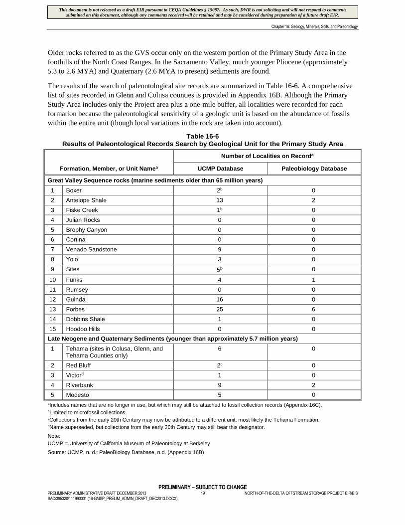
The results of the search of paleontological site records are summarized in Table 16-6. A comprehensive
list of sites recorded in Glenn and Colusa counties is provided in Appendix 16B. Although the Primary
Study Area includes only the Project area plus a one-mile buffer, all localities were recorded for each
formation because the paleontological sensitivity of a geologic unit is based on the abundance of fossils
within the entire unit (though local variations in the rock are taken into account).
Table 16-6Results of Paleontological Records Search by Geological Unit for the Primary Study Area
Formation, Member, or Unit Namea
Number of Localities on Recorda
UCMP Database Paleobiology Database
Great Valley Sequence rocks (marine sediments older than 65 million years)
1 Boxer 2b 0
2 Antelope Shale 13 2
3 Fiske Creek 1b 0
4 Julian Rocks 0 0
5 Brophy Canyon 0 0
6 Cortina 0 0
7 Venado Sandstone 9 0
8 Yolo 3 0
9 Sites 5b 0
10 Funks 4 1
11 Rumsey 0 0
12 Guinda 16 0
13 Forbes 25 6
14 Dobbins Shale 1 0
15 Hoodoo Hills 0 0
Late Neogene and Quaternary Sediments (younger than approximately 5.7 million years)
1 Tehama (sites in Colusa, Glenn, andTehama Counties only)
6 0
2 Red Bluff 2c 0
3 Victord 1 0
4 Riverbank 9 2
5 Modesto 5 0
aIncludes names that are no longer in use, but which may still be attached to fossil collection records (Appendix 16C).bLimited to microfossil collections.cCollections from the early 20th Century may now be attributed to a different unit, most likely the Tehama Formation.dName superseded, but collections from the early 20th Century may still bear this designator.
Note:
UCMP = University of California Museum of Paleontology at Berkeley
Source: UCMP, n. d.; PaleoBiology Database, n.d. (Appendix 16B)
This document is not released as a draft EIR pursuant to CEQA Guidelines § 15087. As such, DWR is not soliciting and will not respond to commentssubmitted on this document, although any comments received will be retained and may be considered during preparation of a future draft EIR.
Chapter 16: Geology, Minerals, Soils, and Paleontology
PRELIMINARY – SUBJECT TO CHANGENORTH-OF-THE-DELTA OFFSTREAM STORAGE PROJECT EIR/EIS 20 PRELIMINARY ADMINISTRATIVE DRAFT DECEMBER 2013
SAC/395320/111990001 (16-GMSP_PRELIM_ADMIN_DRAFT_DEC2013.DOCX)
Many of the recorded paleontological localities in the GVS are microfossil samples (chiefly small
plankton fossils, including foraminifera and diatoms). The use of microfossils in age dating, correlation,
and in paleoenvironmental studies is well documented. However, rocks bearing only microfossils are not
typically assigned high or even moderate levels of paleontological sensitivity because these fossils are
very abundant and found in many different sedimentary units, and therefore are not scientifically
significant as individuals. Also, although microfossils usually possess scientific significance as an
assemblage, isolated specimens or samples of microfossils normally have little scientific use.
Cretaceous Marine Units
The databases consulted (UCMP, n.d.; PaleoBiology Database, n.d.) included references to paleontological
sites in 10 of the 15 Cretaceous geological units comprising the GVS. Of these, three (the Boxer, Fiske, and
Sites formations) are known to yield only microfossils (chiefly foraminifera and radiolaria). The remaining
seven of the GVS units in the Primary Study Area yield scientifically significant megafossils.
The comparative lack of marine sedimentary units that have yielded megafossils is consistent with the
inferred paleoenvironments represented by these units. They are deep-ocean sediments consisting of muds
of the abyssal ocean floor and trench, and sandstones of deep submarine fans. The depth of water during
deposition of the GVS has been calculated as greater than 13,000 feet (Ingersoll, 1979). At that depth, few
animals can be expected to be incorporated into the paleontological record due to a combination of
geochemical and ecological factors, including low probability of preservation due to both the low density
of animals at abyssal depths (the deep sea floor), and the fact that seawater at such depths dissolves
calcite shells. In considering the paucity of fossil record from the GVS, Haggart and Ward (1984)
observed that many paleontologists have had difficulty correlating Cretaceous strata of the GVS due to
the lack of large fossils. Therefore, most studies have relied on microfossils to determine the relative age
and stratigraphic position of these units, and most records for the GVS in the databases consulted
(UCMP, n.d.; PaleoBiology Database, n.d.) consist of these microfossil assemblages.
Changes in the species composition of microfossils that lived at shallow depths have been the principal
means of assigning strata to different ages within the Cretaceous period. However, with more intensive
collecting, Haggart and Ward (1984) demonstrated that megafossils, primarily mollusks, can be found in
at least the Santonian and Campanian strata (85.8 to 70.6 MYA) on the west side of the Sacramento
Valley. Some of these fossils have been instrumental in clarifying the timing of deposition of the upper
portion of the GVS (Haggart and Ward, 1984). The paleontological records of the seven GVS units that
yield megafossils are discussed in Table 16-7.
Table 16-7Great Valley Sequence Units in the Primary Study Area that Yield Megafossils
Antelope Shale: The gastropod Paosia (Trajanella) colusaensis was recovered from rocks that are likely from eitherthe Antelope Shale or the overlying Venado Sandstone (Squires, 2004). The specimens were from near the town ofSites and are donated specimens, so the exact locale for this collection is uncertain. The gastropods Paosiacalifornica and Turitella petersoni are from the upper part of the Antelope Shale (Brown and Rich, 1961). Similar tothe Venado Sandstone above it, many of the invertebrates are thought to be shallow water fauna redeposited insubmarine deposits, which may compromise some of their scientific value because the original context ordepositional setting of the specimens would be in doubt.
Venado Sandstone: Similar to the Antelope Shale, many of the invertebrates found in the Venado are thought tohave been redeposited in submarine deposits. The UCMP database notes that the collections there includeimportant specimens of the Cenomanian to early Turonian (99.6 to 89.3 MYA) bivalve Yaadia leana.
This document is not released as a draft EIR pursuant to CEQA Guidelines § 15087. As such, DWR is not soliciting and will not respond to commentssubmitted on this document, although any comments received will be retained and may be considered during preparation of a future draft EIR.
Chapter 16: Geology, Minerals, Soils, and Paleontology
PRELIMINARY – SUBJECT TO CHANGEPRELIMINARY ADMINISTRATIVE DRAFT DECEMBER 2013 21 NORTH-OF-THE-DELTA OFFSTREAM STORAGE PROJECT EIR/EISSAC/395320/111990001 (16-GMSP_PRELIM_ADMIN_DRAFT_DEC2013.DOCX)
Table 16-7Great Valley Sequence Units in the Primary Study Area that Yield Megafossils
Yolo Formation: The Turonian (93.5 to 89.3 MYA) Yolo Formation has yielded mollusks of the genus Turridea(Oqvist, n.d.) as well as an array of ammonites (Squires, 2004). Also present in this unit is the gastropod Paosiacalifornica (Squires, 2004).
Funks Formation: The texanitid ammonites (a type of cephalopodl) are relatively rare in Cretaceous sediments ofthe Pacific Coast, and the Funks Formation is important because it has yielded more than two dozen specimens ofProtexanites thompsoni (Jones, 1966), a member of this group. The type site is approximately one mile north ofPutah Creek, well south of the current Primary Study Area.
Guinda Formation: The gastropod Paosia californica and the bivalve Cucullaea melhaseana have been recoveredfrom this unit (Squires, 2004). The uppermost portions of this formation yield specimens of the index fossilBostrychoceras elongatum, an ammonite (Haggart and Ward, 1984).
Dobbins Shale: The lower half of the Dobbins Shale contains the ammonite Bostrychoceras elongatum, establishingthat the species’ range continued into this unit from the underlying Guinda Formation. Uppermost portions of theDobbins Shale contain abundant specimens of the pelecypod Inoceramus schmidti, a lower Campanian (83.5 to70.6 MYA) index fossil (Haggart and Ward, 1984).
Forbes Formation: The transition between the Dobbins Shale and the overlying Forbes Formation contains theimportant ammonite Baculites chicoensis, which allows correlation of this unit of the GVS with the upper member ofthe Chico Formation on the east side of the Sacramento Valley (Haggart and Ward, 1984).
Pliocene and Quaternary Terrestrial Units
Tehama Formation
The diverse fossil assemblage from the Pliocene (5.3 to 2.6 MYA) Tehama Formation (including the
outdated Victor and Red Bluff Formations [Appendix 16C]) documents conditions in California not long
before the beginning of the environmental changes accompanying the Pleistocene (2.6 to 0.01 MYA) ice
ages, and the animals living in those environments. Recent discovery of the remains of a giant tortoise
(Geochelone) from the Tehama Formation near Red Bluff (Sierra College, 2007) adds to the list of
animals from the Tehama Formation that already included several records of the giant tortoise, as well as
Pliomastodon (mastodon); Mammut (mammoth); Equus simplicidens, Pliohippus, and Nannippus
(horses); Camelops hesternus (North American camel); Megalonichidae and Mealonyx (ground
sloth);Platygonus (a pig-like animal); Canis (dog); Odocoileus (a genus of deer); Thomomys (pocket
gopher); Neotoma (wood or pack rat); Peromyscus (deer mice); Reithrodontomys (harvest mice);
Osteichtheyes (fish); and the hyena-like dog Borophagus diversidens.
Riverbank Formation
A variety of Pleistocene age (2.6 to 0.01 MYA) fossils were identified in extensive gravel pit excavations
in east Sacramento (Hansen and Begg, 1970). They report a variety of Rancholabrean fossils (from about
125,000 to 10,000 years B.P.) collected from two gravel quarries in the Riverbank Formation. These
fossils include: Archoplites (sunfish), two bird species, Bison antiquus (bison), Camelops hesternus
(camel), Canis dirus (dire wolf), Canis latrans (coyote), Clemmys marmorata (pond turtle), Colubridae
(colubrid snake), Cyprinidae (carp), Equus (horse), Mammuthus (mammoth), Microtus (meadow mouse
or vole), Neotoma (wood rat), Odocoileus (deer), Paramylodon harlani (ground sloth), Perognathus
(pocket mouse), Scapanus latimanus (mole), Spermophilus cf. S. beecheyi (ground squirrel), Sylvilagus
(rabbit), Thomomys bottae (pocket gopher), as well as remains of trees such as Pseudotsuga (Douglas fir),
Platanus (sycamore), and Salix (willow)
A variety of fossils of extinct large mammals were collected by Hilton et al. (2000), including
Glossotherium harlani and Paramylodon harlani (ground sloths), Bison antiquus (bison), Equus sp.
This document is not released as a draft EIR pursuant to CEQA Guidelines § 15087. As such, DWR is not soliciting and will not respond to commentssubmitted on this document, although any comments received will be retained and may be considered during preparation of a future draft EIR.
Chapter 16: Geology, Minerals, Soils, and Paleontology
PRELIMINARY – SUBJECT TO CHANGENORTH-OF-THE-DELTA OFFSTREAM STORAGE PROJECT EIR/EIS 22 PRELIMINARY ADMINISTRATIVE DRAFT DECEMBER 2013
SAC/395320/111990001 (16-GMSP_PRELIM_ADMIN_DRAFT_DEC2013.DOCX)
(horse), Camelops hesternus (camel), Sciurus sp. (squirrel), and Mammuthus sp. (mammoth), as well as
plant fossils during the excavations for a large sports arena north of Sacramento. These fossils were found
in excavations approximately 13 to 30 feet below the ground surface. These fossils were attributed to the
Riverbank Formation.
Dundas and Cunningham (1993) also collected Pleistocene-age ground sloth (Glossotherium harlani) and
Columbian mammoth (Mammuthus columbi) remains from the Riverbank Formation in the Extended
Study Area.
Modesto Formation
Similar to the Riverbank Formation, the Modesto Formation is represented by a variety of deposits,
mainly river deposits, but also terrestrial sediment such as dune fields and sand sheets. The fossil record
of the Late Pleistocene Modesto Formation is, therefore, similar to the Riverbank Formation, although the
taxa represented in the Modesto are generally from a more recent time period. The extinct North
American camel is well represented in collections from the Modesto. Other vertebrates that have been
recovered from the Modesto Formation include Jefferson’s ground sloth (Megalonyx), mammoth
(Mammuthus), and an extinct species of bison.
Sensitivity Criteria
The paleontological sensitivity of a rock unit is determined by the likelihood that it will yield identifiable,
unique, or scientifically important fossils. Well-developed and documented fossil-bearing formations are
less likely to yield a unique paleontological resource, but the resources may nevertheless retain scientific
importance.
An individual fossil specimen may be considered unique or significant if it is (1) identifiable, (2) complete,
(3) well preserved, (4) useful in determining the age of the formation, (5) useful in interpreting the ancient
environment, (6) a member of a rare species, or (7) a skeletal element different from, or a specimen more
complete than, those now available for its species. The value or importance of different fossil groups varies,
depending on the age and depositional environment of the rock unit that contains the fossils, their rarity, the
extent to which they have already been identified and documented, and the ability to recover similar
materials under more controlled conditions (such as part of a research project).
The following tasks were completed to establish the paleontological sensitivity of each rock unit
potentially exposed in the Primary Study Area:
Designated certain unit names as not applicable (n/a) because they duplicate other names being used,
or because they are otherwise no longer used by geologists
Considered the scientific significance of the fossil finds from the unit
Assessed the potential paleontological productivity of each rock unit exposed within one mile of the
proposed project features, based on available documentation
Considered the potential for a rock unit exposed at the project feature site to contain a unique
paleontological resource
This document is not released as a draft EIR pursuant to CEQA Guidelines § 15087. As such, DWR is not soliciting and will not respond to commentssubmitted on this document, although any comments received will be retained and may be considered during preparation of a future draft EIR.
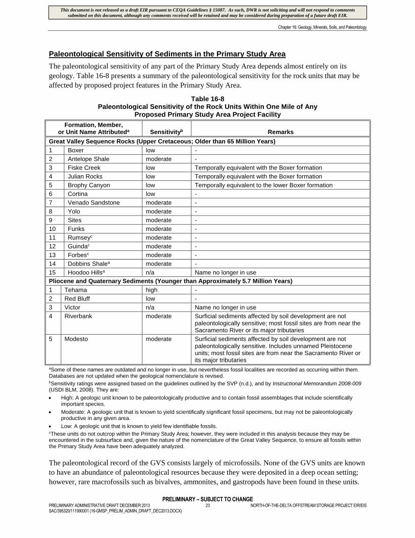
Chapter 16: Geology, Minerals, Soils, and Paleontology
PRELIMINARY – SUBJECT TO CHANGEPRELIMINARY ADMINISTRATIVE DRAFT DECEMBER 2013 23 NORTH-OF-THE-DELTA OFFSTREAM STORAGE PROJECT EIR/EISSAC/395320/111990001 (16-GMSP_PRELIM_ADMIN_DRAFT_DEC2013.DOCX)
Paleontological Sensitivity of Sediments in the Primary Study Area
The paleontological sensitivity of any part of the Primary Study Area depends almost entirely on its
geology. Table 16-8 presents a summary of the paleontological sensitivity for the rock units that may be
affected by proposed project features in the Primary Study Area.
Table 16-8Paleontological Sensitivity of the Rock Units Within One Mile of Any
Proposed Primary Study Area Project Facility
Formation, Member,or Unit Name Attributeda Sensitivityb Remarks
Great Valley Sequence Rocks (Upper Cretaceous; Older than 65 Million Years)
1 Boxer low -
2 Antelope Shale moderate -
3 Fiske Creek low Temporally equivalent with the Boxer formation
4 Julian Rocks low Temporally equivalent with the Boxer formation
5 Brophy Canyon low Temporally equivalent to the lower Boxer formation
6 Cortina low -
7 Venado Sandstone moderate -
8 Yolo moderate -
9 Sites moderate -
10 Funks moderate -
11 Rumseyc moderate -
12 Guindac moderate -
13 Forbesc moderate -
14 Dobbins Shalea moderate -
15 Hoodoo Hillsa n/a Name no longer in use
Pliocene and Quaternary Sediments (Younger than Approximately 5.7 Million Years)
1 Tehama high -
2 Red Bluff low -
3 Victor n/a Name no longer in use
4 Riverbank moderate Surficial sediments affected by soil development are notpaleontologically sensitive; most fossil sites are from near theSacramento River or its major tributaries
5 Modesto moderate Surficial sediments affected by soil development are notpaleontologically sensitive. Includes unnamed Pleistoceneunits; most fossil sites are from near the Sacramento River orits major tributaries
aSome of these names are outdated and no longer in use, but nevertheless fossil localities are recorded as occurring within them.Databases are not updated when the geological nomenclature is revised.bSensitivity ratings were assigned based on the guidelines outlined by the SVP (n.d.), and by Instructional Memorandum 2008-009(USDI BLM, 2008). They are:
High: A geologic unit known to be paleontologically productive and to contain fossil assemblages that include scientificallyimportant species.
Moderate: A geologic unit that is known to yield scientifically significant fossil specimens, but may not be paleontologicallyproductive in any given area.
Low: A geologic unit that is known to yield few identifiable fossils.cThese units do not outcrop within the Primary Study Area; however, they were included in this analysis because they may beencountered in the subsurface and, given the nature of the nomenclature of the Great Valley Sequence, to ensure all fossils withinthe Primary Study Area have been adequately analyzed.
The paleontological record of the GVS consists largely of microfossils. None of the GVS units are known
to have an abundance of paleontological resources because they were deposited in a deep ocean setting;
however, rare macrofossils such as bivalves, ammonites, and gastropods have been found in these units.
This document is not released as a draft EIR pursuant to CEQA Guidelines § 15087. As such, DWR is not soliciting and will not respond to commentssubmitted on this document, although any comments received will be retained and may be considered during preparation of a future draft EIR.
Chapter 16: Geology, Minerals, Soils, and Paleontology
PRELIMINARY – SUBJECT TO CHANGENORTH-OF-THE-DELTA OFFSTREAM STORAGE PROJECT EIR/EIS 24 PRELIMINARY ADMINISTRATIVE DRAFT DECEMBER 2013
SAC/395320/111990001 (16-GMSP_PRELIM_ADMIN_DRAFT_DEC2013.DOCX)
Although uncommon in the GVS, these fossils are important for dating the geologic units they are found
in and for comparing geologic units throughout the Great Basin. The Venado, Yolo, Sites, Funks,
Rumsey, Guinda, and Forbes formations, and the Dobbins shale, are considered to have a “moderate”
paleontological sensitivity rating (Table 16-8). If large fossils, including invertebrate fossils, are
encountered during Project construction, they would likely be scientifically significant.
Neither the Modesto nor the Riverbank formations within the Primary Study Area are assigned “high”
paleontological sensitivity. These formations have yielded important fossils; however, the recorded
paleontological sites are located primarily near the Sacramento River and along its major tributaries. The
paleontological productivity of the geologic units deposited at higher elevations in the Primary Study
Area does not appear to be substantial. Therefore, the paleontological sensitivity of the Modesto and
Riverbank formations is considered “moderate.”
16.3 Environmental Impacts/Environmental Consequences
16.3.1 Regulatory Setting
Geology, minerals, soils, and paleontological resources are regulated at the federal, State, and local levels.
Provided below is a list of the applicable regulations. These regulations are discussed in detail in
Chapter 4 Environmental Compliance and Permit Summary of this EIR/EIS.
16.1.1.1 Federal Plans, Policies, and Regulations
Clean Water Act Section 402, National Pollutant Discharge Elimination System Program
National Pollutant Discharge Elimination System General Permit for Stormwater Discharges from
Construction Sites
Antiquities Act of 1906
Archaeological Resources Protection Act of 1979
Omnibus Public Land Management Act of 2009
16.1.1.2 State Plans, Policies, and Regulations
California Environmental Quality Act, Guidelines for the Implementation of CEQA (Public Resources
Code Section 15023, Appendix G)
Porter-Cologne Water Quality Control Act
California Department of Fish and Game Code 1602
California Water Code, Division 3: Dams and Reservoirs
Surface Mining and Reclamation Act of 1975
Seismic Hazards Mapping Act of 1990
Asbestos Airborne Toxic Control Measure for Surfacing Applications (amended 2000)
Asbestos Airborne Toxic Control Measure for Construction, Grading, Quarrying, and Surface Mining
Operations
This document is not released as a draft EIR pursuant to CEQA Guidelines § 15087. As such, DWR is not soliciting and will not respond to commentssubmitted on this document, although any comments received will be retained and may be considered during preparation of a future draft EIR.
Chapter 16: Geology, Minerals, Soils, and Paleontology
PRELIMINARY – SUBJECT TO CHANGEPRELIMINARY ADMINISTRATIVE DRAFT DECEMBER 2013 25 NORTH-OF-THE-DELTA OFFSTREAM STORAGE PROJECT EIR/EISSAC/395320/111990001 (16-GMSP_PRELIM_ADMIN_DRAFT_DEC2013.DOCX)
Regulatory Design Codes for Buildings, Highways, and Other Structures
Nonpoint Source Implementation and Enforcement Policy
California Public Resources Code Chapter 1.7 Archaeological, Paleontological, and Historical Sites
Section 5097.5
16.1.1.3 Regional and Local Plans, Policies, and Regulations
Glenn County General Plan
Colusa County General Plan
16.3.2 Evaluation Criteria and Significance Thresholds
Significance criteria represent the thresholds that were used to identify whether an impact would be
significant. Appendix G of the CEQA Guidelines suggests the following evaluation criteria for geology,
minerals, soils, and paleontological resources:
Would the Project:
Be located on a geologic unit or soil that is unstable, or that would become unstable as a result of the
Project, and potentially result in on- or off-site landslide, lateral spreading, subsidence, liquefaction,
or collapse?
Result in substantial soil erosion or the loss of topsoil?
Be located on expansive soil, as defined in Table 18-1-B of the Uniform Building Code (1994),
creating substantial risks to life or property?
Have soils incapable of adequately supporting the use of septic tanks or alternative wastewater
disposal systems where sewers are not available for the disposal of wastewater?
Result in the loss of availability of a known mineral resource that would be of value to the region and
the residents of the state?
Result in the loss of availability of a locally important mineral resource recovery site delineated on a
local General Plan, Specific Plan, or other land use plan?
Expose people (working on the Project or the public) during Project construction or operation to
naturally occurring asbestos?
Directly or indirectly destroy of a unique paleontological resource or site or unique geologic feature?
The evaluation criteria used for this impact analysis represent a combination of the Appendix G criteria
and professional judgment that considers current regulations, standards, and/or consultation with
agencies, knowledge of the area, and the intensity of the environmental effects, as required pursuant to
NEPA. For the purposes of this analysis, an alternative would result in a significant impact if it would
result in any of the following:
Effects on a geologic unit or soil unit from Project construction, operation, and maintenance.
Project construction, operation, and maintenance effects on soil erosion and loss of topsoil.
Risks to life and property from Project construction, operation, and maintenance on expansive soil.
This document is not released as a draft EIR pursuant to CEQA Guidelines § 15087. As such, DWR is not soliciting and will not respond to commentssubmitted on this document, although any comments received will be retained and may be considered during preparation of a future draft EIR.
Chapter 16: Geology, Minerals, Soils, and Paleontology
PRELIMINARY – SUBJECT TO CHANGENORTH-OF-THE-DELTA OFFSTREAM STORAGE PROJECT EIR/EIS 26 PRELIMINARY ADMINISTRATIVE DRAFT DECEMBER 2013
SAC/395320/111990001 (16-GMSP_PRELIM_ADMIN_DRAFT_DEC2013.DOCX)
Project construction, operation, and maintenance effects on soils that are incapable of adequately
supporting the use of septic tanks or alternative wastewater disposal systems where sewers are not
available for the wastewater disposal.
Loss of availability of a known mineral resource that would be of value to the region and the residents
of the state.
Loss of availability of a locally important mineral resource recovery site delineated on a local general
plan, specific plan, or other land use plan.
Expose people to naturally occurring asbestos during Project construction, operation, or maintenance
Project construction, operation, and maintenance effects on paleontological resources.
Paleontological resources impacts would include damage or destruction of a scientifically significant
fossil, the removal of a scientifically significant fossil from its stratigraphic context, or any other action
that reduces the amount of information available to future researchers. The probability that excavations
would cause such impacts is proportional to the paleontological sensitivity of the geologic units.
Excavations within high-sensitivity geologic units have a high potential to adversely impact
paleontological resources. Excavations within moderate-sensitivity sediments have a lower potential to
adversely impact paleontological resources, and that potential is frequently limited to specific portions of
the unit. Low-sensitivity sedimentary units have a very low, but non-zero, chance of impacting
paleontological resources. Excavations that do not impact paleontological resources—or that only impact
non-significant fossils, such as microfossils—are not considered to impact paleontological resources.
Impacts to sediment of moderate to high paleontological sensitivity, or to scientifically important fossils,
would constitute significant impacts in the absence of mitigation.
16.3.3 Impact Assessment Assumptions and Methodology
16.3.3.1 Assumptions
The following assumptions were made regarding Project-related construction, operation, and maintenance
impacts to geologic, mineral, soil, and paleontological resources:
Direct Project-related construction, operation, and maintenance activities would occur in the Primary
Study Area.
Direct Project-related operational effects would occur in the Secondary Study Area.
The only direct Project-related construction activity that would occur in the Secondary Study Area is
the installation of an additional pump into an existing bay at the Red Bluff Pumping Plant.
The only direct Project-related maintenance activity that would occur in the Secondary Study Area is
the sediment removal and disposal at the two intake locations (i.e., GCID Canal Intake and Red Bluff
Pumping Plant).
No direct Project-related construction or maintenance activities would occur in the Extended Study Area.
Direct Project-related operational effects that would occur in the Extended Study Area are related to
San Luis Reservoir operation; increased reliability of water supply to agricultural, municipal, and
industrial water users; and the provision of an alternate Level 4 wildlife refuge water supply. Indirect
effects to the operation of certain facilities that are located in the Extended Study Area, and indirect
This document is not released as a draft EIR pursuant to CEQA Guidelines § 15087. As such, DWR is not soliciting and will not respond to commentssubmitted on this document, although any comments received will be retained and may be considered during preparation of a future draft EIR.
Chapter 16: Geology, Minerals, Soils, and Paleontology
PRELIMINARY – SUBJECT TO CHANGEPRELIMINARY ADMINISTRATIVE DRAFT DECEMBER 2013 27 NORTH-OF-THE-DELTA OFFSTREAM STORAGE PROJECT EIR/EISSAC/395320/111990001 (16-GMSP_PRELIM_ADMIN_DRAFT_DEC2013.DOCX)
effects to the consequent water deliveries made by those facilities, would occur as a result of
implementing the alternatives.
The existing bank protection located upstream of the proposed Delevan Pipeline Intake/Discharge
facilities would continue to be maintained and remain functional.
No additional channel stabilization, grade control measures, or dredging in the Sacramento River at or
upstream of the Delevan Pipeline Intake or Discharge Facilities would be required.
Erosion is the wearing away of soil and rock by processes such as mechanical or chemical weathering,
mass wasting, and the action of waves, wind, and underground water. Excessive soil erosion can
eventually lead to damage of building foundations and roadways. At the Project facility sites, areas that
are susceptible to erosion are those that would be exposed during the construction phase and along the
reservoir shoreline where soil is subjected to wave action. Typically, the soil erosion potential is
reduced once the soil is graded and covered with concrete, structures, asphalt, or slope protection.
However, some runoff and soil erosion may occur at discharge points from covered areas.
Effects to paleontological resources would only occur during disturbance of fossil-bearing geologic units,
which are typically associated with the construction phase of any project. No impacts would occur during
Project operation activities or maintenance of Project facilities because no excavations within fossil-
bearing geologic units would occur in association with operations or maintenance activities. Maintenance
for several of the Project components would include dredging of built-up sediment, but such excavation
activities would not affect paleontologically sensitive sediment. Paleontological resources are considered
to be affected only if they are removed from the sediment or otherwise mechanically damaged, which
would only occur during excavations during the Project construction phase.
16.3.3.2 Methodology
A combination of data, published reports, and professional experience with initial investigations for the
proposed Project was used to evaluate the Project alternatives for potential impacts due to geology, soils,
and minerals. The Extended and Secondary study area impact assessments primarily relied on data and
publications (both printed and web-based) from the California Geological Survey and the United States
Geological Survey. Professional experience with initial investigations included geological mapping
within the Primary Study Area and core-drilling at the proposed damsites.
Expansive soils are characterized by a shrink-swell characteristic12. Expansive soils are largely comprised
of clays, which expand in volume when water is absorbed and shrink when dried. Soil materials at the
Project facility sites are composed of a wide variety of soil types. Using the NRCS Soil Data Viewer, the
shrink-swell potential was derived for all of the soil types present at Project facility sites.
The Society of Vertebrate Paleontology Standard Procedures for the Assessment and Mitigation of
Adverse Impacts to Paleontological Resources (SVP, 2010) provide guidelines that establish standard
methods for assessing potential impacts to fossils and mitigating these impacts. For the paleontological
resources impacts assessment, the paleontological sensitivity and distribution of rock units (including
unconsolidated sediments), established during the analysis of the existing environment (refer to
Appendix 16C), within the impacts area was considered, as well as the type of excavation or other
12 “Shrink-swell” is the cyclical expansion and contraction that occurs in fine-grained clay sediments from wetting and drying.Structures located on soils with this characteristic may be damaged over a long period of time, usually as the result of inadequatefoundation engineering or the placement of structures directly on expansive soils.
This document is not released as a draft EIR pursuant to CEQA Guidelines § 15087. As such, DWR is not soliciting and will not respond to commentssubmitted on this document, although any comments received will be retained and may be considered during preparation of a future draft EIR.
Chapter 16: Geology, Minerals, Soils, and Paleontology
PRELIMINARY – SUBJECT TO CHANGENORTH-OF-THE-DELTA OFFSTREAM STORAGE PROJECT EIR/EIS 28 PRELIMINARY ADMINISTRATIVE DRAFT DECEMBER 2013
SAC/395320/111990001 (16-GMSP_PRELIM_ADMIN_DRAFT_DEC2013.DOCX)
subsurface disturbance. The features of the Project were laid out on a map showing the distribution of
rocks having varying paleontological sensitivity. Impacts were identified for those Project facilities that
have the potential to cross units of varying paleontological sensitivity (high, moderate, unknown, low, or
no sensitivity).
16.3.4 Topics Eliminated from Further Analytical Consideration
No Project facilities or topics that are included in the significance criteria listed above for geology, soils,
or minerals were eliminated from further consideration in this chapter.
Within the Primary Study Area, operation and maintenance activities associated with Project facilities
would not require excavations; the impacts of these activities are, therefore, not discussed for
paleontological resources.
16.3.5 Impacts Associated with the No Project/No Action Alternative
16.3.5.1 Geology and Soils
Extended, Secondary, and Primary Study Areas – No Project/No Action Alternative
Construction, Operation, and Maintenance Impacts
Agricultural Water Use; Municipal and Industrial Water Use; Wildlife Refuge Water Use; and San
Luis Reservoir; Trinity Lake; Lewiston Lake; Trinity River; Klamath River downstream of the Trinity
River; Whiskeytown Lake; Spring Creek; Shasta Lake; Sacramento River; Keswick Reservoir; Clear
Creek; Lake Oroville; Thermalito Complex (Thermalito Diversion Pool, Thermalito Forebay, and
Thermalito Afterbay); Feather River; Sutter Bypass; Yolo Bypass; Folsom Lake; Lake Natoma;
American River; Sacramento-San Joaquin Delta; Suisun Bay; San Pablo Bay; and San Francisco Bay
Impact Geo/Soils-1: Effects on a Geologic Unit or Soil Unit from Project Construction, Operation, and
Maintenance
The No Project/No Action Alternative includes implementation of projects and programs being
constructed, or those that have gained approval, as of June 2009. The impacts of these projects have
already been evaluated on a project-by-project basis, pursuant to CEQA and/or NEPA, and their potential
for impacts to geology and soils have been addressed in those environmental documents. Therefore, there
would not be a substantial adverse effect, when compared to Existing Conditions.
Population growth is expected to occur in California throughout the period of Project analysis
(i.e., 100 years), and is included in the assumptions for the No Project/No Action Alternative. A larger human
population would require additional development to occur, which could affect, and/or be affected by, local
geology and soils. These impacts that would occur as a result of the population growth and development
would be managed at the local level (e.g., cities and counties) in accordance with those agencies’ regulations.
Therefore, there would not be a substantial adverse effect, when compared to Existing Conditions.
It is possible that one or more of the projects that are included in the No Project/No Action Alternative
could affect or be affected by existing site-specific geologic and/or soils13 conditions. However, any
project being considered for implementation would be subject to CEQA and/or NEPA review and would
13 Potential impacts relating to geology or soils can be a combination of the two resources. Therefore, geology impacts and soilsimpacts have been combined as “Geo/Soils” impacts.
This document is not released as a draft EIR pursuant to CEQA Guidelines § 15087. As such, DWR is not soliciting and will not respond to commentssubmitted on this document, although any comments received will be retained and may be considered during preparation of a future draft EIR.
Chapter 16: Geology, Minerals, Soils, and Paleontology
PRELIMINARY – SUBJECT TO CHANGEPRELIMINARY ADMINISTRATIVE DRAFT DECEMBER 2013 29 NORTH-OF-THE-DELTA OFFSTREAM STORAGE PROJECT EIR/EISSAC/395320/111990001 (16-GMSP_PRELIM_ADMIN_DRAFT_DEC2013.DOCX)
be required to mitigate for significant impacts. In addition, the Project would not be constructed if this
alternative is implemented. Therefore, there would not be a substantial adverse effect, when compared
to Existing Conditions.
Impact Geo/Soils-2: Project Construction, Operation, and Maintenance Effects on Soil Erosion and
Loss of Topsoil
Refer to the Impact Geo/Soils-1 discussion. That discussion is also applicable to effects on soil erosion
and loss of topsoil.
Impact Geo/Soils-3: Risks to Life and Property from Project Construction, Operation, and
Maintenance on Expansive Soil
Refer to the Impact Geo/Soils-1 discussion. That discussion is also applicable to expansive soils.
Impact Geo/Soils-4: Project Construction, Operation, and Maintenance Effects on Soils that are
Incapable of Adequately Supporting the Use of Septic Tanks or Alternative Wastewater Disposal
Systems where Sewers are not Available for the Wastewater Disposal
Refer to the Impact Geo/Soils-1 discussion. It is possible that one or more of the projects that are
included in the No Project/No Action Alternative would include septic tanks or alternative wastewater
disposal systems sited on soils that are incapable of supporting such systems. However, any project being
considered for implementation would be subject to CEQA and/or NEPA review and would be required to
mitigate for that impact. In addition, the Project would not be constructed if the No Project/No Action
Alternative is implemented. Therefore, there would not be a substantial adverse effect, when compared
to Existing Conditions.
16.3.5.2 Minerals
Extended and Secondary Study Areas – No Project/No Action Alternative
Construction, Operation, and Maintenance Impacts
Agricultural Water Use, Municipal and Industrial Water Use, Wildlife Refuge Water Use, and San
Luis Reservoir, Trinity Lake, Lewiston Lake, Trinity River, Klamath River downstream of the
Trinity River, Whiskeytown Lake, Spring Creek, Shasta Lake, Sacramento River, Keswick
Reservoir, Clear Creek, Lake Oroville, Thermalito Complex (Thermalito Diversion Pool,
Thermalito Forebay, and Thermalito Afterbay); Feather River; Sutter Bypass; Yolo Bypass;
Folsom Lake; Lake Natoma; American River; Sacramento-San Joaquin Delta; Suisun Bay; San
Pablo Bay; and San Francisco Bay
Impact Min-1: Loss of Availability of a Known Mineral Resource that would be of Value to the Region
and the Residents of the State
Refer to the Impact Geo/Soils-1 discussion as it relates to the Extended and Secondary study areas. If the
No Project/No Action Alternative is implemented, mineral resources would continue to be excavated,
stockpiled, imported, or exported, and projected population growth could increase the rate of use of these
resources. However, County General Plans and other regulations identify local mineral resources and
specify measures to protect those resources from depletion. In addition, the Project would not be
constructed if this alternative is implemented. Therefore, implementation of the No Project/No Action
This document is not released as a draft EIR pursuant to CEQA Guidelines § 15087. As such, DWR is not soliciting and will not respond to commentssubmitted on this document, although any comments received will be retained and may be considered during preparation of a future draft EIR.
Chapter 16: Geology, Minerals, Soils, and Paleontology
PRELIMINARY – SUBJECT TO CHANGENORTH-OF-THE-DELTA OFFSTREAM STORAGE PROJECT EIR/EIS 30 PRELIMINARY ADMINISTRATIVE DRAFT DECEMBER 2013
SAC/395320/111990001 (16-GMSP_PRELIM_ADMIN_DRAFT_DEC2013.DOCX)
Alternative would not have a substantial adverse effect on mineral resources in the Extended and
Secondary study areas, when compared to Existing Conditions.
Impact Min-2: Loss of Availability of a Locally Important Mineral Resource Recovery Site Delineated
on a Local General Plan, Specific Plan, or Other Land Use Plan
Refer to the Impact Min-1 discussion as it relates to the Extended and Secondary study areas. That
discussion is also applicable to mineral resource recovery sites.
Impact Min-3: Expose People to Naturally Occurring Asbestos during Project Construction,
Operation, or Maintenance
Refer to the Impact Geo/Soils-1 discussion as it relates to the Extended and Secondary study areas.
Ultramafic rocks (which when converted to the metamorphic rock, serpentinite, can contain asbestos),
occur in certain areas within the Extended and Secondary study areas. It is possible that one or more
projects included in the No Project/No Action Alternative could mine, expose, or use serpentinite and
cause naturally occurring asbestos to become airborne. However, any project being considered for
implementation would be subject to CEQA and/or NEPA review and would be required to mitigate for
that impact. In addition, the Project would not be constructed if this alternative is implemented.
Therefore, there would not be a substantial adverse effect from the airborne emission of naturally
occurring asbestos in the Extended and Secondary study areas, when compared to Existing Conditions.
Primary Study Area – No Project/No Action Alternative
Construction, Operation, and Maintenance Impacts
Impact Min-1: Loss of Availability of a Known Mineral Resource that would be of Value to the Region
and the Residents of the State
According to the Land Use Element of the Colusa County General Plan and Aggregate Resource
Management Plan for Glenn County, identified mineral resource areas are located outside of the Primary
Study Area. Therefore, continued land use activities, as well as projected population growth, within the
counties of the Primary Study Area would not affect mineral resources. In addition, the projects included
in the No Project/No Action Alternative do not occur within the Primary Study Area, and the Project
would not be constructed if this alternative is implemented. Implementation of the No Project/No Action
Alternative would not result in the loss of availability of any known mineral resource, or interfere with
any existing commercial mining activity and therefore would not have a substantial adverse effect on
mineral resources, when compared to Existing Conditions.
Impact Min-2: Loss of Availability of a Locally Important Mineral Resource Recovery Site Delineated
on a Local General Plan, Specific Plan, or Other Land Use Plan
Refer to the Impact Min-1 discussion. That discussion is also applicable to mineral resource recovery sites.
Impact Min-3: Expose People to Naturally Occurring Asbestos during Project Construction,
Operation, or Maintenance
Rocks containing naturally occurring asbestos are not present in the Primary Study Area, nor are they
present in the watershed draining into the Primary Study Area. Therefore, continued land use activities, as
well as projected population growth, within the counties of the Primary Study Area would not expose
people to naturally occurring asbestos in these counties. In addition, the projects included in the No
This document is not released as a draft EIR pursuant to CEQA Guidelines § 15087. As such, DWR is not soliciting and will not respond to commentssubmitted on this document, although any comments received will be retained and may be considered during preparation of a future draft EIR.
Chapter 16: Geology, Minerals, Soils, and Paleontology
PRELIMINARY – SUBJECT TO CHANGEPRELIMINARY ADMINISTRATIVE DRAFT DECEMBER 2013 31 NORTH-OF-THE-DELTA OFFSTREAM STORAGE PROJECT EIR/EISSAC/395320/111990001 (16-GMSP_PRELIM_ADMIN_DRAFT_DEC2013.DOCX)
Project/No Action Alternative do not occur within the Primary Study Area, and the Project would not be
constructed if this alternative is implemented. Implementation of the No Project/No Action Alternative
would not expose people in Glenn and Colusa counties to naturally occurring asbestos, and therefore,
would not have a substantial adverse effect, when compared to Existing Conditions.
16.3.5.3 Paleontology
Extended and Secondary Study Areas – No Project/No Action Alternative
Construction, Operation, and Maintenance Impacts
Agricultural Water Use, Municipal and Industrial Water Use, Wildlife Refuge Water Use, and San
Luis Reservoir, Trinity Lake, Lewiston Lake, Trinity River, Klamath River downstream of the Trinity
River, Whiskeytown Lake, Spring Creek, Shasta Lake, Sacramento River, Keswick Reservoir, Clear
Creek, Lake Oroville, Thermalito Complex (Thermalito Diversion Pool, Thermalito Forebay, and
Thermalito Afterbay); Feather River; Sutter Bypass; Yolo Bypass; Folsom Lake; Lake Natoma;
American River; Sacramento-San Joaquin Delta; Suisun Bay; San Pablo Bay; and San Francisco Bay
Impact Paleo-1: Project Construction, Operation, and Maintenance Effects on Paleontological Resources
Refer to the Impact Geo/Soils-1 discussion as it relates to the Extended and Secondary study areas. It is
possible that projects within the Secondary and Extended study areas that are included in the No
Project/No Action Alternative would affect paleontological resources. However, any project considered
for implementation would be subject to CEQA and/or NEPA review and would be required to mitigate for
paleontological resource impacts. Therefore, there would not be a substantial adverse effect, when
compared to Existing Conditions.
Primary Study Area – No Project/No Action Alternative
Construction, Operation, and Maintenance Impacts
Impact Paleo-1: Project Construction, Operation, and Maintenance Effects on Paleontological Resources
The projects included in the No Project/No Action Alternative do not occur within the Primary Study
Area, and the Project would not be constructed if this alternative is implemented. Therefore, there would
not be a substantial adverse effect to paleontological resources, when compared to Existing Conditions.
16.3.6 Impacts Associated with Alternative A
16.3.6.1 Geology and Soils
Extended Study Area – Alternative A
Construction, Operation, and Maintenance Impacts
Agricultural Water Use, Municipal and Industrial Water Use, Wildlife Refuge Water Use, and San
Luis Reservoir
Impact Geo/Soils-1: Effects on a Geologic Unit or Soil Unit from Project Construction, Operation, and
Maintenance
Because there would be no direct Project-related construction or maintenance activities occurring in the
Extended Study Area, there would be no increase in the risk of geologic or soils hazards to people or
This document is not released as a draft EIR pursuant to CEQA Guidelines § 15087. As such, DWR is not soliciting and will not respond to commentssubmitted on this document, although any comments received will be retained and may be considered during preparation of a future draft EIR.
Chapter 16: Geology, Minerals, Soils, and Paleontology
PRELIMINARY – SUBJECT TO CHANGENORTH-OF-THE-DELTA OFFSTREAM STORAGE PROJECT EIR/EIS 32 PRELIMINARY ADMINISTRATIVE DRAFT DECEMBER 2013
SAC/395320/111990001 (16-GMSP_PRELIM_ADMIN_DRAFT_DEC2013.DOCX)
structures in the Extended Study Area, when compared to Existing Conditions or the No Project/No
Action Alternative. Operation of the Project would result increased water level fluctuations at the San
Luis Reservoir and increased reliability of water to agricultural, municipal and industrial water users, and
an alternate supply to wildlife refuge users; these water delivery operations would not affect geology or
soils. Alternative A would result in no impact to geology or soils or in the Extended Study Area, when
compared to Existing Conditions and the No Project/No Action Alternative.
Impact Geo/Soils-2: Project Construction, Operation, and Maintenance Effects on Soil Erosion and
Loss of Topsoil
Refer to the Impact Geo/Soils-1 discussion as it relates to the Extended Study Area. That discussion is
also applicable to effects on soil erosion and loss of topsoil.
Impact Geo/Soils-3: Risks to Life and Property from Project Construction, Operation, and
Maintenance on Expansive Soil
Refer to the Impact Geo/Soils-1 discussion as it relates to the Extended Study Area. San Luis Reservoir
currently experiences water level fluctuations; changing those would not affect the soils underlying the
reservoir. Increased water reliability to agricultural, municipal and industrial water users, and an alternate
supply to wildlife refuge users in the Extended Study Area would not affect underlying soils. Therefore,
there would be no impact to geology or soils, when compared to Existing Conditions and the No
Project/No Action Alternative.
Impact Geo/Soils-4: Project Construction, Operation, and Maintenance Effects on Soils that are
Incapable of Adequately Supporting the Use of Septic Tanks or Alternative Wastewater Disposal
Systems where Sewers are not Available for the Wastewater Disposal
The Project does not include a septic tank, alternative wastewater disposal system, or sewer system that
would be constructed, operated, or maintained in the Extended Study Area; therefore, there would be no
impact to geology or soils, when compared to Existing Conditions and the No Project/No Action
Alternative.
Secondary Study Area – Alternative A
Construction, Operation, and Maintenance Impacts
Trinity Lake, Lewiston Lake, Trinity River, Klamath River downstream of the Trinity River,
Whiskeytown Lake, Spring Creek, Shasta Lake, Sacramento River, Keswick Reservoir, Clear
Creek, Lake Oroville, Thermalito Complex, Feather River, Sutter Bypass, Yolo Bypass, Folsom
Lake, Lake Natoma, American River, Sacramento-San Joaquin Delta, Suisun Bay, San Pablo Bay,
and San Francisco Bay
Impact Geo/Soils-1: Effects on a Geologic Unit or Soil Unit from Project Construction, Operation, and
Maintenance
The only direct Project-related construction that would occur in the Secondary Study Area is the
installation of an additional pump into an existing bay at the Red Bluff Pumping Plant. Direct Project-
related operational activities in the Secondary Study Area include the larger reservoirs having more stable
water levels (i.e., would not fluctuate as widely) and altered discharge flows in downstream waterways.
The only direct Project-related maintenance activity that would occur is the removal of sediment from the
existing canal intakes. Because these Project-related activities in the Secondary Study Area are not
This document is not released as a draft EIR pursuant to CEQA Guidelines § 15087. As such, DWR is not soliciting and will not respond to commentssubmitted on this document, although any comments received will be retained and may be considered during preparation of a future draft EIR.
Chapter 16: Geology, Minerals, Soils, and Paleontology
PRELIMINARY – SUBJECT TO CHANGEPRELIMINARY ADMINISTRATIVE DRAFT DECEMBER 2013 33 NORTH-OF-THE-DELTA OFFSTREAM STORAGE PROJECT EIR/EISSAC/395320/111990001 (16-GMSP_PRELIM_ADMIN_DRAFT_DEC2013.DOCX)
expected to result in an increase in geologic or soils hazards to people or structures, when compared to
Existing Conditions or the No Project/No Action Alternative, no impact to geology or soils is expected,
when compared to Existing Conditions and the No Project/No Action Alternative.
Impact Geo/Soils-2: Project Construction, Operation, and Maintenance Effects on Soil Erosion and
Loss of Topsoil
Refer to the Impact Geo/Soils-1 discussion as it relates to the Secondary Study Area. That discussion is
also applicable to effects on soil erosion and loss of topsoil.
Impact Geo/Soils-3: Risks to Life and Property from Project Construction, Operation, and
Maintenance on Expansive Soil
Refer to the Impact Geo/Soils-1 discussion as it relates to the Secondary Study Area. The Red Bluff
Pumping Plant is located on soils that have a low shrink/swell capacity. Therefore, no impact to geology
or soils is expected, when compared to Existing Conditions and the No Project/No Action Alternative.
Impact Geo/Soils-4: Project Construction, Operation, and Maintenance Effects on Soils that are
Incapable of Adequately Supporting the Use of Septic Tanks or Alternative Wastewater Disposal
Systems where Sewers are not Available for the Wastewater Disposal
The Project does not include a septic tank, alternative wastewater disposal system, or sewer system that would
be constructed, operated, or maintained in the Secondary Study Area; therefore, there would be no impact to
geology or soils, when compared to Existing Conditions and the No Project/No Action Alternative.
Primary Study Area – Alternative A
Construction, Operation, and Maintenance Impacts
Sites Reservoir Inundation Area (1.27 MAF)
Impact Geo/Soils-1: Effects on a Geologic Unit or Soil Unit from Project Construction, Operation, and
Maintenance
The fundamental geology and soils in the Primary Study Area would remain unchanged with
construction, operation, and maintenance of all of the Project facilities, when compared to Existing
Conditions or the No Project/No Action Alternative; therefore, there would be no impact, when
compared to Existing Conditions and the No Project/No Action Alternative.
Impact Geo/Soils-2: Project Construction, Operation, and Maintenance Effects on Soil Erosion and
Loss of Topsoil
During the construction phase, clearing and grubbing activities would occur. Demolition of existing
structures and removal of asphalt and fencing would also occur. In addition, temporary access roads
would be constructed within the reservoir footprint. These activities would result in an increase of soil
erosion within the reservoir footprint. Construction phase soil erosion is expected to be potentially
significant, when compared to Existing Conditions and the No Project/No Action Alternative.
During Project operation, reservoir water surface elevations would fluctuate between a minimum of
340 feet and 480 feet. Shoreline erosion would occur along the zone of reservoir water elevation
fluctuation. Sediment delivery into the reservoir resulting from shoreline erosion would be retained within
the reservoir and not discharged. Shoreline soil erosion is expected to be potentially significant.
This document is not released as a draft EIR pursuant to CEQA Guidelines § 15087. As such, DWR is not soliciting and will not respond to commentssubmitted on this document, although any comments received will be retained and may be considered during preparation of a future draft EIR.
Chapter 16: Geology, Minerals, Soils, and Paleontology
PRELIMINARY – SUBJECT TO CHANGENORTH-OF-THE-DELTA OFFSTREAM STORAGE PROJECT EIR/EIS 34 PRELIMINARY ADMINISTRATIVE DRAFT DECEMBER 2013
SAC/395320/111990001 (16-GMSP_PRELIM_ADMIN_DRAFT_DEC2013.DOCX)
Maintenance activities, including garbage removal and maintenance of signs and buoys, would not be
expected to result in increased soil erosion. Therefore, there would be no impact, when compared to
Existing Conditions and the No Project/No Action Alternative.
Impact Geo/Soils-3: Risks to Life and Property from Project Construction, Operation, and
Maintenance on Expansive Soil
No structures would be constructed within the proposed reservoir inundation area, except for the Sites
Reservoir Inlet/Outlet Structure, which is addressed separately. Therefore, construction, operation, and
maintenance of the reservoir would result in no impact, when compared to Existing Conditions and the
No Project/No Action Alternative.
Impact Geo/Soils-4: Project Construction, Operation, and Maintenance Effects on Soils that are
Incapable of Adequately Supporting the Use of Septic Tanks or Alternative Wastewater Disposal
Systems where Sewers are not Available for the Wastewater Disposal
No septic tanks or alternative wastewater disposal systems would be constructed within the Sites
Reservoir Inundation Area. Therefore, construction, operation, and maintenance of the reservoir would
result in no impact, when compared to Existing Conditions and the No Project/No Action Alternative.
Sites Reservoir Dams
Impact Geo/Soils-1: Effects on a Geologic Unit or Soil Unit from Project Construction, Operation, and
Maintenance
Refer to the Impact Geo/Soils-1 discussion for the Sites Reservoir Inundation Area. That discussion is
also applicable to Sites Reservoir Dams.
Impact Geo/Soils-2: Project Construction, Operation, and Maintenance Effects on Soil Erosion and
Loss of Topsoil
The construction of the dams would require the excavation, transport, stockpiling, grading, drilling,
blasting, and use of a substantial quantity of bedrock, alluvium, and soil obtained from the borrow areas,
and the installation of support structures. Equipment and vehicle staging areas would also be required.
Construction activities with the potential for sediment delivery to Funks Creek and Stone Corral Creek
include fill placement on the downstream face, and the fill stockpiles downstream of the dam. The soils
disturbed by Project earthwork and construction activities, as well as stockpiled materials for use in the
construction, would be susceptible to water-induced erosion and loss of topsoil. Construction phase soil
erosion is anticipated to be potentially significant, when compared to Existing Conditions and the No
Project/No Action Alternative.
During Project operation and maintenance, no soils would erode because the soils would have been replaced
with the dam structures. The dams would be faced with rip-rap protection on the reservoir side and vegetation
on the landward side. Soil erosion is anticipated to be minimal, resulting in a less-than-significant impact,
when compared to Existing Conditions and the No Project/No Action Alternative.
Impact Geo/Soils-3: Risks to Life and Property from Project Construction, Operation, and
Maintenance on Expansive Soil
Construction of the dams and saddle dams involves excavating all soils down to firm bedrock. Complete
excavation of all soils would remove the expansion potential. Therefore, there would be no impact
This document is not released as a draft EIR pursuant to CEQA Guidelines § 15087. As such, DWR is not soliciting and will not respond to commentssubmitted on this document, although any comments received will be retained and may be considered during preparation of a future draft EIR.
Chapter 16: Geology, Minerals, Soils, and Paleontology
PRELIMINARY – SUBJECT TO CHANGEPRELIMINARY ADMINISTRATIVE DRAFT DECEMBER 2013 35 NORTH-OF-THE-DELTA OFFSTREAM STORAGE PROJECT EIR/EISSAC/395320/111990001 (16-GMSP_PRELIM_ADMIN_DRAFT_DEC2013.DOCX)
related to Project construction, operation, or maintenance, when compared to Existing Conditions and the
No Project/No Action Alternative.
Impact Geo/Soils-4: Project Construction, Operation, and Maintenance Effects on Soils that are
Incapable of Adequately Supporting the Use of Septic Tanks or Alternative Wastewater Disposal
Systems where Sewers are not Available for the Wastewater Disposal
No septic tanks or alternative wastewater disposal systems would be constructed within the damsites.
Therefore, construction, operation, and maintenance of the dams would result in no impact, when
compared to Existing Conditions and the No Project/No Action Alternative.
Recreation Areas
Impact Geo/Soils-1: Effects on a Geologic Unit or Soil Unit from Project Construction, Operation, and
Maintenance
Refer to the Impact Geo/Soils-1 discussion for the Sites Reservoir Inundation Area. That discussion is
also applicable to the Recreation Areas.
Impact Geo/Soils-2: Project Construction, Operation, and Maintenance Effects on Soil Erosion and
Loss of Topsoil
The construction of the Recreation Areas would require grading, including removal and/or stockpiling of
surface soils and some bedrock. Construction phase soil erosion is anticipated to be potentially significant,
when compared to Existing Conditions and the No Project/No Action Alternative. During operation,
increased runoff from impervious surfaces developed at the recreation areas could increase erosion in local
drainages, resulting in a potentially significant impact, when compared to Existing Conditions and the No
Project/No Action Alternative. Maintenance activities, including road grading, vegetation control, and fuels
management, could also increase erosion in local drainages, resulting in a potentially significant impact,
when compared to Existing Conditions and the No Project/No Action Alternative.
Impact Geo/Soils-3: Risks to Life and Property from Project Construction, Operation, and
Maintenance on Expansive Soil
Approximately 66 percent (802 acres) of the total area of the proposed Recreation Areas is classified by
the NRCS as having a high shrink-swell potential. Impacts from constructing, operating, and maintaining
Project facilities within the Recreation Areas on expansive soils are, therefore, considered potentially
significant, when compared to Existing Conditions and the No Project/No Action Alternative.
Impact Geo/Soils-4: Project Construction, Operation, and Maintenance Effects on Soils that are
Incapable of Adequately Supporting the Use of Septic Tanks or Alternative Wastewater Disposal
Systems where Sewers are not Available for the Wastewater Disposal
The Recreation Areas would have vault toilets, and waste would be transported and disposed of outside of
the Primary Study Area. Vault toilets are not considered to be alternative wastewater disposal systems.
Therefore, construction, operation, and maintenance would result in no impact, when compared to
Existing Conditions and the No Project/No Action Alternative.
This document is not released as a draft EIR pursuant to CEQA Guidelines § 15087. As such, DWR is not soliciting and will not respond to commentssubmitted on this document, although any comments received will be retained and may be considered during preparation of a future draft EIR.
Chapter 16: Geology, Minerals, Soils, and Paleontology
PRELIMINARY – SUBJECT TO CHANGENORTH-OF-THE-DELTA OFFSTREAM STORAGE PROJECT EIR/EIS 36 PRELIMINARY ADMINISTRATIVE DRAFT DECEMBER 2013
SAC/395320/111990001 (16-GMSP_PRELIM_ADMIN_DRAFT_DEC2013.DOCX)
Road Relocations and South Bridge
Impact Geo/Soils-1: Effects on a Geologic Unit or Soil Unit from Project Construction, Operation, and
Maintenance
Refer to the Impact Geo/Soils-1 discussion for the Sites Reservoir Inundation Area. That discussion is
also applicable to the Road Relocations and South Bridge.
Impact Geo/Soils-2: Project Construction, Operation, and Maintenance Effects on Soil Erosion and
Loss of Topsoil
Construction of the Road Relocations and South Bridge would require grading and cut/fill operations
along the roads’ footprints and 200-foot construction disturbance area. Slopes may be steepened, leading
to increased erosion potential. Construction phase soil erosion is anticipated to be potentially significant,
when compared to Existing Conditions and the No Project/No Action Alternative.
During Project operation, increased runoff from impervious road surfaces could increase erosion in local
drainages, resulting in a potentially significant impact, when compared to Existing Conditions and the
No Project/No Action Alternative. This potential increase in runoff would require maintenance activities
designed to reduce the impacts of the associated erosion.
Impact Geo/Soils-3: Risks to Life and Property from Project Construction, Operation, and
Maintenance on Expansive Soil
More than 50 percent (679 acres) of the total area of the Road Relocations and South Bridge are classified
by the NRCS as having a high shrink-swell potential. An additional 125 acres are classified as having a
low to high or moderate to high shrink-swell potential. Impacts from constructing, operating, and
maintaining the roads and South Bridge on expansive soils are, therefore, considered potentially
significant, when compared to Existing Conditions and the No Project/No Action Alternative.
Impact Geo/Soils-4: Project Construction, Operation, and Maintenance Effects on Soils that are
Incapable of Adequately Supporting the Use of Septic Tanks or Alternative Wastewater Disposal
Systems where Sewers are not Available for the Wastewater Disposal
No septic tanks or alternative wastewater disposal systems would be constructed, operated, or maintained
within the road relocations. Therefore, there would be no impact, when compared to Existing Conditions
and the No Project/No Action Alternative.
Sites Pumping/Generating Plant, Sites Electrical Switchyard, Tunnel from the Sites
Pumping/Generating Plant to the Sites Reservoir Inlet/Outlet Structure, and Sites Reservoir
Inlet/Outlet Structure
Impact Geo/Soils-1: Effects on a Geologic Unit or Soil Unit from Project Construction, Operation, and
Maintenance
Refer to the Impact Geo/Soils-1 discussion for the Sites Reservoir Inundation Area. That discussion is
also applicable to the Sites Pumping/Generating Plant, Sites Electrical Switchyard, Tunnel from the Sites
Pumping/Generating Plant to the Sites Reservoir Inlet/Outlet Structure, and Sites Reservoir Inlet/Outlet
Structure.
This document is not released as a draft EIR pursuant to CEQA Guidelines § 15087. As such, DWR is not soliciting and will not respond to commentssubmitted on this document, although any comments received will be retained and may be considered during preparation of a future draft EIR.
Chapter 16: Geology, Minerals, Soils, and Paleontology
PRELIMINARY – SUBJECT TO CHANGEPRELIMINARY ADMINISTRATIVE DRAFT DECEMBER 2013 37 NORTH-OF-THE-DELTA OFFSTREAM STORAGE PROJECT EIR/EISSAC/395320/111990001 (16-GMSP_PRELIM_ADMIN_DRAFT_DEC2013.DOCX)
Impact Geo/Soils-2: Project Construction, Operation, and Maintenance Effects on Soil Erosion and
Loss of Topsoil
Construction of these Project facilities would require the excavation, transport, stockpiling, grading,
drilling, blasting. Tunnel construction would require stockpiling of rock spoil removed from the tunnel
alignment. Slopes may be steepened leading to increased runoff potential. Construction phase soil erosion
is anticipated to be potentially significant, when compared to Existing Conditions and the No Project/No
Action Alternative. During Project operation and maintenance, areas would be covered with impervious
material or vegetation; additional erosion is anticipated to be minimal, resulting in a less-than-significant
impact, when compared to Existing Conditions and the No Project/No Action Alternative.
Impact Geo/Soils-3: Risks to Life and Property from Project Construction, Operation, and
Maintenance on Expansive Soil
Approximately 25 percent (24 acres) of the total area of these combined Project facilities is classified by
the NRCS as having a high shrink-swell potential. Impacts from Project construction, operation, and
maintenance are, therefore, considered potentially significant, when compared to Existing Conditions
and the No Project/No Action Alternative.
Impact Geo/Soils-4: Project Construction, Operation, and Maintenance Effects on Soils that are
Incapable of Adequately Supporting the Use of Septic Tanks or Alternative Wastewater Disposal
Systems where Sewers are not Available for the Wastewater Disposal
No Project-related septic tanks or alternative wastewater disposal systems would be constructed,
operated, or maintained at these facilities. Therefore, there would be no impact, when compared to
Existing Conditions and the No Project/No Action Alternative.
Field Office Maintenance Yard
Impact Geo/Soils-1: Effects on a Geologic Unit or Soil Unit from Project Construction, Operation, and
Maintenance
Refer to the Impact Geo/Soils-1 discussion for the Sites Reservoir Inundation Area. That discussion is
also applicable to the Field Office Maintenance Yard.
Impact Geo/Soils-2: Project Construction, Operation, and Maintenance Effects on Soil Erosion and
Loss of Topsoil
The construction of the Field Office Maintenance Yard would require removal of topsoil and possibly
some bedrock. Increased erosion may occur during construction, resulting in a potentially significant
impact, when compared to Existing Conditions and the No Project/No Action Alternative. During Project
operation and maintenance, areas would be covered with impervious material or vegetation; additional
erosion is anticipated to be minimal, resulting in a less-than-significant impact, when compared to
Existing Conditions and the No Project/No Action Alternative.
Impact Geo/Soils-3: Risks to Life and Property from Project Construction, Operation, and
Maintenance on Expansive Soil
Less than two percent (0.3 acre) of the total area of the Field Office Maintenance Yard is classified by the
NRCS as having a high shrink-swell potential. Project construction, operation, and maintenance impacts
This document is not released as a draft EIR pursuant to CEQA Guidelines § 15087. As such, DWR is not soliciting and will not respond to commentssubmitted on this document, although any comments received will be retained and may be considered during preparation of a future draft EIR.
Chapter 16: Geology, Minerals, Soils, and Paleontology
PRELIMINARY – SUBJECT TO CHANGENORTH-OF-THE-DELTA OFFSTREAM STORAGE PROJECT EIR/EIS 38 PRELIMINARY ADMINISTRATIVE DRAFT DECEMBER 2013
SAC/395320/111990001 (16-GMSP_PRELIM_ADMIN_DRAFT_DEC2013.DOCX)
are, therefore, considered potentially significant, when compared to Existing Conditions and the No
Project/No Action Alternative.
Impact Geo/Soils-4: Project Construction, Operation, and Maintenance Effects on Soils that are
Incapable of Adequately Supporting the Use of Septic Tanks or Alternative Wastewater Disposal
Systems where Sewers are not Available for the Wastewater Disposal
It is anticipated that a septic tank would be located in the vicinity of the Field Office Maintenance Yard.
Soils in the vicinity of this Project feature are considered to have “limitations”. Impacts are, therefore,
considered potentially significant for construction, operation, and maintenance, when compared to
Existing Conditions and the No Project/No Action Alternative.
Holthouse Reservoir Complex and Holthouse Reservoir Electrical Switchyard
Impact Geo/Soils-1: Effects on a Geologic Unit or Soil Unit from Project Construction, Operation, and
Maintenance
Refer to the Impact Geo/Soils-1 discussion for the Sites Reservoir Inundation Area. That discussion is
also applicable to the Holthouse Reservoir Complex and the Holthouse Reservoir Electrical Switchyard.
Impact Geo/Soils-2: Project Construction, Operation, and Maintenance Effects on Soil Erosion and
Loss of Topsoil
During the dredging of Funks Reservoir, Funks Reservoir would be de-watered. Draining and
maintenance of the reservoir could lead to increased erosion of exposed reservoir sediments, resulting in a
potentially significant impact, when compared to Existing Conditions and the No Project/No Action
Alternative.
Construction of the Holthouse Reservoir Complex and Holthouse Reservoir Electrical Switchyard would
require the excavation, transport, stockpiling, grading, drilling, blasting, and use of a moderate quantity of
bedrock, alluvium, and soil obtained from the borrow areas. Equipment and vehicle staging areas would
also be required. Construction activities with the potential for sediment delivery to Funks Creek include
fill placement on the downstream face and the fill stockpiles downstream of the dam. The soils disturbed
by Project earthwork and construction activities, as well as stockpiled materials for use in the
construction, would be susceptible to water induced erosion and loss of topsoil, resulting in a potentially
significant impact, when compared to Existing Conditions and the No Project/No Action Alternative.
During Project operation, reservoir water surface elevations would fluctuate up to 14 feet. Shoreline
erosion would occur along the zone of reservoir-elevation fluctuation. Sediment delivery into the
reservoir resulting from shoreline erosion would be retained within the reservoir and not discharged.
Shoreline soil erosion is anticipated to be potentially significant, when compared to Existing Conditions
and the No Project/No Action Alternative.
Periodic maintenance required for the existing Funks Reservoir includes road, vegetation, and fence
maintenance, as well as debris removal, on an as-needed basis. The reservoir is currently also drained
annually. These maintenance activities are expected to be the same for Holthouse Reservoir. These
maintenance activities around the larger reservoir complex could increase erosion in local drainages,
resulting in a potentially significant impact, when compared to Existing Conditions and the No
Project/No Action Alternative.
This document is not released as a draft EIR pursuant to CEQA Guidelines § 15087. As such, DWR is not soliciting and will not respond to commentssubmitted on this document, although any comments received will be retained and may be considered during preparation of a future draft EIR.
Chapter 16: Geology, Minerals, Soils, and Paleontology
PRELIMINARY – SUBJECT TO CHANGEPRELIMINARY ADMINISTRATIVE DRAFT DECEMBER 2013 39 NORTH-OF-THE-DELTA OFFSTREAM STORAGE PROJECT EIR/EISSAC/395320/111990001 (16-GMSP_PRELIM_ADMIN_DRAFT_DEC2013.DOCX)
Impact Geo/Soils-3: Risks to Life and Property from Project Construction, Operation, and
Maintenance on Expansive Soil
The existing Funks Reservoir is filled with water; no NRCS soil data is available. To be conservative,
construction, operation, and maintenance impacts are considered potentially significant, when compared
to Existing Conditions and the No Project/No Action Alternative.
Nearly 90 percent (324 acres) of the total area of the Holthouse Reservoir Complex, including the
footprint of the Holthouse Reservoir Electrical Switchyard, is classified by the NRCS as having a high
shrink-swell potential. Project construction, operation, and maintenance impacts are, therefore, considered
potentially significant, when compared to Existing Conditions and the No Project/No Action
Alternative.
Impact Geo/Soils-4: Project Construction, Operation, and Maintenance Effects on Soils that are
Incapable of Adequately Supporting the Use of Septic Tanks or Alternative Wastewater Disposal
Systems where Sewers are not Available for the Wastewater Disposal
No septic tanks or alternative wastewater disposal systems would be constructed, operated, or maintained
within the Holthouse Reservoir Complex or at the Holthouse Reservoir Electrical Switchyard. Therefore,
there would be no impact, when compared to Existing Conditions and the No Project/No Action
Alternative.
Terminal Regulating Reservoir, Terminal Regulating Reservoir Pumping/Generating Plant,
Terminal Regulating Reservoir Electrical Switchyard, Glenn-Colusa Irrigation District Canal
Connection to the Terminal Regulating Reservoir, and Glenn-Colusa Irrigation District Canal
Facilities Modifications
Impact Geo/Soils-1: Effects on a Geologic Unit or Soil Unit from Project Construction, Operation, and
Maintenance
Refer to the Impact Geo/Soils-1 discussion for the Sites Reservoir Inundation Area. That discussion is
also applicable to the TRR, TRR Pumping/Generating Plant, TRR Electrical Switchyard, GCID Canal
Connection to the TRR, and the GCID Canal Facilities Modifications.
Impact Geo/Soils-2: Project Construction, Operation, and Maintenance Effects on Soil Erosion and
Loss of Topsoil
The construction of the TRR, GCID Canal Connection to the TRR, TRR Pumping/Generating Plant, TRR
Electrical Switchyard, as well as the proposed modifications to existing GCID Canal Facilities, would
require the excavation, transport, stockpiling, grading, and use of a moderate quantity of bedrock,
alluvium, and soil obtained from the borrow areas. Increased erosion may occur during Project
construction, resulting in a potentially significant impact, when compared to Existing Conditions and
the No Project/No Action Alternative. During Project operation and maintenance, areas would be covered
with impervious material or vegetation; additional erosion is anticipated to be minimal, resulting in a less-
than-significant impact, when compared to Existing Conditions and the No Project/No Action
Alternative.
This document is not released as a draft EIR pursuant to CEQA Guidelines § 15087. As such, DWR is not soliciting and will not respond to commentssubmitted on this document, although any comments received will be retained and may be considered during preparation of a future draft EIR.
Chapter 16: Geology, Minerals, Soils, and Paleontology
PRELIMINARY – SUBJECT TO CHANGENORTH-OF-THE-DELTA OFFSTREAM STORAGE PROJECT EIR/EIS 40 PRELIMINARY ADMINISTRATIVE DRAFT DECEMBER 2013
SAC/395320/111990001 (16-GMSP_PRELIM_ADMIN_DRAFT_DEC2013.DOCX)
Impact Geo/Soils-3: Risks to Life and Property from Project Construction, Operation, and
Maintenance on Expansive Soil
All soils at these facilities are classified by the NRCS as having a high shrink-swell potential. Project
construction, operation, and maintenance impacts are, therefore, considered potentially significant, when
compared to Existing Conditions and the No Project/No Action Alternative.
Impact Geo/Soils-4: Project Construction, Operation, and Maintenance Effects on Soils that are
Incapable of Adequately Supporting the Use of Septic Tanks or Alternative Wastewater Disposal
Systems where Sewers are not Available for the Wastewater Disposal
The TRR Pumping/ Generating Plant would have portable toilets, and waste would be transported and
disposed of outside of the Primary Study Area. Portable toilets are not considered to be alternative
wastewater disposal systems. Therefore, construction, operation, and maintenance would result in no
impact, when compared to Existing Conditions and the No Project/No Action Alternative.
Delevan Transmission Line
Impact Geo/Soils-1: Effects on a Geologic Unit or Soil Unit from Project Construction, Operation, and
Maintenance
Refer to the Impact Geo/Soils-1 discussion for the Sites Reservoir Inundation Area. That discussion is
also applicable to the Delevan Transmission Line.
Impact Geo/Soils-2: Project Construction, Operation, and Maintenance Effects on Soil Erosion and
Loss of Topsoil
The construction of the Delevan Transmission Line would require the construction of a temporary access
road along the alignment and soil excavation for tower footings. During Project construction, erosion is
anticipated to occur, resulting in a potentially significant impact. Project operation would be an
unmanned activity. Maintenance activities, including equipment inspections and vegetation maintenance,
are expected to cause minimal soil erosion. Therefore, operation and maintenance would result in a less-
than-significant impact, when compared to Existing Conditions and the No Project/No Action
Alternative.
Impact Geo/Soils-3: Risks to Life and Property from Project Construction, Operation, and
Maintenance on Expansive Soil
The Delevan Transmission Line alignment traverses soils that are classified by the NRCS as having a
high shrink-swell potential. Project construction, operation, and maintenance impacts are, therefore,
considered potentially significant, when compared to Existing Conditions and the No Project/No Action
Alternative.
Impact Geo/Soils-4: Project Construction, Operation, and Maintenance Effects on Soils that are
Incapable of Adequately Supporting the Use of Septic Tanks or Alternative Wastewater Disposal
Systems where Sewers are not Available for the Wastewater Disposal
No Project-related septic tanks or alternative wastewater disposal systems would be constructed, operated,
or maintained along the Delevan Transmission Line. Therefore, there would be no impact, when
compared to Existing Conditions and the No Project/No Action Alternative.
This document is not released as a draft EIR pursuant to CEQA Guidelines § 15087. As such, DWR is not soliciting and will not respond to commentssubmitted on this document, although any comments received will be retained and may be considered during preparation of a future draft EIR.
Chapter 16: Geology, Minerals, Soils, and Paleontology
PRELIMINARY – SUBJECT TO CHANGEPRELIMINARY ADMINISTRATIVE DRAFT DECEMBER 2013 41 NORTH-OF-THE-DELTA OFFSTREAM STORAGE PROJECT EIR/EISSAC/395320/111990001 (16-GMSP_PRELIM_ADMIN_DRAFT_DEC2013.DOCX)
Delevan Pipeline, Terminal Regulating Reservoir Pipeline, Terminal Regulating Reservoir Pipeline
Road, and Delevan Pipeline Electrical Switchyard
Impact Geo/Soils-1: Effects on a Geologic Unit or Soil Unit from Project Construction, Operation, and
Maintenance
Refer to the Impact Geo/Soils-1 discussion for the Sites Reservoir Inundation Area. That discussion is
also applicable to the Delevan Pipeline, TRR Pipeline, TRR Pipeline Road, and the Delevan Pipeline
Electrical Switchyard.
Impact Geo/Soils-2: Project Construction, Operation, and Maintenance Effects on Soil Erosion and
Loss of Topsoil
Construction of the Delevan Pipeline and TRR Pipeline would require dewatering, as well as trenching of
soils and alluvial material down to the design depth. The excess materials could be distributed on a 750-
foot-wide strip on either side of the pipelines’ alignment. Construction of the TRR Pipeline Road and
Delevan Pipeline Electrical Switchyard would also result in ground disturbance. However, during the
construction period additional erosion is anticipated to be minimal because the terrain is flat and generally
surrounded by rice checks, resulting in a less-than-significant impact, when compared to Existing
Conditions and the No Project/No Action Alternative.
During Project operation, because the pipelines would be buried and operated remotely, no additional
erosion impacts are anticipated, resulting in no impact, when compared to Existing Conditions or the No
Project/No Action Alternative. Periodic maintenance inspections would not cause additional erosion
impacts, resulting in no impact, when compared to Existing Conditions and the No Project/No Action
Alternative.
During operation and maintenance of the Delevan Pipeline Electrical Switchyard, areas would be
covered with a gravel base; additional erosion is anticipated to be minimal, resulting in a less-than-
significant impact, when compared to Existing Conditions or the No Project/No Action Alternative.
Impact Geo/Soils-3: Risks to Life and Property from Project Construction, Operation, and
Maintenance on Expansive Soil
More than 80 percent (176 acres) of the total area of these Project features is classified by the NRCS as
having a high shrink-swell potential. Project construction, operation, and maintenance impacts of the
Delevan Pipeline, TRR Pipeline, TRR Pipeline Road, and Delevan Pipeline Electrical Switchyard are,
therefore, considered potentially significant, when compared to Existing Conditions and the No
Project/No Action Alternative.
Impact Geo/Soils-4: Project Construction, Operation, and Maintenance Effects on Soils that are
Incapable of Adequately Supporting the Use of Septic Tanks or Alternative Wastewater Disposal
Systems where Sewers are not Available for the Wastewater Disposal
No Project-related septic tanks or alternative wastewater disposal systems would be constructed, operated,
or maintained along the Delevan Pipeline, TRR Pipeline, or TRR Pipeline Road, or at the Delevan
Pipeline Electrical Switchyard. Therefore, there would be no impact, when compared to Existing
Conditions and the No Project/No Action Alternative.
This document is not released as a draft EIR pursuant to CEQA Guidelines § 15087. As such, DWR is not soliciting and will not respond to commentssubmitted on this document, although any comments received will be retained and may be considered during preparation of a future draft EIR.
Chapter 16: Geology, Minerals, Soils, and Paleontology
PRELIMINARY – SUBJECT TO CHANGENORTH-OF-THE-DELTA OFFSTREAM STORAGE PROJECT EIR/EIS 42 PRELIMINARY ADMINISTRATIVE DRAFT DECEMBER 2013
SAC/395320/111990001 (16-GMSP_PRELIM_ADMIN_DRAFT_DEC2013.DOCX)
Delevan Pipeline Intake Facilities
Impact Geo/Soils-1: Effects on a Geologic Unit or Soil Unit from Project Construction, Operation, and
Maintenance
Refer to the Impact Geo/Soils-1 discussion for the Sites Reservoir Inundation Area. That discussion is
also applicable to the Delevan Pipeline Intake Facilities.
Impact Geo/Soils-2: Project Construction, Operation, and Maintenance Effects on Soil Erosion and
Loss of Topsoil
The construction of the Delevan Pipeline Intake Facilities would require dewatering; clearing and grading
the construction workspace; excavating soils and alluvium from the forebay, afterbay, and pumping plant
sites; and filling and re-grading where needed. During the construction period, additional erosion is
anticipated, resulting in a potentially significant impact, when compared to Existing Conditions and the
No Project/No Action Alternative. During Project operation and maintenance, areas would be covered
with impervious material or vegetation; no additional erosion impacts are anticipated, resulting in no
impact, when compared to Existing Conditions or the No Project/No Action Alternative.
Impact Geo/Soils-3: Risks to Life and Property from Project Construction, Operation, and
Maintenance on Expansive Soil
All soil at this Project feature location is classified by the NRCS as having a low shrink-swell potential.
Construction, operation, and maintenance impacts are, therefore, considered less than significant, when
compared to Existing Conditions and the No Project/No Action Alternative.
Impact Geo/Soils-4: Project Construction, Operation, and Maintenance Effects on Soils that are
Incapable of Adequately Supporting the Use of Septic Tanks or Alternative Wastewater Disposal
Systems where Sewers are not Available for the Wastewater Disposal
The Delevan Pipeline Intake Facilities would have portable toilets, and waste would be transported and
disposed of outside of the Primary Study Area. Portable toilets are not considered to be alternative
wastewater disposal systems. Therefore, construction, operation, and maintenance would result in no
impact, when compared to Existing Conditions and the No Project/No Action Alternative.
Project Buffer
Impact Geo/Soils-1: Effects on a Geologic Unit or Soil Unit from Project Construction, Operation, and
Maintenance
Refer to the Impact Geo/Soils-1 discussion for the Sites Reservoir Inundation Area. That discussion is
also applicable to the Project Buffer.
Impact Geo/Soils-2: Project Construction, Operation, and Maintenance Effects on Soil Erosion and
Loss of Topsoil
During Project construction, existing structures within the Project Buffer would be demolished and fences
would be constructed, which may cause a temporary increase in soil erosion. Project construction,
operation, and maintenance impacts are considered potentially significant, when compared to Existing
Conditions and the No Project/No Action Alternative.
This document is not released as a draft EIR pursuant to CEQA Guidelines § 15087. As such, DWR is not soliciting and will not respond to commentssubmitted on this document, although any comments received will be retained and may be considered during preparation of a future draft EIR.
Chapter 16: Geology, Minerals, Soils, and Paleontology
PRELIMINARY – SUBJECT TO CHANGEPRELIMINARY ADMINISTRATIVE DRAFT DECEMBER 2013 43 NORTH-OF-THE-DELTA OFFSTREAM STORAGE PROJECT EIR/EISSAC/395320/111990001 (16-GMSP_PRELIM_ADMIN_DRAFT_DEC2013.DOCX)
The construction and operation of a fuelbreak around the entire perimeter of the Project Buffer, as well as
maintenance of the fuelbreak, would cause increases in soil erosion, resulting in a potentially significant
impact, when compared to Existing Conditions or the No Project/No Action Alternative.
Impact Geo/Soils-3: Risks to Life and Property from Project Construction, Operation, and
Maintenance on Expansive Soil
No structures would be constructed within the Project Buffer. Therefore, there would be no impact, when
compared to Existing Conditions and the No Project/No Action Alternative.
Impact Geo/Soils-4: Project Construction, Operation, and Maintenance Effects on Soils that are
Incapable of Adequately Supporting the Use of Septic Tanks or Alternative Wastewater Disposal
Systems where Sewers are not Available for the Wastewater Disposal
No Project-related septic tanks or alternative wastewater disposal systems would be constructed within
the Project Buffer. Therefore, there would be no impact, when compared to Existing Conditions and the
No Project/No Action Alternative.
16.3.6.2 Minerals
Extended and Secondary Study Areas – Alternative A
Construction, Operation, and Maintenance Impacts
Agricultural Water Use, Municipal and Industrial Water Use, Wildlife Refuge Water Use, and
San Luis Reservoir, Trinity Lake, Lewiston Lake, Trinity River, Klamath River downstream of the
Trinity River, Whiskeytown Lake, Spring Creek, Shasta Lake, Sacramento River, Keswick
Reservoir, Clear Creek, Lake Oroville, Thermalito Complex (Thermalito Diversion Pool,
Thermalito Forebay, and Thermalito Afterbay); Feather River; Sutter Bypass; Yolo Bypass;
Folsom Lake; Lake Natoma; American River; Sacramento-San Joaquin Delta; Suisun Bay;
San Pablo Bay; and San Francisco Bay
Impact Min-1: Loss of Availability of a Known Mineral Resource that would be of Value to the Region
and the Residents of the State
Aggregate minerals resources of the Stony Creek Fan (Glenn County) would be used for the NODOS
Project. The Stony Creek Fan has an estimated material availability of 160 million cubic yards
(DWR, 2002). Approximately 2,136,000 cubic yards of gravel would be imported from the Stony Creek
Fan, located north of Willows (in the Secondary Study Area), to construct the Project (approximately
0.29 percent of the available resource). No mineral resources are required to operate and maintain the
Project. Alternative A would, therefore, result in a less-than-significant impact on mineral resources in
the Extended and Secondary study areas, when compared to Existing Conditions and the No Project/No
Action Alternative.
Project operation (including operation of San Luis Reservoir) would not require mineral resources,
resulting in no impact on mineral resources. In addition, the pump installation, operation, and
maintenance at the Red Bluff Pumping Plant would not require mineral resources, resulting in no impact,
when compared to Existing Conditions and the No Project/No Action Alternative.
This document is not released as a draft EIR pursuant to CEQA Guidelines § 15087. As such, DWR is not soliciting and will not respond to commentssubmitted on this document, although any comments received will be retained and may be considered during preparation of a future draft EIR.
Chapter 16: Geology, Minerals, Soils, and Paleontology
PRELIMINARY – SUBJECT TO CHANGENORTH-OF-THE-DELTA OFFSTREAM STORAGE PROJECT EIR/EIS 44 PRELIMINARY ADMINISTRATIVE DRAFT DECEMBER 2013
SAC/395320/111990001 (16-GMSP_PRELIM_ADMIN_DRAFT_DEC2013.DOCX)
Impact Min-2: Loss of Availability of a Locally Important Mineral Resource Recovery Site Delineated
on a Local General Plan, Specific Plan, or Other Land Use Plan
Refer to the Impact Min-1 discussion. That discussion is also applicable to locally important mineral
resource recovery sites.
Impact Min-3: Expose People to Naturally Occurring Asbestos during Project Construction,
Operation, or Maintenance
Ultramafic rocks containing naturally occurring asbestos would not be disturbed during Project
construction, operation, or maintenance within the Extended and Secondary study areas. Therefore
Alternative A would result in no impact, when compared to Existing Conditions and the No Project/No
Action Alternative.
Primary Study Area – Alternative A
Construction, Operation, and Maintenance Impacts
All Primary Study Area Project Facilities
Impact Min-1: Loss of Availability of a Known Mineral Resource that would be of Value to the Region
and the Residents of the State
Mineral resource areas are located outside of the Primary Study Area (Glenn County, 1997 and Colusa
County, 1989). Approximately 2,136,000 cubic yards of gravel would be imported from the Stony Creek
Fan, located north of Willows (in the Secondary Study Area), to construct the Project (approximately
0.29 percent of the available resource). No mineral resources are required to operate or maintain the
Project. Therefore, construction, operation, and maintenance of Alternative A would not result in the loss
of availability of any known mineral resource, or interfere with any existing commercial mining activity,
resulting in less-than-significant impact on mineral resources, when compared to Existing Conditions
and the No Project/No Action Alternative.
Impact Min-2: Loss of Availability of a Locally Important Mineral Resource Recovery Site Delineated
on a Local General Plan, Specific Plan, or Other Land Use Plan
Refer to the Impact Min-1 discussion. That discussion is also applicable to mineral resource recovery
sites.
Impact Min-3: Expose People to Naturally Occurring Asbestos during Project Construction,
Operation, or Maintenance
Rocks containing naturally occurring asbestos are not present in the Primary Study Area, nor are they
present in the watershed draining into the Primary Study Area. Therefore, construction, operation, and
maintenance activities associated with Alternative A would not expose people to naturally occurring
asbestos, resulting in no impact, when compared to Existing Conditions and the No Project/No Action
Alternative.
This document is not released as a draft EIR pursuant to CEQA Guidelines § 15087. As such, DWR is not soliciting and will not respond to commentssubmitted on this document, although any comments received will be retained and may be considered during preparation of a future draft EIR.
Chapter 16: Geology, Minerals, Soils, and Paleontology
PRELIMINARY – SUBJECT TO CHANGEPRELIMINARY ADMINISTRATIVE DRAFT DECEMBER 2013 45 NORTH-OF-THE-DELTA OFFSTREAM STORAGE PROJECT EIR/EISSAC/395320/111990001 (16-GMSP_PRELIM_ADMIN_DRAFT_DEC2013.DOCX)
16.3.6.3 Paleontology
Extended Study Area – Alternative A
Construction, Operation, and Maintenance Impacts
Agricultural Water Use, Municipal and Industrial Water Use, Wildlife Refuge Water Use, and San
Luis Reservoir
Impact Paleo-1: Project Construction, Operation, and Maintenance Effects on Paleontological Resources
Because there would be no direct Project-related construction or maintenance occurring in the Extended
Study Area, no paleontologically sensitive sediments would be disturbed. Therefore, there would be no
impact to paleontological resources in the Extended Study Area, when compared to Existing Conditions
and the No Project/No Action Alternative.
Secondary Study Area – Alternative A
Construction, Operation, and Maintenance Impacts
Trinity Lake, Lewiston Lake, Trinity River, Klamath River downstream of the Trinity River,
Whiskeytown Lake, Spring Creek, Shasta Lake, Sacramento River, Keswick Reservoir, Clear
Creek, Lake Oroville, Thermalito Complex (Thermalito Diversion Pool, Thermalito Forebay, and
Thermalito Afterbay); Feather River; Sutter Bypass; Yolo Bypass; Folsom Lake; Lake Natoma;
American River; Sacramento-San Joaquin Delta; Suisun Bay; San Pablo Bay; and San Francisco
Bay
Impact Paleo-1: Project Construction, Operation, and Maintenance Effects on Paleontological Resources
The only direct Project-related construction that would occur in the Secondary Study Area is the
installation of an additional pump into an existing bay at the Red Bluff Pumping Plant. The only direct
Project-related maintenance activity that would occur would be the removal of sediment from the existing
canal intakes. Because neither of these Project-related activities in the Secondary Study Area is expected
to affect paleontologically sensitive sediment, no impact to paleontological resources is expected, when
compared to Existing Conditions and the No Project/No Action Alternative.
Primary Study Area – Alternative A
Construction, Operation, and Maintenance Impacts
Sites Reservoir Inundation Area (1.27 MAF)
Impact Paleo-1: Project Construction, Operation, and Maintenance Effects on Paleontological Resources
Inundation would not affect paleontological resources; however, excavations (borrow pits and other
similar facilities) may occur within the reservoir inundation area. Thus, construction of the 1.27-MAF
reservoir would affect rocks of the GVS, including the low sensitivity Boxer Formation and, to a lesser
extent, the low to moderate sensitivity Cortina Formation, as well as low sensitivity Quaternary alluvium
predominantly located within stream channels. Excavation within the potentially fossiliferous sediments
of the GVS within the reservoir footprint would result in a potentially significant impact to
paleontological resources, when compared to Existing Conditions and the No Project/No Action
Alternative.
This document is not released as a draft EIR pursuant to CEQA Guidelines § 15087. As such, DWR is not soliciting and will not respond to commentssubmitted on this document, although any comments received will be retained and may be considered during preparation of a future draft EIR.
Chapter 16: Geology, Minerals, Soils, and Paleontology
PRELIMINARY – SUBJECT TO CHANGENORTH-OF-THE-DELTA OFFSTREAM STORAGE PROJECT EIR/EIS 46 PRELIMINARY ADMINISTRATIVE DRAFT DECEMBER 2013
SAC/395320/111990001 (16-GMSP_PRELIM_ADMIN_DRAFT_DEC2013.DOCX)
Sites Reservoir Dams
Impact Paleo-1: Project Construction, Operation, and Maintenance Effects on Paleontological Resources
Construction of the footings and anchor walls for Golden Gate Dam and Sites Dam would involve deep
excavation into potentially fossiliferous sediments of the GVS. The construction of Golden Gate and Sites
dams would predominantly affect the moderate sensitivity Venado Sandstone of the Cortina Formation,
and to a lesser extent the low sensitivity Boxer Formation. In addition, the seven saddle dams on the rim
of the 1.27-MAF reservoir would affect the Boxer Formation and overlying low sensitivity basin fill.
Because these saddle dam excavations would be shallower and of more limited extent than for Golden
Gate and Sites dams, the impacts from construction of the saddle dams would be less than those
associated with the larger Sites and Golden Gate dams. The deep excavation into potentially fossiliferous
members of the GVS, as well as construction activities within other moderately sensitive rock units
associated with dam construction, would result in a potentially significant impact to paleontological
resources, when compared to Existing Conditions and the No Project/No Action Alternative.
Recreation Areas
Impact Paleo-1: Project Construction, Operation, and Maintenance Effects on Paleontological Resources
The recreation areas would be constructed predominantly on the rim of the Sites Reservoir inundation
area, and would affect the low sensitivity Boxer Formation, the low- to moderate-sensitivity Cortina
Formation, and low sensitivity Quaternary alluvium. Construction of the Antelope Island Recreation
Area, which would be located within the reservoir, would only impact the Boxer Formation and basin fill
(for this analysis, it is considered the same as Quaternary alluvium). Recreation Area construction
activities within the potentially fossiliferous member of the GVS would result in a potentially significant
impact on paleontological resources, when compared to Existing Conditions and the No Project/No
Action Alternative.
Road Relocations and South Bridge
Impact Paleo-1: Project Construction, Operation, and Maintenance Effects on Paleontological Resources
Similar to the recreation areas, the road relocations would occur predominantly on the rim of and within
the inundation area, and in the case of the South Bridge, within the inundation area. Construction
associated with these features would affect the low sensitivity Boxer Formation, the low- to moderate-
sensitivity Cortina Formation, and low sensitivity Quaternary alluvium. Road construction activities
within the potentially fossiliferous member of the GVS would result in a potentially significant impact
on paleontological resources, when compared to Existing Conditions and the No Project/No Action
Alternative.
Sites Pumping/Generating Plant and Sites Electrical Switchyard
Impact Paleo-1: Project Construction, Operation, and Maintenance Effects on Paleontological Resources
The Sites Pumping/Generating Plant and its associated switchyard would be located on the eastern margin
of the Sites Reservoir, immediately south of the Golden Gate Dam. Project construction would affect the
low- to moderate-sensitivity Cortina Formation and a thin veneer of low sensitivity Quaternary alluvium.
Construction activities within the potentially fossiliferous member of the GVS associated with
construction of these facilities would result in a potentially significant impact on paleontological
resources, when compared to Existing Conditions and the No Project/No Action Alternative.
This document is not released as a draft EIR pursuant to CEQA Guidelines § 15087. As such, DWR is not soliciting and will not respond to commentssubmitted on this document, although any comments received will be retained and may be considered during preparation of a future draft EIR.
Chapter 16: Geology, Minerals, Soils, and Paleontology
PRELIMINARY – SUBJECT TO CHANGEPRELIMINARY ADMINISTRATIVE DRAFT DECEMBER 2013 47 NORTH-OF-THE-DELTA OFFSTREAM STORAGE PROJECT EIR/EISSAC/395320/111990001 (16-GMSP_PRELIM_ADMIN_DRAFT_DEC2013.DOCX)
Tunnel from Sites Pumping/Generating Plant to Sites Reservoir Inlet/Outlet Structure
Impact Paleo-1: Project Construction, Operation, and Maintenance Effects on Paleontological Resources
This tunnel would extend through the low sensitivity Boxer Formation to the west and the low- to moderate-
sensitivity Cortina Formation to the east. Low sensitivity Quaternary alluvium would be impacted at both
ends of the tunnel. Construction activities within the potentially fossiliferous member of the GVS associated
with construction of the tunnel would result in a potentially significant impact on paleontological resources,
when compared to Existing Conditions and the No Project/No Action Alternative.
Sites Reservoir Inlet/Outlet Structure
Impact Paleo-1: Project Construction, Operation, and Maintenance Effects on Paleontological Resources
The Sites Reservoir Inlet/Outlet Structure would affect the low sensitivity Boxer Formation and low
sensitivity Quaternary alluvium within the inundation area, and would affect the low- to moderate-
sensitivity Cortina Formation and low sensitivity basin fill east of the inundation area. Construction
activities within the potentially fossiliferous member of the GVS associated with construction of the
Inlet/Outlet Structure would result in a potentially significant impact on paleontological resources, when
compared to Existing Conditions and the No Project/No Action Alternative.
Field Office Maintenance Yard
Impact Paleo-1: Project Construction, Operation, and Maintenance Effects on Paleontological Resources
The Field Office Maintenance Yard would affect the low- to moderate-sensitivity Cortina Formation and
low sensitivity basin fill, resulting in a potentially significant impact on paleontological resources, when
compared to Existing Conditions and the No Project/No Action Alternative.
Holthouse Reservoir Complex and Holthouse Reservoir Electrical Switchyard
Impact Paleo-1: Project Construction, Operation, and Maintenance Effects on Paleontological Resources
Funks Reservoir is located east of the Sites Reservoir, on low sensitivity basin deposits underlain by the
moderate sensitivity Sites and Yolo members of the Cortina Formation. Dredging is not likely to affect
these formations because most reservoirs build up a layer of sediment over time and dredging would be
directed at removing that recent accumulation of sediment. Because it is recent, sediment dredging would
have no impact on paleontological resources, when compared to Existing Conditions and the No
Project/No Action Alternative.
The Holthouse Reservoir Complex and Holthouse Reservoir Electrical Switchyard would be located adjacent
to the existing Funks Reservoir, within the Sacramento Valley. Similar to that described for Sites Reservoir,
the inundation of Holthouse Reservoir would not impact paleontological resources, but excavations within the
inundation area and excavations associated with the dam construction and the electrical switchyard would
impact paleontologically sensitive geologic units. Construction of these features would affect low sensitivity
basin fill and, at depth, the moderate sensitivity Riverbank Formation. Excavation and other construction
activities associated with the Holthouse Reservoir Complex within the moderate sensitivity Riverbank
Formation would result in a potentially significant impact to paleontological resources, when compared to
Existing Conditions and the No Project/No Action Alternative.
This document is not released as a draft EIR pursuant to CEQA Guidelines § 15087. As such, DWR is not soliciting and will not respond to commentssubmitted on this document, although any comments received will be retained and may be considered during preparation of a future draft EIR.
Chapter 16: Geology, Minerals, Soils, and Paleontology
PRELIMINARY – SUBJECT TO CHANGENORTH-OF-THE-DELTA OFFSTREAM STORAGE PROJECT EIR/EIS 48 PRELIMINARY ADMINISTRATIVE DRAFT DECEMBER 2013
SAC/395320/111990001 (16-GMSP_PRELIM_ADMIN_DRAFT_DEC2013.DOCX)
Glenn-Colusa Irrigation District Canal Facilities Modifications
Impact Paleo-1: Project Construction, Operation, and Maintenance Effects on Paleontological Resources
The majority of the construction associated with the existing GCID Canal consists of repairs or
refurbishments, and would only affect previously disturbed sediment, which has a low paleontological
sensitivity. Any excavations that extend beyond previously disturbed soil would affect the moderate
sensitivity Modesto and Riverbank formations. Due to the possibility of disturbance to moderate
sensitivity formations, construction activities associated with modifications to the GCID Canal would
result in a potentially significant impact on paleontological resources, when compared to Existing
Conditions and the No Project/No Action Alternative.
Terminal Regulating Reservoir and Glenn-Colusa Irrigation District Canal Connection to the
Terminal Regulating Reservoir
Impact Paleo-1: Project Construction, Operation, and Maintenance Effects on Paleontological Resources
Similar to the discussion for Sites and Holthouse reservoirs, the inundation of the TRR would not affect
paleontological resources. However, excavation within the inundation area may occur, and excavations
for dams and other structures around the rim of the inundation area would affect paleontologically
sensitive units. The TRR would be located within the Sacramento Valley, and excavations associated with
this reservoir would impact the moderate sensitivity Riverbank Formation and low sensitivity basin fill.
Construction associated with the connection to the GCID Canal would include the excavation of a canal
energy dissipation bay with check structure, the inlet channel to the TRR, and the inlet control structure.
These excavations would impact the moderate sensitivity Riverbank Formation and low sensitivity basin
fill. Construction activities associated with these facilities within moderate sensitivity formations would
result in a potentially significant impact on paleontological resources, when compared to Existing
Conditions and the No Project/No Action Alternative.
Terminal Regulating Reservoir Pumping/Generating Plant and Terminal Regulating Reservoir
Electrical Switchyard
Impact Paleo-1: Project Construction, Operation, and Maintenance Effects on Paleontological Resources
Excavations associated with this pumping/generating plant and electrical switchyard, which would be
located at the rim of the TRR, would impact the moderate sensitivity Riverbank Formation and low
sensitivity basin fill. Construction activities associated with these facilities within a moderate sensitivity
formation would result in a potentially significant impact on paleontological resources, when compared
to Existing Conditions and the No Project/No Action Alternative.
Terminal Regulating Reservoir Pipeline, Terminal Regulating Reservoir Pipeline Road, and
Delevan Pipeline Electrical Switchyard
Impact Paleo-1: Project Construction, Operation, and Maintenance Effects on Paleontological Resources
Construction of the TRR Pipeline, TRR Pipeline Road, and Delevan Pipeline Electrical Switchyard, which
would be located between Holthouse Reservoir and the TRR, would affect the low- to moderate-sensitivity
Cortina Formation and low-sensitivity basin fill. Construction activities within the potentially fossiliferous
member of the GVS associated with construction of the TRR Pipeline, TRR Pipeline Road, and Delevan
This document is not released as a draft EIR pursuant to CEQA Guidelines § 15087. As such, DWR is not soliciting and will not respond to commentssubmitted on this document, although any comments received will be retained and may be considered during preparation of a future draft EIR.
Chapter 16: Geology, Minerals, Soils, and Paleontology
PRELIMINARY – SUBJECT TO CHANGEPRELIMINARY ADMINISTRATIVE DRAFT DECEMBER 2013 49 NORTH-OF-THE-DELTA OFFSTREAM STORAGE PROJECT EIR/EISSAC/395320/111990001 (16-GMSP_PRELIM_ADMIN_DRAFT_DEC2013.DOCX)
Pipeline Electrical Switchyard would result in a potentially significant impact on paleontological resources,
when compared to Existing Conditions and the No Project/No Action Alternative.
Delevan Transmission Line
Impact Paleo-1: Project Construction, Operation, and Maintenance Effects on Paleontological Resources
The Delevan Transmission Line would affect the low- to moderate-sensitivity Cortina Formation and low
sensitivity basin fill between the Sites Pumping/Generating Plant and the existing WAPA or PG&E
transmission line, and low sensitivity Quaternary alluvium and basin deposits, the moderate sensitivity
Modesto Formation, the moderate sensitivity Riverbank Formation, and the low- to moderate-sensitivity
Cortina Formation between the existing WAPA or PG&E transmission line and the Sacramento River.
Construction activities associated with placement of the transmission line tower footings within the
potentially fossiliferous member of the GVS, or within moderate sensitivity formations, would result in a
potentially significant impact to paleontological resources, when compared to Existing Conditions and
the No Project/No Action Alternative.
Delevan Pipeline
Impact Paleo-1: Project Construction, Operation, and Maintenance Effects on Paleontological Resources
The Delevan Pipeline would parallel the Delevan Transmission Line, and along its entire length would
affect the same geologic units: low sensitivity Quaternary alluvium and basin deposits, the moderate
sensitivity Modesto Formation, the moderate sensitivity Riverbank Formation, and the low- to moderate-
sensitivity Cortina Formation. Construction activities associated with the Delevan Pipeline within the
potentially fossiliferous member of the GVS, or within moderate sensitivity formations, would result in a
potentially significant impact to paleontological resources, when compared to Existing Conditions and
the No Project/No Action Alternative.
Delevan Pipeline Intake Facilities
Impact Paleo-1: Project Construction, Operation, and Maintenance Effects on Paleontological Resources
Geologic units that would be affected by construction of the Delevan Pipeline Intake Facilities consist of
low sensitivity Quaternary alluvium deposited by the Sacramento River and the underlying moderate
sensitivity Modesto Formation and high sensitivity Tehama Formation. Construction activities associated
with the Delevan Pipeline Intake Facilities, within moderate and high sensitivity formations, would result
in a potentially significant impact to paleontological resources, when compared to Existing Conditions
and the No Project/No Action Alternative.
Project Buffer
Impact Paleo-1: Project Construction, Operation, and Maintenance Effects on Paleontological Resources
Excavations associated with the demolition of existing structures would be limited to previously disturbed
sediments of no paleontological sensitivity, and the installation of fencing and creation of a fuelbreak
would not involve excavations, and therefore, would not impact paleontological resources. Construction
activities associated with the Project Buffer would, therefore, have no impact on paleontological
resources, when compared to Existing Conditions and the No Project/No Action Alternative.
This document is not released as a draft EIR pursuant to CEQA Guidelines § 15087. As such, DWR is not soliciting and will not respond to commentssubmitted on this document, although any comments received will be retained and may be considered during preparation of a future draft EIR.
Chapter 16: Geology, Minerals, Soils, and Paleontology
PRELIMINARY – SUBJECT TO CHANGENORTH-OF-THE-DELTA OFFSTREAM STORAGE PROJECT EIR/EIS 50 PRELIMINARY ADMINISTRATIVE DRAFT DECEMBER 2013
SAC/395320/111990001 (16-GMSP_PRELIM_ADMIN_DRAFT_DEC2013.DOCX)
16.3.7 Impacts Associated with Alternative B
16.3.7.1 Geology and Soils
Extended and Secondary Study Areas – Alternative B
Construction, Operation, and Maintenance Impacts
The impacts associated with Alternative B, as they relate to geology and soils (Impact Geo/Soils-1), soil
erosion and loss of topsoil (Impact Geo/Soils-2), the level of risk to life and property from activities on
expansive soil (Impact Geo/Soils-3), and soils that are incapable of supporting septic tanks or alternative
wastewater disposal systems (Impact Geo/Soils-4), would be the same as described for Alternative A for
the Extended and Secondary study areas.
Primary Study Area – Alternative B
Construction, Operation, and Maintenance Impacts
The following Project facilities are included in both Alternatives A and B. These facilities would require the
same construction methods and operation and maintenance activities regardless of alternative, and would,
therefore, result in the same construction, operation, and maintenance impacts to geology and soils:
Recreation Areas
Sites Pumping/Generating Plant
Sites Electrical Switchyard
Tunnel from Sites Pumping/Generating Plant to Sites Reservoir Inlet/Outlet Structure
Sites Reservoir Inlet/Outlet Structure
Field Office Maintenance Yard
Holthouse Reservoir Complex
Holthouse Reservoir Electrical Switchyard
GCID Canal Facilities Modifications
GCID Canal Connection to the TRR
TRR
TRR Pumping/Generating Plant
TRR Electrical Switchyard
TRR Pipeline
TRR Pipeline Road
Delevan Pipeline
Delevan Pipeline Electrical Switchyard
The boundary of the Project Buffer would be the same for Alternatives A and B, but because the
footprints of some of the Project facilities that are surrounded by the Project Buffer would differ between
the alternatives, the acreage of land within the Project Buffer would also differ. However, this difference
in the size of the area included within the buffer would not change the type of construction, operation, and
maintenance activities that were described for Alternative A. It would, therefore, have the same impact on
geology and soils (Impact Geo/Soils-1), soil erosion and loss of topsoil (Impact Geo/Soils-2), the level
of risk to life and property from activities on expansive soil (Impact Geo/Soils-3), and soils that are
incapable of supporting septic tanks or alternative wastewater disposal systems (Impact Geo/Soils-4), as
described for Alternative A.
This document is not released as a draft EIR pursuant to CEQA Guidelines § 15087. As such, DWR is not soliciting and will not respond to commentssubmitted on this document, although any comments received will be retained and may be considered during preparation of a future draft EIR.
Chapter 16: Geology, Minerals, Soils, and Paleontology
PRELIMINARY – SUBJECT TO CHANGEPRELIMINARY ADMINISTRATIVE DRAFT DECEMBER 2013 51 NORTH-OF-THE-DELTA OFFSTREAM STORAGE PROJECT EIR/EISSAC/395320/111990001 (16-GMSP_PRELIM_ADMIN_DRAFT_DEC2013.DOCX)
If Alternative B is implemented, the footprint or construction disturbance area of Sites Reservoir and
Dams, the Road Relocations and South Bridge, and the Delevan Transmission Line would differ from
Alternative A. In addition, the Delevan Pipeline Intake Facilities would be replaced by the Delevan
Pipeline Discharge Facility. Impacts due to geology and soils (Impact Geo/Soils-1), the level of risk to
life and property from activities on expansive soil (Impact Geo/Soils-3), and soils that are incapable of
supporting septic tanks or alternative wastewater disposal systems (Impact Geo/Soils-4) would be the
same for Alternative B as was described for Alternative A. The effects of operation and maintenance
activities associated with these facilities on soil erosion would be the same as described for Alternative A.
The differences in the effects of construction activities between alternatives relative to soil erosion are
described below.
Sites Reservoir Inundation Area (1.81 MAF)
Impact Geo/Soils-2: Project Construction, Operation, and Maintenance Effects on Soil Erosion and
Loss of Topsoil
During Project operation, reservoir surface elevations would fluctuate between a minimum of 340 feet
and 520 feet. Shoreline erosion would occur along the zone of reservoir-elevation fluctuation and would
have a greater impact than Alternative A because a greater surface area would be exposed to wave action
and associated erosion. Sediment delivery into the reservoir resulting from shoreline erosion would be
retained within the reservoir, similar to that described for Alternative A. Soil erosion impacts from Project
construction, operation, and maintenance are considered potentially significant.
Sites Reservoir Dams
Impact Geo/Soils-2: Project Construction, Operation, and Maintenance Effects on Soil Erosion and
Loss of Topsoil
Construction erosion impacts associated with Alternative B would be similar to those described for
Alternative A. However, because of the total of nine saddle dams with Alternative B (compared to seven
with Alternative A), and larger footprints for Sites and Golden Gate dams, overall construction erosion
impacts associated with the Alternative B dams would increase. Increased soil erosion would result in a
potentially significant impact, when compared to Existing Conditions and the No Project/No Action
Alternative.
Delevan Pipeline Discharge Facilities
Impact Geo/Soils-2: Project Construction, Operation, and Maintenance Effects on Soil Erosion and
Loss of Topsoil
The footprint of the Delevan Pipeline Discharge Facility included in Alternative B would be less than half
the size of the Delevan Pipeline Intake Facilities described for Alternative A; therefore, construction
erosion impacts associated with this facility would be less than that described for Alternative A. However,
the increased soil erosion associated with construction activities would still result in a potentially
significant impact, when compared to Existing Conditions and the No Project/No Action Alternative.
This document is not released as a draft EIR pursuant to CEQA Guidelines § 15087. As such, DWR is not soliciting and will not respond to commentssubmitted on this document, although any comments received will be retained and may be considered during preparation of a future draft EIR.
Chapter 16: Geology, Minerals, Soils, and Paleontology
PRELIMINARY – SUBJECT TO CHANGENORTH-OF-THE-DELTA OFFSTREAM STORAGE PROJECT EIR/EIS 52 PRELIMINARY ADMINISTRATIVE DRAFT DECEMBER 2013
SAC/395320/111990001 (16-GMSP_PRELIM_ADMIN_DRAFT_DEC2013.DOCX)
16.3.7.2 Minerals
Extended, Secondary, and Primary Study Areas – Alternative B
Construction, Operation, and Maintenance Impacts
The impacts associated with Alternative B, as they relate to known mineral resources of value (Impact
Min-1), locally important resources (Impact Min-2), and naturally occurring asbestos (Impact Min-3),
would be the same as described for Alternative A for the Extended, Secondary, and Primary study areas.
16.3.7.3 Paleontology
Extended and Secondary Study Areas – Alternative B
Construction, Operation, and Maintenance Impacts
The impacts associated with Alternative B, as they relate to paleontological resources (Impact Paleo-1),
would be the same as described for Alternative A for the Extended and Secondary study areas.
Primary Study Area – Alternative B
Construction, Operation, and Maintenance Impacts
The following Primary Study Area Project facilities are included in both Alternatives A and B. These
facilities would require the same construction methods and operation and maintenance activities
regardless of alternative, and would, therefore, result in the same construction, operation, and
maintenance impacts to paleontological resources:
Recreation Areas
Sites Electrical Switchyard
Sites Pumping/Generating Plant
Tunnel from Sites Pumping/Generating Plant to Sites Reservoir Inlet/Outlet Structure
Sites Reservoir Inlet/Outlet Structure
Field Office Maintenance Yard
Holthouse Reservoir Complex
Holthouse Reservoir Electrical Switchyard
GCID Canal Facilities Modifications
GCID Canal Connection to the TRR
TRR
TRR Pumping/Generating Plant
TRR Electrical Switchyard
TRR Pipeline
TRR Pipeline Road
Delevan Pipeline
Delevan Pipeline Electrical Switchyard
The boundary of the Project Buffer would be the same for Alternatives A and B, but because the
footprints of some of the Project facilities that are surrounded by the Project Buffer would differ between
the alternatives, the acreage of land within the Project Buffer would also differ. However, this difference
in the size of the area included within the buffer would not change the type of construction, operation, and
This document is not released as a draft EIR pursuant to CEQA Guidelines § 15087. As such, DWR is not soliciting and will not respond to commentssubmitted on this document, although any comments received will be retained and may be considered during preparation of a future draft EIR.

Chapter 16: Geology, Minerals, Soils, and Paleontology
PRELIMINARY – SUBJECT TO CHANGEPRELIMINARY ADMINISTRATIVE DRAFT DECEMBER 2013 53 NORTH-OF-THE-DELTA OFFSTREAM STORAGE PROJECT EIR/EISSAC/395320/111990001 (16-GMSP_PRELIM_ADMIN_DRAFT_DEC2013.DOCX)
maintenance activities that were described for Alternative A. It would, therefore, have the same impact on
paleontological resources (Impact Paleo-1) as described for Alternative A.
The major differences between Alternatives B and A are related to the increased size of Sites Reservoir
with Alternative B. The increase in reservoir size necessitates the addition of two saddle dams and the
movement of various project components. In addition, Alternative B replaces the Delevan Pipeline Intake
Facilities with the Delevan Pipeline Discharge Facility. The Alternative B facilities’ construction impacts
on paleontological resources that would differ from those described for Alternative A are discussed
below.
Sites Reservoir Inundation Area (1.81 MAF)
Impact Paleo-1: Project Construction, Operation, and Maintenance Effects on Paleontological
Resources
The reservoir included in Alternative B would be larger than for Alternative A, but would affect the same
geologic units. These units consist of the low sensitivity Boxer Formation and the low- to moderate-
sensitivity Cortina Formation, as well as low sensitivity basin fill. However, the larger reservoir may result in
greater effects to paleontological resources than would occur with Alternative A. Construction of the 1.81-
MAF Sites Reservoir would, therefore, result in a potentially significant impact to paleontological
resources, when compared to Existing Conditions and the No Project/No Action Alternative.
Sites Reservoir Dams
Impact Paleo-1: Project Construction, Operation, and Maintenance Effects on Paleontological Resources
The larger Sites Reservoir Inundation Area included in Alternative B necessitates slightly different
locations for each dam and a larger excavation area for the footprints of Sites and Golden Gate dams, and
therefore, may result in greater effects to paleontological resources than would occur with Alternative A.
The effects on paleontological resources from construction of Alternative B’s Sites and Golden Gate
dams would, therefore, result in a potentially significant impact to paleontological resources, when
compared to Existing Conditions and the No Project/No Action Alternative.
In addition, Alternative B includes nine saddle dams, whereas Alternative A includes seven saddle dams,
so more area would be disturbed with Alternative B than with Alternative A. The saddle dams would be
located around the rim of Sites Reservoir, and therefore, would affect the low sensitivity Boxer Formation
and low sensitivity basin fill, similar to that described for Alternative A. The effects on paleontological
resources from construction of the Alternative B saddle dams would, therefore, result in a potentially
significant impact to paleontological resources, when compared to Existing Conditions and the No
Project/No Action Alternative.
Road Relocations and South Bridge
Impact Paleo-1: Project Construction, Operation, and Maintenance Effects on Paleontological Resources
Excavations for Alternative B would be slightly less extensive than for Alternative A. The lengths of the
saddle dam access roads would be reduced for Alternative B because the dams would be larger and are
located closer to the main roads. This would, therefore, reduce the potential impacts to paleontological
resources in those areas. However, an extension of an access road would be constructed for Alternative B to
provide access from Saddle Dam 3 to Saddle Dams 1 and 2. This road extension would affect the Boxer
Formation and overlying low sensitivity basin fill. Effects on paleontological resources from construction
This document is not released as a draft EIR pursuant to CEQA Guidelines § 15087. As such, DWR is not soliciting and will not respond to commentssubmitted on this document, although any comments received will be retained and may be considered during preparation of a future draft EIR.
Chapter 16: Geology, Minerals, Soils, and Paleontology
PRELIMINARY – SUBJECT TO CHANGENORTH-OF-THE-DELTA OFFSTREAM STORAGE PROJECT EIR/EIS 54 PRELIMINARY ADMINISTRATIVE DRAFT DECEMBER 2013
SAC/395320/111990001 (16-GMSP_PRELIM_ADMIN_DRAFT_DEC2013.DOCX)
associated with road relocations and the South Bridge would be similar for Alternative B to the impacts
described for Alternative A and would, therefore, result in a potentially significant impact to paleontological
resources, when compared to Existing Conditions and the No Project/No Action Alternative.
Delevan Transmission Line
Impact Paleo-1: Project Construction, Operation, and Maintenance Effects on Paleontological Resources
The length of the proposed Delevan Transmission Line for Alternative B is greatly reduced from the length
associated with Alternative A and would extend only from the Sites Electrical Switchyard to its connection
with the existing WAPA or PG&E transmission line. Effects on paleontological resources from construction
of the Alternative B transmission line would, therefore, be greatly reduced, when compared to the Alternative
A transmission line. The Alternative B transmission line would extend through the westernmost margin of the
Sacramento Valley, and would affect the low- to moderate-sensitivity Cortina Formation and low sensitivity
basin fill, and would, therefore, result in a potentially significant impact to paleontological resources, when
compared to Existing Conditions and the No Project/No Action Alternative.
Delevan Pipeline Discharge Facility
Impact Paleo-1: Project Construction, Operation, and Maintenance Effects on Paleontological Resources
The smaller size of the Delevan Pipeline Discharge Facility, when compared to the Delevan Pipeline Intake
Facilities that are included in Alternative A, would lessen the effects to high and moderate paleontologically
sensitive formations. Impacts to paleontological resources would be similar to those discussed for
Alternative A and would, therefore, result in a potentially significant impact to paleontological resources,
when compared to Existing Conditions and the No Project/No Action Alternative.
16.3.8 Impacts Associated with Alternative C
16.3.8.1 Geology and Soils
Extended and Secondary Study Areas – Alternative C
Construction, Operation, and Maintenance Impacts
The impacts associated with Alternative C, as they relate to geology and soils (Impact Geo/Soils-1), soil
erosion and loss of topsoil (Impact Geo/Soils-2), the level of risk to life and property from activities on
expansive soil (Impact Geo/Soils-3), and soils that are incapable of supporting septic tanks or alternative
wastewater disposal systems (Impact Geo/Soils-4), would be the same as described for Alternative A for
the Extended and Secondary study areas.
Primary Study Area – Alternative C
Construction, Operation, and Maintenance Impacts
The following Primary Study Area Project facilities are included in Alternatives A, B, and C. These
facilities would require the same construction methods and operation and maintenance activities
regardless of alternative, and would, therefore, result in the same construction, operation, and
maintenance impacts to geology and soils:
Recreation Areas
Sites Pumping/Generating Plant
This document is not released as a draft EIR pursuant to CEQA Guidelines § 15087. As such, DWR is not soliciting and will not respond to commentssubmitted on this document, although any comments received will be retained and may be considered during preparation of a future draft EIR.
Chapter 16: Geology, Minerals, Soils, and Paleontology
PRELIMINARY – SUBJECT TO CHANGEPRELIMINARY ADMINISTRATIVE DRAFT DECEMBER 2013 55 NORTH-OF-THE-DELTA OFFSTREAM STORAGE PROJECT EIR/EISSAC/395320/111990001 (16-GMSP_PRELIM_ADMIN_DRAFT_DEC2013.DOCX)
Sites Electrical Switchyard
Tunnel from Sites Pumping/Generating Plant to Sites Reservoir Inlet/Outlet Structure
Sites Reservoir Inlet/Outlet Structure
Field Office Maintenance Yard
Holthouse Reservoir Complex
Holthouse Reservoir Electrical Switchyard
GCID Canal Facilities Modifications
GCID Canal Connection to the TRR
TRR
TRR Pumping/Generating Plant
TRR Electrical Switchyard
TRR Pipeline
TRR Pipeline Road
Delevan Pipeline
Delevan Pipeline Electrical Switchyard
The boundary of the Project Buffer would be the same for Alternatives A, B, and C, but because the
footprints of some of the Project facilities that are surrounded by the Project Buffer would differ between
the alternatives, the acreage of land within the Project Buffer would also differ. However, this difference
in the size of the area included within the buffer would not change the type of construction, operation, and
maintenance activities that were described for Alternative A. It would, therefore, have the same impact on
geology and soils (Impact Geo/Soils-1), soil erosion and loss of topsoil (Impact Geo/Soils-2), the level
of risk to life and property from activities on expansive soil (Impact Geo/Soils-3), and soils that are
incapable of supporting septic tanks or alternative wastewater disposal systems (Impact Geo/Soils-4) as
described for Alternative A.
The Alternative C design of the Delevan Transmission Line and Delevan Pipeline Intake Facilities is the
same as described for Alternative A. These facilities would require the same construction methods and
operation and maintenance activities regardless of alternative, and would, therefore, result in the same
construction, operation, and maintenance impacts on geology and soils (Impact Geo/Soils-1), soil erosion
and loss of topsoil (Impact Geo/Soils-2), the level of risk to life and property from activities on
expansive soil (Impact Geo/Soils-3), and soils that are incapable of supporting septic tanks or alternative
wastewater disposal systems (Impact Geo/Soils-4) as described for Alternative A.
The Alternative C design of the Sites Reservoir Inundation Area and Dams, Recreation Areas, and Road
Relocations and South Bridge is the same as described for Alternative B. These facilities would require
the same construction methods and operation and maintenance activities regardless of alternative, and
would, therefore result in the same construction, operation, and maintenance impacts to geology and soils
(Impact Geo/Soils-1), soil erosion and loss of topsoil (Impact Geo/Soils-2), the level of risk to life and
property from activities on expansive soil (Impact Geo/Soils-3), and soils that are incapable of
supporting septic tanks or alternative wastewater disposal systems (Impact Geo/Soils-4) as described for
Alternative B.
This document is not released as a draft EIR pursuant to CEQA Guidelines § 15087. As such, DWR is not soliciting and will not respond to commentssubmitted on this document, although any comments received will be retained and may be considered during preparation of a future draft EIR.
Chapter 16: Geology, Minerals, Soils, and Paleontology
PRELIMINARY – SUBJECT TO CHANGENORTH-OF-THE-DELTA OFFSTREAM STORAGE PROJECT EIR/EIS 56 PRELIMINARY ADMINISTRATIVE DRAFT DECEMBER 2013
SAC/395320/111990001 (16-GMSP_PRELIM_ADMIN_DRAFT_DEC2013.DOCX)
16.3.8.2 Minerals
Extended and Secondary Study Areas – Alternative C
Construction, Operation, and Maintenance Impacts
The impacts associated with Alternative C, as they relate to known mineral resources of value (Impact
Min-1), locally important resources (Impact Min-2), and naturally occurring asbestos (Impact Min-3),
would be the same as described for Alternative A for the Extended and Secondary study areas.
Primary Study Area – Alternative C
Construction, Operation, and Maintenance Impacts
The following Primary Study Area Project facilities are included in Alternatives A, B, and C. These
facilities would require the same construction methods and operation and maintenance activities
regardless of alternative, and would, therefore, result in the same construction, operation, and
maintenance impacts to minerals:
Recreation Areas
Sites Pumping/Generating Plant
Sites Electrical Switchyard
Tunnel from Sites Pumping/Generating Plant to Sites Reservoir Inlet/Outlet Structure
Sites Reservoir Inlet/Outlet Structure
Field Office Maintenance Yard
Holthouse Reservoir Complex
Holthouse Reservoir Electrical Switchyard
GCID Canal Facilities Modifications
GCID Canal Connection to the TRR
TRR
TRR Pumping/Generating Plant
TRR Electrical Switchyard
TRR Pipeline
TRR Pipeline Road
Delevan Pipeline
Delevan Pipeline Electrical Switchyard
The boundary of the Project Buffer would be the same for Alternatives A, B, and C, but because the
footprints of some of the Project facilities that are surrounded by the Project Buffer would differ between
the alternatives, the acreage of land within the Project Buffer would also differ. However, this difference
in the size of the area included within the buffer would not change the type of construction, operation, and
maintenance activities that were described for Alternative A. It would, therefore, have the same impact on
known mineral resources of value (Impact Min-1), locally important resources (Impact Min-2), and
naturally occurring asbestos (Impact Min-3) as described for Alternative A.
The Alternative C design of the Delevan Transmission Line and Delevan Pipeline Intake Facilities is the
same as described for Alternative A. These facilities would require the same construction methods and
operation and maintenance activities regardless of alternative, and would, therefore, result in the same
construction, operation, and maintenance impacts to known mineral resources of value (Impact Min-1),
This document is not released as a draft EIR pursuant to CEQA Guidelines § 15087. As such, DWR is not soliciting and will not respond to commentssubmitted on this document, although any comments received will be retained and may be considered during preparation of a future draft EIR.
Chapter 16: Geology, Minerals, Soils, and Paleontology
PRELIMINARY – SUBJECT TO CHANGEPRELIMINARY ADMINISTRATIVE DRAFT DECEMBER 2013 57 NORTH-OF-THE-DELTA OFFSTREAM STORAGE PROJECT EIR/EISSAC/395320/111990001 (16-GMSP_PRELIM_ADMIN_DRAFT_DEC2013.DOCX)
locally important resources (Impact Min-2), and naturally occurring asbestos (Impact Min-3) as
described for Alternative A.
The Alternative C design of the Sites Reservoir Inundation Area and Dams, Recreation Areas, and Road
Relocations and South Bridge is the same as described for Alternative B. These facilities would require
the same construction methods and operation and maintenance activities regardless of alternative, and
would, therefore result in the same construction, operation, and maintenance impacts to known mineral
resources of value (Impact Min-1), locally important resources (Impact Min-2), and naturally occurring
asbestos (Impact Min-3) as described for Alternative B.
16.3.8.3 Paleontology
Extended and Secondary Study Areas – Alternative C
Construction, Operation, and Maintenance Impacts
The impacts associated with Alternative C, as they relate to paleontological resources (Impact Paleo-1),
would be the same as described for Alternative A for the Extended and Secondary study areas.
Primary Study Area – Alternative C
Construction, Operation, and Maintenance Impacts
The following Primary Study Area Project facilities are included in Alternatives A, B, and C. These
facilities would require the same construction methods and operation and maintenance activities
regardless of alternative, and would, therefore, result in the same construction, operation, and
maintenance impacts to paleontological resources:
Recreation Areas
Sites Electrical Switchyard
Sites Pumping/Generating Plant
Tunnel from Sites Pumping/Generating Plant to Sites Reservoir Inlet/Outlet Structure
Sites Reservoir Inlet/Outlet Structure
Field Office Maintenance Yard
Holthouse Reservoir Complex
Holthouse Reservoir Electrical Switchyard
GCID Canal Facilities Modifications
GCID Canal Connection to the TRR
TRR
TRR Pumping/Generating Plant
TRR Electrical Switchyard
TRR Pipeline
TRR Pipeline Road
Delevan Pipeline
Delevan Pipeline Electrical Switchyard
The boundary of the Project Buffer would be the same for Alternatives A, B, and C, but because the
footprints of some of the Project facilities that are surrounded by the Project Buffer would differ between
the alternatives, the acreage of land within the Project Buffer would also differ. However, this difference
in the size of the area included within the buffer would not change the type of construction, operation, and
This document is not released as a draft EIR pursuant to CEQA Guidelines § 15087. As such, DWR is not soliciting and will not respond to commentssubmitted on this document, although any comments received will be retained and may be considered during preparation of a future draft EIR.
Chapter 16: Geology, Minerals, Soils, and Paleontology
PRELIMINARY – SUBJECT TO CHANGENORTH-OF-THE-DELTA OFFSTREAM STORAGE PROJECT EIR/EIS 58 PRELIMINARY ADMINISTRATIVE DRAFT DECEMBER 2013
SAC/395320/111990001 (16-GMSP_PRELIM_ADMIN_DRAFT_DEC2013.DOCX)
maintenance activities that were described for Alternative A. It would, therefore, have the same impact on
paleontological resources (Impact Paleo-1) as described for Alternative A.
The Alternative C design of the Delevan Transmission Line and Delevan Pipeline Intake Facilities is the
same as described for Alternative A. These facilities would require the same construction methods and
operation and maintenance activities regardless of alternative, and would, therefore, result in the same
construction, operation, and maintenance impacts to paleontological resources (Impact Paleo-1) as
described for Alternative A.
The Alternative C design of the Sites Reservoir Inundation Area and Dams, Recreation Areas, and Road
Relocations and South Bridge is the same as described for Alternative B. These facilities would require
the same construction methods and operation and maintenance activities regardless of alternative, and
would, therefore result in the same construction, operation, and maintenance impacts to paleontological
resources (Impact Paleo-1) as described for Alternative B.
16.4 Mitigation Measures
Mitigation measures are provided below and summarized in Tables 16-9 and 16-10 for the impacts that
have been identified as significant or potentially significant.
16.4.1 Geology and Soils
Table 16-9Summary of Mitigation Measures for
NODOS Project Impacts to/from Geology and Soils
Impact Associated Project Facility
LOSBefore
MitigationMitigationMeasure
LOS AfterMitigation
Impact Geo/Soils-2:ProjectConstruction,Operation, andMaintenance Effectson Soil Erosion andLoss of Topsoil
Sites Reservoir Inundation Area, SitesReservoir Dams, Recreation Areas,Road Relocations and South Bridge,Sites Pumping/Generating Plant,Tunnel, Sites Reservoir Inlet/OutletStructure, Sites Electrical Switchyard,Field Office Maintenance Yard,Holthouse Reservoir Complex,Holthouse Reservoir ElectricalSwitchyard, GCID Canal FacilitiesModifications, TRR, TRRPumping/Generating Plant, TRRElectrical Switchyard, GCID CanalConnection to the TRR, DelevanTransmission Line, Delevan PipelineIntake Facilities, Project Buffer
PotentiallySignificant
Mitigation MeasureGeo/Soils-2:Prepare andImplement aProjectConstructionErosion ControlPlan and a ProjectOperation andMaintenanceErosion andSediment ControlPlan
Less thanSignificant
Mitigation MeasureSW Qual-1c (2):Prepare andImplement aStormwaterPollutionPrevention Plan
This document is not released as a draft EIR pursuant to CEQA Guidelines § 15087. As such, DWR is not soliciting and will not respond to commentssubmitted on this document, although any comments received will be retained and may be considered during preparation of a future draft EIR.
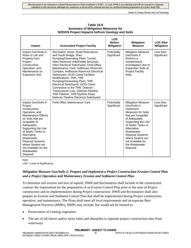
Chapter 16: Geology, Minerals, Soils, and Paleontology
PRELIMINARY – SUBJECT TO CHANGEPRELIMINARY ADMINISTRATIVE DRAFT DECEMBER 2013 59 NORTH-OF-THE-DELTA OFFSTREAM STORAGE PROJECT EIR/EISSAC/395320/111990001 (16-GMSP_PRELIM_ADMIN_DRAFT_DEC2013.DOCX)
Table 16-9Summary of Mitigation Measures for
NODOS Project Impacts to/from Geology and Soils
Impact Associated Project Facility
LOSBefore
MitigationMitigationMeasure
LOS AfterMitigation
Impact Geo/Soils-3:Risks to Life andProperty fromProjectConstruction,Operation, andMaintenance onExpansive Soil
Recreation Areas, Road Relocationsand South Bridge, SitesPumping/Generating Plant, Tunnel,Sites Reservoir Inlet/Outlet Structure,Sites Electrical Switchyard, Field OfficeMaintenance Yard, Holthouse ReservoirComplex, Holthouse Reservoir ElectricalSwitchyard, GCID Canal FacilitiesModifications, TRR, TRRPumping/Generating Plant, TRRElectrical Switchyard, GCID CanalConnection to the TRR, DelevanTransmission Line, Delevan Pipeline,TRR Pipeline, TRR Pipeline Road,Delevan Pipeline Electrical Switchyard
PotentiallySignificant
Mitigation MeasureGeo/Soils-3:Perform aGeotechnicalInvestigation due toExpansive Soils atProject FacilitySites
Less thanSignificant
Impact Geo/Soils-4:ProjectConstruction,Operation, andMaintenance Effectson Soils that areIncapable ofAdequatelySupporting the Useof Septic Tanks orAlternativeWastewaterDisposal Systemswhere Sewers arenot Available for theWastewaterDisposal
Field Office Maintenance Yard PotentiallySignificant
Mitigation MeasureGeo/Soils-4:ImplementMeasures for Soilsthat are Incapableof AdequatelySupporting the Useof Septic Tanks orAlternativeWastewaterDisposal Systemswhere Sewers arenot Available forthe WastewaterDisposal
Less thanSignificant
Note:
LOS = Level of Significance
Mitigation Measure Geo/Soils-2: Prepare and Implement a Project Construction Erosion Control Plan
and a Project Operation and Maintenance Erosion and Sediment Control Plan
To minimize soil erosion and loss of topsoil, DWR and Reclamation shall include in the construction
contract the requirement for the preparation of an Erosion Control Plan prior to the start of Project
construction and its implementation during Project construction. DWR and Reclamation shall also
prepare an Erosion and Sediment Control Plan that shall be implemented during Project construction,
operation, and maintenance. The Plans shall meet all local requirements and incorporate Best
Management Practices (BMPs). BMPs may include, but would not be limited to:
Preservation of existing vegetation
The use of silt fences and/or straw bales and sheetpiles to separate project construction sites from
waterways.
This document is not released as a draft EIR pursuant to CEQA Guidelines § 15087. As such, DWR is not soliciting and will not respond to commentssubmitted on this document, although any comments received will be retained and may be considered during preparation of a future draft EIR.
Chapter 16: Geology, Minerals, Soils, and Paleontology
PRELIMINARY – SUBJECT TO CHANGENORTH-OF-THE-DELTA OFFSTREAM STORAGE PROJECT EIR/EIS 60 PRELIMINARY ADMINISTRATIVE DRAFT DECEMBER 2013
SAC/395320/111990001 (16-GMSP_PRELIM_ADMIN_DRAFT_DEC2013.DOCX)
Covering soil stockpiles with mulch or matting, as well as continuous maintenance of erosion control
measures
PennzSuppress® dust suppressant, or an equivalent product, to stabilize soil during and after
construction
Timely revegetation of disturbed sites to minimize post-construction erosion impacts. The use of
native seeds and plants to assist in the conservation and enhancement of protected species shall be
considered, as required by Section 7(a)(1) of the Endangered Species Act (ESA).
Mitigation Measure SW Qual-1c (2): Prepare and Implement a Stormwater Pollution Prevention Plan
The Project is subject to construction-related stormwater permit requirements of the Clean Water Act
National Pollutant Discharge Elimination System (NPDES) Permit Program. DWR and Reclamation shall
obtain any required permits through the CVRWQCB before any ground-disturbing construction activities
occur. DWR and Reclamation shall prepare and implement a Stormwater Pollution Prevention Plan
(SWPPP) that identifies BMPs to prevent or minimize the introduction of contaminants into surface
waters. BMPs for the Project could include, but are not limited to, silt fencing, straw bale barriers,
diversion ditches, fiber rolls, storm drain inlet protection, hydraulic mulch, and stabilized construction
entrance. The SWPPP shall include development of site-specific structural and operational BMPs to
prevent and control impacts on runoff quality, measures to be implemented before each storm event,
inspection and maintenance of BMPs, and monitoring of runoff quality by visual and/or analytical means.
Mitigation Measure Geo/Soils-3: Perform a Geotechnical Investigation due to Expansive Soils at
Project Facility Sites
A site-specific design-level geotechnical investigation, prepared by a licensed professional, shall be
performed. The geotechnical investigation shall include measures to ensure potential damage related to
expansive soils and non-uniformly compacted fill and engineered fill are minimized. Mitigation options
may range from removal of the problem soils, and replacement, as needed, with properly conditioned and
compacted fill, to design and construction of improvements to withstand the forces exerted during the
expected shrink-swell cycles and settlements. All design criteria and specifications set forth in the
geotechnical investigation shall be implemented to reduce impacts associated with problem soils.
Mitigation Measure Geo/Soils-4: Implement Avoidance Measures for Soils that are Incapable of
Adequately Supporting the Use of Septic Tanks or Alternative Wastewater Disposal Systems where
Sewers are not Available for the Wastewater Disposal
During Project design, Project engineers shall consider the soil types when designing the necessary septic
tank facilities, and shall incorporate and implement measures to accommodate such facilities or their
alternatives. Alternatives could include mound, lagoon, or constructed wetlands systems (University of
Kentucky, 2001).
Implementation of Mitigation Measures Geo/Soils-2, Geo/Soils-3, and Geo/Soils-4 would reduce the
level of significance of Project impacts to geology and soils to less than significant.
16.4.2 Minerals
Because no significant or potentially significant impacts were identified, no mitigation is required or
recommended.
This document is not released as a draft EIR pursuant to CEQA Guidelines § 15087. As such, DWR is not soliciting and will not respond to commentssubmitted on this document, although any comments received will be retained and may be considered during preparation of a future draft EIR.
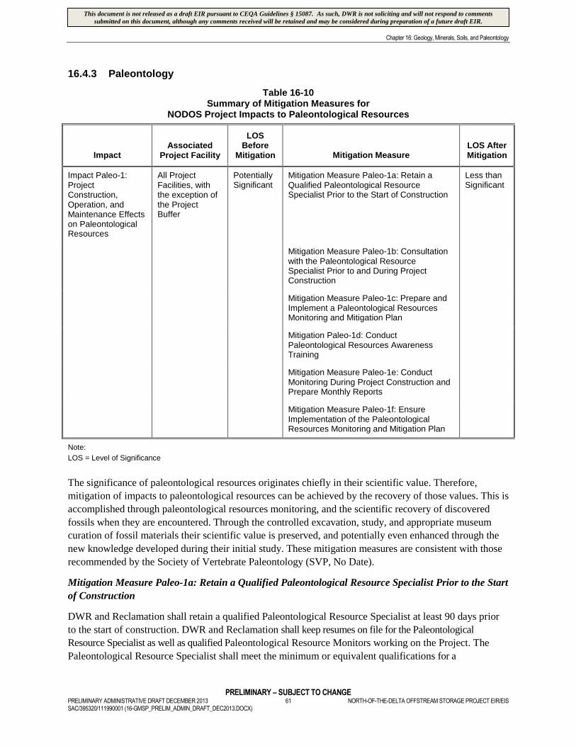
Chapter 16: Geology, Minerals, Soils, and Paleontology
PRELIMINARY – SUBJECT TO CHANGEPRELIMINARY ADMINISTRATIVE DRAFT DECEMBER 2013 61 NORTH-OF-THE-DELTA OFFSTREAM STORAGE PROJECT EIR/EISSAC/395320/111990001 (16-GMSP_PRELIM_ADMIN_DRAFT_DEC2013.DOCX)
16.4.3 Paleontology
Table 16-10Summary of Mitigation Measures for
NODOS Project Impacts to Paleontological Resources
ImpactAssociated
Project Facility
LOSBefore
Mitigation Mitigation MeasureLOS AfterMitigation
Impact Paleo-1:ProjectConstruction,Operation, andMaintenance Effectson PaleontologicalResources
All ProjectFacilities, withthe exception ofthe ProjectBuffer
PotentiallySignificant
Mitigation Measure Paleo-1a: Retain aQualified Paleontological ResourceSpecialist Prior to the Start of Construction
Less thanSignificant
Mitigation Measure Paleo-1b: Consultationwith the Paleontological ResourceSpecialist Prior to and During ProjectConstruction
Mitigation Measure Paleo-1c: Prepare andImplement a Paleontological ResourcesMonitoring and Mitigation Plan
Mitigation Paleo-1d: ConductPaleontological Resources AwarenessTraining
Mitigation Measure Paleo-1e: ConductMonitoring During Project Construction andPrepare Monthly Reports
Mitigation Measure Paleo-1f: EnsureImplementation of the PaleontologicalResources Monitoring and Mitigation Plan
Note:
LOS = Level of Significance
The significance of paleontological resources originates chiefly in their scientific value. Therefore,
mitigation of impacts to paleontological resources can be achieved by the recovery of those values. This is
accomplished through paleontological resources monitoring, and the scientific recovery of discovered
fossils when they are encountered. Through the controlled excavation, study, and appropriate museum
curation of fossil materials their scientific value is preserved, and potentially even enhanced through the
new knowledge developed during their initial study. These mitigation measures are consistent with those
recommended by the Society of Vertebrate Paleontology (SVP, No Date).
Mitigation Measure Paleo-1a: Retain a Qualified Paleontological Resource Specialist Prior to the Start
of Construction
DWR and Reclamation shall retain a qualified Paleontological Resource Specialist at least 90 days prior
to the start of construction. DWR and Reclamation shall keep resumes on file for the Paleontological
Resource Specialist as well as qualified Paleontological Resource Monitors working on the Project. The
Paleontological Resource Specialist shall meet the minimum or equivalent qualifications for a
This document is not released as a draft EIR pursuant to CEQA Guidelines § 15087. As such, DWR is not soliciting and will not respond to commentssubmitted on this document, although any comments received will be retained and may be considered during preparation of a future draft EIR.
Chapter 16: Geology, Minerals, Soils, and Paleontology
PRELIMINARY – SUBJECT TO CHANGENORTH-OF-THE-DELTA OFFSTREAM STORAGE PROJECT EIR/EIS 62 PRELIMINARY ADMINISTRATIVE DRAFT DECEMBER 2013
SAC/395320/111990001 (16-GMSP_PRELIM_ADMIN_DRAFT_DEC2013.DOCX)
paleontological resources manager, as described in the Society of Vertebrate Paleontology guidelines of 1995.
The experience of the Paleontological Resource Specialist shall include the following:
Ability to recognize and collect fossils in the field
Geological and biostratigraphic expertise
Proficiency in identifying vertebrate and invertebrate fossils, and in assessing their scientific
significance
At least three years of paleontological resource mitigation and field experience in California and at
least one year of experience leading paleontological resource mitigation and field activities
DWR and Reclamation shall ensure that the Paleontological Resource Specialist obtains qualified
paleontological resource monitors to monitor Project construction activities, as the Paleontological
Resource Specialist determines necessary on the Project. Paleontological Resource Monitors shall have
the equivalent of the following qualifications:
BS or BA degree in geology or paleontology and one year of experience monitoring in California
AS or AA in geology, paleontology, or biology and four years’ experience monitoring in California
Enrollment in upper division classes pursuing a degree in the fields of geology or paleontology and
two years of monitoring experience in California
Mitigation Measure Paleo-1b: Consultation with the Paleontological Resource Specialist Prior to
and During Project Construction
At least 30 days prior to the start of Project construction, DWR and Reclamation shall provide maps or
drawings to the Paleontological Resource Specialist that show the planned construction footprint. Maps
shall identify all areas of the Project where ground disturbance is anticipated. (Site grading plan and plan
and profile drawings for the utility lines are appropriate for this purpose). The plan drawings shall
show the location, depth, and extent of all ground disturbances affecting paleontologically sensitive
sediment. If Project construction proceeds in phases, maps and drawings may be submitted prior to the start
of each phase. In addition, the proposed schedule of each Project phase shall be provided to the
Paleontological Resource Specialist. Before work commences on affected phases, DWR and
Reclamation shall notify the Paleontological Resource Specialist of any construction phase scheduling
changes. If paleontological resources monitoring is ongoing, DWR and Reclamation shall ensure that the
Paleontological Resource Specialist or Paleontological Resource Monitor consults weekly with the Project
superintendent or construction field manager to confirm area(s) to be worked the following week and
until ground disturbance is completed.
Mitigation Measure Paleo-1c: Prepare and Implement a Paleontological Resources Monitoring
and Mitigation Plan
DWR and Reclamation shall ensure that the Paleontological Resource Specialist prepares a
Paleontological Resources Monitoring and Mitigation Plan (PRMMP) to identify general and specific
measures to minimize potential impacts to significant paleontological resources. Approval of the
PRMMP by DWR and Reclamation shall occur prior to any ground disturbance. The PRMMP shall
function as the formal guide for paleontological resources monitoring, collecting, and sampling activities,
and may be modified by the Paleontological Resource Specialist to accommodate new data or Project changes.
This document is not released as a draft EIR pursuant to CEQA Guidelines § 15087. As such, DWR is not soliciting and will not respond to commentssubmitted on this document, although any comments received will be retained and may be considered during preparation of a future draft EIR.
Chapter 16: Geology, Minerals, Soils, and Paleontology
PRELIMINARY – SUBJECT TO CHANGEPRELIMINARY ADMINISTRATIVE DRAFT DECEMBER 2013 63 NORTH-OF-THE-DELTA OFFSTREAM STORAGE PROJECT EIR/EISSAC/395320/111990001 (16-GMSP_PRELIM_ADMIN_DRAFT_DEC2013.DOCX)
This document shall be used as the basis of discussion when on-site decisions or changes are proposed.
Copies of the PRMMP shall reside with the Paleontological Resource Specialist, each monitor, DWR’s and
Reclamation’s on-site manager, and DWR and Reclamation.
The PRMMP shall be developed in accordance with professional guidelines, and be consistent with
those issued by the Society of Vertebrate Paleontology (SVP, No Date), and shall include, but not be limited
to, the following:
Procedures for the performance and sequence of resource-related tasks, such as any literature searches,
pre-construction surveys, appropriate worker environmental training module, construction monitoring,
mapping and data recovery, discovery situations, fossil preparation and collection, identification and inventory,
preparation of final reports, transmittal of materials for curation, and final report shall be provided in the
PRMMP, including:
A discussion of the geologic units expected to be encountered, the location and depth of the units
relative to the Project, when known, and the known paleontological sensitivity of those units
A discussion of the locations of where the monitoring of Project construction activities is deemed
necessary, and a proposed plan for monitoring and sampling
An explanation of why, how, and how much sampling is expected to take place and in what units,
including descriptions of different sampling procedures that may be used
A discussion of procedures to be followed in the event of a significant fossil discovery, diverting
construction away from a find, resuming construction, and how notifications will be performed
A discussion of equipment and supplies necessary for collection of fossil materials and any specialized
equipment needed to prepare, remove, load, transport, and analyze large-sized fossils or extensive
fossil deposits
Procedures for inventory, preparation, and delivery for curation into a retrievable storage collection in a
public repository or museum, which meet the Society of Vertebrate Paleontology’s standards and
requirements for the curation of paleontological resources
Identification of the institution(s) that will be approached to receive data and fossil materials collected,
and requirements or specifications for materials delivered for curation
The PRMMP shall also provide guidance for preparation of a Paleontological Resources Report by the
designated Paleontological Resource Specialist at the conclusion of ground-disturbing activities that may
affect paleontological resources. The Paleontological Resources Report shall include an analysis of the
collected fossil materials and related information, including a description and inventory of recovered fossil
materials, a map showing the location of paleontological resources encountered, determinations of
sensitivity and significance, and a statement by the Paleontological Resource Specialist that Project impacts to
paleontological resources have been mitigated below the level of significance.
Mitigation Measure Paleo-1d: Conduct Paleontological Resources Awareness Training
Prior to ground disturbance and for the duration of Project construction activities involving ground
disturbance, the Paleontological Resource Specialist shall prepare, and DWR and Reclamation shall
conduct, weekly paleontological resources awareness training for the following workers: project managers,
construction supervisors, forepersons, and general workers involved with or who operate ground-
This document is not released as a draft EIR pursuant to CEQA Guidelines § 15087. As such, DWR is not soliciting and will not respond to commentssubmitted on this document, although any comments received will be retained and may be considered during preparation of a future draft EIR.
Chapter 16: Geology, Minerals, Soils, and Paleontology
PRELIMINARY – SUBJECT TO CHANGENORTH-OF-THE-DELTA OFFSTREAM STORAGE PROJECT EIR/EIS 64 PRELIMINARY ADMINISTRATIVE DRAFT DECEMBER 2013
SAC/395320/111990001 (16-GMSP_PRELIM_ADMIN_DRAFT_DEC2013.DOCX)
disturbing equipment or tools. Workers shall not excavate in paleontologically sensitive sediments prior to
receiving paleontological resources awareness training. Worker training shall consist of a video or in-person
presentation. The paleontological resources awareness training module may be combined with other
training modules prepared for cultural and biological resources, hazardous materials, or other areas of
interest or concern.
The paleontological resources awareness training shall address the possibility of encountering
paleontological resources in the field, the sensitivity and importance of these resources, and legal
obligations to preserve and protect those resources. The training shall include:
A discussion of applicable laws and penalties under the law
Good quality photographs or physical examples of vertebrate fossils
Information that the Paleontological Resource Specialist or Paleontological Resource Monitor has the
authority to halt or redirect construction in the vicinity of a fossil discovery or unanticipated impact to a
paleontological resource
Instruction that employees are to halt or redirect work in the vicinity of a find and to contact their
supervisor and the Paleontological Resource Specialist or Paleontological Resource Monitor
An informational brochure that identifies reporting procedures in the event of a discovery
A certification of completion form signed by each worker indicating that he/she has received the
training
Mitigation Measure Paleo-1e: Conduct Monitoring During Project Construction and Prepare
Monthly Reports
DWR and Reclamation shall ensure that the Paleontological Resource Specialist and Paleontological
Resource Monitor(s) monitor construction excavations consistent with the PRMMP in areas where
potential fossil-bearing materials have been identified, both at reservoir sites and along any constructed
linear facilities associated with the Project. In the event that the Paleontological Resource Specialist
determines full-time monitoring is not necessary in locations that were identified as potentially fossil-bearing
in the PRMMP, the Paleontological Resource Specialist shall notify DWR and Reclamation.
DWR and Reclamation shall ensure that the Paleontological Resource Specialist and Paleontological
Resource Monitor(s) have the authority to halt or redirect construction if paleontological resources are
encountered. DWR and Reclamation shall ensure that there is no interference with monitoring activities, as
directed by the Paleontological Resource Specialist.
DWR and Reclamation shall ensure that the Paleontological Resource Specialist prepares and submits
monthly summaries of monitoring and other paleontological resources management activities. The
summary shall include the name(s) of the Paleontological Resource Specialist or Paleontological Resource
Monitor(s) active during the month, general descriptions of training and monitored construction
activities; and general locations of excavations, grading, and other activities. A section of the report
shall include the geologic units or subunits encountered, descriptions of samplings, if any, and a list of
identified fossils. A final section of the report shall address any issues or concerns about the Project
relating to paleontological resources mitigation activities, including any incidents of non-compliance or any
changes to the monitoring plan by the Paleontological Resource Specialist. If no monitoring took place
during the month, the report shall include an explanation as to why monitoring was not conducted.
This document is not released as a draft EIR pursuant to CEQA Guidelines § 15087. As such, DWR is not soliciting and will not respond to commentssubmitted on this document, although any comments received will be retained and may be considered during preparation of a future draft EIR.
Chapter 16: Geology, Minerals, Soils, and Paleontology
PRELIMINARY – SUBJECT TO CHANGEPRELIMINARY ADMINISTRATIVE DRAFT DECEMBER 2013 65 NORTH-OF-THE-DELTA OFFSTREAM STORAGE PROJECT EIR/EISSAC/395320/111990001 (16-GMSP_PRELIM_ADMIN_DRAFT_DEC2013.DOCX)
Mitigation Measure Paleo-1f: Ensure Implementation of the Paleontological Resources
Monitoring and Mitigation Plan
DWR and Reclamation, through the designated Paleontological Resource Specialist, shall ensure that all
components of the PRMMP are adequately performed during construction.
Implementation of Mitigation Measures Paleo-1a, Paleo-1b, Paleo-1c, Paleo-1d, Paleo-1e, and Paleo-
1f would reduce the level of significance of Project impacts to paleontological resources to less than
significant.
16.5 References
16.5.1 Geology
Brown, R. D. Jr., and E. I. Rich. 1961. Geologic map of the Lodoga quadrangle, Glenn and Colusa
counties, California: United States Geological Survey Oil and Gas Investigations Map OM-210,
scale 1:48,000.
California Geological Survey (CGS). 2000b. GIS Data for the Geologic Map of California, CD 2000-007.
Helley, E. J. and D. S. Harwood. 1985. Geologic map of the Late Cenozoic deposits of the Sacramento
Valley and Northern Sierran Foothills, California: United States Geological Survey
Miscellaneous Field Studies Map MF-179, 5 plates.
Norris, R. M. and R. W. Webb. 1990. Geology of California. New York: John Wiley & Sons, Inc.
16.5.2 Minerals
California Department of Water Resources (DWR). 2002. Sites Reservoir Feasibility Study – Materials
Investigation, Testing, and Evaluation Program.
California Geological Survey. 2000a. A General Location Guide for Ultramafic Rock in California –
Areas More Likely to Contain Natural Occurring Asbestos
California Geological Survey. 2000b. GIS Data for the Geologic Map of California, CD 2000-007.
California Geological Survey (CGS). No Date. California Non-fuel Minerals 2005. Prepared by Susan
Kohler, Senior Geologist, California Geological Survey. Available online at:
http://www.consrv.ca.gov/cgs/minerals/min_prod/Documents/non_fuel_2005.pdf. Accessed June,
2011.
Colusa County. 1989. Colusa County General Plan – Land Use Element. Available online at:
http://countyofcolusageneralplan.org/sites/default/files/backgrounddox/1989%20General%20Plan
/4._Accessed June 2011.
Glenn County. 1997. Glenn County – Aggregate Resource Management Plan, Initial Phase Report.
Available online at: http://gcplanupdate.net/document_library/documents/ARMP.pdf
16.5.3 Soils
Begg, E. L. 1965. Soils of Glenn County, California. University of California, Davis. Available online at:
http://soils.usda.gov/survey/online_surveys/california/glennCA1968/glennCA1968-I.pdf
This document is not released as a draft EIR pursuant to CEQA Guidelines § 15087. As such, DWR is not soliciting and will not respond to commentssubmitted on this document, although any comments received will be retained and may be considered during preparation of a future draft EIR.
Chapter 16: Geology, Minerals, Soils, and Paleontology
PRELIMINARY – SUBJECT TO CHANGENORTH-OF-THE-DELTA OFFSTREAM STORAGE PROJECT EIR/EIS 66 PRELIMINARY ADMINISTRATIVE DRAFT DECEMBER 2013
SAC/395320/111990001 (16-GMSP_PRELIM_ADMIN_DRAFT_DEC2013.DOCX)
University of Kentucky, Cooperative Extension Service. 2001. Alternatives to Traditional Septic Systems.
U.S. Department of Agriculture, Natural Resources Conservation Service (NRCS). 2006. Soil Survey of
Colusa County, California.
U.S. Department of Agriculture, Natural Resources Conservation Service (NRCS). 2011. National Soil
Survey Handbook. Available online at:
http://soils.usda.gov/technical/handbook/contents/part614.html#06. Accessed April 2011.
16.5.4 Paleontology
Blake, M. C., Jr., E. J. Helley, A. S. Jayko, D. L. Jones, and H. N. Ohlin. 1992. Geologic map of the
Willows 1:100,000 quadrangle, California. Open-file Report OF 92-271. U.S. Geological Survey,
Menlo Park, CA.
Dickinson, W. R. and E. I. Rich. 1972. Petrologic intervals and petrofacies in the Great Valley sequence,
Sacramento Valley, California. Geological Society of America Bulletin 83: 3007-3024.
Dundas, R. G. and L. M. Cunningham. 1993. Harlan’s ground sloth (Glossotherium harlani) and a
Columbian mammoth (Mammuthus columbi) from Stevenson Bridge, Yolo County, California.
PaleoBios, v. 15 (3), pp. 47-62.
Hansen, R. O. and E. L. Begg. 1970. Age of Quaternary sediments and soils in the Sacramento area,
California by uranium and actinium dating of vertebrate fossils. Earth and Planetary Science
Letters 8:411-419.
Haggart, J. W. and P. D. Ward. 1984. Late Cretaceous (Santonian-Campanian) stratigraphy of northern
Sacramento Valley, California. Geological Society of America Bulletin 95: 618-627.
Helley, E. J. and D. S. Harwood. 1985. Geologic map of the late Cenozoic deposits of the Sacramento
Valley and Northern Sierran Foothills, California: U.S. Geological Survey Miscellaneous Field
Studies Map MF-179, 5 plates.
Hilton, R., D. C. Daily, and H. G. McDonald. 2000. A Late Pleistocene biota from the Arco Arena site,
Sacramento, California. PaleoBios 20: 7–12.
Ingersoll, R. V. 1979. Evolution of the Late Cretaceous forearc basin, northern and central California.
Geological Society of America Bulletin 90: 813–826.
Jones, D. L. 1966. New Upper Cretaceous ammonite, Protexanites thompsoni, from California. Journal of
Paleontology 40:199–203.
Norris, R. M. and R. W. Webb. 1990. Geology of California. New York: John Wiley and Sons.
Oqvist, C. R. n.d. Surface and Bedrock Geology of the Stebbins Cold Canyon Reserve Area, Vaca
Mountains, Solano County, California. University of California, Davis. Available online at:
http://nrs.ucdavis.edu/stebbins/natural/geo_report.htm
Paleobiology Database, n.d. Available online at: http://paleodb.org/cgi-
bin/bridge.pl?user=Guest&action=displayHomePage
This document is not released as a draft EIR pursuant to CEQA Guidelines § 15087. As such, DWR is not soliciting and will not respond to commentssubmitted on this document, although any comments received will be retained and may be considered during preparation of a future draft EIR.
Chapter 16: Geology, Minerals, Soils, and Paleontology
PRELIMINARY – SUBJECT TO CHANGEPRELIMINARY ADMINISTRATIVE DRAFT DECEMBER 2013 67 NORTH-OF-THE-DELTA OFFSTREAM STORAGE PROJECT EIR/EISSAC/395320/111990001 (16-GMSP_PRELIM_ADMIN_DRAFT_DEC2013.DOCX)
Rich, E. I. 1971. Geologic map of the Wilbur Springs Quadrangle, Colusa and Lake Counties, California.
Miscellaneous Geological Investigations Map I-538, U.S. Geological Survey, Menlo Park, CA.
Sierra College. 2007. Giant fossil tortoise found near Red Bluff. Accessed online August 10, 2011 at:
http://www.sierracollege.edu/EventsAtheletics/NatHistMus/exhibitsIn/gisantTort.htm.
Society of Vertebrate Paleontology (SVP). n.d. Assessment and Mitigation of Adverse Impacts to
Nonrenewable Paleontologic Resources: Standard Guidelines. Available online at:
http://vertpaleo.org/The-Society/Governance-Documents/Conformable-Impact-Mitigation-
Guidelines-Committee.aspx
Society of Vertebrate Paleontology (SVP). 2010. Standard Procedures for the Assessment and Mitigation
of Adverse Impacts to Paleontological Resources. Available online at:
http://vertpaleo.org/PDFS/24/2482305f-38f8-4c1b-934c-1022d264e621.pdf
Squires, R. L. 2004. Pseudomelaniid gastropod Paosia from the marine Cretaceous of the Pacific slope of
North America and a review of the age and paleobiogeography of the genus. Journal of
Paleontology 78:484–500.
University of California Museum of Paleontology (UCMP). n.d. University of California Museum of
Paleontology (UCMP) Online Database. Available online at:
http://ucmpdb.berkeley.edu/loc.html.
U.S.D.I. Bureau of Land Management. 2008. Potential Fossil Yield Classification System FOR
Paleontological Resources on Public Lands. Instructional Memorandum 2008-009. Washington,
D.C.
Wahrhaftig, C. and J. H. Birman. 1965. The Quaternary of the Pacific mountain system in California. In
The Quaternary of the United States, edited by H. E. Wright, Jr., and D. G. Frey, pp. 299–340.
Princeton University Press, New Jersey.
This document is not released as a draft EIR pursuant to CEQA Guidelines § 15087. As such, DWR is not soliciting and will not respond to commentssubmitted on this document, although any comments received will be retained and may be considered during preparation of a future draft EIR.

F igures
This document is not released as a draft EIR pursuant to CEQA Guidelines § 15087. As such, DWR is not soliciting and will not respond to commentssubmitted on this document, although any comments received will be retained and may be considered during preparation of a future draft EIR.
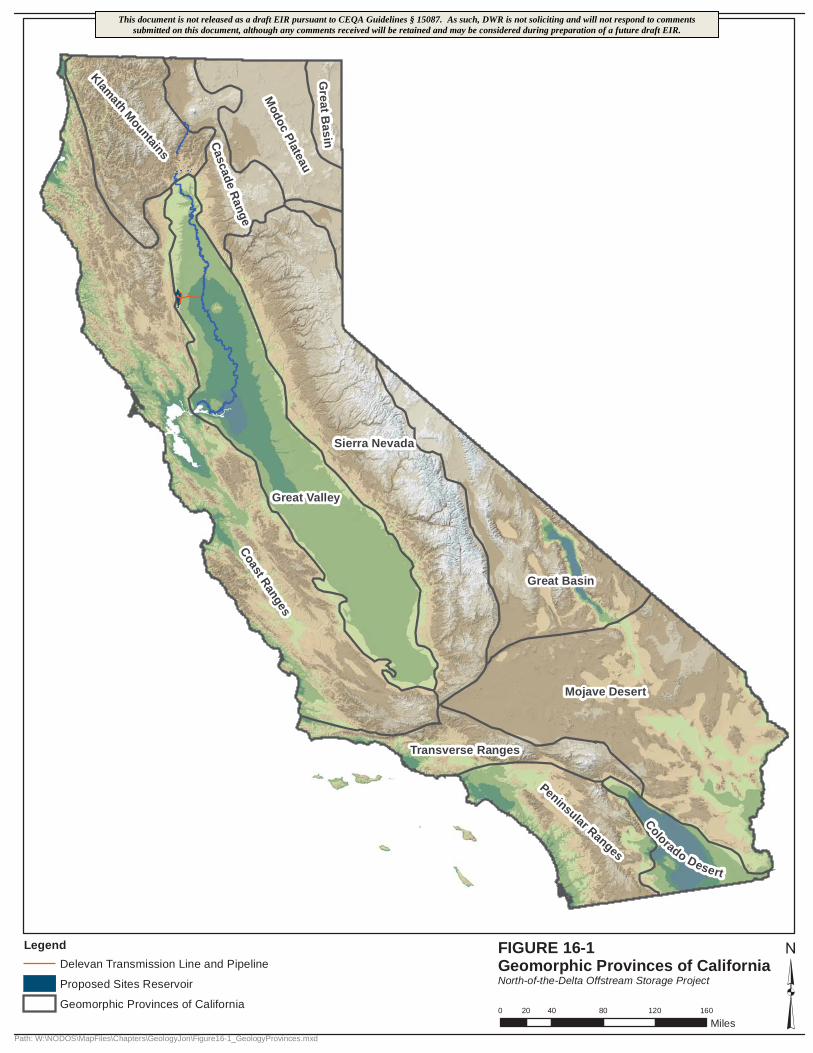
Klamath Mountains
Great Valley
Great Basin
Sierra Nevada
Grea t B
as in
Modoc
Plateau
Cascade Range
Coast Ranges
Transverse Ranges
Peninsular Ranges
Colorado Desert
Mojave Desert
0 40 80 120 16020
Miles
FIGURE 16-1Geomorphic Provinces of CaliforniaNorth-of-the-Delta Offstream Storage Project
Path: W:\NODOS\MapFiles\Chapters\GeologyJon\Figure16-1_GeologyProvinces.mxd
LegendDelevan Transmission Line and Pipeline
Proposed Sites Reservoir
Geomorphic Provinces of California ³
This document is not released as a draft EIR pursuant to CEQA Guidelines § 15087. As such, DWR is not soliciting and will not respond to commentssubmitted on this document, although any comments received will be retained and may be considered during preparation of a future draft EIR.
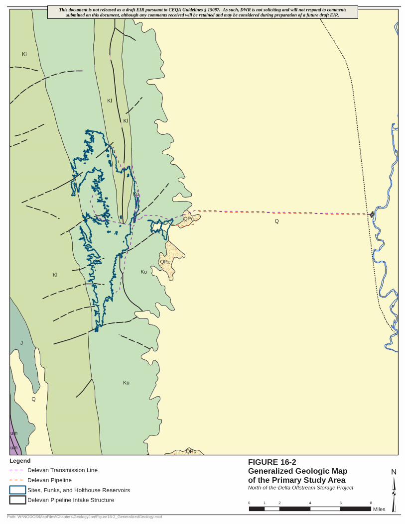
Q
QPc
Ku
Kl
Kl
Kl
Kl
J
um
QPc
Ku
QPc
Ku
Q
umQPc
0 2 4 6 81
Miles
FIGURE 16-2Generalized Geologic Map of the Primary Study Area North-of-the-Delta Offstream Storage Project
Path: W:\NODOS\MapFiles\Chapters\GeologyJon\Figure16-2_GeneralizedGeology.mxd
LegendDelevan Transmission Line
Delevan Pipeline
Sites, Funks, and Holthouse Reservoirs
Delevan Pipeline Intake Structure ³
This document is not released as a draft EIR pursuant to CEQA Guidelines § 15087. As such, DWR is not soliciting and will not respond to commentssubmitted on this document, although any comments received will be retained and may be considered during preparation of a future draft EIR.
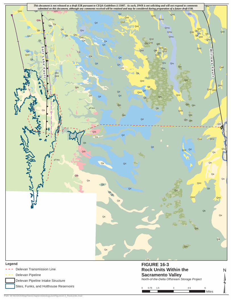
((((
((((
((((
((((
((((
((((
((((
((((
((F
F
M
M
Qrl
QruQml
Qsc
Qa
Qml
QbQm
Qa
Qb
pTms
QmlQru
Qml
Qml
pTms
Qa
Qrl
Qb
Qml
Qb
Qb
QruQb
QmlQb
Qml
Qml
Qml
Qsc
Qa
Qa
Qa
Qrl
Qa
Qrb
Qb
Qb
Qb Qrl
QbQml
Qrb
Qrl
Qml
Qrb
Qb
Qrb
Qrb
Qrl
QrlQa
pTms
Qa
Qrb
Qb
Qa
Qru
Qru
Qrl
Qru
Qml
Qml
Qml Qml
Qm
Qml
Qm
Qm Qm
Qml
Qm
Qm Qm
Qrl
Qa
Qa
Qrl
QmQml
Qmu
Qmu
Qmu
Qmu
QmlQml
QrlQmlQrl
Qrl
Qml
Qml Qm
Qm
QmlQm
QmlQmQml
Qb
Qb
Qml
QmlQrl
Qb
QaQrl
Qrl
Qb
Qml
Qm
Qml
Qml
QrlQml
QrlQa
Qml Qru
Qm
Qm
Qrl
Qrl
Qa
Qru
Qru
Qru
Qb
QmlQmlQb
Qa
Qa
Qa
Qm
Qm
Qa
Qa
Qa
0 1.5 3 4.5 60.75
Miles
FIGURE 16-3Rock Units Within the Sacramento ValleyNorth-of-the-Delta Offstream Storage Project
Path: W:\NODOS\MapFiles\Chapters\GeologyJon\Figure16-3_RockUnits.mxd
LegendDelevan Transmission Line
Delevan Pipeline
Delevan Pipeline Intake Structure
Sites, Funks, and Holthouse Reservoirs ³
Wi l l o
ws
Fa
ul t
Sa
l t La
ke
Fa
ul t
This document is not released as a draft EIR pursuant to CEQA Guidelines § 15087. As such, DWR is not soliciting and will not respond to commentssubmitted on this document, although any comments received will be retained and may be considered during preparation of a future draft EIR.