Embed Size (px)
Citation preview

Journal of Archaeological Method and Theory, Vol. ~ No. 1, 1995
Geoarchaeological Perspectives on Paleolandscapes and Regional Subsurface Archaeology
C. Russell Stafford 1
This paper explores geoarchaeological approaches to regional-scale research in dynamic landscapes. Landscape element, a spatial concept from landscape ecology, and the archaeological notion of place are integrated with geomor- phological models of landscape evolution. A distributional or non-site ap- proach to the subsurface archaeological record is argued to be most consist with a dynamic view of landscapes. Regional geomorphological studies are shown to be crucial, given the volume of sediment that needs to be searched, in developing efficient subsurface sampling strategies. Various subsurface re- covery techniques are reviewed, including the potential use of microartifacts to increase the effectiveness of small bulk samples in sampling the buried archae- ological record.
KEY WORDS: geoarchaeology; landscape ecology; paleolandscapes; microartifacts.
INTRODUCTION
Geoarchaeology, by employing earth science techniques and methods, has commonly focused on site-specific studies of depositional context and formation processes. Investigations have often been expanded to include the reconstruction of a site's local or regional geoenvironmental context (e.g., Butzer, 1977). Studies of archaeological settlement systems that have centered on a landscape approach (Rossignol and Wandsnider, 1992) or ones that encompass the regional archaeological record (Dunnell and Dancey, 1983; Ebert, 1992), rather than just individual sites, require a re- gional geoarchaeological viewpoint from the beginning.
1Department of Geography, Geology, and Anthropology, Indiana State University, Terre Haute, Indiana 47809.
69
1072-5369/95/0300-0069507.50/0 © 1995 Plenum Publishing Corporation

70 Stafford
Many, if not most, regions have been geomorphically dynamic during the Quaternary with only some fraction of past landform surfaces coinci- dent with the modern surface (e.g., Bettis, 1992; Stafford and Hajic, 1992). While archaeological remains occur at the surface, a significant portion of the record may be buried, a factor not fully incorporated into most land- scape-oriented studies. The view taken here and by others (DunneU, 1992; Schiffer, 1987; Stafford and Hajic, 1992; Stein, 1987) is that once discarded, artifacts become a part of the sedimentary record of a region. To determine the structure and context of that regional record, it is necessary to under- stand the landscape evolution of a region and the positional status of ar- tifacts in the sedimentary matrix. Therefore, a regionwide study of the archaeological record in a changing landscape requires both regional-scale geoarchaeological investigations and subsurface recovery strategies.
In this paper I address two general issues that arise in the implemen- tation of a regional approach in a dynamic landscape. The first issue, which stems from Butzer's (1980) contextual approach, concerns developing theo- retical linkages between geomorphological analysis of landscapes and mod- els that examine relationships between prehistoric settlement strategies and landscape structure and change. Landscape ecology, which focuses on spa- tiotemporal environmental heterogeneity of landscapes at various scales, provides several of these links. A better understanding of the regional spa- tial structure of the archaeological record is possible using some of the conceptual tools of landscape ecology that consider landscape structure.
The second issue, which is a logical development from the first, centers on collecting a regional record of landscape use. Though the potential for bias in regional settlement patterns owing to differential burial and pres- ervation has been long recognized (e.g., Butzer, 1960; Dekker and de Weerd, 1973), only recently has it become common to develop three-di- mensional geomorphic maps of buried site potential (e.g., Bettis, 1992; Ha- jic, 1987; Johnson and Logan, 1990). Once this information is available, archaeologists are still faced with the difficult task, given the volume of sediment that may need to be searched in many regions, of selecting ap- propriate sampling strategies and recovery techniques suitable for investi- gating the deeply buried archaeological record. In this regard, issues addressed here include the utility of the site concept in the context of bur- ied land surfaces, a geomorphic approach to regional stratification for sam- piing, choices among subsurface recovery techniques, and accessing the potential of microartifacts in sampling buried contexts. Though most case examples pertain to alluvial settings in the eastern United States, the dis- cussions have wider applicability.

Geoarchaeological Perspectives on Paleolandscapes 71
LANDSCAPES
Numerous studies by archaeologists and other anthropologists (e.g., Binford, 1980, Bettinger, 1991; Winterhalder and Smith, 1981) since Stew- ard's (1938) seminal work a half century ago leave little doubt that human foraging and settlement strategies are a partial function of the ecological structure of a landscape as reflected in the distribution of energy and nu- trients in time and space (Winterhalder, 1980). Butzer (1982; also Hassan, 1985) has explicitly shown how geoarchaeology can provide the environ- mental context necssary to understand human decision-making in particular ecosystems. More mobile populations like hunter gatherers or pastoralists may be affected to a greater extent than horticulturists or agriculturalists by short-term fluctuations; but even sedentary groups must cope with het- erogeneous landscapes. Landscapes are multidimensional phenomena de- fined by the research problems posed; there is no one landscape. As with other generic terms, definitions of landscape are many, ranging from the artist 's view of scenery to cultural landscapes in human geography (Schreiber, 1990; Naveh and Lieberman, 1990). Some are useful scientific concepts, others are not. Different approaches to landscapes are evident in archaeology as well. For instance, compare the ecologically oriented studies in Rossignol and Wandsnider (1992) with the meaning of landscape of Crumley and Marquardt (1990) or Green (1990). Winterhalder (1980, p. 53) provides the following ecologically based definition:
Environmental qualities which define patchiness for terrestrial organisms can be termed landscape.. .and include landform (geomorphology, and geological parent materials), soils, vegetation and vegetation physiognomy, and micro- or local cli- mate. . .Features of landscape combine with animal distributions to give a locality a particular adaptive quality related to both the resources and hazards found there and to the impediments that landscape structure places between the organism, its resources, and its predators and conspecifics.
This is essentially the view taken by landscape ecologists who focus on land- scape heterogeneity (Risser et al., 1984; Urban et a t , 1987). Whereas tra- ditional ecology (including ecological anthropology; see Winterhalder, 1980) has centered on vertical relationships (i.e., homogeneous ecosystems), landscape ecology deals explicitly with horizontal ecosystem patterns and process at different scales.
Landscape Ecology
An emerging discipline, landscape ecology first developed in central and eastern Europe (Schreiber, 1990), where the term was coined by Troll (1950), the German biogeographer. Early on he recognized the potential

72 Stafford
of aerial photography in landscape interpretations (Naveh and Lieberman, 1990, p. 4). Development in Europe has been closely tied to landscape planning and architecture, while in the United States there has been a de- cidedly bioecological orientation (Naveh and Lieberman, 1990; Schreiber, 1990; Forman, 1990). In either case biotic and abiotic processes, specifically material cycles and energy flow between ecosystems making up a landscape, have been of interest. As a result, landscape ecology is expressly interdis- ciplinary, involving biological and geological sciences as well as other dis- ciplines such as geography (Schreiber, 1990, p. 23).
As Turner (1989, p. 173) suggests, landscape ecology is concerned with the structure, function, and change in spatial clusters of ecosystems. Struc- ture refers to the spatial distribution of energy, materials, and species rela- tive to the sizes, shapes, numbers, kinds, and configurations of ecosystems. Function is the interaction between these minimal spatial components and change refers to alterations of their structure and function through time.
Landscape ecology's focus on heterogeneous environments, traditionally ignored by the biological sciences, has also led to enhancements to patch- based models in foraging theory that had previously considered only simple internally homogeneous systems (Risser et al., 1984, p. 8; Johnson et al., 1992; Senft et al., 1987). Landscape ecology has proved useful in modeling environmental heterogeneity, where the foraging behavior of animals like large herbivores had been problematical in conventional foraging theory (Senft et al., 1987). Large herbivores interact with forage resources at dif- ferent temporal and spatial scales (Senft et aL, 1987, p. 789), as opposed to typical predator-prey relationships in optimal foraging theory where envi- ronmental constraints are simplified (Stephens and Krebs, 1986). Landscape ecology deals with patch size, shape, juxtaposition, and presence or absence of corridors not typically a part of patch-based models (Johnson et al., 1992, p. 68). Archaeological models of hunter-gatherers have often been derived from classical optimal-foraging theory (see Bettinger, 1991), which may re- sult in an oversimplification of the landscape that human foragers face. Landscape ecology provides conceptual tools that at least better describe landscape structure that may be important in understanding prehistoric for- aging strategies and decision making (e.g., Stafford and Hajic, 1992).
For instance, Stafford (1994) examines the relationship between land- scape structure and Archaic hunter-gatherer settlement strategies in south- western Indiana by analyzing the association between hafted biface location and proximity to streams of different order within, drainage networks. In this study, streams were viewed as corridors that provide access to resource patches and differential stream orders were argued to be proxies for re- source patch structure. Drainage patterns represent relatively stable aspects of the landscape in comparison to say vegetation and serve as relative in-

Geoarchaeological Perspectives on Paleolandscapes 73
dicators of habitat or patch differences within basins. Marked shifts in the location of hafted bifaces within drainage basins were found to have taken place between the early and middle Holocene. The survey sampled an en- tire physiographic province (Wabash Lowland), allowing the examination of land use at a geographic scale consistent with the mobility strategies of Archaic hunter-gatherers.
Landscape Elements
Landscape ecology provides an explicit means of analyzing the struc- ture of landscapes. Landscape elements (also called ecotopes or cells, among other terms) are a fundamental unit of analysis, which represent minimal homogeneous parcels of land (Forman and Godron, 1986, pp. 11- 12; Zonneveld, 1990, p. 14). It is vertically defined by land attributes (rock, soil, landform, vegetation, climate, animals, etc.) (Zonneveld, 1990, p. 13), which are distributed at various scales. In theory, landscape elements are discrete ecosystems, though pragmatically they represent a tract of land where at least one land attribute (e.g., landform, soil, or vegetation) is ho- mogeneous (Zonneveld, 1990, p. 14). As an analytical unit, they form the basis by which landscape structure can be defined.
Landscape elements are defined in relation to an organism's size, mo- bility, and habits (Stafford and Hajic, 1992, p. 139; also Winterhalder, 1980, p. 152). In terms of prehistoric hunter-gatherer settlement strategies, for example, landscape elements can be defined on the basis of land attributes likely to affect (positively and negatively) mobility strategies or positioning tactics in a given environment (which would be at least partially different from horticulturalists, for instance). Landscape elements may be definable as resource patches on the basis of specific food or other resources they contain or by topographic characteristics that affect drainage or exposure and, therefore, their potential uses for particular tasks. They are similar to the minimal spatial units used in GIS analyses [e.g., Warren (1990, p. 204) uses cells 25 m on a side as a basic observational unit; also Kvamme (1989, pp. 151-153)].
Place (cf. Binford, 1982; Chang, 1992; Schlanger, 1992; Stafford and Hajic, 1992) is a systemic concept, defined here as a subset of landscape elements with appropriate size and land attributes to serve as stopping points on the landscape. They are characterized primarily by their small- scale attributes associated with landforms and medium-scale attributes, re- flecting their proximity to landscape elements containing targeted resources. The frequency and spatial arrangement of landscape elements with high probabilities of serving as stopping points will in part determine

74 Stafford
the pattern of landscape use and reuse. For instance, many high probability elements or places may be contiguously distributed in linear patterns (e.g., natural levee), or at the other extreme, isolated points (e.g., rockshelter) on the landscape. This is the underlying factor that generates variance in what Dewar and McBride (1992, p. 234) call spatial congruence of a se- quence of occupations in the long term. Though other factors like the con- struction of facilities affect reuse of a specific place in the short term (Dewar and McBride, 1992), it is the spatial structure of landscape ele- ments that produce the spatial structure of the archaeological record in the long term. In fact, long-term processes are likely to generate the domi- nant patterns in a cumulative regional record.
Place use is determined empirically, by sampling the distribution of artifacts across a defined landscape. The observed variance in the density of artifacts indicates in which landscape elements cultural deposition took place. The objective is not to identify individual places (or sites), but to determine how artifact spatial structure at a landscape scale is correlated (or not) with types of landscape elements. This is essentially an extension of the approach advocated by Dunnell and Dancey (1983, pp. 273-274), but deals with artifacts and landscape spatial structure at a smaller scale.
Figure 1 depicts the hypothetical distribution of probabilities based on an estimate of the distribution and relative density of Middle Archaic re- mains generated over a 4000-year period, recovered in sample locations (Stafford and Hajic, 1992; Wiant et al., 1983) in a reach of the lower Illinois River. The paleolandscape reconstruction by Styles (1985) and Hajic (1987) represents the early to middle Holocene (ca. 8000-5000 BP). The likelihood of landscape element use is indicated by shading. The character and spatial distribution of landscape elements result in different patterns of reuse over time, hence the spatial distribution of artifacts differs among landforms. Linearly arranged elements on natural levees and the edge of terraces are in proximity and parallel the distribution of aquatic resource patches. In- tensity of use is reflected in the type of aquatic patch (river channel vs stagnate marsh or backwater).
The uplands contained resource patches distinctive from those in the river valley (nuts and deer vs fish, shellfish, and waterfowl). In both cases, landscape elements with similar landform attributes are ubiquitous but the spatial arrangement is dissimilar. Landscape element structure is a planar arrangement in the uplands verses a linear one along the edges of terraces and on natural levees. Stafford and Hajic (1992) found that in the uplands artifact densities were on average low, with a generally low but variable spatial association between tools (primarily halted bifaces) and debitage concentrations; whereas on the edges of terraces and natural levees artifact densities were higher, with substantial and consistent spatial correlations.

/
N,
NL
\
KsT
KST
• VE
RY HI
GH
• HI
GH
i ~
PALE
OCH
ANNE
LS
~ 1
B
VE
RY
Low
N
o
= K
M
gl"
hi
-1
~ig.
1.
Map
of
geom
orph
ic s
urfa
ces
and
rela
tive
prob
abil
itie
s of
lan
dsca
pe e
lem
ents
ser
ving
as
stop
ping
poi
nts
(pla
ces)
in
a po
rtio
n of
the
low
er
'Jlin
ois
Riv
er v
alle
y. K
ey: A
lluvi
al fa
ns (
AF)
, Bat
h T
erra
ce (
BT
), K
each
Sch
ool T
erra
ce (
KST
), n
atur
al l
evee
(N
L),
tri
buta
ry v
alle
y (T
R),
upl
ands
IU
P) (
base
d on
Haj
ic,
1987
, pl
ate
3).
Tri
buta
ry p
roba
bili
ties
are
not
map
ped,
thou
gh v
alle
y si
de s
lope
s ca
n ha
ve a
hig
h po
tent
ial
to c
onta
in
~urie
d ar
chae
olog
ical
dep
osit
s (s
ee S
taff
ord
and
Haj
ic,
1992
); al
so,
floo
dbas
in a
nd p
aleo
chan
nels
hav
e an
ass
ocia
ted
low
pro
babi
lity.
76 Stafford
As the landscape changed by the late Holocene, probabilities associated with landscape elements also shifted, resulting in differential distributions of younger artifacts (e.g., Woodland period).
CoUuvial fans, in contrast, represent point locations on the landscape that occur at significantly lower frequencies. Colluvial fan surfaces that date to the middle Holocene are currently buried more than a meter below the modern surface. They are also located in a strategic location for hunter- gatherers at the interface of floodplain and upland environments. Because of these factors, places on colluvial fans were frequently reused, producing complex stratigraphic records of successive occupations through the early and middle Holocene (Wiant et al., 1983; Hajic, 1990a). Early to middle Holocene deposition on fans tended to result in stratified archaeological deposits. Successive occupations-in upland or foodplain locations, on the other hand, result in conflated or palimpsest assemblages. Understanding the change in spatial structure of landscape elements and their change through time is a key to understanding the regional distribution of artifacts.
A Geomorphic Landscape
Ecosystems that made up landscapes used by prehistoric groups are not necessarily preserved in the modern landscape. While palynology and dendroclimatology may provide reconstructions of large-scale climatic vari- ability, geomorphology contributes the most direct evidence of small- and large-scale variations in paleolandscapes; its focus is on earth surface proc- esses and more precisely the evolution of landforms through process-re- sponse models (Davidson, 1985; Schumm, 1973; Schumm et al., 1987). Landforms and geologic processes are significant agents in regulating eco- system structure and function by controlling the flow of materials and en- ergy (water, dissolved material, organic and inorganic particulate matter) across a landscape (Risser, 1990; Swanson et al., 1990). Specific controlling factors associated with landforms are as follows (Rohdenburg, 1989, pp. 1-2): (1) Slope angle and aspect influence the radiation balance; (2) the land surface is the principal exchange surface within the water balance sys- tem influencing the ratio of runoff to infiltration and, hence, soil erosion and nutrient loss; and (3) decomposition of organic debris and soil horizon formation in turn influence nutrient transfer and germination of plants. In general, landforms exert a strong influence, both directly and indirectly, on the character of the landscape. Given this, we can expect that a geomorphic analysis can provide data on landscape structure that is directly relevant to past landscape elements.
Geoarchaeological Perspectives on Paleolandscapes 77
As defined by Ruhe (1969, p. 5), a geomorphic landscape is the sum of various kinds of landforms. Both landforms and landscapes can be viewed at various scales, ranging from very large to very small features. Within this context, landscape elements are minimal spatial units with ho- mogeneous geomorphic and topographic characteristics (Stafford and Ha- jic, 1992, p. 140). Any one landform may contain many landscape elements of the same or different types.
Quaternary landscapes, however, are typically dynamic and, therefore, geomorphological analysis centers on landscape evolution (Waters, 1992). As landforms are changed by land-surface processes, the character or at- tributes of associated landscape elements also change. The probabilities that a landscape element will serve as a stopping point on the landscape (a place) may shift dramatically through time as the surrounding landscape changes. These changes may be climatically induced or be a function of geomorphic dynamics associated with internal thresholds (Schumm, 1973). An example of such changes is seen on distal alluvial fans in the upper Mississippi River valley (Stafford et al., 1992).
Although rates of deposition on alluvial fans in the Midwest have been linked to Holocene climate change associated with the Hypsithermal, fans als0 exhibit an internal dynamic characterized by fanhead trenching, lateral channel migration, and channel backfilling. Geoarchaeological studies in the northern Sny Bottom of the Mississippi River valley found that channel avulsion, which involves the sudden abandonment of part or a whole me- ander belt for a new lower base level (Allen, 1965, p. 119), was common on distal portions of large low gradient fans produced by abrupt changes in gradient as tributary streams enter the valley trench. In this case a new distal fan lobe progrades a Mississippi river floodbasin. This sudden repo- sitioning of the tributary stream resulted in changing landforms and vege- tation succession that produced concomitant change in the probabilities of cultural deposition associated with landscape elements on the fan lobe.
Four phases of landform development, spanning the period 2800 to 1800 BP, were identified (Stafford et aL, 1992, p. 293): (1) establishment of a new channel resulting in overbank sheet floods and levee construction, (2) local breaching of the natural levee, resulting in crevasse splays near the channel, and (3) development of crevasse channels across splay/levee deposits, with (4) channel avulsion occurring as the gradient between the distal fan lobe and the floodbasin increased and permanent crevasse chan- nels formed. Vegetation succession also accompanied these geomorphic changes with a shift from a Fraxinus-dominated association to a mesophytic forest and, finally, to prairie after channel avulsion (Stafford et aL, 1992, pp. 302-307). Geomorphic processes led to dramatic changes in local eco- systems in distal fan locations.

78 Stafford
These small-scale landscape changes affected the probability of land- scape element use. Figure 2 illustrates estimated probabilities of cultural deposition based on densities of remains recovered and reconstructions of geomorphic surfaces (Stafford, 1992b). Little, if any, cultural deposition takes place when a floodbasin and initial splay and proto-levee deposits were laid down by the new channel. Once a relatively well drained surface on the levee had emerged, and crevasse channels were established, this location began to serve as a stopping point for short-term Early Woodland residential camps. Landscape elements with similar attributes are distrib- uted linearly along the distal fan lobe. Widely scattered Early Woodland artifacts and features indicate sporadic use of places along the active chan- nel and near crevasse channels over a 700-year period. Cultural deposition nearly ceased once the channel avulsed and the fan lobe was abandoned around 1800 BP.
The previous example shows how small-scale landscape changes can affect place use and, therefore, change the density of cultural remains through time. The use of a place is a function not only of the land attributes of elements, but of their relationship to surrounding landscape elements containing specific resource patches that enhance or reduce the probability of place use. Reconstructing the structure of paleolandscapes based on minimal homogeneous spatial units, like landscape elements, leads to a con- sideration of the entire landscape, rather than simply those locations where place use is evident (i.e., sites). Knowledge of the distribution of elements among landforms that have the potential to serve as places provides a bet- ter understanding of the processes that generated the spatial patterning of cultural remains across landscapes.
THE ARCHAEOLOGICAL RECORD AND BURIED LANDSCAPE SURFACES
The prior discussion strongly points to a distributional or nonsite ap- proach to the archeological record. Such approaches have focused on re- gional patterns of landscape use (Dunnell and Dancey, 1983, Ebert, 1992; Foley, 1981; Thomas, 1975), where artifacts rather than sites are viewed as the fundamental unit of observation. Artifacts are assumed to be more or less continuously distributed over the landscape (Dunnell and Dancey, 1983, p. 272; see also Dunnell, 1992), and data recovery is oriented toward sampling variation in artifact density and function (Dunnell, 1992; Ebert, 1992).
Though the site concept is viewed as flawed in this approach, discus- sion has centered primarily on its inappropriateness in surface contexts.

Geoarchaeological Perspectives on Paleolandscapes 79
2700 BP 1500 BP
m
l-- z m w ...i LU m Q. < 0 a Z 5 u. 0
,.1 g ii1 0 E a.
1.0
o , _
0.0 l._
FLOODBASIN
I L _t . . . . . . . . . . . . . .
NEW CHANNEL CREVASSE CHANNEL & LEVEE CHANNELS & AVULSION DEVELOPMENT UPPER LEVEE
FORMATION
Fig. 2. Estimated probability of landscape element use during stages of land- form development on a distal alluvial fan in the upper Mississippi River valley.
Thorough treatment of its status and alternatives can be found elsewhere (e.g., Dunnell, 1992). Some may argue, however, that although the surface archeological record may be accretional, among other ontological and epis- temological problems, buried archaeological remains reflect sealed contexts and therefore surmount these shortcomings. Yet the buried archaeological record is generally subject to many of the same processes that affect the modem surface record (Durmell and Dancey, 1983; Dunnell, 1992, p. 35). Because of the rather long depositional hiatus or at least slow rates of alluviation necessary for soils to develop on land surfaces, artifacts in buried paleosols can and usually do reflect long-termaccumulations [several hun- dred to thousands of years (Birkeland, 1984, p. 203; Holiday et al., 1993, p. 34)]. Further, bioturbation or other disturbance processes associated with soil development or general land surface processes (e.g., Wood and Johnson, 1978) can easily result in local reworking of archaeological de-

80 Stafford
posits. Such disturbances cannot be ruled out even with more ephemeral surfaces where active sediment deposition is taking place.
Further, one is typically faced with forming analytical units that are composed of artifacts that span a significant interval. Occurrence of arti- facts on the same geomorphic surface does not ensure close temporal as- sociation [though analysis may be able to ascertain deposi t ional contemporaneity (see DunneU, 1992, p. 35)]. Artifacts occurring on differ- ent surfaces may actually be closer in time than those on the same surface, depending on the timing of natural and cultural depositional events. There- fore, even the buried archaeological record, with some exceptions, is effec- tively an accretional record or palimpsest of repeated place use over time. Essentially the arguments used to justify a distributional approach in the context of the modern surface record also apply to the subsurface.
Although archaeologists undertaking distributional studies have ac- knowledged the dynamic nature of landscapes (Camilli and Ebert, 1992; Ebert, 1992, pp. 166-170), sampling of the subsurface record has not been incorporated, or investigations have taken place on old landscapes where there is thought to be little or no chance that buried remains exist (Teltser, 1993). A goal of a subsurface-distributional approach should be to track artifact density and compositional differences across surfaces of different age on or in landforms. Density is dependent on depositional rates and preser- vation, however. Many surfaces of varying duration or stability may be rep- resented as a landform aggrades, depending on changing depositional rates (Ferring, 1986, 1992; Ferring and Peter, 1987; Holliday, 1992). The more stable a surface, the greater the probability that a location on that surface will repeatedly serve as a place; therefore, greater numbers of artifacts will likely accumulate there. It is not surprising, then, to find that high artifact densities are associated with buried soils. To determine relative artifact den- sities associated with buried segments of a landscape, it is critical to estimate landform depositional rates. Ferring and Peter (1987, pp. 358-359; also Fer- ring, 1986) show that controlling depositional rates can dramatically affect estimates of occupational intensity. Despite higher artifact densities in a Late Archaic-Woodland stratum, the nearly 10 times greater net sediment depo- sitional rate in a later stratigraphic unit indicated that the rate of artifact deposition was in fact higher in the later prehistoric stratum.
Buried landscape surfaces on which artifacts of varying density may occur are not necessarily identifiable through physical characteristics of the geomorphic record. Buried soils clearly represent formally stable surfaces; other discontinuities represented by lithological breaks may also reflect more temporary surfaces. Ultimately there are many more ephemeral sur- faces within aggrading landforms that may have been suitable for human habitation, but they are not physically detectable by geological means. Such

Geoarchaeological Perspectives on Paleolandscapes 81
surfaces may be indirectly reflected in concentrations of cultural debris that can be traced laterally and conform generally to the known paleotopogra- phy of a landform. At the Ambrose Flick site in the Upper Mississippi River Valley (Stafford, 1992a), it was possible to reconstruct the paleo- topography of an Early Woodland surface based on the vertical density of artifacts. Physical geomorphic evidence of this surface was only sporadically evident in the field. Figure 3 is a block diagram of this surface based on the midelevations of 10 cm levels that contained the highest debris density per unit volume (Stafford, 1992b, p. 91). The artifact surface conforms to the expected paleotopographic surface associated with crevasse channels identified through geomorphological analysis in this portion of the study area. A slight depression in the artifact-generated surface reflects a filled-in channel, while a second open crevasse channel is marked by a sharp dip in the artifact surface.
These are not, strictly speaking, surfaces as much as zones or layers [which Stein (1990, pp. 514-515) has designated as the minimal subdivision of a lithostratigraphic unit in accordance with the standards of NACOSN (1983)] of artifacts that may vary in thickness or vertical discreetness (Fer- ring, 1992). They exhibit physical characteristics, owing to cultural deposi- tion, which are distinct from strata above or below. In one sense, these
VE=6X
EARLY WOODLAND . / / 7 - / .. ~...__ " . : ..... - ..- / "_ SURFACE . - : ~ - ~ - ~ > . ~ . . . . . ~ . . . .
..... : - - ~ ' - - ~ - . _ ~ - ~ ' ~ " " ~ . . . . - ~ I " r [ I I / CHANNEL
Fig. 3. Paleotopographic surface of an Early Woodland occupation estimated from midele- rations of levels with the highest debris density (SURFER).

82 Stafford
artifact-bearing strata are distinguished by a mixture of clasts derived from different depositional agents (natural and cultural) (see Stein, 1987). The advent of regional geomorphological studies of landscape evolution over the past decade has made efficient sampling of such buried artifact layers possible.
SUBSURFACE ARCHAEOLOGY
In the southeastern United States, the early studies by Coe (1964) and Broyles (1966) demonstrated that extensive Archaic period occupations were buried in alluvial settings. Yet another decade elapsed before Chapman's (1976) systematic subsurface investigations with a backhoe in the Little Ten- nessee River in eastern Tennessee. Until recently, discovery of buried occu- pations has remained largely fortuitous (e.g., Struever and Holton, 1979, pp. 19-24). There are several reasons for the lack of systematic investigations in alluvial valleys: (1) the existence of few regional geomorphological studies that identified appropriate contexts (e.g., depositional environments and age) in which to search, most likely owing to the lack of correspondence between the scale of geological and that of archaeological studies (Linse, 1993; Stein, 1993) and (2) the widespread belief that buried occupations were rare, most having been destroyed by fiver erosion; (3) lack of experience with or the cost of various techniques (e.g., backhoe trenching) that might be used in subsurface investigations; and (4) the apparent assumption that there is a link between the presence of surface sites and the potential presence of sub- surface remains. Assumptions about buried site potential began to change as greater numbers of deeply buried and stratified sites were investigated in al- luvial and coUuvial settings (e.g., Anderson and Semken, 1980; Butzer, 1977; Chapman, 1973; Collins, 1979; Styles, 1985). In addition, a better under- standing of depositional environments was gained as geoarchaeology became integrated into subsurface investigations to a greater extent, demonstrating the potential widespread occurrence of buried sites (Butzer, 1980; Gladfelter, 1977, 1981a; Hassan, 1978; Needham and Macklin, 1992). As geomorpholo- gists became more interested in Holocene-age deposits, the stage was set for regionally oriented geoarchaeological studies that could be used to sample systematically the subsurface archaeological record.
Regional Geomorphological Studies
Obtaining an understanding of a region's landscape history is a crucial first step in any discovery or sampling process, as there is potentially a very

Geoarchaeological Perspectives on Paleolandscapes 83
large volume of sediment that may require sampling (Bettis, 1992). Bettis (1993) estimates that in the central Des Moines River valley in Iowa some 384,000,000 m 3 of Holocene valley fill exists that would potentially require sampling. Given this formidable volume, stratification of a region based on geomorphic criteria becomes essential. Landform-sediment assemblages (LSA), defined as landforms and their underlying sedimentary sequences that have predictable age relationships (Bettis, 1992, p. 132-133; Stafford and Hajic, 1992, p. 140), form the matrix in which artifacts occur within a region (LSA may conform to other more formal geologic units like lithos- tratigraphic units). Their potential to contain buried remains can be as- sessed by determining the (1) age, (2) thickness, and (3) depositional environments represented in LSA. Specific LSA can be targeted as con- taining surfaces of specific age. Because of the difficulty in detecting arti- fact-bearing zones and the large volume of sediment, the more finely divided a region (based on geomorphic criteria), the greater likelihood that these microstrata can be systematically searched (see Schiller et al., 1978, pp. 5-6). In the Central De Moines valley, Bettis (1993) points out that elimination of channel and historic age deposits reduces the volume that needs to be searched by 68%.
As Hajic (Hajic and Leigh, 1985, p. 4) and others working in the Mid- west United States have noted, mapping of surficial deposits is usually in- sufficient to provide an understanding of a region's geomorphology. To assess the potential for buried archaeological deposits, it is necessary to have three-dimensional reconstructions of valley structure based on sub- surface data, usually obtained from widespread coring. A trailer-mounted Giddings hydraulic soil probe has been widely used in the eastern United States to collect such geomorphological data, Based on a three-dimensional reconstruction of depositional environments and landforms and a large suite of radiocarbon ages, Hajic's (1987, 1990b) geomorphological investi- gations in the lower Illinois River valley resulted in stack-unit maps that portray archaeological site potential in the upper 10 m of valley fill. In Iowa, using a similar approach, Bettis (1992; Bettis and Hoyer, 1986) has identified early/middle, late, and historic age Holocene lithostratigraphic units (members of the DeForest formation) that can guide sampling within drainages. These units appear to have a widespread distribution in the Mid- west (Bettis, 1992, p. 129). Other similar regional geomorphological studies in the eastern United States include southwestern Kansas (Mandel, 1992), the Kansas River basin in the central Great Plains (Johnson and Logan, 1990), the Southern Plains (Ferring, 1990), the Little Platte River in Mis- souri (Gardner and Donahue, 1985), the Upper Mississippi River (Hajic, 1993; Benn et aL, 1988; Gladfelter, 1981b; Leigh, 1992), dissected uplands of west-central Illinois (VanNest, 1993), the Duck River in Tennessee

84 Stafford
(Brakenridge, 1984), the Savannah River in South Carolina (Brooks et al., 1986), and the Haw River in North Carolina (Larsen and Schuldenrein, 1990). These studies exemplify the approach necessary to design a regional subsurface sampling strategy.
Regional Subsurface Sampling Designs
Discussions of regional subsurface sampling strategies are limited al- most exclusively to the discovery of sites at or near the modern land surface (McManamon, 1984; Lighffoot, 1986; Krakker et al., 1983; Nance and Ball, 1986). These studies have usually centered on regions with poor surface visibility where it is necessary to employ shovel tests or other similar tech- niques. Although mention of more deeply buried cultural deposits is limited (e.g., McManamon, 1984, p. 254; Nance and Ball, 1986, p. 458; Nance, 1983, p. 330), issues addressed in shovel testing in forested regions are rele- vant to this discussion.
Schiffer et al. (1978) and Nance (1983), in the context of general sam- piing issues, make the similar distinction between effective discovery and regionall parameter estimation. Discovery probability entails the likelihood of encountering archaeological remains, while estimation involves deter- mining within certain probability limits parameters of the regional archae- ological record.
If one takes a site-oriented approach, then to be discovered sites must be first intersected, and then detected. The first parameter is affected by both the sampling interval and pattern and the size and shape of sites. Detection (i.e., recovery of artifacts) is a function of sample volume, re- covery method, artifact density, and spatial clustering (Krakker et al., 1983; Nance and Ball, 1986, p. 459). As Nance and Ball (1986, p. 459) demon- strate, the statistical likelihood of site discovery is based on the product of these two independent probabilities. Schiller et al. (1978) identify two ad- ditional factors that affect the discovery of archaeological materials--ob- trusiveness and visibility. The buried archaeological record obviously has zero visibility in the context of conventional surface survey techniques. Al- though obtrusiveness (the probability that remains can be detected with a specific technique) varies based on the activities carded out and the length of cultural deposition, subsurface remains are generally unobtrusive given the recovery techniques at our disposal and the volume of sediment that may need to be searched. This set of conditions has led to generally pes- simistic or at least contentious views on the use of shovel testing and related techniques in forested regions (cf. Shott, 1989, Nance and Ball, 1989; Light- foot, 1989; Wobst, 1983).

Geoarchaeological Perspectives on Paleolandscapes 85
The landscape perspective taken here focuses on the artifact rather than the site as the fundamental unit of observation. The goal is to obtain a reliable statistical estimation of artifact densities at a regional scale (see Nance, 1979, 1983). Since buried remains are unobtrusive (and in that sense "rare"), single-stage sampling to obtain probabilistic parameter estimates are not likely to be effective. Schiffer et al. (1978, pp. 5-6) suggest that microstratification is crucial when archaeological remains are very clustered or rare: "That is, the study area is divided up, on the basis of various cri- teria, into small units of space (microstrata) which have a high probability of containing certain site and artefact types. If these microstrata are searched systematically...credible parameter estimates may be possible." I argue that estimation should be linked to a geomorphic model of regional landscape evolution and, therefore, the sampling of LSA, rather than the question of site intersection and its attendant problems. LSA or differential depositional environments within LSA (sub-LSA) are spatiotemporal geo- morphic units which provide microstrata that can be systematically searched. The more sophisticated this stratification is, the greater the like- lihood that reliable statistical estimates will be forthcoming.
Once a region has been geomorphicaUy stratified, buried archaeological remains must still be detected within LSA. It is clear from discussions of site detection that as artifact density declines or artifact spatial clustering increases, remains will be more difficult to detect. These factors are miti- gated only to the extent that sample volume is increased or the smallest artifact size recovered is decreased (cf. Nance and Ball, 1986; Kintigh, 1988)--both of which depend on the specific techniques of artifact recovery.
Subsurface Recovery Techniques
Backhoe trenching, augering, test pits, and solid core probes have all been widely used to discover and investigate buried archaeological deposits (e.g., Brown, 1975; Chapman, 1976; Stein, 1986). Each has its advantages and disadvantages in terms of cost, type of data yielded, depth to which it is effective, and safety. No one technique is equally suited for all situations, with some combination of approaches likely to produce the most useful results.
Trenching with a tractor-mounted backhoe (3-ft+ bucket) has been extensively adopted as a cost-efficient and preferred technique to investi- gate archaeological deposits within 2-3 m of the surface (e.g., Chapman, 1976; Gardner and Donahue, 1985; Goodyear and Colquhoun, 1987; Turner and Klippel, 1989). Perhaps most importantly backhoe trenches can provide continuous exposures of and detailed relationships between geo-

86 Stafford
logical units and cultural debris and features over large areas. Artifact strata can be effectively traced within LSA by troweling trench wails and marking cultural debris (see Turner et al., 1982). The small fraction of the archaeological deposit destroyed by trenching is outweighed by the amount of information generated.
It is a technique with drawbacks, however. Trenches can be notoriously unsafe, especially in sandy or water saturated deposits, even when steps are taken (shoring, wide or stepped trenches per OSHA standards) to re- duced the chance of trench collapse. Goodyear and Colquhoun (1987) used photographs of trench walls as their basic method of documentation rather than entering trenches. Typically backhoeing is restricted to the upper 2-3 m of a deposit, whereas LSA many extend to depths of 10 m or more (though track mounted hoes can reach to greater depths, safety remains a concern). Furthermore, thick units of historic alluvium (deposited in the last 100 years or so) and water table depths in alluvial valleys may restrict access to buried artifact strata. In the Ohio River valley, for example, his- toric alluvium thickness may be 1-2 m or more on landforms proximate to the modern channel. Combined with shallow water tables, the thickness of the historic alluvium severely limits the ability of backhoe trenches to sam- ple underlying LSA.
Of equal importance, cultural debris observed in trench walls may not provide an accurate record of the cultural stratification of a deposit. Though many studies have successfully detected and traced high-density strata (e.g., Chapman, 1976; Turner and Klippel, 1989), backhoe trenching is less effective at tracking low-density archaeological deposits. Investiga- tions in the Ohio River valley (Stafford and Cantin, 1989; Anslinger, 1993) found that although backhoe trenches discovered buried remains, they did not provide an accurate stratigraphic record of the cultural debris present in silt-dominated late Holocene alluvium in the Ohio River floodplain. Two cultural strata were consistently traced through extensive trenching and flagging of all artifacts observed in trench walls (Stafford and Cantin, 1989). Artifacts were observed in both a buried A horizon and the underlying B horizon. Subsequent hand excavation and screening of deposits revealed a far more complex archaeological record of stratified low-density occupa- tions ranging in age from Late Archaic through Fort Ancient (Anslinger, 1993). The actual sample of deposit observed in trench walls is a small fraction of its total volume. In addition, inspection of trench walls for ar- tifacts or other debris tends to be biased toward large items.
Solid or augered cores have also been commonly used to investigate subsurface deposits (Hoffman, 1993; Schuldenrein, 1991; Stein, 1986, 1991). Although small diameter (ca. 1.6 ern) Oakfield probes can produce infor- mative data on archaeological deposits (Stein, 1986), they are not particu-

Geoarchaeological Perspectives on Paleolandscapes 87
larly useful in tracing artifact-bearing strata (if the stratum can be distin- guished only by its artifact content). Hydraulically driven truck or trailer mounted probes (e.g., Giddings) can extract larger-diameter (6.4- to 8.9-cm) solid cores to substantial depths (15 + m) in largely silt-dominated sediments (e.g., Hajic, 1987; Stein, 1986; Styles, 1985). Again, given the small volume of sediment recovered by this technique, it is limited if macroartifacts are the focus, although anecdotal accounts of the discovery of subsurface re- mains exist (e.g., Hajic, 1985). The depth from which samples can be ex- tracted, however, gives such hydraulic probes a distinct advantage over other subsurface techniques given the potential thickness of some LSA.
Though of somewhat less value in evaluating some sediment and soil characteristics because they extract disturbed samples, hand-operated augers of various types are capable of obtaining larger volumes of sediment to a considerable depth (3+ m) with extension bars. Bucket augers are perhaps more useful than screw or dutch-type augers in that they can ex- tract a discrete sample' in small (10-cm) measurable intervals. Since bucket diameters range up to 25 cm (10-cm or 4-in buckets are probably most prevalent), the likelihood that macroartifacts will be recovered is higher. Artz and Bettis (1993) were able to trace multiple artifact strata in a Mid- west alluvial fan to depths of over 3 m using a 25-cm-diameter auger and screening sediments through 0.25-in. mesh screen at 10 cm intervals. Howell (1993), however, found a poor fit between sherd frequencies in samples from a 10 cm auger (sediment was not screened which may explain the discrepancy) compared to densities derived from lxl-m test pits.
Not only are hand-operated augers (typically 4 in. or 10 cm), because of their relative simplicity, readily available (Schuldenrein, 1991; Stafford, 1993; Stein, 1991), but they allow access to areas (e.g., wooded) which might not be accessible for trenching with backhoes. They are also safer and can easily extract samples from a greater depth than typical tractor- mounted backhoes. Augers or solid cores are less invasive than backhoe trenches, thus it may be feasible to investigate parcels on private land that might not otherwise be accessible. Goodyear and Colquhoun (1987) were limited in the areal extent of their backhoe testing survey because of this factor. Hand angering is, however, a labor-intensive endeavor, since sub- stantial numbers of the small-diameter cores are required to detect and trace artifact strata in any one landform, let alone a region.
Geophysical techniques may be useful in some specific types of deep subsurface discovery. Increasingly magnetometer, resistivity, and ground penetrating radar techniques have successfully detected features and con- centrations of fired remains (e.g., sherds with a magnetometer) associated with the modern surface (Wynn, 1990). Clark (1992) directly addresses the use of geophysical prospecting in alluvium for features associated with bur-

88 Stafford
ied surfaces within landforms. With a fluxgate gradiometer, the detection limits of minor features are within 1 m of the surface, though stronger features such as kilns can be detected to a depth of almost 3 m (Clark, 1992, p. 43). In some cases geophysical techniques may also be useful in tracing buried geomorphic surfaces that may have been occupied (Brooks et al., 1993; Clark, 1992; Dalan, 1993). In general, however, such ap- proaches cannot be used at this point to detect or trace artifact strata and, therefore, are useful in only special cases.
A combination of approaches including backhoe trenching, bucket augering, and other techniques (Oak:field probes, Giddings hydraulic probe, etc.) should be, and has proven, useful, depending on the local field con- ditions, thickness of deposits, size of the area to be investigated, and land use, among other factors. Sampling of deeply buried deposits by whatever technique is problematical. In regions like the lower Illinois River and the Ohio River valleys, to name just two, Holocene LSA thickness in excess of 10 m is not unusual. Backhoe trenching and shallow augering have usu- ally not penetrated to the base of these deposits, therefore, much of the deeply buried archaeological record remains under sampled. Even large block excavations in alluvial (e.g., Collins, 1979) or coUuvial (e.g., Brown, 1975) deposits have produced only marginally acceptable samples of the deepest archaeological strata, because of the restricted exposure at the base of the excavation block. Mechanized drill rigs may provide the only prac- tical means of sampling deposits over 3-4 m in depth. Regardless, bulk sampling of some type is crucial for reliably estimating artifact densities whatever the specific field technique used to retrieve or expose subsurface deposits.
Effective Density and Microartifacts
Typically, regardless of the technique used to investigate subsurface archeological deposits beyond site-specific studies, the focus has been on recovery of macroartifacts (>2 mm and, most often, >0.25 in.). Though various studies have used microartifacts to investigate site formation proc- esses (Hull, 1987; Madsen,1992; Rosen, 1989; Stein and Teltser, 1989), little has been done [the exception is Nicholson's (1983) study in a surface survey context] to detect artifact strata in the subsurface since Fladmark's (1982, p. 216) initial suggestion. As indicated above, the likelihood that an artifact stratum will be detected varies with (1) the density and clustering of cultural remains, (2) the volume of sediment searched, and (3) the size of the small- est artifact fraction recovered. Given the large volume of sediment that potentially requires sampling in a region, recovery of macroartifacts (usually

Geoarchaeological Perspectives on Paleolandscapes 89
>0.25 in.) is likely to require that a very large volume of sediment be proc- essed. The density of artifacts in a volume of sediment, however, is de- pendent on the smallest size fraction recovered. By using a collection technique that recovers microartifacts, the effective density of remains is markedly increased, making it feasible to examine smaller volumes of sedi- ment (Dunnell and Stein, 1989; Fladmark, 1982). Small-volume bucket auger samples (or bulk samples obtained by other means), when processed for microartifacts, provide a high-quality quantitative data set (Dunnell and Stein, 1989, p. 37; cf. Shott, 1994, pp. 101-102) that allows a number of issues to be addressed: (1) quantitative measurement of the archaeological stratification in LSA, (2) tracking of artifact density within soil/stratigraphic units and between archaeological strata, (3) detection of compositional dif- ferences across strata, and (4) assessment of the depositional context of artifacts and the integrity of artifact strata.
It is readily apparent from studies conducted to date that the density of microartifacts can be very high compared to macroartifacts in small bulk samples (see Fladmark, 1982; Rosen, 1989; Stafford, 1993; Stein and Telt- ser, 1989). Figure 4 illustrates the frequency of macro- and microartifacts from approximately 2-liter samples from two cores recovered from late Hoiocene alluvium in the Ohio River floodplain in southeastern Indiana. Debitage, ceramics, oxidized sediment, bone, wood, and nutshell are rep- resented in the graph. The vast majority (97.7%) of these debris categories is represented in the smaller two fractions (2-4 and 1-2 mm), with most (85.0%) in the smallest sand-size fraction (1-2 mm). The microartifact frac- tion contains a low of 55.1% for ceramics to a high of 94.8% for nutshell (it should be noted that in debris categories like wood charcoal the abun- dant smaller fractions may result in part from splintering of larger pieces during processing). The density of remains from these ephemeral occupa- tions (Anslinger, 1993) appears sufficient to make reconstruction of the archaeological stratigraphy feasible with small volume samples.
Screening of auger samples through 0.25-in. hardware cloth, though involving less labor and cost, would not recover sufficient materials to docu- ment the archaeological deposits observed in these smaller fractions. Much of what is even in the 4 mm fraction would not be recovered in 0.25-in. screen. This bulk sampling method also recovers fragile remains and a wide range of debris categories, including nutshell and wood charcoal. If these samples are any indication, the quantities of remains recovered are ade- quate not only for the detection of buried archaeological deposits, but to examine differences in the composition of these deposits. Results suggest that a high quality data set is yielded when a complete range of artifact fractions or grain sizes are recovered using a bulk sampling technique [see also Fladmark (1982); Stein and Teltser (1989)].

90 Stafford
100% ,
80% -t-
60% 4-
40% 4-
Ohio River Cores 1 & 2 Debris types by size fraction
Ceramic Bone
[ ] >4 mm [ ] 2-4 rnm [ ] 1-, mm
Nutshell
Fig. 4. Bar graph of percentages of debris types in sample fractions combined from two cores.
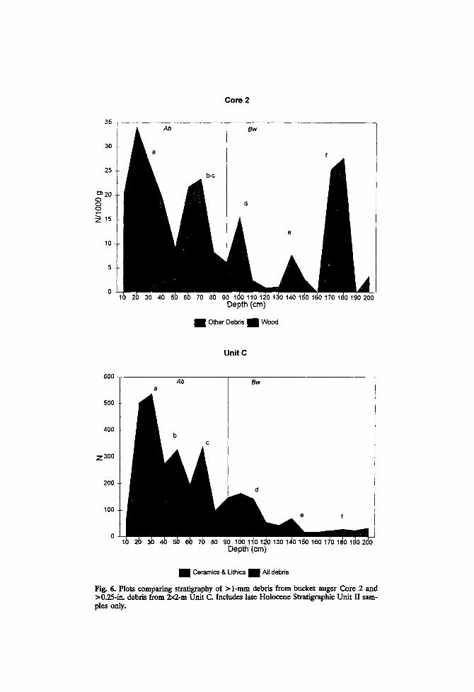
However, given that geomorphic processes may differentially affect mi- croartifact and macroartifacts as a function of their sizes, there is some question whether microartifacts can reliably be used to trace the archae- ological stratigraphy of LSA without an adequate sample of macroartifacts. In all probability it is dependent on the geomorphic processes operating in a particular case. For example, Fladmark (1982) found a poor fit between micro- and macroflake stratification in a sand-dominated aeolian deposi- tional context. This is not unexpected given the vertical displacement noted in similar deposits through refitting studies (Villa, 1982). In silt-dominated alluvial contexts, Stafford (1993) found a close correlation between macro- and microartifact distributions (Figs. 5 and 6). Comparisons were made be- tween macroartifacts (>0.25 in.) recovered in 2 x 2 m units at 10-cm in- tervals with 2-1iter samples collected by bucket auger (4-in. diameter) from a buried soil developed in late Holocene Ohio River alluvium. The volume of sediment screened in these units is approximately 200 times the volume of the auger samples.
Two soil/geomorphic units are represented on the floodplain ridge. An upper 0.25- to 1.0-m-thick unit (SUI) of historic alluvium is underlain by

50
Core 1
40
30
o o o
Z 20
10
Ab Bw i
Depth (m)
• Other Debris • Wood
Unit H
600
500
400
Z 300
200
0
100
Ab Bw
Depth (m)
• Ceramics & Lithics • / ~ 1 Debris
Fig. 5. Plots comparing stratigraphy of > 1-mm debris from bucket auger Core i and >0.25-in. debris from 2x2-m Unit H. Includes late Hoiocene Stratigraphic Unit II sam- pies only.
35
Co re 2
30
25
c~ 2O o o o
z ~ 5
10
Depth (cm)
• Other Debris • Wood
Unit C
600
500
400
z 300
200
100
D e p ~ (cm)
• Ceramics & Lithics • ~, debris
Fig. 6. Plots comparing stratigraphy of > l-ram debris from bucket auger Core 2 and >0.25-in. debris from 2x2-m Unit C. Includes late Holocene StratigraphJc Unit II sam- ple, s only.

Geoarchaeological Perspectives on Paleolandscapes 93
a very thick silt loam unit of late Holocene Ohio River alluvium (SUII). The alluvial ridge is subparallel to the present river channel and was formed by down-valley progradation and overbank deposition from lateral channel migration. Weakly developed soils are present at the top of each unit. The upper 2 m of SU II from which the auger samples were obtained exhibits a fining upward sequence (seen in both the sand and the clay fractions-- i.e., less sand and more clay nearer the surface) typical of overbank de- posits. Radiocarbon ages obtained from prehistoric charcoal at various elevations in the lower unit allowed the calculation of sedimentation rates. Relatively high rates of deposition in SU II, 0.26 cm/year for the lower 3.44 m and 0.14 cm/year for the upper 0.75 m were estimated (Anslinger, 1993). Low rates of deposition appear to have continued as soil develop- ment began, resulting in a cumlic A horizon. These data suggest that ar- chaeological remains were deposited on temporary geomorphic surfaces and, subsequently, buried quickly by overbank deposition.
The best stratigraphic fit is between Core 2 and excavation unit C as depicted in Fig. 5 (letters on the graphs identify corresponding peaks of debris). Some debris peaks are slightly offset, and b and c are not distin- guishable in the core samples (a possible result of pedoturbation in the A horizon). Further, the peak identified as f in Core 2 is not readily apparent in Unit C. Core 1 also shows more complex stratification than that repre- sented by the macroartifacts in Unit H (Fig. 6). Peaks b and d are not present in the unit stratigraphy.
I would have expected, given their small volume, that the core samples would be more likely to fail to detect artifact strata observed in the exca- vation units, rather than exhibit a more complex stratigraphic record. Do the core-debris peaks not seen in the units represent "false readings" (as might be produced by background accumulations of wood charcoal as ob- served in overlying historic age alluvium)? This issue may be addressed by examining the differential composition of samples, e.g., the presence or ab- sence of particular debris types and/or fraction sizes. Since peak f in Core 2 and peak d in Core 1 are composed chiefly of wood charcoal, they may represent such readings. It is worth noting, however, that peaks f in Cores 1 and 2 occur at approximately the same depth, and other debris categories are present in the latter core (Cores 1 and 2 are 60 m apart); and a scatter of fire-cracked rock was encountered in Unit H at this elevation. There are several possible explanations for the more complex core stratigraphy. They reflect (1) cultural deposition (and activities) not represented in the >0.25-in. fraction, (2) small-scale lateral spatial variation in the deposit associated with either primary or secondary refuse disposal, or (3) the pos- sibility that here the auger may have penetrated a pit feature that extends below an occupation surface. Clearly, multiple cores distributed across a
94 Stafford
landform are required accurately to identify and trace buried artifact sur- faces and fully address these questions (see Durmell and Stein, 1989).
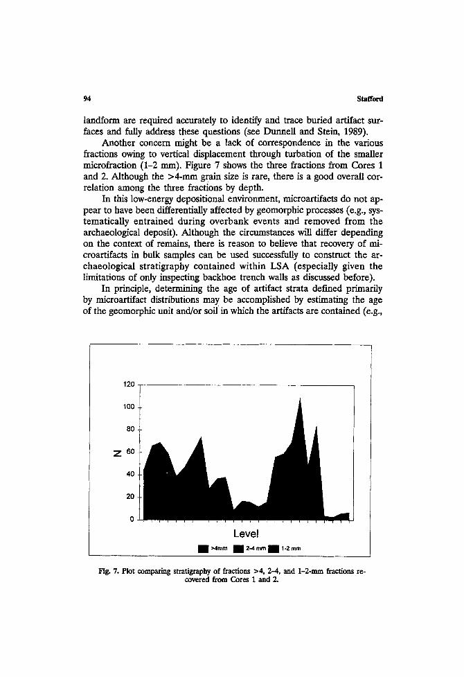
Another concern might be a lack of correspondence in the various fractious owing to vertical displacement through turbation of the smaller microfraction (1-2 ram). Figure 7 shows the three fractions from Cores 1 and 2. Although the >4-ram grain size is rare, there is a good overall cor- relation among the three fractions by depth.
In this low-energy depositional environment, microartifacts do not ap- pear to have been differentially affected by geomorphic processes (e.g., sys- tematically entrained during overbank events and removed from the archaeological deposit). Although the circumstances will differ depending on the context of remains, there is reason to believe that recovery of mi- croartifacts in bulk samples can be used suecessfuUy to construct the ar- chaeological stratigraphy contained within LSA (especially given the limitations of only inspecting backhoe trench walls as discussed before).
In principle, determining the age of artifact strata defined primarily by microartifact distributions may be accomplished by estimating the age of the geomorphic unit and/or soil in which the artifacts are contained (e.g.,
120
100
80
Z 6o
40
20
0
L e v e l
• ~4mm 1 24 ~m • 1-2 mm
Fig. 7. Plot comparing stratigraphy of fractions >4, 2-4, and 1-2-mm fractions re- covered from Cores 1 and 2.

Geoarchaeological Perspectives on Paleolandscapes 95
Bettis, 1992). However, in actual practice this may be a difficult task given that earth scientists many times rely on artifact content to date a unit or soil. Age estimates may also encompass excessively long intervals (e.g., early Holocene). For the most part microartifacts are too small to be temporally diagnostic (Dunnell and Stein, 1989). Although diagnostic macroartifacts are unlikely to be recovered from small bulk samples, artifacts from the surface may provide bracketing dates or age limits for soil/geomorphic units expressed at the surface.
The composition of bulk samples might be used in some circumstances, as demonstrated by Asch and Sidell (1988) with archeobotanical remains, where specific botanical signatures for Archaic and Woodland age occupa- tions have been shown to exist in the lower Illinois River valley. Functional determinants of sample composition, however, likely limit its general use as a means of determining the age of artifact strata.
Since bulk sampling for microartifacts can result in the systematic re- covery of charcoal, albeit in small quantities, extended counting radiocar- bon assay or the accelerator mass spectrometer (AMS) technique can be used routinely to obtain age estimates. As Butler and Stein (1988) and Dunnell. and Readhead (1988) indicate, however, obtaining radiocarbon dates from fluvial deposits can be problematical. Determining the relation between the sample event or event dated and the target event or the depo- sition of microartifacts is crucial (Dunnell and Readhead, 1988, p. 232). Bridging arguments are needed to link the sample and target events. Cer- tainly, understanding the depositional context of the microartifacts, includ- ing the charcoal fraction of the sample, is critical in making these arguments. Identification of the charcoal and restricting dating to specific types like nutshell (a relatively common constituent of botanical samples in the eastern United States) will, for example, limit problems associated with dating old wood. Dunnell and Readhead (1988, p. 233) suggest that techniques like thermoluminescence dating of the sediments themselves, though less precise at this time than radiocarbon dating, provide an age coterminous with the depositional event.
Another issue centers on efficiently processing small bulk samples for microartifacts. Sampling regional distributions of buried remains will pro- duce very large numbers of samples. Stein and Teltser (1989) use a proce- dure that follows conventional grain-size analysis. This is a time-consuming approach that is not likely to be feasible with large sample numbers (they processed only six in their study). An alternative wet-sieving procedure, sug- gested by Stafford (1993), has been used effectively to process several hun- dred samples. Briefly, samples are transferred to nylon 0.2-mm mesh bags, weighed to the nearest gram, soaked in dispersant (sodium hexametaphos- phate) for 4 hr, with fine sediments subsequently removed by forced water.
96 Stafford
Samples are dried, then sieved through graduated geological screens. Debris categories are counted with the aid of a hand lens or stereomicroscope. Den- sity values are obtained by calculating the concentration of debris per 1000 g of sediment in the original sample. The time required to scan and quantify a sample fraction is dependent on the frequency of large-size natural clasts in the sediment. Silt loam samples are quickly analyzed because of the lack of very coarse sand-sized particles, while loam to sandy loam samples may require subsampling of smaller fractions (see Fladmark, 1982; Stein and Teltser, 1989). Distinguishing natural grains from lithic artifacts may also be difficult (e.g., Schick, 1986, p. 32) and time consuming in the latter sedi- ment-type samples. Also, sand-sized coal inclusions can make nutshell and wood charcoal identification more time consuming (Stafford, 1993).
Collection of bulk samples by whatever means (e.g., bucket auger, col- umn samples from trench walls or from solid cores) is crucial for adequate sampling of subsurface deposits. Extraction of microartifacts enhances the likelihood that adequate numbers of remains will be recovered to document the archaeological stratification of a deposit. This approach has been sue- cessfully used in CRM projects where as many as several hundred samples were collected (e.g., Stafford et al., 1993). Its feasibility on a regional scale remains to be tested.
CONCLUSIONS
Taking a landscape approach in a geomorphically dynamic region re- quires that the buried archaeological record be systematically evaluated. Regional geomorphological studies are the required first step in designing an effective recovery strategy. Knowing the age, thickness, and extent of LSA or more formal stratigraphic units provides the basis for stratifying the region to maximize the likelihood of effectively sampling the subsurface. The distributional approach advocated here focuses on obtaining estimates of artifact density within an LSA of appropriate age. Reservations about the concept of site pertain to the subsurface as well as artifacts that are found in modern surface contexts; surface and buried archaeological de- posits are more similar than one might assume. A variety of subsurface recovery techniques is likely to be appropriate, depending on the setting of a project. Those archaeological remains buried more than 3 to 4 m below the surface are the most difficult to sample, regardless of the technique used. It seems clear, however, that bulk sampling is an essential part of a subsurface recovery strategy. Beyond providing an effective means of evalu- ating the context of buried deposits, microartifact recovery appears to be a way of increasing the density of remains, thus allowing potentially smaller

Geoarchaeoiogical Perspectives on Paleolandscapes 97
volume samples to be collected. Efficient means of analysis need to be explored further, however.
Finally, since landscape structure and change are fundamental deter- minants of land use, the approaches used in landscape ecology, which em- phasize environmental heterogeneity, offer some useful applications in a holistic analysis of paleolandscapes. This approach explicitly links geomor- phological studies of landscape evolution with past ecosystem structure that may have affected prehistoric land use. The complexity of the regional ar- chaeological record may be better understood as such measures, like land- scape elements, are incorporated into landscape analysis.
ACKNOWLEDGMENTS
A number of colleagues kindly provided papers and manuscripts, in- cluding Mark Brooks, Art Bettis, Joe Artz, AI Goodyear, and Patrice Telt- ser. Numerous discussions over the years with Ed Hajic have helped fashion the views presented in this paper. I would like to thank Barbara Stafford, Patrice Teltser, and Basil Gomez for their comments on an early version. Comments and revisions suggested by Bruce Gladfelter, Michael Schiller, Michael Shott, LuAnn Wandsnider, William Dancey, and an anonymous reviewer greatly improved the finished product.
REFERENCES CITED
Allen, J. R. (1965). A review of the origin and characteristics of recent alluvial sediments. Sedimentology 5:89-191.
Anderson, D., and Semken. H. (eds.) (1980). The Cherokee Excavations: Holocene Ecology and Human Adaptations in Northwestern Iowa, Academic Press, New York.
Anslinger, C. M. (1993). Archaeological Investigations at BraOgsh: A Prehistoric Site in the Ohio River Valley, Dearborn County, Indiana. Indiana State University, Anthropology Labora- tory, Technical Report 15.
Artz, J. A., and Bettis, E. A., III (1993). Holocene geology as an aid in archaeological survey: An example from the Upper Mississippi Valley. Paper presented at the 58th Annual Meeting of the Society for American Archaeology, St. Louis.
Asch, D. L., and Asch Sidell, N. (1988). Archaeological plant remains: applications to strati- graphic analysis. In Hastoff, C., and Popper, V., (eds.), Current Paleoethnobotany: Ana- lytical Methods and Cultural Interpretations of Archaeological Plant Remains, University of Chicago Press, Chicago, pp. 86-96.
Benn, D. W., Bettis, E. A., III, and Vogel, R. C. (1988). Archaeology and Geomorphology in Pools 17-18, Upper Mississippi River. Center for Archaeological Research Report No. 714. Southwest Missouri State University, Springfield.
Bettinger, R. L. (1991). Hunter-Gatherers: Archaeological and Evolutionary Theory. Plenum Press, New York.
Bettis, E. A. (1992). Soil morphologic properties and weathering zone characteristics as age indicators in Holocene alluvium in the Upper Midwest. In HoUiday, V. T. (ed.), Soils in

98 Stafford
Archaeology: Landscape Evolution and Human Occupation, Smithsonian Institution Press, Washington DC, pp. 119-144.
Bettis, E. A. (1993). Buried site potential: Determination, evaluation, and suggestions for sam- piing l0 g m 3. Paper presented at the 58th Annual Meeting of the Society for American Archaeology, St. Louis.
Bettis, E. A., and Hoyer, B. E. (1986). Late Wisconsinan and Holocene Landscape Evolution and Alluvial Stratigraphy in the Saylorville Lake Area, Central Des Moines River Valley, Iowa. Iowa Geological Survey, Open File Report 86-1.
Binford, L. R. (1980). Willow smoke and dogs' tails: hunter gatherer settlement systems and archaeological site formation. American Antiquity 45:4-20.
Binford, L. R. (1982). The archaeology of place, Journal of AnthropologicalArchaeology 1:5-31. Birkeland, P. W. (1984). Soils and Geomorphology, Oxford University Press, New York. Brakenridge, G. R. (1984). Alluvial stratigraphy and radiocarbon dating along the Duck River,
Tennessee: Implications regarding flood-plain origin. Geological Society of America Bul- letin 95:9-25.
Brooks, M., Stone, P. A., Colquhoun, D. J., Brown, J. G., and Steels, IC B. (1986). Geoar- chaeological research in the coastal plain portion of the Savannah river valley. Geoar- chaeology 1:293-307.
Brooks, M., Taylor, B. E., Grant, J. A., and Gaiser, E. (1993). Upland wetlands investigations of Pleistocene-Holocene environmental changes on the SRS: 1993. An update. Annual Review of Cultural Resource Investigations by the Savannah River Archaeological Re- search Program, Fiscal Year 1993, South Carolina Institute of Archaeology and Anthro- pology, University of South Carolina, pp. 27--44.
Brown, J. A. (1975). Deep-site excavation strategy as a sampling problem. In MueUer, J. (ed.), Sampling in Archaeology, University of Arizona Press, Tucson, pp. 155-169.
Broyles, B. J. (1966). Preliminary report: The St. Albans site (46KA27), Kanawha County, West Virgina. The West l/'wginia Archaeologist 19:1--43.
Butler, V. L., and Stein, J. K. (1988). Comment on "Changing Late Holocene Flooding Fre- quencies on the Columbia River, Washington" by James C. Chatters and Karin Hoover. Quaternary Research 29:186-187.
Butzer, IC W. (1960). Archeology and geology in ancient Egypt. Science 132:1617-24. Butzer, K. W. (1977). Geomorphology of the Lower Illinois Valley as a Spatial-Temporal Context
for the Koster Archaic site. Reports on Investigations 34, Ulinois State Museum. Butzer, K. W. (1980). Context in archaeology: An alternative perspective. Journal of Field
Archaeology 7:417-422. Butzer, IC W. (1982). Archaeology as Human Ecology, Cambridge University Press, Cambridge. Camilli, E. L., and Ebert, J. I. (1992). Artifact reuse and recycling in continuous surface dis-
tributions and implications for interpreting land use patterns. In Rossignol, J., and Wandsnider, L. (eds.), Space, Time, and Archaeological Landscapes, Plenum Press, New York, pp. 113-136.
Chang, C. (1992). Archaeological landscapes: the ethnoarchaeology of pastoral land use in the Grevena Province of Greece. In Rossignol, J., and Wandsnider, L. (eds.), Space, Time, and Archaeological Landscapes, Plenum Press, New York, pp. 65-89.
Chapman, J. (1973). The Icehouse Bottom Site 40MR23. University of Tennessee, Department of Anthropology, Report of Investigations No. 13.
Chapman, J. (1976). Early archaic site location and excavation in the Little Tennessee River Valley: Backhoe and trowels. Southeastern Archaeological Conference, Bulletin 19:80--90.
Clark A. o r. (1992). Archaeogeophysical prospecting on alluvium. In Needham, S., and Macklin, M. G. (eds.), Alluvial Archaeology in Britain, Monograph 27, Oxbow Books, Oxford, pp. 43--49.
Coe, J. L. (1964). The formative culture of the Carolina piedmont. Transactions of the Ameri- can Philosophical Society 54 (5).
Collins, M. B. (ed.) (1979). Excavations at four archaic sites in the lower Ohio Valley, Jef- ferson County, Kentucky. Occasional Papers in Anthropology No. 1. Department of An- thropology, University of Kentucky, Lexington.

Geoarchaeological Perspectives on Paleolandscapes 99
Crumley, C. L, and Marquardt, W. H. (1990). Landscape: A unifying concept in regional analysis. In Allen, K. M. S., Green, S. W., and Zubrow, E. B. W. (eds.), Interpreting Space: GIS and Archaeology, Talyor and Francis, London, pp. 73-79.
Dalan, R. A. (1983). Issues of scale in archaeogeophysieal research. In Stein, J. K. and, Lime, A. R. (eds.), Effects of Scale on Archaeological and Geoscientific Perspectives, Geological Society of America, Special Paper 283, pp. 67-78.
Davidson, D. A. (1985). Geomorphology and Archaeology. In Rapp., G., Jr., and Gifford, J. A~ (eds.), Archaeological Geology, Yale University Press, New Haven, pp. 27-55.
Dekker, L. W., and de Weerd, M. D. (1973). The value of soil survey for archaeology. Geoderma 10:169-178.
Dewar, R. E., and McBride, K. A. (1992). Remnant settlement patterns. In Rossignol, J., and Wandsnider, L. (eds.), Space, Time, and Archaeological Landscapes, Plenum Press, New York, pp. 227-255.
DurmeU, R. C. (1992). The notion site. In Rossignol, J., and Wandsnider, L. (eds.), Space, Time, and Archaeological Landscapes, Plenum Press, New York, pp. 21-41.
Dunnell, R. C., and Dancey W. (1983). The siteless survey: a regional scale data collection strategy. Advances in Archaeological Method and Theory 6:267-287.
Dunnell, R. C., and Readhead, M. L. (1988). The relation of dating and chronology: Com- ments on Chatters and Hoover (1986) and Butler and Stein (1988). Quaternary Research 30:232-233.
Dunnell R. C.; and Stein, J. K. (1989). Theoretical issues in the interpretation of microartifacts. Geoarchaeology 4:31-41.
Ebert, J. I. (1992). Distributional Archaeology, University of New Mexico Press, Albuquerque. Ferring, C. R. (1986). Rate of fluvial sedimentation: implications for archaeological variability.
Geoarchaeology, 1:259-274. Ferring, C. R. (1990). Archaeological geology of the southern plains. In Lasca, N. P. and
Donahue, J. (eds.), Archaeological Geology of North America, Geological Society of America, Centennial Special Volume 4, pp. 253-266.
Ferring, C. R. (1992). Alluvial pedology and geoarchaeological research. In Holliclay, V. T. (ed.), Soils in Archaeology: Landscape Evolution and Human Occupation, Smithsonian In- stitution Press, Washington DC, pp. 1-39.
Ferring, C. R., and Peter, D. E. (1987). Geoarchaeology of the Dyer Site: A prehistoric oc- cupation in the western Ouachitas, Oklahoma. Plains Anthropologist 32:351-366.
Fladmark, K. (1982). Microdebitage analysis-initial considerations. Journal of Archaeological Science 9:205-220.
Foley, R. (1981). A model of regional archaeological structure, Proceedings of the Prehistoric Society 47:1-I8.
Forman, R. T, T. (1990). The beginnings of landscape ecology in America. In Zonneveld, I. S. and Forman, R. T. T. (eds.), Changing Landscapes: An Ecological Perspective, Sprin- ger-Verlag, New York, pp. 35-41.
Forman, R. T. and Godron, M., (1986). Landscape Ecology, John Wiley, New York. Gardner, G. D., and Donahue, J. (1985). The Little Platte Drainage, Missouri" A model for
locating temporal surfaces in a fluvial environment. In Stein, J. K. and Farrand, W. R. (eds.), Archaeological Sediments in Context, Peopling of the Americas, Vol. 1, Center for the Study of Early Man, Institute for Quaternary Studies, University of Maine, Orono, pp. 69-89.
Gladfelter, B. G. (1977). Geoarchaeology: The geomorphologist and archaeology. American Antiquity 42:519-538.
Gladfelter, B. G. (I981a). Developments and directions in geoarchaeology. Advances in Ar- chaeological Method and Theory 4:343-364.
Gladfelter, B. G. (1981b). Investigations at the Labras Lake site, Volume III: Geomorphological observations in the vicinity of the site. Department of Geography, University of Illinois, Chicago.
Goodyear, A. C., and Colquhoun, D. J. (1987). An Archaeological Backhoe Testing Survey of Selected Localities on the Broad River Floodplain Richland County, South Carolina, South

100 Stafford
Carolina Institute of Archaeology and Anthropology, University of South Carolina, Co- lumbia.
Green, S. W. (1990). Sorting out settlement in southeastern Ireland: Landscape archaeology and geographic information systems. In Allen, K. M. S., Green, S. W., and Zubrow, E. B. W. (eds.), Interpreting Space: GIS and Archaeology, Talyor and Francis, London, pp. 356--363.
Hajie, E. R. (1985). Geomorphie and stratigraphie investigations at Campbell Hollow. In Staf- ford, C. R (eds.), The Campbell Hollow Archaic Occupations: A Study of lntrasite Spatial Structure in the Lower lllinois Valley, Research Series No. 4, Kampsville Archaeological Center, Center for American Archaeology, Kampsville, Illinois, pp. 53-81.
Hajic, E. R. (1987). Geoenvironmental Context for Archeological Sites in the Lower Illinois River Valley, United States Army Corps of Engineers, St. Louis District, Historic Properties Management Report 34.
Hajic, E. R. (1990a). Koster Site Archeology I: Stratigraphy and Landscape Evolution, Center for American Archeology, Kampsville Archeological Center, Research Series 8, Kampsville, Illinois.
Hajic, E. R. (1990b). Late Pleistocene and Holocene landscape evolution, depositional sub- systems, and stratigraphy in the lower Illinois River Valley and adjacent central Missis- sippi River Valley. Ph.D. dissertation, University of Illinois. University Microfilms, Ann Arbor.
Hajic, E. R. (1993). Geomorphology of the northern American bottom as context for archae- ology. Illinois Archaeology 5:54--65.
Hajic, E. R., and Leigh, D. S. (1985). Shallow Subsurface Geology, Geomorphology, and Limited Cultural Resource Investigations of the Meredosia ~llage and Meredosia Lake Levee and Drainage Dist~cts, Scott, Morgan, and Cass Counties, Illinois. United States Army Corps of Engineers, St. Louis District Cultural Resource Management Report No. 17.
Hassan, F. A. (1978). Sediments in archaeology: Methods and implications for paleoenviron- mental and cultural analysis. Journal of Field Archaeology 5:197-213.
Hassan, F. A. (1985). Paleoenvironments and Contemporary archaeology: A geoarchaeological approach. In Rapp, G., Jr., and Gifford, J. A. (eds.), Archaeological Geology, Yale Uni- versity Press, New Haven, pp. 85-102.
Hoffman, C. (1993). Close-interval core sampling: Tests of a method for predicting internal site structure. Journal of Field Archaeology 20:461--473.
Holliday, V. T. (1992). Soil formation, time, and archaeology. In Holliday, V. T. (ed.), Soils in Archaeology: Landscape Evolution and Human Occupation, Smithsonian Institution Press, Washington DC, pp. 101-117.
Holliday, V. T., Ferring, C. R., and Goldberg, P. (1993). The scale of soil investigations in archaeology, In Stein, J. K., and Linse, A. R. (eds.), Effects of Scale on Archaeological and Geoscientific Perspectives, Geological Society of America, Special Paper 283, pp. 29- 38.
Howell, T. V. (1993). Evaluating the utility of auger testing as a predictor of subsurface artifact density. Journal of Field Archaeology 20:475--484.
Hull, K. L. (1987). Identification of cultural site formation processes through microdebitage analysis. American Antiquity 52:772-783.
Johnson, A. R., Wiens, J. A., Milne, B. T., and Crist, T. O. (1992). Animal movements and population dynamics in heterogeneous landscapes. Landscape Ecology 7:63-75.
Johnson, W. C., and Logan, B. (1990). Geoarchaeology of the Kansas River Basin, Central Great Plains. In Lasca, N. P. and Donahue, J. (eds.), Archaeological Geology of North America, Geological Society of America, Centennial Special Volume 4, pp. 267-299.
Kintigh, K. W. (1988). The effectiveness of subsurface testing: A simulation approach. Ameri- can Antiquity 53:686-707.
Krakker, J. J., Shott, M. J., and Waleh, P. D. (1983). Design and evaluation of shovel-test sampling in regional archaeological survey. Journal of Field Archaeology 10:469-480.
Kvamme, K. L. (1989). Geographic information systems in regional archaeological research and data management. Archaeological Method and Theory 1:139-203.

Geoarchaeoiogical Perspectives on Paleolandscapes I01
Larsen, C. E., and Schuldenrein, J. (1990). Depositional history of an archaeologically dated flood plain, Haw River, North Carolina, In Lasca, N. P. and Donahue, J. (eds.), Archae- ological Geology of North America, Geological Society of America, Centennial Special Volume 4, pp. 161-181.
Leigh, D. L. (1992). Geomorphology. In Stafford, C. R. (ed.), Early Woodland Occupations at the Ambrose Flick Site in the Sny Bottom of West-Central Illinois, Center for American Archeology, Kampsville Archeological Center, Research Series 10, pp. 21-57.
Lightfoot, K. G. (1986). Regional surveys in the eastern United States: The strengths and weaknesses of implementing subsurface testing programs. American Antiquity 51:484-504.
Lightfoot, K. G. (1989). A defense of shovel-test sampling: A reply to shott. American Antiquity 54:413-416.
Linse, A. R. (1993). Geoarchaeological scale and archaeological interpretation: Examples from the Central Jornada MogoUon. In Stein, J. K. and Linse, A. R. (eds.), Effects of Scale on Archaeological and Geoscientific Perspectives, Geological Society of America, Special Paper 283, pp. 11-28.
Madsen, M. E. (1992). Lithic manufacturing at British camp: Evidence from size distributions and microartifaets. In Stein, J. (ed.), Deciphering a Shell Midden, Academic Press, New York, pp. 193-210.
Mandel, R. D. (1992). Soils and Holocene landscape evolution in central and southwestern Kansas: Implications for Archaeological research. In Holliday, V. T. (ed.), Soils in Ar- chaeology: Landscape Evolution and Human Occupation, Smithsonian Institution Press, Washington DC, pp. 41-100.
McManamon, F. P. (1984). Discovering sites unseen. Advances in Archaeological Method and Theory 7:223-292.
NACOSN (North American Commission on Stratigraphic Nomenclature) (1983). North American stratigraphic code. American Association of Petroleum Geologists Bulletin 67:841-875.
Nance, J. D. (1979). Non-site sampling in the lower Cumberland River valley, Kentucky. M/d- continental Journal of Archaeology 5:169-191.
Nance, J. D. (1983). Regional sampling in archaeological survey: The statistical perspective. Advances in Archaeological Method and Theory 6:289-256.
Nance, J. D., and Ball, B. F. (1986). No surprises: The reliability and validity of test pit sam- piing. American Antiquity 51:457-483
Nance, J. D., and Ball, B. F. (1989). A shot in the dark: Shott's comments on Nance and Ball. American Antiquity 54:405-412.
Naveh, Z., and Lieberman, A. S. (1990). Landscape Ecology: Theory and Application (Student Edition). Springer-Verlag, New York.
Needham, S., and Macklin, M. (1992). Alluvial Archaeology in Britain. Monograph 27, Oxbow Books, Oxford.
Nicholson, B. A. (1983). A comparative evaluation of four sampling techniques and of the reliability of microdebitage as a cultural indicator in regional surveys. Plains Anthropologist 28:273-282.
Risser, P. G. (1990). Landscape pattern and its effects on energy and nutrient distribution. In Zonneveld, I. S. and Forman, R. T. T. (eds.), Changing Landscapes: An Ecological Perspective, Springer-Verlag, New York, pp. 43-56.
Risser, P. G., Karr, J. R., and Forman, R. T. T. (1984). Landscape Ecology." Directions and App. roaches. Illinois Natural History Survey Special Publication No. 2, Champaign, Illi- nois.
Rohdenburg, H. (1989). Landscape Ecology: Geomorphology. Catena Verlag, Cremlingen-Dest- edt, West Germany.
Rosen, A. M. (1989). Ancient town and city sites: a view from the microscope. American Antiquity 54:564--578.
Rossignol, l., and Wandsnider, L. (eds.) (1992). Space, Time, and Archaeological Landscapes. Plenum Press, New York.
Ruhe, R. V. (1969). Quaternary Landscapes in Iowa. Iowa State University Press, Ames, Iowa.

102 Stafford
Schick, K. D. (1986). Stone Age Sites in the Making: Experiments in the Formation and Trans- formation of Archaeological Occurrences, British Archaeological Reports International Se- ries 319, Oxford.
Schiller, M. B. (1987). Formation Processes of the Archaeological Record. University of New Mexico Press, Albuquerque.
Schiffer, M. B., Sullivan, A. P., and Klinger, T. C. (1978). The design of archaeological surveys. World Archaeology 10:1-28.
Schlanger, S. H. (1992). Recognizing persistent places in anasazi settlement systems. In Ros- signol, J., and Wandsnider, L. (eds.), Space, Time, and Archaeological Landscapes, Plenum Press, New York, pp. 91-112.
Schreiber, K. (1990). The history of landscape ecology in Europe. In Zonneveld, I. S., and Forman, R. T. T. (eds.), Changing Landscapes: An Ecological Perspective, Springer-Verlag, New York, pp. 21-33.
Schuldenrein, J. (1991). Coring and the identity of cultural-resource environments: A comment on Stein. American Antiquity 56:131-137.
Schumm, S. A. (1973). Geomorphic thresholds and complex response of drainage systems. In M. Morisawa (ed.), Fluvial Geomorphology, George, Allen, and Unwin, London, pp. 299- 310.
Schumm, S. A. Mosley, M. P. and Weaver, W. E. (1987). Experimental Fluvial Geomorphology. John Wiley & Sons, New York.
Senft, R. L., Coushenour, M. B., Bailey, D. W., Rittenhouse, L. R., Sala, O. E., and Swift, D. M., (1987). Large herbivore foraging and ecological hierarchies. Bioscience 37:789-799.
Shott, M. J. (1989). Shovel-test sampling in archaeological survey: Comments on Nance and Ball, and Lightfoot. American Antiquity 54:396--404.
Shott, M. J. (1994). Size and form in the analysis of flake debris: Review and recent ap- proaches. Journal of Archaeological Method and Theory 1:69-110.
Stafford, C. R. (ed.) (1992a). Early Woodland Occupations at the Ambrose Flick Site in the Sny Bottom of the Mississippi River Valley. Center for American Archeology, Kampsville Archeological Center, Research Series 10, Kampsville, Illinois.
Stafford, C. R. (1992b). Archeological stratigraphy and paleotopography. In Stafford, C. R. (ed.), Early Woodland Occupations at the Ambrose Flick Site in the Shy Bottom of the Mississippi River Valley. Center for American Archeology, Kampsville Archeological Cen- ter, Research Series 10, Kampsville, Illinois, pp. 58-94.
Stafford, C. R. (1993). Applying distributional archaeology to the subsurface: Some initial observations. Paper presented at the 58th Annual Meeting of the Society for American Archaeology, St. Louis.
Stafford, C. R. (1994). Structural changes in archaic landscape use in the dissected uplands of Southwestern Indiana. American Antiquity 59:219-237.
Stafford, C. R., and Cantin, M. (1989). Deep Site Testing at the Proposed Brattish Marina, Dearborn County, Indiana. Indiana State University, Anthropology Laboratory, Technical Report 7.
Stafford, C. R., and Hajic, E. R. (1992). Landscape scale: Geoenvironmental approaches to prehistoric settlement strategies. In Rossignol, J., and Wandsnider, L. (eds.), Space, Time, and Archaeological Landscapes, Plenum Press, New York, pp. 137-161.
Stafford, C. R., Leigh, D. S., and Asch, D. L. (1992). Prehistoric settlement and landscape change on alluvial fans in the upper Mississippi River Valley. Geoarchaeology 7:287-314.
Stafford, C. R., Anslinger, C. M., and Cantin, M. (1993). Geoarchaeological Investigations at Vermillion County Bridge 81, West-Central Indiana. Indiana State University, Anthropology Laboratory, Technical Report 17.
Stein, J. IC (1986). Coring archaeological sites. American Antiquity 51:505-527. Stein, J. IC (1987). Deposits for archaeologists. Advances in Archaeological Method and Theory
11:337-395. Stein, J. K. (1990). Archaeological stratigraphy, In Lasca, N. P., and Donahue, J. (eds.), Ar-
chaeological Geology of North America, Geological Society of America, Centennial Special Volume 4, pp. 513-523.

Geoarchaeological Perspectives on Paleolandscapes 103
Stein, J. K. (1991). Coring in CRM and archaeology: A reminder. American Antiquity 56:138- 142.
Stein, J. IC (1993). Scale in archaeology, geosciences, and geoarchaeology, In Stein, J. K., and Linse, A. R. (eds.), Effects of Scale on Archaeological and Geoscientific Perspectives, Geo- logical Society of America, Special Paper 283, pp. 1-10.
Stein, J. K., and Teltser, P. (1989). Size distributions of artifact classes: Combining macro- and micro-fractions. Geoarchaeology 4:1-30.
Stephens, D. W., and Krebs, J. R. (1986). Foraging Theory, Princeton University Press, Prince- ton, New Jersey.
Steward, J. H. (1938). Basin-plateau aboriginal sociopolitical groups. Smithsonian Institution, Bureau of American Ethnology, Bulletin 120.
Struever, S. and Holton, F. A. (1979). Koster: Americans in search of their prehistoric past. Doubleday, New York.
Styles, T. R. (1985). Holocene and Late Pleistocene Geology of the Napoleon Hollow Site in the Lower lllinois Valley. Kampsville Archeological Center, Center for American Arche- ology, Research Series 5, Kampsville, Illinois.
Swanson, F. J., Franklin, J. F., and SedeU, J. R. (1990). Landscape patterns, disturbance, and management in the Pacific Northwest, USA. In Zonneveld, I. S., and Forman, R. T. T. (eds.), Changing Landscapes: An Ecological Perspective, Springer-Verlag, New York, pp. 191-216.
Teltser, P. (1993). Non-site Survey in the Cairo Lowland of Southeast Missouri. Paper pre- sented at the 58th Annual Meeting of the Society for American Archaeology, St. Louis.
Thomas, D. H. (1975). Nonsite sampling in archaeology: Up the creek without a site? In Mueller, J. (ed.), Sampling in Archaeology, University of Arizona Press, Tucson, pp. 61-81.
Troll, C. (1950). Die geographische Landschaft und ihre Erforschung. Studium Genera& 3:163- 181.
Turner, M. G. (1989). Landscape ecology: The effect of pattern on process. Annual Review of Ecology and Systematics 20:171-197.
Turner, W. B., Hofman, J. L., and Brakenridge, G. R. (1982). Technique to aid in recording and field interpretation of stratigraphic sections in archaeological deposits. Journal of Field Archaeology 9:133-136.
Turner, W. B., and Klipple, W. E. (1989). Hunter-gatherers in the Nashville basin: Archae- ological and geological evidence for variability in prehistoric land use. Geoarchaeology 4:43-6Z
Urban, D. L., O'Neill, R. V., and Shugart, H. H., Jr., (1987). Landscape ecology. Bioscience 37:119-127.
Van Nest, J. (1993). Geoarchaeology of dissected loess uplands in western Illinois. Geoar- chaeology 8:281-31!.
Villa, P. (1982). Conjoinable pieces and site formation processes. American Antiquity 47:276-- 290.
Warren, R. E. (1990). Predictive modelling of archaeological site location: a case study in the Midwest. In Allen, IC M. S., Green, S. W., and Zubrow, E. B. W. (eds.), Interpreting Space: GIS and Archaeology, Talyor and Francis, London, pp. 201-215.
Waters, M. (1992). Principals of Geoarchaeology: A North American Perspective, University of Arizona Press, Tucson.
Wiant, M. D., Hajic, E. R., and Styles, T. R. (1983). Napoleon Hollow and Koster Site stra- tigraphy: Implications for Holocene landscape evolution and studies of archaic period settlement patterns in the lower Illinois River Valley. In Phillips, J. L., and Brown, J. A. (eds.), Archaic Hunters and Gatherers in the American Midwest, Academic Press, New York, pp. 147-164.
Wiens, J. A. (1992). What is landscape ecology, Really? Landscape Ecology 7:149-150. Winterhalder, B. (1980). Environmental analysis in human evolution and adaptation research.
Human Ecology 8:135-155. Winterhalder, B., and Smith, E. A., (eds.) (1981). Hunter-Gatherer Foraging Strategies: Ethno-
graphic and Archaeological Analyses. University of Chicago Press, Chicago.

104 Stafford
Wobst, H, M. (1983). We can't see the forest for the trees: Sampling and the shapes of ar- chaeological distributions, In Moore, J. A., and Keene, A. S. (eds.), Archaeological Ham- mers and Theories, Academic Press, New York, pp. 37-85.
Wood, W. R., and Johnson, D. L. (1978). A survey of disturbance processes in archaeological site formation. Advances in Archaeological Method and Theory 1:315-381.
Wynn J. C. (1990). Applications of high-resolution geophysical methods to archaeology. In Lasca, N. P., and Donahue, J. (eds.), Archaeological Geology of North America, Geological Society of America, Centennial Special Volume 4, pp. 603-617.
Zonneveld, I. S. (1990). Scope and concepts of landscape ecology as an emerging science. In Zonneveld, I. S., and Forman, R. T. T. (eds.), Changing Landscapes: An Ecological Per- spective, Springer-Verlag, New York, pp. 3-19.