Embed Size (px)
Citation preview
BARRICK GOLD INC. SNIP TAILINGS STORAGE FACILITY
PREPARED FOR:
Barrick Gold Corp. – Eskay Creek Mine 6431 Airport Way Smithers, BC V0J 2N0
VA101-2/17-1 Rev 0 November 28, 2014
2014 DAM SAFETY INSPECTION
Knight Piésold www.kni ghtp i eso ld .com
C O N S U L T I N G
PREPARED BY:
Knight Piésold Ltd. Suite 1400 – 750 West Pender Street
Vancouver, BC V6C 2T8 Canada p. +1.604.685.0543 • f. +1.604.685.0147
BARRICK GOLD INC.
SNIP TAILINGS STORAGE FACILITY
2014 DAM SAFETY INSPECTION i of iv VA101-2/17-1 Rev 0 November 28, 2014
EXECUTIVE SUMMARY
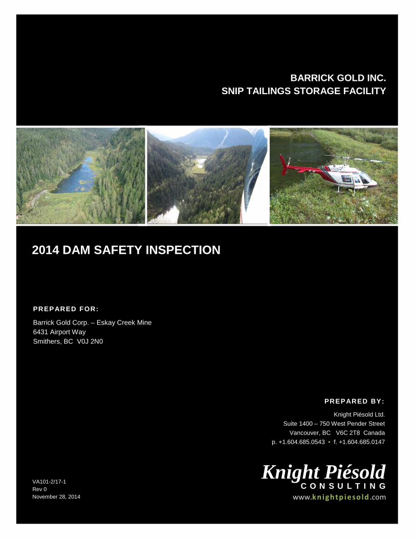
A Dam Safety Inspection (DSI) was completed on the closed Snip Tailings Storage Facility (TSF) on September 12, 2014 as required by an order from the chief inspector of mines of the British Columbia Ministry of Energy and Mines directive dated August 18, 2014. The DSI confirmed the Snip TSF to be in good condition, with no signs of deformation, significant erosion, cracking, bulging or differential settlement on either of the two containment dykes. The Snip TSF is a closed tailings impoundment located in northern British Columbia, approximately 320 km northwest of Smithers. There have been no engineering or construction changes to the TSF or the surrounding/downstream conditions since the past inspections. The most recent formal inspections of the Snip TSF were a Dam Safety Review (DSR) completed in 2013 and a DSI completed 2010. Both inspections were completed by Knight Piésold Ltd. (KP). The next DSI of the Snip TSF should be as specified in the Operating, Monitoring and Surveillance manual currently scheduled for 2017, the next DSR is scheduled for 2023.
The Snip TSF is a valley type impoundment and tailings containment is provided by two relatively low cross-valley structures consisting of zoned earthfill/rockfill embankments with low permeability central cores referred to as Dyke 1 and Dyke 3. The Snip TSF is located in a remote area with limited access to areas below both the Dyke 1 and Dyke 3. The closest structures are a closed airstrip 1.25 km downstream from the Dyke 3 and a historic fishing camp approximately 2.5 km downstream from Dyke 3. The dykes have a SIGNIFICANT dam classification based on the Canadian Dam Association Dam Safety Guidelines (CDA, 2013) guidelines. The consequence classification for Dykes 1 and 3 was most recently re-assessed in the 2013 DSR using the criteria provided in the Dam Safety Guidelines (CDA, 2013). This 2014 DSI includes an audit of the assigned 2013 DSR dam classification, the dam classification of “SIGNIFICANT” is still considered appropriate.
The spillway was noted to be in fair condition with water discharging from the surface water pond fully contained in the spillway and was being transmitted through the voids of the rock blanket lining the base of the channel. A small amount of debris is present at the spillway inlet due to ongoing beaver activity and vegetation growth. This debris and vegetation have created a small obstruction to flow but do not significantly reduce the spillway channel capacity. A perforated pipe installed in the spillway appears to be working as intended to discourage beaver activity, however, the ongoing clearing of beaver dams and vegetation is recommended. The slope above the entrance to the spillway has a dense vegetation cover with no observed changes in conditions compared to the inspection during the 2013 DSR. The tailings cover was observed to be in good condition and the surface water pond on the tailings was similar to the extent observed at the last inspection.
Vegetation is well established within the tailings impoundment and on the dykes. Dyke 1 was cleared of vegetation from the crest downstream to the closure stability berm in 2013. The vegetation on Dyke 3 is dense and well established; it is recommended the vegetation on Dyke 3 be cleared from dam crest down to the stability berm as has been completed on Dyke 1.
Pneumatic piezometers in the dykes and underlying foundations have not been read since the 2013 DSR.
BARRICK GOLD INC.
SNIP TAILINGS STORAGE FACILITY
2014 DAM SAFETY INSPECTION ii of iv VA101-2/17-1 Rev 0 November 28, 2014
TABLE OF CONTENTS
PAGE
EXECUTIVE SUMMARY ........................................................................................................................ I
TABLE OF CONTENTS ......................................................................................................................... i
1 – INTRODUCTION ............................................................................................................................. 1 1.1 2014 DAM SAFETY INSPECTION ....................................................................................... 1 1.2 FACILITY DESCRIPTION ..................................................................................................... 1
2 – 2014 INSPECTION OF THE TAILINGS STORAGE FACILITY ...................................................... 3 2.1 GENERAL ............................................................................................................................. 3 2.2 AERIAL OVERVIEW ............................................................................................................. 8 2.3 DYKE 1 ................................................................................................................................. 8 2.4 SPILLWAY ............................................................................................................................ 9 2.5 DYKE 3 ............................................................................................................................... 10
3 – DAM CLASSIFICATION ................................................................................................................ 11 3.1 DESIGN FLOOD AND EARTHQUAKE .............................................................................. 13
4 – INSTRUMENTATION .................................................................................................................... 15
5 – SUMMARY AND CONCLUSIONS ................................................................................................ 20
6 – REFERENCES .............................................................................................................................. 21
7 – CERTIFICATION ........................................................................................................................... 22
TABLES
Table 3.1 Dam Classification ........................................................................................................ 11 Table 3.2 Suggested Design Flood and Earthquake.................................................................... 14
FIGURES
Figure 1.1 Location of Snip TSF ...................................................................................................... 1 Figure 1.2 Snip Tailings Storage Facility Overview ......................................................................... 2 Figure 2.1 General Arrangement Dyke 1 ......................................................................................... 4 Figure 2.2 General Arrangement Dyke 3 ......................................................................................... 5 Figure 2.3 Dyke 1 Section ............................................................................................................... 6 Figure 2.4 Dyke 3 Section ............................................................................................................... 7 Figure 4.1 Dyke 1 Piezometers Geo A, B 1990 ............................................................................. 16 Figure 4.2 Dyke 1 Piezometers D88-2 (KLA & KLB) ..................................................................... 16
BARRICK GOLD INC.
SNIP TAILINGS STORAGE FACILITY
2014 DAM SAFETY INSPECTION iii of iv VA101-2/17-1 Rev 0 November 28, 2014
Figure 4.3 Dyke 3 Piezometers DH90-04B ................................................................................... 17 Figure 4.4 Dyke 3 Piezometers DH90-05 ...................................................................................... 17 Figure 4.5 Dyke 3 Piezometers DH90-06 ...................................................................................... 18 Figure 4.6 Dyke 3 Piezometers DH90-07 ...................................................................................... 18 Figure 4.7 Dyke 3 Piezometers D88-7 .......................................................................................... 19
APPENDICES
Appendix A Notification of Chief Inspectors Orders Appendix B 2014 Photographs Appendix C 2014 Dam Safety Inspection Checklist
BARRICK GOLD INC.
SNIP TAILINGS STORAGE FACILITY
2014 DAM SAFETY INSPECTION iv of iv VA101-2/17-1 Rev 0 November 28, 2014
ABBREVIATIONS
AEP ............................................................................................ Annual Exceedance Probability CDA ................................................................................................. Canadian Dam Association DSI ...........................................................................................................Dam Safety Inspection DSR ............................................................................................................. Dam Safety Review EDGM .................................................................................. Earthquake Design Ground Motion IDF ............................................................................................................... Inflow Design Flood KP .................................................................................................................. Knight Piésold Ltd. PMF .................................................................................................... Probable Maximum Flood TSF ....................................................................................................... Tailings Storage Facility
BARRICK GOLD INC.
SNIP TAILINGS STORAGE FACILITY
2014 DAM SAFETY INSPECTION 1 of 22 VA101-2/17-1 Rev 0 November 28, 2014
1 – INTRODUCTION
1.1 2014 DAM SAFETY INSPECTION
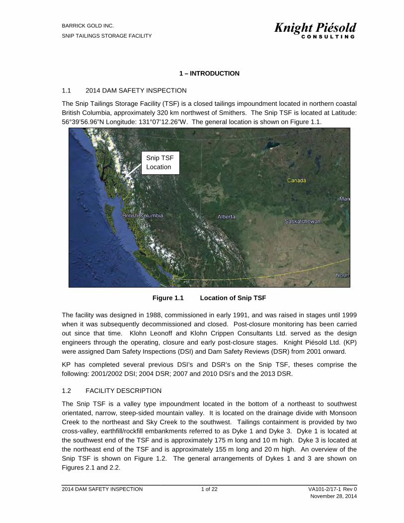
The Snip Tailings Storage Facility (TSF) is a closed tailings impoundment located in northern coastal British Columbia, approximately 320 km northwest of Smithers. The Snip TSF is located at Latitude: 56°39’56.96”N Longitude: 131°07’12.26”W. The general location is shown on Figure 1.1.
Figure 1.1 Location of Snip TSF
The facility was designed in 1988, commissioned in early 1991, and was raised in stages until 1999 when it was subsequently decommissioned and closed. Post-closure monitoring has been carried out since that time. Klohn Leonoff and Klohn Crippen Consultants Ltd. served as the design engineers through the operating, closure and early post-closure stages. Knight Piésold Ltd. (KP) were assigned Dam Safety Inspections (DSI) and Dam Safety Reviews (DSR) from 2001 onward.
KP has completed several previous DSI’s and DSR’s on the Snip TSF, theses comprise the following: 2001/2002 DSI; 2004 DSR; 2007 and 2010 DSI’s and the 2013 DSR.
1.2 FACILITY DESCRIPTION
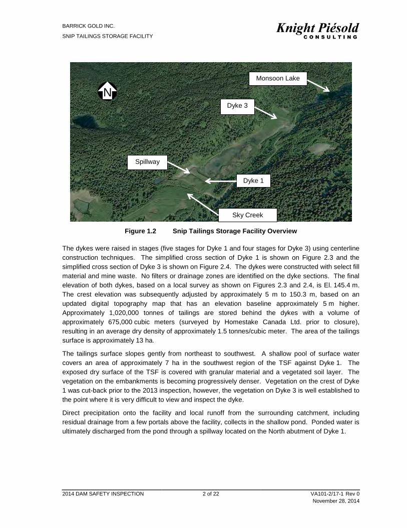
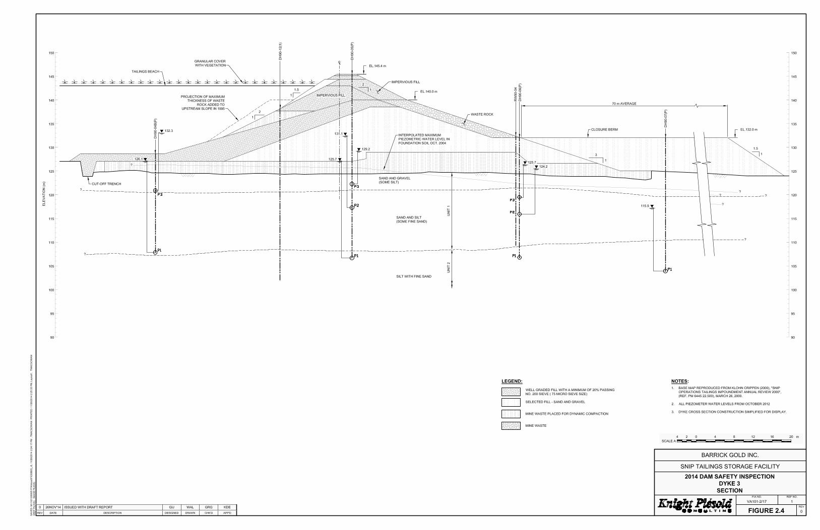
The Snip TSF is a valley type impoundment located in the bottom of a northeast to southwest orientated, narrow, steep-sided mountain valley. It is located on the drainage divide with Monsoon Creek to the northeast and Sky Creek to the southwest. Tailings containment is provided by two cross-valley, earthfill/rockfill embankments referred to as Dyke 1 and Dyke 3. Dyke 1 is located at the southwest end of the TSF and is approximately 175 m long and 10 m high. Dyke 3 is located at the northeast end of the TSF and is approximately 155 m long and 20 m high. An overview of the Snip TSF is shown on Figure 1.2. The general arrangements of Dykes 1 and 3 are shown on Figures 2.1 and 2.2.
Snip TSF Location
BARRICK GOLD INC.
SNIP TAILINGS STORAGE FACILITY
2014 DAM SAFETY INSPECTION 2 of 22 VA101-2/17-1 Rev 0 November 28, 2014
Figure 1.2 Snip Tailings Storage Facility Overview
The dykes were raised in stages (five stages for Dyke 1 and four stages for Dyke 3) using centerline construction techniques. The simplified cross section of Dyke 1 is shown on Figure 2.3 and the simplified cross section of Dyke 3 is shown on Figure 2.4. The dykes were constructed with select fill material and mine waste. No filters or drainage zones are identified on the dyke sections. The final elevation of both dykes, based on a local survey as shown on Figures 2.3 and 2.4, is El. 145.4 m. The crest elevation was subsequently adjusted by approximately 5 m to 150.3 m, based on an updated digital topography map that has an elevation baseline approximately 5 m higher. Approximately 1,020,000 tonnes of tailings are stored behind the dykes with a volume of approximately 675,000 cubic meters (surveyed by Homestake Canada Ltd. prior to closure), resulting in an average dry density of approximately 1.5 tonnes/cubic meter. The area of the tailings surface is approximately 13 ha.
The tailings surface slopes gently from northeast to southwest. A shallow pool of surface water covers an area of approximately 7 ha in the southwest region of the TSF against Dyke 1. The exposed dry surface of the TSF is covered with granular material and a vegetated soil layer. The vegetation on the embankments is becoming progressively denser. Vegetation on the crest of Dyke 1 was cut-back prior to the 2013 inspection, however, the vegetation on Dyke 3 is well established to the point where it is very difficult to view and inspect the dyke.
Direct precipitation onto the facility and local runoff from the surrounding catchment, including residual drainage from a few portals above the facility, collects in the shallow pond. Ponded water is ultimately discharged from the pond through a spillway located on the North abutment of Dyke 1.
N
Dyke 1
Dyke 3
Spillway
Monsoon Lake
Sky Creek
BARRICK GOLD INC.
SNIP TAILINGS STORAGE FACILITY
2014 DAM SAFETY INSPECTION 3 of 22 VA101-2/17-1 Rev 0 November 28, 2014
2 – 2014 INSPECTION OF THE TAILINGS STORAGE FACILITY
2.1 GENERAL
The TSF embankments were assessed based on observations during a visual inspection of the dykes and review of the instrumentation data. Previous DSRs and DSI’s were reviewed to assess whether there have been any changes to the facility and recommended activities. The 2014 DSI of the Snip TSF was conducted on the afternoon of September 12, 2014 by Mr. Greg Johnston, P.Eng of KP accompanied by Mr. Robbin Harmati of Barrick Gold Inc. The weather was warm, calm and clear. The site inspection included an aerial reconnaissance of the facility by helicopter and a ground inspection of Dyke 1, inspection of the spillway, followed by a ground inspection of Dyke 3 and dry portions of the tailings cover. The site inspection began and ended with an aerial fly-over of the Snip TSF dykes, spillway, tailings cover and valley side slopes.
The water level at the time of inspection was approximately 2 m below the crest of Dyke 1.
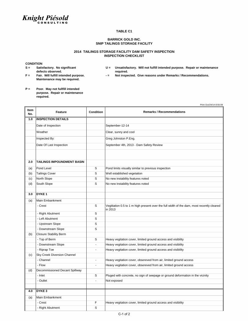
The general arrangement of the Snip TSF, annotated with conditions and observations during the 2014 inspection, is provided as Figures 2.1 and 2.2. Photographs from the site visit are provided in Appendix B and an inspection checklist of the major features of the TSF, including condition assessments and recommendations, is provided in Appendix C. Observations of major features are summarized in the following sections.
BARRICK GOLD INC.
SNIP TAILINGS STORAGE FACILITY
2014 DAM SAFETY INSPECTION 8 of 22 VA101-2/17-1 Rev 0 November 28, 2014
2.2 AERIAL OVERVIEW
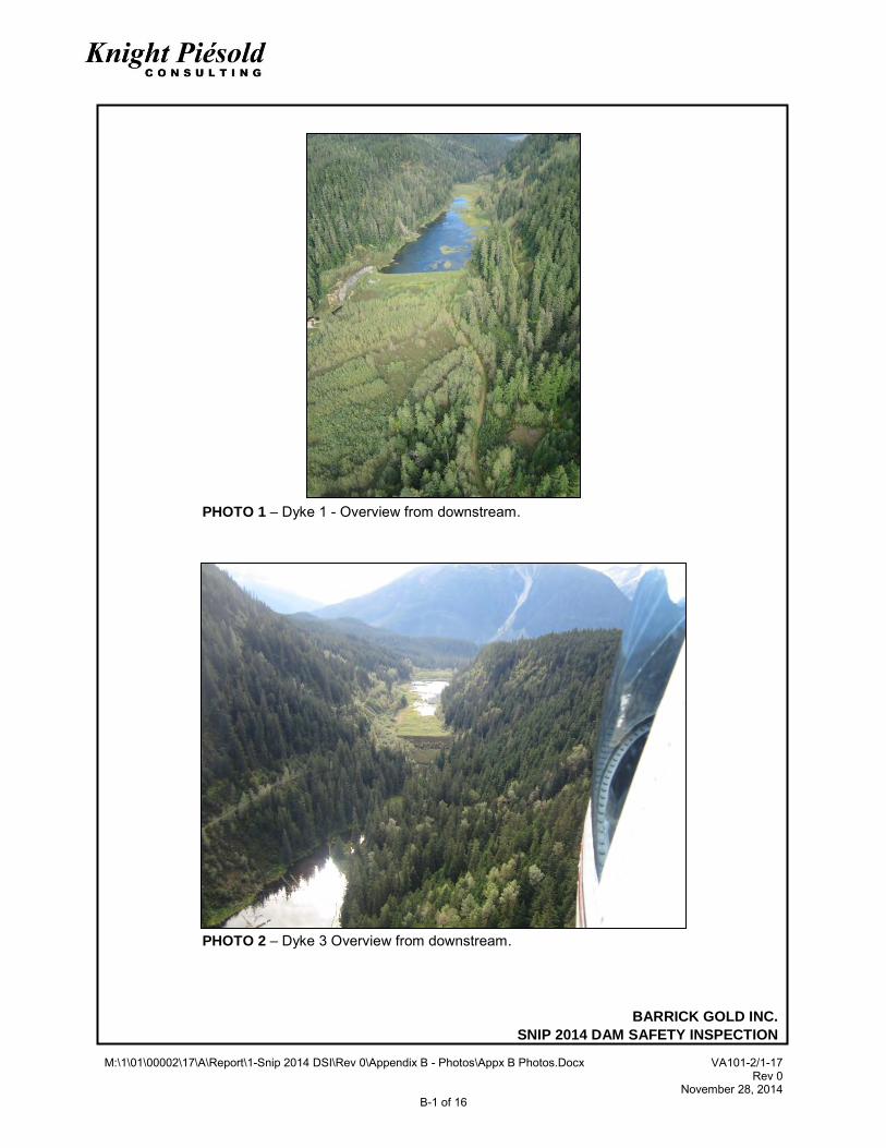
The site inspection began and ended with an aerial fly-over of the facility. The dykes, spillway, tailings cover, valley side slopes, and Sky Creek diversion were viewed from the helicopter. The following observations were made: • The Dykes 1 and 3 were in good condition and did not present any noticeable indications of
deformation or errosion. • The vegetation on the crest, upstream and downstream slope of Dyke 1 has been trimmed to
leave dense low ground cover. Heavy vegetation cover is present on the stability berm (Photo 1).
• The vegetation on the crest, upstream slope, downstream slope and stability berm of Dyke 3 is very thick and well established. There is very limited visibility of the Dyke 3 ground surface from air (Photo 2).
• The spillway was noted to be in good condition and discharging water into Sky Creek, a beaver dam below the spillway near the confluence with Sky Creek has resulted in a pond submerging the monitoring weir (Photo 3).
• The slough above the spillway inlet showed no signs of recent activity and dense vegetation was established on the majority of the slough and slough debris.
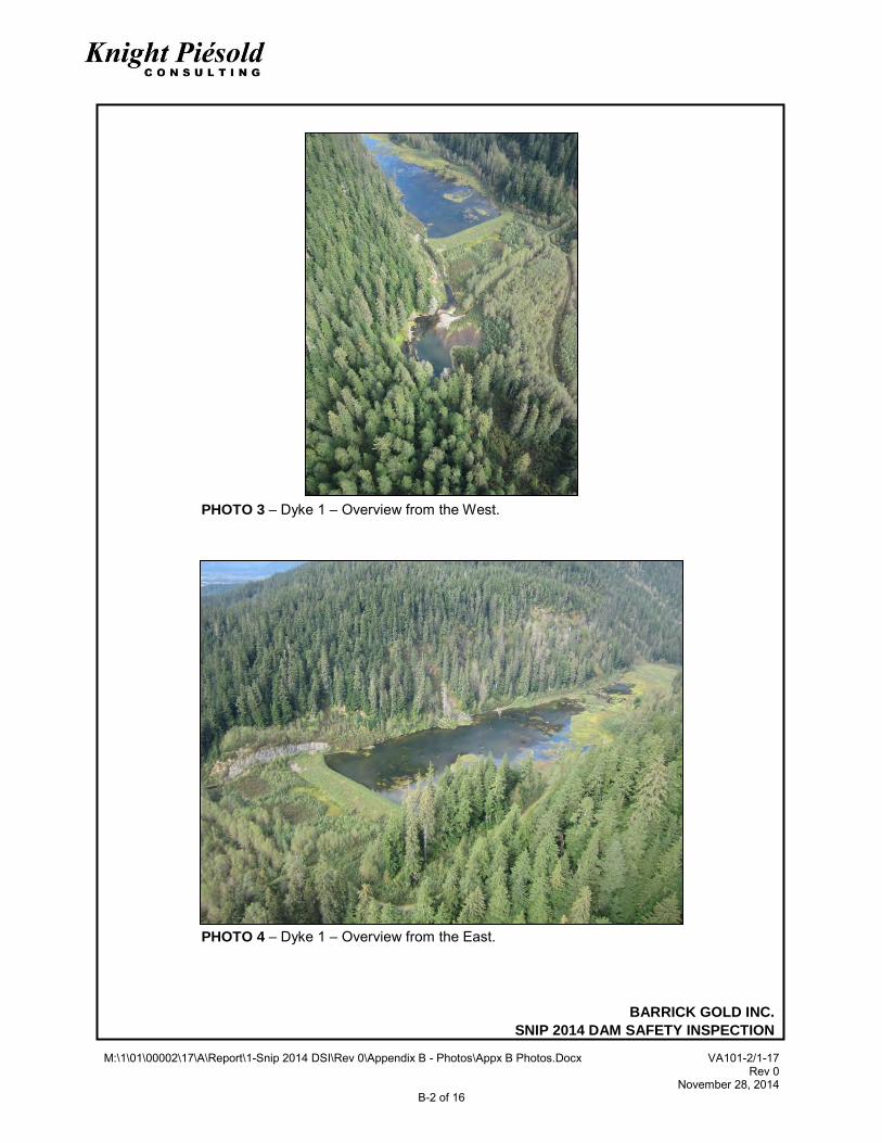
• A shallow water pond covers approximately 60% of the tailings basin area in the southwest side of the facility and is in contact with Dyke 1 (Photo 4). The extent of the pond was similar to that observed in 2013.
• The TSF has approximately 2 m of freeboard. • No activity was observed in the small slide noted on the north slope of the tailings basin,
approximately 100 m upstream of Dyke 1. The slide is now generally covered by a well-established vegetation (Photo 5).
• No new slides were observed in the impoundment side slopes, which are generally heavily vegetated (Photo 4).
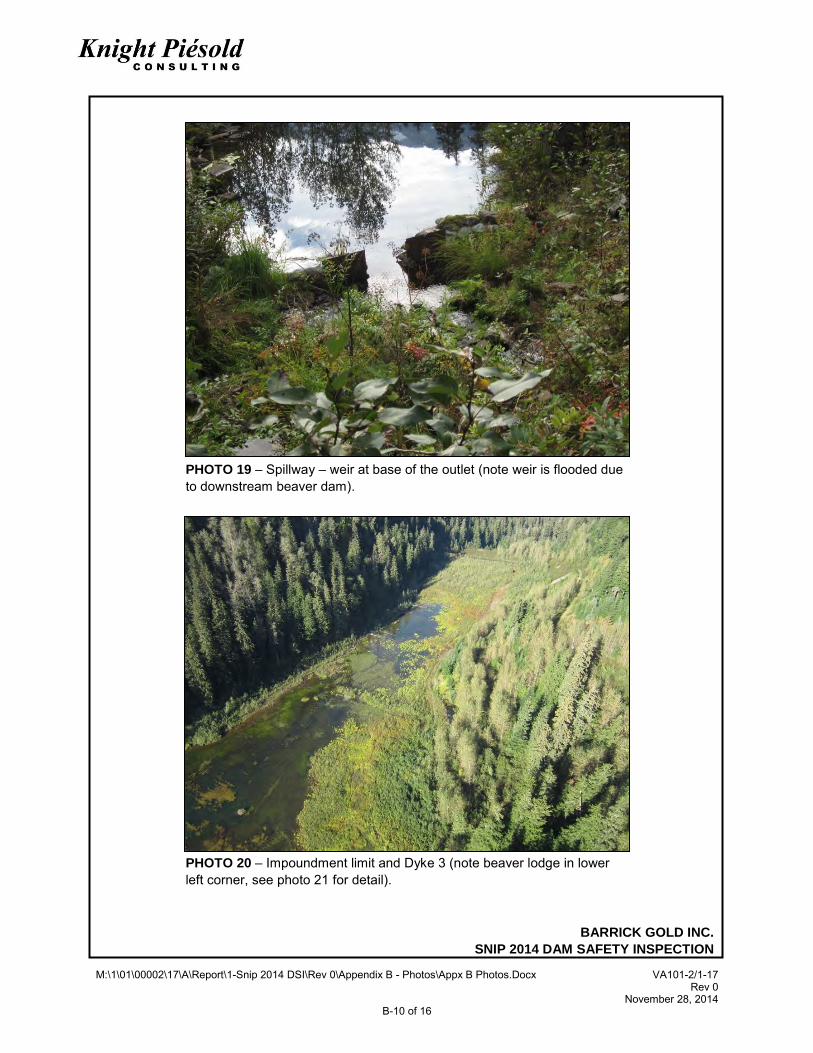
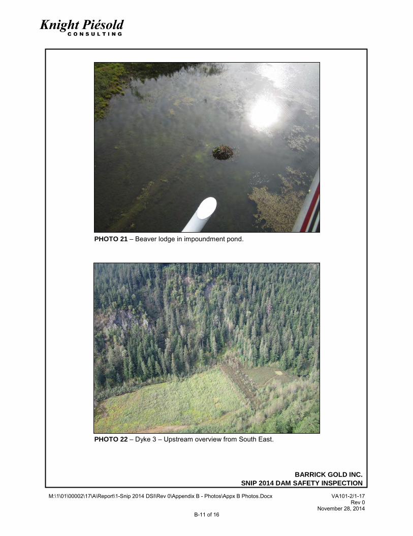
• A beaver lodge is observed in the water pond, no beavers were observed (Photos 20 and 21). • The Sky Creek diversion system below Dyke 1 is covered by dense vegetation and actively
discharging water.
2.3 DYKE 1
Dyke 1 was reviewed by an aerial inspection followed by a ground based inspection with access by landing the helicopter on the crest of the dam, adjacent to the spillway. The following observations were made during the walkover: • The dyke appeared to be in good condition with no cracking, bulging, deformation or erosion
observed. • The vegetation on the crest, upstream and downstream slopes of the dyke was trimmed 2013
prior to the DSR inspection. The vegetation during the site inspection formed a well-established low (300 mm to 600 mm high) ground cover (Photo 6). Ongoing clearance of vegetation from the dam crest and slopes to the stability berm will be required.
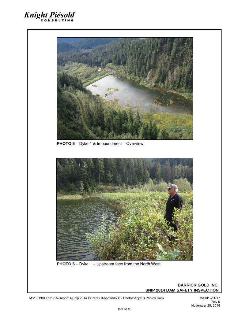
• The upstream face of the dyke was in contact with the pond over the full length of the dyke (Photos 5, 6 and 7).
• The riprap on the upstream face of the dyke was in satisfactory condition with well-established vegetation to the pond edge (Photo 6 and 7).
BARRICK GOLD INC.
SNIP TAILINGS STORAGE FACILITY
2014 DAM SAFETY INSPECTION 9 of 22 VA101-2/17-1 Rev 0 November 28, 2014
• No erosion was noted along the length of the crest (Photos 6 and 7). • The decommissioned outlet decant was in good condition, with no erosion, cracking or
deformations observed at the inlet (Photos 7 and 8). The approximate route of the decant pipe was inspected and no signs of ground distress noted. The outlet of the decommissioned decant is not visible.
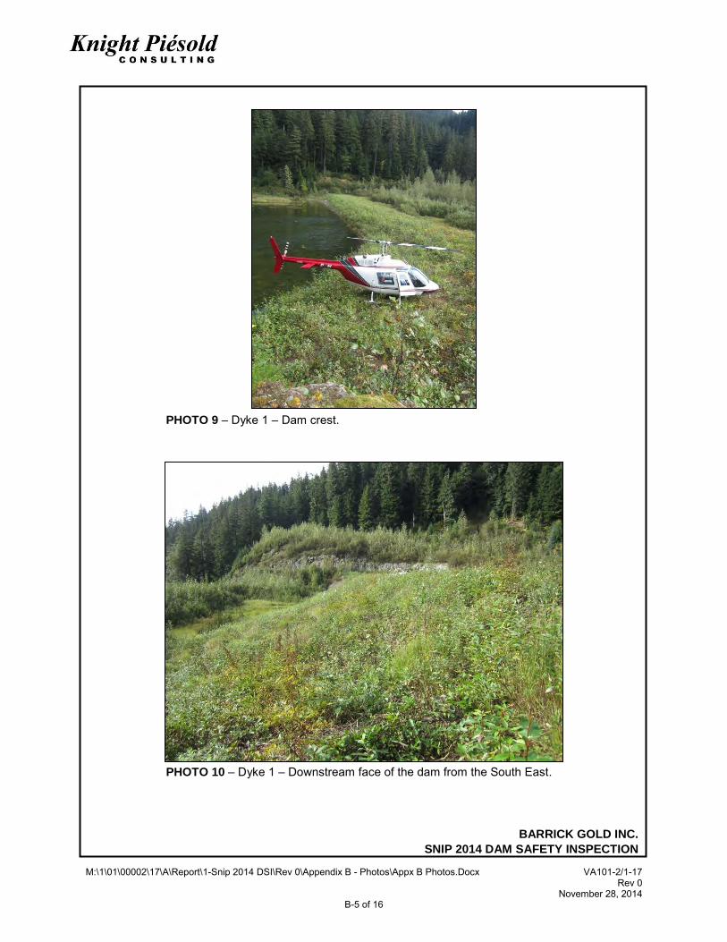
• No cracks, depressions or soft spots were noted on the crest of Dyke 1; the dyke was in good condition along its length (Photo 9).
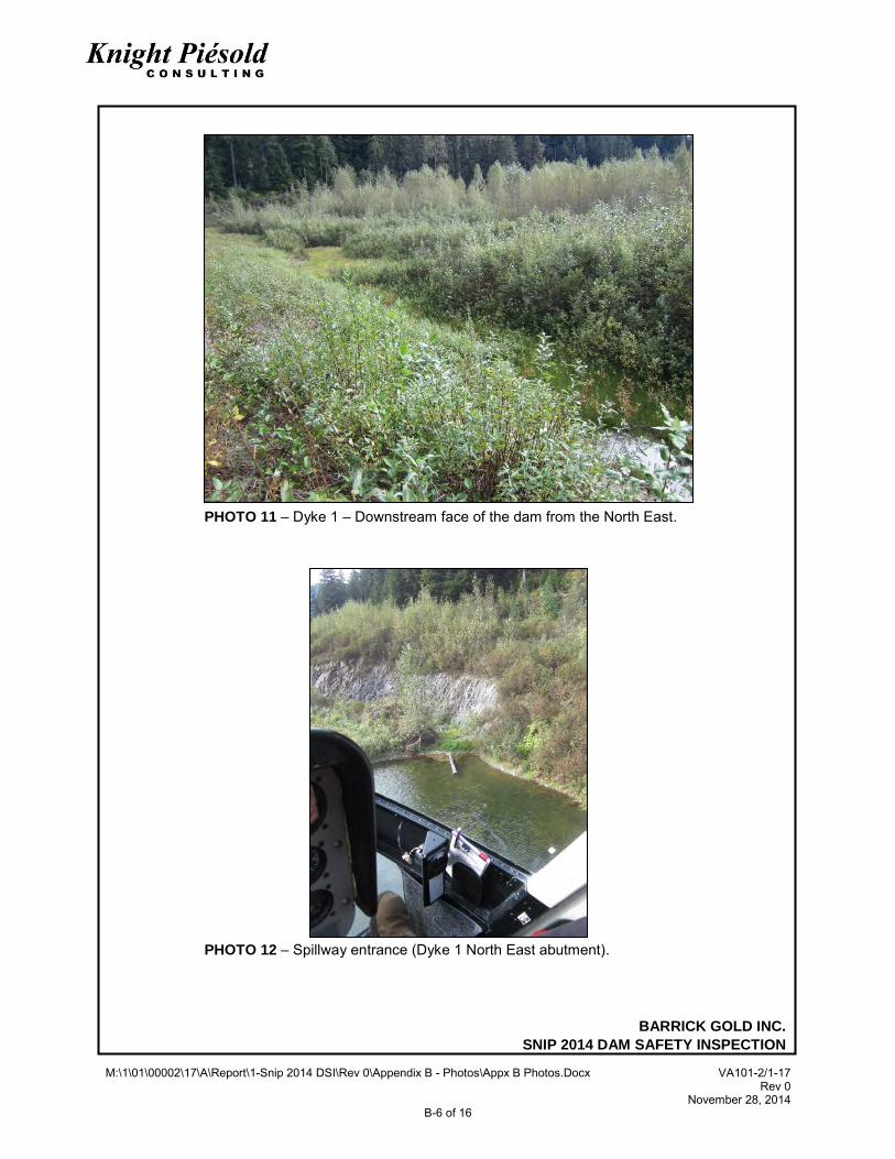
• Vegetation on the downstream face of Dyke 1 is low (approx. 1 m high), well established and very dense. Accessing and traversing the downstream face of the dyke is difficult and visibility of the ground is limited (Photos 10 and 11).
• Vegetation on the closure stability berm is well established and thick and 2 m or more high. Accessing and traversing the stability berm area is difficult with limited visibility due to dense vegetation, a ground inspection was completed of the South East closure stability berm, with the remainder of the stability berm viewed from the dyke crest (Photo 11).
• Standing water was observed on the closure stability berm against the downstream face of the dyke. This was also observed during previous inspections when it was interpreted to be due to local grading of the stability berm not seepage.
• The slough above the spillway inlet showed no signs of recent activity and dense vegetation is established on the majority of the slough and slough debris.
• The slough on the north slope of the tailings basin, approximately 100 m upstream of Dyke 1, was similar to that observed in previous inspections (Photo 5).
2.4 SPILLWAY
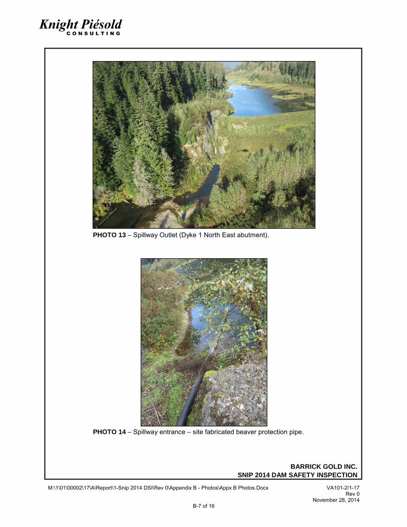
The spillway in the right abutment of Dyke 1 was inspected following the walkover of Dyke 1. The spillway is shown on Photos 12 to 19. The following observations were made: • The spillway inlet (Photo 12) and outlet (Photo 13) were found to be in fair condition with a
generally clear unobstructed passage. • The spillway inlet includes material (mostly branches) placed at the entrance by beavers. This
material has been partially cleared (Photos 12, 14 and 16). • To discourage beaver activity a perforated pipe has been installed at the spillway entrance
(Photos 13 and 14). The perforated pipe was installed in 2013 and extends approximately 5 m into the pond and 10 m into the spillway. This appears on be discouraging beaver activity at the spillway. However, at the spillway entrance some debris has fallen or been placed by beavers into the coarse riprap which lines the channel bottom, resulting in reduced flow capacity within the rock voids at spillway entrance. Ongoing monitoring of the spillway for beaver activity and clearing of vegetation is required.
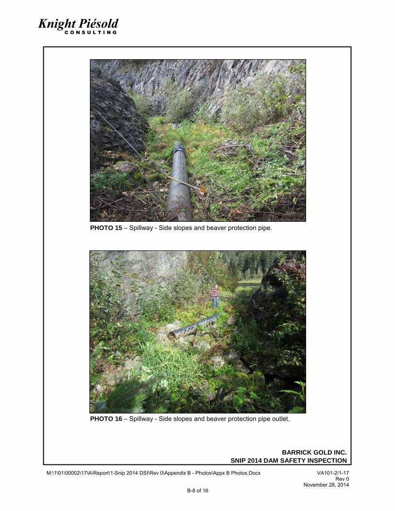
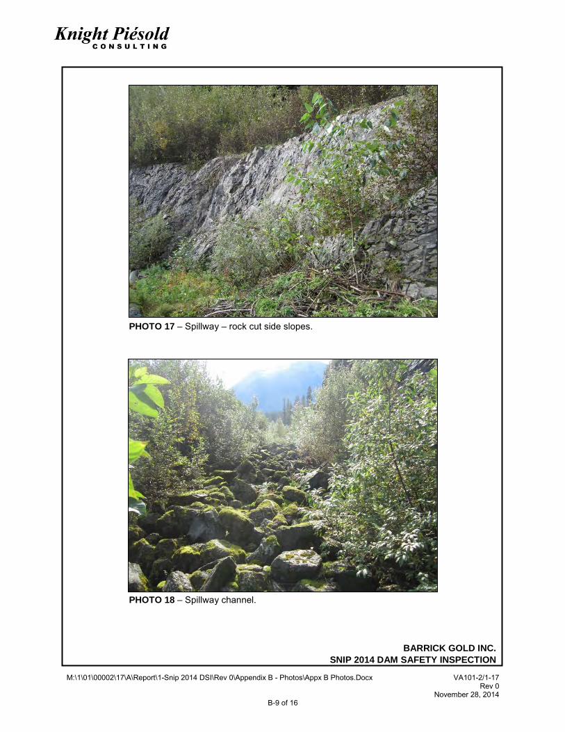
• The spillway side slopes channel are in fair to good condition with minor obstructions or impediments to the flow due to brush becoming established at discrete locations on the walls of the channel (Photos 15 to 18). The riprap on the floor of the spillway was generally clean once past the immediate entrance to the spillway.
• A flow of water was passing through the spillway at the time of inspection. This water flow was contained entirely within the voids in the loose riprap placed over the base of the spillway.
• There was no apparent change in the condition of the slough immediately upstream of the spillway entrance, this slough is now covered in dense vegetation (Photo 5).
BARRICK GOLD INC.
SNIP TAILINGS STORAGE FACILITY
2014 DAM SAFETY INSPECTION 10 of 22 VA101-2/17-1 Rev 0 November 28, 2014
• The outlet of the spillway into Sky Creek was in fair to good condition with some discrete brush becoming established.
• A beaver dam has been has been built downstream of the spillway outlet resulting in ponded water submerging the weir located below the spillway outlet (Photo 19). The beaver dam is approximately 50 m downstream of the spillway exit and has no impact on the security of the facility (Photo 19).
2.5 DYKE 3
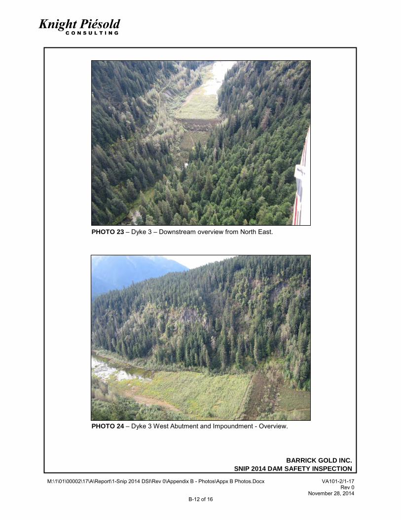
Access to Dyke 3 was achieved by landing the helicopter in a cleared area near the historical instrumentation hut on the closure stability berm (Photo 22). The following observations were made during the walkover of Dyke 3: • The north and south abutments to the dyke were in good condition with no new slope instability
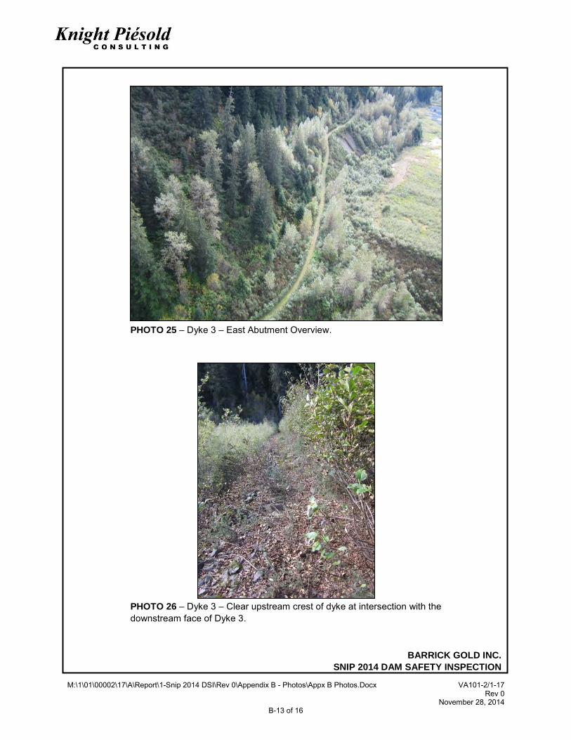
features noted (Photo 22 to 24). • A small road fill instability noted in previous inspections approximately 100 m upstream of the
dyke is unchanged from previous inspections (Photo 25) and poses no threat to TSF stability. • No surface water was ponded against the upstream face of Dyke 3 (Photos 22 to 24). • Very thick vegetation growth, approximately 3 m high, was present on Dyke 3, including the dyke
crest, downstream slope, closure stability berm. The vegetation growth made progress difficult and limited visibility to a few meters (Photos 28 and 29). A thorough visual inspection of Dyke 3 was not possible. The clearing of this vegetation from the upstream rip rap to the crest of the stability berm is recommended.
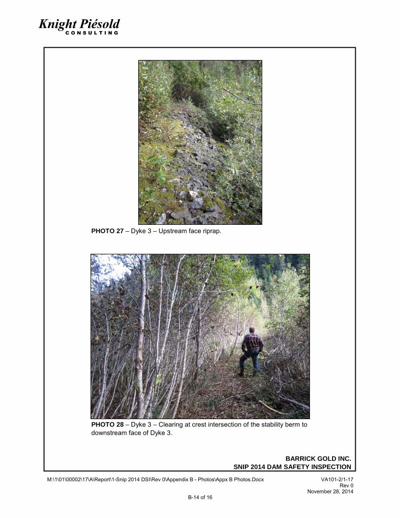
• An assessment of the upstream face of the dyke crest and the riprap was completed (Photos 26 and 27).
• Inspection of the dyke crest and downstream face was not possible due to the dense vegetation cover (Photos 28 and 29).
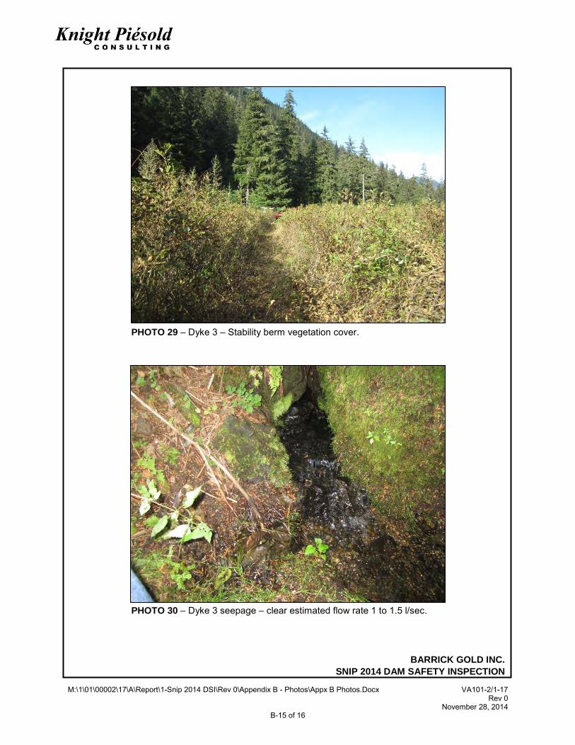
• Well established vegetation approximately 2 m high is present on the tailings cover immediately upstream of the dyke 3 (Photos 22, 24 and 26).
• Seepage from the dyke downstream toe is clean and clear and was visually estimated at approximately 1 to 1.5 l/s, similar to previous inspections.
BARRICK GOLD INC.
SNIP TAILINGS STORAGE FACILITY
2014 DAM SAFETY INSPECTION 11 of 22 VA101-2/17-1 Rev 0 November 28, 2014
3 – DAM CLASSIFICATION
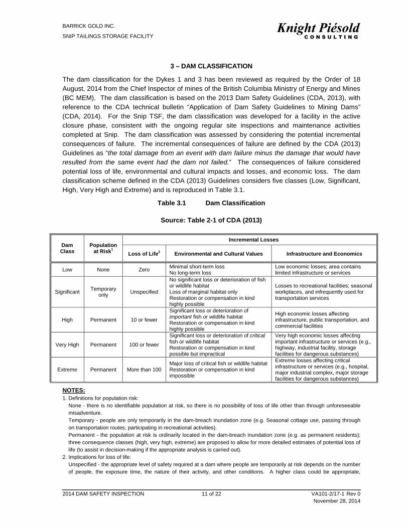
The dam classification for the Dykes 1 and 3 has been reviewed as required by the Order of 18 August, 2014 from the Chief Inspector of mines of the British Columbia Ministry of Energy and Mines (BC MEM). The dam classification is based on the 2013 Dam Safety Guidelines (CDA, 2013), with reference to the CDA technical bulletin “Application of Dam Safety Guidelines to Mining Dams” (CDA, 2014). For the Snip TSF, the dam classification was developed for a facility in the active closure phase, consistent with the ongoing regular site inspections and maintenance activities completed at Snip. The dam classification was assessed by considering the potential incremental consequences of failure. The incremental consequences of failure are defined by the CDA (2013) Guidelines as “the total damage from an event with dam failure minus the damage that would have resulted from the same event had the dam not failed.” The consequences of failure considered potential loss of life, environmental and cultural impacts and losses, and economic loss. The dam classification scheme defined in the CDA (2013) Guidelines considers five classes (Low, Significant, High, Very High and Extreme) and is reproduced in Table 3.1.
Table 3.1 Dam Classification
Source: Table 2-1 of CDA (2013)
Dam Class
Population at Risk1
Incremental Losses
Loss of Life2 Environmental and Cultural Values Infrastructure and Economics
Low None Zero Minimal short-term loss No long-term loss
Low economic losses; area contains limited infrastructure or services
Significant Temporary only Unspecified
No significant loss or deterioration of fish or wildlife habitat Loss of marginal habitat only Restoration or compensation in kind highly possible
Losses to recreational facilities; seasonal workplaces, and infrequently used for transportation services
High Permanent 10 or fewer
Significant loss or deterioration of important fish or wildlife habitat Restoration or compensation in kind highly possible
High economic losses affecting infrastructure, public transportation, and commercial facilities
Very High Permanent 100 or fewer
Significant loss or deterioration of critical fish or wildlife habitat Restoration or compensation in kind possible but impractical
Very high economic losses affecting important infrastructure or services (e.g., highway, industrial facility, storage facilities for dangerous substances)
Extreme Permanent More than 100 Major loss of critical fish or wildlife habitat Restoration or compensation in kind impossible
Extreme losses affecting critical infrastructure or services (e.g., hospital, major industrial complex, major storage facilities for dangerous substances)
NOTES: 1. Definitions for population risk:
None - there is no identifiable population at risk, so there is no possibility of loss of life other than through unforeseeable misadventure. Temporary - people are only temporarily in the dam-breach inundation zone (e.g. Seasonal cottage use, passing through on transportation routes, participating in recreational activities). Permanent - the population at risk is ordinarily located in the dam-breach inundation zone (e.g. as permanent residents); three consequence classes (high, very high, extreme) are proposed to allow for more detailed estimates of potential loss of life (to assist in decision-making if the appropriate analysis is carried out).
2. Implications for loss of life: Unspecified - the appropriate level of safety required at a dam where people are temporarily at risk depends on the number of people, the exposure time, the nature of their activity, and other conditions. A higher class could be appropriate,
BARRICK GOLD INC.
SNIP TAILINGS STORAGE FACILITY
2014 DAM SAFETY INSPECTION 12 of 22 VA101-2/17-1 Rev 0 November 28, 2014
depending on the requirements. However, the design flood requirement, for example, might not be higher if the temporary population is not likely to be present during the flood season.
The Snip TSF has relatively low embankments, approximately 10 m and 20 m high for Dykes 1 and 3 respectively, each with a modest crest length of approximately 150 m. The TSF impounds a small volume of free water above the tailings surface at the southwest end of the facility. The consequence classification of the dykes, as per the CDA Dam Safety Guidelines (2013), is considered to be SIGNIFICANT. The basis for this classification is: • There is no infrastructure, recreational facilities or work place facilities within a zone 5 km
downstream of Dyke 1. • There is no infrastructure within a 1,250 m zone downstream of Dyke 3 that could potentially be
damaged by failure of the dyke. • There is potential for a temporary population or a seasonal workplace below Dyke 3 at the
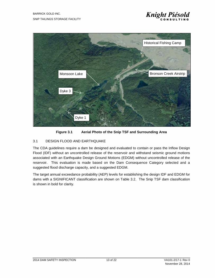
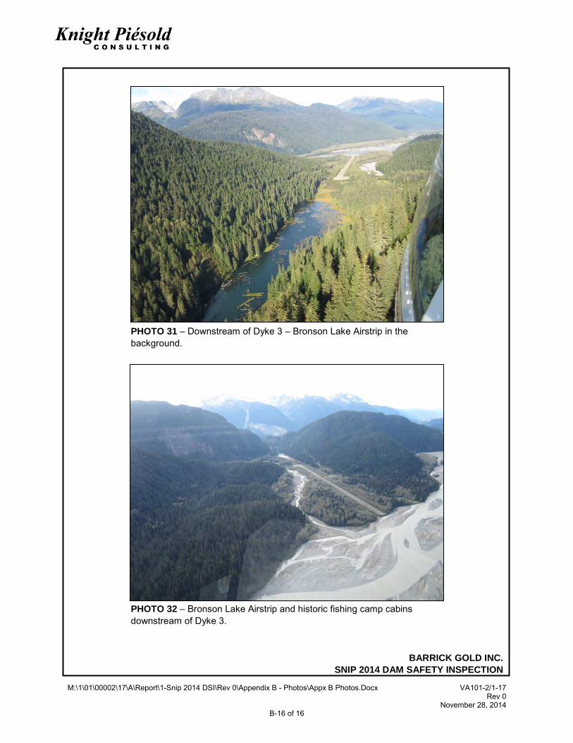
closed Bronson Creek Airstrip located between 1,250 m and 2,500 m downstream of Dyke 3 and at a historical fishing camp comprised of several structures located at the far end of the airstrip 2,500 m downstream of Dyke 3 as shown on Figure 3.1 and Photos 31 & 32. Both of these facilities are located below Monsoon Lake a narrow 900 m long lake and are currently unused and unoccupied. Based on a desktop assessment it is unlikely a dam breach would impact these facilities. However, as a dam breach analysis has not been completed for the site and is beyond the scope of this report. A dam breach analysis is not required for a SIGNIFICANT class dam. Therefore, the population is assessed by conservatively considering Dyke 3 to have ‘a temporary population at risk’.
• A failure of either dyke would damage the ecosystem in the Monsoon Lake and Sky Creek drainages immediately below the TSF, but would not have a significant impact on the fisheries or ecosystems in the Craig River, Bronson Creek and Iskut River located much further downstream from the facility, restoration of compensation in kind is considered to be highly possible.
• There would be “moderate” economic impacts (the costs of the clean-up and local ecosystem rehabilitation efforts) if either dyke failed.
This SIGNIFICANT consequence ranking is unchanged from the 2013 DSR.
BARRICK GOLD INC.
SNIP TAILINGS STORAGE FACILITY
2014 DAM SAFETY INSPECTION 13 of 22 VA101-2/17-1 Rev 0 November 28, 2014
Figure 3.1 Aerial Photo of the Snip TSF and Surrounding Area
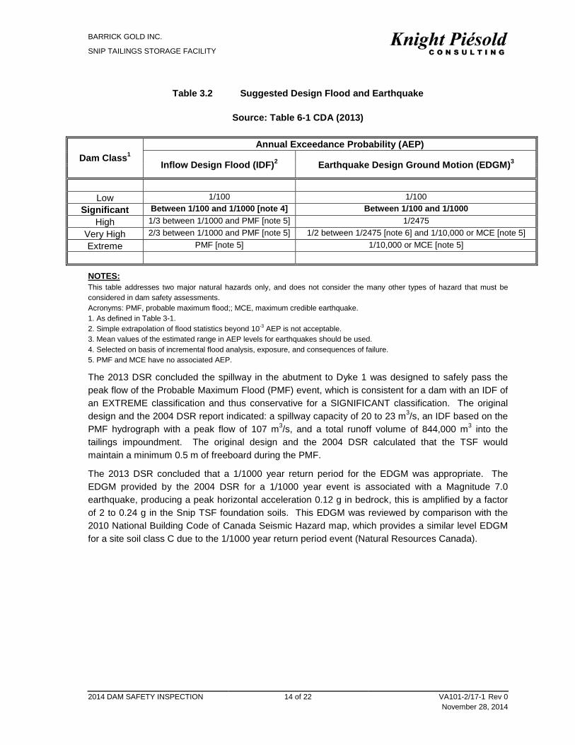
3.1 DESIGN FLOOD AND EARTHQUAKE
The CDA guidelines require a dam be designed and evaluated to contain or pass the Inflow Design Flood (IDF) without an uncontrolled release of the reservoir and withstand seismic ground motions associated with an Earthquake Design Ground Motions (EDGM) without uncontrolled release of the reservoir. This evaluation is made based on the Dam Consequence Category selected and a suggested flood discharge capacity, and a suggested EDGM.
The target annual exceedance probability (AEP) levels for establishing the design IDF and EDGM for dams with a SIGNIFICANT classification are shown on Table 3.2. The Snip TSF dam classification is shown in bold for clarity.
Historical Fishing Camp
Bronson Creek Airstrip Monsoon Lake
Dyke 3
Dyke 1
BARRICK GOLD INC.
SNIP TAILINGS STORAGE FACILITY
2014 DAM SAFETY INSPECTION 14 of 22 VA101-2/17-1 Rev 0 November 28, 2014
Table 3.2 Suggested Design Flood and Earthquake
Source: Table 6-1 CDA (2013)
Dam Class1 Annual Exceedance Probability (AEP)
Inflow Design Flood (IDF)2 Earthquake Design Ground Motion (EDGM)3
Low 1/100 1/100
Significant Between 1/100 and 1/1000 [note 4] Between 1/100 and 1/1000 High 1/3 between 1/1000 and PMF [note 5] 1/2475
Very High 2/3 between 1/1000 and PMF [note 5] 1/2 between 1/2475 [note 6] and 1/10,000 or MCE [note 5] Extreme PMF [note 5] 1/10,000 or MCE [note 5]
NOTES: This table addresses two major natural hazards only, and does not consider the many other types of hazard that must be considered in dam safety assessments. Acronyms: PMF, probable maximum flood;; MCE, maximum credible earthquake. 1. As defined in Table 3-1. 2. Simple extrapolation of flood statistics beyond 10-3 AEP is not acceptable. 3. Mean values of the estimated range in AEP levels for earthquakes should be used. 4. Selected on basis of incremental flood analysis, exposure, and consequences of failure. 5. PMF and MCE have no associated AEP.
The 2013 DSR concluded the spillway in the abutment to Dyke 1 was designed to safely pass the peak flow of the Probable Maximum Flood (PMF) event, which is consistent for a dam with an IDF of an EXTREME classification and thus conservative for a SIGNIFICANT classification. The original design and the 2004 DSR report indicated: a spillway capacity of 20 to 23 m3/s, an IDF based on the PMF hydrograph with a peak flow of 107 m3/s, and a total runoff volume of 844,000 m3 into the tailings impoundment. The original design and the 2004 DSR calculated that the TSF would maintain a minimum 0.5 m of freeboard during the PMF.
The 2013 DSR concluded that a 1/1000 year return period for the EDGM was appropriate. The EDGM provided by the 2004 DSR for a 1/1000 year event is associated with a Magnitude 7.0 earthquake, producing a peak horizontal acceleration 0.12 g in bedrock, this is amplified by a factor of 2 to 0.24 g in the Snip TSF foundation soils. This EDGM was reviewed by comparison with the 2010 National Building Code of Canada Seismic Hazard map, which provides a similar level EDGM for a site soil class C due to the 1/1000 year return period event (Natural Resources Canada).
BARRICK GOLD INC.
SNIP TAILINGS STORAGE FACILITY
2014 DAM SAFETY INSPECTION 15 of 22 VA101-2/17-1 Rev 0 November 28, 2014
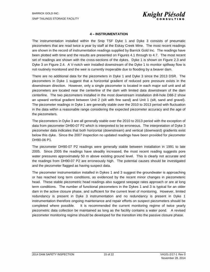
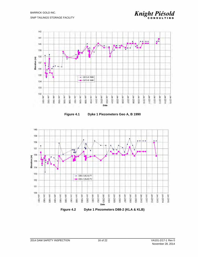
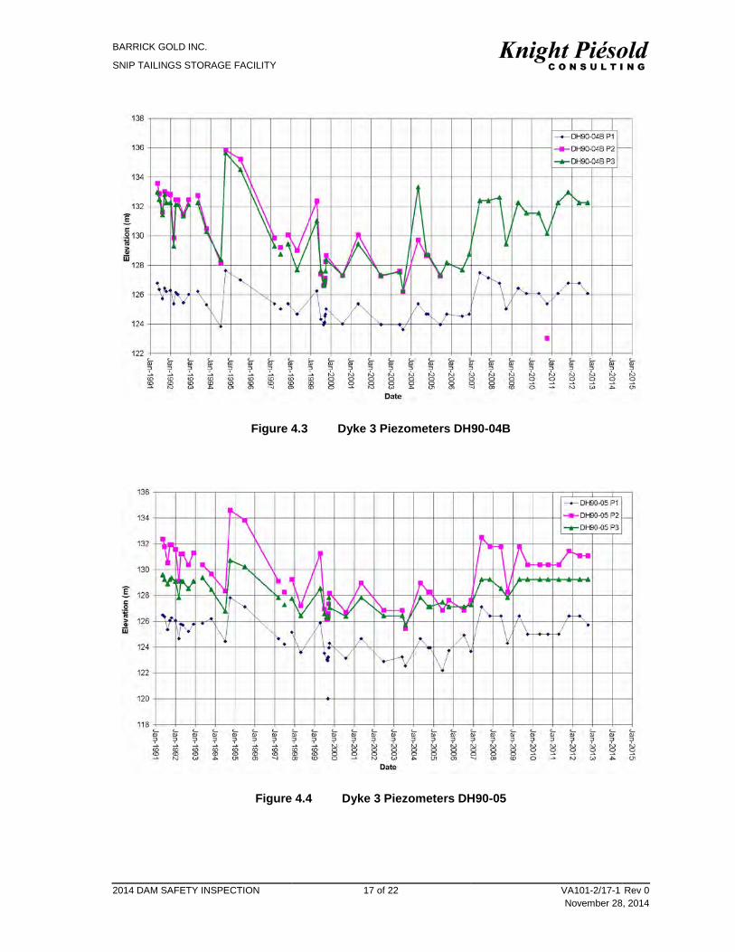
4 – INSTRUMENTATION
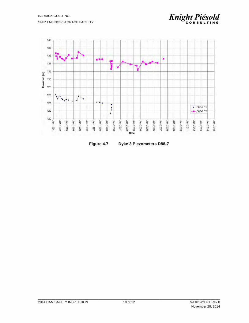
The instrumentation installed within the Snip TSF Dyke 1 and Dyke 3 consists of pneumatic piezometers that are read twice a year by staff at the Eskay Creek Mine. The most recent readings are shown in the record of instrumentation readings supplied by Barrick Gold Inc. The readings have been plotted with time and the results are presented on Figures 4.1 through to 4.7. The most recent set of readings are shown with the cross-sections of the dykes. Dyke 1 is shown on Figure 2.3 and Dyke 3 on Figure 2.4. A V-notch weir installed downstream of the Dyke 1 to monitor spillway flow is not routinely monitored and the weir is currently inoperable due to flooding by a beaver dam.
There are no additional data for the piezometers in Dyke 1 and Dyke 3 since the 2013 DSR. The piezometers in Dyke 1 suggest that a horizontal gradient of reduced pore pressure exists in the downstream direction. However, only a single piezometer is located in each major soil unit and all piezometers are located near the centerline of the dam with limited data downstream of the dam centerline. The two piezometers installed in the most downstream installation drill-hole D88-2 show an upward vertical gradient between Unit 2 (silt with fine sand) and Unit 1 (silt, sand and gravel). The piezometer readings in Dyke 1 are generally stable over the 2010 to 2013 period with fluctuation in the data within a reasonable range considering the expected piezometer accuracy and the age of the piezometers.
The piezometers in Dyke 3 are all generally stable over the 2010 to 2013 period with the exception of data from piezometer DH90-07 P2 which is interpreted to be erroneous. The interpretation of Dyke 3 piezometer data indicates that both horizontal (downstream) and vertical (downward) gradients exist below this dyke. Since the 2007 inspection no updated readings have been provided for piezometer DH90-06 P1.
The piezometer DH90-07 P2 readings were generally stable between installation in 1991 to late 2005. Since 2005 the readings have steadily increased, the most recent reading suggests pore water pressures approximately 50 m above existing ground level. This is clearly not accurate and the readings from DH90-07 P2 are erroneously high. The potential causes should be investigated and the piezometer flagged as having suspect data.
The piezometer instrumentation installed in Dykes 1 and 3 suggest the groundwater is approaching or has reached long term conditions, as evidenced by the recent minor changes in piezometeric head. These stable piezometric head readings also suggest seepage rates approach or are at long term conditions. The number of functional piezometers in the Dykes 1 and 3 is typical for an older dam in the active closure phase, and sufficient for the current level of monitoring. However, limited redundancy is present in Dyke 3 instrumentation and no redundancy is present in Dyke 1 instrumentation therefore ongoing maintenance and repair efforts on suspect piezometers should be completed where possible. It is recommended the current monitoring regime of twice yearly piezometric data collection be maintained as long as the facility contains a water pond. A revised piezometer monitoring regime should be developed for the transition into the passive closure phase.
BARRICK GOLD INC.
SNIP TAILINGS STORAGE FACILITY
2014 DAM SAFETY INSPECTION 16 of 22 VA101-2/17-1 Rev 0 November 28, 2014
Figure 4.1 Dyke 1 Piezometers Geo A, B 1990
Figure 4.2 Dyke 1 Piezometers D88-2 (KLA & KLB)
BARRICK GOLD INC.
SNIP TAILINGS STORAGE FACILITY
2014 DAM SAFETY INSPECTION 17 of 22 VA101-2/17-1 Rev 0 November 28, 2014
Figure 4.3 Dyke 3 Piezometers DH90-04B
Figure 4.4 Dyke 3 Piezometers DH90-05
BARRICK GOLD INC.
SNIP TAILINGS STORAGE FACILITY
2014 DAM SAFETY INSPECTION 18 of 22 VA101-2/17-1 Rev 0 November 28, 2014
Figure 4.5 Dyke 3 Piezometers DH90-06
Figure 4.6 Dyke 3 Piezometers DH90-07
BARRICK GOLD INC.
SNIP TAILINGS STORAGE FACILITY
2014 DAM SAFETY INSPECTION 19 of 22 VA101-2/17-1 Rev 0 November 28, 2014
Figure 4.7 Dyke 3 Piezometers D88-7
BARRICK GOLD INC.
SNIP TAILINGS STORAGE FACILITY
2014 DAM SAFETY INSPECTION 20 of 22 VA101-2/17-1 Rev 0 November 28, 2014
5 – SUMMARY AND CONCLUSIONS
The Snip TSF is generally in good condition. The dam classification of SIGNIFICANT remains appropriate for a TSF in the active closure phase. The following ongoing recommendations relate to clearing of vegetation from the dam crest to the stability berm, management of beaver activity on the spillway and instrumentation maintenance. The monitoring of the spillway and management of beaver activity in the spillway continues to be required to ensure the safe passage of flood water for the Snip TSF. The Snip TSF spillway is a single point of control against elevated water levels within the TSF impoundment.
The clearing of vegetation from earthen dams such as Dykes 1 and 3 is generally recognised as a best management practice, therefore it is recommended that
a) The regular clearing of vegetation from the dam crest to the stability berm to maintain vegetation less than 1.2 m high is completed.
b) The clearing of vegetation from the spillway is completed. c) Ongoing monitoring of the spillway to detect and remove beaver dams is completed.
The maintenance of piezometers should continue as on ongoing activity and it is recommended that performance of Piezometer DH90-07 P2 be assess based on the manufactures recommended trouble shooting guide. The piezometer should either be repaired of removed from service.
BARRICK GOLD INC.
SNIP TAILINGS STORAGE FACILITY
2014 DAM SAFETY INSPECTION 21 of 22 VA101-2/17-1 Rev 0 November 28, 2014
6 – REFERENCES
Canadian Dam Association (CDA 2013) CDA Dam Safety Guidelines 2007 (2013 Edition)
Canadian Dam Association (CDA 2014) Technical Bulletin: Application of Dam Safety Guidelines to Mining Dams October 2014
Federal Emergency Management Agency (FEMA). 2005. Technical Manual for Dam Owners – Impacts of Plants on Earthen Dams. FEMA 534. September 2005
Natural Resources Canada. (N.D.). 2010 National Building Code Of Canada Seismic Hazard Calculator. Retrieved October 23, 2014, From http://www.earthquakescanada.nrcan.gc.ca/hazard-alea/interpolat/index_2010-eng.php
US Army Corps of Engineers (USACE) 2014. Guidelines for Landscape Planting and vegetation Management at Levees, Floodwalls, Embankment Dams, and Appurtenant Structures. USACE ETL 1110-2-583. 30 April 2014
BARRICK GOLD INC.
SNIP TAILINGS STORAGE FACILITY
2014 DAM SAFETY INSPECTION VA101-2/17-1 Rev 0 November 28, 2014
APPENDIX A
NOTIFICATION OF CHIEF INSPECTORS ORDERS
(Pages A-1 to A-4)
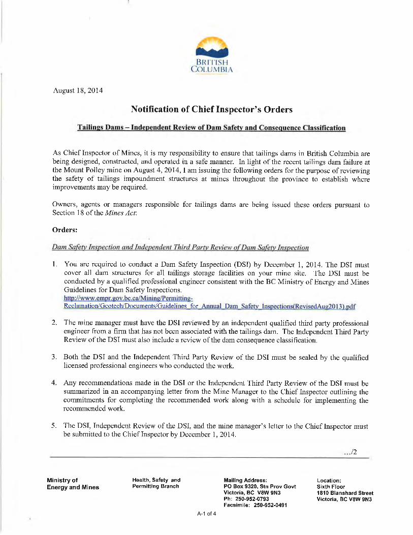
A-1 of 4
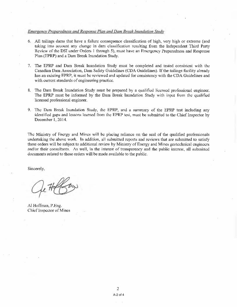
A-2 of 4
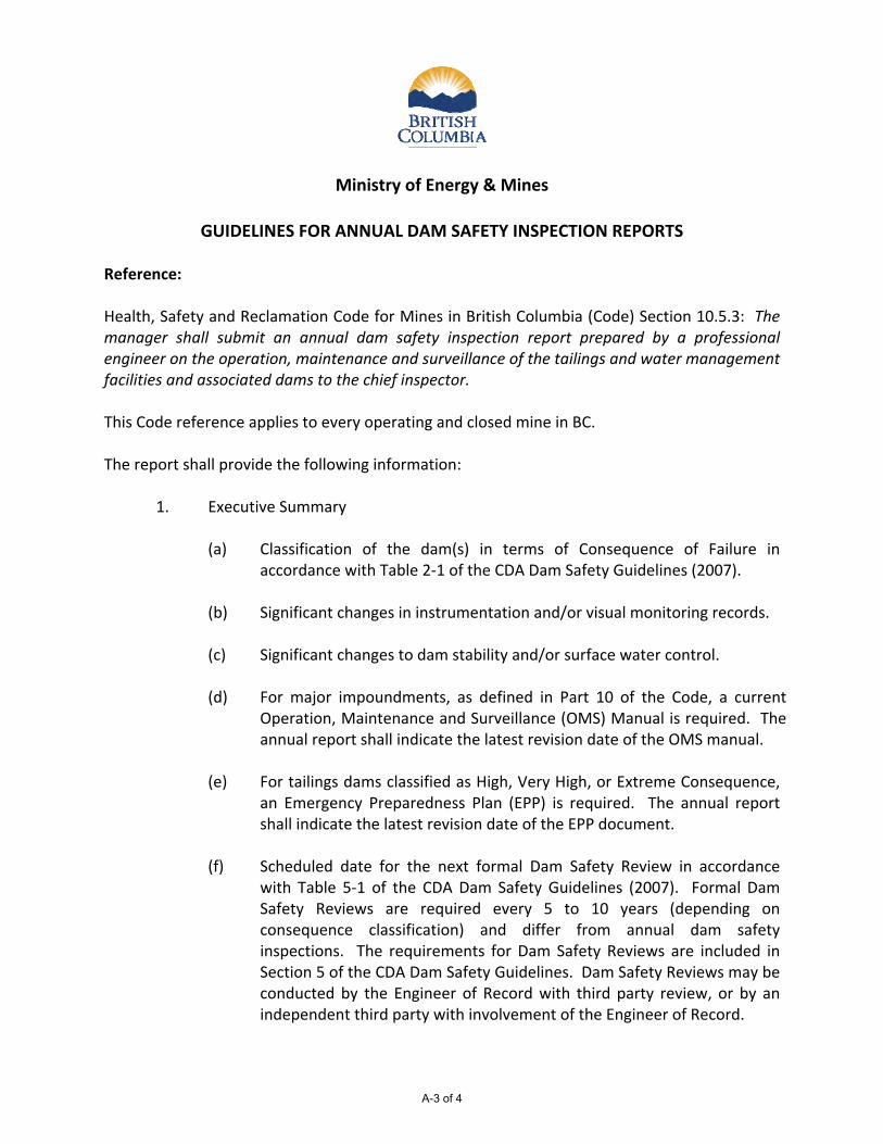
Ministry of Energy & Mines
GUIDELINES FOR ANNUAL DAM SAFETY INSPECTION REPORTS
Reference: Health, Safety and Reclamation Code for Mines in British Columbia (Code) Section 10.5.3: The manager shall submit an annual dam safety inspection report prepared by a professional engineer on the operation, maintenance and surveillance of the tailings and water management facilities and associated dams to the chief inspector. This Code reference applies to every operating and closed mine in BC. The report shall provide the following information:
1. Executive Summary (a) Classification of the dam(s) in terms of Consequence of Failure in
accordance with Table 2‐1 of the CDA Dam Safety Guidelines (2007). (b) Significant changes in instrumentation and/or visual monitoring records. (c) Significant changes to dam stability and/or surface water control. (d) For major impoundments, as defined in Part 10 of the Code, a current
Operation, Maintenance and Surveillance (OMS) Manual is required. The annual report shall indicate the latest revision date of the OMS manual.
(e) For tailings dams classified as High, Very High, or Extreme Consequence,
an Emergency Preparedness Plan (EPP) is required. The annual report shall indicate the latest revision date of the EPP document.
(f) Scheduled date for the next formal Dam Safety Review in accordance
with Table 5‐1 of the CDA Dam Safety Guidelines (2007). Formal Dam Safety Reviews are required every 5 to 10 years (depending on consequence classification) and differ from annual dam safety inspections. The requirements for Dam Safety Reviews are included in Section 5 of the CDA Dam Safety Guidelines. Dam Safety Reviews may be conducted by the Engineer of Record with third party review, or by an independent third party with involvement of the Engineer of Record.
A-3 of 4
Guidelines for Annual Dam Safety Inspection Reports - 2 - August 2013
2. Summary of past years' construction (if any) with a description of any problems
and stabilization. 3. Plan and representative cross sections. 4. Site photographs. 5. Review of climate data. 6. Water balance review. 7. Freeboard and storage availability (in excess of the design flood). 8. Water discharge system, volumes, and quality. 9. Seepage occurrence and water quality. 10. Surface water control and surface erosion. 11. Instrumentation review including: (a) Phreatic surfaces and piezometric data. (b) Settlement. (c) Lateral movement.
The report shall be submitted by a qualified geotechnical engineer registered as a Professional Engineer (P.Eng.) in British Columbia. The professional engineer will be deemed the Engineer of Record for the facility unless another engineer is identified within the Dam Safety Inspection report as having this responsibility. Note, this document modified from the original by George Warnock, P.Eng. (Manager, Geotechnical Engineering) in August 2013. Original prepared by Chris Carr, P.Eng. (former Manager) in February 2002.
A-4 of 4
BARRICK GOLD INC.
SNIP TAILINGS STORAGE FACILITY
2014 DAM SAFETY INSPECTION VA101-2/17-1 Rev 0 November 28, 2014
APPENDIX B
2014 PHOTOGRAPHS
(Pages B-1 to B-16)
M:\1\01\00002\17\A\Report\1-Snip 2014 DSI\Rev 0\Appendix B - Photos\Appx B Photos.Docx VA101-2/1-17 Rev 0 November 28, 2014
BARRICK GOLD INC.
SNIP 2014 DAM SAFETY INSPECTION
PHOTO 1 – Dyke 1 - Overview from downstream.
PHOTO 2 – Dyke 3 Overview from downstream.
B-1 of 16
M:\1\01\00002\17\A\Report\1-Snip 2014 DSI\Rev 0\Appendix B - Photos\Appx B Photos.Docx VA101-2/1-17 Rev 0 November 28, 2014
BARRICK GOLD INC.
SNIP 2014 DAM SAFETY INSPECTION
PHOTO 3 – Dyke 1 – Overview from the West.
PHOTO 4 – Dyke 1 – Overview from the East.
B-2 of 16
M:\1\01\00002\17\A\Report\1-Snip 2014 DSI\Rev 0\Appendix B - Photos\Appx B Photos.Docx VA101-2/1-17 Rev 0 November 28, 2014
BARRICK GOLD INC.
SNIP 2014 DAM SAFETY INSPECTION
PHOTO 5 – Dyke 1 & Impoundment – Overview.
PHOTO 6 – Dyke 1 – Upstream face from the North West.
B-3 of 16

M:\1\01\00002\17\A\Report\1-Snip 2014 DSI\Rev 0\Appendix B - Photos\Appx B Photos.Docx VA101-2/1-17 Rev 0 November 28, 2014
BARRICK GOLD INC.
SNIP 2014 DAM SAFETY INSPECTION
PHOTO 7 – Dyke 1 – Upstream face from the South East.
PHOTO 8 – Dyke 1 – Decommissioned decant inlet.
B-4 of 16
M:\1\01\00002\17\A\Report\1-Snip 2014 DSI\Rev 0\Appendix B - Photos\Appx B Photos.Docx VA101-2/1-17 Rev 0 November 28, 2014
BARRICK GOLD INC.
SNIP 2014 DAM SAFETY INSPECTION
PHOTO 9 – Dyke 1 – Dam crest.
PHOTO 10 – Dyke 1 – Downstream face of the dam from the South East.
B-5 of 16
M:\1\01\00002\17\A\Report\1-Snip 2014 DSI\Rev 0\Appendix B - Photos\Appx B Photos.Docx VA101-2/1-17 Rev 0 November 28, 2014
BARRICK GOLD INC.
SNIP 2014 DAM SAFETY INSPECTION
PHOTO 11 – Dyke 1 – Downstream face of the dam from the North East.
PHOTO 12 – Spillway entrance (Dyke 1 North East abutment).
B-6 of 16
M:\1\01\00002\17\A\Report\1-Snip 2014 DSI\Rev 0\Appendix B - Photos\Appx B Photos.Docx VA101-2/1-17 Rev 0 November 28, 2014
BARRICK GOLD INC.
SNIP 2014 DAM SAFETY INSPECTION
PHOTO 13 – Spillway Outlet (Dyke 1 North East abutment).
PHOTO 14 – Spillway entrance – site fabricated beaver protection pipe.
B-7 of 16
M:\1\01\00002\17\A\Report\1-Snip 2014 DSI\Rev 0\Appendix B - Photos\Appx B Photos.Docx VA101-2/1-17 Rev 0 November 28, 2014
BARRICK GOLD INC.
SNIP 2014 DAM SAFETY INSPECTION
PHOTO 15 – Spillway - Side slopes and beaver protection pipe.
PHOTO 16 – Spillway - Side slopes and beaver protection pipe outlet.
B-8 of 16
M:\1\01\00002\17\A\Report\1-Snip 2014 DSI\Rev 0\Appendix B - Photos\Appx B Photos.Docx VA101-2/1-17 Rev 0 November 28, 2014
BARRICK GOLD INC.
SNIP 2014 DAM SAFETY INSPECTION
PHOTO 17 – Spillway – rock cut side slopes.
PHOTO 18 – Spillway channel.
B-9 of 16
M:\1\01\00002\17\A\Report\1-Snip 2014 DSI\Rev 0\Appendix B - Photos\Appx B Photos.Docx VA101-2/1-17 Rev 0 November 28, 2014
BARRICK GOLD INC.
SNIP 2014 DAM SAFETY INSPECTION
PHOTO 19 – Spillway – weir at base of the outlet (note weir is flooded due to downstream beaver dam).
PHOTO 20 – Impoundment limit and Dyke 3 (note beaver lodge in lower left corner, see photo 21 for detail).
B-10 of 16
M:\1\01\00002\17\A\Report\1-Snip 2014 DSI\Rev 0\Appendix B - Photos\Appx B Photos.Docx VA101-2/1-17 Rev 0 November 28, 2014
BARRICK GOLD INC.
SNIP 2014 DAM SAFETY INSPECTION
PHOTO 21 – Beaver lodge in impoundment pond.
PHOTO 22 – Dyke 3 – Upstream overview from South East.
B-11 of 16
M:\1\01\00002\17\A\Report\1-Snip 2014 DSI\Rev 0\Appendix B - Photos\Appx B Photos.Docx VA101-2/1-17 Rev 0 November 28, 2014
BARRICK GOLD INC.
SNIP 2014 DAM SAFETY INSPECTION
PHOTO 23 – Dyke 3 – Downstream overview from North East.
PHOTO 24 – Dyke 3 West Abutment and Impoundment - Overview.
B-12 of 16
M:\1\01\00002\17\A\Report\1-Snip 2014 DSI\Rev 0\Appendix B - Photos\Appx B Photos.Docx VA101-2/1-17 Rev 0 November 28, 2014
BARRICK GOLD INC.
SNIP 2014 DAM SAFETY INSPECTION
PHOTO 25 – Dyke 3 – East Abutment Overview.
PHOTO 26 – Dyke 3 – Clear upstream crest of dyke at intersection with the downstream face of Dyke 3.
B-13 of 16
M:\1\01\00002\17\A\Report\1-Snip 2014 DSI\Rev 0\Appendix B - Photos\Appx B Photos.Docx VA101-2/1-17 Rev 0 November 28, 2014
BARRICK GOLD INC.
SNIP 2014 DAM SAFETY INSPECTION
PHOTO 27 – Dyke 3 – Upstream face riprap.
PHOTO 28 – Dyke 3 – Clearing at crest intersection of the stability berm to downstream face of Dyke 3.
B-14 of 16
M:\1\01\00002\17\A\Report\1-Snip 2014 DSI\Rev 0\Appendix B - Photos\Appx B Photos.Docx VA101-2/1-17 Rev 0 November 28, 2014
BARRICK GOLD INC.
SNIP 2014 DAM SAFETY INSPECTION
PHOTO 29 – Dyke 3 – Stability berm vegetation cover.
PHOTO 30 – Dyke 3 seepage – clear estimated flow rate 1 to 1.5 l/sec.
B-15 of 16
M:\1\01\00002\17\A\Report\1-Snip 2014 DSI\Rev 0\Appendix B - Photos\Appx B Photos.Docx VA101-2/1-17 Rev 0 November 28, 2014
BARRICK GOLD INC.
SNIP 2014 DAM SAFETY INSPECTION
PHOTO 31 – Downstream of Dyke 3 – Bronson Lake Airstrip in the background.
PHOTO 32 – Bronson Lake Airstrip and historic fishing camp cabins downstream of Dyke 3.
B-16 of 16
BARRICK GOLD INC.
SNIP TAILINGS STORAGE FACILITY
2014 DAM SAFETY INSPECTION VA101-2/17-1 Rev 0 November 28, 2014
APPENDIX C
2014 DAM SAFETY INSPECTION CHECKLIST
(Pages C-1 to C-2)
CONDITIONS = Satisfactory. No significant
defects observed.U = Unsatisfactory. Will not fulfill intended purpose. Repair or maintenance
required.F = Fair. Will fulfill intended purpose.
Maintenance may be required.- = Not inspected. Give reasons under Remarks / Recommendations.
P = Poor. May not fullfill intended purpose. Repair or maintenance required.
Print Oct/24/14 8:55:09
ItemNo. Feature Condition
1.0 INSPECTION DETAILS
Date of Inspection
Weather
Inspected By:
Date Of Last Inspection
2.0 TAILINGS IMPOUNDMENT BASIN
(a) Pond Level S
(b) Tailings Cover S
(c) North Slope S
(d) South Slope S
3.0 DYKE 1
(a) Main Embankment
- Crest S
- Right Abutment S
- Left Abutment S
- Upstream Slope S
- Downstream Slope S
(b) Closure Stability Berm
- Top of Berm S
- Downstream Slope -
- Riprap Toe -
(c) Sky Creek Diversion Channel
- Channel -
- Flow -
(d) Decommissioned Decant Spillway
- Inlet S
- Outlet -
4.0 DYKE 3
(a) Main Embankment
- Crest F
- Right Abutment S
Heavy vegitation cover, limited ground access and visibility
Pluged with concrete, no sign of seepage or ground deformation in the vicinity
Not exposed
Pond limits visually similar to previous inspection
Heavy vegitation cover, limited ground access and visibility
Heavy vegitation cover, limited ground access and visibility
Heavy vegitation cover, limited ground access and visibility
Vegitiation 0.5 to 1 m high present over the full width of the dam, most recently cleared in 2013
Heavy vegitation cover, obsereved from air, limited ground access
Heavy vegitation cover, obsereved from air, limited ground access
Well established vegetation
No new instability features noted
No new instability features noted
September-12-14
Clear, sunny and cool
Greg Johnston P.Eng.
September 4th, 2013 - Dam Safety Review
TABLE C1
BARRICK GOLD INC.SNIP TAILINGS STORAGE FACILITY
2014 TAILINGS STORAGE FACILITY DAM SAFETY INSPECTIONINSPECTION CHECKLIST
Remarks / Recommendations
C-1 of 2
CONDITIONS = Satisfactory. No significant
defects observed.U = Unsatisfactory. Will not fulfill intended purpose. Repair or maintenance
required.F = Fair. Will fulfill intended purpose.
Maintenance may be required.- = Not inspected. Give reasons under Remarks / Recommendations.
P = Poor. May not fullfill intended purpose. Repair or maintenance required.
Print Oct/24/14 8:55:09
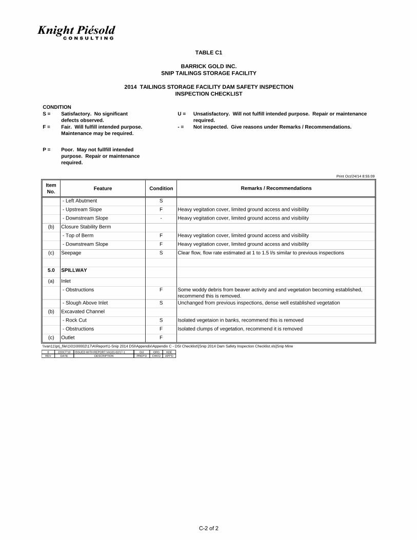
ItemNo. Feature Condition
TABLE C1
BARRICK GOLD INC.SNIP TAILINGS STORAGE FACILITY
2014 TAILINGS STORAGE FACILITY DAM SAFETY INSPECTIONINSPECTION CHECKLIST
Remarks / Recommendations
- Left Abutment S
- Upstream Slope F
- Downstream Slope -
(b) Closure Stability Berm
- Top of Berm F
- Downstream Slope F
(c) Seepage S
5.0 SPILLWAY
(a) Inlet
- Obstructions F
- Slough Above Inlet S
(b) Excavated Channel
- Rock Cut S
- Obstructions F
(c) Outlet F\\van11\prj_file\1\01\00002\17\A\Report\1-Snip 2014 DSI\Appendix\Appendix C - DSI Checklist\[Snip 2014 Dam Safety Inspection Checklist.xls]Snip Mine
Heavy vegitation cover, limited ground access and visibility
Heavy vegitation cover, limited ground access and visibility
Heavy vegitation cover, limited ground access and visibility
Heavy vegitation cover, limited ground access and visibility
Clear flow, flow rate estimated at 1 to 1.5 l/s similar to previous inspections
Isolated vegetaion in banks, recommend this is removed
Isolated clumps of vegetation, recommend it is removed
Some woddy debris from beaver activity and and vegetation becoming established, recommend this is removed.Unchanged from previous inspections, dense well established vegetation
0 22OCT'10 GIJ GRGISSUED WITH REPORT VA101-02/17-1 KDEDATE DESCRIPTION PREP'D CHK'D APP'DREV
C-2 of 2