Embed Size (px)
Citation preview
1
Western Australian Electoral Distribution
2019 Review of Western Australia’sElectoral Boundaries
Final Boundaries
November 2019
2
Introduction The Electoral Act 1907 (the Act) requires that Western Australia’s State electoral boundaries be reviewed once in the life of each Parliament. In accordance with section 16B of the Act the review must be undertaken by an independent Distribution Commission comprising a person with judicial experience (as Chair), the Electoral Commissioner and the Government Statistician. This review was undertaken by:
Hon. Eric Heenan QC, retired Judge of the Supreme Court of Western Australia (Chairperson)
Mr Tom Joseph, Government Statistician
Mr David Kerslake, Electoral Commissioner (during the drafting of the proposed boundaries)
Mr Chris Avent, Acting Electoral Commissioner (for the final stage of the Distribution).
The Commissioners wish to acknowledge and record the very substantial contribution made to this Redistribution by the former Electoral Commissioner Mr David Kerslake until his recent retirement.
Public consultation
The Commissioners were required, after a process of public consultation, to review and determine the boundaries of all Legislative Assembly districts and all Legislative Council regions, including which districts will be placed in each region. They have no authority to alter the number of regions and districts.
The consultation process commenced on 30 March 2019 with public notices inviting public suggestions. Fifteen suggestions were
received and published with an invitation for public comment. Twenty-four comments were received.
Taking all public input into account the Commissioners proceeded to draft proposed boundaries, which were published on 26 July 2019 with an invitation for public objections. Nineteen objections were received and taken into account in determining the final boundaries.
Legislative requirements
The Act specifies that the State is to be divided into 59 electoral districts and six regions. Each district returns a single member to the Legislative Assembly (section 16C); and each region returns six members to serve in the Legislative Council (section 16D).
The Act sets out a number of criteria which the Commissioners must take into account in reaching their determination, with the overriding consideration being elector numbers. The boundaries of each district must (with one exception) be set so that enrolment levels do not vary by 10% or more above or below the average enrolment (Average District Enrolment or ‘ADE’) of all districts in the State.
The exception referred to applies in electoral districts which exceed 100,000 square kilometres in geographical area. Section 16G of the Act stipulates that in such districts a Large District Allowance (LDA) must be applied, equal to 1.5% of the number of square kilometres in the area of the district. This figure (consisting of ‘notional’ electors) is added to the number of actual electors when calculating the total enrolment for such a district. The total arrived at must not be 10% or more above or 20% or more below the ADE.
3
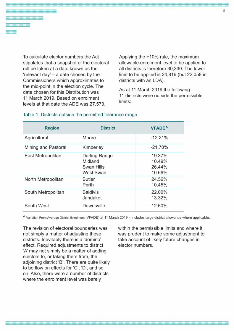
To calculate elector numbers the Act stipulates that a snapshot of the electoral roll be taken at a date known as the ‘relevant day’ – a date chosen by the Commissioners which approximates to the mid-point in the election cycle. The date chosen for this Distribution was 11 March 2019. Based on enrolment levels at that date the ADE was 27,573.
Applying the +10% rule, the maximum allowable enrolment level to be applied to all districts is therefore 30,330. The lower limit to be applied is 24,816 (but 22,058 in districts with an LDA).
As at 11 March 2019 the following 11 districts were outside the permissible limits:
Region District VFADE^
Agricultural Moore -12.21%
Mining and Pastoral Kimberley -21.70%
East Metropolitan Darling RangeMidlandSwan Hills West Swan
19.37%10.49%26.44%10.66%
North Metropolitan ButlerPerth
24.56%10.45%
South Metropolitan BaldivisJandakot
22.00%13.32%
South West Dawesville 12.60%
Table 1: Districts outside the permitted tolerance range
^ Variation From Average District Enrolment (VFADE) at 11 March 2019 – includes large district allowance where applicable.
The revision of electoral boundaries was not simply a matter of adjusting these districts. Inevitably there is a ‘domino’ effect. Required adjustments to district ‘A’ may not simply be a matter of adding electors to, or taking them from, the adjoining district ‘B’. There are quite likely to be flow on effects for ‘C’, ‘D’, and so on. Also, there were a number of districts where the enrolment level was barely
within the permissible limits and where it was prudent to make some adjustment to take account of likely future changes in elector numbers.
4
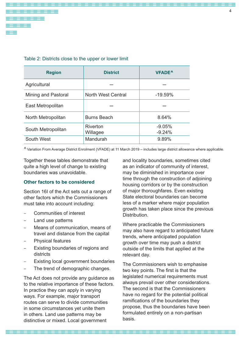
Together these tables demonstrate that quite a high level of change to existing boundaries was unavoidable.
Other factors to be considered
Section 16I of the Act sets out a range of other factors which the Commissioners must take into account including:
– Communities of interest– Land use patterns– Means of communication, means of
travel and distance from the capital– Physical features– Existing boundaries of regions and
districts – Existing local government boundaries– The trend of demographic changes.
The Act does not provide any guidance as to the relative importance of these factors. In practice they can apply in varying ways. For example, major transport routes can serve to divide communities in some circumstances yet unite them in others. Land use patterns may be distinctive or mixed. Local government
and locality boundaries, sometimes cited as an indicator of community of interest, may be diminished in importance over time through the construction of adjoining housing corridors or by the construction of major thoroughfares. Even existing State electoral boundaries can become less of a marker where major population growth has taken place since the previous Distribution.
Where practicable the Commissioners may also have regard to anticipated future trends, where anticipated population growth over time may push a district outside of the limits that applied at the relevant day.
The Commissioners wish to emphasise two key points. The first is that the legislated numerical requirements must always prevail over other considerations. The second is that the Commissioners have no regard for the potential political ramifications of the boundaries they propose, thus the boundaries have been formulated entirely on a non-partisan basis.
Table 2: Districts close to the upper or lower limit
Region District VFADE^
Agricultural — —
Mining and Pastoral North West Central -19.59%
East Metropolitan — —
North Metropolitan Burns Beach 8.64%
South Metropolitan RivertonWillagee
-9.05%-9.24%
South West Mandurah 9.89%
^ Variation From Average District Enrolment (VFADE) at 11 March 2019 – includes large district allowance where applicable.
5
Dividing the state: a repriseIn the report published on 26 July 2019 outlining proposed boundaries, the Commissioners expressed the view that the existing balance of country and metropolitan districts (16 country, 43 metropolitan) should be maintained; the difference between country and metropolitan enrolment averages not being considered sufficient to warrant a change. They were also of the view that the convention of naming districts after localities, rather than prominent historical figures, should be retained. This approach was in keeping with public comment at the 2015 Distribution and has been endorsed in the responses to the July 2019 report. There being no formal objections to the contrary, it is confirmed in this final report.
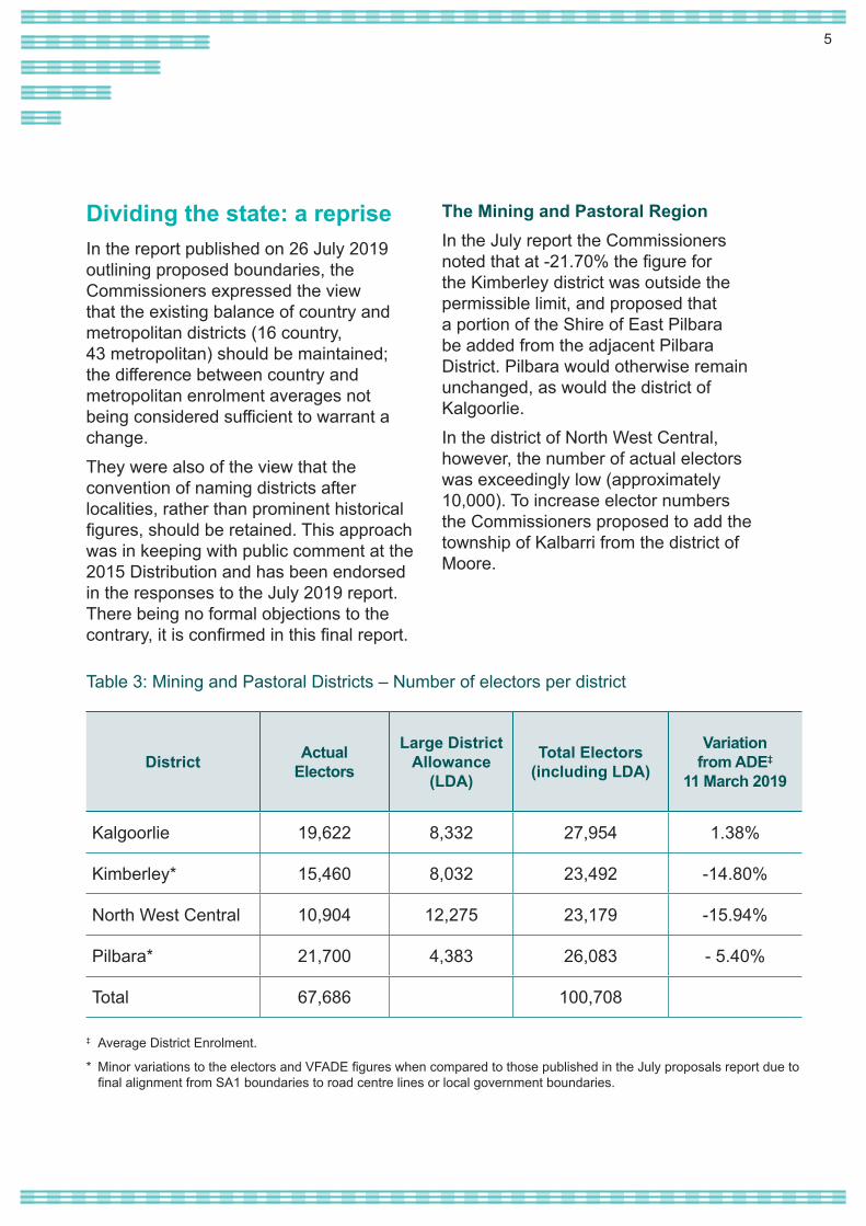
The Mining and Pastoral RegionIn the July report the Commissioners noted that at -21.70% the figure for the Kimberley district was outside the permissible limit, and proposed that a portion of the Shire of East Pilbara be added from the adjacent Pilbara District. Pilbara would otherwise remain unchanged, as would the district of Kalgoorlie.In the district of North West Central, however, the number of actual electors was exceedingly low (approximately 10,000). To increase elector numbers the Commissioners proposed to add the township of Kalbarri from the district of Moore.
District Actual Electors
Large District Allowance
(LDA)
Total Electors (including LDA)
Variationfrom ADE‡
11 March 2019
Kalgoorlie 19,622 8,332 27,954 1.38%
Kimberley* 15,460 8,032 23,492 -14.80%
North West Central 10,904 12,275 23,179 -15.94%
Pilbara* 21,700 4,383 26,083 - 5.40%
Total 67,686 100,708
‡ Average District Enrolment.
* Minor variations to the electors and VFADE figures when compared to those published in the July proposals report due to final alignment from SA1 boundaries to road centre lines or local government boundaries.
Table 3: Mining and Pastoral Districts – Number of electors per district
6
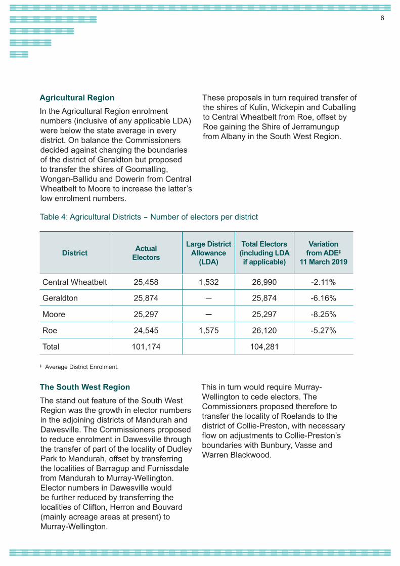
Agricultural RegionIn the Agricultural Region enrolment numbers (inclusive of any applicable LDA) were below the state average in every district. On balance the Commissioners decided against changing the boundaries of the district of Geraldton but proposed to transfer the shires of Goomalling, Wongan-Ballidu and Dowerin from Central Wheatbelt to Moore to increase the latter’s low enrolment numbers.
These proposals in turn required transfer of the shires of Kulin, Wickepin and Cuballing to Central Wheatbelt from Roe, offset by Roe gaining the Shire of Jerramungup from Albany in the South West Region.
District Actual Electors
Large District Allowance
(LDA)
Total Electors (including LDA if applicable)
Variationfrom ADE‡
11 March 2019
Central Wheatbelt 25,458 1,532 26,990 -2.11%
Geraldton 25,874 ─ 25,874 -6.16%
Moore 25,297 ─ 25,297 -8.25%
Roe 24,545 1,575 26,120 -5.27%
Total 101,174 104,281
Table 4: Agricultural Districts – Number of electors per district
‡ Average District Enrolment.
The South West RegionThe stand out feature of the South West Region was the growth in elector numbers in the adjoining districts of Mandurah and Dawesville. The Commissioners proposed to reduce enrolment in Dawesville through the transfer of part of the locality of Dudley Park to Mandurah, offset by transferring the localities of Barragup and Furnissdale from Mandurah to Murray-Wellington. Elector numbers in Dawesville would be further reduced by transferring the localities of Clifton, Herron and Bouvard (mainly acreage areas at present) to Murray-Wellington.
This in turn would require Murray-Wellington to cede electors. The Commissioners proposed therefore to transfer the locality of Roelands to the district of Collie-Preston, with necessary flow on adjustments to Collie-Preston’s boundaries with Bunbury, Vasse and Warren Blackwood.

7
District Actual Electors
Variationfrom ADE‡
11 March 2019
Albany 26,600 -3.53%
Bunbury 29,392 6.60%
Collie-Preston 29,588 7.31%
Dawesville 29,374 6.53%
Mandurah 29,434 6.75%
Murray-Wellington 28,967 5.06%
Vasse 29,287 6.22%
Warren-Blackwood 28,531 3.48%
Total 231,173
Table 5: South West Districts – Number of electors per district
‡ Average District Enrolment.
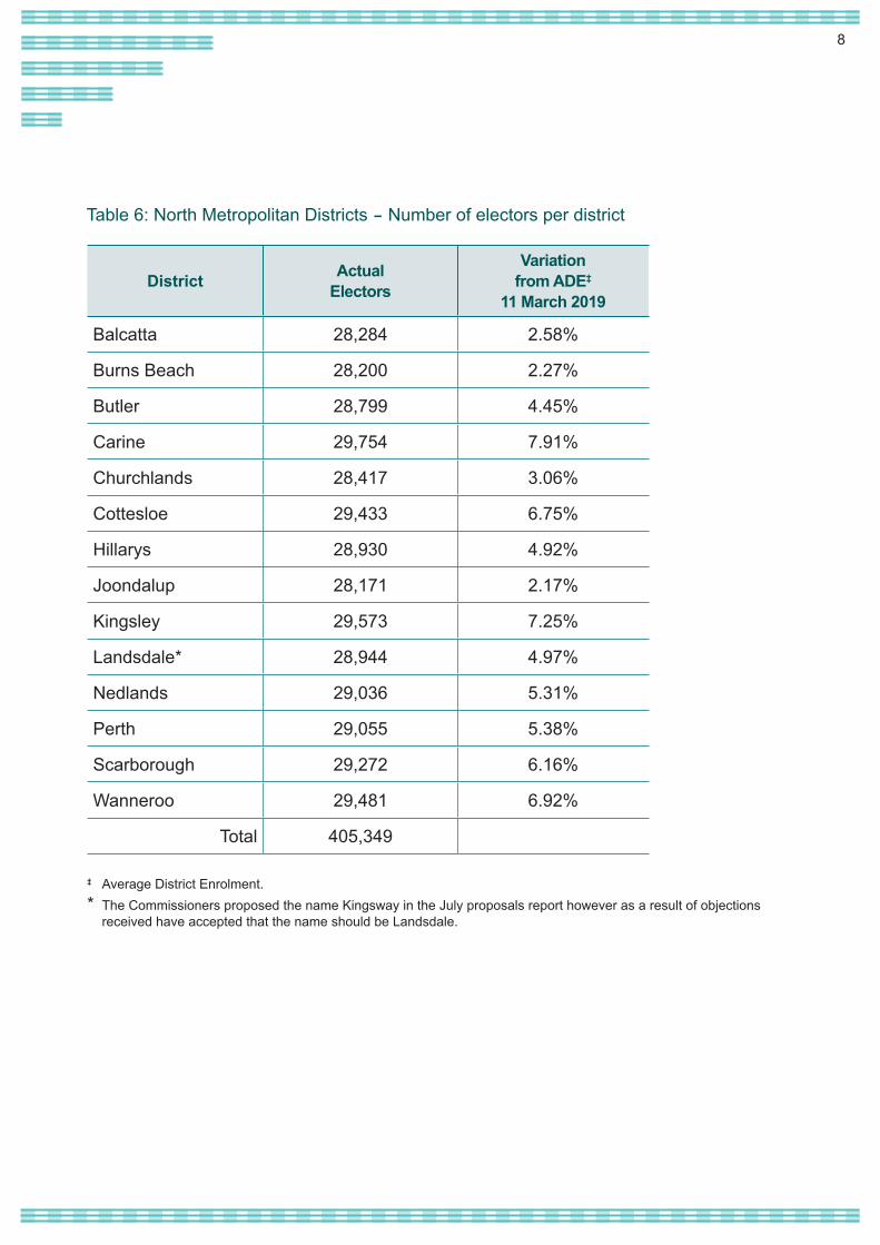
The North Metropolitan RegionAt the northern perimeter of the metropolitan area the Commissioners proposed to reduce elector numbers in Butler (sitting at +24.56%) by transferring the locality of Quinns Rocks to Burns Beach. This is a good example of the effects that can flow on from a single change. Burns Beach would then cede Iluka and part of the locality of Joondalup to the district of Joondalup; the localities of Mullaloo and Beldon would be transferred from Joondalup to Hillarys; and the locality of Sorrento would be transferred from Hillarys to Carine.
The flow on effect would continue with necessary changes to the districts of Scarborough, Churchlands and Cottesloe, which might otherwise have been left unchanged. Changes to Wanneroo,
Kingsley, the former district of Girrawheen1 and Balcatta were also proposed, in part to accommodate necessary changes in the adjacent East Metropolitan Region.
To offset excess elector numbers in the district of Perth the Commissioners proposed to transfer the locality of West Perth to Nedlands.
The narrative on the East Metropolitan district which follows, refers to the Commissioners’ aim to reduce the spread of the existing district of West Swan, which included the locality of Banksia Grove which has more in common with the North Metropolitan Region. This could only be achieved by transferring the localities of Hocking and Pearsall from Wanneroo to the district immediately to the south, nevertheless keeping the two localities in North Metropolitan Region.
1 The Commissioners proposed the name Kingsway in the July proposals report however as a result of objections received have accepted that the name should be Landsdale.
8
District Actual Electors
Variationfrom ADE‡
11 March 2019
Balcatta 28,284 2.58%
Burns Beach 28,200 2.27%
Butler 28,799 4.45%
Carine 29,754 7.91%
Churchlands 28,417 3.06%
Cottesloe 29,433 6.75%
Hillarys 28,930 4.92%
Joondalup 28,171 2.17%
Kingsley 29,573 7.25%
Landsdale* 28,944 4.97%
Nedlands 29,036 5.31%
Perth 29,055 5.38%
Scarborough 29,272 6.16%
Wanneroo 29,481 6.92%
Total 405,349
Table 6: North Metropolitan Districts – Number of electors per district
‡ Average District Enrolment.* The Commissioners proposed the name Kingsway in the July proposals report however as a result of objections
received have accepted that the name should be Landsdale.
9
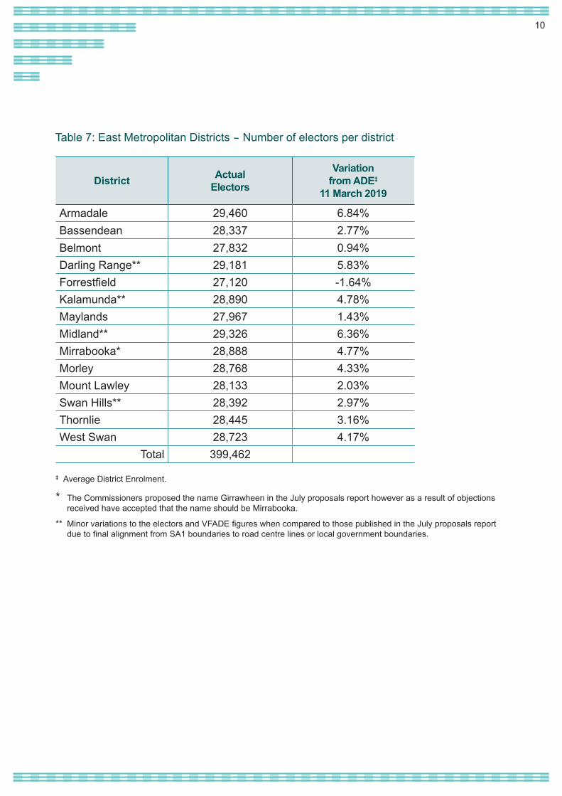
The East Metropolitan RegionA stand out feature of the East Metropolitan Region was the extensive area encompassed by certain existing districts: West Swan extending from the Swan River in the east to the locality of Banksia Grove well to the west; Darling Range from the escarpment to the locality of Keralup in the south-west of the metropolitan area. The Commissioners sought to reduce the spread of these electorates where possible.
Ideally, the Commissioners saw reason to attempt to unite the localities of Aveley, Belhus, Ellenbrook and The Vines in a single district, as suggested in some public submissions. This proved not to be possible, however, because of the concentration of electors in Ellenbrook and its immediate surrounds versus the spread of electors elsewhere. The Commissioners noted one submission which managed to unite these localities in one district, but only by proposing districts elsewhere which crossed the metropolitan boundary, an approach that the Commissioners did not favour. The Commissioners’ proposed boundaries did, however, unite other localities which had previously been divided between districts, Ballajura and Mundaring in particular.
A flow on effect of the changes to the district of Wanneroo in the North Metropolitan Region was that the localities of Girrawheen and Mirrabooka were placed in the same district, whereas previously they had each given their names to separate districts. After some consideration the Commissioners first proposed that Girrawheen be
preferred to Mirrabooka as the name for the reconfigured district. However, as explained later, in this final report Mirrabooka has now been chosen as the name for this district.
The Commissioners considered a range of options for the district of Morley, ultimately deciding that its eastern boundary be extended from the Tonkin Highway to Beechboro Road. This in turn enabled the district of Bassendean to acquire the localities of Bennett Springs and Caversham, the latter serving to reduce elector numbers in the district of Midland which were above the permissible limit.
No changes were found to be necessary for the districts of Armadale, Belmont, Forrestfield, Maylands, Mount Lawley and Thornlie.
10
District Actual Electors
Variationfrom ADE‡
11 March 2019
Armadale 29,460 6.84%Bassendean 28,337 2.77%Belmont 27,832 0.94%Darling Range** 29,181 5.83%Forrestfield 27,120 -1.64%Kalamunda** 28,890 4.78%Maylands 27,967 1.43%Midland** 29,326 6.36%Mirrabooka* 28,888 4.77%Morley 28,768 4.33%Mount Lawley 28,133 2.03%Swan Hills** 28,392 2.97%Thornlie 28,445 3.16%West Swan 28,723 4.17%
Total 399,462
Table 7: East Metropolitan Districts – Number of electors per district
‡ Average District Enrolment.
* The Commissioners proposed the name Girrawheen in the July proposals report however as a result of objections received have accepted that the name should be Mirrabooka.
** Minor variations to the electors and VFADE figures when compared to those published in the July proposals report due to final alignment from SA1 boundaries to road centre lines or local government boundaries.
11
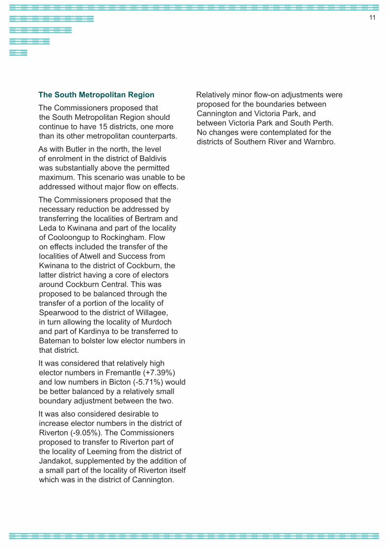
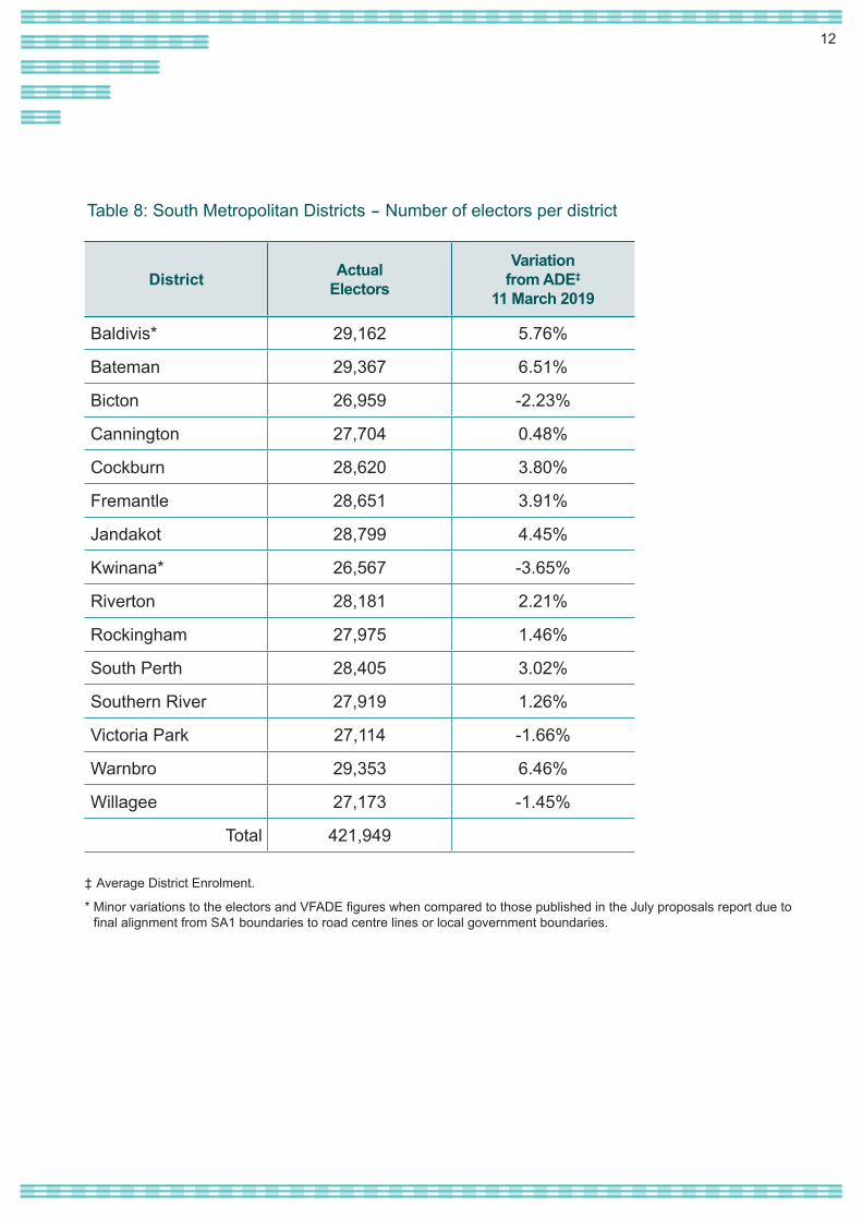
The South Metropolitan RegionThe Commissioners proposed that the South Metropolitan Region should continue to have 15 districts, one more than its other metropolitan counterparts.As with Butler in the north, the level of enrolment in the district of Baldivis was substantially above the permitted maximum. This scenario was unable to be addressed without major flow on effects. The Commissioners proposed that the necessary reduction be addressed by transferring the localities of Bertram and Leda to Kwinana and part of the locality of Cooloongup to Rockingham. Flow on effects included the transfer of the localities of Atwell and Success from Kwinana to the district of Cockburn, the latter district having a core of electors around Cockburn Central. This was proposed to be balanced through the transfer of a portion of the locality of Spearwood to the district of Willagee, in turn allowing the locality of Murdoch and part of Kardinya to be transferred to Bateman to bolster low elector numbers in that district.It was considered that relatively high elector numbers in Fremantle (+7.39%) and low numbers in Bicton (-5.71%) would be better balanced by a relatively small boundary adjustment between the two.It was also considered desirable to increase elector numbers in the district of Riverton (-9.05%). The Commissioners proposed to transfer to Riverton part of the locality of Leeming from the district of Jandakot, supplemented by the addition of a small part of the locality of Riverton itself which was in the district of Cannington.
Relatively minor flow-on adjustments were proposed for the boundaries between Cannington and Victoria Park, and between Victoria Park and South Perth. No changes were contemplated for the districts of Southern River and Warnbro.
12
District Actual Electors
Variationfrom ADE‡
11 March 2019
Baldivis* 29,162 5.76%
Bateman 29,367 6.51%
Bicton 26,959 -2.23%
Cannington 27,704 0.48%
Cockburn 28,620 3.80%
Fremantle 28,651 3.91%
Jandakot 28,799 4.45%
Kwinana* 26,567 -3.65%
Riverton 28,181 2.21%
Rockingham 27,975 1.46%
South Perth 28,405 3.02%
Southern River 27,919 1.26%
Victoria Park 27,114 -1.66%
Warnbro 29,353 6.46%
Willagee 27,173 -1.45%
Total 421,949
Table 8: South Metropolitan Districts – Number of electors per district
‡ Average District Enrolment.
* Minor variations to the electors and VFADE figures when compared to those published in the July proposals report due to final alignment from SA1 boundaries to road centre lines or local government boundaries.
13
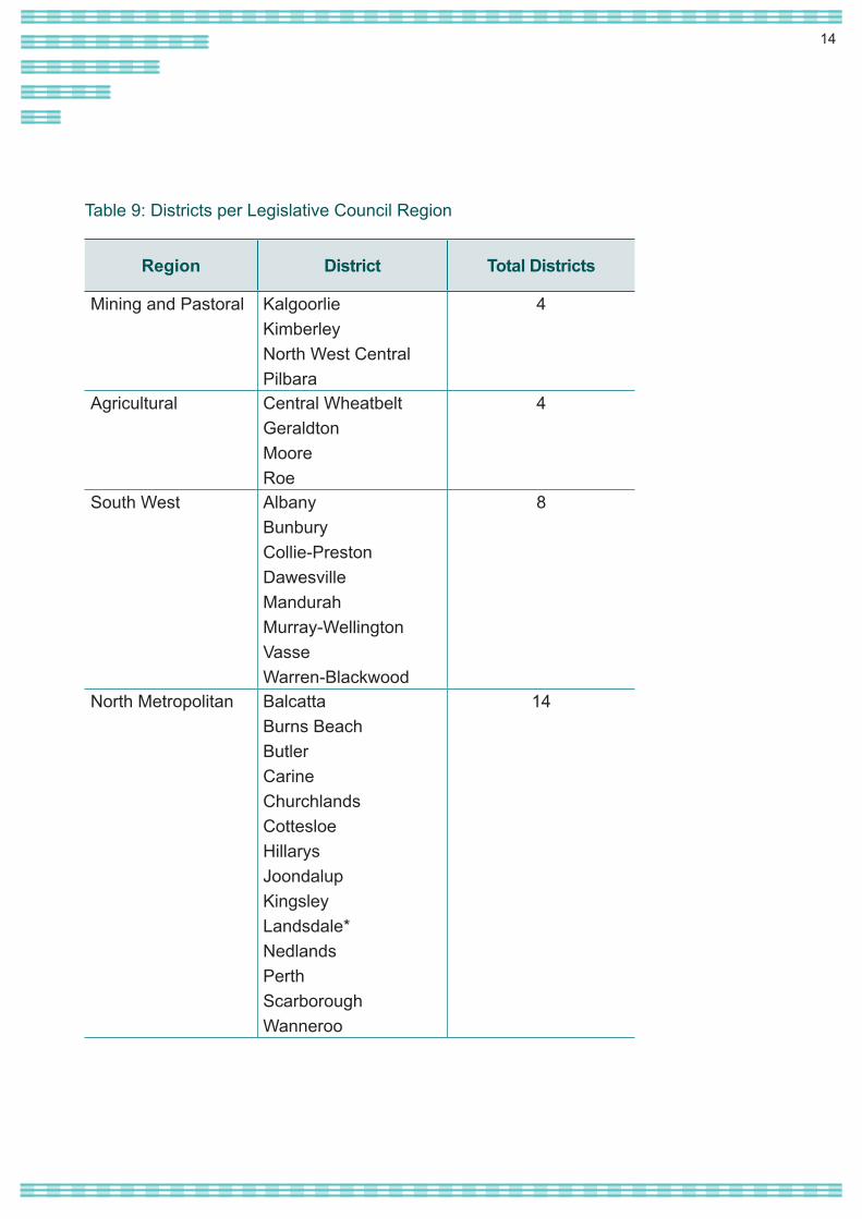
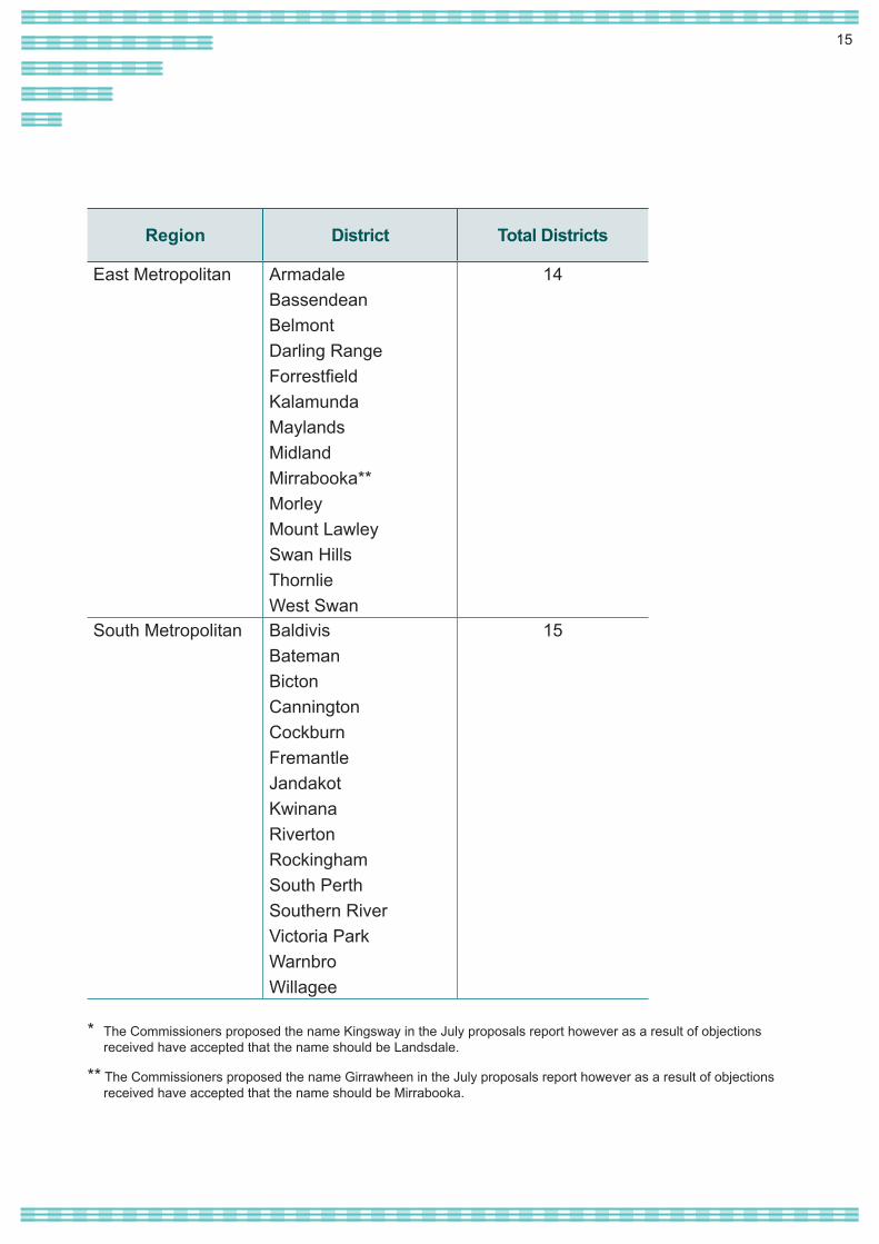
The Act stipulates that the State must be divided into six Legislative Council regions but does not specify how many Legislative Assembly districts should be in each region. The Commissioners did not propose any change in the number of districts currently in each region, as reflected in Table 9.
For the most part the boundaries of the six Legislative Council regions remain unchanged, however, as a result of changes to some Legislative Assembly district boundaries, there has been a corresponding change to a segment of a region boundary.
With the country regions, these changes stem from the movement of Kalbarri from the Agricultural Region to the Mining and Pastoral Region and the movement of the locality of Jerramungup from the South West Region to the Agricultural Region.
For the Perth Metropolitan Area there were no changes to the external perimeter of the metropolitan area regions, however, changes to the internal boundary of the three metropolitan region boundaries have resulted from the movement of:• The localities of Banksia Grove,
Mariginiup, Jandabup, Gnangara, Wangara, Westminster, Alexander Heights and a portion of Wanneroo from the East Metropolitan Region to the North Metropolitan region;
• A portion of Wellard and Baldivis from the East Metropolitan Region to the South Metropolitan Region; and
• A very small parcel of land in Forrestdale from the East Metropolitan Region to the South Metropolitan Region (reflecting the construction of a new road and impacting no electors at this time).
Legislative Council regional boundaries
14
Region District Total Districts
Mining and Pastoral KalgoorlieKimberleyNorth West CentralPilbara
4
Agricultural Central WheatbeltGeraldtonMooreRoe
4
South West AlbanyBunburyCollie-PrestonDawesvilleMandurahMurray-WellingtonVasseWarren-Blackwood
8
North Metropolitan BalcattaBurns BeachButlerCarine Churchlands CottesloeHillarysJoondalupKingsleyLandsdale*NedlandsPerthScarboroughWanneroo
14
Table 9: Districts per Legislative Council Region
15
Region District Total Districts
East Metropolitan ArmadaleBassendeanBelmontDarling RangeForrestfieldKalamundaMaylandsMidlandMirrabooka**MorleyMount LawleySwan HillsThornlieWest Swan
14
South Metropolitan BaldivisBatemanBictonCanningtonCockburnFremantleJandakotKwinanaRivertonRockinghamSouth PerthSouthern RiverVictoria ParkWarnbroWillagee
15
* The Commissioners proposed the name Kingsway in the July proposals report however as a result of objections received have accepted that the name should be Landsdale.
** The Commissioners proposed the name Girrawheen in the July proposals report however as a result of objections received have accepted that the name should be Mirrabooka.
16
The final boundariesIn all, 19 responses were received to the Commissioners’ invitation for objections. While concerns were raised about particular proposals, the overall tenor of the responses received was positive. The Commissioners note that a complete or even significant redrafting of the boundaries proposed in the July report, could deny the opportunity for comment on approaches that were not previously publicly canvassed. The Commissioners have nevertheless given careful consideration to all matters raised.
As indicated earlier, the overriding statutory requirement is the need to ensure each electoral district contains a number of electors that sits within the allowable limits. Thus, in accordance with the Act, meeting the elector number requirements will prevail over consideration of other factors.
All told the boundary adjustments hereby determined are broad ranging, with only 10 of the State’s 59 districts remaining unchanged. In a report of this nature it is not possible to describe how different objections or suggestions were assessed in every single case and in relation to all 59 districts and six regions. Some objections have been able to be accommodated. Where that has not been possible more often than not it was because the numbers would not allow it, particularly when the flow on effects were taken into account. In others there were competing community of interest considerations. While not all objections are referred to in this report, they were all carefully considered prior to determining the final boundaries.
Naming of electoral districtsIn the draft proposals the Commissioners indicated their intention to adhere wherever possible to the convention of naming districts after localities. This approach is confirmed in the final report, there being very limited public support for adopting the names of prominent historical figures.
In the North Metropolitan Region the Commissioners proposed the name ‘Kingsway’ for a reconfigured district formerly known as Girrawheen. The proposed name took into account the existence of a number of community bodies and facilities carrying this name. In response to objections received, the Commissioners have decided that this district will be named Landsdale, the locality in the district with the highest population of electors, noting also that the name Landsdale originally covered a broader expanse prior to the development of other suburbs in the area.
In the East Metropolitan Region another reconfigured district contains the localities of both Girrawheen and Mirrabooka, each of which was previously in a different district and lent its name to that respective district. The Commissioners initially opted to name the reconfigured district Girrawheen, albeit recognising that a case could be mounted for either name and that communities of interest existed for both. After a re-examination of the proposed district’s composition and consideration of related objections received, the Commissioners have now determined that the name Mirrabooka should apply. Mirrabooka Avenue runs the length of the new district in a north-south direction,
17
effectively forming a central spine. WA Labor also highlighted that Mirrabooka “is acknowledged as a town centre in State Planning documents” and forms an important node for various government facilities and services.
All other districts in the State retain their existing names. The names of Legislative Council regions are as specified in the Act.
The balance of metropolitan and country districts The Commissioners’ proposals report flagged the intention to retain the current balance of 43 metropolitan and 16 country districts. Their reasoning is set out again here:
‘…any comparison of overall country and metropolitan enrolment levels should bear in mind the special provisions which Parliament has enacted for districts which are large in geographic area. Districts with an LDA can be expected to have a smaller number of actual electors than others. When those country districts without an LDA are compared with metropolitan districts there is little difference in the overall average enrolment (28,234 country; 28,529 metropolitan). This difference is not considered sufficient to warrant a change to the current apportionment of districts between country and metropolitan regions.’
No public objections to this approach were received and the number of metropolitan and country districts is confirmed. The Commissioners also propose to retain the existing six districts with an LDA. Any
reduction in the number would require the collocation of areas which do not share any appreciable community of interest. In some cases, removing an LDA currently provided for would mean the district was no longer compliant with legislated numerical requirements.
Variation in district enrolments As indicated above, the Act allows enrolment in a given district to be up to 10% above or below the ADE (in districts with an LDA, up to 10% above and up to 20% below). As far as possible the Commissioners have endeavoured to formulate boundaries with elector numbers well within the specified range. There are, however, a small number of cases where the final district enrolment numbers have unavoidably been set closer to the margins. In other cases, especially in the metropolitan area, the variation in district numbers can be attributed to the desirability of using readily identifiable boundaries that coincide with locality or local government boundaries where possible.
The Metropolitan RegionsContinuing rapid population growth at the northern and southern fringes of the Perth metropolitan area presented the Commissioners with many challenges, with the flow on effects resulting in at least some degree of change in 35 of the 43 metropolitan districts. All districts have been brought within legislative tolerance. Overall elector numbers allowed the Commissioners to address some apparent ‘anomalies’ (such as the elongated districts of West Swan and Darling Range) brought about by the difficult spread of electors in 2015, while still keeping all 43 districts within the defined metropolitan area.
18
In other locations the uneven spread of numbers prevented the Commissioners from observing community of interest considerations more closely. The Commissioners note for example a submission from the City of Swan which, while supporting the majority of the proposed boundaries in the East Metropolitan Region, nevertheless expressed concern about ‘the boundary of any State or Federal electorate dividing communities of interest’. The legislated principle of ‘one vote one value’ inevitably gives rise to the division of some communities of interest because the distribution of electors is itself uneven. Division of the communities of Ellenbrook, The Vines, Aveley and Belhus is a case in point, brought about by the uneven spread of elector numbers in adjoining areas.
Similar considerations arise in the North Metropolitan Region. Separate objections were lodged by the Liberal Party and Mr Stuart Hawkins, to the proposed transfer of the locality of Sorrento to the district of Carine, pointing to Sorrento’s synergy with the district of Hillarys from which it will be removed. The Commissioners acknowledge the community of interest considerations raised, yet consider this option preferable to others considered. When considering initial public suggestions the Commissioners also contemplated transferring only the southern portion of Sorrento to Carine but in the end believed it preferable to keep the Sorrento locality intact within one district.
Several changes to the North Metropolitan Region were also proposed by WA Labor, such as reversing the transfer of Beldon from Joondalup to Hillarys and Iluka
from Burns Beach to Joondalup; and transferring all, not just part, of the locality of Currambine to Joondalup. Some of these proposals were considered by the Commissioners at the initial suggestions stage. The Commissioners are of the view that, while there is rarely just one ‘right approach’, the boundaries they have proposed for this area best achieve a balance between existing communities of interest and elector numbers. It is noted that the locality of Currambine was already split under the current boundaries, however the new boundaries do amalgamate all of the locality of Joondalup within the electoral district of Joondalup.
The Commissioners gave detailed consideration to a joint submission from Mr Sean L’Estrange, Member for Churchlands, Dr David Honey Member for Cottesloe and the Hon Bill Marmion Member for Nedlands who submitted that the boundaries of their respective electorates set down in 2015 should remain unchanged. In the alternative they suggested adjustments to the Commissioners’ proposals to allow a section of City Beach to be retained in Churchlands rather than be transferred to Cottesloe. These proposals were supported in the broader submission lodged by the Liberal Party.
The Commissioners acknowledge that the proposed changes to the three districts are not driven by enrolment levels within those current districts, which (as the Members point out) were comfortably within the prescribed limits: -1.99% (Churchlands), - 0.27% (Cottesloe) and +0.23% (Nedlands). Rather, the proposals stemmed from necessary boundary adjustments further to the north, rendering a flow on effect unavoidable.
19
The alternative adjustment proposed in this objection was that the whole of City Beach be retained in Churchlands, part of the locality of Floreat be transferred from Nedlands to Cottesloe, and that Churchlands cede part of the locality of West Leederville to Nedlands. In considering this objection the Commissioners noted that the permissible enrolment levels could only be met through a ‘3-way swap’ which included splitting the locality of West Leederville along minor residential streets (thereby creating a district boundary that divided residents on either side of a local suburban street). This approach was considered more likely to adversely impact on existing communities of interest and the Commissioners therefore decided to affirm their original position.
The Liberal Party suggested two other changes to boundaries proposed for the North Metropolitan Region. In the district of Scarborough they objected to a proposal to transfer to Churchlands part of the locality of Scarborough east of Weaponess Road and south of St Brigid’s Terrace. This would, however, push Scarborough’s enrolment level above +9.5% and is not favoured by the Commissioners. A further proposal was to transfer part of the district of Perth in the vicinity of Mount Street to the district of Nedlands, some 400 electors in all. The alternative proposed would, however, result in an imbalance in elector numbers between the two districts which the Commissioners consider is not desirable or necessary.
The Commissioners considered but ultimately were not persuaded by objections to the inclusion of the localities of Hocking and Pearsall in the (re-named)
district of Landsdale, and the inclusion of the locality of Marangaroo in the same district as the locality of Mirrabooka.
Relatively few comments were received in relation to the South Metropolitan Region. The Commissioners concur with a proposal from the Liberal party to make a minor adjustment to the proposed alignment between the districts of Darling Range and Warnbro. A similar proposal was made by Ms Alyssa Hayden, Member for Darling Range. The Commissioners are, however, unable to accommodate a further suggestion from Ms Hayden to transfer a portion of Kelmscott to the district of Armadale, which they consider would unnecessarily bring elector numbers in that district close to the permissible maximum.
The Country RegionsIn the Mining and Pastoral Region an objection was lodged by Ms Lara Martin relating to the transfer of part of the Shire of East Pilbara from the Pilbara district to the Kimberley district. Ms Martin noted that the Shire was being split in two, a part which ‘is not in the Kimberley’ being added to the district of that name.
Viewed purely in the context of community of interest considerations Ms Martin has raised a valid point. As outlined earlier in this report, however, under the governing legislation numbers must always take precedence. Section 16G expressly provides that in districts with an area greater than 100,000 square kilometres the total enrolment (when actual electors and the applicable LDA are combined) must not be lower than -20% of the overall state average. In the case of the Kimberley the total enrolment level as at the relevant
20
day was -21.7%, mandating some form of change. Expanding the district to incorporate another population centre would at the same time have significantly increased its geographical area, taking it from below to above the permitted level of tolerance. In the absence of discretion to do otherwise, the only option available to the Commissioners is to add the territory which it has; noting that this impacts very few electors.
This will be the limit of changes to the Kimberley and Pilbara districts. As initially proposed, there also will be no change to the current boundaries of the district of Kalgoorlie.
In the district of North West Central the total enrolment level was barely within the permitted tolerance as at the relevant day and then only with the addition of a substantial LDA, leading the Commissioners to propose the addition of the township of Kalbarri from the district of Moore. Objections to this proposal were lodged by Mr Garry Keeffe, Mr Craig Simkin, Mr Shane Love MLA and the Kalbarri Development Association. Issues raised included the township’s links with the Shire of Northampton and the City of Geraldton, and the distance from Kalbarri to the electoral office of the Member for North West Central. The Commissioners have taken careful account of all concerns raised but at the same time are mindful of the very low numbers currently in North West Central (-19.59% which is inclusive of a substantial LDA; only 9,915 actual electors compared to the State ADE of 27,573). In the Commissioner’s view there was clearly a requirement to add a sizeable number of actual electors to the district of North West Central, but given the region’s demographic patterns, few options existed.
Thus to increase actual elector numbers in North West Central, the Commissioners remain of the belief that the town of Kalbarri needs to be transferred to the district. While acknowledging the concerns raised in the objections received, other respondents argued that the overall changes proposed for country regions do not go far enough in balancing elector numbers.
After careful consideration the Commissioners have affirmed this proposal along with other changes proposed for the districts of Moore, Central Wheatbelt and Roe.
An objection was lodged by the Shire of Jerramungup to the proposed transfer of the Shire from the district of Albany in the South West Region to the district of Roe in the Agricultural Region. The objection was accompanied by a report on the proposal prepared by council officers which drew attention to the Shire’s links with the City of Albany and an alliance forged with adjoining shires (Denmark and Plantagenet) as well as the City of Albany. The Commissioners acknowledge the value of such municipal ties to the respective communities. To reprise, transfer of Jerramungup to the district of Roe was intended to balance the transfer of shires on the northern boundary of Roe to the district of Central Wheatbelt, which would otherwise have rendered the district of Roe non-compliant with legislative enrolment requirements. With the affirmation of proposed changes to Central Wheatbelt and following reconsideration of all available options, that requirement remains. The Commissioners have decided therefore to affirm their decision in relation to the Shire of Jerramungup, noting that alteration of state electoral boundaries should not prevent continued collaboration at local government level.
21
In the South West Region there was some variance in responses to published proposals to address high elector numbers in the districts of Dawesville and Mandurah. Whereas the City of Mandurah advised that it ‘does not oppose’ the transfer of Bouvard, Heron and Clifton from Dawesville to Murray-Wellington, the Liberal Party is opposed, preferring to transfer a larger portion of the locality of Dudley Park to Mandurah balanced by transfer of the locality of Parklands and part of the locality of Lakelands from Mandurah to Murray-Wellington. The Commissioners have decided on balance to confirm their original proposals for the districts of Mandurah, Dawesville and Murray-Wellington. This decision best caters for elector numbers, while also noting that in terms of community of interest the localities of Bouvard, Heron and Clifton do share community of interest with adjoining parts of Murray-Wellington.
The most far reaching changes to the Commissioners’ proposals for country districts were lodged by Dr Mark Mulcair. He raised two overarching concerns: the disparity in enrolment levels between the proposed Mining and Pastoral and Agricultural Regions (set at the lower end of tolerance) when compared with the South West Region (generally at the higher end); and the ‘continued 8/4/4 inequality’ between the number of districts in each country region.
The variance in actual elector numbers across country regions is clear. As at 11 March 2019 the Mining and Pastoral Region had a total of 67,686 electors, an average of 16,921 per district. This compares with an average of 25,294 electors in each district in the Agricultural Region and 28,897 in the South West Region.
That said, to an appreciable extent this is the result of legislated requirements. Section 16H of the Act sets down a requirement for six separate Legislative Council regions and provides that those regions must generally reflect recognised communities of interest and land use patterns. Those land use patterns include Mining and Pastoral; Agricultural; and ‘a region that includes coastal and forest areas in the south-west of the State’. In addition, section 16G provides for the application of a special allowance for districts above 100,000 km2 in area. The complex interaction of these factors makes it difficult to achieve more even elector numbers without combining hugely disparate communities of interest. Dr Mulcair himself acknowledged this difficulty when formulating his alternative proposals.
22
ConclusionThe public consultation which forms part of the Distribution process is a vital part of the broader democratic process. The Commissioners very much appreciate the efforts made by individuals and organisations in providing feedback on the original proposals and have written to all participants in the process to thank them. They also take this opportunity to thank the hard-working staff of the Electoral Commission for their support and assistance throughout the Distribution process.
In every instance the feedback provided has been carefully considered. The Commissioners wish to emphasise that, although only a limited number of changes to the original proposals could be made, to a large extent this was because overall the original proposals were well received. Implementing some objections would also have had major flow on effects that could not be accommodated within the statutory numerical requirements.
The boundaries of all electoral districts have been brought within the legislative requirements and the Commissioners make the following formal determination:
Acting under the provisions of the Electoral Act 1907 we, the undersigned Electoral Distribution Commissioners, publish our division of the State into electoral regions and districts. The division of the State determined in this report applies for the next State general election. In accordance with section 16K of the Act, the Commissioners’ determination is final.
The boundaries set out in the accompanying maps will apply for the next State general election due to be held in March 2021. Any by-elections held in the interim will be conducted in accordance with the existing boundaries (those set in 2015).
The Hon. Eric Heenan QC, retired Judge of the Supreme Court of Western Australia (Chairperson)
Mr Tom JosephGovernment Statistician
Mr Chris AventA/Electoral Commissioner
27 November 2019
23
© Western Australian Land Information Authority (Landgate) (2019)
The maps associated with this Report and on the website, are generated from spatial datasets which describe the boundaries for each electoral region and electoral district. These have been created under the authority of the Electoral Distribution Commissioners, drawn, audited and lodged as Deposited Plans Nos 418163 – 418227 with Landgate.
To view the maps in greater detail, or download the maps and Commissioners’ reasons in printable form, visit the Electoral Boundaries WA website: www.boundaries.wa.gov.au.
The Office of the Electoral Distribution Commissioners was established as a temporary office to manage the 2019 electoral division process and will close after the process is completed. All enquiries relating to electoral matters, including the application of electoral boundaries, should be directed to:
Western Australian Electoral CommissionLevel 2, 111 St Georges TerracePERTH WA 6000(08) 9214 0400 (country callers 13 63 06)
Postal Address: Western Australian Electoral CommissionGPO Box F316 PERTH WA 6841
Email:[email protected]
24
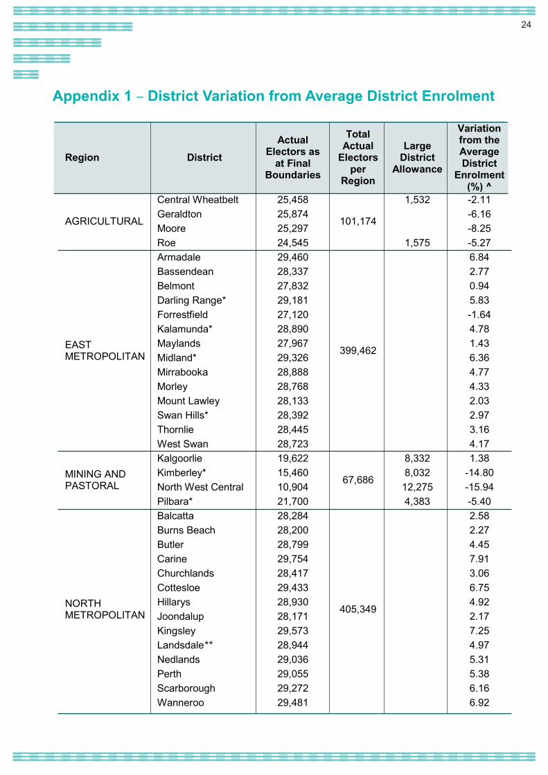
Appendix 1 – District Variation from Average District Enrolment
Region District Actual
Electors as at Final
Boundaries
Total Actual
Electors per
Region
Large District
Allowance
Variation from the Average District
Enrolment (%) ^
AGRICULTURAL
Central Wheatbelt 25,458
101,174
1,532 -2.11 Geraldton 25,874 -6.16 Moore 25,297 -8.25 Roe 24,545 1,575 -5.27
EAST METROPOLITAN
Armadale 29,460
399,462
6.84 Bassendean 28,337 2.77 Belmont 27,832 0.94 Darling Range* 29,181 5.83 Forrestfield 27,120 -1.64 Kalamunda* 28,890 4.78 Maylands 27,967 1.43 Midland* 29,326 6.36 Mirrabooka 28,888 4.77 Morley 28,768 4.33 Mount Lawley 28,133 2.03 Swan Hills* 28,392 2.97 Thornlie 28,445 3.16 West Swan 28,723 4.17
MINING AND PASTORAL
Kalgoorlie 19,622
67,686
8,332 1.38 Kimberley* 15,460 8,032 -14.80 North West Central 10,904 12,275 -15.94 Pilbara* 21,700 4,383 -5.40
NORTH METROPOLITAN
Balcatta 28,284
405,349
2.58 Burns Beach 28,200 2.27 Butler 28,799 4.45 Carine 29,754 7.91 Churchlands 28,417 3.06 Cottesloe 29,433 6.75 Hillarys 28,930 4.92 Joondalup 28,171 2.17 Kingsley 29,573 7.25 Landsdale 28,944 4.97 Nedlands 29,036 5.31 Perth 29,055 5.38 Scarborough 29,272 6.16 Wanneroo 29,481 6.92
**
25
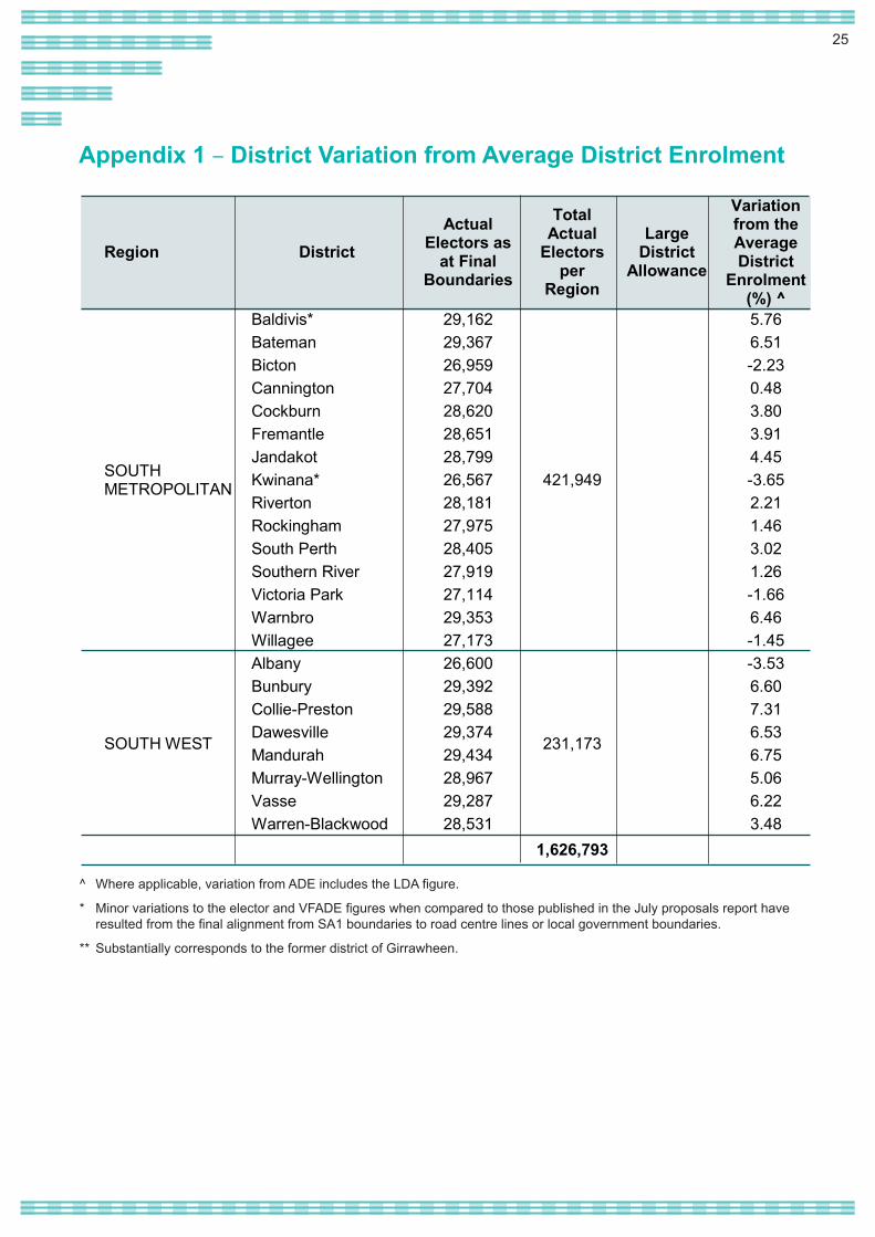
Appendix 1 – District Variation from Average District Enrolment
Region District Actual
Electors as at Final
Boundaries
Total Actual
Electors per
Region
Large District
Allowance
Variation from the Average District
Enrolment (%) ^
SOUTH METROPOLITAN
Baldivis* 29,162
421,949
5.76 Bateman 29,367 6.51 Bicton 26,959 -2.23 Cannington 27,704 0.48 Cockburn 28,620 3.80 Fremantle 28,651 3.91 Jandakot 28,799 4.45 Kwinana* 26,567 -3.65 Riverton 28,181 2.21 Rockingham 27,975 1.46 South Perth 28,405 3.02 Southern River 27,919 1.26 Victoria Park 27,114 -1.66 Warnbro 29,353 6.46 Willagee 27,173 -1.45
SOUTH WEST
Albany 26,600
231,173
-3.53 Bunbury 29,392 6.60 Collie-Preston 29,588 7.31 Dawesville 29,374 6.53 Mandurah 29,434 6.75 Murray-Wellington 28,967 5.06 Vasse 29,287 6.22 Warren-Blackwood 28,531 3.48
1,626,793
^ Where applicable, variation from ADE includes the LDA figure.
* Minor variations to the elector and VFADE figures when compared to those published in the July proposals report have resulted from the final alignment from SA1 boundaries to road centre lines or local government boundaries.
** Substantially corresponds to the former district of Girrawheen.
26
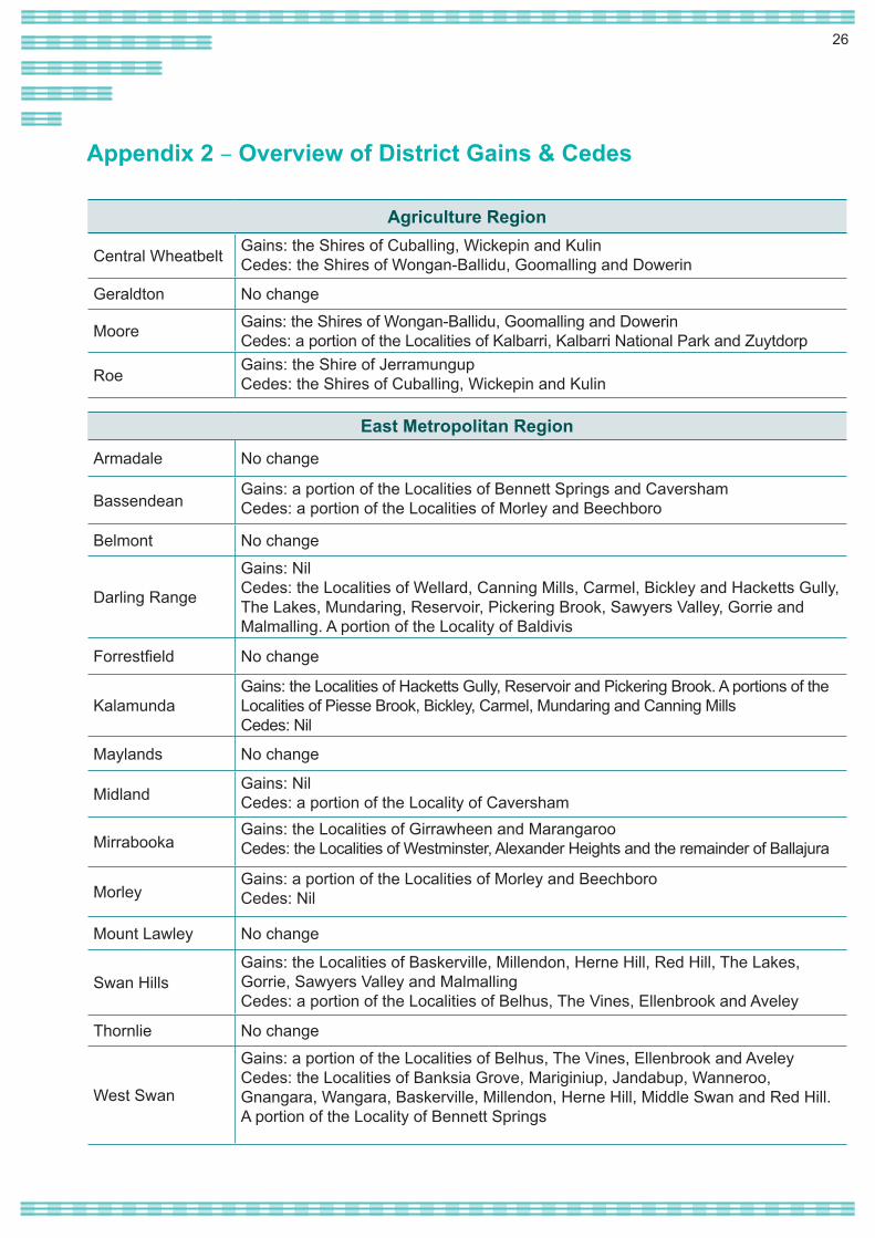
Appendix 2 – Overview of District Gains & Cedes
Agriculture Region
Central Wheatbelt Gains: the Shires of Cuballing, Wickepin and KulinCedes: the Shires of Wongan-Ballidu, Goomalling and Dowerin
Geraldton No change
Moore Gains: the Shires of Wongan-Ballidu, Goomalling and DowerinCedes: a portion of the Localities of Kalbarri, Kalbarri National Park and Zuytdorp
RoeGains: the Shire of JerramungupCedes: the Shires of Cuballing, Wickepin and Kulin
East Metropolitan Region
Armadale No change
BassendeanGains: a portion of the Localities of Bennett Springs and CavershamCedes: a portion of the Localities of Morley and Beechboro
Belmont No change
Darling Range
Gains: NilCedes: the Localities of Wellard, Canning Mills, Carmel, Bickley and Hacketts Gully, The Lakes, Mundaring, Reservoir, Pickering Brook, Sawyers Valley, Gorrie and Malmalling. A portion of the Locality of Baldivis
Forrestfield No change
KalamundaGains: the Localities of Hacketts Gully, Reservoir and Pickering Brook. A portions of the Localities of Piesse Brook, Bickley, Carmel, Mundaring and Canning MillsCedes: Nil
Maylands No change
MidlandGains: NilCedes: a portion of the Locality of Caversham
MirrabookaGains: the Localities of Girrawheen and MarangarooCedes: the Localities of Westminster, Alexander Heights and the remainder of Ballajura
MorleyGains: a portion of the Localities of Morley and BeechboroCedes: Nil
Mount Lawley No change
Swan HillsGains: the Localities of Baskerville, Millendon, Herne Hill, Red Hill, The Lakes, Gorrie, Sawyers Valley and MalmallingCedes: a portion of the Localities of Belhus, The Vines, Ellenbrook and Aveley
Thornlie No change
West Swan
Gains: a portion of the Localities of Belhus, The Vines, Ellenbrook and AveleyCedes: the Localities of Banksia Grove, Mariginiup, Jandabup, Wanneroo, Gnangara, Wangara, Baskerville, Millendon, Herne Hill, Middle Swan and Red Hill. A portion of the Locality of Bennett Springs
27
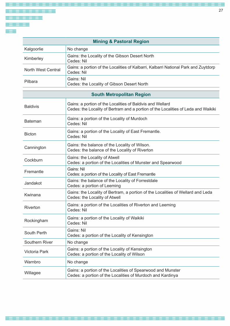
Mining & Pastoral RegionKalgoorlie No change
Kimberley Gains: the Locality of the Gibson Desert NorthCedes: Nil
North West Central Gains: a portion of the Localities of Kalbarri, Kalbarri National Park and ZuytdorpCedes: Nil
Pilbara Gains: NilCedes: the Locality of Gibson Desert North
South Metropolitan Region
Baldivis Gains: a portion of the Localities of Baldivis and WellardCedes: the Locality of Bertram and a portion of the Localities of Leda and Waikiki
Bateman Gains: a portion of the Locality of MurdochCedes: Nil
Bicton Gains: a portion of the Locality of East Fremantle. Cedes: Nil
Cannington Gains: the balance of the Locality of Wilson.Cedes: the balance of the Locality of Riverton
Cockburn Gains: the Locality of AtwellCedes: a portion of the Localities of Munster and Spearwood
Fremantle Gains: NilCedes: a portion of the Locality of East Fremantle
Jandakot Gains: the balance of the Locality of ForrestdaleCedes: a portion of Leeming
Kwinana Gains: the Locality of Bertram, a portion of the Localities of Wellard and LedaCedes: the Locality of Atwell
Riverton Gains: a portion of the Localities of Riverton and Leeming Cedes: Nil
Rockingham Gains: a portion of the Locality of WaikikiCedes: Nil
South Perth Gains: NilCedes: a portion of the Locality of Kensington
Southern River No change
Victoria Park Gains: a portion of the Locality of KensingtonCedes: a portion of the Locality of Wilson
Warnbro No change
Willagee Gains: a portion of the Localities of Spearwood and MunsterCedes: a portion of the Localities of Murdoch and Kardinya
28
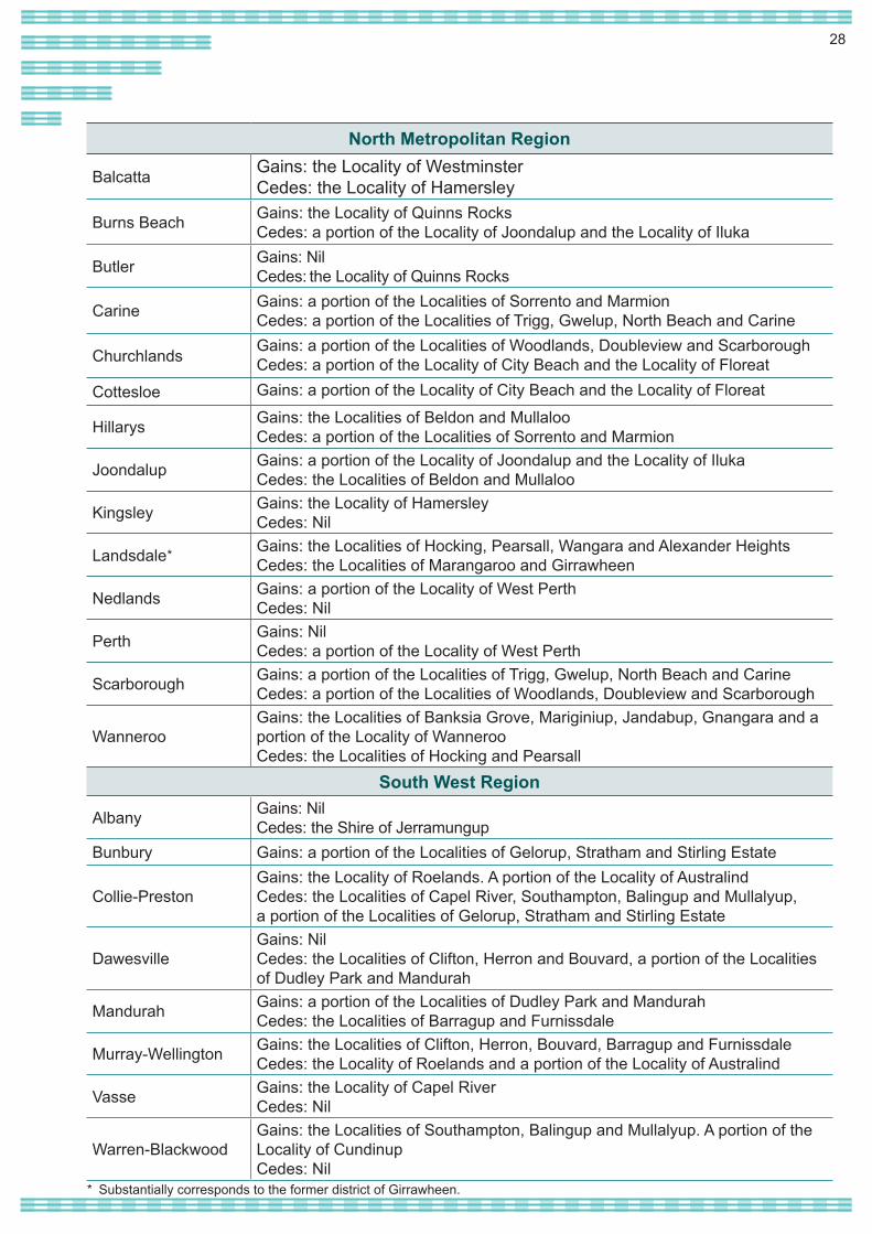
North Metropolitan Region
Balcatta Gains: the Locality of WestminsterCedes: the Locality of Hamersley
Burns Beach Gains: the Locality of Quinns RocksCedes: a portion of the Locality of Joondalup and the Locality of Iluka
Butler Gains: NilCedes: the Locality of Quinns Rocks
Carine Gains: a portion of the Localities of Sorrento and MarmionCedes: a portion of the Localities of Trigg, Gwelup, North Beach and Carine
Churchlands Gains: a portion of the Localities of Woodlands, Doubleview and ScarboroughCedes: a portion of the Locality of City Beach and the Locality of Floreat
Cottesloe Gains: a portion of the Locality of City Beach and the Locality of Floreat
Hillarys Gains: the Localities of Beldon and MullalooCedes: a portion of the Localities of Sorrento and Marmion
Joondalup Gains: a portion of the Locality of Joondalup and the Locality of IlukaCedes: the Localities of Beldon and Mullaloo
Kingsley Gains: the Locality of HamersleyCedes: Nil
Landsdale Gains: the Localities of Hocking, Pearsall, Wangara and Alexander HeightsCedes: the Localities of Marangaroo and Girrawheen
Nedlands Gains: a portion of the Locality of West PerthCedes: Nil
Perth Gains: NilCedes: a portion of the Locality of West Perth
Scarborough Gains: a portion of the Localities of Trigg, Gwelup, North Beach and CarineCedes: a portion of the Localities of Woodlands, Doubleview and Scarborough
WannerooGains: the Localities of Banksia Grove, Mariginiup, Jandabup, Gnangara and a portion of the Locality of WannerooCedes: the Localities of Hocking and Pearsall
South West Region
Albany Gains: NilCedes: the Shire of Jerramungup
Bunbury Gains: a portion of the Localities of Gelorup, Stratham and Stirling Estate
Collie-PrestonGains: the Locality of Roelands. A portion of the Locality of AustralindCedes: the Localities of Capel River, Southampton, Balingup and Mullalyup, a portion of the Localities of Gelorup, Stratham and Stirling Estate
DawesvilleGains: NilCedes: the Localities of Clifton, Herron and Bouvard, a portion of the Localities of Dudley Park and Mandurah
Mandurah Gains: a portion of the Localities of Dudley Park and Mandurah Cedes: the Localities of Barragup and Furnissdale
Murray-Wellington Gains: the Localities of Clifton, Herron, Bouvard, Barragup and FurnissdaleCedes: the Locality of Roelands and a portion of the Locality of Australind
Vasse Gains: the Locality of Capel RiverCedes: Nil
Warren-BlackwoodGains: the Localities of Southampton, Balingup and Mullalyup. A portion of the Locality of CundinupCedes: Nil
* Substantially corresponds to the former district of Girrawheen.
*