Embed Size (px)
Citation preview
+
Vicki Lukas
Chief, NGP Topographic Data Services
June 9, 2015
3D Elevation Program
(3DEP)
+ + 2
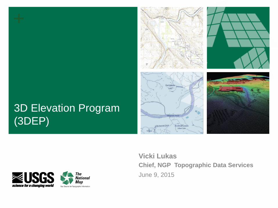
The National Map Geospatial products and services support key priorities
Area of National
Leadership
Program
Emphasis
DOI/Administration
Priorities Supported
A-16 Lead for
Terrestrial
Elevation
3D Elevation
Program (3DEP)
• Climate Action Plan
• Building a Landscape-
Level Understanding
• Ensuring Healthy
Watersheds and
Sustainable, Secure
Water Supplies
• Powering Our Future and
Responsible Use of Our
Resources
• Enhancing America’s
Great Outdoors
• Open Water Data
Initiative
A-16 Co-Lead for
Inland Waters
National
Hydrography
Dataset and
Open Water Data
Initiative
National
Coverage of
Topographic
Maps
U.S. Topo and
Alaska Mapping

+ + 3
■ 3D data include surface elevations
and natural and constructed features
■ 3DEP increases the quality level of
lidar being acquired to enable more
accurate understanding, modeling,
and prediction
■Goal to acquire national coverage in
8 years
Applies ground-
breaking lidar
technology to acquire
and distribute 3D data
Addresses a broad
range of critical
applications of national
significance
3D Elevation Program (3DEP)
+ + 4
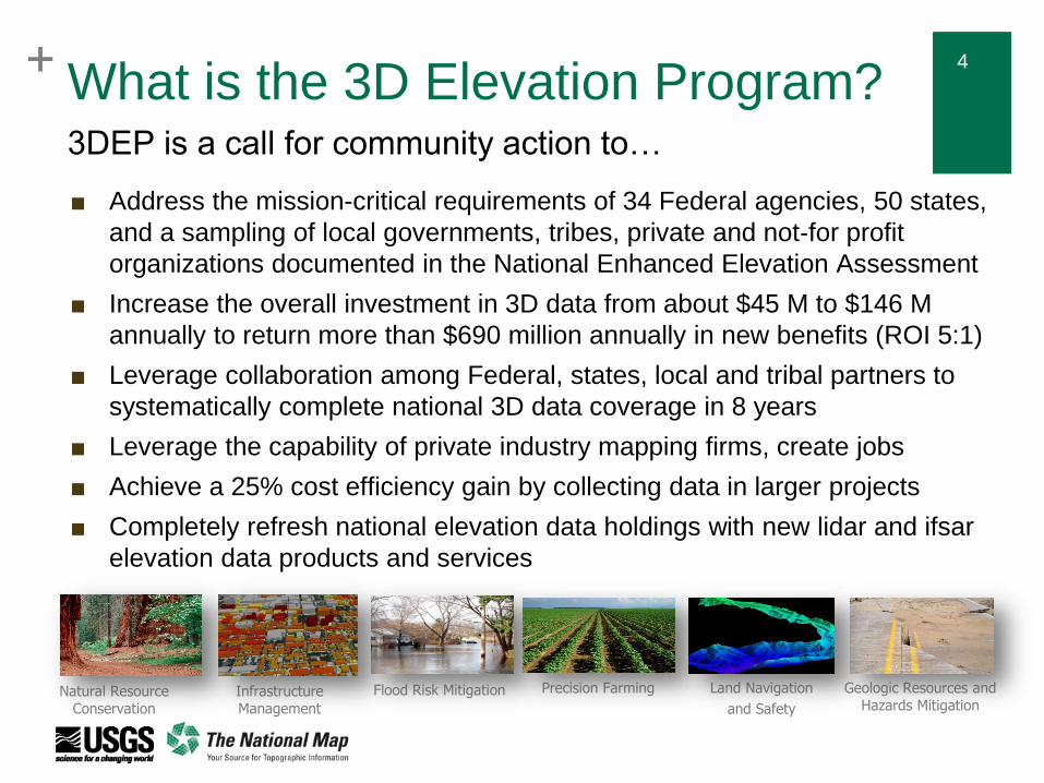
What is the 3D Elevation Program?
■ Address the mission-critical requirements of 34 Federal agencies, 50 states,
and a sampling of local governments, tribes, private and not‐for profit
organizations documented in the National Enhanced Elevation Assessment
■ Increase the overall investment in 3D data from about $45 M to $146 M
annually to return more than $690 million annually in new benefits (ROI 5:1)
■ Leverage collaboration among Federal, states, local and tribal partners to
systematically complete national 3D data coverage in 8 years
■ Leverage the capability of private industry mapping firms, create jobs
■ Achieve a 25% cost efficiency gain by collecting data in larger projects
■ Completely refresh national elevation data holdings with new lidar and ifsar
elevation data products and services
3DEP is a call for community action to…
Natural Resource Conservation
Infrastructure Management
Flood Risk Mitigation Precision Farming Land Navigation
and Safety
Geologic Resources and Hazards Mitigation
+ + 5
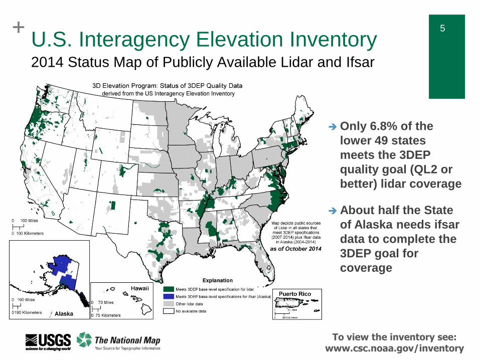
U.S. Interagency Elevation Inventory 2014 Status Map of Publicly Available Lidar and Ifsar
Only 6.8% of the
lower 49 states
meets the 3DEP
quality goal (QL2 or
better) lidar coverage
About half the State
of Alaska needs ifsar
data to complete the
3DEP goal for
coverage
To view the inventory see: www.csc.noaa.gov/inventory

+ 6 + 6
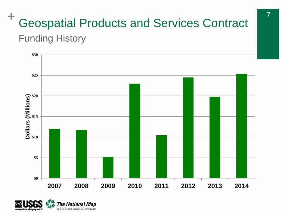
Geospatial Products and Services Contract
A suite of Indefinite Delivery Indefinite Quantity (IDIQ) contracts that provide
a mechanism to obtain geospatial data services throughout the United States
The contracts support The National Map, but may be used by other Federal,
State, and local agencies
Broad scope: photogrammetric mapping and aerotriangulation;
orthophotography; thematic mapping; digital imagery applications; ifsar and
lidar acquisition; GIS development; surveying and control acquisition,
including ground-based and airborne GPS; and much more
To ensure data quality and efficient development of standard products and
services, the USGS prefers that partners use the GPSC when possible and
practical for 3DEP data acquisition
Past Delegated Procurement Authority was $250M over 5 years –
GPSC3 will increase it to $750M to accommodate increased production
for 3DEP
Background
+ 7 + 7
Geospatial Products and Services Contract
$0
$5
$10
$15
$20
$25
$30
2007 2008 2009 2010 2011 2012 2013 2014
Do
lla
rs (
Mil
lio
ns
)
Funding History

+ 8
Process Step Planned Date
Contracting Officer to notify firms not
selected June 29
RFPs sent out to selected firms July 8
RFP evaluation and negotiations July 8-28
Request for proposal revisions July 28 – Sept. 7
Legal review Sept. 7 - 21
Begin awarding contracts Sept. 21
DRAFT Schedule for Establishing GPSC3
Note that there are still GPSC2 contracts that remain active well into 2016
Geospatial Products and Services Contract
+ 9 + 9
Broad Agency Announcement (BAA)
As follow-up to the President’s announcement, the USGS issued a BAA via
FedBizOps that provides information on how to partner with the USGS and other
Federal agencies to acquire 3D elevation data
Designed to provide increased visibility and opportunity to the broadest
stakeholder community possible - Federal agencies, state and local governments,
tribes, academic institutions and the private sector are eligible to submit proposals
Establish a standard, fair and equitable competitive process that can easily be
expanded to account for future growth in the 3D Elevation Program
To ensure data quality and efficient development of standard products and
services, the USGS prefers that partners use the GPSC when possible and
practical; proposals may use GPSC or partner contracts; in both cases 3DEP
makes use of the commercial sector to do the acquisition
A means to recognize, aggregate and inspire collaborative funding partnerships
in support of multi-agency lidar data acquisition requirements
Background
+ 10 + 10
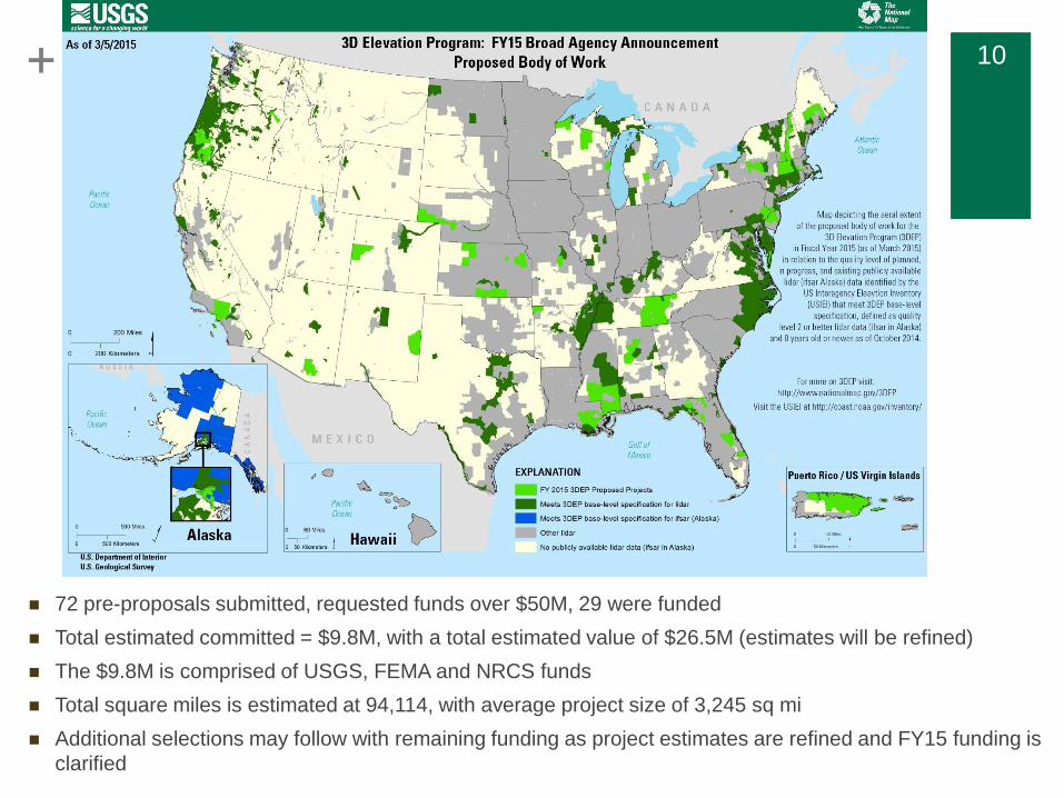
Broad Agency Announcement (BAA)
Background
72 pre-proposals submitted, requested funds over $50M, 29 were funded
Total estimated committed = $9.8M, with a total estimated value of $26.5M (estimates will be refined)
The $9.8M is comprised of USGS, FEMA and NRCS funds
Total square miles is estimated at 94,114, with average project size of 3,245 sq mi
Additional selections may follow with remaining funding as project estimates are refined and FY15 funding is
clarified
+ 11 + 11
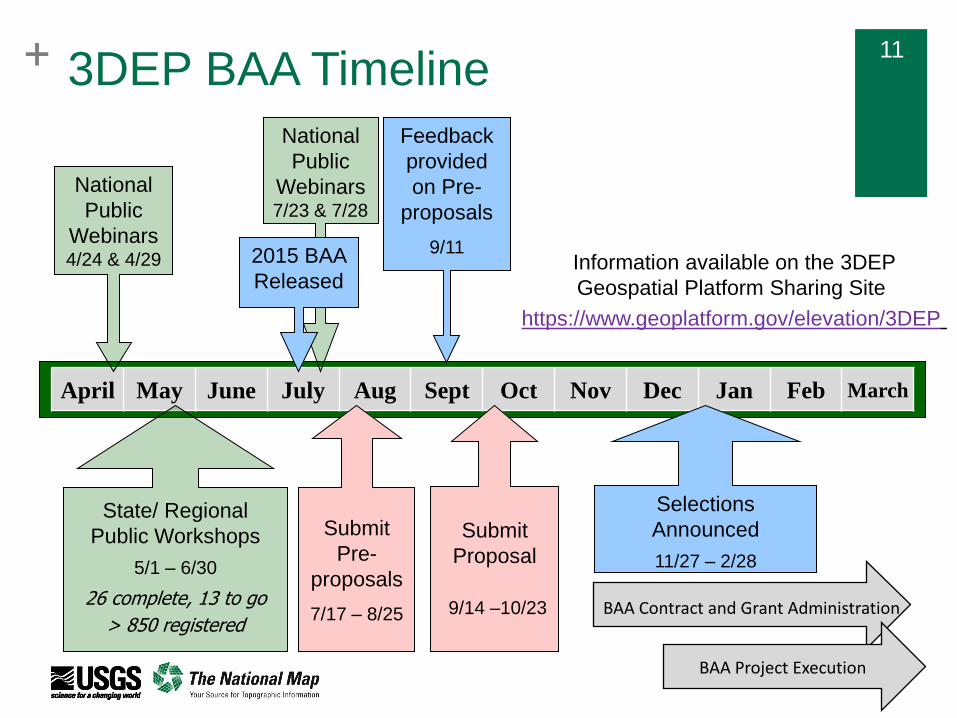
April May June July Aug Sept Oct Nov Dec Jan Feb March
Submit
Proposal
9/14 –10/23
Submit
Pre-
proposals
7/17 – 8/25
Selections
Announced
11/27 – 2/28
National
Public
Webinars 7/23 & 7/28
2015 BAA
Released
Feedback
provided
on Pre-
proposals
9/11
BAA Contract and Grant Administration
BAA Project Execution
3DEP BAA Timeline
National
Public
Webinars 4/24 & 4/29
State/ Regional
Public Workshops
5/1 – 6/30
26 complete, 13 to go
> 850 registered
Information available on the 3DEP
Geospatial Platform Sharing Site
https://www.geoplatform.gov/elevation/3DEP
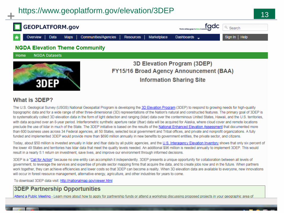
+ 13 + 13 https://www.geoplatform.gov/elevation/3DEP
+ 14 + 14
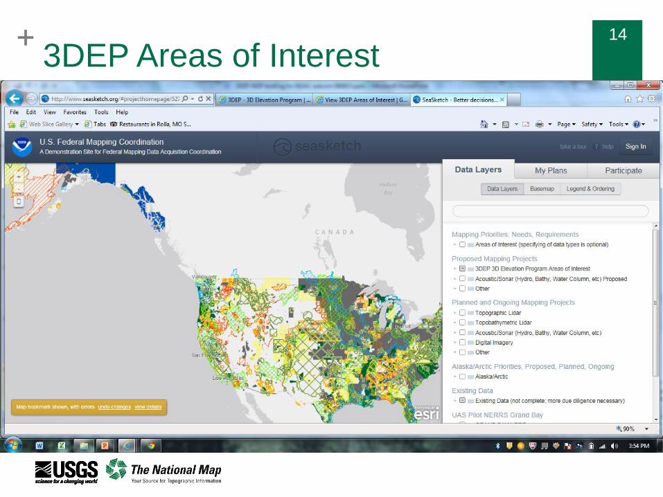
3DEP Areas of Interest
+ 15 + 15
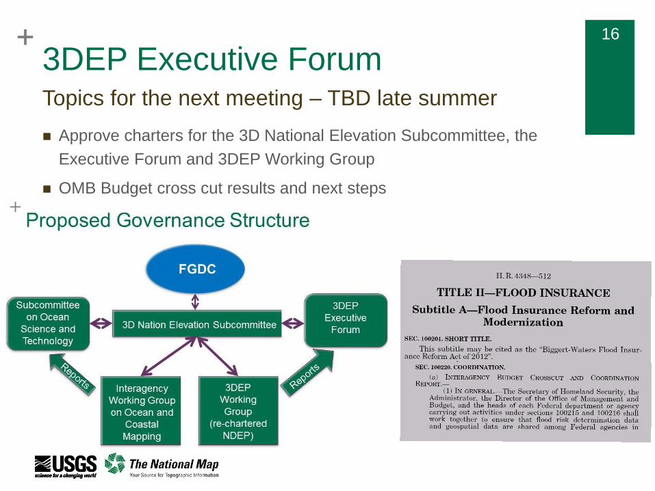
3DEP Executive Forum
Purpose - to facilitate executive dialog and collaboration on strategies to
implement and sustain 3DEP for the benefit of all its stakeholders
Leadership – USGS Associate Director for Core Science Systems, Chair
Objectives
Monitor status, plans and coordination actions for 3DEP implementation
Strategize on significant developments regarding elevation or related geospatial activities, for
example, legislation, GAO studies, supplemental funding, etc.
Share insights and develop strategies to communicate with industry and other stakeholder
groups that could play a role in 3DEP funding
Provide executive direction and input to NDEP as the operational coordinating body
Membership FEMA
NASA
NGA
NOAA
Governance and Executive Outreach
BLM DHS DISDI EPA Others
NPS NRCS USACE USFWS USFS
+ 16 + 16
3DEP Executive Forum
Approve charters for the 3D National Elevation Subcommittee, the
Executive Forum and 3DEP Working Group
OMB Budget cross cut results and next steps
Topics for the next meeting – TBD late summer

+ 18 + 18
Emerging 3D Technologies Working Group
Members from USGS, NOAA, NGA,
FWS, USACE, USFS, NRCS
Coordination with Lidar Interoperability
Work Group (LIWG) led by NGA
Better understand emerging
instruments: potential strengths and
limitations
Come to Federal consensus on
whether these instruments can meet
3DEP requirements
Test data against existing QL1 & 2
data and well understood survey
ground control
Current focus on high altitude and
topobathy lidar systems
E3D-WG under the 3DEP Working Group (Formerly NDEP)

+ 19
3DEP Stakeholder Meeting
Purpose - to provide a status report to our primary Stakeholders and
discuss strategies, challenges and opportunities to fully implement
3DEP in collaboration
Stakeholders
3DEP Executive Forum
American Society for Photogrammetry and Remote Sensing (ASPRS)
Association of American State Geologists (AASG)
Association of State Floodplain Managers (ASFPM)
Coalition of Geospatial Organizations (COGO)
Management Association for Private Photogrammetric Surveyors (MAPPS)
National Geospatial Advisory Committee (NGAC)
National Society of Professional Surveyors (NSPS)
National States Geographic Information Council (NSGIC)
April 15, 1-5 at The National Surveying, Mapping and Geospatial Conference
+ 20
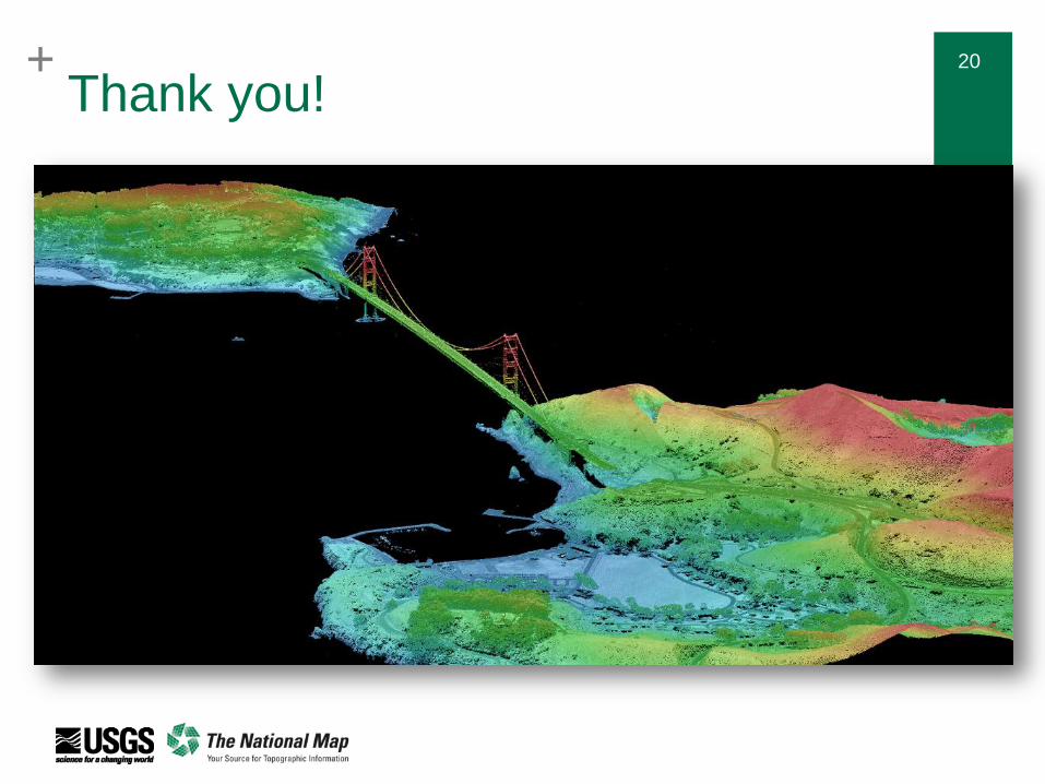
Thank you!