Embed Size (px)
Citation preview
3D GEO-IMAGERY BRIDGING CONTINENTS
W. Schuhr a, E. Kanngieser b
a University of Applied Sciences, 39114 Magdeburg, Germany; e-mail: [email protected] b University of Applied Sciences, 22297 Hamburg, Germany; e-mail: [email protected]
Commission V, WG 4
KEY WORDS: Archaeology, Architecture, Data Mining, Photogrammetry, Spatial, Virtual Reality, Vision Sciences, Visualization ABSTRACT: The general purpose of this paper is, to improve the perception and communication in 3D GEO-IMAGE recording, documentation and information management. In particular it deals with the improvement of Spatial Heritage-Imagery, as a worldwide Challenge - by stimulating the scientific as well as the public interest in virtual Spatial Heritage visualization, - by increasing high resolution virtual Heritage presentation due to the still underestimated gain of a complete additional
dimension, - by gaining new and by collecting existing stereoviews of both media, analog and digital - and by applying Heritage Stereoviews for monument recording, visualization, protection and reconstruction. Consequently the Chapters of this paper are on gaining, collecting, providing, exchanging and on applying International Heritage Stereoviews. Chapter 1 states interesting messages and samples, for Scientists as well as for Amateurs, on gaining 3D Heritage-Imagery, including, e.g., the use of DIGI BEAM CAMERAS LITE on a 10m telescope staff. In this context it is shown, this dealing with fundamentals of spatial data visualization is required and still gains a surprising potential for further research, which at least has to deal with 20 open research topics, like, e.g., the optimum base length etc.. Chapter 2, which deals the RecorDIM task group on Collecting, Compiling and Sharing Heritage Stereoviews, namely reports on existing International Archives for 3D Heritage-Imagery with world wide web presentations. In addition this Chapter is on recommended resolutions, available data-formats and on conditions for providing and exchanging 3D Heritage-Imagery. Chapter 3, which is on applying of 3D Geo-Imagery, for the FIRST time deals with a COMPLETE (!) LIST of AVAILABLE 3D VISUALIZATION TECHNIQUES for VIRTUAL SPATIAL (Heritage- and Geo-) DATA PRESENTATION., in order to advice on suited state of the art technology for Heritage Stereoview verification. For the first time stereo mates are presented in the DOWN UNDER mode. Beside well established 3D visualization Techniques, by means of stereoscopes, anaglyphs, polarized glasses, liquid crystal shutters, chromadepth etc., currently namely the dynamic NUOPTIX method, as already invented by PULFRICH, and in particular the introduced FELIX SOLID STATE REAL(!) 3D SCREEN promise a great future for both, the scientific as well as for the public 3D visualization. From a consequently dealing with the principals of spatial data visualization, even the future of the whole computer industry will improve!
1. GAINING 3D HERITAGE IMAGERY Nowadays serious photographic Heritage documentation at least should deal with 3D photography! It is liked to emphasize, due to the modern camera Technology, single lens cameras of both types, analog and digital, for 3D photography even seem superior to (often old fashioned) stereo cameras! Another big advantage of single lens cameras is the relative low price, the weight and the flexibility in baselength variation. To start up taking own stereoviews of Heritage monuments, the object at least should be photographed twice from partly different projection centers (positions), which gives the baseline. The same objectpart in the view-finder avoids vertical parallaxes and on the stereoscopic perception side "the eyes forgive "small" (up to 5 degrees) deviations from parallel camera axis". As a matter of fact the gain of a complete additional dimension from systematic stereoview photography for documentation purposes is still underestimated and even until now for many Heritage documentation purposes it is more believed in subjective interpreted manual drawings than in objective high resolution 3D photography! In many cases recent aerial Photography of Heritage Monuments and sites is not available or shows lack in resolution. Due to own experiences, related to high resolution mapping of historic objects, the authors invented the 10m DIGI BEAM CAMERA LITE and "take their own high resolution aerial photography from the ground". To overcome hindrances, as caused by, e.g., tree crowns, stereoviews of the monuments have been photographed with a digital Sony Cyber-Shot 5.0 Megapixel camera from 10 m height with a telescope staff
light., see Fig. 1. In the meantime a remote exposure and video control has been established. Though the virtual Heritage Documentation Technology as a part of Geoinformationsystems (GIS) and/or Monumentinformationsystems (MIS) is very advanced, dealing with basics of spatial Heritage data visualization still gains a surprising huge amount of at least partly open research topics, like, e.g., a) Research topics for Technique and Arts Aspects of stereoviews: 1. The market potential for stereo views 2. The professional potential of existing Archives for 3D-
pictures and movies. 3. The complete history for stereo imagery, including the
photo plasticon, see figure 7 (last view) and sample stereoviews of figure 3, 4 and 5
4. The (stereoscopic) effect of combination of stereo mates showing different pixel size 5. The effects of Fusion of different Sensor images (e.g.
optical and radar) 6. The benefit of combining day- and night MIS stereo mates 7. The effects of combination of "before and after" pictures 8. The role of the dominant Eye 9. The potential of stereo-panorama-views 10. The potential of terrestrial stereo image blocks 11. The manipulation of (existing) real and synthetic stereoviews to achieve a required deep perception 12. Optimum baselength for gaining stereoviews
There is no unique answer after the optimum base length or better the base-to (object-) distance ratio, because it depends on the stereo photographer and/or user, to achieve near natural or super elevated deep perception, see Fig. 3. For quick applications using normal and wide angle cameras mainly for 3D documentation purposes, the empiric baseline to object distance ratio should be approximately 1:10. It is highly recommended, to take not only two shots but a queue of stereomates and possibly to chose different appropriate stereo mate combinations according to different criteria, but see also SCHUHR,W. and KANGIESER, E. (2000).
b) Research topics for Arts Aspects of stereoviews: 13. Critical dealing with the Genre 3D photography showing portraits, Heritage Monuments (see figure 1, 3, 4 and 5) Architecture, Landscapes (see figure 4 ), Nature, Environment, Technology etc.. This in particular holds for the "master pieces", like in figure 3, 4 and 5, but also for available stereoviews in general, as well as for own stereoviews.
14. Differences in the object choice between 2D and 3D photography from an artists point of view 15. (Computer) Generation and/or manipulation of artist stereoviews 16. The generation of a lost or a so far not existed stereo mate by analog and/or digital means, for, e.g. , Monument reconstruction purposes and artificial stereomates for paintings etc. c) Research topics for Technique Aspects of stereoviews: 17. Optimizing the stereoview gaining procedure 18. Practical criteria for losing the stereo ability 18. The Geometric potential of (available) stereo imagery; 19. A systematic Considering of the effect of the stereoscopic exaggeration caused by an extremely high base-to-distance ratio near 1 20. Considering the effect of the stereoscopic exaggeration caused by a combination of stereomates showing different focus.
Figure 1. Gaining high resolution stereo mates of the historic part of the Jewish cemetery in Magdeburg. To overcome serious hindrances due to tree crowns, stereo views of the monuments have been taken with a one lens digital Sony Cyber-shot 5.0 Mega-Pixels camera from a 10 m light telescope staff, using remote zoom, exposure and video control.
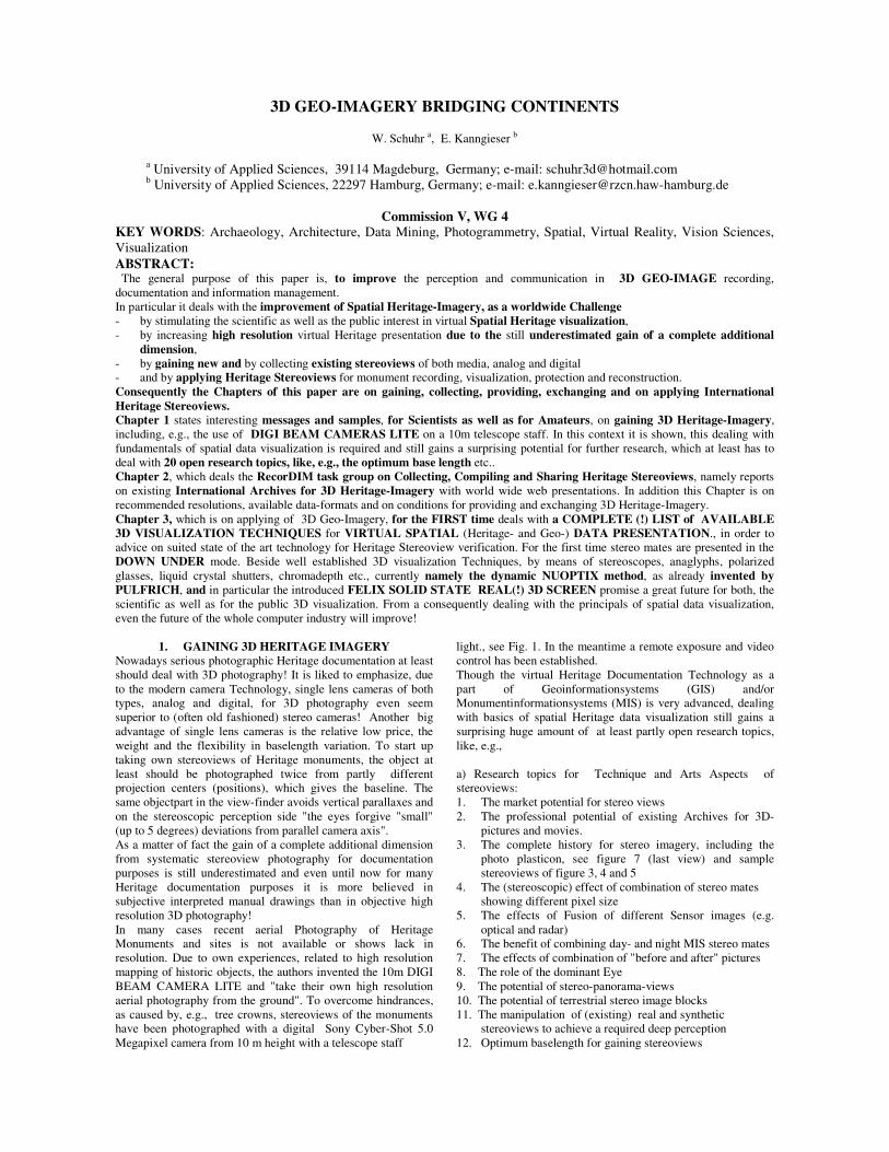
Figure 2. Stereo ability increases the Heritage site mapping potential: An original overlapping 1:50 000 synoptically imagery shows almost the same mapping potential for topographic objects, in particular for buildings and thus for Heritage sites, as stereomates(!) with 2.5m until 5m ground pixel size. 3D Heritage-Imagery as understood here, is part of Geo-Imagery, in particular when it comes to site monitoring, see Fig.2.
2. COLLECTIONS OF 3D HERITAGE IMAGERY Beside their documentary value stereoviews contain important 3D Geometric and Radiometric information In this context it is liked to remember to the famous historic German Photogrammetrist Meydenbauer, whose archive is still maintained as a part of the Conservation Institute of Brandenburg in Germany. It consists of about 10000 stereo views on super sized glass, showing important monuments of Germany. These authentic historic stereoviews in many cases very successfully have been used for rebuilding and restoration purposes. There is no doubt, the most important international Archive for Heritage stereoviews is the Keystone-Mast collection of the UCR (University of California Riverside)/ California Museum of Photography, holding 350000 (analogue) stereoviews of, e.g., the famous Keystone Company, of Underwood and Underwood and of H. C. White etc., from 1892-1963. The current digitization rate is 10%. A nearly complete synoptically overview of existing international Archives holding stereoviews and access to these data is more than overdue. This task will play an important role for the RecordDIM task group on Collecting, Compiling and Sharing Heritage stereoviews. Stretching the question after Archives for stereoviews, a close cooperation of ICOMOS, CIPA, the GCI, ISPRS and ISU (the International Stereoscopic Union) is highly recommended.
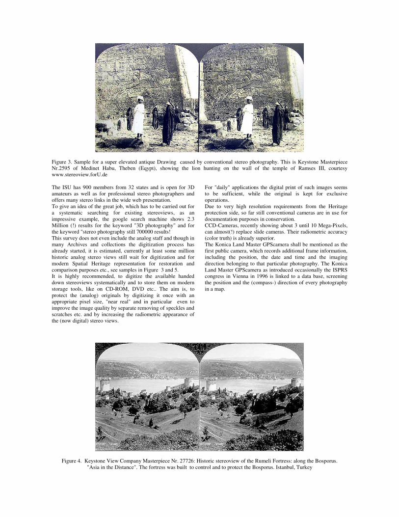
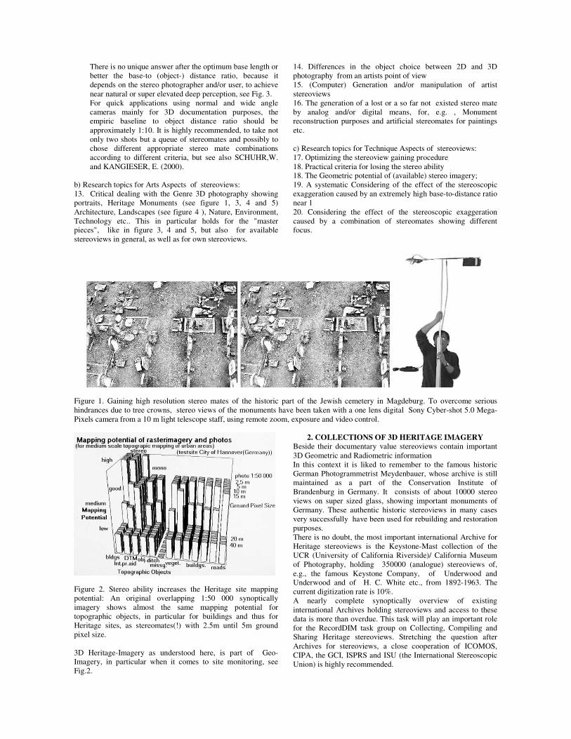
Figure 3. Sample for a super elevated antique Drawing caused by conventional stereo photography. This is Keystone Masterpiece Nr.2595 of Medinet Habu, Theben (Eqypt), showing the lion hunting on the wall of the temple of Ramses III, courtesy www.stereoview.forU.de The ISU has 900 members from 32 states and is open for 3D amateurs as well as for professional stereo photographers and offers many stereo links in the wide web presentation. To give an idea of the great job, which has to be carried out for a systematic searching for existing stereoviews, as an impressive example, the google search machine shows 2.3 Million (!) results for the keyword "3D photography" and for the keyword "stereo photography still 700000 results! This survey does not even include the analog staff and though in many Archives and collections the digitization process has already started, it is estimated, currently at least some million historic analog stereo views still wait for digitization and for modern Spatial Heritage representation for restoration and comparison purposes etc., see samples in Figure 3 and 5. It is highly recommended, to digitize the available handed down stereoviews systematically and to store them on modern storage tools, like on CD-ROM, DVD etc.. The aim is, to protect the (analog) originals by digitizing it once with an appropriate pixel size, "near real" and in particular even to improve the image quality by separate removing of speckles and scratches etc. and by increasing the radiometric appearance of the (now digital) stereo views.
For "daily" applications the digital print of such images seems to be sufficient, while the original is kept for exclusive operations. Due to very high resolution requirements from the Heritage protection side, so far still conventional cameras are in use for documentation purposes in conservation. CCD-Cameras, recently showing about 3 until 10 Mega-Pixels, can almost(!) replace slide cameras. Their radiometric accuracy (color truth) is already superior. The Konica Land Master GPScamera shall be mentioned as the first public camera, which records additional frame information, including the position, the date and time and the imaging direction belonging to that particular photography. The Konica Land Master GPScamera as introduced occasionally the ISPRS congress in Vienna in 1996 is linked to a data base, screening the position and the (compass-) direction of every photography in a map.
Figure 4. Keystone View Company Masterpiece Nr. 27726: Historic stereoview of the Rumeli Fortress: along the Bosporus. "Asia in the Distance". The fortress was built to control and to protect the Bosporus. Istanbul, Turkey
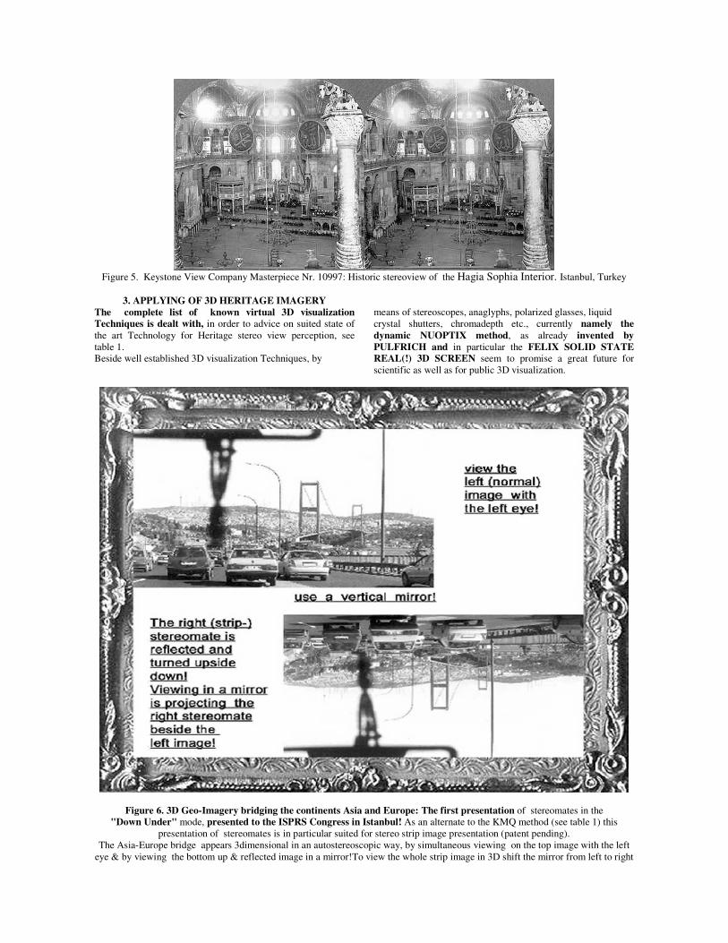
Figure 5. Keystone View Company Masterpiece Nr. 10997: Historic stereoview of the Hagia Sophia Interior. Istanbul, Turkey
3. APPLYING OF 3D HERITAGE IMAGERY
The complete list of known virtual 3D visualization Techniques is dealt with, in order to advice on suited state of the art Technology for Heritage stereo view perception, see table 1. Beside well established 3D visualization Techniques, by
means of stereoscopes, anaglyphs, polarized glasses, liquid crystal shutters, chromadepth etc., currently namely the dynamic NUOPTIX method, as already invented by PULFRICH and in particular the FELIX SOLID STATE REAL(!) 3D SCREEN seem to promise a great future for scientific as well as for public 3D visualization.
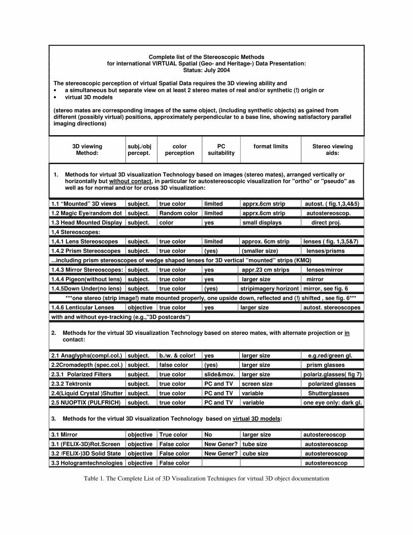
Figure 6. 3D Geo-Imagery bridging the continents Asia and Europe: The first presentation of stereomates in the "Down Under" mode, presented to the ISPRS Congress in Istanbul! As an alternate to the KMQ method (see table 1) this
presentation of stereomates is in particular suited for stereo strip image presentation (patent pending). The Asia-Europe bridge appears 3dimensional in an autostereoscopic way, by simultaneous viewing on the top image with the left
eye & by viewing the bottom up & reflected image in a mirror!To view the whole strip image in 3D shift the mirror from left to right
Complete list of the Stereoscopic Methods
for international VIRTUAL Spatial (Geo- and Heritage-) Data Presentation: Status: July 2004
The stereoscopic perception of virtual Spatial Data requires the 3D viewing ability and • a simultaneous but separate view on at least 2 stereo mates of real and/or synthetic (!) origin or • virtual 3D models (stereo mates are corresponding images of the same object, (including synthetic objects) as gained from different (possibly virtual) positions, approximately perpendicular to a base line, showing satisfactory parallel imaging directions)
3D viewing
Method:
subj./obj percept.
color
perception
PC
suitability
format limits
Stereo viewing
aids:
1. Methods for virtual 3D visualization Technology based on images (stereo mates), arranged vertically or
horizontally but without contact, in particular for autostereoscopic visualization for "ortho" or "pseudo" as well as for normal and/or for cross 3D visualization:
1.1 “Mounted” 3D views subject. true color limited apprx.6cm strip autost. ( fig.1,3,4&5)
1.2 Magic Eye/random dot subject. Random color limited apprx.6cm strip autostereoscop.
1.3 Head Mounted Display subject. color yes small displays direct proj.
1,4 Stereoscopes:
1,4.1 Lens Stereoscopes subject. true color limited approx. 6cm strip lenses ( fig. 1,3,5&7)
1.4.2 Prism Stereoscopes subject. true color (yes) (smaller size) lenses/prisms
...including prism stereoscopes of wedge shaped lenses for 3D vertical ”mounted” strips (KMQ)
1.4.3 Mirror Stereoscopes: subject. true color yes appr.23 cm strips lenses/mirror
1.4.4 Pigeon(without lens) subject. true color yes larger size mirror
1.4.5Down Under(no lens) subject. true color (yes) stripimagery horizont mirror, see fig. 6
***one stereo (strip image!) mate mounted properly, one upside down, reflected and (!) shifted , see fig. 6***
1.4.6 Lenticular Lenses objective true color yes larger size autost. stereoscopes
with and without eye-tracking (e.g.,"3D postcards")
2. Methods for the virtual 3D visualization Technology based on stereo mates, with alternate projection or in
contact:
2.1 Anaglyphs(compl.col.) subject. b./w. & color! yes larger size e.g.red/green gl.
2.2Cromadepth (spec.col.) subject. false color (yes) larger size prism glasses
2.3.1 Polarized Filters subject. true color slide&mov. larger size polariz.glasses( fig 7)
2.3.2 Tektronix subject. true color PC and TV screen size polarized glasses
2.4(Liquid Crystal )Shutter subject. true color PC and TV variable Shutterglasses
2.5 NUOPTIX (PULFRICH) subject. true color PC and TV variable one eye only: dark gl.
3. Methods for the virtual 3D visualization Technology based on virtual 3D models:
3.1 Mirror objective True color No larger size autostereoscop
3.1 (FELIX-3D)Rot.Screen objective False color New Gener? tube size autostereoscop
3.2 /FELIX-)3D Solid State objective False color New Gener? cube size autostereoscop
3.3 Hologramtechnologies objective False color autostereoscop
Table 1. The Complete List of 3D Visualization Techniques for virtual 3D object documentation
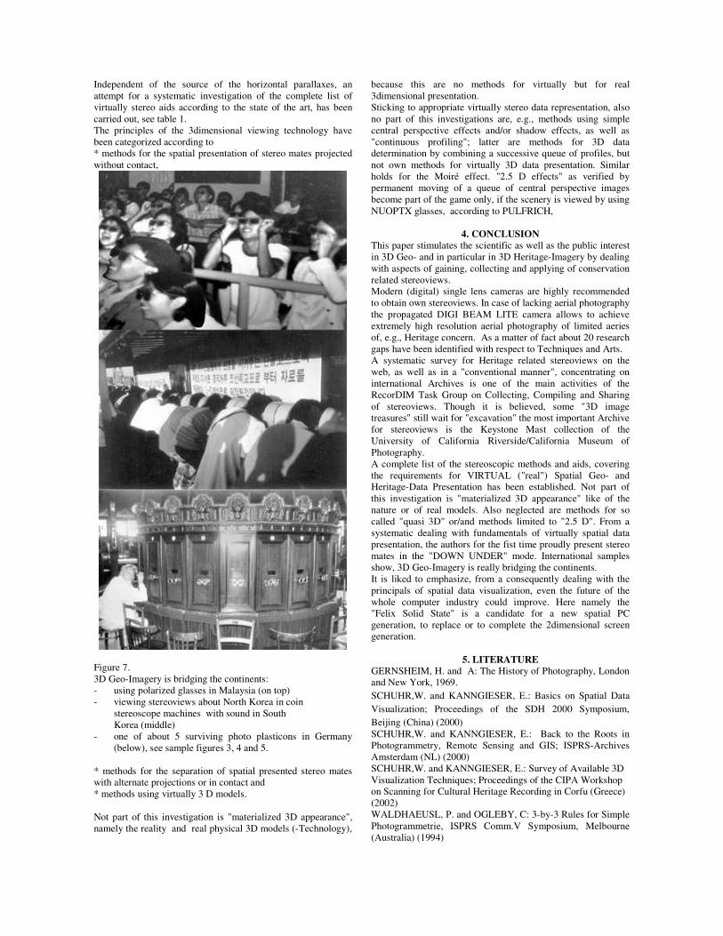
Independent of the source of the horizontal parallaxes, an attempt for a systematic investigation of the complete list of virtually stereo aids according to the state of the art, has been carried out, see table 1. The principles of the 3dimensional viewing technology have been categorized according to * methods for the spatial presentation of stereo mates projected without contact,
Figure 7. 3D Geo-Imagery is bridging the continents: - using polarized glasses in Malaysia (on top) - viewing stereoviews about North Korea in coin stereoscope machines with sound in South Korea (middle) - one of about 5 surviving photo plasticons in Germany
(below), see sample figures 3, 4 and 5. * methods for the separation of spatial presented stereo mates with alternate projections or in contact and * methods using virtually 3 D models. Not part of this investigation is "materialized 3D appearance", namely the reality and real physical 3D models (-Technology),
because this are no methods for virtually but for real 3dimensional presentation. Sticking to appropriate virtually stereo data representation, also no part of this investigations are, e.g., methods using simple central perspective effects and/or shadow effects, as well as "continuous profiling"; latter are methods for 3D data determination by combining a successive queue of profiles, but not own methods for virtually 3D data presentation. Similar holds for the Moiré effect. "2.5 D effects" as verified by permanent moving of a queue of central perspective images become part of the game only, if the scenery is viewed by using NUOPTX glasses, according to PULFRICH,
4. CONCLUSION This paper stimulates the scientific as well as the public interest in 3D Geo- and in particular in 3D Heritage-Imagery by dealing with aspects of gaining, collecting and applying of conservation related stereoviews. Modern (digital) single lens cameras are highly recommended to obtain own stereoviews. In case of lacking aerial photography the propagated DIGI BEAM LITE camera allows to achieve extremely high resolution aerial photography of limited aeries of, e.g., Heritage concern. As a matter of fact about 20 research gaps have been identified with respect to Techniques and Arts. A systematic survey for Heritage related stereoviews on the web, as well as in a "conventional manner", concentrating on international Archives is one of the main activities of the RecorDIM Task Group on Collecting, Compiling and Sharing of stereoviews. Though it is believed, some "3D image treasures" still wait for "excavation" the most important Archive for stereoviews is the Keystone Mast collection of the University of California Riverside/California Museum of Photography. A complete list of the stereoscopic methods and aids, covering the requirements for VIRTUAL ("real") Spatial Geo- and Heritage-Data Presentation has been established. Not part of this investigation is "materialized 3D appearance" like of the nature or of real models. Also neglected are methods for so called "quasi 3D" or/and methods limited to "2.5 D". From a systematic dealing with fundamentals of virtually spatial data presentation, the authors for the fist time proudly present stereo mates in the "DOWN UNDER" mode. International samples show, 3D Geo-Imagery is really bridging the continents. It is liked to emphasize, from a consequently dealing with the principals of spatial data visualization, even the future of the whole computer industry could improve. Here namely the "Felix Solid State" is a candidate for a new spatial PC generation, to replace or to complete the 2dimensional screen generation.
5. LITERATURE GERNSHEIM, H. and A: The History of Photography, London and New York, 1969. SCHUHR,W. and KANNGIESER, E.: Basics on Spatial Data Visualization; Proceedings of the SDH 2000 Symposium, Beijing (China) (2000) SCHUHR,W. and KANNGIESER, E.: Back to the Roots in Photogrammetry, Remote Sensing and GIS; ISPRS-Archives Amsterdam (NL) (2000) SCHUHR,W. and KANNGIESER, E.: Survey of Available 3D Visualization Techniques; Proceedings of the CIPA Workshop on Scanning for Cultural Heritage Recording in Corfu (Greece) (2002) WALDHAEUSL, P. and OGLEBY, C: 3-by-3 Rules for Simple Photogrammetrie, ISPRS Comm.V Symposium, Melbourne (Australia) (1994)