Embed Size (px)
Citation preview
________________Dungeness River Comprehensive Flood Hazard Management Plan 2009
18
4. FLOOD HISTORY AND IDENTIFICATION OF FLOOD HAZARDS
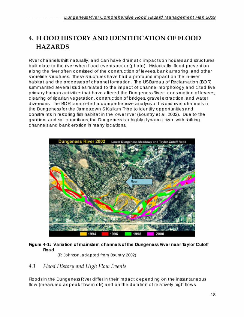
River channels shift naturally, and can have dramatic impacts on houses and structures built close to the river when flood events occur (photo). Historically, flood prevention along the river often consisted of the construction of levees, bank armoring, and other shoreline structures. These structures have had a profound impact on the in-river habitat and the processes of channel formation. The US Bureau of Reclamation (BOR) summarized several studies related to the impact of channel morphology and cited five primary human activities that have altered the Dungeness River: construction of levees, clearing of riparian vegetation, construction of bridges, gravel extraction, and water diversions. The BOR completed a comprehensive analysis of historic river channels in the Dungeness for the Jamestown S’Klallam Tribe to identify opportunities and constraints in restoring fish habitat in the lower river (Bountry et al. 2002). Due to the gradient and soil conditions, the Dungeness is a highly dynamic river, with shifting channels and bank erosion in many locations.
Figure 4-1: Variation of mainstem channels of the Dungeness River near Taylor Cutoff
Road (R. Johnson, adapted from Bountry 2002)
4.1 Flood History and High Flow Events Floods in the Dungeness River differ in their impact depending on the instantaneous flow (measured as peak flow in cfs) and on the duration of relatively high flows
Flow

________________Dungeness River Comprehensive Flood Hazard Management Plan 2009
19
(measured as mean daily flow in cfs) and also as the volume (in total acre-feet) delivered during the event. High flows that appear by one measure to be significant are not necessarily highly damaging. For example, the highest instantaneous peak flow on record occurred in January, 2002 at 7,610 cfs. However, it is only the third largest daily mean flow event and only the 11th largest flood event in terms of acre-feet of water delivered. Table 4-1 shows the peak flood frequency estimates based on the USGS stream gage (12048000). Table 4-2 (next page) shows the flood events of record for each of the three ways of estimating “flood event,” based on measurements at the same USGS stream gage. Table 4-1: Flood Discharge and Probability (From England 1999 as Appendix G, Bountry et al. 1999) Revised flood frequency estimates from BOR 2007 modeling study. BOR prepared a new flood frequency curve in 2007 based on newer peak flows in 2002 and 2003, and additional USGS gage records. Return Period
(years) Annual Exceedance Probability (percent)
Peak Discharge (cfs) 1999 estimate
Revised Peak Discharge (cfs)
2007 estimate 1.5 2,400 2 50 2,990 3,060 5 20 4,690 4,800 10 10 5,780 5,910 25 4 7,120 7,250 50 2 8,060 8,190
100 1 8,960 9,080 Predicting future flooding is very difficult due to changing trends for temperature, precipitation, and runoff in the region. Records have been maintained at the USGS gaging station for approximately 80 years (1899-1901, 1924-1930, 1938-present). The largest peak flow recorded was experienced in 2002, at 7,610 cfs. Other very large flows were experienced during periods of no gaging, and may have been as large. It might be reasonable to base future estimates of likely maximum flood levels on this past record, were it not for the measured change in climate and snowpack experienced in the area in the last several decades. Climate models indicate the likelihood of more frequent high magnitude storm events, with consequences for flood levels and frequency. Apart from evidence for global warming, there is localized evidence in the flow record that the Dungeness River does not enjoy some, “steady state” condition but varies widely across a range of peak flood values. England (1999) estimated that the 95% confidence limit on the 100-year flood that could be experienced on the Dungeness River is 11,400 cfs, substantially higher than the 2002 flood of record. Floods at that level would redefine the entire river morphology and would likely overtop many existing flood structures. It is therefore even more important to focus on reducing susceptibility to flooding by emphasizing funding efforts on removing or relocating residences and other structures from the floodplain and on restoring natural river processes.
________________Dungeness River Comprehensive Flood Hazard Management Plan 2009
20
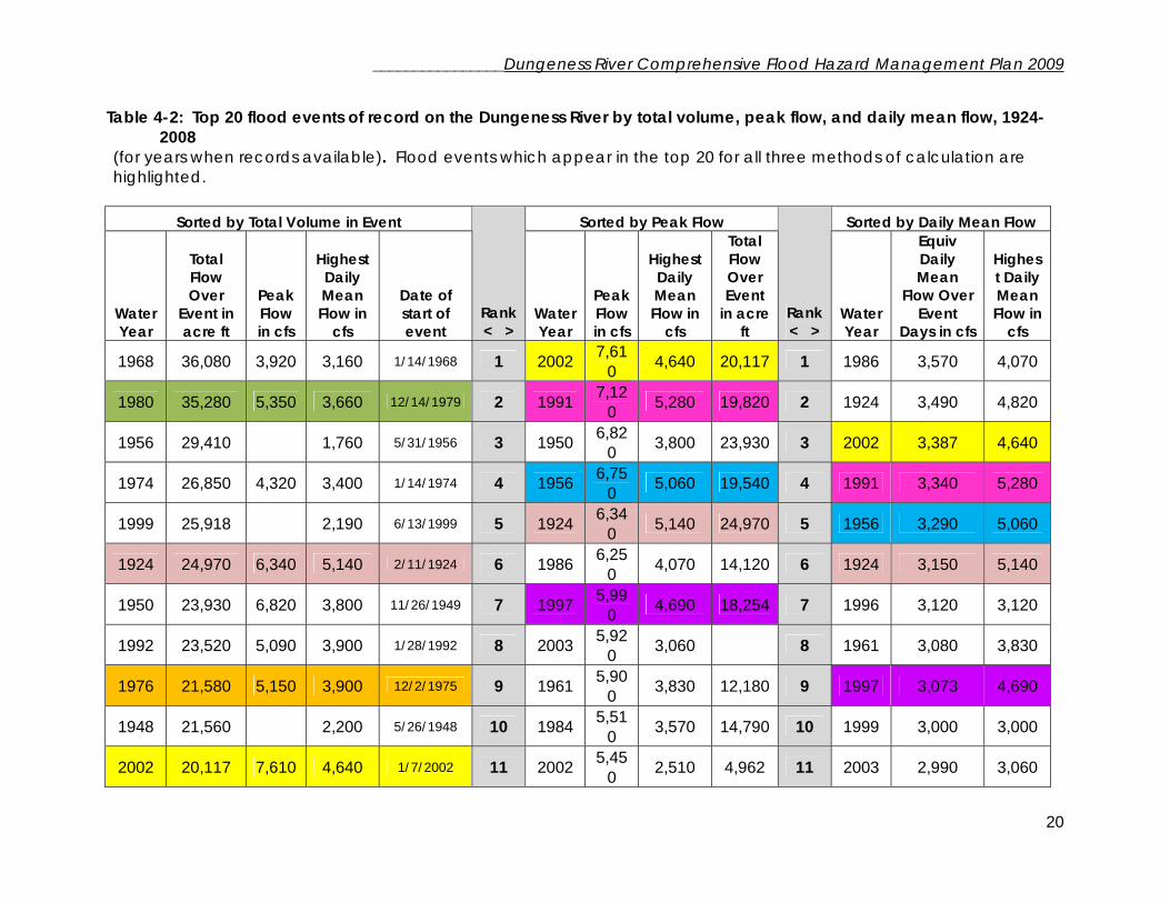
Table 4-2: Top 20 flood events of record on the Dungeness River by total volume, peak flow, and daily mean flow, 1924-2008
(for years when records available). Flood events which appear in the top 20 for all three methods of calculation are highlighted.
Sorted by Total Volume in Event Sorted by Peak Flow Sorted by Daily Mean Flow
Water Year
Total Flow Over
Event in acre ft
Peak Flow in cfs
Highest Daily Mean Flow in
cfs
Date of start of event
Rank < >
Water Year
Peak Flow in cfs
Highest Daily Mean Flow in
cfs
Total Flow Over Event
in acre ft
Rank < >
Water Year
Equiv Daily Mean
Flow Over Event
Days in cfs
Highest Daily Mean Flow in
cfs
1968 36,080 3,920 3,160 1/14/1968 1 2002 7,610 4,640 20,117 1 1986 3,570 4,070
1980 35,280 5,350 3,660 12/14/1979 2 1991 7,120 5,280 19,820 2 1924 3,490 4,820
1956 29,410 1,760 5/31/1956 3 1950 6,820 3,800 23,930 3 2002 3,387 4,640
1974 26,850 4,320 3,400 1/14/1974 4 1956 6,750 5,060 19,540 4 1991 3,340 5,280
1999 25,918 2,190 6/13/1999 5 1924 6,340 5,140 24,970 5 1956 3,290 5,060
1924 24,970 6,340 5,140 2/11/1924 6 1986 6,250 4,070 14,120 6 1924 3,150 5,140
1950 23,930 6,820 3,800 11/26/1949 7 1997 5,990 4,690 18,254 7 1996 3,120 3,120
1992 23,520 5,090 3,900 1/28/1992 8 2003 5,920 3,060 8 1961 3,080 3,830
1976 21,580 5,150 3,900 12/2/1975 9 1961 5,900 3,830 12,180 9 1997 3,073 4,690
1948 21,560 2,200 5/26/1948 10 1984 5,510 3,570 14,790 10 1999 3,000 3,000
2002 20,117 7,610 4,640 1/7/2002 11 2002 5,450 2,510 4,962 11 2003 2,990 3,060

________________Dungeness River Comprehensive Flood Hazard Management Plan 2009
21
1991 19,820 7,120 5,280 11/23/1990 12 1938 5,380 3,240 15,210 12 1976 2,730 3,900
1956 19,540 6,750 5,060 11/3/1955 13 1980 5,350 3,660 35,280 13 1995 2,640 3,320
1991 19,250 3,480 11/9/1990 14 1976 5,150 3,900 21,580 14 1960 2,640 3,300
1996 18,826 4,500 3,240 12/11/1995 15 1992 5,090 3,900 23,520 15 1999 2,590 3,500
1991 18,490 2,840 2/2/1991 16 1995 4,850 3,320 10,450 16 1973 2,590 2,590
1997 18,254 5,990 4,690 3/18/1997 17 1960 4,800 3,300 10,450 17 1951 2,570 3,020
1967 17,780 2,960 2,630 12/12/1966 18 1999 4,640 3,500 10,256 18 1938 2,560 3,240
1999 17,068 1,960 6/22/1999 19 1951 4,600 3,020 15,290 19 1939 2,560 2,560
1963 15,740 3,670 2,180 2/4/1963 20 1996 4,500 3,240 18,826 20 1980 2,550 3,660
Note: Will miss events for which peak flow not recorded.

________________Dungeness River Comprehensive Flood Hazard Management Plan 2009
22
4.2 Flood Damage History The Federal Emergency Management Agency (FEMA) keeps records of all claims made by federal flood insurance policyholders. The information is tabulated on a community basis. The Lower Dungeness Basin is part of the community of Clallam County in the program, and figures are not broken out specific to the Dungeness. The cumulative payments to Clallam County since the inception of the program in 1979 through December 31, 2002 amount to $863,250.42. A private landowners group, the Dungeness Meadows Dike Committee, spent over $75,000 on levee and river maintenance between the years 1981 and 1986. In 1986, the County spent $2,800 on repair of the Dungeness Dike and $12,000 on road repairs associated with the flood damages from the January 18-20, 1986 storm. Two houses were destroyed by flooding in the Dungeness since 1988 – one on Kinkade Island and one across from the May Road area. One of the access bridges to Kinkade Island was washed out in the 2002 flood. Several property owners in the Rivers End area have reported repeated damage, and bank erosion downstream from the 101 Bridge on the Kaiser Road properties has damaged well heads and outbuildings. Extensive erosion has occurred along Taylor Cutoff Road, the west bank downstream from the Railroad Bridge, and other scattered sites throughout the lower river. Areas at high susceptibility to erosion are reported in the 2002 Bureau of Reclamation Report.
A well head stands in the active river channel downstream from the Highway 101 bridge (Kaiser Road area) following a flood event that dramatically eroded the river bank.

________________Dungeness River Comprehensive Flood Hazard Management Plan 2009
23
Figure 4-2: Major infrastructure on the Dungeness River

________________Dungeness River Comprehensive Flood Hazard Management Plan 2009
24
4.3 Levees, Bridges, and other Modifications to the Dungeness River 4.3.1 Levees and major bank protection structures: “Levees (sometimes referred to as dikes) and bank protection have been constructed along several areas of the lower 10.5 river miles since at least the early 1900's. Levees are structures typically built of native material, that are higher in elevation than the natural ground surface to provide protection to a given area from flooding. Levees are often lined with rock to provide additional protection from floods. A 1935 map of the Dungeness River shows wooden bulkhead structures in many of the same areas where levees exist today (Metzger, 1935).” (Bountry et al, 2002) Levees in the Dungeness have been identified as the greatest single factor altering physical river processes. Levees cut off access to side channel habitat for salmonids, act as constrictions which increase the velocity and depth of flood flows, reduce the recruitment of woody debris and corresponding channel complexity, and reduce groundwater contribution to the stream. Additionally, levees can increase downstream erosion and scouring by increasing velocity and modifying the direction of flow, adding more sedimentation to the system. Several major levees and large bank structures occur along the banks of the lower 10 miles of the Dungeness (Figure 4-2) (Table 4-3), and smaller levees occur throughout the lower watershed. Unless otherwise noted, levee maintenance is the responsibility of the property owners and is subject to permit requirements. Table 4-3: Major levees and bank protection structures in the Dungeness River (modified from Bountry, 2002)
Levee/Structure River Mile
Bank Description
River’s End Berm 0-0.8 West Berm constructed from pushing up river gravel onto bank. Constructed by private landowners in 1960s in response to ACOE levee on opposite bank.
Army Corps of Engineers Levee
0-2.6 East Built in 1963-4 by the ACOE. Maintained by Clallam County. Largest levee on the river.
Olympic Game Farm Levee
1.0-2.1
West Private levee originally built as farm levee in 1900s, later connected to other local levees. Levee was raised and expanded in 1960s in response to increased flood stage created by the ACOE levee on opposite bank. Modifications and expansions have continued to occur.
Dungeness Meadows Levee
7.5-8.1
East Built approx 1965-1972 by homeowners association, designed by ACOE. Extended north in 1993. Maintained by Dungeness Meadows Dike Association.
Lower Haller Dike 8.57-8.87
West Private levee constructed by property developer in 1960s. Replaced, set back, and extended by County in 1997 with NRCS funding.
Kinkade Levee 9.6-9.9
East Private levee originally built in 1940, reconstructed 1971 following a flood. Portions removed for habitat restoration in 2001.
Sequim Levee 10.8 East Levee constructed to protect City of Sequim infiltration well facility.

________________Dungeness River Comprehensive Flood Hazard Management Plan 2009
25
The effectiveness of the levees and structures in reducing flood hazard for property owners varies considerably and has changed over time. Additionally, the levees impact flood hazards located both up and down stream:
• The berm at River’s End prevents flooding to River’s End Road residences only up to a 2-year (50%) flood level and residential structures have been flooded frequently. The berm is composed of unconsolidated gravel and is actively eroding. Recent modeling by the BOR indicated that the constriction associated with the River’s End berm increases flood stage upstream of the Schoolhouse Bridge by one foot at a 2-year flood level or two feet at a 5-year flood. The purchase of properties at River’s End by Clallam County, the Jamestown S’Klallam Tribe, WDFW, and conservation entities since 2000 has reduced the number of residences that are exposed to flood hazard to seven as of 2009.
• The ACOE levee was installed to protect the town of Dungeness, Towne Road,
and residential and agricultural property and structures. Personal communication with long-term landowners indicates that the location of the original levee was proposed to coincide with Towne Road, but was moved closer to the river at the landowners’ request. As noted in table 4-3, levees were subsequently constructed across from the ACOE levee The ACOE levee was designed to prevent flooding at a level exceeding the 100-year frequency. However, repairs to the levee in 2002 indicate that the structure is deteriorating due to erosion at the base. “Clallam County believes that the ACOE levee is no longer functioning as designed. Sediment accumulations due to the levees’ constriction have reduced the conveyance capacity of the river channel. The levee was designed to provide three feet of freeboard to the 200 year flood but water has been observed within 2.5 feet of the top at a flood of approximately 4,500 cfs (near a 10-year event).” (Hals/DRRWG, 2003) The levee did not overtop in the January 2002 flood of 7,610 cfs.
• The Dungeness Meadows Levee was built to protect houses in the Dungeness
Meadows subdivision from flooding. Consequently, much of the active channel and floodplain was cut off, causing flooding and erosion of residential properties on the opposite bank along Taylor Cutoff Road. The levee is maintained by the Dungeness Meadows Dike Association. The levee extension was constructed in 1993 to prevent flooding at the downstream end of the Dungeness Meadows development following a flood. Since that time, the downstream properties within and adjacent to Dungeness Meadows have largely been purchased outright or have conservation easements. The Dungeness River Restoration Work Group has proposed revisiting the flood protection utility of the extension due to the impact on the Spring Creek channel behind the extension, as well as the impact to residences along Taylor Cutoff Road.
• The Lower Haller Dike was built to protect erosion of residential property on the
west bank. The dike forces the river eastward and has caused considerable erosion of residential properties along the eastern banks. The dike prevents the river from accessing floodplain and side channels on the western bank.
________________Dungeness River Comprehensive Flood Hazard Management Plan 2009
26
• The levee on the eastern bank at RM 10.5 protects the gravity-fed water supply for the City of Sequim’s Ranney well system. This water supply augments the City’s groundwater system and as an emergency water supply. The levee also protects Highland Ditch.
• Other smaller levees include the Railroad Bridge embankment on the east bank.
In addition to levees, several reaches of river have riprap or other forms of bank protection (material placed along the bank, but not higher than the bank elevation). The majority of levees also have riprap on them, and often private landowners on the other side have responded by hardening the opposite bank with riprap to prevent erosion. In some areas such as downstream of the Railroad Bridge on the west bank, logs and/or log jams have been used to protect the bank.
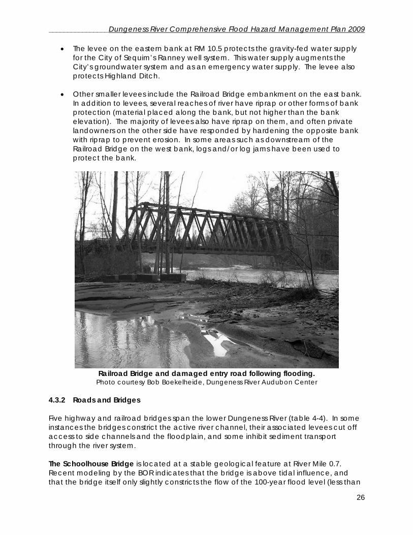
Railroad Bridge and damaged entry road following flooding.
Photo courtesy Bob Boekelheide, Dungeness River Audubon Center 4.3.2 Roads and Bridges Five highway and railroad bridges span the lower Dungeness River (table 4-4). In some instances the bridges constrict the active river channel, their associated levees cut off access to side channels and the floodplain, and some inhibit sediment transport through the river system. The Schoolhouse Bridge is located at a stable geological feature at River Mile 0.7. Recent modeling by the BOR indicates that the bridge is above tidal influence, and that the bridge itself only slightly constricts the flow of the 100-year flood level (less than
________________Dungeness River Comprehensive Flood Hazard Management Plan 2009
27
one foot elevation rise). Historically, a significant portion of the Dungeness flow discharged east of the bridge location to Meadowbrook Creek. The construction of the ACOE levee cut off this flow distributary and the entire flow of the river currently passes under the bridge. Increases in flood stage at the site are due to extensive levees in that section of the river, rather than the bridge. A series of culverts are present to the west of the bridge to alleviate flood flows at the site by directing a portion of the flow to the west at River’s End. Ward Bridge is a wooden structure that presently constricts channel function more than any of the other bridges. Downstream of Woodcock Road, the west bank has been protected with riprap along Ward Road, cutting off portions of the floodplain. The upstream side of the Woodcock Bridge embankment and the east river bank have also been covered with riprap to protect the bridge abutment. The Burlingame Bridge was rebuilt in 1998-99 by Clallam County to increase the opening from 130 to 430 feet. This new opening allows for access to the flood plain and side channels which were previously inaccessible. The eastern end of the new bridge structure was built as a piling structure to enable easterly expansion in the future if necessary due to channel migration. The Railroad Bridge is owned by the Jamestown S’Klallam Tribe as part of Railroad Bridge Park. The bridge was built in 1914-1915 and is an iron and wood truss structure with creosote-treated wood. Railroad traffic ceased in 1985 and the right of way, including the bridge, is now part of the non-motorized Olympic Discovery Trail. The western approach trestle to the bridge crosses several side channels but provides significant flood plain capacity. However, the trestle collects significant quantities of log debris, which may undermine the trestle structure in the future. The eastern approach trestle was breached in a flood in 1961, and was replaced with a 150 foot levee. This levee was modified in 1995 and log structures have been added. “The Highway 101 Bridge does not significantly cut off the prehistoric flood plain because the bridge is at a natural constriction created by terraces. However, just downstream of the bridge a large portion of the east floodplain has been cleared of trees and vegetation. Similar to the area downstream of the Railroad Bridge on the west side, clearing the riparian zone has made this area susceptible to an accelerated rate of erosion.” (Bountry et al, 2002) Table 4-4: Bridges spanning the lower Dungeness River
Bridge River Mile Span (ft) Schoolhouse Bridge 0.7 200 Woodcock Bridge (aka Ward Bridge) 3.3 405 Burlingame Bridge on Old Olympic Highway
4.0 430
Railroad Bridge (including approach trestle)
5.7 1005
Highway 101 Bridge 6.4 590 “At least three more bridges existed in the past across the main Dungeness River as indicated by remnants that are still visible, historical accounts, or photographs. These
________________Dungeness River Comprehensive Flood Hazard Management Plan 2009
28
bridges were located at RM 5.5, about 0.1 mi (.16 km) downstream from the Railroad Bridge (known as the Canfield Bridge); at RM 9.5, about 1 mi (1.6 km) downstream of the Fish Hatchery (known as the Duncan Road Bridge); and at RM 13.3, about 3 mi (4.8 km) upstream of the Fish Hatchery (known as the Clink Bridge).” (Bountry et al, 2002) County roads that have been subject to repeated flooding and flood damage include Sequim-Dungeness Way west of Schoolhouse Bridge, Ward Road downstream of Ward Bridge, Hendrickson Road by the Railroad Bridge, Taylor Cutoff Road downstream and across from the Dungeness Meadows dike, and Fish Hatchery Road. 4.3.3 Clearing of riparian vegetation Loss of riparian vegetation reduces bank slope stability, increases sedimentation to the river, reduces the ability of riparian areas to filter nutrients and other pollutants, removes shade thereby increasing stream temperatures, and reduces the production of macroinvertebrates used as food supplies by salmonids. The loss of riparian vegetation will impair the recruitment of large woody debris for decades, which may inhibit the formation of side channels, pools, and other habitat requirements for aquatic species. The Dungeness River Restoration Work Group identified key areas in the lower river where the loss of riparian vegetation is a factor impairing habitat. Major sites include restoration of the Dungeness estuarine delta, the lower river floodplain at the site of the Game Farm levee, tributary systems such as Matriotti Creek, areas targeted for levee removal and/or setback, and reforestation of riparian parcels along the Dungeness River below Canyon Creek. Table 4-5 contains information on the locations of unvegetated sections of the river. Table 4-5: Dungeness River reaches without riparian vegetation in 2003 (within 50’ of channel meander hazard mapped by Clallam County). Source: Hals, 2004 from aerial photographs taken 4-14-03 and 5-6-03 for Jamestown S'Klallam Tribe
Reference Landmarks Approximate West Bank Unvegetated Reaches
Approximate East Bank Unvegetated Reaches
River Mouth (RM 0.0) RM 0.7 – RM 0.9 Schoolhouse Br. (RM 1.0) RM 1.0 – RM 1.25 RM 0.9 – RM 1.9 RM 2.75 – RM 3.25 RM 2.8 – RM 3.0 Woodcock Rd. (RM 3.25) RM 3.45 – RM 3.54 Old Oly. Hwy. (RM 3.8) RM 3.8 – RM 3.85 Railroad Bridge (RM 5.6) RM 4.95 – RM 5.5 RM 6.22 – RM 6.75 Hwy. 101 (RM 6.4) RM 6.5 – RM 6.8 RM 7.3 – RM 7.5 RM 7.85 – RM 7.9 RM 7.95 – RM 8.2 Powerline Crossing (RM 8.8) RM 8.9 – RM 9.3 RM 9.5 – RM 9.65 Canyon Creek (RM 10.8) RM 10.6 – RM 10.8

________________Dungeness River Comprehensive Flood Hazard Management Plan 2009
29
4.3.4 Other Modifications
• Gravel extraction: Gravel extraction occurred along the lower Dungeness until the mid-1990s; these activities were for commercial gravel-mining purposes, and to compensate for perceived aggradation caused by levees and other channel modifications. Gravel “traps,” consisting of intensive mining sites in the river channel, were excavated in the early 1990s upstream from the Highway 101 bridge specifically to address aggradation issues. Problems associated with gravel extraction include channel avulsion, headcut erosion in the channel, sedimentation, and fish mortality. Significant channel downcutting has occurred in the vicinity of the gravel traps located near the Dungeness Meadows dike. A more detailed discussion of gravel removal in this reach is located in the report on the Dungeness channel migration zone (Rot and Edens, 2008).
• Water diversions: There are five principal water diversions for the Dungeness
irrigation system located between river mile 11.1 and 6.9. Each of the diversions is maintained by the water users and includes a diversion structure, canal/pipe, fish screen, and bypass channel to return fish to the river. The lateral and vertical instability of the Dungeness mainstem channel has prompted the water users to actively modify channel structures in some locations as needed to ensure a water supply during low flows. Several of the outtakes are heavily armored and have been repeatedly damaged during floods. The fish screens must be maintained to ensure that sediment deposition does not alter the approach velocity above fish requirements or that the screens themselves do not become clogged with silt and debris. The CCD outtake is located in a highly unstable section of the river and was rebuilt in 1993. The previous outtake structure is now approximately 3 feet above the active channel due to downcutting. Of the five irrigation diversions, the Independent Irrigation outtake, located at RM 8.5 at the upper end of Dungeness Meadows dike, is situated in the outside of a meander bend and is susceptible to accelerated erosion. Due to the concern that the river channel could avulse into the irrigation ditch, it is being considered for elimination.
The City of Sequim maintains an infiltration water outtake from the Dungeness River at Kinkade Island. However, it is currently used primarily as a back-up system for groundwater sources due to sedimentation and maintenance issues.

________________Dungeness River Comprehensive Flood Hazard Management Plan 2009
30
4.4 Identification of Flood Hazard Areas 4.4.1 Hazard from high flows and channel migration Unlike the Mississippi River or other well known flood-prone areas, flood hazards in the Dungeness are as much a function of vegetation and soil movement as high water. Homes and structures placed in the floodplain or the channel migration zone are in danger of bank erosion and the lateral movement of river channels as well as inundation during high water. This is a river of water, wood, and stone that continually adjusts to the steep gradient of the Dungeness valley. The Dungeness River drops 3800 ft over 30 miles; the roughly 1% gradient from the Dungeness hatchery to Old Olympic Highway is the driving force behind its erosive energy during floods. Due to channel migration and erosion in the Dungeness River, even houses above the level of the 100-year flood elevation may be at risk. Composed of mostly gravel and cobble, the banks of the Dungeness River erode naturally--contributing trees which form logjams and gravel which creates gravel bars. Over time, the channels of the river migrate laterally across the floodplain. Floodplain areas provide room for the river meanders to move and a place for high flows to spread out. Mature riverside forests function to help provide structure for the river. Intertwined root systems and large trees line the banks, and the movement of wood and gravel in the stream forms and destroys salmon habitat in a repetitive and naturally dynamic cycle. In the lower Dungeness, many areas of riverside forest have been altered by logging over several decades; forested areas along the river are smaller and the trees are immature. A few decades ago, many people believed that flood damage could be reduced by increasing river channel conveyance—removing log jams and digging out gravel so that the high flows could move unimpeded. However, these actions accelerate the erosive forces of the river and destabilize the river channel. The energy and erosive forces of high flows are actually slowed down by meanders, eroding banks, the gravel load that the river transports, and logjams. Where riverside forests have been altered and the banks have been armored or diked, the river tends to move much more rapidly and dramatically in floods. The levees and armored banks also create poor salmon habitat conditions and increase flood hazard to downstream landowners.
Photo: Channel migration on the Dungeness River 1997
(Photo courtesy Randy Johnson)

________________Dungeness River Comprehensive Flood Hazard Management Plan 2009
31
Channel migration is the natural movement of a river across its floodplain. In the Dungeness, the channel can move by eroding the outside of a meander, or also through channel avulsion. The channel migration zone is the outermost boundary that the river has historically used or will potentially use through bank erosion or avulsion into new channels. Although the CMZ is usually contained within the boundaries of the 100-year floodplain, in some cases the CMZ may extend outside of it. For example, the river may erode against a high bank or hill, and roads and structures (while above the area inundated by a 100-year level flood) are at risk from erosion and eventual flood damage. Where vegetation along the river has been removed, the erosion risk is generally greater. The location of a building within the Channel Migration Zone is more descriptive of the potential risk than whether the structure is above the 100-year flood plain elevation. The CMZ encompasses the historical channels in the floodplain as well as the river’s erosive potential. Figure 4-3: Illustrated risk of development in the Channel Migration Zone
Figure 4-3a: The Dungeness River has an active river channel that moves over time. Houses that are built within or near the channel migration zone are at risk from flood damage, even if the flowing portion of the river is a substantial distance away. This risk is present even if the structures are above or outside of the 100-year flood plain.
Figure 4-3b: Rivers naturally erode the outside banks of a meander. The homeowners may have assumed that their risk of flooding was low, but bank erosion and flow have damaged the houses. How fast this process occurs depends on several factors, such as whether bank vegetation was left in place to keep the bank less erodible, the type of soil, and the force and velocity of the flow.
________________Dungeness River Comprehensive Flood Hazard Management Plan 2009
32
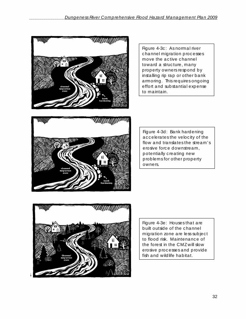
Figure 4-3c: As normal river channel migration processes move the active channel toward a structure, many property owners respond by installing rip rap or other bank armoring. This requires ongoing effort and substantial expense to maintain.
Figure 4-3d: Bank hardening accelerates the velocity of the flow and translates the stream’s erosive force downstream, potentially creating new problems for other property owners.
Figure 4-3e: Houses that are built outside of the channel migration zone are less subject to flood risk. Maintenance of the forest in the CMZ will slow erosive processes and provide fish and wildlife habitat.

________________Dungeness River Comprehensive Flood Hazard Management Plan 2009
33
Channel aggradation and degradation: The river not only moves laterally, but the bed also naturally moves up and down. When the riverbed increases in height (relative to a previous height), it is called aggradation, when it decreases in height it is called bed degradation. Numerous studies have found that sediment moves through a watershed like waves. Pulses of gravel accumulate and decrease in response to the volume of gravel input as well as flood frequency, magnitude, and height. Riverside landowners tend to respond when the river aggrades in their section of river, removing gravel or constructing bank protection structures and levees. However, these actions are a response to a temporary condition of gravel movement and the long term result may be the opposite of what the landowner has intended when the river begins to downcut once again. In the Dungeness River since the 1950s and 1960s photo records, the channel bed has actually degraded at least several feet in most places between Burlingame Bridge and Dungeness Hatchery. Extensive gravel removal during the 1990s exacerbated channel downcutting within a decade--negatively impacting some levees and irrigation outtake facilities. Avulsion: An additional hazard to structures in the floodplain and channel migration zone occurs during an avulsion. An avulsion occurs when the river moves to a new channel, either by creating a new channel or reoccupying an old side channel or low area. Generally the river re-enters its channel shortly downstream creating an island in between the banks of the two channels. In the Dungeness, the area known as Kinkade Island is formed by the river mainstem to the west, and a side channel known as Kinkade Creek to the east. Studies by the Bureau of Reclamation indicate a substantial risk that the main channel of the river will avulse into Kinkade Creek. Several structures on Kinkade Island are currently at risk of flood hazard, and a potential avulsion would be likely to damage or eliminate the bridge that currently provides access.

________________Dungeness River Comprehensive Flood Hazard Management Plan 2009
34
Figure 4-4: Kinkade Island
4.4.2 Location of Channel Migration Zone and 100-Year Flood Plain A 2008 study by Rot and Edens from the Jamestown S’Klallam Tribe utilized recent data in order to update the delineation of the Channel Migration Zone. In addition to Bureau of Reclamation studies in the past decade, data sources included historical and recent airphotos dating to 1942, an 1855 map of the river mouth area, the 1914 Clallam County Tax Assessors map (ortho-rectified by University of Washington), and LiDar data obtained by Clallam County in 2001. The study analyzes avulsion hazards and pathways, erosion hazard areas, locations where the historical flood plain has been disconnected from the river due to structural modification of the river channel, and the channel migration zone boundary. The entire report is located in Appendix C. Figure 4-5 consists of a set of airphotos depicting the revised channel migration zone delineated by Rot and Edens and the 100-year flood plain, using the Clallam County GIS layer based on FEMA maps. This analysis applies to the lower 11 miles of the Dungeness River. The land use above that point is commercial forest or conservancy status. Structures within the floodplain and/or the channel migration zone are considered to be at risk of flood hazard. Letters denote identified flood hazards listed in Section 5.2.

________________Dungeness River Comprehensive Flood Hazard Management Plan 2009
35
Figure 4-5: River reaches with CMZ, 100-yr flood plain, and identified hazards (4 reaches)
Reach 1: River Mile 0.0 to 3.3--River Mouth to Woodcock Road

________________Dungeness River Comprehensive Flood Hazard Management Plan 2009
36
Reach 2: River Mile 3.3 to 6.5--Woodcock Road to Highway 101

________________Dungeness River Comprehensive Flood Hazard Management Plan 2009
37
Reach 3: River Mile 6.5 to 8.6--Highway 101 to BPA power lines

________________Dungeness River Comprehensive Flood Hazard Management Plan 2009
38
Reach 4: River Mile 8.6 to 10.8--BPA Lines to Canyon Creek

________________Dungeness River Comprehensive Flood Hazard Management Plan 2009
39
4.4.3 Coastal flood hazards near the mouth of the Dungeness River Areas along the Strait of Juan de Fuca in the vicinity of the mouth of the Dungeness River are also susceptible to flooding due to a combination of storm events, tides, wave action, shoreline processes, and tsunamis. Because Pacific storms can result in large rainfalls, coastal and riverine flooding can combine to increase flood hazards near river mouths. The interrelationships of these processes are complex and site specific, and mapping the risk of flooding is challenging. A map of tsunami hazard areas in the Sequim-Dungeness area is located in Section 7.4. Meadowbrook Creek is located to the east of the Dungeness River mouth and historically provided a channel path for Dungeness flows to be conveyed through the east floodplain and out to the Strait of Juan de Fuca. The Creek was segregated from the Dungeness River by the US Army Corps of Engineers levee. The area in the vicinity of Meadowbrook Creek and Three Crabs Road is susceptible to flooding from coastal flood events as well as the potential for flows overtopping or breaching the levee during a 100-year flood event.
Above: Three Crabs Road/ Meadowbrook Creek area east of the mouth of the Dungeness River. Below: Flooding along Three Crabs Road (Photos courtesy Clallam Conservation District)
Three Crabs Road
Sequim-Dungeness Way
________________Dungeness River Comprehensive Flood Hazard Management Plan 2009
40
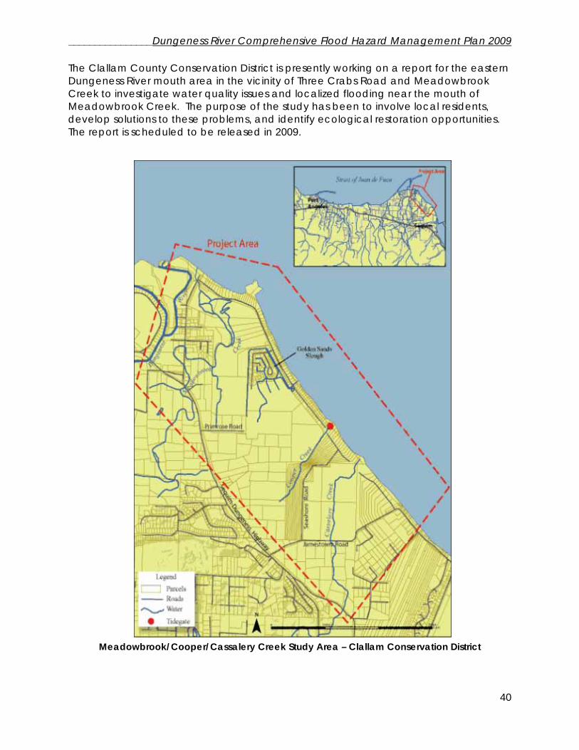
The Clallam County Conservation District is presently working on a report for the eastern Dungeness River mouth area in the vicinity of Three Crabs Road and Meadowbrook Creek to investigate water quality issues and localized flooding near the mouth of Meadowbrook Creek. The purpose of the study has been to involve local residents, develop solutions to these problems, and identify ecological restoration opportunities. The report is scheduled to be released in 2009.
Meadowbrook/Cooper/Cassalery Creek Study Area – Clallam Conservation District

________________Dungeness River Comprehensive Flood Hazard Management Plan 2009
41
Other studies have been completed in the Dungeness River delta in support of habitat restoration efforts and flood hazard analysis. A study of the “Historical geomorphology and ecology of the Dungeness River delta and nearshore environments from the Spit to Washington Harbor” was completed by the University of Washington (Collins, 2005). The study used historical maps, air photos, field notes, and LiDAR to construct a detailed description of the physical landscape in the 1850’s, changes in the last 150 years, and nearshore processes affecting the present environment in the river delta. The Dungeness River and Meadowbrook Creek had a complex system of saltmarsh, lagoons, channels, sandspits, and wetlands in the area of present-day Three Crabs Road. This information may be used to assist in predictions of how the landscape may respond to land use and engineering changes. The Bureau of Reclamation completed a “Numerical Modeling Study of Levee Setback Alternatives for Lower Dungeness River, Washington” in 2007 to evaluate potential levee setback alternatives in the lower 2.7 miles of the river channel. Simulations of the 100-Year flood level (at a flow of 9,080 cfs) indicate the potential for the ACOE levee to be overtopped or breached, and that the water is predicted to flow along the historic location of Meadowbrook Creek, potentially affecting downstream residents. A levee breach of 150 feet is estimated to create flood flows of 3,400 cfs in the right flood plain and Sequim-Dungeness way would be overtopped. Modeling of different tidal elevations indicated small differences in surface water elevation upstream of the Schoolhouse Bridge at the 100-year flood level. Clallam County is proceeding with actions to set back the ACOE levee between the Schoolhouse Bridge and River Mile 2.7 to address the potential for flood hazard from the levee overtopping or breaching, and to improve habitat function in the lower river floodplain.
Sequim-Dungeness Way (Clallam Conservation District Photo)