Embed Size (px)
Citation preview

9 Environmental and Social Impact Assessment

Contents
9 Environmental And Social Impact Assessment .................................................... 9-1
9.1 Project Description ................................................................................................ 9-1
9.2 Policy And Legislative Framework ..................................................................... 9-10
9.3 Existing Environmental And Social Conditions .................................................. 9-19
9.4 Environmental Impact Assessment ..................................................................... 9-30
9.5 Social Impact Assessment ................................................................................... 9-67
9.6 Public Participation & Grievance Procedure ....................................................... 9-71
9.7 Implementation Arrangement .............................................................................. 9-73

ABBREVIATION & ACRONYMS
AIDS Acquired Immunodeficiency Syndrome
AH Affected Households
AP Affected People
BOT Build – Operate - Transfer
COD Cut Off Date
DRC District Resettlement Committee
EIA Environmental Impact Assessment
ESIA Environmental and Social Impact Assessment
EMMP Environmental Monitoring and Management Plan
F Female
FDI Foreign Direct Investment
FM Families
FS Feasibility Study
GOL Government of Lao People’s Democratic Republic
GIS Geographic Information Systems
GRC Grievance Redress Committee
ha Hectare
HH Households
HIV Human Immunodeficiency Virus
HPP Hydro-electric Power Project
kg Kilograms
km Kilometers
km2 Square kilometers
kpm Kip per person per month
LB Left Bank (of the Mekong River)
Lao PDR Lao People’s Democratic Republic
LMB Lower Mekong River Basin
LRAD Livelihood Restoration and Development
MPLHPP Mekong Pak Lay Hydroelectric Power Project
MOU Memorandum of Understanding
MONRE Ministry of Natural Resources and Environment
MRC Mekong River Commission
masl meters above sea level
Mil. Million
m3/s Cubic meters per second
MUSD Million United State Dollars
MW Megawatt (1 million watts of power)

NBCA National Biodiversity Conservation Area
NCG National Consulting Group
NGO Non-Governmental Organization
PRC Provincial Resettlement Committee
NTFP Non-Timber Forest Products
RAP Resettlement Action Plan
RB Right Bank
RCU Resettlement Coordination Unit
RoR Run-of-River
SAF Severely Affected Families
SCJV Sinohydro CEIEC Joint Venture
SIA Social Impact Assessment
SMMP Social Monitoring and Management Plan
SRMU Social and Resettlement Management Unit
STI Sexually Transmitted Infection
US $ United States Dollars
VRDC Village Resettlement and Development Committees
WHO World Health Organization
WREA Water Resources and Environment Administration
WWF Worldwide Fund for Nature
NCG National Consulting Group
9-1
9 Environmental and Social Impact Assessment
9.1 PROJECT DESCRIPTION
9.1.1 PROJECT LOCATION
Located on the middle Mekong River in Laos, Pak Lay Hydropower Station is the fourth
hydropower station (from upstream to downstream) of the 11 Hydropower Stations planned for
the main stream of Mekong River. Xaiyaburi Hydropower Station is located upstream of it while
Sanakham Hydropower Station is located downstream. The dam site of Pak Lay Hydropower
Station is located at 1829km (to the estuary) on the main stream of Mekong River, about 31km
upstream from Pak Lay County and about 241km from Vientiane, the capital city of Laos. The
control drainage area at the dam site is about 278,400 km2 for the geographical location of Pak
Lay Hydropower Station.
In accordance with the Study on Development of Run-of-River Hydroelectric Projects on
Mekong River Main Stream released by Mekong River Commission Secretariat in 1994, 11
hydropower stations are planned on the main stream of Mekong River, including five
hydropower stations in Laos, namely, Pak Beng, LuangPrabang, Sayaburi, Pak Lay and
Sanakham.

9-2
Figure9.1-1 MPLHPP dam sites options 1 and 2 and the Project Location within Lao PDR

9-3
9.1.2 PROJECT CONCEPT
The dam would be a Run-of- River type dam. This means that the very large reservoir of
water usually associated with hydropower dams will not be present. There will instead be a
backwater area on the upstream side of the dam which will normally be at the depth of 240
meters above sea level (masl).The dam would be constructed and operated on a Build-Operate-
Transfer (BOT) basis by JV. Most of the electricity generated by the dam will be sold to
Thailand. The project would be transferred to the GOL at the end of 25-30 year concession (to
be determined).
9.1.3 PROJECT COMPONENTS AND FEATURES
9.1.3.1 OVERVIEW
The MPLHPP has the following characteristics:
The normal pool level is 240.00 m, and the minimum pool level is 239.00 m.
This project has low waterhead and high flood discharge.
Fish pass to be installed according to MRC’s regulations.
The ship lock is of single-stage and the effective dimensions of the gate chamber are
120.00m×12.00m×4.00m.
Run of River dam design.
9.1.3.2 SUMMARY OF DAM COMPONENTS
Normal concrete gravity dam.
Power House on right side.
Generator set is a bulb generator set and uses a water retaining powerhouse.
Installed capacity is 770MW.
Independent capacity is 55MW.
Number of Generators is 14.

9-4
Overflow dam will be on the middle left.
Ship lock on left bank.
9.1.3.3 ACCESS ROADS AND BRIDGES
The access road to Pak Lay HPP will be in Pak Lay District, starting at Souvannaphoum
Village, connecting to National Highway No. 4 at a point 17km away from Pak Lay town, and
terminating at the right bridgehead of the proposed Mekong River Bridge downstream of the Pak
Lay dam. The road will be of surface type and have a total length of 12.313km. There will be 4
bridges along the line with an overall length of 240m, including 120m-long Namphoun River
Bridge, and 3 medium and small bridges totaling 120m long.
The existing road from Souvanaphoum village to Namphoun estuary is about 7.8m long and
needs to be upgraded, and currently access from Namphoun estuary to the right bridgehead of the
proposed Mekong River Bridge downstream of the dam site (4.5km) is not available and needs to
be built. The upgraded and newly built roads will be of Grade 3 highway with concrete pavement,
featuring subgrade width of 8.5m and pavement width of 7.0m. The access road to the project
will cross the Namphoun River and it’s necessary to build a 120m-long bridge.

9-5
9.1.3.4 CONSTRUCTION CAMPS
a) Power Plant living area:
Office and living areas in Paklay power plant are office and living camps of the Owner,
design agency and the supervisor in the construction period and become permanent office and
living areas in later period. The Paklay HPP is staffed with 242. Office buildings, staff
dormitories, mess halls, entertainment centers, multifunctional halls, garages, mechanical and
electrical equipment warehouses, test rooms, accessory occupancies and so on are provided
based on the standard of 62.8m2per capita.
Office and living areas in Paklay power plant are located at 1.2 km downstream of
recommended dam site, on hillside at right side of No.1 highway. The land consists of 3 hillsides
and 2 trenches. Elevation of the land is about 231 m~245 m. It is about 380 m long from east to
west. The max width is about 200 m. Total area of the land is about 48,717 m2. It is sloping field,
high in south and low in north with a drop of about 20 m. Vegetation with the land scope is
relatively favorable.
Office and living areas in Paklay power plant is preliminarily planned to be arranged on
Don Lung. Elevation of the land is about 240 m~260 m. It is about 380 m long from east to west.
The max width is about 150 m. Total area of the land is about 48,700 m2. The overall floorageis
7,330m2.
b) Construction area of right bank:
Construction living and administration camp: arranged at both sides at right bridge head of
Mekong River Bridge, with elevation of 240.00m, occupying about 22,000m2 including floor
area about 8,000m2, with accommodation capacity of 800 persons for living and administration.
c) Quarry and sandstone yard and processing system construction area
Located at adjacent river at left bank of Mekong River about 13km (water and land distance)

9-6
of upstream of dam site. It is about 2km from riverside to material yard and it is accessible by a
tractor load. Sandstone processing system is located on wasteland at lower
9.1.4 QUARRY AND BORROW PITS
a) Quarry
The Quarry is located at the left bank of the Mekong River near the Upper Dam Site. The
quarry can be accessed by a county road. The elevation of the quarry is 300.0 m-650.0 m and the
quarry covers an area of 150,000 m2. The quarry is on the southwest side of a limestone
mountain. The mountain is steep with many cliffs and several karst caves.
b) Borrow Pits
The borrow area is located at terrace I on the right bank of lower dam line at upper dam site,
distributed in strip form along the river and classified as Class I area. The borrow area has a flat
terrain. Currently, the borrow area planned is paddy field and dry land, with a few shrubberies.
The borrow area is 40 m ~ 90 m wide and about 2,000 m long, covering the elevations of 230.00
m a.s.l. ~ 237.00 m a.s.l. and the area of about 152,000 m2. The plane geological mapping and
boreholes reveal that the soil materials are dominated by deposits on terrace, rooted soil is
located within the range of 0.2 m ~ 0.3 m on the surface, with yellow and gray yellow silty clay
below; the content of silt is increasing toward the riverside. Below the depth of 4 m of soil layer
on the borrow area, the water content is obviously high, in the plastic ~ soft plastic form.
The average thickness of soil layers at the borrow area is greater than 10.0 m. Considering
the water content, the thickness of useful layers is calculated as 3.5 m. Calculating with the
average thickness method, the thickness of layers to be removed is about 0.3 m. The total reserve
is about 533,000 m3.
9.1.5 FISH PASSAGE
a) Fish resources and fish pass requirements

9-7
Mekong River basin is the second largest biodiversity basin following the Amazon Basin.
According to Preliminary Design Guidance for Proposed Mainstream Dams in the Lower
Mekong Basin proposed by MRC (Mekong River Commission) in Aug. 2009 and relevant data,
40% ~ 70% fishes in Mekong River multiply depending on long distance migration. Migratory
fishes to the upstream are mainly adult fishes of cyprinidae and grouper with body length of 20
cm ~ 100 cm; target fishes to the downstream include fish roe, young fish with body length of
only a few millimeters and adult fish.
b) Fish way operating water level
Normal pool level of the hydropower station, i.e. 240.00m is taken as the highest upstream
operating water level, and minimum pool level of the hydropower station, i.e. 239.00m is taken
as the lowest; tail water level at full capacity of the hydropower station, i.e. 224.24m is taken as
the highest downstream operating water level, and downstream cascade minimum pool level, i.e.
219.00m is taken as the lowest. The maximum operating water level difference of the fish pass
structure is 21.00m.
c) Type and layout of fish way
The fish pass structure is bilateral vertical slot fishway arranged along the left bank slope of
the powerhouse with a total length of 1017m. The fish can swim upstream and downstream via
the fishway. Under normal operation, the fishway water discharge is about 8.5m3/s including
quotative discharge of the fishway of 3.885m3/s and quotative discharge of the make-up system
of 4.785m3/s. The fishway has a net width of 6m, depth of 3m and vertical slot width of 0.7m. A
single pond is 5m long and level difference between adjacent ponds is 0.14m. A horizontal
section of 10m-long rest pond is provided every 10 ponds. The upstream inlet of the fishway is
arranged about 100m in front of the left-bank dam. Since the surface flow rate is low, obvious
flow variations are created by the fishwayquotative discharge exerting the fish luring effects. The
downstream inlet is arranged on the bank about 280m below the tail water of the hydropower

9-8
station. At the downstream outlet of the make-up system, a 15m-wide artificial waterfall is
arranged to create the fish luring effects through the waterfall sounds and water flow .Between
piles F. 0+613.834 ~ F. 0+670.567 in the middle section of the fishway is a large nature-
imitating ecological rest pond where the fish can prey and feed themselves.
9.1.6 INUNDATION AND RESETTLEMENT
See the Social Impact Assessment chapter of this document for complete details. The
Normal Water Level of the dam is 240 masl and 240 + 1 or 241 masl was the value used to
determine whether or not a village needed to be resettled.
a) Resettlement
The census based on project demarcation surveys indicated the following:
The project would require the resettlement of 7 villages, 789 families and 3,545 people
b) Compensation
Villages which do not require resettlement still need to be given compensation for loss of
their land or other assets as follows:
The project would require compensation for one village ( 27 families and 128 people).

9-9
9.1.7 PROJECT CONSTRUCTION (APPLIES TO BOTH DAM SITE OPTIONS)
a) Transport Conditions:
During construction National highways No. 11 from capital Vientiane to Pak Lay and No. 4
Highway connecting LuangPrabang city and Loei of Thailand will be used. Mekong River
transport will also be used.
b) Water & Electricity Supply
Power supply for construction: calculated according to peak intense of construction, peak
electrical load of this project is 21.59MW. During construction period, power supply may be
provided by house diesel generator unit and 10KV transmission line to dam site from Pak Lay
Town. Water supply for construction: water from Mekong River is used as domestic and
production water in places along the river. The water will not erode the cement and not harm
human beings. Production and domestic water for the project may use the water from Mekong
River after pumped and purified by self-built pump station.

9-10
9.2 POLICY AND LEGISLATIVE FRAMEWORK
9.2.1 ENVIRONMENTAL LEGISLATION
Since the establishment of Lao PDR in 1975 and adopted a new constitution in August
1991, a number of laws and regulations were on boarded. The main ones related to ESIA are as
follows:
a) The Lao Environmental Protection Law (1999)
The Lao Environmental Protection Law (EPL) disseminated in 1999, established a
framework for environmental management of environmental resources with the objective of
preserving and facilitating the sustainable use of natural resources. The Ministry of Natural
Resource and Environment (MONRE) is responsible for the implementation of EPL. Other
ministries issue guidelines for implementing provisions but ultimately MONRE issues the
environmental compliance certificate.
The basic precept of the EPL is that all persons or organizations residing in Lao have an
obligation to protect the environment. People or parties who cause damage to the environment
are responsible for the impact under the EPL.
b) The Instruction Environmental and Social Impact Assessment No. 8030/MONRE
(2013)
Based on the provision in the Environmental Protection Law that development projects and
activities that have the potential Instruction for Lao PDR (2013) No.8030/MONRE. This
regulation specifies the overall principles for the EIA effort and prescribes the thematic issues to
be covered and the outputs expected at the different stages of the ESIA process.
c) The Lao Amended Forestry Law (No. 06/NA-Dec.2007)
The Amended Forestry Law, No 06/NA (Dec. 2007): determines basic principles,
regulations and measures on sustainable management, preservation, development, utilization and
inspection of forest resources and forestland. At the same time it promotes regeneration of forest
and tree planting, and increase of forest resources in the Lao PDR with aiming to maintain the

9-11
balance of nature, making forest and forestland a stable source of living and use of people,
ensuring sustainable preservation of water sources, prevention of soil erosion and maintenance
of soil quality, conserving plant and tree species, wildlife species as well as environment and
contributing to the national socio-economic development.
d) The Lao Wildlife and Aquatics Law (No. 07/NA-Dec.2007)
Wildlife and Aquatics Law, No 07/NA (Dec. 2007) determines principles, regulations
and measures on wildlife and aquatic in the natural to promote the husbandry, breeding to
regenerate and utilization of wildlife and aquatic in sustainable manner, with out any harmful
impact to the natural resources, habitats, restricts on decreasing and extinction of the wildlife and
aquatics, encouraging people at the whole to understand and recognize the significance, and
enhancing their conscientious in loving, care and be kind to the animals. To engage in managing,
monitoring, conserving, protecting, developing and utilizing wildlife and aquatics in sustainable
manner. To guarantee plenteousness and richness of ecological natural equilibrium system, to
contribute in upgrading livelihoods condition of the multi ethnic people, this is the potential in
the development of the national socio-economy.
e) The Lao Water Law (1996)
The Water Law (1996) is intended to assure the sustainable use of water. The Water
Resources Committee under the Prime Minister’s Office administers the Water Law and is
responsible for the review and evaluation of EIAs related to use of Water resources.
f) The Lao Amended Land Law (No. 04/NA-Oct.2003)
The GoL grants rights to individuals, families or organizations pursuant to the Land Law
(2003). These grants are either temporary “right to use” grants for up to five years or as thirty
year “leases”. The National Land Management Authority (NLMA), in conjunction with the
Prime minister’s office (PMO), has the responsibility for land titling, registration and leasing of
land. The MAF manages the use of the land. Decree 37/PM specifies that the MAF provincial
office shall determine which parts of the resettlement area shall be used for what purpose.
Subsequently, the land will be surveyed by the Department of Land Development and Planning

9-12
(NLMA) which can grant a thirty years lease on land for housing and agricultural development.
9.2.2 GUIDELINES ENVIRONMENTAL & SOCIAL IMPACT ASSESSMENT
This guideline can be used in all investment projects identified in the guideline of the ESIA
process No. 8030/MONRE and approved agreement that declared a list of investment project
whether the project must conduct the IEE or ESIA.
Category 1: Investment projects which are small or create less impacts on environment and
society, but require initial environmental examination;
Category 2: Large - sized investment projects which are complicated or create substantial
impacts on environment and society but require environmental impact assessment.
9.2.3 HYDROPOWER ENVIRONMENTAL & SOCIAL SUSTAINABILITY
The 2005 National Policy on Environment and Social Sustainability of the Hydropower
Sector in Lao PDR – An important GOL’s environmental policy improvement was found on the
new national policy on Environment and Social Sustainability of the Hydropower Sector in Lao
PDR which was recently adopted in June 2005. It applies to all large hydropower dams (installed
capacity more than 50 MW or inundated area more than 10,000 hectares) that constructed after
1990.
9.2.4 COMPENSATION & RESETTLEMENT
Key Issues of the “Prime Minister Decree No. 84/GOL on the Compensation and
Resettlement of the Development Project (2016)” include:
Project owners shall compensate project affected people (AP) for their lost rights to use
land and for their lost assets (structures, crops, trees, and other fixed assets), affected in
full or part, at replacement cost.
Where significantly large or entire land holding affected by a project namely
agriculture, residential or commercial land, compensation shall be through provision of
“land for land” arrangements of equivalent size and productivity and be acceptable to
APs and project owners.
If the house or structure is unviable for continued use or the remaining area is less than

9-13
the minimum house size, the AP shall be entitled to be compensated for the entire
structure at replacement cost without depreciation or deduction for salvage materials.
In case the remaining structure is viable for continue use, project owners shall provide
compensation for the lost portion and assistance in cash or material for restoration of
the remaining structure.
AP whose land or assets are temporary taken by the works under the project shall be
fully compensated for their net loss of income, damage assets, crops, trees, as the case
may be. The project owners shall also ensure that the land or assets are returned in its
pre-project state.
Tenants, who have leased a house /structures for any purpose and are affected by the
project, shall be compensated for their loss assets in the amount equivalent to three
months rental allowance, and shall be assisted in finding alternative rental
accommodation.
AP who are living in rural or remote areas, who do not have any legal Land Use
Certificate or any other acceptable proof indicating land use right to the affected land
and assets they occupy shall be compensated for their loss assets at replacement cost
and provided additional assistance to ensure they are not worse off due to the project.
All AP, regardless of land use right, will be entitled to compensation for lost assets
(structures, crops, trees) at replacement cost, and provided with other assistance during
transition period, and economic rehabilitation assistance to ensure that they are not
worse off due to the project.
All previous claims and unresolved issues related to tenure status and ownership of
land and other assets affected by the sub-project or components shall be resolved prior
to initiating any new land acquisition measures on the representatives from all
stakeholders, to assess the loss to the AP.
Prior to the commencement of project construction, AP shall be fully compensated and
resettled and rehabilitation measures shall be in place, although not necessarily

9-14
completed yet.
9.2.5 ETHNIC GROUPS
The 1991 Constitution defined Lao PDR as a Multi-Ethnic State with "Equality among all
ethnic groups” as described under Article 8 of the Constitution below:
The State pursues the policy of promoting Unity and Equality among all ethnic groups.
All ethnic groups have the rights to protect, preserve and promote the fine customs and cultures
of their own tribes and the nation. All Acts of creating Division and Discrimination among
ethnic groups are forbidden. The State implements every measure to gradually develop and
upgrade the economic and social level of all ethnic groups".
9.2.6 CULTURAL & ARCHAEOLOGY
Relevant policy, legal and regulatory framework for archaeology and cultural heritage
included Cultural and Natural Heritage in Lao People’s Democratic Republic (Lao PDR) is
controlled by the following laws and regulations:
The national Heritage Laws of Lao PDR on the preservation of culture, historical and
natural heritage. Complete set of regulations concerning the management of culture,
historical and natural heritage was agreed from National Assembly Number 08/NA on
dated 09 November 2005.
The Decree of the President of the Lao People’s Democratic Republic on the
preservation of culture, historical and natural heritage. Complete set of regulations
concerning the management of cultural, historical and natural heritage.
Constitution. Article 19: The management of national heritage is a State study.
Penal Code. Article 103: Sanction to law offenders in particular in the cases of
damage and destruction of cultural sites, export and trade of antiquities.
Law on the protection of environment. Article 16: Developers must abide by laws and
regulations concerning the material culture sites that might be affected by their
development projects.

9-15
The Ministry of Information, Culture and Tourism , on behalf of the council of
Ministers implements the National policy on culture and cultural heritage. It is
represented at provincial and district level by the Office of Information and Culture of
province and district, respectively. Laws and regulations on cultural heritage are
enforced under the guidance and control of Ministry of Information and Culture.
Lawsuits are filed by Ministry of Information and Culture and transmitted to courts for
trials and sanctions against offenders.
9.2.7 TOURISM
Key issues of the 2005 Law on Tourism related to Pak Lay tourism aspect are as follows:
Article 1: Purposes - The Law on tourism sets the principles, procedures and measures on
the establishment, activity and administration of tourism aiming to promote and develop the
cultural, historical and eco-tourisms in extending, sustainable ways, transforming to modern
tourism industry and contributing the national protection and development, to promotion of
mutual understanding, peace, friendship and to cooperate in international development.
9.2.8 OTHER LAO LAWS/POLICIES RELEVANT TO ESIA
a) Land Law (1997)
Land within Lao PDR is the property of the national community, and individuals are
assigned to effectively use the land, but not treat it as a tradable commodity. The law sets out the
rights of those who have been allocated land, including the right to transfer that land.
b) Road Law (1999)
Environmental protection is required during road activities. National and provincial
authorities of the Ministry of Communications, Transport, Post and Construction are responsible
for environmental protection on road projects. Reasonable compensation must be paid to
individuals whose land is expropriated for road rights-of-way, relocation of replacement
structures, and loss of trees and crops.
c) Prime Minister Decision No. 81/MP (2008) on Endorsement of the Prohibited and
Controlled Species List of Wildlife and Aquatic Animals

9-16
With reference to the Article 22 of the Wildlife and Aquatics Law of the Lao PDR, the
Prime Minister’ Decision has endorsed the prohibited species namely List-1 which include 44
species of mammals, 9 species of reptiles, 36 species of birds, 6 species of aquatics and 1 species
of amphibian. While the Decision has also set the controlled species namely List-2 which
include 15 species of mammals, 13 species of reptiles, 22 species of birds, 9 species of aquatics
and 7 species of insects.
d) MAF Decision No. 0070/MAF (2008) on endorsement of General or Common Species
List of Wildlife and Aquatics
With reference to the Article 22 of the Wildlife and Aquatics Law of the Lao PDR, the
Ministry of Agriculture and Forestry (MAF) has also issued the decision No. 0070/MAF to
endorse the general or common species list of wildlife and aquatics namely List-3 which include
6 species of mammals, 8 species of reptiles, 5 species of birds, 18 species of aquatics, 3 species
of amphibians and 5 species of insects.
e) MAF Regulation No. 0360/MAF on Management of National Biodiversity
Conservation Areas (NBCAs)
MAF’ Regulation Nº 0360/MAF on Management of National Biodiversity Conservation
Areas, Aquatic Animals and Wildlife provides guidelines on NBCA establishment and zoning
and also on restricted activities and development fund establishment and the rights and duties of
state agencies in NBCA management.
f) Regulation on Environment Assessment No. 1770/WREA/2000
Key features of the Regulation are included:
Each Development Project Responsible Agency (DPRA) must ensure that any
development project in the Lao PDR carries out Environmental Assessment (EA) in accordance
with the content determined in this Regulation, and any regulation of its own line ministry.
The Environment Assessment must include at least a Project Description to enable DPRA
to perform a project environment screening under Article 7 of this Regulation. If the project is
not exempt under Article 8 of this Regulation, the EA must include an Initial Environment

9-17
Examination (IEE) as specified in Article 9 of this Regulation. For some projects, through the
findings of the IEE, an Environmental Impact Assessment (EIA) is required as specified in
Articles 11, 12, 13, and 14 of this Regulation.
9.2.9 SAFEGUARD POLICY OF INTERNATIONAL LENDING AGENCY
The international lending agencies, in particular, the World Bankrequires that the dam be
designed and its construction supervised by experienced and competent professionals.
It also requires that the borrower adopt and implement certain dam safety measures for the
design, bid tendering, construction, operation, and maintenance of the dam and associated works.
A number of operational directives have been on boarded as basis for the borrowers to
follow. Tabulated below summarizes the Bank’s operational policies (OP).
9.2.10 REGIONAL AGREEMENT
The regional agreement is found on "The Agreement on the Cooperation for the Sustainable
Development of the Mekong River Basin (1995)" This agreement was signed on 5 April 2005 by
four Mekong riparian countries, namely, the Kingdom of Cambodia, the Lao People's
Democratic Republic, the Kingdom of Thailand and the Socialist Republic of Viet Nam.
The agreement has set a new mandate for organization to cooperate in all fields of
sustainable development, utilization, management and conservation of the water and related
resources of the Mekong River Basin. Signatories to this treaty agree that transfer of the Mekong
River and tributary water outside the Mekong River Basin can occur only by consensus among
the four country members. The member countries therefore agree to coordinate in water project
planning and monitoring of the basin waters.
Also important is to start a process of reasonable and equitable use of the Mekong River
System in each country to develop procedures for water utilization. The Mekong River
Commission (MRC) is supporting a joint basin-wide planning process with the four countries
called The Basin Development Plan, which is the basis of its Integrated Water Resources
Development Program. The MRC has included the following topics: fishery management, the
promotion of safe navigation, irrigated agriculture, watershed management, environmental

9-18
monitoring, flood management and exploring hydropower alternatives.
9-19
9.3 EXISTING ENVIRONMENTAL AND SOCIAL CONDITIONS
9.3.1 Existing Environmental Conditions
9.3.1.1 Surface Water Quality
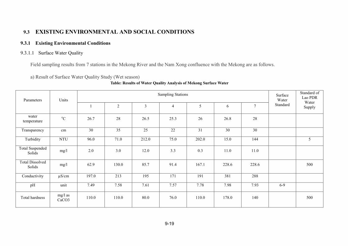
Field sampling results from 7 stations in the Mekong River and the Nam Xong confluence with the Mekong are as follows.
a) Result of Surface Water Quality Study (Wet season) Table: Results of Water Quality Analysis of Mekong Surface Water
Parameters Units
Sampling Stations Surface Water
Standard
Standard of Lao PDR
Water Supply 1 2 3 4 5 6 7
water temperature
oC 26.7 28 26.5 25.3 26 26.8 28
Transparency cm 30 35 25 22 31 30 30
Turbidity NTU 96.0 71.0 212.0 75.0 202.0 15.0 144 5
Total Suspended Solids
mg/l 2.0 3.0 12.0 3.3 0.3 11.0 11.0
Total Dissolved Solids
mg/l 62.9 130.0 85.7 91.4 167.1 228.6 228.6 500
Conductivity µS/cm 197.0 213 195 171 191 381 288
pH unit 7.49 7.58 7.61 7.57 7.78 7.98 7.93 6-9
Total hardness mg/l as CaCO3
110.0 110.0 80.0 76.0 110.0 178.0 140 500

9-20
Dissolved Oxygen
mg/l 5.96 6.63 6.17 6.24 6.13 6.09 4.35 6
COD mg/l 4.2 6.1 4.9 5.3 4.2 4.2 6.8 5
BOD mg/L 4.0 5.4 3.7 4.5 3.9 3.7 5.2 1.5 5
Nitrate ion (NO3-)
mg/l 2.49 3.53 4.28 2.55 3.68 1.87 3.38 <0.5 50
Ammonia ion (NH4+)
mg/l 0.16 0.42 0.28 0.2 0.3 0.07 0.52 0.2 0.5
Total Phosphate (T.P)
mg/l 0.88 0.62 0.79 0.62 0.88 0.49 0.92
Total Cromium (Cr)
mg/l 5.982 8.8 7.257 8.73 16.42 16.01 16.01 0.05
(CR6+ ) 0.05
Nickle (Ni) mg/l ND<0.1 ND<0.1 ND<0.1 ND<0.1 ND<0.1 ND<0.1 ND<0.1 0.1 0.05
Iron (Fe) mg/l ND <0.02 ND <0.02 ND <0.02 ND <0.02 ND <0.02 ND <0.02 ND <0.02 0.3
Manganese (Mn) mg/l 0.180 ND <0.03 ND <0.03 ND <0.03 ND <0.03 ND <0.03 0.080 1.00 0.1
Lead ( Pb) mg/l ND <0.02 ND <0.02 ND <0.02 ND <0.02 ND <0.02 ND <0.02 ND <0.02 0.05 0.05

9-21
a) Result of Surface Water Quality Study (Dry season)
Table: Results of Water Quality Analysis of Mekong Surface Water
Parameters Units
Sampling Stations Surface Water
Standard
Standard of
Lao PDR
Water Supply 1 2 3 4 5 6 7
water temperature oC 21.8 22.4 21.7 23.3 21.7 22 25.3
Transparency cm 40 50 40 40 40 40 10
Turbidity NTU 40.4 8.4 48.0 39.0 27.4 39.3 204 5
Total Suspended
Solids mg/l 53.0 12.0 64.5 43.5 82.0 118.5 418.5
Total Dissolved
Solids mg/l 164.0 203.0 176.0 146.0 155.0 174.0 328 500
Conductivity µS/cm 292.7 346.7 293.4 250.3 291.4 258.9 410.4
pH unit 7.9 8.1 7.9 7.8 7.8 8 8.1 5-Sep
Total hardness
mg/l as
CaCO3 152.0 181.0 150.0 244.0 100.0 132.0 220 500
Dissolved Oxygen mg/l 8.1 7.9 8 7.4 7.9 7.1 8.6 6
COD mg/l 1.8 1.8 2.3 2.5 1.3 1.5 2.7 5
BOD mg/L 3.2 2.7 1.5 1.5 1.5 1.1 1.5 1.5 5
Nitrate ion (NO3-) mg/l 2.49 3.53 4.28 2.55 3.68 1.87 3.38 <0.5 50
Ammonia ion
(NH4+) mg/l 0.18 0.09 0.18 0.15 0.12 0.25 0.53 0.2 0.5
Total Phosphate mg/l 0.8 0.3 0.8 0.7 0.8 0.8 2.2

9-22
(T.P)
Total Cromium
(Cr) mg/l 5.982 8.8 7.257 8.73 16.42 16.01 16.01 0.05 (CR6+ ) 0.05
Nickle (Ni) mg/l ND<0.1 ND<0.1 ND<0.1 ND<0.1 ND<0.1 ND<0.1 ND<0.1 0.1 0.05
Iron (Fe) mg/l 0.630 0.220 0.910 0.900 0.530 0.800 3.060 0.3
Manganese (Mn) mg/l 0.060 ND <0.03 0.080 0.090 0.050 0.070 0.340 1.00 0.1
Lead ( Pb) mg/l ND <0.02 ND <0.02 ND <0.02 ND <0.02 ND <0.02 ND <0.02 ND <0.02 0.05 0.05
Arsenic (As) mg/l ND < 0.005 ND < 0.005 ND < 0.005 ND < 0.005 ND < 0.005 ND < 0.005 ND < 0.005 0.01 0.05
Mercury ( Hg) mg/l ND <0.0005 ND <0.0005 ND <0.0005 0.001 0.001 ND <0.0005 ND <0.0005 0.002 0.001
Zinc (Zn) mg/l ND <0.05 ND <0.05 ND <0.05 ND <0.05 ND <0.05 ND <0.05 ND <0.05 1 5
Copper (Cu) mg/l ND<0.1 ND<0.1 ND<0.1 ND<0.1 ND<0.1 ND<0.1 ND<0.1 0.1 1
Aluminum(Al) mg/l ND<0.1 ND<0.1 ND<0.1 ND<0.1 ND<0.1 1.460 0.270 0.24
Cadmium (Cd) mg/l ND <0.01 ND <0.01 ND <0.01 ND <0.01 ND <0.01 ND <0.01 ND <0.01 0.005 0.01
Faecal Coliform MPN/100 ml >23 >23 >23 >23 >23 >23 >23 1000 0
Total Coliform MPN/100 ml >230 >230 >230 >230 >230 >230 >230 5000 2.2
water temperature oC 21.8 22.4 21.7 23.3 21.7 22 25.3
Transparency cm 40 50 40 40 40 40 10
N.D = Non Detection

9-23
9.3.1.2 Fish Species
A total of 56 fish species from 17 families were collected from the seven sampling
stations during the wet season and dry season.
Widely distributed fish species found at almost all sampling stations in the wet and dry
season were Pa Pian (Barbonymusgonionotus), Pa sai tan tar khao (Cyclocylichthysarmatus),
Pa kee York or Knarmlarnk (Mystacoleucusmarginatus).
The exotic fish found in the Mekong river during this study were Pa Nai
(Cyprinuscarpio) and Pa Nin (Oreocromisniloticus). These species have become valuable
fish; found in the Mekong main stream, reservoirs and cultured ponds.
9.3.1.3 Fishery Activities
Fish caught in the project area by local fishermen during the wet and dry season were of
small size. The medium size and large size were only sold at local restaurants in the Pak Lay
town. Species included Pa Kod ( Hemibagruswyckioides) and Pa Jok
(Cyclocylichthysenoplos).captured in the upstream area between Xayaboury and Pak Lay
town. During the wet season survey, only one fish species was found at Pak Lay morning
market which was caught in the Mekong river. This was Pa Boo ( Oxyeleotrismarmoratus);
sized 1-1.5 kg. The small fish, Pa Pian ( Barbonymusgonionotus and Poropuntiuslaoensis,
were sold during the dry season. Most fish sold at the Pak Lay morning market were from
cultured ponds , e.g, Pangasiushypopthalmus, from the Thai border, Also Pa duk
(Clariasgariepinus) and Pa Chon Channastriata), were from cultured ponds in PakLay. Frogs
( Ranatigrina ) was also cultured in cages at the Mekong river in the Pak Lay town area.
During the survey, very few fishermen were found fishing in the Mekong river. Fishing
gear being used included drift gill net, and stationary gill net. The amount of catch per day
per person was stated to be lower than 1 kg, which might be of naturally low productivity. All
fish caught were for household consumption. It was also indicated that not many families
went fishing in the river. The main occupation of most families was from agriculture
consisting of field crops and vegetables and generally including some livestock husbandry.
Few fish from the Mekong were found in the local market; they were mostly economic fish of

9-24
small size, such as Pa Kod ( Hemibagrusfilamentus) , Pa Kor (Channastriatua), Pa Lod
(Macrognathussiamensis , and Mastacembelusfavus). Some fish was caught from tributaries
of the Mekong river about 3-5 km from Pak Lay town and sold at Pak Lay morning market.
Any fish of large size especially carnivorous fish were directly sold to local restaurants.
There was no inland aquaculture activities found to be operating in the project area
based on both observation and discussions with local government officials and residents.
Captured fish were generally more expensive than cultured fish. At Pak Lay morning market,
any captured(wild) fish were sold at higher prices than cultured fish, such as Pa duk ( Hybrid
Clarias species ) and Nile tilapia ( Oreochromisniloticus).
9.3.1.4 Land Use in Project Area
a) INUNDATED AREA
The table below shows the Land Use in the Project Area and what percent will be
“Affected” or flooded by the project.
b) TOTAL LAND USE IN PROJECT CATCHMENT AREA
The table below shows the amount of surface area inundated by the project and the total
amount of surface area in the project catchment area. The project will inundate an area of
10672.53 ha (more than 51% is water body) while the total catchment of the project area is
1,182,483 ha.

9-9.3-25
Table: Inundated Land compared to all land in the project area
Forest and
Land Use and Forest Areas Percent in Percent of Reservoir compare Total Catchment
Land Use Group Type (ha) Total Reservoir (%) to Catchment Areas(%) Areas(ha)
Current Forest Mixed deciduous 818.81 7.67 0.07
Dry Dipterocarp 76.37 0.72 0.01
Potential Forest
Bamboo 150.76 1.41 0.01
Unstocked Forest 3779.22 35.41 0.32
Ray 111.88 1.05 0.01
Other wooded Areas Scrub 6.46 0.06 0.00
Permanent Agriculture Lands Rice Paddy 184.13 1.73 0.02
Other Non-Forest Land Grassland 4.54 0.04 0.00
Water Water 5540.36 51.91 0.47
Totals 10,672.53 100.00 0.90 1,182,483

9-26
9.3.2 EXISTING SOCIAL CONDITIONS
9.3.2.1 Way of Life of the People
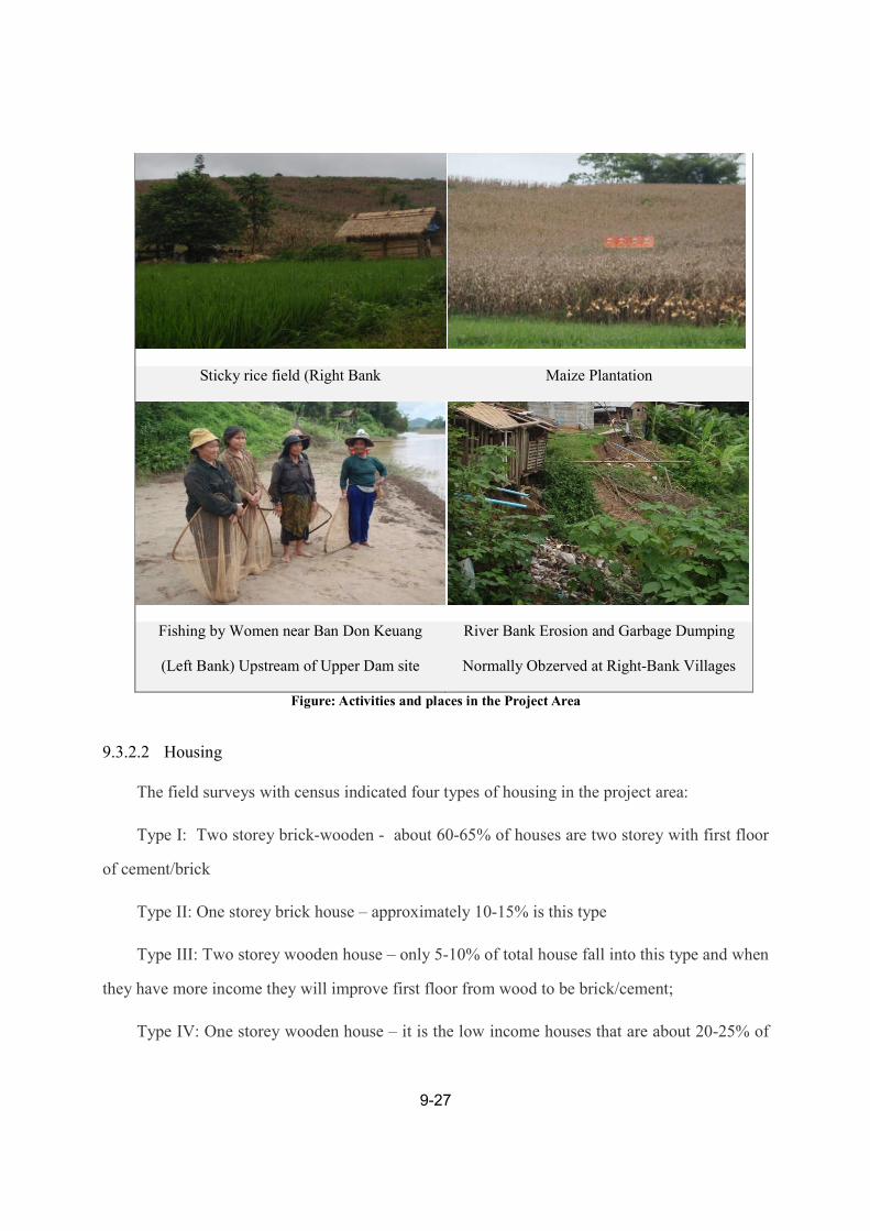
The general field observations indicated that the rural way of life of people on both banks is
mostly based on rice, maize, and cassava farming. Some industrial tree plantation of rubber and
teak were also observed. The land resources for each family in the upstream communities is
limited with average land holding at approximately 3.0 ha per family including 0.1-0.2 ha for the
house; 1.0 ha for glutinous rice plantation, 2.5 ha for maize/cassava farming; and the remaining
is for gardening, and for other purposes.
Results of focus groups revealed that the farm sector employs approximately 80 percent of
the active and productive work force whereas the non-farm sector employs about 20 percent of
the workforce.
The interview with community leaders showed that fishing can be done in the Mekong and
Nam Phoun rivers, nearby natural streams, fish ponds and paddy fields. It is noted that fishing is
not the main occupation among local villagers in the project area since the fish population
have decreased sharply. It is; however, the main source of protein in villagers’ diet and a
supplementary income activity for most villagers both upstream and downstream from the
proposed dam sites. See image below for images of daily life in the project area.
School at Ban Mouang Tai (Right Bank) Health Clinic at Ban Mouang Tai
9-27
Sticky rice field (Right Bank Maize Plantation
Fishing by Women near Ban Don Keuang
(Left Bank) Upstream of Upper Dam site
River Bank Erosion and Garbage Dumping
Normally Obzerved at Right-Bank Villages
Figure: Activities and places in the Project Area
9.3.2.2 Housing
The field surveys with census indicated four types of housing in the project area:
Type I: Two storey brick-wooden - about 60-65% of houses are two storey with first floor
of cement/brick
Type II: One storey brick house – approximately 10-15% is this type
Type III: Two storey wooden house – only 5-10% of total house fall into this type and when
they have more income they will improve first floor from wood to be brick/cement;
Type IV: One storey wooden house – it is the low income houses that are about 20-25% of
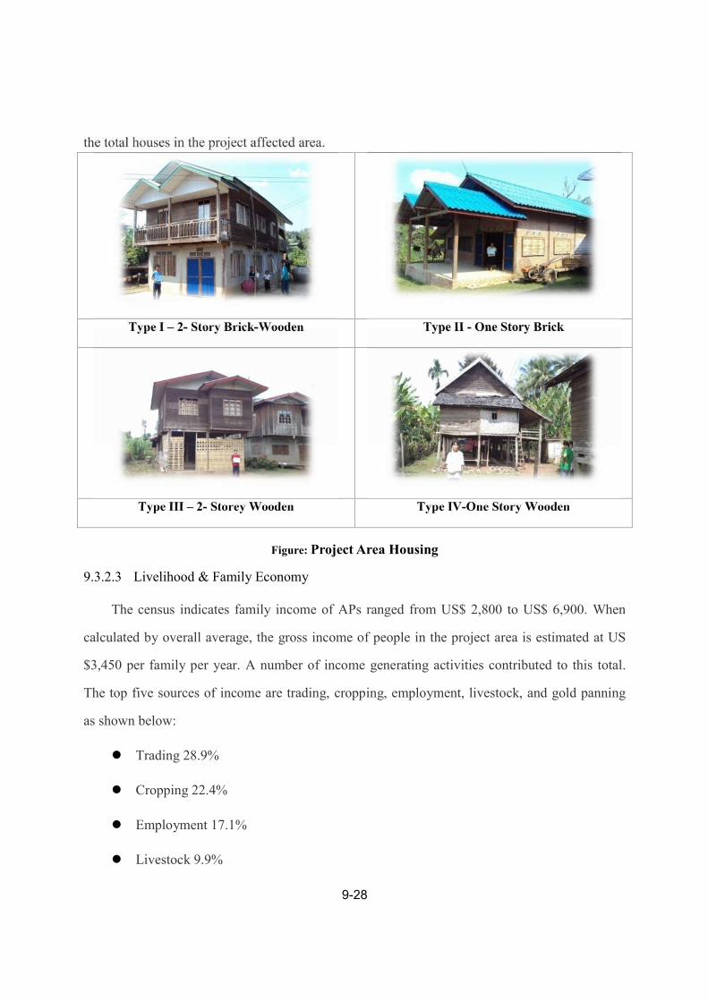
9-28
the total houses in the project affected area.
Type I – 2- Story Brick-Wooden Type II - One Story Brick
Type III – 2- Storey Wooden Type IV-One Story Wooden
Figure: Project Area Housing
9.3.2.3 Livelihood & Family Economy
The census indicates family income of APs ranged from US$ 2,800 to US$ 6,900. When
calculated by overall average, the gross income of people in the project area is estimated at US
$3,450 per family per year. A number of income generating activities contributed to this total.
The top five sources of income are trading, cropping, employment, livestock, and gold panning
as shown below:
Trading 28.9%
Cropping 22.4%
Employment 17.1%
Livestock 9.9%

9-29
Gold panning 6.7%
Sending from relations 3.4%
Fishing 1.8%
Others 9.8%.
The same source of information shows that family expenditure (including cost of production)
ranged between US$ 1,400 and US$ 3,700 with the overall average of US$ 2,150. This indicates
that average net disposable income of APs is US$ 1,300.

9-30
9.4 ENVIRONMENTAL IMPACT ASSESSMENT
The objective of this chapter is to describe key positive and negative impacts of
theMPLHPP.
9.4.1 SCOPING
While Initial scoping was done during the IEE the Biophysical and Social Team leaders
conducted additional detailed project and discipline specific scoping sessions with their
respective teams and stakeholders. The objective of this scoping was to develop Discipline
specific TORs, work plans, methodologies and schedules for the discipline specialist’s data
collection activities and studies. This included identification of the specific type of information
required for the impact assessment work.
Preparation for Participatory Stakeholder Consultation was initiated by the designated NCG
specialist during the Preparation Phase of the EIA. The first step was to prepare a project specific
consultation program and participant specific materials. The participatory consultation process
was designed to verify the validity of the proposed scope and approach to the EIA. Participants
included representatives of the potentially affected people in the project area, NGO’s,
responsible Government agencies. Feedback obtained during the consultations was recorded and
summarized for inclusion in the EIA. Relevant feedback obtained was used to adjust the scope,
approach and focus of the EIA to meet relevant National and International guidelines.
9.4.2 METHODOLOGY IN ASSESSING IMPACT
Impacts were assessed by impact area: Global, Country and Region, Project Area. In order
to assess the significance of a potential impact the impact assessor must consider and integrate
both, the predicted magnitude as determined by the discipline specialist and the relative
importance of the effect as determined by appropriate value systems.

9-31
9.4.3 GLOBAL ENVIRONMENTAL IMPACTS ASSESSMENT
Table: GLOBAL ENVIRONMENTAL IMPACTS ASSESSMENT
Impact Overview Recommendations / Mitigation Impact Assessment
Impact on Global
Warming
Summary: The construction
of dams can lead to an
increase in Global Warming
because biomass can be
flooded which leads to the
generation of greenhouse
gasses. However, if the land
to be inundated is cleared
thoroughly of vegetation
before flooding the dam will
not generate greenhouse
gasses.
Since Thailand plans to buy
most of the electricity from
the dam this will allow them
to use less fossil fuel (coal,
oil, etc.) so Thailand will
contribute less to the total
worldwide emission of
greenhouse gasses.
The vegetation from all land to be
inundated must cleared well to
prevent and increase in
greenhouse gas emissions
With correct mitigation this impact is
expected to be positive with a low –
medium Significance and last the full
period of dam construction.

9-32
9.4.4 REGIONAL AND NATIONAL ENVIRONMENTAL IMPACT ASSESSMENTS
Table: REGIONAL AND NATIONAL ENVIRONMENTAL IMPACT ASSESSMENTS
Impact Overview Recommendations / Mitigation Impact Assessment
Rural electrification The GOL has set a target for the
electrification of approximately 80
percent of households by 2015, and
90 percent by 2020.
The MPLHPP would export
approximately 90 % of generated
electricity to Thailand and Vietnam
and keep 10 % for the domestic
supply.
The construction of the MPLHPP
and associated infrastructure would
help provide much needed
electricity to rural areas of Laos
The MPLHPP should be
constructed according Lao Laws
and Guidelines as well as
International Best Practices
This impact is expected
to be positive and of
medium Significance.
Regional power grid The construction of the project
would include the building of a
Transmission Line further
strengthening the Regional Power
Grid
The MPLHPP should be
constructed according Lao Laws
and Guidelines as well as
International Best Practices
This impact is expected
to be positive and of
medium Significance.

9-33
Foreign direct investment The construction of the project
would cause much foreign
investments in Laos in goods and
services
This impact is expected
to be positive and of
medium Significance.
Trans-boundary Impacts Transboundary Impacts are impacts
to other countries caused by the
MPLHPP.
The building of then dam could
affect the hydrological
characteristics and sedimentation
regime downstream all way to the
Mekong Estuary in Vietnam. Also,
it could affect the fishery of the
river.
The dam must be built and
operated as a true river dam.
Long term migratory species
will likely be affected. Non-
migratory species should not be
adversely affected.
Assuming the dam is
designed, built and
operated as a true Run-of-
River dam there should
not be any significant
hydrological or
sedimentation trans-
boundary impacts.
The transboundaryaffect
on the fishery from the
dam could be significant
for long range migratory
species but will likely
have no effect on non-
migratory or short range
migratory species

9-34
Benefit sharing The sale of electricity will generate
much needed income for the Laos.
This and other benefits from the
project can be shared throughout
the region and country
The details of benefit sharing are
not clear and may be subject to the
policy process of the GOL and
external factors of political,
environmental and social policies
of other countries.
This impact is expected
to be positive with a
medium significance.

9-35
9.4.5 PROJECT AREA ENVIRONMENTAL IMPACT ASSESSMENT
Table: PROJECT AREA ENVIRONMENTAL IMPACT ASSESSMENT
Impact Overview Recommendations / Mitigation Impact Assessment
Impact on Land and
Soil during
Construction Phase
During construction the
following could occur:
o Loss of topsoil.
o Failure to
rehabilitate borrows
areas and
temporarily acquired
land.
o Soil erosion and
siltation.
o Soil contamination
by fuel and
lubricants.
o Disposal of excess
earthworks.
Approximately
8.350×10⁶m3 of spoil
will require disposal.
Loss of topsoil will be avoided by
stripping and storing topsoil (where
present) prior to construction and
reusing it appropriately.
Borrow pit material extraction will
be undertaken in sections with
rehabilitation undertaken in stages
to minimize erosion.
Land shall be rehabilitated after
being used according to Lao PDR
Laws, Guidelines and Decrees
Soil contamination will be
prevented by installing oil
separators at wash-down and
refueling areas, and installing
secondary containment at fuel
storage sites.
Waste rock and aggregate will be
used in construction to the
maximum extent possible.
Since 8.350×10⁶m3 of spoil will
require disposal. Two sites have
With correct mitigation this impact
is expected to be negative with a
low – medium Significance and last
the full period of dam construction.
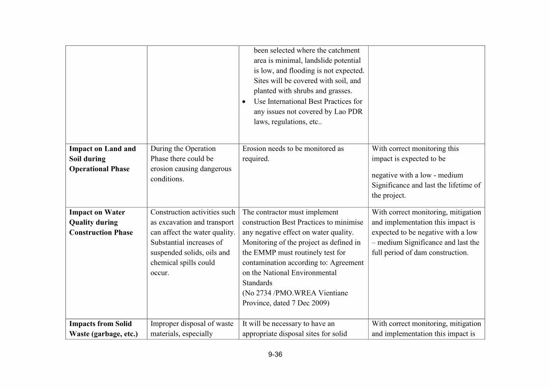
9-36
been selected where the catchment
area is minimal, landslide potential
is low, and flooding is not expected.
Sites will be covered with soil, and
planted with shrubs and grasses.
Use International Best Practices for
any issues not covered by Lao PDR
laws, regulations, etc..
Impact on Land and
Soil during
Operational Phase
During the Operation
Phase there could be
erosion causing dangerous
conditions.
Erosion needs to be monitored as
required.
With correct monitoring this
impact is expected to be
negative with a low - medium
Significance and last the lifetime of
the project.
Impact on Water
Quality during
Construction Phase
Construction activities such
as excavation and transport
can affect the water quality.
Substantial increases of
suspended solids, oils and
chemical spills could
occur.
The contractor must implement
construction Best Practices to minimise
any negative effect on water quality.
Monitoring of the project as defined in
the EMMP must routinely test for
contamination according to: Agreement
on the National Environmental
Standards
(No 2734 /PMO.WREA Vientiane
Province, dated 7 Dec 2009)
With correct monitoring, mitigation
and implementation this impact is
expected to be negative with a low
– medium Significance and last the
full period of dam construction.
Impacts from Solid
Waste (garbage, etc.)
Improper disposal of waste
materials, especially
It will be necessary to have an
appropriate disposal sites for solid
With correct monitoring, mitigation
and implementation this impact is
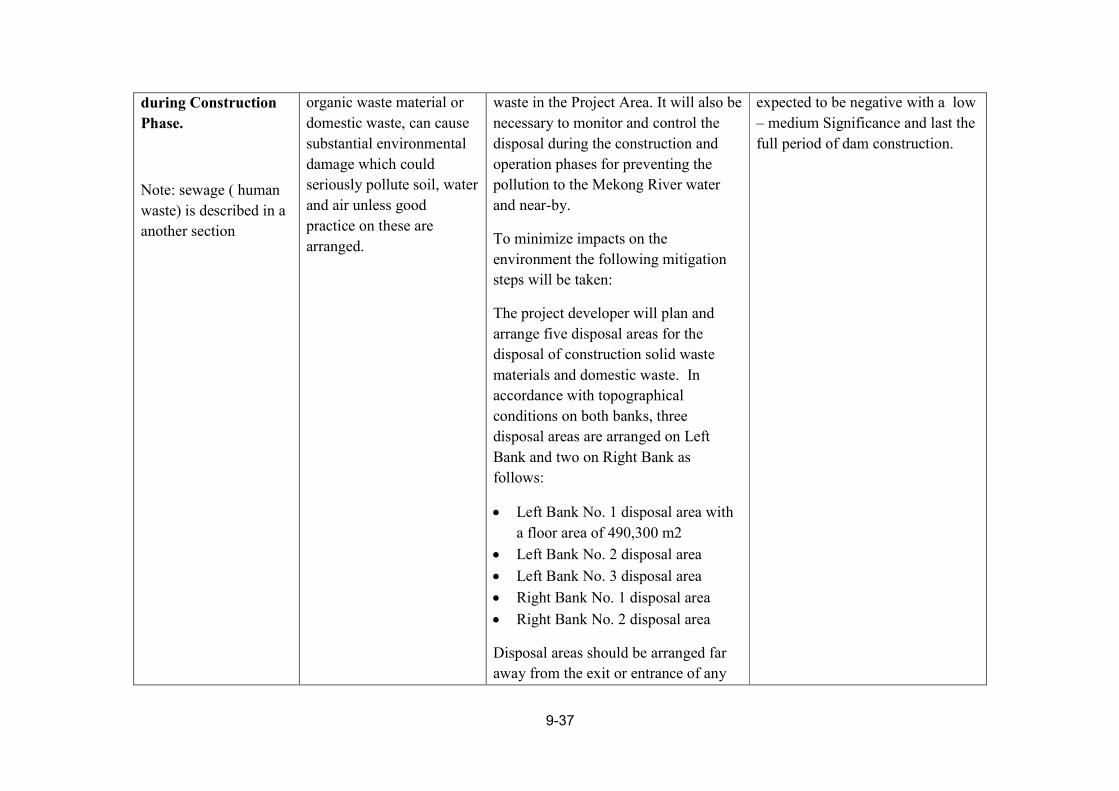
9-37
during Construction
Phase.
Note: sewage ( human
waste) is described in a
another section
organic waste material or
domestic waste, can cause
substantial environmental
damage which could
seriously pollute soil, water
and air unless good
practice on these are
arranged.
waste in the Project Area. It will also be
necessary to monitor and control the
disposal during the construction and
operation phases for preventing the
pollution to the Mekong River water
and near-by.
To minimize impacts on the
environment the following mitigation
steps will be taken:
The project developer will plan and
arrange five disposal areas for the
disposal of construction solid waste
materials and domestic waste. In
accordance with topographical
conditions on both banks, three
disposal areas are arranged on Left
Bank and two on Right Bank as
follows:
Left Bank No. 1 disposal area with
a floor area of 490,300 m2
Left Bank No. 2 disposal area
Left Bank No. 3 disposal area
Right Bank No. 1 disposal area
Right Bank No. 2 disposal area
Disposal areas should be arranged far
away from the exit or entrance of any
expected to be negative with a low
– medium Significance and last the
full period of dam construction.

9-38
possible debris flow gullies or cultural
relic areas.
All these off-site disposal areas should
be constructed according to Lao Laws,
regulations and the International Best
Practices of solid waste management
and approved by the government
authorities. No on-site landfills shall be
developed.
Hazardous waste will be collected and
stored on-site in approved facilities
according to relevant standards.
Hazardous waste will then be removed
from the site to approved hazardous
waste disposal facilities.
Impacts from sewage
and Wastewater
during Construction
Period.
Domestic water used for
toilets, washing, cleaning is
pollutant and can lead to
the deterioration of the
surrounding environment.
It is recommended that all sewage must
be collected and treated by high
efficiency septic tanks and make sure
that the discharge of treated effluent
meets the national environmental
standards; sewage will need to be
monitored to ensure no harm comes to
the natural environment in the project
area.
The contractor must implement
construction Best Practices to minimise
With correct monitoring, mitigation
and implementation, this impact is
expected to be negative with low –
medium Significance and last the
full period of dam construction.

9-39
any negative effect on water quality.
Monitoring of the project as defined in
the EMMP must routinely test for
contamination according to: Agreement
on the National Environmental
Standards
(No 2734 /PMO.WREA Vientiane
Province, dated 7 Dec 2009)
Impact to aquatics life
(fishery) during
Construct and
Operational Period
Operation and Construction
of project will cause
changes to freshwater
ecosystem, altering flows,
interrupting ecological
connectivity, and
fragmenting habitats. This
will adversely affect
fisheries, aquatic biota and
aquatic biodiversity.
The creation of a barrage
without any reservoir
stagnant effects can
improve the overall natural
fish production capacity of
the Mekong River in the
A fishpass as good defined by MRCs
standards must be installed.
A fish hatchery should be set upto
breed indigenous fish species for
release to the Mekong River.
Adoption of aquaculture within the
headpond area would be a partial
solution to the loss of migratory
species.
Fishery conservation should be
implemented in the project area.
The impact on the aquatic biology
and fish population is an effect of
medium to high and negative to
positive depending on the species

9-40
project area, especially in
the dry season; based on
the information of the
water quality and the
existing aquatic organisms,
species diversity and their
quantities, a positive
impact on fish biomass will
occur for species that do
not have long distance
migration patterns.
The increasing volume and
regulation of the water
level would be a benefit for
many aquatic living
organisms. After
impoundment, fisheries
activities would have to be
adapted to using new
fishing methods and gear.
The most important impact
of dams on the Mekong
will be on long distance
migrants that move up the
Mekong to breed, some as
far as China. The Mekong
giant catfish
(Pangasianodongigas) is

9-41
believed to be a long
distance migratory fish.
Research has found that
there are different and
isolated stocks of this fish
such as those found in
Tonle Sap and other deep
pools in the Mekong River.
This fish has succeeded as
a cultured fish in Thailand
by using the brood-stock
from an upstream pond, but
it still is in the list of
CITES.

9-42
9.4.6 ENVIRONMENTAL AND SOCIAL MANAGEMENT AND MONITORING PLAN
The responsible parties are as follows:
ESM: Environmental & Social Manager (from EMU)
ER: Environmental Regulatory officer (from EMU)
SR: Social Regulatory officer (from EMU)
CC: Complying Contractor (The contractor that the responsibility has been assigned to)
Category & topic
Monitoring action Resp. Frequency of monitoring
Monitoring criteria
Contractor non compliance level*
First notification
Multiple notification
Water quality management & pollution control
Drinking water
Visual inspection of treatment facilities
ER Weekly Cleanliness of system, etc
Visual inspection of water sources protection
ER Monthly Location, distance to pollution sources, fencing, information signs
2 or 3 3
Water quality Monitoring in residence and main worker camps
ER
Weekly monitoring of potable water
Once a month, full
Analysis
Color, odor, free chlorine 1 or 2 2 or 3
Water quality random monitoring in temporary camps
ER Weekly monitoring of potable water
Same as above
Visual inspection of treatment facilities and water protection sources
ER Bi-monthly
Cleanliness of facility, maintenance register review, availability of chemicals & spare parts
1 or 2 2 or 3
Review CC monitoring data
ESM Bi-monthly Compliance with design criteria (WHO)
2 or 3 3
Random sampling, main camps and temporary camps when required
ESM /ER
Monthly Color, odor, free chlorine, FC 2 or 3 3
Effluents Routine sampling of treated effluents by operating CC
ER
weekly monitoring of treated effluents
Temperature, pH, Suspended Solids (SS), DO, Fecal Coliforms

9-43
Category & topic
Monitoring action Resp. Frequency of monitoring
Monitoring criteria
Contractor non compliance level*
First notification
Multiple notification
Visual Inspection ER Weekly inspection
Cleanliness of station, drainage of sludge and screenings storage area, total infiltration of treated effluent
1 or 2 2 or 3
Review of monitoring data
ESM
Weekly inspection by ESM
Compliance with effluent design criteria
2 2 or 3
Random sampling of treated effluents
ER Monthly Discharge, temperature, pH, Suspended Solids (SS), Fecal Coliforms , DO
1 or 2 2 or 3
Registration of sludge movements
ER When required
Date & volumes of movements: from station to disposal area and from septic tanks to station
1 or 2 2 or 3
Review of sludge movements registration
ER Once a month
Date & volumes of movements; Cross check with landfill reception records
1 or 2 2 or 3
Worker camps (main)
Routine maintenance and monitoring of CC
ESM /ER/SR
Weekly Cleanliness of camps and maintenance of drainage & sanitation facilities
Registration of septic tank emptying operations
ER When required
Date of maintenance & facility concerned
1 or 2 2 or 3
Visual Inspection of camps waste water and rainstorm water drainage
ER/ ESM
Bi-weekly
General cleanliness of camp, collection and drainage of all water from sanitary facilities and canteens; stormwater drainage;
1 or 2 2 or 3
Review of septic tank emptying operation register
ER Once a month Date of maintenance & facility concerned
1 or 2 2 or 3
Workers Camps (temporary)
Routine maintenance and monitoring of CC
ESM /ER/ SR
Weekly Cleanliness of camps and maintenance of drainage & sanitation facilities
Registration of maintenance
ER When required
Toilets regularly maintained 1 or 2 2 or 3
Visual inspection of facilities and camps
ER Bi-weekly Appropriate system Condition of toilet Defecation around camp
1 or 2 2 or 3
Review of maintenance register
ER Once a month Date of maintenance & facility concerned
1 or 2 2 or 3
Construction areas
Visual inspection of pollution control measures implementation
ER/ ESM
Daily/weekly
Refuelling area and practice Temporary storage of chemicals Temporary storage of wastes
Sampling of drainage water at area outlet
ER Weekly SS, oil and fuel, FC
Review of monitoring data
ESM Monthly SS, oil and fuel, Fecal Coliforms
1 or 2 2 or 3
Random sampling ER Monthly pH, SS, Temperature 1 or 2 2 or 3

9-44
Category & topic
Monitoring action Resp. Frequency of monitoring
Monitoring criteria
Contractor non compliance level*
First notification
Multiple notification
of stormwater outlet
Maintenance areas (workshops, garages)
Visual inspection of pollution control measures implementation
ER/ ESM
Daily/weekly
Refueling area and practice Bunded storage for HM as waste engine oil, grease, hydraulic oil Stormwater design (hydro-carbon separation pit)
Ensure presence and maintenance of spill response equipment kit according to products stored
ER Weekly
Presence of equipment according to standard Procedures posted in the premises Emergency response team identified & trained
2 or 3 3
Registration of used waste generated
ER
Daily registration by garages and workshops as concerned
Date & volumes 1 or 2 2 or 3
Hydrology
Spoil Disposal and Drainage
Ensure spoil disposal areas located & designed in accordance with hydrological Requirements
ESM /ER
As required when delineating disposal site
Design and effective delineation of disposal site compared on map photo or GPS control
Register claims from communities regarding flooding etc
SR As required Location Type of problem
Ensure natural drainage respected or mitigated during earthworks and site development
ESM /ER
Weekly Visual observation 1 or 2 3
Monitor spoil areas ER Bi-weekly inspection
Visual inspection 2 or 3 3
Record presence of impeded drainage and ponding or velocity increases
ER Bi-weekly inspection
Visual inspection 2 or 3 3
Soil Conservation
Erosion Control Measures
Ensure implementation of erosion control measures
ESM /ER
Weekly Visual observation Design documentation
Ensure implementation of sediment transport reduction measures
ER Weekly Visual observation 1 or 2 3
Monitor stormwaterdrainage from concerned
ER Bi-Monthly Suspended Solids 1 or 2 2 or 3

9-45
Category & topic
Monitoring action Resp. Frequency of monitoring
Monitoring criteria
Contractor non compliance level*
First notification
Multiple notification
areas
Top soil protection
Ensure top soil properly managed and preserved for eventual use in restoration
ER
Weekly during large excavation works As requested later
Visual observation Design documentation
Monitor application of design standards for erosion control and topsoil protection
ER/ ESM
Bi-weekly Visual observation 1 or 2 2 or 3
Biodiversity Conservation
Clearing
Ensure demarcation & tree marking for clearing and respect of clearing limits
ESM /ER
Daily observation during clearing by Forestry Department
No. of trees
Ensure log evacuation completed before work starts
ESM /ER
Weekly Visual observation
Monitor clearing operations by CC to ensure no trees felled
ESM /ER
As required According to Project design and Clearances given
3
Re-vegetation Ensure re-vegetation done with native species
ER As needed, control site and nursery
Species used not considered as exotic invasive
1 1 or 2
Wildlife Conservation
Check species used ESM As needed Species used are suitable 1 1 or 2
Ensure hunting ban respected
ESM /ER/ SR
Daily observation
Control at check-points the transport of any dead or alive wild animal Presence of hunting gear Workers cooking wildlife meat
Delineate sensitive natural areas to be avoided and inform by flagging
ESM /ER
Random observation
Direct observation of non avoidance by contractor staff
3
Ensure all staff attended environmental awareness program
ESM /SR
Random observation and review of training attendance register
At least 80% workers on site at any time attended awareness program
1 2 or 3
Monitor conservation efficiency
ER Direct random observation
Number of non-compliance observed including persons having not attended awareness program
1 2 or 3
Chemicals and Waste Management
Non- Visually inspect & ER Weekly Design criteria

9-46
Category & topic
Monitoring action Resp. Frequency of monitoring
Monitoring criteria
Contractor non compliance level*
First notification
Multiple notification
Hazardous Waste Landfill
evaluate with emphasis on review on clay or/and synthetic liner permeability Monitor maintenance and management of landfill
ER/ ESM
Weekly
Access restricted, waste compacted, absence of Hazardous waste, pest control effectiveness,
1 or 2 2 or 3
Visual inspection of leachate leakage
ER Rainy season Pollution indicators 1 or 2 2 or 3
Random sampling of wells water &stormwater
ER Seasoning Absence of pollution indicators
1 or 2 2 or 3
Monitor landfill site cleanliness and management
ER/ ESM
Monthly Visual inspection of facility 1 or 2 2 or 3
Monitor slope stability of disposal
ER Weekly Visual inspection 1 or 2 3
Garbage collection
Ensure regular collection of garbage
ER Weekly Visual inspection and organization of unit
Monitor effectiveness of garbage collection
ER Bi-weekly
Visual inspection during site visits regarding equipment and presence of uncontrolled waste dumping sites along roads
1 2 or 3
Hazardous Waste
Ensure temporary storage sites comply with safety obligations
ESM /ER
Weekly site inspection
Containers, labels, collection register, drainage water control, etc
Ensure appropriate HW registration & disposal in accordance with obligations
ER Weekly
Registration, design of storage area (bunded and fenced area), containers quality, labeling, spill response kits, safety procedures posted, workers in charge trained and PPE available
2 2 or 3
Inspection of temporary and main HW disposal sites
ER Bi-weekly to monthly
Same criteria as above 1, 2 or 3 3
Hazardous Chemicals
Ensure appropriate Hazardous material registration, storage & handling in accordance with safety regulation
ESM /ER
Weekly
Registration, design of storage area (bunded and fenced area), containers quality, labeling, spill response kits, safety procedures posted, workers in charge trained and PPE available
Inspection of Hazardous material management
ER Monthly Same criteria as above 1, 2 or 3 3
Eventual safe disposal of
ESM As required According to HP State pollution Control Board and
2 or 3 3

9-47
Category & topic
Monitoring action Resp. Frequency of monitoring
Monitoring criteria
Contractor non compliance level*
First notification
Multiple notification
Hazardous Waste & Chemicals
national specifications
Cultural Properties
Ensure no cultural site notified prior to works is disturbed without community agreement
ESM /SR
As needed Documentation review and site visit
3
Ensure procedure implemented if heritage discovered
ESM /SR
As justified
Notification to Owner Effective application of decisions on site Temporary fencing of zone and signs posted
3
Monitor appropriate procedure implementation if heritage discovered
SR
Daily to monthly (risk based) checks at identified sites
Effective suspension of works Temporary fencing of zone and signs posted Subsequent conservation measures implemented
3
Access to Site and Road Safety
Road safety
Ensure implementation of road signs & speed reduction bumps
ESM /ER
Daily observations
Compliance with design
Ensure respect of signs & speed limits & parking areas by project drivers
ER Daily observations
Register non-compliances on project roads and on public roads
1 2 or 3
Check road signs and respect of speed limits & parking areas
ER Daily observations
Direct observation Number of non-compliances observed in a month
1 2 or 3
Ensure trucks & vehicles appropriately maintained (engine, breaks, tires, lamps)
ER
Daily observation & registration of vehicles service maintenance
Non-conformity observed on the road Register of truck/car maintenance for sub-contractors
1 or 2 2 or 3
Ensure truck load not overweight, stabilized and covered if bulk
ER Daily observation
Non-conformity observed on the road registered with No. of plate & driver name
1 or 2 2 or 3
Monitoring of traffic safety
ESM /ER
Daily observation Random control point once a month
Direct observation Systematic control regarding truck condition & load and absorption of alcohol or drugs by drivers
1 or 2 2 or 3
Ensure watering of roads is provided in residential areas and in dangerous/dusty road sections to limit dust emission
ER Daily observation in dry season
Visual observation Number of waterings/day Number of watering trucks
1 or 2 2 or 3
Barriers Ensure all areas of works and
ER/ SR Weekly Visual inspection 1 or 2 2 or 3

9-48
Category & topic
Monitoring action Resp. Frequency of monitoring
Monitoring criteria
Contractor non compliance level*
First notification
Multiple notification
contractor compounds are adequately fenced
Worker Health
Health awareness program
Ensure any worker attended awareness program
ESM /SR
Weekly Registration of training attendance
Review training register to confirm employee training
ESM /SR
Bi-weekly to monthly depending on turnover
At least 80% of staff at any time has received training
1 2 or 3
STD and AIDS prevention program
Ensure program implemented
SR Bi-monthly
At least 80% of staff at any time has received induction course, Posters printed and posted, Leaflet printed and distributed, Prophylactics available and number distributed
Pre- employment and annual medical checks
Ensure pre-employment and routine annual medical checks for all staff, with particular check for respiratory and STDs
SR Monthly
Number of pre-employment checks Number of routine annual checks Statistics of disease incidence
Review registers ESM Quarterly Number of medical checks compared to number of staff recruited
1 2
Medical facilities
Ensure medical facilities implemented, equipped and appropriately staffed
ESM /SR
Monthly
Staff & equipment available per facility Number of consultations registered
Monitor efficiency and cleanliness of medical facilities
SR Monthly
Visual observation Inspection of medical supplies and sterile procedures
1 or 2 2 or 3
Vector control
Ensure measures implemented in worker camps and in construction sites
SR Weekly
Camps inspection for hygiene Awareness posters posted in camps and on working places Medicine for treatment available to staff Prevalence statistics
Monitor enforcement of control and effects
SR Monthly
Visual observation from camps inspection Review of medical register
1 or 2 2 or 3
Hygiene Ensure water-borne SR Weekly Number of cases and events

9-49
Category & topic
Monitoring action Resp. Frequency of monitoring
Monitoring criteria
Contractor non compliance level*
First notification
Multiple notification
related disease control
diseases and food- borne illness reporting, investigation and remediation procedures, implemented and effective
Implementation of sanitation and waste management practices Observation of good personal hygiene practices
Monitor enforcement of control and effects
ESM /SR
Quarterly
Visual observation from camps and canteens inspection Review of medical register
1, 2 or 3 2 or 3
Occupational Safety
First Aid Training and Field Implementation
Ensure Foremen and key personnel of "at risk" activity received First Aid Training
ESM /SR
Monthly
Registration of personnel attending training and subsequent job affectation Ensure responsible staff for explosive, chemical and hazardous waste management has attended training
Ensure First Aid Kits available and fully supplied
SR Weekly Review of equipment and location
1 or 2 2
Monitor First Aid equipment and capacity
ESM /SR
Quarterly
Visual observation of equipment, Review register of First Aid training attendance
1 or 2 2 or 3
Injury/Illness reporting
Verify implementation of occupational injury and illness reporting procedure
SR Monthly Register and compile injuries and illness (occupational)
Review OH&S efficiency
ESM Quarterly
Review register of Occupational injuries & illness % of change from previous quarter
1 or 2 2 or 3
Safety procedures
Verify availability and use of appropriate equipment and procedures
ESM /SR/ ER
Monthly
Visual observation of procedure posters in key sites: Harzardous material storage, explosive storage, construction sites, garages, sticker in trucks, etc
Verify adequate signage and barricades in hazardous construction zones
ER/ SR Daily during field visits
Visual observation 1 2 or 3
Review OH&S accident prevention activities
ESM Quarterly
Visual observation and questioning of workers during site inspection Number of non-compliance detected and trend
1 or 2 2 or 3
Community Relations (Project Issue - Not Directly CC Responsibility to Implement) Community Ensure participation ESM Bi-monthly Regular contact with

9-50
Category & topic
Monitoring action Resp. Frequency of monitoring
Monitoring criteria
Contractor non compliance level*
First notification
Multiple notification
liaison of community/leaders in all monitoring activities directly affecting them
/SR individuals and community leaders recorded
Check employment opportunities
SR Monthly
Ensure PAP are given the opportunity to provide labor or services to the Project if they so wish monitored through community liaison
Grievance Redress
Ensure function of grievance redress mechanism
ESM /SR
Weekly Grievance Redress Cell available and at least twice a week
Check Grievance Register
SR Weekly
Ensure all grievances recorded have been subject to a prompt response
Compensation Ensure disbursement of funds
SR Bi-Monthly
Ensure all funds and actions for compensation have been disbursed/executed by the Project by liasing with communities
Security Check police records
SR Bi-Monthly
Inspect police reports of project related security issues. Ensure that women's security is adequately catered for.
Working/Living Conditions
Migrant Labour
Check eligibility SR Weekly Ensure no child labor is utilized by inspection of site and employment records
Monitor dependents ESM /SR
Weekly
Ensure living conditions of dependents are acceptable to the Project by site inspection
1 or 2 3
Fuel
Check CC is providing wood or kerosene to workers and their families
SR Weekly and Monthly
Visual inspection of camps Inspection of CC fuel purchase
Shelter Check quality of accommodation at camps
ESM /SR
Bi-monthly
Ensure no un-authorized indigenous materials are used for building by visual inspection and check of CC purchase orders Ensure provision of separate single and married quarters by visual inspection
Facilities
Check for presence of acceptable sanitation, washing and bathing facilities
ER/ SR Monthly
Ref. water quality parameters above. Ensure no washing and bathing directly in water courses or discharge of wastewater directly to

9-51
Category & topic
Monitoring action Resp. Frequency of monitoring
Monitoring criteria
Contractor non compliance level*
First notification
Multiple notification
streams etc. Visual inspection
Personal Safety Equipment
Ensure all workers adequately equipped with PPE.
ESM /ER/ SR
Daily
Visual inspection to determine use of proper footwear, hard hats, goggles/masks, gloves etc where required. Ref OH&S Sub-plan
1) Non-Compliance Level I: A non-compliance situation not consistent with EMMP
requirements, but not believed to represent an immediate or severe threat to people or to the
environment. Repeated Level I concerns may become Level II concerns if left unattended.
2) Non Compliance Level II: A non-compliance situation that has not yet resulted in clearly
identified damage or irreversible impact, but which potential significance requires expeditious
corrective action and site-specific attention to prevent severe effects. Repeated Level II concerns
may become Level III concerns if left unattended.
3) Non Compliance Level III: A critical non-compliance situation, typically including
observed significant damage on people or the environment or a reasonable expectation of very
severe impending damage. Intentional disregard of specific prohibitions is also classified as a
Level III concern.

9-52
9.4.7 HEALTH IMPACT
9.4.7.1 Health Situation
a) Pak Lay District Health Situation
Pak Lay has a District Health Office (DHO) and hospital. The district hospital is located in
the Pak Lay district town and has 30 beds. There are also 9 HCs with 27 beds within the project
area; two HCs are located in Ban MuangNeua village and Nampoun village in Pak Lay district;
two HCs located in Namphene village and Muangki village of Met District; and one located in
the north-part of upstream under Xayaboury District. The district serves 71 villages, 13,083
families and 66,499 populations. District health staff totals 77 people including:
One (1) postgraduate workers
medical doctors
20 Medical assistants
41 Nurses
Four (4) other staff.
Of which:
15 members of the district health staff work at the DHO
32 work at the district hospital
30 work at the HCs
There are 93 village health volunteers including 91 traditional birth attendants. Twenty-
eight (or 39.4%) of the villages have a revolving drug fund. There are 22 private drugstores.
There were population health targets for 1,310 of children under 1 year old, 6,204 children
under 5 years old, 19,431 women of age 15-49 years old and 1,394 of pregnancies.
b) Met District Health Situation

9-53
Met district is located in the north of Vientiane Province. The DHO targets disease
prevention and health promotion. There are also 5 HCs with 15 beds, which serve 60 villages or
21.66% of the district population. District health staff consists of 26 people: one postgraduate, 3
medical doctors, 11 medical assistants and 11 nurses. There are 18 staff at the DHO and 8 at the
HC. There are 31 private drug stores, 18 clinics and 132 village health volunteers.
Based on data collected from the Met district health office, hygiene promotion, mother and
child health, vaccinations, malaria control, TB control, HIV/AIDS/STIs control, family planning,
water supply and sanitation programs were being implemented throughout the district. The
common causes of morbidity and mortality include seasonal influenza, acute watery diarrhea,
pneumo-bronchitis, pharyngitis or tonsillitis, nervous system non-psychotic, and hyper blood
pressure. The infant mortality rate <1 year old is 27/1000 live births and <5 years of age is
36/1000 live births. The maternal mortality ratio was 91/100,000 live births. The percentage of
the community using clean water was 67.1% and the use of latrines was 67.9%. It was also
found that in the Pek District, 68.3% of women gave birth at health facilities, 2.5% at HCs home,
0.2% at home with a SBA and 29% without a SBA.
9.4.7.2 Identification of Potential Areas of Health risks
According to the HIA reported of Pak Lay HPP has been identified the potential health risk
areas and may affected to population health within and surrounding of the project include:
Villages are closest to the construction areas
Villages are located at upstream/reservoir areas
Villages are located at downstream areas
Villages are located along the road of construction sites
Resettlement villages
Labour and workers
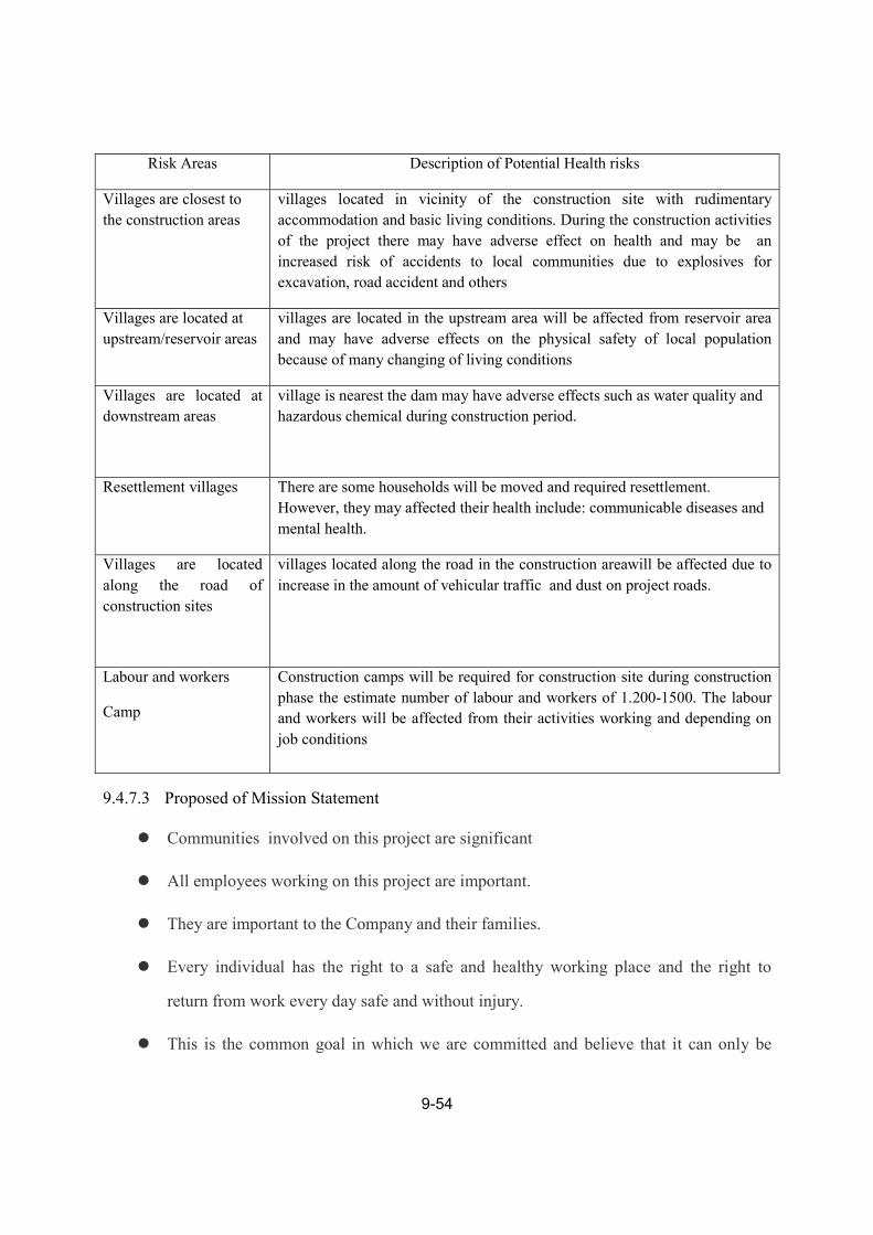
9-54
Risk Areas Description of Potential Health risks
Villages are closest to
the construction areas
villages located in vicinity of the construction site with rudimentary
accommodation and basic living conditions. During the construction activities
of the project there may have adverse effect on health and may be an
increased risk of accidents to local communities due to explosives for
excavation, road accident and others
Villages are located at
upstream/reservoir areas
villages are located in the upstream area will be affected from reservoir area
and may have adverse effects on the physical safety of local population
because of many changing of living conditions
Villages are located at
downstream areas
village is nearest the dam may have adverse effects such as water quality and
hazardous chemical during construction period.
Resettlement villages
There are some households will be moved and required resettlement.
However, they may affected their health include: communicable diseases and
mental health.
Villages are located
along the road of
construction sites
villages located along the road in the construction areawill be affected due to
increase in the amount of vehicular traffic and dust on project roads.
Labour and workers
Camp
Construction camps will be required for construction site during construction
phase the estimate number of labour and workers of 1.200-1500. The labour
and workers will be affected from their activities working and depending on
job conditions
9.4.7.3 Proposed of Mission Statement
Communities involved on this project are significant
All employees working on this project are important.
They are important to the Company and their families.
Every individual has the right to a safe and healthy working place and the right to
return from work every day safe and without injury.
This is the common goal in which we are committed and believe that it can only be

9-55
achieved by dedication and joint efforts by all involved.
As an employer, we undertake to provide a safe working environment and appropriate
tools. We also acknowledge that safety takes precedence over program and cost. The
consequence of injuries is a financial loss to both the individual and to the project.
All employees to undertake to act and work in a safe manner at all times.
As an individual everyone has the right and obligation to stop and correct an unsafe act or
situation.
9.4.8 CUMULATIVE AND TRANSBOUNDARY IMPACT
9.4.8.1 Fish Migration and Fisheries
Transboundary impact
Obstruction of fish migration: Construction of a big dam, like the one for the Pak Lay HPP
at either alternative 1 or 2, would divide the river ecosystem causing separation of living
organisms upstream and downstream. It would impact on the movement of living organisms that
migrate for reproduction and spawning as part of their normal life cycle. Based on the study of
Baran E (2006), there are a total of 768 fish speciesin the Mekong River consisting of 165
migratory fish species, 24 non-migratory and 579 fish species that have not been scientifically
identified as either migratory or non-migratory.
Migrating fish species include ones that are Critically Endangered (CR), Endangered (EN),
Vulnerable (VU) or Near Threatened (NT):
CR species: Mekong Giant Catfish (Pangasianodongigas), Giant pangasius
(Pangasiussanitwongsei).
EN species: Mekong stingray (Dasyatislaosensis).
VU species: Laotian shad (Tenualosathibaudeaui ),Banganabehri.
NT Species: Mekonginaerythrospila, Indochina featherback (Chitalablanchi), Long

9-56
pectoral-fin minnow (Macrochirichthysmacrochirus).
Evidently, the Mekong giant catfish (Pangasianodongigas)migrate from their habitat in the
middle Mekong Basin to spawn at the Upper Mekong Basin at Ban Had Krai, Chiang Khong
District, Chiang Rai Province, Thailand during the end of April to May. Construction of the Pak
Lay dam in the upper Mekong Basin would obstruct the Mekong giant catfish unless an
appropriate fish pathway can be designed.
Limitation of fish habitat: Construction of dam would cause a limitation of fish habitat
unless an appropriate fish pathway can bedesigned. Fishes would tend to congregate in upstream
and downstream areas, which would allow the fishermen to catch more fish. However, this
higher fish catch would decrease the quantity of species, particularly in the Upper Migration
Mekong Basin, which runs from the location of Pak Lay dam at Ban Moung, Tai Pak Lay
District uptoLaungPrabang and down to Chiangkan District, Loei Province, Thailand) the
boundary of upper and middle migration of the Mekong Basin.
Impact to fish population: The construction of the dam would impact on the fish population
due to the change of water level downstreamunless an appropriate fish pathway can be designed.
The lower level of water would accordingly lower normal flood levels, and floodplains along the
river bank. Various aquatic organisms could not adjust themselves to the alteration of water
level and river flow. This would decrease biodiversity, particularly downstream. It might also
decrease the water quantity in rapids and deep pools to a level that is not adequate for fish and
other aquatic organisms to live safely during the dry season (December-beginning of April),
particularly downstream of the proposed Pak Lay dam site down to Chiangkai District, Loei
Province, Thailand, and perhaps go further to Vientiane Province if the discharg water
downstream is lower than the Operational Rule Curve. However, construction of a fish pass will
allow movement upstream even though it is not the same as the existing condition without dam
construction.
Dam construction might cause a severe depletion of fish species as listed by IUCN Red of

9-57
Threatened species.
A transboundary impact would occur at 2 areas; Middle Migration Mekong Basin and
Upper Migration Mekong Basin, particularly on the fish that migrate between the connecting
point of middle and upper basins such as the Mekong giant catfish and the Mekong stingray.
However, negative impacts on the small scaled fishes in the Cynprinidae would be less as these
fish could migrate to the tributaries (no need to pass through dam) for reproduction and
spawning.
Fish migration to the tributaries would increase the risk of fish being caught because the
tributaries are not wide and deep like the Mekong River. A high fish catch would decrease the
quantity of fish in the basin and the sustainability of such fish catchesunless an appropriate fish
pathway can be designed. In the tributaries, there are a variety of fishing equipments eliminating
any chance of survival (Figure below). A critical fish catch would have an graveeffecton fish
and aquatic organisms
Fish catch equipments laying across the stream

9-58
Cumulative Impact
The impact on the Mekong giant catfish(Pangasianodongigas) should be evident. As
mentioned above the construction of thePak Lay dam would cause the separation of the upstream
and downstream sides of the dam. This would cause the obstruction of migration of the Mekong
giant catfish during reproduction and spawning. Itwouldreduce the numbers of the fish and
possibly cause the fish to become extinct. Ifthe fish passis designed well for the Mekong giant
catfish to pass, this effect could be minimized.
Considering the cumulative impact on the Mekong River, the existing ecosystem would
possibly change. Construction of the dam would cause a long term impacton the quantity and
size of fishas stated previously. The impact level can not be distinctly assessed since the data of
fish migration is not sufficiently available. Due to the migration pathway the Mekong giant
catfish is likely to be seriously and negatively impacted. If the fish passis designed well for the
Mekong giant catfish to pass, this effect could be minimized.
In addition, an increasing number of transshipping would impact on the normal living of
fish and other aquatic aqua- organisms due to noise level generated from engined
boating/shipping. In case of disposing solid wastes and wastewater from boats would cause
water pollution further impacting on fish living and status.
9.4.8.2 Navigation
Transboundary impact
Impact of dam construction on navigation between LuangPrabang and Vientiane is now
assessed. The transshipping time would be longer, particularly when ships pass through ship
locks. It is estimated that the time going through a ship lock takes 30-40 minutes, which would
increase overall time by 8-10%.
On the other hand, the construction of dam would increase water levels upstream in the dry
season, which would facilitate enhance the capability of transshipping. This would have a

9-59
positive impact on the growth of navigation. However, there is need of caution about the
possibility of transshipping accidentsdue to rapids and outcrops at the hot spots along the
Mekong River.
In the case of cargo transshipping, such as chemicals and gasoline, there is risk of accidental
leakage or spills of such materials. The International Convention for the Prevention of Pollution
from Ships (MARPOL) only covers sea and seashore areas. However, transshipping downstream
of Pak Lay dam construction will be like the existing condition without dam construction, the
impact along this section would be less to none. Positive impact on this task might be high,
particularly on the tourism business.
Cumulative Impact
Cumulative impacts are similar to transboundary impacts as stated above. Four
environmental aspects are considered as follows.
Impacts in terms of longer time due to dam construction.
Increased risk of ship accidents.
Increased risk of chemical leakage.
Impact on living organisms and their habitat.
For the transshipping from Vientiane down south to Pakse might not be impacted, as
transshipping activities are less popular for time consuming long distance travel. Land
transportation by bus is more popular because it is more convenient and quicker than navigation.
In addition, the impact to tourism business by boating/shipping that uses travel time not
exceeding 3 hours might occur. Business locations far from the proposed Pak Lay dam site,
would not be impacted from the construction of the Pak Lay dam.
9.4.8.3 Water Quality
Transboundary impact

9-60
a) Construction Period
Impacts on water quality due to erosion/sedimentation: Impacts on water quality are the
result of erosion and sedimentation and can take place during construction. Construction of the
project will take about 5 years including land preparation and construction of the main dam,
coffer dam, construction camps, office and living facilities, warehouses, E & M equipment
assembly yard, auto and machinery repair workshop, machinery depot, concrete batching plant,
quarry sites, disposal areas, etc. These construction activities involve clearing of the forest
biomass of the proposed dam construction site, which would induce erosion and release
sedimentation in to the river. Transboundary impacts on water quality could occur from
suspended solids dispersion. Best practices in dam construction are needed to minimize
deforestation and erosion/sedimentation which would accordingly minimize negative impacts on
water quality.
Impacts on water quality due to Solid Waste:In addition, solid wastes generated during
construction include construction material residue (wood, soil, stone, brick, cement, etc),
biomass residue, etc. These solid wastes also cause water pollution if they are disposed ofin the
river.
Impact on water quality due to wastewater discharge: Impacts on water quality can
potentially be caused by wastewater discharge from the worker’s camp. Dam construction
employs a high number of workers who will need to be accommodated on site. The worker’s
camp should be hygienic andinclude an adequate number of sanitary latrines and an onsite
wastewater treatment system. Household solid wastes (e.g. garbage, rubbish, etc) are also
pollution sources that will impact on water quality if disposed in the river. Location of the camp
site should be far from the river at some distance. Otherwise, wastewaters and household solid
wastes might be discharged and disposed in the river, thus causing water pollution.

9-61
b) Operation Period
During the operation period the impacts on water quality can be assessed as follows:
Impact on Water Quality due to Erosion/Sedimentation: Impact on water quality due to
erosion and sedimentation can take place in the reservoir at the location where the degraded
forest exists. Accumulation of sediment could take place in the reservoir causing suspended
solids dispersion in the downstream river to be lower than the existing natural condition; this
may induce erosion and a scouring effect. Periodical sediment release from the reservoir is
necessary to minimize such problems.
Impact on Water Quality Due To Degradation of Biomass Residue: Impact on water quality
due to degradation of biomass residue could also take place in the reservoir and further impact
downstream river areas. Near the beginning of the dam operation (in about 5 years) when the
water upstream is at its normal operating level, the degradation of trees, plants and other
vegetable residue under anaerobic condition could cause water pollution with an odor problem.
This problem is evident in some newly constructed reservoirs (when inundated land has not been
adequately cleared before flooding). It results in a water quality problem in the project area for
domestic water users and can impact on people’s health who reside downstream of the dam.
When the polluted water is discharged downstream, the assimilation capacity of the river may
recover the water. In this regard, the transboundary impact of water pollution is assessed in terms
of recovery distance. If the recovery distance is adequately far from the proposed downstream
dam site, the dam would have little or no impact on the downstream area as the water being
discharged is likely to be at normal water quality levels. However, it is necessary to maintain
good water quality in the reservoir by a proper removal of biomass.
Impact on Water Quality due to Wastewater Discharge: Impact on water quality can
attribute to wastewater discharge from the human activities carried out around the reservoir and
along the river bank. Construction of the Pak Lay HPP will possibly stimulate the expansion of
communities, industries, agriculture, aquaculture, and tourism along the Mekong River

9-62
particularly in the upstream area. If the management of wastewater and solid waste is inadequate,
new sources of pollution would negatively impacton water quality. In addition, these water
quality changes would have an impact on aquatic organisms, such as possible reduced biological
diversity, fish numbers andwater for domesticuse. Project Area Wastewater Discharge could
affect areas downstream so they have potential transboundary impacts. If land use is regulated by
pollution protection and control measures, such impacts would be minimized.
Impact on Water Quality due to Agriculture and Aquaculture: In addition, agriculture and
aquaculture activities are potential supplementary results from dam construction. Agriculture and
aquaculture can directly impact on water quality. Intensive agricultural activities use chemical
substances such as fertilizers and pesticides, which create nutrients and toxic substances that
contaminate the river. Based on the existing water quality mentioned earlier in Chapter 3 of this
document, dispersion of nutrients and sediment, such as nitrogen and phosphorus tend to
increase every year in the Mekong Delta, particularly in the Chau Doc area of Vietnam. Also
found were pollutants such DDT and PCB.
Aquaculture could cause high organic and nutrient contamination in the river as a result of
using fish food that contains high carbohydrates and proteins. The nutrient and chemical
pollutants could be dispersed to other river reaches so they have potential transboundary impacts.
High nutrient contents can cause eutrophication or algal bloom which is one type of pollution.
Good practice in agriculture and aquaculture is necessary to prevent eutrophication as well as
safeguards on the ecosystem from toxic substances.
Other potential transboundary impacts concern nutrients attached with sediment. Such
nutrient-sediment can get trapped in the reservoir and be prevented from being transported
downstream, particularlyto the Mekong Delta and Tonle Sap Lake area, where there are an
abundance of fish species. The lack of nutrient-sediment could possibly impact on fisheries. This
impact could be considered as a potential transboundary one. A periodical release of sediment
during dam/reservoir operation would help alleviate such nutrient obstruction problems.
9-63
Impact on Water Quality due to Navigation and Oil spills: Impacts on water quality from
navigation stem from wastewater, grease and oil being discharged directly into the river from
ships/boats. Oil spills might result from accidental leakages. Increased navigation for cargo
transshipping would directly impact on water quality if waste treatment and anti-oil spill
measures are not properly provided. Impacts caused by navigation activities are likely to be
transboundary ones. Ship locks to facilitate cargo transshipping as well as navigation routes have
to be designed according to the MRCs recommended guidelines.
Cumulative Impact
a) Construction Period
Impacts on water quality due to erosion/sedimentation: During construction, impacts would
be the same as transboundary impacts assessed above. The major cumulative impact in this
period is due to erosion and sedimentation from construction activities in the clearance area.
Erosion on land moving downward to the reservoir disperses soil particles, which finally settles
as sediment in the reservoir. Sediment will accumulate in the reservoir prior to the state of dam
operation. Such accumulation would possibly shorten thereservoir/dam operationage compared
to the designed project age.
Impact on Water Quality due to Wastewater Discharge:Pollution in the reservoir can also be
due to organic and nutrient wastewater discharge from existing communities and agriculture and
aquaculture. Presently, as observed from the field survey, such pollutants are not high –
compared to the high amount of water stored in the reservoir, the existing mentioned activities
have low loading. Dilution as well as biodegradation of low organic and nutrient loading would
minimize the pollution effect.
b) Operation Period
Cumulative impacts due to dam construction can be considered in terms of upstream
discharge of substances including sediment, nutrients, organic matters and toxic substances.

9-64
These pollutants would accumulate in the reservoir, particularly at the front of the dam. The
organic matters in sediment would undergo an anaerobic reaction, causing carbon dioxide,
methane, hydrogen sulfide, etc. Greenhouse gases (carbon dioxide and methane)can be generated
from the reservoir. Also, the accumulation of nutrients can lead to eutrophication in some areas
wherever the condition is suitable for such phenomena (shallow water level, sufficient sunlight,
high nutrients).
When considering that Pak Lay HPP is one proposed dam in a series of proposed dams
along the Mekong River, there is likely to be a continual cumulative impact. As previously
stated, sediment accumulated in the upstream reservoir would minimize suspended solids
dispersion in the downstream river and reservoir. The greater accumulation of sediment upstream
would cause less suspended solids dispersion downstream, which would then stimulate more
river bank erosion and riverbed scouring. Besides erosion and the scouring effect, nutrients
accumulated in the reservoir could possibly cause a decrease of nutrients downstream that would
have an impact on aquatic life because of low nutrient feeding. As mentioned above, periodical
sediment release is a practical measure of reservoir operation which would help alleviate the
negative cumulative andtransboundary impacts.
9.4.8.4 Climate Change
Pak Lay HPP will not create significant impact on climate change; in contrast, the
changes in climate would be directly and indirectly affected by those changes.
Major adjustments to local livelihoods and key development sectors would be required.
Pak Lay hydropower projects would require auditing and possibly retrofitting
Catchments experiencing high rainfall and runoff would have increased hydropower
capacity.

9-65
9.4.8.5 Social Impacts
Anticipated Key Bio-physical Changes
The creation of the above mainstream hydropower dams in the Lower Mekong Basin may
change the river and its ecosystems. The following bio-physical changes are anticipated:
Long-term water level changes on the Mekong that may increase in the range of 1m to
3m during the dry season
Long-term downstream sediments decrease that may decrease in a range of 10% to 20%
depending on number of dams to be operated on the Mekong mainstream and its
tributaries
Long-term changes in the Mekong River morphology and ecosystems that may
havemore water (both in depth and width)
Upstream quantity of fish may decrease from the obstruction of migratory fishes and
from loss of rapids and wetlands that are aquatic habitats
Short-term poorer water quality on the Mekong River due to construction activities
during construction periods.
Degree of Livelihood Dependence in Each Zone
One indicator is to identify most/second most important occupation of people who are
residing in the Mekong corridor. The MRC (2010) revealed that 73% of people earn a living on
farming while only 8% on fishing. This reflected that farming is the key income generation
activity and considered as the most important livelihood of the riparian people. However, fishing
is still important for some people especially those residing in Don Sahong and Don Sadam of
Southern Lao PDR, Tonle Sap Lake of Cambodia and some areas in the Mekong Delta.

9-66
Cumulative Social Impacts
From recent hydropower development in the LMB, it showed that there are a number of
social impacts (both positive and negative) that can be listed as follows:
Positive Impacts are related to the improvement of basic social infrastructure and facilities
such as roads, bridges, water and electricity supply system, education and health facilities,
markets, and other economic benefits like employment.
Negative Impacts are mainly concerned with compensation of lost assets and relocation
and resettlement of directly affected people.
Assessment of CumulativeSocial Impacts
Consideration of cumulative social impacts has been made primarily in Zones 1 and 3 that
are located in the Lao PDR territory. Since there will be 7 Mekong mainstream hydropower
development projects in Lao PDR, the key cumulative impacts may concern the following:
The loss of production land for plantation of rice and other food crops in the country.
Cumulatively, there will be approximately 18,000 ha of production land that will be
submerged due to the creation of the proposed hydropower dams of which food
production (mainly rice and other food crops) with a minimum of 45,000 tons per year
will be lost. This will affect the food supply and its price in the project areas and in the
country as a whole.
The creation of Mekong mainstream projects will displace about 5,700 families with a
population of about 30,000 people. Despite resettlement packagesfor the displaced
people with provision of better infrastructure, the improvement of peoples livelihoods
will be a problem since there is very limited good production land for resettlement.

9-67
9.5 SOCIAL IMPACT ASSESSMENT
9.5.1 DETAILS OF IMPACT FROM INNUNDATION
Construction of the MPLHPP will require resettlement. relocate or compensation for people
living in the inundation area of FLS 240 m . The total numbers of persons to be resettled or
compensated villages and people will be on criteria of upper dam site selection..
a) Resettlement
The census based on project demarcation surveys indicated the following:
The project would require the resettlement of 7 villages, 789 families and 3,545 people.
b) Compensation
Villages which do not require resettlement still need to be given compensation for loss of
their land or other assets. The project would require compensation for one village (27 families
and 128 people).
9.5.2 RESETTLEMENT RECOMMENDATIONS
At this point we can draw key recommendations for the implementation of relocation and
resettlement development for the MPLHPP as below:
Alternative Dam Site Selection – As has been mentioned, to avoid very severe social
impacts to the Nam Phoun River Valley Communities, which have a rich culture and a good
economy, Option#2 (Upper Dam) is more reasonable and optimum dam site for the project as
compared to Option#1 (Lower Dam) which would create highly significant social impacts.
Employment – It is recommended that a representative labor-aged person in each affected
family should have a job working with the project construction activities and that they will have
a continuous family income during the seven year construction period.
Quality of Production Land - Farm plots in the new land settlement should be improved in
line with peasantry economic modes of farming production so as to facilitate the settlers previous
knowledge and experience and allow them to adopt themselves to their new environment within
the shortest time possible. Further, the land improvement should ensure that the per-unit

9-68
production in the receiving land is higher or equivalent to that before resettlement. This will
ensure that the resettlers’ production and standard is higher or equivalent to the original pre-
resettlement level within the shortest time possible.
Capacity Building & Scholarship – Improvement of the capacity of RAP participants,
especially relocates and resettlers, is required with an adequate budget. Each
relocation/resettlement site proposed tobe considered to providescholarship for its students to
further study after finishing their secondary school. The National University of Lao and the
Government Vocational Colleges are the targeted education institutes for the young resettlers.
After they have finished the scholarship they have to go back home and assist in long-term socio-
economic and livelihood development for their home villages.
Benefit Sharing & Equity Issues - It must be ensured that the affected people regain
benefits from the project such as electricity and employment, etc. Vulnerable Groups including
the poor, sick, orphaned and vulnerable children need to be given priority in employment
opportunities arising from the project including special care and treatment during relocation and
resettlement.
Micro Financing– It is recommended that micro-finance such as small loans and savings
facilities are made available to families who are relocated and resettled by the project.
Adequate Budget for Resettlement and Relocation –Note that Population increase and
time factors affect the numbers and costs of resettlement and relocation as show in Table below.
9.5.3 RESETTLEMENT INFRASTRUCTURE
The people who must be resettled by the Project and the host communities will benefit from
resettlement infrastructural developments, which include:
Electrification
Water Supply
Road
School

9-69
Health Clinic
Temples
Village Administration Office
User Organization
Note that domestic electric connections will be constructed for each resettlement village but
villagers will have to pay for the electricity transmission.
There will be some families that are identified as vulnerable people that special assistances
(depending upon vulnerable peoples' requests and needs such as vehicle, driver and facilitation at
the moving) will be provided to these kinds of people: (i) disabled people or people suffering
from serious illnesses; (ii) women and children at risk of being dispossessed of their productive
assets -land- as a result of the land compensation process that may benefit the sole male; (iii)
household head that are widows, orphans and elderly persons.
9.5.4 LIVELIHOOD RESTORATION & DEVELOPMENT
The MPLHPP will adopt the strategy of ensuring that the resettled families and host village
families are enabled to improve their living conditions and their standard of living by the
development of a range of livelihood opportunities. A number of enterprises have been identi-
fied, based upon (i) an evaluation of the natural resources, (ii) taking into account the socio-
economic and cultural background of the people and the economic environment in which they
will be operating, and (iii) oncoming consultations with the villagers.
The resettlers will be able to choose from a range of livelihoods options or combination of
them, as shown below:
Cropping: Wet and dry season cropping with some portion of the land irrigated from
nearby rivers (if possible). Potential cash crops are rice, maize, cassava and job’s tear are
targeted cash crops. There exists maize, a cassava factory and job’s tear market in the project
area.
Livestock: Livestock rearing on a mixture of feed-crops or forages possibly grown on the
irrigated areas, and free range grazing. Livestock rearing improvement activities may include

9-70
promoting more intensive production through forage growth, penning livestock and disease
prevention.
Community or private plantations, including management and harvest of NTFPs in
community forest, plantation land with a mixture of fast growing industrial species and slower
growing but valuable native species plus NTFPs.
Aquaculture: community fisheries at the reservoir and individual household fish/frog ponds.
For farmers who have paddy fields the rice-cum-fish system (simple enhancements to increase
the natural productivity of fish in paddy fields) will be introduced and promoted.
Non-farm employment and cottage industry: Waged or self-employment in a range of
activities such as small shops, repair shops, handicrafts, primary produce trading and
construction labor.
9.5.5 RESETTLED INCOME TARGET
The planned net disposable income 5years after resettlement is estimated to be same as than
they were before.Any how the project will work for livelihood restoration to ensure that the
project meet the regulation of the GoL.

9-71
9.6 PUBLIC PARTICIPATION & GRIEVANCE PROCEDURE
Consultation with members of the communities in the vicinity of the project area are
undertaken through village meetings, interviews with representatives of the local villages and as
part of the household surveys. The survey is used to develop a baseline socio-economic profile
of the local communities and sought information on the level of awareness of the project,
concerns and expectations of the project. Individual household interviewees, social dialogues
were used to document the profile of communities, the range and extent of impacts both at the
household and community level. Specifically the Village level consultations will be held for the
following purposes:
Gather information on the profile of the community and the possible social impacts of
the project on community structure, local resources and livelihood patterns.
Assess the scale of resettlement, loss of assets and livelihood (individual and
community) and explore options for the most suitable livelihood restoration and asset
replacement measures, including resettlement site options.
Identify key environmental concerns of the communities, especially related to diversion
of water, impacts on land use, and construction activities.
Members of the communities in the vicinity of the project area participate through village
meetings, interviews with representatives of the local villages and as part of the household
surveys. The survey is used to develop a baseline socio-economic profile of the local
communities. Information is sought on the level of awareness of the project, concerns and
expectations of the project. Individual household interviewees and social dialogues are used to
document the profile of communities, the range and extent of impacts both at the household and
community level. Specifically the village level consultations will be held for the following
purposes:
Gather information on the profile of the community and the possible social impacts of
the project on community structure, local resources and livelihood patterns. Some
specific “focus group” were conducted in some villages

9-72
Assess the scale of resettlement, loss of assets and livelihood (individual and
community) and explore options for the most suitable livelihood restoration and asset
replacement measures, including resettlement site options.
Identify key environmental concerns of the communities, especially related to the
diversion of water, impacts on land use, and construction activities.
Figure: Consultation at Village Level in the Project Area (people are supporting this project)
The project has already gone though the public involvement from village levels, district
level, site visit of line ministries, local authorizes of 2 provinces and technical consultation,
national consultations. The result was positive and fuly support the project and the project need
to accelerate the project development, coordination with all stake holders and look after the
people to get better off livelihood.
The grievance redress mechanism and process proposed for the MPLHPP includes three
steps as discussed below:
Step 1 – At the village level, a householder or group of householders can approach the
Resettlement Committee through the village chief and present the grievance. The grievance is

9-73
initially considered at the lowest level of the resettlement hierarchy. The issues can be resolved
through discussions and mediation. If at the village level the grievance cannot be resolved or if
the claimants are not satisfied with the decision, the next step can be used – either by the
claimants or the village committee on behalf of the claimants.
Step 2 – At the district level – an official grievance committee must ensure that the claims
are reviewed within the context of the existing policy, regulations procedures and entitlement
limits. The committee has 15 days to resolve and respond to the claimant’s grievance in terms of
the activities to be undertaken. But if the grievance is still not satisfactorily resolved, the
developer company must urgently attend to the matter before it reaches the Provincial Court.
Step 3 – At the Provincial Court - This is the last option to be urgently solved by the
developer's company before reaching the court. At this level, the justice authority at the district is
required to clarify problems.
9.7 IMPLEMENTATION ARRANGEMENT
9.7.1 ADMINISTRATION SYSTEM
Since relocation and resettlement deal with land acquisition, compensation and construction
of public infrastructures, the implementation of RAP will be under the Lao Administration
System which requires appointing Committees and Offices in all levels as follows:
a) Provincial Resettlement Committee (PRC)
b) Resettlement Management Unit (RMU)
c) District Working Group (DWG)
d) Village Development Committees (VDC)
e) Company’s Social Management Office (SMO)

9-74
Figure: Institutional Arrangement for Resettlement Implementation
The Project developers are required to set up an Social Management Office (SMO) to
implement the resettlement plan under the directive of respective government committees as
discussed above.
9.7.2 RESETTLEMENT IMPLEMENTATION TIMETABLE
The timetable (shown below) for resettlement should be compatible with the project
construction. The best time for moving people will be in the dry season of years 4 and 5.
Table:Timetable for Resettlement Implementation
No.
Description of Activities
Year 1 2 3 4 5 6 7 8 9 10 11 12
Construction Phase Operation Phase CONSTRUCTION WORKS 01 Preparation
02 Construction
03 Commissioning
RELOCATION & RESETTLEMENT WORKS 01 Set-up Committees, RMU/RMO
02 Updated census of affected people/assets 03 Confirm relocation/resettlement sites 04 Village consultation program 05 Capacity building for all parties 06 Finalization of compensation rate 07 Compensation payment
08 Relocation/resettlement site plan 09 Infrastructural development in all sites
10 Movement of affected people 11 Re-establishment of community system
12 Livelihood development

9-75
13 Resettlement monitoring 14 Third-party monitoring and evaluation = RAP Milestone