Embed Size (px)
Citation preview

80Nolans Bore Mine Notice of Intent
9. Site Description and Environmental Setting
The Nolans Project is approximately 100km North of Alice Springs, within the Aileron Pastoral Lease. Alice Springs is an area of Australia with complex weather patterns. The Bureau of Meteorology states the climate varies from 45o days in summer to snow on rare occasions during winter, with temperature fluctuations during the day of up to 28o Celsius. Rainfall in the region varies, with a yearly average of only 282mm, and a maximum recorded rainfall of 782.5 mm in 1974. A summary of relevant average monthly climatic parameters for the project area is presented in Table 8 based on data obtained from the Bureau of Meteorology (BoM), Figure 18 illustrating the monthly rainfall for the past 12 months.
The Nolans prospect is situated on a flat plain area straddling Kerosene Camp Creek to the west, north and northeast of Nolans Bore. The Nolans Bore cattle yards cover the eastern portion of the deposit. The area has been subject to heavy grazing pressure over time. A wide expanse of alluvial sand, silt and calcrete separates the fluorapatite outcrops around the Bore and associated holding yards from those adjacent to Kerosene Camp Creek, 500m to the northwest and 800m to the southwest of the Bore (Goulevitch. 2005).
The Nolans Project lies within the Reynolds Range (Goulevitch. 2005). The highest peaks in the Reynolds Range (approximately 200km northwest of Alice Springs) reach over 1000m above sea level (eg. Mt Freeling at 1005m; Mt Thomas at 1116m) whereas the adjacent lowlands, such as occurs around Nolans Bore, are at about 650m above sea level (Goulevitch. 2005).
Table 8 Climatic Characteristics of the Nolans Project Area
Month Rainfall (mm) Evaporation (mm)
Average 09:00 Temperature (oC)
Relative 09:00 Humidity (%)
January 38 406 28.4 34
February 42.3 330 26.9 40
March 31.9 222 24 40
April 16.8 231 19.2 44
May 19.4 149 13.9 57
June 14.5 111 10.1 65
July 14.7 124 9.5 60
August 9.5 174 12.7 47
September 8.3 243 18.2 34
October 21.9 316 22.8 31
November 26.7 351 26 30
December 37.5 384 27.8 31
Annual 282.3 3140 20 43

81Nolans Bore Mine Notice of Intent
Figure 18. Rainfall
9.1 Terrestrial Environment The project is located within the Burt Plain bioregion (see Figure 19).
The Burt Plain Bioregion covers an area of 73,605 square kilometres entirely within the Northern Territory. Elevation across the bioregion ranges from 300 to 1252 metres above sea level (asl) (Neave etal. 2005). The Burt Plain Bioregion is broadly characterised by plains of acacia shrubland, tussock grassland and hummock grassland, acacia and eucalypt woodlands, and mountain ranges in the east, north and west of the bioregion (Neave et al. 2005).

!(
STU
AR
T H
IGH
WA
Y
PLENTY HIGHW AY
SA N
DOVER HIGHWAY
ROSS HIGH WAY
Nolans Bore
#
Project No: Date:
A4
43/21188 21/09/2007
Workspace: Location:
Map Grid:Level 5, 66 Smith StDarwin NT 0800
Tel: 61 8 8982 0100Fax: 61 3 8981 1075
G:43\21188\Projects\Figure_NOIFigure 18 Burt Plain.mxd
Figure 19 Nolans Bore Locality within the Burt Plain BioregionNolans Bore NOI
Data provided by the Northern Territory Government (NTG) 2007. In consideration NTG permitting use of data, you acknowledge and agree that NTG and GHD Pty Ltd gives no warranty in relation to the data (including accuracy, reliabil ity, completeness or suitabil ity) and accepts no liability (including without limitation, l iability in negligence) for any loss, damage or cost (including consequential damage) relating to any use of the data. Imagery obtained from Google Earth Pro. WARNING: Google Earth Pro Imagery is not orthorectified.
Scale: 1 : 2,500,000
0 100 20050 km
Geodetic Datum of Australia 1994
BURT
PLAIN
BIOREGION

83Nolans Bore Mine Notice of Intent
9.1.1 Fauna
An EPBC Act Protected Matters Report was generated for the mine site from the website search tool. A search of the NRETA fauna database was undertaken. Information from the NRETA database indicates records of 30 fauna species, 4 of which are listed as extinct under the Territory Parks and Wildlife Conservation Act. These species are summarised in Table 9 below.
Species listed as vulnerable under the EPBC are described in Table 9, and the likelihood of their occurring in the project area assessed. A list of all fauna (including introduced animals) from the NRETA database within a 2km search radius is provided in Appendix D. It is worth noting that these data appear to be from 2003.
Low et al (2007) undertook a preliminary survey in the proposed Nolans Mine area. The report is attached in Appendix H. Very few mammals and reptiles were observed or captured during the two surveys. The survey did not identify any fauna species of environmental or conservation significance in the area which is not unusual given the present use of the area to pastoral activities.
Table 9 Fauna Status
Name Common Name NT Status EPBC Status
Rostratula australis Australian Painted Snipe
Vulnerable Vulnerable
Macrotis lagotis Bilby Vulnerable Vulnerable
Polytelis alexandrae Princess Parrot Vulnerable Vulnerable
Dasycercus cristicauda Mulgara Vulnerable Vulnerable
Erythrotriorchis radiatus
Red Goshawk Vulnerable Vulnerable
Notoryctes typhlops Southern Marsupial Mole
Vulnerable Endangered
Dromaius novaehollandiae
Emu Vulnerable
Ardeotis australis Australian Bustard Vulnerable
Calyptorhynchus banksii (sub species Samueli)
Red Tailed Cockatoo Near Threatened
Petrogale lateralis Black-footed Rock-wallaby
Near Threatened Vulnerable
Lagorchestes conspicillatus
Spectacled Hare-wallaby
Near Threatened
Pyrrholaemus brunneus
Redthroat Near Threatened

84Nolans Bore Mine Notice of Intent
Name Common Name NT Status EPBC Status
Falco hypoleucos Grey Falcon Near Threatened
Stictonetta naevosa Freckled Duck Near Threatened
Aspidites ramsay Woma Python Near Threatened
Cinclosoma castanotus Chestnut Quail-thrush Near Threatened
Dasyurus geoffroii Western Quoll Extinct Vulnerable
Bettongia leseur Burrowing Bettong Extinct Extinct
Onychogalea lunata Crescent Nailtail Wallaby
Extinct Extinct
Chaeropus ecaudatus Pig-footed Bandicoot Extinct Extinct
Notomys fuscus Dusky Hopping-mouse Endangered Vulnerable
Isoodon auratus Golden Bandicoot Endangered Vulnerable
Pseudechis australis King Brown Snake Data Deficient
Varanus tristis Black-tailed Monitor Data Deficient
Demansia papuensis Papuan Whip Snake Data Deficient
Pseudonaja nuchalis Western Brown Snake Data Deficient
Varanus acanthurus Ridge-tailed Monitor Data Deficient
Porzana tabuensis Spotless Crake Data Deficient
Conopophila whitei Grey Honeyeater Data Deficient
Leipoa ocellata Malleefowl Critically Endangered Vulnerable
Rostratula australis (Australian Painted Snipe)
The Australian Painted Snipe is a stocky wading bird around 220-250mm in length. It is usually found in shallow inland wetlands, either freshwater or brackish, that are either permanently or temporarily filled. It is a cryptic bird that is hard to see and often overlooked. Usually only single birds are seen, though larger groups of up to 30 have been recorded. It nests on the ground amongst tall reed-like vegetation near water, and feeds near the water’s edge and on mudflats, taking invertebrates, such as insects and worms, and seeds (http://www.environment.gov.au/biodiversity/threatened/publications/painted-snipe.html).
The species has a scattered distribution throughout many parts of Australia. Though some individuals are apparently resident in some areas, other individuals appear to be nomadic, temporarily occupying areas where suitable habitat exists. There are sporadic reports from northern Western Australia, inland Northern Territory and inland and sub-coastal North Queensland (http://www.birdsaustralia.com.au/birds/painted.html). The Murray–Darling drainage system appears to have been a key area for this species, as many records of this species come from this region.

85Nolans Bore Mine Notice of Intent
Although it can occur across Australia, the areas of most sensitivity to the species are that wetlands where the birds frequently occur and are known to breed (http://www.environment.gov.au/biodiversity/threatened/publications/painted-snipe.html). It is highly unlikely that this species will be affected by the project.
Macrotis lagotis (Greater Bilby)
The Greater Bilby once occupied the entire area of arid and semi-arid Australia. They burrow up to 2m in depth, and feed on seeds, spiders, insects and bulbs. There are several post 1970 records for this species within the Burt Plain Bioregion (Neave et al. 2005), although none within the project area. It is possible but unlikely that the bilby will occur in the project area or be impacted by the project.
Polytelis alexandrae (Princess Parrot)
This species has a patchy and irregular distribution in arid Australia. It has been recorded in the Northern Territory in the southern section of the Tanami Desert south to Angas Downs and Yulara, and east to Alice Springs. The exact distribution within this range is not well understood and is as yet undetermined whether the species is resident in the Northern Territory. The princess parrot is not resident in any conservation reserve in the Northern Territory but it has been observed regularly in and adjacent to Uluru Kata Tjuta National Park. There is at least one record from West MacDonnell National Park (Pavey 2006 a). They are nomadic, and respond to good rainfall (Neave et al. 2005).
Processes that are likely to affect populations of the Princess Parrot include environmental degradation from clearing, grazing and changes to fire regimes. There have been no records of this species within the Burt Plain Bioregion since 1970 (Neave et al. 2005). It is unlikely to be impacted by the project.
Dasycercus cristicauda (Mulgara)
Information on the distribution and ecology of the Mulgara is scarce, and very little is known about population trends. The species has been recorded from a large number of sites in northeastern South Australia and it may be of less conservation concern than currently recognized. The cause of decline in the crest-tailed mulgara is unknown and it has not been possible to identify threatening processes (Pavey et al. 2006). It is likely that the processes of environmental degradation and habitat homogenization, changes in fire regimes, grazing by introduced herbivores including cattle and rabbits, and predation by introduced predators are likely threatening processes (Maxwell et al. 1996). Mulgara populations are recognised as dramatically fluctuating according to seasonal conditions, and none was recorded during a 2001 survey despite two years of high rainfall (Neave et al. 2005).
It is possible but unlikely that the Mulgara will be within the project area. It is unlikely to be impacted by the project.
Erythrotriorchis radiatus (Red Goshawk)
Red Goshawks occupy habitat that ranges from forest to woodland, with mixed vegetation communities. They are often found in areas with watercourses such as rivers, billabongs or swampy wetland. Their nests are often found in tall, live eucalyptus trees, adjacent to water. Creeks (ie Kerosene Creek) are ephemeral in the project area.
There is one record of the Red Goshawk from the Burt Plain bioregion in the Northern Territory Fauna Atlas (Neave et al. 2005). The subspecies that is listed under the Territory Parks and Wildlife Conservation Act does not occur in this region. It is unlikely that this species will be impacted by this project.

86Nolans Bore Mine Notice of Intent
Notoryctes typhlops (Southern Marsupial Mole)
The Marsupial Mole is blind, spending most of its time underground. They occasionally come to the surface, mostly after rain (Strahan, Ed. 1983). They are cryptic animals, more commonly recorded from tracks rather than sightings or captures (Neave et al. 2005). Their distribution ranges throughout arid Australia, in sandy desert country, including dunefields and river flats (Menkhorst 2001). There is only one record of this species from the Burt Plain bioregion (Neave et al. 2005). It may (but not probable) occur in the project area. If it were to be found within the project area, it would be impacted by the project, but only within a small region.
Petrogale lateralis (Black-footed Rock-wallaby)
The distribution of the MacDonnell Ranges subspecies is centred on the MacDonnell Ranges bioregion of the southern Northern Territory. In the Northern Territory its range extends north to the Davenport and Murchinson Ranges, east to the Jervois Range, west to the Western Australian border and south to the South Australian border (Pavey 2006. b). There are 44 location records for this species within the Burt Plain Bioregion (Neave et al. 2005), with some near the project area. Their habitat includes range country and rocky outcrops that provide protection from predators (Neave et al. 2005). The project area is surrounded by rocky outcrops, but dingoes also occur in the area. It is possible that they occur in the project area, but as no mining or access tracks will occur in the outcrops it is highly unlikely that they will be impacted by the project.
Dasyurus geoffroii (Western Quoll)
The Western Quoll was once widespread across Australia. The last records of this species in the central Australian region were from between Crown Point, to Alice Springs and Barrow Creek, along the Old Telegraph Line. It is now thought that the western quoll is extinct in the Northern Territory (Neave et al. 2005). It is highly unlikely that this species occurs in the area.
Notomys fuscus (Dusky Hopping-mouse)
The Dusky Hopping-mouse appears to be restricted in its distribution to the eastern Lake Eyre Basin within the Simpson-Strezlecki Dunefields Bioregion in South Australia and Queensland (Woinarksi et al. 2007). This species has not been recorded in the Northern Territory since 1939, and it cannot be determined whether it still occurs in the Northern Territory, despite several recent survey attempts to locate them (Woinarksi et al. 2007). It is highly unlikely that this species occurs in the area.
Isoodon auratus (Golden Bandicoot)
Golden Bandicoots have been described from a wide range of habitats, from sand dune and sandplain with spinifex in the arid zone, to sandplains with acacia and eucalyptus woodlands over tussock grasses in the tropical semi-arid zone, to vine thickets and low woodlands with tussock grasses in the tropical sub-humid northwestern Kimberly region (Strahan, ed. 1983). The main threats to these animals include pastoral activity, clearing of vegetation and feral cats. There are no post 1970 records of this species occurring within the Burt Plain Bioregion or surrounding area (Neave et al. 2005). It is highly unlikely that this species occurs in the area.
Leipoa ocellata (Malleefowl)
The Malleefowl was last recorded in the Northern Territory in 1931, and there are only six historical records of this species in the Burt Plain Bioregion (Neave et al. 2005). It is unlikely that this species will be present in the project area.

87Nolans Bore Mine Notice of Intent
9.1.2 Introduced Fauna
The NRETA database search resulted in six exotic recorded species, the house mouse Mus musculus, cat Felis catis, cattle Bos taurus, horse Equus caballus, camel Camelus dromedarius and rabbitsOryctolagus cuniculus. Other introduced species such as goats (Capra hircus) and donkeys (Equus asinus) may occur in the region.
Predation of native species of birds, mammals, and reptiles is listed as a key threatening process under the Commonwealth EPBC Act 1999. The Australian Government in consultation with the states and territories has developed the Threat Abatement Plan for Predation by Feral Cats, which outlines the key control methodology and guide for landowners with feral cat problems.
9.1.3 Flora
The plant communities in the project area are patchly distributed. They include short grasses and forbs with no overstorey in the mine pit area, and open woodland dominated by bloodwoods (Corymbia opaca) and mulga (Acacia aneura) with a sparse understorey in the area peripheral to the proposed pit and surrounding area (Low et al. 2007). A NRETA flora database search was undertaken, and no species of conservation significance under EPBC status was identified. Flora of conservation status in the Northern Terrritory are listed below in Table 10. There are 37 listed flora species, of which 17 are listed as near threatened and the remainder are all classified as data deficient. The full floral species list from NRETA is provided in Appendix E.
Low et al (2007) undertook a survey in the proposed Nolans Mine area. The report is attached in Appendix H. The survey did not identify any floral species of environmental or conservation significance in the area. Although the report states that there will be habitat loss from clearing for construction, impacts will be local, with no expected community impacts on a regional scale. Rocky foothills and riparian areas (having both important ecosystem functions and high plant diversity) are recommended as high priority areas for conservation (Low et al. 2007). These areas will be considered for preservation during ths mine planning phase of the project.
Table 10 Flora Status
Name NT Status
Osteocarpum salsuginosum Near Threatened
Aristida strigosa Data deficient
Eragrostis subtilis Near Threatened
Eragrostis crateriformis Data Deficient
Acacia oswaldii Data Deficient
Sclerolaena birchii Near Threatened
Swainsona laciniata Data Deficient
Swainsona cyclocarpa Data Deficient
Calotis cuneifolia Data Deficient

88Nolans Bore Mine Notice of Intent
Elatine macrocalyx Near Threatened
Schoenus centralis Data Deficient
Gynnanthera Cunninghamii Near Threatened
Lawrencia squamata Near Threatened
Daviesia eremaea Data Deficient
Digitaria hystrichoides Near Threatened
Halosarcia halocnemoides Data Deficient
Triumfetta clivorum Data Deficient
Ruppia tuberosa Near Threatened
Calandrinia pleiopetala Near Threatened
Pimelea microcephala Near Threatened
Acacia aneura Data Deficient
Paractaenum novae-hollandiae Data Deficient
Helioptropium epacrideum Data Deficient
Bulbostylis pyriformis Near Threatened
Acacia macdonnellensis Data Deficient
Spartothamnella puberula Near Threatened
Euphorbia ferninandii Data Deficient
Juncus aridicola Near Threatened
Goodenia angustifolia Near Threatened
Marsilea costulifera Data Deficient
Frankenia punctata Near Threatened
Calotis cuneifolia Data Deficient
Lythrum paradoxum Data Deficient
Osteocarpum salsuginosum Near Threatened
Glinius orygioides Near Threatened
Heliotropium ballii Data Deficient
Crotalaria Novae-Hollandiae Data Deficient
89Nolans Bore Mine Notice of Intent
9.1.4 Weeds
Areas with a pastoral history are likely to have weeds. Fifteen declared weeds listed under the Nothern Territory Weeds Management Act 2001 are known to occur in the Burt Plain Bioregion (Neave et al. 2005). The NRETA database contains no weed records for the area of the proposed mine. Species identified within the project area (Low et al. 2007) are:
Alternathera pungens (Khaki Weed) – Class B weed;
Cenchrus ciliaris (Buffel Grass);
Citrillus colocyntis (Paddymelon);
Sarcostemma australe (Snake Vine); and
Tribulus terrestris (Caltrop).
These are regarded as having some impact on biodiversity. Buffel grass is however widely spread within the region and used and encouraged by pastoralists as rangeland fodder.
9.2 Aquatic Environment Kerosene Camp Creek runs through the proposed mine site and directly across the proposed pit area (Figure 20). This creek is fed via a number of tributaries and is described in Section 9.5 (hydrology). No aquatic fauna have been recorded from the project area.
Kerosene Camp Creek is ephemeral with sporadic flow events. The creek flows in a northeast direction into the Woodforde River. The channel bed is mobile with deep sand deposition and banks showing signs of erosion. The mobile nature of the streambed would provide a difficult environment for vegetation growth. Vegetation is generally sparse. The channel is approximately 1.2m deep with a base width of approximately 5m (SKM, 2006).
90Nolans Bore Mine Notice of Intent
Figure 20. Kerosene Camp Creek
(SKM 2006).
91Nolans Bore Mine Notice of Intent
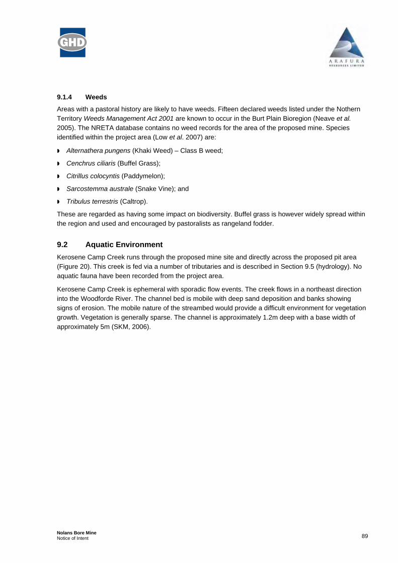
9.3 Geology The site is located within the Southeastern Reynolds Range, which lies over the Arunta Province. The Arunta region is a basement inlier with a complex history of sedimentation, magmatism and tectonism. The surface geology, particularly within the northern parts of the resource area, comprise in-situ derived Quaternary sediments and minor alluvial and Aeolian sand sediments, with minor carbonate deposits (see Figure 21. The basement formation at Nolans Bore comprise two main groups, the Landers Rock beds and the Reynolds Range Group (Environmental Earth Sciences 2007).
The Australia Geoscience Earthquake online search indicates that in recorded history a total of 6 earthquakes have occurred within 100km region of Aileron. These were between 1968 and 2004. The earthquakes’ magnitudes have been relatively low, between 2.5-5.5 on the Richter Scale. http://www.ga.gov.au/oracle/quake/quake_online.jsp. It is likely that there would be minimal risk of an earthquake above 5.5 occurring within the Aileron region.
The geology of the resource area has been devided into two zones based on known mineralization, the North and South zones. Structurally, the Nolans site geology is complex, having experienced several episodes of structural deformation. Regional shear and fault zones trend west-northwest running parallel to the regional fabric, with intense local-scale folding and faulting (Environmental Earth Sciences 2007).
Figure 21 Nolans Geology

92Nolans Bore Mine Notice of Intent
9.3.1 Geology and Resources
The host to REE (Rare Earth Elements) mineralisation is mainly massive fluorapatite with variable fluorapatite stockwork veins and bands. REE occur mainly as cheralite ([REE, Ca][P, Si]O4) in fracture infill and micro-veinlets in the fluorapatite. Mineralisation is hosted by granite-gneiss (primarily quartz-K-feldspar-biotite granitic/felsic gneiss) country rock. Four styles of REE mineralisation have been recognised at Nolans Bore:
Massive fluorapatite dykes of 4-6% REE;
Very high grade REE mineralisation of 10-20% rare earth elements found in the cheralitic apatite-poor rocks;
Calc-silicate hosted apatite-allanite-epidote REE mineralisation; and
Zones of low-grade REE mineralisation in gneisses and kaolinite-altered rocks adjacent to the fluorapatite dykes and adjacent to mylonite zones.
The fluorapatite bands are mainly hosted by granitic gneiss though some bands extend into mafic gneiss that predates the granite gneiss, and to a weaker extent into very coarse-grained pegmatites.
The generalised ore mineralogy is listed in Table 11.
The massive fluorapatite bands strike generally east-northeast and dip steeply (65-80°) to the north-northwest. They are most strongly developed where they crosscut a more east-west trending, north dipping (60°) mylonite zone in the granitic gneiss just to the north of 7502000N.
Table 11 Ore Mineralogy
Mineral Amount SG Notes
Fluorapatite 82% 3.15 F end member Apatite mineral
Cheralite 13% 5.3 Ce end member Monazite Mineral
Clay 3 to 4% 2.15 Used Smectite SG
Calcite, Dolomite, Quartz 1 to 2% 2.62 Used Quartz SG
Weighted SG 3.38
9.4 Soils The dominant soil types within the project area are Rudosols, defined as minimally developed soils, with a generally thin A1 horizon and the occasional minor B horizon in fissures within the underlying parent rock or saprolite (Environmental Earth Sciences 2007).
The dominant soils to the east and northeast of the site (particularly those close to the Stuart Highway) are massive earth kandosols and tenosols. Kandosols lack a clear (or abrupt) textural B horizon, are not calcareous and have a slightly graduating increase in clay content with depth. Tenosols are the most widespread of Australian soils, and are defined as being slightly developed with weak pedological development (Environmental Earth Sciences 2007).

93Nolans Bore Mine Notice of Intent
9.5 Hydrolology Based on long term data obtained from the BoM, the average annual rainfall in the Nolans Project area is around 282.3 mm (annual averages at Alice Springs). The higher proportion of rainfall occurs in the six months from November to March (62%). Rainfall also occurs during the winter period but is less consistent. Mean daily evaporation data indicate an annual evaporation of 3140mm. The 9:00am temperatures for the region range from 9.5oC to 28.4oC with humidity from 30 to 60%.
There is one main drainage feature, Kerosene Camp Creek, which runs through the mine site and directly across the proposed pit area. It flows in a northeasterly direction to the Woodforde River, approximately 11km to the north (Environmental Earth Sciences 2007). The creek is fed via a number of tributaries in a catchment area of approximately 20km2. Kerosene Camp Creek is situated in the centre of the proposed pit operations.
Knowledge of the topography of the area, mainly achieved through a site visit, suggest that the terrain is relatively flat amidst rocky outcrops. The general flow of the land is towards the northwest. The proposed mine site area is within a large erosional intermont plain with drainage channels, alluvial fans, levee banks and sand plains (Low et al. 2007).
9.6 Hydrogeology There is limited information on the hydrogeology of the Nolans Bore region. Groundwater systems can be inferred from the local geology, and from a desktop report completed by SKM (2006). Drill hole records from near Nolans Bore indicate that the main source of groundwater is a fractured rock environment hosted within the basement rocks of gneiss and granites. Groundwater moves along preferential flow pathways associated with joints, faults and shears in fratured rock environments. Connectivity between potential aquifers within the region is unknown and would require further investigation (SKM 2006).
The proposed minesite is situated 10km north of Aileron community, potentially within the boundaries of the Ti Tree basin water resource. If the water supply bores are located within the basin it would lessen the number of bores needed to supply the required 10ML/day (~12 L/sec). Drilling completed at the Nolans Bore deposit found considerable in-flows of groundwater at depths greater than 100m, indicating a deeper high yielding aquifer. A water bore completed onsite to a depth of 60m was found to yield almost 2L/sec, the maximum capacity of the installed pump. Some major flows in excess of 5L/sec were encountered during exploration, which is indicative of a fractured rock environment (Goulevitch, 2006). The water bore currently onsite, known as Nolans Bore (bore RN11769) was drilled in 1978, to a depth of 51m RL. This bore has a concentration of TDS greater than 2,000mg/L, with elevated levels of nitrate and total cyanide (Environmental Earth Sciences 2007). Registered groundwater bores within the surrounding areas indicate similar chemical and physical properties, as well as having high values of uranium.
Careful investigation and planning are needed to identify fracture orientation and where maximum yield may be obtained. Geophysical methods can be used as a non-evasive technique to determine where fracture orientation and preferential flow paths may occur.

94Nolans Bore Mine Notice of Intent
9.7 Geotechnics The massive fluorapatite bands that comprise the bulk of the mineralisation at Nolans strike northeast to east-northeast and dip steeply (65-85°) to the north-northwest (Goulevitch, 20061). The steepness of the dip requires that preliminary investigations be undertaken to ensure appropriate pit stability.
A central mylonite zone separates the ‘hanging wall’ from the ‘footwall’. The mylonite zone that trends east-west is evidence that the mylonite zone has undergone a large shear strain in a ductile fault zone. The mylonite possesses a foliation that reflects the shear stress that was applied upon it when it was in its ductile state. Geotechnical traits need to be further investigated, particularly in regards to the foliation of the mylonite possesses. Furthermore, the mylonite zone has been offset by a right-lateral fault striking north-south (see Figure 22).
Figure 22 Geotechnics
(Courtesy Interdex)
1 Goulevitch, J., 2006 “Report EPL-05/178 Annual Report EL23671 Aileron, Northern Territory” Exploremin Pty. Ltd. For Arafura
Resources NL

95Nolans Bore Mine Notice of Intent
The ‘footwall’ granitic gneiss generally contains fluorapatite bands as well as stockwork mineralised granitic gneiss. The ‘hanging wall’ only comprises massive fluorapatite bands and does not appear to contain any of the stockwork associated with the ‘footwall’.
Geochemical analysis undertaken by the Northern Territory Geological Survey involved analysis of a drill core that specifically targeted the main fluorapatite ore zone. Analysis of drill core NBDH037 revealed that the ore zone and the northern country rocks are variably altered and oxidised as a result of moderate to intense weathering processes. This is likely to affect the integrity of the rock and make them more susceptible to failure.
Geochemical analysis of drill core NBDH037 revealed that void spaces within the ore zone amounted to 10% in some areas, reducing the integrity of the rock and making it more susceptible to failure.
Gneissic foliation in the country rocks around Nolans generally dips steeply (70°-90°) to the northeast though there is sufficient variation, including some slight overturning, to suggest that the dominant gneissic foliation has been folded to some extent by a later structural event. In the mafic gneiss to the northwest, the foliation is more of a mineral segregation rather that alignment of platy minerals and it is possible that the foliation includes an element of primary layering transposed parallel to the foliation (Goulevitch, 2006).
9.8 Historic and Archaeological Significance A search of the Aboriginal Areas Protection Authority (AAPA) database identifed 50 recorded sacred sites within the proposed broad project area (inclusive of potential transport access option areas). Any Authority Certificate with work avoidance areas around the sites will be adhered to in the event access tracks are required in those areas.
A database search by the Northern Territory Division of Environment, Heritage and the Arts (DEH), Heritage Conservation Services lists archaeological sites in the vicinity (but outside) of the broad project area. Two heritage areas (Anna’s Resovoir Conservation Reserve and Aileron Homestead) are located within the general project area, but not within the MLA.
This information includes sites of archaeological significance (Gunn, 2006) and exclusion zones provided by the Central Land Council (CLC). These sites and zones relate to the MLA and the proposed mine access track (mine access option 1) from Nolans Bore to the north of Aileron Roadhouse (as listed in Gunn, 20062). A petroglyph site present along the mine access option 1 route is a significant site. Any access track in this area will be diverted around that site. There may be unrecorded sites of archaeological, historical or other significance in MLA 26659.
No specific archaeological survey has been completed on the areas proposed for the mine access track (mine access option 2), the transport corridor from the mine site across country to the nearest point of the rail due east of Aileron Roadhouse (transport option 1), from the Stuart Highway to the Plenty Highway (transport option 2) or to the potential rail siding further south (transport option 3). Surveys have been completed for the construction of the gas pipeline corridor.
Additional clearances from the AAPA and CLC, as well as more detailed archaeological surveys may be required, once the preferred access and transport routes and rail siding location have been identified.
2 Gunn, R.G. 2006. Nolans Bore Prospect. Aileron, Central Australia: Archaeological Survey.

96Nolans Bore Mine Notice of Intent
Unrecorded sites may be present in these areas. A Heritage Management Plan will be written for any area containing sites that could potentially be impacted by the mine and transport operations.
9.9 Native Title Status A Registered Native Title Claim exists in the eastern portion of the Nolan’s Bore project area, but is outside of the MLA. The Pine Hill Station Native Title Application (NNTT File #: DC99/4; Federal Court File #: NTD6004/99) covers the land and waters of NT Portion 725, known as Pine Hill Station and is situated east of the Stuart Highway. The Central Land Council lodged the application on behalf of the applicants on 06/07/1999. The application was accepted and registered by the Tribunal pursuant to s. 190A of the Native Title Act 1993 (Cwlth) on 16/03/2007.
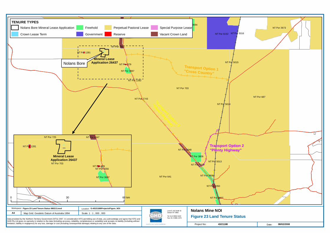
9.10 Land Tenure Pastoralism represents the major industry in the Burt Plain Bioregion. Thirty seven pastoral leases within or intersecting the boundary of the Burt Plain Bioregion occupy 82% of the land area (Neave et al. 2005). The subject site and the surrounding land are all described as NT Portions (refer Figure 23). The following NT Portions describe the land tenure:
Portion 725 Perpetual Pastoral Lease 1030 owned by Northern Territory Land Corporation
Portion 3253 Aboriginal Freehold and owned by Anyungyumba Aboriginal Corporation
Portion 4347 Vacant Crown land (NT Government)
Portion 3694 Freehold land, Table Grape Growers of Australia Pty Ltd
Portion 2427 Freehold land, Oolloo Farm Management Pty Ltd
Portion 1811 Australian Telecommunications Commission
Portion 6152 Govt set aside
Portion 2673 Perpetual Pastoral Lease 972, Robert Purvis
Portion 5016 Crown lease term 1877 AustralAsia Railway Corporation
Portion 687 PERPETUAL PASTORAL LEASE 1122 S and H Goldsworthy
Portion 5014 Crown lease term 1877, AustralAsia Railway Corporation
Portion 5015 Crown lease term 1877, AustralAsia Railway Corporation
Portion 703 Perpetual pastoral lease 1097 Waite River Holdings Pty Ltd as trustee for the Garry Dann Trust
Portion 1281 Reserve 134, Conservation Land Corporation
Portion 379 Reserve 1223, Crown land (NT Government)
Portion 4356
and 378 Freehold, Benregal Pty Ltd
Portion 3697 Freehold, Alyuem Aboriginal Corporation
Portion 1282 RESERVE 1343 Conservation Land Corporation

97Nolans Bore Mine Notice of Intent
Portion 1743 SPECIAL PURPOSES LEASE 535, Conservation Land Corporation (part of the land is within the Stuart Highway Road reservation)
Portion 1812 Freehold, Australian Telecommunications Commission
Portion 4348 Vacant Crown land (NT Government)
Portion 641 PERPETUAL PASTORAL LEASE 904, John Gorey
Portion 3809 Freehold, Mpweringe-Arnapipe (2) Aboriginal Land Trust
Portion 5013 CROWN LEASE TERM 1876 AustralAsia Railway Corporation
Portion 4349 Vacant Crown land
Portion 3888 Vacant Crown land
Portion 3808 Freehold, Mpweringe-Arnapipe (2) Aboriginal Land Trust
Portion 4350 Vacant Crown land
Portion 3807 Freehold, Mpweringe-Arnapipe (2) Aboriginal Land Trust
Portion 2706 Freehold, Injulkama Aboriginal Corporation
! ! ! ! ! ! ! !
!!
!
! ! ! ! ! ! ! ! !
!!
!!
!!
!!
!
!
!
!
!
!
!
!
!
!
!
!
!
!
!
! !!
!!
!!
!
!
!!
!!
!!
!!
!
!
!
!
!
!
!
!
!
!
!
!
!
!
!
!
!
!
!
!
_̂
NT Por 703
NT Por 641
NT Por 687
NT Por 725 NT Por 6152
NT Por 2673NT Por 3694
NT Por 3809
NT Por 4347
NT Por 3807
NT Por 3808
NT Por 3697
NT Por 4348
NT Por 5013
NT Por 5014
NT Por 4350
NT Por 4349
NT Por 2706
NT Por 5016
NT Por 5015
NT Por 1281
NT Por 379
NT Por 1743
NT Por 1282
NT Por 1811
#
Project No: Date:
A4
43/21188 08/02/2008
Workspace: Location:
Map Grid: Geodetic Datum of Australia 1994Level 5, 66 Smith StDarwin NT 0800
Tel: 61 8 8982 0100Fax: 61 3 8981 1075
G:43\21188\Projects\Figure_NOIFigure 23 Land Tenure Status 080213.mxd
Figure 23 Land Tenure StatusNolans Mine NOI
Data provided by the Northern Territory Government (NTG) 2007. In consideration NTG permitting use of data, you acknowledge and agree that NTG andGHD Pty Ltd gives no warranty in relation to the data (including accuracy, reliability, completeness or suitability) and accepts no liability (including withoutlimitation, liability in negligence) for any loss, damage or cost (including consequential damage) relating to any use of the data.
Scale: 1 : 1 , 000 , 000
Nolans Bore Mineral Lease Application
Crown Lease Term
Freehold
Government
Perpetual Pastoral Lease
Reserve
Special Purpose Lease
Vacant Crown Land
TENURE TYPES
0 30 6015 km
! ! ! ! ! !
!!
!!
!!
!
!!
!!
!!
!
_̂
NT Por 703
NT Por 725
NT Por 3697
NT Por 4347
NT Por 1281
NT Por 379NT Por 4356
Nolans BoreMineral Lease
Application 26437Transport Option 1"Cross Country"
Transport Option 2"Plenty Highway"
Transport Option 3
"Stuart Highway"Mineral Lease
Application 26437

99Nolans Bore Mine Notice of Intent
Social and Economic Context
This section provides an overview of the social context for the mine area. It is desk-based research.
Issues identified will be investigated in a Social Impact Assessment (SIA) or other specialist studies as recommended in the assessment process.
A more detailed description of the social setting in Appendix G includes:
Description of the Anmatjere Region;
Values of the Anmatjere Community Government Council;
A demographic overview; and
A review of community services and facilities in the Anmatjere region and surrounding areas.
9.10.1 Where People Live in Anmatjere CGC LGA
The Anmatjere Community Government Council Local Government Area (CGC LGA) is made up of a number of Aboriginal communities/homelands/outstations and pastoral stations (refer to Table 12 and Figure 24).
Table 12 Where People Live in Anmatjere CGC LGA
Name of Community/Pastoral Station Community Type
Alyuen (on Aileron Station) Minor Community
Anyungunba (on Pine Hill Station) Family Outstation
Engawala (on Alcoota Station) Minor Community
Laramba (on Napperby Station) Major Community
Nturiya (the western part of Ti Tree Station) Major Community
Pmara Jutunta (the central part of Ti Tree Station) Major Community
Ti Tree (the town of Ti Tree) Town
Wilora (on Stirling Station) Minor Community
Woolla (Adelaide Bore and the eastern part of Ti Tree Station) Family Outstation
Yanginj (on Anningie Station) Family Outstation
Aileron Station Pastoral Station.
Pine Hill Station3 Pastoral Station
Alcoota Station Pastoral Station
Napperby Station Pastoral Station
Ti Tree Station Pastoral Station
Stirling Station Pastoral Station
Anningie Station Pastoral Station
Reference: www.bushtel.nt.gov.au, accessed 12.09.2007, 2.00pm
3 has a registered Native Title Claim on it, refer to http://www.nntt.gov.au/applications/claimant/DC99_4.html (downloaded 28-08-
07)

_̂
_̂
_̂
_̂
_̂
_̂
_̂
_̂
_̂
_̂
_̂
_̂
STUART HIGHWAY
MT DENISON
SAN
DO
VER
HIG
HW
AY
PLENTY HIGHWAY
NAPPERBY
ADELAIDE BORE
TANAMI RO
AD
WILLOW
RA
DELM
ORE
DOW
NS
ANNINGIE/MT BARKLY
WAI
TE R
IVER
H/S
ALATYEYE
MT BARKLY
TI TREE-ARTARTINGA
CON
ISTON
AC
CES
S
Wilora
Alyuen
Wooolla
Yanginj
Ti TreeNturiya
Laramba
Engawala
Pmara Jutunta
Alcoota Station
Aileron Station
Pine Hill Station
#
Geodetic Datum of Australia 1994
Project No: Date:
A3
43/21188 09/11/2007
Workspace: Location:
Map Datum :
Figure 24 Anmentjere Local Government Region
G:43\21188\Projects\Figures_NOIFigure 24 Anmatjere Local Government Station.mxd
Nolans Bore NOILevel 5, 66 Smith StDarwin NT 0800
Tel: 61 8 8982 0100Fax: 61 3 8981 1075 Topographic data purchased from the Commonwealth of Australia, Geoscience Australia 2003. In consideration of the Commonwealth and NTG permit ting use of data, you acknowledge and agree that the Commonwealth, NTG, and GHD Pty Ltd gives no warranty in relation
to the data (including accuracy, reliability, completeness or suitability) and accepts no liability (including without limitation, liability in negligence) for any loss, damage or cost (including consequential damage) relating to any use of the data.
Scale: 1 : 600,000
© Commonwealth of Australia 2003 0 30 6015 km
¹

101Nolans Bore Mine Notice of Intent
The mine is likely to directly impact on the Aileron and Pine Hill Stations. Other pastoral stations and Aboriginal communities/homelands/outstations may also be impacted in some way. Environmental impacts and the impacts on people living and working on the Aileron and Pine Hill stations (both Aboriginal and non-Aboriginal) will be investigated during the specialist studies for the PER/EIA process.
The roadhouse at Aileron will be directly impacted as it is the proposed location for the construction and permanent mining camp for the mine maybe nearby. Impacts on the Aileron Roadhouse will be investigated in the social and economic impact assessments.
9.10.2 Community Services and Facilities
Local Government services are provided to the region by the Anmatjere Community Government Council.
People living in the Anmatjere Community Government Council area access goods and services at a number of locations as summarised in Table 13. Access to resources is by road, there is no rail and limited air travel4.
Table 13 Summary of Community Services and Facilities5
Service Centre Community Services and Facilities Available
Aileron Hotel and Roadhouse
Located 132 kilometres north of Alice Springs, basic goods and services (including fuel), accommodation
Ti Tree Road house (basic goods and services), arts centre, police station, primary school and primary health care facilities
Alice Springs Range of community services and facilities including a hospital, police, Commonwealth and Northern Territory Government departments, primary and secondary schools, university campus, variety of goods and services and domestic/general aviation airport
The Anmatjere Regional Development Plan 2002-2012 (no page number) states that the region lacks basic facilities, some of the housing stock needs repair or is inadequate, health services are limited and that there is a lack of adequate sewerage and reliable power in some areas. Roads to some of the present horticulture areas are not maintained by the Northern Territory Government, and will need to be upgraded to support the expansion of the industry.
The Anmatjere Region is in the Anmatjere Health Zone with health service provided under the Primary Health Care Access Program. Nursing staff located in Ti Tree provide health services to six communities on a visiting basis
Community services and facilities will need to be identified, and impacts and social impact management plans developed following the SIA.
4 There are some private airstrips on pastoral stations.
5 Table 13 is based on desk based and anecdotal evidence only and will be researched as part of the SIA.

102Nolans Bore Mine Notice of Intent
9.10.3 Economic Context
Pastoralism, tourism and horticulture are the main industries in the region. ACIL Tasman are undertaking an economic study of the region for Arafura Resources. This information will become available during the environmental approvals process.