Embed Size (px)
Citation preview
City of Los Angeles III-1 Loyola Marymount University Master Plan Project Draft EIRENV-2008-1342-EIR January 2010
III. GENERAL DESCRIPTION OF ENVIRONMENTALSETTING
Section 15125 of the California Environmental Quality Act (CEQA) Guidelines requires that an environmental
impact report (EIR) include a description of the existing environment. This section is intended to give a
general overview of the environmental setting for the proposed Loyola Marymount University Master
Plan Project. More detailed information on existing conditions as well as the regulatory framework
applicable to the Proposed Project is provided for each environmental topic studied in Section IV,
Environmental Impact Analysis. This section also provides an overview of related projects that are
considered as part of the future conditions in evaluating cumulative impacts.
1.0 OVERVIEW OF ENVIRONMENTAL SETTING
Project Site Location. The approximately 142-acre Loyola Marymount University campus (Proposed
Project site) is located in the West Los Angeles community of Westchester-Playa del Rey at 1 LMU Drive.
The campus is located adjacent to Lincoln Boulevard (SR-1), and approximately 1 mile from Manchester
Avenue (SR-42), 2 miles from the San Diego Freeway (I-405), and 2.3 miles from the Marina Freeway
(SR-90). Communities and municipalities surrounding Westchester-Playa del Rey include the
unincorporated community of Marina del Rey and the City of Los Angeles communities of Del Rey and
Venice to the north; Culver City and the unincorporated community of Ladera Heights to the northeast;
the City of Inglewood to the east, the City of El Segundo to the south; and the Pacific Ocean to the west.
Existing Land Uses. LMU’s Westchester campus was established in 1928 with the development of the
100-acre Burns Campus. The original Burns Campus expanded in the 1990s with the development of a
contiguous 27.5-acre property to the west now known as Leavey Campus. Leavey Campus extends from
Burns Campus to the bluff edge. LMU purchased the adjacent Hughes property, including the former
Hughes corporate headquarters, in 2000. Hughes Campus provides a physical link between Burns and
Leavey Campuses to the east and Lincoln Boulevard to the southwest and serves as the main LMU
entrance via LMU Drive from Lincoln Boulevard. The former Hughes headquarters building houses
several colleges and administrative offices and is now called University Hall.
At present, the campus is developed with approximately 1.65 million gross square feet of academic and
administrative uses, approximately 942,000 gross square feet of residential facilities, and approximately
185,000 gross square feet of indoor athletic uses. The campus also contains approximately 15.2 acres of
outdoor athletic facilities and more than 25 acres of landscaped open space. Parking for students, faculty,
staff, and visitors is provided in on-campus parking structures and surface lots containing approximately
4,100 spaces.
III. Environmental Setting
City of Los Angeles III-2 Loyola Marymount University Master Plan Project Draft EIRENV-2008-1342-EIR January 2010
Currently, LMU's enrollment cap, as approved by the City in 2000 with a conditional use permit
associated with the acquisition of Hughes Campus, is 7,800 full-time equivalent (FTE) students.1 In Fall
2008, LMU's actual enrollment was 6,868 FTE students. The Proposed Project proposes increasing the
existing enrollment from 6,868 FTE students to the previously approved cap of 7,800 FTE students, but
would not increase the area of the LMU campus.
As of Fall 2008, LMU employed approximately 1,484 FTE faculty and staff working on campus, some of
whom also live on campus.2
Surrounding Land Uses. As described above, the LMU campus is located in the West Los Angeles
community of Westchester. Westchester generally extends from the Pacific Ocean east to Inglewood and
from Ballona Creek on the north to the City of El Segundo and Los Angeles International Airport on the
south. Surrounding municipalities include the unincorporated community of Marina del Rey and the
City of Los Angeles communities of Venice and Del Rey to the north, the City of El Segundo to the south,
the City of Inglewood to the east, and the Pacific Ocean to the west. Other institutions of higher learning
in the area include Otis College of Art and Design on Lincoln Boulevard near Los Angeles International
Airport; the Graduate School of Pepperdine University in northeast Westchester; and Intercontinental
College in northern Westchester.
1.1 Aesthetics and Views, Shading, and Light and Glare
1.1.1 Aesthetics and Views
The approximately 142-acre LMU campus is located in the West Los Angeles community of Westchester,
which consists primarily of low-density to low-medium-density residential uses, with commercial uses
concentrated along the transit corridors of Lincoln Boulevard, Sepulveda Boulevard, Manchester Avenue,
and Century Boulevard. Most of the topography in Westchester is level except for the varied hillside
terrain located in the northwest and western portions where there are significant coastal bluffs. The
1 FTE is a unit of measurement used to calculate enrollment for academic and master planning purposes, asopposed to student headcount. One undergraduate FTE student is defined as one undergraduate student taking12 course units, which represents a full course load. Students taking fewer course units are considered toconstitute a fraction of an FTE student, whereas students taking more than 12 units constitute more than one FTEstudent. One graduate FTE student is defined as one graduate student taking 9 course units, which represents afull course load. Graduate students taking fewer course units are considered to constitute a fraction of an FTEstudent, whereas students taking more than 9 units constitute more than one FTE student.
2 One full-time staff member works 40 hours per week. Two part-time staff members working 20 hours per weekequals one full-time-equivalent staff person. A similar calculation is made for FTE faculty, except that due toreduced hours on Campus associated with a part-time faculty member, three part-time faculty members equalsone FTE faculty member.
III. Environmental Setting
City of Los Angeles III-3 Loyola Marymount University Master Plan Project Draft EIRENV-2008-1342-EIR January 2010
bluffs, which rise approximately 120 feet above sea level in the vicinity of the campus, form the northern
and western campus boundaries.
The LMU campus is considered suburban because of its location amidst predominantly residential
neighborhoods. The campus is bordered on the north and west, at the foot of the Westchester Bluffs, by
Teale Street/Bluff Creek Drive and Playa Vista, a mixed-use multi-family residential and community
commercial development less than 10 feet above sea level. The campus is bordered on the south and east
by low-medium density single-family residential neighborhoods.
The original 100-acre campus has historically been referred to as Burns Campus. Burns Campus, founded
in 1929 and developed with buildings of varying ages and architectural styles, is situated on a relatively
flat plateau above the Westchester Bluffs at a higher elevation than Hughes and Leavey Campuses. Burns
Campus is characterized by a collection of academic buildings arrayed along a formal axis (Alumni Mall)
and cross-axis (the Sunken Garden and pedestrian walkways) that frame views of the Los Angeles Basin
to the north and the Santa Monica Bay to the west.
In 1983, LMU added Leavey Campus, a contiguous 27.5-acre property extending from Burns Campus
west to the bluff edge. Leavey Campus is developed with student housing built after 1992 and surface
parking, as well as a parking structure set into the hillside below Burns Campus. The student residence
halls are grouped informally and linked by pedestrian walkways and landscaped open space. Leavey
Campus offers panoramic views over the Los Angeles Basin to the west and north.
In 2000, LMU purchased the adjacent Hughes corporate headquarters property, now referred to as
Hughes Campus. Hughes Campus provides a physical link between Burns and Leavey Campuses to the
east and Lincoln Boulevard to the west and serves as the primary campus entrance. Hughes Campus sits
at a lower elevation than Leavey and Burns Campuses and the adjacent residential neighborhoods to the
east. It is developed with the three-story University Hall and associated subterranean parking, both set
into the hillside below adjacent Leavey Campus. LMU Drive and a pedestrian bridge connect Hughes
Campus with Leavey Campus to the northwest.
Burns Campus has no height limit. Some of the tallest buildings on Burns Campus include Sacred Heart
Chapel, with a height of approximately 51 feet to the roof, and the Chapel Tower associated with the
Sacred Heart Chapel, with a height of approximately 135 feet. Development on Leavey Campus is limited
to 75 feet in height above finished grade. Development on Hughes Campus is limited to a height of
139 feet above mean sea level, to remain below the ground elevation of the residential neighborhood to
the southeast.
III. Environmental Setting
City of Los Angeles III-4 Loyola Marymount University Master Plan Project Draft EIRENV-2008-1342-EIR January 2010
Key visual resources in the Proposed Project area, in addition to the LMU campus itself, include the
Westchester Bluffs, Marina del Rey Channel and Santa Monica Bay, the Westside and Los Angeles
cityscapes, and Santa Monica Mountains. Because the campus and adjacent residential neighborhoods sit
atop the Westchester Bluffs, long-range panoramic views of these resources are available from LMU’s
campus and off-site vantage points adjacent to the campus.
1.1.2 Shading
As a result of the latitude of Los Angeles, buildings and structures cast relatively short shadows to the
west and east at the height of summer, the summer solstice (June 21), when the sun is nearly directly
overhead. The longest shadows are cast to the northwest, north and northeast around the winter solstice
(December 21), when the sun is at its lowest point in the sky. Shadows are intermediate in length during
the spring and fall equinoxes (March 21 and September 21). Buildings and structures do not cast shadows
to the south in this region.
Shade-sensitive uses in proximity to the LMU campus include single-family residences bordering Burns
Campus to the east, south, and southwest (along Fordham Road); single-family residences south of
Leavey Campus; and LAUSD’s planned Playa Vista Elementary School as well as multi-family residences
and recreational uses in the Playa Vista community, northwest of the LMU campus at the base of the
Westchester Bluffs.
The LMU campus varies in elevation relative to surrounding land uses, with Burns Campus at
approximately the same elevation as off-site residential uses to the east and south; Leavey Campus
elevated above Playa Vista because of its location atop the bluffs, and at the same elevation as residential
land uses to the south; and Hughes Campus at a lower elevation than residential land uses to the
southeast and slightly elevated above Playa Vista to the northwest.
At the summer solstice, shadows are cast to the west by LMU campus buildings and structures in the
morning, but remain confined to the campus. No shadows are cast off site west of Burns Campus, since
the southwest portion of Burns Campus is developed with surface parking, athletic fields, and one-story
buildings.
At the winter solstice, shadows are cast to the west by campus buildings and structures at the western
edge of Burns and Leavey Campuses, projecting across the bluffs and into portions of Playa Vista, but
shadows retreat onto campus by midmorning. No single-family residences west of Burns Campus are
shaded. Shadow projections are minimized by noon and confined to the campus as they begin to project
eastward during the early afternoon. By midafternoon, shadows are projected to the northeast, but
remain on LMU’s campus.
III. Environmental Setting
City of Los Angeles III-5 Loyola Marymount University Master Plan Project Draft EIRENV-2008-1342-EIR January 2010
1.1.3 Light and Glare
The highest ambient light levels in the LMU campus vicinity are along Jefferson Boulevard and within
Playa Vista to the west and along Lincoln Boulevard to the south. Residential streets to the east, south,
and southwest of the LMU campus exhibit relatively low ambient nighttime light levels.
Existing sources of nighttime illumination on the LMU campus include interior campus roadway
lighting; parking lot lighting; lighted pedestrian walkways; exterior building security lighting and visible
illumination of building interiors; and very limited lighting for outdoor athletic facilities in the southern
portion of Burns Campus. With the exception of the Tennis Center and University Pool, LMU’s outdoor
athletic facilities are currently not lighted after dark. Nighttime light levels on the campus are comparable
to those within the adjacent residential neighborhoods.
Sensitive receptors to light and glare in the vicinity of the LMU campus include the single-family homes
east of Burns Campus; single-family residences south of Burns Campus across W. 80th Street; single-
family residences in the neighborhood west of Burns Campus, south of Leavey Campus, and southeast of
Hughes Campus (bounded by Fordham Road, W. 78th Street, and Altavan Road); single-family homes in
West Bluffs south of Lincoln Boulevard; and LAUSD’s planned Playa Vista Elementary School, as well as
multi-family residences in the Playa Vista community, northwest of the campus at the base of the
Westchester Bluffs. There are no hotels, hospitals, or other light-sensitive non-residential uses in the
immediate vicinity of LMU’s campus.
1.2 Air Quality and Climate Change
1.2.1 Air Quality
The Proposed Project site is located within the approximately 6,600-square-mile South Coast Air Basin.
The Basin encompasses all or portions of four counties, including all of Orange County and the western,
non-desert portions of Los Angeles, San Bernardino and Riverside Counties.
A semi-permanent, high-pressure cell over the northern Pacific Ocean is the primary climatological
influence on the Basin, as is the ocean, which moderates the local climate by functioning as a large heat
reservoir. As a result of these influences, warm summers, mild winters, infrequent rainfall and moderate
humidity typify climatic conditions through most of the Basin. These meteorological conditions, in
combination with regional topography, are also conducive to the formation and retention of ozone (O3).
The annual average relative humidity is 71 percent along the coast and 59 percent inland. Because the
ocean effect is dominant, periods of heavy early morning fog are frequent and low stratus clouds are a
characteristic feature. These effects decrease with distance from the coast.
III. Environmental Setting
City of Los Angeles III-6 Loyola Marymount University Master Plan Project Draft EIRENV-2008-1342-EIR January 2010
In the immediate Project vicinity, climatic conditions are characterized by mild summers, mild winters,
infrequent rainfall, moderate afternoon breezes and generally fair weather. Average annual temperature
ranges from the low- to mid-60s°F. Summer daytime temperatures often reach over 77°F, and winter
daytime temperatures often drop below 48°F. Due to its proximity to the coast, temperatures in the
Project vicinity are on average lower than further inland due to the moderating effect of the ocean. This
microclimate is influenced by a marine layer that is characterized by fog or low stratus clouds. Average
rainfall at Los Angeles International Airport, located within 1 mile of the Project site, is approximately
12.5 inches per year.
Health-based air quality standards have been established by California and the federal government for
seven “criteria” air pollutants: O3 (ozone), CO (carbon monoxide), NO2, (nitrogen dioxide), SO2 (sulfur
dioxide), PM10 (respirable particulate matter), PM2.5 (fine particulate matter), and lead. These standards
were established to protect sensitive receptors from adverse health impacts due to air pollution.
California standards are more stringent than the federal standards, and the state has also established
standards for sulfates, visibility-reducing particles, hydrogen sulfide, and vinyl chloride. The Basin is
currently designated as nonattainment for O3, PM10, and PM2.5. These violations are largely due to
automotive vehicle emissions in the region.
Air pollutants within the Basin are generated by stationary and mobile sources. Stationary sources
include “point sources,” referring to one or more emission sources at a single facility, and “area sources,”
which are widely distributed and produce many small emissions. Point sources are usually associated
with manufacturing and industrial uses; examples of “area sources” include residential water heaters,
lawn mowers, and consumer products, such as barbecue lighter fluid or hair spray. “Mobile sources”
refer to operational and evaporative emissions from motor vehicles. Automotive vehicle emissions are
largely responsible for the Basin’s nonattainment status for the three criteria pollutants noted above.
Certain populations, including children, the elderly, and acutely and chronically ill persons, especially
those with compromised respiratory abilities, are considered particularly sensitive to air pollution. The
South Coast Air Quality Management District (SCAQMD) defines sensitive receptors as persons or
facilities housing persons that could be exposed to pollutants for an extended duration (1 hour, 8 hours,
or 24 hours, depending on the pollutant in question). Accordingly, residences, schools, and hospitals are
considered sensitive receptors. Sensitive receptors in the vicinity of LMU’s campus include the residential
neighborhoods to the east, south, and west; LAUSD’s planned Playa Vista Elementary School just west of
the campus; and several other nearby schools (within approximately 0.5 mile).
III. Environmental Setting
City of Los Angeles III-7 Loyola Marymount University Master Plan Project Draft EIRENV-2008-1342-EIR January 2010
1.2.2 Climate Change
Global climate change refers to any significant change in climate measurements, such as temperature,
precipitation, or wind, lasting for an extended period (i.e., decades or longer). Climate change may result
from natural factors, such as changes in the sun’s intensity, natural processes within the climate system
(e.g., changes in ocean circulation), and human activities that change the atmosphere’s composition (e.g.,
through burning fossil fuels) and the land surface (e.g., deforestation).
The primary effect of global climate change has been a rise in the average temperature of the global
troposphere (i.e., the bottom layer of the atmosphere) of 0.2° Celsius per decade. Climate change
modeling shows that further warming is likely to occur, inducing further changes in the global climate
system. Effects of global climate change on California could include dramatically declining Sierra
snowpack levels, which account for approximately half of the surface water storage in California;
increased ozone formation in Southern California and the San Joaquin Valley; increased erosion of
California’s coastlines and sea water intrusion into the Sacramento and San Joaquin Delta and levee
systems; increased pest infestation and forest fires; and increased demand for electricity due to rising
temperatures.
The natural process through which heat is retained in the troposphere is called the “greenhouse effect.”
The greenhouse effect traps heat in the troposphere through the absorption of the Sun’s light, or
short-wave radiation, by Earth, in the form of heat; re-emission of this heat, or long-wave radiation, by
Earth; and absorption and trapping of this heat by greenhouse gases in the upper atmosphere, which then
send it back to Earth and into space. This third process, the absorption of heat by greenhouse gases, is the
focus of current climate change actions.
While water vapor and CO2 are the most abundant greenhouse gases, other trace GHGs have a greater
ability to absorb and re-radiate long-wave radiation. For this reason, gases with high potential for
absorption and re-emission of heat have been identified and are subject to federal and State regulation.
The United States was the number two producer of global greenhouse gas emissions as of 2005, and
California ranks second in the United States for greenhouse gas emissions, behind Texas. As a result,
California defines and regulates the following greenhouse gases: carbon dioxide (CO2), methane (CH4),
nitrous oxide (N2O), hydrofluorocarbons (HFCs), perfluorocarbons (PFCs), and sulfur hexafluoride (SF6).
The primary contributors to California’s greenhouse gas emissions are transportation, electric power
production in-state and out-of-state, industry, agriculture and forestry, and other sources including
commercial and residential activities.
III. Environmental Setting
City of Los Angeles III-8 Loyola Marymount University Master Plan Project Draft EIRENV-2008-1342-EIR January 2010
1.3 Biological Resources
The LMU campus occupies approximately 142 acres atop the Westchester Bluffs. The bluffs rise
approximately 120 feet above sea level in the vicinity of campus and form the northern and northwestern
campus boundaries. Topography on the campus is varied, with sloped areas and level plateaus. The
campus is suburban in nature and surrounded by single-family residential neighborhoods to the east,
west, and south.
The campus encompasses more than 25 acres of open space, including 10 acres along the bluff face. The
majority of open space on LMU’s campus is landscaped with ornamental plantings installed since the
campus was first established. The bluff slope is highly disturbed, crossed by a fire road along its face, and
vegetated primarily with invasive, non-native ground cover, such as ice plant, shrubs, and pine and palm
trees. Some remnant coastal sage scrub elements are scattered throughout the bluffs. The open space in
the campus interior is more formally landscaped and includes turf and ornamental shrubs and trees.
There are no surface streams or water bodies on LMU’s campus, with the exception of a small sump
south of Drollinger Parking Plaza on Leavey Campus, which operates as an element of the campus storm-
drain system.
Two tree species protected under the Los Angeles Municipal Code (Sections 46.00 to 46.06, Protected Tree
Regulations, Ordinance Number 177,404) are present on LMU’s campus: coast live oak (Quercus agrifolia)
and western sycamore (Platanus racemosa).
Several special status wildlife species have been observed and reported north of the LMU campus, at the
bottom of the bluffs in the riparian corridor and freshwater marsh habitat on and near the Playa Vista
site, but no habitat for most of the species in question exists on LMU’s campus. The only special status
wildlife species reported on the LMU campus is the monarch butterfly (Danaus plexippus), which appear
to occur only as migratory transient individuals on the campus. Some potential nesting habitat exists for a
variety of protected bird species within trees, shrubs, and ground cover within the campus, but otherwise
the campus does not contain or serve as link between wildlife movement corridors.
III. Environmental Setting
City of Los Angeles III-9 Loyola Marymount University Master Plan Project Draft EIRENV-2008-1342-EIR January 2010
1.4 Cultural Resources: Paleontological Resources, Archaeological Resources, and Historical
Resources
1.4.1 Paleontological Resources
Paleontological resources include fossil remains, the respective fossil sites, associated specimen data and
corresponding geologic and geographic site data, and the fossil-bearing strata. Paleontological resources
also include rock units that underlie the ground surface and have a potential for yielding particular types
of fossil remains because they have yielded similar remains at previously recorded sites in the area. A
fossil specimen in good condition is considered scientifically important if it can be accurately dated, is
useful in environmental reconstruction, represents a “type specimen” (i.e., a specimen sufficient to serve
as an objective standard of reference for a species), is a member of a rare species or is part of a diverse
assemblage, and/or is a more complete specimen of a given species than others already collected. The
rock units on LMU’s campus were evaluated to determine if they were of high, medium, low, or no
paleontological importance, based on their potential to yield scientifically important fossils.
The LMU campus is underlain by two Quaternary rock units: undifferentiated Palos Verdes Sand and
overlying non-marine terrace cover; and Holocene dune sand. (A former ravine in the northeastern
corner of campus contains fill and is developed with Parking Lot H.)
The undifferentiated Palos Verdes Sand and non-marine terrace cover rock unit is considered
paleontologically highly productive and scientifically important. There are small areas of undifferentiated
Palos Verdes Sand and non-marine terrace cover found in the northeastern and northwestern corners of
the LMU campus at varying depths below the surface. Both are exposed at varying elevations below the
top of the bluffs that form the northern and western edges of the campus. There are no documented
records of fossil sites in these rock units on the LMU campus, but several fossil sites are recorded in Palos
Verdes Sand along the upper part of the bluff face less than 0.2 mile from the campus, and have yielded a
variety of fossils.
Holocene dune sand is exposed at the surface throughout the campus and overlies undifferentiated Palos
Verdes Sand and terrace cover rock units, which are, as previously stated, buried at varying depths below
the surface. There are no recorded fossil sites within the dune sand rock unit on or near the campus, and
it is likely too young to contain remains old enough to be considered fossilized. For these reasons, dune
sand is considered to be of low paleontological productivity and, therefore, of low scientific importance.
III. Environmental Setting
City of Los Angeles III-10 Loyola Marymount University Master Plan Project Draft EIRENV-2008-1342-EIR January 2010
1.4.2 Archaeological Resources
The LMU campus is located at the edge of the Westchester Bluffs above a once extensive estuary, the
Ballona Wetlands, adjacent to Santa Monica Bay. The wetlands served as the mouth of the Los Angeles
River throughout much of prehistory. A rich marsh existed at the base of the bluffs beginning
approximately 18,000 years ago until approximately 5,000 years ago. Humans first appeared in the area
approximately 8,000 years ago (during the Millingstone period) and are believed to have occupied sites in
the Proposed Project area, primarily along the blufftops, on a mobile, seasonal basis. Between 3,000 and
1,000 years ago (the Intermediate period), humans are thought to have occupied more structured,
developed settlements, also on the blufftops. During the Late period of prehistoric settlement of the area,
beginning approximately 1,000 years ago, the population grew dramatically; there are more sites from
this period along the coast than at any other time in history. It is thought that the population in the
Proposed Project area was concentrated during this period in one large settlement at the base of the
bluffs.
There are three recorded archaeological sites on LMU’s campus. CA-LAN-61 is located primarily on
Leavey Campus and may extend onto Burns Campus. CA-LAN-212 is located on Burns Campus.
CA-LAN-1018 is located on Leavey Campus. CA-LAN-61 was first identified by a local resident in 1936
and was later documented in 1939; the site once contained a large number of artifacts on the surface as a
result of plowing, but the artifacts were collected by locals over the years. The site underwent formal
evaluation and subsequent data recovery in the 1980s in advance of planned construction by the Hughes
Aircraft Company. It is thought that the primary occupation of the site occurred during the Intermediate
period (3000–1000 B.P.). CA-LAN-212 was first documented in 1953 and was described as a small
(presumably) prehistoric site; it is likely that this site dates to roughly the same time period as LAN-61.
CA-LAN-1018 was first documented by a local resident in 1936 and formally recorded in 1979; it was
described as a shell midden on a terrace containing historical-period artifacts, but may instead be a
naturally occurring Pleistocene-era shell deposit.
1.4.3 Historical Resources
LMU’s Westchester Campus was founded in 1928, when real estate developer Harry Culver offered
Loyola College approximately 100 acres of land on a high bluff overlooking the Pacific Ocean, which
became Burns Campus. Loyola College broke ground on May 20, 1928.
Original architectural plans developed by Thomas Franklin Power proposed Tudor-Gothic Revival
building styles and a north-south central spine traversing the campus. A new 1928 plan by architect
David Elms Graham proposed Spanish-Colonial revival building styles. Construction of the first two
III. Environmental Setting
City of Los Angeles III-11 Loyola Marymount University Master Plan Project Draft EIRENV-2008-1342-EIR January 2010
buildings on campus was completed in 1929, in the northwestern corner of Burns Campus: Xavier Hall
contained administrative offices and housing for the resident Jesuit community, and St. Robert’s Hall
contained classrooms and lecture halls. The hillside letter “L” located on the bluff face below Xavier Hall
also was constructed in 1929. In 1930, Loyola College achieved university status and become known as
Loyola University.
The 1929 stock market crash and subsequent Depression curtailed Loyola University’s initial building
program. By 1950, much of the original 1928 Campus plan had been abandoned, but a defining feature of
that plan was realized when Sacred Heart Chapel was constructed in 1953 and became the terminus and
focal point of the Campus’s central spine first envisioned in 1928. It also provided an appropriate location
to hold religious services.
In 1954, a new plan for the campus was developed by San Francisco landscape architect and planner
Prentiss French. French’s plan reinforced the original plan’s symmetrical, cross-axial orientation of the
campus and reconciled vehicle and pedestrian circulation and parking. French designed the Sunken
Garden south of Sacred Heart Chapel and Regent’s Terrace, a raised plaza marking the transition from
the Sunken Garden to the central spine that would later become known as the Alumni Mall. In 1956, the
Los Angeles architectural firm A.C. Martin and Associates was retained to assist Loyola University with
building out its master plan. A.C. Martin and Associates was instrumental in establishing modern Los
Angeles after World War II and designed some of the first modern high-rise buildings in downtown Los
Angeles. The firm designed six buildings for Loyola University between 1958 and 1965 in locations
defined in French’s master plan; the buildings were designed in the modernist architectural styles
characteristic of the mid-twentieth century.
In 1967, Loyola University and Marymount College, a women’s college founded in Westwood in 1923,
announced a cooperative agreement whereby Marymount College would relocate to Loyola University’s
Campus and both institutions would share faculty and facilities. In 1973, after five years of affiliation and
shared resources, Loyola University and Marymount College announced a merger to form a single
institution, Loyola Marymount University.
In 1983, LMU purchased 27.5-acre Leavey Campus, west of Burns Campus. The 1990s ushered in a period
of significant campus expansion and construction, including the development of Leavey Campus with
student housing, Drollinger Parking Plaza, and Leavey intramural field on Drollinger’s roof deck. The
Jesuit Community Residences and Burns Recreation Center also were constructed on Burns Campus.
III. Environmental Setting
City of Los Angeles III-12 Loyola Marymount University Master Plan Project Draft EIRENV-2008-1342-EIR January 2010
In 2000, LMU acquired the adjacent Hughes Campus, which included a vacant office building originally
constructed in 1985 to serve as the headquarters of the Hughes Electronics Corporation.3 The building
was converted for academic and administrative purposes and renamed University Hall by LMU. The
acquisition of Hughes Campus allowed LMU to link Leavey and Burns Campuses with a new main
entrance to Lincoln Boulevard.
1.5 Geology
The approximately 142-acre LMU campus is located atop the Westchester Bluffs (also known as the
Ballona Escarpment), overlooking the Ballona Plain. The campus is bounded by the bluffs on the north
and northwest, by W. 78th and W. 80th Streets on the south, by Lincoln Boulevard on the southwest and
west, and by McConnell Avenue on the east. The campus is approximately 66 feet above mean sea level
at the LMU Drive entrance at Lincoln Boulevard, rising to approximately 120 feet above mean sea level
along the bluff edge in the northeastern corner of campus and approximately 150 feet above mean sea
level on Burns Campus. Bluff slopes forming the campus’s northern and northwestern edges range from
approximately 0.5:1 to 3:1 (horizontal:vertical). The bluff face has been locally modified by construction of
a road and a trunk sewer line beneath the road, just off campus, but is otherwise undeveloped. There are
no unique geologic features such as hilltops, ridges, hill slopes, canyons, ravines, rock outcrops, water
bodies, streambeds, or wetlands within the developed areas of the campus.
The campus is underlain by late Pleistocene dune sand deposits that extend to depths of 50 to 90 feet
below the surface. These materials generally consist of dense, poorly graded sand and silty sand. The
dune sand deposits are underlain by the Pleistocene-age Lakewood formation deposits consisting of
sand, silt, and gravel. Artificial fill of variable thickness also is locally present throughout the campus as
the result of past grading activities for existing campus improvements.
Groundwater is estimated to be approximately 10 to 23 feet above mean sea level in the campus vicinity,
and is therefore at least 50 feet below the ground surface of the vast majority of the campus.
3 Historic Resources Group, LLC, Historical Resources Assessment: Loyola-Marymount University, (2009);“Completion Nearing on Hughes Headquarters” Los Angeles Times, Los Angeles County Edition, September 15,1985; Ramos, Georg,. “School With a View: Loyola Marymount remakes the bluff-top former world headquartersof Hughes Aircraft”, Los Angeles Times, Los Angeles County Edition, January 22, 2001.
III. Environmental Setting
City of Los Angeles III-13 Loyola Marymount University Master Plan Project Draft EIRENV-2008-1342-EIR January 2010
1.6 Hazards
Hazardous materials are generally defined as chemicals capable of causing harm during an accidental
release or mishap, and are characterized as being toxic, corrosive, flammable, reactive, an irritant or
strong sensitizer. Exposure to a hazardous substance can occur through the natural or accidental emission
of air toxics or through discharges to soil, groundwater, or surface water. Hazardous substances are
defined and listed in various federal and state laws and regulations, including, but not limited to, the
Resource Conservation and Recovery Act (Title 40 of the Code of Federal Regulations), which identifies
hazardous substances and hazardous waste.
A number of existing uses and operations on the LMU campus regularly store, transport, use and/or
dispose of hazardous materials, including chemicals handled in science laboratories, cleaning products,
paints, oil, and other materials necessary to support campus operations. A comprehensive inventory of
all hazardous substances in use on the campus is maintained by the LMU Environmental Health and
Safety Department.
There are five 400-gallon tanks used to store heating oil on the campus. One tank is above ground and
four tanks are below ground within concrete bunkers. All tanks are adequately sealed and no leaks or
other safety infractions have occurred. Buildings of any age on LMU’s campus have the potential to
contain asbestos-containing materials, and may also include lead-based paint and polychlorinated
biphenyls (PCBs) in certain types of electrical equipment.
The entire LMU campus is mapped as being within either a Methane Zone or Methane Buffer Zone, as
designated by the Los Angeles Department of Building and Safety. A recent investigation did not detect
elevated levels of methane gas on the LMU campus. The campus is located approximately 0.5 mile east of
the Playa del Rey Oil Field, which was operational until the 1940s and is presently used as a reservoir for
natural gas storage by The Gas Company.
The Department of Toxic Substances Control has indicated that an abandoned oil well is located on
Lincoln Boulevard approximately 1,000 feet northwest of the campus. A second oil well is located on
Denrock Avenue slightly more than 1,000 feet east of the northeastern campus boundary. Based upon
review of field maps prepared by the California Department of Conservation, Division of Oil, Gas, and
Geothermal Resources, this oil well was determined to be approximately 1,000 feet northwest of the
northwestern corner of campus.
III. Environmental Setting
City of Los Angeles III-14 Loyola Marymount University Master Plan Project Draft EIRENV-2008-1342-EIR January 2010
1.7 Surface Water Hydrology and Water Quality
The LMU campus comprises three distinct watersheds or drainage areas. The first watershed generally
encompasses the southeast corner of Burns Campus, including Sullivan Field, the baseball and softball
fields, the tennis courts, and the area north of the tennis courts, and discharges into the McConnell
Avenue Storm Drain at the southeast corner of Burns Campus. The second watershed encompasses the
remainder of Burns Campus and discharges via a storm drain pipe at the campus’ northeast corner into
Playa Vista’s Riparian Corridor, a vegetated stormwater conveyance and flood control channel at the base
of the Westchester Bluffs. The third watershed encompasses all of Hughes and Leavey Campuses and
also discharges into the Riparian Corridor via a storm drain pipe west of LMU Drive. Stormwater runoff
is conveyed by an on-campus storm drain system consisting of roof drains, area drains, gutters, catch
basins, and storm drain pipes.
Existing impervious surface area (i.e., developed or paved area) on campus totals approximately 88 acres
or 62 percent of the 142-acre campus and includes roads, walkways, and residential, academic,
administrative, and athletic facilities. The remaining 54 acres, or 38 percent, of the campus is considered
pervious, and includes lawns, athletic fields, landscaped areas, and a small stormwater collection and
flood control sump.
1.8 Land Use
The LMU campus is located within the Westchester community of the City of Los Angeles,
approximately 1.25 miles east of the Pacific Ocean and 1 mile north of Los Angeles International Airport
(LAX). Surrounding communities and municipalities include the unincorporated community of Marina
del Rey and the City of Los Angeles communities of Venice and Del Rey to the north, the City of Culver
City and the unincorporated community of Ladera Heights to the northeast, the City of Inglewood to the
east, the City of El Segundo to the south, and the Pacific Ocean to the west. Other institutions of higher
learning in the area include Otis College of Art and Design on Lincoln Boulevard near Los Angeles
International Airport; the Graduate School of Pepperdine University in northeast Westchester; and
Intercontinental College in northern Westchester. Regional access to the campus is provided by the San
Diego Freeway (I-405), the Marina Freeway/Expressway (State Highway 90), and Lincoln Boulevard
(State Highway 1). The San Diego Freeway/Marina Freeway interchange is approximately 2 miles
northeast of the campus.
The campus is generally bordered on the east by McConnell Avenue, on the southwest by Lincoln
Boulevard, and on the south by W. 78th and W. 80th Streets. The campus is suburban in nature and
surrounded by low-density, single-family residential neighborhoods to the east, west, and south.

III. Environmental Setting
City of Los Angeles III-15 Loyola Marymount University Master Plan Project Draft EIRENV-2008-1342-EIR January 2010
The campus is currently developed with approximately 1.65 million gross square feet of academic and
administrative uses and approximately 942,000 gross square feet of residential facilities. The campus also
contains approximately 185,000 gross square feet of indoor athletic uses and approximately 15.2 acres of
outdoor athletic facilities. Parking for students, faculty, staff, and visitors is provided in on-campus
parking structures and surface lots containing approximately 4,100 spaces.
Land uses on the campus are governed by the City of Los Angeles Zoning Ordinance and the City of Los
Angeles General Plan, including the Westchester-Playa del Rey Community Plan. The LMU campus is
designated “L” (Low Density Residential) in the Westchester-Playa del Rey Community Plan, as are the
neighborhoods surrounding the campus to the west, south, and east. The area north and northwest of the
campus, at the base of the Westchester Bluffs, is contained in the Playa Vista Area D Specific Plan and is
designated for a mix of uses including Commercial (Regional Mixed Use Commercial and Community
Commercial), High-Medium Density Multi-Family, and Industrial. The campus is also zoned [Q]R4-1,
(Residential – Multiple Dwelling Zone, Height District 1). The R4 zoning designation, according to the
Los Angeles Municipal Code, allows education institutions as well as multi-family residences,
dormitories, sorority/fraternity houses, churches, hotels, and other uses; however, these uses are limited
by the [Q] Qualified Conditions that apply to Burns, Leavey, and Hughes Campuses and are intended to
ensure compatibility with surrounding uses. The R4 zone normally corresponds to the High-Medium
Density Residential land use designation under the General Plan. However, LMU’s existing land use
designation is Low Density Residential, which the City has previously found to be consistent with the
campus’ R4 zoning due to the land use limitation of the campus’ [Q] Qualified Conditions,
1.9 Noise
Noise is defined as unwanted sound and is considered undesirable when it interferes with normal
activities, causes actual physical harm, or has an adverse effect on health. Noise is measured on a
logarithmic scale of sound pressure known as a decibel (dB). In response to the human ear’s sensitivity or
lack thereof to different frequencies, the A-weighted noise level, referenced in units of dB(A), was
developed to better correspond to the subjective human judgment of sound levels. Noise sources take
two forms: (1) point sources, such as stationary equipment or individual motor vehicles; and (2) line
sources, such as a roadway with a large number of mobile point sources (motor vehicles). Sound
generated by a stationary point source typically diminishes (attenuates) at a rate of 6 dB(A) for each
doubling of distance from the source to the receptor at acoustically “hard” (paved or developed with
hard surfaces) sites, and at a rate of 7.5 dB(A) at acoustically “soft” sites (such as landscaped areas).
Vibration is noise that is carried through structures and the earth (groundborne), instead of through the
air. Vibration is generally felt rather than heard.
III. Environmental Setting
City of Los Angeles III-16 Loyola Marymount University Master Plan Project Draft EIRENV-2008-1342-EIR January 2010
Plans and policies pertaining to noise conditions include State of California, Department of Health
Services, Environmental Health Division Guidelines for Noise and Land Use Compatibility, the City of
Los Angeles General Plan, the City of Los Angeles Municipal Code (LAMC), and the City of Los Angeles
Community Noise Equivalent Level (CNEL) Guidelines for specific land uses, which measure
A-weighted sounds levels over a 24-hour period.
Sources of noise on LMU’s campus include outdoor athletic recreational activities, which are
concentrated in the southern portion of Burns Campus; outdoor ceremonies and concerts, typically held
in athletic facilities as well as in the Sunken Garden in the north end of Burns Campus; surface parking
lot use; the operation of equipment in Facilities Management shops along the eastern edge of Burns
Campus; the operation of landscaping maintenance equipment throughout landscaped campus open
space; the operation of rooftop, cooling, and ventilation (HVAC) equipment throughout the campus; and
waste collection and other regular maintenance and operation of the campus.
The primary off-site sources of noise in the Proposed Project area are neighboring residential land uses
and traffic along Lincoln Boulevard, southwest of the campus. Current noise levels along the campus
boundary range from 56 dB(A) to 63.5 dB(A) CNEL. Because of LMU’s proximity to LAX (the airport is
approximately 1 mile south of the campus), planes passing overhead on approach or departure also
contribute to the ambient noise environment.
Sensitive noise receptors in the immediate vicinity of the campus include single-family residences in the
McConnell Avenue residential neighborhood that abuts Burns Campus to the east; single-family
residences to the south and southeast of the campus in the W. 78th Street/Fordham Road residential
neighborhood; and multifamily residential uses in Playa Vista community north and west of the campus.
The closest Playa Vista residential uses are located approximately 300 feet northwest of LMU's campus.
1.10 Public Services: Police Protection, Fire Protection and Emergency Medical Services,
and Recreation and Parks
1.10.1 Police Protection
The Los Angeles Police Department (LAPD) is divided into four geographic bureaus: (Central, West,
Valley, and South) and 23 divisions. The LMU campus is located within the Pacific Division (also called
the Pacific Area) of the West Bureau within Reporting District 1474. The Pacific Division covers
25.47 square miles and includes over 200,000 residents. Its boundaries are the Los Angeles/Santa Monica
City boundary and the Santa Monica Freeway (I-10) to the north, the Los Angeles City boundary to the
south and east, and the Pacific Ocean to the west. Reporting District 1474 extends from the former City of
III. Environmental Setting
City of Los Angeles III-17 Loyola Marymount University Master Plan Project Draft EIRENV-2008-1342-EIR January 2010
Los Angeles boundary along the Westchester Bluffs to the north to Manchester Avenue on the south, and
from Georgetown Avenue on the east to Lincoln Boulevard to the west.
The Pacific Community Police Station (Pacific Station), the closest station to the Project site, is located at
12312 Culver Boulevard, which is approximately 3 miles from the Project site. In the Pacific Division,
there were 292 patrol officers for 239,079 residents in 2007. This translates to 1.22 patrol officers per 1,000
residents. Although the Los Angeles Police Department does not have an established goal for response
times to emergency calls, the Citywide average response time in 2007 was 6.9 minutes and the Pacific
Division’s average response time was approximately 7.5 minutes.
The LMU Department of Public Safety provides first-response police protection services for the LMU
campus. The Department of Public Safety has a full-service Campus Security Services Department
operating 24 hours a day, 365 days a year, and employs a Chief, a Deputy Chief, four Captains or
Managers of Public Safety, and six Lieutenants who serve as patrol watch commanders and shift
supervisors. As of January 2009, the Department of Public Safety employs a number of security officers
who conduct foot and vehicle patrols of the campus and assist students, faculty, and staff with residence
hall and office access. The Department of Public Safety also employs LMU students who assist the staff
with routine office functions and serve as after-hours campus escorts.
1.10.2 Fire Protection and Emergency Medical Services
Fire prevention, fire protection, and emergency medical services for the LMU campus are provided by
the City of Los Angeles Fire Department (LAFD). The LAFD is a full-spectrum life safety agency that
provides services to approximately 4 million people in the City of Los Angeles. The LAFD’s
3,586 uniformed personnel protect life, property, and the environment through fire prevention,
firefighting, emergency medical care, technical rescue, hazardous materials mitigation, disaster response,
public education, and community service. A total of 1,101 uniformed firefighters (including 242 serving
as firefighter/paramedics) are on duty 24 hours per day at Fire Department facilities Citywide, including
106 neighborhood fire stations located across the Fire Department’s 471-square-mile jurisdiction.
Approximately 353 non-uniformed support personnel provide technical and administrative expertise.
Target response times for fire protection and emergency medical services within the City of Los Angeles
are 5 minutes for first response and 8 minutes for paramedic response. The LAFD operates three fire
stations in the vicinity of LMU that provide initial response to incidents campus. Each fire station has a
first-in district, or geographic boundaries within which it responds to incidents on a first-due basis,
although fire trucks also respond to incidents in adjacent first-in districts, depending on their location at
the time of an incident.
III. Environmental Setting
City of Los Angeles III-18 Loyola Marymount University Master Plan Project Draft EIRENV-2008-1342-EIR January 2010
Primary fire protection services are provided by Fire Station No. 67, located at 5451 Playa Vista Drive,
approximately 0.8 mile northwest of the campus. Fire Station No. 67 has a fire vehicle response time to
the LMU campus of approximately 3 minutes and is equipped with one engine company and an
emergency medical technician rescue team.
Secondary fire protection is provided by Fire Station No. 5, located at 8900 South Emerson Avenue,
approximately 1.4 mile to the southeast. Fire Station No. 5 has a fire vehicle response time to the LMUcampus of approximately 5.2 minutes and is equipped with a paramedic rescue team and task force.
Fire Station 51, located at 10435 South Sepulveda Boulevard, is the next closest fire station to the campus
and is approximately 2.5 miles to the southeast with a fire vehicle response time to the campus ofapproximately 7.4 minutes. Fire Station No. 51 is equipped with a paramedic assessment fire engine and a
paramedic rescue ambulance.
The City of Los Angeles Fire Department also includes a Hazardous Materials Division that responds toaccidental releases and improper handling, storage, transportation, and disposal of hazardous materials
and wastes. The nearest hazardous materials squad is in Fire Station 95, located at 10010 International
Road, near LAX. Fire Station 95 is located approximately 3.3 miles to the south with a fire vehicleresponse time to campus of approximately 9.4 minutes.
The LMU Department of Public Safety provides support services on campus until Los Angeles Fire
Department arrives. The Department of Public Safety maintains an Emergency Preparedness Program
and has an Emergency Preparedness Manager who maintains LMU’s Emergency Management Guide.
1.10.3 Recreation and Parks
LMU’s campus is developed with a number of athletic and recreational facilities used for intercollegiate,
or varsity sports, intramural sports, and club teams. LMU’s intercollegiate athletic programs include
basketball, crew, cross-country, golf, soccer, baseball, softball, tennis, track, volleyball, water polo, and
swimming, and the demand for training and competition facilities is primarily met by on-campus
facilities. (Crew practices and events are held off-campus at LMU’s Jane Browne Bove Boathouse, located
in Marina del Rey). Additionally, since LMU does not have facilities to host track and field events, LMU
participates only in off-campus track and field events, and when necessary, rents track facilities for
practices.
The LMU campus currently has approximately 185,000 square feet of indoor athletic facilities, 15.2 acres
of outdoor athletic facilities, and more than 25 acres of landscaped open space.
III. Environmental Setting
City of Los Angeles III-19 Loyola Marymount University Master Plan Project Draft EIRENV-2008-1342-EIR January 2010
The majority of the facilities devoted to recreational and athletic instructional activities are concentrated
in the southeast portion of Burns Campus. Most facilities are intended to be used year-round between
approximately 6:00 AM and 10:00 PM, seven days a week.
With respect to off-campus parks and recreational facilities, the City of Los Angeles Department of
Recreation and Parks owns and operates public parks and recreation facilities in the City. The
Department oversees over 15,710 acres of parkland Citywide, including 39 neighborhood and regional
parks, 9 lakes, 176 recreation centers, 9 dog parks, 7 skate parks, 13 golf courses, 63 swimming pools, and
27 senior centers.
There are three City of Los Angeles Recreation and Parks Department parks located within 2 miles of
LMU’s campus. These include Westchester Recreation Center, Del Rey Lagoon, and Vista Del Mar Park.
Approximately 30 acres of additional neighborhood park land is planned within Playa Vista, adjacent to
the LMU campus to the north.
1.11 Transportation
Regional access to the LMU campus is provided by the San Diego Freeway (I-405), the Marina
Freeway/Expressway (State Highway 90), and Lincoln Boulevard (State Highway 1). The San Diego
Freeway/Marina Freeway interchange is approximately 2 miles northeast of the campus.
There are two points of campus ingress/egress. The primary entrance is LMU Drive, which is accessed
from Lincoln Boulevard. Gates are lowered at this entrance during nighttime hours and key card use or
check-in at the guard station is required to gain access to campus via LMU Drive during these hours. A
secondary campus ingress/egress is provided via Loyola Boulevard at W. 80th Street along the southern
edge of the campus and is gate-controlled via key card access.
The Proposed Project area is served by four local transit agencies in the form of express and local bus
service. The Los Angeles County Metropolitan Transportation Authority (Metro), the City of Santa
Monica’s Big Blue Bus, Culver City Bus, and the City of Los Angeles Department of Transportation
Commuter Express provide public transit service to the Proposed Project area. LMU also operates its own
Lion Express shuttle service, which provides transportation from campus to the Loyola Village
Community Commercial Center and other destinations.
A parking inventory and occupancy survey was conducted on the LMU campus in Fall 2008. According
to these surveys, the campus currently has a total parking supply of 4,133 spaces contained within 18
structured and surface parking facilities located throughout campus.
III. Environmental Setting
City of Los Angeles III-20 Loyola Marymount University Master Plan Project Draft EIRENV-2008-1342-EIR January 2010
1.12 Public Utilities: Water Supply, Wastewater, Solid Waste, and Energy
1.12.1 Water Supply
The Los Angeles Department of Water and Power (LADWP) is responsible for providing water within
the City of Los Angeles, including LMU. LADWP’s service area encompasses the City of Los Angeles, an
area of 464 square miles, or approximately 295,000 acres, as well as portions of West Hollywood, Culver
City and small areas adjacent to City of Los Angeles limits. LADWP water sources include local
groundwater, the Los Angeles Aqueduct (which conveys water from the Owens Valley in Eastern
California), and purchased water from MWD. MWD derives its supplies from Northern California
through the State Water Project’s California Aqueduct, operated by the California Department of Water
Resources, and from the Colorado River through MWD’s Colorado River Aqueduct.
The California Urban Water Management Planning Act requires every municipal water supplier that
serves more than 3,000 customers or provides more than 3,000 acre-feet per year of water to prepare an
Urban Water Management Plan addressing water demand and supplies for the ensuing 20-year period.
In the Urban Water Management Plan, the water supplier must describe its service area, including
current and projected population, and any other factors affecting water management and planning;
existing and planned water supplies (including groundwater, if applicable) for the 20-year period
identified, in five-year increments; and any water supply projects and programs undertaken to meet
demand in the service area.
LADWP’s current Urban Water Management Plan, prepared in accordance with the California Urban
Water Management Planning Act, was adopted in 2005 and projects water demand through 2030. The
population of LADWP’s service area is expected to increase at a 0.4 percent annual growth rate between
2005 and 2030, resulting in 368,000 new residents for and a total of approximately 4.3 million residents.
Annual demand is expected to total 683,000 acre-feet per year in 2010, or approximately 610 million
gallons per day, and 776,000 acre-feet per year in 2030, an increase of 17 percent over 2005. In 2008,
LADWP had an available water supply of 638,840 acre-feet (AF), including 22.9 percent derived from the
Los Angeles Aqueduct, 13.5 percent from local ground water, and 66.5 percent from MWD;
approximately 1 percent of the water supply was reclaimed water. The potable water system on LMU’s
campus is supplied by three LADWP water mains. These include a 12-inch water main in McConnell
Avenue, an 8-inch water main in W. 80th Street, and a 12-inch water main in LMU Drive. LMU’s water
system combines domestic and fire water on the main campus “loop” beneath Loyola Boulevard and
Ignatian Circle, and elsewhere on campus.
III. Environmental Setting
City of Los Angeles III-21 Loyola Marymount University Master Plan Project Draft EIRENV-2008-1342-EIR January 2010
LMU’s total existing water demand, as calculated by LADWP and including all academic and
administrative uses, residential uses, athletic uses, cooling towers, and some landscaping, is
approximately 563.5 acre-feet per year, or 502,140.07 gallons per day. LMU also uses reclaimed water to
irrigate approximately 60 percent of the landscaped areas of campus.
1.12.2 Wastewater
The Los Angeles Department of Public Works, Bureau of Sanitation, is responsible for wastewater
collection and treatment in the City of Los Angeles. The Bureau of Sanitation is also responsible for
system maintenance, including channel and debris basin cleaning, catch basin overflow control, basin and
sewer repair, roach/rodent abatement, sewer odor control, sewer service charge adjustment, sewer spill
and stoppage repair, standing water control, and storm drain maintenance.
Sewage generated on the LMU campus is conveyed to and treated at Hyperion Treatment Plant, the
largest of three treatment plants that collectively constitute the Hyperion Treatment System. The
Hyperion Treatment System service area serves the central Los Angeles area, treats excess flows from the
Los Angeles-Glendale Water Reclamation Plant, and processes solids generated by four of the City’s
other treatment/reclamation plants. As of 2008, the plant treated an average capacity of 370 million
gallons per day, with a remaining capacity of 80 million gallons per day.
The wastewater system serving the LMU campus comprises four smaller systems serving different
portions of the campus. Two systems serve Burns Campus, which is developed with residential,
academic, research, and athletic facilities. One system serves Leavey Campus. The fourth system serves
Hughes Campus. LMU’s exterior wastewater system (i.e., the portion of the system outside of buildings)
functions via gravity flow, such that pipes convey wastewater flow using the forces of gravity to a point
of discharge to the nearest municipal system at the downstream end of the pipe, and consequently no
pumps or other mechanical devices are used for LMU’s exterior wastewater system. The oldest and most
constrained (i.e., near capacity) portion of the on-campus sewer system is on Burns Campus, where some
of the pipes date to the original construction of the campus; other portions of the campus sewer system
are newer and possess ample remaining capacity.
The campus wastewater system discharges sewage at four locations along the campus boundary to the
municipal system (i.e., the receiving sewer). Three discharge points along the north edge of Burns and
Leavey Campuses are directly connected to the City’s North Outfall Sewer line, which traverses the
northern edge of LMU’s campus. The fourth campus discharge point is located within the City of Los
Angeles right-of-way at the intersection of LMU Drive and Lincoln Boulevard, where it joins flow from
other off-campus land uses and is collected by the North Outfall Sewer and conveyed south.

III. Environmental Setting
City of Los Angeles III-22 Loyola Marymount University Master Plan Project Draft EIRENV-2008-1342-EIR January 2010
For the year 2008, the most recent year for which data is available, LMU’s wastewater demand was
approximately 393,714 gallons per day or 441.31 acre-feet per year.
1.12.3 Solid Waste
The City of Los Angeles Bureau of Sanitation provides solid waste services to the City of Los Angeles,
including the LMU campus. Non-recyclable waste is collected and delivered to one of four on-campus
garbage compactors, located in or adjacent to the Facilities and Maintenance Operations Yard, Leavey
Campus student housing complex, Malone Student Center, and University Hall. Waste is transported off
campus by LMU’s contracted hauler, Consolidated Disposal Service, LLC, a subsidiary of Republic
Services, Inc. LMU also operates a recycling area in the Facilities and Maintenance Operations Yard. No
waste is chemically processed in this area, but instead is baled, compacted and readied for collection by
the contracted hauler.
As reported by LMU, the campus presently generates approximately 5,800 tons of solid waste per year.
Through LMU’s recycling program, the current annual waste diversion rate on campus is estimated to be
58.6 percent, with 100 percent of green waste recycled. Thus, approximately 3,400 tons of the 5,800 tons of
solid waste generated on campus are diverted from landfills each year. The balance, 2,400 tons, is
deposited into landfills; the primary landfill that presently serves the campus is the Sunshine Canyon
Landfill.
1.12.4 Energy (Electricity and Natural Gas)
The Los Angeles Department of Water and Power (LADWP) provides electricity service to the LMU
campus. Electricity is supplied and distributed to the City of Los Angeles by LADWP, which derives
energy from conventional and alternative resources. The largest single source of power supply for
LADWP is coal, which presently provides approximately 47 percent of the City’s energy. Natural gas
provides approximately 29 percent of the City’s energy; nuclear energy accounts for approximately
9 percent; hydroelectricity, approximately 7 percent; and the remainder, approximately 8 percent, comes
from renewable energy sources such as hydrogeneration plants along the Los Angeles Aqueduct system,
digester and landfill gas from sewage treatment plants and landfills, and purchases from renewable
sources.
LADWP owns and operates 20 receiving stations throughout the Los Angeles area that serve as collection
points for power conveyed from switching stations and power generation facilities in California, Utah,
Nevada and Arizona via a network of major overhead and underground transmission lines. The
receiving stations lower the voltage of electricity to subtransmission levels, sending the power on to
III. Environmental Setting
City of Los Angeles III-23 Loyola Marymount University Master Plan Project Draft EIRENV-2008-1342-EIR January 2010
120 distributing stations throughout the City. LADWP currently serves 1.4 million electric service
connections in the greater Los Angeles area.
For the year 2008, LMU’s electricity consumption was approximately 83,383 kWh per day or 30,435 MWh
annually. As of Spring 2008, Loyola Marymount University used sustainable energy sources to supply a
total of 9 percent of its electricity consumption. By 2009, LMU began using 12 percent sustainable energy
sources, including a total of 6 percent supplied by three photovoltaic systems located on the rooftops of
University Hall, Gersten Pavilion, and Von der Ahe Library.
Natural gas is supplied and distributed to the City of Los Angeles, including the City of Los Angeles, by
the Southern California Gas Company. Natural gas is extracted from on- and off-shore sites in California,
the San Juan Basin in northwestern New Mexico and southwestern Colorado (the largest single source),
west Texas, the Rocky Mountains, southwestern Colorado, and western Canada. It is then transported via
high-pressure transmission lines to one of four storage fields maintained by the Gas Company in
Southern California, and redistributed through a network of transmission, supply, distribution, and local
service lines. With each transition, pressure is regulated down to the most efficient level of pressure for
the end user. The natural gas supply for the LMU campus and vicinity originates from the Playa del Rey
underground storage field and is supplied to the campus through a 4-inch main underneath Fordham
Road, a 2-inch main underneath W. 77th Street, and a 2-inch main underneath McConnell Avenue.
For the year 2008, LMU’s natural gas consumption was approximately 5,070 Mcf per month or 60,836 Mcf
annually.
2.0 RELATED PROJECTS
The analysis contained in Section IV of this EIR examines both Project-specific impacts and the potential
environmental effects associated with cumulative development. CEQA requires that an EIR evaluate
cumulative impacts. CEQA Guidelines, Section 15355, defines “cumulative impacts” in part as “two or
more individual effects which, when considered together, are considerable or which compound or
increase other environmental impacts.” Section 15130(b)(1) states that cumulative impact analysis should
be based on either a list of past, present, and probable future projects or a summary of projections
contained in an adopted General Plan or related document. The selection of methodology is dependent
on the appropriateness and availability of the data. When assessing cumulative impacts upon broad
regional issues, such as air quality, the analysis takes into consideration projections of cumulative growth
that are contained in adopted planning documents of the City, SCAG, or the SCAQMD. Conversely, the
analysis of the cumulative effects of localized impacts focuses on a list of related projects in the project
vicinity.
III. Environmental Setting
City of Los Angeles III-24 Loyola Marymount University Master Plan Project Draft EIRENV-2008-1342-EIR January 2010
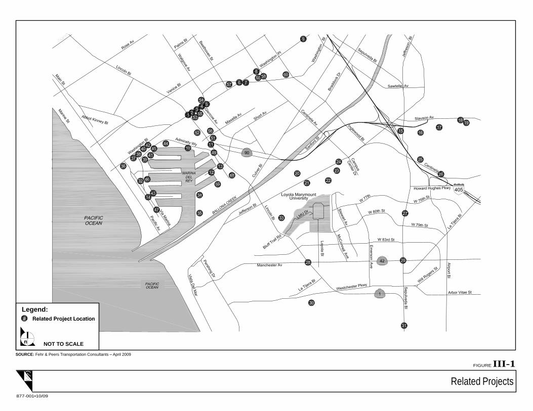
A list of potential projects in the Proposed Project vicinity that might be developed within the study time
frame was compiled based on information currently available from the City of Los Angeles Department
of Transportation (LADOT), the County of Los Angeles, and the City of Culver City. Recent traffic studies
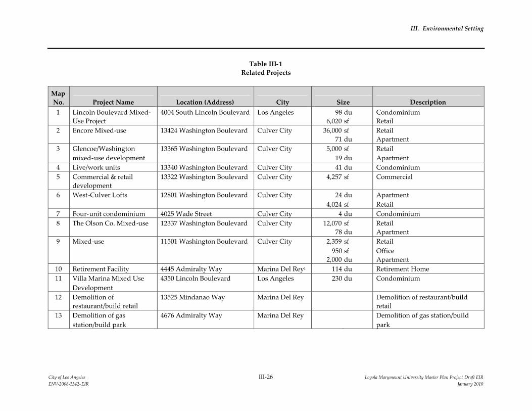
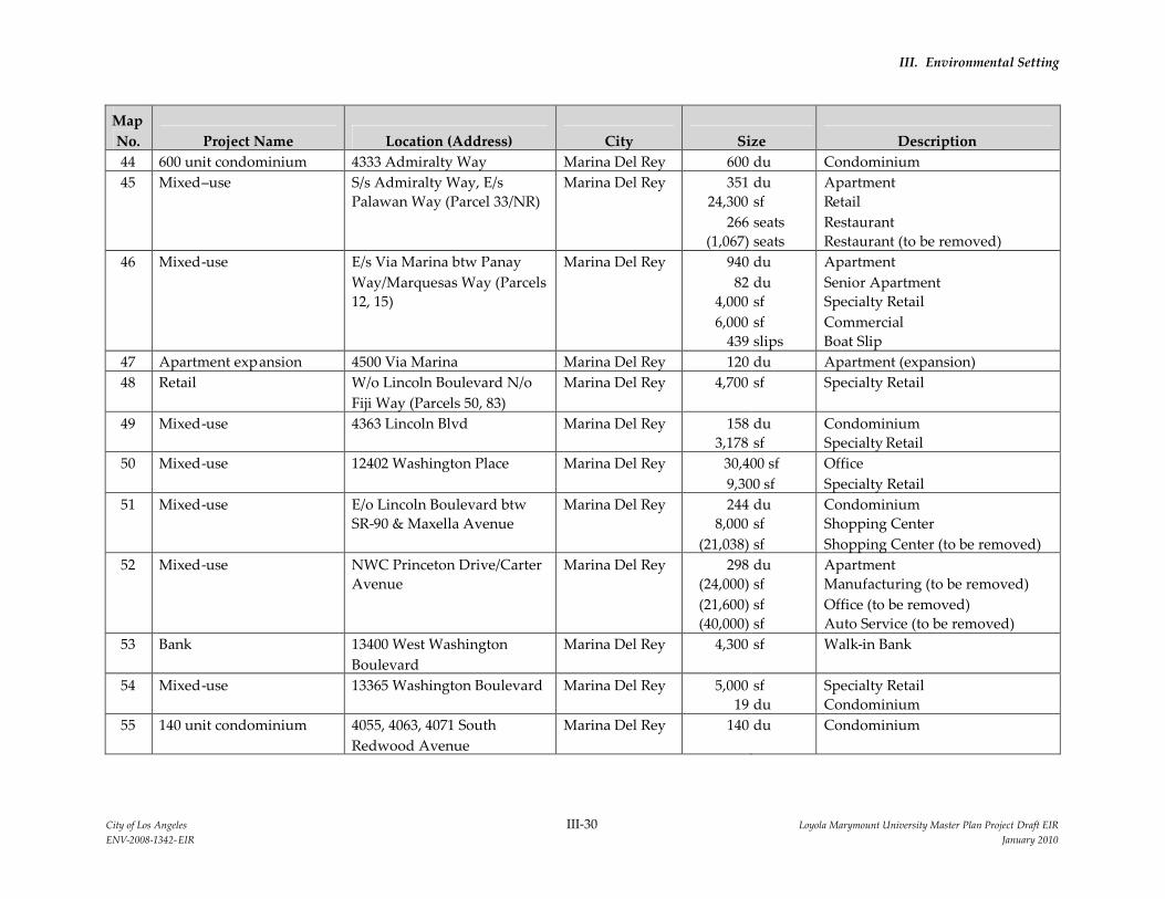
conducted in the area were also used to obtain related project data. The list is presented as Table III-1,
Related Projects. This list of projects accurately reflects the related project proposals at the time of
preparation of this document and is limited in detail to the information that was made available by the
reporting agencies. The locations of the projects relative to the LMU campus are shown in Figure III-1,
Related Projects.
Related Projects
FIGURE III-1
877-001•10/09
SOURCE: Fehr & Peers Transportation Consultants – April 2009
NOT TO SCALEn
Legend:
III. Environmental Setting
City of Los Angeles III-26 Loyola Marymount University Master Plan Project Draft EIRENV-2008-1342-EIR January 2010
Table III-1Related Projects
MapNo. Project Name Location (Address) City Size Description
1 Lincoln Boulevard Mixed-Use Project
4004 South Lincoln Boulevard Los Angeles 986,020
dusf
CondominiumRetail
2 Encore Mixed-use 13424 Washington Boulevard Culver City 36,00071
sfdu
RetailApartment
3 Glencoe/Washingtonmixed-use development
13365 Washington Boulevard Culver City 5,00019
sfdu
RetailApartment
4 Live/work units 13340 Washington Boulevard Culver City 41 du Condominium5 Commercial & retail
development13322 Washington Boulevard Culver City 4,257 sf Commercial
6 West-Culver Lofts 12801 Washington Boulevard Culver City 244,024
dusf
ApartmentRetail
7 Four-unit condominium 4025 Wade Street Culver City 4 du Condominium8 The Olson Co. Mixed-use 12337 Washington Boulevard Culver City 12,070
78sfdu
RetailApartment
9 Mixed-use 11501 Washington Boulevard Culver City 2,359950
2,000
sfsfdu
RetailOfficeApartment
10 Retirement Facility 4445 Admiralty Way Marina Del Rey1 114 du Retirement Home11 Villa Marina Mixed Use
Development4350 Lincoln Boulevard Los Angeles 230 du Condominium
12 Demolition ofrestaurant/build retail
13525 Mindanao Way Marina Del Rey Demolition of restaurant/buildretail
13 Demolition of gasstation/build park
4676 Admiralty Way Marina Del Rey Demolition of gas station/buildpark
III. Environmental Setting
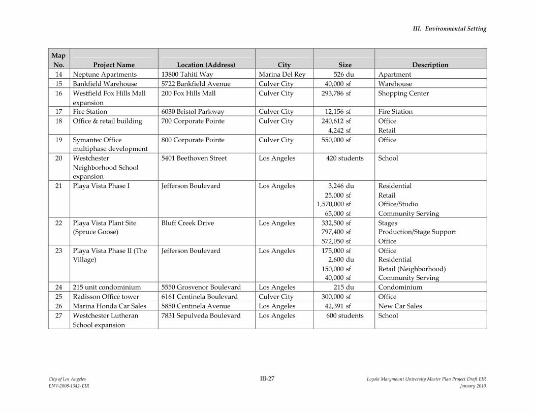
City of Los Angeles III-27 Loyola Marymount University Master Plan Project Draft EIRENV-2008-1342-EIR January 2010
MapNo. Project Name Location (Address) City Size Description14 Neptune Apartments 13800 Tahiti Way Marina Del Rey 526 du Apartment15 Bankfield Warehouse 5722 Bankfield Avenue Culver City 40,000 sf Warehouse16 Westfield Fox Hills Mall
expansion200 Fox Hills Mall Culver City 293,786 sf Shopping Center
17 Fire Station 6030 Bristol Parkway Culver City 12,156 sf Fire Station18 Office & retail building 700 Corporate Pointe Culver City 240,612
4,242sfsf
OfficeRetail
19 Symantec Officemultiphase development
800 Corporate Pointe Culver City 550,000 sf Office
20 WestchesterNeighborhood Schoolexpansion
5401 Beethoven Street Los Angeles 420 students School
21 Playa Vista Phase I Jefferson Boulevard Los Angeles 3,24625,000
1,570,00065,000
dusfsfsf
ResidentialRetailOffice/StudioCommunity Serving
22 Playa Vista Plant Site(Spruce Goose)
Bluff Creek Drive Los Angeles 332,500797,400572,050
sfsfsf
StagesProduction/Stage SupportOffice
23 Playa Vista Phase II (TheVillage)
Jefferson Boulevard Los Angeles 175,0002,600
150,00040,000
sfdusfsf
OfficeResidentialRetail (Neighborhood)Community Serving
24 215 unit condominium 5550 Grosvenor Boulevard Los Angeles 215 du Condominium25 Radisson Office tower 6161 Centinela Boulevard Culver City 300,000 sf Office26 Marina Honda Car Sales 5850 Centinela Avenue Los Angeles 42,391 sf New Car Sales27 Westchester Lutheran
School expansion7831 Sepulveda Boulevard Los Angeles 600 students School
III. Environmental Setting
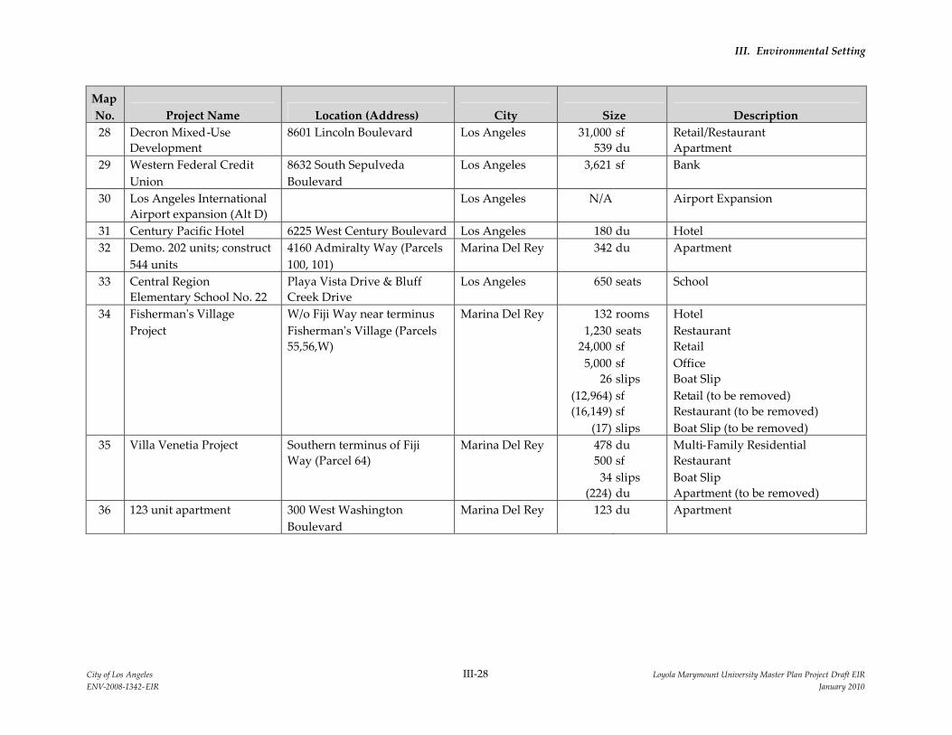
City of Los Angeles III-28 Loyola Marymount University Master Plan Project Draft EIRENV-2008-1342-EIR January 2010
MapNo. Project Name Location (Address) City Size Description28 Decron Mixed-Use
Development8601 Lincoln Boulevard Los Angeles 31,000
539sfdu
Retail/RestaurantApartment
29 Western Federal CreditUnion
8632 South SepulvedaBoulevard
Los Angeles 3,621 sf Bank
30 Los Angeles InternationalAirport expansion (Alt D)
Los Angeles N/A Airport Expansion
31 Century Pacific Hotel 6225 West Century Boulevard Los Angeles 180 du Hotel32 Demo. 202 units; construct
544 units4160 Admiralty Way (Parcels100, 101)
Marina Del Rey 342 du Apartment
33 Central RegionElementary School No. 22
Playa Vista Drive & BluffCreek Drive
Los Angeles 650 seats School
34 Fisherman's VillageProject
W/o Fiji Way near terminusFisherman's Village (Parcels55,56,W)
Marina Del Rey 1321,230
24,0005,000
26(12,964)(16,149)
(17)
roomsseatssfsfslipssfsfslips
HotelRestaurantRetailOfficeBoat SlipRetail (to be removed)Restaurant (to be removed)Boat Slip (to be removed)
35 Villa Venetia Project Southern terminus of FijiWay (Parcel 64)
Marina Del Rey 478500
34(224)
dusfslipsdu
Multi-Family ResidentialRestaurantBoat SlipApartment (to be removed)
36 123 unit apartment 300 West WashingtonBoulevard
Marina Del Rey 123 du Apartment
III. Environmental Setting
City of Los Angeles III-29 Loyola Marymount University Master Plan Project Draft EIRENV-2008-1342-EIR January 2010
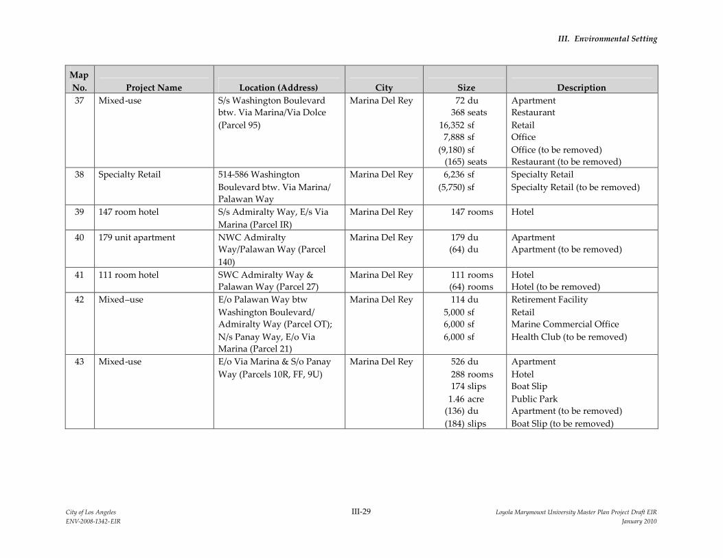
MapNo. Project Name Location (Address) City Size Description37 Mixed-use S/s Washington Boulevard
btw. Via Marina/Via Dolce(Parcel 95)
Marina Del Rey 72368
16,3527,888
(9,180)(165)
duseatssfsfsfseats
ApartmentRestaurantRetailOfficeOffice (to be removed)Restaurant (to be removed)
38 Specialty Retail 514-586 WashingtonBoulevard btw. Via Marina/Palawan Way
Marina Del Rey 6,236(5,750)
sfsf
Specialty RetailSpecialty Retail (to be removed)
39 147 room hotel S/s Admiralty Way, E/s ViaMarina (Parcel IR)
Marina Del Rey 147 rooms Hotel
40 179 unit apartment NWC AdmiraltyWay/Palawan Way (Parcel140)
Marina Del Rey 179(64)
dudu
ApartmentApartment (to be removed)
41 111 room hotel SWC Admiralty Way &Palawan Way (Parcel 27)
Marina Del Rey 111(64)
roomsrooms
HotelHotel (to be removed)
42 Mixed–use E/o Palawan Way btwWashington Boulevard/Admiralty Way (Parcel OT);N/s Panay Way, E/o ViaMarina (Parcel 21)
Marina Del Rey 1145,0006,0006,000
dusfsfsf
Retirement FacilityRetailMarine Commercial OfficeHealth Club (to be removed)
43 Mixed-use E/o Via Marina & S/o PanayWay (Parcels 10R, FF, 9U)
Marina Del Rey 526288174
1.46(136)(184)
duroomsslipsacreduslips
ApartmentHotelBoat SlipPublic ParkApartment (to be removed)Boat Slip (to be removed)
III. Environmental Setting
City of Los Angeles III-30 Loyola Marymount University Master Plan Project Draft EIRENV-2008-1342-EIR January 2010
MapNo. Project Name Location (Address) City Size Description44 600 unit condominium 4333 Admiralty Way Marina Del Rey 600 du Condominium45 Mixed–use S/s Admiralty Way, E/s
Palawan Way (Parcel 33/NR)Marina Del Rey 351
24,300266
(1,067)
dusfseatsseats
ApartmentRetailRestaurantRestaurant (to be removed)
46 Mixed-use E/s Via Marina btw PanayWay/Marquesas Way (Parcels12, 15)
Marina Del Rey 94082
4,0006,000
439
dudusfsfslips
ApartmentSenior ApartmentSpecialty RetailCommercialBoat Slip
47 Apartment expansion 4500 Via Marina Marina Del Rey 120 du Apartment (expansion)48 Retail W/o Lincoln Boulevard N/o
Fiji Way (Parcels 50, 83)Marina Del Rey 4,700 sf Specialty Retail
49 Mixed-use 4363 Lincoln Blvd Marina Del Rey 1583,178
dusf
CondominiumSpecialty Retail
50 Mixed-use 12402 Washington Place Marina Del Rey 30,400 sf9,300 sf
OfficeSpecialty Retail
51 Mixed-use E/o Lincoln Boulevard btwSR-90 & Maxella Avenue
Marina Del Rey 2448,000
(21,038)
dusfsf
CondominiumShopping CenterShopping Center (to be removed)
52 Mixed-use NWC Princeton Drive/CarterAvenue
Marina Del Rey 298(24,000)(21,600)(40,000)
dusfsfsf
ApartmentManufacturing (to be removed)Office (to be removed)Auto Service (to be removed)
53 Bank 13400 West WashingtonBoulevard
Marina Del Rey 4,300 sf Walk-in Bank
54 Mixed-use 13365 Washington Boulevard Marina Del Rey 5,00019
sfdu
Specialty RetailCondominium
55 140 unit condominium 4055, 4063, 4071 SouthRedwood Avenue
Marina Del Rey 140 du Condominium
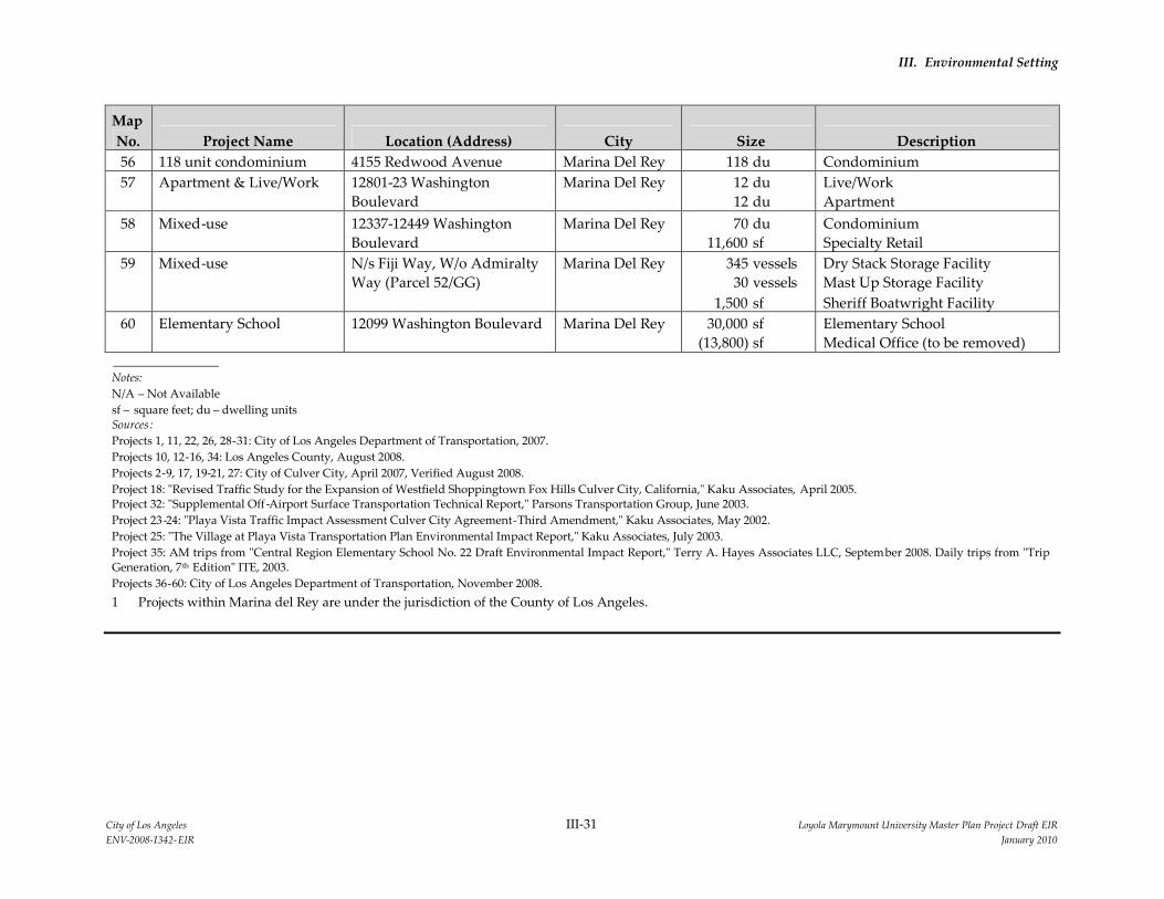
III. Environmental Setting
City of Los Angeles III-31 Loyola Marymount University Master Plan Project Draft EIRENV-2008-1342-EIR January 2010
MapNo. Project Name Location (Address) City Size Description56 118 unit condominium 4155 Redwood Avenue Marina Del Rey 118 du Condominium57 Apartment & Live/Work 12801-23 Washington
BoulevardMarina Del Rey 12
12dudu
Live/WorkApartment
58 Mixed-use 12337-12449 WashingtonBoulevard
Marina Del Rey 7011,600
dusf
CondominiumSpecialty Retail
59 Mixed-use N/s Fiji Way, W/o AdmiraltyWay (Parcel 52/GG)
Marina Del Rey 34530
1,500
vesselsvesselssf
Dry Stack Storage FacilityMast Up Storage FacilitySheriff Boatwright Facility
60 Elementary School 12099 Washington Boulevard Marina Del Rey 30,000(13,800)
sfsf
Elementary SchoolMedical Office (to be removed)
Notes:N/A – Not Availablesf – square feet; du – dwelling unitsSources :Projects 1, 11, 22, 26, 28-31: City of Los Angeles Department of Transportation, 2007.Projects 10, 12-16, 34: Los Angeles County, August 2008.Projects 2-9, 17, 19-21, 27: City of Culver City, April 2007, Verified August 2008.Project 18: "Revised Traffic Study for the Expansion of Westfield Shoppingtown Fox Hills Culver City, California," Kaku Associates, April 2005.Project 32: "Supplemental Off -Airport Surface Transportation Technical Report," Parsons Transportation Group, June 2003.Project 23-24: "Playa Vista Traffic Impact Assessment Culver City Agreement-Third Amendment," Kaku Associates, May 2002.Project 25: "The Village at Playa Vista Transportation Plan Environmental Impact Report," Kaku Associates, July 2003.Project 35: AM trips from "Central Region Elementary School No. 22 Draft Environmental Impact Report," Terry A. Hayes Associates LLC, September 2008. Daily trips from "TripGeneration, 7th Edition" ITE, 2003.Projects 36-60: City of Los Angeles Department of Transportation, November 2008.1 Projects within Marina del Rey are under the jurisdiction of the County of Los Angeles.