Embed Size (px)
Citation preview

A GEOGRAPHIC APPLICATION PROJECT UTILIZING LOCATION-ALLOCATION
COMPUTER PROGRAMS TO DETERMINE CANNING FACILITY LOCATIONS
IN THE WILLAMETTE VALLEY
BY
NICHOLAS ANTHONY MADDOCKS
A RESEARCH PAPER
submitted to
THE DEPARTMENT OF GEOGRAPHY
in partial fulfillment of
the requirements for the
degree of
MASTER OF SCIENCE
March 1981
Directed by
Dr. Philip L. Jackson

TABLE OF CONTENTS
LIST OF FIGURES
ABSTRACT
INTRODUCTION ........................... 2Statement of Purpose ...................... 3
1ethodology........................... 4
BACKGROUND ............................ 5
The Location-Allocation Problem ................. 5
Location Theory ......................... 6
Definitions of Most Accessible ................. 8
Computer Treatment of Location-Allocation Problems ....... 11
Locations on a Route Structure ................. 11
Location-Allocation Computer Programs .............. 12
APPLICATION PROJECT ........................ 13
Preparing Input Data ...................... 15
Using SPA and ALLOC ....................... 15
Results............................. 17
CONCLUSION . ........................... 21
FOOTNOTES .............................. 24
APPENDIX: Using SPA and ALLOC on Oregon State Liniversity's
CYBER-70 Computer ................... 26
LIST OF FIGURES
Figure
1. The Location-Allocation Problem ............... 7
2. Optimal Locations of Canning Facilities for Willaniette
Valley Contract Farm Distribution - Based on Total
Production ......................... 18
3. Optimal Locations of Canning Facilities for Willamette
Valley Contract Farm Distribution - Based on
Individual Corimodity Production .............. 19
A GEOGRAPHIC APPLICATION PROJECT UTILIZING LOCATION-ALLOCATION
COMPUTER PROGRAMS TO DETERMINE CANNING FACILITY LOCATIONS
IN THE WILLAMETTE VALLEY
ABSTRACT: A Willamette Valley farm cooperative was interested
in evaluattng locations for their canning facilities based on
the criterion of minimizing aggregate distance to their contract
farms. This location problem presented an excellent opportunity
for a geographic application project as it was characterized by
one, a spatfal distribution of farms and two, the need to mini-
mize one variable, distance. The projects aim was to provide
a methodology utilizing location-allocation analysis performed
by a geographic tool, the computer, to solve the specific facility
location problems of the cooperative. Since the growers were
constrained to existing roads in transporting their produce to
the canning facilities, the problem became one of minimizing
distance over a route network. Two location-allocation computer
programs, designed to solve location problems on a network were
called upon to generate locations for the canning facilities.
The cooperative was presented with detailed information about one
very important variable, distance minimization, to be considered
along with the many complex variables weighing in their ultimate
locational decision.
2
INTRODUCTION
The application of geographic theory to solve spatial problems
related to decision making in government and private enterprise has
been important in advancing the professional competencies of the
discipline. Location theory in particular has found widespread
application to geographic problems involving land use planning, trans-
portation, and industrial location.
Though a location problem may seem simple when first examined,
a more penetrating analysis leads one to discover how complex it really
The geographer, trained in solving spatial problems, is well
prepared to consider the range of economic, environmental, and social
factors upon which a locational decision is predicated. Since some
factors weigh more heavily than others, methodologies exist allowing
certain quantifiable variables to be thoroughly investigated.
One such variable, distance, has been a critical concept in the
evolution of geographic thought. Its importance as a geographic
variable was recognized in the location theories of Johann Heinrich
Von Thünen and Walter Christaller, both equating distance with cost.
Today, with attentions focused on the energy situation, distance
remains an important geographical variable because it can also be
equated with transportation energy consumption. When the distance
variable in a locational decision is minimized, so too is the amount
of transportation energy consumed.
A location problem reflecting on this variable of distance minimi-
zation can be approached as a geographic application project. An
application project promotes a more thorough understanding of a problem
3
by incorporating components of geographic theory with geographic
problem solving tools. This paper will describe the methodology for
a project using one such tool, the computer, and applying elements
of location theory, economic geography, land use planning, and
location-allocation analysis.
Statement of Purpose
An agricultural cooperative wanted to consider the effects of one
important locational variable, distance minimization, in the evaluation
of locations for their canning facilities.
The cooperative, Agripac, comprises 156 contract farms distributed
throughout the Willamette Valley. The farms vary in size and produce
different amounts of four commodities: beans, corn, beets, and carrots.
The actual number of tons produced by each farm constitutes its weight-
ing value, a measure of the locational demand exerted by the farms.
At harvest, the cooperative's growers incur costs of transportation
in trucking their produce via existing roads to the nearest canning
facility for processing. Agripac wishes to minimize the growers trans-
port costs and thus energy consumption by locating their canning facil-
ities in such a way that the "aggregate weighted distance" to all farms
is minimized. The term "weighted distance" represents a combination
of each farm's production and its distance to the nearest cannery.
"Aggregate weighted distance" represents the sum of the weighted dis-
tances for all 156 farms. Since the growers are constrained to existing
roads in transporting their produce to the canning facilities, the
problem becomes one of minimizing distance over a route network. Solu-
tions to the problem, that is, canning facility locations that minimize
4
aggregate traveling distance from the farms, present Agripac with detail-
ed information of the variable, distance minimization. Lacking the
proper facilities to thoroughly investigate the location problem,
Agripac enlisted assistance from the Oregon State University Geography
Department.
Methodol ogy
Due to the large amount of information requiring assimilation,
Oregon State University's CYBER-70 computer provided the most efficient
means for solving the problem. It was able to utilize a recently im-
plemented package containing fourteen computer programs for location-
allocation problems.2 Capable of generating exact solutions toa wide
range of location problems, the various computer programs were compiled
and made available by the Geography Department at the University of Iowa.
Two of those programs, designed to solve location problems on a route
structure, were called upon to solve the specific location problems of
the application project.
The cooperative provided the raw data for the project consisting
of a map denoting farm locations and a table describing individual farm
production in terms of acreage devoted to each commodity. First the
input was formulated. It consisted of farm labels, farm weighting values,
and shortest travel distances between adjacent farms. The computer
algorithm calculated distances between all farms and determined locations
for the canning facilities based on minimizing the weighted distance to
all the farms. Separate solutions were generated locating one, two,
and three canneries to serve the contract farms. Additional solutions
were generated based on the isolated distribution of each of the four
5
commodities.
These computer generated solutions allowed Agripac to thoroughly
investigate one geographic variable - distance minimization. From the
set of solutions, Agripac was able to consider the number and locations
of their canneries that would best minimize the growers1 transport costs.
Further, they were able to scrutinize the distribution of the four
commodities determining the proximity of each to the canning facilities.
This paper first presents a background which examines the under-
lying geographic concepts of the application project. Next, the solu-
tion procedure for the canning facility location problem is outlined in
three parts: preparation of input data, computer program usage and
presentation of results. Then, a conclusion summarizes the objectives
and methodology of the application project and discusses the importance
of location-allocation analysis as a geographic problem solving technique.
BACKGROUND
The Location-Allocation Problem
Truly a geographical problem, a location-allocation problem has
three things that can vary: one, the number of facilities to be assigned;
two, the size or capacity of the facilities; and three, the locations to
which the facilities must be allocated.3 One way to approach a complex
locational problem of this nature is by holding constant some of the
variables. If the number and size of the facilities are held constant,
their locations may be solved for by evaluating the given criterion,
distance minimization. Isolating certain variables in this manner allows
a location problem to be solved by a systematic procedure.
The systematic solution procedure to a location-allocation problem
asks the question: how can certain objects be located in order that
a certain variable or variables attain a maximum or minimum value?
Under these circumstances the maximum or minimum value attained is said
to be that variable's "optimal" value. Definable in many ways, the
term optimal in this case refers to canning facility locations that
minimize the aggregate weighted distance from the farms. Minimizing
that particular variable is the sole criterion for solving the problem
at hand. Inasmuch as the cooperative's ultimate locational decision
will be based on a wide range of criteria, and, only one variable is
under consideration, the minimum or maximum values found for that
variable do not necessarily yield the best solution to the problem.
They do provide, however, a solution reflecting the given criterion.
When a location-allocation problem is solved by finding a minimum or
maximum value for a single variable or set of variables, the solution
to that problem can be called the optimal solution. Hence, locations
for canning facilities that minimize the variable of aggregate weighted
distance are termed optimal locations.
This geographic application project was approached by considering
discrete. location-allocation problems. The location-allocation problem
formulated for this project asked the question: how shall one set of
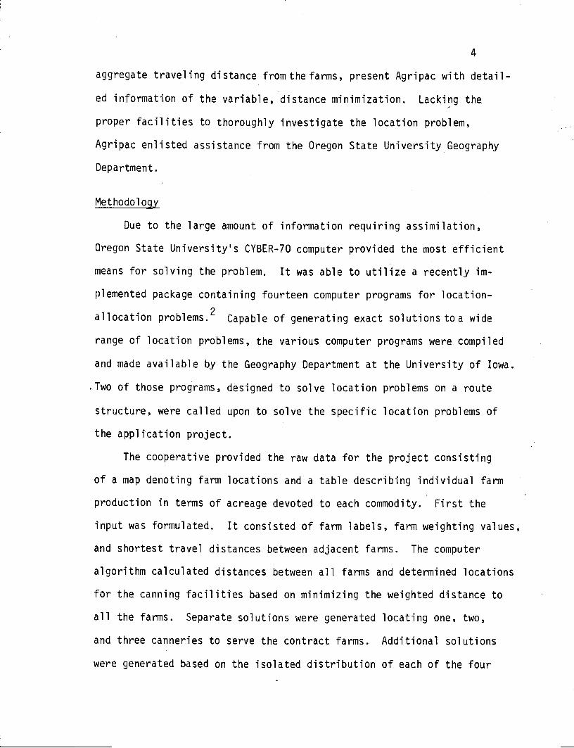
facilities be allocated to serve a second set of locations (Fig. 1)?
The cooperative provided the locations (farms) and asked for a set of
facilities (canneries) to be allocated.
Location Theory
In each geographical problem, there is some spatial distribution
under consideration. Location theory offers different approaches for
7
analyzing the given criteria and explaining the areal distribution
which are created. In short it uses the "where" to explain the "why".
The first attempt at explaining the location of economic activities
was provided by the German economist, Johann Heinrich Von ThUnen.4
His concentric ring model, accounting for the types of agriculture
that prospered around an urban market, made three assumptions. First,
Von ThUnen assumed that farmers wishing to maximize a variable (profits)
were able to make adjustments. Next, he assumed there was only one
means of overland transportation. Third, he stated transportation costs
were directly proportional to distance.
Comparisons may be drawn to Von ThUnen's assumptions in order to
simplify the canning facility location problem. First, the cooperative's
objective of minimizing a variable, distance, could be reached by adjust-
ing cannery locations. Second, growers are correspondingly constrained
Things to beallocated:
Hospitals 0-?Schools 0 -- 7Birth control clinics 0Fire stations Q ?
Polling places 0 7
Administrative centers 0 --- ? . .
Branch campuses 0 ? . . . . ..
Playgrounds ? .
Etc . - ? ..
.
A populationto be served
. . . .
S. . . S
Figure 1. The Location-Allocation Problem..*
*Taken from: Abler, Adams, and Gould, Spatial Organization, p. 532.
8
to a single means of overland transportation. Third, cost is directly
proportional to distance as growers traveling greater distances incur
higher transportation costs. These characteristics correspond to ways
in which the problem may be simplified so that the computer can generate
a locational solution based on a single variable.
Comparisons may also be drawn to Walter Christaller's Central
Place Theory. Based on hypothetically uniform terrain, movement, and
distribution, Central Place Theory was the first to offer explanations
for the location pattern of market centers.5 It postulated a uniform
hierarchical arrangement of central places in response to varying need
and availability of goods and services. Evaluating a given distribution
pattern of people and goods, the theory accounted for the number and
location of service centers to best serve that distribution. During
the early 1900's when the theory was developed, the major locational
constraint was ease of traveling, or, in other words, accessibility.
If easily accessible to many people, a location prospered.
- The canning facility locations for the application project may be
correlated with Christallers central places and are also concerned
with accessibility to the contract farms. in this case, based on the
distribution pattern of farms, locations for the canneries were not
explained, they were deduced. Again, as in Central Place Theory, the
most important criterion in deducing locations for the canneries was
minimizing distance, thus maximtzing accessibility.
Definitions of Most Accessible
A more thorough understanding of location-allocation problems and
their applications can be gained through. examination of different types
of optimal values corresponding to various locational decisions. One
approach to solving problems is to ask the following questions: if one
wanted a certain variable or variables to attain a maximum or minimum
value, could certain values be relocated to achieve this? If so, where
should those locations be? Because people are distributed unevenly in
earth space, they must obtainmany kinds of goods and services located
at widely separated places.6 Their interest is in the locations of
facilities being "most accessible". By defining the term "most access-
ible", the different types of location-allocation problems can be better
understood
tn his book Optimal Location of Facilities, Gerard Rushton offers
a number of definitions for the term "most accessible". Those defini-
tions correspond to different types of optimal solutions.
The first defines a location as being "most accessible" when the
total of the distances of all the people from their closest facility
is minimum. This is equivalent to minimizing the "average distance".
The application project falls into this category. Another example of
this type would be in locating a warehouse to serve the supermarkets
of a region. If the aggregate distance from the supermarkets to the
warehouse is minimized, so too are transportation costs. The next
definition of "most accessjble' is when the farthest distance of people
from their closest facility is minimum. This criterion is used when
locating emergency facilities such as fire and health care services.
The third defines a location as "most accessible" when the number of
people in the proximal area surrounding each facility is approximately
equal. This is known as the "equal assignment" criterion. Locations
of facilities such as schools, hospitals, and polling places are eval-
10
uated in this manner. The fourth definition of "most accessible" is
when the number of people in the proximal area surrounding each facility
is always greater than a specified number i.e., must exceed some "thres-
hold" value. The location of a swimming pool maintenance business
falls into this category as its viability depends upon a sufficient
amount of swimming pools in the area. The fifth definition of "most
accessible" is when the number of people in the proximal area surround-
ing each facility is never greater than a specified number. This
"capacity constraint" is often considered when locating public services.
Health care devices, institutions, and jails are some examples of
public services that cannot accommodate more than a specified number
of people.
Each definition can be interpreted in a number of ways corresponding
to different locational problem situations. For example, in the second
definition, a location is defined as most accessible when the farthest
distance of people from their closest facility is minimum. Instead of
requiring that the farthest distance be minimized, a problem may state
that the farthest distance from the people to their closest facility
cannot exceed a specified number. This constraint might govern the
location of a fire station where the maximum response time could not
exceed a specified number of minutes.
Tftese examples provide a brief overview of the different types of
location decisions that must be made. More thoroughly understood, they
can provide insight into the wide range of capabilities of location-
allocation analysjs.
11
Computer Treatment of Location-Allocation Problems
The approach to this geographic application project utilizes loca-
tion-allocation analysis performed by computer. Although complex in
nature, the computer methodology for solving location-allocation problems
can be explained in rudimentary terms.
The computer deals with numerical values. Before it can solve the
location-allocation problem, the input data must be transformed into some
symbology (i.e. numerical values) that the computer can understand.8
The computer then manipulates the input data with an "algorithm". An
algorithm is a prescribed set of instructions (or logical procedure)
for solving a given recurrent mathematical problem. The algorithm
searches for the optimal location by generating solutions corresponding
to different' locations and comparing them to one another. First, a
solution is generated for one location, that is, the aggregate weighted
distance from that location to all farms is calculated. The solution
for the first location is stored and will be compared to subsequent
solutions. After generating a solution for the next location, the computer
compares that solution to the previous one and from the pair selects the
"best'1 solution. The subsequent solutions for each location is compared
to the current "best value in the same manner. In each case the better
of the two is retained as the "best" value. After all feasible locations
have been evaluated, the location corresponding to the current ubestI
value becomes the optimal location.
Locations on a Route Structure
Constrained to a route network the location prohiem is altered
slightly: given distances defined between each. node, or point on a route
12
network, find that point from which the sum of the distances to all
other points is least. Weights may be associated with the nodes.
There is a theorum, developed by Hakimi (1964), stating that the node
for which this is true is itself a node on the network.9 Hakimi's
theorum states:
There is a point of the graph which minimizes the sum
of the weighted shortest distances from all nodes to
that point which is itself a node on the graph.
The theorum can be restated as: there never will lie a point on an
arc between two nodes that will have a smaller total distance to the
remaining nodes than either of the nodes themselves. This is important
as it has encouraged solution methods that evaluate alternative nodes
on the route network to find the optimum node. Time need not be spent
unnecessarily examining points along the arcs connecting nodes)0
Location-Allocation Computer Programs
The preceeding discussions have outlined how the solution to a
location-allocation problem can be determined through a series of math-
ematical manipulations. Performed systematically by computer, the
manipulations become a program. Of the location-allocation package's
fourteen programs, two are designed to solve problems on a route network
and are called upon to solve th2carrning facilities location problem.
The first program calledSPA, an acronym for shortest path algorithm,
computes the shortest distances and paths between all pairs of nodes on
a route network. tnput for SPA consists of integer labels for all nodes
on a route network and distances between adjacent nodes. Output from
SPA is in the form of a distance matrix denoting the distances from each
13
node to all other nodes on the network. The distance matrix that is
part of the output from SPA comprises a portion of the input for the
next program, ALLOC.
Short for location-allocation, the program ALLOC offers solutions
to a wide range of location problems along a route network. The various
types of solutions are categorized three ways. The first locates one
or more facilities to minimize total distance (or time) traveled to the
closest facility. The Agripac problem requires this type of solution.
Optimally locating the canning facilities will minimize the aggregate
distance traveled by the growers to their nearest cannery. The second
group of solutions determine locations that again minimize aggregate
distance (or time). In this case, the problem is subject to the con-
straint that no person be further than a specified distance (or time)
from their closest facility. The third group solves the problem of
optimally locating one or more facilities such that the maximum distance
to a demand point's closest supply center is a minimum. Corresponding
to definition three of ttrnost accessible't, this type of solution is often
generated when locattng emergency services. SPA and ALLOC's input, output,
and capabilities are discussed in greater detail in the following section.
APPLICATION PROJECT
The problem's solutions of where to locate the canning facilities
were based on the demand exerted by the cooperative's 156 farms.
More than distance alone, each farm's demand is the product of its
distance to the nearest cannery (in miles) and its output (jn tons).
Output naturally varies because of unequal farm size and differing acre-
ages devoted to each of the four commodities, Each commodity is associ-
14
ated with a certain average tonnage per acre e.g., an acre's yield of
carrots weighs more than acre's yield of beans. The various average
yields are: beans - 5.6 tons/acre, corn - 9 tons/acre, beets - 20 tons/
acre, and carrots - 24 tons/acre. As a result, some growers must trans-
port heavier loads than others - they must overcome a greater amount of
ton-miles. Although referred to as distance, the amount of ton-miles
constitutes each farm's "weighted distance".
In each case, problem solutions locating the canning facilities
minimized the criterion of aggregate weighted distance. First, locations
for the canning facilities were generated with weighting values describ-
ing each farm's total tonnage of all four commodities. Then the problem
was broken down and locations were found based on the distribution of
each of the four commodities. The latter problem determined, for example,
the location for a bean cannery based on the cooperative's distribution
of bean growers.
The Agripac problem is characterized in four ways. One, a spatial
distribution of farms is under consideration. Two, each farm is associ-
ated with a weighting valuecorresponding to the tonnage it must haul
to the canning facilities. Three, the produce is transported by truck
over existing roads (route network). Four, the desired solutions are
based on the sole criterion of minimizing weighted distance in moving the
commodities to the canning factilties.
These four characteristics not only constituted a classic geographic
problem, they provided an excellent educational opportunity forageographic
application project.

15
Preparing Input Data
By far, the most time consuming task in using SPA and ALLOC to solve
this location problem was formulating the input data. Agripac provided
a map of the Willarnette Valley denoting the 156 farm locations. To begin
with, the farm locations were transferred to an identical second map.
Nodes (farm locations), their integer labels, and the shortest routes
between nodes were designated on the second map. Nodes were indentified
simply by integer labels; no georeferencing was necessary as the algor-
ithms function is to interpret internodal distances. Since the computer
programs were dimensioned for a maximum of 150 nodes, the data had to
be simplified. Pairs of nearly adjacent farms were incorporated into
single nodes with combined tonriages serving as the weighting value for
each node. This was done for eight pairs of farms reducing the node
total to 148. Next, the distances between adjacent nodes were calculated
with the Geography Department's digitizing planimeter and graphic display
computer terminal. An interactive computer program on the graphic terminal
facilitied data transfer from map to computer memory tape. The interactive
program asked for the map scale and node labels, then converted the digi-
tized distances between nodes into miles. Labels and iñternodal distances
for pairs of adjacent nodes were stored on the graphic terminal's memory
tape - ready for transfer to the CYBER. It is important that only dis-
tances between pairs of adjacent nodes on the route network were input -
SPA calculated distances and shortest paths for all pairs of nodes on the
route network.
Using SPA and ALLOC
The primary function of the program SPA is to formulate and output
16
a matrix comprised of distances between all nodes. Additional output
from SPA is in the form of two options. Option 1 provides the shortest
paths between all pairs of nodes on the network. In other words, each
grower is told the shortest routes from his farm to all others. Option 2
provides the shortest paths between a specified sub-set of nodes and all
other nodes on the network. If distances and routes are needed to and
from farms growing only carrots for example, then option 2 would be
selected. Output from SPA can also include an "echo check" of the input
data allowing it to be validated.
The inter-nodal distance matrix supplied the bulk of the input for
the program ALLOC. Additional input for ALLOC consisted of the following:
1. The total number of places (nodes) along the route network (148).
2. Integer identification numbers of the nodes (1-148) and their corre-
sponding weights (tonnages).
3. The number of service sites required. Three solutions respectively
locating one, two, and three canneries were generated.
4. Source locations for the canneries. The program utilizes a heuristic
algorithm and must therefore be provided with a logical starting
point. A heuristic algorithm is a solution procedure that relies on
a starting point provided by the user. It first calculated the
aggregate weighted distance to the source locations, then compared
alternative locations.
5. Locational constraints. Three types of locational constraints are
considered by ALLOC. One, a "constrained location" is always forced
into the final solution. Two, a "feasible location" may be chosen
in the final solution. Three, an "infeasible location" cannot be
17
present in the final solution but its demand influences the solution.
If the cooperative had one existing cannery and desired a location
for a second, the existing cannery would be forced into the final
solution thereby influencing the optimal location of the second.
6. Distance constraints. These are applicable when a problem has max-
imum distance constraints.
In addition to solving the optimal locations, program ALLOC assigned
each node to its nearest supply center i.e., directed each grower to
the nearest cannery. Output also contained the aggregate weighted dis-
tances (ton-mileage) for each node evaluated during the search for the
optimal node.
Results
It will be recalled that the application project had two principal
objectives. The first was to determine locations for canning facilities
based on the criterion of minimizing aggregate weighted distance to the
contract farms. Weighting values were assigned to each farm describing
its total production. Three separate solutions were generated respective-
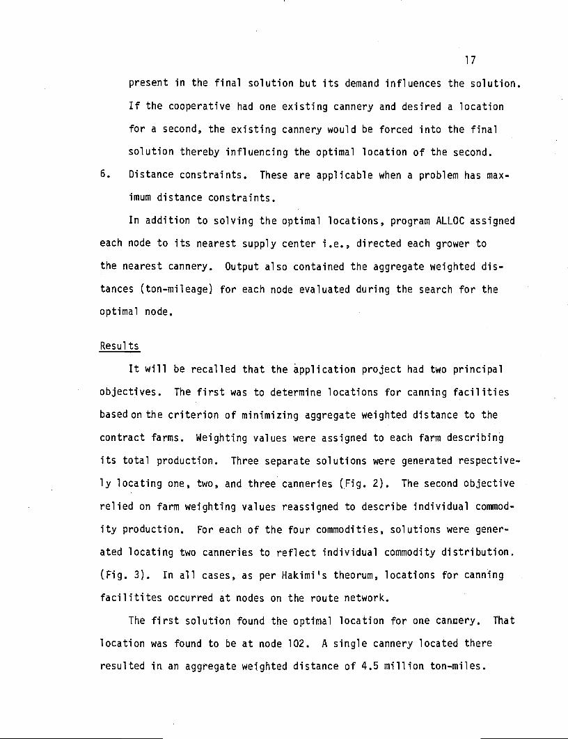
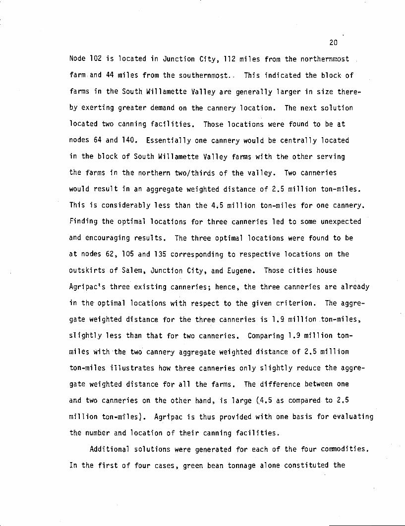
ly locating one, two, and three canneries (Fig. 2). The second objective
relied on farm weighting values reassigned to describe individual commod-
ity production. For each of the four commodities, solutions were gener-
ated locating two canneries to reflect individual commodity distribution,
(Fig. 3). In all cases, as per Hakimis theorum, locations for canning
facilitites occurred at nodes on the route network.
The first solution found the optimal location for one cannery. That
location was found to he at node 102. A single cannery located there
resulted in an aggregate weighted distance of 4.5 million ton-miles.
13
OPTIMAL LOCATIONS OF CANNING FACILITIES
FOR WILLAMETTE VALLEY CONTRACT FARM DISTRIBUTION*
LEGEND
Farm Producing Less Than1000 Tons
Farm Producing More Than1000 Tons
Principal Roads
o One Cannery Solution
0 Two Cannery Solution
z Three Cannery Solution
Scale
0 Miles 0
* Based on the minimization of aggregate distance
Portland
Saern
?.H...
Eugene
Figure 2. Optimal Locations of Canning Facilities for Willamette
Valley Contract Farm Distribution - Based on Total
Production.

iI!
OPTIMAL LOCATIONS OF CANNING FACILITIES
FOR WILLAMETTE VALLEY CONTRACT FARM DISTRIBUTION*
LEGEND
Farm Producing Less Than1000 Tons
Farm Producing More Than1000 Tons
Principal Roads
Beon Cannery Locations
Corn Cannery Locations
0 Beet Cannery Locations
Carrot Cannery Locations
0 Mdes 0
* Based on the minimization of aggregate distance
Portland
Salem
0
Eugene
Figure 3. Optimal Locations of Canning Facilities for Willamette
Valley Contract EarnDistribution - Based on
Individual Commodity Production.
Node 102 is located in Junction City, 112 miles from the northernmost
farmand 44 miles from the southernmost. This indicated the block of
farms in the South Willamette Valley are generally larger in size there-.
by exerting greater demand on the cannery location. The next solution
located two canning facilities. Those locations were found to be at
nodes 64 and 140. Essentially one cannery would be centrally located
in the block of South Willamette Valley farms with the other serving
the farms in the northern two/thirds of the valley. Two canneries
would result in an aggregate weighted distance of 2.5 million ton-miles.
This is considerably less than the 4.5 million ton-miles for one cannery.
Finding the optimal locations for three canneries led to some unexpected
and encouraging results. The three optimal locations were found to be
at nodes 62, 105 and 135 corresponding to respective locations on the
outskirts of Salem, Junction City, and Eugene. Those cities house
Agripacs three existing canneries; hence, the three canneries are already
in the optimal locations with respect to the given criterion. The aggre-
gate weighted distance for the three canneries is 1.9 million ton-miles,
slightly less than that for two canneries. Comparing 1.9 million ton-
miles with the two cannery aggregate weighted distance of 2.5 million
ton-miles illustrates how three canneries only slightly reduce the aggre-
gate weighted distance for all the farms. The difference between one
and two canneries on the other hand, is large (4.5 as compared to 2.5
million ton-miles). Agripac is thus provided with one basis for evaluating
the number and location of their canning facilities.
Additional solutions were generated for each of the four commodities.
In the first of four cases, green bean tonnage alone constituted the
21
weighting value for each particular farm. Problem solutions solely
dependent on the distribution of beans located two canneries in rough-
ly the same places as those considering total output indicating uni-
form bean production throughout the Willamette Valley. The next solu-
tion, corresponding to corn, indicated a distribution skewed slightly
to the north, that is, contract farms in the northern part of the
valley devote more acreage to corn. The solution evaluating beet pro-
duction placed two canneries in the southern part of the valley, indi-
cating farms there produce large amounts of beets. In the fourth case,
carrot distribution was shown to be skewed just slightly to the south,
contrary to the distribution of corn. The solutions generated assisted
the cooperative in evaluating locations for their canneries based on
total production of the farms and production of each of the four commod-
ities.
CONCLUSION
A number of complex variables may weigh in a locational decision.
This paper has described an application project focusing on the effects
of one important variable, distance minimization. By holding other
variables constant, the agricultural cooperative was able to evaluate
the effects of distance in locating their canning facilities to best
serve the distribution of contract farms. The distance variable served
as the criterion for determining optimal canning facility locations.
To aid in comprehending the application project's problem solving tech-
nique, the criterion, originally stated as "distance mininiztiont', was
transformed to "aggregate distance minimization" then to "aggregate
weighted distance minimization". Since the growers were constrained to
22
existing roads, the criterion became one of minimizing aggregate weighted
distance along a route network. Two location-allocation computer pro-
grams designed to solve such a locational problem were called upon to
generate locations for the canning facilities based on the specific needs
of the cooperative. The results indicated that given constant factory
size, the difference in ton-mileage for three as opposed to two canneries
was small. Two canneries as opposed to one however, substantially
reduced the number of ton-miles.
The results, i.e., optimal canning facility locations and their corre-
sponding ton-mileages, provided Agripac with information about the effects
of one locational variable, distance. Other locational variables such as
cannery size, land availability, and marketing costs may also be consid-,
ered by Agripac in the evaluation of their canning facility locations.
The terms "aggregate weighted distance", "transportation costs", and
"transportation energy consumption" were presented to the facilitate a
more thorough understanding of the application project. While expressing
three distinct concepts, those terms can be equated in the following way:
when a location is found that minimizes aggregate weighted distance, that
location also minimizes transportation costs and transportation energy
consumption.
The locational pattern of any activity influences the quantity and
quality of services received. Methodologies exist as this paper has
pointed out, "to evaluate the locational effectiveness of any location
pattern, to determine improvements that can be made, and to compute
location patterns that are optimum with respect to defined criteria."'1
In adopting the question of finding the best location pattern to meet
23
specified requirements. "the prime concern is no longer to explain
things how they are but to make rational assertions about how they
should be."12 ttflth this in mind, location-allocation analysis departs
from traditional descriptive science and enters the realm of prescrip-
tive science)3 This approach to geographical problem solving is
timely "for pressures of expanding populations in relation to finite
land resources are demanding new approaches to locational decisions."14
24
a'I')IffsIl*l
1 Ronald Abler, John S. Adams, and Peter Gould, Spatial Organization
(Englewood Cliffs, New Jersey: Prentice-Hall, Inc., 1971), P. 531.
2 A detailed description of the locational problems, algorithms, and
input requirements of the fourteen location-allocation programs is
given in Gerard Rushton, Michael F. Goodchild, and Lawrence M. Ostresh,
Jr., Computer Programs for Location-Allocation Problems, University
of Iowa Department of Geography Monograph Series, 6 (Iowa City: Uni-
versity of Iowa, 1973).
3 Abler, Adams, and Gould, Spatial Orqanization, p. 533.
4, John W. Alexander and Lay James Gibson, Economic Geography, 2nd ed.
(Englewood Cliffs, New Jersey: Prentice-Hall, Inc., 1979), p. 440.
5 Edgar C. Conkling and Maurice Veates, Man's Economic Environment
(New York: McGraw-Hill, 1976), P. 157.
6 Gerard Rushton, Optimal Location of Facilities (Wentworth, New
Hampshire: COMpress, Inc., 1979), p. 31.
7 Rushton, Optimal Location of Facilities, the term "most accessible"
is daftned seven different ways followed by separate instructional
explanations, p. 32-33.
8 Waldo R. Tobler, "Automation and Cartography," Geographical Review
49 (October 1959): 526.
9 Rushtorr, Optimal Location of Facilities, p. 64.
10 Ibid.
11 Ibid., p. 2
12 Ibid., p. 3
25
13 Ibid.
14 Ibid.
26
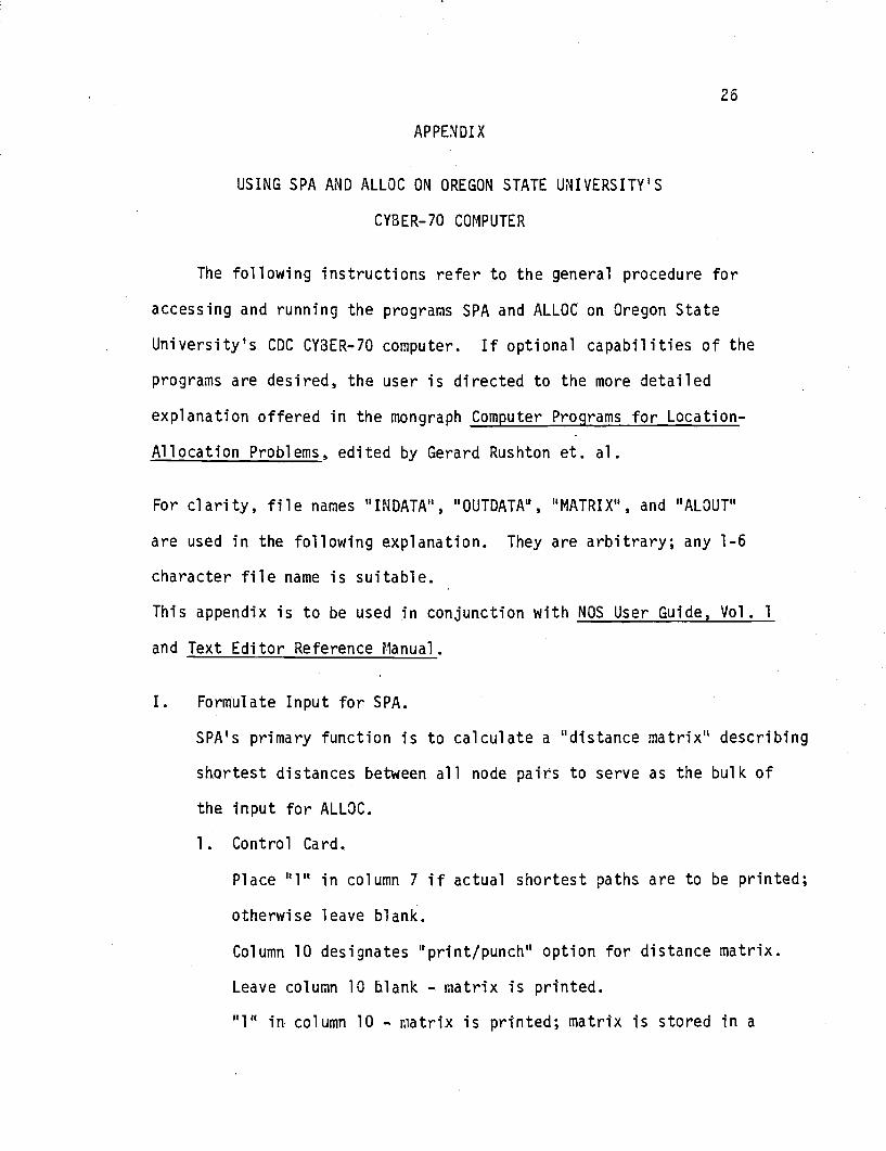
APPENDIX
USING SPA AND ALLOC ON OREGON STATE UNIVERSITY'S
CYBER-70 COMPUTER
The following instructions refer to the general procedure for
accessing and running the programs SPA and ALLOC on Oregon State
University's CDC CYBER-70 computer. If optional capabilities of the
programs are desired, the user is directed to the more detailed
explanation offered in the mongraph Computer Programs for Location-
Allocation Problems, edited by Gerard Rushton et. al.
For clarity, file names "INDATA", "OUTOATA", "MATRIX", and "ALOUT"
are used in the following explanation. They are arbitrary; any 1-6
character file name is suitable.
This appendix is to be used in conjunction with NOS User Guide, Vol. 1
and Text Editor Reference 1anual.
I. Formulate Input for SPA.
SPA's primary function is to calculate a "distance matrix" describing
shortest distances between all node pairs to serve as the bulk of
the input for ALLOC.
1. Control Card.
Place "1" in column 7 if actual shortest paths are to be printed;
otherwise leave blank.
Column 10 designates "print/punch" option for distance matrix.
Leave column 10 blank - matrix is printed.
'l" in column 10 - matrix is printed; matrix is stored in a
27
local file entitled "PUNCH".
"2" in column 10 creates local file "PUNCH".
Place "TRUE" in columns 16-20 if an echo check of data cards
is desired; if not place "FALSE"
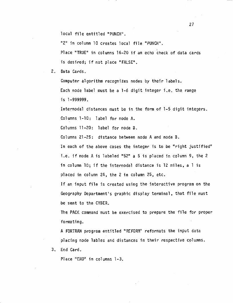
2. Data Cards.
Computer algorithm recognizes nodes by their labels.
Each node label must be a 1-6 digit integer i.e. the range
is 1-999999.
Internodal distances must be in the form of 1-5 digit inteçjers.
Columns 1-10: label for node A.
Columns 11-20: label for node B.
Columns 21-25: distance between node A and node B.
In each of the above cases the integer is to be "right justified"
i.e. if node A is labeled "52" a 5 is placed in column 9, the 2
in column 10; if the internodal distance is 12 miles, a 1 is
placed in column 24, the 2 in column 25, etc.
If an input file is created using the interactive program on the
Geography Department's graphic display terminal, that file must
be sent to the CYBER.
The PACK command must be exercised to prepare the file for proper
formating.
A FORTRAN program entitled "REFORM" reformats the input data
placing node lables and distances in their respective columns.
3. End Card.
Place "END" in columns 1-3.
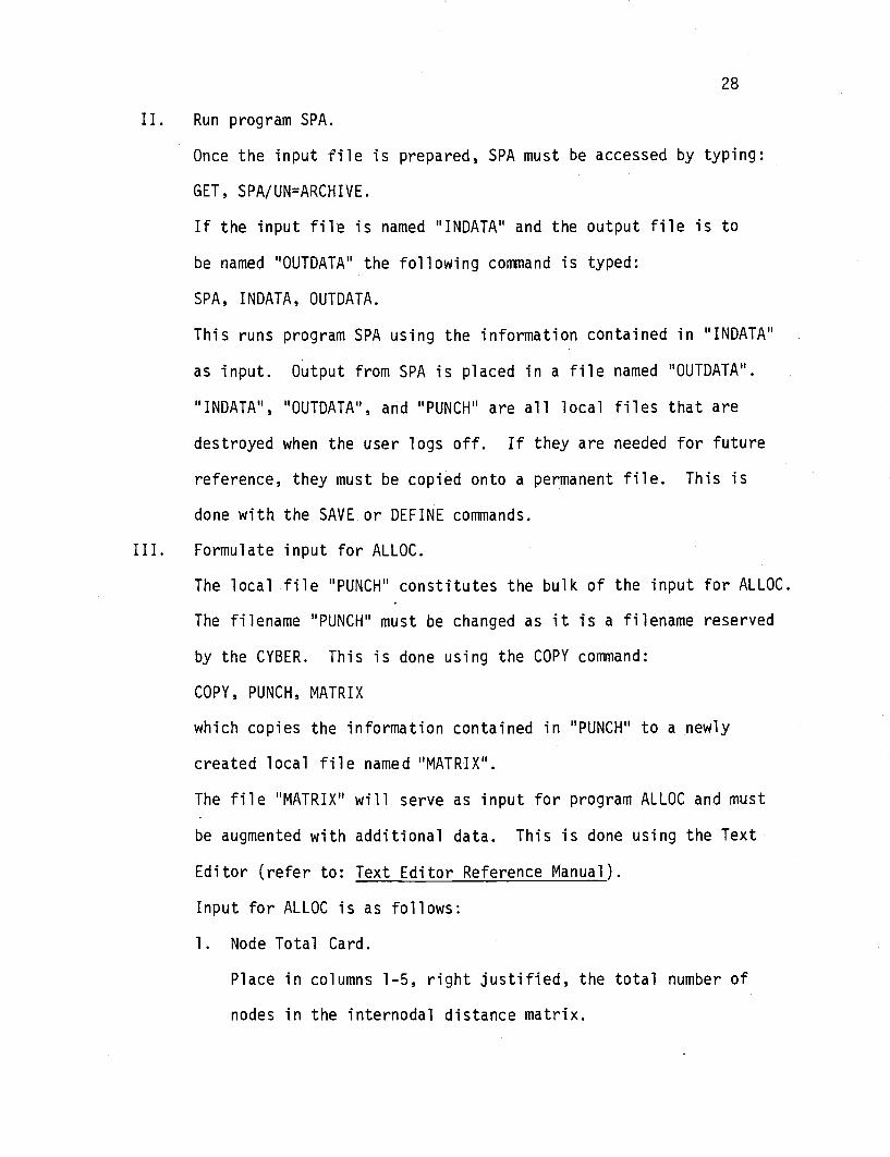
II. Run program SPA.
Once the input file is prepared, SPA must be accessed by typing:
GET, SPA/UN=ARCHIVE.
If the input file is named "INDATA" and the output file is to
be named "OUTDATA'1 the following command is typed:
SPA, INDATA, OUTDATA.
This runs program SPA using the information contained in "INDATA"
as input. Output from SPA is placed in a file named "OUTDATA".
"INDATA", "OUTDATA", and "PUNCH' are all local files that are
destroyed when the user logs off. If they are needed for future
reference, they must be copied onto a permanent file. This is
done with the SAVE or DEFINE commands.
III. Formulate input for ALLOC.
The local file "PUNCH" constitutes the bulk of the input for ALLOC.
The filename "PUNCH" must be changed as it is a filename reserved
by the CYBER. This is done using the COPY command:
COPY, PUNCH, MATRIX
which copies the information contained in "PUNCH" to a newly
created local file named "MATRIX".
The file "MATRIX' will serve as input for program ALLOC and must
be augmented with additional data. This is done using the Text
Editor (refer to: Text Editor Reference Manual).
Input for ALLOC is as follows:
1. Node Total Card.
Place in columns 1-5, right justified, the total number of
nodes in the internodal distance matrix,
29
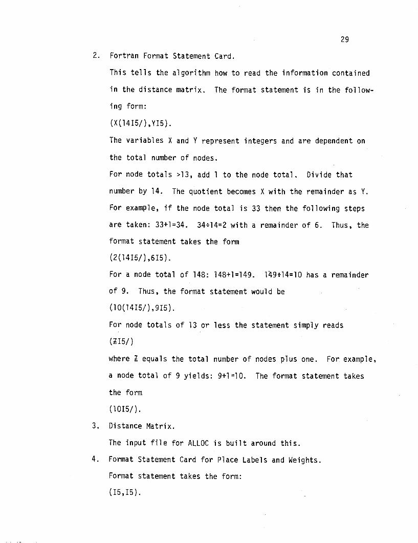
2. Fortran Format Statement Card.
This tells the algorithm how to read the information contained
in the distance matrix. The format statement is in the follow-
ing form:
(X(l415/),Y15).
The variables X and Y represent integers and are dependent on
the total number of nodes.
For node totals >13, add 1 to the node total. Divide that
number by 14. The quotient becomes X with the remainder as Y.
For example, if the node total is 33 then the following steps
are taken: 33+1=34. 34914=2 with a remainder of 6. Thus, the
format statement takes the form
(2(1415/) ,615).
For a node total of 148: 148+1=149. 14914=10 has a remainder
of 9. Thus, the format statement would be
(10(1415/) ,915).
For node totals of 13 or less the statement simply reads
(I5/)
where equals the total number of nodes plus one. For example,
a node total of 9 yields: 9+1=10. The format statement takes
the form
(1015/).
3. Distance Matrix.
The input file for ALLOC is built around this.
4. Format Statement Card for Place Labels and Weights.
Format statement takes the form:
(15,15).
30
5. Node Label and Weight Cards.
Node label is placed, right justified, in columns 1-5 with
corresponding weight, right justified, in columns 6-10.
There will be one card for each node.
6. Control Cards.
These instruct ALLOC which duties to perform. In all cases
numbers placed in the designated columns are to be right
justified.
CARD 1. Columns 1-5: number of service sites desired.
Column 10: select algorithm desired; 1 Maranzana, 2 = Tietz
and Bart, 3 = Minimax Solution. Tietz and Bart yields the
most reliable solution.
CARD 2. Initial source node labels: User provides the algorithm
with logical nodes to start with. If three service sites are
desired for example, three source locations must be provided
by the user.
Columns 1-5: node label for first source location.
Columns 6-10: node label for second source location, etc.
7. Blank Card.
Necessarily placed at end of input file.
IV. Run Program ALLOC.
Once input file for ALLOC is complete, the following commands are
typed:
GET ,ALLOC/UN=ARCI-IIVE
REWIND, MATRIX
ALLOC, MATRIX, ALOUT

31
This runs program ALLOC using MATRIX as input and placing
output on a newly created local file named ALOUT. If any of
the files contain information that may be desired at a later
date, they must be saved as permanent files. For example, if
the input "MATRIX" and output "ALOUT" of ALLOC must be saved,
the following commands are typed:
REWIND, MATRIX, ALOUT
SAVE, MATRIX, ALOUT
If hard copies of the two files are desired than the following
commands are typed:
ROUTE, MATRIX/DC=LP
ROUTE, ALOUT/DC=LP
The files' contents are printed on the line printer.
The preceeding information corresponds to the most basic form of
output generated from SPA and ALLOC. To facilitate programs' use,
the user should become familiar with the following commands in addition
to those previously noted:
CHANGE CLEAR ENQUIRE
PURGE RENAME REPLACE