Embed Size (px)
Citation preview
September, 2006
A place named Irishtown
In 1845, the Adelaide Register newspaper reported that nineteen Catholics had been baptized at ‘little Dublin’ on the outskirts of Mount Barker. ‘Little Dublin’ was
not an official placename for this spot. It is unclear whether the placename came about because Dubliners were among the small Catholic community living there, or whether the name Dublin, or Little Dublin, was being considered as an official name at the time. The placename Dublin had been considered before. In 1840, the Register reported that the map showing the allotments for a proposed village of ‘Dublin’ was on display at the Emu Inn, Morphett Vale. While local history shows a small Irish community in this area in the nineteenth century, the placename Dublin did not eventuate. In 1876, however, the name Dublin appeared in the hundred of Dublin, named for Dublin-born Governor MacDonnell. Before that, Dublin town, north of Gawler, was settled in the 1870s.
The founding of Dublin town in South Australia
was not prompted by the existence of a local Irish or Catholic community. Nevertheless, the name is linked nominally with Ireland, and individuals and communities occasionally exploit the connection:
in 1970, the South Australian Dublin Progress Association invited Richard O’Brien, the Irish ambassador, to open its centennial celebrations.
Placenames can evolve and develop in surprising ways. Unofficial placenames, that are perpetuated, can reveal hidden tensions in a supposed smooth plan. The city of Adelaide prides itself on its regulated and controlled beginnings, mapped out before any
European footprint marked the sands of Holdfast Bay.
Adelaide’s founder and surveyor, Colonel William Light, mapped out allotments and the street design in London, but street naming was left to a small group of pioneers. One of these was John Jeffcott, a Kerryman born in Tralee, who named Jeffcott Street after himself (or his father), Kermode Street after his fiancée, and
CONTINUED PAGE 4
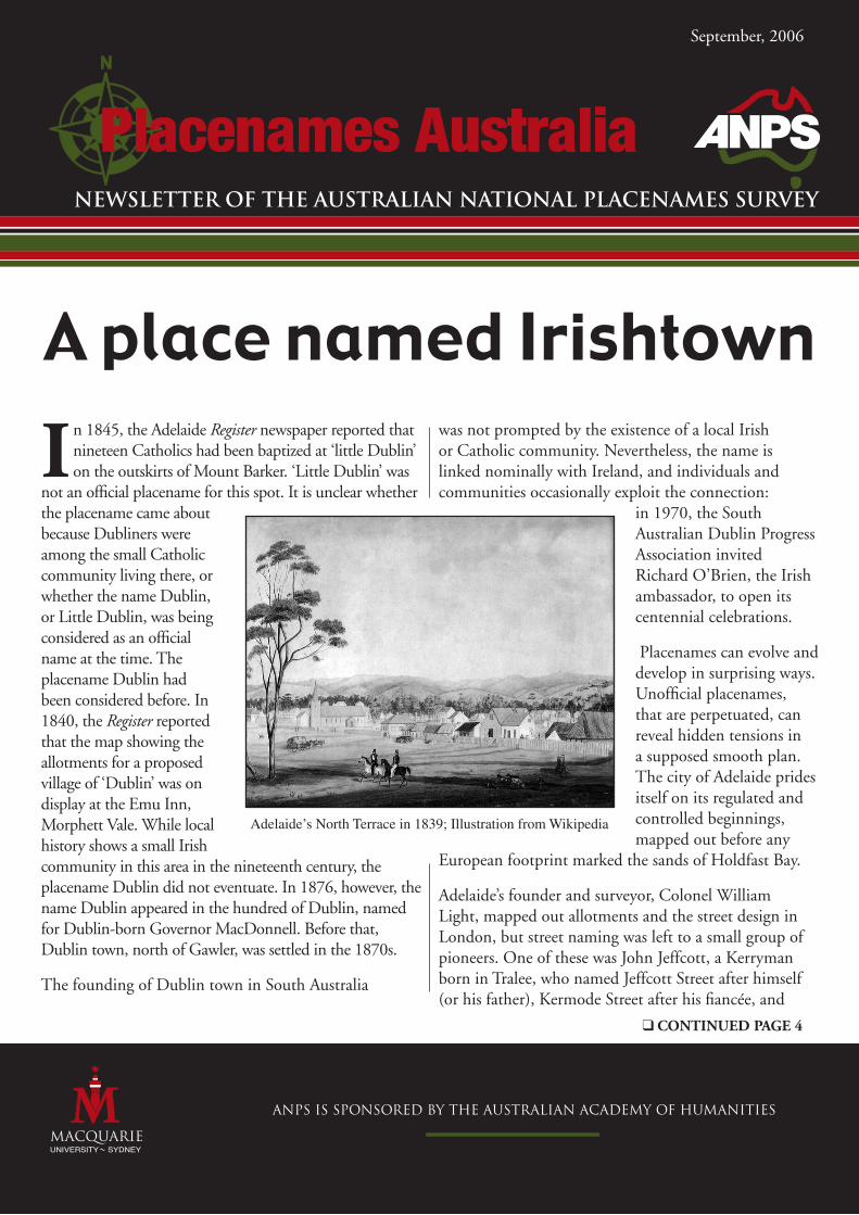
Adelaide’s North Terrace in 1839; Illustration from Wikipedia
�
Reader feedback
In this issue
A place named Irishtown ............................................... 1
Reader feedback ............................................................. 2
New publications ........................................................... 2
On the Web ................................................................... 5
Placenames in the news .................................................. 5
Dutch placenaming practices on the Southland .............. 6
Research friend .............................................................. 9
Placenames of Fiji, Part 5 ............................................. 10
Dunns Leap, NSW ...................................................... 11
Placenames Puzzle no.19 .............................................. 12
Mailing list and volunteer research ............................... 12
I thought I should write about the article in ‘Placenames Australia’ by Jan Tent ‘The importance of bygone
placenames’ (March 2006). I’m a botanist with a strong interest in the history of botanical collecting in Australia. This goes back to William Dampier in 1699, or possibly Willem de Vlamingh in 1697. A problem in researching specimens, especially those pre-1900, is interpreting the locality of collection. Collectors commonly travelled in regions where there were few or no placenames and so gave their own names, or their best guess, or (the worst scenario) nothing. Some such names later became official but many did not, while in some instances a name was officially changed (e.g. Newcastle to Toodyay in WA). There are (literally) tens of thousands of such specimens in herbaria both in Australia and overseas. The same goes for zoological specimens in museums. In most cases the localities have appeared in print in scientific papers and books. It would therefore add another level of difficulty to research were we to start changing names, or even the practice of using dual names as apparently has begun in Sydney. I caution against such changes.
With best wishes,
Alex George (botanist, editor, indexer)
New Publications
Sweers Islands Unveiled: Details from Abel Tasman and Matthew Flinders' explorations of Australia, by Carsten Berg Høgenhoff, in co-operation with Lyn & Tex Battle, Bob Forsyth and Annette Sweerts, 2006, published by Høgenhoff Forlag, Oslo, ISBN 8299714028
Tiny Sweers Island in the South Wellesley Group in the Gulf of Carpentaria is not a place that hits the news every day. It houses a small fishing resort run by Tex and Lyn Battle since 1987, and is mainly part of the Aboriginal trust area belonging to the Kaiadilt people. A recent study of the Bonaparte Tasman map, owned by the Mitchell Library in Sydney since 1933, quite literally places Sweers Island on the map. ‘In placing a small part of the Australian coastline under the microscope, the authors of Sweers Islands Unveiled have advanced our understanding of Abel Tasman’s great voyage of 1644’, says Senior Curator Paul Brunton of the Mitchell Library at the State Library of New South Wales.
Sweers Islands Unveiled is a 48-page book with colour plates focusing on Salomon Sweers, an official of the Dutch East India Company at Batavia (Jakarta) in the seventeenth century and the uncle of one of the ancestors of main author Carsten Berg Høgenhoff of Oslo. Together with the Battles of Sweers Island, genealogist Annette Sweerts of Amsterdam and historian Bob Forsyth of Mount Isa, Qld, he has followed the paths of Australian explorers Abel Tasman and Matthew Flinders. The combining factor has been places named after Salomon Sweers in Tasmania, the Bismarck Archipelago and Queensland.
‘This might appear a book of only local interest, but it is a splendid example of a good local study illuminating the wider picture’, says Senior Curator Paul Brunton of the Mitchell Library. When he was presented with a draft version of the book in January this year, Mr Brunton immediately saw that some of the conclusions drawn in this book advance the understanding of Abel Tasman’s voyages in the 1640s. In particular, the book reveals that some tiny parts of the so-called Bonaparte Tasman map are much more accurate than previously believed. ‘Sweers Islands Unveiled has provided further evidence that the Bonaparte Tasman map, one of the few pieces of evidence for Tasman’s 1644 voyage, is in fact a contemporary document of the 1640s’, says Mr. Brunton.
The book can be read on many levels. 2006 is the 400th anniversary for the Dutch mapping of Australia, most of which was performed by ships run by the Dutch United East India Company (VOC), and the book gives a brief but solid introduction to the VOC’s important role. Following one particular individual in Tasman and Flinders’ nomenclature
�
of Australia, it also gives an interesting insight into their journeys. For example, present-day Sweers Island in the Gulf of Carpentaria has its own, very special place in Australia’s history. In 1802, Matthew Flinders finally answered one of the old questions about New Holland, as Australia was known by at that time: was it one continent, or were the eastern and western parts divided by sea? Flinders’ conclusion that it was indeed one continent was made while he stayed on Sweers Island in 1802.
The only Sweers Island which today retains Salomon Sweers’ name is in the Gulf of Carpentaria. It was named by Matthew Flinders after his 1801-03 circumnavigation of Australia. This was one of many tributes by way of nomenclature which he paid to the Dutch contribution to the charting of Australia. From 1642-43, Abel Tasman was the first to circumnavigate the continent, discovering Tasmania and New Zealand, and he sailed along Australia’s north coast in 1644. He named places both in Tasmania, the Bismarck Archipelago and the Gulf of Carpentaria after Sweers, but none of these remain. Even more picturesque is the fact that the so-called Sweers Islands in Tasmania -- they were really not islands, but high headlands -- have found their way into Gulliver’s Travels, Jonathan Swift’s classic novel from 1726, where they are charted as some islands not far from the Land of the Houyhnhnms where the Yahoos lived.
Sweers Islands Unveiled (RRP Au$19.95 / Euro 11.95) is richly illustrated with maps by the author and vignettes by local Aboriginal artist M Henry, and has a preface by Paul Brunton. It is available at selected outlets around the country and online from www.sweers.com.au
g g g
Blue Mountains Geographical Dictionary, by Brian Fox, 2006, ISBN 0957873727
The latest Blue Mountain publication, Blue Mountains Geographical Dictionary, was officially launched at the Blue Mountains Historical Society, Wentworth Falls, on 3 June 2006.
The book is a complete update and revision on the previous edition, and now covers all the Blue Mountains, from Lapstone to Mount Victoria. Cross-referencing includes a listing near the front of the book of 22 major localities across the mountains which have their individual names covered; this shows at a glance what names are in each area, then for
more detailed information each of these names is detailed in the A-Z section. Also included are 30 maps (historical as well as new), photographs and a section showing where information has been sourced from.
Brian Fox has been described by John Low, Local Studies Librarian for the Blue Mountains City Council, as ‘the foremost historian of Blue Mountains place-names’, and his book brings together the skills of his 35 years’ experience as a cartographer and over 350 day walks within the Blue Mountains. He is a cartographer with the NSW Department of Lands and a member of the Central West Bushwalking Club, Engineers Track Heritage Infrastructure Committee (along the Grose River) and two historical societies. In this publication he has researched and documented over 2,165 placenames within the Blue Mountains region. Each entry details the location, origin and background to the name’s meaning.
Copies may be obtained from the author – Brian Fox, 19 Weeks Place, Bathurst, NSW 2795; phone 02 6332 2590 – at02 6332 2590 – at – at the price of $45 each (plus postage and packing, $7.90 for one copy or $8.25 for two copies within Australia).
g g g
Australian Place Names, by Brian and Barbara Kennedy, 2006, published by ABC Books, ISBN 073331760X (a revised version of the 1999 classic published by Hodder & Stoughton Australia)
From Abbotsford to Zillmere, Australian Place Names is a fascinating guide to the meanings
and origins of more than 2000 of Australia’s best-known placenames. Authoritative and
entertaining, it examines not only urban and suburban names but also the frequently colourful and exotic names of Australia's far-flung rural communities. Almost three-quarters of Australia's placenames are derived from Aboriginal words, and in recent years some placenames of Aboriginal origin have been restored as official names, the best known being Uluru/Ayers Rock. But many others were named for people and locations well known in distant Great Britain during colonial times. Still others have more obscure and fascinating origins: at least one place is named after its discoverer's horse! There are names that echo with infamy – Port Arthur, Maralinga, Snowtown; others raise a smile – Wait a While, Snug, Come by Chance. And many locations, such as Mount Hopeless and Mount Disappointment, reflect the despairing moments of the explorers who named them. Endlessly fascinating, Australian Place Names is an outstanding addition to every reference shelf.
g g g
�
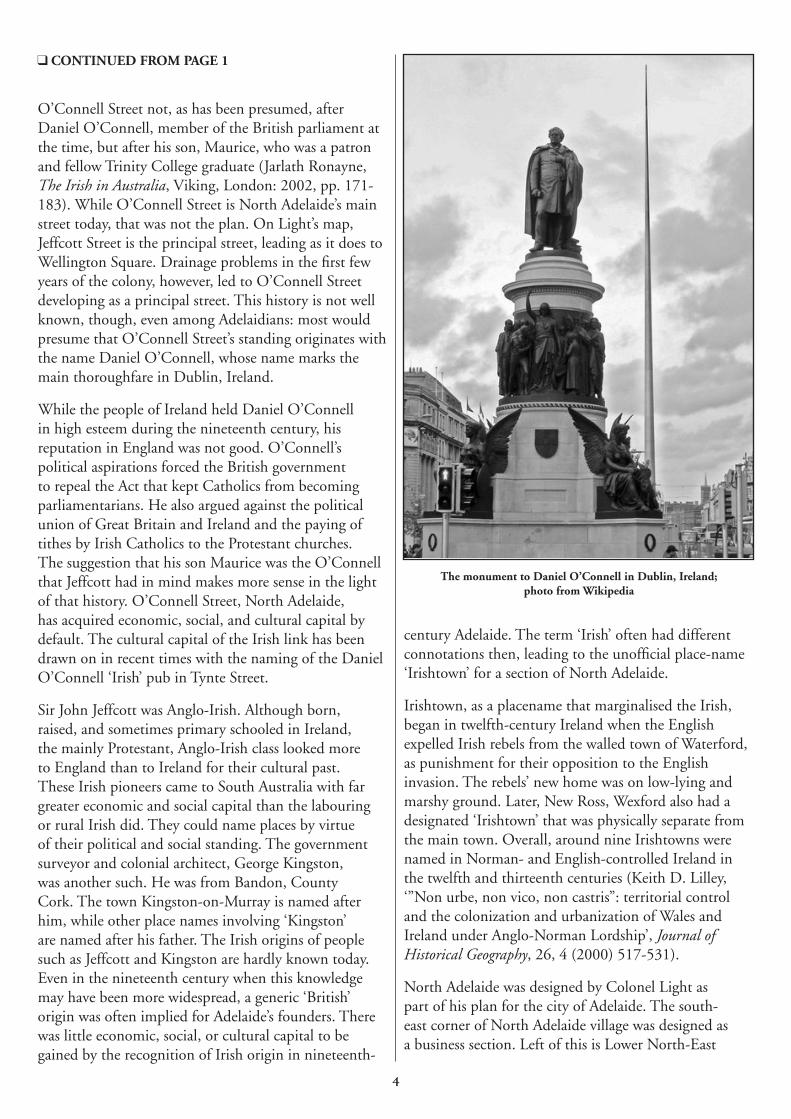
O’Connell Street not, as has been presumed, after Daniel O’Connell, member of the British parliament at the time, but after his son, Maurice, who was a patron and fellow Trinity College graduate (Jarlath Ronayne, The Irish in Australia, Viking, London: 2002, pp. 171-183). While O’Connell Street is North Adelaide’s main street today, that was not the plan. On Light’s map, Jeffcott Street is the principal street, leading as it does to Wellington Square. Drainage problems in the first few years of the colony, however, led to O’Connell Street developing as a principal street. This history is not well known, though, even among Adelaidians: most would presume that O’Connell Street’s standing originates with the name Daniel O’Connell, whose name marks the main thoroughfare in Dublin, Ireland.
While the people of Ireland held Daniel O’Connell in high esteem during the nineteenth century, his reputation in England was not good. O’Connell’s political aspirations forced the British government to repeal the Act that kept Catholics from becoming parliamentarians. He also argued against the political union of Great Britain and Ireland and the paying of tithes by Irish Catholics to the Protestant churches. The suggestion that his son Maurice was the O’Connell that Jeffcott had in mind makes more sense in the light of that history. O’Connell Street, North Adelaide, has acquired economic, social, and cultural capital by default. The cultural capital of the Irish link has been drawn on in recent times with the naming of the Daniel O’Connell ‘Irish’ pub in Tynte Street.
Sir John Jeffcott was Anglo-Irish. Although born, raised, and sometimes primary schooled in Ireland, the mainly Protestant, Anglo-Irish class looked more to England than to Ireland for their cultural past. These Irish pioneers came to South Australia with far greater economic and social capital than the labouring or rural Irish did. They could name places by virtue of their political and social standing. The government surveyor and colonial architect, George Kingston, was another such. He was from Bandon, County Cork. The town Kingston-on-Murray is named after him, while other place names involving ‘Kingston’ are named after his father. The Irish origins of people such as Jeffcott and Kingston are hardly known today. Even in the nineteenth century when this knowledge may have been more widespread, a generic ‘British’ origin was often implied for Adelaide’s founders. There was little economic, social, or cultural capital to be gained by the recognition of Irish origin in nineteenth-
century Adelaide. The term ‘Irish’ often had different connotations then, leading to the unofficial place-name ‘Irishtown’ for a section of North Adelaide.
Irishtown, as a placename that marginalised the Irish, began in twelfth-century Ireland when the English expelled Irish rebels from the walled town of Waterford, as punishment for their opposition to the English invasion. The rebels’ new home was on low-lying and marshy ground. Later, New Ross, Wexford also had a designated ‘Irishtown’ that was physically separate from the main town. Overall, around nine Irishtowns were named in Norman- and English-controlled Ireland in the twelfth and thirteenth centuries (Keith D. Lilley, ‘”Non urbe, non vico, non castris”: territorial control and the colonization and urbanization of Wales and Ireland under Anglo-Norman Lordship’, Journal of Historical Geography, 26, 4 (2000) 517-531).
North Adelaide was designed by Colonel Light as part of his plan for the city of Adelaide. The south-east corner of North Adelaide village was designed as a business section. Left of this is Lower North-East
CONTINUED FROM PAGE 1
The monument to Daniel O’Connell in Dublin, Ireland; photo from Wikipedia
�
Adelaide which was developed as housing for labourers and their families under the Wakefield Plan: a tiered city would comprise a ruling class, a merchant class, and a labouring class. Land prices were kept high to make sure that the labouring classes remained so, for the good of the fledgling colony. From the very beginning, this social divide manifested itself in the North Adelaide’s big houses that contrasted with the small cottages in Irishtown.
The earliest record of North Adelaide’s ‘Irishtown’ is in the Destitute Institute register in 1855. While Irish migrants had arrived from the first years of settlement, the 1840s saw significant numbers through assisted immigration. In 1849, the Inconstant brought thousands of Irish female Famine orphans. By 1851 Irish road labourers outnumbered the English by six to one. Although the Irish were not proportionally numerous in Adelaide, they were sometimes present in sufficient numbers to attract attention. When the name ‘Irishtown’ was first recorded in Adelaide, 2,047 Irish females were registered at the Destitute Institute.
We do not know whether a concentration of Irish in ‘Irishtown’, North Adelaide led to the placename or whether the name evolved from a need to distinguish those North Adelaide residents who owned big houses from those labourers who occupied the cottages. The Census of 1843 shows a ratio of masters to servants in South Australia as 17% to 78%. The Wakefield plan for a ruling class, a business class, and a labouring class appeared to be working. However, the 1850s and the gold rushes brought great changes. With new-found wealth, servants could become masters, and many did. In turn, they built the type of homes previously unavailable to them. These changes heralded an end to the building of the Big House in North Adelaide and an end to the placename ‘Irishtown’.
For thirty or forty years in the second part of the nineteenth century the name Irishtown was applied to a section of Adelaide, probably to serve the need to perpetuate a divide between rich and poor. Placenames are useful starting points for studying social histories that have left the main historical stage. They are a challenge to our tendency to forget the forgettable, and a reminder of values that once prevailed, and of presences that once provoked.
Dymphna LonerganFlinders University
On the Web
Placenames in the News
There is now a searchable database of Northern Territory placenames available on the website of the Territory’s Department of Planning and Infrastructure. The NT Place Names Amendment Act 2004 provided that the Place Names Register should be publicly accessible, and this has been implemented by way of an Internet-searchable version. The official Register contains only names approved by the Minister. However, the Place Names Committee has decided that information on all placenames in its database should be made available in order to assist researchers. The database is continually being updated and new placenames being added. It has been developed using Web Feature Server software, so that whenever a search is made, the result obtained is the latest information which is held in the database at that time.
http://dpi.nt.gov.au/whatwedo/landinformation/place/
The UK magazine Lincolnshire Life contained an article ‘A fitting tribute to Flinders’ under the heading ‘County People’ in its issue for May 2006. It described the unveiling of a bronze statute of the pioneering explorer of the Australian coastline in the marketplace of his native village of Donington, Lincs, on the 232nd anniversary of his birth, 16th March. The article, by David Robinson, remarks on the number of names of Lincolnshire settlements that were used by Flinders in naming features of the Great Australian Bight: Donington itself, Lincoln, Louth, Boston, Sleaford, Willoughby, Spalding, Stamford, Bolingbroke, Partney, Dalby, Winceby, Stickney, Tumby and Revesby.
(Many thanks to Nigel Sinnott and Michael Byrd for bringing this to our attention.)
�
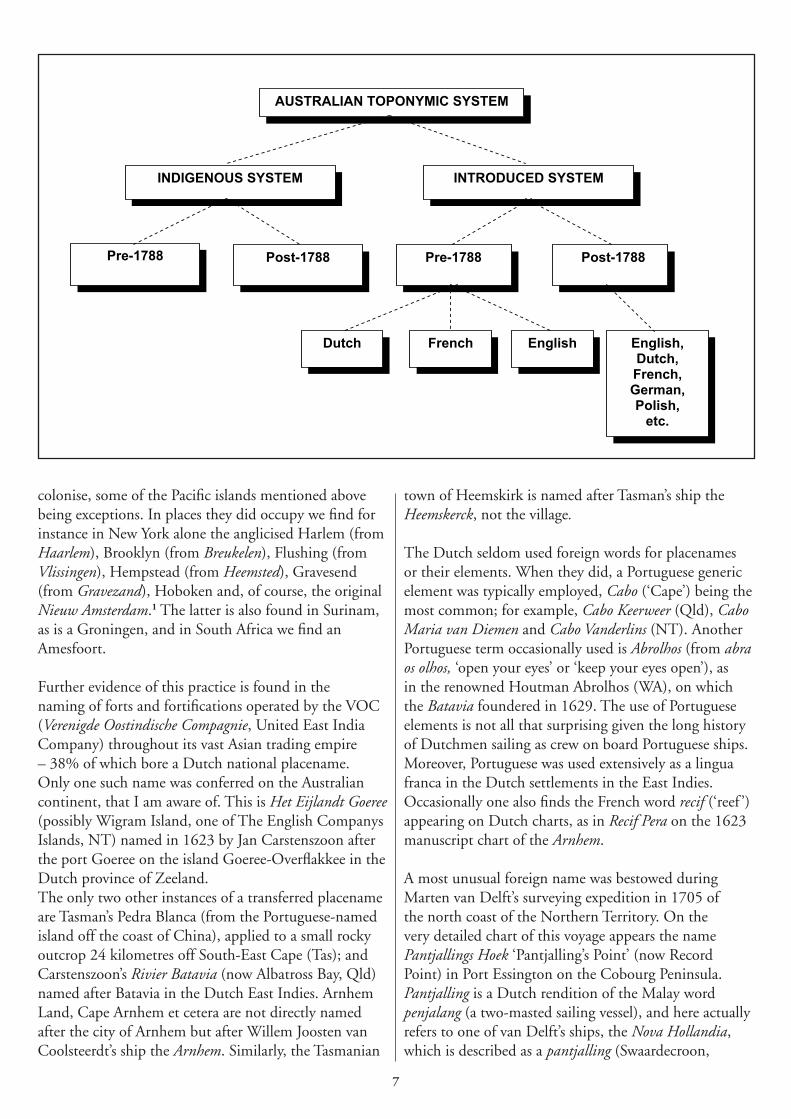
A ustralian placenames should be classified under two broad systems – the Indigenous and the introduced. Each of these is further divided
into placenames bestowed before and after European settlement in 1788. The situation is best illustrated in the diagram opposite.
The vast majority of recorded introduced and Indigenous placenames are naturally post-1788, and the bulk of pre-1788 recorded placenames are Dutch. Others, of course, are French (by Bougainville, Furneaux) and English (by Dampier and Cook). As I mentioned in my previous article (Placenames Australia, March 2006) some 200 Dutch placenames were bestowed during the 150-year long Dutch interest in the Southland. Of these less than 20% are found on today’s maps or in gazetteers; the rest were supplanted, forgotten or lost. Using historical and contemporary Dutch and Dutch-linked placenames in our region as examples, we may distinguish a number of broad types of placename, which include:
• proper nouns (eponyms): Van Diemen Gulf (NT), Nuyts Archipelago (SA), St Peter Island (SA), Carpentaria (Qld), Tasmania, Maria Island (Tas & NT), Schouten Island (Tas), Maatsuyker Island (Tas), and Orange (NSW).
Ships’ names were also a source, e.g. Arnhem Land (NT), Limmen Bight (NT), Pera Head (Qld), Cape Leeuwin (WA), Zuytdorp Cliffs (WA), Zeehan (Tas), Mt Heemskirk (Tas), and Duyfken Point (Qld);
• descriptive and associative names: Vliege Baij (‘Fly Bay’, now Albatross Bay, Qld), Witte Hoek (‘White Point’, now Radford Point, NT), Groote Eylandt (‘Great Island’, NT), Rottnest Island (‘Rat Nest
Island’, WA), Swan River (WA), Red Bluff (from Roode Hoek, WA), and Dorre Island (‘Barren Island’, WA);
• commemorative names (recording incidents, events or conditions): Storm Bay (Tas), Cape Keerweer (Qld), Paesdachslandt (‘Easter Day Land’, NT), Doodslagers Rivier (‘Manslaughterer’s River’, West Papua), Moordenaers Baij (‘Murderer’s Bay’, now Golden Bay, New Zealand), Verraders Eiland (‘Traitor’s Island’, Niuatoputapu); and
• transferred placenames: Pedra Blanca (Tas), New Zealand (after the province of Zeeland), and the Pacific islands of Amsterdam (i.e. Tongatapu), Middleburgh (i.e. Eua), Rotterdam (i.e. Nomuka).
In addition, placenames usually consist of a generic element and/or a unique element where, for instance, in Limmen Bight (NT), ‘Limmen’ is the unique element, which specifically identifies the generic element ‘Bight’, which in turn identifies the type of topographic feature named. Many placenames consist of a unique element only; for example, Coen (Qld), Leeman (WA), Orange (NSW), and Zeehan (Tas). Only rarely do we find a generic element being used by itself: Waterplaets (‘Watering Place’) and Droochte (‘Shoal’, ‘Sandbar’) are two examples, and are best classified as ‘loose descriptors’.
Some Dutch place-naming practices
Approximately 60% of the placenames conferred by the Dutch are eponyms, 36% descriptors, 3.5% commemorative, and 0.5% other (i.e. of unknown meaning or transferred placenames).
The Dutch were not inclined to transfer their own national placenames, at least not to places they did not
Dutch placenaming: practices on the
Southland
�
AUSTRALIAN TOPONYMIC SYSTEM
INDIGENOUS SYSTEM INTRODUCED SYSTEM
Pre-1788 Post-1788 Pre-1788 Post-1788
EnglishFrenchDutch English,Dutch,French,German,Polish,
etc.
colonise, some of the Pacific islands mentioned above being exceptions. In places they did occupy we find for instance in New York alone the anglicised Harlem (from Haarlem), Brooklyn (from Breukelen), Flushing (from Vlissingen), Hempstead (from Heemsted), Gravesend (from Gravezand), Hoboken and, of course, the original Nieuw Amsterdam.1 The latter is also found in Surinam, as is a Groningen, and in South Africa we find an Amesfoort.
Further evidence of this practice is found in the naming of forts and fortifications operated by the VOC (Verenigde Oostindische Compagnie, United East India Company) throughout its vast Asian trading empire – 38% of which bore a Dutch national placename. Only one such name was conferred on the Australian continent, that I am aware of. This is Het Eijlandt Goeree (possibly Wigram Island, one of The English Companys Islands, NT) named in 1623 by Jan Carstenszoon after the port Goeree on the island Goeree-Overflakkee in the Dutch province of Zeeland. The only two other instances of a transferred placename are Tasman’s Pedra Blanca (from the Portuguese-named island off the coast of China), applied to a small rocky outcrop 24 kilometres off South-East Cape (Tas); and Carstenszoon’s Rivier Batavia (now Albatross Bay, Qld) named after Batavia in the Dutch East Indies. Arnhem Land, Cape Arnhem et cetera are not directly named after the city of Arnhem but after Willem Joosten van Coolsteerdt’s ship the Arnhem. Similarly, the Tasmanian
town of Heemskirk is named after Tasman’s ship the Heemskerck, not the village.
The Dutch seldom used foreign words for placenames or their elements. When they did, a Portuguese generic element was typically employed, Cabo (‘Cape’) being the most common; for example, Cabo Keerweer (Qld), Cabo Maria van Diemen and Cabo Vanderlins (NT). Another Portuguese term occasionally used is Abrolhos (from abra os olhos, ‘open your eyes’ or ‘keep your eyes open’), as in the renowned Houtman Abrolhos (WA), on which the Batavia foundered in 1629. The use of Portuguese elements is not all that surprising given the long history of Dutchmen sailing as crew on board Portuguese ships. Moreover, Portuguese was used extensively as a lingua franca in the Dutch settlements in the East Indies. Occasionally one also finds the French word recif (‘reef ’) appearing on Dutch charts, as in Recif Pera on the 1623 manuscript chart of the Arnhem.
A most unusual foreign name was bestowed during Marten van Delft’s surveying expedition in 1705 of the north coast of the Northern Territory. On the very detailed chart of this voyage appears the name Pantjallings Hoek ‘Pantjalling’s Point’ (now Record Point) in Port Essington on the Cobourg Peninsula. Pantjalling is a Dutch rendition of the Malay word penjalang (a two-masted sailing vessel), and here actually refers to one of van Delft’s ships, the Nova Hollandia, which is described as a pantjalling (Swaardecroon,
�
Chastelijn & Craine 1856 [1705]; Collingridge 1983 [1895], p. 299).
As mentioned above, some 60% of Dutch placenames were eponyms (many after powerful or influential people either back home or in Batavia) and 36% were descriptive. The vast majority of Tasman’s placenames (86%) were eponyms. One has to wonder at his motives as Governor van Diemen and his wife Maria have places named after them in both Tasmania and the Gulf of Carpentaria. Whatever Tasman’s motives, they were not shared by Willem Janszoon (1606), Willem de Vlamingh (1696-97) or van Delft, who largely conferred descriptive placenames. For instance, 55% of van Delft’s placenames alone are descriptive (e.g. Kliphoek ‘Cliff Point’, Boompjes Hoek ‘Little Trees Point’, Witte Hoek ‘White Point’, Vuyle Bocht ‘Foul Bight’, de Konijnenberg ‘the Rabbits Hill’, Oosthoek van Drie Bergens bocht ‘East Point of Three Hills Bight’, Hoefyzer Hoek ‘Horseshoe Point’). The rest were eponyms (40%) honouring the men and ships of his own expedition (e.g. Marten van Delft’s baai ‘Marten van Delft’s Bay’, Waijers hoek ‘Waijers Point’, Vossenbosch Ruyge Hoek ‘Vossenbosch Rugged Point’, Hoek van Onier, Jan Melchers Hoek, Roseboomshoek, P. Frederiksrivier), and another 5% commemorative (Bedriegers Hoek ‘Deceiver’s Point’, Pantjallings Hoek).
Why so few placenames?
When we consider the extent of Dutch exploration, contact with and charting of the Southland’s coastline, it is quite striking how, overall, so few placenames were bestowed. The notable exception is van Delft, who recorded no less than 47 placenames during his three-month expedition, more than any other Dutch explorer. However, if we take into account the general motives of the Dutch in charting the Southland, it is perhaps not so surprising that they conferred so few placenames. The main interests of the VOC in charting this region were to help their ships safely navigate to their stations in the East Indies, and to discover potential sources of precious metals and new markets for trade. However, the company saw no potential for profit in this land and, unlike the British in the latter years of the 18th century, showed no desire to take possession of it. The names we see on Dutch charts were essentially applied to only those topographic features that had some significance for navigation. Further naming was, therefore, unnecessary. Prolific naming of places is a characteristic by-product of settlement, for when you name a place, you in effect also take ‘possession’ of it. Further evidence may be found in
Tasman’s journal of his 1642 voyage and those compiled on de Vlamingh’s ships the Geelvinck and Nijptangh. These journals hardly ever make any specific mention of bestowing names to topographic features. It is only on the charts and coastal profile sketches made on these voyages that we see any evidence of placenaming.
Since European settlement, many more Dutch and Dutch-linked names have been added to the ever-expanding catalogue of Australian placenames. Today there are more than 300 such placenames. Although they comprise only 0.006% of the estimated 5 million-plus contemporary placenames, they feature some of the most significant and well-known – Arnhem Land, Gulf of Carpentaria, Groote Eylandt, Rottnest Island, Swan River, Cape Leeuwin, Orange, Camperdown, Tasmania (and the specific element ‘Tasman’ in a myriad of placenames such as Tasman Sea, Tasman Peninsula, and Tasman Basin etc.), and of course the celebrated historical placenames, New Holland and Van Diemensland.
In my next article I shall compare the Dutch, French and English place-naming practices on the Southland.
�an Tent�an TentDepartment of Linguistics, Macquarie University
Footnote
1 Of the 13 other Dutch placenames in New York, three are eponyms and ten descriptive/ associative.
References
Collingridge, G. (1895) The Discovery of Australia: A Critical, Documentary and Historic Investigation Concerning the Priority of Discovery in Australasia by Europeans before the arrival of Lieut James Cook, in the ‘Endeavour’, in the year 1770, facsimile edition (1983), Golden Press, Gladesville.
Swaardecroon, H., Chastelijn, C. & Craine, J.S. (1856 [1705]) ‘Report to Jan van Hoorn and Council of India, 6 October 1705’, in Major, R.H. (ed.) Early voyages to Terra Australis, now called Australia: A collection of documents, and extracts from early manuscript maps, illustrative of the history of discovery on the coasts of that vast island, from the beginning of the sixteenth century to the time of Captain Cook, Hakluyt Society, London, pp. 165–173.
�
Research Friend
T hree years ago I was in the final year of study at the University of
Leipzig. If anyone had asked me then ‘What will you be doing in three years?’, I am not sure what I would have answered. I certainly would not have said ‘teaching German in Malaysia’. Teaching maybe, but in Malaysia?
The combination of subjects I took at university pointed towards a career in a language-related field, although people always raised an eyebrow suspiciously when I told them I was doing American Studies, German and Onomastics – only a few people knew that this was the word for the ‘science of names’. This course was fairly new and it was small. It focused on personal and geographical names with a touch of Slavic studies and offered a deep insight into etymology. I believe when you understand where the language you speak comes from, you begin to understand your culture -- the German culture in my case -- on a more fundamental level.
Well, after 25 years of being around Germans, speaking German, and after four years of study and now having a top knowledge of the language and culture I figured it was time for a change, a change of location. I went to Australia. My girlfriend was waiting there for me and I planed to write my masters thesis on German placenames in Australia, something that had already raised my curiosity in 2001 when I went there for the first time.
Most of 2003 I spent in the Brisbane State Library and the Queensland Department of Mapping and Surveying working my way through early maps, pastoral directories and archives. By February 2004 I had about a hundred pages together, printed and bound, with maps and pictures, the last milestone in my student career. I returned to Leipzig and handed it in.
It would take a while to get the results back. Meanwhile I put my html skills to some good use, registered a web address, www.onomastik.com, put a handful of pages online with general information on family names, a guide on how to trace their origin and also an abridged copy of my thesis. However, that’s all in German.
By April I graduated. Nothing much kept me in Germany; on the contrary, my girlfriend was homesick – and Malaysian. So we went to Malaysia. It did not take long to adjust to the climate, and the variety of food was impressive. It was also fairly easy to find a job as a German teacher, in a bright and friendly college in Petaling Jaya, near Kuala Lumpur.
I still remember my first class, almost two years ago. I was a fresh graduate and my first full-time teaching job had me standing in front of 60 students curious about who ‘the new teacher’ is going to be. A class that big was not what I had expected, but we made things work and it turned out to be very enjoyable. The students are courteous and eager for knowledge; some of them plan to go to Europe after
they graduate.
I have to admit that even though I have been here for quite some time now I still don’t know more than a handful of words in Malay. Everyone speaks English – more or less.
Professionally I am not involved with onomastics, but still with language. Names have never lost their fascination for me, and they have remained a hobby. The time that
is left at the end of the day I spend in front of the screen, trying to improve the website I started two years ago or to help people in the forum.
We will most likely stay in Malaysia for another few years, maybe longer. My classes are much smaller now, the experience I gained over the last semesters has improved my teaching a lot and every day in college has something new in store for me -- it is never boring.
Thomas Liebecke
Thomas Liebecke
10
I n the previous instalment of this series, we followed Captain William Bligh to the volcanic island of Tofua in Tonga, just to the east of Fiji, where the famous
mutiny on the Bounty took place. Our excuse for this excursus was that it is an instance of a common strategy in the naming of places in the prehistoric Pacific: the use of a suffix consisting of an optional consonant plus the vowel ‘a’. For example, namu means ‘mosquito’ in many Pacific languages, and Namuka (pronounced Nomuka in Tongan) is the name of a number of mosquito-infested islands in Fiji, Tonga and Samoa.
Similarly, Tofua in Tongan is equivalent to Tafua in Samoan and Tavua in Fijian, and is based on the ancient word tavu meaning ‘burn’ or ‘make a fire’, so means something like ‘land of fire’, a very apt name for a volcanic island. Now, there are a number of places in Fiji called Tavua – a town and district in northern Vitilevu, an island in the Mamanuca Group to the west of Vitilevu, a village on the west coast of Koro Island in Lomaiviti, an abandoned village near Lekutu in northern Bua – but none of these is volcanic. In fact, standard works on the geography of Fiji tell us that there hasn’t been any volcanic activity in Fiji for many thousands of years, since long before Fiji was first occupied
by Lapita people some three thousand years ago. So could the placename Tavua mean ‘place of firing pottery’ or ‘place of burning trees’ – or is there another explanation?
To say Fiji is not known for volcanic activity is an understatement. Whilst active volcanoes are found in almost all Fiji’s neighbours, such as Tonga, Samoa, and Vanuatu, there has never been a report of a volcanic eruption in Fiji, nor is there any such oral tradition, nor has any Fijian language a word for 'volcano'. (Nor has English, of course, we borrowed it from the Italians). Whatever knowledge the first Fijians had of volcanoes in Vanuatu or the Solomons, where they came from, must have been lost over the generations, and the word for ‘volcano’ with it.
There were, as Cook and his fellow travellers noted, many Fijians in Tonga during the eighteenth century. They would have been aware of volcanoes in Tonga, and probably told their friends about them when they returned to Fiji, but they evidently did not introduce the Tongan word for them into Fijian. People who have written accounts of volcanoes in Fijian this century have either borrowed the European word and Fijianised it as volekano, or used a circumlocution such as ulunivanua kama, meaning 'burning mountain'. The suffix -a was not the only suffix used to form placenames (and other nouns) from other words. There were some variants, and one of the most common of these was -yaga (recall that in Fijian g is pronounced like the ng in sing). Its meaning is a little more specific than -a, since it almost always refers to a place where something is done. It is common in Polynesian languages and Rotuman (the language of Rotuma, a small island north of Fiji), but in Fijian it is now confined to parts of the eastern island of Vanualevu. The word to which it is attached is sometimes reduplicated, that is, repeated, and preceded by the prefix i-. For instance, from the simple word moce meaning 'sleep', the suffixed word imocemoceyaga means 'place to sleep', or 'bed'.
Placenamesof Fiji (part 5)
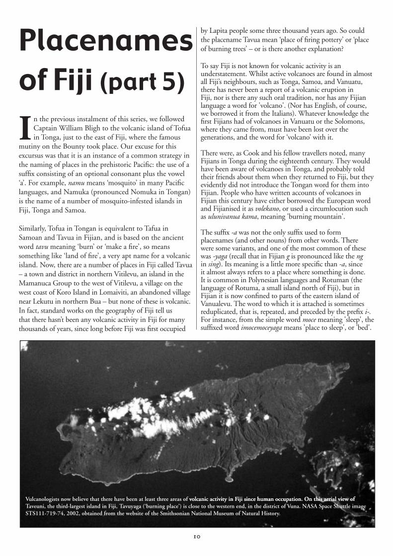
Vulcanologists now believe that there have been at least three areas of volcanic activit�� in �i�i since hu�an occu�ation�� �n this aerial view ofvolcanic activit�� in �i�i since hu�an occu�ation�� �n this aerial view of Taveuni, the third-largest island in �i�i, Tavu��aga (‘burning �lace’) is close to the western end, in the district of Vuna�� NASA S�ace Shuttle i�age STS111-719-74, 2002, obtained fro� the website of the S�ithsonian National Museu� of Natural Histor����
11
From the base bale meaning 'cross over', one gets the derived word ibalebaleyaga meaning 'crossing place'. A related suffix is the Polynesian -aga, found in placenames such as Hokianga (‘turning place’) and Whitianga (‘crossing place’) in New Zealand.
Many placenames have this -yaga ending even in parts of Fiji where the suffix is no longer in regular use. There is Naikeleyaga in Kabara, Lau, which means simply 'the anchoring place'. On the mainland opposite the island of Qoma in Tailevu, where Queen Victoria School is now situated, is a headland named Naikaciyaga, which means 'the calling place'. It is where people used to stand to call over the channel to Qoma when they needed a boat to ferry them across to the island.
Most intriguingly, there are two mountains (that I know of ) named Tavuyaga, one in Northeast Koro and the other in the Vuna district of Southwest Taveuni. Like the previously mentioned Tavua, this name is derived from the word tavu meaning ‘burn’, so can be analysed as meaning ‘burning place’, hence ‘volcano’. Again, the question arises: could these have been active volcanoes within the last three thousand years, when Fiji was occupied? The study of placenames certainly admits this possibility, but received geological knowledge has always denied it – until recently.
Recent research by New Zealanders Cronin and Neall, published in 1998, has indeed determined that volcanic eruptions occurred in the Vuna district of southern Taveuni, the most recent only 340 years ago – well within the period of human occupation of Fiji. And it should not surprise us to learn that this most recent volcanic eruption came from two cones, one of which is named Naucunilawe, the other Tavuyaga.
There is corroboration then from vulcanological research that Tavuyaga did indeed mean ‘volcano’, and I have no doubt that evidence will be found that Tavua had the same meaning, but was probably in use at an earlier period. Distributional linguistic evidence, i.e., the more restricted area in which the disyllabic suffix is found, suggests that places named Tavuyaga were named more recently than places named Tavua – a nice example of placename stratification. The same stratification is suggested by the fact that the disyllabic suffix is not found in placenames of wider reference, being largely confined to names for small islands and tracts of land.
So the answer to the question raised above is, simply, that the standard works on the geography of Fiji have been wrong, and that if geographers had seriously looked at the study of placenames, they would have long since discovered the error of their ways. Placenames, we must tell the world, do not lie!
Paul GeraghtyUniversity of the South Pacific
Dunns Leap, NSWoseph Frederick Dunn was a publican of the Post Office Hotel at Frederickton, about 10 km north of Kempsey in NSW. With his wife
Evelyn Isabel he had five children, all born in the Kempsey district. The year was 1908. They decided to go on holidays to Mount Victoria in the Blue Mountains, most likely to visit other family members (school records show a number of Dunns in the local Mount Victoria school), but -- unlike most holidays where you return home safely, and before you know it you’re back at work and feel as if you’ve never had a holiday -- an incident occurred which gave rise to a name and an intriguing feature which is still there today nearly 100 years later.
While on holidays two of the boys, Arthur in his early 20s and his younger brother Charles just 14 years of age, went exploring along the top of the cliff line just below Mount Piddington. One of the overhangs they explored has a sloping floor and is made up of Mount York claystone, a reddish very fragile rock with very loose footing to walk on, and it was at this point on Sunday 10th May 1908 that the younger boy, Charles Daniel Dunn, slipped and fell over the edge of the 181-feet (55m) cliff.
If he had died that would have been a tragic end to their holiday, but over time the event would have passed into history and been forgotten. But not only did the boy survive but he survived with only minor abrasions and bruises. While Arthur was up the top wondering how he was going to tell his parents, Charles was able to walk home.
Now what makes this spot more intriguing is that at the top where he slipped an iron spike has been hammered into the ground and a piece of wire tied to the spike, and at the base where he landed the other end of the wire is tied to the base of a sign reading Dunns Leap to show the trajectory of his fall. Now the sign reads Dunns Leap 200ft.
Brian FoxNSW Department of Lands
Dunns Leap is just one of the 2,166 names of the Blue Mountains region recorded in Brian’s Blue Mountains Geographical Dictionary; for further details see under New Publications in this issue.
1�
Mailing list and volunteer researchIf you’d like to receive the ANPS newsletter and/or receive information about how to become a Research Friend of the ANPS, please complete the form below and send by post or fax; or email the details to:
ANPSDivision of HumanitiesMacquarie UniversityNorth Ryde, SydneyNSW 2109Fax: (02) 9850 8240Email: [email protected]
Name and/or organisation:…………………………………………….
…………………………………………………………………………
…………………………………………………………………………
Address:……………………………………………………………......
……………………………………………………………....................
Phone: …………………………….Fax:……………………………....
Email: ………………………………………………………………….
q Please add me to the newsletter mailing list q I wish to receive the newsletter by post q I wish to receive the newsletter by emailq Please send me information about becoming a Research Friendq Please remove me from the newsletter mailing listq Please note my change of address (new address above).
Please send all contributions to the Editor, Flavia Hodges, at the address below. Electronic submissions are preferred, and photographic or other illustrations are greatly appreciated.
ContributionsContributions for Placenames Australia are welcome. Closing dates for submissions are:
31 January for the March issue 31 July for the September issue 30 April for the June issue 31 October for the December issue.
Answers: 1. Don (Bradman). 2. Franklin (Roosevelt). 3. Port Arthur. 4. Phillip (Prince Philip). 5. Katherine (Catherine). 6. Virginia (Woolf). 7. Victor Harbor (Victor Hugo). 8. Port Vincent (Van Gogh). 9. Roger Corner (Roger Bannister). 10. Keith (Richards). 11. Alfred Cove (King Alfred). 12. Clyde (Barrow). 13. Dudley (Moore). 14. Arnold (Bennett). 15. Shirley (Bassey). 16. Venus Bay (Venus Williams). 17. Greta (Garbo). 18. Sydney (Sidney Nolan). 19. Jerrys Plains (Jerry Springer). 20. Nelly Bay (Nellie Melba).
Placenames puzzle no. 19Placenames puzzle no. 19
First names
All the clues reveal placenames that are also the first names of well-known people (disregard spelling), e.g. (SA) Also known as Dame Edna … BARRY (Humphries)
1. (TAS) 20th-century Australian cricketing icon
2. (TAS) USA President FDR3. (TAS) Place where ships unload; chief
of the Round Table4. (ACT) The Queen’s husband5. (NT) The great Empress of Russia6. (NT/QLD/SA) Is anyone still afraid
of her?7. (SA) Author of Les Miserables; shelter
for ships8. (SA) Sweet Portuguese wine; painted
sunflowers and starry nights9. (SA) In 1954 he broke the four-
minute mile record; where two streets meet
10. (SA) Stones’ guitarist who fell out of a coconut tree
11. (WA) Not good at cake baking; slang for ‘chap’
12. (VIC) Went around with Bonnie13. (VIC) Stage partner of Peter Cook14. (VIC) Wrote about the Five Towns15. (VIC) The dame who sang
“Goldfinger”16. (VIC/SA) A tennis ‘star’ with a
tennis-playing sister; noise of a hound
17. (VIC/NSW) Film star who wanted to be alone
18. (NSW) Famous for his pictures of Ned Kelly
19. (NSW) Mr Springer’s flat lands20. (QLD) 20th-century Australian
opera singer; type of laurel used in victory
© Joyce Miles 2006