Embed Size (px)
Citation preview

Accelerating Line-of-Sight queries for Terrain Processing using Region BasedVisibility
Brian Salomon David Tuft Sean Hanlon Dinesh ManochaUniversity of North Carolina at Chapel Hill
{salomon, tuft, wanderer, dm}@cs.unc.edu
ABSTRACT
We present an efficient algorithm for line-of-sight (LOS) compu-tations in modeling and simulation applications. LOS queries aresolved by performing point-to-point visibility computations in com-plex environments with moving entities. Our approach divides theenvironment into regions and uses region based visibility calcula-tions to compute region-to-region visibility as a visibility table foreach region. This table indicates portions of the environment thatare definitely blocked from any point within a region. When an-swering an LOS query we examine visibility tables of the regionscontaining the endpoints. If the portions of the environment con-taining the endpoints are blocked from each other according to theRBV computation then we do not need to perform a ray cast test.We have implemented our algorithm and have demonstrated its per-formance on terrain and urban environments. We observe more thanthree times speedup based on our region based visibility implemen-tation.
Keywords: Region Based Visibility, Line of Sight, Ray Tracing
1 INTRODUCTION
Computer generated forces (CGFs) are computer systems that em-ulate the behavior of multiple entities and units in a complex envi-ronment. In these systems the tactical behaviors and decisions areeither made by human operators or automated decision algorithms.Such systems are increasingly used in computer games, battlefieldsimulations, and training environments.
One of the recent challenges has been to perform these inter-active simulations on complex terrain and urban environments.Any entry level simulation requires interaction between the enti-ties. Representing the effects of terrain requires some method forcomputing an unbroken geometric line of sight (LOS) between anytwo given entities or locations. An LOS query simply requires de-termining whether two entities in the environment can see eachother with respect to all sources of occlusion. Occlusion may becaused by environmental obstacles such as the terrain, man-madestructures, atmospheric effects, or other simulation entities. Thesequeries are used extensively in entity AI processing allowing enti-ties to react to other entities within their visible range (or the rangeof various sensors). Figure 2 depicts two LOS queries. Query Aintersects geometry and does not have LOS, while Query B doeshave LOS.
Although a single LOS query is a fairly simple geometricproblem, LOS queries can account for upwards of 40% [15] oftotal simulation time. In a battlefield simulation with n entities thetotal number of LOS queries tends to grow as O(n2) [9]. This isdemonstrated by Figure 1. Simulation designers must reduce thenumber of LOS queries and often employ filters and heuristics.
Figure 1: LOS Between Multiple Entities. LOS between multipleentities is inherently an O(n2) algorithm. For the eight entities shownhere there are 28 LOS queries. The blocked LOS queries are shownin black. The unblocked queries are shown in white.
Distance thresholds are commonly used to reduce the total numberof LOS calls. This requires calculating entity-to-entity distancesand reduces the number of queries by a constant factor but doesnot address the theoretical complexity. Thus, as the desiredcomplexity of simulation increases, the fraction of CPU cyclesused to compute LOS rises. A few thousand entities may requiremillions of LOS queries per time step. Moreover, advances inacquisition and modeling technologies have allowed simulationdesigners to create more complex environments, thereby increasingthe number of obstacles against which an LOS query must betested. Legacy combat simulation systems sample an LOS ray andtest points along the ray against a terrain rather than computingexact interactions to cope with the number of LOS queries thatmust be resolved [12].
LOS and Ray Casting: LOS is typically solved as a point-to-pointvisibility problem using ray casting. A ray is traced through the en-vironment and tested against obstacles. Simulators may account foratmospheric effects by tracking the distance the ray travels througha transparent medium such as smoke or fog. LOS algorithms canborrow many of the techniques used in ray tracing for image syn-thesis such as acceleration data structures (e.g. grid or kd-tree).Ray tracing acceleration algorithms often rely on spatial coherencebetween rays because the eye rays all have a common origin andare shot through the same plane. However, LOS requires tracingmany non-coherent rays through the environment making it diffi-cult to leverage more efficient ray tracing algorithms. Moreover,for many scenarios it is sufficient to simply know whether the linebetween the entities is blocked without computing the actual pointof intersection or blocking object.
Region based visibility (RBV) algorithms have been developedin computer graphics as solutions for various problems. RBV
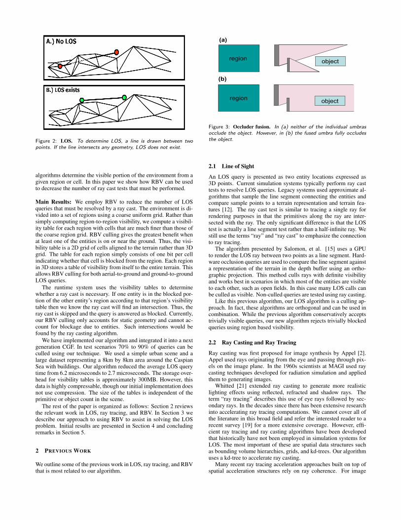
Figure 2: LOS. To determine LOS, a line is drawn between twopoints. If the line intersects any geometry, LOS does not exist.
algorithms determine the visible portion of the environment from agiven region or cell. In this paper we show how RBV can be usedto decrease the number of ray cast tests that must be performed.
Main Results: We employ RBV to reduce the number of LOSqueries that must be resolved by a ray cast. The environment is di-vided into a set of regions using a coarse uniform grid. Rather thansimply computing region-to-region visibility, we compute a visibil-ity table for each region with cells that are much finer than those ofthe coarse region grid. RBV culling gives the greatest benefit whenat least one of the entities is on or near the ground. Thus, the visi-bility table is a 2D grid of cells aligned to the terrain rather than 3Dgrid. The table for each region simply consists of one bit per cellindicating whether that cell is blocked from the region. Each regionin 3D stores a table of visibility from itself to the entire terrain. Thisallows RBV culling for both aerial-to-ground and ground-to-groundLOS queries.
The runtime system uses the visibility tables to determinewhether a ray cast is necessary. If one entity is in the blocked por-tion of the other entity’s region according to that region’s visibilitytable then we know the ray cast will find an intersection. Thus, theray cast is skipped and the query is answered as blocked. Currently,our RBV culling only accounts for static geometry and cannot ac-count for blockage due to entities. Such intersections would befound by the ray casting algorithm.
We have implemented our algorithm and integrated it into a nextgeneration CGF. In test scenarios 70% to 90% of queries can beculled using our technique. We used a simple urban scene and alarge dataset representing a 8km by 8km area around the CaspianSea with buildings. Our algorithm reduced the average LOS querytime from 6.2 microseconds to 2.7 microseconds. The storage over-head for visibility tables is approximately 300MB. However, thisdata is highly compressable, though our initial implementation doesnot use compression. The size of the tables is independent of theprimitive or object count in the scene.
The rest of the paper is organized as follows: Section 2 reviewsthe relevant work in LOS, ray tracing, and RBV. In Section 3 wedescribe our approach to using RBV to assist in solving the LOSproblem. Initial results are presented in Section 4 and concludingremarks in Section 5.
2 PREVIOUS WORK
We outline some of the previous work in LOS, ray tracing, and RBVthat is most related to our algorithm.
region object
regionobject
(a)
(b)
Figure 3: Occluder fusion. In (a) neither of the individual umbrasocclude the object. However, in (b) the fused umbra fully occludesthe object.
2.1 Line of Sight
An LOS query is presented as two entity locations expressed as3D points. Current simulation systems typically perform ray casttests to resolve LOS queries. Legacy systems used approximate al-gorithms that sample the line segment connecting the entities andcompare sample points to a terrain representation and terrain fea-tures [12]. The ray cast test is similar to tracing a single ray forrendering purposes in that the primitives along the ray are inter-sected with the ray. The only significant difference is that the LOStest is actually a line segment test rather than a half-infinite ray. Westill use the terms “ray” and “ray cast” to emphasize the connectionto ray tracing.
The algorithm presented by Salomon, et al. [15] uses a GPUto render the LOS ray between two points as a line segment. Hard-ware occlusion queries are used to compare the line segment againsta representation of the terrain in the depth buffer using an ortho-graphic projection. This method culls rays with definite visibilityand works best in scenarios in which most of the entities are visibleto each other, such as open fields. In this case many LOS calls canbe culled as visible. Non-culled queries are tested using ray casting.
Like this previous algorithm, our LOS algorithm is a culling ap-proach. In fact, these algorithms are orthogonal and can be used incombination. While the previous algorithm conservatively acceptstrivially visible queries, our new algorithm rejects trivially blockedqueries using region based visibility.
2.2 Ray Casting and Ray Tracing
Ray casting was first proposed for image synthesis by Appel [2].Appel used rays originating from the eye and passing through pix-els on the image plane. In the 1960s scientists at MAGI used raycasting techniques developed for radiation simulation and appliedthem to generating images.
Whitted [21] extended ray casting to generate more realisticlighting effects using reflected, refracted and shadow rays. Theterm “ray tracing” describes this use of eye rays followed by sec-ondary rays. In the decades since there has been extensive researchinto accelerating ray tracing computations. We cannot cover all ofthe literature in this broad field and refer the interested reader to arecent survey [19] for a more extensive coverage. However, effi-cient ray tracing and ray casting algorithms have been developedthat historically have not been employed in simulation systems forLOS. The most important of these are spatial data structures suchas bounding volume hierarchies, grids, and kd-trees. Our algorithmuses a kd-tree to accelerate ray casting.
Many recent ray tracing acceleration approaches built on top ofspatial acceleration structures rely on ray coherence. For image
synthesis all rays originate at the eye and thus the initial set of raysexhibit very high coherence. Secondary rays originating at highlyspecular surfaces may also exhibit high coherence. Early researchusing coherence includes [8], pencil tracing [18] and cone tracing[1]. One recent approach [20] leverages modern architectures bygrouping rays into bundles and accelerates traversal and intersec-tion with primitives for all rays simultaneously by taking advan-tage of SIMD instructions. Reshetov et al. [14] present a variationon beam tracing to exploit coherence in traversing a kd-tree spatialstructure.
LOS has different coherence characteristics than traditional raytracing for image synthesis. LOS queries are issued by AI simula-tors and other simulation steps for the various entities in an inco-herent manner and thus tracing multiple rays simultaneously is notfeasible. Furthermore, the design of existing simulators precludes asimple method for bundling queries after they are issued. In effecteach query must be answered sequentially in the order issued.
2.3 Region Based Visibility
Given a subspace of a virtual environment, RBV algorithms com-pute a visible subset of the environment from the subspace. Typi-cally the subspace is a convex polyhedral such as a box. RBV algo-rithms have many applications in computer graphics. One main useis to increase rendering speeds by culling invisible geometry. RBVhas also been used to decrease network traffic for remote render-ings. However, it has been shown that computing RBV exactly isan O(n4) problem [13]. As with ray tracing, this a very broad topicwhich has been extensively researched. We provide an extremelybrief overview and refer readers to recent surveys [4, 3].
To alleviate the computational complexity three classes of algo-rithms have been developed: approximate, conservative, and ag-gressive. Conservative algorithms compute a superset of the actualvisible set. Aggressive algorithms compute a subset of the visibleset [11]. Approximate algorithms compute a possibly bounded esti-mate of the visible set which may be neither a subset nor a superset.Our aim is to conservatively cull LOS queries that are definitelyblocked by the environment. Thus, we restrict ourselves to conser-vative algorithms.
Early work in region based visibility focused on using a singleoccluder [5, 16], or approximated multiple occluders [7]. In orderto perform more effective visibility culling, umbras of multiple oc-cluders must be joined to create larger occluders. The concept ofmerging the umbras of occluders is called occluder fusion. An ex-ample of occluder fusion is presented in Figure 3. In this figure, theoccluders are represented by the gray bars. The object being viewedis not blocked by any one occluder alone. However, the occlusionumbra cast by both occluders together occludes the object. The al-gorithm presented in [6] was one of the first to effectively exploitoccluder fusion in 3D.
Two practical RBV algorithms for 3D environments that performoccluder fusion are: ray space factorization [10] and a volumetricapproach [17]. These RBV algorithms perform a spatial decom-position on the environment (e.g. octree or kd-tree). RBV is thencomputed for every spatial region. The ray space factorization al-gorithm performs computations in the space of possible rays ema-nating from a region and uses the GPU for acceleration. We presentthe volumetric approach of Schaufler et al. in more detail becausewe have employed it for our LOS algorithm.
The volumetric approach[17] requires all occluders to be submit-ted as closed volumes. A spatial subdivision hierarchy is imposedon the environment. The cells of the hierarchy are marked as in-terior if they are completely inside an occluder, exterior if they arecompletely outside all occluders and boundary if they are partiallyinside the occluders and are at the maximum level allowed level ofsubdivision.
Figure 4: Visualization of Volumetric Approach. This image showsa region in white, the leaf level of the hierarchy and an occluder.The red cells are exterior cells, the green cells are interior cells, andthe blue cells are blocked cells. The yellow cell is current cell in thetraversal. It is a blocked cell that is being used as an occluder. Theextents have been enlarged to cover neighboring blocked and interiorcells to create a larger occluder (magenta).
To calculate occlusion for a region the subdivision is traversed ina hierarchical front to back manner. As the traversal proceeds eachcell visited is marked as either visible or blocked with respect to theregion. The traversal stops when it finds a node that can be used asan occluder. The authors show that blocked cells can be used, inaddition to interior cells, as occluders to facilitate occluder fusion.Furthermore, rather than using just the cell as an occluder, the ex-tents of the cell are enlarged to enclose neighboring cells which arealso interior or blocked into a single occluder. An umbra is com-puted for the occluder as a set of planes and cells inside the umbraare marked as blocked. Figure 4 shows an illustration of the algo-rithm in progress. The output is a partitioning of the environmentvolume into conservatively blocked and potentially visible sets.
3 LOS USING RBV
As mentioned earlier, there are many techniques that reduce thecomplexity of ray casting for static scenes. These techniques areusually based on spatial subdivisions and coherent rays. Spatialsubdivisions can be used to speed up LOS and, indeed, our LOSalgorithm uses a kd-tree for ray casting. However, ray coherencemethods do not apply well to LOS calculations. As previously dis-cussed, LOS rays tend to be extremely incoherent. Even thoughmany rays may originate at the same entity, they are not necessar-ily generated in an entity coherent order. Moreover, directions ofLOS rays are extremely incoherent. Ray casting algorithms devel-oped for ray tracing benefit from coherence in both ray origins anddirections. While the kd-tree structure dramatically speeds up raycasting, we show that a large fraction of LOS rays can be culledfrom ray casting altogether with a simple table lookup. Thus, thesetechniques work in tandem to reduce the average LOS call time.
Conservative RBV can be used to accelerate LOS calculationsfor static environments with dynamic entities. We subdivide the en-vironment into regions and then compute region-to-region visibil-
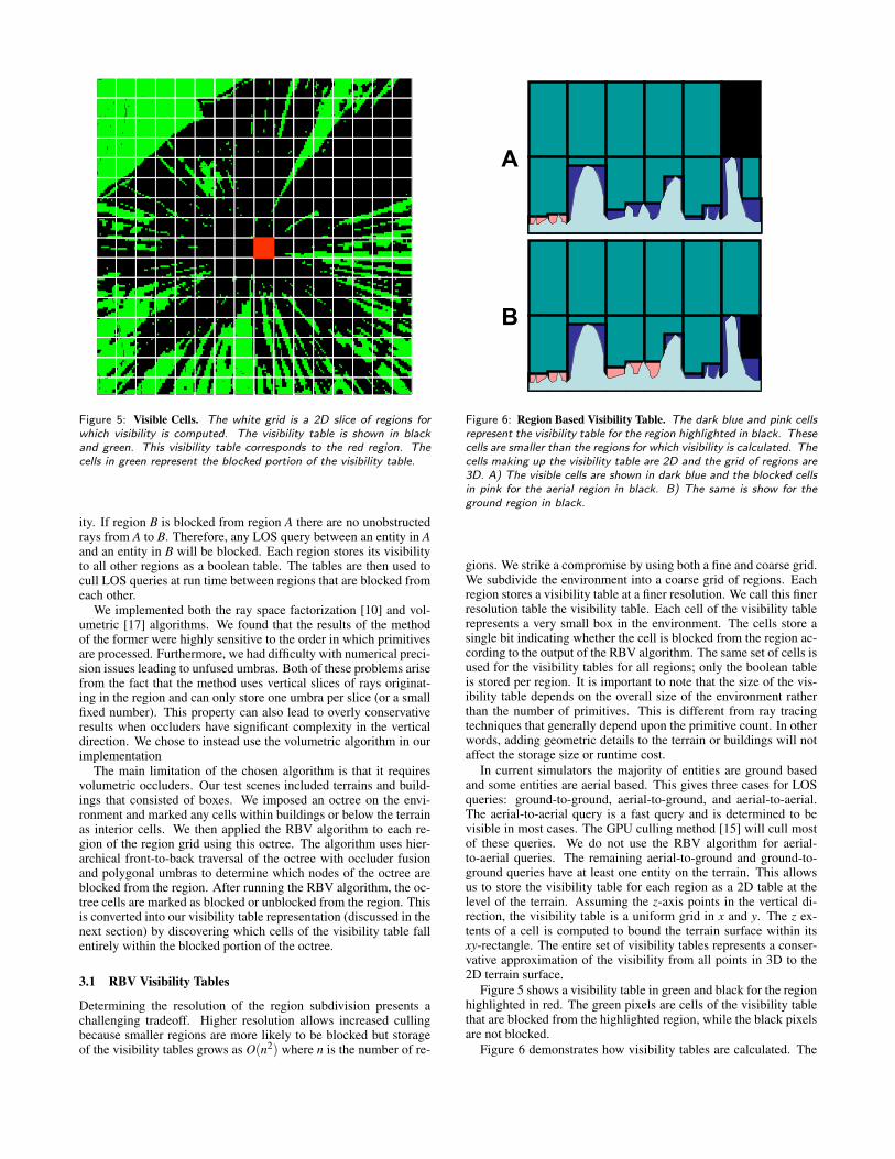
Figure 5: Visible Cells. The white grid is a 2D slice of regions forwhich visibility is computed. The visibility table is shown in blackand green. This visibility table corresponds to the red region. Thecells in green represent the blocked portion of the visibility table.
ity. If region B is blocked from region A there are no unobstructedrays from A to B. Therefore, any LOS query between an entity in Aand an entity in B will be blocked. Each region stores its visibilityto all other regions as a boolean table. The tables are then used tocull LOS queries at run time between regions that are blocked fromeach other.
We implemented both the ray space factorization [10] and vol-umetric [17] algorithms. We found that the results of the methodof the former were highly sensitive to the order in which primitivesare processed. Furthermore, we had difficulty with numerical preci-sion issues leading to unfused umbras. Both of these problems arisefrom the fact that the method uses vertical slices of rays originat-ing in the region and can only store one umbra per slice (or a smallfixed number). This property can also lead to overly conservativeresults when occluders have significant complexity in the verticaldirection. We chose to instead use the volumetric algorithm in ourimplementation
The main limitation of the chosen algorithm is that it requiresvolumetric occluders. Our test scenes included terrains and build-ings that consisted of boxes. We imposed an octree on the envi-ronment and marked any cells within buildings or below the terrainas interior cells. We then applied the RBV algorithm to each re-gion of the region grid using this octree. The algorithm uses hier-archical front-to-back traversal of the octree with occluder fusionand polygonal umbras to determine which nodes of the octree areblocked from the region. After running the RBV algorithm, the oc-tree cells are marked as blocked or unblocked from the region. Thisis converted into our visibility table representation (discussed in thenext section) by discovering which cells of the visibility table fallentirely within the blocked portion of the octree.
3.1 RBV Visibility Tables
Determining the resolution of the region subdivision presents achallenging tradeoff. Higher resolution allows increased cullingbecause smaller regions are more likely to be blocked but storageof the visibility tables grows as O(n2) where n is the number of re-
A
B
Figure 6: Region Based Visibility Table. The dark blue and pink cellsrepresent the visibility table for the region highlighted in black. Thesecells are smaller than the regions for which visibility is calculated. Thecells making up the visibility table are 2D and the grid of regions are3D. A) The visible cells are shown in dark blue and the blocked cellsin pink for the aerial region in black. B) The same is show for theground region in black.
gions. We strike a compromise by using both a fine and coarse grid.We subdivide the environment into a coarse grid of regions. Eachregion stores a visibility table at a finer resolution. We call this finerresolution table the visibility table. Each cell of the visibility tablerepresents a very small box in the environment. The cells store asingle bit indicating whether the cell is blocked from the region ac-cording to the output of the RBV algorithm. The same set of cells isused for the visibility tables for all regions; only the boolean tableis stored per region. It is important to note that the size of the vis-ibility table depends on the overall size of the environment ratherthan the number of primitives. This is different from ray tracingtechniques that generally depend upon the primitive count. In otherwords, adding geometric details to the terrain or buildings will notaffect the storage size or runtime cost.
In current simulators the majority of entities are ground basedand some entities are aerial based. This gives three cases for LOSqueries: ground-to-ground, aerial-to-ground, and aerial-to-aerial.The aerial-to-aerial query is a fast query and is determined to bevisible in most cases. The GPU culling method [15] will cull mostof these queries. We do not use the RBV algorithm for aerial-to-aerial queries. The remaining aerial-to-ground and ground-to-ground queries have at least one entity on the terrain. This allowsus to store the visibility table for each region as a 2D table at thelevel of the terrain. Assuming the z-axis points in the vertical di-rection, the visibility table is a uniform grid in x and y. The z ex-tents of a cell is computed to bound the terrain surface within itsxy-rectangle. The entire set of visibility tables represents a conser-vative approximation of the visibility from all points in 3D to the2D terrain surface.
Figure 5 shows a visibility table in green and black for the regionhighlighted in red. The green pixels are cells of the visibility tablethat are blocked from the highlighted region, while the black pixelsare not blocked.
Figure 6 demonstrates how visibility tables are calculated. The
heights of the cells in the visibility table are adjusted to the heightof the terrain. Changes in visibility occur more frequently due tohorizontal movement than vertical. Therefore our grid of regionsis much coarser in the vertical direction. Figure 6 shows that theregions are taller than they are wide. These modifications reduceboth the storage space and the computation time for the algorithm.
3.2 Run-Time
The run-time portion of the algorithm consists of calculating LOSbetween all entities in the simulation. Queries are culled first bythe RBV lookup tables. Next they are culled by the GPU methoddescribed in [15]. If both of these cull tests pass, then the ray castcomputation is performed.
The RBV cull test for ground-to-ground entities requires two ta-ble lookups. An LOS query contains two entities, e1 and e2. Thefirst step is to identify the visibility table, V1, of the region con-taining e1. Similarly, we identify the relevant visibility table fore2 which is labeled V2. Then, we lookup the boolean value of thecell containing e1 in V2 and e2 is looked up in V1. If either of thelookups return false then the LOS query is culled. Because theRBV algorithm is conservative, one or both of these tables maybe unblocked even though there is no visibility. The bidirectionaltest reduces the number of queries between blocked regions thatare then ray casted due to the conservative nature of the algorithm.Both of these lookups are O(1). For calculations between aerial-to-ground queries we use one table lookup. The ground unit is lookedup in the visibility table of the region containing the aerial unit.
4 RESULTS
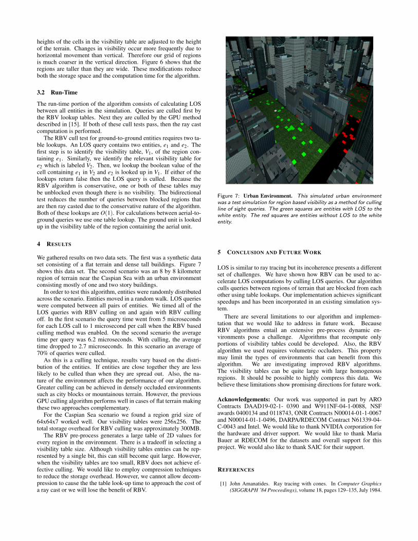
We gathered results on two data sets. The first was a synthetic dataset consisting of a flat terrain and dense tall buildings. Figure 7shows this data set. The second scenario was an 8 by 8 kilometerregion of terrain near the Caspian Sea with an urban environmentconsisting mostly of one and two story buildings.
In order to test this algorithm, entities were randomly distributedacross the scenario. Entities moved in a random walk. LOS querieswere computed between all pairs of entities. We timed all of theLOS queries with RBV culling on and again with RBV cullingoff. In the first scenario the query time went from 5 microsecondsfor each LOS call to 1 microsecond per call when the RBV basedculling method was enabled. On the second scenario the averagetime per query was 6.2 microseconds. With culling, the averagetime dropped to 2.7 microseconds. In this scenario an average of70% of queries were culled.
As this is a culling technique, results vary based on the distri-bution of the entities. If entities are close together they are lesslikely to be culled than when they are spread out. Also, the na-ture of the environment affects the performance of our algorithm.Greater culling can be achieved in densely occluded environmentssuch as city blocks or mountainous terrain. However, the previousGPU culling algorithm performs well in cases of flat terrain makingthese two approaches complementary.
For the Caspian Sea scenario we found a region grid size of64x64x7 worked well. Our visibility tables were 256x256. Thetotal storage overhead for RBV culling was approximately 300MB.
The RBV pre-process generates a large table of 2D values forevery region in the environment. There is a tradeoff in selecting avisibility table size. Although visibility tables entries can be rep-resented by a single bit, this can still become quit large. However,when the visibility tables are too small, RBV does not achieve ef-fective culling. We would like to employ compression techniquesto reduce the storage overhead. However, we cannot allow decom-pression to cause the the table look-up time to approach the cost ofa ray cast or we will lose the benefit of RBV.
Figure 7: Urban Environment. This simulated urban environmentwas a test simulation for region based visibility as a method for cullingline of sight queries. The green squares are entities with LOS to thewhite entity. The red squares are entities without LOS to the whiteentity.
5 CONCLUSION AND FUTURE WORK
LOS is similar to ray tracing but its incoherence presents a differentset of challenges. We have shown how RBV can be used to ac-celerate LOS computations by culling LOS queries. Our algorithmculls queries between regions of terrain that are blocked from eachother using table lookups. Our implementation achieves significantspeedups and has been incorporated in an existing simulation sys-tem.
There are several limitations to our algorithm and implemen-tation that we would like to address in future work. BecauseRBV algorithms entail an extensive pre-process dynamic en-vironments pose a challenge. Algorithms that recompute onlyportions of visibility tables could be developed. Also, the RBValgorithm we used requires volumetric occluders. This propertymay limit the types of environments that can benefit from thisalgorithm. We are investigating improved RBV algorithms.The visibility tables can be quite large with large homogenousregions. It should be possible to highly compress this data. Webelieve these limitations show promising directions for future work.
Acknowledgements: Our work was supported in part by AROContracts DAAD19-02-1- 0390 and W911NF-04-1-0088, NSFawards 0400134 and 0118743, ONR Contracts N00014-01-1-0067and N00014-01-1-0496, DARPA/RDECOM Contract N61339-04-C-0043 and Intel. We would like to thank NVIDIA corporation forthe hardware and driver support. We would like to thank MariaBauer at RDECOM for the datasets and overall support for thisproject. We would also like to thank SAIC for their support.
REFERENCES
[1] John Amanatides. Ray tracing with cones. In Computer Graphics(SIGGRAPH ’84 Proceedings), volume 18, pages 129–135, July 1984.
[2] Arthur Appel. Some techniques for shading machine renderings ofsolids. In AFIPS 1968 Spring Joint Computer Conf., volume 32, pages37–45, 1968.
[3] J. Bittner and P. Wonka. Visibility in computer graphics. Journal ofEnvironment and Planning B: Planning and Design, 30(5), 2003.
[4] D. Cohen-Or, Y. Chrysanthou, C. Silva, and F. Durand. A survey ofvisibility for walkthrough applications. IEEE Transactions on Visual-ization and Computer Graphics, 2003.
[5] D. Cohen-Or, G. Fibich, D. Halperin, and E. Zadicario. Conservativevisibility and strong occlusion for viewspace partitioning of denselyoccluded scenes. Comput. Graph. Forum, 17:C243–C253, 1998. Eu-rographics ’98.
[6] F. Durand, G. Drettakis, J. Thollot, and C. Puech. Conservative vis-ibility preprocessing using extended projections. Proc. of ACM SIG-GRAPH, pages 239–248, 2000.
[7] C. Gottsman, O. Sudarsky, and J. Fayman. Optimized occlusionculling using five-dimensional subdivision. Computer and Graphics,23(5):645–654, 1999.
[8] Paul S. Heckbert and Pat Hanrahan. Beam tracing polygonal objects.In SIGGRAPH ’84, pages 119–127, 1984.
[9] D. L. Henderson. Modterrain: A proposed standard for terrain repre-sentation in entity level simulation. Master’s thesis, Naval PostGrad-uate School, 1999.
[10] Tommer Leyvand, Olga Sorkine, and Daniel Cohen-Or. Ray spacefactorization for from-region visibility. ACM Transactions on Graph-ics (TOG), 22(3):595–604, 2003.
[11] S. Nirenstein and E. Blake. Hardware accelerated visibility prepro-cessing using adaptive sampling. In Eurographics Workshop on Ren-dering, 2004.
[12] Line of Sight Technical Working Group. Line-of-sight compendium.[13] Harry Plantinga and Charles R. Dyer. Visibility, occlusion, and the
aspect graph. Int. J. Comput. Vision, 5(2):137–160, 1990.[14] Alexander Reshetov, Alexei Soupikov, and Jim Hurley. Multi-level
ray tracing algorithm. ACM Trans. Graph., 24(3):1176–1185, 2005.[15] Brian Salomon, Naga Govindaraju, Avneesh Sud, Russell Gayle,
Ming Lin, and Dinesh Manocha. Accelerating line of sight compu-tations using graphics processing units. In 24th Army Science Confer-ence Proceedings, 2004.
[16] C. Saona-Vazquez, I. Navazo, and P. Brunet. The visibility octree: Adata structure for 3d navigation. Comput. & Graphics, 23(5):635–643,October 1999.
[17] G. Schaufler, J. Dorsey, X. Decoret, and F. Sillion. Conservative vol-umetric visibility with occluder fusion. Proc. of ACM SIGGRAPH,pages 229–238, 2000.
[18] Mikio Shinya, Tokiichiro Takahashi, and Seiichiro Naito. Principlesand applications of pencil tracing. In SIGGRAPH, volume 21, pages45–54, July 1987.
[19] Peter Shirley, Philipp Slusallek, Bill Mark, Gordon Stoll, and IngoWald. Introduction to real-time ray tracing. SIGGRAPH Course Notes,2005.
[20] Ingo Wald, Carsten Benthin, Markus Wagner, and Philipp Slusallek.Interactive rendering with coherent ray tracing. In Computer GraphicsForum (EUROGRAPHICS), volume 20, pages 153–164, 2001.
[21] Turner Whitted. An improved illumination model for shaded display.Commun. ACM, 23(6):343–349, 1980.


![Cheetah: Accelerating Database Queries with Switch Pruningminlanyu.seas.harvard.edu/writeup/sigmod20.pdf · 2020. 5. 1. · BigQuery [23]. When a user submits a query, Spark SQL uses](https://img.pdfslide.net/doc/110x75/6126fea511008d14a852b0ff/cheetah-accelerating-database-queries-with-switch-2020-5-1-bigquery-23.jpg)


![Edinburgh Research Explorer · queries goes to hash index lookups used in hash-join opera-tions [16]. By accelerating hash index lookups, a functionality that is essential in modern](https://img.pdfslide.net/doc/110x75/60bdb9bcc0af1064d6068dc7/edinburgh-research-queries-goes-to-hash-index-lookups-used-in-hash-join-opera-tions.jpg)