Embed Size (px)
Citation preview

ADMINISTRATIVE BOUNDARY DATA SERVICE AS PART OF
SPATIAL DATA INFRASTRUCTURES
Dr. Mihály SzabolcsDr. Mihály SzabolcsInstitute of Geodesy, Cartography and
Remote Sensing (FÖMI)Hungary
6th GSDI ConferenceSeptember 16-19th 2002
Budapest
Dr. Mihály Sz.: Administrative boundary data services as part of spatial data infrastructures6th GSDI Conference, September 16-19th 2002, Budapest

SUMMARY (1)
Transition towards the information Society is the challenge of our time. Geographic information systems play special role in forming the national, continental and global spatial data infrastructures because larger part of any kind of information can be linked to its location by direct or indirect positioning.
For a big deal of users and information the co-ordinate systems are too specific. Indirect positioning, e.g. is linking the information to administrative territorial units suits much more users’ requirements.
Dr. Mihály Sz.: Administrative boundary data services as part of spatial data infrastructures6th GSDI Conference, September 16-19th 2002, Budapest
SUMMARY (2)Geometrically, the administrative territorial units can be represented by their boundaries. Addition of attributes to them widens the circle of interest to them. The registry of boundaries and some attributes, the data capture and compilation of the administrative boundary database as well as the data services are generally the task of the national mapping agencies and partly those of the statisticians, all representing a part of the National Geographical Data Infrastructure. The globalisation and the increasing number of crossborder co-operations require unified interoperable data for any region and at global level.
Dr. Mihály Sz.: Administrative boundary data services as part of spatial data infrastructures6th GSDI Conference, September 16-19th 2002, Budapest

SUMMARY (3This awareness in Europe led to the creation of SABE (Seamless Administrative Boundaries of Europe) by the European mapping agencies to be part of the continental spatial data infrastructure. Later, under the support of the European Commission R+D framework – as a kind of geographic extension and in the same time a technological innovation – the ABDS for the CEEC (Administrative Boundary Data Services for Central and Eastern European Countries) project advanced in the topic.
The paper presents how the ABD services can be managed to fulful the requirements of the Information Society and gives example how to go from national platform to continental and global ones in a comprehensive way.
Dr. Mihály Sz.: Administrative boundary data services as part of spatial data infrastructures6th GSDI Conference, September 16-19th 2002, Budapest

ABD as part of spatial data infrastructure (1)
Provision of reliable up-to date basic data infrastructure is generally the task of the government. Nowadays this task is even more important, when the transition towards the Information society takes place.
Dr. Mihály Sz.: Administrative boundary data services as part of spatial data infrastructures6th GSDI Conference, September 16-19th 2002, Budapest

The Administrative boundary data – being the base information infrastructure for different kind of analysis when spatial reference is required – are core part of the NSDI. The number of potential users is practically indefinite, range from statistics to economic analysis, from environment to logistics, from business administration to marketing, etc. A wide spread use of such kind of information can greatly contribute to modernisation of the whole infrastructure of a country, or a region. The provision and integration of such data and services seems indispensable for the modern electronik governance.
ABD as part of spatial data infrastructure (2)
Dr. Mihály Sz.: Administrative boundary data services as part of spatial data infrastructures6th GSDI Conference, September 16-19th 2002, Budapest
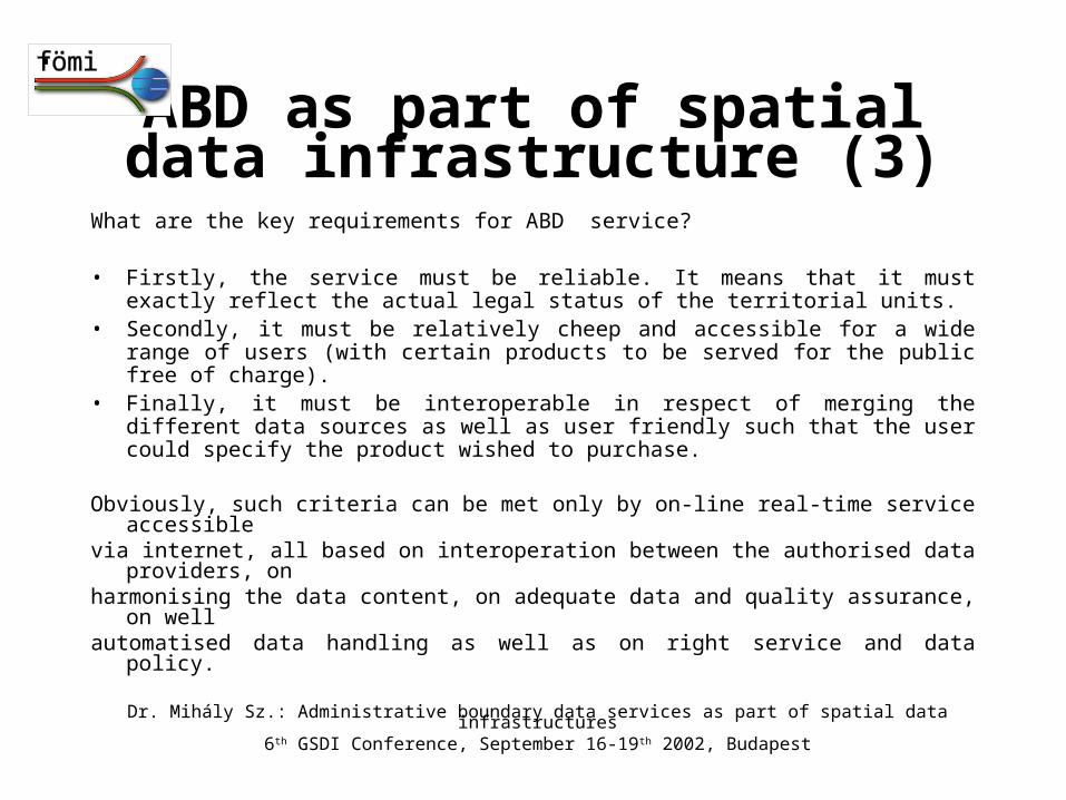
What are the key requirements for ABD service? • Firstly, the service must be reliable. It means that it must exactly reflect the
actual legal status of the territorial units. • Secondly, it must be relatively cheep and accessible for a wide range of users
(with certain products to be served for the public free of charge). • Finally, it must be interoperable in respect of merging the different data
sources as well as user friendly such that the user could specify the product wished to purchase.
Obviously, such criteria can be met only by on-line real-time service accessible via internet, all based on interoperation between the authorised data providers, on harmonising the data content, on adequate data and quality assurance, on well automatised data handling as well as on right service and data policy.
ABD as part of spatial data infrastructure (3)
Dr. Mihály Sz.: Administrative boundary data services as part of spatial data infrastructures6th GSDI Conference, September 16-19th 2002, Budapest
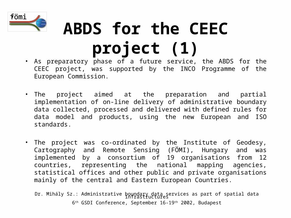
ABDS for the CEEC project (1)• As preparatory phase of a future service, the ABDS for the CEEC project, was
supported by the INCO Programme of the European Commission.
• The project aimed at the preparation and partial implementation of on-line delivery of administrative boundary data collected, processed and delivered with defined rules for data model and products, using the new European and ISO standards.
• The project was co-ordinated by the Institute of Geodesy, Cartography and Remote Sensing (FÖMI), Hungary and was implemented by a consortium of 19 organisations from 12 countries, representing the national mapping agencies, statistical offices and other public and private organisations mainly of the central and Eastern European Countries.
Dr. Mihály Sz.: Administrative boundary data services as part of spatial data infrastructures6th GSDI Conference, September 16-19th 2002, Budapest
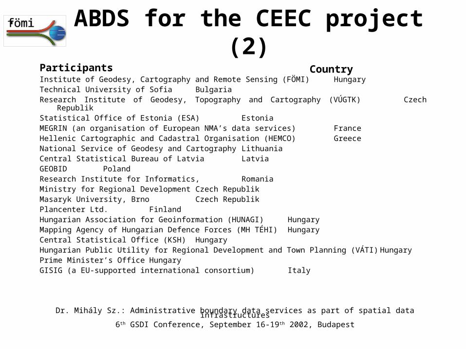
Participants sssssstordd CCountryCosssssss
Institute of Geodesy, Cartography and Remote Sensing (FÖMI) HungaryTechnical University of Sofia BulgariaResearch Institute of Geodesy, Topography and Cartography (VÚGTK) Czech RepublikStatistical Office of Estonia (ESA) EstoniaMEGRIN (an organisation of European NMA’s data services) FranceHellenic Cartographic and Cadastral Organisation (HEMCO) GreeceNational Service of Geodesy and Cartography LithuaniaCentral Statistical Bureau of Latvia LatviaGEOBID PolandResearch Institute for Informatics, RomaniaMinistry for Regional Development Czech RepublikMasaryk University, Brno Czech RepublikPlancenter Ltd. FinlandHungarian Association for Geoinformation (HUNAGI) HungaryMapping Agency of Hungarian Defence Forces (MH TÉHI) HungaryCentral Statistical Office (KSH) HungaryHungarian Public Utility for Regional Development and Town Planning (VÁTI) HungaryPrime Minister’s Office HungaryGISIG (a EU-supported international consortium) Italy
ABDS for the CEEC project (2)
Country
Dr. Mihály Sz.: Administrative boundary data services as part of spatial data infrastructures6th GSDI Conference, September 16-19th 2002, Budapest

Tasks fulfilled:• Inventory• Generalisation• Memorandum of Undrstanding• Horizontal activities
– Standard conformity checking
– Quality assurance
– Legal protection
ABDS for the CEEC project (3)
Dr. Mihály Sz.: Administrative boundary data services as part of spatial data infrastructures6th GSDI Conference, September 16-19th 2002, Budapest
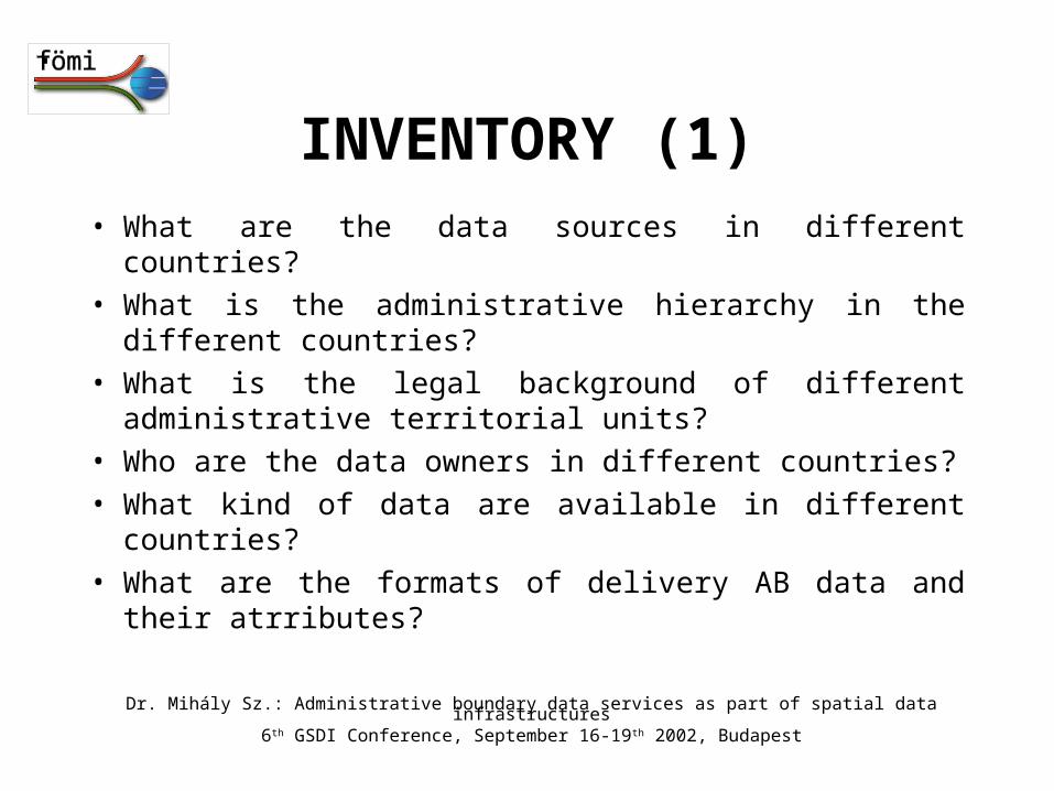
INVENTORY (1)• What are the data sources in different countries?
• What is the administrative hierarchy in the different countries?
• What is the legal background of different administrative territorial units?
• Who are the data owners in different countries?
• What kind of data are available in different countries?
• What are the formats of delivery AB data and their atrributes?
Dr. Mihály Sz.: Administrative boundary data services as part of spatial data infrastructures6th GSDI Conference, September 16-19th 2002, Budapest
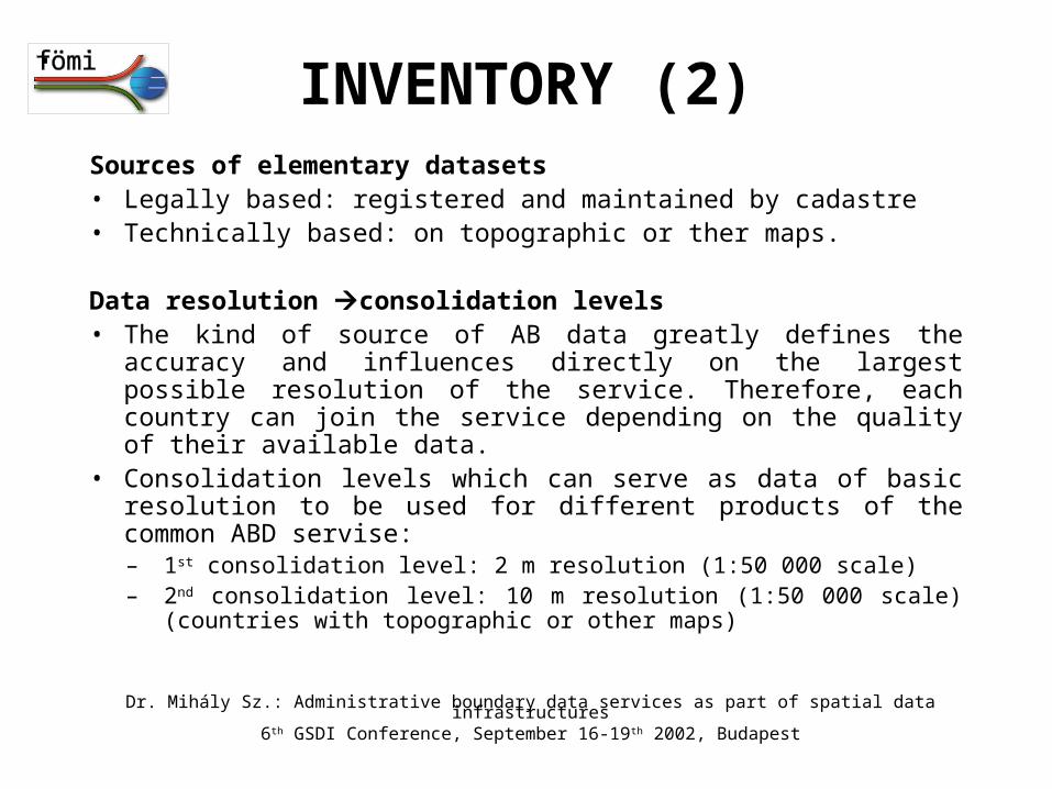
INVENTORY (2)Sources of elementary datasets• Legally based: registered and maintained by cadastre• Technically based: on topographic or ther maps.
Data resolution consolidation levels• The kind of source of AB data greatly defines the accuracy and
influences directly on the largest possible resolution of the service. Therefore, each country can join the service depending on the quality of their available data.
• Consolidation levels which can serve as data of basic resolution to be used for different products of the common ABD servise:– 1st consolidation level: 2 m resolution (1:50 000 scale)– 2nd consolidation level: 10 m resolution (1:50 000 scale) (countries with
topographic or other maps)
Dr. Mihály Sz.: Administrative boundary data services as part of spatial data infrastructures6th GSDI Conference, September 16-19th 2002, Budapest
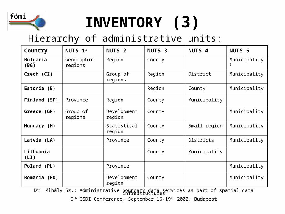
INVENTORY (3)Hierarchy of administrative units:
Country NUTS 11 NUTS 2 NUTS 3 NUTS 4 NUTS 5
Bulgaria (BG) Geographic regions
Region County Municipality2
Czech (CZ) Group of regions Region District Municipality
Estonia (E) Region County Municipality
Finland (SF) Province Region County Municipality
Greece (GR) Group of regions Development region
County Municipality
Hungary (H) Statistical region County Small region Municipality
Latvia (LA) Province County Districts Municipality
Lithuania (LI) County Municipality
Poland (PL) Province Municipality
Romania (RO) Development region
County Municipality
Dr. Mihály Sz.: Administrative boundary data services as part of spatial data infrastructures6th GSDI Conference, September 16-19th 2002, Budapest
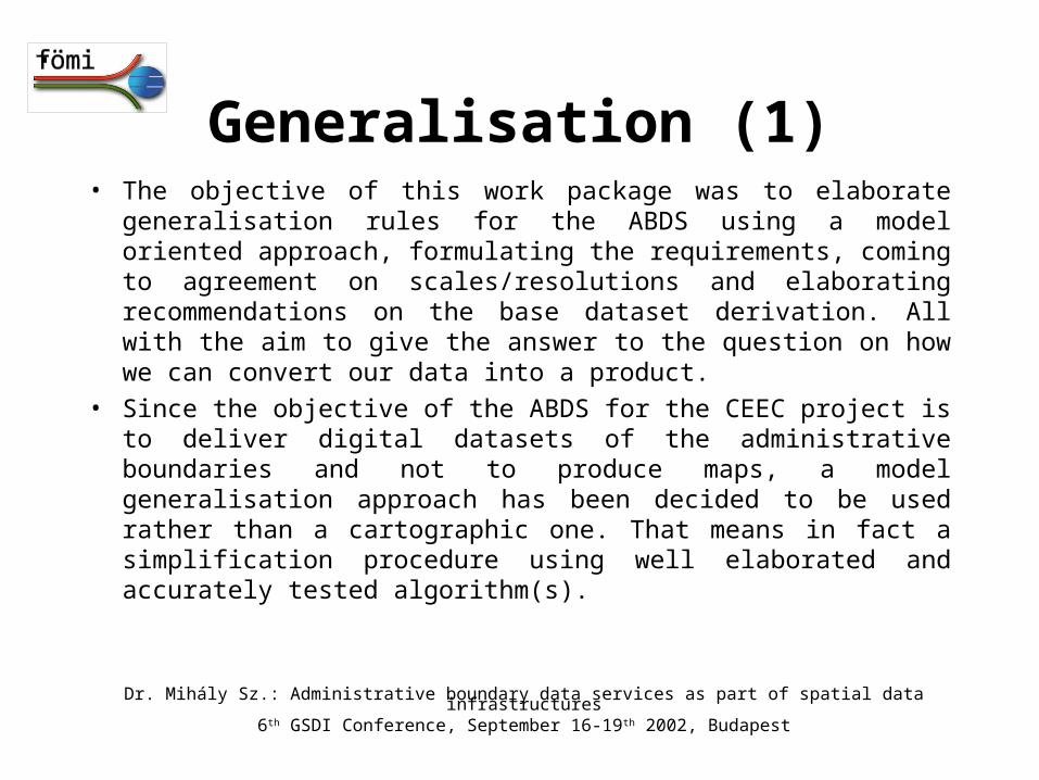
Generalisation (1)• The objective of this work package was to elaborate generalisation
rules for the ABDS using a model oriented approach, formulating the requirements, coming to agreement on scales/resolutions and elaborating recommendations on the base dataset derivation. All with the aim to give the answer to the question on how we can convert our data into a product.
• Since the objective of the ABDS for the CEEC project is to deliver digital datasets of the administrative boundaries and not to produce maps, a model generalisation approach has been decided to be used rather than a cartographic one. That means in fact a simplification procedure using well elaborated and accurately tested algorithm(s).
Dr. Mihály Sz.: Administrative boundary data services as part of spatial data infrastructures6th GSDI Conference, September 16-19th 2002, Budapest
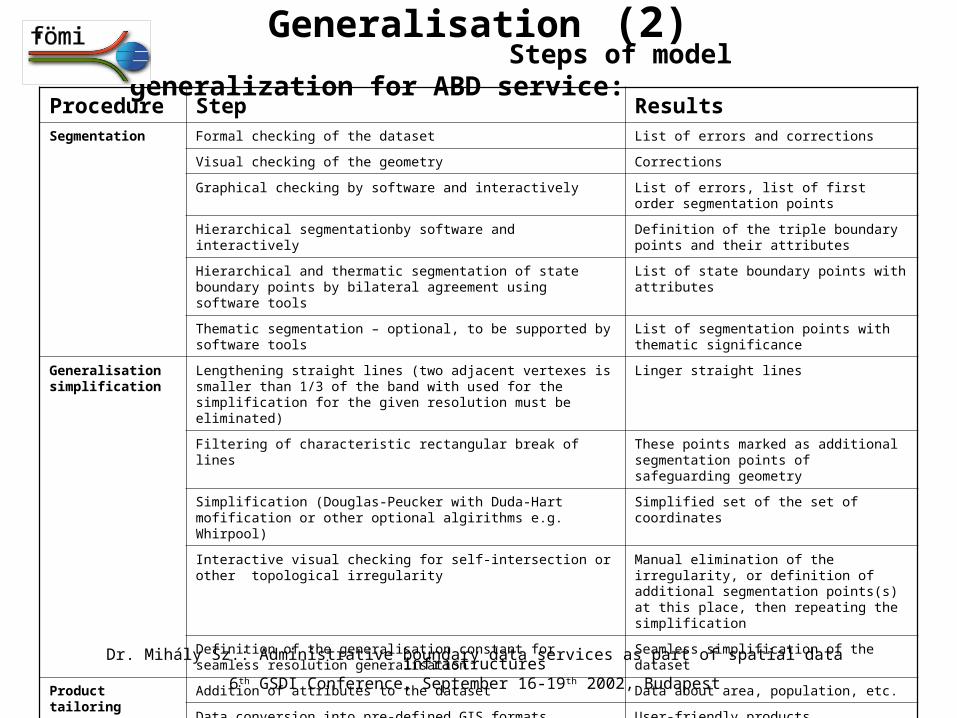
Steps of model generalization for ABD service:Generalisation (2)
Procedure Step ResultsSegmentation Formal checking of the dataset List of errors and corrections
Visual checking of the geometry Corrections
Graphical checking by software and interactively List of errors, list of first order segmentation points
Hierarchical segmentationby software and interactively Definition of the triple boundary points and their attributes
Hierarchical and thermatic segmentation of state boundary points by bilateral agreement using software tools
List of state boundary points with attributes
Thematic segmentation – optional, to be supported by software tools List of segmentation points with thematic significance
Generalisation simplification
Lengthening straight lines (two adjacent vertexes is smaller than 1/3 of the band with used for the simplification for the given resolution must be eliminated)
Linger straight lines
Filtering of characteristic rectangular break of lines These points marked as additional segmentation points of safeguarding geometry
Simplification (Douglas-Peucker with Duda-Hart mofification or other optional algirithms e.g. Whirpool)
Simplified set of the set of coordinates
Interactive visual checking for self-intersection or other topological irregularity
Manual elimination of the irregularity, or definition of additional segmentation points(s) at this place, then repeating the simplification
Definition of the generalisation constant for seamless resolution generalisation Seamless simplification of the dataset
Product tailoring Addition of attributes to the dataset Data about area, population, etc.
Data conversion into pre-defined GIS formats (including XML, .txt) User-friendly products
Addition of metadata Complete information to the user about the product
Dr. Mihály Sz.: Administrative boundary data services as part of spatial data infrastructures6th GSDI Conference, September 16-19th 2002, Budapest
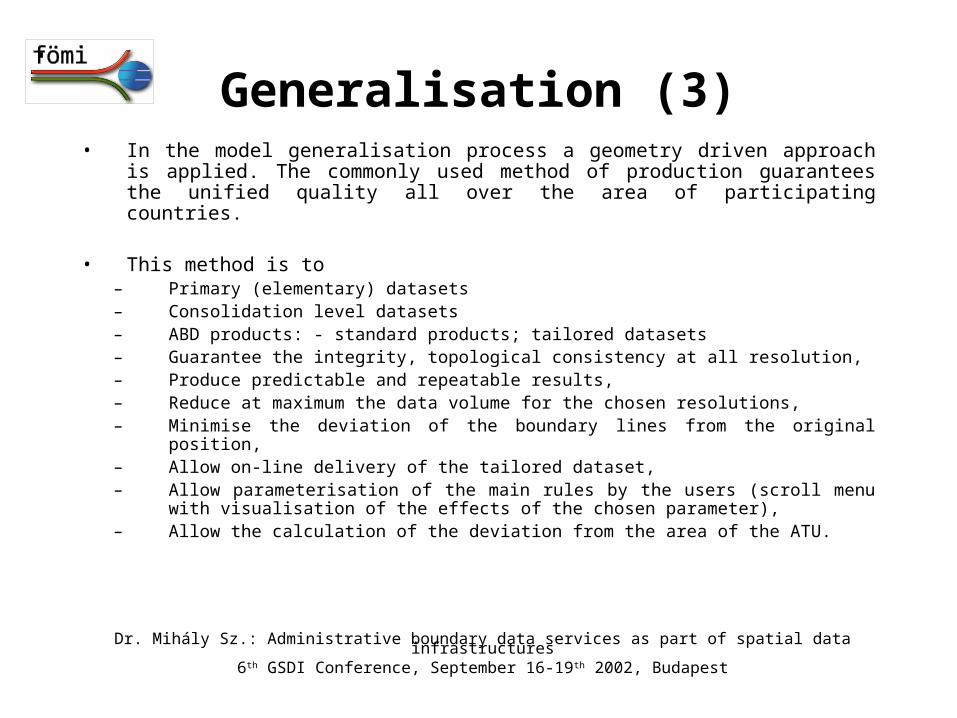
Generalisation (3)• In the model generalisation process a geometry driven approach is applied. The
commonly used method of production guarantees the unified quality all over the area of participating countries.
• This method is to– Primary (elementary) datasets– Consolidation level datasets– ABD products: - standard products; tailored datasets– Guarantee the integrity, topological consistency at all resolution,– Produce predictable and repeatable results,– Reduce at maximum the data volume for the chosen resolutions,– Minimise the deviation of the boundary lines from the original position,– Allow on-line delivery of the tailored dataset,– Allow parameterisation of the main rules by the users (scroll menu with visualisation
of the effects of the chosen parameter),– Allow the calculation of the deviation from the area of the ATU.
Dr. Mihály Sz.: Administrative boundary data services as part of spatial data infrastructures6th GSDI Conference, September 16-19th 2002, Budapest
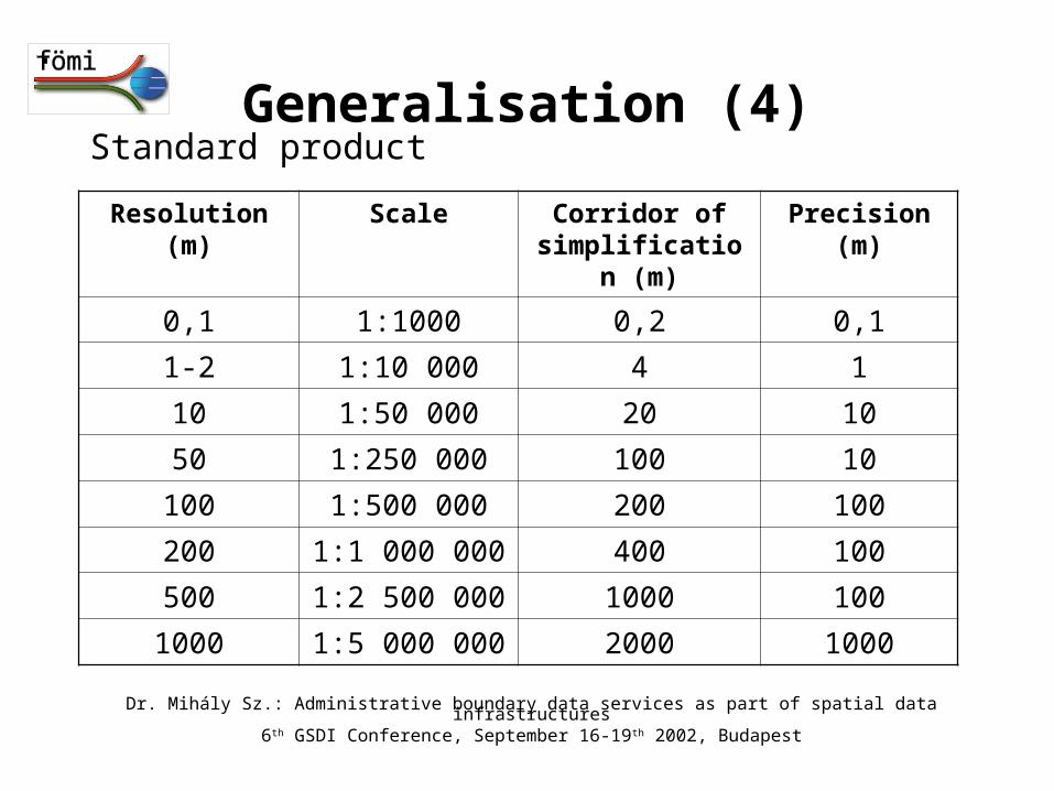
Generalisation (4)Standard product
Resolution (m) Scale Corridor of simplification (m)
Precision (m)
0,1 1:1000 0,2 0,1
1-2 1:10 000 4 1
10 1:50 000 20 10
50 1:250 000 100 10
100 1:500 000 200 100
200 1:1 000 000 400 100
500 1:2 500 000 1000 100
1000 1:5 000 000 2000 1000
Dr. Mihály Sz.: Administrative boundary data services as part of spatial data infrastructures6th GSDI Conference, September 16-19th 2002, Budapest
ABDS: Data model, Service model (1)
Factors considered
• Results of inventory
• Results of elaboration on generalisation
• International GI standartisation
• Quality aspects
• Legal and organisational issues
Dr. Mihály Sz.: Administrative boundary data services as part of spatial data infrastructures6th GSDI Conference, September 16-19th 2002, Budapest
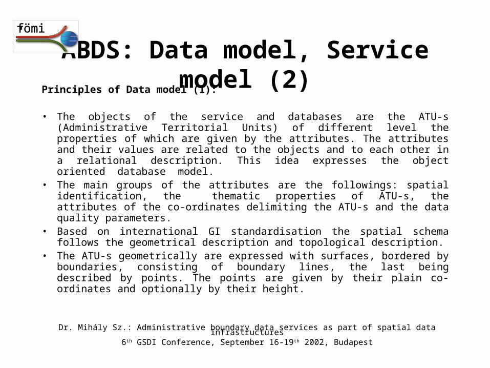
Principles of Data model (1):
• The objects of the service and databases are the ATU-s (Administrative Territorial Units) of different level the properties of which are given by the attributes. The attributes and their values are related to the objects and to each other in a relational description. This idea expresses the object oriented database model.
• The main groups of the attributes are the followings: spatial identification, the thematic properties of ATU-s, the attributes of the co-ordinates delimiting the ATU-s and the data quality parameters.
• Based on international GI standardisation the spatial schema follows the geometrical description and topological description.
• The ATU-s geometrically are expressed with surfaces, bordered by boundaries, consisting of boundary lines, the last being described by points. The points are given by their plain co-ordinates and optionally by their height.
ABDS: Data model, Service model (2)
Dr. Mihály Sz.: Administrative boundary data services as part of spatial data infrastructures6th GSDI Conference, September 16-19th 2002, Budapest
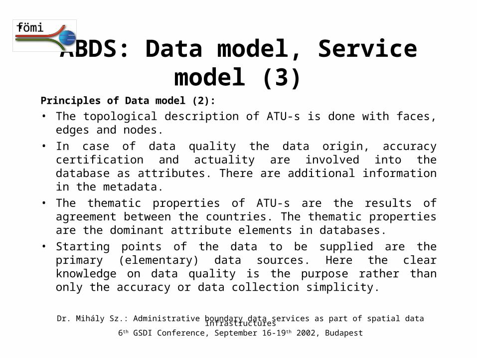
Principles of Data model (2):
• The topological description of ATU-s is done with faces, edges and nodes.
• In case of data quality the data origin, accuracy certification and actuality are involved into the database as attributes. There are additional information in the metadata.
• The thematic properties of ATU-s are the results of agreement between the countries. The thematic properties are the dominant attribute elements in databases.
• Starting points of the data to be supplied are the primary (elementary) data sources. Here the clear knowledge on data quality is the purpose rather than only the accuracy or data collection simplicity.
ABDS: Data model, Service model (3)
Dr. Mihály Sz.: Administrative boundary data services as part of spatial data infrastructures6th GSDI Conference, September 16-19th 2002, Budapest
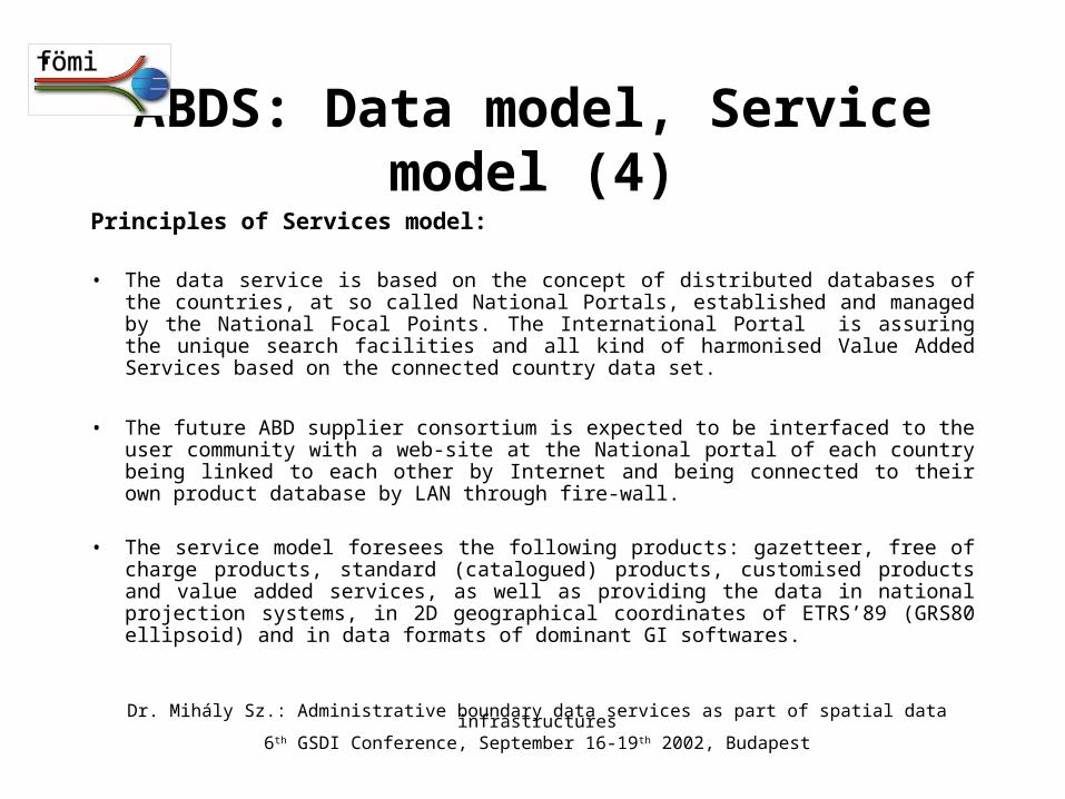
Principles of Services model:
• The data service is based on the concept of distributed databases of the countries, at so called National Portals, established and managed by the National Focal Points. The International Portal is assuring the unique search facilities and all kind of harmonised Value Added Services based on the connected country data set.
• The future ABD supplier consortium is expected to be interfaced to the user community with a web-site at the National portal of each country being linked to each other by Internet and being connected to their own product database by LAN through fire-wall.
• The service model foresees the following products: gazetteer, free of charge products, standard (catalogued) products, customised products and value added services, as well as providing the data in national projection systems, in 2D geographical coordinates of ETRS’89 (GRS80 ellipsoid) and in data formats of dominant GI softwares.
ABDS: Data model, Service model (4)
Dr. Mihály Sz.: Administrative boundary data services as part of spatial data infrastructures6th GSDI Conference, September 16-19th 2002, Budapest
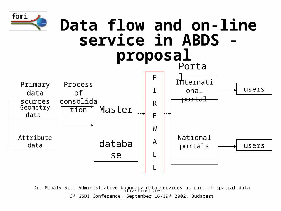
Data flow and on-line service in ABDS - proposal
Primary data sources
Geometry data
Attribute data
Process of consolidation
Master
database
F
I
R
E
W
A
L
L
International portal
National portals
users
users
Portal
Dr. Mihály Sz.: Administrative boundary data services as part of spatial data infrastructures6th GSDI Conference, September 16-19th 2002, Budapest

MEMORANDUM OF UNDERSTANDINGThe project was finalised by the signature of the Memorandum of Understanding at the Prague closing review meeting.
It describes the technical, organisational, and some other aspects of the future service.
It regulates the relationship between the SABE and the future ABDS.
The ABDS will be not a competitive product to the SABE, but rather a complementary one, as regarded the geographical scope, the technological innovation and the resolution of the data to be supplied.
On one hand the experience of SABE in managing of such kind of databases, on the other hand the geographical and resolutional extension and the technological innovations of the ABDS open together a good base for joint thinking and actions at European level, too.
Dr. Mihály Sz.: Administrative boundary data services as part of spatial data infrastructures6th GSDI Conference, September 16-19th 2002, Budapest
Conclusion (1)
The „Administrative Boundary Data Services for the CEEC project implemented a work in harmony of general trends of Geographic Information Infrastructure and the Information Society. Its main objective, to define framework for implementation of a new ABD service in the region was achieved.
Dr. Mihály Sz.: Administrative boundary data services as part of spatial data infrastructures6th GSDI Conference, September 16-19th 2002, Budapest
The innovative approach on comparing with other existing
services of the same character was expressed in the following
fields:• Using administrative boundary data with legal background rather
than the topographical ones of secondary data source• Scientific selection of the generalisation/simplification methods• Providing a full range of scales (resolutions) starting with 1:10 000
large scale AB data • Presenting the possibility of unique position determination of the
points on the border between the states in a Hungarian-Romanian pilot action
• Full range of products of the service, including the product tailoring according to the demands of the users
• Steps towards an on-line real time service.
Conclusion (2)
Dr. Mihály Sz.: Administrative boundary data services as part of spatial data infrastructures6th GSDI Conference, September 16-19th 2002, Budapest

Besides of the innovation the project has some more positive results:
• Formation of a competent network of specialists able and willing to work together
• Impact on the development on the European GI infrastructure (possible further contribution GSDI
The positive experiences of the pilot project have proven, that we took apromising step towards the implementation of a modern international on-line service of the base data insfrastructure. Our results were highly appreciated by the European Commission. The public report of the results of the project „ABDS for the CEEC”, including the names of representatives of participating countries and organisations, can be visited web site.
Conclusion (3)
Dr. Mihály Sz.: Administrative boundary data services as part of spatial data infrastructures6th GSDI Conference, September 16-19th 2002, Budapest
ABDS Data Model Administrative Boundary
Data Servicescase of Hungary
ABBREVIATIONS OF HUNGARIAN ORGANISATIONS USED LATER-ON:
CSO – Central Statistal Office of Hungary
DLO – District Land Offices of Hungary (1st level of cadastre)
CLO – County Land Offices of Hungary (2nd level of cadastre)
FÖMI – Institute of Geodesy, Cartography and Remote Sensing, Hungary (3rd level, nation-wide collection of
AB cadastre data)
Case of Hungary
Dr. Mihály Sz.: Administrative boundary data services as part of spatial data infrastructures6th GSDI Conference, September 16-19th 2002, Budapest
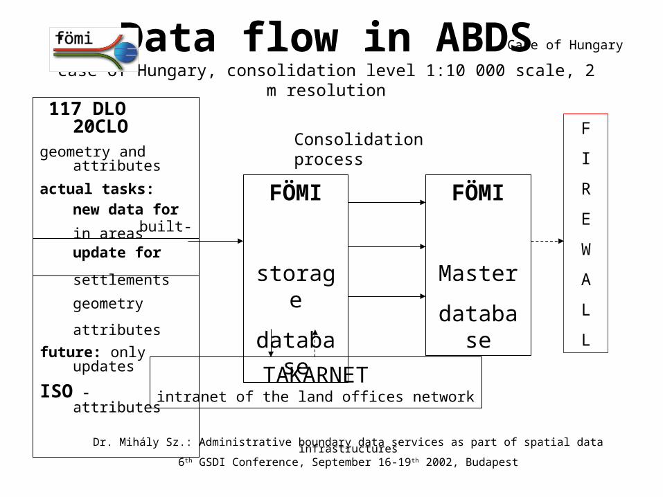
117 DLO 20CLOgeometry and attributes
actual tasks:
new data forbuilt-in areas
update for
settlements
geometry
attributes
future: only updates
ISO - attributes
CSO - attributes
Data flow in ABDScase of Hungary, consolidation level 1:10 000 scale, 2 m resolution
FÖMI
Master
database
F
I
R
E
W
A
L
L
FÖMI
storage
database
Consolidation process
TAKARNETintranet of the land offices network
Dr. Mihály Sz.: Administrative boundary data services as part of spatial data infrastructures6th GSDI Conference, September 16-19th 2002, Budapest
Case of Hungary
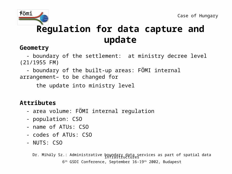
Regulation for data capture and update
Geometry - boundary of the settlement: at ministry decree level (21/1955 FM)
- boundary of the built-up areas: FÖMI internal arrangement– to be changed for
the update into ministry level
Attributes - area volume: FÖMI internal regulation
- population: CSO
- name of ATUs: CSO
- codes of ATUs: CSO
- NUTS: CSO
Case of Hungary
Dr. Mihály Sz.: Administrative boundary data services as part of spatial data infrastructures6th GSDI Conference, September 16-19th 2002, Budapest
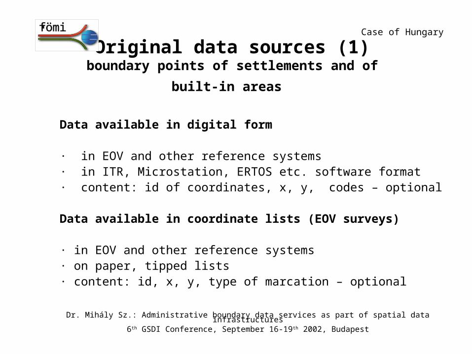
Original data sources (1)boundary points of settlements and of built-in areas
Data available in digital form
· in EOV and other reference systems· in ITR, Microstation, ERTOS etc. software format· content: id of coordinates, x, y, codes – optional Data available in coordinate lists (EOV surveys)
· in EOV and other reference systems· on paper, tipped lists· content: id, x, y, type of marcation – optional
Case of Hungary
Dr. Mihály Sz.: Administrative boundary data services as part of spatial data infrastructures6th GSDI Conference, September 16-19th 2002, Budapest
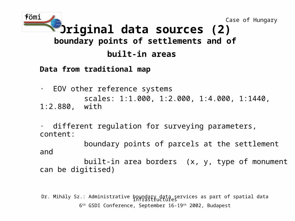
Original data sources (2)boundary points of settlements and of built-in areas
Data from traditional map
· EOV other reference systems scales: 1:1.000, 1:2.000, 1:4.000, 1:1440, 1:2.880, with
· different regulation for surveying parameters, content: boundary points of parcels at the settlement and built-in area borders (x, y, type of monument can be digitised)
Case of Hungary
Dr. Mihály Sz.: Administrative boundary data services as part of spatial data infrastructures6th GSDI Conference, September 16-19th 2002, Budapest
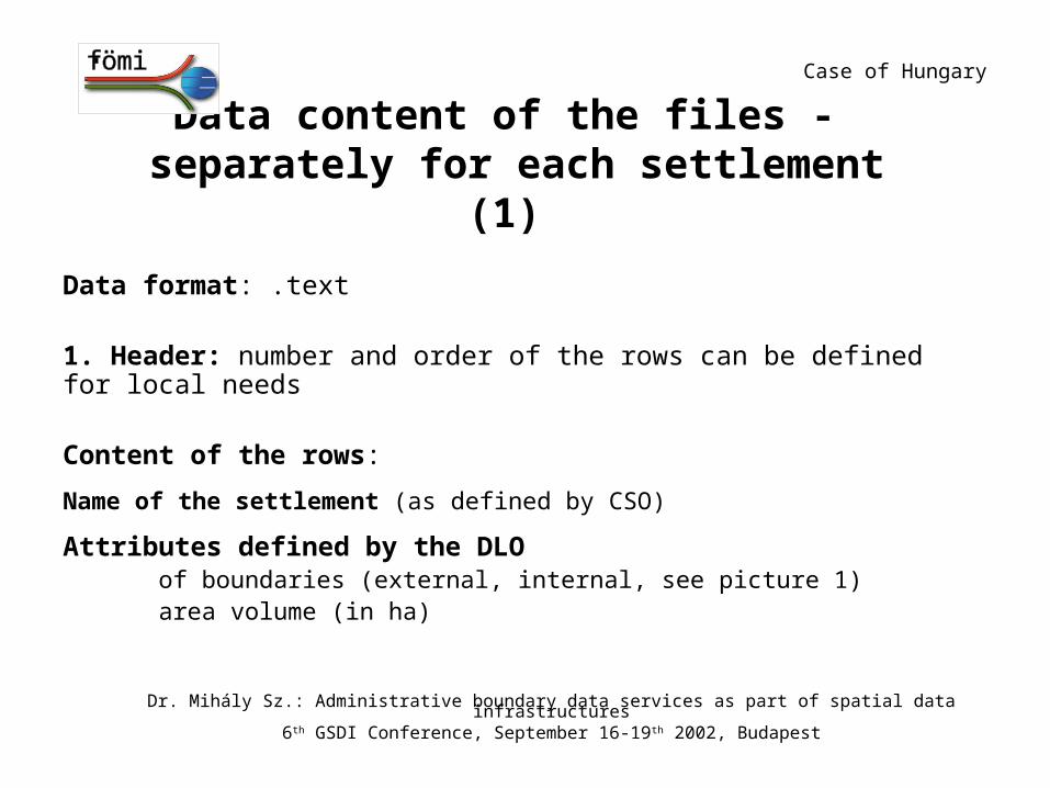
Data content of the files - separately for each settlement (1)
Data format: .text
1. Header: number and order of the rows can be defined for local needs
Content of the rows:
Name of the settlement (as defined by CSO)
Attributes defined by the DLOof boundaries (external, internal, see picture 1)
area volume (in ha)
Case of Hungary
Dr. Mihály Sz.: Administrative boundary data services as part of spatial data infrastructures6th GSDI Conference, September 16-19th 2002, Budapest
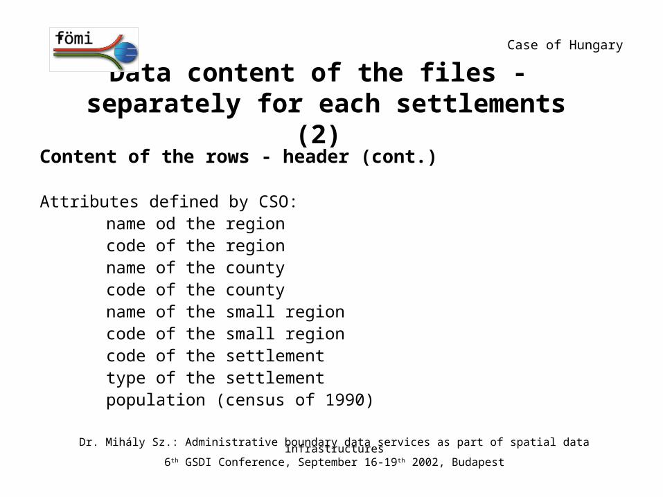
Data content of the files - separately for each settlements (2)
Content of the rows - header (cont.)
Attributes defined by CSO:name od the regioncode of the regionname of the countycode of the countyname of the small regioncode of the small regioncode of the settlementtype of the settlementpopulation (census of 1990)
Case of Hungary
Dr. Mihály Sz.: Administrative boundary data services as part of spatial data infrastructures6th GSDI Conference, September 16-19th 2002, Budapest
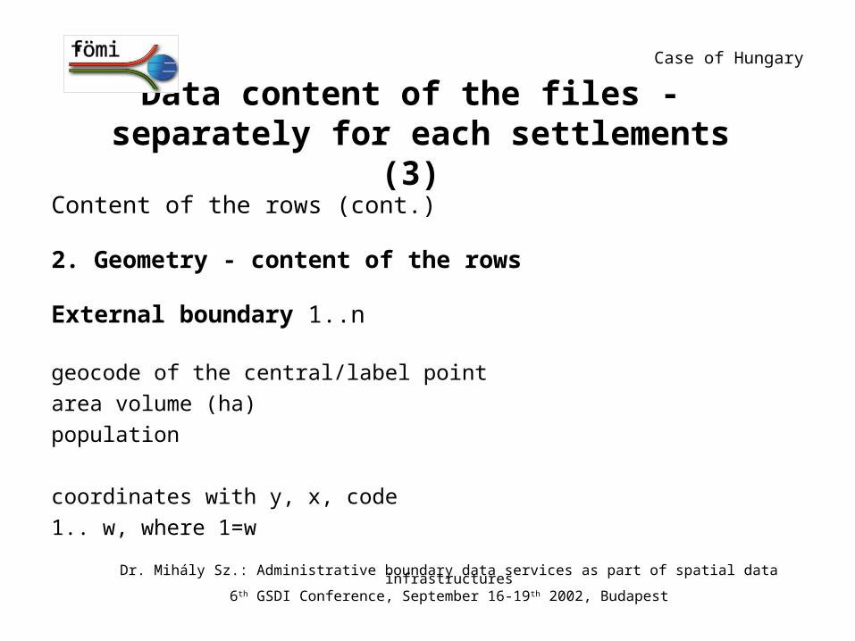
Data content of the files - separately for each settlements (3)
Content of the rows (cont.)
2. Geometry - content of the rows
External boundary 1..n
geocode of the central/label point
area volume (ha)
population
coordinates with y, x, code
1.. w, where 1=w
Case of Hungary
Dr. Mihály Sz.: Administrative boundary data services as part of spatial data infrastructures6th GSDI Conference, September 16-19th 2002, Budapest
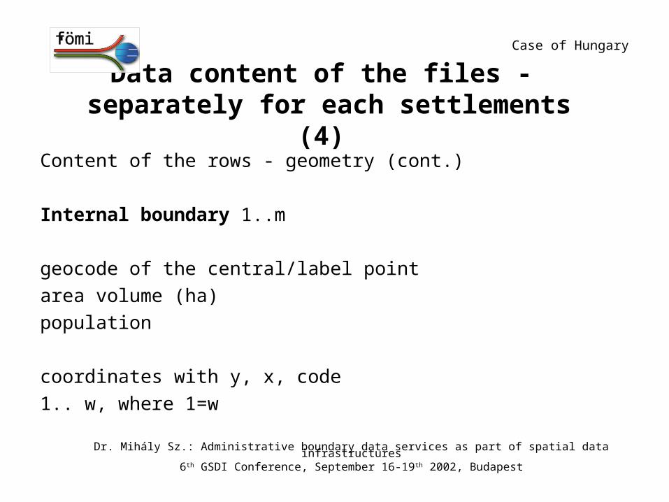
Data content of the files - separately for each settlements (4)
Content of the rows - geometry (cont.)
Internal boundary 1..m
geocode of the central/label point
area volume (ha)
population
coordinates with y, x, code
1.. w, where 1=w
Case of Hungary
Dr. Mihály Sz.: Administrative boundary data services as part of spatial data infrastructures6th GSDI Conference, September 16-19th 2002, Budapest
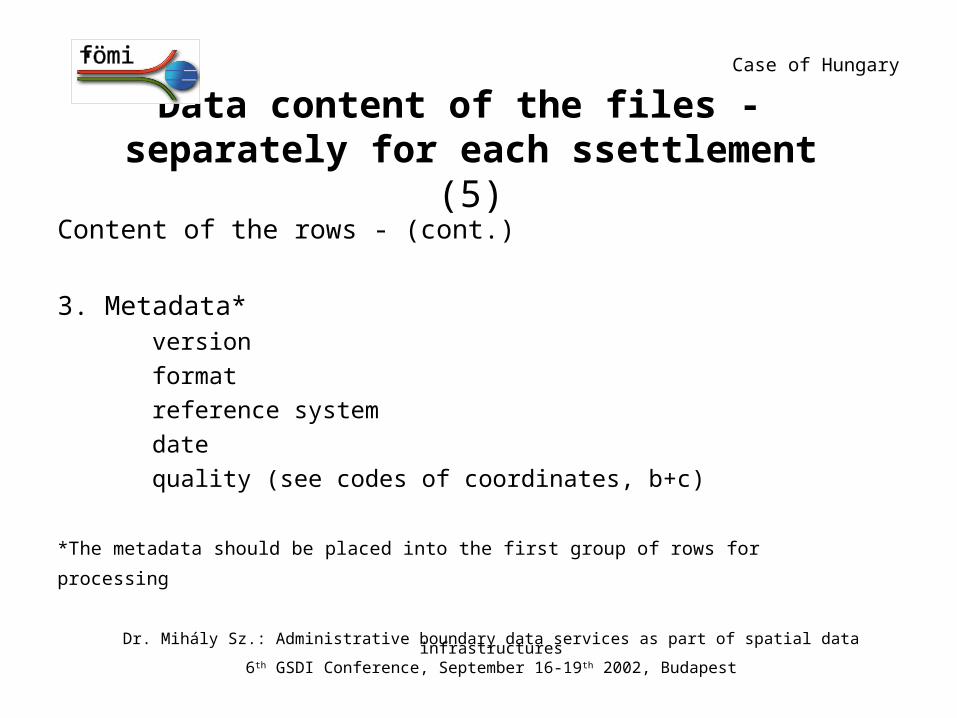
Data content of the files - separately for each ssettlement (5)
Content of the rows - (cont.)
3. Metadata*version
format
reference system
date
quality (see codes of coordinates, b+c)
*The metadata should be placed into the first group of rows for processing
Case of Hungary
Dr. Mihály Sz.: Administrative boundary data services as part of spatial data infrastructures6th GSDI Conference, September 16-19th 2002, Budapest
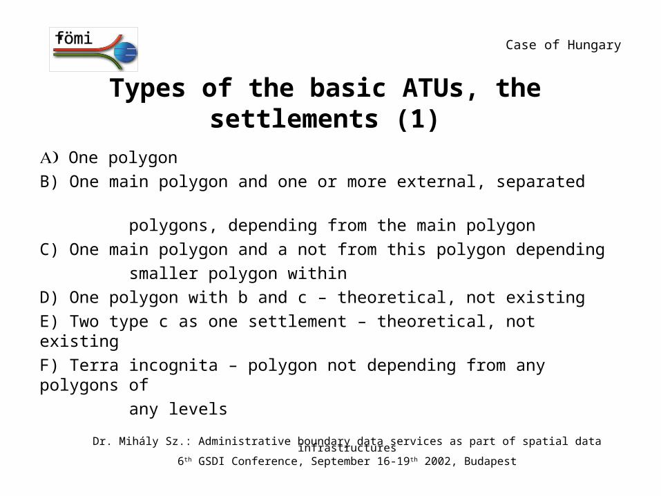
Types of the basic ATUs, the settlements (1)
One polygon
B) One main polygon and one or more external, separated
polygons, depending from the main polygon
C) One main polygon and a not from this polygon depending
smaller polygon within
D) One polygon with b and c – theoretical, not existing
E) Two type c as one settlement – theoretical, not existing
F) Terra incognita – polygon not depending from any polygons of
any levels
Case of Hungary
Dr. Mihály Sz.: Administrative boundary data services as part of spatial data infrastructures6th GSDI Conference, September 16-19th 2002, Budapest
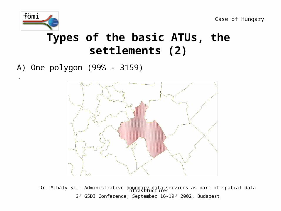
Types of the basic ATUs, the settlements (2)
A) One polygon (99% - 3159)
·
Case of Hungary
Dr. Mihály Sz.: Administrative boundary data services as part of spatial data infrastructures6th GSDI Conference, September 16-19th 2002, Budapest
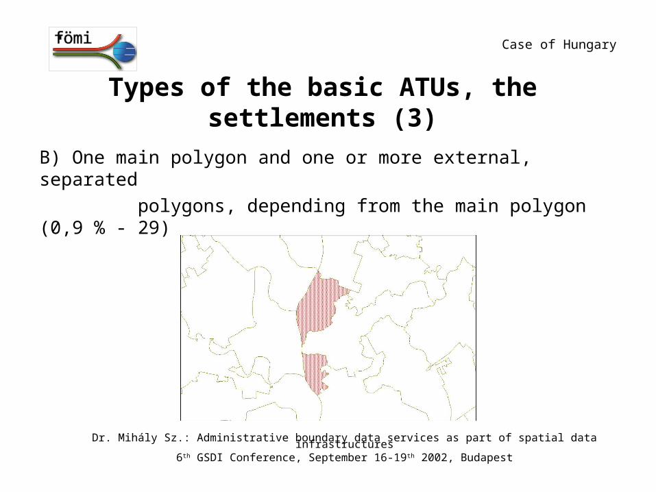
Types of the basic ATUs, the settlements (3)
B) One main polygon and one or more external, separated
polygons, depending from the main polygon (0,9 % - 29)
Case of Hungary
Dr. Mihály Sz.: Administrative boundary data services as part of spatial data infrastructures6th GSDI Conference, September 16-19th 2002, Budapest
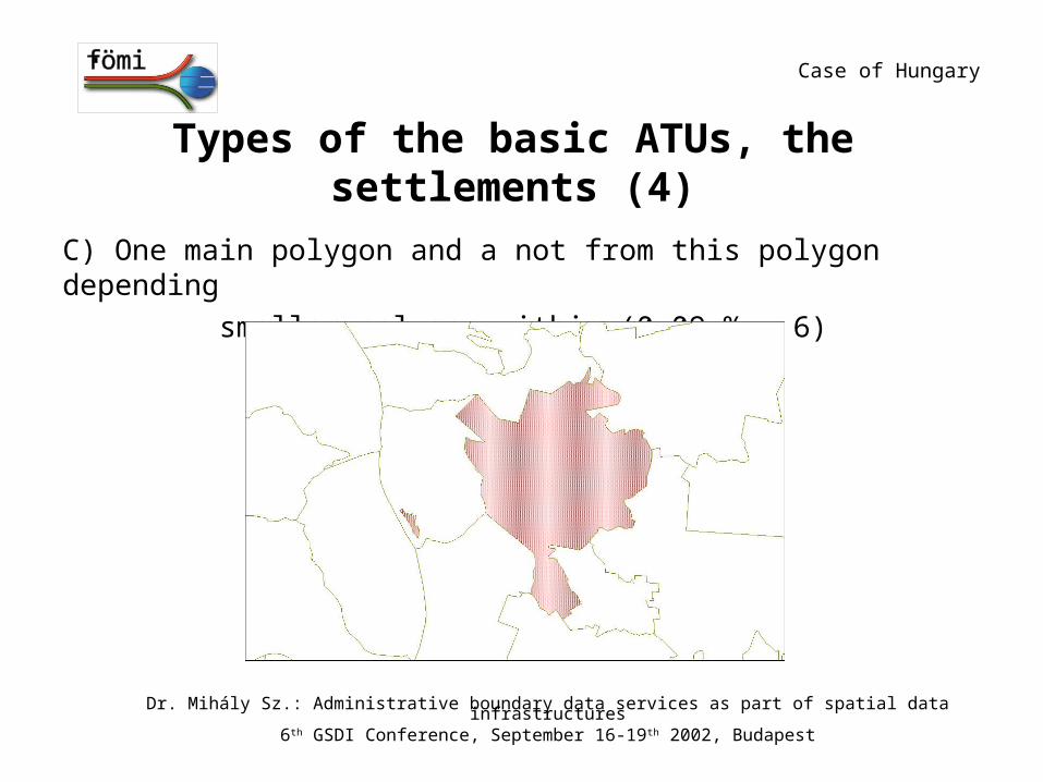
Types of the basic ATUs, the settlements (4)
C) One main polygon and a not from this polygon depending
smaller polygon within (0.09 % - 6)
Case of Hungary
Dr. Mihály Sz.: Administrative boundary data services as part of spatial data infrastructures6th GSDI Conference, September 16-19th 2002, Budapest
Types of the basic ATUs, the settlements (5)
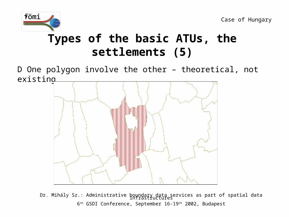
D One polygon involve the other – theoretical, not existing
Case of Hungary
Dr. Mihály Sz.: Administrative boundary data services as part of spatial data infrastructures6th GSDI Conference, September 16-19th 2002, Budapest
Types of the basic ATUs, the settlements (6)
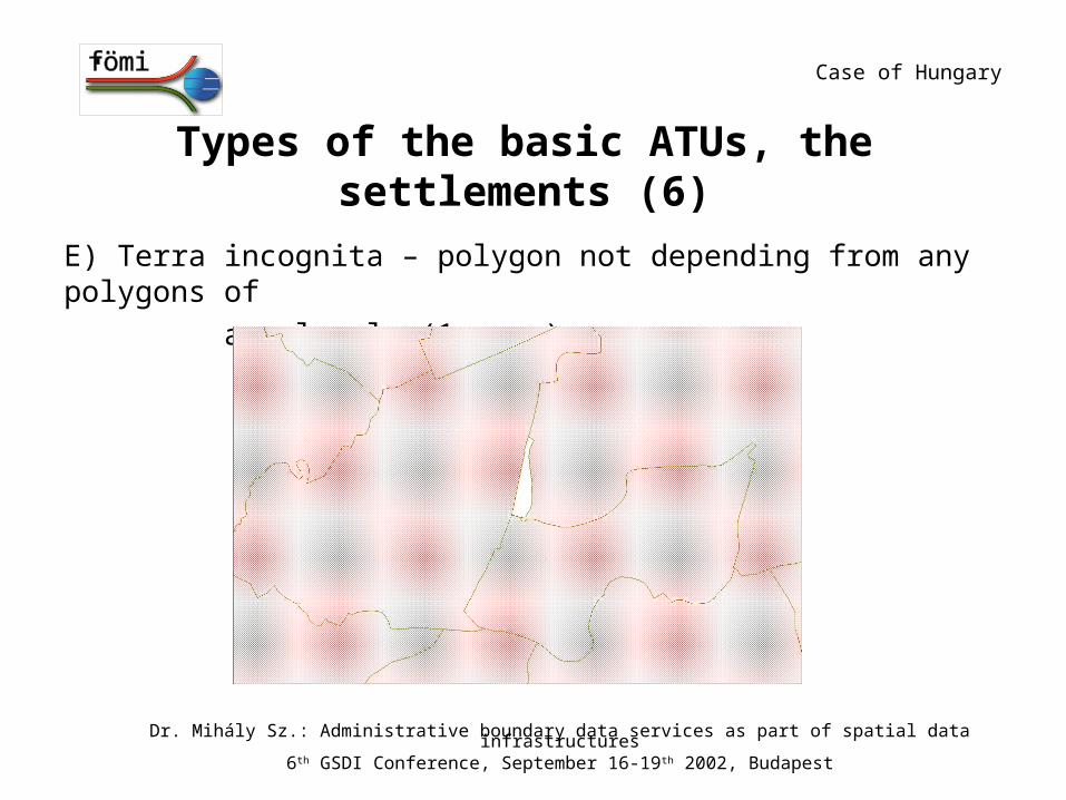
E) Terra incognita – polygon not depending from any polygons of
any levels (1 case)
Case of Hungary
Dr. Mihály Sz.: Administrative boundary data services as part of spatial data infrastructures6th GSDI Conference, September 16-19th 2002, Budapest
Built-in areas – polygons below the basic ATU level
Categories
built-in area
external zonesspecial external zones(former “closed garden”)
other legally validated categories detached farmsgroup of detached farms
Number of the built-in areas by settlement: 1… n (maximum: 128, case of Debrecen)
Dr. Mihály Sz.: Administrative boundary data services as part of spatial data infrastructures6th GSDI Conference, September 16-19th 2002, Budapest
Case of Hungary
Codes of the coordinates (1)
A) level of ATU in the administrative hierarchy
1 = state boundary2= region3= county4 = small region5 = settlement6 = built-in area
(7 = reserved for blocks)
(8 = reserved for parcels) B) monument – only for the storage database
0= no monument
1= marked point
Case of Hungary
Dr. Mihály Sz.: Administrative boundary data services as part of spatial data infrastructures6th GSDI Conference, September 16-19th 2002, Budapest
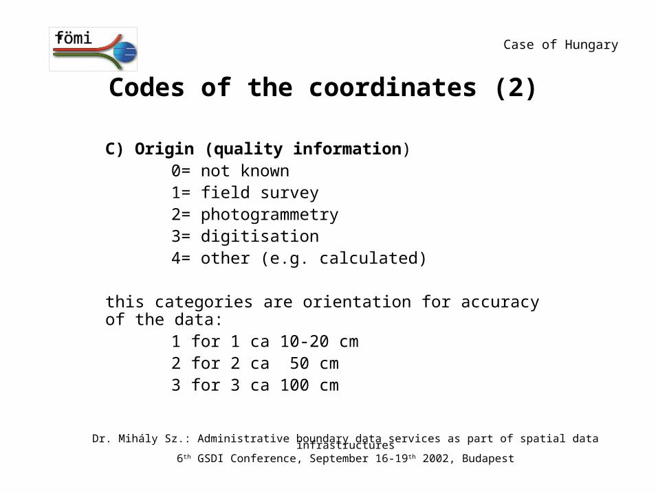
Codes of the coordinates (2)
C) Origin (quality information)0= not known1= field survey2= photogrammetry3= digitisation4= other (e.g. calculated)
this categories are orientation for accuracy of the data:
1 for 1 ca 10-20 cm2 for 2 ca 50 cm3 for 3 ca 100 cm
Case of Hungary
Dr. Mihály Sz.: Administrative boundary data services as part of spatial data infrastructures6th GSDI Conference, September 16-19th 2002, Budapest
Codes of the coordinates (3)
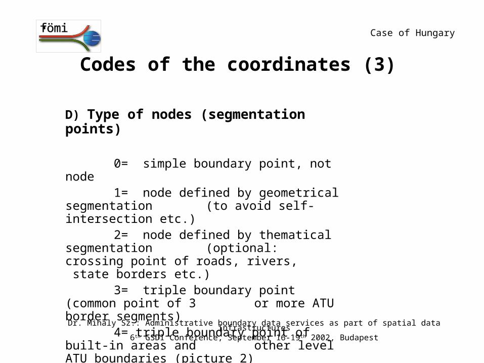
D) Type of nodes (segmentation points)
0= simple boundary point, not node1= node defined by geometrical segmentation (to avoid self-intersection etc.)2= node defined by thematical segmentation (optional: crossing point of roads, rivers, state borders etc.)3= triple boundary point (common point of 3 or more ATU border segments)4= triple boundary point of built-in areas and other level ATU boundaries (picture 2)
Case of Hungary
Dr. Mihály Sz.: Administrative boundary data services as part of spatial data infrastructures6th GSDI Conference, September 16-19th 2002, Budapest
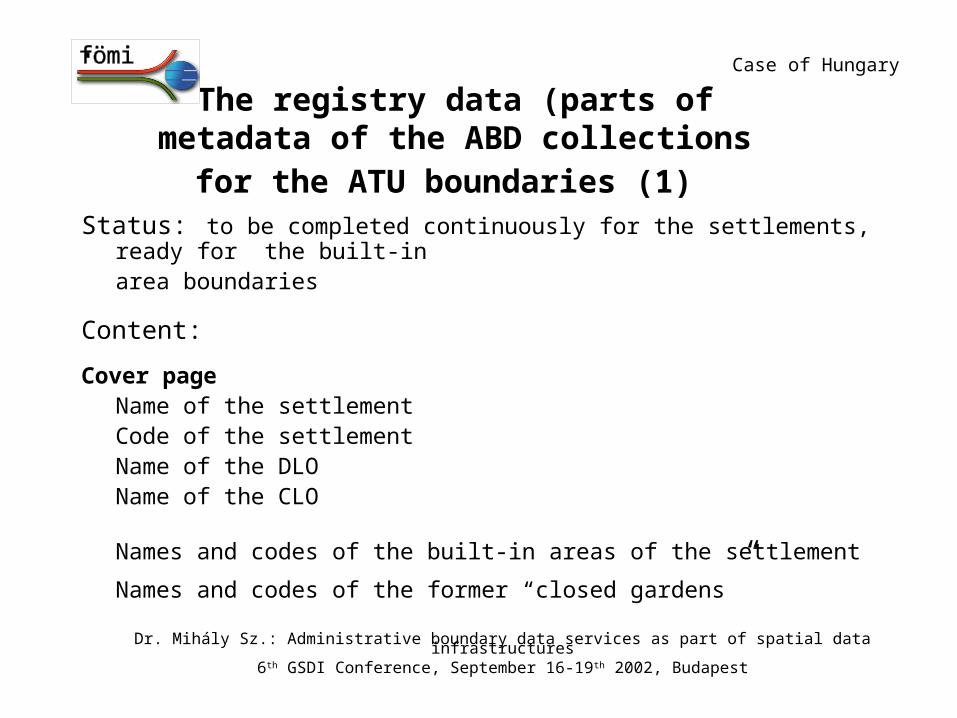
The registry data (parts of metadata of the ABD collections for the ATU boundaries (1)
Status: to be completed continuously for the settlements, ready for the built-in
area boundaries
Content:
Cover pageName of the settlementCode of the settlementName of the DLOName of the CLO
Names and codes of the built-in areas of the settlement
Names and codes of the former “closed gardens”
Case of Hungary
Dr. Mihály Sz.: Administrative boundary data services as part of spatial data infrastructures6th GSDI Conference, September 16-19th 2002, Budapest
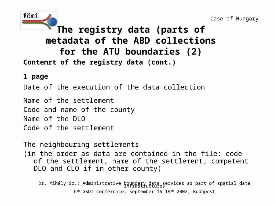
The registry data (parts of metadata of the ABD collections for the ATU boundaries (2)
Contenrt of the registry data (cont.)
1 page
Date of the execution of the data collection Name of the settlementCode and name of the countyName of the DLOCode of the settlement The neighbouring settlements(in the order as data are contained in the file: code of the settlement, name of the
settlement, competent DLO and CLO if in other county)
Case of Hungary
Dr. Mihály Sz.: Administrative boundary data services as part of spatial data infrastructures6th GSDI Conference, September 16-19th 2002, Budapest
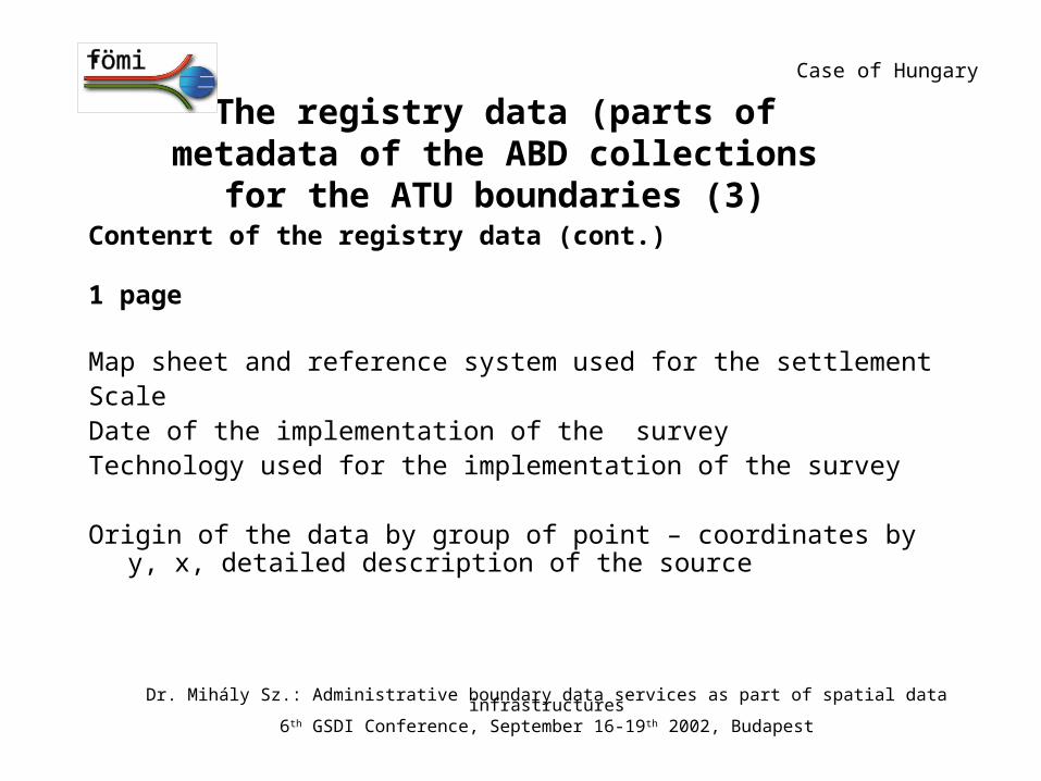
The registry data (parts of metadata of the ABD collections for the ATU boundaries (3)
Contenrt of the registry data (cont.)
1 page
Map sheet and reference system used for the settlementScale Date of the implementation of the surveyTechnology used for the implementation of the survey Origin of the data by group of point – coordinates by y, x, detailed description of
the source
Case of Hungary
Dr. Mihály Sz.: Administrative boundary data services as part of spatial data infrastructures6th GSDI Conference, September 16-19th 2002, Budapest
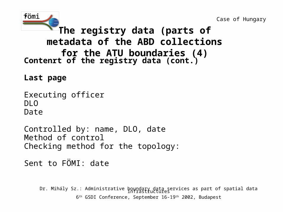
The registry data (parts of metadata of the ABD collections for the ATU boundaries (4)
Contenrt of the registry data (cont.)
Last page Executing officer DLODate Controlled by: name, DLO, dateMethod of controlChecking method for the topology: Sent to FÖMI: date
Case of Hungary
Dr. Mihály Sz.: Administrative boundary data services as part of spatial data infrastructures6th GSDI Conference, September 16-19th 2002, Budapest
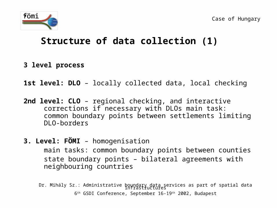
Structure of data collection (1)
3 level process
1st level: DLO – locally collected data, local checking
2nd level: CLO – regional checking, and interactive corrections if necessary with DLOs main task: common boundary points between settlements limiting DLO-borders
3. Level: FÖMI – homogenisationmain tasks: common boundary points between countiesstate boundary points – bilateral agreements with neighbouring countries
Case of Hungary
Dr. Mihály Sz.: Administrative boundary data services as part of spatial data infrastructures6th GSDI Conference, September 16-19th 2002, Budapest
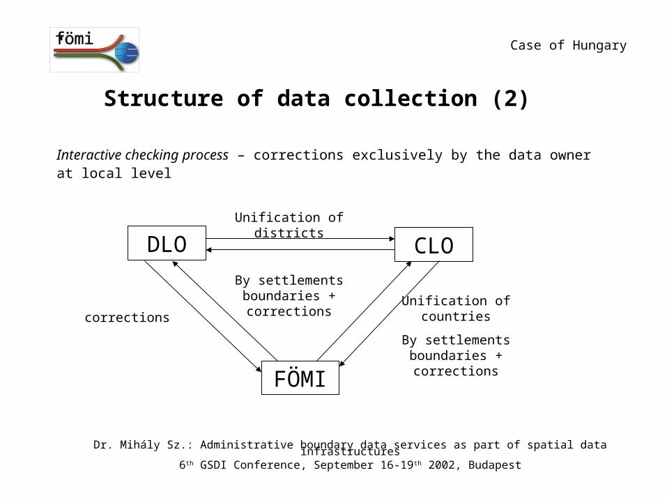
Structure of data collection (2)
Interactive checking process – corrections exclusively by the data ownerat local level
DLO CLO
FÖMI
Unification of districts
By settlements boundaries + corrections
correctionsUnification of
countries
By settlements boundaries + corrections
Case of Hungary
Dr. Mihály Sz.: Administrative boundary data services as part of spatial data infrastructures6th GSDI Conference, September 16-19th 2002, Budapest
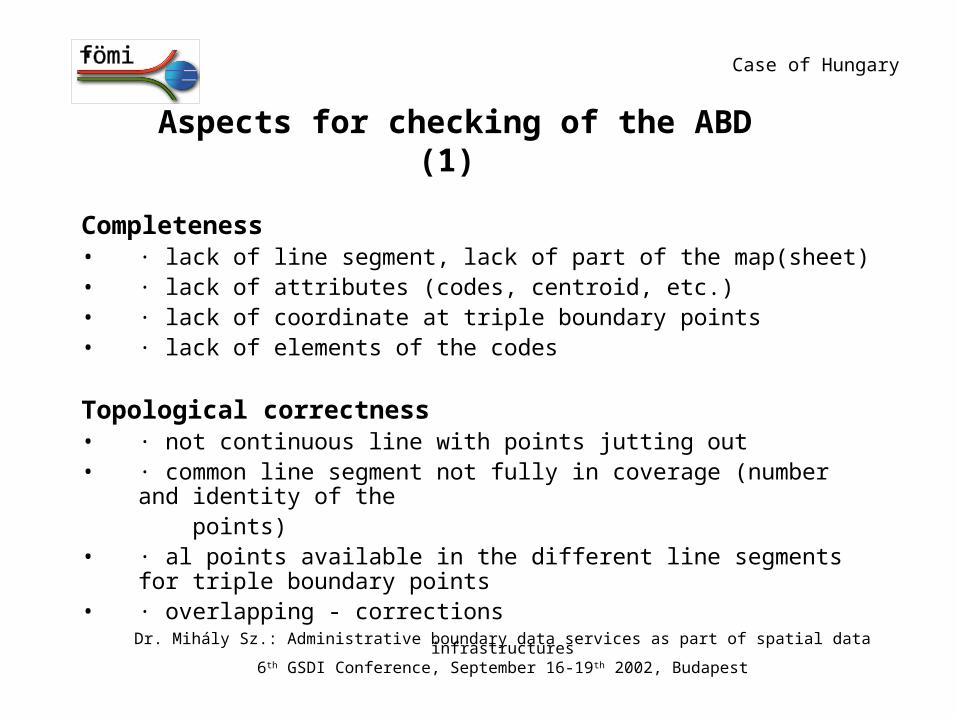
Aspects for checking of the ABD (1)
Completeness• · lack of line segment, lack of part of the map(sheet)• · lack of attributes (codes, centroid, etc.)• · lack of coordinate at triple boundary points• · lack of elements of the codes
Topological correctness• · not continuous line with points jutting out• · common line segment not fully in coverage (number and identity of the
points)• · al points available in the different line segments for triple boundary points• · overlapping - corrections
Case of Hungary
Dr. Mihály Sz.: Administrative boundary data services as part of spatial data infrastructures6th GSDI Conference, September 16-19th 2002, Budapest
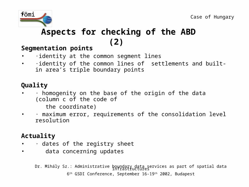
Aspects for checking of the ABD (2) Segmentation points• ·identity at the common segment lines• ·identity of the common lines of settlements and built-in area’s triple
boundary points
Quality• · homogenity on the base of the origin of the data (column c of the code of
the coordinate)
• · maximum error, requirements of the consolidation level resolution
Actuality• · dates of the registry sheet• data concerning updates
Case of Hungary
Dr. Mihály Sz.: Administrative boundary data services as part of spatial data infrastructures6th GSDI Conference, September 16-19th 2002, Budapest
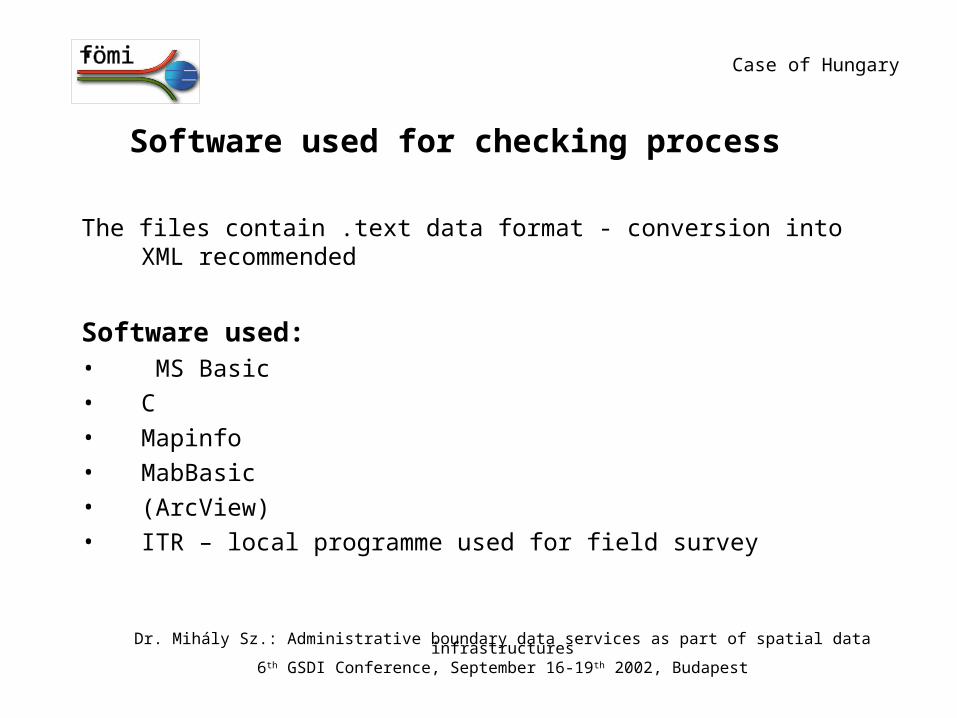
Software used for checking process
The files contain .text data format - conversion into XML recommended
Software used:• MS Basic
• C
• Mapinfo
• MabBasic
• (ArcView)
• ITR – local programme used for field survey
Case of Hungary
Dr. Mihály Sz.: Administrative boundary data services as part of spatial data infrastructures6th GSDI Conference, September 16-19th 2002, Budapest
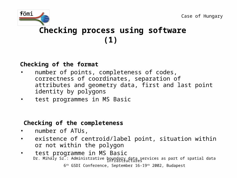
Checking process using software (1)
Checking of the format• number of points, completeness of codes, correctness of coordinates,
separation of attributes and geometry data, first and last point identity by polygons
• test programmes in MS Basic
Checking of the completeness• number of ATUs, • existence of centroid/label point, situation within or not within the polygon • test programme in MS Basic
Case of Hungary
Dr. Mihály Sz.: Administrative boundary data services as part of spatial data infrastructures6th GSDI Conference, September 16-19th 2002, Budapest
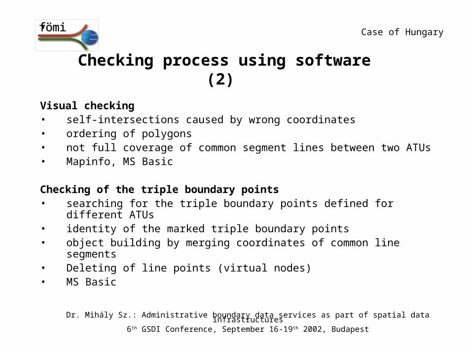
Checking process using software (2)
Visual checking• self-intersections caused by wrong coordinates• ordering of polygons• not full coverage of common segment lines between two ATUs• Mapinfo, MS Basic
Checking of the triple boundary points• searching for the triple boundary points defined for different ATUs• identity of the marked triple boundary points• object building by merging coordinates of common line segments • Deleting of line points (virtual nodes) • MS Basic
Case of Hungary
Dr. Mihály Sz.: Administrative boundary data services as part of spatial data infrastructures6th GSDI Conference, September 16-19th 2002, Budapest
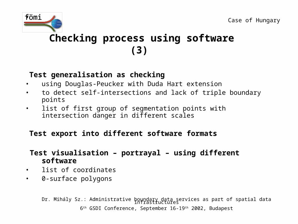
Checking process using software (3)
Test generalisation as checking• using Douglas-Peucker with Duda Hart extension• to detect self-intersections and lack of triple boundary points• list of first group of segmentation points with intersection danger in
different scales
Test export into different software formats
Test visualisation – portrayal – using different software • list of coordinates • 0-surface polygons
Case of Hungary
Dr. Mihály Sz.: Administrative boundary data services as part of spatial data infrastructures6th GSDI Conference, September 16-19th 2002, Budapest
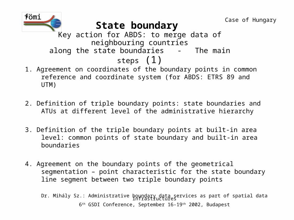
State boundary Key action for ABDS: to merge data of neighbouring countries
along the state boundaries - The main steps (1)
1. Agreement on coordinates of the boundary points in common reference and coordinate system (for ABDS: ETRS 89 and UTM)
2. Definition of triple boundary points: state boundaries and ATUs at different level of the administrative hierarchy
3. Definition of the triple boundary points at built-in area level: common points of state boundary and built-in area boundaries
4. Agreement on the boundary points of the geometrical segmentation – point characteristic for the state boundary line segment between two triple boundary points
Case of Hungary
Dr. Mihály Sz.: Administrative boundary data services as part of spatial data infrastructures6th GSDI Conference, September 16-19th 2002, Budapest
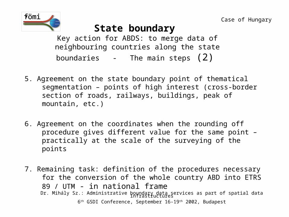
State boundary Key action for ABDS: to merge data of neighbouring countries along
the state boundaries - The main steps (2)
5. Agreement on the state boundary point of thematical segmentation – points of high interest (cross-border section of roads, railways, buildings, peak of mountain, etc.)
6. Agreement on the coordinates when the rounding off procedure gives different value for the same point – practically at the scale of the surveying of the points
7. Remaining task: definition of the procedures necessary for the conversion of the whole country ABD into ETRS 89 / UTM - in national frame
Case of Hungary
Dr. Mihály Sz.: Administrative boundary data services as part of spatial data infrastructures6th GSDI Conference, September 16-19th 2002, Budapest
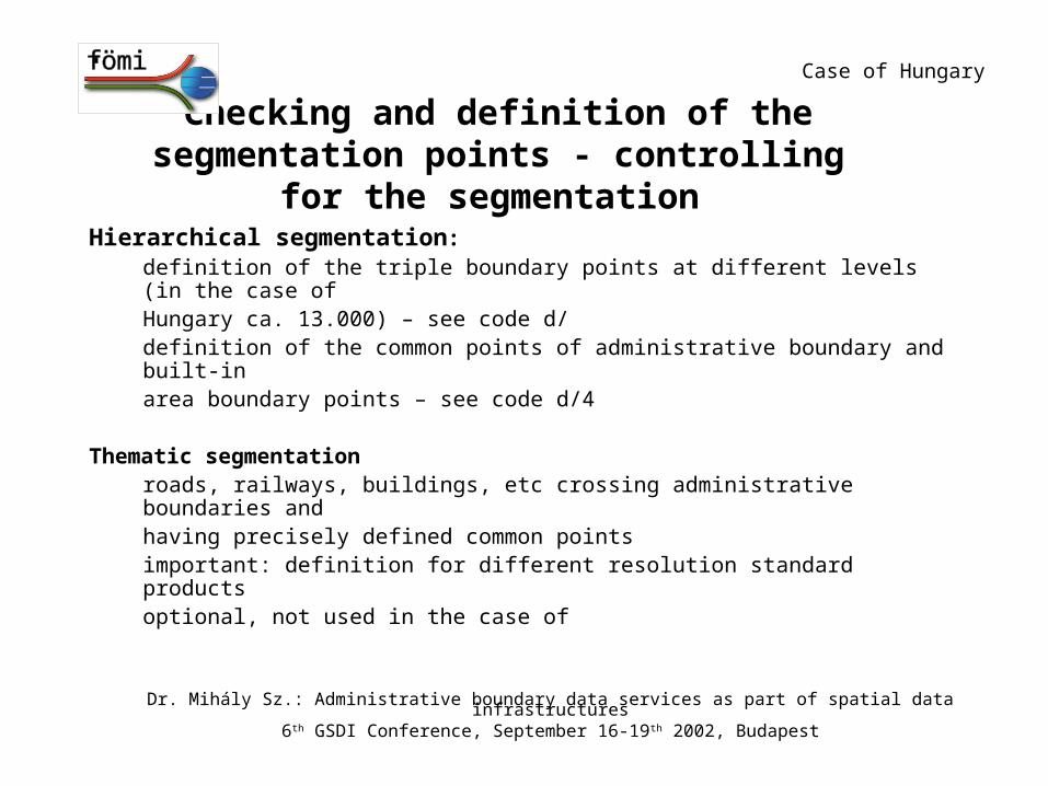
Checking and definition of the segmentation points - controlling for the segmentation
Hierarchical segmentation:definition of the triple boundary points at different levels (in the case of
Hungary ca. 13.000) – see code d/definition of the common points of administrative boundary and built-inarea boundary points – see code d/4
Thematic segmentation roads, railways, buildings, etc crossing administrative boundaries andhaving precisely defined common points important: definition for different resolution standard productsoptional, not used in the case of
Case of Hungary
Dr. Mihály Sz.: Administrative boundary data services as part of spatial data infrastructures6th GSDI Conference, September 16-19th 2002, Budapest
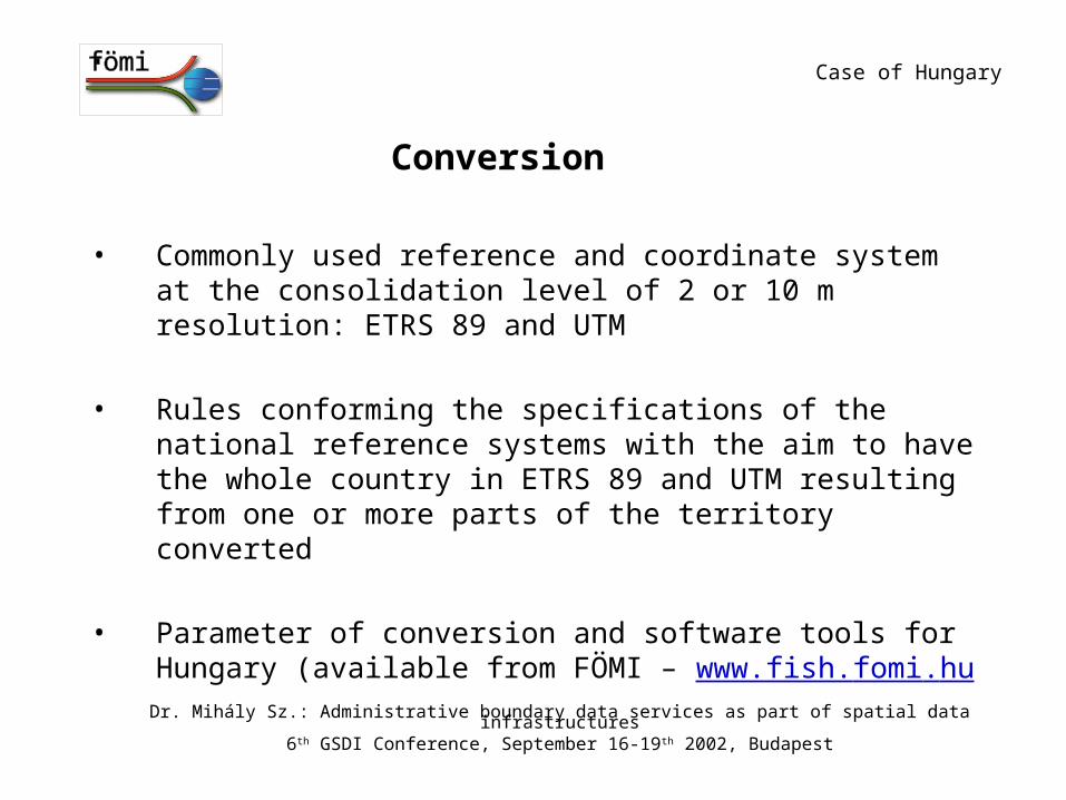
Conversion
• Commonly used reference and coordinate system at the consolidation level of 2 or 10 m resolution: ETRS 89 and UTM
• Rules conforming the specifications of the national reference systems with the aim to have the whole country in ETRS 89 and UTM resulting from one or more parts of the territory converted
• Parameter of conversion and software tools for Hungary (available from FÖMI – www.fish.fomi.hu
Case of Hungary
Dr. Mihály Sz.: Administrative boundary data services as part of spatial data infrastructures6th GSDI Conference, September 16-19th 2002, Budapest
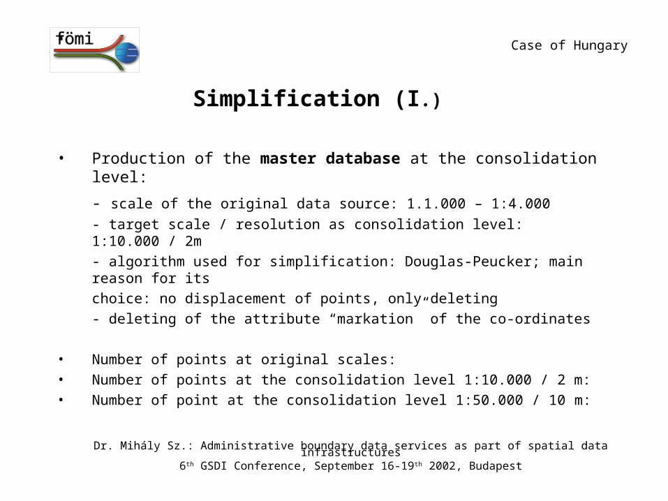
Simplification (I.)
• Production of the master database at the consolidation level:
- scale of the original data source: 1.1.000 – 1:4.000
- target scale / resolution as consolidation level: 1:10.000 / 2m
- algorithm used for simplification: Douglas-Peucker; main reason for its
choice: no displacement of points, only deleting
- deleting of the attribute “markation” of the co-ordinates
• Number of points at original scales:
• Number of points at the consolidation level 1:10.000 / 2 m:
• Number of point at the consolidation level 1:50.000 / 10 m:
Case of Hungary
Dr. Mihály Sz.: Administrative boundary data services as part of spatial data infrastructures6th GSDI Conference, September 16-19th 2002, Budapest

Result: consolidation levels of the ABDS
• Master database at the consolidation level is ready to start the creation, tailoring of the products and services at the resolution of 2 m, scale of 1:10.000 - from the national portal, actually in elaboration
• Simplification of the dataset into the 10 m resolution, 1:50.000 scale: one step of generalisation, first standard product for the ABDS
• Differences: number of points, upgrade period (halfyearly at 1:10.000 scale)
Case of Hungary
Dr. Mihály Sz.: Administrative boundary data services as part of spatial data infrastructures6th GSDI Conference, September 16-19th 2002, Budapest
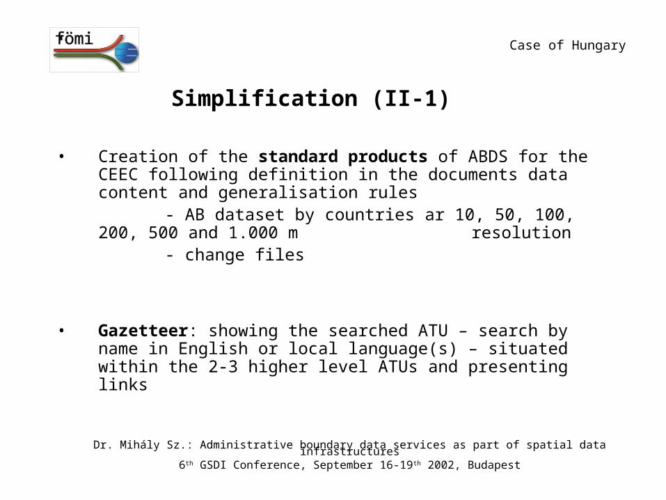
Simplification (II-1)
• Creation of the standard products of ABDS for the CEEC following definition in the documents data content and generalisation rules
- AB dataset by countries ar 10, 50, 100, 200, 500 and 1.000 m resolution
- change files
• Gazetteer: showing the searched ATU – search by name in English or local language(s) – situated within the 2-3 higher level ATUs and presenting links
Case of Hungary
Dr. Mihály Sz.: Administrative boundary data services as part of spatial data infrastructures6th GSDI Conference, September 16-19th 2002, Budapest

Simplification (II-2)
Use of algorithms – software available: Preferred: Douglas-Peucker with Duda-Hart extension – generalisation factor
allows seamless resolution product composition
For tailoring standard product only: Whirlpool
Other could be included into the product line if needed andalgorithm defined
Case of Hungary
Dr. Mihály Sz.: Administrative boundary data services as part of spatial data infrastructures6th GSDI Conference, September 16-19th 2002, Budapest
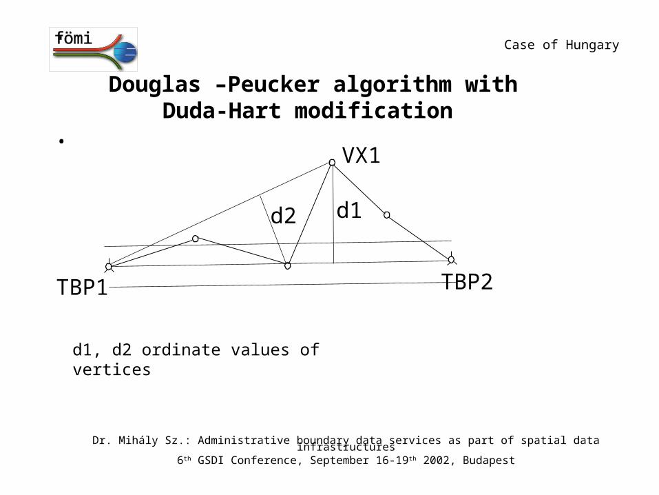
Douglas –Peucker algorithm with Duda-Hart modification
•VX1
TBP1 TBP2
d2 d1
d1, d2 ordinate values of vertices
Case of Hungary
Dr. Mihály Sz.: Administrative boundary data services as part of spatial data infrastructures6th GSDI Conference, September 16-19th 2002, Budapest
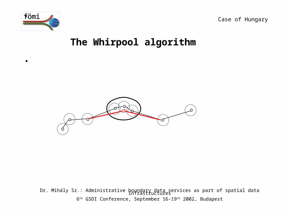
The Whirpool algorithm
•
Dr. Mihály Sz.: Administrative boundary data services as part of spatial data infrastructures6th GSDI Conference, September 16-19th 2002, Budapest
Case of Hungary
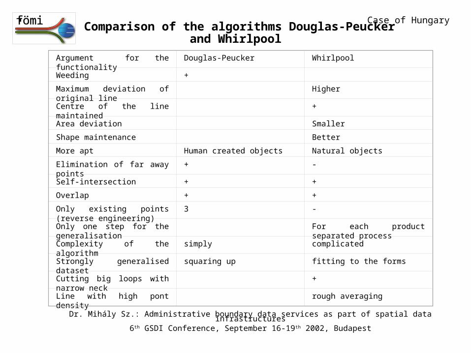
Comparison of the algorithms Douglas-Peucker and Whirlpool
Argument for the functionality Douglas-Peucker Whirlpool
Weeding +
Maximum deviation of original line
Higher
Centre of the line maintained +
Area deviation Smaller
Shape maintenance Better
More apt Human created objects Natural objects
Elimination of far away points + -
Self-intersection + +
Overlap + +
Only existing points (reverse engineering)
3 -
Only one step for the generalisation
For each product separated process
Complexity of the algorithm simply complicated
Strongly generalised dataset squaring up fitting to the forms
Cutting big loops with narrow neck
+
Line with high pont density rough averaging
Case of Hungary
Dr. Mihály Sz.: Administrative boundary data services as part of spatial data infrastructures6th GSDI Conference, September 16-19th 2002, Budapest

Filtering of straight lines
V0V1
V2d1
If d1<3BW v1 eliminated
Case of Hungary
Dr. Mihály Sz.: Administrative boundary data services as part of spatial data infrastructures6th GSDI Conference, September 16-19th 2002, Budapest
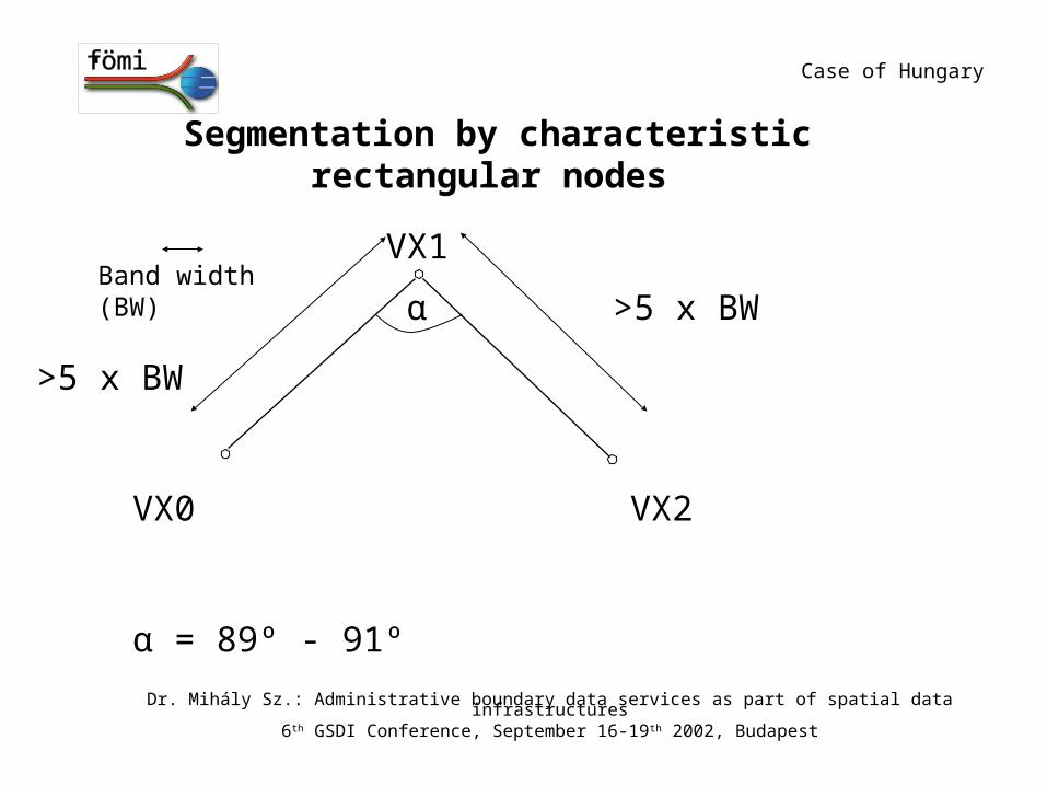
Segmentation by characteristic rectangular nodes
VX1
VX2VX0
>5 x BWBand width (BW)
>5 x BW
α
α = 89º - 91º
Case of Hungary
Dr. Mihály Sz.: Administrative boundary data services as part of spatial data infrastructures6th GSDI Conference, September 16-19th 2002, Budapest
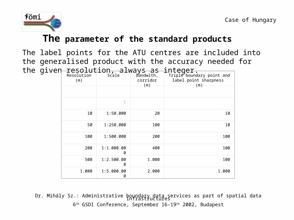
The parameter of the standard products
The label points for the ATU centres are included into the generalised product with the accuracy needed for the given resolution, always as integer.
Resolution(m)
Scale Bandwith, corridor (m)
Triple boundary point and label point sharpness (m)
:
10 1:50.000 20 10
50 1:250.000 100 10
100 1:500.000 200 100
200 1:1.000.000 400 100
500 1:2.500.000 1.000 100
1.000 1:5.000.000 2.000 1.000
Case of Hungary
Dr. Mihály Sz.: Administrative boundary data services as part of spatial data infrastructures6th GSDI Conference, September 16-19th 2002, Budapest
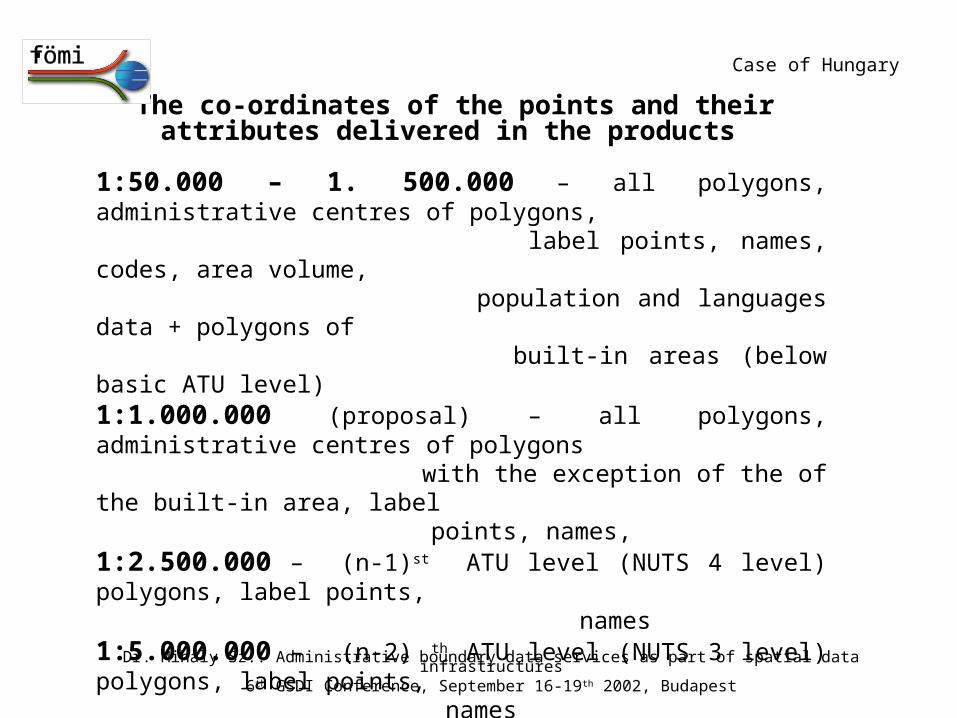
The co-ordinates of the points and their attributes delivered in the products
1:50.000 – 1. 500.000 – all polygons, administrative centres of polygons, label points, names, codes, area volume, population and languages data + polygons of built-in areas (below basic ATU level)
1:1.000.000 (proposal) – all polygons, administrative centres of polygons with the exception of the of the built-in area, label points, names,
1:2.500.000 – (n-1)st ATU level (NUTS 4 level) polygons, label points, names
1:5.000.000 – (n-2) th ATU level (NUTS 3 level) polygons, label points, names
Note: The search interfaces of the international portal for ATU names, administrative centre names and codes will run at the 1:1.000.000 or 1.250.000 scale harmonised dataset.
Case of Hungary
Dr. Mihály Sz.: Administrative boundary data services as part of spatial data infrastructures6th GSDI Conference, September 16-19th 2002, Budapest
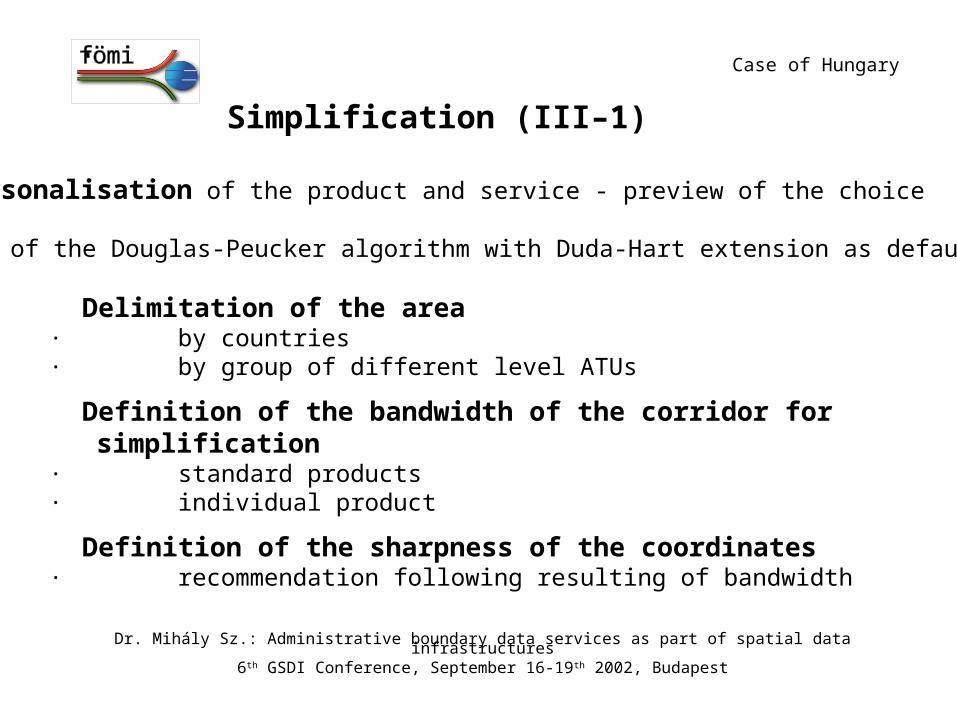
Simplification (III–1)
Personalisation of the product and service - preview of the choice
Use of the Douglas-Peucker algorithm with Duda-Hart extension as default
· Delimitation of the area· by countries · by group of different level ATUs
· Definition of the bandwidth of the corridor for simplification
· standard products· individual product
· Definition of the sharpness of the coordinates
· recommendation following resulting of bandwidth
Case of Hungary
Dr. Mihály Sz.: Administrative boundary data services as part of spatial data infrastructures6th GSDI Conference, September 16-19th 2002, Budapest

Simplification (III-2)
· Definition of the formatXML, text, dxf, dwg, MapInfo, ArcInfo, etc.
· Definition of the creation of long straight – deleting points· parameter for the bandwidth of the corridor · Definition and selection of the typical “rectangulars” –
definition of new segmentation points for the individual product
· parameter for the angle between the sides· parameter for the sides in function of the bandwidth
Case of Hungary
Dr. Mihály Sz.: Administrative boundary data services as part of spatial data infrastructures6th GSDI Conference, September 16-19th 2002, Budapest
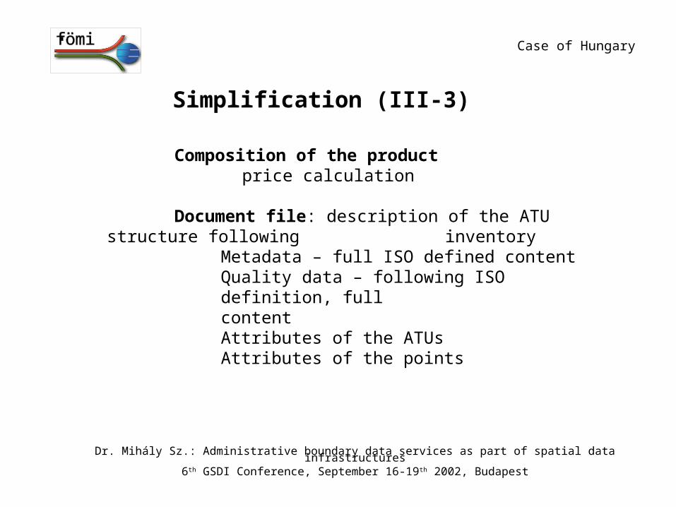
Simplification (III-3)
Composition of the productprice calculation
Document file: description of the ATU structure following inventory
Metadata – full ISO defined contentQuality data – following ISO definition, full
contentAttributes of the ATUsAttributes of the points
Case of Hungary
Dr. Mihály Sz.: Administrative boundary data services as part of spatial data infrastructures6th GSDI Conference, September 16-19th 2002, Budapest
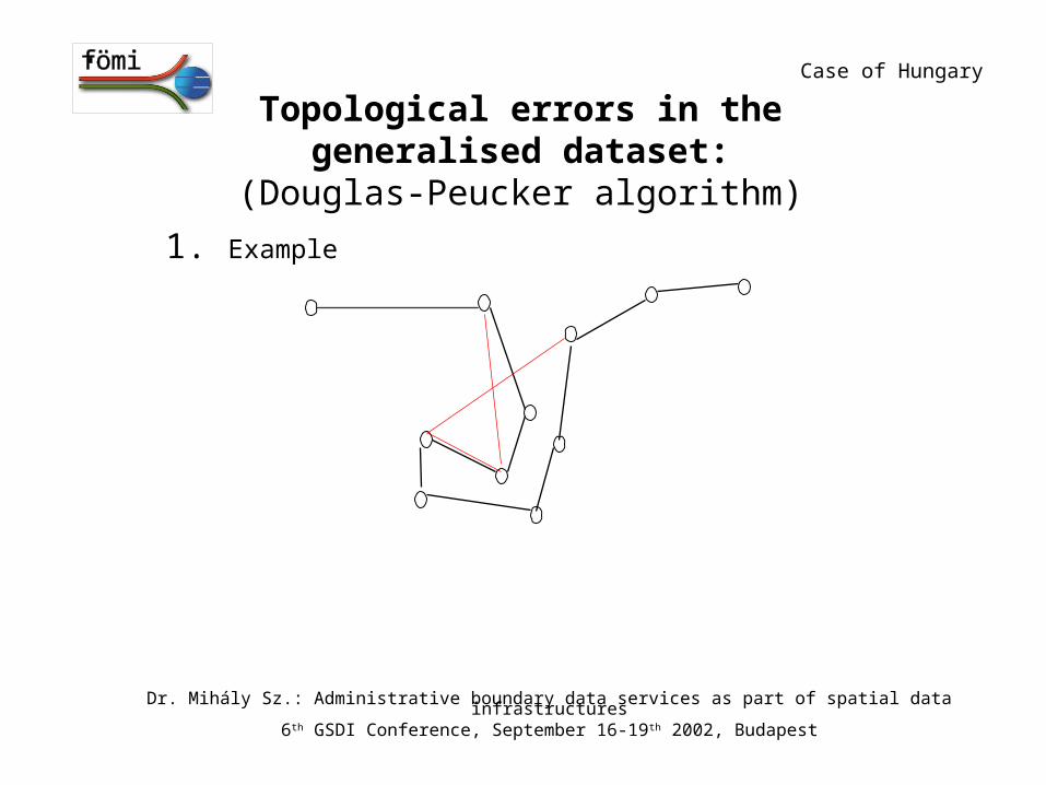
Topological errors in the generalised dataset:(Douglas-Peucker algorithm)
1. Example
Case of Hungary
Dr. Mihály Sz.: Administrative boundary data services as part of spatial data infrastructures6th GSDI Conference, September 16-19th 2002, Budapest
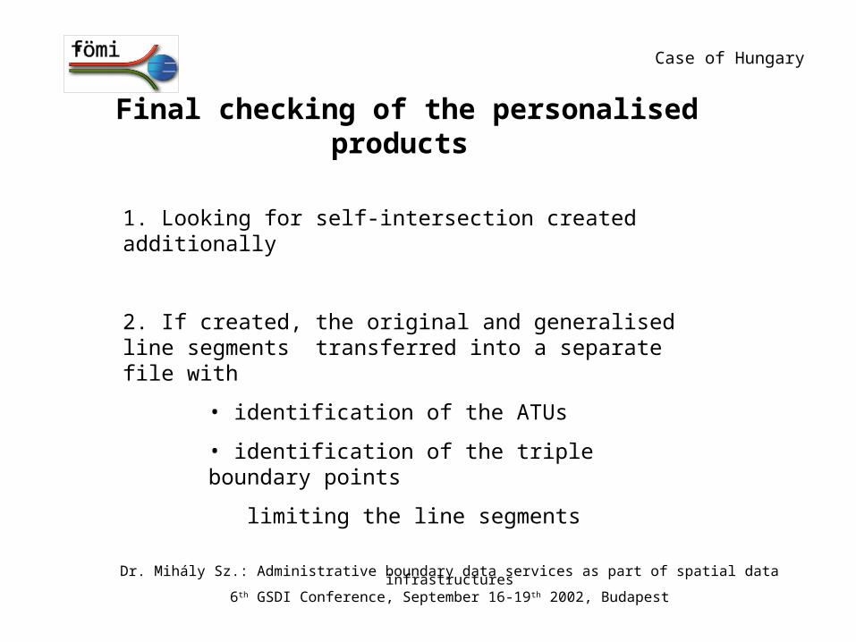
Final checking of the personalised products
1. Looking for self-intersection created additionally
2. If created, the original and generalised line segments transferred into a separate file with
• identification of the ATUs
• identification of the triple boundary points
limiting the line segments
Case of Hungary
Dr. Mihály Sz.: Administrative boundary data services as part of spatial data infrastructures6th GSDI Conference, September 16-19th 2002, Budapest
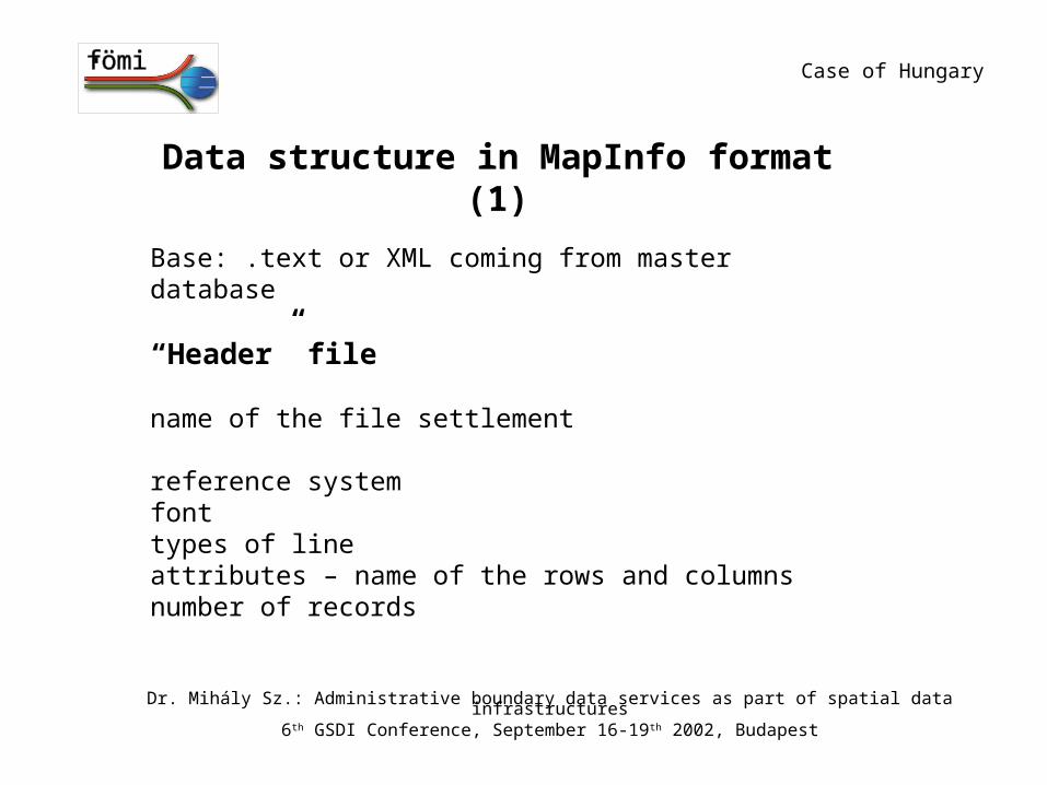
Data structure in MapInfo format (1)
Base: .text or XML coming from master database
“Header” file
name of the file settlement
reference systemfonttypes of lineattributes – name of the rows and columnsnumber of records
Case of Hungary
Dr. Mihály Sz.: Administrative boundary data services as part of spatial data infrastructures6th GSDI Conference, September 16-19th 2002, Budapest
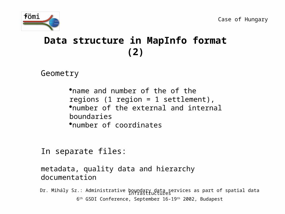
Data structure in MapInfo format (2)
Geometry
name and number of the of the regions (1 region = 1 settlement), number of the external and internal boundariesnumber of coordinates
In separate files:
metadata, quality data and hierarchy documentation
Case of Hungary
Dr. Mihály Sz.: Administrative boundary data services as part of spatial data infrastructures6th GSDI Conference, September 16-19th 2002, Budapest