Embed Size (px)
Citation preview

A Companion to Contemporary Documentary Filn1
Edited by
Alexandra Juhasz and Alisa Lebow
WI LEY Blackwell
2 o ,�-
This edition first published 2015
© 2015 John Wiley & Sons, Inc, excepting Chapter 1 © 2014 by the Regents of the University of Minnesota and Chapter 19 © 2007 Wayne State University Press
Registered Office
John Wiley & Sons, Ltd, The Atrium, Southern Gate, Chichester, West Sussex, PO19 8SQ, UK
Editorial Offices
350 Main Street, Malden, MA 02148-5020, USA
9600 Garsington Road, Oxford, OX4 2DQ, UK
The Atrium, Southern Gate, Chichester, West Sussex, PO19 8SQ, UK
For details of our global editorial offices, for customer services, and for information about how
to apply for permission to reuse the copyright material in this book please see our website at
www.wiley.com/wiley-blackwell.
The right of Alexandra Juhasz and Alisa Lebow to be identified as the authors of the editorial material
in this work has been asserted in accordance with the UK Copyright, Designs and Patents Act 1988.
All rights reserved. No part of this publication may be reproduced, stored in a retrieval system,
or transmitted, in any form or by any means, electronic, mechanical, photocopying, recording or
otherwise, except as permitted by the UK Copyright, Designs and Patents Act 1988, without the
prior permission of the publisher.
Wiley also publishes its books in a variety of electronic formats. Some content that appears in print
may not be available in electronic books.
Designations used by companies to distinguish their products are often claimed as trademarks. All
brand names and product names used in this book are trade names, service marks, trademarks or
registered trademarks of their respective owners. The publisher is not associated with any product or
vendor mentioned in this book.
Limit of Liability/Disclaimer of Warranty: While the publisher and authors have used their best
efforts in preparing this book, they make no representations or warranties with respect to the accuracy
or completeness of the contents of this book and specifically disclaim any implied warranties of
merchantability or fitness for a particular purpose. It is sold on the understanding that the publisher is
not engaged in rendering professional services and neither the publisher nor the author shall be liable
for damages arising herefrom. If professional advice or other expert assistance is required, the services
of a competent professional should be sought.
Library of Congress Cataloging-in-Publication Data
A companion to contemporary documentary film / edited by Alexandra Juhasz and Alisa Lebow.
pages cm
Includes bibliographical references and index.
ISBN 978-0-470-67164-1 ( cloth)
1. Documentary films-History and criticism. I. Juhasz, Alexandra, editor.
II. Lebow, Alisa, editor.
PN1995.9.D6C543 2015
070.1'8-dc23
2014031042
A catalogue record for this book is available from the British Library.
Cover image: The Day of the Sparrow, directed by Philip Scheffner ( Germany, 2010. Produced by ARTE, Blinker Filmproduktion, Pong, Worklights Media, and Zweites Deutsches Fernsehen (ZDF))
Set in 10.5/13pt Minion by SPi Publisher Services, Pondicherry, India Printed and bound in Malaysia by Vivar Printing Sdn Bhd
2015
Contents
Notes on Contributors
Introduction: A World Encountered
Alexandra Juhasz and Alisa Lebow
Part I Planet
Juan Francisco Salazar
Introduction
Juan Francisco Salazar
1 Crude Aesthetics: The Politics of Oil Documentaries
ImreSzeman
2 Anticipatory Modes of Futuring Planetary Change in
Documentary Film
Juan Francisco Salazar
3 Projecting Sea Level Rise: Documentary Film and Other
Geolocative Technologies
Janet Walker
Part II Migration
Anik6Imre
Introduction
Anik6 Imre
4 Videogeographies
Ursula Biemann
ix
1
19
21
28
43
61
87
89
92
I! : !
60 Juan Francisco Salazar
Renov, M. (1993) Theorizing Documentary. New York: Routledge. Robinson, K.S. (2011) Remarks on Utopia in the Age of Climate Change. Arena Journal,
36(6), 8-21. Roe, A.H. (2009) Animating Documentary. Unpublished PhD Dissertation, University of
Southern California, http://digitallibrary.usc.edu/ cdm/ compoundobject/ collection/ p15799coll127/id/257788/rec/7, accessed July 19, 2014.
Rogers, B. (2010) Otolith I, http://otolithgroup.org/index.php?m=project&id=5, accessed July 20, 2014.
Seligman, M.E.P. and Csikszentmihalyi, M. (2000) Positive Psychology: An Introduction. American Psychologist, 55(1), 5-14.
Solte, D. (2009) Global Financial System in Balance: Crisis as Opportunity for a Sustainable Future. Berlin: Terra Media Verlag.
Vint, S. (2009) Possible Fictions: Blochian Hope in The Scar. Extrapolation, 50(2), 276-292. Williams, L. (2011) Shadows of the Holocene: Transfigurations of the Non-Human World in
Science Fiction Film. Arena Journal, 36(6), 196-215. Williams, R. (1989) Resources of Hope: Culture, Democracy, Socialism, ed. Robin Gable.
London and New York: Verso. Wissot, L. (2011) Into Eternity: An Interview with Michael Madsen. Global Comment,
February 2, 2011, http://globalcomment.com/2011/into-eternity-an-interview-withmichael-madsen/, accessed July 20, 2014.
Wolf, M. (1999) Subjunctive Documentary: Computer Imaging and Simulation. In Gaines, J.M. and Renov, M. (eds.) Collecting Visible Evidence, pp. 2 7 4-291. Minneapolis: Universityof Minnesota Press.
3
Projecting Sea Level Rise Documentary Film and Other
Geolocative Technologies
Janet Walker
The catastrophe of climate change is excessive and will inscribe all earthly space.
It is earth writing writ large. Kathryn Yusoff (2009: 1010)
Introduction
Part way into the documentary film Someplace with a Mountain (2010), the director
Steve Goodall describes how the people of Puluwat atoll in the Federated States of
Micronesia first learned of climate change-induced sea level rise. They had been
making their own observations of high waters and the effects of encroaching salinity
on crops. However, according to the film, it was only when Goodall fetched a laptop
computer from his sailboat anchored in the cove and showed the gathered islanders
Al Gore's and Davis Guggenheim's An Inconvenient Truth (2006) that they realized
the extent of the problem.
"I made friends with the chief;' Goodall reports to the camera from the deck of his
boat, "a young chief named Ioki [ cut to images of the Ioki Alet surrounded by chil
dren]; I mean, just [a] fantastic guy and his family, it's beautiful ... And always in the
back of my mind was sea level rise, sea level rise. What's going to happen to these
people?" Goodall then describes in retrospect how he finally got up the courage to
ask about their preparations and how Alet reacted immediately, running across the
island to draw in other chiefs and elders. This urgency is conveyed - in a way, re
enacted - through a hand-held camera bobbing along a path through the tropical
foliage. It is then that we see a shot of the laptop on a desk and hear Gore's voice
A Companion to Contemporary Documentary Film, First Edition. Edited by Alexandra Juhasz
and Alisa Lebow.
© 2015 John Wiley & Sons, Inc. Published 2015 by John Wiley & Sons, Inc.

62 Janet Walker
Figure 3.1 Someplace with a Mountain. Still frame reproduced courtesy of Steve Goodall.
emanating from it, as the surrounding men discuss and imitate with sweeping gestures An Inconvenient Truth's animation of predicted, encroaching sea level rise in the Shanghai area. Chevy Chase as narrator of Someplace with a Mountain takes over from Gore and the now soundless excerpt from the latter's film breaks free of the laptop and enlarges to fill our distant screens (Figure 3.1): "They knew the sea had been rising;' Chase intones, "but they didn't understand that the worst was yet to come. When they saw the animated graphic of rising water levels, they understood immediately the true seriousness of their situation:' The extent of sea level rise in this particular area, we're told, is already among the highest on the planet.2 "It was the end of their world and you could see it in their faces;' recalls Goodall. Reaction shots - still and moving - of men, women, and children reveal their shocked expressions in being confronted with the planetary scale of the problem.
There are aspects of this documentary with which I take issue, informed by the literature of new ethnography. For one, the sequence uncritically recapitulates "first contact;' with great white men and their all-knowing technology bringing "civilization'' to stunned natives. 3 Elsewhere in the film there is the verbal characterization of Pacific atoll inhabitants as "suspended in time;' and "still living their traditional, independent, and sustainable ways they have for almost three millennia'' ( while consumer goods pervade the shots). This denial of coevalness - that is, "a persistent and systematic tendency to place the referent(s) of anthropology in a Time other than the present of the producer of anthropological discourse" (Fabian, 1983: 31, italics original) - is particularly egregious given the profound and instantaneous response by the Puluwatese to a symptom of global warming still largely neglected by the developed world.
Nevertheless, I believe the film is significant as an activist work and, even more importantly, for the links it makes - and/ or makes possible - between the affective and geospatial registers. Human geographer Carol Farbotko and earth and environmental
Projecting Sea Level Rise 63
scientist Helen V McGregor call for greater attention to "the emotional geographies
of climate change, and the ways in which science and emotion combine with
reformist or radical potential" (Farbotko and McGregor, 2010: 164). Goodall's
ethnographic film, unlike others in which only the narrating filmmaker or
anthropologist speaks to the audience, includes articulate and moving statements
by locals and their embodied presence in the increasingly affected environment. 4
Thus, in addition to bringing Gore to Puluwat, Someplace with a Mountain trans
ports emotionally charged islander testimonials across Micronesia and into spaces
where they may be witnessed by viewers on our own "psychogeographic journeys"
(Bruno, 2002: 6).
An Inconvenient Truth, for its part, has been subject to a great deal of criticism: from climate skeptics of the political right wing to those expressing annoyance with
the autobiographical elements (read as careerist partisan politics or as an insult to
the audience's ability to connect with a film minus a crusading hero). My environ
mental media students find the film's listing of "solutions" in the end credits to be
too little too late. Moreover, the film barely depicts affected individuals other than
scientists or other opinion leaders. Two photos shot on Tuvalu by Mark Lynas are an
exception,5 yet their use in An Inconvenient Truth has been criticized by Farbotko
since, ironically, it is to illustrate Gore's point that "the people on these Pacific islands
have all had to move to New Zealand:' Not quite all, Farbotko points out (2010: 58).
In any case, the overall absence of people serves to downplay sensations of human
suffering and maintain the focus on scientific argument.
As with Someplace with a Mountain, though, An Inconvenient Truth has its exem
plary attributes. The Gore/Guggenheim work is a premier environmental documen
tary of the current wave, recipient of numerous accolades including an Academy
Award. Its graphic animation of coastal areas being flooded, in combination with
the citation of population numbers of coastal residents, presages climate migration
on a massive scale. Gore's refrain "this is what would happen'' - accompanied by
anxiety-producing musical cues - is applied to Florida and then, after an ominous
pause, to the San Francisco Bay Area. After describing what would happen in The
Netherlands (their impressive flood protection infrastructure notwithstanding) as
"absolutely devastating;' he moves from the West to the Far East and begins to
mention the huge numbers of people who would be forced to relocate. From a per
spective that is historical and long-term on the one hand, and urgent on the other,
the film draws on scientific extrapolation to advocate mitigation of the greenhouse
gas emissions that contribute to global warming.
This chapter takes these two films' common subject of sea level rise6 and the
embedding of the one film into the other as an opportunity to read the works rela
tionally and spatially. In Atlas of Emotion, Giuliana Bruno conceptualizes the motion
picture as a form of "site seeing;' defining the medium, poetically, as "the very syn
thesis of seeing and going - a place where seeing is going" (2002: 15-53, 245). This
motile sense of cinema seems to me apposite for studying Someplace with a Mountain
as a site-specific or "situated" documentary where movement and location loom
large. I choose to regard this film - among others with perambulatory subjects and
64 Janet Walker
makers and moving cameras - as a kind of a navigational technology. Then, fac
toring in the technically rich means An Inconvenient Truth uses to convey. the
impending need for people to retreat from coastal areas, a second goal of this chapter
is to envision these documentaries within a substantially wider repertoire of geo
locative screen media that includes modes of scientific modeling and geoweb-based
programs and applications for digital earth mapping.
These other "discourses of sobriety" - to embrace the geosciences within the
kinship structure Bill Nichols describes for documentary and other nonfictional
systems ("science, economics, politics, foreign policy, education, religion, welfare"
[1991: 3-4]) - take various media forms: live action, animated, computer- or web
based, interactive, moving, graphic, photographic, or any combination thereof. And
they are all, as documentary scholars know about our purview, rhetorically nuanced
in their design and construction. Together and separately, they participate in the
shaping of the physical and social spaces they may seem only to access, observe, measure, model, or move through.
Furthermore, just as digital technologies of modeling, mapping, visualization,
and systemization are proliferating, so too are new scholarly approaches. The litera
ture at the intersection of geography with literary, historical, and media studies is
burgeoning and an interdiscipline known as the "spatial humanities" or the "geohu
manities" is forming (Rumsey, 2009; Bodenhamer, Corrigan, and Harris, 201 O; Dear
et al., 2011; Gregory and Ell, 2007; Cope and Elwood, 2009). Although scholars
characterizing this development point to a friction between the humanities'
treatment of knowledge "as multivalent, equivocal, and protean'' and the scientific
privileging of empirical study and disambiguation (Harris, Corrigan, and
Bodenhamer, 2010: 169), actually, at the same time that humanists are curious about
geospatial tools, geographers are aware of geography's epistemological nature and
thorough imbrication with cultural, social, and political practices and ideologies
(Gregory, 1993; Massey, 1994; Smith, 2008).7
From within film and media studies, therefore, I am interested in developing our
spatial consciousness and perception of the media textuality of scientific visualiza
tion and geographic information systems (GIS).8 Facing outward, I am interested in
articulating what film and media studies has to offer geospatial research, including
especially critical human geography as an approach to place and environment.
Spatial humanities researchers Alexander von Li.inen and Wolfgang Moschek under
stand a GIS as "an active component" and not a neutral medium for the presentation of a research outcome. "We employ GIS;' they state, "as a geographically induced heuristics in historical research'' ( 2011: 249). Similarly, the project of this chapter is to engage with screen-based navigational technologies as an "active component" and "geographically induced heuristics" to investigate how people in coastal areas form attachments to and also shape the places they inhabit.
What are the conceptual elective affinities or frictions among geolocative representations of people and places, among geographical imaginations (Gregory, 1993), if you will? Kathryn Yusoff has termed catastrophic climate change a form of "earth writing writ large" (2009: 1010). As the inhabitants of low-lying Pacific islands
Projecting Sea Level Rise 65
imagine, plan for, and seek to exert agency over their future lives, this chapter pro
poses geolocative media, in combination with environmental activism, as a poten
tially eloquent form of "earth re-writing:'
Land and Water
The primary message of Someplace with a Mountain is that the traditional self-suf
ficiency of the outer islanders - especially the Puluwatese - is threatened by sea
level rise, and that, in moving out of harm's way to a high island area, at least some
of them should keep together as an isolated group in order to maintain their cultural
practices "uncontaminated" by other influences. The sequence following the
importation of An Inconvenient Truth to Puluwat opens with rain falling on a slate
grey sea. Several interlocutors remark on the sore irony of islanders being harmed
by industrialized nations' profligate use of fossil fuels. "We know the water is get
ting higher and higher and we are going to lose our homes;' states Chief Manuel
Taromai, seated on a cushion among the mats, pillows, and blankets in an interior
space (Figure 3.2a). "We are not the ones who polluted the whole world:' The sub
title of this statement persists over a shot of inundated plants that used to stand
clear of the ocean (Figure 3.2b ). A wave crashes against the base of a downed palm,
its top partially submerged. We meet Francis of Lamotrek who gestures across the
remains of a taro patch. No crops can grow there any longer, he explains. We see
him at the left of the frame, where, in the center, a pool of water - saltwater incur
sion - reflects the blue sky.
This depiction of the islanders' blameless vulnerability might be read as a produc
tive social ecological critique: those already without resources beyond the subsistence
level tend to be disproportionately affected by so-called natural disasters that are in
fact anthropogenic.9 Or the depiction of island culture as untainted by consumerism
might be read as expeditious.10 If, as Goodall believes, the inhabitants of small
low-lying islands will be obliged to relocate, and since he sees their culture as worthy
of preservation because it is traditional, then playing up this claim to prospective
hosts may well make the climate migrants more culturally appealing and less threat
ening as competitors for jobs in their new location.11 The pointedly ethnographic
material Goodall has shot therefore becomes his - and, by extension, the islanders' -
calling card on the island of Yap. We see him with Francis overlooking an uninhab
ited, high-elevation area on Yap that, he says, could support about 1000 relocated
people. Then, in a second film-within-a-film sequence, we see Goodall entering the
Yap State Legislature. In the Office of the Governor he screens a montage of his own
footage for an audience of gathered politicians and residents of Yap. "It's tragic to
lose their islands because they're so beautiful;' he says in introducing the presenta
tion. "But the real tragedy is to lose the culture that is totally self-sufficient and
doesn't use fossil fuels:' Across the table we make out on the laptop images of
islanders weaving thatch and a theme familiar from earlier sequences: "Still living
the traditional, independent, and sustainable ways they have for almost three

66 Janet Walker
(a)
(b)
Figure 3.2a and Figure 3.2b "We are not the ones who polluted the whole world:' Coastal
inundation in Someplace with a Mountain. Still frames reproduced courtesy of Steve Goodall.
millennia. Every essential is done by hand. Everything is done for the good of the
village. Could this truly be the last utopia?"
Well, perhaps. But not for the qualities such a salvage ethnography is capable of
conveying. In fact, Someplace with a Mountain dispenses with many of the tangible
and intangible realities of life as it is currently lived on Puluwat, including, signi
ficantly, major privileges of the islanders' citizenship. The Federated States of
Micronesia (FSM), in which Chuuk is a state and Puluwat ( alternative spellings,
Projecting Sea Level Rise 67
Polowat and Poluwat) a coral atoll and municipality, has had the political status since 1986 of a sovereign nation under a Compact of Free Association with the
United States. This status enables the US education of FSM citizens (which is men
tioned in the film), and also (left out of the film) travel without a visa by FSM citi
zens to places including Guam, Hawaii, and the US mainland. More than half of the
people once living on Puluwat now live abroad, such that a large proportion of current inhabitants are children and older people. In the FSM overall, "aid counts for
at least one third of the GNP" and locals are also supported by "remittances sent
from family living abroad" (Barnett and Campbell, 2010: 7-8). The islanders'
so-called sustainable ways are enmeshed within and supported by a broad geo
graphic network extending well beyond the islands themselves. I communicated with two Chuukese individuals living in California to confirm
what I was reading about the area. Vid Raatior, who was raised on the islands of
Onoun and Tamatam just to the north of Puluwat and on Houk (formerly Pulusuk)
just to the south, queried why the assistance Goodall promised as a follow-up to the
filming could not take the form of "rebuilding the terrible elementary and high
schools, buying textbooks, water catchments for potable water, etc:' instead of fund
ing a move to another island (pers. comm., December 22, 2011). Schools? No such
buildings, dilapidated or otherwise, are shown on Puluwat. Given that Goodall has
to a large extent framed out the aspects of Puluwatese life that don't fit within the
narrative of a culture unchanged for millennia, we are left to wonder about the
plastic bags, glass bottles, snorkels, and flip-flops that pass through our field of
vision without explanation. And actually, even though the film has a stake in the
depiction of island culture as unchanging, it also contributes by its very existence to
the islanders' imagination of dispersed audiences and new horizons.
(Re )mapping "A Sea of Islands with Their Inhabitants"
What other options are there for illustrating the plight of islanders and how can we
deepen our spatially attuned thinking about the problem? An essay by Fijian
anthropologist Epeli Hau'ofa is noteworthy in this regard. Hau'ofa powerfully refutes
the notion that islands and island states across Polynesia and Micronesia "are much
too small, too poorly endowed with resources, and too isolated from the centres of
economic growth for their inhabitants ever to be able to rise above their present
condition of dependence on the largesse of wealthy nations" ( 199 3: 4).
Micronesia's physical geography is characterized by great distances and com
paratively small landmasses. The FSM comprises 607 small islands in what are
known as the Eastern and Western Caroline Islands for a total land area of only
270.8 square miles over more than one million square miles of the Pacific Ocean.
Nevertheless, Hau'ofa's insight was to perceive "a gulf of difference" between
islander and outsider thinking. "The idea of smallness is relative;' he writes, "it
depends on what is included and excluded in any calculation of size" (1993: 6). In
fact it was "the continental men, Europeans and Americans who drew imaginary
68 Janet Walker
lines across the sea, making the colonial boundaries that for the first time confined ocean peoples to tiny spaces" (1993: 7). Instead of using the term "Pacific Islands;' with its connotations of "small areas of land surfaces sitting atop submerged reefs or seamounts;' Hau'ofa nominates "Oceania'' to connote "not only land surfaces, but the surrounding ocean as far as they could traverse and exploit it:' "Our ancestors;' he tells us, "viewed their worlds as a 'sea of islands; rather than 'islands in the sea' " (1993: 7).
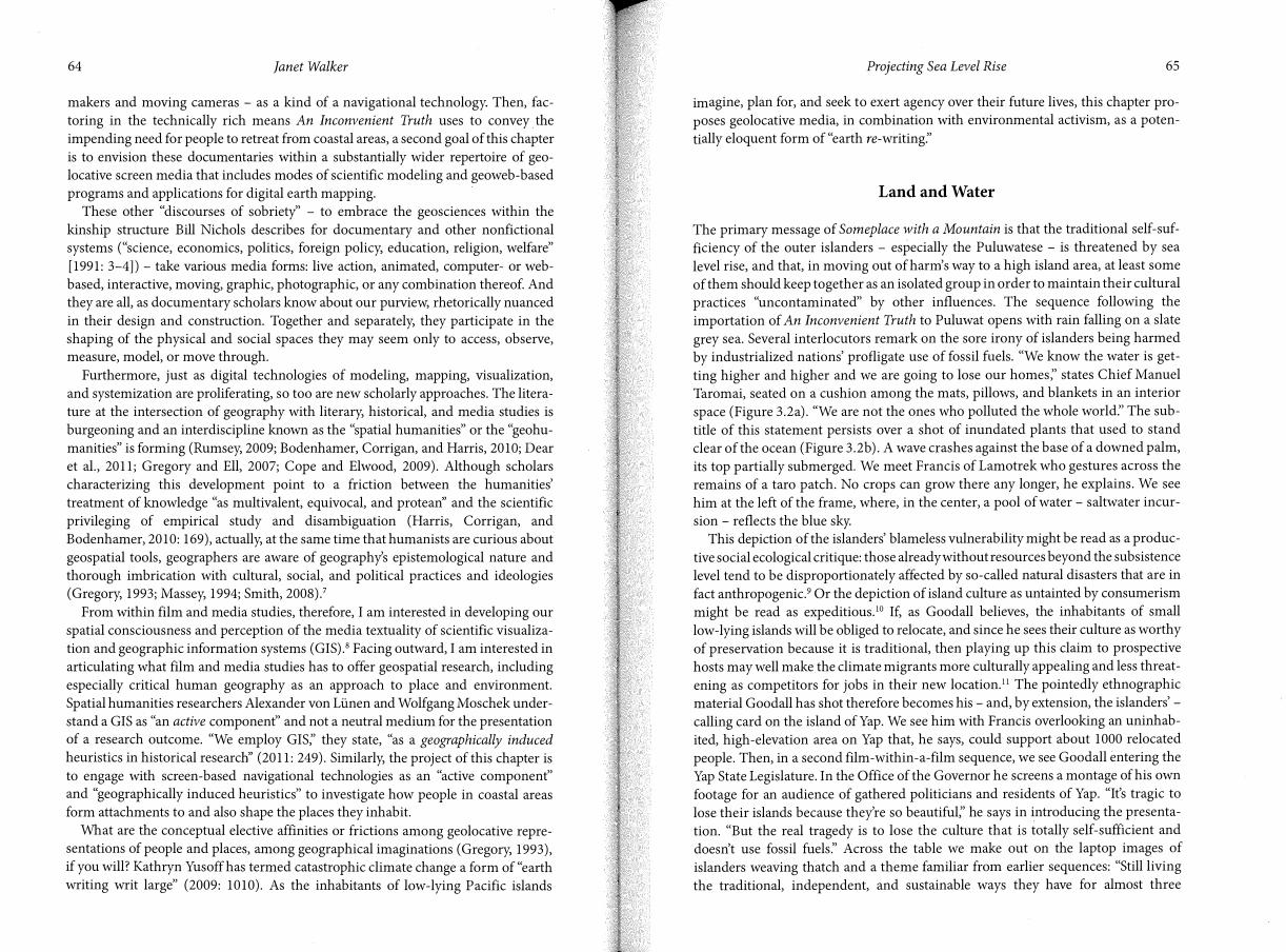
The geographical imagination of Someplace with a Mountain contrasts with that of Hau'ofa. Just as the field of contemporary documentary studies was founded on the premise that documentary films, while accepted as non-fiction, are nevertheless structured in and through their profoundly "fictive" strategies (Renov, 1993: 2-3; see also Nichols, 1991), so too is there a "fictive" quality to documentary space. This is the case, I believe, even when the given documentary is shot in and depends for its meaning on a specific location. Instead of a "sea of islands;' Someplace presents a pre-Oceanian (in Hau'ofa's sense) geography that emphasizes island smallness, isolation, and vulnerability and de-emphasizes multiplicity, connectivity, fluidity, and the agency of islanders. The film's first shot is of a distant island, its flat top visible above a wide and otherwise empty horizon.12 People are first seen after a tilt up from footprints in the sand to the two local children who made them. The third to last shot of the film (in the Epilogue) is a long take from a high angle looking down at four children in a small canoe. For much of the time there is no horizon in sight. The space around them is an expanse of opaque aquamarine in which the children appear profoundly isolated (Figure 3.3). This is not to minimize the considerable threat of sea level rise to low-lying islands nor the challenges of expressing Oceania in documentary form. Rather, my point is to exemplify the eminently ideological implications of this particular documentary geography.
Figure 3.3 Someplace with a Mountain. Still frame reproduced courtesy of Steve Goodall.
Projecting Sea Level Rise 69
Farbotko describes a further problem attendant upon perceptions of "smallness:' Disappearing islands in the South Pacific, she submits, are saddled with the burden
of "proof of a global climate change crisis" (2010: article abstract; see also Cameron, 2011) and are therefore rendered expendable in the "onward sweep of both climate
activism and its opponent, capitalist modernity" (2010: 58). Pacific islands have become, she concludes, a "litmus" test of global warming and, even more unfortunately, a site of "wishful sinking:'
Other Technologies of Navigation
Characterizing the difference between European and Puluwatese seafaring, Levinson, Ward, and Webb (1973) explain that while "[t]he European at sea in a small vessel, tends to envisage his situation as one in which his craft moves towards, passes by, and then away from fixed islands . . . the Puluwat navigator, once on course, inverts the concept and in his navigational system considers the canoe to be stationary and the islands to move towards and past him'' (Levinson et al., 1973).
As a navigational technology extraordinaire, the Google Earth web application greatly multiplies this Western proclivity for speed, and for moving towards, by, and away from objects of consequently fleeting interest; for "flying to" as the Google interface would have it, but also "flying from;' one could say. Echoing the naviga
tional orientation and practices of the European seafarers, the Google Earth vessel runs counter to the canoes of island navigators who evidently - steering by the sun, stars, and planets; by reefs, land masses, and marine animals; by swell, waves, currents, and winds; and by the curvature of the earth's surface - remained present and centered in their environment.
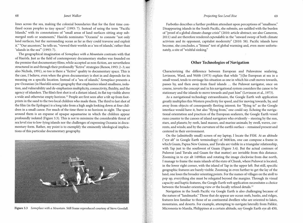
On the ( admittedly small) screen of my laptop, I locate the FSM. At an altitude ("eye alt" in Google Earth terminology) of 3600 km, one can compose a frame in
which Guam, Papua New Guinea, and Tuvalu are visible in a triangular relationship, with Yap just to the southwest of Guam (Figure 3.4). But the actual contours of Puluwat ( and Tuvalu and Guam for that matter) are invisible from this distance.
Zooming in to eye alt 1498km and rotating the image clockwise from due north, I manage to frame the main islands of the state of Chuuk, where Puluwat is located,
in the lower right corner, with the island of Yap in the upper left. But still, specific
geographic features are barely visible. Zooming in even further to get the lay of the land, one loses the broader orienting points. For the names of villages on the atoll to pop up, everything else must be relegated beyond the margins. Through its visual
capacity and haptic features, the Google Earth web application necessitates a choice between the broader orienting view or the locally refined details.13
Navigation in the South Pacific via Google Earth is also challenging because of the nature of "landmarks:' Those that do appear are ocean reefs, banks, and ridges,
features less familiar to those of us continental dwellers who are oriented to lakes, mountains, and deserts. For example, attempting to navigate laterally from Palikir, Micronesia to Manila, Philippines at a certain altitude, say Google Earth eye alt 450,
70 Janet Walker
Figure 3.4 Framing Yap and Tuvalu in Google Earth.
one might become lost in sea of blue. But if one embarks over approximately the
same distance east from California to Atlanta there are, literally, landmarks along
the way: the Salton Sea, the Grand Canyon, the Mississippi River.
It is not these formal aspects alone that matter, but rather how they make meaning
in relation to the geographic information program's overall "geometry of social/
power relations" (Massey, 1994: 4). Released in 2005 by Google corporation, Google
Earth eschews established boundaries while at the same time profiting from the dis
parities that these boundaries - as manifestations of the colonial imagination Hau'ofa
invoked - maintain. As satellite media scholar Lisa Parks explains:
[t]he very production of Google Earth software is symptomatic of a global economy in
which most nation-states are unable to control the production and circulation of rep
resentations of their own territories and those transnational corporations that own and
operate satellite and computer technologies - the technologies of high visual capital -
are able to generate huge profits from such a condition of disparity. (Parks, 2010: 260)
The images we see as we fly around include those gathered over 50 years by multiple
US federal agencies but then repurposed in the web application to which Google
Earth owns the proprietary rights (Parks, 2010: 259-260). It is a conceit that Google
Earth is a free and democratic service for the realization of fantasies of "digital
nomadism;' "bodily transcendence;' instant connectivity;' and the annihilation of
time and space (Parks, 2004: 37). Responding to Parks's exhortation to take seriously
Projecting Sea Level Rise 71
"the material specificities and limits -of network infrastructures" (2004: 37-38), I
would add that the expenditure of different fuels made to secure Google Earth's
combination of satellite, space shuttle, and airplane aerial imagery directly connect
this earth-mapping system to the problems of global warming and sea level rise.
Someplace with a Mountain also fantasizes borderlessness, harkening back, again,
to past millennia. As Goodall describes his discovery of the area of Micronesia where the film takes place, narrating how he sailed in the Caribbean and then
through the Panama Canal and to and past the islands of the Galapagos, the
Marquesas, Tahiti, Tongo, Fiji, Tuvalu, Kirabati, and the Marshalls, the film presents
an aerial map of this whole area with each spot illuminated in turn by a kind of light
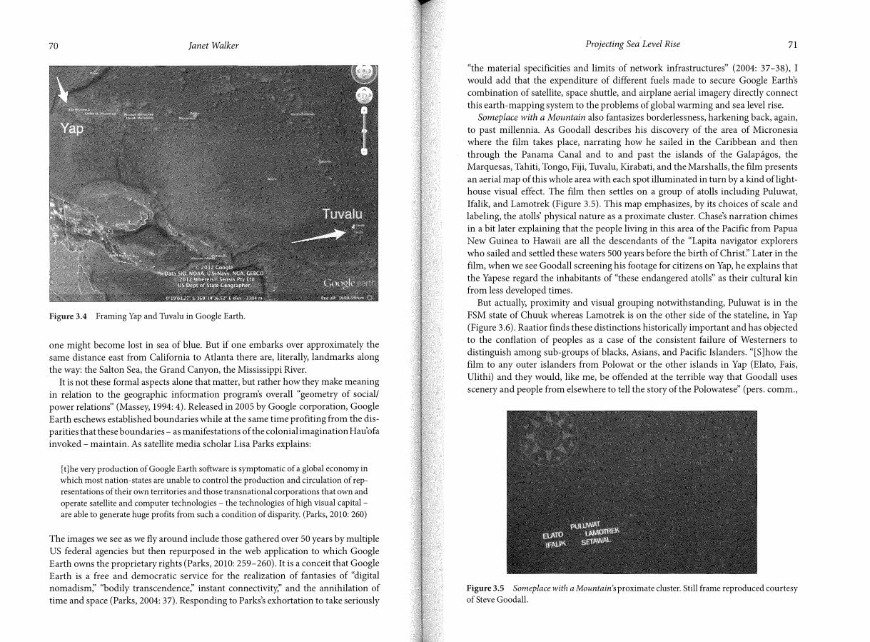
house visual effect. The film then settles on a group of atolls including Puluwat,
Ifalik, and Lamotrek (Figure 3.5). This map emphasizes, by its choices of scale and
labeling, the atolls' physical nature as a proximate cluster. Chase's narration chimes
in a bit later explaining that the people living in this area of the Pacific from Papua
New Guinea to Hawaii are all the descendants of the "Lapita navigator explorers
who sailed and settled these waters 500 years before the birth of Chrisf' Later in the
film, when we see Goodall screening his footage for citizens on Yap, he explains that
the Yapese regard the inhabitants of "these endangered atolls" as their cultural kin
from less developed times.
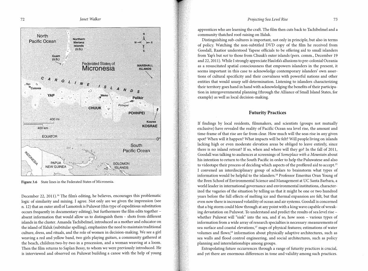
But actually, proximity and visual grouping notwithstanding, Puluwat is in the
FSM state of Chuuk whereas Lamotrek is on the other side of the stateline, in Yap
(Figure 3.6). Raatior finds these distinctions historically important and has objected
to the conflation of peoples as a case of the consistent failure of Westerners to
distinguish among sub-groups of blacks, Asians, and Pacific Islanders. "[S]how the
film to any outer islanders from Polowat or the other islands in Yap (Elato, Fais,
Ulithi) and they would, like me, be offended at the terrible way that Goodall uses
scenery and people from elsewhere to tell the story of the Polowatese" (pers. comm.,
Figure 3.5 Someplace with a Mountain's proximate cluster. Still frame reproduced courtesy
of Steve Goodall.
72
North
Pacific Ocean
Guam (U.S.)
---........_. r:l
C A R o Yap 1>,
'=-colonia
YAP '-- c)
0
400mi
400km
EQUATOR
Janet Walker
Northern Mariana Islands (U.S.)
Federated States of Micronesia
I S L A N D SWeno
� 1 L
CHUUK (!I'
Palikir
_..-V* (lPohnp�i a
POHNPEI
Kosrae KOSRAE
South
Pacific
11 1f
�SOLOMON
6 "".. . ISLANDS D> ,;\ o(> ""°
�
Figure 3.6 State lines in the Federated States of Micronesia.
December 22, 2011).14 The film's editing, he believes, encourages this problematic
logic of similarity and mixing. I agree. Not only are we given the impression ( see
n. 12) that an outer atoll ofLamotrek is Puluwat (this type of expeditious substitution
occurs frequently in documentary editing), but furthermore the film edits together -
absent information that would allow us to distinguish them - shots from different
islands in the cluster. Amanda Tachibelmel, introduced as a mother and educator onthe island oflfaluk (subtitular spelling), emphasizes the need to maintain traditionalculture, dress, and rituals, and the role of women in decision-making. We see a girlweaving a red and yellow band, two girls playing guitars, a community gathered atthe beach, children two-by-two in a procession, and a woman weaving at a loom.Then the film returns to Saplan Bessy, to whom we were previously introduced. Heis interviewed and observed on Puluwat building a canoe with the help of young
Projecting Sea Level Rise 73
apprentices who are learning the craft. The film then cuts back to Tachibelmel and a community thatched roof-raising on Ifaluk.
Distinguishing sub-cultures is important, not only in principle, but also in terms of policy. Watching the non-subtitled DVD copy of the film he received from Goodall, Raatior understood Yapese officials to be offering aid to small islanders from Yap's but not to those from Chuuk's outer islands (pers. comm., December 19 and 22, 2011). While I strongly appreciate Hau'ofa's allusions to pre-colonial Oceania as a resuscitated spatial consciousness that empowers islanders in the present, it seems important in this case to acknowledge contemporary islanders' own assertions of cultural specificity and their coevalness with powerful nations and other entities that would usurp self-determination. Listening to islanders characterizing their territory goes hand in hand with acknowledging the benefits of their participation in intergovernmental planning ( through the Alliance of Small Island States, for example) as well as local decision -making.
Futurity Practices
If findings by local residents, filmmakers, and scientists (groups not mutually exclusive) have revealed the reality of Pacific Ocean sea level rise, the amount and time-frame of that rise are far from clear. How much will the seas rise in any given spot? When will it happen? What impacts will be felt? Will people living on islands lacking high or even moderate elevation areas be obliged to leave entirely, since there is no inland retreat? If so, when and where will they go? In the fall of 2011, Goodall was talking to audiences at screenings of Someplace with a Mountain about his intention to return to the South Pacific in order to help the Puluwatese and also to videotape their process of deciding which aspects of the proffered aid to accept. 15
I convened an interdisciplinary group of scholars to brainstorm what types of information would be helpful to the islanders.16 Professor Emeritus Oran Young of the Bren School of Environmental Science and Management at UC Santa Barbara, a world leader in international governance and environmental institutions, characterized the vagaries of the situation by telling us that it might be one or two hundred years before the full effects of melting ice and thermal expansion are felt, but that even now there is increased volatility of ocean and air systems. Goodall is concerned that a big storm could blow through at any point with a king wave capable of wreaking devastation on Puluwat. To understand and predict the results of sea level rise -whether Puluwat will "sink'' into the sea, and if so, how soon - various types of information from a wide array of research specialties is necessary: measurements of sea surface and coastal elevations, 17 maps of physical features; estimations of water volumes and flows;18 information about physically adaptive architectures, such as sea walls and flood control engineering, and social architectures, such as policy planning and interrelationships among groups.
Extrapolating future occurrences through a range of futurity practices is crucial, and yet there are enormous differences in tone and validity among such practices.
74 Janet Walker
In this regard, the previously discussed projected sea level sequence bears further
examination. An Inconvenient Truth's coastal inundation animations - commissioned
from visual effects expert Brian Fisher, whose numerous big-budget film credits
include District 9, Avatar, Tron: Legacy, and Transformers: Dark of the Moon - are
technically impressive as well as awesome to behold. On the commentary track
director Davis Guggenheim attests to the achievement of the sequence:
When Al gave his slide show, and I saw it, these were still pictures, and to me [ ani
mating them] ... this is one of the most devastating things in the movie. I just couldn't
imagine what would happen to all the people who lived under this water. This was
actually extremely technically difficult to actually find out where the levels of sea level
rise would be on these maps in an accurate way. All these maps are exactly accurate.
And then animating how the water would seep into these areas. It was actually very
very difficult. It took us months to do. It looks very simple.
It does seem apparent, as Gore states, that tens of millions of people will soon be on
the move. However, the statement that the "maps are exactly accurate" invites
qualification.
Scientists tend to perceive the challenge to map the world's existing coastline, pre
dict its changing contours, and evaluate its vulnerability to sea level rise as ongoing
rather than as achievable through a few months of hard work. Pioneering GIS
geographer Michael Goodchild often references the French mathematician Benoit
Mandelbrat to make the point that the length of a coastline is in fact indefinite
( unknowable, infinite) since the measurement becomes greater according to the
refinement of the measuring instrument and the scale of the physical feature being
measured.19 A.T. Vafeidis and colleagues explain that "[d]espite being one of the
most distinct features on the earth's surface . . . the coast has always been difficult to
represent due to its dynamic nature and to the multi-dimensionality of information
associated with it" (2004: 802). Of course these creators of what is a major European
Union coastal mapping project tackle the problem nevertheless, by combining GIS
processing of datasets with a new technique for spatially referencing coastal features
called "dynamic segmentation:' But they do so while highlighting the relationships
among "how information is presented;' the "organization and reliability of a data
base;' and decision-making;2° that is to say, with a respect for knowledge as "multi
valent, equivocal, and protean:'
I decided to search for scientific counterparts to the extrapolative animations of
coastal inundation in An Inconvenient Truth, with a focus on the Pacific island area
under discussion here (but left out of Gore's film). This scientific knowledge, while
medium specific and analytically distinct, can be pooled with Someplace with a
Mountain's ethnographic "modeling" of the coast, its inhabitants, and the coming
changes. Interactive visioning tools are proliferating online. The Digital Coast project of
the National Oceanic and Atmospheric Administration (NOAA) and a web map
visualization tool called climateGEM created at the University of Arizona are state of
Projecting Sea Level Rise 75
the art for sea level rise visualization.21 NOA.A's and the University of Arizona's models show inundation at six meters, while Alex Tingle's Google Earth hack models flooding up to 60 meters!22
In general and in comparison with Gore's didactic certainty, these geospatial mapping tools are often accompanied by statements of their own limitations. The NOAA tool has a button labeled "confidence:' Clicking on it, one reads, "The inundation areas depicted in the Sea Level tab are not as precise as they may appear:' A "Mapping Confidence" slider is provided; blue is for "High Confidence;' ochre for "Low Confidence:' The "Understanding the Map" section indicates:
[ t ]here are many unknowns when mapping future conditions, including natural evolution of the coastal landforms ... as well as the data used to predict the changes. The presentation of confidence in these maps represents only the known error in the elevation data and tidal corrections.
Tingle blogs about "significant sources of inaccuracy;' including that his model "knows nothing about the tides" and "takes no account of the effects of coastal erosion'' nor of coastal defenses. And, in fact, he reports, the NASA data he has drawn on "is not very accurate" (http:/ /blog.firetree.net). Whereas Guggenheim and Gore purport to exact accuracy, geographers are careful to map on the basis of multiple data sources, and they often signal where data is lacking, especially when it comes to coastal modeling.
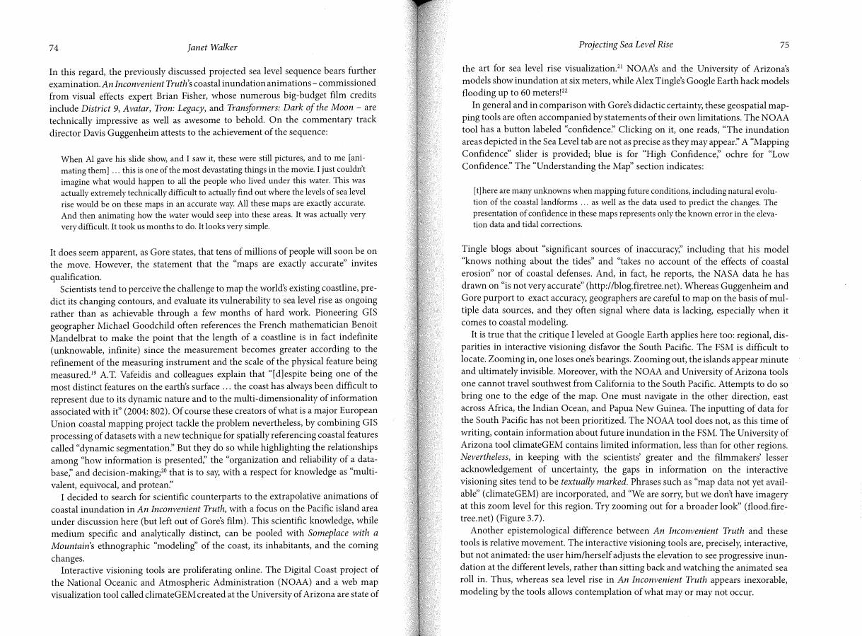
It is true that the critique I leveled at Google Earth applies here too: regional, disparities in interactive visioning disfavor the South Pacific. The FSM is difficult to locate. Zooming in, one loses one's bearings. Zooming out, the islands appear minute and ultimately invisible. Moreover, with the NOAA and University of Arizona tools one cannot travel southwest from California to the South Pacific. Attempts to do so bring one to the edge of the map. One must navigate in the other direction, east across Africa, the Indian Ocean, and Papua New Guinea. The inputting of data for the South Pacific has not been prioritized. The NOAA tool does not, as this time of writing, contain information about future inundation in the FSM. The University of Arizona tool climateGEM contains limited information, less than for other regions. Nevertheless, in keeping with the scientists' greater and the filmmakers' lesser acknowledgement of uncertainty, the gaps in information on the interactive visioning sites tend to be textually marked. Phrases such as "map data not yet available" ( climateGEM) are incorporated, and "We are sorry, but we don't have imagery at this zoom level for this region. Try zooming out for a broader look'' (flood.firetree.net) (Figure 3.7).
Another epistemological difference between An Inconvenient Truth and these tools is relative movement. The interactive visioning tools are, precisely, interactive, but not animated: the user him/herself adjusts the elevation to see progressive inundation at the different levels, rather than sitting back and watching the animated sea roll in. Thus, whereas sea level rise in An Inconvenient Truth appears inexorable, modeling by the tools allows contemplation of what may or may not occur.
76 Janet Walker
Figure 3.7 A suggestion from flood.firetree.net: "Try zooming out for a broader look:'
From a critical perspective, therefore, the didacticism and unacknowledged limits
of An Inconvenient Truth's scientific basis are problematic. And yet, embracing the
complexity of texts and thought, I do still believe that there are critical as well as
practical grounds for celebrating the film's bold advocacy work. An Inconvenient
Truth's animations might be regarded as productively "excessive" in the way Yusoff
(2009) supports. This is not to fall into a crisis mode of panicked response,23 but
rather to accept the need to act, even in the face of uncertainty and given that "map
ping confidence" is never full.
Yusoff is critical of the timidity of The Fourth Assessment Report of the
Intergovernmental Panel on Climate Change (IPCC) (Solomon et al., 2007) because,
even as it projected a global sea level rise of ~60 centimeters (nearly two feet) by
2100 due to the thermal expansion of sea water and the melting of glaciers (Nicholls
and Cazenave, 2010: 1517), the report pointed only implicitly toward abrupt change
(Yusoff, 2009: 1010). As she explains:
the catastrophic failure of the ice sheet was seen by the IPCC as an excessive, unpre
dictable event (the problem of rising sea levels was not entirely understood), which
was consequently left out of the IPCC's calculations for the Fourth Assessment Report.
Rather than risk uncertainly and disagreement over how sea level would rise, the IPCC
omitted the failure of the ice sheets and relegated it to a footnote. (Yusoff, 2009: 1011-
1012, italics added)
Drawing on Bataille and Blanchot, Yusoff articulates the problem of "nonknowledge
[being] that part of human experience that is excluded or expelled, because it is seen
not to contribute to knowledge, even though it is experienced and is thus the most
intimate form of knowledge" (2009: 1014). She therefore queries how we can
"respond to unknowing within knowledge in a way that does not simply restate the
limited terms of engagement that continue to disregard this excess" (2009: 1015).
Projecting Sea Level Rise 77
Focus on the aesthetics of scientific visualizations and not merely their content, may be productive, she suggests:
At the point at which data become image, and thus regimes of colour, light, and density, the accumulative force of data become fluvial, in the sense that it washes away the possibility of the atomisation of thought - information is inhabited as experience or as "matter-emotion'' (Blanchot, 1995b, page 108) . . . In short, the animated world that we know is reanimated through visualisation models . . . Placing the catastrophic "visions of the world" generated by digital earth into an aesthetic and philosophical space of consideration (they are of course already there), we can say that they exhibit an exorbitant potential, pushing conventional conditions of observing to the limit. (2009: 1021)
If "[f]or Bataille the project of recognising excess within economies is part of an uneasy form of vital recuperation that allows us to understand rather than undergo destruction'' (2009: 1024), then excessive visions with their exorbitant potential may contribute understanding, Yusoff is convinced.
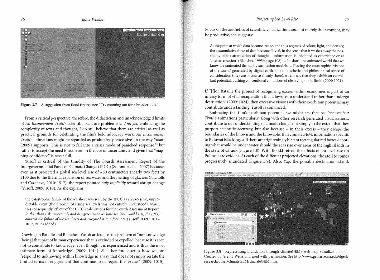
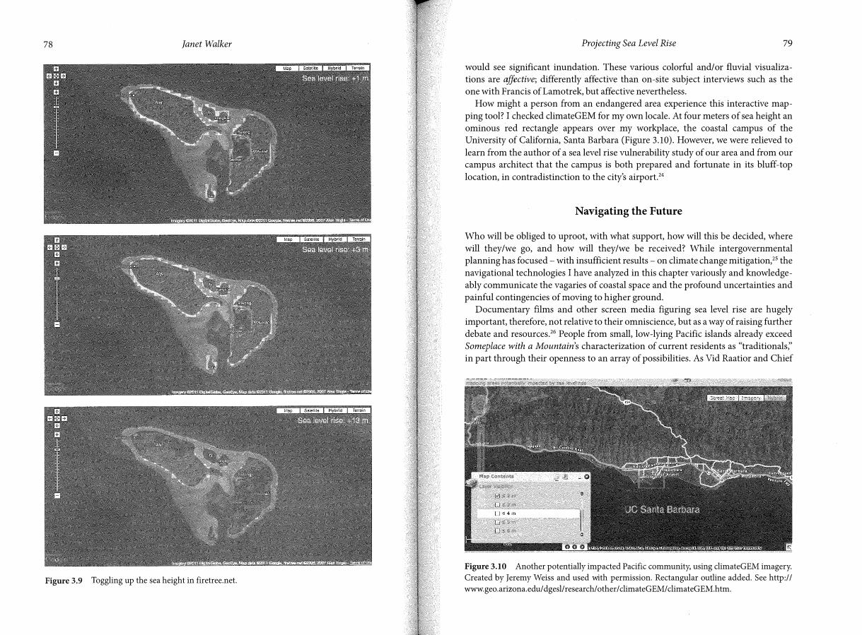
Embracing this film's exorbitant potential, we might say that An Inconvenient Truth's animations particularly, along with other research generated visualizations, contribute to our understanding of climate change not simply to the extent that they purport scientific accuracy, but also because - in their excess - they escape the boundaries of the known and the knowable. If in climateGEM, information specific to Puluwat is lacking, still there are frighteningly blatant rectangular red boxes denoting what would be under water should the seas rise over areas of the high islands in the state of Chuuk (Figure 3.8). With flood.firetree, the effects of sea level rise on Puluwat are evident. At each of the different projected elevations, the atoll becomes progressively inundated (Figure 3.9). Also, Yap, the possible destination island,
OOESL : climateGEM
- 0 elevations
0:Slm
[?!�2m
QS3m
0�4m
Figure 3.8 Representing inundation through climateGEM's web map visualization tool.
Created by Jeremy Weiss and used with permission. See http://www.geo.arizona.edu/dgesl/
research/ other/ climateGEM/ climateGEM.htm.
78 Janet Walker
Figure 3.9 Toggling up the sea height in firetree.net.
Projecting Sea Level Rise 79
would see significant inundation. These various colorful and/ or fluvial visualiza
tions are affective; differently affective than on-site subject interviews such as the
one with Francis of Lamotrek, but affective nevertheless.
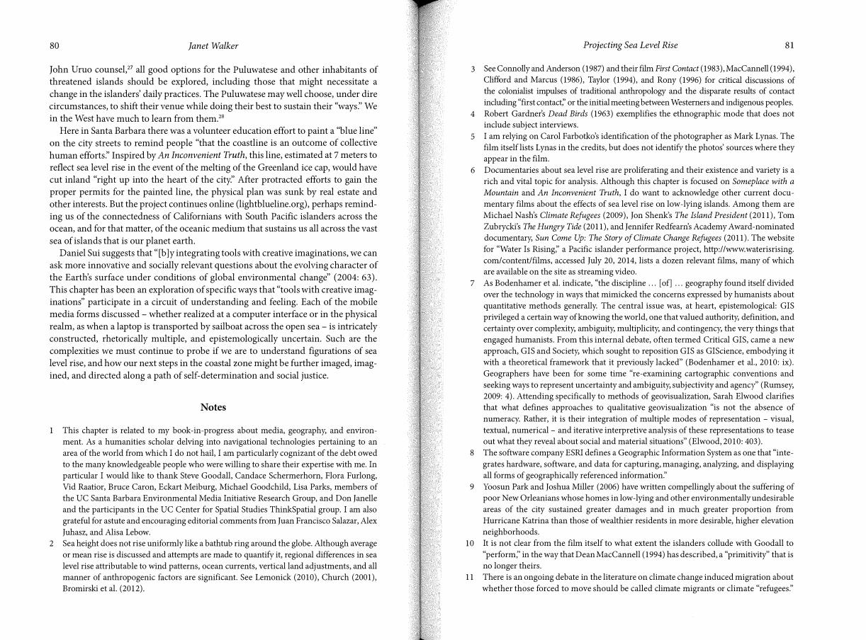
How might a person from an endangered area experience this interactive map
ping tool? I checked climateGEM for my own locale. At four meters of sea height an
ominous red rectangle appears over my workplace, the coastal campus of the University of California, Santa Barbara (Figure 3.10). However, we were relieved to
learn from the author of a sea level rise vulnerability study of our area and from our campus architect that the campus is both prepared and fortunate in its bluff-top
location, in contradistinction to the city's airport.24
Navigating the Future
Who will be obliged to uproot, with what support, how will this be decided, where
will they/we go, and how will they/we be received? While intergovernmental
planning has focused with insufficient results - on climate change mitigation,25 the
navigational technologies I have analyzed in this chapter variously and knowledge
ably communicate the vagaries of coastal space and the profound uncertainties and
painful contingencies of moving to higher ground.
Documentary films and other screen media figuring sea level rise are hugely
important, therefore, not relative to their omniscience, but as a way of raising further
debate and resources.26 People from small, low-lying Pacific islands already exceed
Someplace with a Mountain's characterization of current residents as "traditionals;'
in part through their openness to an array of possibilities. As Vid Raatior and Chief
Figure 3.10 Another potentially impacted Pacific community, using climateGEM imagery.
Created by Jeremy Weiss and used with permission. Rectangular outline added. See http://
www.geo.arizona.edu/ dgesl/research/ other/ climateGEM/ climateGEM.htm.
80 Janet Walker
John Uruo counsel,27 all good options for the Puluwatese and other inhabitants of threatened islands should be explored, including those that might necessitate a
change in the islanders' daily practices. The Puluwatese may well choose, under dire circumstances, to shift their venue while doing their best to sustain their "ways:' We in the West have much to learn from them.28
Here in Santa Barbara there was a volunteer education effort to paint a "blue line" on the city streets to remind people "that the coastline is an outcome of collective
human efforts:' Inspired by An Inconvenient Truth, this line, estimated at 7 meters to
reflect sea level rise in the event of the melting of the Greenland ice cap, would have cut inland "right up into the heart of the citf' After protracted efforts to gain the proper permits for the painted line, the physical plan was sunk by real estate and
other interests. But the project continues online (lightblueline.org), perhaps remind
ing us of the connectedness of Californians with South Pacific islanders across the ocean, and for that matter, of the oceanic medium that sustains us all across the vast
sea of islands that is our planet earth. Daniel Sui suggests that "[b ]y integrating tools with creative imaginations, we can
ask more innovative and socially relevant questions about the evolving character of the Earth's surface under conditions of global environmental change" (2004: 63).
This chapter has been an exploration of specific ways that "tools with creative imaginations" participate in a circuit of understanding and feeling. Each of the mobile media forms discussed - whether realized at a computer interface or in the physical
realm, as when a laptop is transported by sailboat across the open sea - is intricately constructed, rhetorically multiple, and epistemologically uncertain. Such are the complexities we must continue to probe if we are to understand figurations of sea level rise, and how our next steps in the coastal zone might be further imaged, imag
ined, and directed along a path of self-determination and social justice.
Notes
1 This chapter is related to my book-in-progress about media, geography, and environ
ment. As a humanities scholar delving into navigational technologies pertaining to an
area of the world from which I do not hail, I am particularly cognizant of the debt owed
to the many knowledgeable people who were willing to share their expertise with me. In
particular I would like to thank Steve Goodall, Candace Schermerhorn, Flora Furlong,
Vid Raatior, Bruce Caron, Eckart Meiburg, Michael Goodchild, Lisa Parks, members of
the UC Santa Barbara Environmental Media Initiative Research Group, and Don Janelle
and the participants in the UC Center for Spatial Studies ThinkSpatial group. I am also
grateful for astute and encouraging editorial comments from Juan Francisco Salazar, Alex
Juhasz, and Alisa Lebow.
2 Sea height does not rise uniformly like a bathtub ring around the globe. Although average
or mean rise is discussed and attempts are made to quantify it, regional differences in sea
level rise attributable to wind patterns, ocean currents, vertical land adjustments, and all
manner of anthropogenic factors are significant. See Lemonick (2010), Church (2001),
Bromirski et al. (2012).
Projecting Sea Level Rise 81
3 See Connolly and Anderson (1987) and their film First Contact (1983), MacCannell (1994),
Clifford and Marcus (1986), Taylor (1994), and Rony (1996) for critical discussions of the colonialist impulses of traditional anthropology and the disparate results of contact
including "first contact:' or the initial meeting between Westerners and indigenous peoples.
4 Robert Gardner's Dead Birds (1963) exemplifies the ethnographic mode that does not
include subject interviews.
5 I am relying on Carol Farbotko's identification of the photographer as Mark Lynas. The
film itself lists Lynas in the credits, but does not identify the photos' sources where they
appear in the film.
6 Documentaries about sea level rise are proliferating and their existence and variety is a
rich and vital topic for analysis. Although this chapter is focused on Someplace with a
Mountain and An Inconvenient Truth, I do want to acknowledge other current docu
mentary films about the effects of sea level rise on low-lying islands. Among them are
Michael Nash's Climate Refugees (2009), Jon Shenk's The Island President (2011), Tom
Zubrycki's The Hungry Tide (2011), and Jennifer Redfearn's Academy Award-nominated
documentary, Sun Come Up: The Story of Climate Change Refugees (2011). The website
for "Water Is Rising;' a Pacific islander performance project, http:/ /www.waterisrising.
com/content/films, accessed July 20, 2014, lists a dozen relevant films, many of which
are available on the site as streaming video.
7 As Bodenhamer et al. indicate, "the discipline .. . [ of] . .. geography found itself divided
over the technology in ways that mimicked the concerns expressed by humanists about
quantitative methods generally. The central issue was, at heart, epistemological: GIS
privileged a certain way of knowing the world, one that valued authority, definition, and
certainty over complexity, ambiguity, multiplicity, and contingency, the very things that
engaged humanists. From this internal debate, often termed Critical GIS, came a new
approach, GIS and Society, which sought to reposition GIS as GIScience, embodying it
with a theoretical framework that it previously lacked" (Bodenhamer et al., 2010: ix).
Geographers have been for some time "re-examining cartographic conventions and
seeking ways to represent uncertainty and ambiguity, subjectivity and agency' ' (Rumsey,
2009: 4). Attending specifically to methods of geovisualization, Sarah Elwood clarifies
that what defines approaches to qualitative geovisualization "is not the absence of
numeracy. Rather, it is their integration of multiple modes of representation - visual,
textual, numerical - and iterative interpretive analysis of these representations to tease
out what they reveal about social and material situations" (Elwood, 2010: 403).
8 The software company ESRI defines a Geographic Information System as one that "inte
grates hardware, software, and data for capturing, managing, analyzing, and displaying
all forms of geographically referenced information:'
9 Yoosun Park and Joshua Miller (2006) have written compellingly about the suffering of
poor New Orleanians whose homes in low-lying and other environmentally undesirable
areas of the city sustained greater damages and in much greater proportion from
Hurricane Katrina than those of wealthier residents in more desirable, higher elevation
neighborhoods.
10 It is not clear from the film itself to what extent the islanders collude with Goodall to
"perform;' in the way that Dean MacCannell (1994) has described, a "primitivity" that is
no longer theirs.
11 There is an ongoing debate in the literature on climate change induced migration about
whether those forced to move should be called climate migrants or climate "refugees:'

I
82 Janet Walker
The latter term is thought by some to make the people and their plight legible and
deserving of consideration within policy discourses. Others dispute the label as one that
undermines the perceived identities, rights, and agency of people at the greatest risk of
being made landless. See McNamara and Gibson (2009) and Biermann and Boas (2010).
12 Steve Goodall has let me know via email that the shot is actually of one of the small outer
atolls of Lamotrek (7° 27' 30.06"N 146° 22' 27.62" E). While perhaps not problematic
in and of itself, the substitution for Puluwat is part of a broader conflation to be
discussed below. 13 There is also a dearth of labels programmed into Google Earth for the area, especially in
comparison with the large number appearing for the continental United States.
14 Also when he talks about the film project, as I have heard him do on four occasions,
Goodall consistently states that it is the Puluwatese, in particular, he seeks to help. The
four occasions were at the 2010 Santa Barbara International Film Festival, to students in
my course on Films of the Natural and Human Environment in the fall of 2011, and
during two meetings of UC Santa Barbara's Environmental Media Initiative Research
Group of the Carsey-Wolf Center in November 2011.
15 Goodall is resolved that the decision whether to relocate from Puluwat is for the
Puluwatese themselves to make. That said, a documentary scholar will know that the
actions of documentary subjects are never wholly independent of the production
process.
16 The participants were a core group of the members of the Environmental Media
Initiative Research Group of the Carsey-Wolf Center on the University of Santa Barbara
campus. See http://www.carseywolf.ucsb.edu/ emi, accessed July 20, 2014.
17 Land elevation and sea surface measurements may be achieved through the high resolu
tion imaging instruments LIDAR (Light Detection And Ranging, looking downward
from airplanes and satellites) and ASTER (Advanced Spaceborne Thermal Emission
and Reflection Radiometer, flying on the Terra satellite).
18 These would include predictions of land-based ice melt and calculations of the earth's
gravitational pull, termed "glacial forebulge" ( where the earth is pooched up by glacial
movement). See also n. 2.
19 Michael Goodchild mentioned this point in his October 4, 2011 talk, "Geographical
Intelligence;' for the ThinkSpatial forum of the Center for Spatial Studies at UC Santa
Barbara, http://spatial.ucsb.edu/ events/thinkspatial-brownbags/brownbags-2011-2012/,
accessed July 20, 2014. See also Longley et al. (2011).
20 The project is entitled DINAS-COAST, which stands for Dynamic and Interactive
Assessment of National, Regional and Global Vulnerability of Coastal Zones to Climate
Change and Sea-Level Rise. The goal is to establish a user-friendly, cross-disciplinary
database for coastal modeling and vulnerability assessment taking into account "(i) the
geomorphic structure of the coastal environment; (ii) the potential for wetland migra
tion; (iii) the locations of major rivers and deltas; (iv) population density classes; and (v)
administrative boundaries" (Vafeidis et al., 2004: 803).
21 The NOAA tool is the "Sea Level Rise and Coastal Flooding Impacts Viewer" provided by
the Digital Coast project of the Coastal Services Center, http:/ /www.csc.noaa.gov/
digitalcoast/tools/slrviewer/, accessed July 20, 2014. The University of Arizona "web map visualization tool;' climateGEM, has been created under the Geospatial Environmental
Modeling of Climatic Hazards and Their Impacts project of the Department
of Geosciences and Environmental Studies Laboratory, http:/ /climategem.geo.arizona.
Projecting Sea Level Rise 83
edu/slr/world/index.html, accessed July 20, 2014. There is also the Google Earth hack by Alex Tingle, http://flood.firetree.net, accessed July 20, 2014, which uses NASA data.
22 Google Earth has its own interactive sea level rise modeling layer in a section of the web
application under "terrain:' But I decided to discontinue prioritization of Google Earth at this point in the chapter.
23 Parks (2010) is critical of the "Crisis in Darfur" layer of Google Earth because although
it intends a productive crisis mapping, it nevertheless reverts to unproductive stereo
types of Africa and Africans and pretends a fullness of information that it actually lacks.
For research on crisis mapping see Liu and Palen (2010) and Meier (2010).
24 The session at which this information was presented, entitled "Santa Barbara Geographies:
Past, Present, and as the Sea Levels Rise" (November 9, 2012), was part of the 2012-2013
"Figuring Sea Level Rise" series of our campus's Critical Issues in America program. The
speakers being referenced here are Gary Griggs and Marc Fisher. The third speaker was
Edward Keller. See http://criticalissues.ucsb.edu, accessed July 20, 2014.
25 The Kyoto Protocol with its binding targets for the reduction of greenhouse gases is an
intergovernmental attempt at mitigation. The Protocol has been signed and ratified by
192 parties. Canada withdrew. The US is the only signatory that has not ratified the agreement.
26 The recent Sun Come Up (Redfearn, 2011) is notable for showing Carteret islanders them
selves attempting to arrange for the migration of an initial cluster of families to Bougainville,
the main island of the Autonomous Region of Bougainville, Papua New Guinea.
27 ChiefUruo visited our UC Santa Barbara campus on January 25, 2012.
28 Also, a group calling themselves The Pacific Voyagers are sailing across the Pacific to raise awareness about "our Ocean in peril:'
References
Barnett, J. and Campbell, J. (2010) Climate Change and Small Island States: Power, Knowledge
and the South Pacific. London: Earthscan.
Biermann, F. and Boas, I. (2010) Preparing for a Warmer World: Towards a Global Governance
System to Protect Climate Refugees. Global Environmental Politics, 10(1), 60-68.
Blanchot, M. (1995) The Work of Fire, trans. C. Mandell. Palo Alto, CA: Stanford University Press.
Bodenhamer, D.J., Corrigan, J., and Harris, T.M. (eds.) (2010) The Spatial Humanities: GIS
and the Future of Humanities Scholarship. Bloomington: Indiana University Press.
Bromirski, P.D., Miller, A.J., and Flick, R.E. (2012) Understanding North Pacific Sea Level
Rise Trends. BOS, Transactions, American Geophysical Union, 93(27), 249-256.
Bruno, G. (2002) Atlas of Emotion: Journeys in Art, Architecture and Film. New York: Verso.
Cameron, FR. (2011) Saving the "Disappearing Islands": Climate Change Governance,
Pacific Island States and Cosmopolitan Dispositions. Continuum: Journal of Media &
Cultural Studies, 25( 6), 873-886.
Church, J.A. (2001) How Fast are Sea Levels Rising? Science, 294 (October 26), 802-803.
Clifford, J. and Marcus, G.E. (eds.) (1986) Writing Culture: The Poetics and Politics of
Ethnography. Berkeley: University of California Press.
Connolly, B. and Anderson, R. (1987) First Contact: New Guinea's Highlanders Encounter the
Outside World. New York: Viking.
84 Janet Walker
Cope, M. and Elwood, S. (eds.) (2009) Qualitative GIS: A Mixed Methods Approach.
Los Angeles and London: Sage.
Dear, M., Ketchum, J., Luria, S., and Richardson, D. ( eds.) (2011) Geo Humanities: Art, History,
Text at the Edge of Place. London and New York: Routledge.
Elwood, S. (2010) Geographic Information Science: Visualization, Visual Methods, and the
Geoweb. Progress in Human Geography, 35(3), 401-408.
Fabian, J. (1983) Time and the Other: How Anthropology Makes Its Object. New York:
Columbia University Press.
Farbotko, C. (2010) Wishful Sinking: Disappearing Islands, Climate Refugees and
Cosmopolitan Experimentation. Asia Pacific Viewpoint, 51(1), 47-60.
Farbotko, C. and McGregor, H.V (2010) Copenhagen, Climate Science and the Emotional
Geographies of Climate Change. Australian Geographer, 41 (2), 159-166.
Gregory, D. (1993) Geographical Imaginations. Oxford: Wiley-Blackwell.
Gregory, I.N. and Ell, P.S. (2007) Historical GIS: Technologies, Methodologies and Scholarship.
Cambridge: Cambridge University Press.
Harris, T.M., Corrigan, J., and Bodenhamer, D.J. (2010) Challenges for the Spatial Humanities:
Toward a Research Agenda. In Bodenhamer, D.J., Corrigan, J., and Harris, T.M. (eds.)
(201 O) The Spatial Humanities: GIS and the Future of Humanities Scholarship. Bloomington:
Indiana University Press.
Hau'ofa, E. (1993) Our Sea oflslands. In Waddell, E., Naidu, V, and Hau'ofa, E. (eds.) A New
Oceania: Rediscovering Our Sea of Islands, pp. 2-16. Suva: School of Social and Economic
Development, University of the South Pacific and Beake House.
Lemonick, M.D. (2010) The Secret of Sea Level Rise: It Will Vary Greatly by Region. Yale
Environment 360 (March 22), http://e360.yale.edu/content/feature.msp?id=2255, accessed
July 21, 2014.
Levinson, M., Ward, R.G., and Webb, J.W (1973) The Settlement of Polynesia: A Computer
Simulation. Minneapolis: Minnesota University Press.
Liu, S. and Palen, L. (2010 The New Cartographers: Crisis Map Mashups and the Emergence
of Neogeographic Practice. Cartography and Geographic Information Systems, 37, 69-90.
Longley, P.A., Goodchild, M.F., Maguire, D.J., and Rhind, D.W (2011) Geographic Information
Systems and Science, 3rd edn. Chichester: John Wiley & Sons, Ltd.
MacCannell, D. (1994) Cannibal Tours. In Taylor, L. (ed.) Visualizing Theory: Selected Essays
from VA.R. 1990-1994. New York and London: Routledge.
McNamara, K.E. and Gibson, C. (2009) "We Do Not Want to Leave Our Land": Pacific
Ambassadors at the United Nations Resist the Category of "Climate Refugees:' Geoforum,
40, 475-483.
Massey, D. (1994) Space, Place, and Gender. Minneapolis: University of Minnesota Press.
Meier, P. (2010) The Rise of Crisis Mapping and the Crisis Mappers Group. iRevolution
(March 28), http://irevolution.wordpress.com/2010/03/28/rise-of-crisismappers, accessed
July 21, 2014.
Nichols, B. (1991) Representing Reality. Bloomington: Indiana University Press.
Nicholls, R.J. and Cazenave, A. (2010) Sea-level Rise and Its Impact on Coastal Zones.
Science, 328, 1517-1520.
Park, Y. and Miller, J. (2006) The Social Ecology of Hurricane Katrina. Smith College Studies
in Social Work, 76(3), 9-24.
Parks, L. (2004) Kinetic Screens: Epistemologies of Movement at the Interface. In Couldry, N.
and McCarthy, A. (eds.) MediaSpace: Place, Scale and Culture in a Media Age, pp. 37-57.
London and New York: Routledge.
Projecting Sea Level Rise 85
Parks, L. (2010) Between Orbit and the Ground: Conflict Monitoring, Google Earth and the
"Crisis in Darfur" Project. In Sarkar, B. and Walker, J. (eds.) Documentary Testimonies:
Global Archives of Suffering, pp. 245-267. London and New York: Routledge.
Renov, M. (1993) Introduction: The Truth About Non-Fiction. In M. Renov (ed.) Theorizing
Documentary, pp. 1-11. New York and London: Routledge.
Rony, F.T. (1996) The Third Eye: Race, Cinema, and Ethnographic Spectacle. Durham, NC:
Duke University Press.
Rumsey, A.S. (2009) Spatial Technologies and the Humanities. Scholarly Communication
Institute 7 Report, University of Virginia, http://uvasci.digress.it/, accessed August 15,
2014.
Smith, N. (2008) Uneven Development: Nature, Capital and the Production of Space, 3rd edn.
Athens: University of Georgia Press.
Solomon, S. et al. (eds.) (2007) Climate Change 2007: The Physical Science Basis, Contribution
of Working Group 1 to the Fourth Assessment Report of the Intergovernmental Panel on
Climate Change. Cambridge: Cambridge University Press.
Sui, D.Z. (2004) GIS, Cartography, and the "Third Culture": Geographic Imaginations in the
Computer Age. The Professional Geographer, 56(1), 62-72.
Taylor, L. (ed.) (1994) Visualizing Theory: Selected Essays from VA.R. 1990-1994. New York
and London: Routledge.
Vafeidis, A.T., Nicholls, R.J., McFadden, L., Hinkel, J., and Grashoff, P.S. (2004) Developing a
Global Database for Coastal Vulnerability Analysis: Design Issues and Challenges. The
International Archives of the Photogrammetry, Remote Sensing and Spatial Information
Sciences, 34, Part XXX, 801-805.
von Liinen, A. and Moschek, W (2011) Without Limits: Ancient History and GIS. In Dear,
M., Ketchum, J., Luria, S., and Richardson, D. (eds.) (2011) GeoHumanities: Art, History,
Text at the Edge of Place. London and New York: Routledge.
Yusoff, K. (2009) Excess, Catastrophe, and Climate Change. Environment and Planning D:
Society and Space, 27, 1010-1029.