Embed Size (px)
Citation preview

APPENDIX J Stage 1 Archaeological Assessment

Stage 1 Archaeological
Assessment: Courtneypark Drive
East, Kennedy Road to Dixie Road
Parts of Lots 8 and 9, Concession 1
East (E), Parts of Lots 7 to 9,
Concession 2E, Parts of Lots 7 and 8,
Concession 3E, and Parts of Lots 7
and 8, Concession 4E,
Geographic Township of Toronto,
former Peel County,
now City of Mississauga, Ontario
Prepared for:
Corporation of the City of
Mississauga,
300 City Centre Drive, Mississauga,
ON L5B 3C1
Prepared by:
Stantec Consulting Ltd.
200 - 835 Paramount Drive
Stoney Creek ON L8J 0B4
Tel: (905) 385-3234
Fax: (905) 385-3534
Licensee: Jim Wilson, MA
License Number: P001
PIF Number: P001-0838-2014
ORIGINAL REPORT
February 10, 2015

STAGE 1 ARCHAEOLOGICAL ASSESSMENT: COURTNEYPARK DRIVE EAST, KENNEDY ROAD TO DIXIE
ROAD
Table of Contents
PROJECT PERSONNEL ................................................................................................................ I
EXECUTIVE SUMMARY .............................................................................................................. II
1.0 PROJECT CONTEXT ......................................................................................................1.1
1.1 DEVELOPMENT CONTEXT .............................................................................................. 1.1 1.1.1 Objectives..................................................................................................... 1.1
1.2 HISTORICAL CONTEXT .................................................................................................... 1.2 1.2.1 Post-contact Aboriginal Resources ........................................................... 1.2 1.2.2 Historic Euro-Canadian Archaeological Resources and Surveys ......... 1.3 1.2.3 Recent Reports ............................................................................................ 1.6
1.3 ARCHAEOLOGICAL CONTEXT ...................................................................................... 1.6 1.3.1 The Natural Environment ............................................................................ 1.6 1.3.2 Pre-contact Aboriginal Resources ............................................................ 1.7 1.3.3 Previously Identified Archaeological Sites and Surveys ......................... 1.7 1.3.4 Existing Conditions ....................................................................................... 1.9
2.0 FIELD METHODS ...........................................................................................................2.1
3.0 ANALYSIS AND CONCLUSIONS ..................................................................................3.1
4.0 RECOMMENDATIONS ..................................................................................................4.1
5.0 ADVICE ON COMPLIANCE WITH LEGISLATION ..........................................................5.1
6.0 BIBLIOGRAPHY AND SOURCES ...................................................................................6.1
7.0 IMAGES........................................................................................................................7.1
7.1 PHOTOGRAPHS .............................................................................................................. 7.1
8.0 MAPS ...........................................................................................................................8.1
9.0 CLOSURE ......................................................................................................................9.1
LIST OF TABLES
Table 1: Property Owners and Historical Features Depicted in the 1877 Historic
Map of Toronto Township .......................................................................................... 1.4 Table 2: Cultural Chronology for Regional Municipality of Peel ......................................... 1.7 Table 3: Archaeological Sites Registered Within One Kilometre of the Study Area ........ 1.8

STAGE 1 ARCHAEOLOGICAL ASSESSMENT: COURTNEYPARK DRIVE EAST, KENNEDY ROAD TO DIXIE
ROAD
LIST OF FIGURES
Figure 1: Location of Study Area ............................................................................................. 8.2 Figure 2: Treaties and Purchases (Adapted from Morris 1943) ............................................ 8.3 Figure 3: 1877 Survey Map of Northern Half of Toronto Township (Walker and Miles
1877) ............................................................................................................................. 8.4 Figure 4: Stage 1 Archaeological Potential Map .................................................................. 8.5
STAGE 1 ARCHAEOLOGICAL ASSESSMENT: COURTNEYPARK DRIVE EAST, KENNEDY ROAD TO DIXIE
ROAD
i
Project Personnel
Project Manager: Gordon Murray
Archaeology Lead: Paige Glenen, MSc. (R386)
Licensed Archaeologist: Jim Wilson, MA (P001)
Licensed Field Director: Gemma Calgie, B.Sc. (R472)
Report Writer: Gemma Calgie, B.Sc. (R472); Paige Glenen, M.Sc.
(R386)
Technical Review: Parker Dickson, MA (P256)
Senior Review: Tracie Carmichael, BA, B.Ed. (R140)
Proponent Contact: Dana Glofcheskie, Project Manager, City of
Mississauga
Ministry of Tourism, Culture and Sport: Robert von Bitter

STAGE 1 ARCHAEOLOGICAL ASSESSMENT: COURTNEYPARK DRIVE EAST, KENNEDY ROAD TO DIXIE
ROAD
ii
Executive Summary
Stantec Consulting Ltd. (Stantec) has been retained by the City of Mississauga (the City) to
complete a Stage 1 archaeological assessment for the Schedule “C” Municipal Class
Environmental Assessment (Class EA) Study and Preliminary Design for Courtneypark Drive East.
The Stage 1 assessments was undertaken in the preliminary planning and design process for the
Class EA in accordance with the Municipal Class Environmental Assessment document by the
Municipal Engineers (October 2000, as amended in 2007), approved under the Ontario
Environmental Assessment Act (Government of Ontario 1990).
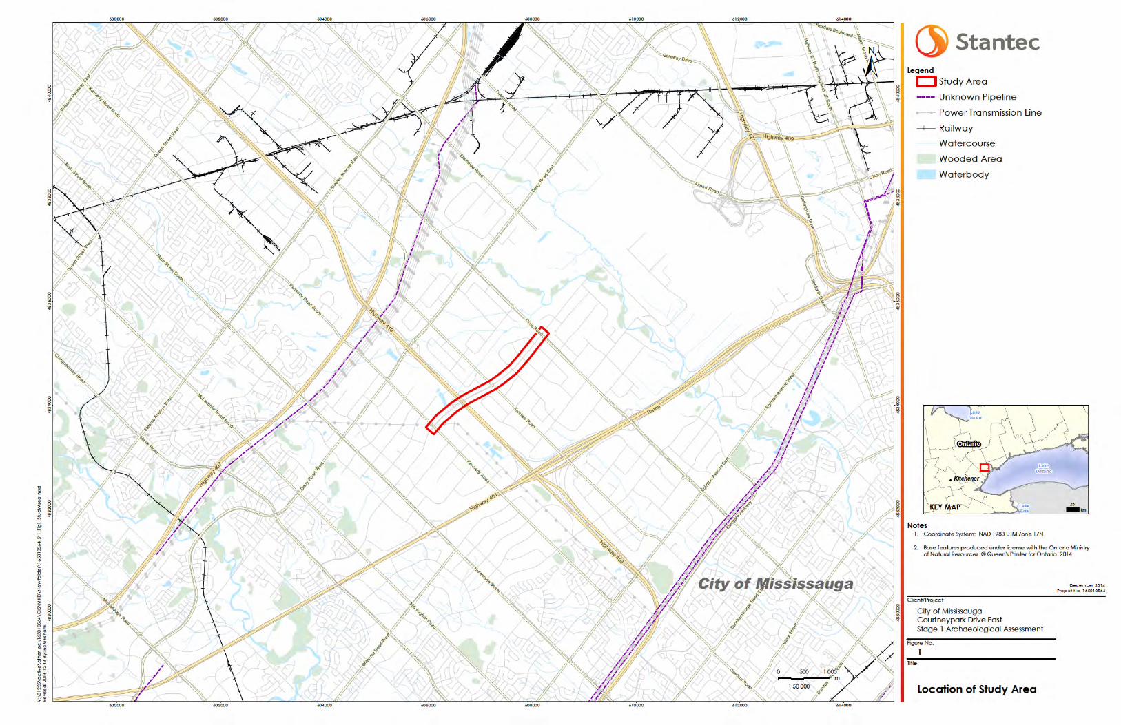
The study area includes an approximate 2.8 kilometre portion of the existing Courtneypark Drive
East, from Kennedy Road to Dixie Road, as well as the intersections therein. More specifically, the
study area includes parts of Lots 8 and 9, Concession 1 East (E), Parts of Lots 7 to 9, Concession
2E, Parts of Lots 7 and 8, Concession 3E, and Parts of Lots 7 and 8, Concession 4E, Geographic
Township of Toronto, former Peel County, now City of Mississauga, Ontario.
Archaeological potential for pre-contact Aboriginal, post-contact Aboriginal, and Euro-
Canadian sites is deemed to be moderate to high within the study area based on historical
documentation; however, the Stage 1 property inspection has determined that the entire study
area (100%) has been subject to extensive land disturbance which has removed archaeological
potential. Thus, in accordance with Section 7.7.4 Standard 1b, no part of the study area retains
archaeological potential and no further archaeological assessment is required.
The Ministry of Tourism, Culture and Sport is asked to review the results presented and to accept
this report into the Ontario Public Register of Archaeological Reports.
The Executive Summary highlights key points from the report only; for complete information and
findings, the reader should examine the complete report.
STAGE 1 ARCHAEOLOGICAL ASSESSMENT: COURTNEYPARK DRIVE EAST, KENNEDY ROAD TO DIXIE
ROAD
1.1
1.0 PROJECT CONTEXT
1.1 DEVELOPMENT CONTEXT
Stantec Consulting Ltd. (Stantec) has been retained by the City of Mississauga (the City) to
complete a Stage 1 archaeological assessment for the Schedule “C” Municipal Class
Environmental Assessment (Class EA) Study and Preliminary Design for Courtneypark Drive East.
The Stage 1 assessment was undertaken in the preliminary planning and design process for the
Class EA in accordance with the Municipal Class Environmental Assessment document by the
Municipal Engineers (October 2000, as amended in 2007), approved under the Ontario
Environmental Assessment Act (Government of Ontario 1990). It is the City’s intention to make
use of the existing Courtneypark Drive East structure across Highway 410; however, the existing
structure will be widened significantly.
The study area includes an approximate 2.8 kilometre portion of the existing Courtneypark Drive
East, from Kennedy Road to Dixie Road, as well as the intersections therein. More specifically, the
study area includes parts of Lots 8 and 9, Concession 1 East (E), Parts of Lots 7 to 9, Concession
2E, Parts of Lots 7 and 8, Concession 3E, and Parts of Lots 7 and 8, Concession 4E, Geographic
Township of Toronto, former Peel County, now City of Mississauga, Ontario (Figure 1).
1.1.1 Objectives
The objectives of the Stage 1 assessment were to compile all available information about the
known and potential archaeological heritage resources within the study area and to provide
specific direction for the protection, management and/or recovery of these resources. In
compliance with the provincial standards and guidelines set out in the Ministry of Tourism,
Culture and Sport’s (MTCS) 2011 Standards and Guidelines for Consultant Archaeologists
(Government of Ontario 2011), the objectives of the Stage 1 Archaeological
Overview/Background Study are as follows:
To provide information about the study area’s geography, history, previous
archaeological fieldwork and current land conditions;
To evaluate in detail the study area’s archaeological potential which will support
recommendations for Stage 2 survey for all or parts of the property; and
To recommend appropriate strategies for Stage 2 survey.
To meet these objectives Stantec archaeologists employed the following research strategies:
A review of relevant archaeological, historic and environmental literature pertaining to
the study area;
A review of the land use history, including pertinent historic maps;

STAGE 1 ARCHAEOLOGICAL ASSESSMENT: COURTNEYPARK DRIVE EAST, KENNEDY ROAD TO DIXIE
ROAD
1.2
An examination of the Ontario Archaeological Sites Database (ASDB) to determine the
presence of known archaeological sites in and around the project area; and
A property inspection of the study area.
Permission to access the study area was provided by Farhad Shahla, former Project Manager for
the City of Mississauga.
1.2 HISTORICAL CONTEXT
1.2.1 Post-contact Aboriginal Resources
The post-contact Aboriginal occupation of Southern Ontario was heavily influenced by the
dispersal of various Iroquoian-speaking communities by the New York State Iroquois and the
subsequent arrival of Algonkian speaking groups from northern Ontario at the end of the 17th
century and the beginning of the 18th century (Konrad 1981; Schmalz 1991). When Europeans
arrived in the 1600s, both Algonkian-speaking and Iroquoian peoples already lived in the Credit
River Valley area. One of the First Nations groups the French traders encountered near the
Credit River were the Algonkian Mississaugas. However, by 1700 the Mississaugas had driven the
Iroquois from the area. In southwestern Ontario, members of the Three Fires Confederacy
(Chippewa, Ottawa, and Potawatomi) were immigrating from Ohio and Michigan in the late
1700s (Feest and Feest 1978:778-779).
The nature of Aboriginal settlement size, population distribution, and material culture shifted as
European settlers encroached upon their territory. However, despite this shift, “written accounts
of material life and livelihood, the correlation of historically recorded villages to their
archaeological manifestations, and the similarities of those sites to more ancient sites have
revealed an antiquity to documented cultural expressions that confirms a deep historical
continuity to Iroquoian systems of ideology and thought” (Ferris 2009:114). As a result, First Nations
peoples of Southern Ontario have left behind archaeologically significant resources throughout
Southern Ontario which show continuity with past peoples, even if they have not been recorded
in Euro-Canadian documentation.
The study area is located within the Geographic Township of Toronto, which lies within the
bounds of Treaty 13A. On August 2, 1805, the Principal Chiefs of the Mississauga Nation and
William Claus, Esquire, Deputy Superintendent General and Deputy Inspector General of Indians
and their Affairs, signed Treaty 13A (Morris 1943). The area of Treaty 13A is described as follows:
Commencing at the eastern bank of the mouth of the River Etobicoke, being in the limit
of the western boundary line of the Toronto Purchase, in the year 1787; then north
twenty-two degrees west, six miles; thence south 38 degrees west, twenty-six miles more
or less, until it intersects a line on the course north 45 degrees west, produced from the
outlet of Burlington Bay; then along the said produced line, one mile more or less to the
lands granted to Captain Brant; then north 45 degrees east, one mile and a half; then
south 45 degrees east, three miles and a half more or less to Lake Ontario; then north

STAGE 1 ARCHAEOLOGICAL ASSESSMENT: COURTNEYPARK DRIVE EAST, KENNEDY ROAD TO DIXIE
ROAD
1.3
easterly along the water[‘]s edge of Lake Ontario to the eastern bank of the River
Etobicoke being the place of beginning.
(Morris 1943:22)
In this treaty, known as the “First Purchase”, the Crown acquired over 74,000 acres of land,
excluding a one mile strip on each side of the Credit River which became known as the Credit
River Indian Reserve. While it is difficult to delineate treaty boundaries today, Figure 2 provides
an approximate outline of Treat Number 13A (identified by the letter “M”).
1.2.2 Historic Euro-Canadian Archaeological Resources and Surveys
The study area is situated on parts of Lots 8 and 9, Concession 1E, parts of Lots 7 to 9, Concession
2E, parts of Lots 7 and 8, Concession 3E, and parts of Lots 7 and 8, Concession 4E, Geographic
Township of Toronto, former Peel County, now City of Mississauga, Ontario.
The French adventurer Etienne Brûlé likely visited the area in 1615 (Jurgens 1966), however little
European settlement occurred in the 17th and early 18th centuries. Toronto Township was
originally formed as part of York County in 1805, but separated in 1851 to become part of Peel
County. Samuel Wilmot completed the survey of the southern half of the township (known as the
Old Survey) in 1806 and the area was made available for Euro-Canadian settlement at the same
time. Weaver (1913:65) notes that “[A] strip of land one mile wide on each side of the Credit
[River] was then reserved for the Mississauga Indians, with special privilege as to fishing.” Further
evidence of the importance of the Credit River to Aboriginal populations at the time of initial
Euro-Canadian settlement is found in the published diary of Mrs. Simcoe, the wife of the first
Governor of Canada. An entry dated June 1796 notes that “[N]umbers of Indians resort here
[the Credit River]…to fish for salmon” (Weaver 1913:63). The entry further describes travel up the
Credit River, to a point where a portage was necessary to traverse around a set of rapids.
Nearly a quarter of a century later the village of Streetsville was founded beside these rapids.
The northern half of Toronto Township (known as the New Survey) was surveyed in 1819 by the
British government. Early transportation routes in the Township of Toronto opened in the early 19th
century. For example, Dundas Street, also known as Governor’s Road, was opened in the early
19th century as a principal military route between York (now City of Toronto) and London.
Euro-Canadian settlement of Toronto Township focused around Dundas Street, an established
aboriginal trail that had been expanded into a main road (Riendeau 2002:124). Many of the
initial settlers were United Empire Loyalists leaving the newly formed United States. The proportion
of British immigrants dramatically increased after the war of 1812, in part due to the upheavals of
the Napoleonic wars in Europe (Riendeau 2002:126). Between 1815 and 1850 over a million British
immigrants came to settle in Toronto Township where agricultural potential was vast. With the
demand for land so high at this point the provincial government purchased the remainder of the
Mississauga Tract in 1818 and six months later the north half of Toronto Township was surveyed.
Prior to this many squatters were living in the northern portion of the township in hopes of

STAGE 1 ARCHAEOLOGICAL ASSESSMENT: COURTNEYPARK DRIVE EAST, KENNEDY ROAD TO DIXIE
ROAD
1.4
receiving land grants. It was in the spring of 1819 that Malcolm McKinnon was officially granted
land in the north of Toronto Township.
Railway development within Peel County began in the 1850s with the construction of the
Hamilton Toronto Railway along the lakefront of Lake Ontario. The railway became part of the
Great Western Railway prior to being acquired by the Grand Trunk Railway in 1882 (Currie 1957).
Construction of the Credit Valley Railway began in 1871 and was completed by 1881. In 1883,
the railway was absorbed in to the Ontario & Quebec Railway and later, in to the Canadian
Pacific Railway.
The1877 Illustrated Historical Atlas of the County of Peel (Walker & Miles 1877) notes several land
owners for the various lots associated with the study area (Figure 3). Table 1 summarizes the
landowner information from the 1877 historic map of Toronto Township.
Table 1: Property Owners and Historical Features Depicted in the 1877 Historic Map of
Toronto Township
Lot Concession Owner/Resident Euro-Canadian Features
8 (Northeast
quarter and
West half)
1 E George Evans Building and orchard on west side. Property is bordered
by Kennedy Road to the east.
9 (full) 1 E David Brown
One building and orchard at the north west corner,
one building and orchard at the south west corner.
Property is bordered by Kennedy Road to the east.
7 (East half) 2 E David McGraw Building and orchard on east side. Tomken Road
borders property to the east.
8 (West half) 2 E Andrew Aikens Building and orchard on west side. Property is bordered
by Kennedy Road to the west.
8 (East half) 2 E Estate of Thomas
Smith
Building and orchard centrally located. 9th with
laneway from the east side. Tomken Road borders
property to the east.
9 (South half) 2 E Thomas Aikens
Building and orchard on east side. Orchard near the
north east side. Two tributaries of Etobicoke Creek run
east-west through east side of property
7 (Northwest
quarter) 3 E James Johnston
Two buildings one at north west edge, one near south
east edge. Tomken Road borders property to the west.
7 (Southwest
quarter) 3 E
Estate of William
Maley
Building at west side. Property is bordered by Tomken
Road to the west
7 (East half) 3 E William Johnston Dixie Road borders property to the east.
8 (West half) 3 E James Johnston
Tributary of Etobicoke Creek runs east-west through
northern half of property. Tomken Road borders
property to the west.
8 (East half) 3 E William Johnston
Building and orchard on east side. Dixie Road to the
east, tributary of Etobicoke Creek runs east-west
through northern half of property

STAGE 1 ARCHAEOLOGICAL ASSESSMENT: COURTNEYPARK DRIVE EAST, KENNEDY ROAD TO DIXIE
ROAD
1.5
Lot Concession Owner/Resident Euro-Canadian Features
7 (full) 4 E Nathaniel
Cooper
Building and orchard on west side. Dixie Road borders
the property to the west.
8 (full) 4 E Estate of William
Hornby
Building and orchards on west side. Dixie Road to the
west, tributary of Etobicoke Creek runs east-west
through center of property.
Several villages and hamlets grew up in the area and are visible on the 1877 map. The closest
early settlements to the study area are Palestine, Mount Charles, Derry West, Elmbank, and
Britannia. The community of Palestine is located at the intersection of current day Tomken and
Derry Roads. The community had a Methodist church by 1871 and by 1877 it also had a store,
school and tavern on all four corners of the community (Riendeau 2002:134). The hamlet of
Mount Charles is located at the east corner of Derry and Dixie Roads and was originally named
King’s Corner or Kingsville after the King family who settled in the area in the 19th century. In 1862
it was later changed to Mount Charles after the postmaster and shopkeeper Charles Junior
(Riendeau 2002:128). The hamlet of Derry West is located on Centre Road north of Britannia. It
was settled by Protestants from Ireland and by mid-century it boasted a post office, a church,
two inns, a shoemaker, a schoolhouse, a store, an Orange Hall and a hotel. All that remains
today of this hamlet is a cemetery and a plaque (Riendeau 2002:133). The hamlet of Elmbank
was located where the Pearson International Airport is in present day. Elmbank had a carpenters
shop and a school house as shows on Figure 3. When the Pearson Airport was expanded in 2001
there was also evidence of a church and cemetery that contained over 300 burials dating to
between 1833 and 1932 (Riendeau 2002:127). The village of Britannia is located at the
intersection of Highway 10 and Britannia Road and was originally referred to as Gardner’s,
Gardner’s Corners or Gardner’s Clearing after the Gardner family that settled in the area
(Riendeau 2002:130). In 1843 a red brick Wesleyan Methodist church was built to replace the log
church that was built in 1821. Later, in 1852, a school house was constructed and by 1863 a post
office was established.
Although landowner information is available on the historic map, it should be recognized that
historical county atlases were produced primarily to identify factories, offices, residences and
landholdings of subscribers and were funded by subscriptions fees. Therefore, landowners who
did not subscribe were not always listed on the maps (Caston 1997:100). Moreover, associated
structures were not necessarily depicted or placed accurately (Gentilcore and Head 1984).
However, the Peel historical atlas maps do provide a considerable amount of detail as listed
above and it is apparent that the road system in place in the late 19th century is still recognizable
today.
Toronto Township was predominantly an agricultural area, although its southern portions
became more urbanized over the first half to the 20th century (Riendeau 2002:141). The Town of
Mississauga was incorporated in 1968, including all of Toronto Township except for the towns of
Port Credit and Streetsville. These communities were later included when the town of Mississauga
was incorporated as a City in 1974.

STAGE 1 ARCHAEOLOGICAL ASSESSMENT: COURTNEYPARK DRIVE EAST, KENNEDY ROAD TO DIXIE
ROAD
1.6
1.2.3 Recent Reports
Other than the existing historic documentation, the study area has not been documented in
recent archaeological assessments.
1.3 ARCHAEOLOGICAL CONTEXT
1.3.1 The Natural Environment
The study area is situated within the “South Slope” physiographic region (Chapman and Putnam
1984: 172-174).
The South Slope is the southern slope of the Oak Ridges Moraine but it includes the strip
south of the Peel plain. …it rises 300 to 400 feet in an average width of 6 or 7 miles.
Extending from the Niagara Escartment to the Trent River it covers approximately 940
square miles. The central portion is drumlinized…The streams flow directly down the
slope; being rapid they have cut shard valleys in the till…Bare grey slopes, where soil is
actively eroding are common with this area.
(Chapman and Putnam 1984:172-174)
The underlying bedrock of the South Slope is comprised of grey and black shale with some inter-
bedded limestone (Freeman 1979). The central portion of the South Slope, located in the
Regional Municipality of Durham, consists of scattered long thin drumlins which tend to be
oriented directly up the slope (Chapman and Putnam 1984). The South Slope region contains a
variety of soils, many of which have proved to be excellent through more than a century of
agricultural use. In general, the soils are developed upon tills than tend to be sandy in the
eastern portion of the region and clayey in the west (Chapman and Putnam 1984). It is further
noted that sloping within the South Slope is more pronounced in the east than in the west
(Chapman and Putnam 1984). The South Slope is truncated along its southern edge by the
Iroquois Plain, a beach ridge and narrow plain that represents the remnant of glacial Lake
Iroquois.
The major soil type within the study area is Peel clay, alongside smaller deposits of Malton clay,
and Alluvial Bottom Land. Peel clay is suitable for farming as it is only imperfectly drained while
Malton clay is poorly drained and is not suitable for all crop types (Hoffman and Richards 1953).
Notwithstanding the Malton series soils, the study area would have been suitable for pre-contact
Aboriginal agriculture.
Potable water is the single most important resource for any extended human occupation or
settlement and since water sources in southwestern Ontario have remained relatively stable
over time, proximity to drinkable water is regarded as a useful index for the evaluation of
archaeological site potential. In fact, distance to water is one of the most commonly used
variables for predictive modeling of archaeological site location in Ontario. A tributary of

STAGE 1 ARCHAEOLOGICAL ASSESSMENT: COURTNEYPARK DRIVE EAST, KENNEDY ROAD TO DIXIE
ROAD
1.7
Etobicoke Creek runs roughly east to west through the study area, which would have provided
potable water.
1.3.2 Pre-contact Aboriginal Resources
This portion of southwestern Ontario has been demonstrated to have been occupied by people
as far back as 11,000 years ago as the glaciers retreated. For the majority of this time, people
were practicing hunter gatherer lifestyles with a gradual move towards more extensive farming
practices. Table 2 provides a general outline of the cultural chronology of the Regional
Municipality of Peel, based on Ellis and Ferris (1990).
Table 2: Cultural Chronology for Regional Municipality of Peel
Period Characteristics Time Period Comments
Early Paleo-Indian Fluted Projectiles 9000 - 8400 B.C. spruce parkland/caribou hunters
Late Paleo-Indian Hi-Lo Projectiles 8400 - 8000B.C. smaller but more numerous sites
Early Archaic Kirk and Bifurcate Base Points 8000 - 6000 B.C. slow population growth
Middle Archaic Brewerton-like points 6000 - 2500 B.C. environment similar to present
Late Archaic
Lamoka (narrow points) 2000 - 1800 B.C. increasing site size
Broad Points 1800 - 1500 B.C. large chipped lithic tools
Small Points 1500 - 1100B.C. introduction of bow hunting
Terminal Archaic Hind Points 1100 - 950 B.C. emergence of true cemeteries
Early Woodland Meadowood Points 950 - 400 B.C. introduction of pottery
Middle Woodland
Dentate/Pseudo-Scallop
Pottery 400 B.C. - A.D.500 increased sedentism
Princess Point A.D. 550 – 900 introduction of corn
Late Woodland
Early Ontario Iroquoian A.D. 900 – 1300 emergence of agricultural
villages
Middle Ontario Iroquoian A.D. 1300 – 1400 long longhouses (100m +)
Late Ontario Iroquoian A.D. 1400 – 1650 tribal warfare and displacement
Contact
Aboriginal Various Algonkian Groups A.D. 1700 – 1875
early written records and
treaties
Late Historic Euro-Canadian A.D. 1796 - present European settlement
1.3.3 Previously Identified Archaeological Sites and Surveys
In order that an inventory of archaeological resources could be compiled, the registered
archaeological site records kept by MTCS were consulted. In Ontario, information concerning
archaeological sites is stored in the ASDB maintained by the MTCS. This database contains
archaeological sites registered according to the Borden system. Under the Borden system,
Canada is divided into grid blocks based on latitude and longitude. A Borden Block is

STAGE 1 ARCHAEOLOGICAL ASSESSMENT: COURTNEYPARK DRIVE EAST, KENNEDY ROAD TO DIXIE
ROAD
1.8
approximately 13 kilometres east to west and approximately 18.5 kilometres north to south. Each
Borden Block is referenced by a four-letter designator and sites within a block are numbered
sequentially as they are found. The study area under review is within Borden Blocks AjGv and
AjGw.
Information concerning specific site locations is protected by provincial policy, and is not fully
subject to the Freedom of Information and Protection of Privacy Act. The release of such
information in the past has led to looting or various forms of illegally conducted site destruction.
Confidentiality extends to all media capable of conveying location, including maps, drawings,
or textual descriptions of a site location. The Ministry of Tourism, Culture and Sport will provide
information concerning site location to the party or an agent of the party holding title to a
property, or to a licensed archaeologist with relevant cultural resource management interests.
An examination of the ASDB indicates that four archaeological sites are registered within a one
kilometer radius of the study area (Table 3). The Marcove Site (AjGw-360) is a pre-contact
Aboriginal artifact scatter documented by Bruce Welsh in 2003 (ASI 2004). The P1 sites (AjGw-
414) is a pre-contact Aboriginal findspot documented by Kim Slocki in 2005 (Slocki 2006). AkGv-
100 is a pre-contact findspot documented by Robert G. Mayer in 1990, along with the J.A.
McBride site (AkGv-99) a Historic Euro-Canadian homestead (MPA 1990).
Table 3: Archaeological Sites Registered Within One Kilometre of the Study Area
Borden
Number Site Name Site Type Cultural Affiliation
AjGw-360 Marcove Undetermined Pre-contact Aboriginal
AjGw-414 P1 Findspot Pre-contact Aboriginal
AkGv-100 N/A Findspot Pre-contact Aboriginal
AkGv-99 J.A. McBride Homestead Historic Euro-Canadian
There has also been one archaeological study undertaken within 50 metres of the study area. In
2007 Archeological Services Inc. (ASI) conducted a Stage 1 Archaeological Assessment as part
of a Class Environmental assessment for intersection improvements at Dixie Road and
Courtneypark Drive (ASI 2007). There are no sites that have been identified within 50 metres of
the study area (personal communication, Robert von Bitter December 17, 2014; Government of
Ontario n.d.).

STAGE 1 ARCHAEOLOGICAL ASSESSMENT: COURTNEYPARK DRIVE EAST, KENNEDY ROAD TO DIXIE
ROAD
1.9
1.3.4 Existing Conditions
The Stage 1 assessment was conducted November 24, 2014 under PIF number P001-0838-2014
issued to Jim Wilson, MA, of Stantec by the MTCS. The study area extends for 2.8 kilometers
through heavily developed urban lands, industrial parks, highways and roadways. The existing
conditions of the study area are further discussed in Sections 2.0 and 3.0 below, and are
illustrated in Section 7.0.

STAGE 1 ARCHAEOLOGICAL ASSESSMENT: COURTNEYPARK DRIVE EAST, KENNEDY ROAD TO DIXIE
ROAD
2.1
2.0 FIELD METHODS
The Stage 1 archaeological assessment compiled all available information about the known
and potential archaeological heritage resources within the study area, and a site visit to inspect
the study area for areas of disturbance, wet, or retaining low archaeological potential was
conducted under archaeological consulting license P001 issued to Jim Wilson, MA, of Stantec by
the MTCS. The property inspection was completed on November 24, 2014 under PIF P001-0838-
2014 in accordance with Section 1.2 of the MTCS’ 2011 Standards and Guidelines for Consultant
Archaeologists (Government of Ontario 2011). The property inspection involved randomly spot
checking within the study area to identify the presence or absence of any features of
archaeological potential. During the property inspection the weather was overcast and cool,
and visibility of land features was excellent. At no time were field conditions, lighting, or weather
conditions detrimental to the identification of features of archaeological potential.
Broadly, the study area covers approximately 2.8 kilometers of Courtneypark Drive East, from
Kennedy Road to Dixie Road, along Courtneypark Drive East. The weather was clear and cool at
the time of the assessment. The study area is a large rectangle containing Courntneypark Drive
East and the existing Right of Way (ROW) from the intersection of Kennedy Road to the
intersection of Dixie Road (Figures 1 and 4).
The entire study area (100%) shows extensive modern disturbance from road and highway
construction, industrial and commercial building footprints, as well as sewage and infrastructure
development. The photography from the property inspection conducted on November 24, 2014
is presented in Section 7.1 and confirms that the requirements for a Stage 1 property inspection
were met, as per Section 1.2 and Section 7.7.2 Standard 1 of the MTCS’ 2011 Standards and
Guidelines for Consultant Archaeologists (Government of Ontario 2011).
Photos 1 to 19 illustrate the existing road networks and their associated disturbed ROWs that
comprise the study area (Figure 4). Previous grading in manicured lawn areas to create
drainage ditches and berms is depicted in Photos 3 to 6. Photos 7 to 10 show the existing
conditions at the Highway 410 overpass, including on and off ramps to the highway. Additional
extensive ground disturbance is noted in the sloping, grading, and landscaping of the ROW
along Courtneypark Drive East (Photos 11 to 14). Sewage and infrastructure disturbances are
visible in Photos 15 to 19.

STAGE 1 ARCHAEOLOGICAL ASSESSMENT: COURTNEYPARK DRIVE EAST, KENNEDY ROAD TO DIXIE
ROAD
3.1
3.0 ANALYSIS AND CONCLUSIONS
Archaeological potential is established by determining the likelihood that archaeological
resources may be present on a subject property. Stantec applied archaeological potential
criteria commonly used by the MTCS (Government of Ontario 2011b) to determine areas of
archaeological potential within the region under study. These variables include proximity to
previously identified archaeological sites, distance to various types of water sources, soil texture
and drainage, glacial geomorphology, elevated topography and the general topographic
variability of the area. However, it is worth noting that extensive land disturbance can eradicate
archaeological potential (Wilson and Horne 1995).
Potable water is the single most important resource for any extended human occupation or
settlement and since water sources in southern Ontario have remained relatively stable over
time, proximity to drinkable water is regarded as a useful index for the evaluation of
archaeological site potential. In fact, distance to water is one of the most commonly used
variables for predictive modeling of archaeological site location in Ontario. Distance to modern
or ancient water sources is generally accepted as the most important determinant of past
human settlement patterns and, considered alone, may result in a determination of
archaeological potential. However, any combination of two or more other criteria, such as well-
drained soils or topographic variability, may also indicate archaeological potential. When
evaluating distance to water it is important to distinguish between water and shoreline, as well
as natural and artificial water sources, as these features affect sites locations and types to
varying degrees. The MTCS categorizes water sources in the following manner:
Primary water sources: lakes, rivers, streams, creeks;
Secondary water sources: intermittent streams and creeks, springs, marshes and swamps;
Past water sources: glacial lake shorelines, relic river or stream channels, cobble beaches,
shorelines of drained lakes or marshes; and
Accessible or inaccessible shorelines: high bluffs, swamp or marshy lake edges, sandbars
stretching into marsh.
Within the study area, a tributary of Etobicoke Creek is the primary source of potable water and
is situated less than 50 metres away. Additional ancient and/or relic tributaries of Etobicoke
Creek may have existed but are not identified on historic or modern mapping.
Further examination of the original natural environment within the study area identified soil
conditions suitable for both Aboriginal and Euro-Canadian agriculture. An examination of the
ASBD identified four recorded archaeological sites within a one kilometer radius of the study
area, three pre-contact Aboriginal sites and one Historic Euro-Canadian site. All the sites
identified from the ASBD were recorded north of the existing study area in agricultural fields.

STAGE 1 ARCHAEOLOGICAL ASSESSMENT: COURTNEYPARK DRIVE EAST, KENNEDY ROAD TO DIXIE
ROAD
3.2
Based on these considerations, along with the background research presented in Sections 1.2.1
and 1.3.2, the pre-contact and post-contact Aboriginal archaeological potential of the study
area is judged to be moderate to high.
For Euro-Canadian sites, archaeological potential can be extended to areas of early Euro-
Canadian settlement, including places of military or pioneer settlements, early transportation
routes, and properties listed on the municipal register or designated under the Ontario Heritage
Act or property that local histories or informants have identified with possible historical events.
Evidence for historic Euro-Canadian land use within the study area includes buildings and historic
transportation routes as depicted in the 1877 historic map of Toronto Township (Walker & Miles
1877; Figure 3). Moreover, the study area is in close proximity to early Euro-Canadian settlements,
including: Palestine, Mount Charles, Derry West, Elmbank, and Britannia. Much of the
established road and rail networks from that time are still visible today. Considering the above,
the Euro-Canadian archaeological potential of the study area is judged to be moderate to
high.
Following the property inspection, it has been further determined that extensive land
disturbance has eradicated archaeological potential for the entire study area (Figure 4). For
example, extensive and deep alterations to the natural landscape have occurred by the
construction of the existing municipal road networks (e.g. Courtneypark Drive East, Kennedy
Road, and Dixie Road) and their associated infrastructure, such as ditching, sidewalks, and
landscape grading. Extensive land disturbance is also noted in other areas of the study area
and include commercial, retail, and industrial buildings and structures. Due to these extensive
and deep 20th century land alterations and construction impacts, the archaeological potential
of the study area has been rendered negligible.
In summary, while the archaeological potential for pre-contact Aboriginal, post-contact
Aboriginal, and Euro-Canadian sites is deemed to be moderate to high within the study area
based on historical documentation, the Stage 1 property inspection has determined that the
entire study area (100%) has been subject to extensive land disturbance which has removed
archaeological potential.

STAGE 1 ARCHAEOLOGICAL ASSESSMENT: COURTNEYPARK DRIVE EAST, KENNEDY ROAD TO DIXIE
ROAD
4.1
4.0 RECOMMENDATIONS
Stantec was retained by the City to complete a Stage 1 archaeological assessment as part of
the Schedule “C” Municipal Class Environmental Assessment (Class EA) Study and Preliminary
Design for Courtneypark Drive East. The Stage 1 archaeological assessment, involving
background research and a property inspection, resulted in the determination that the entire
study area does not retain archaeological potential. Thus, in accordance with Section 7.7.4
Standard 1b, no part of the study area retains archaeological potential and no further
archaeological assessment is required.
The MTCS is asked to review the results presented and to accept this report into the Ontario
Public Register of Archaeological Reports.

STAGE 1 ARCHAEOLOGICAL ASSESSMENT: COURTNEYPARK DRIVE EAST, KENNEDY ROAD TO DIXIE
ROAD
5.1
5.0 ADVICE ON COMPLIANCE WITH LEGISLATION
This report is submitted to the Minister of Tourism, Culture and Sport as a condition of licensing in
accordance with Part VI of the Ontario Heritage Act, R.S.O. 1990, c 0.18 (Government of Ontario
1990). The report is reviewed to ensure that it complies with the standards and guidelines that
are issued by the Minister, and that the archaeological fieldwork and report recommendations
ensure the conservation, protection and preservation of the cultural heritage of Ontario. When
all matters relating to archaeological sites within the project area of a development proposal
have been addressed to the satisfaction of the Ministry of Tourism, Culture and Sport, a letter will
be issued by the ministry stating that there are no further concerns with regard to alterations to
archaeological sites by the proposed development.
It is an offence under Sections 48 and 69 of the Ontario Heritage Act for any party other than a
licensed archaeologist to make any alteration to a known archaeological site or to remove any
artifact or other physical evidence of past human use or activity from the site, until such time as
a licensed archaeologist has completed fieldwork on the site, submitted a report to the Minister
stating that the site has no further cultural heritage value or interest, and the report has been
filed in the Ontario Public Register of Archaeological Reports referred to in Section 65.1 of the
Ontario Heritage Act.
Should previously undocumented archaeological resources be discovered, they may be a new
archaeological site and therefore subject to Section 48(1) of the Ontario Heritage Act. The
proponent or person discovering the archaeological resources must cease alteration of the site
immediately and engage a licensed consultant archaeologist to carry out archaeological
fieldwork, in compliance with Section 48(1) of the Ontario Heritage Act.
The Cemeteries Act, R.S.O. 1990 c. C.4 and the Funeral, Burial and Cremation Services Act, 2002,
S.O. 2002, c.33 (when proclaimed in force) require that any person discovering human remains
must notify the police or coroner and the Registrar of Cemeteries at the Ministry of Consumer
Services.

STAGE 1 ARCHAEOLOGICAL ASSESSMENT: COURTNEYPARK DRIVE EAST, KENNEDY ROAD TO DIXIE
ROAD
6.1
6.0 BIBLIOGRAPHY AND SOURCES
ASI. 2007. Stage 1 Archaeological Assessment; Intersection Improvements Class Environmental
Assessment, Dixie Road and Courtney Park Drive, City of Mississauga (Project #00-4220),
Dixie Road and Drew Road, City of Brampton (Project# 06-4275), Regional Municipality of
Peel, Ontario.
ASI. 2004. Stage 1&2 A. A. of Proposed Retail & Warehouse Develop., Part of Lots 9&10, Conc. 2,
E.H.S & Stage 3 A.A of the Marcove Site (AjGw-360), Former Twp. Of Toronto Now in the
City of Mississauga, PM of Peel, Ontario
Chapman, Lyman John and Donald F. Putnam. 1984. The Physiography of Southern Ontario. 3rd
edition. Ontario Geological Survey Special Volume 2. Toronto: Ontario Ministry of Natural
Caston, Wayne A. 1997. Evolution in the Mapping of Southern Ontario and Wellington County.
Wellington County History 10:91-106.
Currie, Archibald William. 1957. The Grand Trunk Railway of Canada. Toronto: University of
Toronto Press.
Ellis, Chris J. and Neal Ferris (editors) 1990. The Archaeology of Southern Ontario to A.D. 1650.
Occasional Publication of the London Chapter, Ontario Archaeological Society, Number
5.
Feest, Johanna E. and Christian F. Feest 1978. The Ottawa. In Handbook of North American
Indians. Vol.15 Northeast, pp. 772-786. B.G. Trigger, ed. Washington: Smithsonian Institute.
Ferris, Neal. 2009. The Archaeology of Native-Lived Colonialism: Challenging History in the Great
Lakes. Tucson: University of Arizona Press.
Freeman, E.B. 1979. Geological Highway Map, Southern Ontario. Ontario Geological Survey,
Map 2441.
Gentilcore, R. Louis and C. Grant Head. 1984. Ontario’s History in Maps. Toronto: University of
Toronto Press.
Government of Ontario. 1990a. Environmental Assessment Act, R.S.O. 1990, CHAPTER E.18. Last
amendment: 2010, c. 16, Sched 7, s. 1. Electronic document: www.e-
laws.gov.on.ca/Download/elaws statutes 90e18 e.doc Last accessed December 17,
2014.
Government of Ontario. 1990b. Ontario Heritage Act, R.S.O. 1990, CHAPTER O.18. Last
amendment: 2009, c. 33, Sched. 11, s. 6. Electronic document: http://www.e-

STAGE 1 ARCHAEOLOGICAL ASSESSMENT: COURTNEYPARK DRIVE EAST, KENNEDY ROAD TO DIXIE
ROAD
6.2
laws.gov.on.ca/html/statutes/english/elaws statutes 90o18 e.htm. Last accessed
December 17, 2014.
Government of Ontario. 2011. Standards and Guidelines for Consultant Archaeologists. Toronto:
Ministry of Tourism, Culture and Sport.
Government of Ontario. n.d. Archaeological Sites Database Files. Toronto: Archaeology
Programs Unit, Ministry of Tourism, Culture and Sport.
Hoffman, D.W and N.R. Richards. 1953. Soil Survey of Peel County. Soil Survey Report No. 18.
Toronto: Ontario Department of Agriculture and Food.
Jurgens, Olga. 1966. BRÛLÉ, ÉTIENNE. Electronic document:
http://www.biographi.ca/en/bio.php?BioId=34217. Last accessed December 4, 2014.
Konrad, Victor. 1981. An Iroquois Frontier: the North Shore of Lake Ontario During the Late
Seventeenth Century. Journal of Historical Geography, 7(2):129-144.
Mayer, Poulton & Associates Inc. 1990. Assessment Report.
Morris, J.L. 1943. Indians of Ontario. 1964 reprint. Toronto: Department of Lands and Forests,
Government of Ontario.
Riendeau, Roger E. 2002. Settlement and Lost Villages: A History of Toronto Township. In
Mississauga: the First 10,000 Years. Edited by Frank A. Dieterman. Toronto: Eastendbooks
Schmalz, Peter S. 1991. The Ojibwa of Southern Ontario. Toronto: University of Toronto Press.
Slocki, K. 2006. Stage 2 Archaeological Assessment (AA) for : Proposed Beckett Sproule 2100mm
Feedermain, Detailed Design (Mississauga Section), Regional Municipality of Peel,
Ontario.
Walker & Miles. 1877. Illustrated Historical Atlas of the County of Peel, Ont. Toronto: Walker &
Miles.
Weaver, Emily P. 1913. The Story of the Counties of Ontario. Toronto: Bell & Cockburn.
Wilson, J.A. and M. Horne. 1995. City of London Archaeological Master Plan. London: City of
London, Department of Planning and Development.

STAGE 1 ARCHAEOLOGICAL ASSESSMENT: COURTNEYPARK DRIVE EAST, KENNEDY ROAD TO DIXIE
ROAD
7.1
7.0 IMAGES
7.1 PHOTOGRAPHS
Photo 1: Courtneypark Drive East, south of Kennedy Road, facing northeast

STAGE 1 ARCHAEOLOGICAL ASSESSMENT: COURTNEYPARK DRIVE EAST, KENNEDY ROAD TO DIXIE
ROAD
7.2
Photo 2: Courtneypark Drive East, facing northeast
Photo 3: Courtneypark Drive East, facing northeast

STAGE 1 ARCHAEOLOGICAL ASSESSMENT: COURTNEYPARK DRIVE EAST, KENNEDY ROAD TO DIXIE
ROAD
7.3
Photo 4: Courtneypark Drive East, facing southwest
Photo 5: Courtneypark Drive East, facing northeast

STAGE 1 ARCHAEOLOGICAL ASSESSMENT: COURTNEYPARK DRIVE EAST, KENNEDY ROAD TO DIXIE
ROAD
7.4
Photo 6: Courtneypark Drive East, facing southwest
Photo 7: Courtneypark Drive East overpass for Highway 410, facing northeast

STAGE 1 ARCHAEOLOGICAL ASSESSMENT: COURTNEYPARK DRIVE EAST, KENNEDY ROAD TO DIXIE
ROAD
7.5
Photo 8: Courtneypark Drive East, north of Highway 410 overpass, facing northeast
Photo 9: Courtneypark Drive East, exit ramp from Highway 410 facing southwest

STAGE 1 ARCHAEOLOGICAL ASSESSMENT: COURTNEYPARK DRIVE EAST, KENNEDY ROAD TO DIXIE
ROAD
7.6
Photo 10: Courtneypark Drive East, just north of Highway 410 overpass, facing northeast
Photo 11: Courtneypark Drive East, facing northeast

STAGE 1 ARCHAEOLOGICAL ASSESSMENT: COURTNEYPARK DRIVE EAST, KENNEDY ROAD TO DIXIE
ROAD
7.7
Photo 12: Tomken Road looking toward Courtneypark Drive East, facing southeast
Photo 13: Courtneypark Drive East, facing northeast

STAGE 1 ARCHAEOLOGICAL ASSESSMENT: COURTNEYPARK DRIVE EAST, KENNEDY ROAD TO DIXIE
ROAD
7.8
Photo 14: Courtneypark Drive East, facing southwest
Photo 15: Courtneypark Drive East, facing northeast

STAGE 1 ARCHAEOLOGICAL ASSESSMENT: COURTNEYPARK DRIVE EAST, KENNEDY ROAD TO DIXIE
ROAD
7.9
Photo 16: Courtneypark Drive East, facing southwest
Photo 17: Courtneypark Drive East, facing northeast

STAGE 1 ARCHAEOLOGICAL ASSESSMENT: COURTNEYPARK DRIVE EAST, KENNEDY ROAD TO DIXIE
ROAD
7.10
Photo 18: Courtneypark Drive East, facing southwest
Photo 19: Courtneypark Drive East, facing southwest

STAGE 1 ARCHAEOLOGICAL ASSESSMENT: COURTNEYPARK DRIVE EAST, KENNEDY ROAD TO DIXIE
ROAD
Maps
January 20, 2015
8.1
8.0 MAPS
All maps will follow on the succeeding pages.