Embed Size (px)
Citation preview

Aquatic Transfer Facility (ATF) – San Pablo Bay (SPB)
Proposed Region of ATF Proposed Seabed Pipeline

Technical Studies – An Overview Scope: Provide background and new scientific information and analysis for technical evaluation of ATF in San Pablo Bay. Focus on hydrodynamic and sedimentological processes affected by the location and operation of the ATF. Guidance: Specific topics incorporated in the technical report were decided upon by steering committee including representatives from ACOE, Coastal Conservancy, BCDC, Jones and Stokes, and CME (D. Cacchione). Technical Studies:
1. Long-term erosion rates and mercury-rich deposits in SPB • Bruce Jaffe and Theresa Fregoso, USGS Coastal & Marine
Geology, Santa Cruz, CA
2. Suspended sediment concentrations and transport in SPB • David Schoellhamer, Neil Ganju, and Greg Shellenbarger,
USGS Water Resources Division, Sacramento, CA
3. Tidal hydrodynamic modeling in SPB • Michael MacWilliams, Environmental Consultant, San
Francisco, and Ralph Cheng, USGS Water Resources Division, Menlo Park, CA
4. Sediment properties, erosion, and accumulation within the ATF
• Craig Jones, Sea Engineering Inc., Santa Cruz, CA
5. Loss of dredged material during discharge operations • Engineering Research and Development Center, Army Corps of
Engineers, Vicksburg, MS

Major Considerations for ATF Site Selection:
1. ATF would be located northwest of the main navigation channel in SPB. 2. A bay-floor pipeline would be constructed from ATF to Hamilton Restoration Area.
3. Dredging vessels would have safe navigable access to the ATF with no or minimal newly dredged channel required for entry or egress.
4. ATF maximum depth and horizontal dimensions would accommodate required material volume for wetland restoration.
5. ATF would be located in a region of low volumes of buried mercury-rich sediment (hydraulic mining debris).
6. Erosive loss of sediment within ATF due to the action of waves and currents.must be minimized 7. Alterations to tidal flows and sediment dispersal in SPB must be minimized.

Bathymetric Change Analysis -- Accretion in Red/Yellow; Erosion in Blue/OrchidSan Pablo Bay

SPB Bathymetry and Locations of Potential ATF Sites

Detailed Bathymetry and Site Locations
1
2
3
SF-10

Net Bed Level Changes at Selected ATF Sites Period ATF
Site Average Change, cm
Rate, cm/yr
1951-1983
1 200 6.1 ± 0.5
2 198 6.0 ± 0.7 3 56 1.7 ± 0.6 1983-2006
1 -81 -3.4 ± 1.2
2 -87 -3.6 ± 0.9
3 -84 -3.5 ± 0.7
123
Seafloor Erosion and Accretion based on Detailed Bathymetric Analysis

Mercury-Rich Deposits from Hydraulic Mining Debris (HMD)

D
Delta Water Discharge, Wind Speed, and Suspended Sediment Concentration (SSC)
Source: USGS
Measured at Carneros
Data from Subsurface Mooring in ATF Area


UnTRIM Model Overview
• Model includes San Francisco Bay and extends into Pacific Ocean.• Highly refined project area in San Pablo Bay with 25 m grid resolution
(64% of total grid cells in San Pablo Bay).• Model calibrated and validated using two independent data sets
(Calibrated for 1998; validated using velocity data from 1980).• 7 ATF Configurations modeled and compared to existing conditions. • Results presented show velocity changes and scalar tracer analysis
for preferred ATF alternative.

Open ATF (sites 1, 2, 3)
Confined ATF (sites 1, 2)
Partially Confined ATF (site 1)
Open ATF Confined ATF
Partially Confined ATF
Tidal Flow Model Runs (7 total)
Half-filled Open ATF (site 2)

Preferred ATF Velocity Comparison
Start Ebb

Preferred ATF Velocity Comparison
Peak Ebb

Preferred ATF Velocity Comparison
Start Flood

Preferred ATF Velocity Comparison
Peak Flood

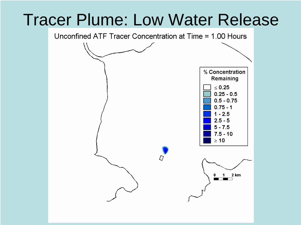
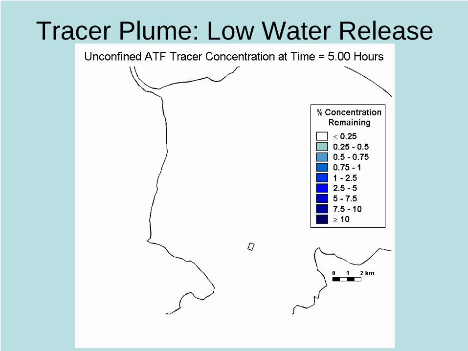
Tracer Plume: Low Water Release

Tracer Plume: Low Water Release
Tracer Plume: Low Water Release

Tracer Plume: Low Water Release

Tracer Plume: Low Water Release

Tracer Plume: Low Water Release

Tracer Plume: Low Water Release

Tracer Plume: Low Water Release

Tracer Plume: Low Water Release

Tracer Plume: Low Water Release
Tracer Plume: Low Water Release

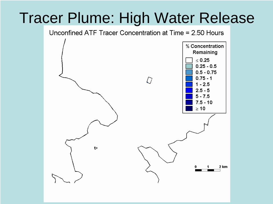
Tracer Plume: High Water Release

Tracer Plume: High Water Release

Tracer Plume: High Water Release

Tracer Plume: High Water Release

Tracer Plume: High Water Release
Tracer Plume: High Water Release

Tracer Plume: High Water Release

Tracer Plume: High Water Release

Tracer Plume: High Water Release
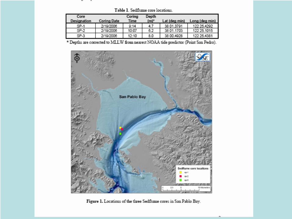
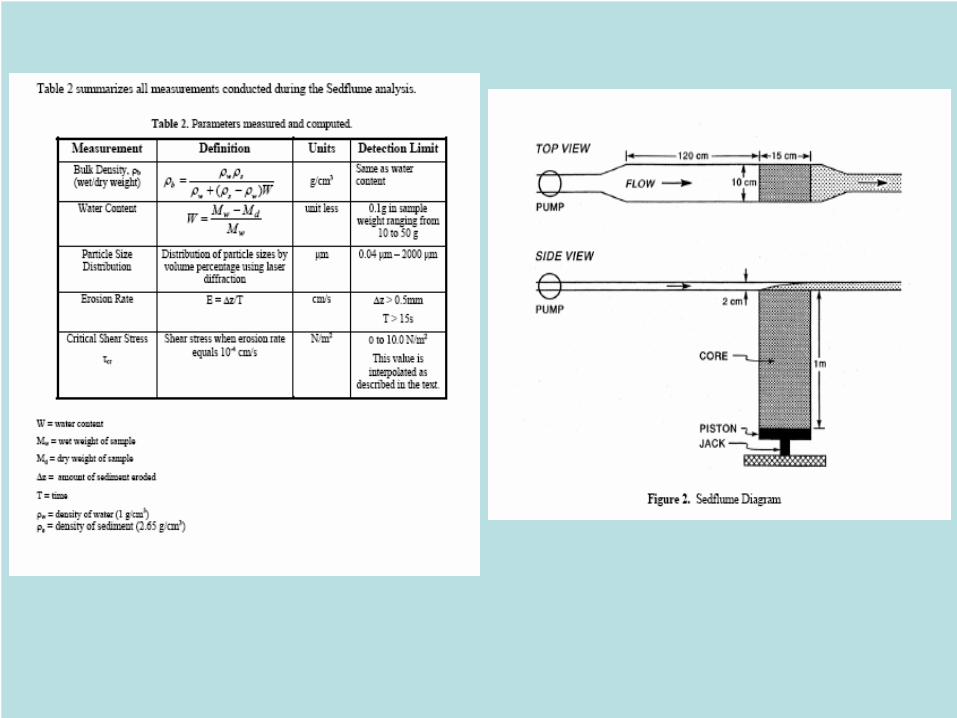

Sediment Cores•Grain size and Bulk density•Erosion Rates•Threshold Erosion Stress
Hydrodynamic Model•Near-bed velocities•Bed shear stresses
Sediment Transport Model•Erosion •Deposition
1. For full basins erosion depths based on 1-day consolidation of dredged sediment at ATF
Site 2 are comparable to erosion of native sediment. ATF Site 1 has over twice the maximum depth of erosion as the other Sites.
2. Erosion of dredged sediment consolidated over 1 day is nil for half- and full-depth ATF
basins at all locations.
3. Dredged sediment consolidated over 7 days and longer is much stiffer than the native material, likely due to the absence of a developed biotic community, and is essentially unerodable at all ATF Sites.
. 4. Deposition rates within half- and full-depth ATF basins would increase by at least a
factor of 3 over the natural setting at ATF Site 2, and by at least a factor of 20 at ATF Site 1.
Sediment Transport Modeling
Major Results

Erosion
Depositionlong term (Jaffe)
Depositionin ATF (Jones)

TECHNICAL STUDIES for the ALTERNATIVE TRANSFER FACILITY, HAMILTON WETLANDS RESTORATION PROJECT
David A. Cacchione, CME (Coastal & Marine Environments); Editor TABLE OF CONTENTS EXECUTIVE SUMMARY INTRODUCTION ENVIRONMENTAL SETTING CHAPTER 1. A History of Deposition, Erosion, and Mercury-Contaminated Hydraulic Mining Debris in the Region of the Proposed San Pablo Bay Aquatic Transfer Facility Bruce Jaffe and Theresa Fregoso, both at USGS Coastal and Marine Programs CHAPTER 2. Sediment Transport in San Pablo Bay
David H. Schoellhamer, Neil K. Ganju, and Gregory G. Shellenbarger; all at USGS Water Resources Division, Sacramento District
CHAPTER 3. Hydrodynamic Modeling of the Aqautic Tranfer Facility, San Pablo Bay, CA
Michael L. MacWilliams, Environmental Consultant, and Ralph T. Cheng, USGS Water Resources Division, National Research Program, Menlo Park, CA
CHAPTER 4. Aquatic Transfer Facility Sediment Transport Analysis Craig Jones, Sea Engineering Inc., Santa Cruz, CA CHAPTER 5. HAMILTON WETLAND RESTORATION PROJECT
STFATE Evaluation Environmental Research and Development Center, ACOE, Vicksburg, MS