Embed Size (px)
Citation preview
FPN/2014
Capt. Fritz Ploug Nielsen
FPN/2014
66 years old Graduate from Copenhagen Navigationsschool in 1971 and shortly after started as Nav.off in a private company A.E.Sørensen sailing in Greenland waters, and in december 1972 I joined KGH (Kongelige grønlandske Handel) and after 40 Years Arctic service in KGH , KNI and last Royal Arctic Line I retired in december 2012. Under my duty in 40 Years I joined 22 Years as Captain, and it was mostly at the eastcoast and Northwestgreenland I sailed. Under those Years I joined the Ice Patrol in Narssarssuaq for 2 Years and I was Super Cargo/Kendtmand/Ice Adviser for several years. The last 2 Years I have sailed as Ice Navigator with large cruise ships in the summertime and work for The Danish Geodata Agency making/update a new Electronic Harbour Pilot , which should be in the air late this Year.
Navigation around Greenland is markedly different from sailing in non-Arctic waters. It is generally difficult to navigate near Greenland for mariners who are not familiar with the conditions. This is partly due to the climate and the influence of the weather, but is also due to the fact that instruments such as compasses may become unreliable so far north. At the same time, the vastness of the sea area and the Greenland archipelago means that there are many places along the coast of Greenland, where no systematic and comprehensive surveys have been done. This means that there are still areas where the nature of the seabed is unknown. 1. A 26/Res.1024 - Guidelines for Ships Operating in Polar Waters (18 January
2010) 2.
MSC.1-Circ.1056 - MEPC.1-Circ.399 - Guidelines For Ships Operating In Arctic Ice-Covered Waters (23 December 2002)
FPN/2014
Navigational Safety
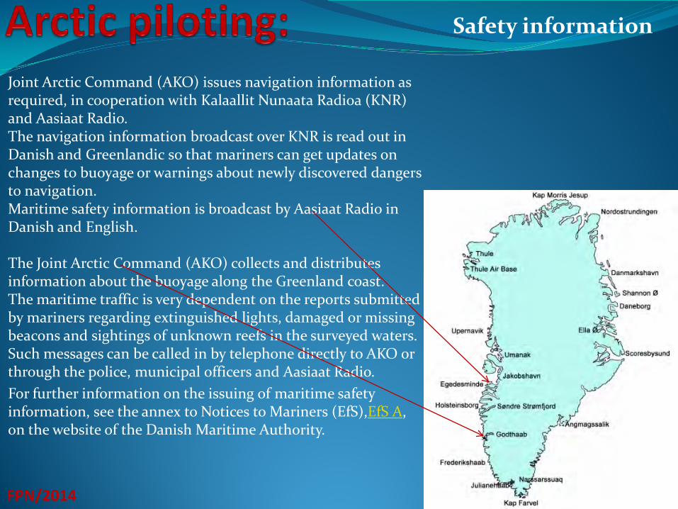
Joint Arctic Command (AKO) issues navigation information as required, in cooperation with Kalaallit Nunaata Radioa (KNR) and Aasiaat Radio. The navigation information broadcast over KNR is read out in Danish and Greenlandic so that mariners can get updates on changes to buoyage or warnings about newly discovered dangers to navigation. Maritime safety information is broadcast by Aasiaat Radio in Danish and English. The Joint Arctic Command (AKO) collects and distributes information about the buoyage along the Greenland coast. The maritime traffic is very dependent on the reports submitted by mariners regarding extinguished lights, damaged or missing beacons and sightings of unknown reefs in the surveyed waters. Such messages can be called in by telephone directly to AKO or through the police, municipal officers and Aasiaat Radio. For further information on the issuing of maritime safety information, see the annex to Notices to Mariners (EfS),EfS A, on the website of the Danish Maritime Authority.
FPN/2014
Safety information
FPN/2014
Many areas of the world, including Greenland, use the international system, NAVTEX, for broadcasting important and vital information to the maritime traffic. The NAVTEX system is part of the Global Maritime Distress and Safety System, GMDSS, and must be available on all cargo ships in international trade, on all passenger ships and on the largest fishing vessels. Greenland waters are covered by 2 transmitters located in Iceland at Grindavik and Saudarnes (East Greenland) and 3 transmitters located at Simiutaq, Nuuk, and Upernavik respectively (West Greenland). The broadcasts are operated remotely from the Joint Arctic Command (AKO). It is therefore the Maritime Rescue Coordinator Centre Nuuk (MRCC Nuuk) that edits and transmits the safety messages via NAVTEX. For details on the NAVTEX system’s categories of messages and broadcast hours and areas, see the annex to Notices to Mariners (EfS), EfS A, on the website of the Danish Maritime Authority. Broadcast hours and areas are also listed in the radio handbooks, for example UKHO NP285, Admiralty List of Radio Signals, Volume 5 - Global Maritime Distress and Safety System (GMDSS).
Navtex:
FPN/2014
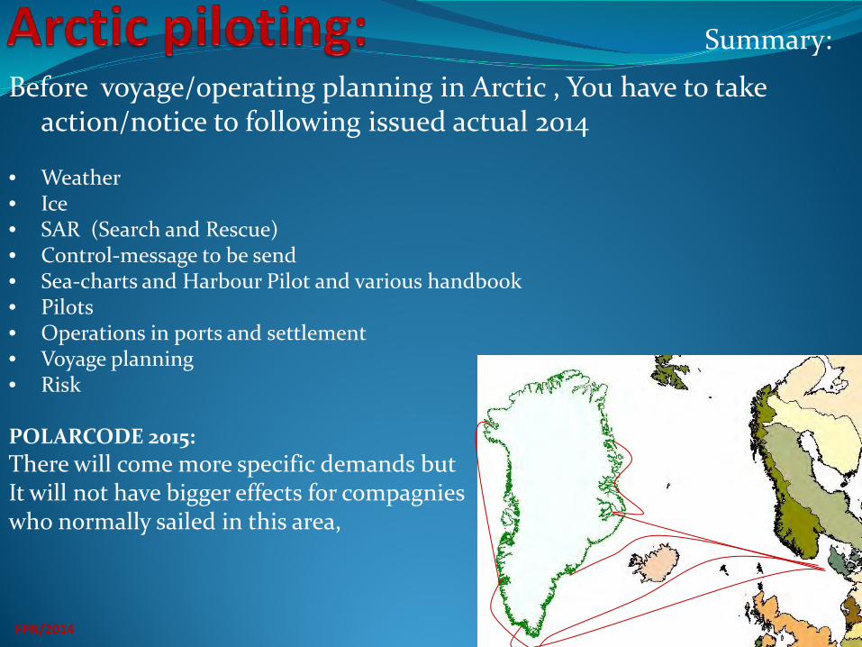
Before voyage/operating planning in Arctic , You have to take action/notice to following issued actual 2014
• Weather • Ice • SAR (Search and Rescue) • Control-message to be send • Sea-charts and Harbour Pilot and various handbook • Pilots • Operations in ports and settlement • Voyage planning • Risk
POLARCODE 2015: There will come more specific demands but It will not have bigger effects for compagnies who normally sailed in this area,
Summary:
Weather service :
FPN/2014
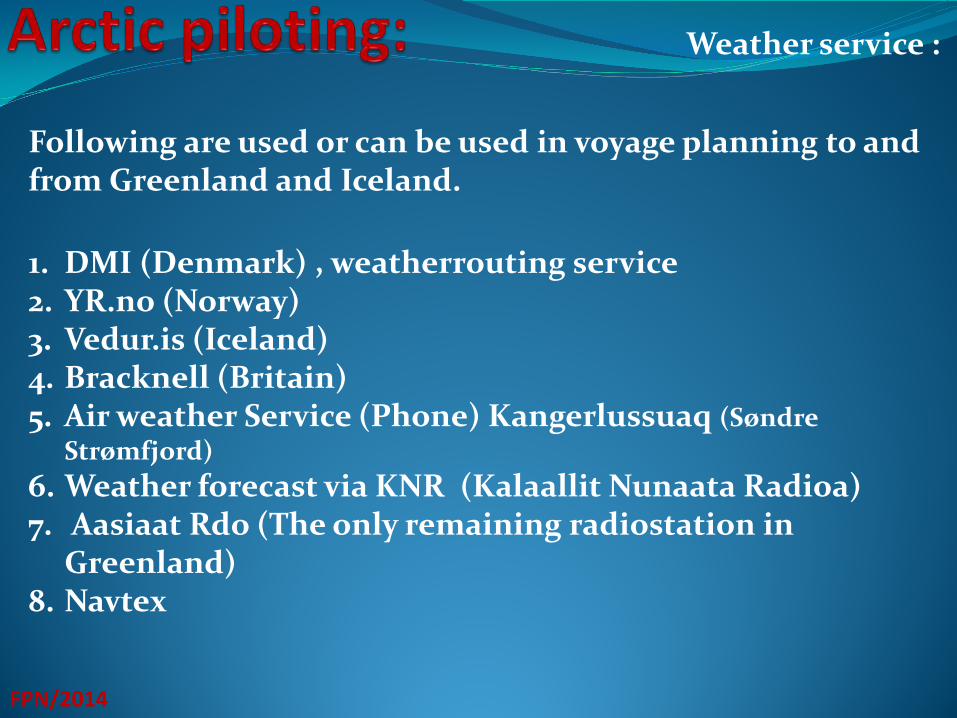
1. DMI (Denmark) , weatherrouting service 2. YR.no (Norway) 3. Vedur.is (Iceland) 4. Bracknell (Britain) 5. Air weather Service (Phone) Kangerlussuaq (Søndre
Strømfjord) 6. Weather forecast via KNR (Kalaallit Nunaata Radioa) 7. Aasiaat Rdo (The only remaining radiostation in
Greenland) 8. Navtex
Following are used or can be used in voyage planning to and from Greenland and Iceland.
Weather on route:
FPN/2014
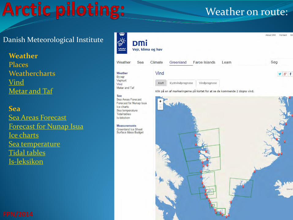
Danish Meteorological Institute
Weather Places Weathercharts Vind Metar and Taf Sea Sea Areas Forecast Forecast for Nunap Isua Ice charts Sea temperature Tidal tables Is-leksikon
Weather on route:
FPN/2014
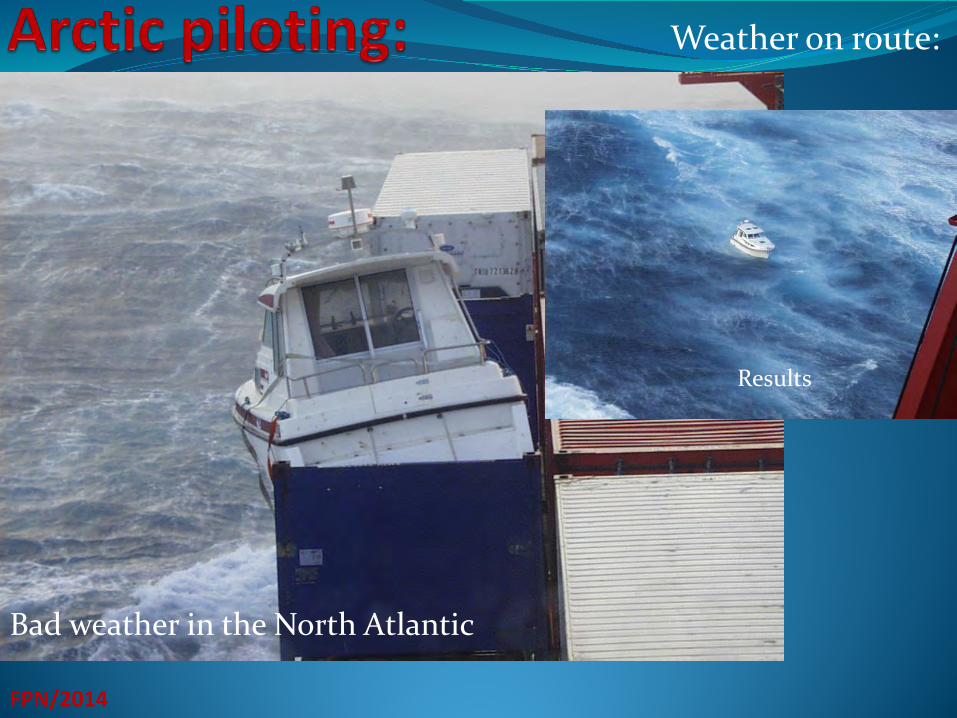
Bad weather in the North Atlantic
Results
Weather on route:
FPN/2014
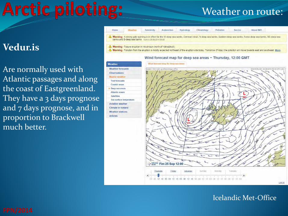
Vedur.is Are normally used with Atlantic passages and along the coast of Eastgreenland. They have a 3 days prognose and 7 days prognose, and in proportion to Brackwell much better.
Icelandic Met-Office
Weather on route:
FPN/2014
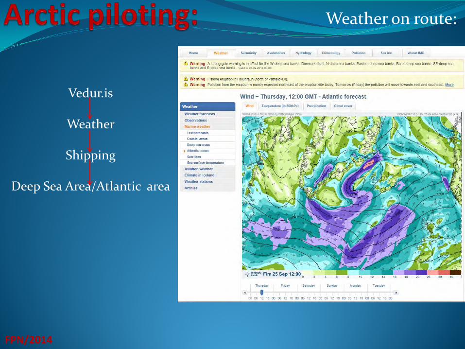
Vedur.is
Weather
Shipping
Deep Sea Area/Atlantic area
Weather on route:
FPN/2014
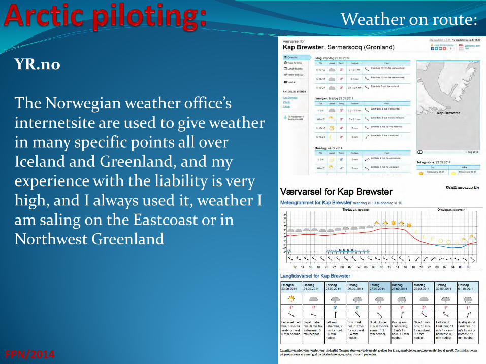
YR.no The Norwegian weather office’s internetsite are used to give weather in many specific points all over Iceland and Greenland, and my experience with the liability is very high, and I always used it, weather I am saling on the Eastcoast or in Northwest Greenland
FPN/2014
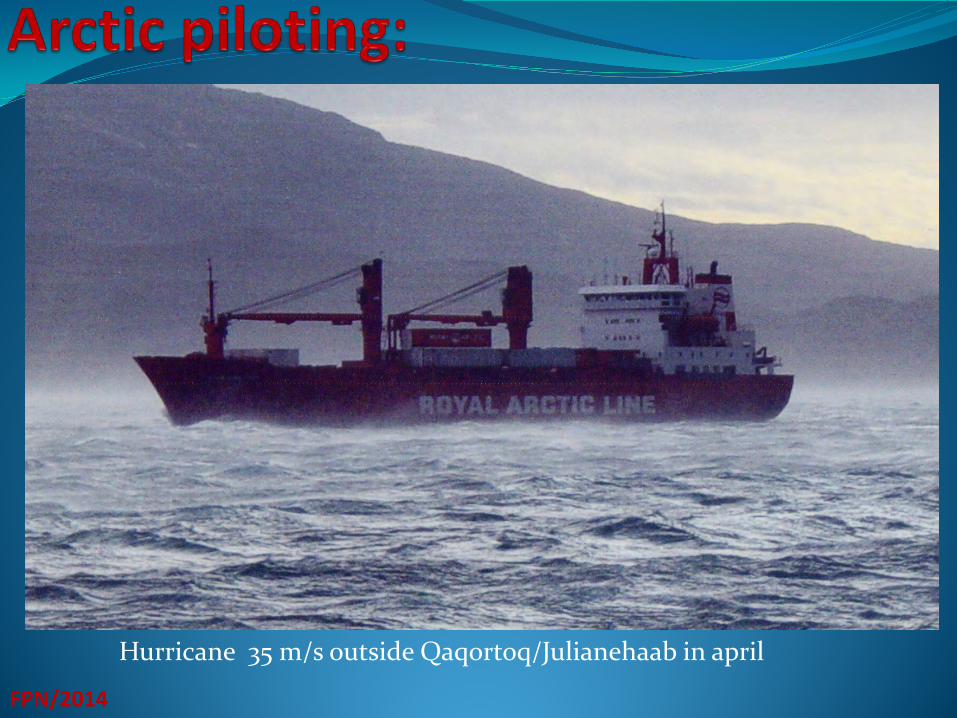
Hurricane 35 m/s outside Qaqortoq/Julianehaab in april
Ice:
FPN/2014
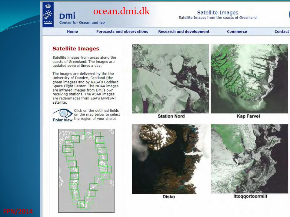
1. DMI’s internetsite 2. Iscentralen for Greenland approches 3. ArcticWeb (icecharts from DMI) 4. Ocean.dmi.dk (satelitepicture from specific areas in Greenland)
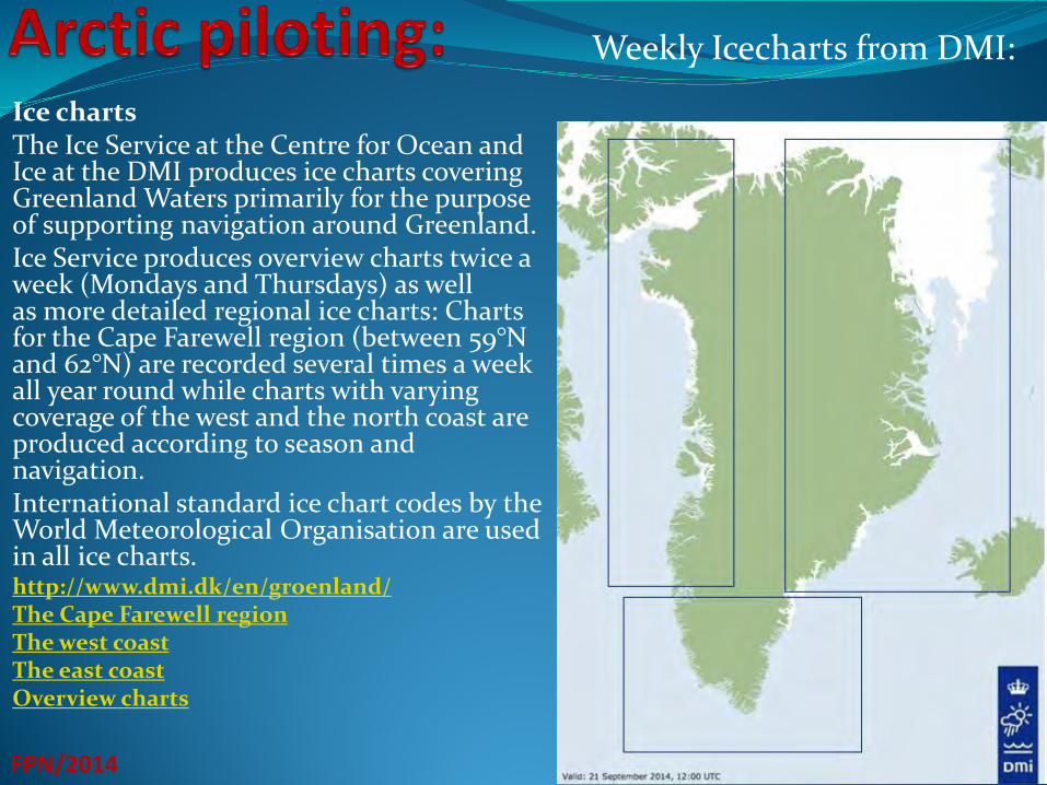
Ice charts The Ice Service at the Centre for Ocean and Ice at the DMI produces ice charts covering Greenland Waters primarily for the purpose of supporting navigation around Greenland. Ice Service produces overview charts twice a week (Mondays and Thursdays) as well as more detailed regional ice charts: Charts for the Cape Farewell region (between 59°N and 62°N) are recorded several times a week all year round while charts with varying coverage of the west and the north coast are produced according to season and navigation. International standard ice chart codes by the World Meteorological Organisation are used in all ice charts. http://www.dmi.dk/en/groenland/ The Cape Farewell region The west coast The east coast Overview charts FPN/2014
Weekly Icecharts from DMI:
FPN/2014
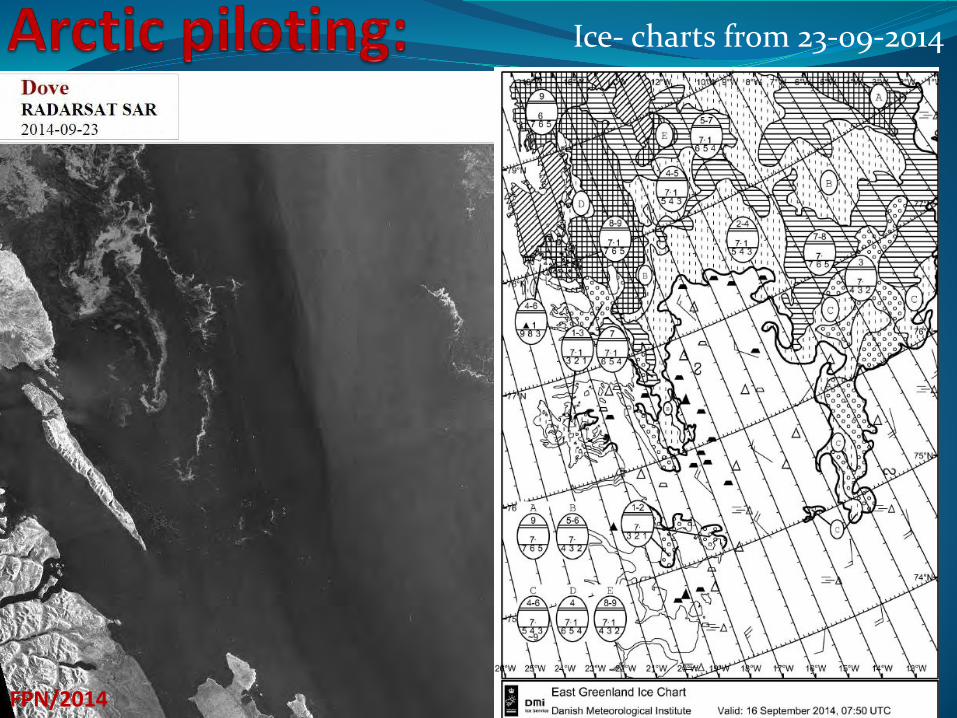
Ice- charts from 23-09-2014
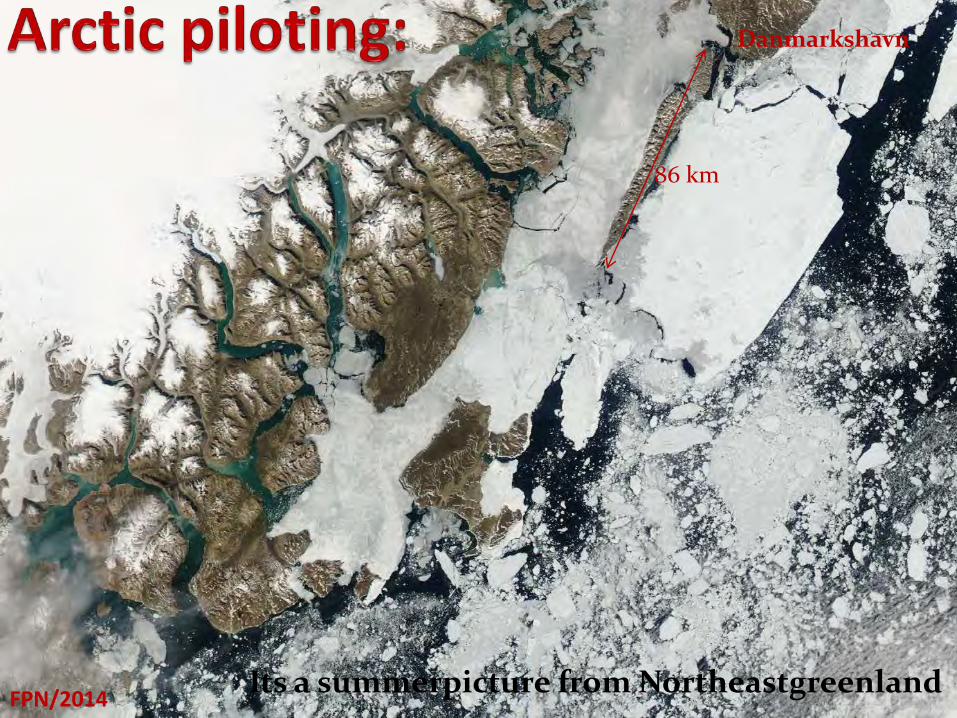
Its a summerpicture from Northeastgreenland FPN/2014
86 km
Danmarkshavn
Satelite picture:
FPN/2014
ocean.dmi.dk

Icecentral in Narssarssuaq
FPN/2014
In january 1959 m/s ”Hans Hedtoft” KGH were lost in Cape Farewell area in a hurricane on her maiden voyage back to Denmark . After this tragedy the Danish Goverment establish the Ice Central. The first danish icerecco from Narssarssuaq was carried out the 30’ of November 1959. The Ice Central is situated in Narssarssuaq in Southgreenland and is a part of DMI’s Center for Ocean and Ice. In the beginning icerecco was carried out with DC4 and later Tween-otter airplanes out-skerries and small helicopters in-skerries, but now all icerecco out-skerries are based on satelite, but at least 2-3 times a week, icerecco are carried out in-skerries in Julianehaabs Bay(if the weather permit). Personel on the IceCentral has allways been navigators from KGH, KNI and Royal Arctic Line, and they have normally a periode of 2 to 3 years duty.
SAR (Search and Rescue)
FPN/2014
Rescue Service The management of the search and rescue service (SAR) in Greenland is divided between the Joint Arctic Command (AKO), the Air Rescue Coordination Centre in Kangerlussuaq and the Chief Constable of Greenland. The Joint Arctic Command, which staffs the Maritime Rescue Coordination Centre Nuuk (MRCC Nuuk), is responsible for the management of the maritime rescue service, meaning search and rescue operations involving distressed vessels of any kind, above or below sea level, irrespective of whether the relief measures are carried out at sea, from the air or on land. The Danish Transport Authority is responsible for the management of the air navigation service, meaning search and rescue operations for people in distress by aircraft, whether the relief measures are carried out from the air, at sea or on land. The Chief Constable of Greenland is responsible for the management of the local rescue service, meaning search and rescue operations in local waters and for search and rescue operations on land. The Joint Arctic Command has operational control of all Danish vessels deployed in search and rescue operations, and is authorized to assign such resources to specific search areas. Each ship’s master, however, has full responsibility at all times for their own ship and crew.
The International Maritime Organization (IMO) has prepared guidelines that provide relevant information for ships intending to navigate in Greenland waters. These guidelines are available here:
FPN/2014
SAR (Search and Rescue)
1. MSC.1/Circ.1184 - Enhanced Contingency Planning Guidelines for Passenger Ships Operating in Areas Remote from SAR Facilities (31 May 2006)
2. MSC.1/Circ.1185 – Guide for Cold Water Survival (31 May 2006)
Present, there are not many ships or helicopter in rescueduty in the Greenland waters. The Danish Navy have 1 (2) bigger and 2 smaller inspectionsship /vessels stationering on both coast in the summertime,. The Police in Greenland have 4 small cutters stationering on the westcoast Air Greenland has one S-61 helicopter with hoist
Voyage control messages:
FPN/2014
Radio Reporting Services Note the IMO-adopted ship reporting systems GREENPOS and COASTAL CONTROL. The GREENPOS system is mandatory for all ships sailing to or from Greenland waters within the Greenland continental shelf or EEZ. GREENPOS reports must be sent to the Joint Arctic Command (AKO), if necessary via the coastal radio stations. COASTAL CONTROL reports apply to any ship of 20 GT or more and fishing vessels sailing between Greenland ports and landing sites. These vessels must submit COASTAL CONTROL reports to the coastal radio. AKO encourages ships navigating the Atlantic Ocean within the Greenland EEZ, including cruise ships and research vessels, to remain in the GREENPOS system during their entire voyage. Based on the reports received, AKO and the coastal radio will keep track of the position in Greenland waters of ships participating in the reporting system, so that a search and rescue operation can be established at any given time. For details about GREENPOS and COASTAL CONTROL, including the compilation of sailing schedules and reports, see the annex to Notices to Mariners (EfS), EfS A, on the website of the Danish Maritime Authority. The website also features information on the radio reporting service AMVER, which is administered by the U.S. Coast Guard and is open to all ships in the Atlantic Ocean.
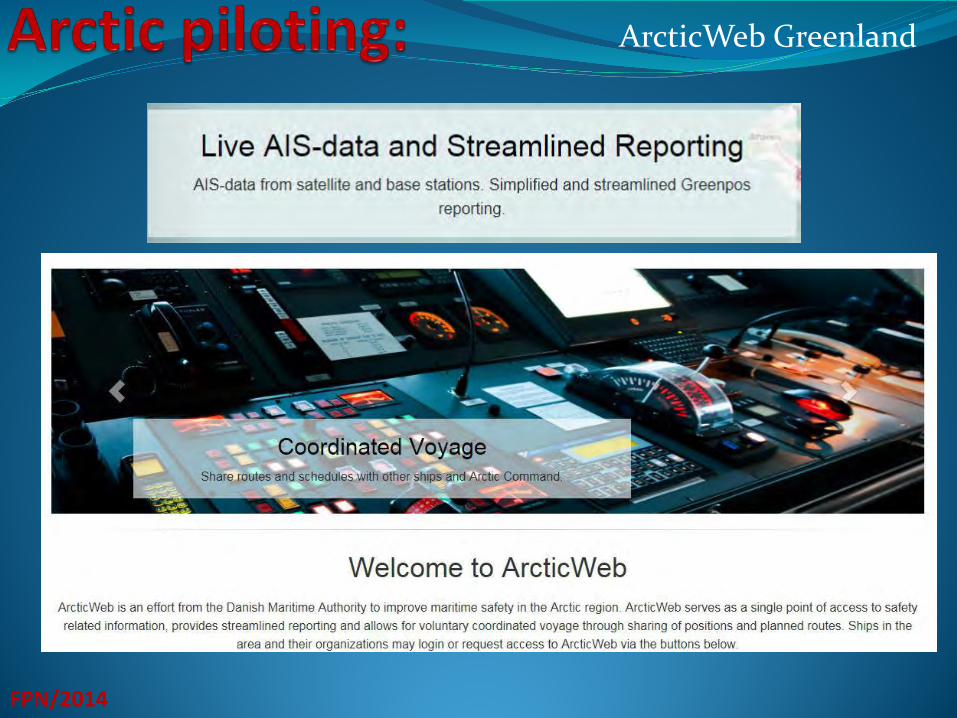
ArcticWeb Greenland
FPN/2014
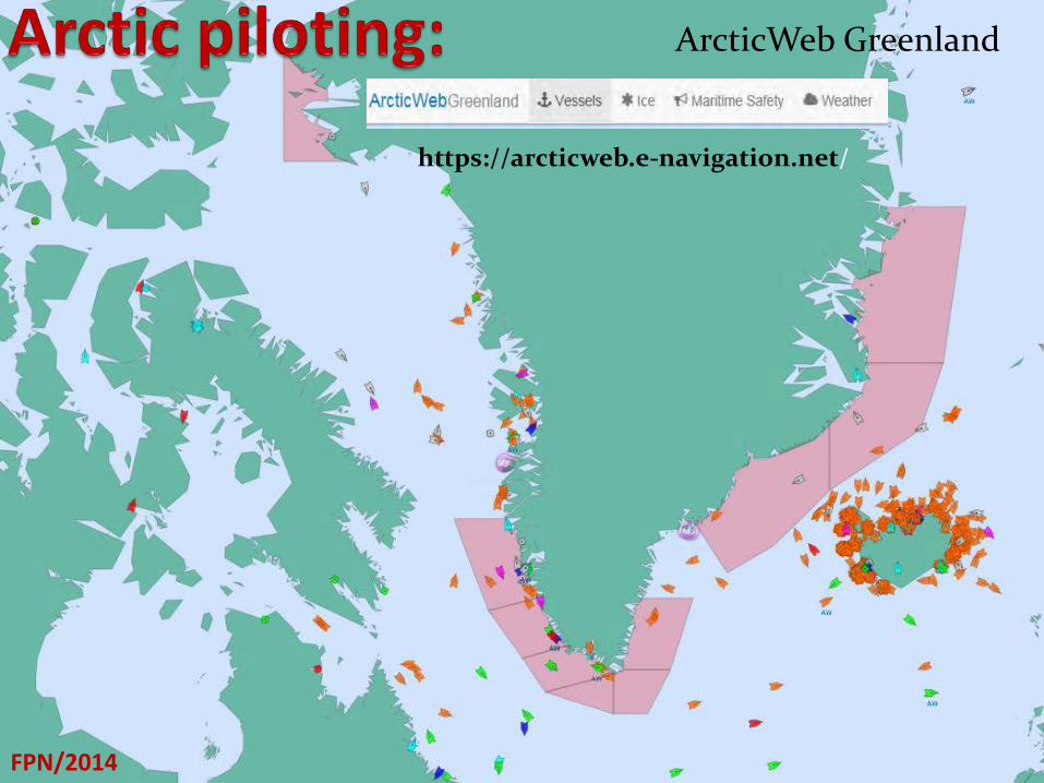
ArcticWeb Greenland
FPN/2014
https://arcticweb.e-navigation.net/
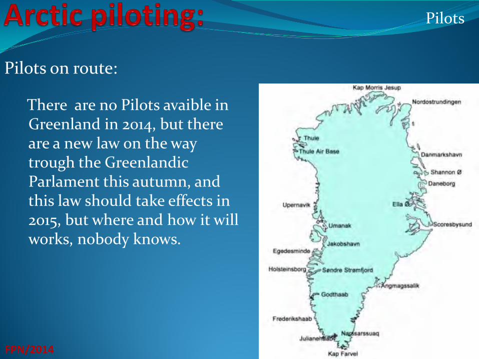
Pilots on route:
FPN/2014
There are no Pilots avaible in Greenland in 2014, but there are a new law on the way trough the Greenlandic Parlament this autumn, and this law should take effects in 2015, but where and how it will works, nobody knows.
Pilots
Seacharts
FPN/2014
Navigational Planning Mariners can obtain information for the safe navigation in charts and nautical publications. The Danish Geodata Agency publishes the official paper charts, electronic navigational charts (ENC) and nautical publications of the Greenland waters. Mariners should be aware that the majority of the paper charts for Greenland were originally compiled in the 1960s. The source material on which these paper charts are based had limitations, especially with regard to their geometric accuracy. The positioning of the information in these paper charts (i.e. topography, including the coastline, and hydrography) is therefore not accurate. Since the positioning accuracy that can be achieved with satellite navigation systems (for instance GPS) is better than that of the paper charts, mariners are advised to use sources of positional information other than satellite navigation systems.
Precautions in using navigational charts in Greenland waters
GUIDELINES ON VOYAGE PLANNING FOR PASSENGER SHIPS OPERATING IN REMOTE AREAS
SeaCharts
FPN/2014
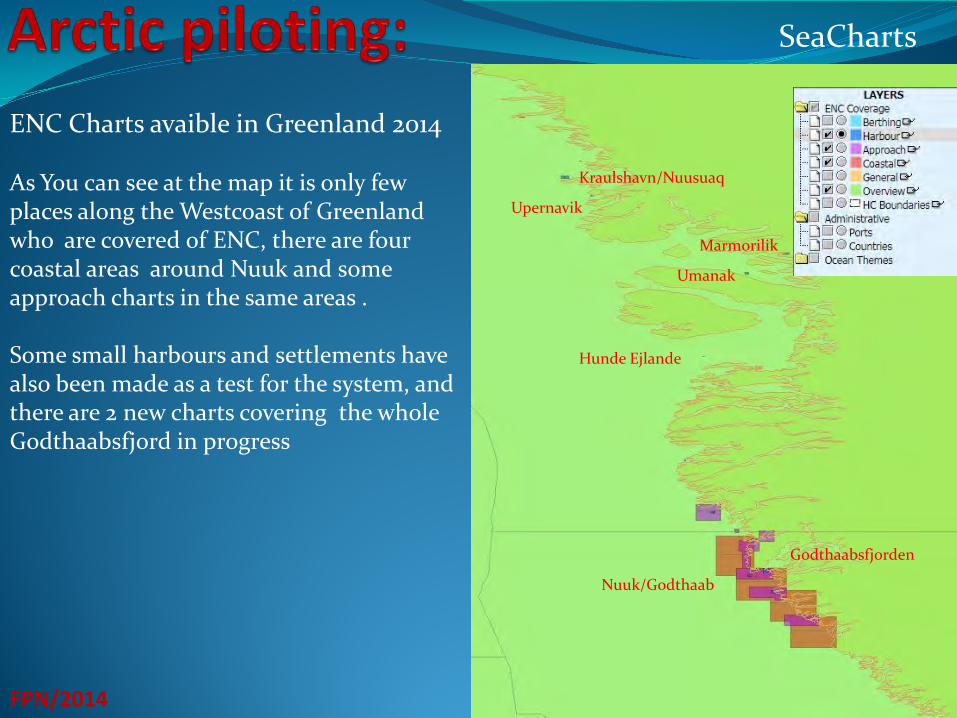
ENC Charts avaible in Greenland 2014 As You can see at the map it is only few places along the Westcoast of Greenland who are covered of ENC, there are four coastal areas around Nuuk and some approach charts in the same areas . Some small harbours and settlements have also been made as a test for the system, and there are 2 new charts covering the whole Godthaabsfjord in progress
Umanak
Upernavik
Kraulshavn/Nuusuaq
Hunde Ejlande
Marmorilik
Godthaabsfjorden
Nuuk/Godthaab
:
FPN/2014
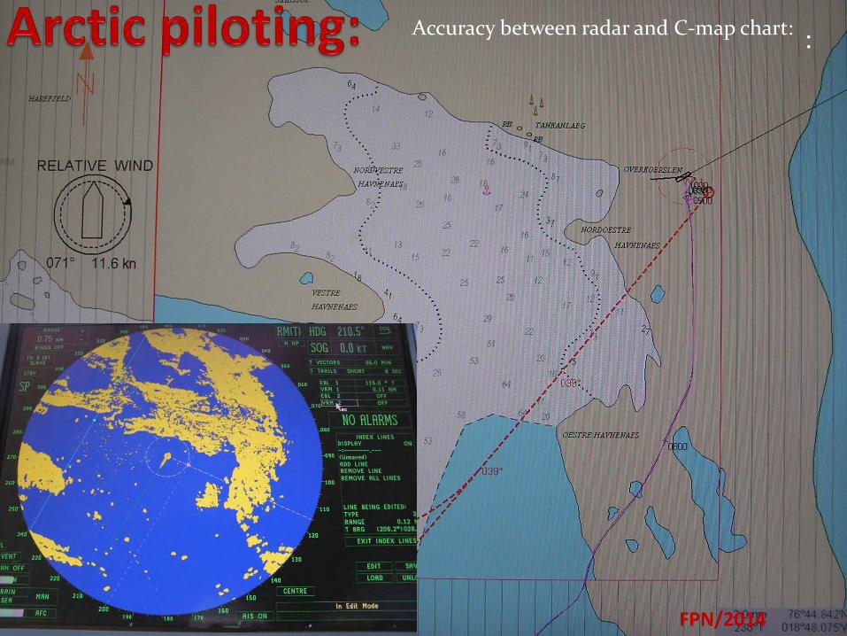
Accuracy between radar and C-map chart:
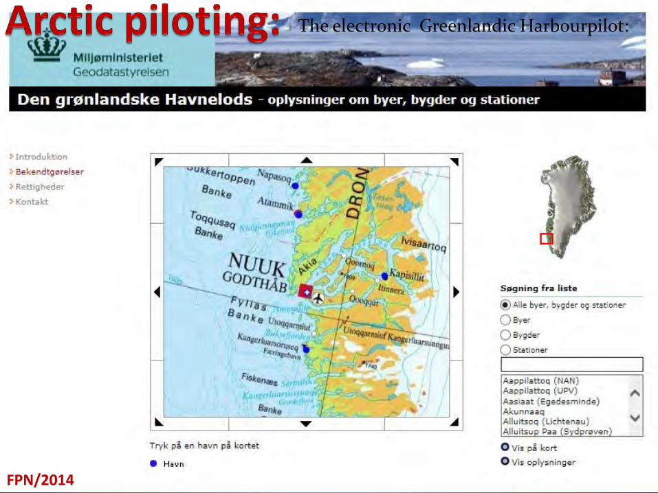
The electronic Greenlandic Harbourpilot:
FPN/2014
The electronic Greenlandic Harbourpilot:
FPN/2014
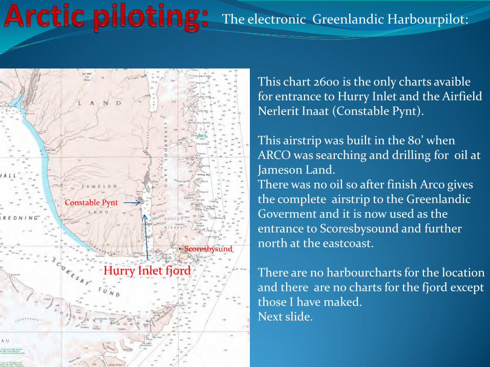
Constable Pynt
Scoresbysund
Hurry Inlet fjord
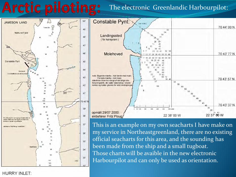
This chart 2600 is the only charts avaible for entrance to Hurry Inlet and the Airfield Nerlerit Inaat (Constable Pynt). This airstrip was built in the 80’ when ARCO was searching and drilling for oil at Jameson Land. There was no oil so after finish Arco gives the complete airstrip to the Greenlandic Goverment and it is now used as the entrance to Scoresbysound and further north at the eastcoast. There are no harbourcharts for the location and there are no charts for the fjord except those I have maked. Next slide.
The electronic Greenlandic Harbourpilot:
FPN/2014
This is an example on my own seacharts I have make on my service in Northeastgreenland, there are no existing official seacharts for this area, and the sounding has been made from the ship and a small tugboat. Those charts will be avaible in the new electronic Harbourpilot and can only be used as orientation.
Operation in Greenlandic ports:
FPN/2014
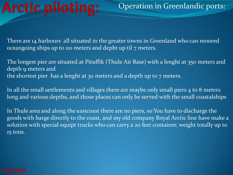
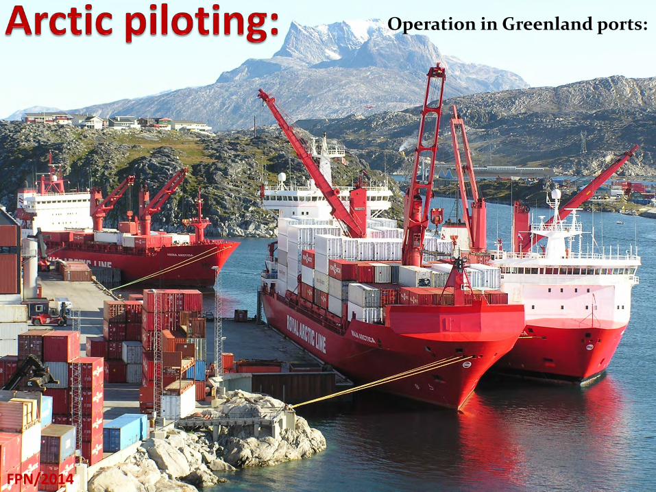
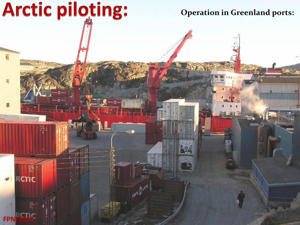
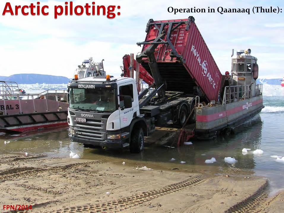
There are 14 harbours all situated in the greater towns in Greenland who can moored oceangoing ships up to 110 meters and depht up til 7 meters. The longest pier are situated at Pituffik (Thule Air Base) with a lenght at 350 meters and depth 9 meters and the shortest pier has a lenght at 30 meters and a depth up to 7 meters. In all the small settlements and villages there are maybe only small piers 4 to 8 meters long and various depths, and those places can only be served with the small coastalships In Thule area and along the eastcoast there are no piers, so You have to discharge the goods with barge directly to the coast, and my old company Royal Arctic line have make a solution with special equipt trucks who can carry a 20 feet container, weight totally up to 15 tons.
Operation in Greenland ports:
FPN/2014
Operation in Greenland ports:
FPN/2014
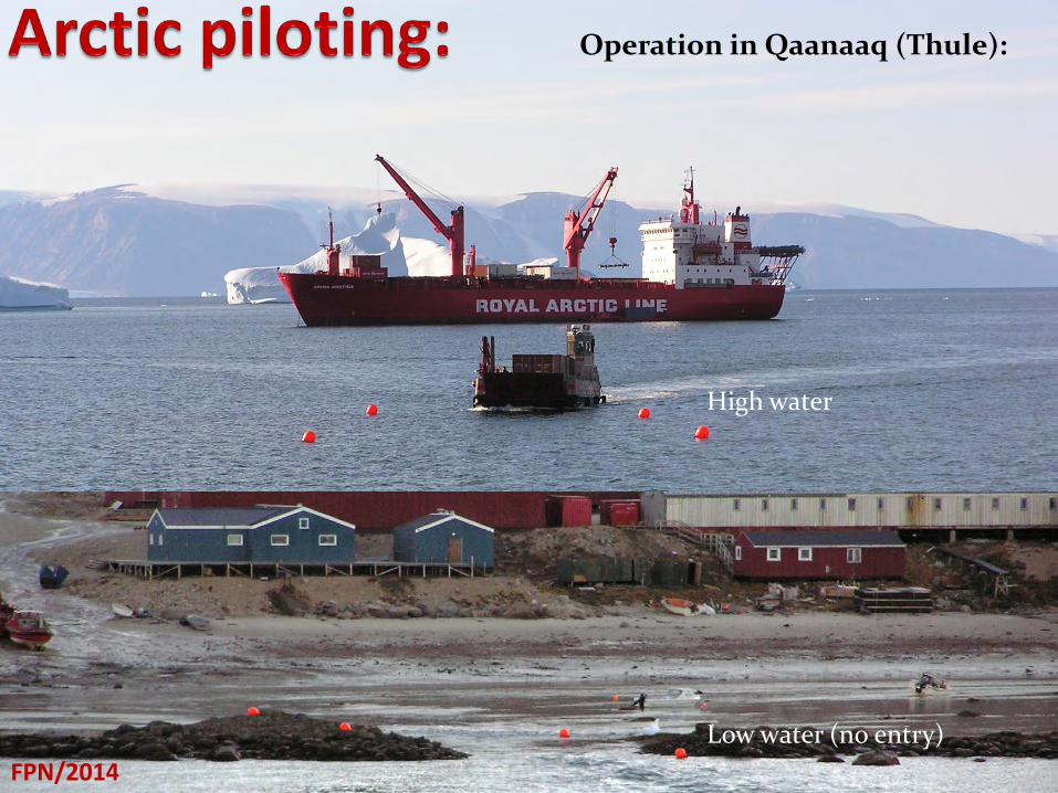
Operation in Qaanaaq (Thule):
FPN/2014 FPN/2014
High water
Low water (no entry)
FPN/2014
Operation in Qaanaaq (Thule):
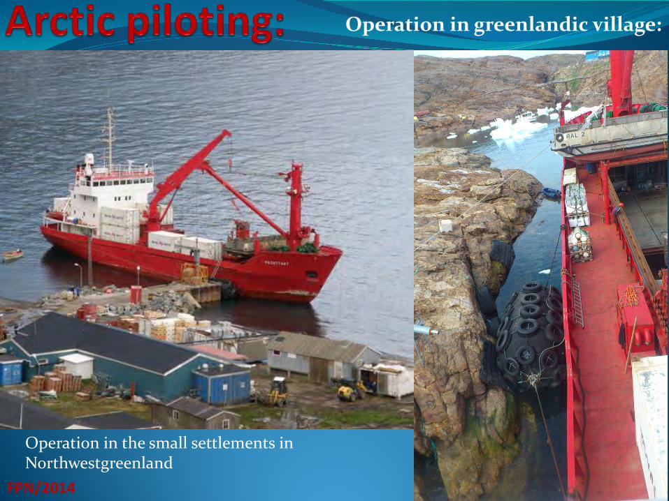
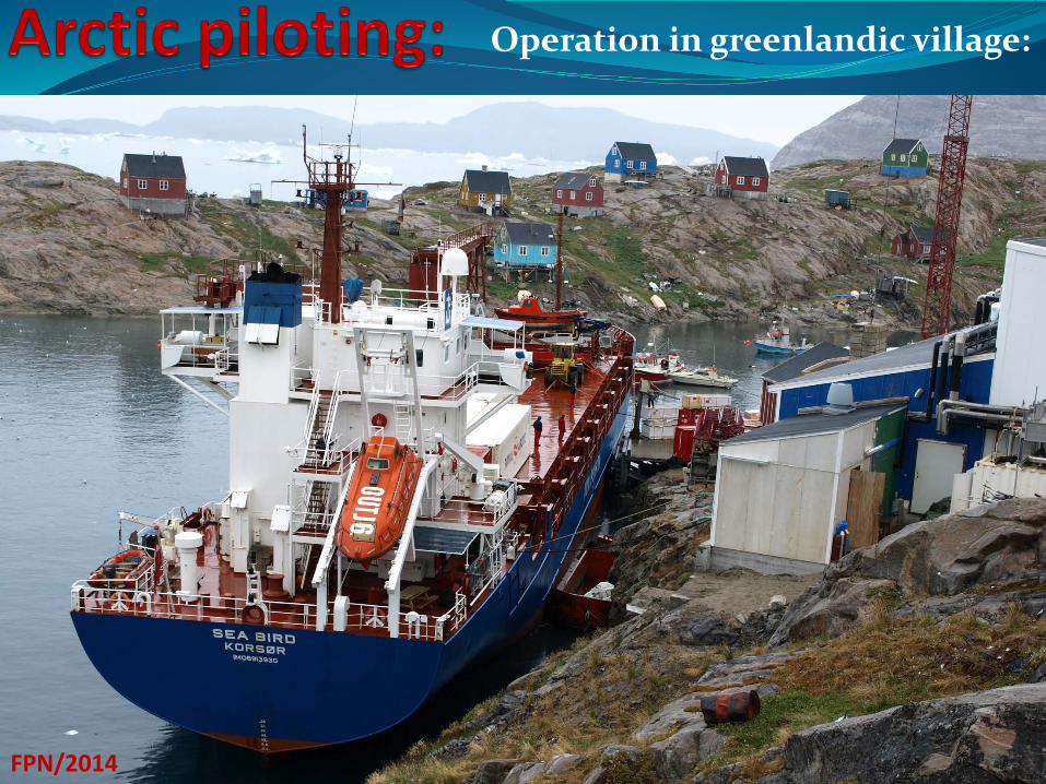
Operation in greenlandic village:
FPN/2014
Operation in the small settlements in Northwestgreenland
Operation in greenlandic village:
FPN/2014
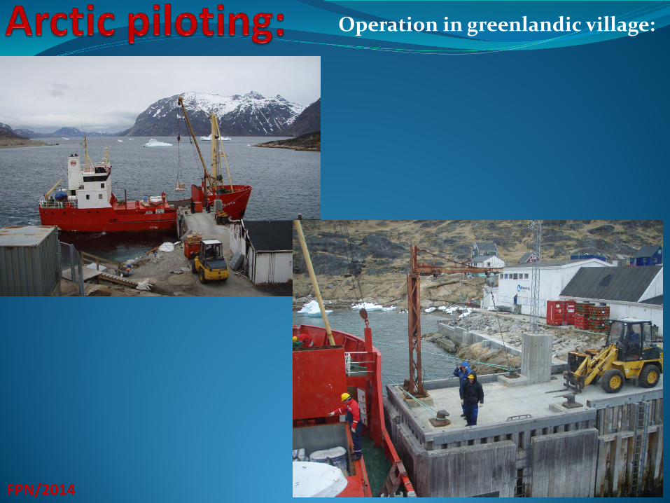
Operation in greenlandic village:
FPN/2014
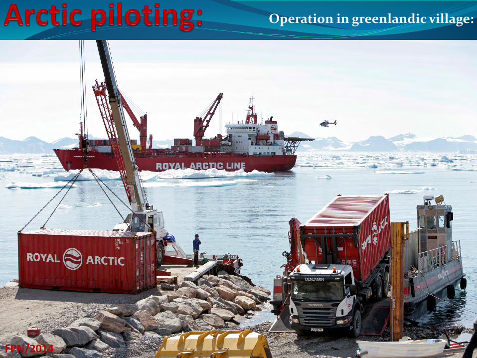
Operation in greenlandic village:
FPN/2014
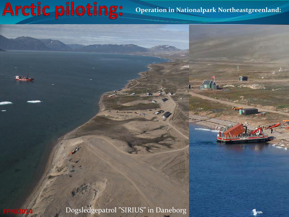
Operation in Nationalpark Northeastgreenland:
FPN/2014 Dogsledgepatrol ”SIRIUS” in Daneborg
Operation in ports:
FPN/2014
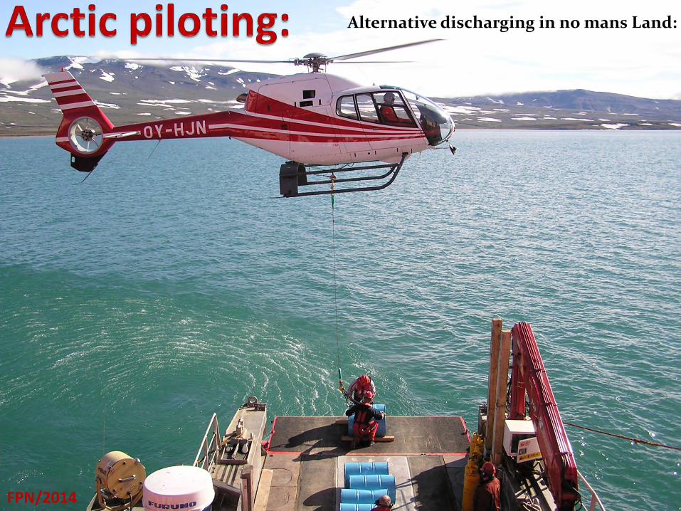
Alternative discharging in no mans Land:
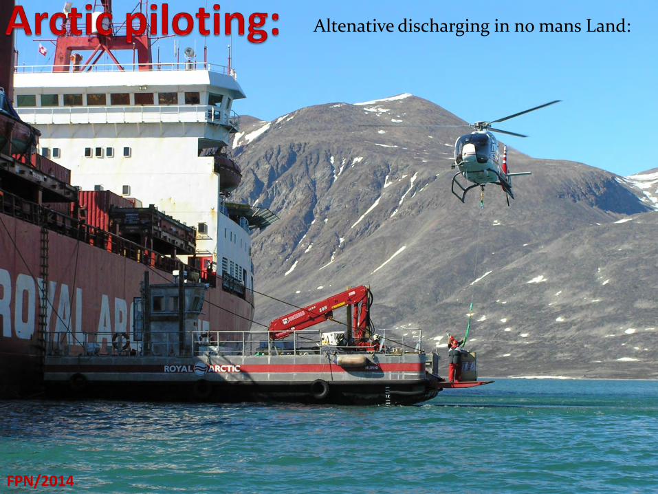
Altenative discharging in no mans Land:
FPN/2014

Altenative discharging in no mans Land:
FPN/2014
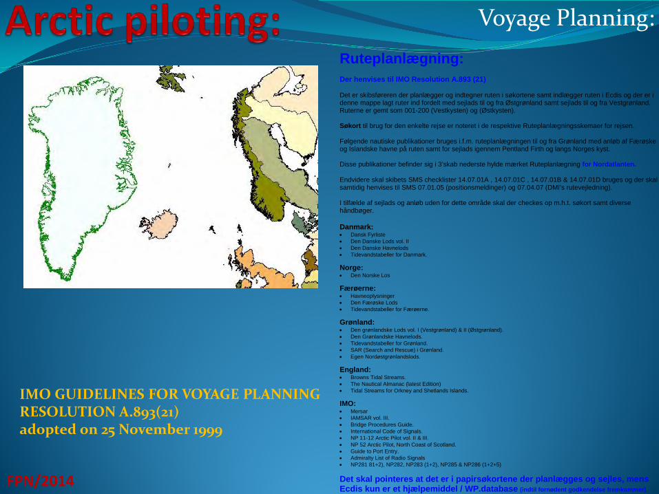
Voyage Planning:
FPN/2014
Ruteplanlægning: Der henvises til IMO Resolution A.893 (21) Det er skibsføreren der planlægger og indtegner ruten i søkortene samt indlægger ruten i Ecdis og der er i denne mappe lagt ruter ind fordelt med sejlads til og fra Østgrønland samt sejlads til og fra Vestgrønland. Ruterne er gemt som 001-200 (Vestkysten) og (Østkysten). Søkort til brug for den enkelte rejse er noteret i de respektive Ruteplanlægningsskemaer for rejsen. Følgende nautiske publikationer bruges i.f.m. ruteplanlægningen til og fra Grønland med anløb af Færøske og Islandske havne på ruten samt for sejlads igennem Pentland Firth og langs Norges kyst. Disse publikationer befinder sig i 3’skab nederste hylde mærket Ruteplanlægning for Nordatlanten. Endvidere skal skibets SMS checklister 14.07.01A , 14.07.01C , 14.07.01B & 14.07.01D bruges og der skal samtidig henvises til SMS 07.01.05 (positionsmeldinger) og 07.04.07 (DMI’s rutevejledning). I tilfælde af sejlads og anløb uden for dette område skal der checkes op m.h.t. søkort samt diverse håndbøger. Danmark: • Dansk Fyrliste • Den Danske Lods vol. II • Den Danske Havnelods • Tidevandstabeller for Danmark. Norge: • Den Norske Los Færøerne: • Havneoplysninger • Den Færøske Lods • Tidevandstabeller for Færøerne. Grønland: • Den grønlandske Lods vol. I (Vestgrønland) & II (Østgrønland). • Den Grønlandske Havnelods. • Tidevandstabeller for Grønland. • SAR (Search and Rescue) i Grønland. • Egen Nordøstgrønlandslods. England: • Browns Tidal Streams. • The Nautical Almanac (latest Edition) • Tidal Streams for Orkney and Shetlands Islands. IMO: • Mersar • IAMSAR vol. III. • Bridge Procedures Guide. • International Code of Signals. • NP 11-12 Arctic Pilot vol. II & III. • NP 52 Arctic Pilot, North Coast of Scotland. • Guide to Port Entry. • Admiralty List of Radio Signals • NP281 81+2), NP282, NP283 (1+2), NP285 & NP286 (1+2+5) Det skal pointeres at det er i papirsøkortene der planlægges og sejles, mens Ecdis kun er et hjælpemiddel / WP.database (indtil fornødent godkendelse fremkommer).
IMO GUIDELINES FOR VOYAGE PLANNING RESOLUTION A.893(21) adopted on 25 November 1999
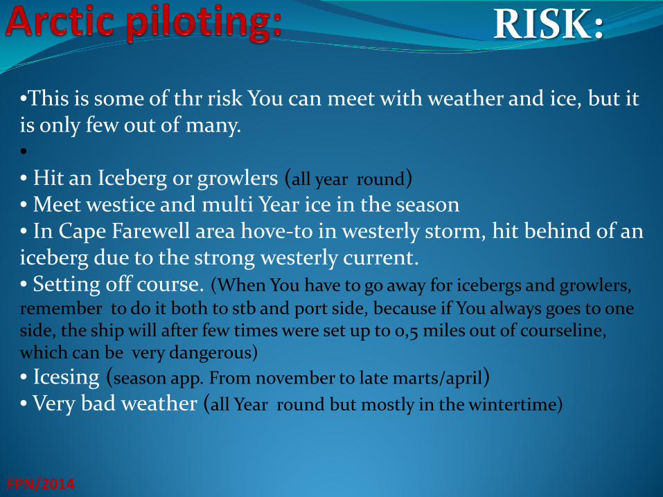
RISK:
FPN/2014
•This is some of thr risk You can meet with weather and ice, but it is only few out of many. • • Hit an Iceberg or growlers (all year round) • Meet westice and multi Year ice in the season • In Cape Farewell area hove-to in westerly storm, hit behind of an iceberg due to the strong westerly current. • Setting off course. (When You have to go away for icebergs and growlers, remember to do it both to stb and port side, because if You always goes to one side, the ship will after few times were set up to 0,5 miles out of courseline, which can be very dangerous) • Icesing (season app. From november to late marts/april) • Very bad weather (all Year round but mostly in the wintertime)
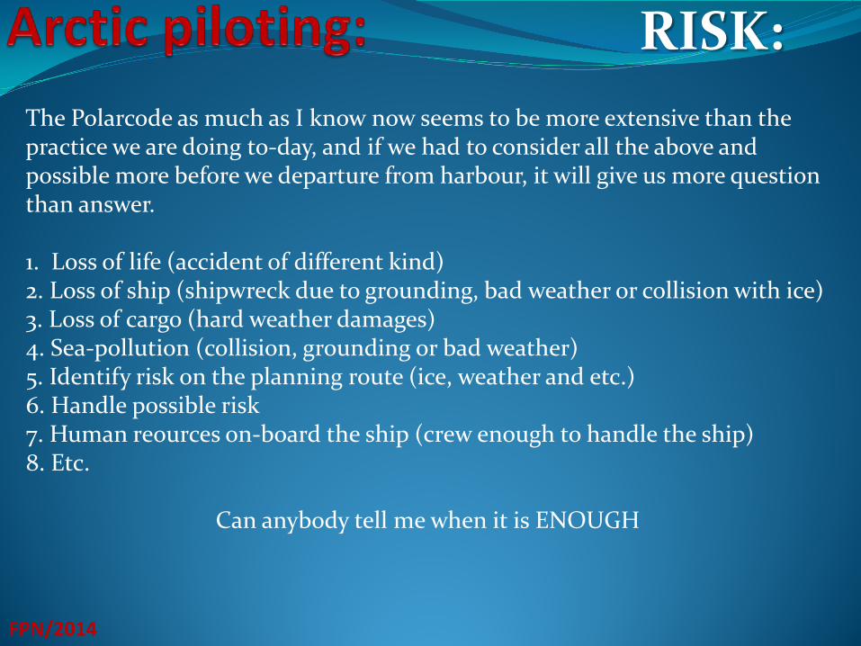
RISK:
FPN/2014
The Polarcode as much as I know now seems to be more extensive than the practice we are doing to-day, and if we had to consider all the above and possible more before we departure from harbour, it will give us more question than answer. 1. Loss of life (accident of different kind) 2. Loss of ship (shipwreck due to grounding, bad weather or collision with ice) 3. Loss of cargo (hard weather damages) 4. Sea-pollution (collision, grounding or bad weather) 5. Identify risk on the planning route (ice, weather and etc.) 6. Handle possible risk 7. Human reources on-board the ship (crew enough to handle the ship) 8. Etc.
Can anybody tell me when it is ENOUGH
Various mineprojets through the Years:
FPN/2014
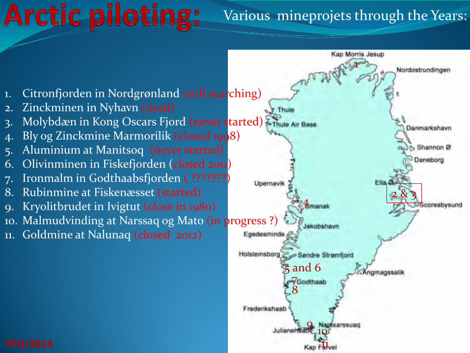
1. Citronfjorden in Nordgrønland (still searching) 2. Zinckminen in Nyhavn (dead) 3. Molybdæn in Kong Oscars Fjord (never started) 4. Bly og Zinckmine Marmorilik (closed 1998) 5. Aluminium at Manitsoq (never started) 6. Olivinminen in Fiskefjorden (closed 2011) 7. Ironmalm in Godthaabsfjorden ( ???????) 8. Rubinmine at Fiskenæsset (started) 9. Kryolitbrudet in Ivigtut (close in 1980) 10. Malmudvinding at Narssaq og Mato (in progress ?) 11. Goldmine at Nalunaq (closed 2012)
1
2 & 3 4
11 10 9
8 7
5 and 6
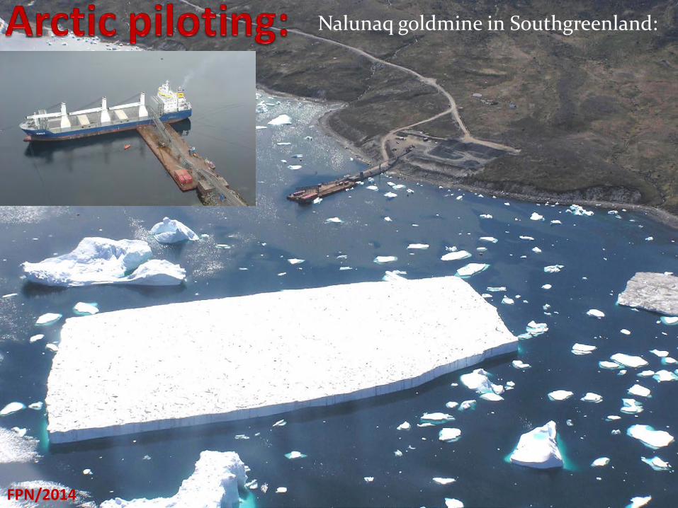
Nalunaq goldmine in Southgreenland:
FPN/2014
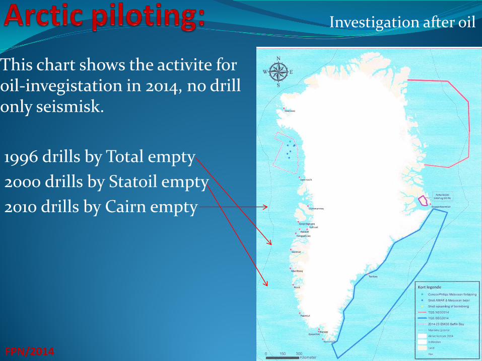
This chart shows the activite for oil-invegistation in 2014, no drill only seismisk. 1996 drills by Total empty 2000 drills by Statoil empty 2010 drills by Cairn empty
FPN/2014
Investigation after oil
FPN/2014
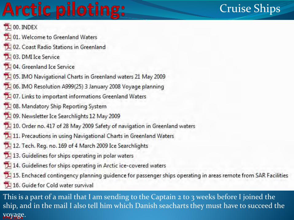
This is a part of a mail that I am sending to the Captain 2 to 3 weeks before I joined the ship, and in the mail I also tell him which Danish seacharts they must have to succeed the voyage.
Cruise Ships
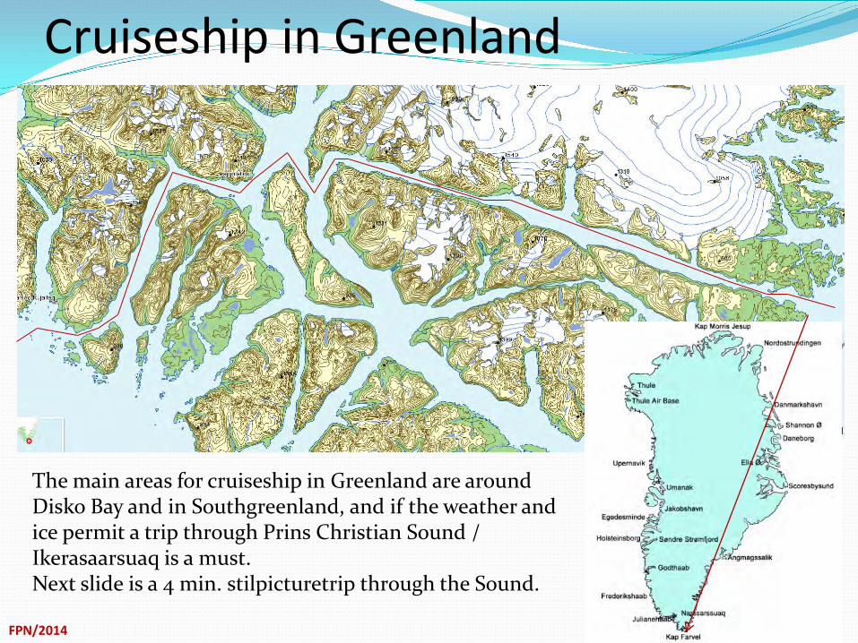
Cruiseship in Greenland
FPN/2014
The main areas for cruiseship in Greenland are around Disko Bay and in Southgreenland, and if the weather and ice permit a trip through Prins Christian Sound / Ikerasaarsuaq is a must. Next slide is a 4 min. stilpicturetrip through the Sound.
Cruiseship through PCS
FPN/2014
FPN/2014
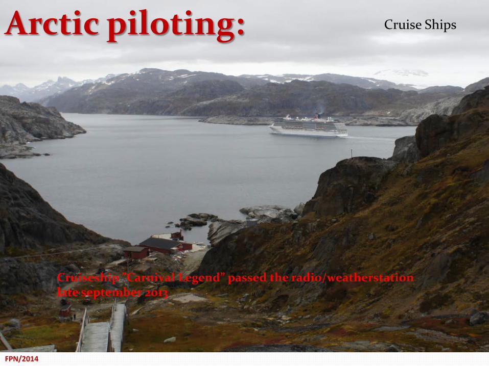
Cruiseship ”Carnival Legend” passed the radio/weatherstation late september 2013
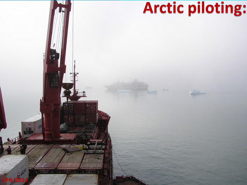
Arctic piloting: Cruise Ships
FPN/2014
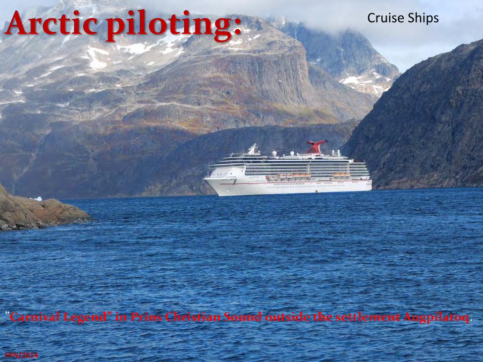
”Carnival Legend” in Prins Christian Sound outside the settlement Augpilatoq.
Cruise Ships
Arctic piloting:
FPN/2014
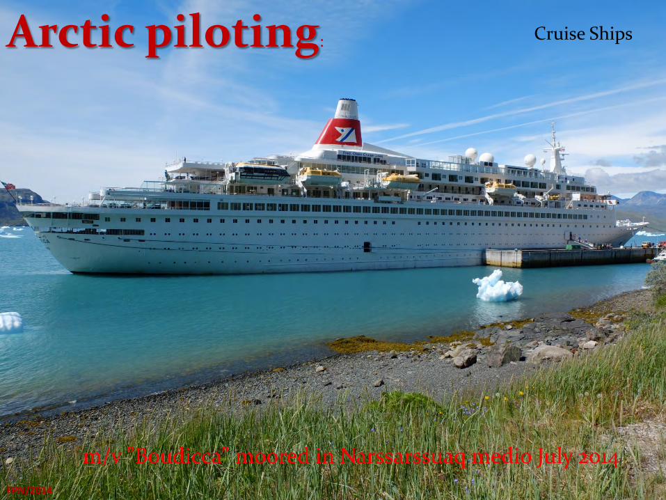
m/v ”Boudicca” moored in Narssarssuaq medio July 2014
Arctic piloting: Cruise Ships
FPN/2014
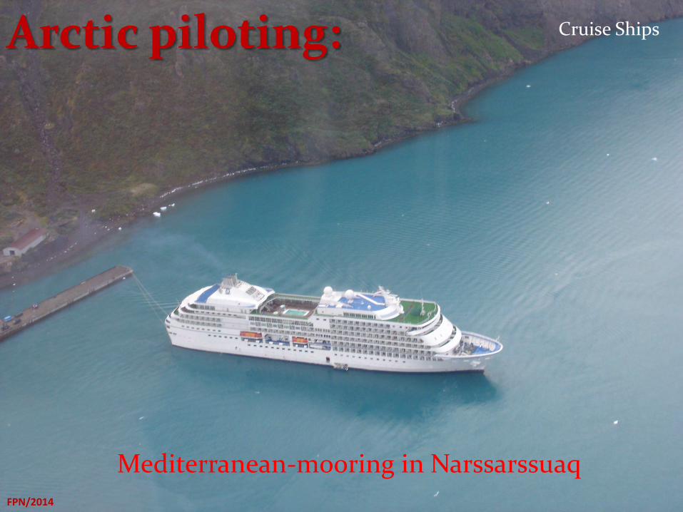
Mediterranean-mooring in Narssarssuaq
Arctic piloting: Cruise Ships
FPN/2014
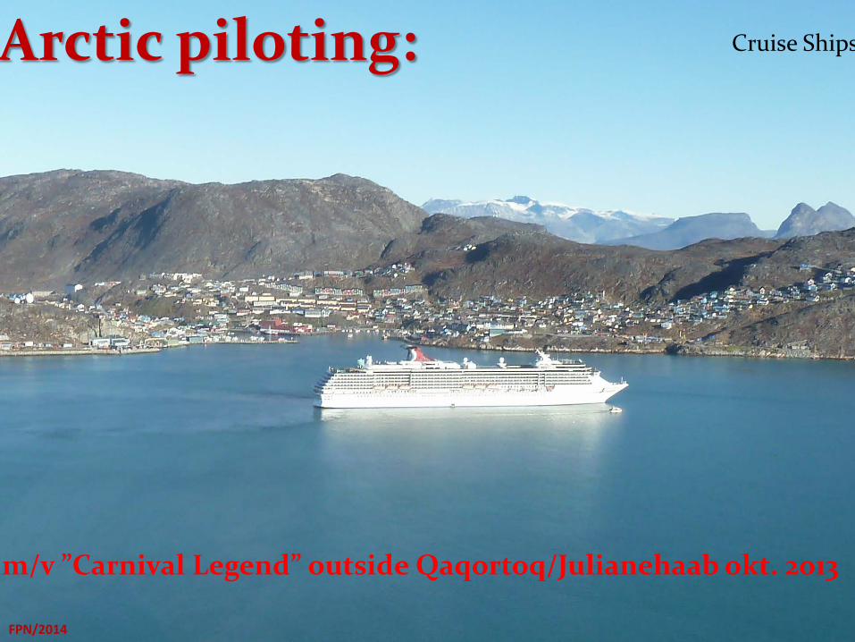
m/v ”Carnival Legend” outside Qaqortoq/Julianehaab okt. 2013
Arctic piloting: Cruise Ships
Thats All FPN/2014