Embed Size (px)
Citation preview


Assessment Report on Diamond Drilling on the Harpoon Property (Licences 18539M and 18249M),
Lake Ambrose Area, Newfoundland and Labrador
NTS 12A/10
For
Paragon Minerals Corporation
Work conducted from December 10th, 2010 to February 11th, 2011
Total Eligible Expenditures:
18539M – $101,109 18249M - $88,256
Total 186 claims
Prepared by:
Christine A. Devine, M.Sc., P.Geo.
April 11, 2011
1
TABLE OF CONTENTS 1.0 SUMMARY .................................................................................................................. 3 2.0 INTRODUCTION ........................................................................................................ 5 3.0 LOCATION, ACCESS AND PHYSIOGRAPHY ....................................................... 5 4.0 PROPERTY DESCRIPTION ....................................................................................... 5 5.0 REGIONAL GEOLOGY .............................................................................................. 8 6.0 PROPERTY GEOLOGY ............................................................................................ 10 7.0 MINERALIZATION .................................................................................................. 11 8.0 EXPLORATION HISTORY ...................................................................................... 16
8.1 Duck West Area (Harpoon Brook and Gill’s Pond North Areas) .................................. 17
8.2 Gill’s Pond Area .................................................................................................................. 19
8.3 Beaver Lake Area (Beaver Lake, Duckworth, Cookstown and BL-1 grids) ................. 19
8.4 Rogerson Lake Alteration Zone (Monkstown and Prescott Grids)................................ 22
8.5 Lemarchant and Spencer’s Pond Areas ........................................................................... 23 9.0 2011 EXPLORATION ................................................................................................ 26
9.1 Diamond Drilling ................................................................................................................ 26
9.2 Statement of Expenditures ................................................................................................. 27 10.0 CONCLUSIONS AND RECOMMENDATIONS ................................................... 28 12.0 REFERENCES ......................................................................................................... 30 13.0 PROFESSIONAL CERTIFICATION ...................................................................... 38 LIST OF APPENDICES Appendix I. List of Personnel and Contractors ........................................................... at end Appendix II. Diamond Drill Logs ............................................................................... at end Appendix III. Drill Core Analytical Certificates ........................................................ at end Appendix IV. Analytical Procedures .......................................................................... at end LIST OF TABLES Table 1. List of Property. .................................................................................................... 6 Table 2. Significant Massive Sulphide Deposits in the Victoria Lake Group. ................ 11 Table 3. Significant Drill Intercepts, Lemarchant Prospect. ............................................ 13 Table 4. Revised names for exploration grids in the Harpoon and South Tally Pond Areas.
................................................................................................................................... 16 Table 5. Statement of Expenditures by Licence ............................................................... 27 Table 6. Recommended 2011 Minimum Work Program – South Tally Pond Project. .... 29 LIST OF FIGURES Figure 1. Location of the South Tally Pond and Harpoon Properties……………………7 Figure 2. Tectono-stratigraphic zones of Newfoundland.………………………………..9 Figure 3. Geology of the Victoria Lake Volcanic Belt…………………………………..14 Figure 4. Geology and Mineral Occurrences of the Tally Pond Volcanic Belt…………15

2
Figure 5. Drill Plan – Duck West Prospect .................................................................. at end Figure 5. Cross Section – Duck West Prospect ........................................................... at end Figure 6. Duck West Area Geology Plan Map 1:20000……………………………..at end Figure 7. Drill Plan – Cookstown Grid ........................................................................ at end Figure 7. Cross Section – Cookstown Grid ................................................................. at end Figure 8. Cookstown Area Geology Plan Map 1:5000………………………………at end

3
1.0 SUMMARY The Harpoon and South Tally Pond Projects are located on NTS map sheets 12A/07 and 10 in the Lake Ambrose Area of Central Newfoundland approximately 20 kilometres south of the community of Millertown. The properties cover rocks of the Tally Pond Volcanics that are being explored for base metal VMS deposits within the same geological environment as the nearby Duck Pond Mine. The Harpoon and South Tally Pond Properties consist of 15 licences comprising 1154 claims for a total area of 28850 hectares. Paragon Minerals Corporation has a 100% interest in the mining and mineral rights to the Property. The Harpoon and South Tally Pond Properties are underlain by felsic and mafic volcanic rocks, with interbedded clastic sediments of the Tally Pond Volcanics, which form a part of the larger Victoria Lake Supergroup in Central Newfoundland. These volcanic and sedimentary units strike northeast and have variable northwest and southeast dips through the properties. The felsic rocks consist of rhyolite, quartz and feldspar porphyries, breccia and crystal to lapilli tuff. Mafic rocks are mainly flows with lesser tuff and breccia. These rocks are interbedded with conductive graphitic shale horizons which are apparent on airborne and ground EM surveys. The Tally Pond volcanic belt has been explored by Noranda from 1973 to 1998 with work beginning in the Beaver Lake and Harpoon Brook areas in 1979. An airborne survey of the belt, by Aerodat in 1974, was followed up by regional geochemical and geophysical surveys, reconnaissance geological mapping and prospecting. Several grids of various sizes were cut over parts of the current Harpoon and South Tally Pond Properties, and several were covered with detailed geological, geochemical and geophysical surveys. Follow up work from these surveys included limited basal till sampling and gravity surveys, and lithogeochemical sampling. The majority of the drill holes targeting the resultant geophysical and geochemical anomalies and mapped alteration zones have been largely confined to four main areas; the Lemarchant Prospect, the Spencer’s Pond alteration zone, The Rogerson Lake alteration zone and the Gill’s Pond area. Additional drilling outside of these areas comprises cursory drill testing of short strike length airborne conductors. In total, 149 drill holes for 34,219 metres have been drilled within the entire Harpoon and South Tally Pond Project area, underscoring the underexplored nature of the western half of the Tally Pond Volcanic belt. In late 2007 Paragon made a significant precious metal rich base metal massive sulphide discovery at the Lemarchant Prospect. From December 10, 2010 to February 1, 2011, Paragon Minerals Corporation completed diamond drilling on licences 18539M and 18249M on the companies’ Harpoon Property. Work on licence 18539M comprised drilling one hole (DW11-01) totalling 443.9 metres. The hole was designed to test for the western continuation of the Duck Pond alteration zone west of the Duck Pond Mine, as mapped and interpreted by previous explorers and interpreted from nearby hole HP90-01 (the Duck West Prospect) the hole was designed to intersect at 250m. A total of 33 samples were collected for assay and 14 samples for lithogeochemical analysis. Assays are returned for all samples with no significant sulphides
4
to report. DW11-01 intersected dark green-grey-black, coarse-grained, homogeneous, massive gabbro, dark green-grey-blue, very fine to fine-grained diabase intrusions; massive felsic volcanic, lapilli tuff and breccias, and mafic dykes. Work on licence 18249M comprising drilling one hole (CT11-01) totalling 209.4 metres. A single drillhole (CT11-01) was designed to test a priority airborne AEM conductor (30 Siemens) in the vicinity of a historic Zn-in-till anomaly and trenching completed in late 2005. The trench exposed pyritic shale/mudstone in contact with mafic volcanic rocks that bears a similar appearance to the immediate hangingwall to massive sulphide mineralization at the nearby Lemarchant Prospect. Previous lithogeochemical sampling by Noranda in the area has returned intensely altered felsic volcanic rocks from this area. The conductor is interpreted to dip gently (10-15 degrees) to the north and the hole is designed to intersect 75-100m. Only 2 drill holes have been previously completed in the area (450 metres NNW) targeting the north end of what appears to be a continuous conductive unit. Historic hole 372-7 intersected a 20 metre thick sequence of graphitic shale and interbedded felsic tuff with pyrite and pyrrhotite. The graphitic shale is hosted within a conformable sequence of felsic tuff, mafic volcanics and feldspar porphyry (synvolcanic?). CT11-01 intersected grey-green to dark grey-black, bedded to massive locally graphitic greywacke and graphitic argillite near the top of the hole grey, fine-grained sparsely amygdaloidal basalt intercalated with lesser argillite lenses. The drill hole intersected a thick pyrrhotite-rich mudstone horizon (26 metres) explaining the conductor with assays up to 2.48% zinc, 0.14% copper and 1.1 g/t silver over 0.55 metres along the contact. A total of 75 samples were collected for assay and 11 samples for lithogeochemical analysis. 1 sample was taken for ultra trace level geochemistry using Inductively Coupled Plasma - Mass Spectroscopy (ICP - MS). The results of exploration work completed to date (both current and historic) have demonstrated that the western half of the Tally Pond Volcanic Belt is underlain by several VMS-style alteration zones that have potential to host poly-metallic base metal massive sulphide mineralization such as that recently discovered at the Lemarchant Prospect and that currently being mined at Duck Pond. A work program comprising 9000 metres of drilling at the Lemarchant, Lemarchant SW, Beaver Lake, Bindon’s Pond and Duck West Prospects is recommended. Additional high resolution airborne EM and magnetics surveys are warranted to cover areas outside of previous surveying at near Quinn Lake and Gills Pond. The total estimated cost for the exploration program in 2011 is $1.5 million.

5
2.0 INTRODUCTION From December 10, 2010 to February 11, 2011, Paragon Minerals completed a total of 653.3 metres of diamond drilling in 2 drill holes on the South Tally Pond Project targeting base metal mineralization in the Harpoon property. This report covers the work completed and makes recommendations for suture work on the Harpoon Property. All data and work presented in this report are presented in UTM NAD27, Zone 21U, unless otherwise stated. 3.0 LOCATION, ACCESS AND PHYSIOGRAPHY The Harpoon and South Tally Pond properties are located on NTS map sheets 12A/07 and 12A/10 in the Lake Ambrose Area of Central Newfoundland approximately 20 kilometres south of the community of Millertown (Figure 1). Access to the properties is gained by travelling southwest 45 kilometres along the Buchans Highway from the Trans-Canada Highway to the community of Millertown, then by travelling south along the dirt road maintained by Teck Limited and Newfoundland Hydro to Lake Ambrose. Additional access is possible via Quinn Lake access (south of Beaver Lake), abandoned logging roads north of Beaver Lake (ATV access only), the active and well-maintained Duck Pond Mine Road and several un-maintained but truck-accessible logging roads in the Gills Valley (Gills Pond) area. The physiography of the Victoria Lake-Millertown region as summarized by Klassen (1994) can be divided into three areas geographically defined as the northwestern, southern and central areas, as follows: the northwestern area is underlain by gabbros and diorites forming the high (400-600 m) northeast-southwest trending ridges of the Annieopsquotch Mountains. The southern area, south of Victoria Lake, is a barren, gently undulating, peneplane of approximately 350-400 m elevation, which extends to the south coast of Newfoundland. The central area consists of the gently undulating and hummocky, heavily forested valleys of the northeast flowing Victoria and Tulks River systems. On a property scale, the area has a mean elevation of about 300 meters and is characterized by low, rounded hills. Second growth forest cover is interspersed with cut-over areas, several bogs and a few medium sized ponds (including Beaver Lake and Gills Pond) and small to medium-sized lakes (Rogerson Lake, Lake Ambrose and Quinn Lake). The property is drained by small brooks which flow northeast to Harpoon Brook. Bedrock exposure is generally less than 1%. The region is covered with a thin veneer of Pleistocene glacial till and outwash deposits typically 2-10 meters thick, but reaching up to 20 meters thick locally. The glacial cover is composed of as many as three separate till sheets. An earlier southerly ice flow direction (140o-170o) and a later northeast one (40o-60o) have been identified (Kean and Jayasinghe, 1980 and Klassen, 1994).
4.0 PROPERTY DESCRIPTION

6
The Harpoon and South Tally Pond Properties consist of 12 licences comprising 856 claims for a total area of 21,400 hectares (Figure 1, Table 1). Paragon Minerals Corporation has a 100% interest in the mining and mineral rights to the Property through three underlying option agreements with Kevin Keats, Allan Keats, Peter Dimmell and Altius Resources Inc. as well as claims staked 100% by Paragon. Table 1. List of Property.
Licence Property Registered Holder
NTS Claims Area (Ha)
Anniversary Date
13448M South Tally Pond Paragon Minerals Corporation 012A/10 10 250 14-May-11
13449M South Tally Pond Paragon Minerals Corporation
012A/07,10 5 125 14-May-11
12357M South Tally Pond Paragon Minerals Corporation 012A/10 38 950 26-Jul-11
07695M South Tally Pond Paragon Minerals Corporation 012A/10 20 500 18-Sep-11
18249M South Tally Pond Paragon Minerals Corporation 012A/10 47 1175 13-Dec-11
18539M South Tally Pond Paragon Minerals Corporation 012A/10 139 3475 13-Dec-11
12885M South Tally Pond Paragon Minerals Corporation 012A/10 5 125 14-Dec-11
11981M South Tally Pond Paragon Minerals Corporation 012A/10 22 550 19-Aug-11
18888M South Tally Pond Paragon Minerals Corporation
012A/07,10 249 6225 29-Jan-19
13583M South Tally Pond Paragon Minerals Corporation 012A/10 160 4000 11-Jun-11
18887M South Tally Pond Paragon Minerals Corporation 012A/10 11 275 29-Mar-11
14158M South Tally Pond Paragon Minerals Corporation
012A/07,10 150 3750 19-Nov-11
Total 12 licences 856 21400

7
Figure 1. Location of the South Tally Pond and Harpoon Properties and other properties held by Paragon in the Victoria Lake Belt.

8
5.0 REGIONAL GEOLOGY The island of Newfoundland covers the northern extremity of the Appalachian Orogen. Four major tectonostratigraphic zones have been identified in this segment of the orogen. From west to east, these are the Humber, Dunnage, Gander, and Avalon zones (Figure 2). These zones record the opening and closing of the Iapetus Ocean in the late Precambrian and early Palaeozoic (Williams, 1979). The Humber Zone represents the continental margin of Laurentia and consists of Precambrian crystalline rocks overlain by Paleozoic shelf facies rocks. At the eastern margin of Newfoundland, the Avalon Zone represents part of ancient Gondwana, and is composed of late Precambrian plutonic, volcanic and sedimentary rocks overlain by Palaeozoic platformal sedimentary units. The Dunnage Zone comprises the vestiges of the Iapetus Ocean. Rocks within this zone include volcanic and sedimentary rocks of back-arc and island-arc affinity, associated intrusions, and ophiolitic rocks. Volcanism was active as early as the late Precambrian and continued sporadically until the Devonian. The Dunnage Zone has been subdivided into the Notre Dame and Exploits subzones, representing volcanic belts that formed on the Laurentian and Gondwanan sides of the Iapetus Ocean, respectively, and that were not linked until the Llanvirn (van Staal et al., 1998). These subzones are separated by an extensive fault system termed the Red Indian Line. The Gander Zone consists mostly of sedimentary rocks that were deposited near the eastern continental margin of the Iapetus Ocean, and have Avalonian affinities. The Harpoon and South Tally Pond properties are located in the Red Indian Lake-Victoria Lake area of south-central Newfoundland, within the Exploits Subzone of the Dunnage tectonostratigraphic zone (Figure 2). The area is underlain by rocks of the Victoria Lake supergroup (Figure 3; Evans and Kean, 2002; Rogers and van Staal, 2002). The Victoria Lake supergroup consists of a structurally complex, composite collage of bimodal Neoproterozoic to Ordovician arc-related magmatic and sedimentary rocks. These comprise at least six distinct lithologic assemblages, bounded by the Red Indian Line to the northwest and the Noel Paul’s Line to the southeast, with the volcanic packages defining an overall northwest younging arrangement (Rogers and van Staal, 2002; Valverde-Vaquero and van Staal, 2002; Zagorevski et al., 2003). From west to east the assemblages include: the Pats Pond assemblage (488Ma?), the Tulks Hill assemblage (498 +6/-4Ma; 495 ± 2 Ma), the Long Lake assemblage (~505 Ma), the Harpoon Brook Belt, an assemblage of pre-Caradocian clastic sedimentary rocks, the Tally Pond assemblage (513 ± 2 Ma, 509 ± 1 Ma, 512 ± 2 Ma, 514 ± 7 Ma), and the Burnt Pond/Spencer’s Pond assemblage (~563 Ma, 572 ± 4 Ma). The contacts between the different assemblages are high-strain zones, and are generally interpreted to be thrusts. The volcanic, volcaniclastic and epiclastic sequences constituting the northeastern part of the Victoria Lake supergroup are conformably overlain by a regionally extensive unit of shale and chert known as the “Caradocian Shale”. The shale horizon is in turn overlain by a flyschoid sequence of argillite, greywacke and conglomerate that ranges in age from Middle Ordovician to Early Silurian, and is succeeded by younger Silurian rocks consisting of subaerial, mainly felsic volcanic and terrestrial sedimentary rocks.

9
Figure 2. Tectono-stratigraphic zones of Newfoundland.

10
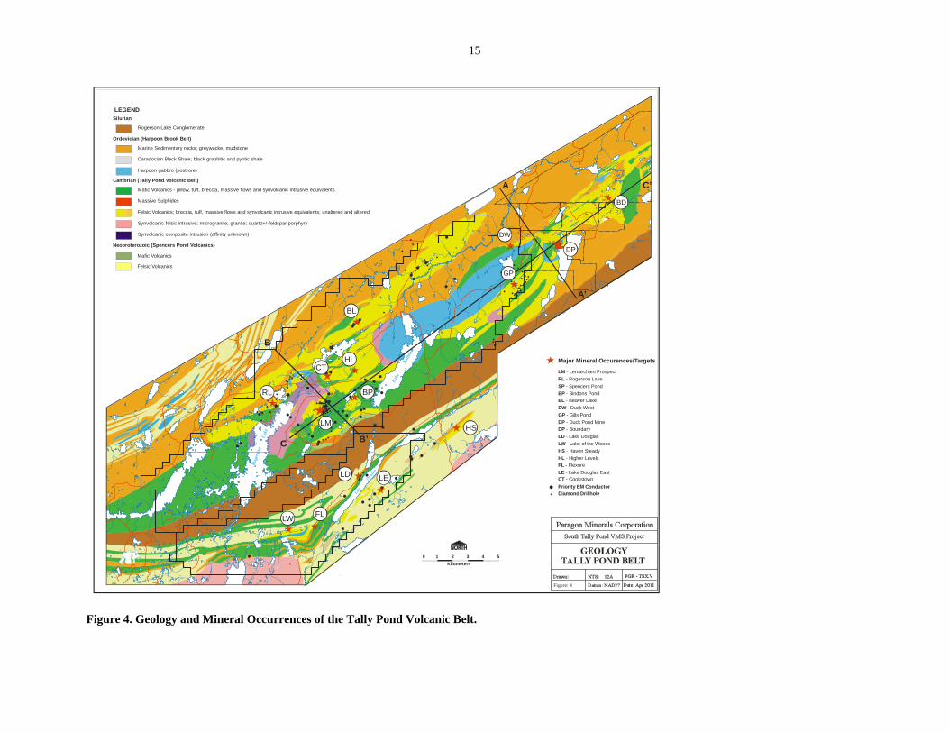
6.0 PROPERTY GEOLOGY The Harpoon and South Tally Pond properties occur within the Tally Pond assemblage (informally renamed Tally Pond group by Pollock et al. (2002); Figure 4). They define the Tally Pond group as the assemblage of volcanic, volcaniclastic and sedimentary rocks that extend from Victoria Lake northeast to Burnt Pond. These rocks are sub-divided into four sequences: the Lake Ambrose, Boundary Brook and Burnt Pond formations, and the black shale mélange. The Lake Ambrose formation consists of variably amygdaloidal, locally porphyritic, pillowed to massive mafic flows, with lesser breccias, autoclastic, hyaline and reworked tuffs, and dikes. These rocks are compositionally sub-alkalic basalts or basaltic andesites with a depleted island-arc tholeiitic signature (Figure 4; Pollock and Wilton, 2001). The mafic volcanics are intricately intermingled and interlayered with felsic rocks of the Boundary Brook formation, indicating synchronous deposition. These rocks are host to numerous volcanogenic massive sulphide deposits and occurrences within the Tally Pond volcanic belt (e.g. Duck Pond, Boundary, Lemarchant). The Boundary Brook formation consists of felsic flows that are variably massive to pseudo-brecciated and locally flow banded, breccias, tuffs and quartz porphyry with rhyolitic to dacitic composition and arc geochemical signatures. The Burnt Pond formation is an extensive unit of epiclastic sedimentary rocks comprised of greywacke, conglomerate, argillite, siltstone and minor chert. The sedimentary rocks contain dominantly volcanic detritus, with pyroclastic content and clast size increasing with proximity to the volcanic rocks, suggesting derivation from the adjacent volcanics. However, the sedimentary rocks are very rarely in direct contact with the volcanics, generally being separated by an extensive black shale mélange. Based on scant fossil data the mélange is tentatively correlated with the regional Caradocian black shale, although minor black shale layers are interfingered with the volcanic rocks of the Lake Ambrose and Boundary Brook formations. These interfingering black shale sequence commonly occur at the contact between the mafic Lake Ambrose formation and felsic Boundary Brook formation contacts and in places comprise massive bedded pyritic mudstone that is intimately associated with base metal massive sulphide mineralization (e.g. Duck Pond, Lemarchant). Along the southeast margin of the Tally Pond Group are a series of distinct bimodal volcanic and epiclastic rocks that were previously correlated with the Tally Pond volcanics. Recent dating at Burnt Pond returned an age of 572 ± 4 Ma, similar to the 565 +4/-3 Ma age of the adjacent Crippleback Lake quartz monzonite, rather than the ~513 Ma age of the Tally Pond volcanics (Rogers et al., 2006). Similar rocks, which underlie part of the South Tally Pond property at Spencer’s Pond, have Nd isotopic signatures identical to those of the Burnt Pond volcanics, and are probably also late Neoproterozoic. Further to the southeast, the 563 ± 2 Ma Valentine Lake trondhjemite occurs in similar position along the southeast margin of the Tally Pond Group. The late Neoproterozoic rocks, and in part the Tally Pond Group, are unconformably overlain to the southeast by the Rogerson Lake Conglomerate. This unit is interpreted as a fault-scarp, molasse-type sequence that is suspected to mask a Silurian or earlier structure (Kean and Evans, 1988a, b). Volcanic and epiclastic rocks of the Victoria
11
Dam Belt, which occur southeast of the Rogerson Lake Conglomerate, are tentatively correlated with the Tally Pond Group (Valverde-Vaquero and van Staal, 2002). 7.0 MINERALIZATION The Victoria Lake supergroup hosts numerous base metal-bearing volcanogenic massive sulphide (VMS) deposits, showings and extensive VMS alteration zones, and several gold deposits and showings (Table 2; Figure 3). This mineralization is distributed throughout all of the lithotectonic assemblages that comprise the supergroup. The Tulks Hill assemblage contains eight known sub-economic massive sulphide deposits, some of which are currently undergoing evaluation, including the Boomerang deposit of Messina Minerals which has an estimate for the Boomerang deposit (using a 1% zinc cut-off grade) of an indicated mineral resource totalling 1,364,600 tonnes grading 7.09% zinc, 3.00% lead, 0.51% copper, 110.43 g/t silver, and 1.66 g/t gold, and an inferred mineral resource of 278,100 tonnes grading 6.72% zinc, 2.88% lead, 0.44% copper, 96.53 g/t silver, and 1.29 g/t gold. Domino, adjacent to Boomerang and thought to be the same mineralized horizon, hosts another 411,200 tonnes inferred mineral resource grading 6.3% zinc, 2.8% lead, 0.4% copper, 94 g/t silver and 0.6 g/t gold (Messina Minerals press release, June 21, 2007). The Long Lake assemblage hosts four known massive sulphide lens that are currently undergoing evaluation. The Tally Pond Group contains five massive sulphide lenses at the Duck Pond and Boundary deposits, with an aggregate size of approximately 20 million tonnes, and calculated proven and probable reserves of 5.48 million tonnes grading 3.3% copper, 5.8% zinc, 0.9% lead, 59 g/t silver and 0.8 g/t gold. Teck Ltd. is currently mining the Duck Pond Deposit with the Boundary Deposit slated for later production. Several other sulphide showings occur within the Tally Pond volcanics. The Burnt Pond/Spencer’s Pond assemblage hosts a high-grade massive sulphide occurrence at Burnt Pond, and extensive VMS-style alteration zones. These VMS accumulations are associated with extensive hydrothermal alteration zones, which may be used as a guide to exploration in this environment. The felsic volcanics in the vicinity of the Duck Pond and Boundary deposits were subjected to pervasive vein silicification and sericitization. Within about 100 meters of the sulphide bodies the main alteration is strong to intense chloritization, with disseminated, stringer and semi-massive pyrite. A late stage carbonate alteration halo occurs, replacing chlorite alteration, immediately above, below and for 200 meters laterally from the Duck Pond deposit. The alteration consists of contorted calcite veins. Noranda discovered the Duck Pond deposit through follow up of alteration along the favourable felsic volcanic horizon. Since that time, lithogeochemical sampling by Noranda of the alteration zones associated with the Duck Pond and Boundary deposits, led to the recognition of a geochemical pattern which they termed the “Duck Pond Signature”. The Duck Pond alteration signature is characterized by plotting log(Hg/Na2O) versus log(Ba/Sr) (Collins, 1989a). Table 2. Significant Massive Sulphide Deposits in the Victoria Lake Group. Deposit Tonnes Grade Comments Cu % Pb % Zn % Ag g/t Au g/t Tally Pond Belt
12
Duck Pond
5,560,000 3.4 1.1 6.6 64.5 0.9 3 zones
Boundary 450,000 3.5 1.0 3.5 22.8 2 zones Tulks Belt
Tulks 730,000 1.1 2.1 5.5 45.2 0.4 Tulks East 4,500,000 0.2 0.1 1.5 8.5 Trace Bobby’s Pond
1,233,000 1.1 0.7 6.9 16.8 0.2
Long Lake 560,000 2.2 1.3 16.0 38.0 0.9 Baritic Daniels Pond
n/a - 5.0 8.7 350.0 - Avg. grade over>1km strike length -discontinuous
SOURCE: Newfoundland Department of Mines and Energy mineral inventory files and non-confidential assessment reports. Similar alteration assemblages associated with disseminated and stringer base metal sulphide mineralization have been located elsewhere in the Tally Pond Belt. The most notable of these are the Burnt Pond Prospect about 20 kilometres northeast of Duck Pond, and at the Lemarchant and Rogerson Lake Prospects, about 25 and 30 respectively to the southwest of Duck Pond (Collins, 1994). The South Tally Pond project is located immediately southwest of the Duck Pond mine and hosts numerous underexplored VMS target areas such as the Lemarchant Prospect, and other areas including Bindon’s Pond, Rogerson Lake, Spencer’s Pond, Beaver Lake, Duck Pond West, and Gills Pond (Figure 4). Paragon’s exploration is focused on the Lemarchant Prospect where significant massive sulphides hosted by proximal altered felsic volcanic rocks have been intersected by drilling since late 2007. The Lemarchant Prospect alteration zone has been outlined over a strike length of 4 kilometres and consists of altered rhyolite with abundant disseminated and stringer sulfide mineralization. The altered rhyolite has a very similar alteration signature to those observed at the Duck Pond and Boundary deposits to the northeast. The majority of the historical drilling (14 holes, 3,018 metres) concentrated on an 1100-metre section within the central portion of this alteration zone and tested the stratigraphy to a depth of 160 vertical metres.
Since acquiring the South Tally Pond property in 2006, Paragon has focused much of its effort on the Lemarchant Prospect. Following-up anomalous base and precious metal results from drilling by Noranda (4.5% Cu, 5.7% Zn, 273 g/t Ag, 1.06 g/t Au over 0.30 m in hole LM92-7), Paragon intersected 0.77% Cu, 7.49% Zn, 2.13% Pb, 40 g/t Ag, 0.21 g/t Au over 5.05 m in their first hole LM07-13. This hole is some 140 m down dip of LM92-7 and at a depth of only 160 m below surface.
Since the discovery, Paragon has completed 16,000 metres of diamond drilling in 42 holes at Lemarchant and has outlined a zone of significant sulphide mineralization over a 500 m strike length based on widely spaced drilling (> 50 to 100 m centres). Significant results are tabulated below (Table 3) (Copeland et al., 2007, 2008a, 2008b, 2010).

13
Table 3. Significant Drill Intercepts, Lemarchant Prospect. Hole No. Section Length
(m) Cu (%)
Zn (%)
Pb (%)
Ag (g/t) Au (g/t)
Average Down Hole Depth (m)
LM07-13 101+00N 5.05 0.77 7.49 0.07 40.29 1.21 167 LM10-46 101+00N 8.4 0.3 4.3 0.16 36.29 0.38 174.8 LM07-14 102+00N 5.4 1.06 5.26 1.52 92.56 0.85 206.2 LM10-43 102+50N 30.1 0.91 9.3 2.28 60.37 1.41 202 incl. 102+50N 17.05 1.41 14.8 3.56 80.9 1.35 202 LM11-52 102+50N 8.7 0.75 8.09 2.09 90.06 2.59 210.1 LM07-15 103+00N 14.6 0.81 9.46 2.13 73.44 1.85 226.3 LM08-33 103+00N 26.85 0.48 4.98 0.93 37.70 0.83 232.6 incl. 8.10 0.68 5.92 2.19 102.70 2.14 233.8 LM07-17 104+00N 14.6 0.45 12.38 2.61 50.32 0.74 243.3 incl. 8.1 0.72 21.04 4.26 76.05 0.65 246.6 LM08-24 105+00N 6 0.61 6.6 0.68 28.4 0.45 432 LM08-37 106+00N 3 0.97 9.32 0.45 16.1 0.26 296.2

14
5340000mN
5360000mN
5380000mN
5400000mN
5420000mN
440000mE
460000mE
480000mE
500000mE
520000mE
540000mE
560000mE
VM
BY
DN
JP
TE
TH
BZ
CP
LL
B
LM
LD
BP
SR
PPB
EG
RSMP
IK
LLG
VL SQL
VL
~498Ma
~473Ma
~462Ma
~488Ma
~481Ma
~478Ma
~468Ma
~505Ma
~563Ma
~495Ma~513Ma
~464Ma
~513Ma
~462Ma
~565Ma
KingGeorge IV
Lake
Lloyd’s Lake
Victoria Lake
Long Lake
ValentineLake
Red
India
n L
ake
LakeAmbrose
RogersonLake
TallyPond
Badger
Millertown
Buchans Junction
Exploits
RiverS
ub
zo
ne
Su
bz
on
e
RED D IN
IIAN
E L N
V tShea Z e
i i akc o
onr L
ae r
Da
me
No
tr
e
Me
el
pa
eg VM
BYDNJPTETHBZCPLLB
DPLMBPLD
- Victoria Mine- Bobby’s Pond- Daniel’s Pond- Jack’s Pond- Tulk’s East- Tulk’s Hill- Boomerang- Curve Pond- Long Lake- Boundary- Duck Pond- Lemarchant- Burnt Pond- Lake Douglas
(Main, East, South Limb, Lucky Gnome)
MASSIVE SULPHIDE DEPOSITS/PROSPECTS
SRPPB
EGRSMPIK
LLGVL
SQL
- Star River- Pat’s Pond Brook- Eagle Gold Zone- Road Showing- Midas Pond- Island “K”- Long Lake- Valentine Lake- South Quinn Lake
GOLD PROSPECTS
roads & trails
gold prospects
massive sulphide deposits/prospects
U/Pb zircon crystallization age
TH
PPB
~505Ma
NOTRE DAME SUBZONE
EXPLOITS SUBZONEDevonian & Older
Redcross Lake Intrusion
Rogerson Lake Conglomerate
undivided igneous & sedimentary rocks
Ordovician & OlderBadger Group
Pat’s Pond Assemblage
Tulk’s Hill Assemblage
Long Lake Assemblage
Burnt Pond - Spencer’s Pond Assemblage
clastic sedimentary rocks
Tally Pond Assemblage
Victoria Dam Belt
Late Neoproterozoic intrusive rocks
Victoria Lake Supergroup
MEELPAEG SUBZONEundivided igneous & sedimentary rocks
MapArea
Map compiled from the following sources:Rogers & van Staal (2002)Valverde-Vaquero & van Staal (2002)Zagorevski et al. (2003)
0 4 8Kilometers
12 16 20
South Tally Pond Property
Buchans MiningCamp
Lake Douglas Property
DP
Figure 3. Geology of the Victoria Lake Volcanic Belt.
15
!(
!(
!(
!(!(
!(!(!(
!(
!(
!(
!(
!(
!(!(
!(
!(
!(!(!(!(!(!(!(!(
!(!(!(!(!(
!(
!(!(!(
!(!(
!(!(
!(
!( !(!(
!(
!(
!( !(
!(
!(
!(!(
!(
!(
!(
!(
!(
!(
!(
!(
!(!(
!(
!(!(
!(
!(
!(!(
!(
!(
!(!(!(
!(!(!(
!(
!(
!(!(!(
!(!(
!(
!(
!(!(
!(
!(
!(
!( !(
!(
!(
!(
!(
!(
!(
!(
!(
!(
!(
!(
!(
!(
!(
!(
!(
!(
!(!(
!(
!(
!(
!( !(!(
!(
!(
!(
!(
!(
!(!(
!(
!(!(!(
!(!(
!(
!(!(
!(
!(
!(
!(!(
!(
!(
!(
!(
!(
!(
!(
!(
!(
!(
!(
!(
!(
!(
!(
!(
!(
!(
!(
!(
!(
!(
!(
!(
!(
!(
!(!(
!(
!(
!(
!(
!(
!(
!(
!(
!(
!(
!(
!(
!(
!(
!(
!(
!(
!(
!(
!(
!(
!(
!(
!(
!( !(
!(!(
!(
!(
!(
!(
!(
!(
!(
!(
!(
!(
!(
Roge
rson
Lake
Lake
Ambr
ose
Lake
Dougla
s
0 1 2Kilometers
3 4 5
Figure: 4
BPRL
BL
DW
HL
HS
LD LE
FLLW
Rogerson Lake Conglomerate
SilurianLEGEND
Ordovician (Harpoon Brook Belt)
Marine Sedimentary rocks; greywacke, mudstone
Caradocian Black Shale; black graphitic and pyritic shale
Harpoon gabbro (post-ore)
Mafic Volcanics - pillow, tuff, breccia, massive flows and synvolcanic intrusive equivalents
Cambrian (Tally Pond Volcanic Belt)
Felsic Volcanics; breccia, tuff, massive flows and synvolcanic intrusive equivalents; unaltered and altered
Synvolcanic felsic intrusive; microgranite; granite; quartz+/-feldspar porphyry
Synvolcanic composite intrusion (affinity unknown)
Neoproterozoic (Spencers Pond Volcanics)
Mafic Volcanics
Felsic Volcanics
Massive Sulphides
C
B
B’
A
A’
C’
Major Mineral Occurences/Targets
RL - Rogerson LakeSP - Spencers PondBP - Bindons PondBL - Beaver LakeDW - Duck WestGP - Gills PondDP - Duck Pond MineDP - BoundaryLD - Lake DouglasLW - Lake of the WoodsHS - Haven Steady
LM - Lemarchant Prospect
LM
GP
DP
BD
HL - Higher Levels
Priority EM ConductorDiamond Drillhole
FL - FlexureLE - Lake Douglas East
CT
CT - Cookstown
Figure 4. Geology and Mineral Occurrences of the Tally Pond Volcanic Belt.

16
8.0 EXPLORATION HISTORY The Harpoon and South Tally Pond properties have been intermittently explored since the late 1970s for base metal massive sulphide mineralization following cursory exploration work by Asarco during the 1960’s and 1970’s. Asarco drilled a total of 3 holes testing relatively long strike length EM conductors resulting in the presumed intersection of largely thick sequences of black, graphitic shale, in the Beaver Lake and Rogerson Lake areas. The lack of drill logs, orientation, length and location information for these holes precludes any significant interpretation of what results may have been obtained. The earliest preserved record of diamond drilling within the property is from 6 drillholes completed in 1975 by Labrador Mining and Exploration Co. Ltd. in the Harpoon Brook area (Tuffy, 1975). The bulk of the exploration work was undertaken by Noranda and its various partners from 1973 to 1998. Systematic exploration work by Noranda resulted in the discovery of several base metal VMS deposits and occurrences (e.g. Duck Pond, Boundary, Moose Pond, and Lemarchant). In addition, geological, geochemical and geophysical surveys conducted by Noranda in other areas throughout the Tally Pond Belt resulted in the discovery of several areas of anomalous geochemical signatures that are coincident with zones of altered volcanic stratigraphy with geophysical conductors. In total 149 drillholes for 34,219 metres have been drilled within the entire Harpoon and South Tally Pond Project area, underscoring the underexplored nature of the western half of the Tally Pond Volcanic belt. The majority of these holes have targeted four main areas including the Lemarchant, Rogerson Lake, Spencers Pond and Gills Pond alteration zones. Drilling in each of these areas other than at the Lemarchant Prospect is broad spaced (>100 metres) at best. Outside of these four areas sporadic drilling has occurred largely as initial testing of short strike length airborne conductors. Several exploration grids were cut to cover priority airborne conductors with the majority of the grids initially cut in 1981 to 1982. Subsequent re-cutting, extension and renaming of the grids was completed by Noranda in the early 1990s as outlined in Table 4. Table 4. Revised names for exploration grids in the Harpoon and South Tally Pond Areas. Old Grid Name Current Grid Name 371-1 Part of Cookstown Grid 371-2 BL-1 (recut in different orientation)371-3 Cookstown 371-4 Duckworth 371-5 Part of Cookstown Grid 372-1 Lemarchant 372-2 Spencers Pond 372-4 Prescott 372-5 Monkstown
17
372-6 372-6 372-7 Beaver Lake The following is a synopsis by grid/prospect area of work conducted by various parties in the South Tally Pond Area based on reports by Arseneau et. al. (1994), Collins (1990, 1991, 1992, 1993 and 1994), Collins and Squires (1991), Coulson (1992), Gower (1987), MacKenzie (1985), MacKenzie and Robertson (1986), Rogers and Collins (1989), Rogers and Squires (1988) and Reid (1979, 1980a, 1980b, 1981, 1982, 1983 and 1984). This report frequently references a summary marketing document outlining all the previous central Newfoundland base metal properties by Noranda (1998). In 2007 Paragon completed a detailed airborne EM and magnetic survey over the Harpoon Project area (Copeland, 2007). 8.1 Duck West Area (Harpoon Brook and Gill’s Pond North Areas) Exploration in the Duck West Area, formerly termed the Gills Pond North and Harpoon Brook Areas, were initiated largely by Noranda in 1979 (Reid, 1979 and Reid, 1980a, b). During 1979 Noranda completed 27.5 line kilometres of line cutting on grid 373-2 to cover and airborne conductor resulting from the 1974 Aerodat survey. The conductor comprises an ENE trending conductor that pinches out to the SW and is in contact with sediments to the north and Tally Pond volcanic rocks to the south (Reid, 1979). Also during 1979 Noranda collected 775 soil samples over the entire grid area. Sampling resulted in anomalous Cu (126 ppm), Pb (130 ppm) and Zn values, particularly in the east end of the grid. The high Cu values is located along L40W and forms part of 500 metre long, ENE oriented, anomalous trend with better values towards the east end of the grid (Reid, 1979). The high Pb value is an isolated Pb anomaly located at the north end of L20W. The east end of the grid is overall more anomalous in all elements but also coincides with a boggy area and metal scavenging was suspected. Still the anomalies are strong outside this area and were considered representative of bedrock effects and are best centred at L40W 100 metres north of the baseline. Work during 1980 on the grid comprised 23 line kilometres of C.E.M. Horizontal Shootback surveying, geological mapping of the entire grid, collection of the 35 till samples on 7 profile lines and 3.35 line kilometres of gravity surveying. The CEM survey located the main formational conductor from L40W to 0+00 where it runs off the grid to the east onto grid 373-1. The conductor thickens in the middle and lenses out on the western and eastern ends. The main formational conductor appears to consist of two or three beds of conductive material (graphitic argillite). Conductivity ratios are moderate to poor, however they are better on a semi-isolated conductor which flanks the north side of the main conductor between L8W and L20W. Geological mapping on the grid provided limited new information due to the paucity of outcrop exposure in the area.

18
Till sampling on 7 profile lines in the eastern part of the grid over the better soil anomalies from 1979, resulted in high Zn values (up to 9474 ppm) at the bottom half of the most easterly profile. No other base metal anomalies were correlative with this. In the profile furthest west high Cu, Pb, Zn and Ag were found 2 metres down the hole. All other samples in this profile were not anomalous. The gravity survey shows a very steep regional gradient on L40W increasing to the south. This may be due to the basic intrusion which forms part of the Harpoon Hill intrusive to the southwest. A 0.35 mgal anomaly was located over a 125 metre cord on L10W centred on 3+50N. This corresponds directly with the most northerly CEM conductor. The coincident 0.35 mgal gravity anomaly, conductor and isolated mag high are thought to be the result of pyrrhotite bearing argillite. During 1988 and 1989 the area was geologically mapped and HLEM (Max-Min), VLF-EM and magnetic surveys were performed on a re-established surface grid (Lee, 1989; 012A/0529). In 1990, Noranda completed drilling in a single vertical hole HP90-01 for a total length of 405.4 metres. The hole was drilled to test for fault offset mineralized stratigraphy representative of the western extension of the Duck Pond Deposit. The hole was located at 5+60E and 30+00W on the Harpoon Grid (re-cut grid 373-1?). The following is taken from the report by Squires (1990, pages 9, 10 and 11) regarding the rocks intersected in the hole:
“Hole HP-90-1 collared in a sequence of Granodiorite/granite with frequent narrow hypabyssal felsic dykes. Both of these lithologies have been intruded by later gabbro dykes which now make up >50% of the sequence down to 356.2 metres. Shearing and silicification of this sequence is frequent. Assays of silicified zones for Au returned negligible results. This sequence is correlated with the “Upper Block” stratigraphy which in the Duck Pond Deposit area to the NE consists of barren bimodal volcanics and later mafic and felsic intrusives which are thrust over the mineralized felsic stratigraphy of the Duck Pond mineralized horizon along the Duck Pond Thrust. “A two metre thick (356.2 to 358.2), 45o-dipping, weakly graphitic shear zone below this sequence is interpreted as being narrow counterpart to the Duck Pond Thrust which, as mentioned above, juxtaposes “Upper Block” and ‘Mineralized Block” stratigraphy. The style of deformation, presence of graphite and dip of the shear zone are consistent with this interpretation. “Beneath this shear zone and to the bottom of the hole, a volcaniclastic sediment was encountered which contains trace sulphides overall, but has local concentrations of up to 10% pyrite over 60cm. The volcaniclastic nature of this horizon, as well as the increase in sulphide content, suggests this stratigraphy is correlative with the Duck Pond mineralized horizon.

19
“The inferred existence of Duck Pond Deposit stratigraphy on this licence is tentatively confirmed on the results of drill hole HP-90-1. The lack of significant mineralization however precludes the recommendation of further drill targets at this time. Surface geochemistry, mapping and geophysics have reasonably eliminated near surface massive sulphide potential in the area.”
In 1990, a surface (EM37) and borehole TEM survey was completed on the Harpoon Brook grid and down hole HP90-1. The survey did not result in any significant conductors indicative of Duck Pond type mineralization (Collins, 1990; 012A/0604).
Since the completion of this drill hole, no work has been completed in the Duck West area outside of a property visit to the area in 2005 by Rubicon Minerals Corporation as outlined in the report by Sparkes (2005). The area is of great interest to Paragon Minerals Corporation. 8.2 Gill’s Pond Area In 1986 Esso Minerals Canada Ltd. staked the Gill’s Pond area following the recent discovery of base metal massive sulphides at Duck Pond. Mapping and prospecting indicated the presence of favorably altered Tally Pond felsics-mafics and sedimentary rocks. Assays from several newly discovered showings yield values up to 2,000 ppm Cu, 300 ppm Pb and 5,000 ppm Zn. Preliminary line cutting and Max-Min surveys were completed over several areas and many shallow EM anomalies were observed. Esso concluded that the strike extension of the host Duck Pond felsic volcanics were present immediately SE of Gills Pond. Further work including drilling was proposed (O'Sullivan, 1987). However, due to exploration cut backs, Esso optioned the property to Rio Algom Exploration Inc. During 1988 and 1989, Rio Algom completed gridding, several geophysical surveys (Ma, VLF, EM) and drilling 29 drill holes for 5,482 m (Figure 6; Thicke, 1988, 1989, 1990). Most holes were shallow (<150m) but helped to define the geological setting of the property. Many of these shallow holes and several deeper holes (400 to <525 m) intersected VMS-favorable rock types including sedimentary sequences underlain by mixed and favorable felsic and mafic volcanics, variably altered and intruded by a complex series of rhyolitic to gabbroic dikes and sills and larger intrusives. VMS style alteration (sericite, chlorite, carbonate, silica, pyritization, etc.) of these rocks, while not extensively strong is nevertheless present in most holes in weak to moderate amounts. Intense alteration and weak mineralization is also present in several of the deeper drill holes along the southeastern side of the property. It appears very likely that the Duck Pond VMS host rocks continue striking to the SW and underlie the Gills-Tally Pond Project in the SE; the favorable horizon would likely be 350 to >500 m below surface. 8.3 Beaver Lake Area (Beaver Lake, Duckworth, Cookstown and BL-1 grids)
20
Exploration activity in the Beaver Lake area began in 1981 with preliminary follow-up on the 1974 Aerodat survey. Several grids were established (371-1, 2 and 3, 372-4, 5, 6 and 7) covering priority airborne conductors in the Beaver Lake and Rogerson Lake areas. Several of these grids, covering a large area were subsequently renamed by Noranda as outlined in Table 4. Each of these grids was generally covered by a combination of prospecting, soil and or till sampling, geological mapping and ground EM, VLF, magnetics and gravity surveys were completed on most of these grids from 1981 to 1986. 8.3.1 Beaver Lake and BL-1 Grids The Beaver Lake grid was cut in 1981 to cover a 1200 metre long airborne EM conductor. Subsequent prospecting and geological mapping in the area by Noranda in 1981-1982 has outlined a 3 kilometre long VMS-style alteration zone. Ground geophysical surveys completed in 1981 and 1982 have confirmed the presence and location of the conductor and a gravity survey completed in 1983 shows that the ENE-trending EM conductor coincides with two separate gravity anomalies (0.1 to 0.25 mgal) located on each end of the conductor. The eastern and western gravity anomalies measure roughly 100 by 300 metres and 200 by 500 metres, respectively. Limited till sampling in 1983 over the gravity and EM anomalies has resulted in anomalous base metal values including 200 pm Cu, 88 ppm Pb, 1200 ppm Zn and 1.9 g/t Ag. Local outcropping felsic volcanic to the south of the conductive horizon comprises sericite-chlorite-silica alteration with Zn assays to 1.5%. Previous lithogeochemical sampling in the area has returned Duck Pond alteration signatures. An attempt was made in 1983 to trench the western conductor and till anomaly, but failed to reach bedrock. This target, despite its strong geophysical and geochemical anomalies was never drill tested. Prospecting and sampling in 2006 by Rubicon Minerals Corporation has located semi-massive pyrite float (hosted within felsic volcanic breccias) overlying the western gravity anomaly, proximal to the anomalous till samples. In 1987, Noranda completed diamond drilling on the BL-1 grid in hole BL-87-1 (Figure 5). Drilling targeted a north-south trending short strike length airborne conductor just north of Beaver Lake. Work during 1988 comprised geological mapping of grid BL-1. Two additional holes (BL-88-1 and BL-88-2) were drilled on the BL-1 grid to test the continuation of the HLEM conductor intersected in hole BL-87-1 (Rogers and Collins, 1989; 012A/0537). Work during 1989 comprised 2 days of prospecting and completion of a 10.5 line kilometre HLEM (Max-Min) survey over the grid (Collins, 1989b; 012A/0541). 8.3.2 Duckworth Grid The Duckworth grid was re-established in 1989 from the former grid 371-4 by the BP-Norex Joint Venture. Work on the grid during 1989 comprised 13.9 line kilometres of
21
line cutting and grid re-establishment and 12.8 line kilometres of HLEM. The max-min survey conducted in 1989 outlined an extensive and broad anomaly through the central portion of the grid. Previous work by Noranda indicated that the large conductor was likely related to underlying conductive sediments although at the time no testing via trenching or drilling was completed. The survey also outlined two weak to moderate strength conductors along lines 2100W through 1900W between 100S and 30S. Previous soil surveys indicate that these conductors are flanked by anomalous Cu and Zn with values up to 138 ppm and 262 ppm, respectively (Collins, 1989a). At the time Noranda proposed to conduct magnetic, VLF-EM and additional soils as well as extending the grid, geophysical and geochemical coverage to the west. During 1991, several days of recce prospecting were completed north of Beaver Lake. Prospecting at this time located an exposure of silica/chlorite stockwork alteration in felsic volcanics with 2-4% disseminated and stringer sulphide including pyrite, sphalerite, galena and chalcopyrite, named the Keats Showing. The showing is located over the Duckworth grid on line 12W at 125S, on the interpreted footwall to a strong formational HLEM anomaly. Assays from the outcrop include 1.11% Zn, 0.27% Cu and 8.56 g/t Ag. An angular float from the same area returned an assay of 0.19% Cu, 1.15% Pb, 0.91% Zn and 9.25 g/t Ag (Collins, 1992; 012A/0630). Additional work during 1991 on the Duckworth grid comprised B-horizon soil sampling over the western half of the grid (as proposed in 1989) and analysis of 551 B-horizon soils from samples collected over the east half of the grid in 1990. Work on the Duckworth Grid in 1993 comprised collection of 21 lithogeochemical samples for whole rock analysis, collection of 19 basal till samples across selected conductors and a limited gravity survey comprising 1.6 line kilometres. The gravity survey did not result in encouraging results and no further work was recommended (Collins, 1994; 012A/0724). 8.3.3 Cookstown Grid Noranda completed linecutting and geological surveying on the Cookstown grid from 1981 to 1982. In 1983, Noranda completed drilling in 2 holes 371-6 and 7 targeting airborne conductors in the central part of the Cookstown grid. The Cookstown grid was re-established in 1989 from the former grid 371-1 by the BP-Norex Joint Venture (Collins, 1989a). Work on the grid during 1989 comprised 13.0 line kilometres of line cutting and grid re-establishment, 11.2 line kilometres of HLEM and 11.0 kilometres of magnetics and VLF-EM surveys. The max-min survey conducted over the Coosktown grid outlined three moderate to strong conductive targets of which two are associated with coincident or flanking high magnetic anomalies. Two of the conductors resulting from the survey were attributed to previously drill tested and trenched exposures of graphitic shale, while the magnetic high is associated with outcropping gabbro (Collins, 1989a). One of the conductive zones, located along lines

22
300E through 500E at 600S at the time remained unexplained with follow-up soils planned for 1990. During 2005, Rubicon Minerals completed a short trenching program on the south side of the Cookstown grid targeting short strike length EM conductors and weak historic till anomalies. The trenching program was successful in exposing pyritic and graphitic mudstone in contact with mafic and felsic volcanic rocks with trace amounts of sphalerite (Sparkes, 2005). 8.3.4 Licence 11981M During 2003 Crosshair and Rubicon completed a high-resolution frequency domain EM and magnetic survey over the licence and ground further to the north in search for gold mineralized zones similar to that at the Jaclyn Zone on the Golden Promise property (Copeland and Newport, 2004). This survey outlines a zone of low resistivity that corresponds with anomalous lake sediments and soil samples (see below). The resistivity low could be attributed to black shale underlying the area (as is common) but no ground work has proven or refuted the presence of graphitic shale. Work during 2005 on licence 11981M included collection of 155 soil samples by Crosshair Exploration and Mining Corp. under an option agreement with Rubicon Minerals (Morgan et al., 2006). The soil grid covered an area surrounding an elevated Au (129 ppb), Zn (700 ppm) and Ba (1200 ppm) lake sediment sample collected by the government in 1977. Sampling resulted in anomalous Au (up to 115 ppb) and Zn (up to 366 ppm) along a line of small steadies following and east west brook. The samples, comprising largely organic humus, outline anomalous Zn over 300 metres. Follow-up prospecting by Paragon (this report) targeted the coincident Zn in soil and Au and Ba in lake sediment anomalies in search for base metal VMS mineralization (Copeland, 2008). 8.4 Rogerson Lake Alteration Zone (Monkstown and Prescott Grids) In 1981, Noranda completed linecutting on the Prescott and Monkstown grids following up on priority airborne conductors from the 1974 Aerodat survey (Figure 5). In addition soil sampling and ground geophysical surveys (CEM, VLF-EM, HLEM, magnetics and gravity (partial coverage)) were completed from 1981 to 1982. Till sampling was successful in outlining several areas with anomalous Cu, Pb, Zn and Ag, including two sites which returned greater than 5,000 ppm Pb (Noranda, 1998; Reid, 1981, 012A/0319). Subsequent trenching and prospecting of the till anomalies located numerous boulders of massive and banded pyrite. A heavy mineral separate of tills at one of these sites assayed 17.2% Pb. From 1983 to 1994 Noranda completed 28 drill holes for 3514.12 metres throughout the Rogerson Lake alteration zone targeting a combination of priority airborne conductors and semi-massive to massive pyrite exposed in trenches. The most significant results

23
were from drilling in which several holes intersected stringer sulphide mineralization within strongly altered coarse felsic pyroclastic rocks. One hole (MT-90-01) intersected semi-massive pyrite (up to 50%) over widths up to 0.5 metres, whereas another hole (PG-90-01) intersected several banded pyrite/argillite horizons within felsic volcanic rocks that returned assays of 7.54 g/t Ag and 7.88 g/t Ag over 0.8 and 0.4 metres, respectively (Noranda, 1998). Hole 372-11 intersected 2-4% sphalerite (0.77% Zn from 30.7 to 33.2 metres) within felsic volcanic rocks immediately beneath exhalative pyritic mudstone at the mafic-felsic contact. The Rogerson Lake alteration zone is a significant VMS-style alteration zone that extends for 5.6 kilometres, 700 metres wide and is centred on the north end of Rogerson Lake. Alteration comprises intensely chlorite-altered felsic volcanic rocks (rhyolite) with locally strong silica and carbonate alteration and ubiquitous disseminated sulphide (pyrite) mineralization. Massive pyrite float has been discovered on surface is several places. Previous broadly spaced (100 to 500 metres) drilling along the extent of the alteration zone comprises 28 holes for 3514.12 metres. Several drillholes (e.g. MT90-01, 03 and PG90-01, 04) have intersected stringer to semi-massive sulphides (pyrite) hosted within graphitic sediments and underlying felsic volcanics. Samples from some of these holes have returned “Duck Pond Index” alteration. The nearest hole to 372-11 is 500 metres to the north. In December 2000, Altius Resources Inc. optioned the South Tally Pond Property from Noranda. During the winter of 2001 Altius Resources Inc. completed 160.62 metres of diamond drilling in one hole (RL.01-01) at the western end of the Prescott grid area along the Rogerson Lake Alteration Zone (Barbour and Churchill, 2001; Smith et al., 2001). No significant results were obtained. 8.5 Lemarchant and Spencer’s Pond Areas During 1981 and 1982 Noranda completed linecutting on grids 372-1 (Lemarchant) and 372-2 (Spencer’s Pond) following up on airborne conductors. Soil sampling, ground geophysics (VLF-EM, HLEM, EM-37 (partial coverage) and magnetics) were completed on these grids by Noranda from the period from 1982 to 1994. Initial drill testing and trenching of the area was completed in 1983 with drilling of holes 372-1, 2, 3, 4 and 5 (Reid, 1984; 012A/0376). Each of the drillholes was successful in explaining the airborne conductors while discovering exhalative pyritic mudstone and stringer base metal mineralized footwall felsic volcanic rocks. Noranda did not complete significant work at Spencer’s Pond or Lemarchant from 1984 to 1989. Following discovery of the Duck Pond deposit in 1987, Noranda recognized that earlier work at Lemarchant had outlined a similar VMS environment to that at Duck Pond. From 1990 to 1993 Noranda completed diamond drilling in 3 holes at Spencer’s Pond (SP90-1 to 3) and 2,846 metres of drilling in 12 holes at Lemarchant (LM91-1 to 6 and LM92-7 to 8, and LM93-9 to 12). Significant historical results from the Lemarchant Prospect include:

24
• 7.4% Zn, 0.6% Cu, 6.3% Pb, 1515.0 g/t Ag and 11.4 g/t Au, over 0.6 metres (LM91-01);
• 5.70% Zn, 4.5% Cu, 0.33% Pb, 272.5 g/t Ag and 1.06 g/t Au over 0.3 metres (LM92-07); and
• 1.53% Zn, 59.8 g/t Ag and 6.1 g/t Au over 3.8 metres (LM92-08). Following the dissolution of the Norex JV, Noranda completed a GIS compilation of previous exploration data. Other work in the Spencer’s Pond/Lemarchant area included linecutting (Spencer's Pond 96 Extension Grid), soil sampling and a VLF-EM survey (Noranda, 1998). Altius Resources Inc. optioned the South Tally Pond Property from Noranda in December 2000 and during winter 2001 Altius completed 786.69 metres of diamond drilling in five holes in the Spencer’s Pond Area (SP.01-01 to SP.01-05). All drill holes were surveyed using Borehole TEM geophysics (Smith et. al., 2001; Barbour and Churchill, 2001; and Dalton, 2000). Also in 2001 Altius completed a limited program of geological mapping, drill core re-logging, and lithogeochemical sampling on the Lemarchant and Spencer’s Pond alteration zones, deepening of drill hole SP.01-04 and surveying the hole with bore hole TDEM. Baselines on the Lemarchant grid were refurbished in order to facilitate this work (Barbour and Churchill, 2002). Additional outcrop lithogeochemical sampling was completed in 2002 (Barbour and Churchill, 2003). In 2004, Altius completed re-logging of 14 diamond drillholes from the Lemarchant Prospect and one (1) diamond drillhole from the Rogerson Lake alteration zone. Altius also collected several lithogeochemical and assay samples from the historic drill core (Barbour and Churchill, 2005). A comprehensive geological mapping and lithogeochemical sampling program was conducted on the property that resulted in better definition of the extents of the Lemarchant and Spencer’s Pond alteration zones and led to the discovery of the alteration at Bindon’s Pond. The Spencer’s Pond alteration zone was determined to have a much larger strike length than previously recognized (Barbour and Churchill, 2004). Altius also conducted an 844.9 line kilometre airborne HTEM surveying that confirmed the extents of known conductors as well as discovery of numerous conductors in all three alteration zones outside areas of previous geophysical surveying. In 2005, Altius compiled existing geological and geophysical data and created new 1:5,000 scale geological base maps and completed 25.354 kilometres of linecutting on the Spencer’s Pond grid and a southern extension of the Lemarchant grid. The linecutting was completed to enable a planned TDEM ground survey over the area which was not completed due to a lack of geophysical contractors at the time. In 2006, Altius completed one (1)- 425m diamond drillhole (SP06-01) that was designed to test a borehole TEM anomaly along the Spencer’s Pond alteration zone (Winter et. al., 2006). Associated with the drilling, 9 kilometres of road into the Spencer’s Pond area

25
was rehabilitated. Drilling intersected zones of disseminated pyrite and base metal sulphides with concentrations from 1-5%. No samples were collected from the hole.
Paragon Minerals Corporation (“Paragon”) optioned the South Tally Pond Project from Altius in December 2006. From August 2007 to May 2008, Paragon completed 7,068 metres of diamond drilling in 19 holes that outlined high grade precious metal-rich massive sulphides, down-dip of the historic drilling completed by Norex JV (Copeland et al., 2008a, b), that assay as follows:
• 7.49% Zn, 0.77% Cu, 0.07% Pb, 40.29 g/t Ag and 1.21 Au over 5.05 metres from 164.5 to 169.55 metres (LM07-13);
• 5.26% Zn, 1.06% Cu, 1.52% Pb, 92.56 g/t Ag and 0.85 g/t Au over 5.40 metres from 203.5 to 208.9 metres (LM07-14);
• 9.46% Zn, 0.81% Cu, 2.13% Pb, 73.44 g/t Ag and 1.85 g/t Au over 14.60 metres from 219.0 to 233.6 metres (LM07-15); and
• 12.38% Zn, 2.61% Pb, 0.45% Cu, 50.32 g/t Ag and 0.74 g/t Au over 14.6 metres from 236.0 to 250.6 metres, including 8.1 metres of 21.04% Zn, 4.26% Pb, 0.72% Cu, 76.05 g/t Ag and 0.65 g/t Au from 242.5 to 250.6 metres (LM07-17).
• 0.47% Zn, 0.04% Cu, 0.07% Pb, 3.43 g/t Ag, and 0.08 g/t Au over 43 metres from 151.0 to 194.0 metres (LM08-25)
• 0.58% Zn, 0.08% Cu, 0.11% Pb, 2.87 g/t Ag, and 0.10 g/t Au over 51 metres from 324.0 to 375 metres (LM08-29)
Additional work completed included linecutting and grid refurbishment, a Pulse EM geophysical survey, soil sampling and interpretation of geochemical data collected during the drill program (Copeland et. al., 2008a, b).
During the summer of 2008, Paragon conducted a deep penetrating Titan 24 ground geophysical survey covering the felsic volcanic stratigraphy over a 1000 metre by 2400 metre grid from lines 98+00N to 108+00N and completed a 101 sample orientation enzyme leach soil survey over the Lemarchant prospect (Copeland et al., 2009). The Titan 24 survey has resulted in DCIP chargeability and resistivity anomalies on section that are spatially associated with known stringer to massive sulphide mineralization defined by previous drilling. In addition the survey has outlined anomalous chargeability trends to the west and east of the Lemarchant prospect that make excellent targets for future exploration. Drilling by Paragon in the fall of 2008 (3,000 metres in 9 holes) extended the known massive sulphide mineralization and associated stringer and alteration zone to the north and west of previous drilling (Copeland et al., 2009). Significant assays from the fall 2008 drilling program include:
• 5.92% Zn, 2.19% Pb, 0.68% Cu, 2.14 g/t Au and 102.7 g/t Ag over 8.10 metres within a broader zone of mineralization grading 4.98% Zn, 0.93% Pb, 0.48% Cu, 0.83 g/t Au and 37.7 g/t Ag over 26.85 metres (LM08-33); and
• 9.32% Zn, 0.45% Pb, 0.97% Cu, 0.26 g/t Au and 16.10 g/t Ag over 3.0 metres (LM08-37).

26
Between February 7 and April 1, 2010, Paragon completed 10 diamond drill holes, totalling 3,489 metres (LM10-41 to LM10-48; extensions to LM93-11 and LM08-24) and surveyed 11 drillholes (4,915 metres) with Pulse EM geophysics on the South Tally Pond Project (Copeland, 2010). The ten hole winter drill program focused on the Lemarchant massive sulphide discovery and included four infill drillholes on sections 102+50N and 103+50N and drill testing of down-hole geophysical Pulse EM conductors to the north (section 105N to 106N) and south (section 100N) of previously drilled massive sulphides. Highlights of the program include: • Infill drillhole LM10-43 intersected 30.10 metres of 9.30% zinc, 2.28% lead, 0.91%
copper, 60.37 g/t silver and 1.41 g/t gold (core length) including 17.05 metres of 14.80% zinc, 3.56% lead, 1.40% copper, 80.90 g/t silver, 1.35 g/t gold.
• Down-hole geophysics outlined a strong off-hole conductor extending 200-300
metres north of previously completed drillhole LM08-19 (North Target area). Drilling intersected 6.0 metres of 6.60% zinc, 0.68% lead, 0.61% copper, 28.38 g/t silver and 0.46 g/t gold (core length) including 1.1 metres of massive sulphide of 30.54% zinc, 2.94% lead, 1.50% copper, 88.9 g/t silver and 0.72 g/t gold .
9.0 2011 EXPLORATION From December 10, 2010 to February 10th, 2011, Paragon completed a total of 653.3 metres of diamond drilling in 2 holes (DW11-01 and CT11-01). The work was completed by Paragon staff and several contractors as presented in Appendix I. Drill logs for both holes are presented in Appendix II with analytical certificates presented in Appendix III. A summary of the analytical procedures used is presented in Appendix IV. 9.1 Diamond Drilling DW11-01 was drilled to 443.9 metres from January 26th to February 2nd, 2011 on licence 18539M. The hole was designed to test for the western continuation of the Duck Pond alteration zone west of Duck Pond Mine, as mapped and interpreted by previous explorers and interpreted from nearby hole HP90-01 (the Duck West Prospect) and was designed to intersect the alteration zone at 250m. A total of 33 samples were collected for assay and 14 samples for lithogeochemical analysis. Assays are returned for all samples with no significant sulphides to report. DW11-01 intersected dark green-grey-black, coarse-grained, homogeneous, massive gabbro, dark green-grey-blue, very fine to fine-grained diabase intrusions; massive felsic volcanic, lapilli tuff and breccias, and mafic dykes. The drill hole did not cross structure/stratigraphy that is interpreted to be the equivalent of the Duck Pond thrust as described at the Mine or interpreted to be intersected in hole HP90-01. Additionally the felsic volcanic rocks intersected in the hole are not significantly altered and do not show pyrite mineralization or chlorite alteration

27
similar to that hosted within mafic volcaniclastic sediments toward the bottom of HP90-01. Work on licence 18249M comprised drilling one hole (CT11-01) totalling 209.4 metres to test a priority airborne AEM conductor (30 Siemens) in the vicinity of a historic Zn-in-till anomaly and trenching completed in late 2005. The trench exposed pyritic shale/mudstone in contact with mafic volcanic rocks that bears a similar appearance to the immediate hangingwall to massive sulphide mineralization at the nearby Lemarchant Prospect. Previous lithogeochemical sampling by Noranda in the area has returned intensely altered felsic volcanic rocks. The conductor is interpreted to dip gently (10-15 degrees) to the north and the hole is designed to intersect 75-100m. Only 2 drillholes have been previously completed in the area (450 metres NNW) targeting the north end of what appears to be a continuous conductive unit. Historic hole 372-7 intersected a 20 metre thick sequence of graphitic shale and interbedded felsic tuff with pyrite and pyrrhotite. The graphitic shale is hosted within a conformable sequence of felsic tuff, mafic volcanics and feldspar porphyry (synvolcanic?). CT11-01 was drilled from February 8th to February 11th, 2011 with many additional days needed prior to drilling set up a water supply system as the closest water source was over 1.5 kilometres away from the drill site and trouble was encountered with freezing hoseline. Eventually a truck with a mounted water tank was brought in to supply the drill with water for drilling. CT11-01 intersected grey-green to dark grey-black, bedded to massive locally graphitic greywacke and graphitic argillite near the top of the hole. A grey, fine-grained sparsely amygdaloidal basalt unit is intercalated with lesser argillite lenses from a depth of 28.8 to 41.65 metres. At 41.65 metres a felsic intrusive unit (feldspar porphyry) is encountered along with narrow veins or stringers of base metal sulphide mineralization with assays up to 2.48% zinc, 0.14% copper and 1.1 g/t silver over 0.55 metres along the contact (41.1 to 41.65 metres). A total of 75 samples were collected for assay and 11 samples for lithogeochemical analysis. 1 sample was taken for ultra trace level geochemistry using Inductively Coupled Plasma - Mass Spectroscopy (ICP - MS). 9.2 Statement of Expenditures A summary of expenditures by licence on the Harpoon Properties are below in Table 5: Table 5 – Statement of Expenditures. DRILLING 18539M 18249M Salaries (excludes reporting) $ 30,537 $ 18,150 Truck Rental and Accommodation $ 5,400 $ 4,446 Field Supplies & Rentals $ 2,553 $ 1,693 Snow Clearing and Water Hauling $ 3,788 $ 9,031 Drilling Costs $ 42,068 $ 37,690
28
Reporting and Data Compilation $ 1,059 $ 1,059 Geochemistry $ 2,517 $ 4,675 Total Costs $ 87,921 $ 76,744 Administrative (15%) $ 13,188 $ 11,512 TOTAL EXPLORATION COSTS $ 101,109 $ 88,256
10.0 CONCLUSIONS AND RECOMMENDATIONS Drilling in hole DW11-01 was designed to test the western continuation of the Duck Pond alteration zone. The hole intersected a thick gabbroic intrusive unit likely correlative with the Ordovician-aged Harpoon Gabbro. This intrusive unit is more extensive at depth and to the north than was interpreted based on the results from hole HP90-01 (100 metres to the east), the aerial extent of the magnetic high from the airborne EM survey and limited outcrop exposure in the area. The extent of the gabbro at depth in this hole may signify that the rocks are dipping to the north in this area and that the drillhole largely proceeded down-dip. There is no direct evidence for this in the drillhole though and the hole did eventually pass into felsic volcanic rocks at depth. The felsic volcanic rocks display quite weak hydrothermal alteration with ACNK and Ishikawa indexes of 1.56 and 13.49, respectively. The Duck West area remains a compelling target for follow-up work despite the results from the current hole. Future drill holes in the area should be collared to the north in the black shale horizon and drilled to the south to test for the altered felsic sequence at depth. Drilling in hole CT11-01 was successful in testing the airborne EM conductor and determining that it is likely caused by a thick sequence of graphitic and pyrite/pyrrhotite bearing argillite. This sequence was exposed in a nearby (50 metres) trench in 2005 by Rubicon and was also encountered in drillholes 372-6 and 7 to the north. The conductor forms a 1.7km long conductive trend that runs in a NS direction to Beaver Lake in the north. Slightly elevated alteration indices in the felsic volcanics ACNK 1.66-1.86 and Ishikawa 31.88-57.26, the occurrence of vein or stringer base metal mineralization at the mafic-felsic contact and the strike length of the conductor make the Cookstown area of interest for follow-up drilling. Prospects or alteration zones that currently have the highest potential to host such deposits include the Lemarchant Prospect, Lemarchant SW, Beaver Lake, Bindon’s Pond, Spencer’s Pond, Rogerson Lake, Duck Pond West and Gills Pond on the South Tally Pond Property and the Lake Douglas East, Lake Douglas, Flexure and LOTW prospects on the Lake Douglas Property. Despite a strong effort by Noranda and several of its partners throughout the 1980’s and 1990’s the western half of the Tally Pond Volcanic Belt remains under-explored with many of the alteration zones lacking systematic drill testing and in some cases lacking systematic surface geochemistry or drilling at all (e.g. Beaver Lake Area). Outside of the


30
11.0 REFERENCES Arseneau, V. et al. (1994) 1993 Report of Work by Noranda Exploration Company,
Limited on AND Charter, RL #227, RL #228, RL #229, RL #231, RL #232, RL #234, RL #235, RL #247, Vol 1 Fol 110, Vol 2 Fol 25, SP Vol 2 Fol 307, Vol 1 Fol 43, Vol 1 Fol 61, Vol 1 Fol 62, Vol 2 Fol 29.
Barbour, D. and Churchill, R. (2005) First Year Supplementary & Second Year and Fifth
Year Supplementary & Sixth Year Assessment Report on Geological Mapping, Lithogeochemistry, Diamond Drill Core Relogging, & Airborne HTEM Surveying, Licenses 9569M & 8183M, South Tally Pond Property, Rogerson Lake Area, Central Newfoundland, NTS 12A10 & 12A07.
Barbour, D. and Churchill, R. (2004) First and Fifth Year Assessment Report on
Geological Mapping & Lithogeochemical investigations, Licenses 9569M & 8183M, South Tally Pond Property, Rogerson Lake Area, Central Newfoundland, NTS 12A/10 & 12A/07.
Barbour, D. and Churchill, R. (2003) Fourth Year Assessment Report on
Lithogeochemical Investigations, License 8183M, South Tally Pond Property, Rogerson Lake Area, Central Newfoundland, NTS 12A/10 & 12A/07.
Barbour, D. and Churchill, R. (2002) Third Year Assessment Report on Geological &
Lithogeochemical Investigations, License 8183M, South Tally Pond Property, Rogerson Lake Area, Central Newfoundland, NTS 12A/10 & 12A/07.
Barbour, D. and Churchill, R. (2001) Report on Diamond Drilling & Down-hole Time
Domain EM Surveys on Grouped License 8183M, South Tally Pond Property, South-central Newfoundland, NTS 12A/10 & 12A/07.
Collins, C. (1987): First Year Assessment Report on Licence 2863-Jigsaw Pond, Licence
2864-Trout Pond, Licence 2865-Northeast Tally Pond, Licence 2866-Lost Pond, 12A/9, 10. Unpublished Assessment Work Report prepared for Noranda Exploration Company, Limited. 23 pages.
Collins, C. (1989a): Third Year Assessment Report on Lost Pond Property (4773),
Licence 2866, NTS 12A/10. Unpublished Assessment Work Report prepared for Noranda Exploration Company, Limited. 9 pages.
Collins, C.J. (1989b): Report on Lithogeochemical Study of the Tally Pond Volcanics
and associated alteration and mineralization. Unpublished Report prepared for Noranda Exploration Company, Limited. 34 pages.
Collins, C. (1990): Fourth Year Assessment Report on the Harpoon Brook Property,
Licence 3099, NTS 12A/10. Unpublished Assessment Work Report prepared for Noranda Exploration Company, Limited. 11 pages.
31
Collins, C. (1991): Report on Assessment work over Concession Lands within the
boundary of the Noranda-BP Resources Ltd. Tally Pond Joint Venture, central Newfoundland. (Reid Lots 229, 231, 235 and AND Charter). Unpublished report for Noranda Exploration Co. Ltd.
Collins, C. (1992): Report on Assessment work over Concession Lands within the
boundary of the Noranda-BP Resources Ltd. Tally Pond Joint Venture (A.N.D. Charter, Reid Lot 229, 231, 234 & 235), NTS 12A/7, 9, 10. Unpublished report for Noranda Exploration Co. Ltd.
Collins, C. (1994): Report on assessment work for 1993 by Noranda Exploration on Reid
Lot 231, central Newfoundland. Unpublished report for Noranda Exploration Company Ltd.
Collins, C. and Squires, G. (1991) Report on Assessment Work over Concession Lands
within the Boundary of the Noranda – BP Resources Ltd. Tally Pond Joint Venture (Reid Lot 229, 231, 235 & AND Charter), NTS 12A/7, 9, 10. Written for Noranda Exploration Company, Limited.
Coulson, S.T. (1992) Results of TEM Surface and Borehole Surveys over the Prescott,
Lemarchant and Mary March Grids. Written for Noranda Exploration Co. Ltd. Copeland, D.A. and Newport, A. (2004) 1st Year Assessment Report on Airborne
Geophysics On the South Golden Promise Property, central Newfoundland, NTS 12A/10 and 12A/16. Assessment work report completed on behalf of Crosshair Exploration and Mining Corporation and Rubicon Minerals Corporation. 29 pages.
Copeland, D.A. (2007) Assessment Report on Airborne Geophysical Surveying on the
Harpoon Property (Licences 7695M, 10461M, 10464M, 10465M, 10607M, 11981M, 12357M, 12885M and 13667M) and the Barren Lake Property (Licences 9109M, 10207M, 13448M and 13449M), Lake Ambrose Area, Newfoundland and Labrador. Unpublished assessment work report prepared for Paragon Minerals Corporation.
Copeland, D.A. (2008) Assessment Report on Data Compilation, Prospecting, Soil
Sampling, Till Sampling, Trenching, Airborne Geophysical Surveying and Review of Historic Diamond Drill Core on the Harpoon Property (Licences 7695M, 10461M, 10464M, 10465M, 10607M, 11981M, 12357M, 12885M and 13667M) the Barren Lake Property (Licences 9109M, 10207M, 13448M and 13449M) and the South Tally Pond Property (Licence 8183M, 9569M and 14158M) Lake Ambrose Area, Newfoundland and Labrador . Unpublished assessment work report prepared for Paragon Minerals Corporation.
Copeland, D.A., McClenaghan, S.H., and Piercey, S.J. (2008a) 9th Year Assessment
Report on Diamond Drilling, Lithogeochemistry, Pulse EM Surveying and Line Cutting on Licence 8183M, South Tally Pond Property, Rogerson Lake Area,
32
Newfoundland and Labrador. Unpublished assessment work report prepared for Paragon Minerals Corporation.
Copeland, D.A., Toole, R.M.S., Piercey, S.P. (2008b) Assessment Report on Diamond
Drilling and Soil Sampling, Licence 8183M (10th Year) and 9569M (5th Year), South Tally Pond Property, Rogerson Lake Area, Newfoundland and Labrador. Unpublished assessment work report prepared for Paragon Minerals Corporation.
Copeland, D.A., Toole, R.M.S., Piercey, S.P. (2009) 10th Year Supplementary
Assessment Report on Diamond Drilling and Soil Sampling, Linecutting and Titan 24 Ground Geophysical Surveying, Licence 8183M, South Tally Pond Property, Rogerson Lake Area, Newfoundland and Labrador. Unpublished assessment work report prepared for Paragon Minerals Corporation.
Copeland, D.A. (2009) Assessment Report on Prospecting, Lithogeochemical Sampling
and Data Interpretation on the Harpoon Property (Licences 7695M, 10461M, 10464M, 10465M, 10607M, 11981M, 12357M, 12885M, 13583M, 13448M, 13449M and 13667M) and the South Tally Pond Property (Licence 8183M, 9569M and 14158M), Lake Ambrose Area, Newfoundland and Labrador. Unpublished assessment work report prepared for Paragon Minerals Corporation.
Copeland, D.A. (2010) 11th Year Assessment Report on Diamond Drilling and Borehole
Pulse EM Surveying, Licence 16364M, South Tally Pond Property, Rogerson Lake Area, Newfoundland and Labrador. Unpublished assessment work report prepared for Paragon Minerals Corporation.
Dalton, B. (2000) Application for Diamond Drilling Assistance made to the Junior
Company Exploration Assistance Program (J.C.E.A.P.) for Drilling Programs to be conducted on the South Tally Pond Property, NTS 12A/10 and 12A/07, Rogerson Lake Area, Central Newfoundland. Written for Altius Resources Inc.
Evans, D.T.W. and Kean, B.F. (2002): The Victoria Lake Supergroup, central
Newfoundland – its definition, setting and volcanogenic massive sulphide mineralization. Newfoundland Department of Mines and Energy, Geological Survey, Open File NFLD/2790, 68 pages.
Gower, D. (1987) Report on 1986 Field Work, Selco-Norex Joint Venture, Rogerson
Lake Area (Reid Lot 229, 234, 235, 231 and A.N.D. Charter). Written for Noranda Exploration Company Ltd.
Kean, B.F. and Evans, D.T.W. (1988a): Regional metallogeny of the Victoria Lake
Group, central Newfoundland, In Current Research. Newfoundland Department of Mines, Mineral Development Division, Report 88-1, pages 319-330.
Kean, B.F. and Evans, D.T.W. (1988b): Geology and mineral deposits of the Victoria
Lake Group, In The Volcanogenic Sulphide Districts of Central Newfoundland.
33
Edited by H.S. Swinden and B.F. Kean. Geological Association of Canada, Mineral Development Division, pages 144-156.
Kean, B.F. and Jayasinghe, N.R. (1980): Geology of the Lake Ambrose (12A/10)-Noel
Paul’s Brook (12A/9) map area, central Newfoundland. Newfoundland Department of Mines and Energy, Mineral Development Division, Report 80-2, 29 pages.
Kean, B.F. and Jayasinghe, N.R. (1982): Geology of the Badger map area (12A/16),
Newfoundland. Newfoundland Department of Mines and Energy, Mineral Development Division, Report 81- 2, 37 pages.
Kean, B.F., Dean, P.L., and Strong, D.F. (1981): Regional geology of the Central
Volcanic Belt of Newfoundland. Geological Association of Canada, Special Paper 22, pages 65-78.
Kean, B.F. and Strong, D.F. (1975): Geochemical evolution of an Ordovician island arc
of the Central Newfoundland Appalachians. American Journal of Science, Volume 275, pages 97-118.
Klassen, R.A. (1994): Till geochemistry and ice flow data, central Newfoundland.
Geological Survey of Canada, Open File 2823, 350 pages. Lee, D. (1989): Second Year Assessment Report of the Harpoon Brook, Licence 3099,
NTS 12A/10. Unpublished Assessment Work Report prepared for Noranda Exploration Company, Limited. 11 pages.
MacKenzie, A.C. (1985) Report on 1984 Field Work (Geophysical, Geochemical and
Diamond Drilling) on Portions of Anglo-Newfoundland Development Charter and Associated Reid Lots, NTS.12A/7, 12A/9, 12A/10. Written for Noranda Exploration Company, Limited.
MacKenzie, A.C. and Robertson, K. (1986) Report on 1985 Field Work on Portions of
Anglo-Newfoundland Development Charter and Associated Reid Lots (Compilation, Geophysical, Geological), NTS.12A/7, 12A/9, 12A/10. Written for Noranda Exploration Company, Limited.
Morgan, J.A., Pickett, J.W., Froude, T. (2006). Fourth and Second Year Report on
Diamond Drilling, Trenching, Rock and Soil Sampling On Map-Staked Licences 11981M, 11983M, 12462M (4th Year) and 12460M (2nd Year), South Golden Promise Project, Central Newfoundland. Assessment work report prepared for Crosshair Exploration and Mining Corporation and Rubicon Minerals Corporation. 19 pages plus appendices.
Moore, P.J. (2003) Stratigraphic implications for mineralization: Preliminary findings of
a metallogenic investigation of the Tally Pond Volcanics, central Newfoundland. In

34
Current Research (2003), Newfoundland Department of Mines and Energy, Geological Survey, Report 03-01, p. 1-17.
Neuman, R.B. (1984): Geology and paleobiology of islands in the Ordovician Iapetus
Ocean: a review and implications. Geological Society of America Bulletin, Volume 95, pages 118-1201.
Noranda (1998) Noranda Mining and Exploration Inc. Atlantic Region. Precious and
Base Metal Properties Available for Option in Central Newfoundland. Prepared by Noranda Staff February 1998. Newfoundland and Labrador, Department of Mines and Energy. Geofile# 012A/1231.
Pollock, J.C., Wilton, D.H.C., and van Staal, C.R. (2002) Geological studies and
definition of the Tally Pond Group, Victoria Lake Supergroup, Exploits Subzone, Newfoundland Appalachians. In Current Research (2002), Newfoundland and Labrador Department of Mines and Energy, Geological Survey, Report 02-1, p.155.
Pollock, J.C., Wilton, D.H.C., and van Staal, C.R., and Tubrett, M.N. (2002) Laser
ablation ICP-MS geochronology and provenance of detrital zircons from the Rogerson Lake Conglomerate, Botwood Belt, Newfoundland. In Current Research (2002), Newfoundland and Labrador Department of Mines and Energy, Geological Survey, Report 02-1, p. 169.
Reid, W. (1979): First Year Assessment Report (Geochemical), Licence Numbers 1249, 12064, 12065, Gill’s Pond North Area, N.T.S. 12A/10. Unpublished Assessment Work Report prepared for Noranda Exploration Company, Limited. 3 pages.
Reid, W. (1980a): First Year Assessment Report (Geological, Geophysical and
Geochemical), Licence Number 1334, Harpoon Brook Area, N.T.S. 12A/10. Unpublished Assessment Work Report prepared for Noranda Exploration Company, Limited. 5 pages.
Reid, W. (1980b): Second Year Assessment Report (Geophysical, Geological and
Geochemical), Licence Number 1249, 12064, 12065, Gill’s Pond North Area, N.T.S. 12A/10. Unpublished Assessment Work Report prepared for Noranda Exploration Company, Limited. 5 pages.
Reid, W. (1981) Report on 1980 Field Work (Geological, Geophysical, Geochemical and
Diamond Drilling) on portions of Anglo-Newfoundland Development Charter and Associated Reid Lots, NTS. 12A/7, 12A/9 & 12A/10. Written for Noranda Exploration Co. Ltd.
Reid, W. (1982) Report on 1981 Field Work (Geological, Geophysical, Geochemical and
Diamond Drilling) on portions of Anglo-Newfoundland Development Charter and Associated Reid Lots, NTS. 12A/7, 12A/9 & 12A/10. Written for Noranda Exploration Co. Ltd.

35
Reid, W. (1983) Report on 1982 Field Work (Geological, Geophysical, Geochemical and Diamond Drilling) on portions of Anglo-Newfoundland Development Charter and Associated Reid Lots, NTS. 12A/7, 12A/9 & 12A/10. Written for Noranda Exploration Co. Ltd.
Reid, W. (1984) Report on 1983 Field Work (Geological, Geophysical, Geochemical and
Diamond Drilling) on portions of Anglo-Newfoundland Development Charter and Associated Reid Lots. Written for Noranda Exploration Co. Ltd.
Rogers, H.D. and Squires, G.C. (1988) Report of Assessment Work on Concession Lands
within the Boundary of the BP Mining – Norex Joint Venture Agreement (Reid Lot 231, 234 and AND Charter), NTS 12A/7, 9, 10. Written for Noranda Exploration Company, Limited.
Rogers, H.D. and Collins, C. (1989): Report of Assessment Work on Concession Lands
Within the Boundary of the Norex – BP Mining Norex Joint Venture Agreement Area (Reid Lot 231, 234, 235, AND Charter & Reid Lot 229), NTS 12A/7, 9, 10. Unpublished Assessment Work Report prepared for Noranda Exploration Company, Limited. 23 pages.
Rogers, N. and van Staal, C. (2002): Toward a Victoria Lake Supergroup: A provisional
stratigraphic revision of the Red Indian to Victoria Lakes area, central Newfoundland. In Current Research. Newfoundland Department of Mines and Energy, Geological Survey, Report 02-1, pages 185- 193.
Rogers, N., van Staal, C.R., McNicoll, V.J., Squires. G.C., Pollock, J. and Zagorevski, A.
(2005) Geology, Lake Ambrose and part of Buchans, Newfoundland and Labrador; Geological Survey of Canada, Open File 4544, scale 1:50,000.
Rogers, N., van Staal, C. R., McNicoll, V., Pollock, J., Zagorevski, A., and Whalen, J.
(2006) Neoproterozoic and Cambrian arc magmatism along the eastern margin of the Victoria Lake Supergroup: A remnant of Ganderian basement in central Newfoundland?: Precambrian Research, v. 147, p. 320-341.
Saunders, P. (2001): Report on compilation, geology, prospecting and basal till
sampling, Lost Pond Project, Central Newfoundland. Licenses 7114M, 7115M, 7537M and 7695M. NTS 12A/10. Buchans River Minerals Assessment Report, 12 pages plus appendicies.
Smith, R.L., Barbour, D.M., Churchill, R. (2001) First & Second Year Assessment
Report on Diamond Drilling & Geophysics, Licenses 6559M & 6560M, South Tally Pond Property, Rogerson Lake Area, Central Newfoundland, NTS 12A/10 & 12A/07. Written for Altius Resources Inc.
Sparkes, B.A. (2005): Assessment Report of Prospecting, Compilation, Trenching, Basal
Till Sampling and Geochemical Investigations on Licences 7695M (Fifth Year) and
36
10607M (First Year), Harpoon Brook Property, (Rubicon Minerals Corporation Project NF442), Lake Ambrose (NTS 12A/10), Newfoundland. Rubicon Minerals Corporation. 24 pages plus appendices.
Squires, G.C. (1990): Third year assessment report of the Harpoon Brook, License 3099,
NTS 12A/10. Noranda Exploration Co. Ltd, 11 pages plus appendicies. Swinden, H.S. (1990): Regional geology and metallogeny of central Newfoundland. In
Metallogenic framework of base and precious metal deposits, central and western Newfoundland. Edited by H.S. Swinden, D.T.W. Evans and B.F. Kean. Eighth IAGOD Symposium Field Trip Guidebook. Geological Survey of Canada, Open File 2156, pages 1-27.
Swinden, H.S., and Thorpe, R.I. (1984): Variations in style of volcanism and massive
sulfide deposition in Early to Middle Ordovician Island arc sequences of the Newfoundland Central Mobile Belt. Economic Geology, Volume 79, pages 1596-1619.
Thicke, M. J., (1988) First and second year assessment report on geophysical exploration
for license 2784 on claim block 2765 and license 3276 on claim blocks 4864-4874 in the Gills Pond area, Newfoundland, 15 p. Rio Algom Exploration Incorporated, Geofile 012A/10/0491.
Thicke, M. J., (1989) Report on diamond drilling, License 2784 & 3276, Gills Pond
Project, August-November, 1988, 40 p. Rio Algom Exploration Inc., Geofile 12A/10 (522).
Thicke, M. J., (1990) Report on diamond drilling and pulse EM survey, License 2784,
Gills Pond Project, May-August, 1989, 12 p. Rio Algom Exploration Inc., Geofile 12A/10(554).
Tuffy (1975). Diamond Drilling Report, Millertown Claim Group, Newfoundland. A
report prepared for Labrador Mining and Exploration Co. Ltd. Valverde-Vaquero, P. and van Staal, C.R. (2002) Geology and magnetic anomalies of the
Exploits- Meelpaeg boundary zone in the Victoria lake area (central Newfoundland): Regional implications. In Current Research (2002), Newfoundland and Labrador Department of Mines and Energy, Geological Survey, Report 02-1, p. 197.
Williams, H. (1979): Appalachian Orogen in Canada. Canadian Journal of Earth
Sciences, Volume 16, pages 792- 807. Williams, H., Colman-Sadd, S.P. and Swinden, H.S. (1988): Tectonic-Stratigraphic
subdivisions of central Newfoundland. In Current Research, Part B. Geological Survey of Canada, Paper 88-1B, pages 91-98.

37
Winter, L., Churchill, R., Barbour, D. and Voordouw, R. (2006) Seventh and Eighth Year Assessment Report on Linecutting & Diamond Drilling, Licence 8183M, South Tally Pond Property, Rogerson Lake Area, Central Newfoundland, NTS Sheets 12A10 & 12A07. A report prepared for Altius Resources Inc. and Xtrata Zinc Canada. 32 pages.
Zagoreviski, A., Rogers, N. and van Staal, C.R. (2003) Tectonostratigraphic relationships
in the Lloyds River and Tulks Brook region of central Newfoundland: a geological link between Red Indian and King George IV lakes. In Current Research (2003), Newfoundland and Labrador Department of Mines and Energy, Geological Survey, Report 03-01, p. 167.
Zagoreviski, A. and van Staal, C.R. (2002) Structures associated with the Red Indian
Line in southwestern Newfoundland. In Current Research (2002), Newfoundland and Labrador Department of Mines and Energy, Geological Survey, Report 02-1, p. 211.
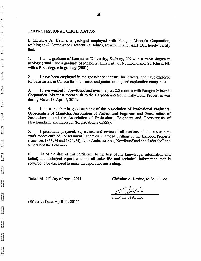

APPENDIX I - LIST OF PERSONNEL AND CONTRACTORS
PERSONNEL Name Location Title Copeland, David St. John’s, NL Geologist Vande Guchte, Mike Vancouver, BC Geologist Devine,Christine St. John’s, NL Geologist Sparrow, Bryan St. John’s, NL Geologist Fost, Dianne Millertown, NL Core Technician Fost, Charlie Millertown, NL Core Technician
CONTRACTORS Name Location Title Eastern Analytical Springdale, NL Geochemical Laboratory ALS Chemex N. Vancouver, BC Geochemical Laboratory New Valley Drilling Springdale, NL Drilling Contractor Lakeview Inn Millertown, NL Accommodations Rob’s Grader Service Springdale, NL Road\Snow Clearing Bill's Service Centre Buchan’s Jct, NL Snow Clearing

APPENDIX II - Diamond Drill Logs

Hole No.
Paragon Minerals CorporationDiamond Drill Log
Licence
N.T.S.
Property
Hole Location
Elevation (m-ASL)
Length (m)
Downhole Survey TestsDepth(m) Dip Azimuth (true)
Region
Drilled byStartedFinishedCore Size
Core Location
UTM EastUTM North
Casing (m)Logged by
Dates Logged
Comments
Grid EastingGrid Northing
Azimuth (grid)
Duck West
252
443.5
New Valley Drilling
Jan. 26, 2011
February 2, 2011NQ
534650.00
5386130.00
B. Sparrow
Test western extension of DuckPond Alteration Zon
DW11-01
0.00
0.00
18539M
12A/10
South Tally Pond
Millertown, NLTally Pond - Lake Ambrose
0.00 -47.00 340.00 340.00
15.00 -44.00 350.10 350.10
74.70 -44.50 351.30 351.30
135.60 -44.30 351.30 351.30
195.60 -43.80 351.90 351.90
257.60 -43.10 352.30 352.30
318.50 -43.20 353.20 353.20
379.50 -42.80 353.60 353.60
2011/04/11Paragon Minerals Corporation

From(m)
To (m)
Rocktype & Description From(m)
To(m)
Width(m)
Sample
Project: DW11-01Hole Number:
Auppb
Agppm
Pbppm
Cuppm
Paragon Minerals Corporation Diamond Drill Log
Znppm
South Tally Pond
Overburden 0.00 4.80
Gabbro 4.80 65.00 14.40 .NULL. 14.90 CNF37191 0.50 .NULL. .NULL .NULL..NUL
Dark green-grey-black, cg'd gabbro w/chloritoid spots + local spotty crb altn. 30.30 .NULL. 30.70 CNF37192 0.40 .NULL. .NULL .NULL..NUL
Minor serpentine (?) developed on some fracture surfaces; light-pale green,lime to pistachio colored. Unit is mostly homogeneous massive except at:
41.7-47.9m - weak - minor crb altn and shearing w/bleached effect on gabbro.
42.2-44.0m - similar to above but more intense w/more crb-chl-ser altn and moreshearing.
Minor sulphides occur interstitially throughout, ~1% Po + Py.Strong Fe oxidization (crb altn ?) in 50 deg fracture at 43.1m.
Intermediate Dyke 65.00 68.20 67.20 .NULL. 67.50 CNF37193 0.30 .NULL. .NULL .NULL..NUL
Light green-grey to pale, beige intermediate intrusive w/50-60cm dark grey toblack chill margins. Chill margins are crb-rich, but centre of unit isn't;perhaps there are two intrusive generations withing this unit.
Sharp upper and lower contacts show abrupt discontinuation of grain size andmineralogy, though plag appears consistent in texture.
Centre of unit appears to contain qtz-pl +/- lesser hbl +/- chloritoidspotting. Unit is cut by numerous qtz-crb veins some of which contain gabbroic(?) xenoliths.
Gabbro 68.20 177.30 92.20 .NULL. 92.60 CNF37194 0.40 .NULL. .NULL .NULL..NUL
Same unit as from 4.8-65.0m. 166.30 .NULL. 166.60 CNF37195 0.30 .NULL. .NULL .NULL..NUL
2011/04/10 Page 1DW11-01

From(m)
To (m)
Rocktype & Description From(m)
To(m)
Width(m)
Sample
Project: DW11-01Hole Number:
Auppb
Agppm
Pbppm
Cuppm
Paragon Minerals Corporation Diamond Drill Log
Znppm
South Tally Pond
Fault zone from 133.4-135.3m; drillers report losing water return (around thisdepth) which suggests this zone is a fault, but there is no fault gouge, justblocky core - minor oxidization of blocks surfaces.
Minor Py on fractures surfaces consistent through unit. Minor Po sporadicallyoccurs on mm-scale interstitially.
105.4-106.6m - crb-rich zone w/nebulous stringers. Looks a lot like crb-richzones on intermediate dyke chill margins above.
Felsic Volcanic Lapilli Tuff 177.30 181.30
Dark green-grey, weakly foliated lapilli tuff (or tuff); lapilli are rare.matrix consists of wispy white-lt grey stringlets (almost frothy looking)intermixed with fg'd dark green-grey matrix of fg'd pl+hbl+chltd. 3%disseminated Po throughout.
Rare cm to dm-scale exotic clasts (?) occur locally; these are near completelychl-ep altered and some edges appear incompletely assimilated (?) or brokendown (?) or chemically replaced.
Some zones appear like altered/foliated mudstones; 180.8-181.0m: large ejecta (?) or bx clast (?) or dyke (?) or flow (?), thishas sharp and opposing contacts which are angular-unconformable to foliationbounding this zone.
Towards base of unit sediment texture (?) is more apparrent.
Moderately chl+ep altered throughout.
Gabbro 181.30 205.50 197.10 .NULL. 197.40 CNF37196 0.30 .NULL. .NULL .NULL..NUL
Dark green-grey, cg'd mafic tuff w/chl altn throughout.
2011/04/10 Page 2DW11-01

From(m)
To (m)
Rocktype & Description From(m)
To(m)
Width(m)
Sample
Project: DW11-01Hole Number:
Auppb
Agppm
Pbppm
Cuppm
Paragon Minerals Corporation Diamond Drill Log
Znppm
South Tally Pond
Crb zone from 190.1 - 205.7m.
This unit doesn't loook like a gabbro, but doesn't have a strong affinityw/tuffaceous sedimentary textures either. Locally, the unit can be fg'd, and itcan look like it has sedimentary layering.
There appears to be two phases of crb alteration w/2 types of spotty crb; oneis high relief and the other is low relief. Locally, the unit has cm-dm-scaleclasts.
Gabbro 205.50 261.50 222.50 .NULL. 223.00 CNF37197 0.50 .NULL. .NULL .NULL..NUL
Mafic Volcanic Intrusive.
Same gabbro as has been seen thus far down hole.Dark olive green-grey, cg'd pl+hbl+chltd. Pervasive chl-ep alteration.
Qtz-crb-ep veinlets along fractures, sometimes with rhyolitic dykelets (?).
Micro faults occur throughout these gabbros and they offset pre-existingfractures. These may accumulatively account for significant offset of originalstructure.
Diabase 261.50 266.20 265.00 .NULL. 265.20 CNF37198 0.20 .NULL. .NULL .NULL..NUL
Dark grey, mg'd, gabbro. Spotty crb looks like snowflakes (and exhibits highrelief). Chl-ep is minor, crb is moderate. Po occurs as interstitial, widely,weakly disseminated sub-mm-scale grains. Whole rock sample from 265.0-265.2m.
Gabbro 266.20 307.60 269.00 .NULL. 269.40 CNF37199 0.40 .NULL. .NULL .NULL..NUL
Dark green-grey-black, cg'd gabbro w/chloritoid spots + local spotty crb altn.Minor serpentine (?) developed on some fracture surfaces; light-pale green,lime to pistachio colored. Same as gabbro at top of hole.
2011/04/10 Page 3DW11-01

From(m)
To (m)
Rocktype & Description From(m)
To(m)
Width(m)
Sample
Project: DW11-01Hole Number:
Auppb
Agppm
Pbppm
Cuppm
Paragon Minerals Corporation Diamond Drill Log
Znppm
South Tally Pond
There might be two generations of gabbro here:
1) earlier gabbro, longer lived, better developed euhedral-sub-hedral xtls.
2) later gabbro, shorter lived, less voluminous, crb-rich; intrudes firstgabbro.
5cm dyke, diorite @299.3m.
306.1 - pale purple-white vein - sourced by dissolution of a nearby jasper?Diabase 307.60 315.40 309.00 .NULL. 309.30 CNF37202 0.30 .NULL. .NULL .NULL..NUL
Dark green-grey-blue, v.fg-fg'd diabase dyke w/no chills; could be a gabbro.Poorly defined contacts; upper and lower, both.
Chl-ep altered and veined.
Lower half of unit has/displays on increase in qtz-veins. Felsic Volcanic Massive 315.40 321.00 317.10 .NULL. 317.60 CNF37204 0.50 .NULL. .NULL .NULL..NUL
Light, pale grey, v.fg-fg'd, rhyolite or felsic dyke. Weakly defined upper and 318.00 5 319.00 CNF37203 1.00 0.20 1 8835
lower contacts. unit is homogeneous and massive except where cut by veins - 319.00 5 320.00 CNF37205 1.00 0.20 1 8238
grains appear larger here, perhaps they are better defined by alteration. 320.00 9 321.00 CNF37206 1.00 0.20 1 7232
Py occurs as mm-scale euhedral cubes in clusters. Looks like overgrowths ofprimary minerals, but they may be primary (though they are several times largerthan the average grain size). Qtz-pl dominates the unit.
Felsic Volcanic Breccia 321.00 331.20 321.00 5 321.50 CNF37207 0.50 0.20 1 266
Light grey, poorly sorted or in-situ brecciated rhyolite. Unit appears to be 321.50 5 322.00 CNF37208 0.50 0.20 1 176
matrix supported with varying clast sizes from cm to dm-scale. Some zones look 322.00 5 322.50 CNF37209 0.50 0.20 1 96
brecciated but others appear to be exotic clasts. 322.50 5 323.00 CNF37210 0.50 0.20 1 1250 323.00 5 323.50 CNF37211 0.50 0.20 1 1478
2011/04/10 Page 4DW11-01
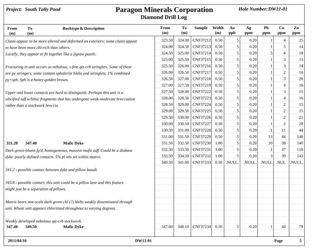
From(m)
To (m)
Rocktype & Description From(m)
To(m)
Width(m)
Sample
Project: DW11-01Hole Number:
Auppb
Agppm
Pbppm
Cuppm
Paragon Minerals Corporation Diamond Drill Log
Znppm
South Tally Pond
Clasts appear to be more altered and deformed on exteriors; some clasts appear 323.50 5 324.00 CNF37212 0.50 0.20 1 254
to have been more chl-rich than others. 324.00 5 324.50 CNF37213 0.50 0.20 1 145
Locally, they appear to fit together like a jigsaw puzzle. 324.50 5 325.00 CNF37214 0.50 0.20 5 184 325.00 5 325.50 CNF37215 0.50 0.20 1 133
Fracturing in unit occurs as nebulous, v.fine qtz-crb stringlets. Some of these 325.50 5 326.00 CNF37216 0.50 0.20 1 143
are py stringers, some contain sphalerite blebs and stringlets, 1% combined 326.00 5 326.50 CNF37217 0.50 0.20 1 162
py+sph. Sph is a honey-golden brown. 326.50 5 327.00 CNF37218 0.50 0.20 1 203 327.00 5 327.50 CNF37219 0.50 0.20 1 164
Upper and lower contacts are hard to distinguish. Perhaps this unit is a 327.50 5 328.00 CNF37222 0.50 0.20 1 153
silicified tuff w/lithic fragments that has undergone weak-moderate brecciation 328.00 5 328.50 CNF37223 0.50 0.20 1 164
rather than a stockwork breccia. 328.50 5 329.00 CNF37224 0.50 0.20 1 152 329.00 5 329.50 CNF37225 0.50 0.20 1 152 329.50 5 330.00 CNF37226 0.50 0.20 1 212 330.00 5 330.50 CNF37227 0.50 0.20 1 282 330.50 5 331.00 CNF37228 0.50 0.20 1 4411 331.00 5 331.50 CNF37229 0.50 0.20 13 14844
Mafic Dyke 331.20 347.40 331.50 5 332.50 CNF37230 1.00 0.20 10 14038
Dark green-bluem fg'd, homogeneous, massive mafic tuff. Could be a diabase 332.50 5 333.50 CNF37231 1.00 0.20 1 11837
dyke. poorly defined contacts. 5% pl xtls set within matrix. 333.50 5 334.50 CNF37232 1.00 0.20 3 14339 340.50 .NULL. 341.00 CNF37233 0.50 .NULL. .NULL .NULL..NUL
341.2 - possible contact between dyke and pillow basalt.
343.8 - possible contact, this unit could be a pillow lave and this featuremight just be a separation of pillows.
Matrix bears mm-scale dark green chl (?) blebs weakly disseminated throughunit. Whole unit appears chloritized throughout to varying degrees.
Weakly developed nebulous qtz-crb stockwork.Mafic Dyke 347.40 349.50 347.60 5 348.10 CNF37234 0.50 0.20 1 7944
2011/04/10 Page 5DW11-01
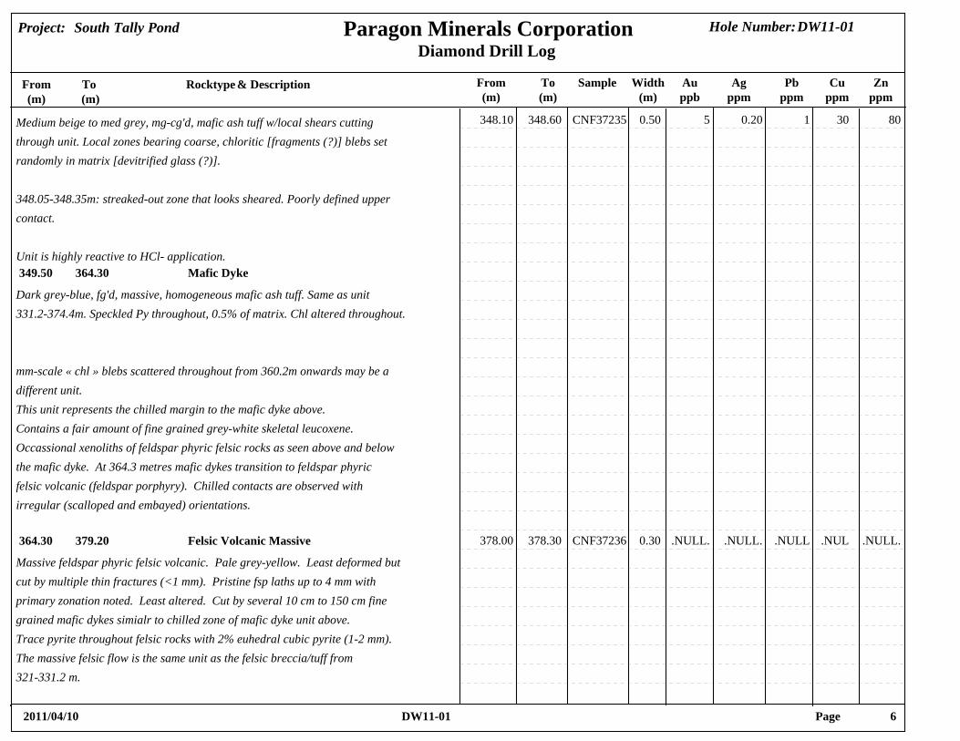
From(m)
To (m)
Rocktype & Description From(m)
To(m)
Width(m)
Sample
Project: DW11-01Hole Number:
Auppb
Agppm
Pbppm
Cuppm
Paragon Minerals Corporation Diamond Drill Log
Znppm
South Tally Pond
Medium beige to med grey, mg-cg'd, mafic ash tuff w/local shears cutting 348.10 5 348.60 CNF37235 0.50 0.20 1 8030
through unit. Local zones bearing coarse, chloritic [fragments (?)] blebs setrandomly in matrix [devitrified glass (?)].
348.05-348.35m: streaked-out zone that looks sheared. Poorly defined uppercontact.
Unit is highly reactive to HCl- application.Mafic Dyke 349.50 364.30
Dark grey-blue, fg'd, massive, homogeneous mafic ash tuff. Same as unit331.2-374.4m. Speckled Py throughout, 0.5% of matrix. Chl altered throughout.
mm-scale « chl » blebs scattered throughout from 360.2m onwards may be adifferent unit.This unit represents the chilled margin to the mafic dyke above.Contains a fair amount of fine grained grey-white skeletal leucoxene.Occassional xenoliths of feldspar phyric felsic rocks as seen above and belowthe mafic dyke. At 364.3 metres mafic dykes transition to feldspar phyricfelsic volcanic (feldspar porphyry). Chilled contacts are observed withirregular (scalloped and embayed) orientations.
Felsic Volcanic Massive 364.30 379.20 378.00 .NULL. 378.30 CNF37236 0.30 .NULL. .NULL .NULL..NUL
Massive feldspar phyric felsic volcanic. Pale grey-yellow. Least deformed butcut by multiple thin fractures (<1 mm). Pristine fsp laths up to 4 mm withprimary zonation noted. Least altered. Cut by several 10 cm to 150 cm finegrained mafic dykes simialr to chilled zone of mafic dyke unit above.Trace pyrite throughout felsic rocks with 2% euhedral cubic pyrite (1-2 mm).The massive felsic flow is the same unit as the felsic breccia/tuff from321-331.2 m.
2011/04/10 Page 6DW11-01

From(m)
To (m)
Rocktype & Description From(m)
To(m)
Width(m)
Sample
Project: DW11-01Hole Number:
Auppb
Agppm
Pbppm
Cuppm
Paragon Minerals Corporation Diamond Drill Log
Znppm
South Tally Pond
Mafic Dyke 379.20 387.20
Massive fine to medium grained gabbro dyke from 379.2 to 387.2 metres asintrusive unit above. Occasional chlorite filled amygdules. Felsic(fsp-phyric) volcanic xenolith from 380.2 to 381.4 metres comprising white fspphyric rhyolite and black to dark grey quartz (? fine grained) phyric rhyolite. Qtz has carbonate coronas overgrowing them. Chilled contacts up against thefelsic xenoliths.
Felsic Volcanic Massive 387.20 396.40 391.30 .NULL. 391.55 CNF37237 0.25 .NULL. .NULL .NULL..NUL
Alternating white and dark-grey felsic volcanic. White rhyolite is fsp phyric. Dark grey rhyolite has very fine quartz crystals with overprints of snowflakecarbonate. Somewhat reminiscent of chaotic carbonate zone (carbonatemicrolites) at Duck Pond and Lemarchant without intense chlorite alt.The unit is cut by occassional fine grained mafic dykes with chilled margins.Least deformed and outside of carbonate the unit is least altered. Occassionalqtz-cal veins (1 cm) and thin fractures. Chilled abrupt contact withunderlying mafic dyke.
Mafic Dyke 396.40 443.50
Medium grey-green, medium grained mafic dyke (gabbro). Cut by qtz cal veins (<1cm) every 30-50 cm, weakly deformed, calcite filled fractures. 30-40% Fsp andgreen chlorite. Occasional wisps of dark green chlorite with associatedFe-carb spots. 2-3% diss leucoxene throughout. Chlorite filled amygdulespossible but vague. Similar to mafic dykes above.
EOH 443.50 443.50
2011/04/10 Page 7DW11-01

Hole No.
Paragon Minerals CorporationDiamond Drill Log
Licence
N.T.S.
Property
Hole Location
Elevation (m-ASL)
Length (m)
Downhole Survey TestsDepth(m) Dip Azimuth (true)
Region
Drilled byStartedFinishedCore Size
Core Location
UTM EastUTM North
Casing (m)Logged by
Dates Logged
Comments
Grid EastingGrid Northing
Azimuth (grid)
Cookstown Grid
368
209.4
New Valley Drilling
February 8, 2011
February 11, 2011NQ
523790.00
5380683.00
B. Sparrow/C. Devine
Targeted an EM conductor~40m depth.
CT11-01
0.00
0.00
18249M
12A/10
South Tally Pond
Millertown, NLTally Pond - Lake Ambrose
0.00 -65.00 180.00 180.00
14.30 -64.30 177.30 177.30
60.00 -64.00 177.30 177.30
118.00 -63.10 178.90 178.90
178.90 -62.70 179.50 179.50
2011/04/11Paragon Minerals Corporation

From(m)
To (m)
Rocktype & Description From(m)
To(m)
Width(m)
Sample
Project: CT11-01Hole Number:
Auppb
Agppm
Pbppm
Cuppm
Paragon Minerals Corporation Diamond Drill Log
Znppm
South Tally Pond
Overburden 0.00 2.80
Greywacke 2.80 8.40 3.25 5 4.00 CNF37238 0.75 0.20 55 32056
Light grey-green to dark grey-black, fg-cg'd bedded to massive locally 4.00 5 4.50 CNF37239 0.50 0.20 6 18647
graphitic greywacke. 4.50 5 5.50 CNF37242 1.00 0.20 16 16964 5.50 5 6.50 CNF37243 1.00 0.40 20 24066
Stringer to spotty Po min 5-8%. 6.50 5 7.50 CNF37244 1.00 0.40 22 32071 7.50 5 8.30 CNF37245 0.80 0.20 15 116122
Local cm-scale rip-up (?) clasts of black argillite; perhaps flattened by laterfoln. Some zones of greywacke are intermixed w/black argillite.
Minor qtz-crb veining associated with argillite layers. Sharp lower contactw/intrusive; bedding (So) is cut at oblique angle.
Po stringers/blebs occur as discontinuous laminae within fol // domains, sameas So.
Greywacke 8.40 18.90
Grey-blue, fg-cg'd, granular greywacke w/local chl-amygdules and v.fg'd spottycrb-overprint; unit reacts moderately to HCl application. Minor qtz-crb veiningfrom mm-cm-scale; probably a late stage feature - displays cutting andoffsetting of silicic dykelet @14.7m.
2011/04/10 Page 1CT11-01

From(m)
To (m)
Rocktype & Description From(m)
To(m)
Width(m)
Sample
Project: CT11-01Hole Number:
Auppb
Agppm
Pbppm
Cuppm
Paragon Minerals Corporation Diamond Drill Log
Znppm
South Tally Pond
8.4-9.1 - mafic dyke with amygdules, fg'd, grey-blue-green w/sharp contacts.
14.9-16.1 - Fspar porphyry w/fg'd, mm-scale chill margins. mm-scale, chillmargins. mm-scale chl amygdules scattered throughout.
Whole greywacke unit appears to be weakly chloritic with chl-specs orintermixed w/qtz-crb veining.
Irregular lower contact. Graphitic Argillite 18.90 28.80 18.90 5 19.20 CNF37246 0.30 0.60 117 530137
Dark grey-black, v.fg'd, homogeneous, massive graphitic argillite bearing 19.20 5 20.10 CNF37247 0.90 0.40 41 23089
mm-scale Po stringers and veins and sub-cm-scale blebs of Po. Po also as fg'd 20.10 5 21.10 CNF37248 1.00 0.50 44 590136
clusters which occur moderately disseminated. Po occurring as bedding as well 21.10 5 22.20 CNF37249 1.10 0.50 22 290123
as stockwork fracture-filling mineralization. Minor Py associated with late 22.20 5 22.60 CNF37250 0.40 1.80 320 5500128
qtz-crb veining. Clottly Po locally as cm-scale blotches. 22.60 5 23.00 CNF37251 0.40 0.70 32 520132 23.00 5 24.00 CNF37252 1.00 0.80 73 430182
0.3-0.5% Sph near qtz-crb vein at 23.7m. 10-12% Py throughout. 1-2% Py near 24.00 5 25.00 CNF37253 1.00 0.20 4 58060
qtz-crb veins. 25.00 5 26.00 CNF37254 1.00 0.20 7 8526 26.00 5 27.20 CNF37255 1.20 0.20 8 5530
24.0-27.2m - Mafic intrusive w/greywacke zones; greywackes are chloritized 27.20 5 27.50 CNF37256 0.30 0.20 18 12252
within dyke (?) Possibly incomplete assimilation of sediments. Specular Py+Po 27.50 5 28.20 CNF37257 0.70 1.40 74 960250
~1% throughout. Minor qtz-crb veining. 28.20 5 28.80 CNF37258 0.60 1.00 60 1200162
Sharp lower contact @ 28.8m.Mafic Volcanic Massive 28.80 33.70 28.80 5 29.80 CNF37259 1.00 0.20 5 9646
Light to medium grey, v.fg-mg'd, massive homogeneous basalt w/minor 29.80 5 30.80 CNF37262 1.00 0.60 33 19267
sub-mm-scale chloritoid speckles. Weakly to moderately disseminated 30.80 5 31.80 CNF37263 1.00 0.20 1 45052
throughout. 31.80 5 32.70 CNF37264 0.90 0.20 1 50047 32.70 5 33.70 CNF37265 1.00 0.20 23 9769
Po blebs throughout.
2011/04/10 Page 2CT11-01

From(m)
To (m)
Rocktype & Description From(m)
To(m)
Width(m)
Sample
Project: CT11-01Hole Number:
Auppb
Agppm
Pbppm
Cuppm
Paragon Minerals Corporation Diamond Drill Log
Znppm
South Tally Pond
[Could this unit be a v.fg'd sediment? There are no apparent qtz grains or eyesdisplayed.]
Minor zones of qtz-crb veining and some argillite beds occur not bounded byqtz-crb veins - thrust faulting (?).
Marcasite on fracture surfaces at 30.2 m, 65deg - associated with qtz-crbveins.
Dyke from 31.1-31.4m - v.fg'd, light, dull grey w/sharp contacts that displaychill margins.
Sharp lower contact @33.7m.Graphitic Argillite 33.70 35.80 33.70 5 34.50 CNF37266 0.80 0.20 13 6165
Alternating black and grey, intercalated lenses and laminae of graphitic 34.50 5 35.80 CNF37267 1.30 0.20 18 56085
argillite and v.fg'd wacke/siltstone/mudstone. Conjugate fracture sets @35.1m.
Regularly bedded So @ 30deg t.c.a., v.fg'd; [ deep basinal, low energylaminae.]
Po speckles throughout and sometimes as blotchy lenses // to So. Irregularlower contact - sharp, discontinuously lined w/Po blebs.
Mafic Volcanic basalt 35.80 41.65 35.80 5 36.80 CNF37268 1.00 0.20 6 13065
Parlr, dull grey, fg'd, groundmass basalt bearing cm-scale amygdules. 36.80 5 37.70 CNF37269 0.90 0.20 1 13146
Intercalated w/rare argillite lenses; these have an associated bleached margin 37.70 5 38.70 CNF37270 1.00 0.20 53 33046
on the basaltic side of contacts. This margin is also displayed rimming argilic 38.70 5 39.70 CNF37271 1.00 0.20 69 15677
rip-up clasts (?) @37.3m; [Possibly a late stage fluid front of alteration - 39.70 5 40.00 CNF37272 0.30 0.20 69 1300250
reacts with HCl]. 40.00 5 41.10 CNF37273 1.10 0.20 100 22047
2011/04/10 Page 3CT11-01

From(m)
To (m)
Rocktype & Description From(m)
To(m)
Width(m)
Sample
Project: CT11-01Hole Number:
Auppb
Agppm
Pbppm
Cuppm
Paragon Minerals Corporation Diamond Drill Log
Znppm
South Tally Pond
41.10 5 41.65 CNF37274 0.55 1.10 174 248001400
Locally looks brecciated, pillowed and tuffaceous at different points. Basaltappears to have a hyaloclasite texture; it occurs as cm-scale podiformagglomerations especially at top of unit. Lower in unit it contains increasing#'s of exotic lithic clasts as from 39.9-40.0m; 46.6-47.7m; further, it appearswith weak foliation and generally a lumpy-massive texture.
Sphalerite lens from 41.2-41.25m (massive sulphide); 41.58-41.60m (massivesulphide).
Late qtz-crb veining along foliation (?)
Irregular lower contact.Felsic Intrusive feldspar porphyry 41.65 50.70 41.65 5 42.40 CNF37275 0.75 1.30 11 1231300
Light to dark grey, fg'd groundmass w/mm-scale porphyritic, sub-hedral plag 42.40 5 43.40 CNF37276 1.00 0.20 5 23052
xtls throughout. Blotchy sulphide zones intermittently occur as @47.7m 46.40 5 47.60 CNF37277 1.20 0.20 2 6733 47.60 5 48.50 CNF37278 0.90 0.20 5 398
Unit appears strongly siliceous; possibly a late alteration. 48.50 5 49.20 CNF37279 0.70 0.20 3 6024
Some diabase sections as at 45.0-46.0m; 49.2-49.9m.Mafic Volcanic Basalt 50.70 55.00
Massive, gfg'd, med-dark grey, homogeneous basalt.
Contains a fsp-porphyry zone as from 53.6-53.9m.
Weakly diss, v.fg'd Po specs ~1%.
Sharp lower contact.Felsic Intrusive fsp porphyry 55.00 59.50 58.20 .NULL. 58.50 CNF37282 0.30 .NULL. .NULL .NULL..NUL
Dark grey-black, v.fg-fg'd groundmass, bearing coarse, porphyritic plag. 58.50 5 59.50 CNF37283 1.00 0.20 3 483
2011/04/10 Page 4CT11-01

From(m)
To (m)
Rocktype & Description From(m)
To(m)
Width(m)
Sample
Project: CT11-01Hole Number:
Auppb
Agppm
Pbppm
Cuppm
Paragon Minerals Corporation Diamond Drill Log
Znppm
South Tally Pond
laths.
Units occurs as subtly striped dark grey bands w/black bands, both of whichcontain plag laths (sub-hedral to euhedral); in some places the laths appear asclumps and in others along foliation // to striping.
Minor sulphides present, 1-2%.irregular contact.
Same as unit 41.7-50.7m.Mafic Volcanic Basalt 59.50 65.20 59.50 5 60.50 CNF37284 1.00 0.20 3 837
Dark green-grey, fg-mg'd basalt w/chloritic amygdules and weak chl overprint. 62.50 5 63.60 CNF37285 1.10 0.20 1 22032
Minor sulphides as weakly disseminated blebs and stringers. 63.60 5 64.50 CNF37286 0.90 0.20 1 17555 64.50 5 65.20 CNF37287 0.70 0.20 1 25064
Minor qtz-crb veining.
Some zones contain xenoliths of surrounding (?) lithologies.
Sharp lower contact @50deg t.c.a.Felsic Intrusive Feldspar Porphyry 65.20 67.10
Same as above. Dark grey black, v.fg-fg'd groundmass bearing coarse,porphyritic plag laths.
Mafic Volcanic Massive 67.10 78.20
Basalt, homogeneous, fg'd, locally massive, bears fsp porphyry zones. Light tomed grey, some zones are more massive.
Local zones of spherulitic chloritized blebs; occur more intense [wherehyaloclastite (?) textures predominate] in some zones.
Local zones of qtz-crb, late stage, fracture-filling material, also some localepidotization as blebs and fracture-filling material.
2011/04/10 Page 5CT11-01

From(m)
To (m)
Rocktype & Description From(m)
To(m)
Width(m)
Sample
Project: CT11-01Hole Number:
Auppb
Agppm
Pbppm
Cuppm
Paragon Minerals Corporation Diamond Drill Log
Znppm
South Tally Pond
Local sericitization from 84-100m.
103.3 - fault w/sericitic gouge (?) and epidote (?).Mafic Intrusive Diabase 78.20 85.20 78.50 .NULL. 79.10 CNF37288 0.60 .NULL. .NULL .NULL..NUL
Med. grey-blue, fg'd, homogeneous, massive diabase w/ep-chl-crb veining.
V.fg'd chill margins fro 3cm at upper contact of unit.
Possibly some sericite alteration in veins as well.
Lower contact @85.2m @shear; original contact may be displaced or may beobliterated.
Mafic Volcanic Ash Tuff 85.20 104.10 97.10 .NULL. 97.50 CNF37289 0.40 .NULL. .NULL .NULL..NUL
Crystal ash tuff. Med. grey-blue, fg'd groundmass bearing coarse, sub-hedral,zoned plagioclase xtls. Locally weak to moderate ep-chl veining.
Possibly some lithic fragments; one 3cm fragment (xenolith?) w/Cpy+Po blotches.
[Perhaps this unit is the porphyritic intrusive's external expression, thoughthere are no recognized felsic suggestions in the core.]
Felsic Intrusive Feldspar Porphyry 104.10 131.00 109.80 .NULL. 110.30 CNF37290 0.50 .NULL. .NULL .NULL..NUL
Dark grey, fg'd groundmass w/mm-plag, weakly disseminated; some plag appears 121.00 .NULL. 121.60 CNF37291 0.60 .NULL. .NULL .NULL..NUL
altered. unit looks silica-rich.
Minor weak ser along some fractures. most of unit displays some v.fine grainednebulous fracturing w/crb infill.
Mafic Volcanic Massive 131.00 209.40 145.90 7 146.90 CNF37292 1.00 0.20 1 7938
Variable basalts from massive to tuffaceous to brecciated textures. Local 146.90 .NULL. 147.30 CNF37293 0.40 .NULL. .NULL .NULL..NUL
2011/04/10 Page 6CT11-01

From(m)
To (m)
Rocktype & Description From(m)
To(m)
Width(m)
Sample
Project: CT11-01Hole Number:
Auppb
Agppm
Pbppm
Cuppm
Paragon Minerals Corporation Diamond Drill Log
Znppm
South Tally Pond
jasper blotches; 144.8m, and increasing down unit in quantity, but not volume 147.30 .NULL. 148.30 CNF37294 1.00 .NULL. .NULL .NULL..NUL
(more grains but smaller). 153.00 8 154.00 CNF37295 1.00 0.20 1 9527 154.00 .NULL. 154.30 CNF37296 0.30 .NULL. .NULL .NULL..NUL
Rhyolite dyke at 154.0-154.3m and from 166.2-167.1m - light grey, fg'd, massive 154.30 5 155.30 CNF37297 1.00 0.20 1 8425
w/fg'd qtz eyes. Minor fracturing, some bearing minor sulphides. Abundant 164.20 5 165.20 CNF37298 1.00 0.20 1 7639
vesicular zones, some inflled with crb, and occurring on mm-scales. Weak to 165.20 15 165.70 CNF37299 0.50 0.20 3 8140
moderately disseminated throughout. 165.70 14 166.20 CNF37302 0.50 0.20 8 8737 166.20 .NULL. 166.60 CNF37303 0.40 .NULL. .NULL .NULL..NUL
Py occurs in patchy zones of strongly disseminated, sub-mm-scale grains, ~3% 166.60 36 167.10 CNF37304 0.50 0.20 96 17729
throughout. Po occurs as rare and weakly disseminated zone of grains, ~0.5% of 167.10 25 167.60 CNF37305 0.50 0.20 10 5241
unit locally. 167.60 8 168.60 CNF37306 1.00 0.20 2 8947 170.70 .NULL. 171.10 CNF37307 0.40 .NULL. .NULL .NULL..NUL 184.20 5 184.70 CNF37308 0.50 0.20 1 6531 184.70 33 185.00 CNF37309 0.30 0.60 29 7759 185.00 9 185.50 CNF37310 0.50 0.40 4 7840 195.50 .NULL. 195.90 CNF37323 0.40 .NULL. .NULL .NULL..NUL 200.50 5 201.50 CNF37311 1.00 0.20 7 11960 201.50 15 202.00 CNF37312 0.50 0.20 138 30037 202.00 19 202.50 CNF37313 0.50 0.20 540 38063 202.50 9 203.00 CNF37314 0.50 0.20 260 38080 203.00 7 203.50 CNF37315 0.50 0.20 300 33068 203.50 5 204.00 CNF37316 0.50 0.20 12 18492 204.00 64 204.50 CNF37317 0.50 0.20 91 13829 204.50 28 205.00 CNF37318 0.50 0.20 101 13543 205.00 6 205.50 CNF37319 0.50 0.20 23 15573 205.50 9 206.00 CNF37322 0.50 0.20 23 16073
EOH 209.40 209.40
2011/04/10 Page 7CT11-01

APPENDIX III - Drill Core Analytical Certificates

ALS CODE DESCRIPTION
SAMPLE PREPARATION
WEI-21 Received Sample WeightLOG-24 Pulp Login - Rcd w/o BarcodeLOG-QC QC Test on Received Samples
ALS CODE DESCRIPTION INSTRUMENT
ANALYTICAL PROCEDURES
Pb-OG62 VARIABLEOre Grade Pb - Four AcidZn-OG62 VARIABLEOre Grade Zn - Four AcidME-XRF06 XRFWhole Rock Package - XRFOA-GRA06 WST-SIMLOI for ME-XRF06ME-MS81 ICP-MS38 element fusion ICP-MSME-ICP61 ICP-AES33 element four acid ICP-AESME-OG62 ICP-AESOre Grade Elements - Four AcidCu-OG62 VARIABLEOre Grade Cu - Four Acid
CERTIFICATE VA11033488
This report is for 133 Pulp samples submitted to our lab in Vancouver, BC, Canada on 2-MAR-2011.
Project: NL442P.O. No.:
The following have access to data associated with this certificate: ACCOUNTS PAYABLE DAVID COPELAND
PARAGON MINERALS CORPATTN: DAVID COPELAND140 WATER STREET, SUITE 605ST. JOHN'S NL A1C 6H6
To:
Page: 1Finalized Date: 17-MAR-2011
Account: PARMIN
PARAGON MINERALS CORP140 WATER STREET, SUITE 605ST. JOHN'S NL A1C 6H6
To:ALS Canada Ltd.
2103 Dollarton HwyNorth Vancouver BC V7H 0A7 Phone: 604 984 0221 Fax: 604 984 0218 www.alsglobal.com
This is the Final Report and supersedes any preliminary report with this certificate number. Results apply to samples as submitted. All pages of this report have been checked and approved for release. Signature:
Colin Ramshaw, Vancouver Laboratory Manager

Page: 2 - ATotal # Pages: 5 (A - F)
Finalized Date: 17-MAR-2011Account: PARMIN
ALS Canada Ltd.
2103 Dollarton HwyNorth Vancouver BC V7H 0A7 Phone: 604 984 0221 Fax: 604 984 0218 www.alsglobal.com
PARAGON MINERALS CORP140 WATER STREET, SUITE 605ST. JOHN'S NL A1C 6H6
To:
Project: NL442
CERTIFICATE OF ANALYSIS VA11033488
Sample Description
MethodAnalyteUnitsLOR
WEI-21 ME-ICP61 ME-ICP61 ME-ICP61 ME-ICP61 ME-ICP61 ME-ICP61 ME-ICP61 ME-ICP61 ME-ICP61 ME-ICP61 ME-ICP61 ME-ICP61 ME-ICP61 ME-ICP61Recvd Wt. Ag Al As Ba Be Bi Ca Cd Co Cr Cu Fe Ga K
kg ppm % ppm ppm ppm ppm % ppm ppm ppm ppm % ppm %0.02 0.5 0.01 5 10 0.5 2 0.01 0.5 1 1 1 0.01 10 0.01
CNF37191 0.22 0.5 7.10 12 320 1.1 3 5.31 <0.5 38 76 23 10.30 20 0.82CNF37192 0.16 <0.5 6.85 16 150 1.0 5 5.65 <0.5 38 86 28 9.91 20 0.33CNF37193 0.16 <0.5 6.79 33 220 0.8 <2 6.25 <0.5 33 38 21 7.40 20 1.71CNF37194 0.20 <0.5 7.48 11 180 0.9 2 6.77 <0.5 38 80 53 8.41 20 0.77CNF37195 0.18 <0.5 6.87 44 330 0.9 <2 6.74 <0.5 53 54 34 10.65 20 0.48
CNF37196 0.14 <0.5 6.96 21 90 0.9 2 4.76 <0.5 39 41 76 8.62 20 0.89CNF37197 0.14 <0.5 6.86 13 120 0.7 6 6.22 <0.5 49 72 46 10.25 20 0.37CNF37198 0.16 <0.5 7.61 26 250 0.9 5 4.98 <0.5 36 42 54 8.35 20 2.02CNF37199 0.18 0.5 7.58 17 230 0.9 <2 6.61 <0.5 36 76 47 8.50 20 0.68CNF37200 0.16 <0.5 5.58 <5 680 1.4 <2 0.26 <0.5 2 250 1 1.11 20 2.71
CNF37201 0.06 56.0 3.25 141 130 <0.5 36 1.87 332 84 75 >10000 14.85 10 0.57CNF37202 0.16 <0.5 6.95 53 80 1.0 <2 5.25 <0.5 37 49 50 8.85 20 0.10CNF37203 0.20 <0.5 5.73 11 190 1.0 <2 5.62 <0.5 31 50 39 7.48 20 1.05CNF37204 0.22 <0.5 5.98 9 220 1.2 <2 5.15 <0.5 31 31 38 7.71 20 1.33CNF37205 0.20 <0.5 6.27 30 140 1.0 2 5.25 <0.5 34 34 42 8.03 20 0.55
CNF37206 0.14 <0.5 6.24 9 310 1.4 <2 5.88 <0.5 32 32 36 8.04 20 1.80CNF37207 0.18 <0.5 6.97 10 160 0.8 2 1.26 <0.5 5 123 4 2.84 10 0.69CNF37208 0.16 <0.5 6.20 <5 90 0.5 <2 1.02 <0.5 4 199 4 1.89 10 0.34CNF37209 0.18 <0.5 5.95 <5 190 0.8 2 1.33 <0.5 5 204 4 1.98 10 0.88CNF37210 0.20 <0.5 5.08 <5 150 0.6 <2 1.85 <0.5 5 217 52 1.60 10 0.69
CNF37211 0.24 <0.5 5.08 5 120 0.5 <2 2.06 <0.5 5 183 22 2.23 10 0.52CNF37212 0.18 <0.5 8.33 10 220 0.9 <2 1.37 <0.5 6 114 3 3.73 20 1.05CNF37213 0.18 <0.5 6.23 <5 120 0.7 <2 1.03 <0.5 3 173 3 1.80 10 0.48CNF37214 0.20 <0.5 6.41 <5 120 0.7 <2 1.11 <0.5 4 154 2 2.34 10 0.54CNF37215 0.22 <0.5 6.30 <5 100 0.6 <2 1.12 <0.5 4 166 2 2.20 10 0.46
CNF37216 0.20 <0.5 6.28 <5 140 0.7 <2 1.29 <0.5 3 151 1 2.02 10 0.71CNF37217 0.22 <0.5 6.89 <5 130 0.8 <2 1.26 <0.5 5 126 1 2.60 10 0.56CNF37218 0.18 <0.5 6.49 8 150 0.8 <2 1.07 <0.5 4 171 1 2.62 10 0.55CNF37219 0.22 <0.5 6.03 <5 110 0.6 <2 1.17 <0.5 3 167 2 1.93 10 0.40CNF37220 0.16 <0.5 5.81 <5 680 1.7 <2 0.27 <0.5 2 275 3 1.12 20 3.07
CNF37221 0.06 57.3 3.33 135 120 <0.5 39 1.89 335 83 77 >10000 15.05 10 0.58CNF37222 0.20 <0.5 6.51 <5 200 0.9 <2 1.55 <0.5 2 158 3 2.38 10 0.75CNF37223 0.20 <0.5 6.77 7 190 0.9 <2 1.24 <0.5 4 161 5 2.11 10 0.67CNF37224 0.20 <0.5 6.82 <5 160 0.9 <2 1.39 <0.5 3 132 1 1.99 10 0.57CNF37225 0.24 <0.5 6.21 <5 120 0.7 <2 1.19 <0.5 4 142 1 2.13 10 0.45
CNF37226 0.18 <0.5 7.11 7 220 1.1 <2 1.22 <0.5 5 121 1 3.17 10 0.84CNF37227 0.20 <0.5 6.52 <5 170 1.0 <2 1.35 <0.5 4 120 1 2.61 10 0.69CNF37228 0.20 <0.5 6.16 8 110 0.8 <2 2.13 <0.5 7 160 12 2.75 10 0.46CNF37229 0.20 <0.5 6.31 13 90 0.9 2 4.80 0.6 29 84 49 7.23 20 0.49CNF37230 0.22 <0.5 6.45 18 90 1.1 <2 5.17 <0.5 36 42 42 8.29 20 0.20

Page: 2 - BTotal # Pages: 5 (A - F)
Finalized Date: 17-MAR-2011Account: PARMIN
ALS Canada Ltd.
2103 Dollarton HwyNorth Vancouver BC V7H 0A7 Phone: 604 984 0221 Fax: 604 984 0218 www.alsglobal.com
PARAGON MINERALS CORP140 WATER STREET, SUITE 605ST. JOHN'S NL A1C 6H6
To:
Project: NL442
CERTIFICATE OF ANALYSIS VA11033488
Sample Description
MethodAnalyteUnitsLOR
ME-ICP61 ME-ICP61 ME-ICP61 ME-ICP61 ME-ICP61 ME-ICP61 ME-ICP61 ME-ICP61 ME-ICP61 ME-ICP61 ME-ICP61 ME-ICP61 ME-ICP61 ME-ICP61 ME-ICP61La Mg Mn Mo Na Ni P Pb S Sb Sc Sr Th Ti Tl
ppm % ppm ppm % ppm ppm ppm % ppm ppm ppm ppm % ppm10 0.01 5 1 0.01 1 10 2 0.01 5 1 1 20 0.01 10
CNF37191 20 2.39 1685 <1 2.46 5 1270 7 0.17 5 30 391 <20 2.10 <10CNF37192 20 2.27 1500 <1 2.55 7 1110 5 0.29 7 29 305 <20 2.06 <10CNF37193 20 2.56 1335 <1 2.09 18 980 4 0.28 <5 27 199 <20 0.78 <10CNF37194 20 3.00 1425 <1 2.24 22 1020 5 0.18 5 32 294 <20 1.26 <10CNF37195 20 3.07 1705 <1 2.06 21 930 3 0.29 6 34 275 <20 1.73 <10
CNF37196 20 3.25 1405 <1 2.73 24 880 3 0.27 <5 32 264 <20 1.29 <10CNF37197 20 3.12 1575 <1 2.36 24 850 9 0.37 5 34 283 <20 1.64 <10CNF37198 20 2.84 1310 <1 0.44 19 1100 6 0.12 <5 32 43 <20 1.15 <10CNF37199 20 2.95 1435 <1 2.37 20 1090 5 0.18 <5 31 331 <20 1.30 <10CNF37200 30 0.03 298 <1 3.27 5 30 13 0.06 <5 2 19 <20 0.06 <10
CNF37201 10 1.06 583 31 0.64 43 350 >10000 >10.0 65 11 69 <20 0.22 <10CNF37202 20 2.80 1520 1 2.52 22 1170 5 0.23 <5 29 158 <20 1.40 <10CNF37203 20 2.23 1280 <1 2.13 13 1030 9 0.50 <5 23 169 <20 0.88 <10CNF37204 20 2.33 1335 <1 1.53 14 1020 9 0.29 5 25 157 <20 0.98 <10CNF37205 20 2.45 1325 <1 2.33 14 1090 7 0.15 <5 26 146 <20 1.10 <10
CNF37206 20 2.53 1435 <1 1.19 13 1020 8 0.27 <5 25 139 <20 0.94 <10CNF37207 30 0.84 326 1 4.32 6 420 <2 0.41 <5 10 121 <20 0.20 <10CNF37208 20 0.57 257 <1 4.54 5 390 <2 0.16 <5 8 86 <20 0.19 <10CNF37209 20 0.59 285 <1 3.51 6 380 <2 0.37 <5 8 90 <20 0.20 <10CNF37210 20 0.65 315 <1 3.25 5 270 <2 0.29 <5 8 91 <20 0.20 <10
CNF37211 20 0.78 331 <1 3.27 6 220 5 0.52 <5 9 109 <20 0.13 <10CNF37212 20 1.00 369 <1 5.26 5 560 2 0.46 <5 15 124 <20 0.23 <10CNF37213 20 0.56 219 <1 4.45 6 380 <2 0.11 <5 8 106 <20 0.20 <10CNF37214 20 0.84 262 <1 4.20 6 480 <2 0.07 <5 10 96 <20 0.22 <10CNF37215 20 0.70 278 <1 4.22 8 290 <2 0.07 <5 10 86 <20 0.17 <10
CNF37216 20 0.74 263 <1 4.20 6 490 <2 0.07 <5 9 95 <20 0.22 <10CNF37217 20 0.98 337 <1 4.52 6 490 <2 0.10 <5 13 108 <20 0.25 <10CNF37218 20 0.96 317 <1 4.14 5 450 <2 0.18 <5 12 113 <20 0.23 <10CNF37219 20 0.74 241 <1 4.10 6 360 <2 0.09 <5 9 89 <20 0.20 <10CNF37220 40 0.03 247 1 3.20 6 30 13 0.08 <5 2 19 <20 0.05 <10
CNF37221 10 1.07 587 32 0.65 43 370 >10000 >10.0 82 11 71 <20 0.22 10CNF37222 20 1.03 462 <1 4.07 7 450 <2 0.09 <5 11 100 <20 0.26 <10CNF37223 20 0.91 275 <1 4.37 9 450 <2 0.09 <5 12 109 <20 0.25 <10CNF37224 20 0.94 308 <1 4.63 6 510 <2 0.07 <5 12 103 <20 0.27 <10CNF37225 20 0.88 283 <1 4.05 7 400 <2 0.08 <5 10 89 <20 0.25 <10
CNF37226 20 1.31 381 <1 3.88 6 420 <2 0.09 <5 12 107 <20 0.22 <10CNF37227 20 1.15 354 <1 3.83 5 470 3 0.07 <5 13 118 <20 0.26 <10CNF37228 20 1.08 487 <1 4.30 6 450 3 0.13 <5 11 116 <20 0.27 <10CNF37229 20 2.24 1375 <1 2.66 13 1100 21 0.13 <5 23 175 <20 0.94 <10CNF37230 10 2.56 1545 1 2.76 17 1090 26 0.19 <5 27 210 <20 1.23 <10

Page: 2 - CTotal # Pages: 5 (A - F)
Finalized Date: 17-MAR-2011Account: PARMIN
ALS Canada Ltd.
2103 Dollarton HwyNorth Vancouver BC V7H 0A7 Phone: 604 984 0221 Fax: 604 984 0218 www.alsglobal.com
PARAGON MINERALS CORP140 WATER STREET, SUITE 605ST. JOHN'S NL A1C 6H6
To:
Project: NL442
CERTIFICATE OF ANALYSIS VA11033488
Sample Description
MethodAnalyteUnitsLOR
ME-ICP61 ME-ICP61 ME-ICP61 ME-ICP61 Cu-OG62 Pb-OG62 Zn-OG62 ME-XRF06 ME-XRF06 ME-XRF06 ME-XRF06 ME-XRF06 ME-XRF06 ME-XRF06 ME-XRF06U V W Zn Cu Pb Zn SiO2 Al2O3 Fe2O3 CaO MgO Na2O K2O Cr2O3
ppm ppm ppm ppm % % % % % % % % % % %10 1 10 2 0.001 0.001 0.001 0.01 0.01 0.01 0.01 0.01 0.01 0.01 0.01
CNF37191 <10 349 <10 136 47.98 12.87 15.23 7.59 4.21 3.16 0.99 0.01CNF37192 <10 356 <10 119 48.97 12.78 15.38 8.50 4.17 3.39 0.40 0.01CNF37193 <10 253 10 103 37.61 12.72 10.78 9.13 4.64 2.76 2.09 <0.01CNF37194 <10 276 <10 105 48.68 13.63 12.61 9.74 5.31 2.89 0.92 0.01CNF37195 <10 534 <10 116 46.51 12.71 16.13 9.96 5.48 2.70 0.58 0.01
CNF37196 <10 338 <10 101 45.86 12.61 12.47 6.76 5.63 3.52 1.04 <0.01CNF37197 <10 501 <10 131 45.85 12.75 15.61 9.16 5.57 3.07 0.46 0.01CNF37198 <10 272 <10 75 46.02 13.90 11.96 7.02 4.98 0.53 2.45 <0.01CNF37199 <10 281 <10 101 48.87 14.00 12.93 9.76 5.27 3.09 0.83 0.01CNF37200 10 3 <10 44
CNF37201 <10 90 60 >10000 1.315 1.510 7.06CNF37202 <10 288 <10 120 46.73 12.68 12.67 7.38 4.82 3.26 0.12 0.01CNF37203 <10 209 <10 108CNF37204 <10 230 <10 100 41.77 11.28 11.23 7.62 4.24 2.06 1.62 0.01CNF37205 <10 252 <10 104
CNF37206 <10 235 <10 103CNF37207 10 42 <10 28CNF37208 10 27 <10 15CNF37209 10 50 <10 10CNF37210 10 42 <10 13
CNF37211 10 35 <10 30CNF37212 10 58 <10 24CNF37213 10 27 <10 10CNF37214 10 35 <10 13CNF37215 10 24 <10 9
CNF37216 10 31 <10 10CNF37217 10 32 <10 12CNF37218 10 36 <10 17CNF37219 10 26 <10 12CNF37220 10 3 <10 43
CNF37221 <10 94 60 >10000 1.290 1.500 6.97CNF37222 10 35 <10 17CNF37223 10 32 <10 22CNF37224 10 30 <10 14CNF37225 10 35 <10 13
CNF37226 10 41 <10 19CNF37227 10 44 <10 24CNF37228 10 60 <10 47CNF37229 <10 209 <10 160CNF37230 <10 250 <10 156
Page: 2 - DTotal # Pages: 5 (A - F)
Finalized Date: 17-MAR-2011Account: PARMIN
ALS Canada Ltd.
2103 Dollarton HwyNorth Vancouver BC V7H 0A7 Phone: 604 984 0221 Fax: 604 984 0218 www.alsglobal.com
PARAGON MINERALS CORP140 WATER STREET, SUITE 605ST. JOHN'S NL A1C 6H6
To:
Project: NL442
CERTIFICATE OF ANALYSIS VA11033488
Sample Description
MethodAnalyteUnitsLOR
ME-XRF06 ME-XRF06 ME-XRF06 ME-XRF06 ME-XRF06 ME-XRF06 ME-XRF06 ME-MS81 ME-MS81 ME-MS81 ME-MS81 ME-MS81 ME-MS81 ME-MS81 ME-MS81TiO2 MnO P2O5 SrO BaO LOI Total Ag Ba Ce Co Cr Cs Cu Dy
% % % % % % % ppm ppm ppm ppm ppm ppm ppm ppm0.01 0.01 0.001 0.01 0.01 0.01 0.01 1 0.5 0.5 0.5 10 0.01 5 0.05
CNF37191 3.68 0.22 0.268 0.03 0.03 2.08 98.36CNF37192 3.67 0.22 0.245 0.03 0.02 2.23 100.00CNF37193 2.15 0.18 0.220 0.01 0.02 15.80 98.10CNF37194 2.18 0.19 0.222 0.03 0.02 1.82 98.24CNF37195 3.05 0.24 0.205 0.02 0.04 2.37 100.00
CNF37196 2.23 0.18 0.190 0.02 <0.01 7.61 98.13CNF37197 2.88 0.22 0.189 0.03 0.01 2.38 98.19CNF37198 2.27 0.17 0.233 <0.01 0.02 8.57 98.13CNF37199 2.31 0.20 0.234 0.03 0.03 1.99 99.55CNF37200CNF37201CNF37202 2.34 0.20 0.253 0.01 0.01 7.80 98.27CNF37203CNF37204 2.16 0.18 0.233 <0.01 0.03 16.15 98.58CNF37205CNF37206CNF37207CNF37208CNF37209CNF37210CNF37211CNF37212CNF37213CNF37214CNF37215CNF37216CNF37217CNF37218CNF37219CNF37220CNF37221CNF37222CNF37223CNF37224CNF37225CNF37226CNF37227CNF37228CNF37229CNF37230

Page: 2 - ETotal # Pages: 5 (A - F)
Finalized Date: 17-MAR-2011Account: PARMIN
ALS Canada Ltd.
2103 Dollarton HwyNorth Vancouver BC V7H 0A7 Phone: 604 984 0221 Fax: 604 984 0218 www.alsglobal.com
PARAGON MINERALS CORP140 WATER STREET, SUITE 605ST. JOHN'S NL A1C 6H6
To:
Project: NL442
CERTIFICATE OF ANALYSIS VA11033488
Sample Description
MethodAnalyteUnitsLOR
ME-MS81 ME-MS81 ME-MS81 ME-MS81 ME-MS81 ME-MS81 ME-MS81 ME-MS81 ME-MS81 ME-MS81 ME-MS81 ME-MS81 ME-MS81 ME-MS81 ME-MS81Er Eu Ga Gd Hf Ho La Lu Mo Nb Nd Ni Pb Pr Rb
ppm ppm ppm ppm ppm ppm ppm ppm ppm ppm ppm ppm ppm ppm ppm0.03 0.03 0.1 0.05 0.2 0.01 0.5 0.01 2 0.2 0.1 5 5 0.03 0.2
CNF37191CNF37192CNF37193CNF37194CNF37195CNF37196CNF37197CNF37198CNF37199CNF37200CNF37201CNF37202CNF37203CNF37204CNF37205CNF37206CNF37207CNF37208CNF37209CNF37210CNF37211CNF37212CNF37213CNF37214CNF37215CNF37216CNF37217CNF37218CNF37219CNF37220CNF37221CNF37222CNF37223CNF37224CNF37225CNF37226CNF37227CNF37228CNF37229CNF37230
Page: 2 - FTotal # Pages: 5 (A - F)
Finalized Date: 17-MAR-2011Account: PARMIN
ALS Canada Ltd.
2103 Dollarton HwyNorth Vancouver BC V7H 0A7 Phone: 604 984 0221 Fax: 604 984 0218 www.alsglobal.com
PARAGON MINERALS CORP140 WATER STREET, SUITE 605ST. JOHN'S NL A1C 6H6
To:
Project: NL442
CERTIFICATE OF ANALYSIS VA11033488
Sample Description
MethodAnalyteUnitsLOR
ME-MS81 ME-MS81 ME-MS81 ME-MS81 ME-MS81 ME-MS81 ME-MS81 ME-MS81 ME-MS81 ME-MS81 ME-MS81 ME-MS81 ME-MS81 ME-MS81 ME-MS81Sm Sn Sr Ta Tb Th Tl Tm U V W Y Yb Zn Zr
ppm ppm ppm ppm ppm ppm ppm ppm ppm ppm ppm ppm ppm ppm ppm0.03 1 0.1 0.1 0.01 0.05 0.5 0.01 0.05 5 1 0.5 0.03 5 2
CNF37191CNF37192CNF37193CNF37194CNF37195CNF37196CNF37197CNF37198CNF37199CNF37200CNF37201CNF37202CNF37203CNF37204CNF37205CNF37206CNF37207CNF37208CNF37209CNF37210CNF37211CNF37212CNF37213CNF37214CNF37215CNF37216CNF37217CNF37218CNF37219CNF37220CNF37221CNF37222CNF37223CNF37224CNF37225CNF37226CNF37227CNF37228CNF37229CNF37230

Page: 3 - ATotal # Pages: 5 (A - F)
Finalized Date: 17-MAR-2011Account: PARMIN
ALS Canada Ltd.
2103 Dollarton HwyNorth Vancouver BC V7H 0A7 Phone: 604 984 0221 Fax: 604 984 0218 www.alsglobal.com
PARAGON MINERALS CORP140 WATER STREET, SUITE 605ST. JOHN'S NL A1C 6H6
To:
Project: NL442
CERTIFICATE OF ANALYSIS VA11033488
Sample Description
MethodAnalyteUnitsLOR
WEI-21 ME-ICP61 ME-ICP61 ME-ICP61 ME-ICP61 ME-ICP61 ME-ICP61 ME-ICP61 ME-ICP61 ME-ICP61 ME-ICP61 ME-ICP61 ME-ICP61 ME-ICP61 ME-ICP61Recvd Wt. Ag Al As Ba Be Bi Ca Cd Co Cr Cu Fe Ga K
kg ppm % ppm ppm ppm ppm % ppm ppm ppm ppm % ppm %0.02 0.5 0.01 5 10 0.5 2 0.01 0.5 1 1 1 0.01 10 0.01
CNF37231 0.22 <0.5 6.48 11 80 1.1 <2 4.93 <0.5 35 41 44 8.08 20 0.06CNF37232 0.20 <0.5 6.80 7 110 1.1 <2 5.58 0.5 37 39 43 8.47 20 0.08CNF37233 0.26 <0.5 6.44 25 110 1.0 <2 5.03 <0.5 37 33 44 8.63 20 0.41CNF37234 0.20 <0.5 6.88 301 90 1.1 <2 6.73 <0.5 37 35 48 8.36 20 0.10CNF37235 0.22 <0.5 6.64 90 220 1.2 <2 5.77 <0.5 35 41 29 8.46 20 0.30
CNF37236 0.18 <0.5 5.83 10 80 0.9 <2 0.96 <0.5 3 184 4 1.69 10 0.15CNF37237 0.28 <0.5 7.62 14 300 1.5 <2 3.21 <0.5 26 26 7 7.22 20 1.03CNF37238 0.18 <0.5 7.27 <5 940 1.3 <2 3.01 2.6 12 64 64 4.90 20 2.40CNF37239 0.26 <0.5 8.76 <5 980 1.2 <2 2.32 1.2 12 29 51 4.89 20 2.28CNF37240 0.22 <0.5 5.70 <5 720 1.6 <2 0.26 <0.5 1 191 1 1.04 20 2.83
CNF37241 0.04 57.2 3.31 134 350 <0.5 38 1.95 346 86 79 >10000 15.55 10 0.58CNF37242 0.22 <0.5 8.29 6 970 1.2 <2 2.23 1.1 11 50 71 6.21 20 2.45CNF37243 0.26 <0.5 7.69 10 980 1.2 <2 2.63 1.4 11 36 66 5.79 20 2.63CNF37244 0.18 <0.5 7.84 7 1000 1.2 <2 1.75 1.9 13 49 72 6.54 20 2.99CNF37245 0.24 <0.5 7.79 <5 1130 1.1 <2 0.74 0.7 15 45 142 7.81 20 3.87
CNF37246 0.18 1.0 7.33 40 210 1.1 <2 3.67 4.0 23 71 160 12.75 20 2.06CNF37247 0.22 0.5 7.50 37 770 1.2 <2 2.61 1.2 14 41 96 7.74 20 1.97CNF37248 0.24 <0.5 6.98 104 280 1.3 <2 2.15 4.9 17 61 147 10.85 10 1.72CNF37249 0.22 <0.5 7.85 131 560 1.3 <2 0.93 2.1 18 53 132 9.76 20 1.43CNF37250 0.22 2.3 7.65 66 600 1.4 <2 2.04 23.3 16 50 143 10.00 20 1.52
CNF37251 0.20 0.7 8.03 158 390 1.4 <2 0.82 2.8 20 63 144 10.10 20 1.22CNF37252 0.18 1.0 7.52 147 240 1.5 <2 0.96 2.6 27 56 217 13.45 20 1.28CNF37253 0.22 <0.5 7.31 17 180 1.0 <2 2.32 2.0 15 63 63 5.65 20 0.40CNF37254 0.24 <0.5 7.08 17 150 1.0 <2 2.02 <0.5 15 71 26 5.30 20 0.37CNF37255 0.22 <0.5 6.95 39 120 0.9 <2 4.17 <0.5 19 177 31 3.73 10 0.35
CNF37256 0.22 <0.5 7.51 12 150 1.0 <2 2.48 0.5 18 196 54 4.77 20 0.45CNF37257 0.24 1.6 6.46 9 210 1.9 <2 0.96 10.3 28 82 279 16.30 10 1.95CNF37258 0.20 1.4 7.10 10 270 2.0 <2 1.07 12.0 21 102 196 12.20 20 2.06CNF37259 0.26 <0.5 7.49 34 210 1.1 <2 3.13 <0.5 20 177 50 4.70 20 0.64CNF37260 0.22 <0.5 5.70 6 670 1.6 <2 0.25 <0.5 1 215 2 1.11 20 2.74
CNF37261 0.06 56.7 3.25 137 380 <0.5 60 1.94 344 86 78 >10000 15.50 20 0.58CNF37262 0.26 <0.5 7.91 22 390 1.2 <2 5.83 1.4 23 97 77 5.52 10 1.27CNF37263 0.34 <0.5 7.71 16 230 0.7 <2 4.76 1.6 22 46 53 4.99 10 0.60CNF37264 0.18 <0.5 8.06 29 270 0.6 <2 6.94 3.7 29 39 53 5.82 10 0.72CNF37265 0.20 <0.5 8.78 32 630 0.9 <2 4.69 <0.5 35 41 76 6.52 20 1.73
CNF37266 0.22 <0.5 7.02 5 390 0.9 <2 0.93 4.9 11 60 65 5.64 10 0.91CNF37267 0.24 <0.5 6.96 6 570 1.2 <2 1.41 5.0 18 50 90 8.03 20 1.37CNF37268 0.18 <0.5 7.42 11 240 0.8 <2 1.79 <0.5 32 28 65 9.83 20 0.50CNF37269 0.20 <0.5 7.57 9 40 0.5 <2 2.41 <0.5 30 96 52 8.51 20 0.08CNF37270 0.18 0.6 8.02 50 340 0.8 <2 4.84 0.8 33 244 45 6.43 10 0.85

Page: 3 - BTotal # Pages: 5 (A - F)
Finalized Date: 17-MAR-2011Account: PARMIN
ALS Canada Ltd.
2103 Dollarton HwyNorth Vancouver BC V7H 0A7 Phone: 604 984 0221 Fax: 604 984 0218 www.alsglobal.com
PARAGON MINERALS CORP140 WATER STREET, SUITE 605ST. JOHN'S NL A1C 6H6
To:
Project: NL442
CERTIFICATE OF ANALYSIS VA11033488
Sample Description
MethodAnalyteUnitsLOR
ME-ICP61 ME-ICP61 ME-ICP61 ME-ICP61 ME-ICP61 ME-ICP61 ME-ICP61 ME-ICP61 ME-ICP61 ME-ICP61 ME-ICP61 ME-ICP61 ME-ICP61 ME-ICP61 ME-ICP61La Mg Mn Mo Na Ni P Pb S Sb Sc Sr Th Ti Tl
ppm % ppm ppm % ppm ppm ppm % ppm ppm ppm ppm % ppm10 0.01 5 1 0.01 1 10 2 0.01 5 1 1 20 0.01 10
CNF37231 10 2.63 1470 1 2.96 14 1080 16 0.24 <5 27 246 <20 1.14 <10CNF37232 10 2.69 1525 1 2.87 17 1120 23 0.22 <5 28 334 <20 0.98 <10CNF37233 10 2.63 1615 1 3.39 12 1140 10 0.30 <5 28 260 <20 1.27 <10CNF37234 10 2.48 1290 <1 2.54 18 1140 7 0.23 <5 28 149 <20 1.19 <10CNF37235 20 2.73 1380 1 2.44 16 1100 2 0.18 <5 27 149 <20 1.11 <10
CNF37236 20 0.56 334 <1 4.36 6 110 3 0.10 <5 8 101 <20 0.11 <10CNF37237 10 3.76 1175 <1 2.82 13 640 7 0.08 <5 28 122 <20 0.50 <10CNF37238 20 1.43 1190 62 2.16 85 1210 64 1.73 <5 15 74 <20 0.27 <10CNF37239 20 1.69 1355 6 3.65 16 1690 10 1.46 <5 17 102 <20 0.30 <10CNF37240 30 0.03 234 2 3.16 4 30 12 0.05 <5 2 22 <20 0.05 <10
CNF37241 10 1.11 614 31 0.66 44 380 >10000 >10.0 78 11 73 <20 0.22 <10CNF37242 20 1.64 1375 13 3.03 51 1590 26 2.37 <5 16 85 <20 0.30 <10CNF37243 10 1.36 1215 15 2.51 50 1450 31 2.15 <5 16 78 <20 0.28 <10CNF37244 20 1.69 1150 18 1.86 52 1460 29 2.29 <5 16 58 <20 0.28 <10CNF37245 20 2.11 773 28 0.77 76 1770 21 2.66 <5 17 24 <20 0.31 <10
CNF37246 30 2.44 2170 64 1.61 149 1780 136 5.25 <5 17 84 <20 0.28 <10CNF37247 20 1.52 1675 23 3.06 67 1900 59 3.23 <5 15 95 <20 0.28 <10CNF37248 30 1.62 1870 58 2.46 128 1860 58 4.60 <5 16 70 <20 0.27 <10CNF37249 20 1.76 1745 42 3.82 118 2240 49 4.15 <5 18 75 <20 0.31 <10CNF37250 20 1.98 2270 40 3.43 111 2000 370 4.15 <5 19 86 <20 0.37 <10
CNF37251 20 1.97 1790 51 3.71 138 2380 50 4.48 <5 20 68 <20 0.32 <10CNF37252 20 2.09 1900 64 3.14 148 2340 92 6.19 <5 20 58 <20 0.31 <10CNF37253 10 2.04 2130 4 4.31 11 710 10 1.62 <5 22 128 <20 0.47 <10CNF37254 10 2.16 2060 3 4.51 9 730 11 1.68 <5 21 115 <20 0.49 <10CNF37255 10 2.11 2230 1 4.00 61 370 12 1.32 <5 20 153 <20 0.29 <10
CNF37256 10 2.82 2400 <1 4.34 73 420 26 1.60 <5 21 145 <20 0.33 <10CNF37257 30 1.75 1215 68 1.79 265 2120 90 8.91 <5 19 45 <20 0.32 <10CNF37258 30 1.86 1240 84 2.13 203 2340 79 7.09 <5 21 50 <20 0.36 <10CNF37259 10 3.07 1805 1 3.52 72 390 12 1.45 <5 21 121 <20 0.32 <10CNF37260 40 0.03 187 1 3.16 3 30 12 0.07 <5 2 23 <20 0.06 <10
CNF37261 10 1.10 612 31 0.64 41 370 >10000 >10.0 82 11 70 <20 0.22 10CNF37262 10 3.23 2540 7 2.94 63 420 38 2.02 <5 27 147 <20 0.32 <10CNF37263 10 2.23 1875 1 3.76 14 590 3 0.92 <5 25 122 <20 0.45 <10CNF37264 10 3.07 2260 <1 3.25 24 550 4 0.67 <5 29 128 <20 0.44 <10CNF37265 10 4.63 2320 <1 1.88 43 330 31 0.76 <5 36 79 <20 0.39 <10
CNF37266 20 1.71 882 11 3.82 77 1000 20 1.87 <5 14 81 <20 0.31 <10CNF37267 20 1.99 1115 17 2.92 123 1780 29 2.79 <5 19 70 <20 0.42 <10CNF37268 10 4.15 2200 2 3.10 32 730 12 2.62 <5 32 67 <20 0.81 <10CNF37269 10 4.68 2370 1 2.92 43 690 <2 1.56 <5 32 54 <20 0.71 <10CNF37270 10 6.01 3130 1 1.58 115 290 65 0.23 <5 36 75 <20 0.41 <10
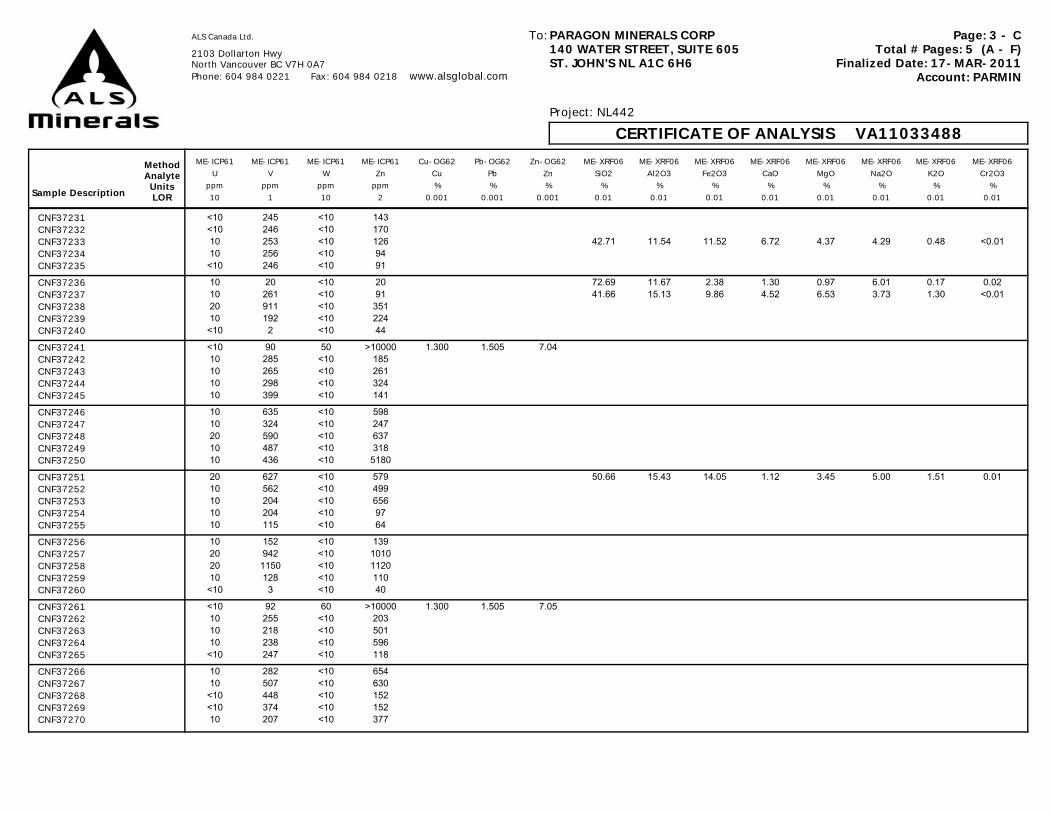
Page: 3 - CTotal # Pages: 5 (A - F)
Finalized Date: 17-MAR-2011Account: PARMIN
ALS Canada Ltd.
2103 Dollarton HwyNorth Vancouver BC V7H 0A7 Phone: 604 984 0221 Fax: 604 984 0218 www.alsglobal.com
PARAGON MINERALS CORP140 WATER STREET, SUITE 605ST. JOHN'S NL A1C 6H6
To:
Project: NL442
CERTIFICATE OF ANALYSIS VA11033488
Sample Description
MethodAnalyteUnitsLOR
ME-ICP61 ME-ICP61 ME-ICP61 ME-ICP61 Cu-OG62 Pb-OG62 Zn-OG62 ME-XRF06 ME-XRF06 ME-XRF06 ME-XRF06 ME-XRF06 ME-XRF06 ME-XRF06 ME-XRF06U V W Zn Cu Pb Zn SiO2 Al2O3 Fe2O3 CaO MgO Na2O K2O Cr2O3
ppm ppm ppm ppm % % % % % % % % % % %10 1 10 2 0.001 0.001 0.001 0.01 0.01 0.01 0.01 0.01 0.01 0.01 0.01
CNF37231 <10 245 <10 143CNF37232 <10 246 <10 170CNF37233 10 253 <10 126 42.71 11.54 11.52 6.72 4.37 4.29 0.48 <0.01CNF37234 10 256 <10 94CNF37235 <10 246 <10 91
CNF37236 10 20 <10 20 72.69 11.67 2.38 1.30 0.97 6.01 0.17 0.02CNF37237 10 261 <10 91 41.66 15.13 9.86 4.52 6.53 3.73 1.30 <0.01CNF37238 20 911 <10 351CNF37239 10 192 <10 224CNF37240 <10 2 <10 44
CNF37241 <10 90 50 >10000 1.300 1.505 7.04CNF37242 10 285 <10 185CNF37243 10 265 <10 261CNF37244 10 298 <10 324CNF37245 10 399 <10 141
CNF37246 10 635 <10 598CNF37247 10 324 <10 247CNF37248 20 590 <10 637CNF37249 10 487 <10 318CNF37250 10 436 <10 5180
CNF37251 20 627 <10 579 50.66 15.43 14.05 1.12 3.45 5.00 1.51 0.01CNF37252 10 562 <10 499CNF37253 10 204 <10 656CNF37254 10 204 <10 97CNF37255 10 115 <10 64
CNF37256 10 152 <10 139CNF37257 20 942 <10 1010CNF37258 20 1150 <10 1120CNF37259 10 128 <10 110CNF37260 <10 3 <10 40
CNF37261 <10 92 60 >10000 1.300 1.505 7.05CNF37262 10 255 <10 203CNF37263 10 218 <10 501CNF37264 10 238 <10 596CNF37265 <10 247 <10 118
CNF37266 10 282 <10 654CNF37267 10 507 <10 630CNF37268 <10 448 <10 152CNF37269 <10 374 <10 152CNF37270 10 207 <10 377

Page: 3 - DTotal # Pages: 5 (A - F)
Finalized Date: 17-MAR-2011Account: PARMIN
ALS Canada Ltd.
2103 Dollarton HwyNorth Vancouver BC V7H 0A7 Phone: 604 984 0221 Fax: 604 984 0218 www.alsglobal.com
PARAGON MINERALS CORP140 WATER STREET, SUITE 605ST. JOHN'S NL A1C 6H6
To:
Project: NL442
CERTIFICATE OF ANALYSIS VA11033488
Sample Description
MethodAnalyteUnitsLOR
ME-XRF06 ME-XRF06 ME-XRF06 ME-XRF06 ME-XRF06 ME-XRF06 ME-XRF06 ME-MS81 ME-MS81 ME-MS81 ME-MS81 ME-MS81 ME-MS81 ME-MS81 ME-MS81TiO2 MnO P2O5 SrO BaO LOI Total Ag Ba Ce Co Cr Cs Cu Dy
% % % % % % % ppm ppm ppm ppm ppm ppm ppm ppm0.01 0.01 0.001 0.01 0.01 0.01 0.01 1 0.5 0.5 0.5 10 0.01 5 0.05
CNF37231CNF37232CNF37233 2.22 0.20 0.236 0.01 0.01 13.80 98.11CNF37234CNF37235CNF37236 0.20 0.04 0.025 0.01 <0.01 2.73 98.21CNF37237 1.07 0.15 0.140 <0.01 0.03 14.00 98.11CNF37238CNF37239CNF37240CNF37241CNF37242CNF37243CNF37244CNF37245CNF37246CNF37247CNF37248CNF37249CNF37250CNF37251 0.61 0.23 0.506 0.01 0.06 5.73 98.37 <1 527 41.0 20.1 70 0.63 130 6.63CNF37252CNF37253CNF37254CNF37255CNF37256CNF37257CNF37258CNF37259CNF37260CNF37261CNF37262CNF37263CNF37264CNF37265CNF37266CNF37267CNF37268CNF37269CNF37270

Page: 3 - ETotal # Pages: 5 (A - F)
Finalized Date: 17-MAR-2011Account: PARMIN
ALS Canada Ltd.
2103 Dollarton HwyNorth Vancouver BC V7H 0A7 Phone: 604 984 0221 Fax: 604 984 0218 www.alsglobal.com
PARAGON MINERALS CORP140 WATER STREET, SUITE 605ST. JOHN'S NL A1C 6H6
To:
Project: NL442
CERTIFICATE OF ANALYSIS VA11033488
Sample Description
MethodAnalyteUnitsLOR
ME-MS81 ME-MS81 ME-MS81 ME-MS81 ME-MS81 ME-MS81 ME-MS81 ME-MS81 ME-MS81 ME-MS81 ME-MS81 ME-MS81 ME-MS81 ME-MS81 ME-MS81Er Eu Ga Gd Hf Ho La Lu Mo Nb Nd Ni Pb Pr Rb
ppm ppm ppm ppm ppm ppm ppm ppm ppm ppm ppm ppm ppm ppm ppm0.03 0.03 0.1 0.05 0.2 0.01 0.5 0.01 2 0.2 0.1 5 5 0.03 0.2
CNF37231CNF37232CNF37233CNF37234CNF37235CNF37236CNF37237CNF37238CNF37239CNF37240CNF37241CNF37242CNF37243CNF37244CNF37245CNF37246CNF37247CNF37248CNF37249CNF37250CNF37251 4.24 1.35 18.3 5.86 2.9 1.42 25.8 0.56 60 4.1 27.4 148 45 6.30 31.5CNF37252CNF37253CNF37254CNF37255CNF37256CNF37257CNF37258CNF37259CNF37260CNF37261CNF37262CNF37263CNF37264CNF37265CNF37266CNF37267CNF37268CNF37269CNF37270

Page: 3 - FTotal # Pages: 5 (A - F)
Finalized Date: 17-MAR-2011Account: PARMIN
ALS Canada Ltd.
2103 Dollarton HwyNorth Vancouver BC V7H 0A7 Phone: 604 984 0221 Fax: 604 984 0218 www.alsglobal.com
PARAGON MINERALS CORP140 WATER STREET, SUITE 605ST. JOHN'S NL A1C 6H6
To:
Project: NL442
CERTIFICATE OF ANALYSIS VA11033488
Sample Description
MethodAnalyteUnitsLOR
ME-MS81 ME-MS81 ME-MS81 ME-MS81 ME-MS81 ME-MS81 ME-MS81 ME-MS81 ME-MS81 ME-MS81 ME-MS81 ME-MS81 ME-MS81 ME-MS81 ME-MS81Sm Sn Sr Ta Tb Th Tl Tm U V W Y Yb Zn Zr
ppm ppm ppm ppm ppm ppm ppm ppm ppm ppm ppm ppm ppm ppm ppm0.03 1 0.1 0.1 0.01 0.05 0.5 0.01 0.05 5 1 0.5 0.03 5 2
CNF37231CNF37232CNF37233CNF37234CNF37235CNF37236CNF37237CNF37238CNF37239CNF37240CNF37241CNF37242CNF37243CNF37244CNF37245CNF37246CNF37247CNF37248CNF37249CNF37250CNF37251 6.02 1 70.5 0.3 1.04 4.23 0.7 0.61 17.40 733 5 42.9 3.90 491 87CNF37252CNF37253CNF37254CNF37255CNF37256CNF37257CNF37258CNF37259CNF37260CNF37261CNF37262CNF37263CNF37264CNF37265CNF37266CNF37267CNF37268CNF37269CNF37270

Page: 4 - ATotal # Pages: 5 (A - F)
Finalized Date: 17-MAR-2011Account: PARMIN
ALS Canada Ltd.
2103 Dollarton HwyNorth Vancouver BC V7H 0A7 Phone: 604 984 0221 Fax: 604 984 0218 www.alsglobal.com
PARAGON MINERALS CORP140 WATER STREET, SUITE 605ST. JOHN'S NL A1C 6H6
To:
Project: NL442
CERTIFICATE OF ANALYSIS VA11033488
Sample Description
MethodAnalyteUnitsLOR
WEI-21 ME-ICP61 ME-ICP61 ME-ICP61 ME-ICP61 ME-ICP61 ME-ICP61 ME-ICP61 ME-ICP61 ME-ICP61 ME-ICP61 ME-ICP61 ME-ICP61 ME-ICP61 ME-ICP61Recvd Wt. Ag Al As Ba Be Bi Ca Cd Co Cr Cu Fe Ga K
kg ppm % ppm ppm ppm ppm % ppm ppm ppm ppm % ppm %0.02 0.5 0.01 5 10 0.5 2 0.01 0.5 1 1 1 0.01 10 0.01
CNF37271 0.22 <0.5 8.14 45 530 1.0 <2 6.66 <0.5 36 178 89 6.01 20 1.38CNF37272 0.26 <0.5 7.32 8 90 0.6 <2 5.62 2.9 31 121 268 8.25 10 0.21CNF37273 0.22 <0.5 7.56 73 90 0.6 <2 5.00 <0.5 33 268 48 6.18 10 0.21CNF37274 0.24 1.6 7.40 58 110 0.6 37 2.29 79.1 45 356 1280 8.08 20 0.25CNF37275 0.14 1.2 5.50 <5 110 1.0 <2 0.60 <0.5 10 269 1100 2.94 10 0.24
CNF37276 0.22 <0.5 5.85 5 590 0.9 <2 0.61 <0.5 3 171 49 2.09 10 1.12CNF37277 0.18 <0.5 6.63 <5 1420 0.9 <2 1.19 <0.5 18 180 34 5.23 20 1.42CNF37278 0.16 <0.5 5.81 <5 270 0.7 <2 0.46 <0.5 9 188 5 3.40 10 2.65CNF37279 0.24 <0.5 6.64 13 940 0.9 <2 0.96 <0.5 12 131 20 3.39 20 0.92CNF37280 0.18 <0.5 5.85 8 690 1.5 <2 0.27 <0.5 1 249 3 1.08 20 2.87
CNF37281 0.06 57.8 3.38 153 550 <0.5 57 1.97 349 87 81 >10000 15.65 10 0.60CNF37282 0.22 <0.5 6.20 <5 1870 1.0 <2 0.25 <0.5 4 181 2 1.72 10 1.97CNF37283 0.22 <0.5 7.12 <5 1260 0.9 <2 0.58 <0.5 6 118 3 2.87 20 1.65CNF37284 0.18 <0.5 7.28 10 900 0.9 <2 2.30 <0.5 11 185 5 2.90 10 1.52CNF37285 0.24 <0.5 8.59 11 690 0.9 <2 3.93 <0.5 31 154 32 6.32 10 0.95
CNF37286 0.18 <0.5 8.66 5 1260 0.9 <2 4.79 <0.5 31 159 57 5.75 10 1.35CNF37287 0.20 <0.5 8.67 <5 970 0.9 <2 5.23 <0.5 30 158 66 6.47 20 1.02CNF37288 0.30 <0.5 7.53 8 800 0.9 <2 6.08 <0.5 43 94 109 8.73 20 1.78CNF37289 0.24 <0.5 8.67 28 130 0.6 <2 4.85 <0.5 36 176 60 6.77 20 0.39CNF37290 0.20 <0.5 6.35 <5 240 1.0 <2 0.58 <0.5 1 105 <1 2.40 10 1.31
CNF37291 0.28 <0.5 6.47 7 350 1.2 <2 0.34 <0.5 1 137 2 2.30 20 1.37CNF37292 0.18 <0.5 8.42 <5 80 0.7 <2 2.95 <0.5 28 24 39 7.69 20 0.60CNF37293 0.22 <0.5 7.69 8 60 0.7 <2 1.82 <0.5 27 42 38 7.22 20 0.54CNF37294 0.24 <0.5 7.70 10 70 0.6 <2 2.26 <0.5 27 26 34 7.37 20 0.61CNF37295 0.20 <0.5 7.36 7 320 0.8 <2 2.24 <0.5 27 29 22 7.10 20 1.71
CNF37296 0.20 <0.5 5.68 11 310 0.8 <2 2.07 <0.5 2 132 2 1.43 10 1.51CNF37297 0.26 <0.5 7.20 6 330 0.8 <2 2.87 <0.5 22 33 21 6.69 20 1.75CNF37298 0.18 <0.5 7.65 11 270 0.5 <2 3.57 <0.5 22 40 39 7.32 10 1.11CNF37299 0.22 <0.5 7.43 14 730 0.7 <2 4.08 <0.5 24 28 41 6.88 20 3.01CNF37300 0.16 <0.5 5.64 5 670 1.4 <2 0.27 <0.5 <1 250 1 1.20 20 2.80
CNF37301 0.04 57.1 3.29 144 380 <0.5 64 1.95 344 86 79 >10000 15.45 10 0.59CNF37302 0.18 <0.5 7.71 31 930 0.8 <2 2.76 <0.5 24 38 44 6.51 20 3.56CNF37303 0.30 0.6 6.26 96 850 0.7 <2 0.93 2.7 16 98 29 2.85 10 2.91CNF37304 0.24 0.5 5.79 77 900 0.7 <2 1.06 3.4 14 99 31 2.49 10 2.93CNF37305 0.24 <0.5 7.76 66 1340 1.1 <2 0.54 <0.5 23 59 43 5.93 20 4.61
CNF37306 0.18 <0.5 8.09 17 720 0.7 <2 3.18 <0.5 24 31 56 6.48 20 2.61CNF37307 0.22 <0.5 7.90 <5 230 0.5 <2 4.92 <0.5 23 34 43 6.87 20 0.88CNF37308 0.22 <0.5 8.33 <5 140 0.6 <2 3.33 <0.5 24 32 39 7.00 20 0.51CNF37309 0.24 1.2 7.13 140 30 <0.5 <2 4.73 <0.5 53 22 68 9.28 20 0.11CNF37310 0.20 <0.5 8.00 13 30 <0.5 <2 3.23 <0.5 27 21 47 8.19 20 0.12
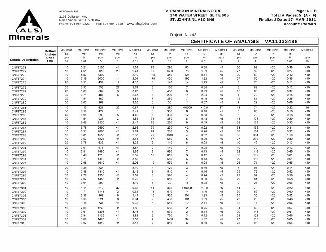
Page: 4 - BTotal # Pages: 5 (A - F)
Finalized Date: 17-MAR-2011Account: PARMIN
ALS Canada Ltd.
2103 Dollarton HwyNorth Vancouver BC V7H 0A7 Phone: 604 984 0221 Fax: 604 984 0218 www.alsglobal.com
PARAGON MINERALS CORP140 WATER STREET, SUITE 605ST. JOHN'S NL A1C 6H6
To:
Project: NL442
CERTIFICATE OF ANALYSIS VA11033488
Sample Description
MethodAnalyteUnitsLOR
ME-ICP61 ME-ICP61 ME-ICP61 ME-ICP61 ME-ICP61 ME-ICP61 ME-ICP61 ME-ICP61 ME-ICP61 ME-ICP61 ME-ICP61 ME-ICP61 ME-ICP61 ME-ICP61 ME-ICP61La Mg Mn Mo Na Ni P Pb S Sb Sc Sr Th Ti Tl
ppm % ppm ppm % ppm ppm ppm % ppm ppm ppm ppm % ppm10 0.01 5 1 0.01 1 10 2 0.01 5 1 1 20 0.01 10
CNF37271 10 5.21 3160 <1 1.63 78 290 83 0.30 <5 36 99 <20 0.38 <10CNF37272 10 4.61 3010 28 2.41 99 1680 78 1.59 <5 27 99 <20 0.27 <10CNF37273 10 5.57 3390 1 2.10 148 350 123 0.11 <5 29 80 <20 0.42 <10CNF37274 10 5.19 3030 14 2.04 170 450 195 1.82 <5 27 50 <20 0.36 <10CNF37275 20 0.51 499 17 4.10 8 140 14 1.49 <5 8 76 <20 0.11 <10
CNF37276 20 0.53 558 27 3.74 5 160 7 0.64 <5 8 82 <20 0.12 <10CNF37277 20 1.83 862 3 3.20 6 450 6 0.99 <5 15 83 <20 0.37 <10CNF37278 30 0.71 487 6 2.67 5 290 11 2.04 <5 4 79 <20 0.15 <10CNF37279 20 1.54 862 1 3.81 7 350 7 0.45 <5 12 81 <20 0.25 <10CNF37280 30 0.03 262 1 3.26 6 30 11 0.07 <5 2 22 <20 0.06 <10
CNF37281 10 1.13 621 32 0.67 43 380 >10000 >10.0 87 11 74 <20 0.22 10CNF37282 30 0.58 477 1 3.49 3 300 6 0.40 <5 5 65 <20 0.16 <10CNF37283 40 0.95 693 5 4.46 5 360 12 0.98 <5 5 79 <20 0.18 <10CNF37284 20 1.54 937 3 4.54 38 350 8 0.48 <5 11 108 <20 0.29 <10CNF37285 10 6.48 2530 <1 2.47 76 260 9 0.49 <5 38 105 <20 0.33 <10
CNF37286 10 5.78 2590 <1 2.66 79 230 <2 0.22 <5 38 135 <20 0.31 <10CNF37287 10 5.31 2860 <1 2.74 74 260 3 0.26 <5 38 154 <20 0.32 <10CNF37288 10 3.81 1550 <1 2.33 29 1040 4 0.52 <5 36 384 <20 1.19 <10CNF37289 10 3.67 1225 <1 3.41 47 680 5 0.09 <5 27 299 <20 0.80 <10CNF37290 20 0.78 632 <1 3.32 2 140 6 0.08 <5 10 49 <20 0.13 <10
CNF37291 20 0.61 671 <1 3.87 2 140 7 0.05 <5 10 70 <20 0.13 <10CNF37292 10 3.81 1480 <1 3.65 9 690 7 0.13 <5 32 116 <20 0.65 <10CNF37293 10 3.40 1215 <1 3.59 10 610 3 0.12 <5 30 102 <20 0.61 <10CNF37294 10 3.71 1440 <1 3.50 8 650 6 0.13 <5 29 110 <20 0.61 <10CNF37295 10 2.98 1610 <1 2.06 10 570 6 0.28 <5 26 71 <20 0.55 <10
CNF37296 20 0.38 538 1 3.19 3 170 3 0.30 <5 7 91 <20 0.14 <10CNF37297 10 2.48 1310 <1 2.19 8 510 4 0.16 <5 25 79 <20 0.52 <10CNF37298 10 2.78 1355 <1 2.52 8 590 4 0.24 <5 29 92 <20 0.59 <10CNF37299 10 2.07 1455 <1 0.70 9 610 7 0.88 <5 29 81 <20 0.58 <10CNF37300 40 0.04 299 1 3.19 5 30 15 0.05 <5 2 21 <20 0.06 <10
CNF37301 10 1.11 612 32 0.65 41 360 >10000 >10.0 86 11 70 <20 0.22 <10CNF37302 10 1.71 1145 2 0.62 13 610 14 1.46 <5 30 52 <20 0.60 <10CNF37303 10 0.38 162 6 1.41 10 560 104 1.93 <5 25 36 <20 0.52 <10CNF37304 10 0.39 221 8 0.94 9 480 101 1.39 <5 23 28 <20 0.46 <10CNF37305 10 1.18 737 <1 0.32 8 680 10 2.11 <5 32 17 <20 0.66 <10
CNF37306 10 2.08 1245 <1 1.85 8 680 2 0.75 <5 31 69 <20 0.67 <10CNF37307 10 2.61 1395 <1 3.16 7 630 2 0.14 <5 29 143 <20 0.61 <10CNF37308 10 2.94 1125 <1 3.82 8 760 3 0.12 <5 31 132 <20 0.66 <10CNF37309 10 3.68 1470 1 2.53 7 1400 34 1.82 <5 27 115 <20 0.65 <10CNF37310 10 3.97 1310 <1 3.13 7 810 6 0.30 <5 28 98 <20 0.64 <10
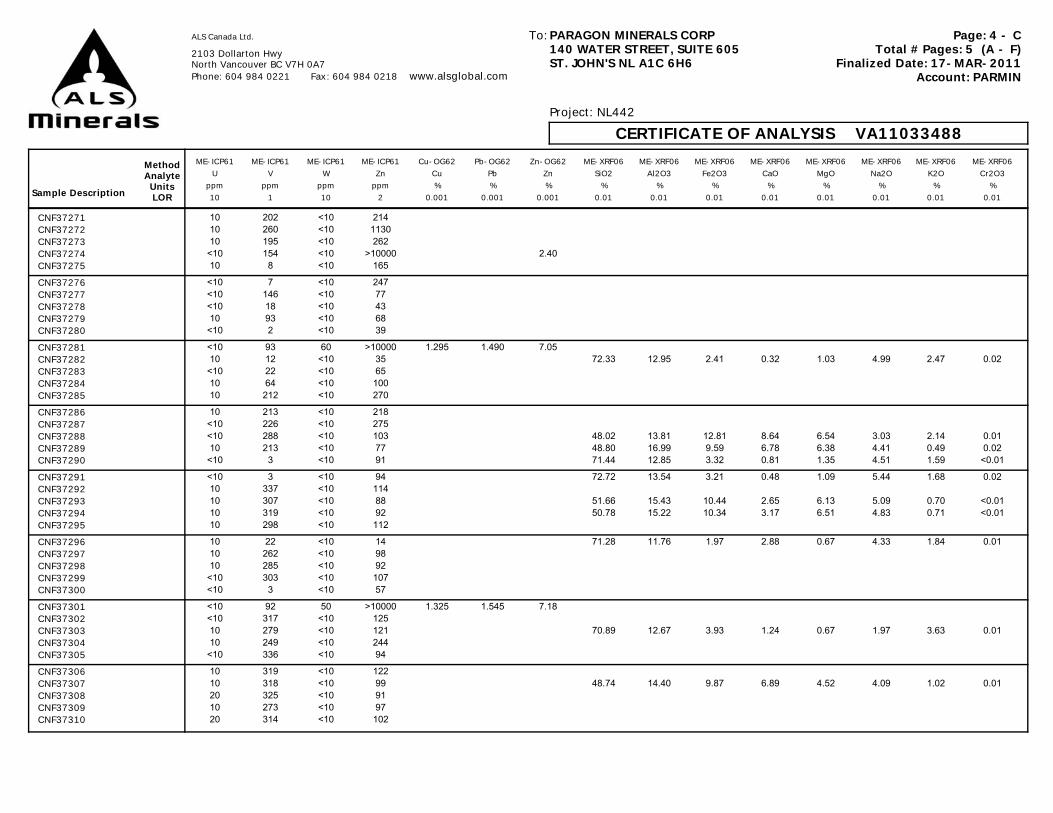
Page: 4 - CTotal # Pages: 5 (A - F)
Finalized Date: 17-MAR-2011Account: PARMIN
ALS Canada Ltd.
2103 Dollarton HwyNorth Vancouver BC V7H 0A7 Phone: 604 984 0221 Fax: 604 984 0218 www.alsglobal.com
PARAGON MINERALS CORP140 WATER STREET, SUITE 605ST. JOHN'S NL A1C 6H6
To:
Project: NL442
CERTIFICATE OF ANALYSIS VA11033488
Sample Description
MethodAnalyteUnitsLOR
ME-ICP61 ME-ICP61 ME-ICP61 ME-ICP61 Cu-OG62 Pb-OG62 Zn-OG62 ME-XRF06 ME-XRF06 ME-XRF06 ME-XRF06 ME-XRF06 ME-XRF06 ME-XRF06 ME-XRF06U V W Zn Cu Pb Zn SiO2 Al2O3 Fe2O3 CaO MgO Na2O K2O Cr2O3
ppm ppm ppm ppm % % % % % % % % % % %10 1 10 2 0.001 0.001 0.001 0.01 0.01 0.01 0.01 0.01 0.01 0.01 0.01
CNF37271 10 202 <10 214CNF37272 10 260 <10 1130CNF37273 10 195 <10 262CNF37274 <10 154 <10 >10000 2.40CNF37275 10 8 <10 165
CNF37276 <10 7 <10 247CNF37277 <10 146 <10 77CNF37278 <10 18 <10 43CNF37279 10 93 <10 68CNF37280 <10 2 <10 39
CNF37281 <10 93 60 >10000 1.295 1.490 7.05CNF37282 10 12 <10 35 72.33 12.95 2.41 0.32 1.03 4.99 2.47 0.02CNF37283 <10 22 <10 65CNF37284 10 64 <10 100CNF37285 10 212 <10 270
CNF37286 10 213 <10 218CNF37287 <10 226 <10 275CNF37288 <10 288 <10 103 48.02 13.81 12.81 8.64 6.54 3.03 2.14 0.01CNF37289 10 213 <10 77 48.80 16.99 9.59 6.78 6.38 4.41 0.49 0.02CNF37290 <10 3 <10 91 71.44 12.85 3.32 0.81 1.35 4.51 1.59 <0.01
CNF37291 <10 3 <10 94 72.72 13.54 3.21 0.48 1.09 5.44 1.68 0.02CNF37292 10 337 <10 114CNF37293 10 307 <10 88 51.66 15.43 10.44 2.65 6.13 5.09 0.70 <0.01CNF37294 10 319 <10 92 50.78 15.22 10.34 3.17 6.51 4.83 0.71 <0.01CNF37295 10 298 <10 112
CNF37296 10 22 <10 14 71.28 11.76 1.97 2.88 0.67 4.33 1.84 0.01CNF37297 10 262 <10 98CNF37298 10 285 <10 92CNF37299 <10 303 <10 107CNF37300 <10 3 <10 57
CNF37301 <10 92 50 >10000 1.325 1.545 7.18CNF37302 <10 317 <10 125CNF37303 10 279 <10 121 70.89 12.67 3.93 1.24 0.67 1.97 3.63 0.01CNF37304 10 249 <10 244CNF37305 <10 336 <10 94
CNF37306 10 319 <10 122CNF37307 10 318 <10 99 48.74 14.40 9.87 6.89 4.52 4.09 1.02 0.01CNF37308 20 325 <10 91CNF37309 10 273 <10 97CNF37310 20 314 <10 102

Page: 4 - DTotal # Pages: 5 (A - F)
Finalized Date: 17-MAR-2011Account: PARMIN
ALS Canada Ltd.
2103 Dollarton HwyNorth Vancouver BC V7H 0A7 Phone: 604 984 0221 Fax: 604 984 0218 www.alsglobal.com
PARAGON MINERALS CORP140 WATER STREET, SUITE 605ST. JOHN'S NL A1C 6H6
To:
Project: NL442
CERTIFICATE OF ANALYSIS VA11033488
Sample Description
MethodAnalyteUnitsLOR
ME-XRF06 ME-XRF06 ME-XRF06 ME-XRF06 ME-XRF06 ME-XRF06 ME-XRF06 ME-MS81 ME-MS81 ME-MS81 ME-MS81 ME-MS81 ME-MS81 ME-MS81 ME-MS81TiO2 MnO P2O5 SrO BaO LOI Total Ag Ba Ce Co Cr Cs Cu Dy
% % % % % % % ppm ppm ppm ppm ppm ppm ppm ppm0.01 0.01 0.001 0.01 0.01 0.01 0.01 1 0.5 0.5 0.5 10 0.01 5 0.05
CNF37271CNF37272CNF37273CNF37274CNF37275CNF37276CNF37277CNF37278CNF37279CNF37280CNF37281CNF37282 0.40 0.05 0.063 0.01 0.18 1.12 98.35CNF37283CNF37284CNF37285CNF37286CNF37287CNF37288 2.11 0.21 0.225 0.03 0.09 2.36 100.05CNF37289 1.45 0.16 0.144 0.03 0.01 3.06 98.31CNF37290 0.20 0.08 0.027 0.01 0.01 2.19 98.39
CNF37291 0.24 0.08 0.032 0.01 0.04 1.46 100.05CNF37292CNF37293 1.14 0.16 0.138 0.01 <0.01 4.68 98.23CNF37294 1.08 0.19 0.135 0.01 <0.01 5.32 98.29CNF37295CNF37296 0.27 0.06 0.037 0.01 0.03 3.22 98.37CNF37297CNF37298CNF37299CNF37300CNF37301CNF37302CNF37303 0.96 0.02 0.117 0.01 0.10 2.97 99.17CNF37304CNF37305CNF37306CNF37307 1.04 0.18 0.130 0.01 0.02 7.79 98.71CNF37308CNF37309CNF37310
Page: 4 - ETotal # Pages: 5 (A - F)
Finalized Date: 17-MAR-2011Account: PARMIN
ALS Canada Ltd.
2103 Dollarton HwyNorth Vancouver BC V7H 0A7 Phone: 604 984 0221 Fax: 604 984 0218 www.alsglobal.com
PARAGON MINERALS CORP140 WATER STREET, SUITE 605ST. JOHN'S NL A1C 6H6
To:
Project: NL442
CERTIFICATE OF ANALYSIS VA11033488
Sample Description
MethodAnalyteUnitsLOR
ME-MS81 ME-MS81 ME-MS81 ME-MS81 ME-MS81 ME-MS81 ME-MS81 ME-MS81 ME-MS81 ME-MS81 ME-MS81 ME-MS81 ME-MS81 ME-MS81 ME-MS81Er Eu Ga Gd Hf Ho La Lu Mo Nb Nd Ni Pb Pr Rb
ppm ppm ppm ppm ppm ppm ppm ppm ppm ppm ppm ppm ppm ppm ppm0.03 0.03 0.1 0.05 0.2 0.01 0.5 0.01 2 0.2 0.1 5 5 0.03 0.2
CNF37271CNF37272CNF37273CNF37274CNF37275CNF37276CNF37277CNF37278CNF37279CNF37280CNF37281CNF37282CNF37283CNF37284CNF37285CNF37286CNF37287CNF37288CNF37289CNF37290CNF37291CNF37292CNF37293CNF37294CNF37295CNF37296CNF37297CNF37298CNF37299CNF37300CNF37301CNF37302CNF37303CNF37304CNF37305CNF37306CNF37307CNF37308CNF37309CNF37310

Page: 4 - FTotal # Pages: 5 (A - F)
Finalized Date: 17-MAR-2011Account: PARMIN
ALS Canada Ltd.
2103 Dollarton HwyNorth Vancouver BC V7H 0A7 Phone: 604 984 0221 Fax: 604 984 0218 www.alsglobal.com
PARAGON MINERALS CORP140 WATER STREET, SUITE 605ST. JOHN'S NL A1C 6H6
To:
Project: NL442
CERTIFICATE OF ANALYSIS VA11033488
Sample Description
MethodAnalyteUnitsLOR
ME-MS81 ME-MS81 ME-MS81 ME-MS81 ME-MS81 ME-MS81 ME-MS81 ME-MS81 ME-MS81 ME-MS81 ME-MS81 ME-MS81 ME-MS81 ME-MS81 ME-MS81Sm Sn Sr Ta Tb Th Tl Tm U V W Y Yb Zn Zr
ppm ppm ppm ppm ppm ppm ppm ppm ppm ppm ppm ppm ppm ppm ppm0.03 1 0.1 0.1 0.01 0.05 0.5 0.01 0.05 5 1 0.5 0.03 5 2
CNF37271CNF37272CNF37273CNF37274CNF37275CNF37276CNF37277CNF37278CNF37279CNF37280CNF37281CNF37282CNF37283CNF37284CNF37285CNF37286CNF37287CNF37288CNF37289CNF37290CNF37291CNF37292CNF37293CNF37294CNF37295CNF37296CNF37297CNF37298CNF37299CNF37300CNF37301CNF37302CNF37303CNF37304CNF37305CNF37306CNF37307CNF37308CNF37309CNF37310
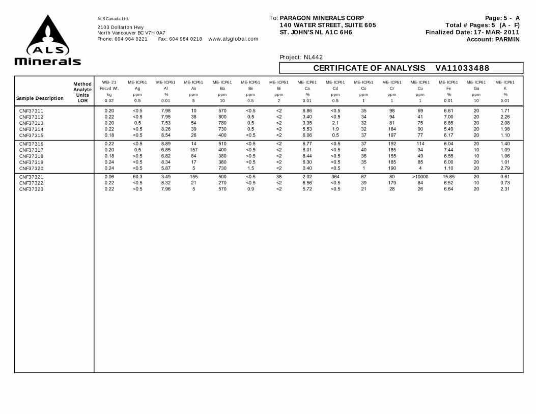
Page: 5 - ATotal # Pages: 5 (A - F)
Finalized Date: 17-MAR-2011Account: PARMIN
ALS Canada Ltd.
2103 Dollarton HwyNorth Vancouver BC V7H 0A7 Phone: 604 984 0221 Fax: 604 984 0218 www.alsglobal.com
PARAGON MINERALS CORP140 WATER STREET, SUITE 605ST. JOHN'S NL A1C 6H6
To:
Project: NL442
CERTIFICATE OF ANALYSIS VA11033488
Sample Description
MethodAnalyteUnitsLOR
WEI-21 ME-ICP61 ME-ICP61 ME-ICP61 ME-ICP61 ME-ICP61 ME-ICP61 ME-ICP61 ME-ICP61 ME-ICP61 ME-ICP61 ME-ICP61 ME-ICP61 ME-ICP61 ME-ICP61Recvd Wt. Ag Al As Ba Be Bi Ca Cd Co Cr Cu Fe Ga K
kg ppm % ppm ppm ppm ppm % ppm ppm ppm ppm % ppm %0.02 0.5 0.01 5 10 0.5 2 0.01 0.5 1 1 1 0.01 10 0.01
CNF37311 0.20 <0.5 7.98 10 570 <0.5 <2 6.86 <0.5 35 98 69 6.61 20 1.71CNF37312 0.22 <0.5 7.95 38 800 0.5 <2 3.40 <0.5 34 94 41 7.00 20 2.26CNF37313 0.20 0.5 7.53 54 780 0.5 <2 3.35 2.1 32 81 75 6.85 20 2.08CNF37314 0.22 <0.5 8.26 39 730 0.5 <2 5.53 1.9 32 184 90 5.49 20 1.98CNF37315 0.18 <0.5 8.54 26 400 <0.5 <2 6.06 0.5 37 197 77 6.17 20 1.10
CNF37316 0.22 <0.5 8.89 14 510 <0.5 <2 6.77 <0.5 37 192 114 6.04 20 1.40CNF37317 0.20 0.5 6.85 157 400 <0.5 <2 6.01 <0.5 40 185 34 7.44 10 1.09CNF37318 0.18 <0.5 6.82 84 380 <0.5 <2 8.44 <0.5 36 155 49 6.55 10 1.06CNF37319 0.24 <0.5 8.34 17 380 <0.5 <2 6.30 <0.5 35 185 85 6.00 20 1.01CNF37320 0.24 <0.5 5.87 5 730 1.5 <2 0.40 <0.5 1 190 4 1.10 20 2.79
CNF37321 0.06 60.3 3.49 155 500 <0.5 38 2.02 364 87 80 >10000 15.85 20 0.61CNF37322 0.22 <0.5 8.32 21 270 <0.5 <2 6.56 <0.5 39 179 84 6.52 10 0.73CNF37323 0.22 <0.5 7.96 5 570 0.9 <2 5.72 <0.5 21 28 26 6.64 20 2.31

Page: 5 - BTotal # Pages: 5 (A - F)
Finalized Date: 17-MAR-2011Account: PARMIN
ALS Canada Ltd.
2103 Dollarton HwyNorth Vancouver BC V7H 0A7 Phone: 604 984 0221 Fax: 604 984 0218 www.alsglobal.com
PARAGON MINERALS CORP140 WATER STREET, SUITE 605ST. JOHN'S NL A1C 6H6
To:
Project: NL442
CERTIFICATE OF ANALYSIS VA11033488
Sample Description
MethodAnalyteUnitsLOR
ME-ICP61 ME-ICP61 ME-ICP61 ME-ICP61 ME-ICP61 ME-ICP61 ME-ICP61 ME-ICP61 ME-ICP61 ME-ICP61 ME-ICP61 ME-ICP61 ME-ICP61 ME-ICP61 ME-ICP61La Mg Mn Mo Na Ni P Pb S Sb Sc Sr Th Ti Tl
ppm % ppm ppm % ppm ppm ppm % ppm ppm ppm ppm % ppm10 0.01 5 1 0.01 1 10 2 0.01 5 1 1 20 0.01 10
CNF37311 10 3.69 2020 <1 1.69 46 340 10 0.47 <5 33 134 <20 0.42 <10CNF37312 10 3.24 1800 1 1.46 44 390 166 1.34 <5 34 61 <20 0.47 <10CNF37313 <10 3.24 1905 <1 1.59 38 400 591 2.24 <5 30 63 <20 0.45 <10CNF37314 <10 2.90 2360 <1 2.54 92 210 269 1.73 <5 33 102 <20 0.33 <10CNF37315 <10 4.00 2770 <1 2.94 108 210 343 0.96 <5 34 105 <20 0.32 <10
CNF37316 <10 4.42 2980 <1 2.68 112 210 16 0.52 <5 35 111 <20 0.33 <10CNF37317 <10 3.06 2400 4 2.29 92 170 105 4.59 <5 28 94 <20 0.26 <10CNF37318 <10 3.18 3250 2 2.22 78 200 119 3.24 <5 28 118 <20 0.29 <10CNF37319 <10 4.35 2740 <1 2.74 105 180 25 0.73 <5 33 109 <20 0.32 <10CNF37320 40 0.05 151 1 3.22 2 20 11 0.13 <5 2 24 <20 0.06 <10
CNF37321 10 1.13 641 32 0.69 44 380 >10000 >10.0 92 11 81 <20 0.23 10CNF37322 10 4.68 2820 <1 2.67 111 170 24 0.61 <5 33 116 <20 0.31 <10CNF37323 10 1.57 1475 <1 2.62 <1 960 6 0.19 <5 29 122 <20 0.64 <10
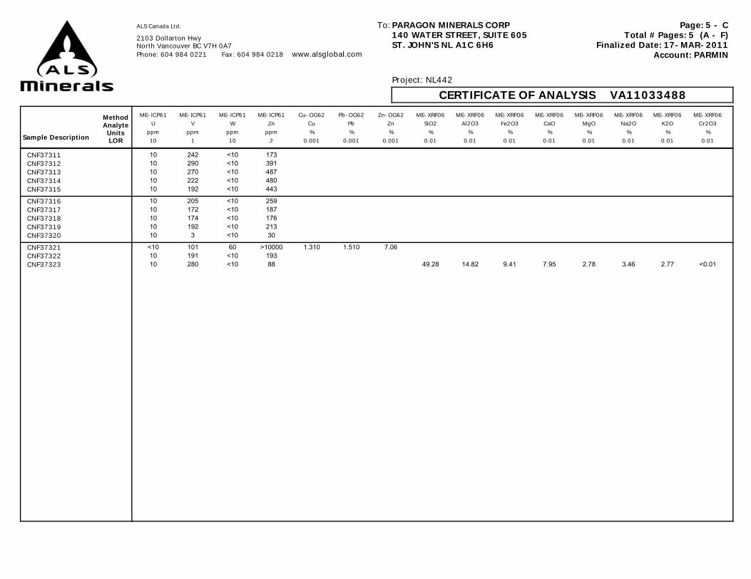
Page: 5 - CTotal # Pages: 5 (A - F)
Finalized Date: 17-MAR-2011Account: PARMIN
ALS Canada Ltd.
2103 Dollarton HwyNorth Vancouver BC V7H 0A7 Phone: 604 984 0221 Fax: 604 984 0218 www.alsglobal.com
PARAGON MINERALS CORP140 WATER STREET, SUITE 605ST. JOHN'S NL A1C 6H6
To:
Project: NL442
CERTIFICATE OF ANALYSIS VA11033488
Sample Description
MethodAnalyteUnitsLOR
ME-ICP61 ME-ICP61 ME-ICP61 ME-ICP61 Cu-OG62 Pb-OG62 Zn-OG62 ME-XRF06 ME-XRF06 ME-XRF06 ME-XRF06 ME-XRF06 ME-XRF06 ME-XRF06 ME-XRF06U V W Zn Cu Pb Zn SiO2 Al2O3 Fe2O3 CaO MgO Na2O K2O Cr2O3
ppm ppm ppm ppm % % % % % % % % % % %10 1 10 2 0.001 0.001 0.001 0.01 0.01 0.01 0.01 0.01 0.01 0.01 0.01
CNF37311 10 242 <10 173CNF37312 10 290 <10 391CNF37313 10 270 <10 487CNF37314 10 222 <10 480CNF37315 10 192 <10 443
CNF37316 10 205 <10 259CNF37317 10 172 <10 187CNF37318 10 174 <10 176CNF37319 10 192 <10 213CNF37320 10 3 <10 30
CNF37321 <10 101 60 >10000 1.310 1.510 7.06CNF37322 10 191 <10 193CNF37323 10 280 <10 88 49.28 14.82 9.41 7.95 2.78 3.46 2.77 <0.01
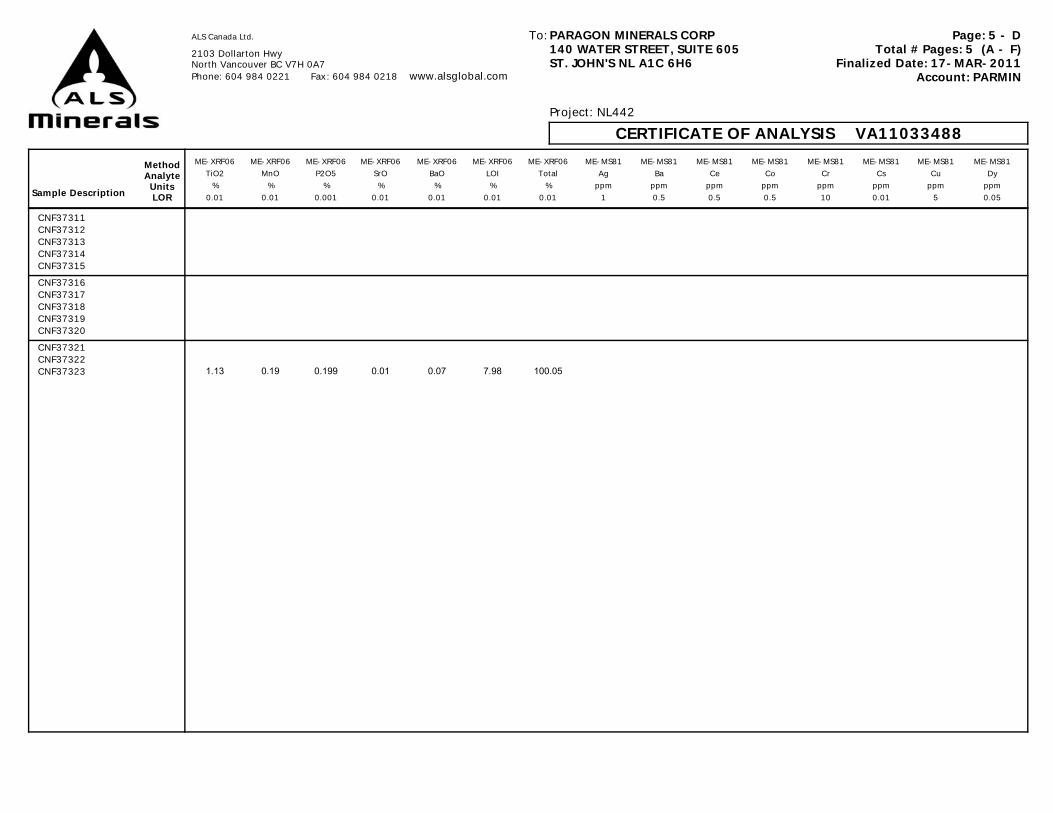
Page: 5 - DTotal # Pages: 5 (A - F)
Finalized Date: 17-MAR-2011Account: PARMIN
ALS Canada Ltd.
2103 Dollarton HwyNorth Vancouver BC V7H 0A7 Phone: 604 984 0221 Fax: 604 984 0218 www.alsglobal.com
PARAGON MINERALS CORP140 WATER STREET, SUITE 605ST. JOHN'S NL A1C 6H6
To:
Project: NL442
CERTIFICATE OF ANALYSIS VA11033488
Sample Description
MethodAnalyteUnitsLOR
ME-XRF06 ME-XRF06 ME-XRF06 ME-XRF06 ME-XRF06 ME-XRF06 ME-XRF06 ME-MS81 ME-MS81 ME-MS81 ME-MS81 ME-MS81 ME-MS81 ME-MS81 ME-MS81TiO2 MnO P2O5 SrO BaO LOI Total Ag Ba Ce Co Cr Cs Cu Dy
% % % % % % % ppm ppm ppm ppm ppm ppm ppm ppm0.01 0.01 0.001 0.01 0.01 0.01 0.01 1 0.5 0.5 0.5 10 0.01 5 0.05
CNF37311CNF37312CNF37313CNF37314CNF37315CNF37316CNF37317CNF37318CNF37319CNF37320CNF37321CNF37322CNF37323 1.13 0.19 0.199 0.01 0.07 7.98 100.05

Page: 5 - ETotal # Pages: 5 (A - F)
Finalized Date: 17-MAR-2011Account: PARMIN
ALS Canada Ltd.
2103 Dollarton HwyNorth Vancouver BC V7H 0A7 Phone: 604 984 0221 Fax: 604 984 0218 www.alsglobal.com
PARAGON MINERALS CORP140 WATER STREET, SUITE 605ST. JOHN'S NL A1C 6H6
To:
Project: NL442
CERTIFICATE OF ANALYSIS VA11033488
Sample Description
MethodAnalyteUnitsLOR
ME-MS81 ME-MS81 ME-MS81 ME-MS81 ME-MS81 ME-MS81 ME-MS81 ME-MS81 ME-MS81 ME-MS81 ME-MS81 ME-MS81 ME-MS81 ME-MS81 ME-MS81Er Eu Ga Gd Hf Ho La Lu Mo Nb Nd Ni Pb Pr Rb
ppm ppm ppm ppm ppm ppm ppm ppm ppm ppm ppm ppm ppm ppm ppm0.03 0.03 0.1 0.05 0.2 0.01 0.5 0.01 2 0.2 0.1 5 5 0.03 0.2
CNF37311CNF37312CNF37313CNF37314CNF37315CNF37316CNF37317CNF37318CNF37319CNF37320CNF37321CNF37322CNF37323
Page: 5 - FTotal # Pages: 5 (A - F)
Finalized Date: 17-MAR-2011Account: PARMIN
ALS Canada Ltd.
2103 Dollarton HwyNorth Vancouver BC V7H 0A7 Phone: 604 984 0221 Fax: 604 984 0218 www.alsglobal.com
PARAGON MINERALS CORP140 WATER STREET, SUITE 605ST. JOHN'S NL A1C 6H6
To:
Project: NL442
CERTIFICATE OF ANALYSIS VA11033488
Sample Description
MethodAnalyteUnitsLOR
ME-MS81 ME-MS81 ME-MS81 ME-MS81 ME-MS81 ME-MS81 ME-MS81 ME-MS81 ME-MS81 ME-MS81 ME-MS81 ME-MS81 ME-MS81 ME-MS81 ME-MS81Sm Sn Sr Ta Tb Th Tl Tm U V W Y Yb Zn Zr
ppm ppm ppm ppm ppm ppm ppm ppm ppm ppm ppm ppm ppm ppm ppm0.03 1 0.1 0.1 0.01 0.05 0.5 0.01 0.05 5 1 0.5 0.03 5 2
CNF37311CNF37312CNF37313CNF37314CNF37315CNF37316CNF37317CNF37318CNF37319CNF37320CNF37321CNF37322CNF37323


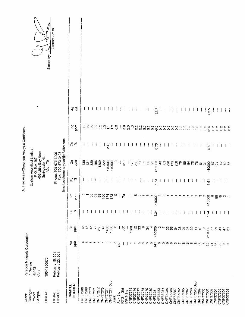
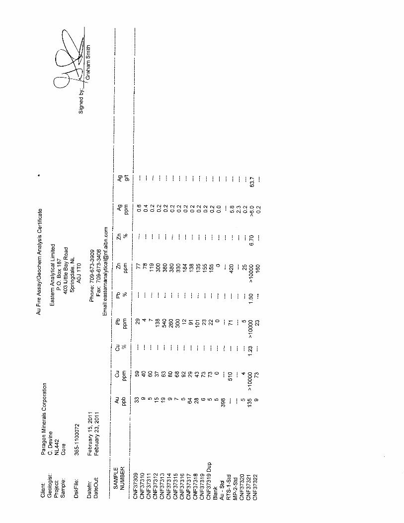
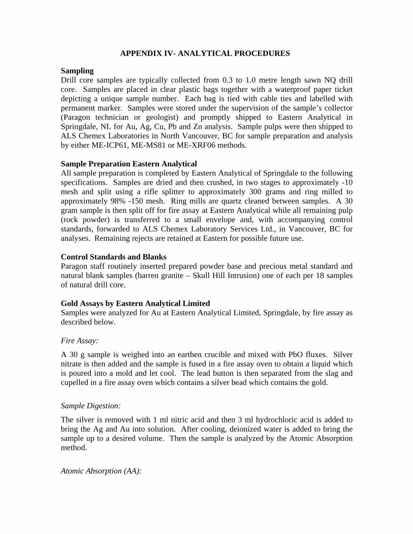
APPENDIX IV- ANALYTICAL PROCEDURES
Sampling Drill core samples are typically collected from 0.3 to 1.0 metre length sawn NQ drill core. Samples are placed in clear plastic bags together with a waterproof paper ticket depicting a unique sample number. Each bag is tied with cable ties and labelled with permanent marker. Samples were stored under the supervision of the sample’s collector (Paragon technician or geologist) and promptly shipped to Eastern Analytical in Springdale, NL for Au, Ag, Cu, Pb and Zn analysis. Sample pulps were then shipped to ALS Chemex Laboratories in North Vancouver, BC for sample preparation and analysis by either ME-ICP61, ME-MS81 or ME-XRF06 methods. Sample Preparation Eastern Analytical All sample preparation is completed by Eastern Analytical of Springdale to the following specifications. Samples are dried and then crushed, in two stages to approximately -10 mesh and split using a rifle splitter to approximately 300 grams and ring milled to approximately 98% -150 mesh. Ring mills are quartz cleaned between samples. A 30 gram sample is then split off for fire assay at Eastern Analytical while all remaining pulp (rock powder) is transferred to a small envelope and, with accompanying control standards, forwarded to ALS Chemex Laboratory Services Ltd., in Vancouver, BC for analyses. Remaining rejects are retained at Eastern for possible future use. Control Standards and Blanks Paragon staff routinely inserted prepared powder base and precious metal standard and natural blank samples (barren granite – Skull Hill Intrusion) one of each per 18 samples of natural drill core. Gold Assays by Eastern Analytical Limited Samples were analyzed for Au at Eastern Analytical Limited, Springdale, by fire assay as described below. Fire Assay:
A 30 g sample is weighed into an earthen crucible and mixed with PbO fluxes. Silver nitrate is then added and the sample is fused in a fire assay oven to obtain a liquid which is poured into a mold and let cool. The lead button is then separated from the slag and cupelled in a fire assay oven which contains a silver bead which contains the gold.
Sample Digestion:
The silver is removed with 1 ml nitric acid and then 3 ml hydrochloric acid is added to bring the Ag and Au into solution. After cooling, deionized water is added to bring the sample up to a desired volume. Then the sample is analyzed by the Atomic Absorption method.
Atomic Absorption (AA):

Samples are analyzed one at a time by AA (in batches of 24) with a value obtained by taking the average of three readings per sample. Unit is checked with a calibration solution after every 12 samples. Sample results are recorded manually and transferred to the manual data entry person where assay data is remerged with RMX sample number and tabulated into reports for certificates. Reports and standards are checked by the Chief Assayer before the certificates are release to the client. Sample Analysis by ALS Chemex Samples were analysed by ALS Chemex in Vancouver, BC ME-ICP61 or ME-MS81 or ME-XRF06. Samples of economic significance (mineralized) were only analysed via ME-ICP61 while samples of interest for lithogeochemistry and alteration studies, including some mineralized intervals were analysed via each of the methods outlined above. These assay procedure is outlined below.
Analytical Procedures
Geochemical Procedure – ME-ICP61
Trace Level Methods Using Conventional ICP-AES Analysis
A prepared sample (0.250 gram) is digested with perchloric, nitric, and hydrofluoric acids to near dryness. The sample is then further digested in a small amount of hydrochloric acid. The solution is made up to a final volume of 12.5 ml with 11% hydrochloric acid, homogenized, and analyzed by inductively coupled plasma-atomic emission spectrometry. Results are corrected for spectral inter-element interferences.
Element Symbol Lower Reporting Limit
Upper Reporting Limit Units
Silver Ag 0.5 100 ppm Aluminum Al 0.01 25 % Arsenic As 5 10,000 ppm Barium Ba 10 10,000 ppm Beryllium Be 0.5 1000 ppm Bismuth Bi 2 10,000 ppm Calcium Ca 0.01 25 % Cadmium Cd 0.5 500 ppm Cobalt Co 1 10,000 ppm Chromium Cr 1 10,000 ppm Copper Cu 1 10,000 ppm Iron Fe 0.01 25 % Potassium K 0.01 10 % Magnesium Mg 0.01 15 % Manganese Mn 5 10,000 ppm Molybdenum Mo 1 10,000 ppm Sodium Na 0.01 10 % Nickel Ni 1 10,000 ppm Phosphorus P 10 10,000 ppm Lead Pb 2 10,000 ppm
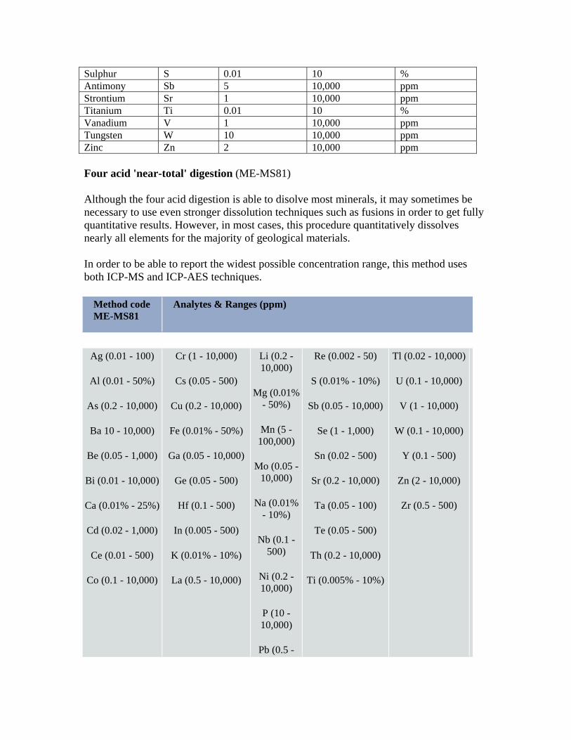
Sulphur S 0.01 10 % Antimony Sb 5 10,000 ppm Strontium Sr 1 10,000 ppm Titanium Ti 0.01 10 % Vanadium V 1 10,000 ppm Tungsten W 10 10,000 ppm Zinc Zn 2 10,000 ppm
Four acid 'near-total' digestion (ME-MS81) Although the four acid digestion is able to disolve most minerals, it may sometimes be necessary to use even stronger dissolution techniques such as fusions in order to get fully quantitative results. However, in most cases, this procedure quantitatively dissolves nearly all elements for the majority of geological materials.
In order to be able to report the widest possible concentration range, this method uses both ICP-MS and ICP-AES techniques.
Method code ME-MS81
Analytes & Ranges (ppm)
Ag (0.01 - 100)
Al (0.01 - 50%)
As (0.2 - 10,000)
Ba 10 - 10,000)
Be (0.05 - 1,000)
Bi (0.01 - 10,000)
Ca (0.01% - 25%)
Cd (0.02 - 1,000)
Ce (0.01 - 500)
Co (0.1 - 10,000)
Cr (1 - 10,000)
Cs (0.05 - 500)
Cu (0.2 - 10,000)
Fe (0.01% - 50%)
Ga (0.05 - 10,000)
Ge (0.05 - 500)
Hf (0.1 - 500)
In (0.005 - 500)
K (0.01% - 10%)
La (0.5 - 10,000)
Li (0.2 - 10,000)
Mg (0.01% - 50%)
Mn (5 - 100,000)
Mo (0.05 - 10,000)
Na (0.01% - 10%)
Nb (0.1 - 500)
Ni (0.2 - 10,000)
P (10 - 10,000)
Pb (0.5 -
Re (0.002 - 50)
S (0.01% - 10%)
Sb (0.05 - 10,000)
Se (1 - 1,000)
Sn (0.02 - 500)
Sr (0.2 - 10,000)
Ta (0.05 - 100)
Te (0.05 - 500)
Th (0.2 - 10,000)
Ti (0.005% - 10%)
Tl (0.02 - 10,000)
U (0.1 - 10,000)
V (1 - 10,000)
W (0.1 - 10,000)
Y (0.1 - 500)
Zn (2 - 10,000)
Zr (0.5 - 500)

10,000)
Rb (0.1 - 10,000)
Whole Rock Geochemistry (ME-XRF06) The analysis of all the major oxides in a geological matrix is referred to as whole rock analysis , because the expectation is that for non-mineralized rocks, the sum of the major oxides should be close to 100% of the total composition of the sample. XRF is a non-destructive instrumental technique widely used for whole rock analysis. For high precision whole rock analysis we use XRF (code ME-XRF06) or ICP-AES (code ME-ICP06) and report the major and minor elements as oxides. Loss on Ignition is also reported. In addition to the major and minor oxides, a number of add-on options are also available with whole rock analysis.
Samples for whole rock analysis by XRF are fused using a lithium borate fusion.The melt is then poured into a mould and cooled to yield a solid glass disk. The disks can then be analysed and the elements determined by comparison with standard reference materials. A lithium borate fusion is the preferred fusion for Whole Rock Analysis (WRA) in which rock characterisation can be made through an analysis of major and minor elements. Tantalum also responds well to this fusion with follow up by ICPMS Method ME-MS81. At ALS Chemex, lithium metaborate fusions are carried out in an automated fashion using a Claisse-type fluxer. The fusion melts can be poured into disks in preparation for X-ray fluorescence (XRF) analysis or they can be dissolved in acid for subsequent ICPMS analysis.
Method code Description Elements and Ranges (%)
ME-XRF06*
Whole rock analysis.
Si SiO2 (0.01 - 100)
Al Al2O3 (0.01 - 100)
Fe Fe2O3 (0.01 - 100)
Ca CaO (0.01 - 100)
Mg MgO (0.01 - 100)
Na Na2O (0.01 - 100)
K K2O (0.01 - 100)
Cr Cr2O3 (0.01 - 100)
Ti TiO2 (0.01 - 100)
Mn MnO (0.01 - 100)
P P2O5 (0.01 - 100)
Sr SrO (0.01 - 100)
Ba BaO (0.01 - 100)
Loss on Ignition (0.01 - 100)


!(!(!(
!(
!(
!(
!(
!(
!(
!(
!(
!(
!(
!(
!(
!(
!(!(
!(
!(
!(
!(
!(
!(
!(
!(
!(
!(
!(
!(
!(
!(
!(
!(
!(
!(!(!(
!(
!(
!(!(
!(
!(
!(!(
!(!(
!(
!(
!(
!(
!(
!(!(!(
#*
[_
[_[_
Para
gon
Prop
erty
Bou
ndar
y
Duck Pond Thrust
Duck Pond Thrust
G
G'
Duck West
Gills Pond
Duck Pond Mine
534000
534000
536000
536000
538000
538000
5384
000
5384
000
5386
000
5386
000
5388
000
5388
000
´
0 500 1,000250Meters
South Tally Pond Project
Paragon Minerals Corporation
Scale 1:20,000 Datum: NAD27
NTS: 12A/7,10 PGR - TSX.V
Date: April. 2011
DUCK WEST AREAGEOLOGICAL COMPILATION
Figure
Granite intrusion
Felsic Tuff
Gabbro
Quartz Monzonite
Massive Sulphide
Rogerson Lake Conglomerate
Mafic Volcanic
Altered Mafic Volcanic
Mudstone, Sandstone and Greywacke
Felsic Volcanic
Altered Felsic Volcanic
Chloritoid-bearing altered mafic and/or felsic volcanics
Lemarchant Granite - Synvolcanic
Composite Intrusive Zone
Ash Tuff and Tufaceous Sediment
LegendRock Samples (Ba/Sr Alteration Index)
0 - 5 (unaltered)5 - 25 (possibly altered)25 - 50 (weak-mod altered)
50 - 100 (mod-strog altered)
100 - 1224 (intensely altered "ore proximal")
Diamond Drillholes
Historic drill collars (1987 - 2008)
Airborne Conductors
HLEM Conductors
Max Min Conductors
VLF Conductors
Exploration Grid
Map Staked Licences
Mining Leases
Roads
Drainage
Ponds, Lakes
Geology
!(
High ACNK (intensely altered)


!(
!(
!(
!(
!(
CT11-01
till anomalies
trench with sulphidic mudstone
521000
521000
5377
000
5377
000
Ordovician Black Shale
Ordovician Siliciclastic Sediments
Mafic Volcanics
Exhalative Sediments
Felsic Volcanics
Altered and Mineralized Felsic Volcanics
¯
0 100 20050Meters
South Tally Pond VMS Project
Paragon Minerals Corporation
Scale 1:5,000 Datum: NAD27
NTS: 12A/7,10 PGR - TSX.V
Date: April 2011
COOKSTOWN GRIDPROPOSED HOLE
Figure
Proposed Drillholes
Exploration Grid
Roads
!(
St. John's
CornerBrook
Gander
NEWFOUNDLAND
Existing Drillhole!(
Airborne Conductor
Lemarchant microgranite#*