Embed Size (px)
Citation preview
ASX RELEASE | 23 JULY 2015
SUBSTANTIAL INCREASE OF 96% IN INDICATED COAL RESOURCES
TO 333 MILLION TONNES HIGHLIGHTS:
Substantial increase in Indicated Coal Resources to 333 million tonnes for the Lublin Coal Project, representing a 96% increase from the Coal Resource Estimate in 2014
Prairie has confirmed Free Swell Index (“FSI”) numbers of 3.5 – 6.0 in all target mining areas of the key 391 coal seam, comparable to international benchmark semi-soft coking coals as well as semi-soft coking coals already produced in Poland
Updated Coal Resource Estimate based on the results of Prairie’s own drilling program and the results of historical drilling
Updated Coal Resource Estimate will be incorporated into the mine plan for the Pre-Feasibility Study which is on track for publication during 2015
Prairie Mining Limited (“Prairie” or “Company”) is pleased to announce an updated Coal Resource Estimate (“CRE”) for the Lublin Coal Project (“LCP” or “Project”) in south eastern Poland. The updated CRE has focused on increasing the number of Indicated tonnes within the overall resource, as the Project heads into the development phase with the Pre-Feasibility Study (“PFS”) on track for completion during 2015.
The CRE is reported in accordance with the JORC Code (2012) and comprises 333 million tonnes (“Mt”) in the Indicated Category as part of a Global CRE of 722Mt. The CRE has been modelled based on data from 10 coal seams that were considered economically extractable and applies a 1m seam thickness cut off and a 100m stand-off from the Jurassic formation.
Table 1: Lublin Coal Project Coal Resource Estimate – Gross Seam Thickness
Coal Seam Indicated Coal Resource In-Situ (Mt)
Inferred Coal Resource In-Situ (Mt)
Total Coal Resource In-Situ (Mt)
382 60 39 98
385 39 21 60
389 19 41 60
391 164 82 246
Other Seams 51 207 258
Total – Project Area 333 390 722
* The tonnage calculations for the Indicated Resource have included allowances for geological uncertainty (15%)
* Note: Apparent differences in totals may occur due to rounding
Prairie’s CEO Ben Stoikovich commented that: “The quality and scale of the Lublin Coal Project is clearly demonstrated by the substantial increase in Indicated Coal Resources to 333Mt, which we believe has the potential to underpin a world-class, long life mining operation. Also significant is the fact that our completed coal quality testing program has confirmed semi-soft coking coal in the 391 coal seam which is the thickest and highest quality coal seam in the Lublin Coal Basin. The update to the CRE has focused on the conversion of Inferred Resources into Indicated Resources in support of the mine plan for our Pre-Feasibility Study and is based on our completed drilling program and the evaluation of historical government drilling data.”
For further information contact:
Ben Stoikovich Hugo Schumann
Chief Executive Officer Business Development
+44 207 478 3900 +44 207 478 3900 [email protected]
For
per
sona
l use
onl
y
Page 2
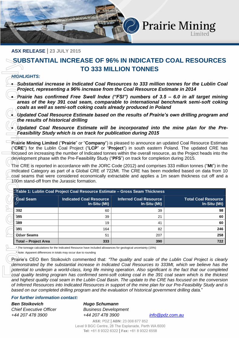
Background
The Lublin Coal Basin is an emerging coal basin that covers approximately 9,100km² in the east of Poland. It
has been identified as a significant future source and supplier of coal, with only a single mine, Bogdanka, in
operation since 1982 and which currently produces ~9.2Mt per annum.
Exploratory drilling within the LCP concession area first began in the late 1960’s, with the majority of drilling
being undertaken by Polish government agencies during the 1970’s and 1980’s. It is previously reported that
between 1965 and 1983 more than 200 boreholes were drilled in the region, including a total of 117 boreholes
within the LCP. As such, a significant proportion of the data for the LCP is historical and has been collated by
Prairie from a number of sources, including archives of the Polish Government and Polish Geological
Institute/National Research Institute.
Prairie has concluded agreements with the Polish MoE giving the Company access to detailed documentation
from the historical drill hole database. The documentation includes hundreds of volumes of coal quality,
geotechnical, hydrogeological, geophysical and seismic test data, analysis and interpretation.
Figure 1: Location of historical drill holes throughout the LCP
Using the historical data, Prairie engaged Wardell Armstrong International (“WAI”) in 2013 to produce a
Maiden CRE for the LCP that was superseded in 2014 with an Updated CRE in support of Prairie’s Scoping
Study for the LCP.
Prairie undertook a core drilling program between 2012 and 2014 that was designed to corroborate past
findings and provide additional high resolution data for geological, geotechnical, hydrogeological, washability
and other purposes. The drilling program was highly successful, confirming the findings of the historical
boreholes and confirming semi-soft coking coal in the 391 coal seam.
For
per
sona
l use
onl
y
Page 3
Updated CRE Prairie has engaged a joint team of consultants from Golder Associates and Royal HaskoningDHV (“RHDHV”)
to complete a PFS for the Project. The updated CRE published today was prepared by RHDHV, an
established international consulting firm specialising in engineering and project management. RHDHV has
over 130 years’ experience, providing expertise in the fields of aviation, buildings, energy, industry,
infrastructure, maritime, mining, transport, urban and rural planning and water. The technical specialist and
peer reviewer who composed the CRE have substantial expertise in resource geology, with specific
experience in related stratiform deposits, and are recognised Competent Persons in coal. Both specialists are
members of internationally recognised professional organisations. RHDHV prepared the updated CRE in
accordance with the JORC Code (2012 edition).
The updated CRE was designed to support the mine plan for the PFS by delivering sufficient tonnes into the
Indicated category. RHDHV modelled the available drilling data from 10 potentially economic coal seams
within the LCP, as compared with 21 coal seams modelled previously by WAI during the Scoping Study phase
of the Project. The modelling of fewer seams is a natural progression from the Scoping Study phase to the
PFS phase, where seams are evaluated more critically as proposed mining methods are refined and a more
focused approach is taken. The updated CRE does not incorporate coal resources from the Company’s new
Sawin-Zachod exploration concession (refer ASX Announcement 18 March 2015) which has the potential to
add further coal resources based on successful exploration in the future.
The updated CRE has been estimated on a gross tonnage basis, and therefore includes dirt partings within the
seam. This tonnage is approximately equivalent to the Run-of-Mine coal that would theoretically be extracted
directly from the operation, but does not consider out-of-seam dilution i.e. contamination from roof and floor
and mining or processing losses.
RHDHV applied a 1m seam thickness cut-off and also applied a more conservative stand-off of 100m from the
overlying Jurassic formation which has been identified as a potential aquifer (WAI used 20m, 60m, and 100m
stand-offs to the Jurassic in the 2013 WAI report and 20m and 45m in the 2014 WAI Scoping Study Report).
RHDHV excluded certain areas within the concessions which had previously been modelled by WAI, including
the northern half of the K-9 concession which was deemed not of mineable thickness. Whilst the Global CRE
has reduced from the 2014 CRE conducted by WAI (refer to ASX Announcement 28 April 2014) compared to
the 2015 CRE conducted by RHDHV, the studies were not undertaken on the same areas nor under the same
criteria, and are not therefore directly comparable - as discussed above, RHDHV modelled the available
drilling data from 10 potentially economic coal seams within the LCP, as compared with 21 coal seams
modelled previously by WAI. As the LCP moves towards development, Prairie’s focus is on increasing
confidence in its resource base by delivering coal resources into the Indicated and Measured categories in key
areas within the LCP concessions. Indicated coal resources have increased by 96% to 333Mt including an
increase within the 391 coal seam to a total of 164Mt of Indicated Coal.
The results have reaffirmed that the 391 coal seam within the LCP is an extensive, thick, flat, consistent, and
laterally continuous coal seam containing high quality coal with confirmed potential to produce semi soft coking
coals.
For
per
sona
l use
onl
y
Page 4
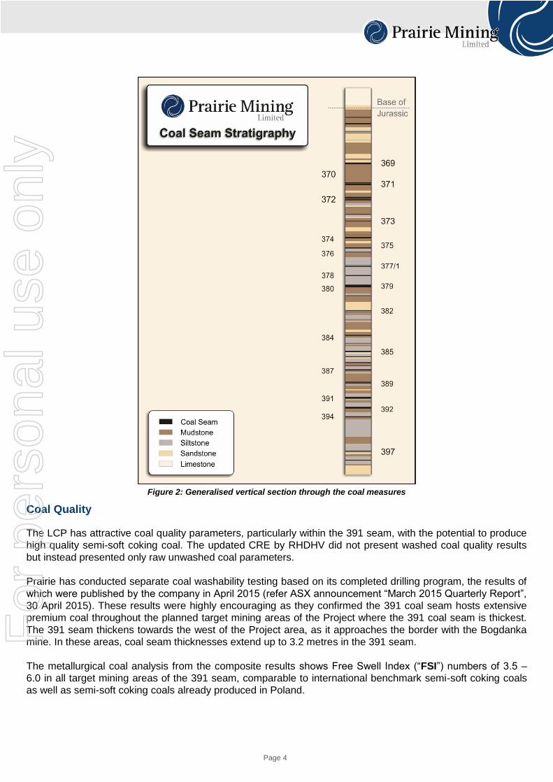
Figure 2: Generalised vertical section through the coal measures
Coal Quality
The LCP has attractive coal quality parameters, particularly within the 391 seam, with the potential to produce
high quality semi-soft coking coal. The updated CRE by RHDHV did not present washed coal quality results
but instead presented only raw unwashed coal parameters.
Prairie has conducted separate coal washability testing based on its completed drilling program, the results of
which were published by the company in April 2015 (refer ASX announcement “March 2015 Quarterly Report”,
30 April 2015). These results were highly encouraging as they confirmed the 391 coal seam hosts extensive
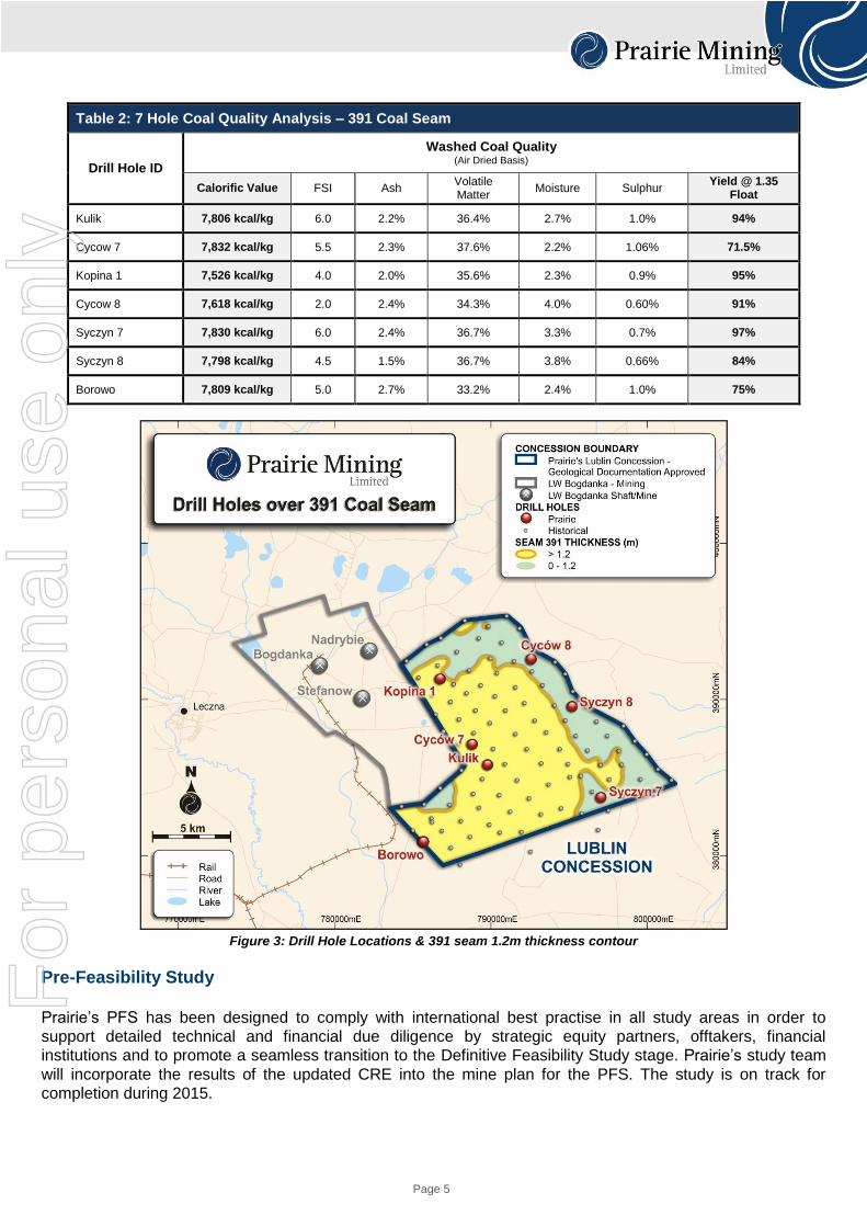
premium coal throughout the planned target mining areas of the Project where the 391 coal seam is thickest.
The 391 seam thickens towards the west of the Project area, as it approaches the border with the Bogdanka
mine. In these areas, coal seam thicknesses extend up to 3.2 metres in the 391 seam.
The metallurgical coal analysis from the composite results shows Free Swell Index (“FSI”) numbers of 3.5 –
6.0 in all target mining areas of the 391 seam, comparable to international benchmark semi-soft coking coals
as well as semi-soft coking coals already produced in Poland.
For
per
sona
l use
onl
y
Page 5
Table 2: 7 Hole Coal Quality Analysis – 391 Coal Seam
Drill Hole ID
Washed Coal Quality (Air Dried Basis)
Calorific Value FSI Ash Volatile Matter
Moisture Sulphur Yield @ 1.35
Float
Kulik 7,806 kcal/kg 6.0 2.2% 36.4% 2.7% 1.0% 94%
Cycow 7 7,832 kcal/kg 5.5 2.3% 37.6% 2.2% 1.06% 71.5%
Kopina 1 7,526 kcal/kg 4.0 2.0% 35.6% 2.3% 0.9% 95%
Cycow 8 7,618 kcal/kg 2.0 2.4% 34.3% 4.0% 0.60% 91%
Syczyn 7 7,830 kcal/kg 6.0 2.4% 36.7% 3.3% 0.7% 97%
Syczyn 8 7,798 kcal/kg 4.5 1.5% 36.7% 3.8% 0.66% 84%
Borowo 7,809 kcal/kg 5.0 2.7% 33.2% 2.4% 1.0% 75%
Figure 3: Drill Hole Locations & 391 seam 1.2m thickness contour
Pre-Feasibility Study
Prairie’s PFS has been designed to comply with international best practise in all study areas in order to
support detailed technical and financial due diligence by strategic equity partners, offtakers, financial
institutions and to promote a seamless transition to the Definitive Feasibility Study stage. Prairie’s study team
will incorporate the results of the updated CRE into the mine plan for the PFS. The study is on track for
completion during 2015.
For
per
sona
l use
onl
y
Page 6
Summary of Resource Estimate and Reporting Criteria
Geology and Geological Interpretation
The Lublin Coal basin covers approximately 9,100 km2 in the east of Poland near the border with Ukraine. The
Lublin Basin is known to have formed during the Late Visean due to enhanced subsidence, which was
followed by numerous episodes of marine ingression and repeated sequences of shallow marine and deltaic
sediment deposition during the Namurian. The remaining succession contains lithologies from four main
divisions. The first, and oldest, are the Late Carboniferous (Westphalian age) sediments which represent the
main coal-bearing strata of the basin, deposited in predominantly fluvial environments. Following tectonic
inversion and erosion, these were subsequently overlain unconformably by a sequence comprising Jurassic
carbonates, Cretaceous limestone, and finally Quaternary superficial deposits (clay, sand, gravel) of varying
thickness.
The Lublin structure is largely controlled by the Bogdanka Syncline and strata is found to be either horizontal
or shallowly dipping (predominantly to the west), with the overlying Jurassic and Cretaceous generally more
shallowly dipping compared to the Carboniferous.
The site is overlain by poorly consolidated Quaternary superficials of varying thickness between 0 and 85m.
The upper stratigraphical sequence comprises Cretaceous and Jurassic units. Both units vary in thickness.
The Cretaceous sequence is made up of a range of marine sediments; principally limestones, marls and
chalks, and can reach thicknesses of 606m within the vicinity. The base of the Cretaceous sequence is
characterised by the water-bearing and less consolidated Albian Sands. The thinner Jurassic units (65m to
155m from borehole intersections) comprise dolomites and dolomitic sandstones. The Cretaceous and
Jurassic formations unconformably overly the Carboniferous sequence, of which the upper section is
considered the productive series containing the coal seams investigated in the CRE upgrade. The coal
sequence within the LCP comprises 30 distinct seams, from Seam 369 at the top to Seam 399 at the base.
Carboniferous interburden is made up of sedimentary lithologies ranging from claystones to mudstones to
sandstones and some minor calcareous units. The uppermost coal seams subcrop against the base of the
Jurassic in some areas.
Drilling and Sampling Techniques
Some 117 historic boreholes were drilled within the licence area and comprised approximately 90,000m of
core drilling, which was subject to down-hole geophysical logging, geotechnical testing and coal quality
analysis. The drilling was conducted by various Polish government agencies between the 1960’s and 1980’s.
Historical drilling was conducted using a combination of open hole and strata core drilling in every borehole,
reportedly using OP-1200 and ZIF-1200 drilling rigs. All historical boreholes are assumed to have been drilled
vertically. Open hole drilling was employed to aid progression through the overlying Cretaceous and Jurassic
strata within which rock cutting samples were recovered at 2.0m intervals. Diamond core drilling was used
through the base of the Jurassic and the underlying Carboniferous Coal Measures sequence to the end of the
borehole.
Coal samples for laboratory analysis were obtained from the solid core, cleaned and sealed in individually
labelled plastic bags to prevent contamination or excessive moisture loss before being sent to a laboratory.
Coal quality analysis was conducted by the Analytical Tests Department of Katowice Geological Enterprise
although exact testing procedures are not available. Coal seams ≥40cm thick were analysed and dirt/non-coal
bands ≥5cm thick were not analysed.
In 2013/14 Prairie undertook a geological drilling programme of seven boreholes to corroborate past findings
and provide additional high resolution data for geological, geotechnical, hydrogeological, and other purposes
including washability test work.
Drilling comprised a combination of rotary openhole and continuous core drilling, with potential zones of
unstable ground cased off during drilling. Rock cutting samples were obtained at 2m intervals during the
For
per
sona
l use
onl
y
openhole drilling (Quaternary, Cretaceous and Jurassic strata) above the Coal Measures – where
geotechnical core drilling was undertaken. The core drilling method deployed was wire line rotary drilling using
single tube core barrels.
Geological logging of solid core and chip samples was performed by PolGeol. Detailed lithological descriptions
were used as the basis for graphic logs, and were input by PolGeol using RockLab software.
Core and associated samples were stored in robust, marked, wooden boxes at site and housed in a
permanent building, providing a secure, covered environment. Core was sealed in plastic sheeting and stored
at a controlled temperature to prevent damage and excessive moisture loss or core deterioration. In order to
ensure consistency core was photographed through by a camera attached to a rigid metal frame. The
photography area was further lit by two lamps.
All the boreholes were subject to detailed down-hole geophysical logging to confirm the depths and
thicknesses of the coal seams, together with geotechnical and hydrogeological parameters. The suite of
geophysical testing includes 4-arm calliper, dual-spaced density, temperature, natural gamma, resistivity,
verticality and acoustic scanner (two boreholes). All coal seams > 0.60m were sampled for coal quality testing
and roof and floor strata of the target economic seams), was sampled for geotechnical laboratory testing.
Core recovery (%) was calculated after drilling with comparison to coal seam depths and thicknesses as
interpreted from the geophysical logs. A record of Total and Solid core recovery and Rock Quality Designation
(RQD) were recorded in each of the seven boreholes and provided to RHDHV in the form of geotechnical
logging sheets. Fracture / discontinuity logging was also undertaken as part of the geotechnical logging
procedure, with roof and floor samples adjacent to coal seams analysed.
Classification Criteria
The CRE has been classified and is reported as Indicated and Inferred Resources based on guidelines
specified in the 2012 JORC Code.
Sample Analysis Method
Coal seams > 0.40m thick were sampled and tested from the historic boreholes, however dirt beds >0.05 were
not tested. The sampled coal was subject to highly detailed coal quality testing in accordance with Polish
Standards. A varied suite of analyses were carried out including, standard proximate analysis and coking
properties, which formed the basis of the study.
The recent 2013/2014 cored boreholes were subject to detailed coal quality testing undertaken by accredited
laboratories in Poland and the UK. The testing included standard proximate analysis and detailed tests,
including float and sink analysis.
In regard to the 2013/14 drilling, immediately after the coal seam cores are extracted from the core barrel a
spot coal sample was taken for gas testing, secured in an air tight container. Core was then stored within core
boxes in plastic sleaving or sheeting prior to logging and sampling to mitigate moisture loss. Coal seam
intersections with core recoveries less than 90-95% were generally omitted as Points of Observation, however
intervals were exampled on a case-by-case basis, considering seam homogeneity, variability versus adjacent
boreholes, overall confidence, and seam properties.
Resource Estimation Methodology
In 2012, Prairie announced a maiden CRE for the LCP (refer ASX announcement 14 February 2013). The
Resource was defined within 21 coal seams found at depths of 624m and 1,091m within the Company’s four
coal licenses, with average coal seam thicknesses of ~1.4m and ranging between 1.0m and 4.5m.
For
per
sona
l use
onl
y
Page 8
The Maiden CRE was prepared in accordance with the JORC Code (2004) with the geological modelling of the
resource based on a database of approximately 200 historical core holes covering the LCP concessions and
totalling some 200,000 metres of drilling which was conducted by various Polish governmental agencies
between the 1960’s and 1980’s.
In February 2014 Prairie announced it had concluded an agreement with the Polish Ministry of Environment
giving Prairie access to further documentation from the historical drill hole database (refer ASX Announcement
13 February 2014). The additional documentation included hundreds of volumes of coal quality, geotechnical,
hydrogeological, geophysics and seismic test data, analysis and interpretation.
Independent consultants, WAI, together with Prairie’s geological team carried out a detailed review of the
additional data obtained from the Government and, together with the results of the Company’s ongoing drilling
program and coal quality testing, delivered an upgrade to the classification of the CRE (“2014 CRE”). The
2014 CRE formed the basis of the mine planning for the LCP and was integrated into the Scoping Study, also
conducted by WAI (refer to ASX Announcement 28 April 2014).
In July 2015, RHDHV prepared a further resource upgrade in support of the PFS for the LCP (“2015 CRE”). The 2015 CRE has been estimated on a gross tonnage basis, and therefore includes dirt partings within the seam. This tonnage is approximately equivalent to the Run-of-Mine coal that would theoretically be extracted directly from the operation, but does not consider out-of-seam dilution i.e. contamination from roof and floor and mining or processing losses. The estimate is based on drilling data derived from both the newly available historical data and further information obtained from the Prairie 2013/14 campaign.
RHDHV modelled the available drilling data from 10 potentially economic coal seams within the LCP, as
compared with 21 coal seams modelled previously by WAI during the Scoping Study phase of the Project. The
modelling of fewer seams is a natural progression from the Scoping Study phase to the PFS phase, where
seams are evaluated more critically as proposed mining methods are refined and a more focused approach is
taken. RHDHV applied a 1m seam thickness cut-off and also applied a more conservative stand-off of 100m
from the overlying Jurassic formation which has been identified as a potential aquifer. Whilst the Global CRE
has reduced from the 2014 CRE compared to the 2015 CRE, the studies were not undertaken on the same
areas nor under the same criteria, and are not therefore directly comparable.
Cut-off Grade
No cut-off grades (qualities) were applied during the estimate. Coal was modelled on a gross tonnage basis, including dirt partings within the seam. Coal seams are generally distinct and homogenous with low ash concentrations. Coal will not be selectively mined and Run-of-Mine coal will undergo beneficiation, and as such estimation does not warrant application of grade cut-off. Physical/spatial cut-offs were applied, including omission of faulted regions, seam thickness <1.0m, and 100m stand-off to the base of the Jurassic).
Mining and Metallurgical Methods and Parameters
Previous studies suggest that the deposit has the potential to support an underground longwall mining
operation, accessed and supplied via two shafts to depths of approximately 1,000m. A previous Scoping Study
by WAI concludes that the deposit could be exploited utilising plows or shearers depending on seam
thickness. In general above seam thickness of 1.5m shearers are used and below 1.5m plows are to be used.
Previous investigations have considered both the use of steel arches and rock bolting, however further work
and consideration of detailed geotechnical laboratory analysis will be considered in this regard. RHDHV did
not identify any fatal flaws with respect to Modifying Factors and the Resource classification and estimation
was undertaken in accordance with the JORC (2012) Code.
For
per
sona
l use
onl
y
Page 9
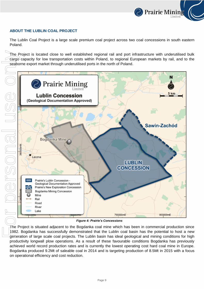
ABOUT THE LUBLIN COAL PROJECT
The Lublin Coal Project is a large scale premium coal project across two coal concessions in south eastern
Poland.
The Project is located close to well established regional rail and port infrastructure with underutilised bulk
cargo capacity for low transportation costs within Poland, to regional European markets by rail, and to the
seaborne export market through underutilised ports in the north of Poland.
Figure 4: Prairie’s Concessions
The Project is situated adjacent to the Bogdanka coal mine which has been in commercial production since
1982. Bogdanka has successfully demonstrated that the Lublin coal basin has the potential to host a new
generation of large scale coal projects. The Lublin basin has ideal geological and mining conditions for high
productivity longwall plow operations. As a result of these favourable conditions Bogdanka has previously
achieved world record production rates and is currently the lowest operating cost hard coal mine in Europe.
Bogdanka produced 9.2Mt of saleable coal in 2014 and is targeting production of 8.5Mt in 2015 with a focus
on operational efficiency and cost reduction.
For
per
sona
l use
onl
y
Page 10
Forward Looking Statements This release may include forward-looking statements. These forward-looking statements are based on Prairie’s expectations and beliefs concerning future events. Forward looking statements are necessarily subject to risks, uncertainties and other factors, many of which are outside the control of Prairie, which could cause actual results to differ materially from such statements. Prairie makes no undertaking to subsequently update or revise the forward-looking statements made in this release, to reflect the circumstances or events after the date of that release.
Competent Person Statements The information in this announcement that relates to Exploration Results and Coal Resources is based on information compiled or reviewed by Mr Samuel Moorhouse who is a Competent Person and a Chartered Geologist and Fellow of the Geological Society of London. Mr Moorhouse is employed by independent consultants Royal HaskoningDHV. Mr Moorhouse has sufficient experience that is relevant to the style of mineralization and type of deposit under consideration and to the activity being undertaken to qualify as a Competent Person as defined in the 2012 Edition of the ‘Australasian Code for Reporting of Exploration Results, Mineral Resources and Ore Reserves’. Mr Moorhouse consents to the inclusion in the announcement of the matters based on his information in the form and context in which it appears. The information in this announcement that relates to Exploration Results (drill holes Syczyn 7, Kopina 1, Kulik. Borowo, Cycow 7, Cycow 8 and Syczyn 8) was extracted from Prairie’s ASX announcements dated 30 April entitled ‘March 2015 Quarterly Report’ and 13 March 2014 entitled ‘Initial Washability Results Display Exceptionally High Yields’ which are available to view on the company’s website at www.pdz.com.au The information in the original ASX announcements that related to Exploration Results (drill holes Syczyn 7, Kopina 1, Kulik and Borowo) is based on information compiled or reviewed by Dr Richard Lowman, a Competent Person who is a Fellow of the Geological Society of London. Dr Lowman is employed by independent consultants Wardell Armstrong LLP which owns Wardell Armstrong Limited. Dr Lowman has sufficient experience which is relevant to the style of mineralisation and type of deposit under consideration and to the activity which he is undertaking to qualify as a Competent Person as defined in the 2012 Edition of the ‘Australasian Code for Reporting of Exploration Results, Mineral Resources and Ore Reserves’. The information in the original ASX announcement that relates to Exploration Results (drill holes: Cycow 7, Cycow 8 and Syczyn 8) is based on information compiled or reviewed by Mr Jonathan O’Dell, a Competent Person who is a Member of the Australian Institute of Mining and Metallurgy. Mr O’Dell is a consultant employed full time by Prairie Mining Limited. Mr O’Dell has sufficient experience that is relevant to the style of mineralization and type of deposit under consideration and to the activity being undertaken to qualify as a Competent Person as defined in the 2012 Edition of the ‘Australasian Code for Reporting of Exploration Results, Mineral Resources and Ore Reserves’.
Prairie confirms that: a) it is not aware of any new information or data that materially affects the information included in the original ASX announcements and; b) the form and context in which the relevant Competent Persons’ findings are presented in these announcements have not been materially modified from the original ASX announcement.
For
per
sona
l use
onl
y
Page 11
APPENDIX 1 - JORC CODE, 2012 EDITION – TABLE 1 – LUBLIN COAL PROJECT
Section 1 Sampling Techniques and Data
Criteria JORC Code explanation Commentary
Sampling
techniques
Nature and quality of sampling (eg cut channels, random chips, or specific specialised industry standard measurement tools appropriate to the minerals under investigation, such as down hole gamma sondes, or handheld XRF instruments, etc). These examples should not be taken as limiting the broad meaning of sampling.
Include reference to measures taken to ensure sample representivity and the appropriate calibration of any measurement tools or systems used.
Aspects of the determination of mineralisation that are Material to the Public Report.
In cases where ‘industry standard’ work has been done this would be relatively simple (eg ‘reverse circulation drilling was used to obtain 1 m samples from which 3 kg was pulverised to produce a 30 g charge for fire assay’). In other cases more explanation may be required, such as where there is coarse gold that has inherent sampling problems. Unusual commodities or mineralisation types (eg submarine nodules) may warrant disclosure of detailed information.
HISTORICAL DRILLING Across all four license areas the following works have been carried out:
Over 100 boreholes, totalling 71,999m were drilled, between 1965 and 1981 using a combination of open-hole and core drilling;
Coal quality was evaluated through laboratory testing samples, yielding of Coal seams >40cm were analysed and dirt partings less than 5cm, were analysed as part of a composite sample;
The sample collection procedure involved initial cleaning of the coal of any mud and transfer to plastic bags. Bags were then labelled with the borehole ID and sample number and sealed with tape to minimise moisture loss. Individual sample bags were further transferred to a collection bag, and then containers prior to delivery to the laboratory;
Coal quality analysis was undertaken by Analytical Tests Department of Katowice Geological Enterprise;
Average core recoveries for licenses K4-5, K6-7, K8, and K9 were 70%, 80%, 67.5%, and 70% respectively.
PRAIRIE MINING LTD DRILLING
Boreholes were openhole drilled from surface to the base of the Jurassic. Rock cutting samples were obtained at 2m intervals;
From the top of coal measures to the base of hole continuous rotary rock coring was carried out. A sufficient proportion of coal was obtained to ensure a representative sample was available for analysis;
Geologists carried out detailed lithological logging, core recovery measurements, to confirm an acceptable level of recovery and the use of and geophysical logging. Core recoveries were checked to ensure acceptable levels, and geophysical logs were used to confirm seam thickness;
Core was temporarily placed in plastic sleeves prior to sampling;
After sampling coal was placed into plastic bags to minimise excessive moisture loss. Core was stored at temperatures of <18°C within a secure, air conditioned building at site;
Samples were given a unique identifier (borehole name, seam code and sample number) to prevent loss, misplacement of confusion. All samples were weighed by
For
per
sona
l use
onl
y
Page 12
Criteria JORC Code explanation Commentary
PDZ and re-weighed at the laboratory. All details were cross-checked by the receiving laboratory to confirm receipt;
Coal seams were sampled single units, or as sub-samples (plies) of coal and/or dirt partings. The core was not split longitudinally and the full core was always sampled. When sampling only samples of >90% core recovery were taken as representative for whole seam or individual ply samples, with recoveries determined through comparison with geophysical logs, as below.
Drilling
techniques
Drill type (eg core, reverse circulation, open-hole hammer, rotary air blast, auger, Bangka, sonic, etc) and details (eg core diameter, triple or standard tube, depth of diamond tails, face-sampling bit or other type, whether core is oriented and if so, by what method, etc).
HISTORICAL DRILLING
Over 100 boreholes, totalling 71,999m were drilled, between 1965 and 1981 using a combination of openhole and core drilling;
Openhole drilling was confined to the upper units (surface to base of Jurassic), with coring commencing at the top of the Carboniferous, through the coal measures, to the base of the borehole.
Some boreholes were cored from surface, the details of which are described per license below:
License K4-5
Contained a total of 21 boreholes (21,615m) drilled between 1965-1975;
In 15 boreholes overburden strata was drilled by open-hole methods only, with segmental coring of the base of Cretaceous and Jurassic layers;
For boreholes Lublin 47, Lublin 49, Lublin 55 and Lublin 57 the overburden strata was fully cored.
For boreholes Lublin 51 and Lublin 59 full coring of the Cretaceous to a depth of 150m and then segmental coring was undertaken (one 5m long section every 50m). Full coring commenced ~20m above the Jurassic roof.
Rotary open-hole and core drilling (use of diamond drill bits) methods were used.
License K6-7
Contained a total of 23 boreholes (21,960m) drilled between 1968-1976;
In 15 boreholes overburden was drilled by open-hole methods only, with segmental coring of the base of Cretaceous and Jurassic;
For boreholes Lublin 71, Lublin 76, Lublin 84, Lublin 86 and Lublin 89 segmental coring of the overburden (one 6m long section every 30m) was carried out;
For boreholes Lublin 68, Lublin 72 and Lublin 79, the overburden was cored to a depth of 150m and the segmental coring commenced (one 6m long section every
For
per
sona
l use
onl
y
Page 13
Criteria JORC Code explanation Commentary
30m). In these boreholes continuous coring started approximately 20m above the roof of the Jurassic strata.
Rotary drilling with continuous coring using diamond bits was performed in the Carboniferous strata.
License K8
Contained a total of 23 boreholes (20,903m) drilled between 1968-1978;
In 16 boreholes overburden was openhole drilled with segmental coring of the Cretaceous and Jurassic;
For boreholes Lublin 90, Lublin 94, Lublin 95, Lublin 102, Lublin 106, Lublin 108 and Lublin 112 continuous coring of the Cretaceous strata to a depth of 150m as well as Jurassic and Carboniferous strata was observed;
Segmental coring (6m long drilling section every 30m) was performed for the Cretaceous interval between 150m and 20m above the roof of the Albian Strata;
Diamond core drilling methods were used in the Carboniferous strata.
License K9
K9 contained a total of 28 boreholes (26,971m) drilled between 1965-1981;
In 24 boreholes overburden was open-hole drilled with segmental coring of the Cretaceous and Jurassic strata.
For boreholes Lublin 114 and Lublin 123, coring was applied to a depth of approximately 150m;
In borehole Lublin 134 to a depth of 153m and in BH 138 to a depth of 210.30m, with full coring of the Jurassic and Carboniferous strata.
Segmental coring of the Cretaceous strata was carried out from the depths of 150m, 153m and 210.30m to 20m above the roof of the Albian strata was conducted;
Carboniferous strata were drilled using diamond core drilling methods.
Drilling was undertaken by Polish companies based in Katowice and Kielce, using OP-1200 and ZIF-1200 drilling rigs.
Core diameters varied between 74mm, 93mm, 112mm and 132mm.
PRAIRIE MINING LTD DRILLING
A total of seven boreholes were drilled within the LCP (Borowo, Cycow7, Cycow8, Kopina1, Kulik, Syczyn7, and Syczyn8);
Drilling was carried out via rotary open hole and core drilling;
During drilling sections of potentially
For
per
sona
l use
onl
y
Page 14
Criteria JORC Code explanation Commentary
unstable or unconsolidated ground were cased off to limit collapse;
Coal-bearing units were continuously cored via wireline rotary drilling with single tube 6m length core barrels, producing 85mm diameter core;
Upon completion the boreholes were sealed with cement.
Drill sample
recovery
Method of recording and assessing core and chip sample recoveries and results assessed.
Measures taken to maximise sample recovery and ensure representative nature of the samples.
Whether a relationship exists between sample recovery and grade and whether sample bias may have occurred due to preferential loss/gain of fine/coarse material.
HISTORICAL DRILLING
Core sample collection and assimilation was undertaken using standard procedures as set by the Polish coal industry at the time;
Core recovery was determined by measuring the lengths of recovered core and converting to length through application of a formula. Broken and fragmented core was then weighed and the proportion relative to the total weight was estimated. An overall core recovery length and percentage was then estimated and the output value was expressed as a thickness of the coal seam, based on drilling depths. Recovered core was also compared to the coal interval thickness and geophysical log depth;
It is unknown whether core recovery measurements were recorded based on individual core runs, with details of “solid core” and “RQD”;
It is understood that poor core recovery was caused by inappropriate drilling tools and/or poor technical conditions of the boreholes;
Coal seams that were interpreted by geophysical logging but lacked core recovery data were re-sampled using a W-1 hydro mechanical sidewall sampler. The reliability of this method is disputed but poor relative to full seam sampling and analysis and in some cases the results were not found to be reliable (insufficient proportion of seam not represented and analysed).
PRAIRIE MINING LTD DRILLING
Boreholes were openhole drilled from surface to the base of the Jurassic. Rock cutting samples were obtained at 2m intervals, and lithologically described;
Boreholes were continuously cored through the coal-bearing strata;
Core recovery was derived for each core run based on the length of the core run and the core measured from the core barrel. Coal seam recoveries were calculated using standard methodology, i.e. as the percentage of recovered core (determined by careful measurement) within the overall seam thickness (determined by examination of the geophysical logs, namely density);
Core recovery was recorded per drill run,
For
per
sona
l use
onl
y

Page 15
Criteria JORC Code explanation Commentary
with records of “solid core” and “RQD”.
Coal samples of <90% core recovery for a particular sample (of coal or inter-seam strata) are not typically considered representative. Coal quality analysis and seam representation were considered on a case-by-case basis during the encompassing lateral continuity investigation.
In general, core recoveries exceeded 90% for the principal seams.
Logging Whether core and chip samples have been geologically and geotechnically logged to a level of detail to support appropriate Mineral Resource estimation, mining studies and metallurgical studies.
Whether logging is qualitative or quantitative in nature. Core (or costean, channel, etc) photography.
The total length and percentage of the relevant intersections logged.
HISTORICAL DRILLING
Core sample collection and assimilation was undertaken using standard procedures as set by the Polish coal industry at the time;
Detailed graphical and written geological logs were produced for the boreholes, incorporating geological/lithological descriptions, geotechnical information, and core recovery data. All logs exhibited information pertaining to depths and thicknesses of the coal seams according to drilling depths, geophysical logs, and a combination of the two.
PRAIRIE MINING LTD DRILLING
Detailed geological logs were produced based using recorded drilling depths. Coal seam thicknesses and depths were cross-checked against geophysical logs;
A range of samples were taken for the purposes of both geotechnical and coal quality analysis;
All chip samples were geologically logged;
All cores were photographed using a dedicated stable and well-lit metal frame to maintain consistency.
Sub-sampling
techniques
and sample
preparation
If core, whether cut or sawn and whether quarter, half or all core taken.
If non-core, whether riffled, tube sampled, rotary split, etc and whether sampled wet or dry.
For all sample types, the nature, quality and appropriateness of the sample preparation technique.
Quality control procedures adopted for all sub-sampling stages to maximise representivity of samples.
Measures taken to ensure that the sampling is representative of the in situ material collected, including for instance results for field duplicate/second-half sampling.
Whether sample sizes are appropriate to the grain size of the material being sampled.
HISTORICAL DRILLING
Sub-sampling methodology for the historic drilling is not fully understood. Dirt partings under 5cm were incorporated into coal samples;
The sample collection procedure involved initial cleaning of the coal of any mud and transfer to plastic bags. Bags were then labelled with the borehole ID and sample number and sealed with tape to minimise moisture loss. Individual sample bags were further transferred to a collection bag, and then containers prior to delivery to the laboratory;
Quality control procedures for maximising sample representivity cannot be confirmed.
PRAIRIE MINING LTD DRILLING
All samples were logged by experienced local geologists from PDZ sub-contractor PolGeol;
For
per
sona
l use
onl
y
Page 16
Criteria JORC Code explanation Commentary
Samples were checked and verified by PDZ geologists and Head of Geosciences Jonathan O’Dell;
Coal seams were sampled single units, or as sub-samples (plies) of coal and/or dirt partings. The core was not split longitudinally and the full core was always sampled. When sampling only samples of >90% core recovery were taken as representative for whole seam or individual ply samples, with recoveries determined through comparison with geophysical logs;
Immediately following extraction from the core barrel a spot coal sample was secured in an air tight container and taken for gas testing
Quality of
assay data
and
laboratory
tests
The nature, quality and appropriateness of the assaying and laboratory procedures used and whether the technique is considered partial or total.
For geophysical tools, spectrometers, handheld XRF instruments, etc, the parameters used in determining the analysis including instrument make and model, reading times, calibrations factors applied and their derivation, etc.
Nature of quality control procedures adopted (eg standards, blanks, duplicates, external laboratory checks) and whether acceptable levels of accuracy (ie lack of bias) and precision have been established.
HISTORICAL DRILLING
Limited detail is available regarding the quality analysis and RHDHV are unable to ratify historical sampling methods and laboratory data, and reliably determine whether international standards (or equivalent) were followed;
Historical geophysical logs for seam intersections were provided and included natural gamma, density (gamma gamma) and resistivity information;
RHDHV have evaluated seam depths, thicknesses and correlations during audit and verification.
PRAIRIE MINING LTD DRILLING
Coal quality analysis has been carried out in accordance with Polish and International standards. A full suite of typical coal quality analysis has been undertaken, plus a range of additional detailed tests (such as ultimate analysis, ash compositions, basic washability) described in the report
All coal seams >0.60m thick were analysed for basic parameters. The additional detailed analysis was carried out on the key economic seams (typically >1.0m thick);
Geophysical logs were used to carry out checks on sample thickness and depths;
A basic suite of analysis has been undertaken by accredited Polish laboratories, including proximate analysis, total sulphur, CV and ultimate analysis. As a cross-check some samples were tested at an accredited international laboratory in the UK (with which RHDHV staff have worked successfully with in the past). Basic washability and some additional analysis (e.g. ash analysis, ultimate analysis, ash fusion, coking properties) were undertaken.
Verification of The verification of significant intersections by HISTORICAL DRILLING
For
per
sona
l use
onl
y
Page 17
Criteria JORC Code explanation Commentary
sampling and
assaying
either independent or alternative company personnel.
The use of twinned holes.
Documentation of primary data, data entry procedures, data verification, data storage (physical and electronic) protocols.
Discuss any adjustment to assay data.
Drilling works were supervised by the Lublin-based branch of the Geological Survey Company from Kielce;
The Geological Survey Company also undertook detailed core logging and sampling as part of the investigation of macro flora and macro fauna;
It is not believed any twinning was implemented in the historic drilling programme, or any modifications made to laboratory quality analysis.
PRAIRIE MINING LTD DRILLING
All coal sample thicknesses recorded by the contract geologists were checked by PDZ technical staff (site geologists and Head of Geosciences Jonathan O’Dell);
Certified sampling and coal quality analysis were provided in electronic format (.xlsx and .pdf) and are held in Poland and the UK. Again all information was checked by PDZ technical staff and subsequently RHDHV geologists
Location of
data points
Accuracy and quality of surveys used to locate drill holes (collar and down-hole surveys), trenches, mine workings and other locations used in Mineral Resource estimation.
Specification of the grid system used.
Quality and adequacy of topographic control.
HISTORICAL DRILLING
It is understood that original spatial data was presented in a range of coordinate systems including 1992 and 2000/8.
Borehole positions/collars have been resurveyed by a local certified surveyor in 2013/14 to ensure consistency. Signed and certified surveys were provided. RHDHV converted all data to the 1992 system to ensure compatibility with all official documentation;
PRAIRIE MINING LTD DRILLING
Boreholes are set out by survey in accordance with the Polish local grid. Following drilling each borehole, a down-hole geophysical logging survey is undertaken to confirm the depth location of all coal seams and provide the inclination and azimuth of the boreholes throughout their length.
Data spacing
and
distribution
Data spacing for reporting of Exploration Results.
Whether the data spacing and distribution is sufficient to establish the degree of geological and grade continuity appropriate for the Mineral Resource and Ore Reserve estimation procedure(s) and classifications applied.
Whether sample compositing has been applied.
HISTORICAL DRILLING
The historical boreholes were sited on an approximate 1000-1500m grid by the Geological Survey Company (on behalf of the governmental State Geological Institute);
Points of Observation were determined using a base set of criteria, and then on a case-by-case basis, using a defined set of criteria, including core recovery, degree of sampling and analysis, homogeneity of the coal seam, variability in seam structure and quality, and correlatability with adjacent boreholes.
For
per
sona
l use
onl
y
Page 18
Criteria JORC Code explanation Commentary
PRAIRIE MINING LTD DRILLING
The new boreholes are widely spaced, and have been drilled to both verify the historic boreholes data set and according to the works program agreed with Poland’s Ministry of Environment under the exploration concessions.
Sample compositing has been applied during modelling to produce a sample of a complete seam, or sub-sections of a seam, whereby individual ply samples of coal/dirt are combined based on the thickness and density of each sample. Samples were taken per lithological unit and were therefore typically smaller than the full seam thickness
Orientation of
data in
relation to
geological
structure
Whether the orientation of sampling achieves unbiased sampling of possible structures and the extent to which this is known, considering the deposit type.
If the relationship between the drilling orientation and the orientation of key mineralised structures is considered to have introduced a sampling bias, this should be assessed and reported if material.
HISTORICAL DRILLING
It has been assumed that all historic boreholes were drilled vertically with no other predetermined orientation. Precise details regarding verticality are unknown;
Whilst some deviation from the vertical is likely RHDHV have assumed all boreholes are vertical during interpretation and subsequent modelling;
The sampling methods are well understood and defined and are implemented to minimise risk of bias.
PRAIRIE MINING LTD DRILLING
The geological structures are relatively simple, whereby sampling is not affected by geological structure;
Whilst some deviation from the vertical is likely RHDHV have assumed all boreholes are vertical during interpretation and subsequent modelling;
The sampling methods were designed to minimise risk of bias, are well understood, have been strictly adhered to
Sample
security
The measures taken to ensure sample security.
HISTORICAL DRILLING
No information was available regarding sample security of the historic data, however RHDHV do not have any reason to believe that this will have affected analysis and the resultant information used in the report.
PRAIRIE MINING LTD DRILLING
Samples were given a unique identifier (borehole name, seam code and sample number) to prevent loss, misplacement of confusion. All samples were weighed by PDZ and re-weighed at the laboratory. All details were cross-checked by the receiving laboratory to confirm receipt;
Laboratories used are considered competent, responsible and unlikely to cause concern for sample security;
Samples were able to be confidently tracked
For
per
sona
l use
onl
y
Page 19
Criteria JORC Code explanation Commentary
from site to laboratory.
Audits or
reviews
The results of any audits or reviews of sampling techniques and data.
RHDHV has carried out a range of verification procedures to ensure sampling methods were consistent and reliable. Methods carried out at site by PDZ and associated technical staff were also evaluated during a site visit and shown to be of a satisfactory level.
Section 2 Reporting of Exploration Results
Criteria JORC Code explanation Commentary
Mineral
tenement and
land tenure
status
Type, reference name/number, location and ownership including agreements or material issues with third parties such as joint ventures, partnerships, overriding royalties, native title interests, historical sites, wilderness or national park and environmental settings.
The security of the tenure held at the time of reporting along with any known impediments to obtaining a licence to operate in the area.
Prairie hold the exploration licences to 4 no. concession areas that constitute the Lublin Coal Project: Cycow (K-6-7; No. 23/2012/p, updated 2013), Syczyn (K-8; No.21/2012/p), Kulik (K-4-5; No.20/2012/p) and Kopina (K-9; No.22/2012p).
Exploration
done by other
parties
Acknowledgment and appraisal of exploration by other parties.
Between 1965 and 1983 a total of 205 historical boreholes have been drilled in the area of the LCP, 117 of which are located within the 4 no. licence areas.
A study of data collected during historical exploration has previously been undertaken and provided to RHDHV by PDZ as Geological Documentation and Supplementary Documentation for the deposit, which includes but is not limited to; resource maps & tables, seam coal quality tables, structural contour maps, cross sections, boreholes cards and geological reports.
Geology Deposit type, geological setting and style of mineralisation.
The Lublin Coalfield comprises a stratified Upper Carboniferous coal deposit comprising some 30 coal seams, which include a number of economic target seams, in particular the 389 and 391 seams.
Carboniferous coal-bearing sequence is overlain by strata of the Quaternary, Cretaceous and Jurassic.
Drill hole
Information
A summary of all information material to the understanding of the exploration results including a tabulation of the following information for all Material drill holes: o easting and northing of the drill hole collar o elevation or RL (Reduced Level – elevation
above sea level in metres) of the drill hole collar
o dip and azimuth of the hole o down hole length and interception depth o hole length.
If the exclusion of this information is justified on the basis that the information is not Material
A summary of the drill hole information for exploration undertaken by PDZ has previously been provided on the Borehole Summary Sheets (refer to ASX announcement 13 March 2014).
A summary table of historic and current boreholes used as the basis for this report is provided in Tables A1 and A2 of the Competent Persons Report (CPR), illustrating basic borehole information and Points of Observation respectively.
As the basis of the geological model, RHDHV hold a managed database
For
per
sona
l use
onl
y
Page 20
Criteria JORC Code explanation Commentary
and this exclusion does not detract from the understanding of the report, the Competent Person should clearly explain why this is the case.
containing all information pertaining to the structure and geological nature of the deposit, including geological and geophysical logs and coal quality results.
Data
aggregation
methods
In reporting Exploration Results, weighting averaging techniques, maximum and/or minimum grade truncations (eg cutting of high grades) and cut-off grades are usually Material and should be stated.
Where aggregate intercepts incorporate short lengths of high grade results and longer lengths of low grade results, the procedure used for such aggregation should be stated and some typical examples of such aggregations should be shown in detail.
The assumptions used for any reporting of metal equivalent values should be clearly stated.
No data aggregation methods were used in the preparation of this announcement.
The coal quality for each seam has been determined using the methods outlined in the CPR.
Calculation parameters used to constrain the geological model for the reporting of Coal Resources is discussed in detail in Section 5 of the CPR.
Relationship
between
mineralisation
widths and
intercept
lengths
These relationships are particularly important in the reporting of Exploration Results.
If the geometry of the mineralisation with respect to the drill hole angle is known, its nature should be reported.
If it is not known and only the down hole lengths are reported, there should be a clear statement to this effect (eg ‘down hole length, true width not known’).
All exploration boreholes for the LCP have been drilled vertically. Subsequent geophysical logging techniques have been employed in every borehole to confirm the inclination deviation and azimuth.
Coal seam intercept depths and thicknesses have been confirmed using geophysical logging in each borehole as a means of confirming the structure of the deposit.
Diagrams Appropriate maps and sections (with scales) and tabulations of intercepts should be included for any significant discovery being reported. These should include, but not be limited to a plan view of drill hole collar locations and appropriate sectional views.
A cross section through the geological model of the LCP is provided in Figure 15 of the CPR. Cross section extracted from Vulcan™ modelling software.
A borehole plan relative to the exploration licence boundaries is provided in Figure16 of the CPR. Vulcan™ screenshot of LCP.
A full database of every coal seam intercept used for the purpose of geological model is held by RHDHV and can be supplied on request.
Balanced
reporting
Where comprehensive reporting of all Exploration Results is not practicable, representative reporting of both low and high grades and/or widths should be practiced to avoid misleading reporting of Exploration Results.
All Exploration Results have been provided in Appendix B of the CPR and summarised throughout the CPR.
Other
substantive
exploration
data
Other exploration data, if meaningful and material, should be reported including (but not limited to): geological observations; geophysical survey results; geochemical survey results; bulk samples – size and method of treatment; metallurgical test results; bulk density, groundwater, geotechnical and rock characteristics; potential deleterious or contaminating substances.
A summary of Material exploration data pertaining to the geological nature and characteristics of the Lublin deposit has been provided or described in the CPR.
Where applicable and considered necessary to the understanding of the CPR, extracts from primary exploration data is provided.
Additional exploration data including detailed geological and geophysical logs are considered surplus to the CPR.
Further work The nature and scale of planned further work (eg tests for lateral extensions or depth extensions or large-scale step-out drilling).
Diagrams clearly highlighting the areas of
Recommendations that should be considered for the future progression of the LCP have been presented and fully justified in Section 6 of the CPR.
For
per
sona
l use
onl
y
Page 21
Criteria JORC Code explanation Commentary
possible extensions, including the main geological interpretations and future drilling areas, provided this information is not commercially sensitive.
Section 3 Estimation and Reporting of Mineral Resources
Criteria JORC Code explanation Commentary
Database
integrity
Measures taken to ensure that data has not been corrupted by, for example, transcription or keying errors, between its initial collection and its use for Mineral Resource estimation purposes.
Data validation procedures used.
A complete geological database in electronic spreadsheet format has been provided to RHDHV by PDZ for the purpose of geological modelling using Vulcan™ software. This database including coal quality and seam interception data was originally constructed by PDZ using historical data collated from a number of local sources, including Polish Geological and National Archives.
Full details of the data audit and verification procedures employed by RHDHV is provided in Section 4.2 of the CPR. In summary these procedures included a thorough check of spatial and structural data, stratigraphic/geological interpretations and a numerical assessment of coal quality data. Spot checking and cross-comparison between multiple sets of data was undertaken to ensure the most relevant and accurately sourced data was used as the basis for the geological model.
Data audit and validation procedures have been applied equally to both historical and 2013-14 exploration data.
Site Visits Comment on any site visits undertaken by the Competent Person and the outcome of those visits.
If no site visits have been undertaken indicate why this is the case.
RHDHV geologist Sam Moorhouse visited the exploration site as part of a ground-truthing exercise in August 2014. Mr Moorhouse witnessed the PDZ drilling rigs in operation and was able to observe the overall site set up and facilities. Refer to Section 5.2.2 of the CPR for further details.
Site investigation procedures were discussed with PDZ staff, including drilling, logging, sampling and testing procedures, as well as data transfer, recording and manipulation.
Prior to this study the RHDHV consultant geologist has visited the exploration work being carried out by PDZ, the coal laboratory being used for their recent testwork, and Bogdanka mine, together with several mines and projects in the extension of the Lublin coal basin in adjacent Ukraine.
Geological
interpretation
Confidence in (or conversely, the uncertainty of) the geological interpretation of the mineral deposit.
Nature of the data used and of any assumptions made.
The coal resources have been classified as indicated and inferred resources in accordance with the JORC 2014 Guidelines for the Estimation and Classification of Coal Resources.
For
per
sona
l use
onl
y
Page 22
Criteria JORC Code explanation Commentary
The effect, if any, of alternative interpretations on Mineral Resource estimation.
The use of geology in guiding and controlling Mineral Resource estimation.
The factors affecting continuity both of grade and geology.
Allowances have been made for geological uncertainty, 15% for Indicated and 20% for Inferred Resources.
During geological evaluation RHDHV employed standard interpretive techniques to elucidate seam continuity and delimit seam properties. The interpretive techniques included preparation of; basic fence diagrams and cross sections, schematic stratigraphies, seam contour plots, ispoachs and structural features such as faults and key interburden units, such as massive sandstones.
The geological continuity of the Lublin deposit has been considered in the CPR with reference to adjacent established mines, previous Resource estimations, general accuracy and reliability of the data and additional interpretive work undertaken by WAI, PDZ’s in-house technical team, local Geological Enterprise ‘POLGEOL S.A.’ and RHDHV. These considerations are discussed in further detail in Table 5 of the CPR.
Dimensions The extent and variability of the Mineral Resource expressed as length (along strike or otherwise), plan width, and depth below surface to the upper and lower limits of the Mineral Resource.
The nature and variation in the geological characteristics of the deposit including but not limited to seam extent, thickness, core recovery and coal quality variation are fully presented and described in Appendix E of the CPR.
Estimation and
modelling
techniques
The nature and appropriateness of the estimation technique(s) applied and key assumptions, including treatment of extreme grade values, domaining, interpolation parameters and maximum distance of extrapolation from data points. If a computer assisted estimation method was chosen include a description of computer software and parameters used.
The availability of check estimates, previous estimates and/or mine production records and whether the Mineral Resource estimate takes appropriate account of such data.
The assumptions made regarding recovery of by-products.
Estimation of deleterious elements or other non-grade variables of economic significance (e.g. sulphur for acid mine drainage characterisation).
In the case of block model interpolation, the block size in relation to the average sample spacing and the search employed.
Any assumptions behind modelling of selective mining units.
Any assumptions about correlation between variables.
Description of how the geological interpretation was used to control the resource
Continued geological interpretation pre- and post- modelling was carried out to assess any regions of specific geological characteristics or uncertainty. Three principal domains have been identified that require independent consideration during Resource definition, including (i) Seam inconsistency to the north, (ii) faulted region to the southeast and (iii) faulted region to the southwest. Domain 1 was excluded entirely from the Resource estimation, but represents an upside case for additional Resources following more detailed geological interpretation. Domain 2 was excluded entirely from the Resource estimation. Coal within Domain 3 was still modelled and included in the Resource estimation, however RHDHV invoked a condition of classification downgrading in this region whereby coal could be classified only as Inferred status, not Indicated or Measured. Additional domains within the Resource estimation area regarding seam splitting have also been identified within the Resource area, although these did not affect tonnage and quality estimations or the classification thereof;
A detailed methodology of the geological
For
per
sona
l use
onl
y
Page 23
Criteria JORC Code explanation Commentary
estimates.
Discussion of basis for using or not using grade cutting or capping.
The process of validation, the checking process used, the comparison of model data to drill hole data, and use of reconciliation data if available.
modelling procedure is provided in Appendix D of the CPR. The Integrated Stratigraphic Modelling (ISM) process is considered the optimised approach for modelling coal deposits within Vulcan™;
ISM comprises five principle phases that convert basic raw data (spatial and numerical) into a 3D geological Horizon Adaptive Rectangular Prism (“HARP”) model – equivalent to a conventional block model but with additional flexibility on block shape. The HARP model provides information relating to coal extent, quality and quantity and allows a Resource to be accurately and reliably estimated;
Stratigraphic surfaces were produced by a triangulation modelling method with a 1st order, linear trend;
The base and roof of each block in the model is defined by 5 points. For the purpose of this study each block had a lateral extent of 25m x 25m;
Proportional cell evaluation was used in preference to centroid evaluation. Proportional is considered the more accurate method and also produces slightly lower (~0.3%) tonnages;
The radii function was used to digitise arcs around the remaining, selected boreholes with radii of 600m and 2,000m for Indicated (or equivalent to all remaining coal) and Inferred classifications respectively;
Interpolation of the quality data was performed using the default inverse distance methodology, with a 0 trend order and 9 smoothing passes. A maximum of 10 samples were used to estimate each node on a grid. Default and null sample values such as -99 were excluded from the estimate;
The coal thickness and elevation model was created separately to the coal quality grids, with the two being superimposed together at HARP model stage (Vulcan™ block model), to allow the production of both tonnages and the relevant coal quality grades;
In built validation procedures in Vulcan™ were ran to ensure no duplicates, overlaps or extreme values were included in the modelling;
Advanced geostatistical methods, i.e. variograms, were not considered appropriate for this study. The relevance of geostatistics to estimations in stratiform deposits such as coal is regularly debated. RHDHV’s approach to estimation has been based on geological assessment of the lateral continuity of the seams across the deposit
For
per
sona
l use
onl
y
Page 24
Criteria JORC Code explanation Commentary
and attaining a good understanding of the stratigraphic and structural features at the site. Further, basing the model on advanced geostatistics was not considered appropriate due to the limitations of defining spacings (e.g. no downhole variogram can be produced); RHDHV consider geostatistical models to be more suitable for non-stratiform deposits where geology cannot be as easily understood, correlated, predicted, or extrapolated;
Resource estimates are compared in Section 5.10 of the CPR but were shown to exhibit similar composition and results (tonnages, qualities and confidence levels) to the interim and final Resource models produced as part of the CPR. The similarities corroborate the interpretations and outcomes of the Report.
Moisture Whether the tonnages are estimated on a dry basis or with natural moisture, and the method of determination of the moisture content.
The coal quality and tonnages were calculated on an air dried basis.
Cut-off
parameters
The basis of the adopted cut-off grade(s) or quality parameters applied.
A quality cut-off – with previous studies having shown coal quality within the seams to be high and of good lateral consistency no quality restrictions or cut-offs were considered. It has been assumed that the impact of any variations in coal quality will be mitigated during mine design, scheduling and processing.
Mining factors
or
assumptions
Assumptions made regarding possible mining methods, minimum mining dimensions and internal (or, if applicable, external) mining dilution. It is always necessary as part of the process of determining reasonable prospects for eventual economic extraction to consider potential mining methods, but the assumptions made regarding mining methods and parameters when estimating Mineral Resources may not always be rigorous. Where this is the case, this should be reported with an explanation of the basis of the mining assumptions made.
At each stage of geological interpretation and modelling, RHDHV has consistently considered the potential of the deposit to be economically extractable.
Previous studies suggest that the deposit has the potential to support an underground longwall mining operation, accessed and supplied via two shafts to depths of approximately 1000m. A previous Scoping Study concludes that the deposit could be exploited utilising plows or shearers depending on seam thickness. In general above seam thickness of 1,5m shearers are used and below 1.5m plows are to be used.
A seam thickness cut-off of 1.0m has been applied manually in Vulcan™ using a thickness contour (string). Isopachs have been evaluated by RHDHV for each seam to identify isolated regions of anomalous coal to be removed, including; (i) small areas within thick coal that thin to slightly less than 1m – it was assumed this coal would still be mined and (ii) Small areas within thin coal where the seam thickens to greater than 1m – it was assumed this coal would not be extracted.
Variables which have not been considered in this Report in regard to mining limitations
For
per
sona
l use
onl
y
Page 25
Criteria JORC Code explanation Commentary
include; restrictions due to seam dip, coal sterilisation where seams are in close proximity to each other and the extraction of both seams is not possible.
Previous investigations have considered both the use of steel arches and rock bolting, however further work and consideration of detailed geotechnical laboratory analysis should be considered.
A stand-off of from the Jurassic has been assumed to be 100m to account for uncertainties in the exact nature of the basal surface.
It has been assumed that there would be no depth limitations on coal extractability.
Metallurgical
factors or
assumptions
The basis for assumptions or predictions regarding metallurgical amenability. It is always necessary as part of the process of determining reasonable prospects for eventual economic extraction to consider potential metallurgical methods, but the assumptions regarding metallurgical treatment processes and parameters made when reporting Mineral Resources may not always be rigorous. Where this is the case, this should be reported with an explanation of the basis of the metallurgical assumptions made.
Not applicable.
Environmental
factors or
assumptions
Assumptions made regarding possible waste and process residue disposal options. It is always necessary as part of the process of determining reasonable prospects for eventual economic extraction to consider the potential environmental impacts of the mining and processing operation. While at this stage the determination of potential environmental impacts, particularly for a greenfields project, may not always be well advanced, the status of early consideration of these potential environmental impacts should be reported. Where these aspects have not been considered this should be reported with an explanation of the environmental assumptions made.
Modifying Factors, typically applied for the definition of Reserves (including geotechnical, hydrogeological, mining, processing, marketing, environmental and legal) have not been assessed in detail for the CPR but have been evaluated from a Fatal Flaw perspective, e.g. areas of natural conservation have been identified within the sphere of influence of the LCP and the mine plan should be designed to minimise any impact of such areas.
Previous assessments of the deposit suggest that all Run of Mine coal (ROM) will be processed in a CHPP and the waste, of approximately 1.5M tonnes per annum, will be deposited in a suitable emplacement area. This will require an environmental permit but since the site is a previous mine it is not expected to encounter opposition. Transport of coal will be protected from causing environmental issues such as dust. Surface infrastructure has also been considered in a Scoping Study to avoid potentially sensitive areas.
Bulk density Whether assumed or determined. If assumed, the basis for the assumptions. If determined, the method used, whether wet or dry, the frequency of the measurements, the nature, size and representativeness of the samples.
The bulk density for bulk material must have been measured by methods that adequately
The estimation of coal resources has utilised air dried density figures, provided by the laboratory test results.
For
per
sona
l use
onl
y
Page 26
Criteria JORC Code explanation Commentary
account for void spaces (vugs, porosity, etc), moisture and differences between rock and alteration zones within the deposit.
Discuss assumptions for bulk density estimates used in the evaluation process of the different materials.
Classification The basis for the classification of the Mineral Resources into varying confidence categories.
Whether appropriate account has been taken of all relevant factors (i.e. relative confidence in tonnage/grade estimations, reliability of input data, confidence in continuity of geology and metal values, quality, quantity and distribution of the data).
Whether the result appropriately reflects the Competent Person’s view of the deposit.
The Mineral Resource Estimate has been classified and is reported as Indicated and Inferred coal resources based on the guidelines specified in the 2012 JORC code and the 2014 Edition of Guidelines for the Estimation and Classification of Coal Resources.
RHDHV can confirm that the data quantity, quality, and provenance are of ample reliability to form the basis of a Mineral Resource Statement compliant with the principles of the JORC Code.
The work undertaken by PDZ and subsequently RHDHV is sufficient to permit formal estimation of Resources. The reliability of the data, and the continuity of the geology, is represented in the Resource Classification (allocation of coal to Measured, Indicated and Inferred status), and also through the application of geological losses to these tonnages.
As set out under the requirements of JORC and in order to satisfy the fundamental principles of the reporting code geological interpretation of the Lublin deposit, through the allocation of Points of Observation for the purpose of Resource Estimation, has been carried out on the expertise of the Competent Persons, drawing on both post experience of similar studies and knowledge of the Lublin coal basin seams.
Audits or
reviews
The results of any audits or reviews of Mineral Resource estimates.
RHDHV has undertaken a comprehensive data audit and validation process on a proportion of historical and current exploration data and consider it to be sufficiently reliable for the purpose of developing a geological model of the Lublin deposit for resource estimation.
Previous estimates have been undertaken by PolGeol in 1999-01 in accordance with the Polish system for each of the four main license areas. After consideration of the differences in estimation parameters the PolGeol estimate was predicted to be significantly higher, but within the same order of magnitude. This can be observed in the estimate produced which considers three times as many, albeit thinner and less laterally consistent, seams, and employs different criteria for defining what is a potentially workable seam. The Resource estimate carried out by WAI in October 2013
For
per
sona
l use
onl
y
Page 27
Criteria JORC Code explanation Commentary
contained tonnages more directly comparable with the RHDHV. After deduction of geological losses in line with RHDHV’s methodology the resultant tonnages could be compared and show that a difference of only ~18Mt was observed in the global estimate. Variations between individual seams were shown to be both increases and decreases, demonstrating that differences are caused by “random” factors rather than a particular difference in approach or methodology.
Discussion of
relative
accuracy/
confidence
Where appropriate a statement of the relative accuracy and confidence level in the Mineral Resource estimate using an approach or procedure deemed appropriate by the Competent Person. For example, the application of statistical or geostatistical procedures to quantify the relative accuracy of the resource within stated confidence limits, or, if such an approach is not deemed appropriate, a qualitative discussion of the factors that could affect the relative accuracy and confidence of the estimate.
The statement should specify whether it relates to global or local estimates, and, if local, state the relevant tonnages, which should be relevant to technical and economic evaluation. Documentation should include assumptions made and the procedures used.
These statements of relative accuracy and confidence of the estimate should be compared with production data, where available.
As discussed above, previous estimates have been undertaken, both historical and current, for the Lublin deposit and have been compared to the resource estimations made by RHDHV in this report, which has been determined to fall within the same order of magnitude;
Advanced geostatistical methods, i.e. variograms, were not considered appropriate for this study. RHDHV consider geostatistical models to be more suitable for non-stratiform deposits where geology cannot be as easily understood, correlated, predicted, or extrapolated;
Allowances have been made for geological uncertainty, 15% for Indicated and 20% for Inferred Resources.
For
per
sona
l use
onl
y