Embed Size (px)
Citation preview
This Final Report was prepared for the Alaska Department of Environmental Conservation as
part of the Alaska Clean Water Actions Grant # ACWA 13-08 (FY13) and 14-05 (FY14).
AUKE LAKE WATER QUALITY MONITORING
JULY 2, 2012 – JUNE 30, 2014
1
Auke Lake Water Quality Monitoring JULY 2, 2012 – JUNE 30, 2014
INTRODUCTION
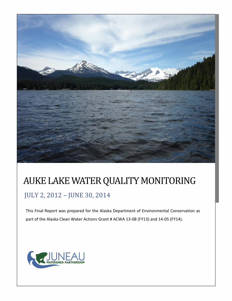
Auke Lake is located in the Auke Bay area, 10 miles northwest of Juneau,
AK. The Auke Lake watershed drains an area of 2,500 acres, and the lake itself has
a surface area of approximately 177 acres and a maximum depth of 113 feet. The
lake’s outlet is Auke Creek, which discharges into Auke Bay. Its headwaters include
Lake Creek, Lake Two Creek and unnamed drainages from Goat Hill and Peterson
Hill. The lake is an anadromous system supporting coho, sockeye, pink and chum
salmon, as well as cutthroat and rainbow trout and Dolly Varden char (Bethers,
1995). The undeveloped areas of the Auke Lake watershed include Sitka spruce
and Western hemlock forest intermixed with wetlands, which support a variety of
wildlife including a variety of water fowl and birds, beavers, river otters, Sitka
black-tailed deer, and black bear.
Auke Lake is one of the few freshwater lakes easily accessible by the road
system. Its accessibility makes it a popular recreational area for uses including
swimming, motorized and non-motorized boating, hiking, running, and biking.
The boat launch and parking area, located at the southwest corner of the lake, is a designated
City and Borough of Juneau (CBJ) Recreation Service Park. Auke Lake Trail is a CBJ owned trail that
parallels the western edge of the lake, and provides access to two (2) floating docks.
There has been concern about the effect of motorized watercraft use on Auke Lake’s water
quality. This concern has prompted water quality studies to assess PAH concentrations in relation to
recreational use of the lake. NOAA/NMFS conducted periodic water quality sampling in Auke Lake from
1999 to 2003 for polycyclic aromatic hydrocarbon (PAH) discharges, in tandem with daily recreational
boating observations. That study showed an increase in PAH concentrations in surface waters of Auke
Lake coincided with the increase of two-stroke engine watercraft on the lake.
Using Alaska Clean Water Act (ACWA) funds, the JWP was able to continue the monitoring of the
recreational usage on the lake and its effect on the water quality of the lake.
JUNEAU
WATERSHED
PARTNERSHIP
Our mission is to
promote watershed
integrity in the City
and Borough of
Juneau through
education, research
and communication
while encouraging
sustainable use and
development.
2
CONTENTS
AUKE LAKE MONITORING LOCATIONS 3
METHODS 5
RESULTS 8
PUBLIC OUTREACH 11
ACKNOWLEDGEMENTS 12
APPENDIX 13
3
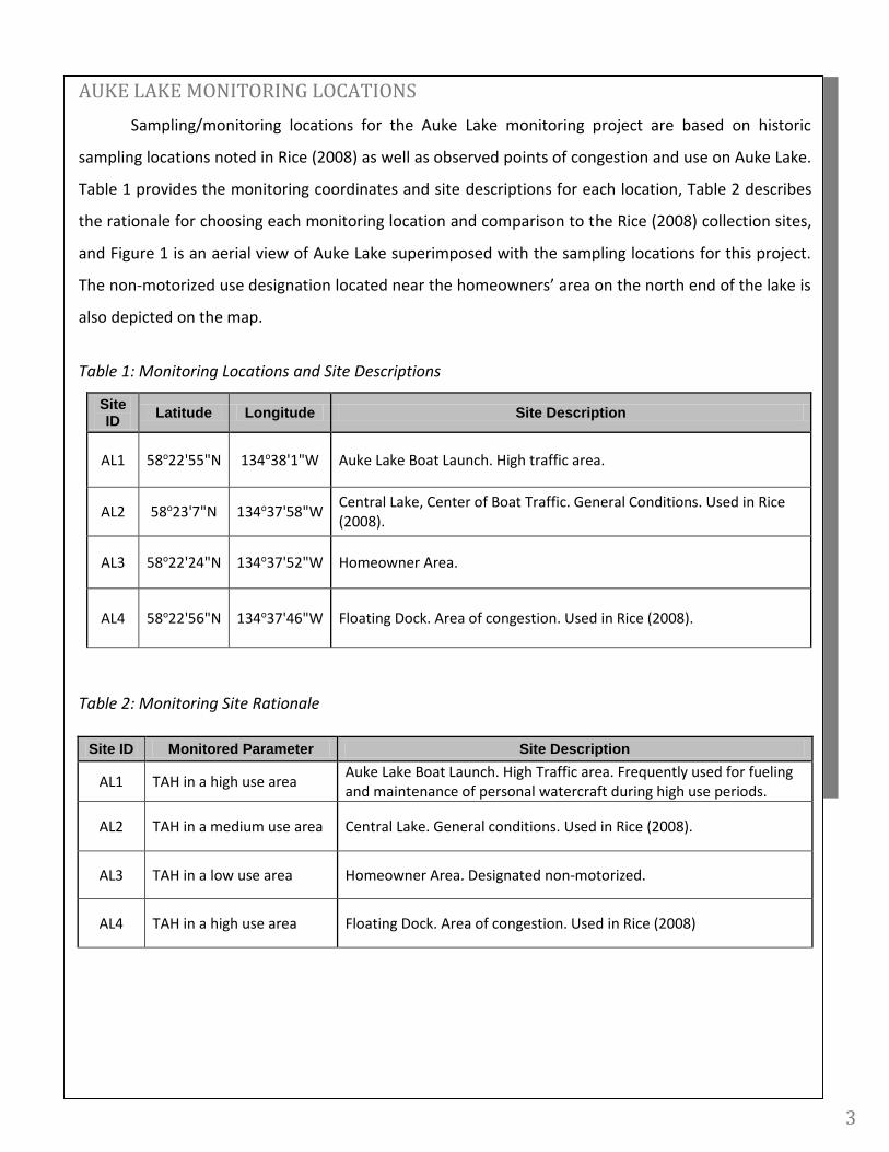
AUKE LAKE MONITORING LOCATIONS
Sampling/monitoring locations for the Auke Lake monitoring project are based on historic
sampling locations noted in Rice (2008) as well as observed points of congestion and use on Auke Lake.
Table 1 provides the monitoring coordinates and site descriptions for each location, Table 2 describes
the rationale for choosing each monitoring location and comparison to the Rice (2008) collection sites,
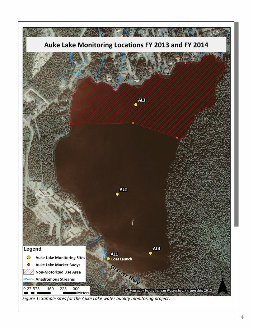
and Figure 1 is an aerial view of Auke Lake superimposed with the sampling locations for this project.
The non-motorized use designation located near the homeowners’ area on the north end of the lake is
also depicted on the map.
Table 1: Monitoring Locations and Site Descriptions
Site ID
Latitude Longitude Site Description
AL1 58o22'55"N 134o38'1"W Auke Lake Boat Launch. High traffic area.
AL2 58o23'7"N 134o37'58"W Central Lake, Center of Boat Traffic. General Conditions. Used in Rice (2008).
AL3 58o22'24"N 134o37'52"W Homeowner Area.
AL4 58o22'56"N 134o37'46"W Floating Dock. Area of congestion. Used in Rice (2008).
Table 2: Monitoring Site Rationale
Site ID Monitored Parameter Site Description
AL1 TAH in a high use area Auke Lake Boat Launch. High Traffic area. Frequently used for fueling and maintenance of personal watercraft during high use periods.
AL2 TAH in a medium use area Central Lake. General conditions. Used in Rice (2008).
AL3 TAH in a low use area Homeowner Area. Designated non-motorized.
AL4 TAH in a high use area Floating Dock. Area of congestion. Used in Rice (2008)
4
Figure 1: Sample sites for the Auke Lake water quality monitoring project.
Auke Lake Monitoring Locations FY 2013 and FY 2014
5
METHODS
Samples were collected for the Auke Lake water quality monitoring project at four (4) different
sample locations on Auke Lake (see Figure 1). All of the sampling for FY13 was conducted during the
summer of 2013 prior to the end of the fiscal year, June 30, 2013. The samples for FY14 were collected
during the summer months spanning from July 1, 2013 through June 30, 2014. Samples were collected
from the four pre-determined locations during seasonal peak activity periods on Auke Lake. Often, the
highest period of activity occurs on warm, calm and sunny days during the week days after professional
work hours, when a large amount of use is concentrated on the lake at the same time. Use on the
weekends during nice weather occurred, but not in concentrations comparable to most of the weekdays.
Samples from Auke Lake were collected to determine TAH concentrations and additional field
parameters were collected at the four (4) sites on Auke Lake. All samples were collected by Juneau
Watershed Partnership staff following Standard Operating Procedures as described in the Auke Lake Tier
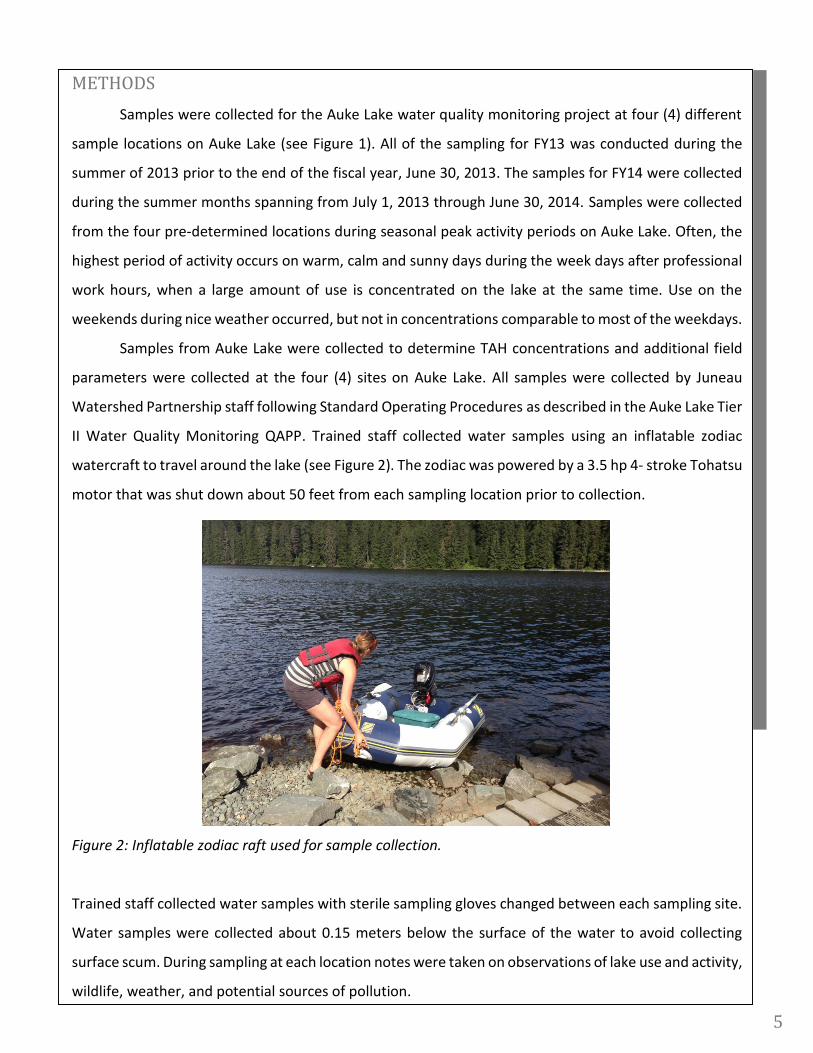
II Water Quality Monitoring QAPP. Trained staff collected water samples using an inflatable zodiac
watercraft to travel around the lake (see Figure 2). The zodiac was powered by a 3.5 hp 4- stroke Tohatsu
motor that was shut down about 50 feet from each sampling location prior to collection.
Figure 2: Inflatable zodiac raft used for sample collection.
Trained staff collected water samples with sterile sampling gloves changed between each sampling site.
Water samples were collected about 0.15 meters below the surface of the water to avoid collecting
surface scum. During sampling at each location notes were taken on observations of lake use and activity,
wildlife, weather, and potential sources of pollution.
6
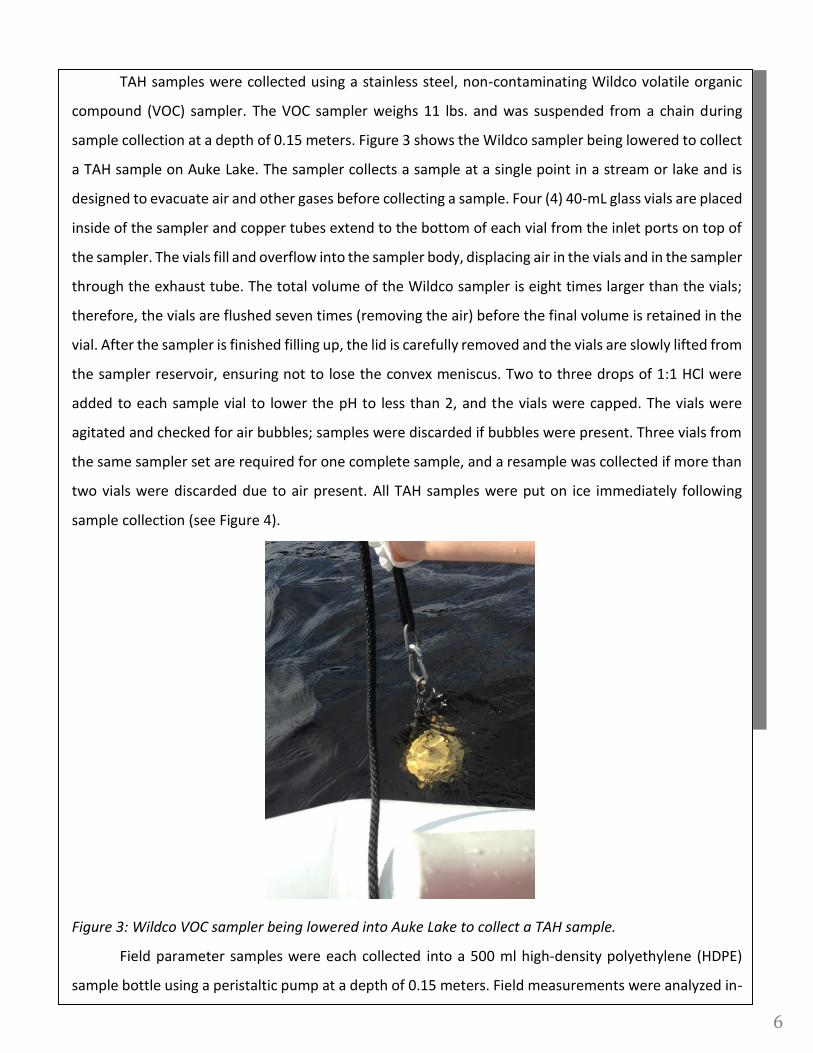
TAH samples were collected using a stainless steel, non-contaminating Wildco volatile organic
compound (VOC) sampler. The VOC sampler weighs 11 lbs. and was suspended from a chain during
sample collection at a depth of 0.15 meters. Figure 3 shows the Wildco sampler being lowered to collect
a TAH sample on Auke Lake. The sampler collects a sample at a single point in a stream or lake and is
designed to evacuate air and other gases before collecting a sample. Four (4) 40-mL glass vials are placed
inside of the sampler and copper tubes extend to the bottom of each vial from the inlet ports on top of
the sampler. The vials fill and overflow into the sampler body, displacing air in the vials and in the sampler
through the exhaust tube. The total volume of the Wildco sampler is eight times larger than the vials;
therefore, the vials are flushed seven times (removing the air) before the final volume is retained in the
vial. After the sampler is finished filling up, the lid is carefully removed and the vials are slowly lifted from
the sampler reservoir, ensuring not to lose the convex meniscus. Two to three drops of 1:1 HCl were
added to each sample vial to lower the pH to less than 2, and the vials were capped. The vials were
agitated and checked for air bubbles; samples were discarded if bubbles were present. Three vials from
the same sampler set are required for one complete sample, and a resample was collected if more than
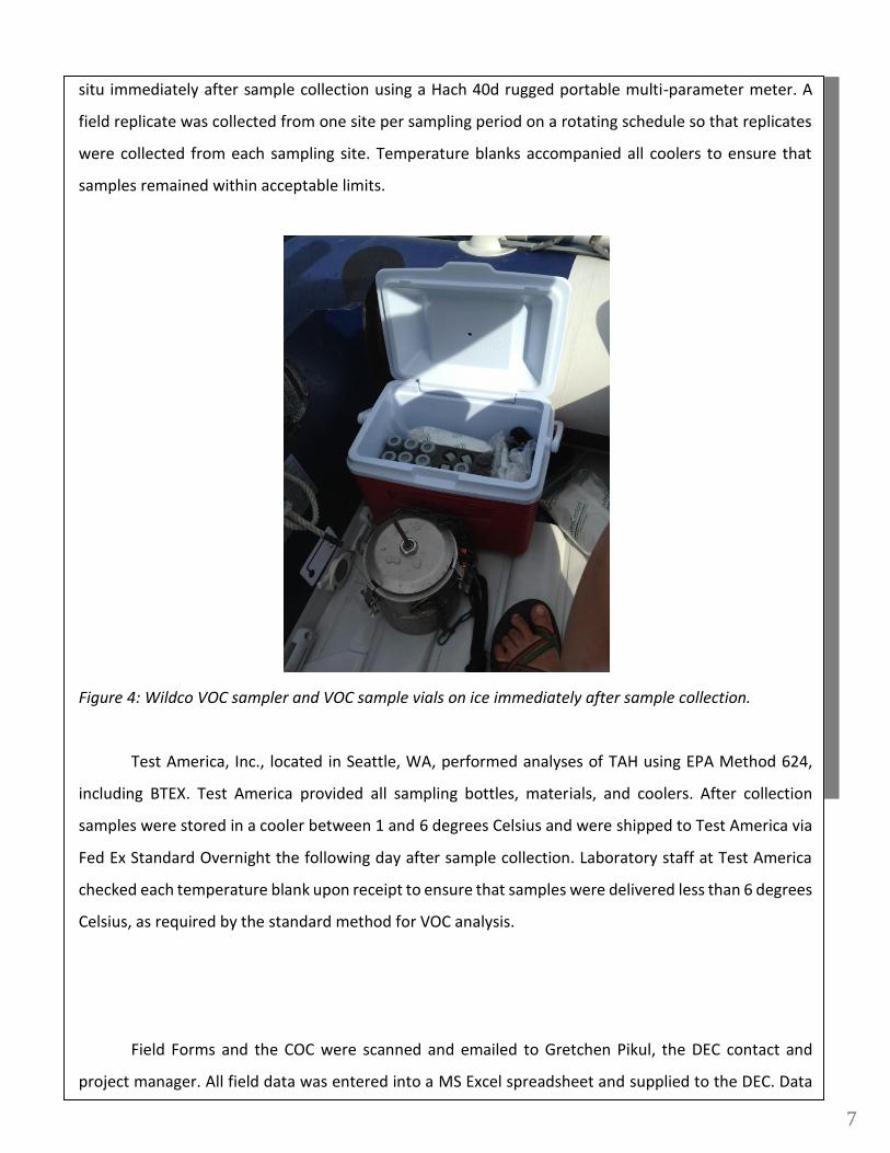
two vials were discarded due to air present. All TAH samples were put on ice immediately following
sample collection (see Figure 4).
Figure 3: Wildco VOC sampler being lowered into Auke Lake to collect a TAH sample.
Field parameter samples were each collected into a 500 ml high-density polyethylene (HDPE)
sample bottle using a peristaltic pump at a depth of 0.15 meters. Field measurements were analyzed in-
7
situ immediately after sample collection using a Hach 40d rugged portable multi-parameter meter. A
field replicate was collected from one site per sampling period on a rotating schedule so that replicates
were collected from each sampling site. Temperature blanks accompanied all coolers to ensure that
samples remained within acceptable limits.
Figure 4: Wildco VOC sampler and VOC sample vials on ice immediately after sample collection.
Test America, Inc., located in Seattle, WA, performed analyses of TAH using EPA Method 624,
including BTEX. Test America provided all sampling bottles, materials, and coolers. After collection
samples were stored in a cooler between 1 and 6 degrees Celsius and were shipped to Test America via
Fed Ex Standard Overnight the following day after sample collection. Laboratory staff at Test America
checked each temperature blank upon receipt to ensure that samples were delivered less than 6 degrees
Celsius, as required by the standard method for VOC analysis.
Field Forms and the COC were scanned and emailed to Gretchen Pikul, the DEC contact and
project manager. All field data was entered into a MS Excel spreadsheet and supplied to the DEC. Data
8
was then reviewed for quality control and assurance by DEC staff and ultimately uploaded to the state
Alaska Water Quality Monitoring System (AQWMS) database.
RESULTS
The four (4) Auke Lake sampling sites were sampled three (3) times during the summer of 2013
in FY2013, four (4) times during the summer of 2013 in FY2014, and two (2) times in June 2014 in FY2014.
Graphs for measured field parameters and TAH results are listed in the Appendix to this report. Samples
were collected during high use periods on the lake during sunny and warm-weathered days in order to
determine whether Auke Lake currently meets state water quality standards.
Auke Lake has been identified by the Alaska Clean Water Action program as being a water of
concern for degradation by petroleum hydrocarbons associated with personal watercraft and motor
boat usage. The applicable State Water Quality Standard (WQS) for the growth and propagation of fish,
shellfish, other aquatic life and wildlife states that “Total aromatic hydrocarbons (TAH) in the water
column may not exceed 10 ug/l.” The water quality criteria for toxics and other deleterious substances
specific to this project, specifically the individual BTEX compound limits, are shown in Table 3 below. Out
of the three (3) sampling events in June 2013, only one of the events returned a positive TAH result. The
TAH results are summarized in Table 4 below. Site AL1, the CBJ Boat Launch, reported a result of 20 ug/L,
which exceeds the Alaska water quality standard of 10 ug/l. Site AL2 had a concentration of TAH reported
as 1.3 ug/l, which is below the limit of 10 ug/l. Both of these positive results occurred during the sampling
event on June 24, 2013.
Table 3: Water Quality Criteria for Toxics and Other Deleterious Substances specific to this project
Chemical of Concern Type of Pollutant Water Use µg/L (unless reported otherwise)
Benzene VOC Drinking Water 5
Ethylbenzene VOC Drinking Water + Aquatic 700 3,100
Toluene VOC Drinking Water + Aquatic 1,000 6,800
Xylene (total) VOC Drinking Water 10,000
Table 4: Summary of TAH results
9
Sampling Location
TAH Results (ug/L)*
AL1 AL2 AL3 AL4
6/11/13 <1 <1 <1 <1
6/19/13 <1 <1 <1 <1
6/24/13 20 1.3 <1 <1
7/14/13 1.7 <1 <1 <1
7/17/13 <1** <1** <1** <1**
7/29/13 46** 16** 20** 5.4**
8/12/13 <1 <1 <1 <1
6/6/14 <1 <1 <1 <1
6/27/14 <1 <1 <1 <1
*Reporting Limit= 1 ug/L **Samples analyzed past holding period Alaska WQS= 10 ug/L
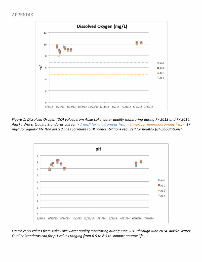
Field parameters were measured at each site alongside the TAH sampling. The graphs
for each of these field parameters are available in the appendix to this document. Overall, there
appeared to be slight increases in the water temperatures throughout the month, which can be
attributed to the surface lake water warming with the temperatures of summer and the increasingly
warmer temperatures that Juneau experienced during the month of June. Most of the water
temperatures were greater than 20 degrees Celsius, which is the Alaska Water Quality standard for
waters available to support aquatic life. The conductivity values ranged from 24 uS/cm to 91.8 uS/cm,
all values which support aquatic life in freshwater systems. All pH values for sites AL1, AL2, AL3 and AL4
ranged between 6.5 and 8.5, the water quality standard put forth by the State of Alaska to support
aquatic life. Dissolved Oxygen (DO) values for sites AL1, AL2, AL3 and AL4 are all within the greater
than 7 mg/L standard DO concentrations recommended for anadromous fish habitat.
Using ACWA funds the JWP continued monitoring the water quality in FY14. Out of the six (6)
sampling events in fiscal year 2014, only one (1) of the events resulted in samples that yielded results
over the Alaska Water Quality Standard (WQS) for TAH. The sampling event collected July 29, 2013
yielded samples that tested over the WQS of 10 ug/l at sites AL1, AL2, and AL3 with results of 46, 16,
and 20 ug/l, respectively. During this sampling event on July 29, traffic was extremely busy on the lake,
with at least 4 jet skis at a time present during sample collection at each site out on the lake, along
with two (2) motor boats. Immediately prior to sample collection at site AL1 (the boat launch) a 2-
10
stroke boat launched from its trailer and there was a jet ski present at the launch with its engine idling
while the sample was collected. During sample collection at site AL3, the homeowners area, there
were two boats present and actively circling the area inside the non-motorized use boundary. The
heavy motorized activity on the lake appears to have directly contributed to the high concentrations of
TAH in the samples during this sampling collection event. While several drops of 1:1 HCL were added to
each VOA vial immediately after sample collection and the vials were capped with no airspace, the
samples from this July 29, 2013 event were received at the laboratory with a pH higher than 2. The
samples are required to have a pH less than two (2) to be considered properly preserved and analyzed
between the 7 and 14-day window. By the time the laboratory analyzed the samples and realized that
they were actually unpreserved, they had sat past their seven (7) day unpreserved holding period. The
samples were analyzed within 14 days (the standard holding period for method 624 TAH preserved
analysis), but were out of the unpreserved holding period for the method 624 analysis and are flagged
with an ‘H’ in the final report from Test America, the analytical laboratory. The samples collected on
July 17, 2013 were also analyzed outside of their holding period and flagged with an ‘H’ data qualifier
in the final report.
Two sampling events (one with data qualifiers) tested above the Alaska WQS of 10 ug/l for TAH,
which were the samples collected on June 24, 2013 at site AL1 with result of 20 ug/l, and on July 29,
2013 at sites AL1, AL2, and AL3 with results of 46, 16, and 20 ug/l, respectively. All of the other samples
returned values of 5.4 ug/l or less. The July 29, 2013 samples analyzed past their holding period
(qualified with ‘H’) show the presence of TAH and probably contained higher levels if properly
preserved or analyzed within 7 days. Site AL-1 is the only site on the lake that boaters are able to
launch their motorized vehicles and experiences the highest pressure of boat traffic. Site AL-2 is the
central lake (center of boat traffic), AL-3 is the homeowner area, and AL-4 is the floating dock (area of
congestion). Based on this dataset collected during FY2013 and FY2014 that includes the qualified data,
motorized activity on the lake impacted the TAH levels at the sampling sites collected at sites AL1, AL2,
and AL3, and AL4 on Auke Lake. The days of heaviest motorized use on the lake reflected the highest
levels of TAH concentrations.
Based on the data presented in this report, the Juneau Watershed Partnership would
recommend continued TAH sampling at Auke Lake to increase the current data set, using the DEC
Supplemental Listing Methodology- Petroleum Hydrocarbons, Oils and Grease (dated February 14,
2014), as well as continued outreach about motorized use and the differences in types of engines used
on the lake. Additionally, there were numerous marine ocean boats that were observed backing up
11
and rinsing down from their excursions in saltwater, oblivious to the posted sign prohibiting this type
of activity, and further outreach is necessary to reduce this activity.
The Juneau Watershed Partnership and various volunteers observed and recorded recreational
user surveys during calendar years 2013 and 2014. The numerical data for these surveys were entered
into a data spreadsheet and are attached separately to this report. Highest use on the lake occurred
during the summer of 2013, when Southeast Alaska experienced unusually warm weather and high
temperatures. The highest concentrations of motorized vehicles usually occurred on the week nights
after work, when residents enjoy the warm weather and longer days that summer offers. Use on the
lake was generally mixed between 2-stroke boats and 4-stroke jet skis, assuming that the new model
jet skis were operating 4-stroke engines. Throughout the course of the surveys, there were several
obviously older jet skis observed on the lake that may have had 2-stroke engines, but generally most of
the personal watercraft observed seemed like newer models of jet skis less than 13 feet in length. The
smaller fishing boat motor craft commonly observed on Auke Lake generally had two-stroke older
model engines that had obvious signs of oil sheen in the water when launched and loaded from the
trailer. The newer boats on the lake appeared to have 4 stroke type engines, were about 16 feet in
length, and tended to pull water skiers or wake boarders when using the lake.
PUBLIC OUTREACH
The Juneau Watershed Partnership wrote and published an article about the Auke Lake water quality
monitoring project in our “Stream Scene” Newsletter in May 2013. Also, the JWP staff was able to talk
to the public during sampling events at Auke Lake and at the Wild and Scenic Film Festival in February
2013 explaining the background of the project. A comprehensive project write-up was also featured in
the issue of our “Stream Scene” Newsletter in August/September 2013, wrapping up the sampling
project for FY13 and providing a synopsis of sampling results.
During the last sampling event on Auke Lake collected 6/27/14, Amy Sumner, the JWP Board
President, and a JWP volunteer set up a public outreach booth near the boat launch dock. Photos and a
write-up about this event and other outreach methods are attached in a separate write-up to this report.
12
ACKNOWLEDGEMENTS
The Juneau Watershed Partnership thanks Gretchen Pikul (ADEC) for her support and patience during
the development and implementation of this program. We would also like to thank all of the volunteers
and the City and Borough of Juneau for participating in the Auke Lake User surveys.
APPENDIX
Figure 1: Dissolved Oxygen (DO) values from Auke Lake water quality monitoring during FY 2013 and FY 2014. Alaska Water Quality Standards call for > 7 mg/l for anadromous fish; > 5 mg/l for non-anadromous fish; < 17 mg/l for aquatic life (the dotted lines correlate to DO concentrations required for healthy fish populations). Figure 2: pH values from Auke Lake water quality monitoring during June 2013 through June 2014. Alaska Water Quality Standards call for pH values ranging from 6.5 to 8.5 to support aquatic life.
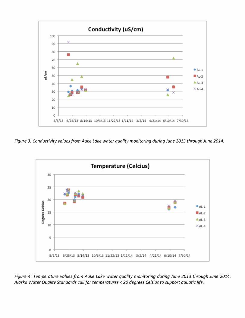
Figure 3: Conductivity values from Auke Lake water quality monitoring during June 2013 through June 2014. Figure 4: Temperature values from Auke Lake water quality monitoring during June 2013 through June 2014. Alaska Water Quality Standards call for temperatures < 20 degrees Celsius to support aquatic life.
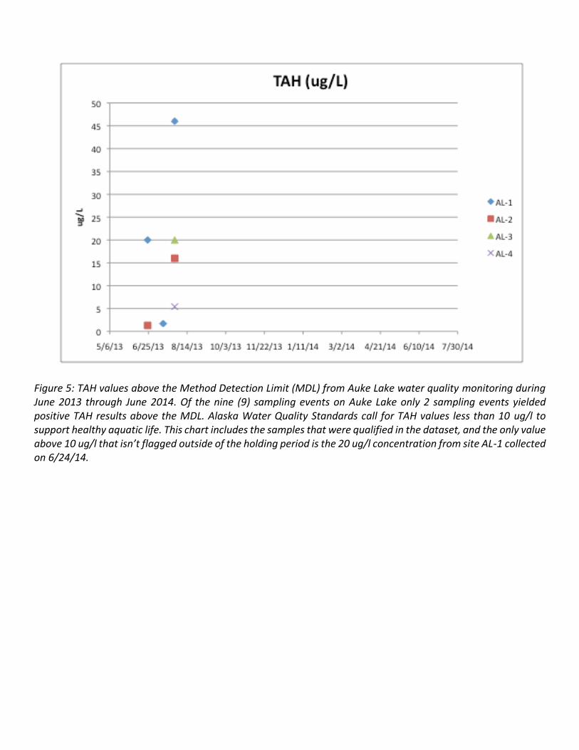
Figure 5: TAH values above the Method Detection Limit (MDL) from Auke Lake water quality monitoring during June 2013 through June 2014. Of the nine (9) sampling events on Auke Lake only 2 sampling events yielded positive TAH results above the MDL. Alaska Water Quality Standards call for TAH values less than 10 ug/l to support healthy aquatic life. This chart includes the samples that were qualified in the dataset, and the only value above 10 ug/l that isn’t flagged outside of the holding period is the 20 ug/l concentration from site AL-1 collected on 6/24/14.