Embed Size (px)
Citation preview

BIG HORN COUNTY
COMMUNITY WILDFIRE PROTECTION AND PRE-DISASTER MITIGATION PLAN
Little Big Horn River Valley by Lodge Grass
Prepared by: Cossitt Consulting
April 2006

ACKNOWLEDGEMENTS
Cossitt Consulting expresses sincere thanks to all the many, many people who participated in the development of this plan. Hundreds of hours of time were dedicated by people who faithfully attended the meetings (sometimes staying for as much as 4-5 hours) and made such useful and informative contributions. Thanks also to everyone who graciously shared information on the phone, took time out of their busy days to gather additional information, and then send it to me. People from each of the fire agencies took on the task of completing a lengthy questionnaire, which included the detailed lists of equipment that are included in Chapter 5 of this document. Big Horn County is fortunate to have so many dedicated individuals and this plan is a credit to their efforts.

Big Horn County CWPP/PDM Plan i
BIG HORN COUNTY COMMUNITY WILDFIRE PROTECTION PRE-DISASTER MITIGATION PLAN
TABLE OF CONTENTS Plan Adoption.......................................................................................... vi Executive Summary................................................................................ ix Acronyms Used in This Plan ................................................................. xi
1. Introduction................................................................................. 1-1 Authority ............................................................................................ 1-1 Scope and Plan Organization............................................................ 1-1 Preparation of the Plan...................................................................... 1-3 Project Area Description.................................................................... 1-3 General.......................................................................................... 1-3 Physical Characteristics ................................................................ 1-4 Land Use and Development Trends .............................................. 1-7 Transportation ............................................................................. 1-14 Economy......................................................................................1-14 Climate and Weather................................................................... 1-17 2. Planning Process ........................................................................ 2-1 Overall Approach and Philosophy ..................................................... 2-1 Process ............................................................................................. 2-1
Understanding Purpose and Need for the Plan—Getting Started.................................................. 2-2
Public Involvement and Outreach ................................................. 2-3 Document Development and Review............................................ 2-6 Plan Approval................................................................................ 2-6
3. Hazard Evaluation and Risk Assessment................................. 3-1
Methodology...................................................................................... 3-1 Identified Hazards.............................................................................. 3-2 Drought..............................................................................................3-5 Flooding............................................................................................. 3-9 Winter Storms.................................................................................. 3-19 Severe Thunderstorms .................................................................... 3-21 Hazardous Materials........................................................................ 3-23 Earthquakes .................................................................................... 3-25 Volcanic Eruptions........................................................................... 3-27 Landslides ....................................................................................... 3-28 Power Outages................................................................................ 3-30 Assets and Vulnerable Populations ................................................. 3-33

Big Horn County CWPP/PDM Plan ii
4. Mitigation Strategy ..................................................................... 4-1 Methodology...................................................................................... 4-1 Goals and Mitigation Actions ............................................................. 4-1 Project Ranking and Prioritization...................................................... 4-7 Project Implementation.................................................................... 4-19 5. Community Wildfire Protection ................................................. 5-1 Executive Summary........................................................................... 5-1 Introduction........................................................................................ 5-2 Methodology...................................................................................... 5-4 Identification and Description of Areas to be Evaluated .................... 5-5 General Description...................................................................... 5-5 Fire Protection .............................................................................. 5-6 Fire History ................................................................................... 5-7 At-Risk Communities and Wildland Urban Interface..................... 5-8 Risk Assessment ............................................................................. 5-31 Hazard Assessment ........................................................................ 5-32 Vegetative Fuel Hazards ............................................................ 5-35 Structural Fuel Hazards.............................................................. 5-36 Unique Wildland Severity Factors............................................... 5-37 Values to Be Protected.................................................................... 5-39 Value of Health and Safety ......................................................... 5-39 Economic Values........................................................................ 5-39 Value of Natural Resources and Ecosystem Health ................... 5-40 Social Values.............................................................................. 5-40 Key Values for Big Horn County ................................................. 5-41 Assessment of Fire Preparedness and Capability ........................... 5-41 Community Preparedness for Wildfire Protection ....................... 5-41 Fire Protection – Responder Capabilities ................................... 5-44 Vulnerability and Potential Loss Estimate........................................ 5-55 Mitigation Plan ................................................................................. 5-57
Executive Summary ................................................................... 5-57 Background ................................................................................ 5-57 Strategic Plan/Desired Condition ............................................... 5-58 Goals, Objectives, Projects/Actions ........................................... 5-58 Priority Ranking of Mitigation Projects........................................ 5-64 Project Implementation .............................................................. 5-73 Roles and Responsibilities ......................................................... 5-73 Schedule .................................................................................... 5-74 Fund Guidelines ......................................................................... 5-74 Plan Maintenance and Coordination .......................................... 5-75

Big Horn County CWPP/PDM Plan iii
6. Plan Maintenance and Coordination......................................... 6-1 Responsible Parties........................................................................... 6-1 Review Triggers................................................................................. 6-1 Criteria for Evaluating the Plan .......................................................... 6-1 Procedures ........................................................................................ 6-1 Incorporation into other Plans............................................................ 6-2 Sources ............................................................................................ 7-1 APPENDICES Appendix A: Meeting Materials Tables
1.1 Big Horn County Land Uses ....................................................... 1-9 1.2 Public Water Systems in Big Horn County................................ 1-11 1.3 Population Changes 1990-2000 and Housing Information........ 1-12 1.4 Average Temperatures ............................................................. 1-17 3.1 Big Horn County Hazards ........................................................... 3-3 3.2 Drought-Related Disaster Declarations ...................................... 3-6 3.3 One Year Drought Loss Estimation ............................................ 3-8 3.4 Selected Flood Events in Big Horn County............................... 3-10 3.5 Potential Flood Loss in Lodge Grass........................................ 3-12 3.6 Summary of Potential Loss Impacts from Natural Event Flooding ........................................................................................................ 3-17 3.7 High Hazard Dams in Big Horn County .................................... 3-18 3.8 Major Winter Storm Events....................................................... 3-19 3.9 Major Severe Thunderstorm Events ......................................... 3-22 3.10 Damage Summary of Thunderstorm/Wind Events .................. 3-23 3.11 National Response Center Reported Spills by Type................ 3-24 3.12 National Response Center Reported Spills by Location .......... 3-24 3.13 Summary of Assets in Big Horn County .................................. 3-34 3.14 Detailed Inventory of Assets by Community ............................ 3-36 4.1 Mitigation Project Prioritization.................................................. 4-9 5.1 Fire Departments in Big Horn County ......................................... 5-7 5.2 At-Risk Communities in Big Horn County ................................... 5-8 5.3 Fire Protection Response Capability......................................... 5-44 5.4 Summary of Fire Agency Capabilities and Staff........................ 5-46 5.5 Fire Equipment and Apparatus ................................................. 5-49 5.6 Potential Loss Scenario-Estimate ............................................. 5-56 5.7 Mitigation Project Prioritization.................................................. 5-65

Big Horn County CWPP/PDM Plan iv
Figures/Maps
1.1 Big Horn County ......................................................................... 1-2 1.2 Vegetation Map........................................................................... 1-5 1.3 Land Ownership in Big Horn County........................................... 1-8 1.4 Precipitation .............................................................................. 1-16 1.5 Wind Speed .............................................................................. 1-19 3.1 Palmer Drought Severity Index.................................................... 3-5 3.2 Precipitation—6 Year Departure from Normal ............................ 3-6 3.3 Aerial Photo of Lodge Grass, May 1978 Flood ......................... 3-13 3.4 FIRM Floodplain Map of Lodge Grass...................................... 3-14 3.5 Map of Hardin ........................................................................... 3-15 3.6 Aerial Photo of Crow Agency, May 1978 Flood ........................ 3-16 3.7 Lightning Strikes in Big Horn County, June 6, 2005 .................. 3-22 3.8 Peak Acceleration Values in Montana ...................................... 3-26 3.9 Intermountain Seismic Belt ....................................................... 3-26 3.10 National Landslide Overview Map .......................................... 3-29 3.11 Map of Selected Critical Facilities........................................... 3-41 5.1 “At-Risk Community” WUI Area Buffers................................... 5-11 5.2 Mines, Railroads, Pipelines, Major Transportation Routes
and Mountain Ranges ..................................................... 5-34 5.3 Fire Department Locations........................................................ 5-43 5.4 Big Horn County Equipment Locations ..................................... 5-49

Big Horn County CWPP/PDM Plan v
Resolution of Adoption- Big Horn County

Big Horn County CWPP/PDM Plan vi
Resolution of Adoption- City of Hardin
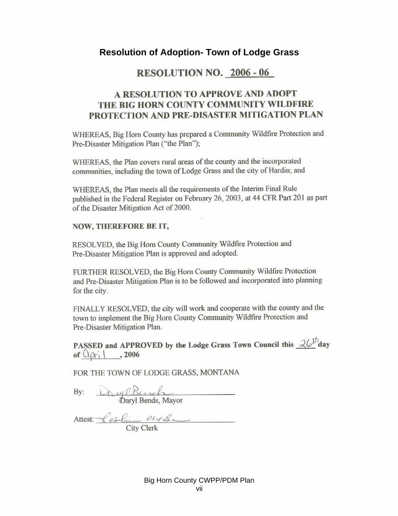
Big Horn County CWPP/PDM Plan vii
Resolution of Adoption- Town of Lodge Grass

Big Horn County CWPP/PDM Plan viii
Executive Summary Big Horn County and the incorporated communities of Hardin and Lodge Grass intend to become disaster resistant by preparing and implementing this Community Wildfire Protection and Pre-Disaster Mitigation Plan (CWPP/PDM). The plan identifies hazards and mitigation measures to reduce or prevent the effects of those hazards, and raises the awareness about the importance of taking personal and collective (public and private) responsibility for reasonably foreseeable natural disasters. The plan was developed with leadership from Big Horn County Commissioners and mayor and council members of Hardin and Lodge Grass. Throughout the process, from identifying hazards to developing mitigation measures, efforts were made to encourage public involvement and to draw all interested parties into the preparation of the plan whether formally at the series of public meetings, or informally through one-on-one conversations. A Steering Committee appointed by the county commissioners oversaw the preparation of the plan by a contractor. The mitigation goals, objectives, actions and projects were developed utilizing a wide range of expertise and interests located within the county. Each of the signing entities to the plan, Big Horn County and the incorporated communities of Hardin and Lodge Grass, participated in the development of the plan through the Steering Committee or via other meetings and phone calls, specifically by providing data, helping to set priorities, and identifying mitigation projects. The natural disasters of most concern to participants in the planning process were (in order of priority) drought, wildfire, severe thunderstorms (including hail, lightning, wind, etc.), and winter storms. Each of these priority hazards and other hazards (including flooding, hazardous materials, and others) is profiled in the plan with a discussion of historic occurrences and vulnerability. Generally speaking, there are no specific patterns to the ways in which various disasters strike the county. Just about any area of the county has potential for effects from drought, winter storms, wildfire, severe thunderstorms, and wind storms. Flooding and flash flooding can occur along the rivers and streams in Big Horn County, and also along intermittent drainages throughout the county. With the exception of Lodge Grass, there are no maps of the 100-year floodplain developed by the Federal Emergency Management Association. Only those areas that have had flood review by FEMA are eligible for flood insurance. Five goals with corresponding objectives and projects were developed for the identified hazards of concern:

Big Horn County CWPP/PDM Plan ix
• Reduce impacts of drought • Improve capabilities to prepare for and respond to a variety of disasters • Mitigate effects of flooding • Reduce effects in natural high hazard areas • Reduce the effects of power outages
In addition, six more goals were developed to address wildfire issues. This plan serves Big Horn County and the municipalities of Hardin and Lodge Grass.

Big Horn County CWPP/PDM Plan x
ACRONYMS USED IN THIS PLAN BIA Bureau of Indian Affairs BLM Bureau of Land Management CWPP Community Wildfire Protection Plan DES Disaster and Emergency Services DNRC Department of Natural Resources and Conservation EMS Emergency Medical Services FEMA Federal Emergency Management Agency FIRM Flood Insurance Rate Map (prepared by FEMA) FSA Farm Service Agency (US Department of Agriculture) FWP Montana Fish, Wildlife and Parks HFRA Healthy Forests Recreation Act IHS Indian Health Service LEPC Local Emergency Planning Committee MACO Montana Association of Counties MDOT Montana Department of Transportation MFWP Montana Fish, Wildlife and Parks NFIP National Flood Insurance Program NFP National Fire Plan NOAA National Oceanic and Atmospheric Administration NPS National Park Service PDM Pre-Disaster Mitigation PPE Personal Protective Equipment SCBA Self Contained Breathing Apparatus TERC Tribal Emergency Response Commission USGS U.S. Geological Survey WUI Wildland Urban Interface

Big Horn County CWPP/PDM Plan xi
THIS PAGE INTENTIONALLY BLANK.

Big Horn County CWPP/PDM Plan 1-1
CHAPTER 1: INTRODUCTION AUTHORITY Big Horn County and the incorporated communities of Hardin and Lodge Grass intend to become disaster resistant by preparing and implementing this Community Wildfire Protection and Pre-Disaster Mitigation Plan (CWPP/PDM). State law (MCA 10-3-401) gives local governments the authority to plan for disasters and emergencies (Jelinski). The plan identifies mitigation measures to be taken, sets priorities, and raises the awareness about the importance of taking personal and collective (public and private) responsibility for reasonably foreseeable natural disasters. The plan has been prepared utilizing funds from the Bureau of Land Management supplemented by county match. The plan meets the requirements of the Healthy Forests Restoration Act of 2003 (HFRA), the National Fire Plan, and the Interim Final Rule published in the Federal Register on February 26, 2003, at 44 CFR Part 201 as part of the Disaster Mitigation Act of 2000. SCOPE AND PLAN ORGANIZATION This plan is organized into six major chapters plus the crosswalk documentation showing how the plan meets federal requirements for pre-disaster planning. Chapter 1. Introduction
This chapter provides background material to put the plan and mitigation strategies into the context of Big Horn County’s unique assets, resources, and hazards. Chapter 2. Planning Process
This chapter describes how the plan was developed, including public involvement. Chapter 3. Hazard Evaluation and Risk Assessment
This chapter gives information about historical disaster occurrences in the county then lists potential hazards, hazard profiles, critical facilities, and vulnerabilities. Chapter III also provides information about asset values, for example, how much the county courthouse, the town hall, or the municipal water treatment plant would cost to replace if it was lost in a disaster. Chapter 4. Mitigation Strategy
This chapter takes the hazard information and develops goals, objectives and projects that can be accomplished to lessen the chances and/or severity of a potential disaster. Recognizing the limitation of resources to accomplish all projects identified, Chapter 4 also provides the local priorities for the projects.

Big Horn County CWPP/PDM Plan 1-2
Figure 1.1 Big Horn County
Source: Montana Natural Resource Information System

Big Horn County CWPP/PDM Plan 1-3
Chapter 5. Wildfire Protection (Community Wildfire Protection Plan) This chapter addresses the Pre-Disaster Mitigation Plan wildland fire issues and comprises the Community Wildfire Protection Plan (CWPP) element of this plan. It is intended to function as a stand-alone document for the purposes of HFRA and the National Fire Plan. This section describes the current situation with respect to vegetation and fuels, past occurrences of fire, values at risk, and potential losses. This chapter also contains goals, objectives, and mitigation actions (projects) that can be done to reduce risk of wildland fire. The projects are prioritized. Chapter 6. Plan Maintenance
This chapter describes how the plan is to be maintained and kept current. Chapter 7. Crosswalk Documentation
The crosswalk displays in an easy to understand format how the pre-disaster mitigation sections of the plan meet current statutory requirements. PREPARATION OF THE PLAN Detailed information on how the plan was prepared is included in Chapter 2 and also at the beginning of Chapters 3 and 4 under the section entitled “Methodology.” Cossitt Consulting provided staff assistance in the development of the CWPP and PDM plans—facilitating meetings, and drafting the documents based on information received at the meetings and from research. County Disaster and Emergency Services Coordinator, Ed Auker, served as the primary contact for the county and assisted in data collection, public involvement, and document review. Fire staff and volunteers were instrumental in developing the wildfire risk assessment and mitigation. Each of the signing entities to the plan, Big Horn County and the city of Hardin and the town of Lodge Grass, participated in the development of the plan through the Steering Committee, specifically by providing data, helping to set priorities, and identifying mitigation projects. PROJECT AREA DESCRIPTION General The project area for this plan is Big Horn County, Montana, which was created in 1913 from portions of what was then Yellowstone and Rosebud Counties. With 3,198,200 acres, Big Horn County is the fifth largest county in the state. The county includes most of the area of the Crow Indian Reservation and slightly less than half of the area of the Northern Cheyenne Indian Reservation. There are two incorporated communities in Big Horn County, the city of Hardin and the town of Lodge Grass. Montana state law differentiates cities and towns by size of population. (Big Horn County Growth Policy) The County has a total population of 12,671, of which 60 percent are American Indian (2000 census).

Big Horn County CWPP/PDM Plan 1-4
The county is bordered to the south by Wyoming (Sheridan and Big Horn Counties in Wyoming), to the west by Carbon and Yellowstone Counties, to the north by Yellowstone and Treasure Counties, and to the east by Rosebud County. The history of humans in Big Horn County extends thousands of years. At least one site in the Pryor Mountains dates back 10,000 years (Van West). The first recorded foreign visitor to the area was Chavalier de la Verendrye who was searching a route to the Pacific in 1743. Subsequent ventures included fur trading explorers in 1804 and the Lewis and Clark expedition in 1806. Except for a few fur traders and an occasional gold prospector, the area was rarely visited by white men until the opening of the Bozeman Trail in 1864. Many miners and settlers passed over the trail that crossed the slopes of the Big Horn Mountains, and crossed the Big Horn River near Fort Smith and then continued westward across the slopes of the Pryor Mountains. Fort C. F. Smith was built in 1866. The Indians resented the fort and in 1868 it was abandoned under a government agreement. Miners and settlers who were ordered to keep out of the area, disregarded the agreement. Indians resisted until 1876 when federal troops, under the command of General George A. Custer, were sent to control them. In the ensuring battle Custer and his troops were killed at the Little Big Horn (about 3 miles south of present day Crow Agency). Between 1880 and 1890, soon after the danger of Indian raids had passed, the first permanent non-Indian settlers moved into the area. The first settlers raised cattle and sheep. (Soil Survey) Physical Characteristics Terrain Big Horn County is bounded by the Big Horn and Pryor Mountains to the south, and the Wolf and Rosebud Mountains to the east. The county elevation ranges from the lowest point of 2700 feet along the Big Horn River north of Hardin to 9200 feet above sea level in the Big Horn Mountains in the southwest portion of the county. (Big Horn County Growth Policy) The mountainous areas include grasslands, shrubland (including sage brush), evergreen and mixed forest areas. The prairie and rolling hills are primarily grass and shrubland (inclluding sage brush). The hilly Pine Ridge area in the north part of the county has large stands of pine trees. Cropland areas are generally along the river valleys, although there are some dryland crop areas on benches above the valleys. (Montana Natural Resource Information System) Water There are over 1,000 miles of streams in Big Horn County (Big Horn County Growth Policy). The major surface water formations are the Big Horn River (and Big Horn Lake), Little Big Horn River (also referred to as the Little Horn), Lodge Grass Creek, Tongue River (and Tongue River Reservoir), Pryor Creek, and Rosebud Creek. In addition there are a number of tributaries to these rivers and creeks.

Big Horn County CWPP/PDM Plan 1-5
Figure 1.2 Vegetation Map
Source: Montana Natural Resource Information System

Big Horn County CWPP/PDM Plan 1-6
There are four major holding dams in Big Horn County: Yellowtail on the Big Horn (two dams) in extreme canyon lands, Tongue River in rough hills, and Willow Creek in the foothills of the Big Horn Mountains. Two diversion dams are on the Big Horn. One is south of Hardin about 10 miles and the other is north about 20 miles. One diversion dam is at Crow Agency on the Little Big Horn. There are also a large number of farm storage dams which are used for watering livestock. (Big Horn County Homeland Security Strategy) There are more than a dozen irrigation canals in the county (Soil Survey). All of the systems within the exterior boundaries of the Crow Indian Reservation are managed by the BIA (although some headgates may be directly operated and controlled by the Bureau of Reclamation. These serve the areas of South Valley (on the Big Horn River from Fort Smith to Hardin), Little Big Horn Valley, Lodge Grass Creek area, and the Wyola area. There are three private canal systems outside of the Crow Indian Reservation, north and east of Hardin. (Bruckner) Approximately 1,500 water rights were filed with the Water Rights Division of the DNRC for wells and springs as of 1999. The majority of the wells in the county have yields between 5 and 30 gallons per minute. Relative to the number of wells in the county, very few are high yield wells. Some notable exceptions occur west of Hardin, north of Pryor, Busby area, along the Little Big Horn and Big Horn River valleys, and in the Spring Creek area. Some of the wells in these areas have yields ranging from 200 to 2,000 gpm). The highest yields are west of Hardin and north of Pryor. (Big Horn County Growth Policy) Minerals Mineral resources in Big Horn County include coal, natural gas (including coalbed methane gas), oil, and sand, gravel, and bentonite deposits. (USDA Soil Survey) Sub-bituminous coal is found in the east and northeast portions of the county. Reserves of this high quality, accessible coal are estimated to exceed 11 billion tons. (Big Horn County Growth Policy) The county has nine oil and gas fields, including four oil fields, one conventional gas field at Toluca, and an inactive gas field at Hardin. In addition, Big Horn County has the largest identified reserves of coalbed methane gas in the state of Montana (USDA Department of the Interior). Bentonite is found south and west of Lodge Grass between the Little Big Horn and Big Horn Rivers and on the east flank of the Pryor Mountains. Uranium is present on the south slopes of the Pryor Mountains and was last mined during World War II. Gravel deposits are found in the west half of the county. (Big Horn County Growth Policy) Wildlife Big Horn County provides habitat for a wide range of fish and wildlife species. Important habitats in the county include river or riparian habitats, valley bottoms, uplands, and mountainous areas. Species in Big Horn County include deer, elk, moose, antelope, upland game birds, turkeys, bear, mountain lion, bobcat, fox, coyotes and smaller species such as raccoons and skunks. The river areas also provide habitat for migratory bird species such as bald eagle, osprey, ducks, geese, and neo-tropical birds.

Big Horn County CWPP/PDM Plan 1-7
There is a wild horse herd in the Pryor Mountains and a bison herd managed by the Crow Tribe in the Big Horn Mountains. The Big Horn River has a world-renowned trout fishery and attracts a large number of nonresident fly fisherman. The Tongue River Reservoir contains the only warm water fishery in the county and includes walleye, crappie, bass and Northern Pike. Cultural Resources Cultural resources include sites of prehistoric, historic, cultural, or spiritual importance. There has been no systematic county-wide inventory or sampling for cultural resources, but as of January 2000, a total of 1,778 sites had been recorded and entered into the database of the Montana State Historic Preservation Office. Of these, 37 sites were nominated and listed on the National Register of Historic Places. These sites include churches, residences, residential and commercial districts, battlefields, a hotel, grain elevator, hospital, jail, store, ranch, and medicine wheel. (Big Horn County Growth Policy) Because the history of human habitation dates back thousands of years, the county is rich in cultural resources. The Pryor and Big Horn Mountains have religious significance for many tribes. In addition to the significant battles involving the U.S. army, there were also important battles involving Crow and other Indian tribes. (Van West) Many cultural sites may go unreported for a variety of reasons, including the tribes’ desires to protect information about sensitive sites. Land Use and Development Trends Land Ownership Big Horn County includes portions of two Indian Reservations, and lands owned by individuals, corporations, communities (e.g., the towns or county), state of Montana, individual tribal members, the Crow Tribe, the Northern Cheyenne Tribe, and the U.S. government. The Crow Reservation lies primarily within Big Horn County, but about six percent extends into Yellowstone County. The majority of the Northern Cheyenne Indian Reservation lies in Rosebud County. The multiple ownerships and overlapping jurisdictions create complexities for coordination. The county must coordinate with the two tribes, and each of the tribes must work with two counties to address issues such as infrastructure and services such as law enforcement or fire protection. The Crow Indian Reservation was established by Act of Congress through the Treaty of Fort Laramie in 1851 and subsequently reduced in size from the original 38 million acres to 8 million acres in 1868. The reservation currently encompasses approximately 2.5 million acres. Title to nearly half of the land within the reservation boundary is held by non-Indians. The Northern Cheyenne Reservation was created by Executive Order in 1884. Ninety-eight percent of all lands within the Northern Cheyenne Reservation are owned by the Tribe or tribal members.

Big Horn County CWPP/PDM Plan 1-8
Figure 1.3 Land Ownership
Source: NRIS

Big Horn County CWPP/PDM Plan 1-9
The federal government owns approximately two percent of the surface land area in Big Horn County, but has a large presence in the county owing to the uses on these lands. Federal lands include two national parks, Big Horn Canyon National Recreational Area, Yellowtail dam (on the Big Horn River). State lands include scattered school sections, fishing access sites, and Chief Plenty Coups and Rosebud Battlefield state parks. (Big Horn County Growth Policy) The BLM manages both surface land and federally owned minerals, most of which are located in the southeastern portion of the county. Land Use Agriculture is the primary land use in Big Horn County. It includes livestock (cattle, sheep, and hogs) and crop production.
Table 1.1 Big Horn County Land Uses Land Use Acres % of Total Cropland 352,600 11% Rangeland 2,557,400 80% Forestland 214,800 7% Other 73,400 2% Total 3,198,200 100% Source: Big Horn County Growth Policy
According to the 2004 Montana Agricultural Statistics, there were 584 farms/ranches with a total of 2,811,337 acres in Big Horn County in the year 2002. Between 1997 and 2002, the number of farms/ranches decreased by two, but the total acreage of all farms increased by about 100,000 acres. Agricultural production in the county includes grains (particularly wheat and barley), forage (hay), sugarbeets, corn (for silage), cattle, horses, bison, hogs, poultry, and bees,. Big Horn County ranked second in the state for bison production, third in the state for cattle production, fifth in the state for horse production, third for sugarbeet production, and seventh for silage corn. (USDA 2002 Census of Agriculture) Mineral extraction is another major land use, although it does not currently comprise a large land area. It is a noticeable land use in the southeastern part of the county, where there are two coal mines and where coalbed methane development is being initiated. Once coalbed methane development is in full production as anticipated, there could be as many as 2,500 to 7,000 coalbed methane wells in Big Horn County, primarily along the eastern and southern portions (U.S. Department of the Interior). One of the side products of the production will be excess water, which is proposed to be discharged to the surface (and proposed to be held in retaining ponds).

Big Horn County CWPP/PDM Plan 1-10
Oil Well near Lodge Grass
Photo from Cossitt Consulting Coal production is concentrated in three mines: Apsalooka in the Rosebud Mountains east of Hardin, Spring Creek in the Wolf Mountains near Tongue River Reservoir in the southeast corner of the county, and Decker in the same area on the south west shore of the reservoir. (Big Horn County Homeland Security Strategy) The south part of the county near Soap Creek by Fort Smith has an oil field. (Big Horn County Homeland Security Strategy) A total of 844 oil and gas wells (other than coalbed methane) had been drilled in the county as of 2003. (U.S. Department of Interior) An electric power generation plant is under construction immediately north of Hardin near the Cenex asphalt plant. (Big Horn County Homeland Security Strategy) The plant will utilize coal for power production. The Yellowtail Dam also produces electrical power. Four generators at the facility each produce 62.5 megawatts of electricity. Production timberlands in Big Horn County are privately owned, and owned by the Crow and Northern Cheyenne Tribes. The state and federal governments generally do not manage their modest amounts of timber in the county commercially. Timberlands involved in production in the county are primarily under the ownership of the Crow Tribe. The BIA and Tribe share responsibilities for the forestry program on the Crow Reservation. (Big Horn County Growth Policy) Residents of the county live in developed areas and on scattered rural residences. Developed areas include the incorporated communities of Hardin and Lodge Grass as well as the unincorporated communities of Busby, Muddy Cluster, and Rosebud (on the Northern Cheyenne Indian Reservation); Crow Agency, Fort Smith, Garryowen, Pryor, St. Xavier, and Wyola (on the Crow Indian Reservation); and Kirby and Decker (off-reservation in the southeastern area of the county). Water for human consumption in Big Horn County comes from individual wells, privately and municipally-owned systems. Those meeting the state definition of public systems include:

Big Horn County CWPP/PDM Plan 1-11
Table 1.2 Public Water Systems in Big Horn County Community Source Busby wells Muddy Cluster wells Crow Agency Little Big Horn River Fort Smith-Yellowtail town wells Fort Smith-Bureau of Reclamation Housing wells Garryowen-7th Ranch RV Camp well Hardin Big Horn River Little Big Horn Battlefield National Monument Little Big Horn River Lodge Grass wells Pryor wells Pretty Eagle School at St. Xavier well St. Charles Mission at Pryor well Wyola wells Sources: Big Horn County Growth Policy
Craig Taft, Big Horn County Sanitarian Development Trends There are several different significant trends for future development in Big Horn County.
• Population Increase. Population is increasing in Big Horn County, primarily due to a high birth rate. (Big Horn County Growth Policy) Although the number of seasonal homes has been increasing (see below), persons who own seasonal homes are not typically counted in the county’s decennial census. Instead, they would be counted in the location of their primary residence.
• The number of seasonal homes is increasing. There were 117 seasonal homes in 1980, 198 seasonal homes in 1990, and 296 seasonal homes in 2000 (US Census). Approximately 1/3 of all seasonal homes are located in existing communities; the remainder area in rural areas of the county. These are primarily located along the Big Horn River, which is a seasonal vacation destination for fisherman and hunters. There are also some seasonal homes along the Tongue River Reservoir and the upper reaches of the Little Horn River.
• Coal bed methane development has been initiated with approximately 250 wells over the past decade, but has the potential to expand to several thousand wells at full development. Associated with the development will be roads, fences, pumphouses, pipelines, power lines, water discharge facilities.
• The Tongue River Reservoir and Big Horn National Recreation Area will continue to be popular destination locations for boaters and fishermen.
• The power plant being developed just north of Hardin will utilize coal from the Rosebud Mountains east of Hardin. There are new jobs during the construction phase and jobs for the operation of the plant. This may result in some in-migration to the area as well as additional traffic between the mine and Hardin on Highway 384.
• The primary land use will likely remain that of agriculture over the next decade, given past trends.
• The Northern Cheyenne have proposed to develop a casino near the Tongue River Reservoir on property owned by the tribe. This could increase traffic in the vicinity and from Sheridan, Wyoming, the nearest major urban center.

Big Horn County CWPP/PDM Plan 1-12
• Environmental analysis has been conducted by the state and federal governments on a proposed rail line that would extend from the southern end of Big Horn County along the Tongue River to Miles City, Montana. The proposed line would serve proposed new coal mines to the east of Big Horn County. The development of the line is tied to the development of the mines.
Table 1.3 Population Changes 1990-2000 and Housing Information
2000 1990
change 1990-2000
# of Housing Units in 2000
Seasonal Housing Units in 2000
Hardin 3,384 2,940 444 1,411 5Lodge Grass 510 517 -7 164 2Busby 695 409 286 201 3Crow Agency 1,552 1,446 106 361 2Fort Smith 122 -- -- 143 81Muddy Cluster 627 387 240 160 3Pryor 628 654 -26 197 4St.Xavier 67 -- -- 36 9Wyola 186 -- -- 57 1Rest of County 4,900 -- -- 1,925 186County Total 12,671 11,337 1,334 4,655 296
Source: US Census Bureau Land Use Management and Regulations Big Horn County has a growth policy (comprehensive plan) that was adopted in 2002. The County has subdivision regulations, floodplain regulations, and sanitation regulations. There is no zoning in Big Horn County. An electrical/plumbing/mechanical permit may be required by the state of Montana for new noncommercial construction and is required for all commercial construction. Development of water wells, wastewater systems, and structures within federally identified floodplains also require permits. No other permits are required by the county for new development, but there are additional regulatory mechanisms in the incorporated communities and in some cases state, tribal, or federal requirements may also apply to new development in the county as noted below. The city of Hardin has a growth policy and zoning code. The zoning code establishes standards for nonconforming uses, height limits, yard requirements, parking requirements, accessory uses, and signage. (Big Horn County Growth Policy) Lodge Grass has zoning but no growth policy. Due to an extremely constrained budget and limited staff resources, zoning enforcement and permitting is ad hoc at best in Lodge Grass. The Crow Tribe has a master plan, and zoning regulations that were adopted in the 1960s. In 1999, the Crow Tribal Planning and Zoning Commission identified a need to update the zoning regulations. Land use on the Northern Cheyenne Reservation is guided by the Land Committee in the interest of the tribe.

Big Horn County CWPP/PDM Plan 1-13
For areas outside of the jurisdiction of the Northern Cheyenne or Crow, permits to develop may also be required by the state or federal government depending on the type of development. Certain types of industrial or agricultural activities (e.g., feedlot) may be required to obtain permits for water discharge, or for development that would alter wetlands. The county’s floodplain ordinance (which is based on the state model) allows, by a permitting process, for construction in the flood fringe of the 100-year floodplain (no dwellings allowed in the floodway). State and county sanitation regulations require wastewater systems to be located at least 100 feet outside of the 100-year floodplain. FEMA Flood Insurance Rate Maps have been developed only for those areas of the county outside of the Northern Cheyenne and Crow Indian Reservations. There are no official 100-year floodplain maps for those areas. There are unofficial 1973 floodprone area maps for the Big Horn River. Big Horn County subdivision review applies only to parcels that are being divided on lands not under the jurisdiction of the Crow or Northern Cheyenne Tribes. Subdivision regulations do not allow for building in hazardous areas (such as slopes greater than 25%, floodways, or in areas of unstable soils, for example) unless, with the exception of floodways, the hazards are mitigated through design features. Up until the mid-1990s, state law exempted from subdivision review any parcel that was 20 acres or greater. Currently state law defines a subdivision as creating parcels of less than 160 acres. Consequently, it is possible for new construction to occur throughout the county on existing parcels with the only required review for electrical/plumbing/mechanical and water/wastewater system, and floodplain development permits. For other types of development not requiring federal or state permits for other than water/wastewater or electrical/plumbing/mechanical permits (and outside of the jurisdiction of the Crow Tribe, Northern Cheyenne Tribe, Hardin city government, or Lodge Grass town government), the only review that new noncommercial development receives is from the county sanitarian or state Department of Environmental Quality for wastewater systems, or from the state for electrical permits. The county’s floodplain ordinance (which is based on the state model) allows for construction in the floodplain. State and county sanitation regulations require wastewater systems to be located outside of the 100-year floodplain. FEMA Flood Insurance Rate Maps have been developed only for those areas of the county outside of the Northern Cheyenne and Crow Indian Reservations. There are no 100-year floodplain maps for those areas. Subdivision review applies only to parcels that are being divided on lands not under the jurisdiction of the Crow or Northern Cheyenne Tribes. Subdivision regulations do not allow for building in hazardous areas (such as slopes greater than 25% or in areas of unstable soils, for example) unless the hazards are mitigated through design features. Up until the mid-1990s, state law exempted from subdivision review any parcel that was 20 acres or greater. Currently state law defines a subdivision as creating parcels of less than 160 acres. Consequently, it is possible for new construction to occur throughout the county on existing parcels with the only required review for electrical and waste water system permits.

Big Horn County CWPP/PDM Plan 1-14
Transportation There are three main highways that cross Big Horn County. Interstate 90 runs south to north from Sheridan to Hardin then west to Billings generally dividing the county in half. State Highway 212 runs east to west from Lame Deer to Crow Agency, bisecting the eastern half of the county. State Highway 47 runs north to south, from US Interstate 94 near Custer through Hardin and continues south as 313 to dead end at Fort Smith. There are also a number of other main routes in the county. These include the road from Fort Smith to Lodge Grass, From St. Xavier to Pryor, from St. Xavier to Lodge Grass, Crow Agency to Highway 313, and from Pryor to Billings. The Burlington Northern and Santa Fe railroad generally follows the interstate from Billings to Sheridan through Big Horn County, but from Crow Agency south, it is some distance to the west following the Little Big Horn River. Big Horn County’s major airport is at the fairgrounds in Hardin with one lighted, paved runway. Basic services can be provided but are not normally available. The airport is mainly used for agricultural operations. Fort Smith has a 50’ wide paved runway 3800’ long with no services. Additionally, several sod runways are scattered across the country. (Big Horn County Homeland Security Strategy) Economy Big Horn County’s economy is diverse and complex. It is one of the state’s top ranking agricultural producers. The coal mines in the county have 41percent of the statewide total coal mining employment and they account for 51 percent of total private sector wages paid in the county (Montana Department of Labor and Industry). But the county also had the second to lowest per capita income of any county in Montana and an unemployment rate of 15.7 percent in 2003. Nearly one-third of all county residents are living below poverty level. Total personal income (all income for all persons in the county) was $219.9 million in 2003. Total personal income includes net earnings by place of residence; dividends, interest, and rent; and personal current transfer receipts (including retirement, disability, and Medicare and Medicaid payments). From 1993 to 2003 net earnings decreased on average 1.4 percent each year; dividends, interest, and rent increased on average 3.3 percent; and personal current transfer receipts increased on average 6.9 percent. Of the total personal income in the county in 2003, net earnings accounted for 59 percent and 26 percent came from personal current transfer receipts. (Bureau of Economic Analysis “Bearfacts” webpage, and Table CA05, www.bea.gov/bea) In 2003, Big Horn County had per capita personal income of $17,063 (ranking it 55th out of 56 counties in the state and at 54 percent of the national average of $34,472). According to the 2000 census, 29.2 percent of all persons in Big Horn County were living below poverty level, compared to 14.6 percent for the state of Montana. (Bureau of Economic Analysis and U.S. Census) In 2003, earnings of persons employed in Big Horn County totaled $166 million of which approximately $2 million was farm earnings (earnings from farm workers). Of non-farm

Big Horn County CWPP/PDM Plan 1-15
earnings, private earnings comprised $79 million and government work comprised $84 million. (Bureau of Economic Analysis, Table CA05) In 2002, the market value of agricultural production was $66.2 million, up nine percent from 1997 (USDA 2002 Census of Agriculture). Farm proprietors’ income, however, has been negative for the last three years for which information is available from the U.S. Bureau of Economic Analysis. In 2001, total net income for farm proprietors in Big Horn County was negative $3.3 million, in 2002 it was negative 5.1 million, and in 2003 it was negative $3.4 million. In 2003, there were 299 business establishments in Big Horn County with total annual wages paid of $108.7 million. The private sector accounted for 47 percent of all wages paid, and government jobs accounted for 53 percent. The industry sectors with the highest annual payroll were mining (4 establishments with $25.8 million in annual wages paid), retail (42 establishments with $4.7 in annual wages paid), and health care (12 establishments with $4.5 million in annual wages paid). (Montana Department of Labor and Industry) Average annual employment in the county was 3,914 in 2003. The government sector employed 2,128 persons and the private sector employed 1,786 persons. Mining was the largest private sector employer (with 373 employees), followed by retail trade (315 employees), accommodations and food services (262 employees), and health care (213 employees). Approximately 83 percent of all persons employed in Big Horn County in 2000 were residents of the county. The other 17 percent came from other places in Montana (7%) and out of state (10%). (Montana Department of Labor and Industry) Because three of the mines are located close to the Wyoming border, and one mine is located in the northeastern corner of the county, it is well-known in the county that many mine employees are not county residents.

Big Horn County CWPP/PDM Plan 1-16
Figure 1.4 Precipitation
Source: Montana Natural Resource Information System

Big Horn County CWPP/PDM Plan 1-17
Climate and Weather Big Horn County is located east of the Continental Divide and subject to continental weather patterns. In general summers are hotter, winters are colder, precipitation is less evenly distributed, skies are sunnier, and winds are stronger than on the west side of the divide. (Western Regional Climate Center, Climate of Montana) Within this general climate type, there is a wide range of temperature and precipitation within the county, affected primarily by the mountains. The Pryor and Big Horn Mountain areas in Big Horn County have been called a “launching pad” for severe weather events that can extend into North Dakota, South Dakota, and Minnesota (Scarlett). The county is subject to air masses from several sources. During winter the coldest weather comes from Arctic air, typically followed by warmer air from the Pacific. Spring and early summer are typically the wettest times of the year. Heaviest rain is usually associated with storms from the Gulf of Mexico, mostly in May and June. Midsummer afternoon thunderstorms occur about 25 to 35 days per year. (Soil Survey) Precipitation can range from as low as eight inches average annual (in the extreme southwest corner of the county) to as high as 24 to 28 inches per year (in the Big Horn Mountains in the southwest portion of the county). In general, the largest drier areas are the Big Horn River Valley area from Hardin north and the Tongue River Valley. These areas receive about 12 to 14 inches per year. The areas with greatest precipitation are the Big Horn, Pryor, and Wolf Mountains. (NRIS maps) Annual snowfall varies throughout the county. Decker receives approximately 19 inches of snowfall per year and Pryor receives 66 inches. Much of the precipitation in the mountains falls as snow. Snow in the Big Horn Mountains near the Wyoming border can reach depths of 100 inches or more on some slopes before it starts to melt in the Spring. (Soil Survey) Average maximum and minimum temperatures recorded at Hardin, Busby, Wyola, and Crow Agency indicate average annual minimum temperatures ranging from 60 to 62 degrees and monthly minimum temperatures ranging from 29 to 32. Busby generally had the coolest temperatures of all four recording sites and Yellowtail Dam had the highest. Table 1.4 Average Temperatures: Hardin (1948-2005), Busby (1944-2005), and Yellowtail (1948-2005) Jan Feb Mar Apr May Jun Jul Aug Sep Oct Nov Dec AnnHardin Ave max 33 41 49 61 72 81 90 89 77 65 48 37 62 Ave min 7 14 22 32 42 50 55 53 43 32 20 11 32 Busby Ave max 32 38 43 59 69 78 88 88 76 62 46 35 60 Ave min 5 11 19 29 38 46 51 50 40 30 18 9 29 Yellowtail Dam
Ave max 38 44 51 62 71 80 90 90 78 65 49 41 63 Ave min 16 22 27 36 45 53 58 57 48 39 28 20 37 Source: Western Regional Climate Center Period of Record Monthly Climate Summary (wrcc.dri.edu)

Big Horn County CWPP/PDM Plan 1-18
Big Horn County holds two of the temperature records for the state of Montana. Yellowtail Dam is recorded as having the highest average annual temperature (50.2 degrees) and Crow Agency has the record for longest consecutive period with temperatures 90 degrees or above (38 days between July and September, 1922). (Western Regional Climate Center, http://wrcc.dri.edu/htmlfiles/state.extremes.html) Areas in Montana lying east of the continental divide are windier than areas to the west of the divide. Mountainous areas tend to have the strongest winds. The Pryor, Big Horn, and Wolf Mountains have average annual wind speeds of greater than 15 miles per hour with some localized areas with speeds of 19 miles per hour or more in the Big Horn and Pryor Mountains. Extreme weather in the county can include storms with hail, lightning, and strong winds and winter storms with ice, snow, cold temperatures, and strong winds. Weather events are covered in more detail in Chapter 3.

Big Horn County CWPP/PDM Plan 1-19
Figure 1.5 Wind Speed

Big Horn County CWPP/PDM Plan 1-20
THIS PAGE INTENTIONALLY BLANK.

Big Horn County CWPP/PDM Plan 2-1
CHAPTER 2: PLANNING PROCESS This chapter describes:
• The overall approach to developing the plan • The plan process, including:
o Who was involved in the planning process and how they were involved o Efforts to involve the general public o Efforts to involve various interests including government, business,
education, and others Supporting documents in Appendix A include:
• Meeting agendas • Meeting summaries • Meeting sign-in sheets • Flyers and News Releases • Correspondence
OVERALL APPROACH AND PHILOSOPHY The development of this plan was based on the premise that plans with the greatest likelihood of being implemented are those with local momentum, where individuals in the groups in the community(ies) are actively involved and have a stake in accomplishing goals and specific projects. From the start it was important that any and all interested individuals be offered the opportunity to participate. Special efforts were made to invite persons representing a wide variety of interests that could be affected by disasters or that play a role in disaster response. It was recognized that a number of individuals were critical resources to the process by virtue of their knowledge and expertise. The process sought to engage both these knowledgeable individuals and the general public. Many individuals committed considerable amounts of personal time to the development of this plan. Without their involvement, this document would not have been possible. PROCESS The process used to develop this plan was geared toward developing a PDM plan as well as a Community Wildfire Protection Plan. Because wildfire is one of the significant hazards in Big Horn County, these two planning efforts dovetailed smoothly into the process that developed this document. The following describes the general process used for the PDM Plan. More detail on the process for the Community Wildfire Protection Plan is provided in Chapter 5. There were several key participants in the process:
• County Commissioners—initiated the effort and approved the plan • Incorporated communities of Hardin and Lodge Grass—participated and
approved the plan.

Big Horn County CWPP/PDM Plan 2-2
• Steering Committee—functioned as the planning committee (see detailed description below under “Public Involvement and Outreach”)
• General Public—encouraged to participate, attend steering committee meetings, stay informed (See more under “Public Involvement and Outreach”)
• County DES Coordinator—lead staff person in the county for coordinating with the contractor and liaison for local expertise
• Consulting Team—provided the staffing to research and write the report, facilitating discussion at meetings leading to hazard evaluation and risk assessment, mitigation measures (goals, objectives, projects)
• Technical Experts and Others. A number of individuals were contacted for information and were extremely responsive and helpful. These included the following:
• Steering Committee Members • Local Government officials and staff • Business and nonprofit institutions • Jim Scarlett, National Weather Service-Billings Office
There were four basic elements of plan development:
1. Getting Started - Understanding the Purpose and Need for the Plan 2. Public Involvement and Outreach 3. Document Development and Review 4. Plan Approval
The process for each of these elements is described in more detail below. Understanding the Purpose and Need for the Plan-Getting Started The Big Horn County Commissioners initiated the efforts to develop a PDM plan and already had a good understanding of the need for such a plan. In December 2004, Big Horn County Commissioners hired contracted technical assistance from Anne Cossitt of Cossitt Consulting to complete the PDM and prepare a Community Wildfire Protection Plan. Anne Cossitt met with the County Commissioners in February 2005 to review purpose and approach to the plan, identify how best to involve various interests and the general public, identify existing plans, studies, reports, and technical information, and to finalize the schedule and products. The agenda and meeting notes for that meeting are included in this chapter. Soon after that meeting the County Commissioners sent letters to dozens of individuals inviting them to participate on the Steering Committee. Information about the basic need for the plan was included in that letter and was reviewed at each Steering Committee Meeting. The Mayors of Hardin and Lodge Grass received an invitation letter from the County Commissioners and a follow-up letter from Anne Cossitt. Cossitt met with the Hardin city Council on April 19 and the Lodge Grass Town Council on July 28, 2005.

Big Horn County CWPP/PDM Plan 2-3
Representatives of both incorporated jurisdictions also attending Steering Committee meetings. Big Horn County already has considerable experience in disaster and emergency response. At the onset of the work by Cossitt Consulting there was already an active Local Emergency Planning Committee (LEPC) with diverse participation. Public Involvement and Outreach Efforts to include and inform the public included Steering Committee participation and public outreach via meeting announcements and general information. Steering Committee The Steering Committee functioned as a planning committee and guided the work of the consultant. The role of the Steering Committee was to represent a wide range of interests, serve as a technical resource, guide the planning process, and finally, review the draft document for accuracy and completeness. The County Commissioners sent invitations to the following individuals to participate on the Steering Committee. The intent was to start with persons already participating on the LEPC and to encourage participation from business interests, utilities, health care, education, transportation infrastructure, news media, law enforcement, and local, state, and federal government. Lists of who attended each meeting are included in Appendix A. Invited to participate on the Steering Committee: Laura Ackerman Decker Coal Ron Adams Mayor of Hardin Luana Acker Indian Health Service Kirk Barnette County Rural Addressing Darrell Bends Mayor of Lodge Grass Lydina Big Man Northern Cheyenne Fire and Aviation Roger Bruckner Farm Services Agency – County Executive Director Rob Bryson Hardin Volunteer Fire Department Carson Buffington Montana Department of Transportation – Hardin Chuck Bushey Montana Prescribed Fire Services Steve Collins BIA Fire- Crow Agency Darrell Cook National Park Service Bob Crane State Farm Insurance Clay Creek Montana Highway Patrol Dick Crockford Big Horn County News Wendy Dean Agricultural Extension Lyndon Driftwood Fort Smith Volunteer Fire Department William Driftwood Crow DES Ed Eastman BIA Law Enforcement Luke Enemy Hunter Pryor Schools Superintendent Dell Fritzler Pryor Schools Paul Green Big Horn County Government Study Commission Deb Haines Indian Health Services

Big Horn County CWPP/PDM Plan 2-4
Charlie Hanson District DES Coordinator Jim Herbel Rancher Bill Hodges Public Health Director Joe Icenoggle Fidelity Exploration and Production Wanda Johnston Wyola Schools Superintendnet Darrell Kirk MT Dept of Natural Resources and Conservation Rick Kruger Big Horn County Superintendent Dena Lang BLM Joe Lavato Town of Lodge Grass – Public Works Eugene Little Coyote Northern Cheyenne President John Luther Historical Preservation Office Dennis Maasjo Lodge Grass Schools Superintendent Susanne McCandless St. Xavier School JR Means Northern Cheyenne EMS Larson Medicine Horse Big Horn County Sheriff Beth Mehling Big Horn County Insurance Bill Miller, Jr. Lodge Grass Volunteer Fire Department Bill Miller, Sr. Lodge Grass Volunteer Fire Department Pete Molina Big Horn County SO Ellis Murdock Big Horn County Government Study Commission Allen Nipple Spring Creek Coal Company Daniele O’Banion Big Horn County EMS Lee Old Bear Northern Cheyenne Fire and Aviation Rich Osborne Northwest Energy Al Peterson School Superintendent Burton Pretty on Top Crow Housing Authority Dennis Redden US Bureau of Reclamation – Yellowtail Field Office Matt Redden Big Horn County Road and Fire Henry Rides Horse Crow Tribal Emergency Response Commission Jeff Rides the Bear Crow Homeland Security Rusty Rokita Businessman, County Planning Board Tom Rossetto Westmoreland Resources Dianna Scheidt Big Horn County Museum Lyndon Schlenker National Park Service Pat Schwaiger Public Health Ray Sheldon 2 Rivers Tradeport Merlin Sioux N. Cheyenne Fire Paula Small Heritage Acres Burton Smith Rancher Rob Snow Busby Volunteer Fire Department Rich Solberg KHDN Radio Reuben Spotted Horse Crow Tribe Public Works Bill Stenerson Susan Stewart Plenty Coups State Park Ronald Storey Fort Smith Volunteer Fire Department Craig Taft Big Horn County Sanitarian Dr. James Upchurch Indian Health Service/EMS Director Lynn Van Aarsdel Office of Public Assistance Larry Vandersloot Hardin Public Works Superintendent Carl Venne Crow Tribal Chairman Chip Watts Big Horn County Government Study Commission

Big Horn County CWPP/PDM Plan 2-5
Henry Wilson Project Telephone Busby School Superintendent Participants at June 16 CWPP-PDM Meeting working on wildfire map
Photo from Ed Auker, County DES The Steering Committee met three times:
• March 31, 2005 • June 16, 2005 • July 28, 2005 •
Prior to each meeting, written reminders with the date, time, and location of the meeting were sent out to each person on the list. At the first meeting, participants identified and prioritized hazards and identified any existing plans or other resources relevant to the plan. At the second meeting, the committee worked on drafting goals. At the third meeting, participants identified and prioritized projects. Meetings were facilitated by the planning consultant according to an agenda developed prior to each meeting. Each meeting began with introductions and an explanation of the purpose of the plan and planning process. Anyone who attended a meeting, whether they had been formally invited or had learned of the meeting through news articles or

Big Horn County CWPP/PDM Plan 2-6
other means, was welcome to participate and comment. Following each meeting, a meeting summary was prepared, copies of which are provided later in this chapter. Public Outreach and Information Public outreach began immediately following the consultant meeting with the county commissioners in February 2005. A news release summarizing that meeting and announcing the commencement of the plan process was sent to the Big Horn County News, Original Briefs and Bison Briefs. Notices of each steering committee meeting were sent to all newspapers as one or more articles. Articles explained the purpose of the meetings, planning schedule, topic for upcoming meetings, and provided contact information. Following the meetings, news releases were sent to the papers on the meeting results, and identifying next meeting date/time/location, and other next steps. Printed articles are included in Appendix A. Notice of the availability of the draft plan for public review was also posted in the paper along with comment deadlines. Document Development and Review Cossitt Consulting prepared the plan document, starting with elements identified at the various meetings. A detailed description of the methodology for the hazard evaluation and risk assessment for the PDM is included in Chapter 3. That chapter also discusses the review and incorporation of existing plans, studies, reports, and technical information. Methodology for specific sections of the Community Wildfire Protection Plan is included in Chapter 5. Drafts of plan chapters were submitted to the County DES Coordinator for review as they were completed. Following the third Steering Committee meeting, a draft of the entire document was assembled and provided to the county for public review. The draft document was made available in the offices of the incorporated communities of Hardin and Lodge Grass, Big Horn County, and the Big Horn County library. The comment period was open for 30 days, from October 27 to November 28, 2005. Comments were received from the Montana Department of Natural Resources and Conservation and from a member of the Fort Smith Volunteer Fire Department. Both of these persons had corrections for the Community Wildfire Protection Plan (CWPP) portion of the plan. The county sanitarian had corrections to Chapter 1. Changes were made to the draft to reflect the comments. A final review and some subsequent additions were made to ensure that the plan addressed all regulatory requirements. Plan Approval Following incorporation of the comments received, the plan was finalized. Draft resolutions were prepared for Hardin, Lodge Grass, and Big Horn County for adoption and approval of the plan. These signed resolutions can be found on the first pages of this plan.

Big Horn County CWPP/PDM Plan 3-1
CHAPTER 3: HAZARD EVALUATION AND RISK ASSESSMENT
This chapter identifies:
• Hazards to which Big Horn County is susceptible • What effects the hazards can have on the County’s physical, social, and
economic assets • Which areas are most vulnerable to damage from these hazards • Estimated costs of damage
Chapter 3 includes a short description of methodology; followed by a list of the identified hazards discussed in this chapter and rationale for why each hazard was included; detailed profiles of each hazard type including historic occurrences and vulnerability and potential loss estimates; and assets and vulnerable populations that could be affected by various hazards. METHODOLOGY Hazards were evaluated for the county as a whole and for the incorporated jurisdictions of Hardin and Lodge Grass as follows:
1. Identify hazards that may occur. Hazards that may occur were identified through: a. Meetings and discussions with community leaders (county
commissioners, mayors, town councils, and county DES Coordinator) b. The Steering Committee meetings (steering committee and members of
the public identified past disasters and potential future disasters) c. Review of hazard lists in the FEMA “How-to Guide: Understanding your
Risks” and initial research on websites recommended in the Guide d. Review of the State of Montana Multi-Hazard Mitigation Plan and
Statewide Hazard Assessment e. Researching other plans and reports, and newspapers (included at the
end of this plan under “Sources”) f. Discussion with technical experts (included in the Sources section at the
end of the chapter) including the NOAA staff (Jim Scarlett) in Billings to review weather-related natural hazards and obtain storm information.
2. Prioritize the hazards and focus on the most prevalent. Hazards were prioritized
at the 1st Steering Committee meeting. (See also discussion below on “Identified Hazards” for more detail on methodology for identifying and prioritizing hazards.)
3. Profile hazard events. This step basically answers the question, “How bad can it
get?” This included: a. Identifying maps of the geographic extent of hazards that can occur in
predictable areas (note that that hazards with “predictable occurrence areas were limited primarily to flood hazards identified in Federal Insurance Rate maps).
b. Obtaining data on historical occurrences—frequency, severity, and related damage from other plans and technical information sources. For

Big Horn County CWPP/PDM Plan 3-2
hazards for which there was little verifiable data of occurrence in the county, information on potential severity and probability of occurrence was obtained from occurrences elsewhere in Montana or the nation.
c. Using results of hazard ranking that was conducted at the first meeting. Participants ranked potential consequences and probability for occurrence of various hazards as high, medium, or low.
Vulnerability and potential loss estimates were assessed for the county, Hardin, and Lodge Grass as follows:
1. Identify the future potential for the hazard to result in damages. Potential for future damage was assessed primarily by looking at past occurrences, by considering information from existing plans and technical information sources, and by considering factors that could potentially increase risk (such as new development in hazard areas).
2. Inventory assets and identify what might be affected by the different hazard
events. This includes structures, operations important to the county’s economy as well as vulnerable populations that could be particularly hard-hit by a disaster. Critical facilities and vulnerable populations were identified at the 1st steering committee meeting, when participants were asked to identify important features of their community that could potentially be affected by a disaster. In addition, the contractor consulted with the DES Coordinator and others to identify any other important assets. The inventories of assets in this document include location and replacement value, identified using tax assessments, and via conversations and information provided by representatives of the various facilities. Because most of the hazards in Big Horn County can essentially occur anywhere, the inventory of assets is included as a separate section in this chapter. Information from the inventory of assets was used to identify potential dollar loss estimates for each specific hazard.
3. Estimate losses. Loss estimates were based on:
a. Data on actual costs of past occurrences b. Consideration of the value of assets at risk (detail included in the section
on “Assets and Vulnerable Populations” at the end of this chapter) c. Estimates from other information sources, such as the Montana Multi-
Hazard Mitigation Plan Because most hazards can vary in location and extent, and because there are no existing detailed hazard maps for the county, estimates are often presented as a cost range.

Big Horn County CWPP/PDM Plan 3-3
IDENTIFIED HAZARDS Table 3.1 includes potential hazards for Big Horn County, how and why they were identified, how they were ranked at the public meeting, and where they are discussed in this chapter. Table 3.1 Big Horn County Hazards Type How Identified Why Identified Location in
Chapter 3 Rank at Public Meeting
Floods Commissioners Hardin City Council Steering Committee/Public Meeting
History of floods; major flood in 1978
Flooding
Ice storms Commissioners History of ice storms and loss of power
Winter Storms 4
Fire Commissioners Steering Committee/Public Meeting Lodge Grass Town Council
History of fires Chapter 5 2
Ice jams Commissioners Steering Committee/Public Meeting
History of ice jam floods in Crow Agency and in Lodge Grass
Winter Storms
Pipeline breaks
Commissioners Steering Committee/Public Meeting
History of past events Hazardous Materials-Transportation-Related Accidents
Drought Commissioners Steering Committee/Public Meeting
County has been in severe or extreme drought over most of past 100 years
Drought/Extreme Heat
1
Tornadoes and Microbursts
Commissioners Hardin City Council Steering Committee/Public Meeting
History of past events, damage to fairgrounds from a microburst
Severe Thunderstorms
3
Hailstorms Commissioners Steering Committee/Public Meeting
History of past events Severe Thunderstorms
3
Summer Storms
Steering Committee/Public Meeting
History of past events Severe Thunderstorms
3
Winter Storm Commissioners Steering Committee/Public Meeting
History of past events; storms have stranded travelers
Winter Storms 4
Strong Winds Hardin City Council History of past events Severe Thunderstorms
Hail Hardin City Council History of past events Severe Thunderstorms
Hazardous Materials
Commissioners Hardin City Council Steering Committee/Public Meeting
Interstate and railroad carrying goods across the county; history of past events
Hazardous Materials-Transportation-Related Accidents
Earthquakes Hardin City Council Steering Committee/Public Meeting
History of past events, in proximity to seismic activity in southwestern part of MT
Earthquakes

Big Horn County CWPP/PDM Plan 3-4
Type How Identified Why Identified Location in Chapter 3
Rank at Public Meeting
Power Outages
Steering Committee/Public Meeting Lodge Grass Town Council
History of past events Power Outages
Insect Infestations
Steering Committee/Public Meeting
Grasshoppers have caused damage in the county
Drought/Extreme Heat
Railroad Wrecks
Commissioners Steering Committee/Public Meeting
History Hazardous Materials-Transportation-Related Accidents
Dam Failure Steering Committee/Public Meeting
Yellowtail Dam failure has potential to cause flooding all the way to North Dakota; other large dams in the county
Flooding
Volcanic Events
Steering Committee/Public Meeting
In proximity to volcanic area of Yellowstone National Park and
Volcanic Eruptions
Lodge Grass Deterioration
Steering Committee/Public Meeting
The deterioration has many potential implications, for hazard analysis—the most significant potential is for wildfire
Chapter 4
Landslides Montana State Hazard Mitigation Plan, public comment, USGS National Landslide Map
County includes areas of high susceptibility for landslides and some slide areas known in county
Landslides
FEMA identifies seven major hazards (floods, earthquakes, tsunamis, tornadoes, coastal storms, landslides, and wildfires) to be considered in the development of a Pre-Disaster Mitigation Plan. Of these seven major hazards, five were identified as potential hazards in Big Horn County--floods, earthquakes, tornadoes, landslides, and wildfires. The wildfire hazard and mitigation are addressed in Chapter 5 of this document. The other two hazards were eliminated from more detailed review in this plan for the following reasons:
• Tsunamis are not applicable to Big Horn County. • Coastal storms are not applicable to Big Horn County.

Big Horn County CWPP/PDM Plan 3-5
DROUGHT/EXTREME HEAT “Drought is an extended period of below normal precipitation which causes damage to crops and other ground cover; diminishes natural stream flow; depletes soil and subsoil moisture; and because of these effects causes social, environmental, and economic impacts to Montana.” (Montana Drought Response Plan, 1995) Drought and extreme heat (with or without drought) can occur throughout the county. Historic Occurrences Legendary drought occurred in eastern Montana in the 1930s. Impacts were severe across not just Montana, but the entire Great Plains and led to changes in farm practices that have lessened the impacts of subsequent droughts, such as the one in the 1950s. As shown in Figure 3.1, between 1895 and 1995, Big Horn County has been in severe or extreme drought 15 to 19.99% of the time. Figure 3.1 is based on the Palmer Drought Severity Index (PDSI), which quantifies drought in terms of moisture demand and moisture supply. Figure 3.1 Palmer Drought Severity Index
Precipitation can range from as low as eight inches average annual (in the extreme southwest corner of the county) to as high as 24 to 28 inches per year (in the Big Horn Mountains in the southwest portion of the county). In general, the largest drier areas are the Big Horn River Valley area from Hardin north and the Tongue River Valley. These areas receive about 12 to 14 inches per year. Figure 3.2 shows the 6-year departure from normal precipitation between January 1999 and April 2005. In some areas of the county, the cumulative effect over the past six years has been the equivalent of a loss of

Big Horn County CWPP/PDM Plan 3-6
one to two years or more of precipitation. (Compare to the map of average annual precipitation in Chapter 1.) Figure 3.2 Precipitation-6 Year Departure from Normal
Source: NOAA. http://www.wrh.noaa.gov/tfx/pdfs/hydro/mt_1999.pdf Drought brings other related hazards—grasshoppers, plant disease, wind erosion, and wildfires. Table 3.2 lists declarations related to drought (excluding wildfires, which are covered in Chapter 5 of this report). There have been no FEMA or state disaster declarations related to drought in Big Horn County. Table 3.2 Drought-related Disaster Declarations Type Period Number Notes Presidential Declarations
0 Drought is excluded from presidential declarations*
USDA Secretarial Declarations
1998- 2004 7 6 for drought 1 for grasshoppers
Source: USDA Disaster Declaration Summary * Abers, Jesse, Montana Drought Advisory Committee. Extreme heat with or without prolonged drought can stress humans, crops, and animals. Extreme heat was not identified by PDM participants as an issue but Big Horn County has a history of extreme heat. Crow Agency has the record for longest consecutive period with temperatures 90 degrees or above (38 days between July and September, 1922).

Big Horn County CWPP/PDM Plan 3-7
Vulnerability and Potential Loss Estimates Based on past history, there is continued probability that drought will occur in the future in Big Horn County. Although there may be periods of higher than average precipitation, the Palmer Drought Severity Index long-term trend data indicate that Big Horn County is in severe or extreme drought up to nearly 20 percent of the time.
Drought produces a complex web of impacts that spans many sectors of the economy. Direct effects of drought include:
• reduced crop, livestock, and rangeland productivity
• increased fire hazard
• reduced water levels and potential for reduced drinking water supply
• damage to wildlife and fish habitat.
Indirect effects include those impacts that ripple out from the direct effect. Indirect effects include reduced business and income for local retailers, increased credit risk for financial institutions, capital shortfalls, loss of tax revenues and reduction in government services, unemployment, and out-migration. The Montana Governor’s Drought Report of May, 2004 referenced the economic and societal effects of drought:
The state’s biggest drought story remains the deepening socio-economic drought. The drought threatens to change the very fabric of Montana’s rural communities and landscape. It is the final straw that can bankrupt 4th- and 5th-generation farmers and ranchers, placing the birthright of descendants of pioneer families on the auction block. And like the changing vistas, many of the well-established county agri-businesses are disappearing forever, along with other main street institutions.
There is no standardized method for tracking economic losses related to drought in Montana. Historical data for direct economic effects of drought include the following:
• Continued lack of moisture in 1985 resulted in a state-wide wheat crop that was the smallest in 45 years. For a typical 2500 acre farm/ranch, the operation lost more than $100,000 in equity over the course of that year. (www.state.mt.us/dma/DES/Drought.htm)
• In 2001, the Montana Department of Livestock estimated a decrease in Montana
cattle herds of approximately 450,000 head of cattle, or 18%, due to drought. The loss estimate consisted primarily of cattle moved out of state for change of pasture (and includes those that were sold). (Drought Relief Activities of the Montana Department of Livestock and Montana Agricultural Statistics Service)
• In May 2005, the USDA Farm Services Agency approved Emergency
Conservation Program (ECP) funding to assist producers with cost-share assistance to provide emergency water in pastures where the previously

Big Horn County CWPP/PDM Plan 3-8
adequate water source had failed. Big Horn County was among 10 counties that qualified for the program.
• Damage Assessment Reports filed by the Farm Service Agency in Big Horn
County in 2004 and 2005 indicated that 84% of all producers were experiencing production losses of 40% or more.
Drought does not directly affect structures and infrastructure in the same dramatic and immediately costly ways that other hazards, such as flooding, can and to which there are existing disaster aid responses, such as through FEMA. The primary effect of drought is on land and water resources. Table 3.3 provides an estimate of some initial costs associated with drought. Indirect cost effects, such as reduced business with local merchants, etc.), would be in addition to direct losses to agricultural producers. The combined direct and indirect costs of drought are estimated to be double that of the direct costs alone (Aber, personal communication). Table 3.3 presents estimates for key crops in Big Horn County comparing typical yields with drought year yields. The table also provides an economic loss estimate for these crops, which are only a part of the overall loss because the table does not include all crops in McCone County. Table 3.3 One-Year Drought Loss Estimation for Key Crops in Big Horn County Crop Normal Year
Yield Drought Year Yield
3-year Average Price Per Unit
Acres Planted
Economic Loss
Wheat-dryland 26 bu/acre 20 3.22 87,900 1,698,228Wheat-irrigated 53 bu/acre 53 3.39 24,100 0Barley-irrigated 79 bu/acre 71 2.63 20,600 433,424Sugarbeets 23 T/acre 17 38.00 11,050 2,519,400Hay-irrigated 3.5 T/acre 2.8 89 15,500 965,650Hay-dryland 1.07 T/acre .25 80 40,000 2,624,000Total 8,240,702
Source: USDA FSA Damage Assessment Report for Big Horn County submitted in April 2005 Identifying the direct economic loss from drought for livestock producers involves many factors, most of which are difficult to track with existing systems. Big Horn County ranks 5th in cattle inventory in Montana. Over the past 7 years (1998-2004), cattle numbers ranged from 86,000 to 96,000. In 2004, the inventory was 87,000. (Montana Agricultural Statistics 2004) Livestock numbers, however, are not necessarily a good indicator of economic impacts. For example, cattle numbers can remain relatively stable over a period, but ranchers can be experiencing any number of economic impacts that include:
• Reduced productivity of rangeland. Normal rangeland productivity in Big Horn County is 2.9 acres per animal unit month(AUM). In 2005 it was estimated at 6 to 7.5 acres per AUM, a loss of 50% or more.
• Forced reduction of foundation stock • Closure/limitation of public lands for grazing

Big Horn County CWPP/PDM Plan 3-9
• Cost of supplemental feed and/or cost of moving to other locations with pasture • High cost/unavailability of water for livestock • Cost of new or supplemental water resource development (wells, etc.) • Increased feed transportation costs • Disruption of reproduction cycles (delayed breeding, more miscarriages, etc.) • Decreased stock rates • Range fires
In summary, there is a high potential for drought occurrence in Big Horn County with accompanying high economic losses in the millions of dollars annually. There is no specific mapped hazard area, instead the entire county is essentially vulnerable to drought. The estimates above indicate direct annual losses of $8 million or more for some crop types alone. Considering losses to other crops and livestock, the direct costs is likely many more millions of dollars annually. FLOODING “A flood is a natural event for rivers and streams. Excess water from snowmelt, rainfall, or storm surge accumulates and overflows onto the banks and adjacent floodplains.” (FEMA, Understanding Your Risks). Flooding can occur throughout the county as a result of snowmelt, widespread rainfall, or intense thunderstorms. High soil moisture, frozen ground, and rainfall on melting snowpacks contribute to the most severe floods (Zelt). In addition, there is potential for flooding from dam failure. There are over 1,000 miles of streams in Big Horn County (Big Horn County Growth Policy). Major rivers and streams include Big Horn River, Little Big Horn River (also referred to as the Little Horn), Lodge Grass Creek, Tongue River, Pryor Creek, and Rosebud Creek. In addition there are a number of tributaries to these rivers and creeks. There are four major holding dams in Big Horn County: Yellowtail on the Big Horn (two dams) in extreme canyon lands, Tongue River in rough hills, and Lodge Grass Storage Reservoir in the foothills of the Big Horn Mountains. These dams have the potential to cause damage if they breach or fail, but they also function to reduce effects from upstream flooding. The Yellowtail Dam was estimated to have reduced flood damages by $90.4 million since its construction in 1966 (Bureau of Reclamation website) The geographic extent of the 100-year flood (a flood magnitude with a probability of occurring every 100 years) has been mapped for the town of Lodge Grass and portions of the county that are outside of the boundaries of the Crow and Northern Cheyenne Indian Reservations. Historic Occurrences Flooding in Big Horn County has occurred from storm events, snow melt, ice jams, and flash floods. Table 3.4 provides information on flood events in Big Horn County.

Big Horn County CWPP/PDM Plan 3-10
Table 3.4 Selected Flood Events in Big HornCounty Date Location Nature of
Flood Damage Estimate
Loss/Damage and Notes
May 1978 Flooding along Little Big Horn and Big Horn Rivers
Widespread rain on saturated soils combined with snowmelt runoff
$3.83 million in federal aid to local government; $.62 million to individuals (in 7 counties) Big Horn County alone lost 5,000 head of cattle
Part of widespread flooding in the Yellowstone River Basin on the Big Horn, Tongue, and Powder Rivers and the Yellowstone River from Billings to Miles City. In Big Horn County, most of the affected area was from flooding on the Little Big Horn River and the Big Horn River downstream of the confluence
1980s Flooding in southeastern and southwestern areas of Hardin
Peritsa Creek—freezing caused culverts to jam
Approximately 10% of Hardin flooded
Exact date unknown. This was identified by participants in the Steering Committee/Public meeting.
Feb 1996 Crow Agency Ice Jam 4 homes destroyed
An additional 50-60 homes were threatened by the jam
June 1997 Decker area Several creeks out of banks; minor washouts of county roads
Date Location Nature of Flood
Damage Estimate
Loss/Damage and Notes
July 2001 Flash flooding in Hardin
Flash Flood 3 feet of water cover Custer Street and 7th and 8th Streets. Widespread downtown flooding.
July 2001 Decker area Flash Flood 2-3 feet of water running over the road; 145 feet of road bed washed out beneath the railroad tracks, 2 feet of water over the tracks
Sources: Public Participation (Meetings with county commissioners, Hardin and Lodge Grass city council and staff, participants in the Steering Committee public meetings) “Storm Data and Unusual Weather Phenomena” May 1996-April 2005, NOAA Environmental Setting of the Yellowstone River Basin (by Zelt, et.al) US Army Corps of Engineers, CRREL. http://www.crrel.usace.army.mil/ierd/ijdb/ USDA Disaster Declaration Summary Larry VanderSloot, Hardin Public Works Director. Ice jams were reported by county commissioners and by participants at the Steering Committee public meetings as having occurred and caused damage in Crow Agency and in Lodge Grass. The U.S. Army Corps of Engineers Cold Regions Research and Engineering Laboratory (CRREL) maintains records of recorded ice jams. Not all towns in the county are included in the data base (and not all ice jams are recorded). The CRREL data base indicates 12 ice jams in Crow Agency from 1932 to 1996, 11 ice jams in Hardin between 1954 and 1971, and 19 in Wyola between 1936 and 1971. Lodge Grass was not in the data base, but is known to have ice jams. Wyola, just south of Lodge Grass, is ninth among 16 towns with the most reported ice jams in Montana, and Montana has the most ice jams of any state in the nation (Montana Multi-Hazard

Big Horn County CWPP/PDM Plan 3-11
Mitigation Plan). Ice jams are also reported to cause flooding northeast of Pryor (Storey). Flash floods are events “occurring with little or no warning where water levels rise at an extremely fast rate.” (FEMA, Understanding Your Risks) Based on information from the SHELDUS data base, nine flood events between 1960 and 2000 resulted in $.85 million in property damage and $1 million in crop damage. SHELDUS data is not always accurate, however, and the major flood of 1978 was not included in the data base. Vulnerability and Potential Loss Estimates for a Flood from a Natural Event For the purposes of this discussion, a natural event is any event that triggers a flood except for dam failure. Natural events include widespread precipitation, rapid snowmelt, ice jams, and localized heavy precipitation. The geographic extent of flooding in Big Horn County has only partially been determined with FEMA Flood Insurance Rate Maps (FIRMs). These maps indicate the area of the 100-year flood designation for major drainages. The 100-year flood designation applies to the area that has a 1% chance on average of flooding in any given year. The 100-year flood is also referred to as the base flood, a national standard that has been adopted for the National Flood Insurance Program (NFIP). (FEMA, Understanding Your Risks) There is actually a range of floods that could occur, other than just the 100-year flood. For example, an “annual flood” occurs much more frequently and produces less damage than a 100-year flood. The 100-year flood would produce much greater damage but occur less frequently. In Big Horn County, there are FIRM maps for the town of Lodge Grass, and rural areas outside of the Crow and Northern Cheyenne Indian Reservations. Big Horn County, Crow Tribe, and Northern Cheyenne have periodically investigated the possibility of extending the FIRM mapping to all applicable areas of the county, including the Indian Reservations, but without results. The County Floodplain Administrator has aerial photographs of the May 1978 that extended from Wyola to north of Hardin, which are useful to augment the FIRM maps and to identify past flood effects in areas with no FIRM maps. FEMA administers the National Flood Insurance Program (NFIP). The NFIP is the only source of flood insurance in the country. There are 11 NFIP policies in Big Horn County, one is in Hardin. Incorporated Community of Lodge Grass The town of Lodge Grass is the only municipality in Big Horn County with a FIRM map. Approximately one/quarter of the developed area of the town lies within Zone A (shaded in black on Figure 3.4), the area of the 100 year flood. The remainder of the town lies in Zone C, which includes areas of minimal flooding. Mandatory flood insurance purchase requirements apply in Zone A, but there are no policies in effect in Lodge Grass.

Big Horn County CWPP/PDM Plan 3-12
Table 3.5 provides a potential loss estimate for a flood in Zone A, based on assessed market values. This is likely an underestimate since properties within the town that are owned by the tribe are exempt from property taxes and would not be included in the calculations. In addition to the damage to structures and infrastructure (railroad and utilities), there would be additional costs associated with interruption of business. Table 3.5 Potential Flood Loss in Lodge Grass in Zone A of the 100-year Flood Plain Description Market Value Estimated %
located in floodplain
Total vulnerable to Risk
Residential 1,630,198 10% $163,020Commercial 660,750 100% $660,750Railroad property 267,978 100% $267,978Utilities 32,473 50% $16,237Total $1,527,984Sources: Montana Department of Revenue for tax year 2004 for property values FEMA FIRM for Lodge Grass Aerial photo of 1978 flood Town hall buildings and other infrastructure are not located in Zone A. The public school is on a bench above the Lodge Grass Creek and Little Big Horn Rivers. Storm drainage was cited as a serious issue in Lodge Grass. Just west of Highway 451, stormwater builds up in pools at the entrance to the town. In recent rain storms, water has backed up to the door steps of the post office and other downtown businesses. Ponding occurs in front of the grocery store as well. Beaver ponds are an ongoing and serious issue related to drainage. Beaver ponds back-up water flow in Lodge Grass Creek. When water flow is high, the ponds exacerbate flooding issues.

Big Horn County CWPP/PDM Plan 3-13
Figure 3.3 Aerial Photo of Lodge Grass, May 1978 flood
Source: Big Horn County Floodplain Administrator

Big Horn County CWPP/PDM Plan 3-14
Figure 3. FIRM Floodplain Map of Lodge Grass
Source: FEMA ( Map Effective September 2, 1981)

Big Horn County CWPP/PDM Plan 3-15
Incorporated Community of Hardin There is no FIRM for Hardin. It is outside of the Big Horn River 100 year flood plain. Hardin has experienced localized flooding in various parts of the town, primarily related to storm drainage. NOAA information for the flash flood of 2001 in Hardin indicates approximately three feet of water covered Custer Street and 7th and 8th Streets, and there was widespread flooding downtown. Town residents identified the south and southeastern portions of town as flooding most often. The town public works director indicted that Miles Avenue, Custer Avenue, and the area from 2nd to Choteau Avenue are problems particularly near Railway Street. The raised railroad bed forms a natural barrier for water to collect and the drain ditches are not always clear. The public works director also indicated that the Peritsa Flood (which occurred in the 1980s) inundated about ten percent of Hardin and was a kind of freak occurrence, caused by ice jamming in drainage culverts. It was a single event and not a periodic occurrence. Figure 3.5 Map of Hardin
Source: DEX Telephone Directory for Billings and Southeastern Montana Crow Agency Although there is no FIRM for Crow Agency, there is aerial photography of the May 1978 flood. Based on that photo approximately 50 to 75 percent of the town area was inundated by that flood. Crow Agency is the seat of tribal government for the Crow Tribe.

Big Horn County CWPP/PDM Plan 3-16
Figure 3.6 Aerial Photo of Crow Agency, May 1978 flood
Source: Big Horn County Floodplain Administrator Wyola The main portion of the town of Wyola was not inundated by the 1978 flood (based on the aerial photos). Wyola has a high rate of ice jams which can cause localized flooding. All Other Areas of the County Based on a map that shows population density in the Montana Multi-Hazard Mitigation Plan, the areas with the densest concentrations of population in Big Horn County are along Big Horn, Little Big Horn, and Pryor Rivers. All of the communities in Big Horn

Big Horn County CWPP/PDM Plan 3-17
County are located in proximity to a river or stream or other water source, which in some cases may be an intermittent stream. All of the communities would have some potential for a flash flood event; many also have potential for ice jams. Summary Although virtually all the county is subject to some sort of flood event, most have been localized either along a river or stretch of river or stream, or within areas of a community as a result of storm drainage issues. Potential costs for a single major event, such as the 1978 floods, could be in the tens of million dollars or higher based on information in Table 3.6. Table 3.6 Summary of potential loss impacts from natural event flooding in Big Horn
County Type Description Potential Damage Estimates Communities Hardin Primary problem is localized
storm drainage – no FIRM map As much as 10% of the town has been inundated at one time. Total and complete damage is unlikely. Damage likely to result in repairs and interruption of business and daily operations. Total assessed value of town is $61.3 million.
Lodge Grass 100-year flood inundation area as shown on FIRM flood map
$1.5 million or more
Crow Agency As much as 50-70% of the town could be inundated based on area of 1978 flood
Potential for millions of dollars of damage.
All other areas of the county: Agricultural Partial to total loss (localized),
reduced production Total value of irrigated crops is $23 million (based on 2004 irrigated crop acres, normal year yields, and 3-year average price) 5,000 head of cattle were lost in the 1978 spring floods
Damage to irrigation facilities Could be as high as $10,000 or more for individual problem areas1
Residential Potential loss or damage to homes
$61,400 per unit based on the median value of Big Horn County housing units according to 2000 census
Railroad Potential for interrupted service or track damage
Assessed value of railroad property in Big Horn County is $22.6 million
Water Supply & Sewage treatment facilities (generally located in proximity to rivers, streams)
Potential for inundation, eroding of distance from river bank
Replacement costs could be $3 million or more per system2
Roads, culverts and bridges
Washouts County roads and bridge replacement costs: $240,000 per bridge (average); $90,000-$100,000/mile for graveled-paved county roads
1 Based on events in Richland County
2 based on information from Larry Vandersloot for Hardin

Big Horn County CWPP/PDM Plan 3-18
Vulnerability and Potential Loss Estimates for a Flood from a Dam Failure There are 82 dams in Big Horn County included in the National Inventory of Dams. Six are classified as high hazard, four are classified as significant, and 72 are classified as low hazard. The following defines the high, significant, and low hazard ratings used by the National Inventory. High: Where failure or misoperation will probably cause loss of human life. Significant: where failure or misoperation results in no probable loss of human life but can cause economic loss, environmental damage, disruption of lifeline facilities, or impact other concerns. Low: Where failure or misoperation results in no probable loss of human life and low economic and/or environmental losses. Losses are principally limited to the owner’s property. The high hazard dams are shown in Table 3. 7. All high hazard dams are required to be inspected at least once every five years and to have an Emergency Operations Plan. Table 3.7 High Hazard Dams in Big Horn County
Dam Year Built Height Storage Owner
Closest Downstream Community
Yellowtail 1965 525 1,427,340 Bureau of Reclamation
Fort Smith
Yellowtail After Bay 1964 72 3,141 Bureau of Reclamation
Saint Xavier
Tongue River 1939 91 150,000 State of Montana
Ashland (Rosebud County)
Willow Creek Willow Creek Dike 1 Willow Creek Dike 2
1941 109 23,000 Bureau of Indian Affairs
Lodge Grass
Source: National Inventory of Dams Yellowtail is a dam and storage facility of national significance. If the dam were to fail, floodwaters would not be stopped until they reach the next downstream dam facility in North Dakota. In Big Horn County, effects would be catastrophic and immediate. Floodwaters would inundate the wide swath of the Big Horn River Valley, with backflow up drainages, including the Little Big Horn River. Floodwaters would reach Hardin in 2 hours 36 minutes and would crest there at 59 feet above the normal water elevation in the river. Of the four dams classified as significant, with potential to cause economic loss and other damage, but with no probable loss of human life, two are upstream of Busby, one is upstream of Acme, Wyoming, and one is upstream of Pompey’s Pillar in Yellowstone County. A literature search did not reveal any past dam failures in Big Horn County, nor were any identified in the public meetings.

Big Horn County CWPP/PDM Plan 3-19
At one of the public meetings, a participant raised the issue of flushing flows from Yellowtail Dam. The purpose of a flushing flow is to improve trout reproduction by flushing fine sediments from spawning gravels in the river. Additionally flushing flows reduce floating algae which is beneficial for irrigation systems as well. It is unclear if people with homes and other structures along the Big Horn River are aware of potential for flushing flows and potential effects on their property. The potential for dam failure is low, based on past experience and the procedures and safeguards required at high hazard dams. A dam failure would have severe results; catastrophic in the case of Yellowtail Dam. Losses for a high hazard dam have a probability for loss of life (certain loss of life in the case of Yellowtail Dam), and economic loss. Economic costs would be catastrophic in the event of failure of Yellowtail Dam. WINTER STORMS Extreme winter weather events occur throughout Big Horn County and include blizzards, extreme cold temperatures, heavy snow, ice storms, and freezes. Winter weather events have occurred in Big Horn County from October through May. Storm events can be particularly severe in spring or fall. Storms may start off in relatively warm weather and snow can be accompanied by thunder. A blizzard is defined as a storm with winds over 35 mph with snow and blowing snow reducing visibility to near zero. Annual snowfall varies throughout the county. Decker receives approximately 19 inches of snowfall per year and Pryor receives 66 inches. Mountain snow depths can reach 100 inches or more before it begins to thaw and melt. Table 3.8 Major Winter Storm Events Date Event Type Description March 1999 Blizzard Heavy snow across southern Montana. Winds as high as
40 mph across southern Big Horn County. 9 inches of snow in Pryor.
September 2000
Heavy Snow Heavy snow cause trees, still in full foliage, to break, and many areas experienced power outages
April 2001 Heavy Snow 4-5 foot drifts in Kirby/Decker area. 8-10 inches of snow in Busby (started as thundersnow). An estimated 600 power poles were knocked down by heavy, wet snow, ice, and wind. Thousands of people were without power for up to 7 days. The hardest hit area was along Route 314 in the Kirby/Decker area.
January 2003 Heavy Snow Snow across the county; 12 inches at Yellowtail December 2003
Blizzard 3-day snowstorm/blizzard from December 26-28. Snowdrifts ranged from 2-4 feet across the county. Approximately 2,500 travelers were stranded in Hardin and Crow Agency
October 2005 Heavy Snow Heavy snow across county downs trees and power lines. Power out in some locations for up to 3 days.
Sources: NOAA data and accounts from public meetings

Big Horn County CWPP/PDM Plan 3-20
Historic Occurrences Between 1996 and 2004, NOAA recorded 23 heavy snow, ice storm, and/or blizzard events in Big Horn County. Details of some of these events are included Table 3.8. There has been one winter storm-related disaster declaration for Big Horn County, a FEMA disaster declaration in 2001 which provided $705,644 in federal assistance to Big Horn County and the Crow Reservation. Vulnerability and Potential Loss Estimate Given the location of Big Horn County and weather patterns for the northcentral United States, winter storms, ice storms, and related colder weather events will continue to be a potential hazard for the county. Winter storm events in Big Horn County can have a number of potential effects and related costs:
• Loss of human life and other human risks—hypothermia, stranded motorists • Damage to electric transmission facilities and power outages • Livestock loss and stress • Crop losses and stress • Road closures • Snow removal and sanding • Business interruption expenses • Overtime loads on emergency and law enforcement personnel • Vehicle accidents • Other property damage (e.g., structural to buildings) • Damage to trees and vegetation (spring and fall storms with heavy wet snow)
and related damage to buildings (e.g., trees and tree limbs falling on buildings) In addition, the county faces challenges of winter storm related safety factors for isolated rural residents. The county has had periods where roads are closed for days, basically stranding individuals wherever they might be. Providing emergency services to persons located far from emergency operations bases can be hazardous for emergency personnel as well. Based on past events, the single most costly effect of winter storms for structures in Big Horn County is for damage to power facilities. It cost approximately $750,000-$850,000 to repair/replace the downed power lines from the 2001 event in the Kirby-Decker area. There may some localized effects on individual structures, primarily dependent on roof structure. (Rugg). Based on information from the SHELDUS Data Base, 10 winter weather events between 1960 and 2000 resulted in a total of $547,314 in property damage and $264,974 in crop damage (amounts not adjusted for inflation). The single highest event in the SHELDUS data base was for $576,000. In summary, cost of a single weather event for structures (primarily power lines) could be approximately $800,000 or more. This estimate does not include costs of business interruption, livestock and/or crop loss, emergency response time, etc. Based on past

Big Horn County CWPP/PDM Plan 3-21
events and public comment, the severity of a winter weather event is moderate to severe, and the probability of occurrence is also moderate to severe. SEVERE THUNDERSTORMS (INCLUDING HAIL, WIND, AND TORNADOES) Big Horn County is subject to severe thunderstorms that include lightning, hail, wind, and tornadoes throughout the county. A severe thunderstorm is a thunderstorm that produces tornadoes, hail 0.75 inches or more in diameter, or winds of 50 knots (58 mph) or more. (Montana Multi-Hazard Mitigation Plan) A tornado is a violently rotating column of air in contact with the ground and extending from the base of a thunderstorm. Tornadoes are categorized by the Fujita scale. The Fujita scale ranges from F0 (with estimated speeds less than 73 mph) to F5 (with estimated wind speeds greater than 261 mph). (Montana Multi-Hazard Mitigation Plan) The wind speeds are an estimate only. The Fujita scale is a damage scale. The worse the damage, the higher the F scale rating. In southeastern Montana, with plenty of wide open spaces, if a really wide, fast spinning tornado hits an area with no buildings, it still has a rating of F0. (Fransen) High wind events (exceeding 50 knots) can and do occur at any time of the year. When combined with snow, they create blizzard conditions and are discussed in the section above on “Winter Storms.” Straight line winds are more likely to occur in eastern Montana than tornadoes, and the resulting damage can be worse than a tornado. (Fransen) A microburst is defined as “a small downburst with its outburst damaging winds extending only 4 km (2.5 miles) or less. In spite of its small horizontal scale, an intense microburst could induce damaging winds as high as 75 m/sec (168 mph). (Caracena) Historic Occurrences NOAA data for 1996-2004 indicates 30 thunderstorms (which resulted in three injuries), six microbursts, 69 hail events, 18 high wind events (not associated with a thunderstorm or blizzard), and one lightning event (which resulted in a death). The Tornado Project data base lists 10 tornadoes and two funnel clouds in Big Horn County between 1960 and 2004. Seven tornadoes were F1 scale, the others were F0 scale. Selected key events from the period 1996-2004 are included in Table 3.9. The county experiences significant lightning events on a countywide basis. Figure 3.7 displays positive (+) and negative (-) lightning strikes between 6:00 p.m. on June 6 and 1:15 a.m on June 7. There were a total of 2,128 strikes during this seven-hour period. The county has received assistance from two disaster declarations, both from USDA, one in 1999 for high wind effects, and one in 2001 for effects of hail.

Big Horn County CWPP/PDM Plan 3-22
Table 3.9 Major Severe Thunderstorm Events Date Event Type Description May 1996 Tornado Near Kirby. No damage reported. June 1996 Tornado F1 tornado caused building and power line damage north of
Hardin. July 1996 Hail One inch hail at Busby caused damage to a home and school
windows. July 1996 Thunderstorm
Wind A wind gust estimated at 80mph damaged a shed roof and two grain bins near Lodge Grass.
April 1998 Thunderstorm Wind
Wind blew roof off a trailer at a mobile home park in southwest Hardin.
July 1998 Hail Baseball sized hail damaged numerous vehicles and broke windows and yard lights.
Date Event Type Description July 1999 Lightning A 13 year old girl was struck and killed by lightning on the Tongue
River Reservoir. July 2000 Microburst Six different microbursts recorded during this month July 2001 Thunderstorm
Wind 100 mph thunderstorm wind gust 8 miles north of Hardin. Several 5 to 6 foot diameter trees blown down.
July 2003 Thunderstorm Wind
2-4 miles east of Pryor. Unsecured, unoccupied mobile home was thrown off cinder block foundation and tossed 75 yards away and destroyed. Two grain silos destroyed. Damage consistent with straight line winds in excess of 100 mph.
Winds Strong winds (possibly a microburst) took out the bleachers in the county fairgrounds. Date unknown—sometime in 2002 or 2003.
Sources: NOAA and meeting with county commissioners Figure 3.7 Lightning Strikes in Big Horn County; evening of June 6, 2005
Source: BLM

Big Horn County CWPP/PDM Plan 3-23
Vulnerability and Potential Loss Estimate Thunderstorms, windstorms and related weather events will continue to be a hazard for the county for existing and future development wherever it may be located in the county. Severe thunderstorms, high winds, tornadoes, and hail have the potential for:
• loss of life and injury • property damage (complete destruction possible in the case of tornadoes and
extreme winds, other damage to roofs, siding, windows, vehicles, equipment, from strong winds, tornadoes, and hail)
• power outages and related effects • crop damage (particularly from hail) • livestock fatalities and injuries • damage to utility infrastructure (power lines, etc.)
SHELDUS data indicates property and crop damage from severe thunderstorms, hail, lightning and wind events for the period 1960 through 2000 as shown in Table 3.10. Table 3.10 Damage Summary of Thunderstorm/Wind Events from SHELDUS data Type # of Events Property Damage Crop Damage Hail 10 $ 721,414 $ 1,019,141 Tornado 4 154,000 100,000 Severe Thunderstorm (includes events with hail and wind)
10 1,145,444 721,934
Strong Winds (includes thunderstorm and blizzards)
10 1,127,701 424,173
Source: SHELDUS data base The most property damage from a single event was $500,000 from a hail/thunderstorm event in 1989, and the most costly in terms of crop damage was $500,000 from the same storm event. (SHELDUS) Based on past events, all areas of the county are vulnerable to damage from severe thunderstorms, wind events, hail, lightning, and tornadoes, but damage is typically localized rather than county-wide. There is a high probability for occurrence of thunderstorms, lightning, wind events, and hail and a low-moderate probability for tornadoes and microbursts. Severity of event can vary. Because of the potential to completely destroy major facilities, tornadoes have tremendous potential for economic losses. Losses could be in dollar amounts of hundreds of millions if a major facility, such as the power plant in Hardin, were destroyed. HAZARDOUS MATERIALS/TRANSPORTATION-RELATED ACCIDENTS Hazardous materials are chemical substances, which if released or misused, can pose a threat to the environment or health. Hazardous materials come in the form of explosives, flammable and combustible substances, poison, and radioactive materials. These substances can be released because of transportation accidents, pipeline releases or accidents, mechanical or human error at various facilities. (Montana Multi-Hazard Mitigation Plan) A hazardous material incident could occur anywhere in Big Horn County.

Big Horn County CWPP/PDM Plan 3-24
As many as 500,000 products pose physical or health hazards and can be defined as “hazardous chemicals.” Nationwide, most discharges are from fixed facilities (52%) and discharges from mobile facilities (railroads, trucking, etc.) are about 18%. (Montana Multi-Hazard Mitigation Plan) Based on information received at the planning meetings, issues of concern for Big Horn County include hazardous spills of all types, including transportation-related spills and pipeline spills. Transportation facilities in Big Horn County include roads and highways, railroad, airport, and pipelines. Fixed sources include non-mobile machinery, refineries, manufacturing plants, and numerous other fixed facilities. In Big Horn County, fixed facilities include the mines, oil and gas exploration and development facilities, power plant, water treatment facilities, and smaller fixed facilities including gas stations, farm and ranch supply facilities, etc. Hazardous materials and transportation-related incidents can be tied in some cases to natural events, such as rain, ice, or snow creating slick conditions for transport, or extreme heat or cold that may cause conditions leading to railroad track misalignment. Historic Occurrences The National Response Center is the national point of contact for reporting oil and chemical spills in the United States. Data for Big Horn County from the National Response Center for the period 1990 to 2005 indicated a total of 42 reported incidents.
Source: National Response Center The Montana DEQ also keeps a data base of reported incidents. The data are organized somewhat differently than that of the National Response Center website. DEQ spill data for Big Horn County for the period from January 1997 through April 15, 2005 indicated a total of 72 spill reports. Most related to vehicle accidents/incidents, some dealt with complaints about non-transportation related spills. (Coleman) In the 31 year period between January 1975 and July 2005, there were 40 rail accidents in Big Horn County. Total cost in equipment and track was over $6 million. The highest single incident was $1.08 million in 1998. (Federal Railroad Administration)
Table 3.11 National Response Center Reported Spills 1990-2005 by Type Type # Fixed 11 Continuous 2 Pipeline 5 Storage Tank 3 Railroad 6 Mobile 13 Unknown Sheen 1 Land 1 Total 42
Table 3.12 National Response Center Reported Spills 1990-2005 by Location Location # Decker 16 Hardin 11 Lodge Grass 5 Fort Smith 3 Pipeline (no specific location)
3
Wyola 2 Aberdeen 1 Busby 1 Total 42

Big Horn County CWPP/PDM Plan 3-25
Vulnerability and Potential Loss Estimate Big County has potential for hazardous materials related accidents from both fixed and mobile sources. Hazardous materials incidents can result in:
• injury or loss of life • damage to structures (e.g., explosions) • business interruption (e.g., during evacuations)
Between 1982 and 1991, there was an annual average of 6,774 hazardous materials transportation incidents nationwide that resulted in 10 deaths and 436 injuries. The most common type of transportation hazardous material incident is from highway crashes, followed by railroad incidents. (Montana Multi-Hazard Mitigation Plan) The Billings Gazette cited statistics from the Association of American Railroads that 99.99% of hazardous materials that travel by rail make it safely. (February 28, 2005) Still the small percent can result in serious consequences. For example, an April 1996 rail crash in Alberton, Montana, resulted in the second largest chlorine spill in the history of the nation. One death and the evacuation of 1,000 people resulted. In February 1998, 48 rail cars rolled backward and downgrade into Helena. The crash caused an explosion that forced the evacuation of 2,000 people and cost $6 million. (Montana Multi-Hazard Mitigation Plan) Potential losses can vary from relatively small spills and leaks to major events. Clean-up and damages are typically borne by the responsible party, but in some cases, effects can be widespread and far-reaching with public cost implications. A single incident can have serious effects. In January 1999 a vehicle accident in Big Horn resulted in a spill of 5,700 gallons of fuel oil, one of the largest transportation-related hazardous material spills in Montana in the ten years between 1993 and 2003. Participants in the PDM planning process identified hazardous materials and transportation-related incidents as having potentially severe impacts, and a moderate probability of occurrence. To date in Big Horn County, there have been no incidents that have required mass evacuations. Given proximity of much of the population to Interstate 90, the railroad, and to Highway 212, which also carries considerable interstate traffic, there is potential for a serious event that could affect hundreds or more residents. EARTHQUAKES An earthquake is “a sudden motion or trembling that is caused by a release of strain accumulated within or along the edge of Earth’s tectonic plates. Common effects of earthquakes are ground motion and shaking, surface fault ruptures, and ground failure.” (Understanding Your Risks) The FEMA guidebook “Understanding Your Risks: Identifying Hazards and Estimating Losses” recommends that if there is an area of 3% g peak acceleration or more then the hazard should be profiled more closely. Earthquake severity is often expressed as a comparison to the normal acceleration due to gravity and is expressed as “g” force. A

Big Horn County CWPP/PDM Plan 3-26
100% g earthquake is very severe. Peak acceleration valued in Big Horn County range from 3% (dark grey) to about 5% (light blue). Figure 3.8 Peak Acceleration Values in Montana.
Source: Montana Multi-Hazard Mitigation Plan Historic Occurrences The most seismically active portion of the state is in the southwestern Montana as shown in Figure 3.8. Figure 3.9 shows smaller historic earthquakes in northeastern Montana. (State of Montana Multi-Hazard Mitigation Plan) There have been 27 earthquakes in Big Horn County and the surrounding counties between 1943 and 2004. The magnitude ranged from 1.9 to 4.3 on Modified Mercalli Scale. (Stickney) There are no quarternary faults in Big Horn County, although many exist to the west and south (USGS, Quarternary Fault and Fold database). Figure 3.9 Intermountain Seismic Belt.
Source: Montana Multi-Hazard Mitigation Plan

Big Horn County CWPP/PDM Plan 3-27
Vulnerability and Potential Loss Estimate Earthquakes will continue to occur in Montana, however the precise time, location, and magnitude of future events cannot be predicted. The Montana Multi-Hazard Mitigation Plan identified earthquake losses for the 10 Montana counties with the highest potential for earthquake damage. All of these counties were in the western portion of the state. Annualized loss estimates ranged from $225,000 in Madison County to $2.3 million in Gallatin County. Estimates were made using the HAZUS (beta v 28.b) Earthquake model developed by the Federal Emergency Management Agency (FEMA). The Montana Multi-Hazard Mitigation Plan identified Big Horn County’s potential for an earthquake to have less probability of occurring than in Madison County. Therefore, the annualized loss estimate for Big Horn County as a result of an earthquake would be less than $225,000. (State of Montana Multi-Hazard Mitigation Plan) VOLCANIC ERUPTIONS The state of Montana is within a region with potential for volcanic activity. The two volcanic centers affecting Montana in recent geologic time are: 1) the Cascade Range of Washington, Oregon and California; and 2) the Yellowstone Caldera in Wyoming and eastern Idaho. Volcanic eruptions are generally not a major concern in Montana due to the relatively low probability (compared with other hazards) of events in any given year. Volcanic eruptions in the Cascade Mountains are more likely to impact Montana than Yellowstone eruptions, based on the historic trends of past eruptions. (Montana Multi-Hazard Mitigation Plan) The primary effect of the Cascade volcanic eruptions on Montana would be ashfall. According to the Montana Multi-Hazard Mitigation Plan, ashfall can create significant damage including:
• Short-circuiting and causing failure of electronic components, especially high-voltage circuits and transformers
• Interrupting or preventing radio and telephone and radio communication • Damage to air filters and affecting internal combustion engines • Making roads, highways, and airport runways slippery and treacherous • Reducing visibility to near 0 • Causing crop damage depending on the thickness of ash, type and maturity of
plants, and timing of subsequent rainfall. • Posing health risks, especially to children, the elderly, and people with cardiac or
respiratory conditions Historic Occurrences The Mount St. Helen eruption in the state of Washington is the most recent volcanic event that has significantly affected Montana. After the eruption of Mount St. Helen in May 1980, a coating of up to 5.0 mm (0.2 inches) of ash fell on Western Montana. Ash

Big Horn County CWPP/PDM Plan 3-28
deposits were thickest in the western portions of the state, tapering to near zero on the eastern part of the state. (Montana Multi-Hazard Mitigation Plan) Vulnerability and Potential Loss Estimate The Montana Multi-Hazard Mitigation Plan assesses vulnerability as follows:
Due to the numerous variables involved, it is difficult to assess the vulnerability of the State of Montana to a volcanic eruption. The primary hazard to which the State may be vulnerable at some future time, is ashfall from a Cascade volcano. The effect would depend on the interaction of such variables as source location, frequency, magnitude and duration of eruptions, the nature of the ejected material and the weather conditions. Therefore, the entire state may be considered vulnerable to ashfall to some degree in the event of a volcanic eruption. Although the probability is minimal, there is the potential for a catastrophic eruption in the vicinity of Yellowstone National Park that would have very serious consequences for Montana and neighboring states. Again, assessing the vulnerability of the State to such an event is impossible due to the numerous variables and uncertainties that must be considered.
The Summer 2005 edition of Yellowstone Science discussed advance notice for a volcanic eruption:
The science of forecasting a volcanic eruption has significantly advanced over the past 25 years. Most scientists that the build-up preceding a catastrophic eruption would be detectable for weeks, and perhaps months to years.
They added that for the most likely type of volcanic eruption in Yellowstone, “everywhere would be safe except in the immediate vicinity of the advancing lava flow.” Based on existing information, the probability of a volcanic event is low but potential impacts could be very severe to catastrophic. Costs of a major ashfall event could be in the millions. It is estimated that the ashfall cost Missoula County nearly $6 million in cleanup and lost work time. The statewide cost has been estimated at between $15 and $20 million. (Montana Multi-Hazard Mitigation Plan) LANDSLIDES Big Horn County includes areas with potential for landslides. The term landslide, as used in the Montana Multi-Hazard Mitigation Plan, includes “all types of gravity-caused mass movements of earth material, ranging from rock falls, slumps, rock slides, mud slides, and debris flows.” (Montana Multi-Hazard Mitigation Plan) Earth movement most commonly occurs as the almost imperceptible slow creep of soil down gentle slopes, but it also can occur as catastrophic landslides. Landslides can damage and destroy homes, farm/ranch and commercial/industrial facilities, roads,

Big Horn County CWPP/PDM Plan 3-29
railroads, pipelines, electrical and telephone lines, mines, oil wells, annals, sewers, bridges, and dams. In landslide-prone areas, anything affecting slope conditions such as seismic activity or increased soil moisture may cause movement or may reactivate prior movement. (Montana Multi-Hazard Mitigation Plan) The USGS indicates low to moderate incidence of landslides for Big Horn County. Certain areas of the county, as shown in Figure 3.10, have a moderate to high susceptibility for landslides. The highest susceptibility is along the Big Horn Mountains, an area from the Wyoming border to St. Xavier that includes Rotten Grass Creek. Areas of slumping are visible in this area and landslides have been known to occur. The area includes scattered rural residences and the Yellowtail Reservoir. No damage reports were identified in any technical reports, existing plans, or from public comment. Figure 3.10 National Landslide Overview Map
Source: USGS
National Map Legends
Landslide Incidence
Low (less than 1.5% of area involved)
Moderate (1.5%-15% of area involved)
High (greater than 15% of area involved)
Landslide Susceptibility/Incidence Moderate susceptibility/low incidence
High susceptibility/low incidence
High susceptibility/moderate incidence
Susceptibility not indicated where same or lower than incidence. Susceptibility to landsliding was defined as the probable degree of response of [the areal] rocks and soils to natural or artificial cutting or loading of slopes, or to anomalously high precipitation. High, moderate, and low susceptibility are delimited by the same percentages used in classifying the incidence of landsliding. Some generalization was necessary at this scale, and several small areas of high incidence and susceptibility were slightly exaggerated.

Big Horn County CWPP/PDM Plan 3-30
Historic Occurrences Areas of landslides or earth slumping are visible along the eastern slopes of the Big Horn Mountains between St. Xavier and the Wyoming border. The exact number is unknown. Vulnerability and Potential Loss Estimate There is no statewide or national inventory of landslides, but nationwide, landslides are estimated to result in annual losses of approximately 25-50 lives and $1-2 billion annually (Montana Multi-Hazard Mitigation Plan). The largest landslide in the history of Montana was caused by the 1959 Hebgen Lake Earthquake. Nearly 1.25 miles of the Madison River and Highway 287 were buried to depths as great as 394 feet. In May 2005, mudslides damaged 13 sections of the Beartooth Highway in Carbon County, resulting in $20.4 million in repairs (Billings Gazette, July 30, 2005). Indirect costs to the businesses in Red Lodge, Cooke City and Silver Gate that rely on summer tourist dollars have not been calculated but was reported to have been seriously affected (particularly in Cooke City and Silver Gate). (Various articles in Billings Gazette, summer 2005) The area in Big Horn County with highest susceptibility is also identified as having a moderate incidence level. This area is rural and does not include any communities (St. Xavier is located in the flat area of the Big Horn River Valley. The area likely contains less than two percent of all structures in the county, with little projected growth in the future. The market value of two percent of all assessed land improvements in the county is estimated at $390,000. (Montana Department of Revenue and see Inventory of Assets below.) Roads in the area (BIA and county roads) would also be at risk and repairs could be in the hundreds of thousands of dollars or more based on the extent of damage. POWER OUTAGES/LOSS OF COMMUNICATION Power outages were identified at the public steering committee meetings as a serious issue for critical facilities and for general residents in Big Horn County. Power outages can be caused by local hazard events (e.g., ice storm), accidents (e.g., vehicle accidents resulting in downed lines), wildfires, or from events outside of Big Horn County that affect power generation or transmission. Hazards most likely to cause serious damage to power and communications facilities are those that will affect overhead transmission. The key hazards are high winds and ice. Flooding can affect a pole or poles in a few places, but high winds and ice can take out hundreds of poles at a time. Problems with communications facilities were also identified by participants in the PDM planning process. These included areas with no cell phone coverage, and problems with communication between the various emergency responder systems (Crow, Northern Cheyenne, County, etc.). Statewide, there is currently an effort to improve communications interoperability among different responders and Big Horn County is part of a multi-county effort.

Big Horn County CWPP/PDM Plan 3-31
Historic Occurrences Big Horn County has a history of power outages, the most severe of which are typically associated with ice storms. Power outages can last up to several days or more. In April 2001, for example, thousands of people in the eastern part of the county were without power for 7 days. Communications have been an issue in the past, as evidenced by comments at the PDM planning meetings. In addition, 2000 census data indicate that nine percent of all housing units in the county lack telephone service. Lack of communication can result in delay times for emergency responders. Vulnerability and Potential Loss Estimate Big Horn County has a high potential for occurrence and severity of power outages. Risks include potential for loss of life/injury and economic losses.
• Downed lines sparking fires • Risk to people who need power-supplied medical equipment (e.g., people in their
own homes without back-up power generation) • Damage to appliances, etc.; loss of frozen goods • Inability to heat structures, cook, etc., in places where electricity is the source,
resulting damage to water lines, etc. in freezing temperatures. • Inability to run public water supply and wastewater systems. Some communities
have some back-up supply, but others such as Lodge Grass, have no back-up power. The town of Lodge Grass could run out of water within a day without power.
• Inability to access fuel. Gas stations don’t typically have back-up power supplies. Without power, no gas can be pumped.
• Inability to access information via radio, television • Lack of function for power-generated communications (e.g., some residential
phones, some communications facilities such as radio stations without back-up power)
• Business interruption and associated costs Most communities, including Hardin, do not have a reliable back-up power supply for water and wastewater. This could create significant issues in times of prolonged power outages. This is a particular issue for limited water storage supplies, such as in Lodge Grass, which has only one tower with a 200,000 gallon capacity. The town would be without water in a day or so without back-up and/or additional storage capacity. (Note that storage capacity is an issue in many communities and is addressed more specifically in the discussion on wildfire in Chapter 5.) Communication problems may continue to be a problem, but efforts to improve interoperability among emergency responders will help to improve future emergency communications. In 2005 the first NOAA Weather Radio All-Hazard transmitter in Big Horn County was installed. This will improve the communication of local weather and all types of hazards to all residents in Big Horn County. The transmitter provides 24-hour information that can be accessed by standard radios.
Big Horn County CWPP/PDM Plan 3-32
Although costs of downed power lines can be extremely high, these are counted as the costs of other hazards (and described in the section on winter storms above). The costs of power outages, excluding direct effects to power generation and transmission as a result of other hazards, are not well-documented. Nationally, power outages and black-outs are estimated to cost approximately $80 billion, when costs of business interruption are included (Berkeley Lab) Approximately 2% of the national total is residential loss, 73% is commercial, and 25% is industrial. Economic losses in Big Horn County could be hundreds of thousands of dollars or more per incident, based on these national estimates.

Big Horn County CWPP/PDM Plan 3-33
ASSETS AND VULNERABLE POPULATIONS This section provides more information on physical, social, and economic assets in Big Horn County that might be affected by a hazard. Information on assets includes types and numbers of various buildings and infrastructure in the county and estimates of replacement costs where available. The information in this section was used to identify potential costs of specific hazards. Unfortunately, with the exception of the FEMA FIRM map for Lodge Grass, there are no official, detailed maps of the geographic extent of a specific hazard. Most of the hazards discussed in this chapter, such as strong winds, tornadoes, or blizzards could strike almost anywhere in the county. Flooding can occur along approximately 1,000 miles of streams and rivers in the county. The information in this section is intended to provide a general guide for estimating cost of damages from potential hazards. Disasters could affect critical facilities, facilities essential to health and welfare. Critical facilities include medical facilities, transportation systems, utility systems (such as potable water and wastewater distribution systems), and high potential loss facilities. Social assets include vulnerable populations, people who may be at special risk for a hazard. Identifying these populations assists in providing emergency assistance if and when it may be needed during a disaster. Critical Facilities Table 3.13 identifies key assets in Big Horn County and their estimated replacement value in the event of a complete loss. It includes facilities identified as critical by participants at the Steering Committee meetings. The table is intended to provide an initial yardstick measurement of loss because actual damages could range from relatively minor damage to complete destruction, and interruption of service or business. Costs of providing services in temporary locations and loss of business revenue would be additional to the replacement costs. Table 3.14 provides more detailed information for each community in the county. Information for Tables 3.13 and 3.14 came from property tax records, U.S. census data, phone conversations with property owners and managers, and estimated replacement costs as identified in the FEMA How-To Guide, “Understanding Your Risks: Identifying Hazards and Estimating Losses.” In addition to the facilities in Tables 3.13 and 3.14, participants in the PDM planning process also identified the following as critical facilities.
• Incident Command Centers. These are located at county law enforcement offices in Hardin, tribal offices in Crow Agency, and at each hospital.
• Dispatch Centers. Dispatch centers in Big Horn County are located at county law enforcement offices in Hardin and at BIA and tribal offices in Crow Agency. Emergency calls in the county are also taken at a number of out-of-county locations including Treasure County, and Wyoming.

Big Horn County CWPP/PDM Plan 3-34
• Water wells. There are 1,015 wells certified through the state of Montana (for commercial, domestic, stock, or other purposes). Certificates have not been required for wells in the past, but have been used to ensure groundwater rights. Therefore, not all wells in the county may be included in this total.
• Rural fire facilities. Rural fire facilities are housed in local government or tribal structures and are included in that respect in Table 3.14. See Chapter 5 for more detail.
Table 3.13 Summary of Assets in Big Horn County Description Replacement Value # Units Notes Residential $ 89,680,684 4,655 housing
units Assessed value for tax purposes (does not include tribal properties or non-deeded properties owned by tribal members)
Commercial 25,898,244 299 business establishments
Same as above for assessed value
Industrial 78,716,518 Included in commercial establishments total of 299
Same as above for assessed value
Business Equipment 13,202,189 Same as above for assessed value
Rural Electric and Telephone
18,387,939 Same as above for assessed value
Utilities 29,927,991 Same as above for assessed value
Timberland 14,025,505 76,383 acres Same as above for assessed value
Railroad 22,660,514 Same as above for assessed value
Agricultural Land 106,388,115 1,543,737 acres Same as above for assessed value
County Govt. property (county-wide)
5,858,580 Courthouse and other facilities—see detail below by community
Per insurance records—replacement values
County Roads $90,000/mile for graveled roads $100,000/mile for paved roads (once built up)
1500 miles of county roads
Info from County Road Supervisor
County Bridges $240,000/each (average)
18 bridges Info from County Road Supervisor
City of Hardin – Govt. 5,323,848 Town hall, water and sewer facilities, firehall, misc. other buildings
Info from City Clerk
Town of Lodge Grass – Govt.
1,048,400 Town hall, water and sewer facilities, misc. other
Info from Public Works Director
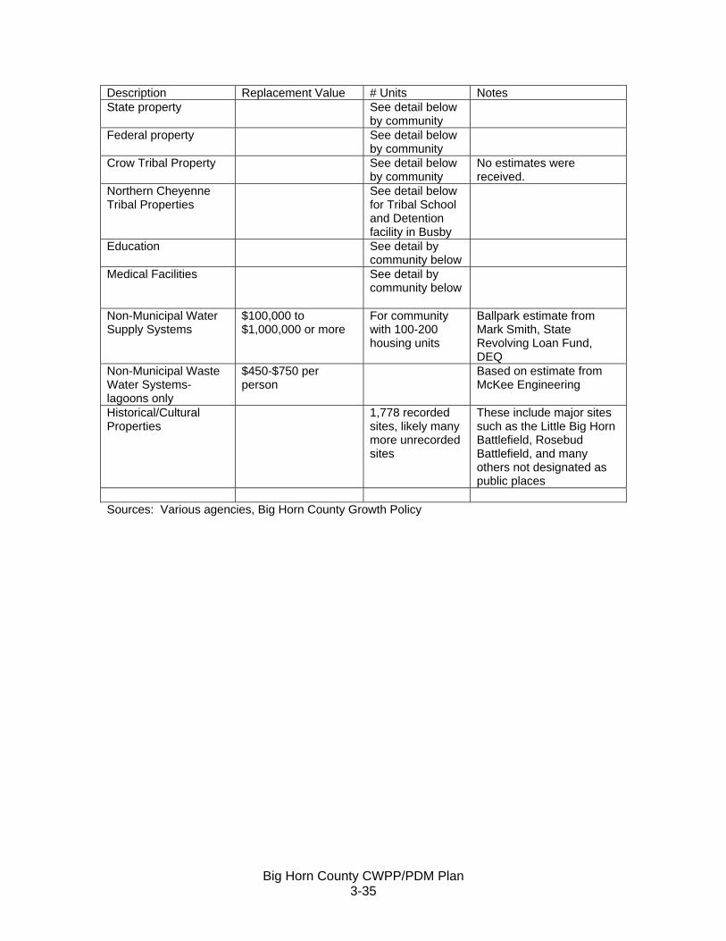
Big Horn County CWPP/PDM Plan 3-35
Description Replacement Value # Units Notes State property See detail below
by community
Federal property See detail below by community
Crow Tribal Property See detail below by community
No estimates were received.
Northern Cheyenne Tribal Properties
See detail below for Tribal School and Detention facility in Busby
Education See detail by community below
Medical Facilities See detail by community below
Non-Municipal Water Supply Systems
$100,000 to $1,000,000 or more
For community with 100-200 housing units
Ballpark estimate from Mark Smith, State Revolving Loan Fund, DEQ
Non-Municipal Waste Water Systems- lagoons only
$450-$750 per person
Based on estimate from McKee Engineering
Historical/Cultural Properties
1,778 recorded sites, likely many more unrecorded sites
These include major sites such as the Little Big Horn Battlefield, Rosebud Battlefield, and many others not designated as public places
Sources: Various agencies, Big Horn County Growth Policy

Big Horn County CWPP/PDM Plan 3-36
Table 3.14 Detailed Inventory of Assets by Community
Name or Description of Asset C
ritic
al F
acili
ty
Vul
nera
ble
Pop
ulat
ion
Eco
nom
ic A
sset
s
Spe
cial
C
onsi
dera
tions
His
toric
/Oth
er
Con
side
ratio
n
Replacement Value
# of Facilities/Units Other
Busby
Residential
x x
$53,200/unit 201units per 2000 census
Commercial x x $67/ square foot
one convenience
store
no gas station in town; nearest station in Hardin or Lame Deer; replacement value based on FEMA “Understanding Your Risks” page 3-10
U.S. Post Office x x 1
Northern Cheyenne Tribal School x x x $8.7 million 1
Estimate from school administrator
Youth Detention Facility x x x $7.6 million 1 based on recent construction costs
Busby Public Water Supply x x $500,000- $1 million 1
General estimate from MT DEQ for system serving 100-200 homes
Busby Wastewater System X X $315,000-$525,000 1
Based on cost of $450-$750 per person for new treatment lagoons (estimate from McKee Engineering)
Christ the King Catholic Church x x x
$113/square foot 1
replacement value based on FEMA “Understanding Your Risks” page 3-10
Crow Agency
Residential x x $27,600/unit 361 per 2000 census
Commercial x x $67-$88/ square foot 10-15
gas stations, hotel, casino, gift shops, laundermat, mercantile, RV Camp, restaurants; replacement value based on FEMA “Understanding Your Risks” page 3-10
Churches x x x $113/square foot 5-6
replacement value based on FEMA “Understanding Your Risks” page 3-10
Crow Agency Elementary School x x x $5,282,000 1
Little Big Horn College x x x $115/square foot 1
no estimate received from the college; replacement value based on FEMA “Understanding Your Risks” page 3-10
Crow Tribal Facilities x x x $88-$225 /square foot
Multiple buildings
no estimate received; includes government buildings, senior center, headstart
U.S. Post Office x x 1
BIA Offices x x $19.1 million Various
Includes water and waste water system, law enforcement building; estimate from Bruce Ward BIA Rocky Mountain Region Facility Manager

Big Horn County CWPP/PDM Plan 3-37
Little Big Horn Battlefield National Monument x x x
$131/square foot 1
No estimate received from Park Service, replacement value based on FEMA “Understanding Your Risks” page 3-10
Awekualawaache Care Center x x x
$225/square foot 1
No estimate received-based on $225/square foot estimate of hospital cost replacement from IHS
IHS Hospital x X x $21.2 million 1
Estimate of $225/square foot from Gary Carter, IHS, Billings
Decker
Residential x x $61,400/unit <25
Per unit value based on the county-wide 2000 census median housing value
3 coal mine locations x x 3 E and W Decker, Spring Creek
Reservoir Marina x $67-$88/ square foot 1
replacement value based on FEMA “Understanding Your Risks” page 3-10
U.S. Post Office x x 1
County Facilities x x $109,400 various houses, storage buildings (fire equipment)
Decker School x x x $350,000 1 Estimate from clerk
Tongue River Dam and Reservoir x x $85 million 1
Estimate from Dave Adair, Engineer, DNRC
Dunmore
Residential x x $61,400/unit <50
Per unit value based on the county-wide 2000 census median housing value
Church x x x $113/square foot 1
replacement value based on FEMA “Understanding Your Risks” page 3-10
Fort Smith
Residential x x $61,400 and up per unit 143
median price of housing in county is $61,400; note however that this area includes several high end homes along river (est. $350,000 or more)
Commercial x x x $67-$88/ square foot 10-15
outfitters, cabins, shops, grocery store, Ok-A-Beh Marina; replacement value based on FEMA “Understanding Your Risks” page 3-10
7 Hills Healing Center x x $113 per square foot 1
Crow Tribe operation – no estimate received; replacement value based on FEMA “Understanding Your Risks” page 3-10
Big Horn Canyon National Recreation Area Headquarters x x
$131/square foot 1
No estimate received from National Park Service
Yellowtail Dam and Hydroelectric Generation x x x $1 billion 1
Estimate from Bureau of Reclamation Electrical Engineer Tom Manni
Fort Smith Public School x x x $2,781,000 1 K-5 facility; estimate from clerk
Public Water and wastewater systems x x
$500,000 to $1 million up-each facility
Separate systems—for town and govt
Based on estimates from DEQ and from McKee Engineering

Big Horn County CWPP/PDM Plan 3-38
housing
Garryowen
Residential x x $61,400/unit <25
Per unit value based on the county-wide 2000 census median housing value
Commercial x x $67-$88/ square foot 1-2
Conoco-restaurant- trading post-museum; replacement value based on FEMA “Understanding Your Risks” page 3-10
U.S. Post Office x x 1
Reno-Benteen Battlefield Memorial x x x
$131/square foot 1
No estimate received from Park Service, replacement value based on FEMA “Understanding Your Risks” page 3-10
Hardin
Residential x x $65,800/unit 1441 Per 2000 census Commercial x x $18,647,822 per assessed value Utilities x x $1,688,317 per assessed value Railroad property x x $463,702 per assessed value Telecommunications x x $1,062,071 per assessed value Big Horn County Govt Fairgrounds x x $353,750 insured replacement value Health Services x x x $548,100 insured replacement value Court House and Jail x x $3,013,500 insured replacement value Library x x $945,900 insured replacement value Senior Citizens Center x x x Center for Disabled x x x 253,200 insured replacement value
County Shop x x x $680,000 insured replacement value; includes fire facilities
Misc/Other x x $64,130 insured replacement value
Airport x x $5 million
Costs of relocating the airport based on an environmental assessment prepared for the county
Hardin Schools x x x $40,234,000 insured replacement value for public school
Big Horn Christian Academy X X X $91/square foot 1
No estimate received-- replacement value based on FEMA “Understanding Your Risks” page 3-10
Hardin City
city streets x x $200,000/per city block
estimate from Public Works
Water treatment facility x x $3-4 million estimate from Public Works
Water storage tanks x x $1million/each 2 estimate from Public Works
Sewage Treatment x x $3.5-4 million estimate from Public Works
Town hall, firehall, and other x x $1,089,900
From city clerk—estimate of town facilities less value of water and sewer facilities
Churches x x x $113 per square foot 10-12
replacement value based on FEMA “Understanding

Big Horn County CWPP/PDM Plan 3-39
Your Risks” page 3-10
Hospital x x x $10 million 1
Insured replacement value for building and contents per Gary Roberson, Administrator
Heritage Acres x x x $3.4 million 1
Insured replacement value for building and contents per Paula Small, Administrator
Kirby
Residential x x $61,400/unit <10
Per unit value based on the county-wide 2000 census median housing value
Commercial x $67/ square foot 1
Bar; Replacement value based on FEMA “Understanding Your Risks” page 3-10
Rosebud Battlefield State Park x x x $275,000 1
Replacement value from John Little, MT Dept of Fish, Wildlife, and Parks (Miles City office)—includes buildings, interpretive, and fencing
Lodge Grass
Residential x x $41,800/unit 164 2000 census
Commercial x x $660,750 <12
per assessed value, includes a grocery store in town limits, gas station (outside of town limits)
Telecommunicaitons and electric x x $32,473 per assessed value Railroad x x $267,998 per assessed value
Churches x x x $113 per square foot 3-4
Replacement value based on FEMA “Understanding Your Risks” page 3-10
County Facilities x x $189,950
insured replacement value for shop, senior center, sheds
Lodge Grass Town
Town Hall x x $610,000 Estimated insured replacement value
Water storage tank x x $150,000 Estimated insured replacement value
Sewage lagoon/building x x $100,000 Estimated insured replacement value
Other facilities x x $188,400 various
Estimated insured replacement values (includes equipment)
Public School x x x $8.7million insured replacement value
IHS Clinic x x x $225/square foot 1
on border of town limits; estimate based on $225 square foot replacement cost of IHS Hospital in Crow Agency
Head Start Building x x x $91/square foot 1
on border of town limits Replacement value based on FEMA “Understanding Your Risks” page 3-10
Lodge Grass area Willow Creek Dams x x x 2 No estimate received Pryor

Big Horn County CWPP/PDM Plan 3-40
Residential x x $55,000/unit 195 2000 census
Commercial x x $67-$88/ square foot 1-2
gas station, restaurant Replacement value based on FEMA “Understanding Your Risks” page 3-10
IHS Clinic x x x $225/square foot 1
estimate based on $225 square foot replacement cost of IHS Hospital in Crow Agency
Churches x x x $113 per square foot 1-2
Replacement value based on FEMA “Understanding Your Risks” page 3-10
Public School(s) x x x $6,377,000 1
one elementary; one high school; insured replacement value
St. Charles Mission Elementary x x x
$91/square foot 1
No estimate received; Replacement value based on FEMA “Understanding Your Risks” page 3-10
Chief Plenty Coups State Park x x x $1.8 million 1
State Parks Regional Office in Billings, Doug Haberman
Public Water and Wastewater System x x
$815,000-$1.5 million 1
Comparable in size to Busby, estimate based on Busby’ estimates
St. Xavier
Residential x x $61,400 and up <100
median price in county is $61,400; note however that this area includes several high end homes along river (est. $350,000 or more)
Pretty Eagle School x x x $91/square foot 1
private school-no estimate received; Replacement value based on FEMA “Understanding Your Risks” page 3-10
U.S. Post Office x x 1 Wyola
Residential x x $23,300/unit 55 2000 census
Wyola Public School x x x $91/square foot 1
no estimate received; Replacement value based on FEMA “Understanding Your Risks” page 3-10
Public Water and Wastewater x x
$500,000 to $1 million up-each facility
Based on estimates from DEQ and from McKee Engineering
Notes: Tribal properties and properties owned by tribal members that are non-deeded are not included in the tax assessment values Residential housing values per unit are based on the 2000 census median housing value for the community unless otherwise indicated. Sources: Various government and public agencies (e.g., clerks of town and county government, public school clerks, public works directors) Montana Department of Revenue Property Owners and Managers Others as Noted in the Table

Big Horn County CWPP/PDM Plan 3-41
Figure 3.11 Map of Selected Critical Facilities

Big Horn County CWPP/PDM Plan 3-42
Vulnerable Populations The following were identified by the steering committee as populations that may require special care or assistance during or after a disaster or who may be at particular risk to a disaster.
• People in need of medical care. There are two hospitals (Hardin and Crow Agency) and clinics (Lodge Grass and Pryor) in Big Horn County. There is one dialysis center in Crow Agency. There are two nursing homes in Hardin, and one in Crow Agency.
• Seniors and Elderly. There were 1,089 persons (8.5% to total county population)
aged 65 or older in Big Horn County, according to the 2000 census.
• Children. There are schools in Crow Agency, Lodge Grass, Hardin, Decker, Wyola, Fort Smith, St. Xavier, Pryor, and Busby. There are 4,534 children (36% of total population) under the age of 18 in Big Horn County.
• People living in the floodplains. There is no accurate method to assess the
number of persons living in the floodplains. The densest concentration of population in Big Horn County is along the major rivers (primarily the Big Horn and Little Big Horn Rivers).
• Isolated rural populations. According to the 2000 census, approximately 39% of
the population of Big Horn County lived outside of Hardin, Lodge Grass, Busby, Crow Agency, Fort Smith, Muddy Cluster, Pryor, Saint Xavier, or Wyola. Even for those living in most of these communities, basic necessities such as a grocery store, medical care, or even a gas station may be several miles away.
• Large events such as Crow Fair and the Little Big Horn Battle Re-enactment
(because many people are gathered in one location that could be struck by a hazard). Several thousands attend these major events, which are held outdoors. Severe summer storms, including lightning, hail, wind, and tornadoes are possible hazards for these events.

Big Horn County CWPP/PDM Plan 3-43
SUMMARY Table 3.15 provides an overall summary description of the county’s vulnerability to each identified hazard. Table 3.15 also includes a brief summary of the potential impacts that are described in more detail elsewhere in this chapter (and in Chapter 5 for fire) Table 3.15 also describes the geographic are that could be potentially affected by each specific hazard. Most hazards can occur anywhere in the count. The incorporated jurisdictions of Hardin and Lodge Grass have essentially the same risk as elsewhere in the county for most hazards. There are, however, some unique differences for these two incorporated areas compared to the county as a whole. Lodge Grass has unique risk factors and concerns related to emergency/disaster response as noted below:
• Storm Drainage/Flooding. This was raised as a significant issue at the meeting with the Lodge Grass town council. Lodge Grass is subject to flooding from natural events (e.g., storms, rapid snow melt, and ice jams), and from problems with beaver dams along Lodge Grass Creek. In addition, the Willow Creek dams are upstream of Lodge Grass. Much of the town lies in the 100-year flood plain of Lodge Grass Creek and flooding is a regular occurrence.
• Power Outages. This was also raised as an issue at the town council meeting.
The problem is that the town has no back-up power, and among other things, the town’s water and wastewater systems require power to function.
• Fire Fuels Management. This was identified as a major issue at the Steering
Committee meeting and at the town council meeting. Issues include limited water supply, vacant abandoned buildings, and weeds and other unmanaged vegetative growth throughout the town.
• Technical Assistance. The town has a very limited tax base and few staff. They
need technical assistance in a number of areas related to basic services.
• Evacuation Shelter/Safe Place. There is no designated evacuation shelter or other designated “safe place” in Lodge Grass.
• Local Weather Radio Reception. It is unclear if the Lodge Grass area will be
able to receive transmissions from the recently installed weather radio station in Big Horn County. That will need to be checked and addressed as necessary.
Hardin has unique risk factors and concerns related to emergency/disaster response as noted below:
• Storm Drainage/Flooding. The town has suffered various degrees of flooding, primarily in the downtown area and along Railway St. Ice jams along the Big Horn River could potentially pose problems for the town’s water and wastewater systems. These were raised as issues at the town council meeting.

Big Horn County CWPP/PDM Plan 3-44
• Hazardous Materials. Interstate 90 and two state highways run through or are in
close proximity to Hardin. Truck traffic on these routes increases potential for truck accidents and related spills. In addition, the railroad also runs through Hardin.
• Potential for mosquitoes and insect-borne illnesses. The amount of irrigation in
and around Hardin, as well as the fact that there is a high groundwater table, raise concerns about mosquitoes and mosquito-borne illnesses. The city does operate a mosquito control district.
• Need for back-up power. Back-up power is needed for the city’s water and
wastewater systems.
• The city is growing and a new coal-fired power plant is being constructed. The city just annexed a large area north of Interstate-90 and includes the are of the coal-fired power plant.

Big Horn County CWPP/PDM Plan 3-45
Table 3.15 Summary of Hazards in Big Horn County
Hazard Geographic Area History Risk Severity Probability of Occurrence
Existing Structures at Risk
Future Structures at Risk Potential Loss Estimate
Drought-Extreme Heat
All of county could be affected simultaneously
In severe or extreme drought 15-19.99% of time between 1895 and 1996
High Severity--severe direct and indirect effects
High Probability 0 from direct effects 0
As high as $10m or more annually for direct losses to crops and livestock production. Potential for loss of life/injury from prolonged heat.
Natural Event Flood
1,000 miles of streams in Big Horn County; most of county population is along rivers and streams
Floods have occurred throughout the county, but typically are localized events instead of county-wide
Damage can be severe
Moderate Probability
Lack of FEMA FIRM maps limit ability to identify specific structures on a countywide basis (see section on Flooding for more detail)
More residential development is expected along the rivers in the future
A single occurrence, such as the flood of 1978, could result in direct damages in the $ tens of million or higher, with additional costs associated with interruption of business, etc. Potential for loss of life/injury.
Dam Failure Flood
82 dams in county, six are high hazard (meaning failure would probably result in loss of life)
No recorded history of dam failure Severe
Low Probability
High hazard dam downstream areas include all communities along the Big Horn River (Yellowtail Dam), Lodge Grass (Willow Creek), and Ashland in Rosebud County (Tongue River)
More residential development is expected along the rivers in the future
Catastrophic cost in the worst case scenario of Yellowtail Dam failure: Total destruction of communities, loss of life, cost of displacement and rebuilding far downstream of Big Horn County
Winter Storms
Vulnerable county-wide
considerable history of winter storms and damage
Moderate to Severe
Moderate to High
Biggest single cost expense structure is downed power lines ; could be some structure damage to buildings
New structures not at any greater risk than existing structures
Direct structure costs could be $800,000 or more per event, plus additional losses from livestock/crop loss and stress; business interruption, etc. Potential for loss of life or injury.
Severe Thunder-storms (hail, wind, lightning, tornadoes)
Vulnerable county-wide, but events are likely to be localized; widespread county-wide damage not likely
Considerable history of occurrence (many events annually), history of damage; including loss of human life
Moderate to Severe (localized)
hail-wind-thunderstorms-lightning: high probability; tornadoes: low-moderate
All structures are at risk
New structures not at any greater risk than existing structures
Although damage from a tornado is localized, it could conceivably destroy numerous structures. Potential for damages in the $ hundreds of million if a major facility, such as the new power plant, was destroyed. Potential loss of human life/injury.

Big Horn County CWPP/PDM Plan 3-46
Hazard Geographic Area History Risk Severity Probability of Occurrence
Existing Structures at Risk
Future Structures at Risk Potential Loss Estimate
Hazardous Materials
Vulnerable along transportation routes, pipelines, and at facilities that use or sell hazardous materials
There is a history of occurrence; but past events have not caused widespread damage or evacuations Severe Moderate
Greatest potential damage is from explosion; structures at risk are those in proximity to hazardous material sources and transportation routes
Building close to transportation routes is a continuing phenomenon. New structures not at any greater risk than existing structures, and development is generally not occuring at the same rapid pace as in other parts of Montana.
Based on experience in other locations in Montana, economic losses could be $6 million or more in direct losses, plus additional costs for business interruption and loss, etc. Potential for loss of life/injury.
Earthquake
Entire county at some risk; however, there are no identified faults in the county
History of earthquakes in area in and around Big Horn County Moderate Low-Moderate
Structures could suffer some damage
New structures not at any greater risk than existing structures
<$225,000 benchmarking against counties with higher probability of occurrence
Volcano
County at risk from ashfall; no volcanoes in the county
The county experienced ashfall from the 1980 eruption of Mt.St. Helen
Moderate-severe Low
Structural damage not likely; damage more likely for mechanical (engines) and air filter systems
Risks same as for existing structures
Costs for dealing with ashfall could be $6 million or more based on experience in Missoula County. A catastrophic event in Yellowstone National Park would have extremely severe consequences in Big Horn County.
Landslides
highest along slopes of Big Horn Mountains
visible evidence of slumping and earth movement Moderate
Moderate Incidence Rating per USGS
For area of greatest risk, estimated at less than 2% of all structures in county; some roads at risk
Not an area with recent or projected development growth activity
Losses could include structural damage or loss to structures, roads, and other infrastructure, and potential for loss of life/injury. Dollar costs could be in the $hundreds of thousands or more.
Power Outages County-wide
history of occurrences Moderate High
Structures not likely at risk generally. More likely results--frozen waterlines, appliance damage , etc.
Risks same as for existing structures
Potential for loss of life/injury. Economic costs could be in the hundreds of thousands of dollars or more per incident, based on national figures.

Big Horn County CWPP/PDM Plan 3-47
Hazard Geographic Area History Risk Severity Probability of Occurrence
Existing Structures at Risk
Future Structures at Risk Potential Loss Estimate
Wildfire County-wide
Big Horn County typically has more than 100 fires per year Severe High
Structures are at risk throughout the county.
The wildfire priority areas with greatest potential for future residential development are along river bottoms, especially the Big Horn River.
Estimate for a hypothetical fire that destroys Busby is $30 million, not including business interruption and displacement costs

Big Horn County CWPP/PDM Plan 3-48
THIS PAGE INTENTIONALLY BLANK.

Big Horn County CWPP/PDM Plan 4-1
CHAPTER 4: MITIGATION STRATEGY This chapter identifies the “blueprint” for reducing losses associated with the hazards described in Chapter 3. The mitigation strategy for wildfire is addressed in Chapter 5. This chapter includes:
• a short description of the methodology used to develop the mitigation strategy, which is also discussed to some extent in Chapter 2;
• the Goals and Mitigation Actions • Project Ranking and Prioritization and • Implementation and administration of the plan
METHODOLOGY The contractor developed initial goal statements and a preliminary list of projects from information discussed at the steering committee meeting/public meeting held in Hardin on June 16. The contractor reviewed each hazard with participants at the meeting to ensure that all hazards were considered for mitigation measures. On July 28, participants at the meeting reviewed and revised the initial goal statements and project/mitigation measures. Subsequent to the meeting, the DES Coordinator suggested additional changes for accuracy and brevity. For example, there was a project that stated evacuation plans should be developed for the county. The DES Coordinator indicated evacuation plans were already in place, but should be reviewed and revised as necessary on an ongoing basis. Some of the projects had long, run-on sentences and these were shortened. Participants reviewed a range of mitigation actions that included data collection, hazard mapping and other mapping projects, ways to improve public awareness, better response mechanisms, technical assistance, and regulatory mechanisms. Some participants expressed clear and distinct opposition to new regulatory measures, while others indicated that such measures could reduce future impacts. As part of the public review of the draft plan, the public was expressly encouraged to review the goals, objectives, and mitigation measures and suggest changes. One action to develop an updatable GIS system was added as a result of public comment. GOALS AND MITIGATION ACTIONS The following goals were developed in response to each of the hazards. Participants identified a number of actions that apply to a variety of hazards. These include measures to improve preparation and response to a variety of hazards and are included in Goal 2 “Improve capabilities to prepare for and respond to a variety of disasters.” Other measures that address more than one hazard are included in Goal 4 “Reduce damages in naturally occurring high hazard areas.” It is understood that hazard-specific information would be a necessary part of implementing the various measures related to this goal.

Big Horn County CWPP/PDM Plan 4-2
Specific goals were developed for drought (the #1 hazard identified by participants early on in the process), and for fire (the #2 hazard). The fire projects are included in Chapter 5. There is a goal and many projects identified to address effects of flooding. Flooding was not identified as a specific priority issue at the first public meeting, but historical occurrences clearly indicate potential for severe, wide-spread damage. The ability to address effects of future development is limited by the fact that there is no county-wide FEMA FIRM map, and this is identified as the first project under the goal to reduce effects of flooding. There is a goal to address power outages, which have been documented to last up to days in Big Horn County. There is inadequate or complete lack of back-up power supply for public water and wastewater systems in nearly every community in Big Horn County. There is also a goal to address specific needs of the town of Lodge Grass. Lodge Grass has significant infrastructure issues and extremely limited resources with which to address those issues. The town is incorporated but has little income from property taxation. The major source of revenue is from the provision of water and waste water. Improvements have been made to the bill collection procedures, but there is still a way to go. Forty percent of the town’s residents are below poverty level (U.S. Census 2000), making it difficult for people to pay for necessities. Some water and wastewater customers pay their bills with in-kind labor to the town. A separate goal was also identified to address natural high hazard areas (those that can be defined geographically, but for which there is limited information currently). The goal also addresses the specific hazard awareness needs of rural residents. The following projects would be for both new and existing buildings and infrastructure where applicable. For example, working to address adequate storm drainage would be something that might require maintenance, repair, or reconstruction of specific sections to protect existing development and infrastructure. It could also benefit potential new development as well. For new construction, review might involve an assessment of drainage, and measures to prevent new development from worsening drainage problems. Other specific actions that would reduce disaster effects on existing buildings include Objectives 2.1 and 2.2 (which would improve public awareness and mechanisms to prevent damage to existing buildings) and Objectives 3.2 and 3.3. Many of the actions proposed in the mitigation section for the Community Wildfire Protection Plan would also work to protect existing buildings and reduce fire hazards related to new construction.
Big Horn County CWPP/PDM Plan 4-3
Goal 1: Reduce impacts of drought. Objective 1.1 Identify water supply and distribution issues and develop a forum to
address issues. 1.1.1 Initiate a forum among water suppliers, water users. Include a broad spectrum of
persons and entities that could be affected by water shortages or distribution issues (communities, users of surface and ground water—e.g., individual well owners, private companies, irrigation companies, farmers/ranchers, state and federal agencies, etc.)
1.1.2 At least annually, bring in outside experts and speakers to assist in dealing with this complex issue and to raise awareness about new approaches.
1.1.3 Identify mechanisms to improve supply as needed to address water shortages (including new/additional dams, water storage areas, more efficient distribution, etc.)
1.1.4 Identify mechanisms to reduce demand in periods of water shortage (such as a water use restriction plan to be activated as needed)
Objective 1.2 Improve public awareness about drought and water shortages. 1.2.1 Provide information to the public about water shortage emergencies and water
conservation. Goal 2: Improve capabilities to prepare for and respond to a variety of disasters. Objective 2.1. Improve the general public’s preparedness for disasters. 2.1.1 Qualify the county as a NOAA storm-ready community. 2.1.2 Provide and distribute public education on how to prepare for and respond to
various disasters. 2.1.3 Monthly, provide news releases (as available from FEMA, NOAA, and other
sources) with information on how to prepare for a particular type of event (e.g., winter storms, thunderstorms, hail, wildfire, etc.)
2.1.4 Regularly release information about warning systems (sirens, notices over the television and radio), what the signals mean, and how to respond.
2.1.5 Provide information geared specifically to disaster preparedness for occupants of mobile homes, as these are specifically vulnerable to a variety of disasters such as strong winds, hail, fire, and flooding.
2.1.6 Work with coordinators of major events—such as the Battle Re-enactment, Crow Fair—to identify potential disasters (e.g., strong wind events, storms, etc.) – and means to protect participants and visitors.
2.1.7 Work with the school systems to provide education/projects on disasters (such as a school project for a community calendar with seasonal specific information on various types of weather hazards and disaster contact information)
2.1.8 Continue to consult and use other disaster plans and programs in an overall approach to disasters in Big Horn County. Such programs include Homeland Security, public health programs that deal with insects and diseases, (e.g., Healthcare Epidemiology and Infection Control programs), and emergency response programs for hospitals.

Big Horn County CWPP/PDM Plan 4-4
2.1.9 Continue to coordinate with the various local, state, and federal agencies that would deal with rare but potentially catastrophic disasters such as major earthquakes, volcanoes, and major dam failure (e.g., Yellowtail Dam).
Objective 2.2. Expand the use of NOAA weather radios. 2.2.1 Distribute information to the public on the importance of NOAA weather
information, how to listen to the stations, the differences between NOAA weather radios and “regular” radios, and how to obtain weather radios.
2.2.2 Identify sources of assistance for those who cannot afford NOAA weather radios. 2.2.3 Work with critical facilities (health/medical facilities, schools, other public
buildings) to make sure each has working NOAA weather radios. 2.2.4 Work to expand local weather radio coverage to all communities in the county.
Objective 2.3. Improve the ability of emergency responders and county officials to
respond to disasters. 2.3.1 Continue to update the emergency resource guide and develop a resource
inventory (e.g., equipment to be used during an emergency). 2.3.2 Develop an updatable GIS system in the county that includes a variety of
information critical for disaster response and for monitoring various conditions related to disasters and emergency response.
2.3.3 Evaluate county evacuation plan and update as necessary. 2.3.4 Identify emergency “safe” places/shelters and determine any needs to improve
the adequacy of those places. Make sure local officials and general public know about these facilities.
2.3.5 Continue to hold training/drill exercises on various types of situations (including evacuations), and expand training as needed.
2.3.6 On a regular basis, assess communications capabilities, identify any needed improvements, and develop specific plans to address.
2.3.7 Monitor/evaluate effective response from dispatchers (including out-of-county dispatchers that respond to Big Horn County calls), coordinate dispatcher training and public education on how to use the 911 system as necessary.
2.3.8 Review existing emergency response policies for public places, update as necessary, and hold training exercises. Procedures should address measures for severe windstorms, winter storms, and evacuation plans for fire.
2.3.9 Create Community Emergency Response Teams. Objective 2.4. Improve disaster preparedness for vulnerable populations. 2.4.1 Provide disaster preparedness information geared specifically for the medically
at-risk, homebound, elderly, isolated rural residents, etc. 2.4.2 Address the specific needs of vulnerable populations in evacuation plans.

Big Horn County CWPP/PDM Plan 4-5
Lodge Grass Health Care Center
Photo from Cossitt Consulting Objective 2.5 Improve capabilities to respond to winter/spring storms. 2.5.1 Identify and publicize snow routes. 2.5.2 Provide information to new homebuilders and reminders to existing residents in
rural areas about winter road conditions, capabilities of existing public road maintenance systems, and maintenance responsibilities for private road systems.
Objective 2.6 Address the needs of livestock and domestic animals in disaster situations. 2.6.1 Provide general information to the public about steps that they can take to protect
livestock and animals. 2.6.2 Continue to provide for livestock and animals in emergency response plans. Goal 3: Mitigate the potential loss of life, property, and infrastructure from
flooding. Objective 3.1 Coordinate so that all eligible areas of the county become part of the
National Flood Insurance Program.
3.1.1 Work with the Crow and Northern Cheyenne Tribes and FEMA to complete FEMA FIRM floodplain maps for the entire county area.
Objective 3.2 Reduce potential impacts in high hazard areas along major river corridors 3.2.1 Examine potential impacts of planned release and flushing flows from the
Yellowtail Dam on existing and future development. 3.2.2 Continue existing mechanisms, such as implementation of floodplain regulations,
and identify and implement other regulatory and non-regulatory options to reduce impacts to new and existing development in high hazard flood areas.

Big Horn County CWPP/PDM Plan 4-6
3.2.3 Identify potential effects from flooding to water supply and sewage treatment systems along the rivers. As necessary, identify methods to address issues.
Development along Big Horn River west of St. Xavier
Photo from Cossitt Consulting Objective 3.3. Reduce effects of poor storm drainage. 3.3.1 For Hardin:
1) Assess storm drainage issues, including around Miles Avenue, Custer Avenue and Railroad Street, and develop implementation plans.
2) Work with Burlington Northern Santa Fe Railroad to maintain adequate and functioning drainage systems in their rights-of-way.
3) Assess drainage ditches. Address issues of restricted or obstructed flow.
3.3.2 For Lodge Grass: 1) Identify and implement measures to address storm water drainage in
downtown Lodge Grass 2) Identify and implement measures to address and prevent beaver-caused
flood damage.
3.3.3. For other areas of the county: 1) Assess capacity of county roads to handle flood events and mitigate as
necessary 2) Work with Crow, Northern Cheyenne, state and federal agencies to
address capabilities of other road systems to accommodate flood events and mitigate as necessary.
Objective 3.4. Reduce potential effects of dam failures.
Big Horn County CWPP/PDM Plan 4-7
3.4.1 Continue to identify and test (drills, practices) emergency response (including evacuation) for dam failures.
3.4.2 Work with DNRC to increase awareness among owners of smaller private dams of maintenance and upkeep (even during drought years).
Objective 3.5. Reduce effects of ice jams. 3.5.1 Identify areas especially vulnerable to ice jams (e.g., Wyola, Hardin). 3.5.2 Identify methods to reduce impacts to existing critical facilities and infrastructure
in these areas and to reduce impacts to potential future structures.
Goal 4: Reduce damages in naturally-occurring high hazard areas.
4.1 Identify high hazard areas, such as strong wind areas/corridors, areas subject to ice jams and other floods, areas subject to landslides, etc. on a map of the county.
4.2 Update the “Way of the West” or develop a similar publication that provides basic information on hazards in Big Horn County and clarifies that some rural properties may be difficult to access by emergency responders.
Goal 5: Reduce the effect of power outages.
5.1 Identify back-up power for critical facilities throughout the county (starting with water supply and wastewater systems) and work to obtain needed equipment.
5.2 Maintain an inventory of portable generators. 5.3 Identify power back-up and other means to avoid or reduce issues for medically
at risk during power outages. 5.4 Work with power companies and the media to provide information on an annual
or semi-annual basis to the public on installing, operating, and maintaining back-up generators.
5.5 Provide information to the public on how to prepare for and respond to power outages.
Goal 6: Improve disaster preparedness in Lodge Grass.
6.1 Address the back-up power supply needs of Lodge Grass. At a minimum, the back-up generator at the school needs to be refurbished to working condition and back-up power system provided for the water and wastewater systems.
6.2 Address the need for another water storage tower. 6.3 Develop an evacuation plan, including identification of local evacuation shelter.
The town is limited in ability to evacuate—it is possible that the main routes out of town could be inundated or otherwise blocked.
6.4 Address the long-term needs for technical assistance to the town of Lodge Grass for a variety of infrastructure and resource issues that affect the ability of the town to avoid, prepare for and/or respond to disasters.
Project Ranking and Prioritization Ranking projects helps to set the local priorities for accomplishing the plan. Resources to accomplish objectives can be limited in any planning process and in rural Montana counties, such as Big Horn County. Prioritizing helps to identify which projects to start

Big Horn County CWPP/PDM Plan 4-8
on, given that there are typically far more projects than can be addressed at any one time. The mitigation projects were prioritized by the participants at the final planning meeting held on July 28, 2005, in Hardin. Projects were ranked by high, medium, or low, by meeting participants based upon subjective assessment against the following criteria:
• Number of lives at risk • Value of property at risk • Infrastructure at risk • Risk of business interruption/loss • Cost/benefit of the project
Participants considered cost-benefit to include an emphasis on cost-effective and technically feasible mitigation actions. The group did not get through the entire set of projects on July 28. For purposes of the draft document, the County DES Coordinator prioritized the remaining projects. As part of the public review of the draft plan, the public was expressly encouraged to review the priorities in the draft and suggest changes. There were no additional changes to priority projects as a result of public comment, other than for the addition of the one additional action for an updatable GIS system for tracking resources and other information necessary for disaster mitigation and response. Table 4.1 displays the mitigation actions, the cost-benefit summary, priority ranking, timetable and potential participants (resources) for implementing the action.

Big Horn County CWPP/PDM Plan 4-9
Table 4.1 Mitigation Project Prioritization, Cost-Benefit Summary, Schedule, and Potential Resources/Participants # Project description Benefits Costs Schedule Rank Potential Resources Estimated $ Costs* Other Costs/ “Cons” GOAL 1 Reduce
impacts of drought.
1.1.1 Forum to identify and address water supply/use issues.
If forum is successful in making change, could result in more reliable water supply in drought
Medium $ Would take support staff to coordinate various interests
Could be time consuming and not result in significant changes
2-4 years M Irrigation facility owner/managers, farmers and ranchers, local, state, tribal, and federal agencies, conservation district
1.1.2 Bring in outside technical expertise.
Could result in new ideas for addressing drought issues. Bringing in outside speakers can enhance motivation to succeed
Medium $ Funds may be needed to pay for speaker (or travel costs)
Time to coordinate logistics
2-4 years L County DES, LEPC, Extension, conservation district, other local, state, tribal, and federal govt or private entities
1.1.3 Identify options/mechanisms for improving supply.
Could improve water supply and reduce impacts from drought
Medium to High $ Would require a more detailed review of supply systems; actual construction or major repairs in supply systems could be in the $$millions
Coordination among various parties; potential political issues
1-5 years H Local, state, tribal, and federal agencies, and other interested parties
1.1.4 Identify options/mechanisms to reduce demand.
Could result in improved water supply and reduced impacts of drought
Low to Medium $ Methods to reduce use may not cost much in real dollars
Coordination among various parties; potential political issues
1-2 years H Irrigation facility owner/managers, farmers and ranchers, local, state, tribal, and federal agencies
1.2.1 Provide information to the public about water shortage and water conservation.
Could result in improved water supply over long term and reduced impacts of drought
Low $ Generally low dollar cost—many materials already available
Will require staff time to coordinate
1-2 years H County DES, Extension, municipalities, tribal government, BIA, DNRC, Governor’s Drought Committee, local media, schools

Big Horn County CWPP/PDM Plan 4-10
# Project description Benefits Costs Schedule Rank Potential Resources Estimated $ Costs* Other Costs/ “Cons” GOAL 2
Improve capabilities to prepare for and respond to a variety of disasters.
2.1.1 Qualify the county as a NOAA storm-ready community.
County as a whole will be better able to prepare and respond to storms. County has been working on this for some time and is close to completion
Low $ Few additional $$ needed to achieve status
County DES Coordinator already working on this
1 year H County DES, NOAA
2.1.2 Public education on preparing and responding to disasters.
Currently, not all county residents understand and prepared for disasters—a little education could go a long way for change
Low $ Generally low dollar cost—many materials already available
Will require staff time to coordinate
1-2 years H Towns, County DES, County Public Health, DES, FEMA, tribal government, local media, schools
2.1.3 Monthly news releases focusing on a particular disaster type
Currently, not all county residents understand and prepared for disasters
Low $ Generally low dollar cost—many materials already available
Will require staff time to coordinate; not everyone reads the paper
1-2 years M County DES, FEMA, tribal government, local media, schools
2.1.4 Regularly release information about disaster warning systems.
Many people in the county may not know about official warning systems; getting more people aware could save lives
Low $ Generally low dollar cost
Will require staff time to coordinate
1-2 years H County DES, FEMA, towns, tribal government, local media, schools
2.1.5 Disaster Preparedness for occupants of mobile homes.
High # of mobile homes in county; mobile homes esp. vulnerable in many disasters; some changes could make a big difference
Low to High $ Low dollar cost to provide information, but making modifications to mobile homes to secure roofs, etc. could be costly
2-5 years M County DES, FEMA, tribal government, towns, local media, schools

Big Horn County CWPP/PDM Plan 4-11
# Project description Benefits Costs Schedule Rank Potential Resources Estimated $ Costs* Other Costs/ “Cons” 2.16 Identify mechanism
for safety response at major events, like Crow Fair.
History of high winds at some events; safety response mechanism could save lives
Low to High $ Could range from low (developing evacuation plans) to high (structural changes)
Will require coordination among various entities
2-5 years H County DES, FEMA, tribal government, towns
2.1.7 Work with school systems on disaster prevention and education projects.
Starting disaster prevention awareness with youth could last individuals a life time; students may also “educate” their parents
Low $ Generally low dollar cost—many materials already available
Will require staff time to coordinate
1-2 years H County DES, FEMA, tribal government, towns
2.18 Continue to use and consult other disaster plans and programs in area.
Not a major change from current situation, but ensures good work continues
Low $ County DES Coordinator already doing this
ongoing M County DES, FEMA, tribal government, towns, public health agencies, law enforcement
2.19 Continue to coordinate with other agencies on rare but potentially catastrophic events (e.g., earthquake, volcanic events, dam failure, etc.).
Not a major change from current situation, but ensures good work continues
Low $ County DES Coordinator already doing this
Ongoing L County, tribal governments, state agencies, federal agencies including FEMA, Bureau of Reclamation
2.2.1 Public information on importance of NOAA weather radios.
Goal is to have NOAA weather radios in more homes and other locations, with ultimate goal of reducing risk
Low $ Generally low dollar cost—many materials already available
Will require staff time to coordinate
1-2 years H County DES, NOAA, FEMA, tribal government, towns, public health agencies
2.2.2 Identify sources of assistance for NOAA weather radio acquisition, as necessary.
Goal is to have NOAA weather radios in more homes and other locations, with ultimate goal of reducing risk
Low $ Generally low dollar cost—many materials already available
Will require staff time to coordinate
1-2 years L County DES, NOAA, FEMA, tribal government, towns, public health agencies
2.2.3 Ensure critical facilities have working NOAA radios.
Reduce risk of critical facilities and persons located in them
Low $ staff time to coordinate and $$ cost of radios
DES Coordinator already doing this, but efforts could be expanded
Ongoing H County DES, NOAA, FEMA, tribal government, towns, public health agencies

Big Horn County CWPP/PDM Plan 4-12
# Project description Benefits Costs Schedule Rank Potential Resources Estimated $ Costs* Other Costs/ “Cons” 2.2.4 NOAA radio coverage
to all Big Horn County communities.
Currently, not all communities can receive NOAA weather transmission. DES Coordinator has already been involved in one tower placement
Low to High $ Cost to identify gaps and build towers or other to increase transmissions
Will require staff time to coordinate
3-5 years M County DES, NOAA, FEMA, tribal government, towns, public health agencies
2.3.1 Continue to update emergency resource guide and inventory.
Up-to-date information makes a difference in saving lives and property
Low $ staff time to coordinate
DES Coordinator doing this now,
Ongoing H County DES, LEPC, FEMA, tribal government, towns, public health agencies
2.3.2 Develop an updatable GIS system
This type of system has made a huge difference in nearby Stillwater County—helping responders to get to scene; providing warnings and evacuation info to residents, etc. DES Coordinator recently received some training and is familiar with Stillwater County system
Low to Medium $ cost to obtain GIS software/hardware; cost to train staff, cost to continually update; cost to staff office
3-5 years H County DES, LEPC, FEMA, tribal government, towns, public health agencies
2.3.3 Evaluate county evacuation plan and update as necessary.
Up-to-date information makes a difference in saving lives and property
Low $ cost of staff time to coordinate
DES Coordinator doing this now.
ongoing M County DES, LEPC, FEMA, tribal government, towns, public health agencies, Red Cross
2.3.4 Identify emergency safe shelters.
Not all communities have identified safe shelters; need an assessment of each—having these in place and working; and having people informed about them could save lives
Low to High $ cost of staff time to coordinate; additional funds may be needed to equip locations as emergency safe shelters
2-4 years H County DES, LEPC, FEMA, tribal government, towns, public health agencies

Big Horn County CWPP/PDM Plan 4-13
# Project description Benefits Costs Schedule Rank Potential Resources Estimated $ Costs* Other Costs/ “Cons” 2.3.5 Continue training/drill
exercises, including for evacuations, and expand as necessary.
Keeping responders trained and ready will make a difference in saving lives
Low $ cost of staff time to coordinate; cost of responders overtime; cost of exercise
DES Coordinator doing this now.
Ongoing H County DES, LEPC, FEMA, tribal government, towns, public health agencies, Red Cross
2.3.6 Regularly assess communications capabilities and address needed changes/improvements, as necessary.
Emergency responders need to be able to communicate with each other. County is already working with tribes and other counties on “inter-operability” communications improvements
Low to Medium $ cost of staff time to coordinate; cost of any needed equipment, etc.
Ongoing H County DES, LEPC, FEMA, tribal government, towns, public health
2.3.7 Monitor/evaluate dispatch and coordinate dispatcher training and public education as necessary.
Effective notice to emergency #s and quick dispatch makes a difference in response. Existing systems are already fairly efficient
Low $ cost of staff time to coordinate
Cross jurisdictional issues
Ongoing L County DES, FEMA, law enforcement, dispatch centers
2.3.8 Review and update as necessary emergency response procedures for various disasters in public places.
Many plans in place, not always tested in all locations. Testing and updating plans could save lives
Low $ cost of staff time to coordinate
1-2 years- then ongoing
M County DES, LEPC, FEMA, tribal government, towns, public health
2.3.9 Create Community Emergency Response Teams.
Given distances in county, local teams could improve response
Low $ cost of staff time to coordinate
Difficulty in recruiting and training volunteers.
3-5 years L County DES, LEPC, FEMA, tribal government, towns, public health
2.4.1 Disaster preparedness information for medically at-risk, isolated rural residents, etc.
Unclear how prepared these vulnerable populations are at present
Low to Medium $ cost of staff time to coordinate; individuals may have costs related to getting better prepared
County has many low income residents--many people may need financial help to get better prepared
2-4 years M County DES, LEPC, FEMA, tribal government, towns, public health

Big Horn County CWPP/PDM Plan 4-14
# Project description Benefits Costs Schedule Rank Potential Resources Estimated $ Costs* Other Costs/ “Cons” 2.4.2 Address specific
needs of vulnerable populations in evacuation plans.
Unclear how this is addressed in various plans
Low $ cost of staff time to coordinate
2-4 years M County DES, LEPC, FEMA, tribal government, towns, public health, Red Cross
2.5.1 Identify and publicize snow routes.
It has been several years since a major snow storm disrupted travel for days, existing residents and newcomers may be unfamiliar with first roads to be plowed and what to expect
Low $ cost of staff time to coordinate
2-4 years M County DES, County Road Department, BIA road department, tribal government
2.5.2 Information to potential and existing homeowners about winter road conditions and other factors that can affect disaster response in winter storm conditions
It has been several years since a major snow storm disrupted travel for days, existing residents and newcomers may be unfamiliar with how to prepare and respond
Low $ cost of staff time to coordinate
3-5 years L County DES, Planning Board, Realtors, tribal government
2.6.1 Public education on protecting livestock and animals during disasters
Efforts to protect livestock and pets can result in human safety issues
Low $ cost of staff time to coordinate
2-4 years M County DES, Extension, Veterinarians, tribal government, towns
2.6.2 Continue to provide for livestock and animals in emergency response plans
Efforts to protect livestock and pets can result in human safety issues
Low $ cost of staff time to coordinate
2-4 years M County DES, LEPC, Extension, Veterinarians, tribal government, towns
GOAL 3 Mitigate potential loss of life, property, and infrastructure from flooding.

Big Horn County CWPP/PDM Plan 4-15
# Project description Benefits Costs Schedule Rank Potential Resources Estimated $ Costs* Other Costs/ “Cons” 3.1.1 Work to complete the
FEMA FIRM floodplain maps for the entire county.
Residents and structures may be at risk for damage; developing maps can be used as part of subdivision review for new development
Low to Medium $ cost of staff time to coordinate
Complications of working with various jurisdictions; attempts to get this started have been made in the past but with no results
1-5 years H County Floodplain Administrator, County DES, tribal governments, FEMA
3.2.1 Examine potential impacts of flushing flows to existing and future development along the Big Horn River.
These events could result in some damage to facilities; preparing the public could reduce damage
Low to Medium $ cost of staff time to coordinate; higher costs if specialized studies needed
2-5 years M County Floodplain Administrator, Bureau of Reclamation, County DES, tribal governments
3.2.2 Identify and implement options to reduce impacts to new and existing development in high hazard flood areas.
Could result in less property damage and less human loss Could result in fewer new buildings in hazard areas; also better protection for those existing in hazard areas. Subdivision regulations already address this
Low $ cost of staff time to coordinate
New regulatory options, such as river setbacks, could be most effective but could meet with public opposition
3-5 years L County Floodplain Administrator, County DES, tribal governments, Conservation District
3.2.3 Identify and address potential impacts of flooding on water supply and waste water systems.
Unclear what systems might be at risk—but likelihood that some are
Medium to High $ cost to identify issues and develop and implement mechanisms to address
3-5 years L County Floodplain Administrator, County Sanitarian, County DES, tribal governments
3.3.1 Assess and address storm drainage issues in Hardin.
Would result in less interruption to business and less damage to property
Medium to High $ cost for analysis and implementation measures
Need to coordinate with private owners, including railroad, can be difficult
1-5 years H Hardin, Burlington Northern
3.3.2 Assess and address storm drainage issues in Lodge Grass.
Would result in less interruption to business and less damage to property
Medium to High $ cost for analysis and implementation measures
Very limited resources in town, few staff
1-5 years H Lodge Grass

Big Horn County CWPP/PDM Plan 4-16
# Project description Benefits Costs Schedule Rank Potential Resources Estimated $ Costs* Other Costs/ “Cons” 3.3.3 Assess and address
storm drainage and flood issues along roadways in the county.
Would result in less loss of public property, more likelihood that evacuation routes can stay open
Medium to High $ cost for analysis and implementation measures
Staff time already stretched
1-5 years H County Road Department, County DES, BIA, tribal governments, MT Dept. of Transportation
3.4.1 Continue to test emergency response for dam failure.
Less loss of life and property
Low $ cost of staff time to coordinate
Ongoing M County DES, LEPC, state, tribal, and federal dam operators
3.4.2 Increase awareness among smaller dam owners of maintenance and upkeep needs.
Less loss of life and property
Low $ cost of staff time to coordinate
2-4 years M County DES, DNRC
GOAL 4 Reduce effects in natural high hazard areas
4.1 Identify naturally occurring high hazard areas.
Could result in fewer new buildings in hazard areas; also better protection for those existing in hazard areas. Subdivision regulations already address this on a site-by-site basis
Low to Medium $ cost of staff time to coordinate; some special studies may be needed
People may still build in unsafe areas
3-5 years M County DES, FEMA, tribal governments
4.2 Update publication that provides basic information on hazards in Big Horn County.
Less loss of life and property. Publication already exists in draft form.
Low $ cost of staff time to coordinate
People may still build in unsafe areas and/or be unprepared for disasters
3-5 years M County DES, LEPC, FEMA, tribal governments
GOAL 5 Reduce effect of power outages.

Big Horn County CWPP/PDM Plan 4-17
# Project description Benefits Costs Schedule Rank Potential Resources Estimated $ Costs* Other Costs/ “Cons” 5.1 Identify back-up
power for critical facilities.
Without power, many communities will be without water systems, heat, etc., resulting in potential serious human safety issues
Medium to High $ cost to identify issues and develop and implement mechanisms to address
1-2 years H County DES, LEPC, FEMA, towns, tribal governments
5.2 Maintain inventory of portable generators.
Back-up supply for critical infrastructure, emergency shelters, etc. is critical
Low (inventory only) to High $ (purchase and fit portable generators) cost of staff time to coordinate; cost of equipment; cost to prepare facilities for portable generator use
2-4 years H County DES, LEPC
5.3 Identify back-up power and other means to avoid or reduce issues for medically at risk during power outages.
Could save human lives Low (inventory only) to High $ (purchase and fit portable generators) cost of staff time to coordinate
3-5 years M County DES, LEPC, FEMA, towns, tribal government, public health agencies
5.4 Periodic information on installing, operating, and maintaining back-up generators.
Could save human lives Low $ cost of staff time to coordinate
1-3 years, then ongoing
M County DES, LEPC, FEMA, towns, tribal government, power utilities
5.5 Public education on how to prepare for and respond to power outages.
Less loss of life and property
Low $ Generally low dollar cost—many materials already available
Will require staff time to coordinate
1-2 years M County DES, LEPC, FEMA, towns, tribal government, power utilities
GOAL 6 Improve disaster preparedness in Lodge Grass.

Big Horn County CWPP/PDM Plan 4-18
# Project description Benefits Costs Schedule Rank Potential Resources Estimated $ Costs* Other Costs/ “Cons” 6.1 Address back-up
power supply needs of Lodge Grass, starting with refurbishing generator at the school, and providing back-up power to water and wastewater systems.
Without power, many communities will be without water systems, heat, etc., resulting in potential serious human safety issues
Medium to High $ cost to identify issues and develop and implement mechanisms to address
Town has few resources and will need help from others. School has begun work on this.
1-3 years H Lodge Grass, County DES, FEMA
6.2 Address need for another water storage tower
Continued water supply critical at all times; back-up needed for power outages
High $ cost to identify issues and develop and implement mechanisms to address
Town has few resources and will need help from others
2-4 years H Lodge Grass, County DES, FEMA
6.3 Develop an evacuation plan, including identification of local evacuation shelter.
Significant potential benefit in addressing human safety issues
Low to Medium $ cost to identify issues and develop and implement mechanisms to address
Town has few resources and will need help from others
1-2 years H Lodge Grass, County DES, FEMA, Red Cross
6.4 Long-term needs for technical assistance
Improve ability to prepare for, mitigate, and respond to disasters
Medium to High$ Town has few resources
2-4 years H Lodge Grass, County DES, FEMA, Red Cross
*Estimated costs: Low = $ 10,000 or less, Medium = $ 10-100,000, High = $ 100,000 or greater

Big Horn County CWPP/PDM Plan 4-19
PROJECT IMPLEMENTATION The projects listed above are the means by which the county and towns intend to realize the goals to become more disaster resistant. Accomplishing the projects will be dependent on funding, staff, and technical resources from a variety of sources including the county, towns, state and federal government, not-for-profits, and the business community. Some of the projects can be undertaken by the county within existing resources. One example of this would be to examine county participation in the national flood insurance program. Another would be to provide information on how to prepare for various types of disasters. Some of the projects can be completed by the county or towns with additional funding. The amount of funding needed depends on the project. One example would be the project to address the need for back-up power and additional public water supply storage capacity. This would take financial resources that would likely require additional funding. Some of the projects will require a public-private partnership to accomplish. An example of this would be working with local electric companies to provide information on how to properly install and maintain stand-by electric generators. Some projects may require expertise not available in the county. For example, identifying methods to address drought will likely necessitate expertise from outside the county. Projects will be accomplished as resources, either at the local, state or federal levels, become available. Those projects with a higher priority ranking would be considered first. Implementation of the plan will be the responsibility of the LEPC and the Big Horn County Disaster and Emergency Services Coordinator acting on the behalf of the county. Plan implementation also depends on the willingness of other public entities (e.g., the schools), private business (such as the electric companies), and not-for-profit organizations such as the American Red Cross to participate in specific mitigation actions and projects. In selecting projects to compete for funding whether it is existing internal funding or funding from state and federal sources, emphasis should be placed on the relative benefits compared to the cost of the project. The cost of the project should be considered and weighed against the dollar value or other measure of assets protected or potential reduction of damages. Where possible a basic cost benefit and/or value analyses should be completed during the planning of the project. The municipalities and county understand that while completion of the plan will make them eligible to compete for additional funds, it is in the best interests of the local jurisdictions and residents to proceed with those projects that can be done within existing resources while exploring avenues to obtain assistance for those projects beyond local capabilities.

Big Horn County CWPP/PDM Plan 5-1
CHAPTER 5: COMMUNITY WILDFIRE PROTECTION PLAN

Big Horn County CWPP/PDM Plan 5-2
CHAPTER 5: COMMUNITY WILDFIRE PROTECTION PLAN
EXECUTIVE SUMMARY This chapter addresses wildland fire issues for the county and comprises the Community Wildfire Protection Plan (CWPP) element of this plan. It is intended to function as a stand-alone document for the purposes of Healthy Forests Restoration Act of 2003 (HFRA) and the National Fire Plan. This fire protection plan has two distinct parts, 1) risk assessment and 2) mitigation of those risks. The risk assessment identifies fuel hazards, values, and assets. It also presents a synopsis of the fire protection preparedness of the county. The mitigation section identifies goals, objectives, and projects to reduce or mitigate the wildfire risk. Big Horn County has a higher than average occurrence for wildfire starts in Montana. There are approximately 100 or more fires per year on average. Of these, approximately 80-90% is human caused, compared to a state average of closer to 50% for human caused fires. There are multiple jurisdictions and associated authority in Big Horn County, including the Crow Indian Reservation, Northern Cheyenne Indian Reservation, municipalities of Hardin and Lodge Grass, properties managed by the National Park Service, Bureau of Reclamation, and the State of Montana. There are 10 different fire suppression agencies in the county. Both the Crow and Northern Cheyenne have fire management plans. Key points to consider for wildfire mitigation for Big Horn County include:
• High rates of human-caused fires (80-90%, compared to 50% statewide) • High number of fires/year (100 or more). • Lack of reliable water supplies to fight fire and hydrant systems that are in need
of repair/maintenance • Difficulty in attracting and retaining volunteers, # of volunteer firefighters on the
decline • Diverse terrain and vegetation throughout the county from grassland to wooded • High value placed on historic/cultural sites, and desire to protect these sites. • Overall population trends are on the increase. • Compared to other areas of Montana, development of seasonal/recreational
homes is slower. The area with more growth of this kind is along the Big Horn River, a blue-ribbon trout fishery.
• Ranching and farming remain the #1 land use in the county. • Un-managed fuels and fuel build-up throughout the county—specifically
referenced were areas around Lodge Grass and other communities where weeds may be waist-high on lots in town, problems with abandoned structures (buildings, mobile homes, and vehicles).
• Residents place a high priority on privacy and individual freedoms.

Big Horn County CWPP/PDM Plan 5-3
INTRODUCTION This Community Wildfire Protection Plan (CWPP) was prepared as part of Big Horn County’s Pre-Disaster Mitigation (PDM) plan to make the county more disaster-resistant. A CWPP is intended to reduce wildfire risk. Through the process of developing a CWPP, communities identify wildfire risks and hazards and identify means to reduce those risks. This CWPP is intended to meet the specific needs of Big Horn County as well as to meet the requirements of FEMA’s PDM planning process and the Healthy Forests Restoration Act of 2003 (HFRA). HFRA requires hazardous fuel reduction projects on federal lands in Wildland Urban Interface (WUI) areas. Federal lands are defined in the law as lands in the National Forest System and lands administered by the Bureau of Land Management. The WUI is commonly described as the area where houses meet or intermingle with wildland vegetation. Wildfire in these areas can pose significant threats to human life or property. This CWPP defines the WUI in Big Horn County. HFRA emphasizes the need for federal agencies to work collaboratively with communities in developing hazardous fuel reduction projects and it places priority on treatment areas identified by communities themselves in a CWPP. A diverse group of persons living and/or working in Big Horn County developed this CWPP and they defined the areas and communities of concern for this plan. More detail on the process used to develop the CWPP is included in the methodology section below. A CWPP needs to accomplish two basic objectives:
1) Identify and prioritize areas for hazardous fuel reduction treatments and recommend the types and methods of treatment that will protect one or more at-risk communities and essential infrastructure,
2) Recommend measures to reduce structural ignitability throughout the at-risk community
Once the CWPP is completed and approved by the Big Horn County Fire Warden and the Montana Department of Natural Resources and Conservation, it will:
1) provide an overall guide to reducing fire risk in Big Horn County 2) function as the priority for fuel reduction and mitigation projects on lands
managed by BLM in Big Horn County. BLM is required by HFRA to give special consideration to fuel reduction projects identified in a CWPP.
This plan is also consistent with national fire policy articulated in the National Fire Plan. The National Fire Plan (NFP) was developed in August 2000, following a landmark wildland fire season, with the intent of “actively responding to severe wildland fires and their impacts to communities while ensuring sufficient firefighting capacity for the future.” The NFP addresses five key points: Firefighting, Rehabilitation, Hazardous Fuels Reduction, Community Assistance, and Accountability. This fire protection plan has two distinct parts, 1) risk assessment and 2) mitigation of those risks. The risk assessment identifies fuel hazards, values, and assets. It also

Big Horn County CWPP/PDM Plan 5-4
presents a synopsis of the fire protection preparedness of the county. The mitigation section identifies goals, objectives, and projects to reduce or mitigate the wildfire risk. METHODOLOGY This plan was developed by the participation of firefighting agencies, residents of Big Horn County, other emergency service providers, and local, state, tribal, and federal governments. The CWPP/PDM Steering Committee guided the development of the entire CWPP/PDM plan. A core group of fire agencies and other interested parties guided the development of the CWPP. Participants in the CWPP process included: Ed Auker County DES Lydina Big Man Northern Cheyenne Fire and Aviation Chuck Bushey Montana Prescribed Fire Services John Campbell Fidelity Exploration and Production Richard Clausen Westmoreland Mining Steve Collins BIA Fire- Crow Agency Bob Crane State Farm Insurance Mike Dannenberg BLM Lyndon Driftwood Fort Smith Volunteer Fire Department William Driftwood Crow DES Dena Lang BLM Joe Lavato Town of Lodge Grass – Public Works John Luther Historical Preservation Office Ellis Murdock Big Horn County Government Study Commission Bill Miller, Jr. Lodge Grass Volunteer Fire Department Bill Miller, Sr. Lodge Grass Volunteer Fire Department Allen Nipple Spring Creek Coal Company Daniele O’Banion Big Horn County EMS Lee Old Bear Northern Cheyenne Fire and Aviation Dan Powell Fidelity Exploration and Production Dan Redden Big Horn County Road and Fire Matt Redden Big Horn County Road and Fire Linden Schlenker National Park Service Merlin Sioux N. Cheyenne Fire Rob Snow Busby Volunteer Fire Department Ronald Storey Fort Smith Volunteer Fire Department Craig Taft Big Horn County Sanitarian Larry VanderSloot Hardin Public Works Superintendent Mike Wegleitner Apsalooka Mine The Steering Committee met three times:
• March 31, 2005 • June 16, 2005 • July 28, 2005

Big Horn County CWPP/PDM Plan 5-5
The meetings were held immediately following the PDM Steering Committee meetings. The general public was invited to attend. Each meeting was noticed for the public, conducted according to an agenda, and documented through meeting notes and participant sign-in sheets. Copies of meeting notes and other documentation are included in Appendix A. At the first meeting, participants identified and prioritized hazards. At the second meeting, the committee worked on drafting goals. At the third meeting, participants identified and prioritized projects. In between meetings, the planning consultant conducted on-on-one interviews and had numerous conversations with participants to obtain information and clarification. Existing plans, such as the fire management plans for both the Crow and Northern Cheyenne, were also reviewed. Cossitt Consulting prepared the plan document, building on the elements identified at the various meetings. IDENTIFICATION AND DESCRIPTION OF AREAS TO BE EVALUATED General Description This CWPP covers the entire area of Big Horn County. A general overview of Big Horn County is included in Chapter 1. Some highlights, with particular relevance for community wildfire protection, are summarized below.
• Demographics: Big Horn County has a population of 12,671 (2000 census), up nearly 12 percent from the 1990 census.
• Land ownership: The county includes most of the area of the Crow Indian
Reservation and slightly less than half of the Northern Cheyenne Indian Reservation. Federal land ownership is approximately 2% of the total 3.2 million acres in the county. Federal ownership includes the Big Horn Canyon National Recreation Area and Little Big Horn Battlefield sites managed by the National Park Service. The BLM manages approximately 27,000 acres of land, almost all of which is located in the southeast corner of the county.
• Topography and Vegetation: Big Horn County topography is diverse. The
county includes steep, difficult-to-access mountainous areas, including the Big Horn, Pryor, Wolf, and Rosebud Mountains, with vegetation that includes grass, shrubs and evergreen and mixed forest areas. The hilly terrain of Pine Ridge and the Sarpy Tullock areas includes grasslands, shrubs, and pine trees. Much of the county includes rolling hills, benches, and valleys, typically with grasses and/or crops. A number of perennial streams and rivers cross the county with vegetation that can be dense with shrubs, bushes, and cottonwoods along the banks.

Big Horn County CWPP/PDM Plan 5-6
• Climate: Big Horn County has a varied climate because of the diverse terrain. Overall, however, the county is relatively dry (most of the county receives less than 18 inches of precipitation annually). The entire county has been severely affected by 7-8 consecutive years of severe drought.
• Residential Development Trends: Rural residential development has occurred
much more slowly in Big Horn County compared to other counties with population growth in Montana. Stillwater County and Carbon County (to the west of Big Horn County and with somewhat similar terrain and recreational opportunities) have seen considerable rural residential development over the past 15 years, with a sharp upswing in the past 5 years. Stillwater County has over 200 residential subdivisions, some of which include hundreds of individual lots within a single subdivision (Larson). Big Horn County has virtually no identifiable rural subdivisions. Although there is no accurate count of total subdivisions in Big Horn County, the County Clerk confirms that she is unaware of any filed subdivisions with more than five lots (Maxwell, pers. Comm., Sept 19). On average since 1996, there have been 1-5 subdivisions in any given year in Big Horn County and these typically consist of one or two lots. Rural areas with new construction in the past decade are generally in a few locales—near Fort Smith and along the Big Horn River. There is also some new development along the Tongue River Reservoir, and the Little Bighorn River.
• Business/Commercial/Industrial Development Trends: Agriculture is the
predominate land use and a significant contributor to the overall economy of the county. The county has three coal mines, which comprise the largest private sector employers in the county. The county also has some of the largest reserves of coalbed methane gas in the state of Montana. Extraction of coalbed methane has been initiated but is not fully underway. Once fully underway, there could be thousands of coalbed methane wells in the county. There is some limited timber harvest for commercial purposes, primarily on lands owned by the Crow Tribe.
Fire Protection There are ten fire agencies that are first responders to fire in Big Horn County, as shown in Table 5.1. Only the Big Horn County Fire District qualifies as a rural fire district (as established under state law, Title 7, Chapter 33, Part 21, Montana Code Annotated). Although each department has a defined response area, all ten departments coordinate well to respond to fires in Big Horn County within and outside of their individual response areas. Even with this coordination, the major impediment to quick response is the enormity of the county. The response time could be up to two hours in some areas of the county.

Big Horn County CWPP/PDM Plan 5-7
Table 5.1 Fire Departments in Big Horn County Department Area Covered BIA Forestry-Fire Management: Crow Indian Reservation
Crow Indian Reservation
Northern Cheyenne Fire and Aviation (BIA)
Northern Cheyenne Indian Reservation
Big Horn County Fire Department*
Entire county
Crow Agency Volunteer FireDepartment*
5 mile radius around Crow Agency (primarily a corridor extending from the Dunmore exit to the Garryowen exit along I-90)
Fort Smith Volunteer Fire Department* 5 mile radius around Yellowtail Government Camp (Fort Smith)
Hardin Volunteer Fire Department* City of Hardin Lodge Grass Volunteer Fire Department*
From Reno Creek (south of Highway 212) to Wyoming border
National Park Service Big Horn Canyon National Recreation Area Northern Cheyenne Tribal Fire Department*
Northern Cheyenne Reservation
Northern Cheyenne Tribal Schools* Busby * Primarily set up to fight structure fires Sources: Various Departments Fire History Big Horn County has had large fires of regional significance over the past 40 years. In addition the county typically has more numbers of fires annually than many other counties of Montana. Statistical information on numbers and types of fires by the county as a whole is not readily available. Information from the Bureau of Indian Affairs for the Crow and Northern Cheyenne Reservations indicates that there are on average 100 fires per year on each reservation. Most of the Crow Reservation is within Big Horn County, but approximately 10 percent is in Yellowstone County. Slightly less than half of the Northern Cheyenne Reservation is in Big Horn County. Each of the fire agencies with wildland firefighting capabilities reported that they respond to at least 100 wildland fires per year. Because more than one agency may respond to a fire, it is not possible to produce a cumulative total for the county from that information. A total of 64,589 acres burned on the Crow Reservation in the 10 year period between 1987 and 1996, of which half was from a single large fire. During the same period approximately one-quarter of the Northern Cheyenne Reservation was burned by wildland fires. (U.S. Bureau of Indian Affairs) Multiple concurrent fires are not atypical. Big Horn County Fire Chief Matt Redden responded to 7 different fires scattered throughout the county in one 24-hour period.

Big Horn County CWPP/PDM Plan 5-8
The Windmill Complex fire, which burned nearly 25,000 acres in 2003, was actually four different fires in an area near Busby. Fires mentioned by planning participants included:
• Pine Ridge Fire of 2000 • Crow Fire that burned almost to Wyoming – 1990s (exact date unknown) • St. Xavier Fire August 1996 • Wildfire near Lodge Grass May 2001 (400 acres) • Windmill Complex Fire of 2003
Between 1998 and 2004, the county has been included in three different fire-related disaster declarations. In 2000, Big Horn County was included with more than 40 counties and Indian Reservations in Montana in a Presidential Disaster Declaration. The county was also included in two USDA Secretarial Declarations (1999 and 2001). At-Risk Communities and Wildland Urban Interface in Big Horn County The CWWP is a plan to reduce the damages associated with wildfire. All areas of Big Horn County are at risk for wildfire. Assets at risk from wildfire include residences, farms and ranches and associated outbuildings and fences, and commercial infrastructure including energy development (oil, coal, coalbed methane exploration and development operations). Most residences (59%) are located in nine communities (Hardin, Lodge Grass, Busby, Crow Agency, Fort Smith, Muddy Cluster, Pryor, St. Xavier, and Wyola). Outside of these communities, there are approximately 2000 residences scattered across the more than 3 million acres of Big Horn County. Participants considered all of the assets in the county important and potentially at risk from wildfire. As part of prioritizing areas for wildfire mitigation measures, participants considered federally identified “At-risk communities.” As defined by HFRA these are communities listed in the Federal Register (66 Fed. Reg.753, January 4, 2001), shown in Table 5.2. Table 5.2 At Risk Communities in Big Horn County
Community Risk 1 Benteen High 2 Busby Medium 3 Crow Agency Medium 4 Decker Medium 5 Dunmore Medium 6 Fort Smith Medium 7 Garryowen Medium 8 Hardin Medium 9 Kingley Medium 10 Kirby High 11 Lodge Grass Medium 12 Pryor Medium 13 Quietus Medium 14 Saint Xavier Medium 15 Wyola High
Source: Federal Register (66 Fed. Reg.753, January 4, 2001)

Big Horn County CWPP/PDM Plan 5-9
HFRA also allows for unlisted at-risk communities to be identified if they consist of “a group of homes and other structures with basic infrastructure and services (such as utilities and collectively maintained transportation routes) within or adjacent to Federal land.” With that in mind, the Big Horn County CWPP participants identified the following additional areas, consisting of clusters or groups of homes, as at-risk communities:
16 Muddy Cluster High 17 Rosebud High
As described by HFRA, the term Wildland Urban Interface (WUI) can mean an area within or adjacent to an at risk community that is identified in recommendations to the Secretary in a community wildfire protection plan. The WUI is also described as “the zone where structures and other human development meet and intermingle with undeveloped wildland or vegetative fuels.” (Preparing a Community Wildfire Protection Plan) HFRA sets the WUI as ½ mile from the boundary of an at-risk community (and up to 1½ miles under certain conditions, such as steep slopes) unless a different area is identified in the CWPP. Participants in the CWPP process determined the need for a 3 mile boundary (as shown in Figure 5.1), based on the following:
1) Fire can move at approximately 2 miles or more per hour in Big Horn County, faster in fine fuels such as grass.
2) All of the at-risk communities have grass (and other fuels) surrounding them—Big Horn County is cattle country and rangeland abuts most communities
3) Average annual wind speed in most parts of Big Horn County is 12 miles per hour or greater (See Wind Speed Map in Chapter 1). Wind gusts and wind storms can accelerate fire spread. For example, in 2003 the Little Hawk fire near Busby made a 3-mile run in 15 minutes. (Billings Gazette)
4) Response times to any community could be up to 1 to 2 hours. This is true even in communities where wildfire fighting equipment is located, such as Hardin. It is possible that some or most of the equipment may have already been called to another location. The Big Horn County Fire Chief has been on as many as seven different fires in a 24 hour period.
The 17 identified communities and the following locations were identified as priority locations for potential wildland fire with WUI associated impacts:
• Transportation corridors. These include Interstate 90, state highways, main travel routes in the county (e.g., Hardin to Pryor, Pryor to Billings, Pryor to St. Xavier, St. Xavier to Lodge Grass, Fort Smith to Lodge Grass, Crow Agency to Highway 313), railroads, and pipelines. Participants suggested a one-mile wide area on these routes to be considered high risk WUI areas.
• The areas of river valley, particularly for the Big Horn, Little Big Horn, and Tongue Rivers, and along Pryor Creek. Trends indicate more residential development in these areas.
• Pine Ridge. This is an area with rolling hills and timber. Development is predominately scattered ranches.
• Sarpy-Tullock area. This is a hilly area with timber, also location of the Apsalooka coal mine.

Big Horn County CWPP/PDM Plan 5-10
• Decker area-southeastern corner of the county. Coalbed methane gas development and related infrastructure is increasing in this area.
• Narrow canyon of the Little Horn. Rugged terrain makes fire-fighting difficult.

Big Horn County CWPP/PDM Plan 5-11
Figure 5.1 “At-Risk Community” WUI Area Buffers

Big Horn County CWPP/PDM Plan 5-12
The following provides detailed descriptions for each of the at-risk communities. Benteen
08/08/96; Photo is 1.23 miles wide Source: NRIS Benteen is located on the Crow Indian Reservation, approximately 12 miles north of Lodge Grass. There are no identifiable community boundaries, but state maps show the site between Interstate 90 (to the east) and the railroad tracks (to the west). It is within a quarter to half mile of the Little Big Horn River to the west and Otter Creek to the south. There are scattered residences in the area at a density of less than one per forty acres. The area is relatively flat. Vegetation is riparian (trees and shrubs) along the Little Big Horn River and Otter Creek. Remaining vegetation in the area is cultivated farmland and rangeland. Past trends for this area indicate land use to remain similar to existing uses.

Big Horn County CWPP/PDM Plan 5-13
Busby
07/14/96; Photo is 1.11 miles wide Source: NRIS Busby is located on the Northern Cheyenne Indian Reservation on Highway 212 approximately 26 miles east of Interstate 90. The Rosebud River and tributaries are in close proximity (adjacent to the town’s southwest area). Busby has a community water system from groundwater wells that serves residents, the Northern Cheyenne Tribal School, and a youth detention facility, constructed in 2004. There were approximately 200 homes in Busby in 2000. Population in 2000 was 695 persons, an increase of nearly 70 percent from 1990. The Eagle Feather housing development is located west of Busby and east of 314 on Highway 212. There are approximately 10-12 homes in this area. The area known as “Magic City” is south of Highway 212 across from the entry road into Busby, it also has about 10-12 homes. The area is flat to gently rolling. Vegetation is primarily prairie grasses, with riparian vegetation (shrubs, bushes, and trees) along the river and drainages.

Big Horn County CWPP/PDM Plan 5-14
Past trends for this area indicate land use to remain similar to existing uses. The largest change in the past few years is the construction of the youth detention facility. Issues for fire protection for this community include lack of continuous, adequate water supply (limited by availability in storage towers), and lack of volunteers for the fire department (currently at about 3 volunteers). Crow Agency
06/15/91; Photo is 2.45 miles wide; pink lines are property ownership boundaries Source: NRIS Crow Agency is the center of government operations for the Crow Tribe. It is located on Interstate 90 in the central part of Big Horn County. The community is bordered to the east and south by the Little Big Horn River. Tribal offices, the Indian Health Service, tribal college, a nursing home, the dialysis unit that serves members of the Crow and Northern Cheyenne tribes, and the Little Big Horn Battlefield Visitor Center are located within the Crow Agency area. Crow Agency has a community water system utilizing water from the Little Big Horn River. There are approximately 600 homes in Crow Agency. The 2000 census recorded 1,552 persons living in Crow Agency. The area is generally flat, especially in the core of Crow Agency where tribal offices are located, but within the three-mile area surrounding the town, there are rolling hills and benches. In the valleys, there are crops and range. The rolling hills and benches are predominately grasses. The Little Big Horn River and drainages have riparian vegetation consisting of brush, shrubs, and trees.

Big Horn County CWPP/PDM Plan 5-15
Past trends for this area indicate land use to remain similar to existing uses. Major new construction over the past decade includes the hospital and additions to the tribal college. Decker
Decker- post office location 09/10/96; Photo is 1.23 miles wide Source: NRIS The Decker area is located in the southeast corner of Big Horn County. The state map identifies Decker as the location of the post office, however the community school and county shop buildings are located approximately four to five miles to the north to the east of Highway 314 and east of the Tongue River Reservoir. The Tongue River Reservoir is a popular destination for boaters and fisherman. There are also a number of recreational residences along the Reservoir. There are three surface coal mines in the area--Spring Creek and East and West Decker mines. The Tongue River flows through the area from the southwest to the northeast. There are scattered residences in the area at a density of less than one per forty acres. The area consists primarily of rolling hills. Vegetation consists of large grassy areas, broken with shrubs and woody/shrubby riparian vegetation along the drainages. There are some trees along the Tongue Reservoir. Some pines and more dense shrubs are found in the higher elevations in the Wolf Mountains to the west and north. Energy development is a major factor in future development trends. Coalbed methane development is being initiated in this area, but has not been fully developed. Once in full

Big Horn County CWPP/PDM Plan 5-16
development, the number of wells in this area could expand from around 250 to thousands. The development is typically accompanied by roads, pipelines, and power lines, in addition to well heads and compressor stations. Other potential future developments include the extension of the Tongue River Railroad north from the existing end of the rail line spurs near the mines to Miles City, Montana, and the potential development of a casino on lands owned by the Northern Cheyenne Tribe just west of the Tongue River Reservoir. Dunmore
08/19/96; Photo is 2.45 miles wide Source: NRIS Dunmore is located on the Crow Indian Reservation between Hardin and Crow Agency along Interstate 90. There are no definable community boundaries to Dunmore and development is less than one residence per forty acres in the three mile area surrounding the center of Dunmore as identified on the state NRIS mapping system. The area generally sits in the Little Big Horn River Valley and is abutted to the west with rolling hills and benches. Vegetation consists of crops and rangeland. Past trends for this area indicate land use to remain similar to existing uses.

Big Horn County CWPP/PDM Plan 5-17
Fort Smith (and Yellowtail Government Camp)
Fort Smith (right) and Yellowtail Government Camp (on left) 08/26/96; Photo is 1.23 miles wide Source: NRIS The community of Fort Smith and the Yellowtail Government Camp are located in central Big Horn County on the Crow Indian Reservation, approximately 45 miles southwest of Hardin on Highway 313. The Yellowtail Government Camp provides residences for federal employees for the Yellowtail Dam and Big Horn Canyon Reservoir area. The local elementary school is also located at the Yellowtail Government Camp. There are separate public water supplies for each community. The community of Fort Smith is tied directly to the recreation resource provided by the reservoir. The community is split by Highway 313. Lots are almost entirely for mobile homes north of the highway and mixed use south of the highway. Lime Kiln Creek flows south to north between Fort Smith and the Yellowtail Government Camp. The Big Horn River flows generally from the southwest to the northeast through the area. There are two dams along this stretch of the river. The photo above shows the smaller downstream dam. The upstream dam that contains Big Horn Lake is approximately 500 feet high and produces hydroelectric power. Both the core communities of Fort Smith and the Yellowtail Government Camp are located on relatively flat slopes. Areas to the west, south, and north across the river consist of steeply rising foothills (for the Pryor Mountains to the west and north, and Big Horn Mountains to the south). Vegetation consists of crops, rangeland, and brush. There are scattered pines in the hills. There is riparian vegetation in the drainages,

Big Horn County CWPP/PDM Plan 5-18
including large cottonwoods along stretches of the Big Horn River. On the north end of the Big Horn Canyon Recreation Area, there is little vegetation other than grasses and shrubs. Steep slopes and large areas of bare rock create natural fire breaks. The Ok-A-Beh Marina is located to the southwest of the Yellowtail Government Camp. This area has a growing seasonal population. According to the 2000 census there were 143 residences in the general Fort Smith area, of which 81 were seasonal residences. There were a total of 122 year-round permanent residents in the area in 2000. Future development is likely to include more residential development in Fort Smith as well as scattered in rural locations, especially in proximity to the Big Horn River. Issues for this area include the large proportion of seasonal residents who may not be present during fire situations, and who may be less aware of fire danger than long-term residents. Garryowen
06/15/91; Photo is 2.45 miles wide Source: NRIS Garryowen is located on the Crow Indian Reservation between Crow Agency and Lodge Grass on Interstate 90. There are no definable community boundaries to the community and development is less than one residence per forty acres in the three mile area surrounding the center of Garryowen as identified on the state NRIS mapping system. The area includes the Reno-Benteen Battlefield Memorial.

Big Horn County CWPP/PDM Plan 5-19
The area generally sits in the Little Big Horn River Valley and is abutted to the west with rolling hills and benches. Vegetation consists of crops and rangeland. There are several drainages in the vicinity (Shoulder Blade Creek) and these drainages and the Little Big Horn River have riparian vegetation that includes shrubs, bushes, and trees. In the past decade or so major new development in the Garryowen area has included a facility that includes a gas station, convenience store, gift store, and restaurant, and a separate museum building (which is now currently not operating as a museum). There are no known major developments projected in the future for the area. Hardin
08/19/96; Photo is 3.27 miles wide Source: NRIS Hardin is the county seat. It is located on Interstate 90 in the central portion of the county. The area includes city and county government offices, the county’s only public airport, a hospital, nursing home, and public schools K-12. The area surrounding Hardin includes the confluence of the Little Big Horn and Big Horn Rivers creating a broad flat valley. The valley rises to meet rolling hills and benches. Vegetation in the area is almost exclusively crops and rangelands, except for riparian vegetation along the rivers and drainages. According to the 2000 census there were 3,384 residents in 1,411 housing units in the city of Hardin. Population increased by 444 persons between 1990 and 2000.

Big Horn County CWPP/PDM Plan 5-20
The city of Hardin recently annexed a large area to the north of Interstate 90 (just north of the area shown on the above photo). This area includes the coal-fired power plant being constructed at the time this report was written. Kingley
08/26/96; Photo is 2.45 miles wide Source: NRIS Kingley is located approximately 12 miles north of Hardin on Highway 47. It is located in the broad valley of the Big Horn River. Topography is flat in the valley, rising to hills and benches to the east and west. Vegetation consists of crops, some rangeland, and riparian areas along the Big Horn River and drainages. The North Valley Community School (elementary school) is in the area. Residential development is less than one per forty acres. Trends over the past decade or so indicate more residential development in the area, however, this has been on isolated parcels, rather than in major, planned subdivisions.

Big Horn County CWPP/PDM Plan 5-21
Kirby
07/14/96; Photo is 1.23 miles wide Source: NRIS Kirby is located between Busby and Decker on Highway 314 in the eastern portion of Big Horn County. There are no identifiable community boundaries, but state maps show the site at the confluence of Cache Creek and Rosebud Creek. The only facility in the area is a bar. Rosebud Battlefield State Park is approximately 8-10 miles to the south. This is a sparsely populated area of the county. There are scattered residences in the area at a density of less than one per forty acres. The area is hilly with many drainages. Vegetation includes forested areas, rangeland, and dense riparian vegetation along the drainages. Other than potential coalbed methane, there is no anticipated future development in this area.

Big Horn County CWPP/PDM Plan 5-22
Lodge Grass
08/08/96; Photo is 2.45 miles wide Source: NRIS Lodge Grass is located on the Crow Reservation west of Interstate 90 between Crow Agency and the Wyoming border. The confluence of Lodge Grass Creek and the Little Big Horn River is just southeast of the town. Lodge Grass includes town hall, clinic, grocery store, public school (K-12). There is also an area to the northwest of the town limits that includes tribal housing for Crow tribal members. There are scattered rural residences along Highway 463 leading to the Lodge Grass Storage Reservoir, approximately 12-15 miles southwest of town. The Lodge Grass area is noticeably wet, reflective of its proximity to the confluence of Lodge Grass Creek and the Little Big Horn River and its proximity to the Big Horn Mountains to the west. The population of Lodge Grass in 2000 was 510 persons, down from 517 in 1990. There were 164 housing units in Lodge Grass in 2000. Future development is likely to remain similar to past trends. No new major facilities are anticipated at this time. Issues for Lodge Grass include lack of financial resources generally (capability of town to assess taxes is limited by tribal and Indian-owned properties excluded from taxation), lack of continuous, reliable, and adequate water supply (limitation of storage towers), unknown status of fire hydrants in town, overall deterioration of the community (numerous buildings that are vacant and many already the subject of arson; unmanaged

Big Horn County CWPP/PDM Plan 5-23
weed growth on vacant lots, etc.), and diminishing numbers of volunteers on the local fire department. Pryor
08/23/96; Photo is 1.65 miles wide Source: NRIS Pryor is located on the Crow Indian Reservation in eastern Big Horn County, approximately 40-45 miles from St. Xavier on BIA Road #91. Pryor includes a public school (K-12), private school, and clinic. Chief Plenty Coups State Park is within the vicinity (northwest of the Pryor community). Pryor Creek flows from southwest to northeast along the northern edge of the community. Topography is rolling hills intermixed with numerous drainages. Pryor sits at the northeastern edge of the Pryor Mountains. Vegetation is crops, rangeland, and dense riparian vegetation along the drainages.
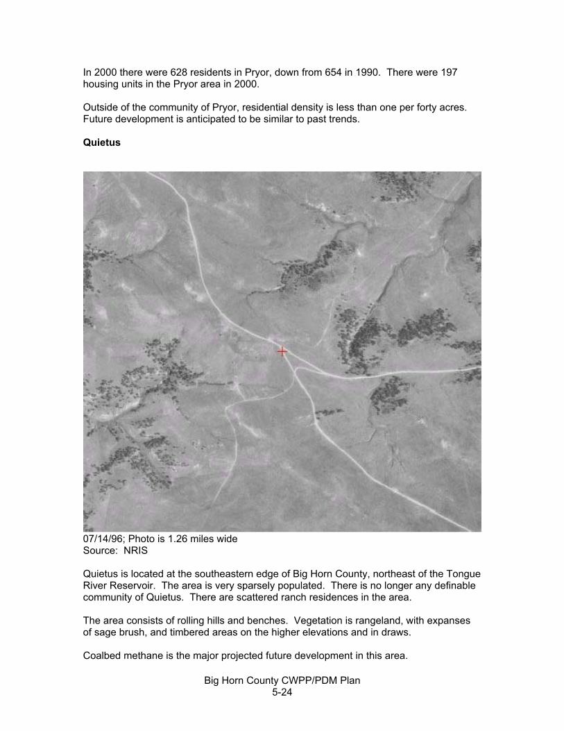
Big Horn County CWPP/PDM Plan 5-24
In 2000 there were 628 residents in Pryor, down from 654 in 1990. There were 197 housing units in the Pryor area in 2000. Outside of the community of Pryor, residential density is less than one per forty acres. Future development is anticipated to be similar to past trends. Quietus
07/14/96; Photo is 1.26 miles wide Source: NRIS Quietus is located at the southeastern edge of Big Horn County, northeast of the Tongue River Reservoir. The area is very sparsely populated. There is no longer any definable community of Quietus. There are scattered ranch residences in the area. The area consists of rolling hills and benches. Vegetation is rangeland, with expanses of sage brush, and timbered areas on the higher elevations and in draws. Coalbed methane is the major projected future development in this area.
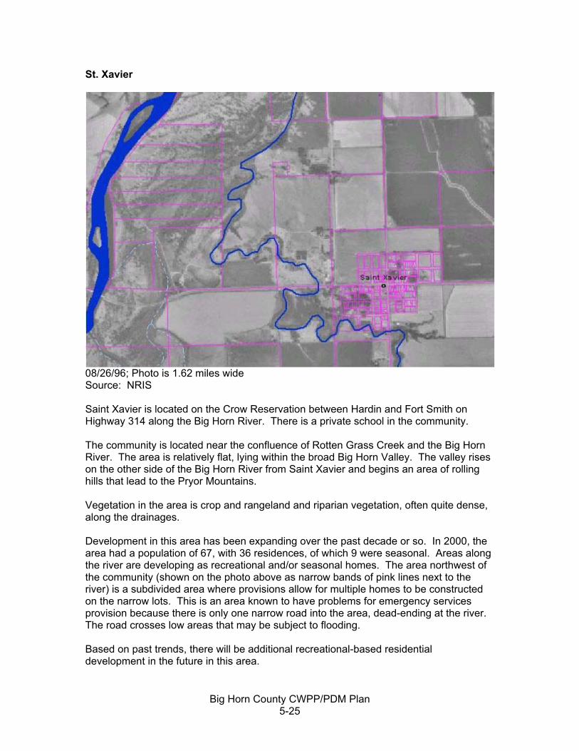
Big Horn County CWPP/PDM Plan 5-25
St. Xavier
08/26/96; Photo is 1.62 miles wide Source: NRIS Saint Xavier is located on the Crow Reservation between Hardin and Fort Smith on Highway 314 along the Big Horn River. There is a private school in the community. The community is located near the confluence of Rotten Grass Creek and the Big Horn River. The area is relatively flat, lying within the broad Big Horn Valley. The valley rises on the other side of the Big Horn River from Saint Xavier and begins an area of rolling hills that lead to the Pryor Mountains. Vegetation in the area is crop and rangeland and riparian vegetation, often quite dense, along the drainages. Development in this area has been expanding over the past decade or so. In 2000, the area had a population of 67, with 36 residences, of which 9 were seasonal. Areas along the river are developing as recreational and/or seasonal homes. The area northwest of the community (shown on the photo above as narrow bands of pink lines next to the river) is a subdivided area where provisions allow for multiple homes to be constructed on the narrow lots. This is an area known to have problems for emergency services provision because there is only one narrow road into the area, dead-ending at the river. The road crosses low areas that may be subject to flooding. Based on past trends, there will be additional recreational-based residential development in the future in this area.

Big Horn County CWPP/PDM Plan 5-26
Issues for this area include seasonal residents who may not be present during fire situations, and who may be less aware of fire danger than long-term residents. Wyola
08/08/96; Photo is 1.25 mile wide Source: NRIS Wyola is located on the Crow Reservation west of Interstate 90, between Lodge Grass and the Wyoming border. The Little Big Horn River flows from the southwest to the northeast through the area. The town lies in the flat area of the river valley. Rolling hills edge the valley. Vegetation is primarily range, with some crop production, and riparian vegetation, often quite dense along the river and the drainages. Wyola had 186 residents and 57 housing units in 2000. Outside of the community, housing density is less than one per 40 acres. There are no known major developments anticipated for the future.

Big Horn County CWPP/PDM Plan 5-27
Muddy Cluster
09/10/96; Photo is .62 miles wide Source: NRIS Muddy Cluster is located on the Northern Cheyenne Indian Reservation on Highway 212 between Busby and the Rosebud County line. Muddy Cluster is a residential area with housing for tribal members. Muddy Cluster is an area of rolling hills, near the base of the western side of the “Lame Deer Divide.” The hills are forested with some expanses of range grass in the flatter, lower areas. Rosebud Creek flows from southwest to northeast just north of the area (just outside the area of the photograph above). The population of the Muddy Cluster area was 627 in 2000, up more than 60 percent from 1990. There were 160 housing units in the Muddy Cluster area in 2000. Of this total, approximately 58 were in the Muddy Cluster tribal housing area (shown above in 1996), as reported in the Wildfire Hazard Assessment and Mitigation Plan for Lame Deer and Muddy Cluster.

Big Horn County CWPP/PDM Plan 5-28
Past trends for this area indicate land use to remain similar to existing uses. Issues for Muddy Cluster include the proximity of woody vegetation to residences, lack of reliable and adequate water supply (water storage capabilities), and distance from structural fire responders. Rosebud
06/13/96; Photo is 1.38 miles wide Source: NRIS Rosebud is located on the Northern Cheyenne Reservation on Highway 212 approximately halfway between Busby and Muddy Cluster. There are about 5 or 6 homes on each side of the road.

Big Horn County CWPP/PDM Plan 5-29
Pine Ridge Area
08/26/96: 2.06 miles wide Source: NRIS The Pine Ridge area is located north of Hardin. The area is comprised of large ranches. There are no subdivisions or areas with housing units at densities greater than one per 320 acres in the general vicinity. The area consists of rolling to steep hills with range and timber (similar to the photo above). The area was identified as an area of concern for build-up in timber fuel/slash. Portions of some county roads in this area are steep and may have other issues that make it difficult for access by fire-fighting equipment. For example, there are some areas where a water tender couldn’t probably go without assistance. There are no anticipated major future developments in this area.
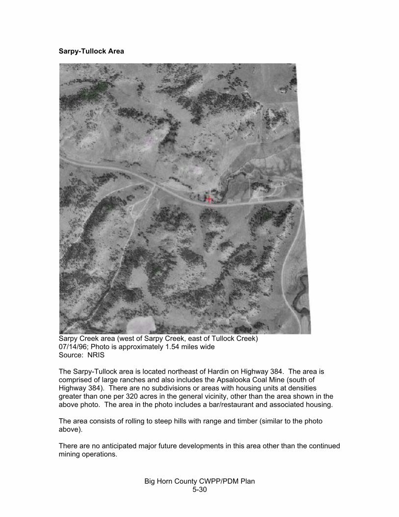
Big Horn County CWPP/PDM Plan 5-30
Sarpy-Tullock Area
Sarpy Creek area (west of Sarpy Creek, east of Tullock Creek) 07/14/96; Photo is approximately 1.54 miles wide Source: NRIS The Sarpy-Tullock area is located northeast of Hardin on Highway 384. The area is comprised of large ranches and also includes the Apsalooka Coal Mine (south of Highway 384). There are no subdivisions or areas with housing units at densities greater than one per 320 acres in the general vicinity, other than the area shown in the above photo. The area in the photo includes a bar/restaurant and associated housing. The area consists of rolling to steep hills with range and timber (similar to the photo above). There are no anticipated major future developments in this area other than the continued mining operations.

Big Horn County CWPP/PDM Plan 5-31
RISK ASSESSMENT Big Horn County overall has a high risk of wildfire occurrence and evidenced by the average of approximately 100 or more fires that most of the wildfire agencies in the county respond to each year. The CWPP committee identified the common causes of fires in Big Horn County at the PDM-CWPP meeting on March 31, 2005. These included: Human Sources
• Arson • Railroad-related fires • Fireworks • Machinery • Power Line sparks • Debris Burning • Cigarettes and other flammables from along roadways • Winter home heating (e.g., wood stoves and dumping ashes)
Natural Sources
• Lightning • Natural combustion (e.g., on haystacks)
Although statistics are not readily available for the entire county, information for the Crow Indian Reservation, of which 90% is within Big Horn County, indicates that human-caused fires account for about 80% of all fires. Human causes include arson, debris burning, miscellaneous (including fireworks), equipment use, railroad fires, children-caused fires, smoking related fires, and campfires. The other 20% are caused by lightning. (Fire Management Plan and Collins) The ratio of human-caused ignition sources to natural ignition sources is high compared to the state of Montana as a whole. The Montana Department of Natural Resources and Conservation (MDNRC) data for fire starts from 1994 through 2003 show 53% of wildfires were started by lightning. Other major human caused ignition sources were debris burns (13%); campfires (10%); railroad starts (3%); and equipment caused fires (3%). (State of Montana Multi-Hazard Mitigation Plan) Most of the human-caused fires are in an area described as “Fire Alley.” The Fire Alley corridor runs along Interstate 90 south of Hardin, along Highway 212 east of Crow Agency, and on Highway 1 west of Crow Agency. Fire Alley includes the at-risk communities of Benteen, Hardin, Crow Agency, Dunmore, Garryowen, Lodge Grass, Wyola, Muddy Cluster, Rosebud, and Busby. Approximately 55% of all fires between 1987 and 1996 on the Crow Reservation were in Fire Alley, a trend that continues at present. (Fire Management Plan and Collins) Fireworks are sold year-round on the Crow Indian Reservation, but are prohibited on the Northern Cheyenne Reservation. In subsequent interviews with fire agency personnel, one person pointed out there are “gangs of kids setting fires in our communities, with matches or fireworks.” Fires started by children do not typically result in measurable amounts of burned areas, but they can take up considerable time for responders.

Big Horn County CWPP/PDM Plan 5-32
Arson was identified as a significant issue at the PDM-CWPP meetings. In one year in the town of Lodge Grass and vicinity, there were 72 arson fires (Redden). Participants in the PDM-CWPP meetings pointed out that abandoned vehicles, and vacant and abandoned homes are particular targets of arsonists. Railroad fires accounted for approximately nine percent of all fires on the Crow Indian Reservation. The Big Horn County Fire Department alone responded to 20 railroad fires in 2003. Participants in the CWPP process indicated that the railroad does not maintain the rights-of-way next to the rail lines. There are two rail lines in the county, one that parallels Interstate 90, and a spur line that extends north from Wyoming into the coal fields around Decker in the southeast corner of the county. Fires started by equipment or machinery accounted for less than five percent of all fires on the Crow Reservation between 1987 and 1996. These few fires accounted for nearly 40% of all the acreage burned during the same period. CWPP participants indicated that equipment includes farm equipment as well as other types of equipment used in the field, such as equipment for other industries, such as oil and gas and other. Debris burning has been a considerable issue in the past, accounting for approximately 20% of all fires on the Crow Reservation. Big Horn County adopted a burn permit policy approximately two years ago. Debris and prescribed burns (e.g., burning field stubble) are prohibited in the county unless permitted in advance. The Big Horn County Fire Department indicates that although change was slow at first, now that county residents are aware of the policy and its enforcement, it has made a significant difference. Lightning is a major source of ignition in Big Horn County. It is not uncommon for the county to receive as many as 900 lightning strikes in a 24-hour period during the thunderstorm season (June-August). Lightning strikes are most likely in the higher elevations—the Pryor, Big Horn, and Wolf mountains, and also in the Pine Ridge and Sarpy-Tullock areas. (Redden) Each of the identified at-risk communities has a generally high risk of human-caused ignitions, and a medium to high risk of lightning-caused ignitions. Although lightning caused fires are more likely in the higher elevations, lightning-caused fires can occur just about anywhere in the county. HAZARD ASSESSMENT CWPP participants at the PDM-CWPP meeting on March 31, 2005 identified a variety of wildfire hazards:
• Railroad • Muddy Cluster area (homes in timbered area—less of a hazard since initiation of
fuel reduction efforts) • Homes in the country – these can be difficult to locate or access • Timbered areas throughout the county (including North Valley, Pine Ridge
timbered areas, hilly timbered areas of the Northern Cheyenne Reservation, narrow canyon of the Little Horn on the Crow Reservation)
• Power Lines

Big Horn County CWPP/PDM Plan 5-33
• River Bottoms (with cottonwoods, riparian vegetation, and increasing number of homes)
• Junk vehicles with fuel • Bulk fuel storage—propane tanks • Gas Lines • Dilapidated structures (mentioned as a particular problem for Lodge Grass) • Unmanaged fuels (properties where weeds, other fuel sources become a
hazard—this includes highway and railroad rights-of-ways The group then created a short list of hazards and prioritized those using dots as “votes.” The following is the short list and the numbers reflect the number of votes for each hazard type.
• Forested Areas (10) • Un-managed Fuels (16) • River bottoms (4) • Fuel Storage (0) • Power Lines (2) • Gas Lines (0)
Figure 5.2 displays some of the hazards in the county as well as areas particularly subject to lightning strikes. The coal mines are shown on the map because they also have potential for fire.

Big Horn County CWPP/PDM Plan 5-34
Figure 5.2 Mines, Railroads, Pipelines, Major Transportation Routes, and Mountain Ranges

Big Horn County CWPP/PDM Plan 5-35
Vegetative Fuel Hazards The intensity of a wildfire is dependent on the likelihood of ignition in combination with the amount and complexity of the vegetative fuels and weather conditions. This section describes the vegetative conditions and types in Big Horn County, primarily utilizing information from the Fire Management Plan for the Crow Indian Reservation and from the Wildfire Hazard Assessment and Mitigation Plan for Lame Deer and Muddy Cluster. Fire regime condition class is used to describe vegetative fuels. The condition class system describes vegetation in terms of historical disturbance regimes, such as fire, insects, disease, blow down, and flooding. Disturbances are a natural part of the ecosystem and departures from the historical disturbance regimes can influence the severity of wildfire. In the condition class rating system, a higher rating indicates an increasingly significant the departure from the natural regime of vegetation characteristics as described below: Condition Class 1 Fire regimes are within an historical range and the risk of losing
key ecosystem components is low. Condition Class 2 Fire regimes have been moderately altered from their historical
range. The risk of losing key ecosystem components is moderate. This results in moderate changes to one or more of the following: fire size, intensity and severity, and landscape patterns. Vegetation attributes have been moderately altered from their historical range.
Condition Class 3 Fire regimes have been significantly altered from their historical range. The risk of losing key ecosystem components is high. Fire frequencies have departed from historical frequencies by multiple return intervals. This results in dramatic changes to one or more of the following: fire size, intensity, severity, and landscape patterns. Vegetation attributes have been significantly altered from their historical range.
Based on mapping prepared for the entire United States, Big Horn County is predominately in Condition Class 1. Areas to the west and southwest (Big Horn and Pryor Mountains) and to the southeast (Wolf Mountains and prairie south of the Northern Cheyenne Reservation) are generally classified as Class 2 with some limited areas of Condition Class 3. The mapping on which this information is based was general in nature, and may not accurately reflect conditions in specific locations—for that more detailed information is necessary. (State of Montana Multi-Hazard Mitigation Plan) Western Montana has been mapped in detail for fire regime condition classes, but eastern Montana does not yet have this completed. Finalizing these maps for Big Horn County and using them to identify areas with high potential for significant fire disturbance could be an important tool for Big Horn County to consider in identifying and targeting wildfire mitigation projects in the future. Rangeland Type The Rangeland area is characterized by a continuous perennial grass fuel type, dissected by riparian vegetation along the rivers and drainages and areas of cropland. Approximately 90% of all fires on the Crow Reservation are within this vegetation type.

Big Horn County CWPP/PDM Plan 5-36
The Rangeland Fuel Type includes all of the at-risk communities except Kirby and Muddy Cluster. Mountain Type Vegetation Wolf and Sarpy Mountains These mountain areas are characterized by a mixture of ponderosa pine lands and savannahs, with interspersed grass, brush, slash, and aspen stands. Fuel loadings vary greatly from pine litter and grass to old harvest areas, bug killed patches of timber, and blowdown in some areas. Slopes are moderate to steep. The Sarpy area has very steep rock slopes that form natural fire breaks. The Ponderosa pine stands in the Wolf Mountains are being invaded by heavy thickets of hawthorn. Approximately 5% of all fires on the Crow Reservation were within these areas. This area includes the communities of Muddy Cluster and Kirby. Pine Ridge Area The Pine Ridge area is similar to the Wolf and Sarpy mountains with ponderosa pine lands and savannahs. Average annual precipitation is less than in the Wolf Mountains and therefore there is less heavy brush. The area is not quite as steep and has fewer natural fire breaks than in the Sarpy area. Big Horn and Pryor Mountains This area is characterized by dense stands of overmature and bug-killed lodgepole pine on the tops of the Pryors and dense, overmature stands of spruce and fir in the Big Horns. Open fields of grass and sage with scatter clumps of ponderosa pine and limber pine are interspersed in the heavy timbered areas. Once leaving the lowlands or flat plateau, slopes in the area can exceed 100%. Lack of access from slopes and lack of roads, causing long response times, combined with a heavy fuel loading hampers fire fighting efforts. Approximately 6% of all fires on the Crow Reservation are within this area. Structural Fuel Hazards The type of structures, location (in proximity to wildfire fuels), and type of construction are important considerations for assessing structural fuel hazards. Outside of existing communities, structures in Big Horn County that could be affected by wildfire include residences, recreation and historic facilities operated by the state of Montana or the federal government (e.g., Chief Plenty Coups State Park, Rosebud Battlefield, Little Big Horn Battlefield National Monument, Tongue River Reservoir, Big Horn Canyon National Recreation Area), farming and ranching operations, power lines, pipelines, communication facilities, and oil, gas, and mining operations. There are few other types of commercial or industrial operations outside of existing communities. The CWPP team identified communications facilities (such as repeater towers) as important for general day-to-day activities in the county, but especially important for emergency situations. Bulk fuel storage was also identified as a structural fuel hazard.

Big Horn County CWPP/PDM Plan 5-37
There is little pattern or grouping to structural fuel hazards outside of the existing communities other than proximity to travel corridors (interstate, highways, roads). In 2000, there were 4,655 housing units in Big Horn County, of which 1,925 (41%) were outside of defined community areas. There are no major subdivisions in Big Horn County and tribal housing developments typically fall within the 3 mile boundaries of identified at-risk communities. The CWPP team indicated that housing outside of existing communities can generally be found within one-half mile of the major roadway corridors and along the Big Horn River. Outside of existing communities, the major roadway corridors and the Big Horn River area, the overall density of development in Big Horn County is generally less than one housing unit per square mile. The vulnerability of structures to fire is dependent in part on what they are made of and how they are constructed. The Montana Department of Commerce CAMAS (Computer Assisted Mass Appraisal System database) provides information on type of housing, condition, age, and materials for houses on taxable property. This information therefore does not include information on tribal housing or housing owned by tribal members on land that is not in the state’s taxable system. The Crow Indian Tribe was conducting a Wildfire Hazard Assessment for structures throughout the reservation at the time this CWPP was being developed. The Northern Cheyenne completed such an assessment for the Lame Deer and Muddy Cluster areas in 2002. The CAMAS data indicates there was a total of 3,118 housing units in Big Horn County on taxable properties in 2004. Of these 1,176 (38%) were identified as mobile homes, of which 63% were pre-1980 construction. Of the 1,942 single on-site constructed homes (not mobile homes), 92% had frame wall construction. Of ten different exterior finish types for on-site constructed homes, most (47%) had wood siding or sheathing as the exterior wall finish and the second largest group (12%) had asbestos siding. Roof type was predominately asphalt shingles for both mobile homes and on-site construction—54% had asphalt shingles, 27% had metal roofs, and about 10% had wood shake or wood shingles. According to the U.S. census, which includes all properties in Big Horn County, 20% of the total 4,655 homes in Big Horn County in 2000 were mobile homes. Approximately 9% of all housing units lacked telephone service and 29% were heated with bottled tank or LP gas. Unique Wildfire Severity Factors There are a number of unique factors that can contribute to the probability of increased fire ignition and/or extreme fire behavior. Difficult Terrain. The Pryor, Big Horn, Wolf, Sarpy, and Pine Ridge areas all have areas of steep and rugged terrain. Many areas are not easily accessed by roads. Weather: The county has been in severe drought for the past 7 or 8 years, broken only by the wetter weather of 2005. The county has high winds and significant lightning. Winds can be erratic.

Big Horn County CWPP/PDM Plan 5-38
Long fire seasons: The fire seasons are long in Big Horn County. The fire season on the Northern Northern Cheyenne Indian Reservation is from March 12 through Oct 17, and on the Crow Indian Reservation it is from February 10 through May 10 and May 31 through November 6. Lack of water for fire suppression: Only a few of the identified at-risk communities have public water supplies and even in these locations, quantity and reliability can be an issue. Outside of the communities, water sources are typically from stock ponds (which have been at reduced capacity over the past several years of drought) or from rivers and streams, many of which are intermittent in Big Horn County and may not have much if any flow. For those with adequate flow, boggy terrain and dense brushy vegetation can impede or preclude access to the water. Problems with fuel build-up on unmanaged properties: Participants in the CWPP-PDM meetings specifically referenced problems with properties with weeds, junk, abandoned vehicles, abandoned homes, and unmowed areas around residences. These were mentioned as specific problems in Lodge Grass and Wyola. This was also brought up as an issue by the town council members of the town of Lodge Grass in a July 28, 2005 meeting. Structural and vehicle fires spreading into wildfires: In part because of problems with unmanaged fuels in some of the communities, there is potential for structural fires to create wildfires. (Fire Management Plan) Wildland fuel build-up and vegetation stress. There are areas with slash, blowdowns, and diseased timber. In addition, vegetation is stressed due to prolonged drought, and even with the rains from 2005, trees and shrubs are not back to pre-drought conditions. Response Time: Response time could be several hours after the start of a fire. This is true for naturally caused fires, such as lightning strikes, because the fire may start in a remote location. Even in cases where a person might be present, such as in the case of a machine-caused fire, it could take some time before the person is able to report it (e.g., the time it would take to get within an area with cell phone or land-line communication access). Once reported, it could take up to one to two hours for responders to arrive. High rate of human-caused fires: As noted in the Section on “Risk of Wildfire Occurrence,” the rate of human-caused fires is high compared to the state of Montana overall. Increasing numbers of seasonal homes: Particularly along the Big Horn River. Increase in energy development traffic: This includes increase of coalbed methane development traffic, and traffic between the Apsalooka Mine and Hardin for coal deliveries to the power plan. Lack of building codes outside of zoned areas. There is no regulatory mechanism to address building standards for fire prevention purposes.

Big Horn County CWPP/PDM Plan 5-39
VALUES TO BE PROTECTED One of the purposes of the CWPP and fire protection in general is to protect values at risk. A successful fire management program would be one that reduces risks associated with values important to the communities and residents of the county. Some of the values at risk in Big Horn County are:
• Value of health and safety • Economic values • Value of natural resources and ecosystem health • Social values
Value of Health and Safety Wildfires pose risk to firefighters and the public. The risks to firefighters are obvious—death, injuries, problems from smoke inhalation, exhaustion, etc. For the public not actively participating as a firefighter, there is potential for injury, illness (e.g., heart attack), or death as people work to protect or evacuate from their homes, and from smoky conditions which can cause or exacerbate respiratory problems. Economic Values Economic losses can be considerable from a wildfire. There are potential direct economic losses—the business facility that may burn, the livestock that may die, the crops that may be destroyed. Indirect impacts after a fire is suppressed could include increase of weedy species that affect range production, mud flow damage to structures, roads, bridges, and public water supplies. In Big Horn County, key economic factors include:
• Agriculture: farming and ranching—Big Horn County is one of the state’s top-ranking agricultural producers
• Mining: 3 coal mines • Oil and gas: throughout the county, with development of coalbed methane gas
on the verge of a major expansion • Power Production. The Yellowtail Dam is a major producer of hydroelectric
power. A new coal-fired power plant is being developed in Hardin. • Tourism/Recreation: The Big Horn River is a world-class trout fishery. A number
of outfitters (local and from throughout Montana) host fishermen along the Big Horn River. Hunting is also important—outfitters often provide both fishing and hunting opportunities. The Big Horn Canyon Recreation Area, Tongue River Reservoir, the Big Horn Battlefield National Monument, and other outdoor and cultural sites attract hundreds of thousands of visitors per year to Big Horn County.
• Community Infrastructure o Power corridors o Communication sites/facilities o Transportation corridors o Community water supplies and distribution systems

Big Horn County CWPP/PDM Plan 5-40
o Hospitals and healthcare facilities o Local and tribal government operations, including law enforcement and
emergency services • Personal and real property of county residents and landowners
Wildfire could affect any of the above economic factors, creating ripple effects in the economy. Value of Natural Resources and Ecosystem Health Big Horn County has diverse natural resources, from the mountainous terrain of the Pryor, Big Horn, and Wolf Mountains and the Sarpy and Pine Ridge areas to the broad savannah and prairie areas. Generally air quality is good to excellent. The Northern Cheyenne Reservation is a Class 1 airshed, the most pristine designation of the three designations of air quality established under the Clean Air Act of 1970. The rest of the county is designated Class 2. The county provides habitat for diverse wildlife, including migratory species. The county has a number of major water resources (e.g., Big Horn River and associated Big Horn Lake, Little Big Horn River, Tongue River and Tongue River Reservoir) that provide drinking water for various communities (either directly or via wells to the alluvial aquifers) and also provide habitat for cold and warm water fisheries. Some factors to consider include the immediate impacts of the fire as well as those that may occur later due to lack of vegetation or other ground disturbance. For example, if heavy rains follow a major fire in steep terrain, other natural disasters can occur, including landslides and mudflows. Once ground cover has been burned away, little is left to hold soil in place on steep slopes and hillsides. Wildfire is part of a natural historic disturbance system. The following is excerpted from the Montana Multi-Hazard Mitigation Plan:
Wildland fire is part of the natural ecological process of many ecosystems. The effects of fire can retard or accelerate the natural development of plant communities, alter species diversity, change nutrient flows, and interact with other physical, chemical, and biological systems. Without wildland fires, the ecological health of many forests, rangelands, and wilderness areas decline.
(State of Montana Multi-Hazard Mitigation Plan) Social Values Social values encompass those attributes which make a place particularly meaningful or important to an individual or a community over and above the economic value. There are strong social values tied to Big Horn County—it is the home of two Indian nations—the Crow and Northern Cheyenne; it has considerable focus for the history of the American West (including the site of Custer’s last stand at the battle of the Little Big Horn); it is the home for many farmers and ranchers who make their livelihood from the land; and it is increasingly (albeit considerably more slowly than other parts of Montana) becoming a destination for second homes and vacation residences.

Big Horn County CWPP/PDM Plan 5-41
Social values for Big Horn County include:
• Importance of cultural and historic sites • Importance of personal rights, including personal property rights and privacy • Importance of natural resources—for aesthetics (views), for ecosystem health,
and for livelihood (agriculture and natural resource extraction), and for recreation (hunting, fishing, berry-picking, etc.)
Key Values for Big Horn County Participants at the CWPP meeting identified specific key values and resources that should be considered in wildfire situations, including mitigation and suppression. The following items are in the priority order placed by persons present at the CWPP meeting in July 2005:
1. Health and safety of the public and firefighters. This is the number one concern—making sure that people are not hurt or injured by wildfire or wildfire suppression efforts.
2. Real property, public and private infrastructure. Protecting homes, public places
(schools, etc.), businesses (including oil, gas, power generation, livestock and farming operations, and others), is critical in Big Horn County.
3. Cultural and historic sites. Big Horn County is rich in history with many
documented sites. Firefighters, landowners, and long-time residents (including the Crow and Northern Cheyenne) are knowledgeable of the importance of these sites and work to reduce impacts and damage from wildfire.
4. Cropland, grazing land, and harvestable timber. Farming and ranching constitute
the primary land use in the county. There is some limited timber harvest. Maintaining existing land use is important to the character and economy of the community.
5. Recreation and other economic factors. The recreation-related resources are not
only an important part of the long-term and historic use of the land, but an important part of the economy as well. These resources include the rivers, lakes, and reservoirs, and wildlife habitat areas.
ASSESSMENT OF FIRE PROTECTION PREPAREDNESS AND CAPABILITY Community Preparedness for Wildfire Protection Emergency preparedness in Big Horn County for wildfire situations has been improving over the past few years. The biggest gains have been in improved communication among the ten different responders in the county and with the coal, oil, and gas industries which also work to suppress fires. For example, Fidelity Exploration has been working with the County Fire Department on developing maps of the water resources in the areas being explored by Fidelity. Although there is no organized group for all fire responders in the county, the Big Horn County fire department, County DES Coordinator, and others share information about training sessions to be held locally and

Big Horn County CWPP/PDM Plan 5-42
throughout the state. Responders from Big Horn County who attend the training sessions use time there to review issues in the county with each other. (Redden) Generally, agencies seemed comfortable with the level of coordination among departments. The various fire departments are at various stages in terms of emergency and fire management planning and implementation. Both the Crow and Northern Cheyenne have fire management plans. The Northern Cheyenne completed a wildfire hazard assessment and mitigation plan for Lame Deer and Muddy Cluster in 2004. The national historic and recreation areas have fire management strategies, as do the coal, oil, and gas companies. Big Horn County Fire Department does not have an active plan and this CWPP will function as the mitigation plan for the county’s fire department. Generally speaking, long-term county residents and commercial operations are aware of potential fire danger and take precautions to avoid wildfire situations. The coal mines have their own fire protection plans and resources (and can and do assist when possible on other fires). The level of preparedness for individual property owners is not well known. There was some concern expressed by firefighters that property owners could benefit from training on how best to respond to fire, such as in cases where a farmer or rancher may be the first one on-site to a fire. County residents and landowners appear unevenly prepared in terms of firewise prevention methods. It is evident from a windshield survey and from comments at the CWPP meetings, that many residents are not active in developing defensible space around their homes and structures. Issues of unkempt properties, abandoned structures and abandoned vehicles were all identified at CWPP-PDM meetings.

Big Horn County CWPP/PDM Plan 5-43
Figure 5.3 Fire Department Locations

Big Horn County CWPP/PDM Plan 5-44
Fire Protection – Responder Capabilities Historic Workload The capabilities of the different responders to respond to structural and wildland fires is shown in Table 5.3, which was developed using information provided by the firefighters. Of the 10 different responders in the county, seven are equipped to fight structural fires, and three are equipped only for wildland fire. Table 5.3 Fire Protection Response Capability Department Structural ISO
Rating Ability to Respond to Grass Fires
Ability to Respond to Timber Fire
Average # of Responses/Year
Big Horn County 10 not fully staffed for structural
1 (once on site)
1 (once on site)
Grass/wildland fires:100-200 or more Structure fires: 10-30 (includes vehicle fires)
BIA Forestry-Fire Management (Crow)
NA 3 4 100 or more
Crow Agency Volunteer Fire Department
10 3 8 30
Fort Smith Volunteer Fire Department
Unknown 4 7
Hardin Volunteer Fire Department
6 6 Don’t have special grass fire equipment
NA No such areas near Hardin
10 grass fires 5 structure fires
Lodge Grass Volunteer Fire Department
10
1 (once on site)
5 (once on site)
50 grass fires 8-10 structure fires
National Park Service NA 3 NA Very little timber in the north end of the Big Horn Canyon National Recreation Area
2-4 (2003-2005)
Northern Cheyenne Fire and Aviation (BIA)
NA 1 3 175 fires in 2004
Northern Cheyenne Tribal Fire Department
6 (but hasn’t been updated in 3 years)
5 5 100-150 all fire types 30-40 structure fires per year, 100-120 car wrecks/fires per year
Northern Cheyenne Tribal Schools
Unknown 1 7 10
Source: Various fire department personnel

Big Horn County CWPP/PDM Plan 5-45
Notes: Ratings for ability to respond to grass and timber fires were based upon a scale of 1-10 with 1 being very able to respond, and 10 being unable. ISO Rating: Insurance premiums are based on a rating system established by the Insurance Services Office (ISO). The ISO considers the water system and fire protection of a community when issuing a rating. The rating system contains ten protection classifications. Class One is the best rating a community can receive. Class Ten is the lowest, meaning the ISO recognizes little if any ability to provide fire protection. The ratings in Table 5.3 are based on the Insurance Services Office (ISO) rating system, which ranges from 1 to 10, with one being the best capability and 10 being the lowest capability. The firefighters scored themselves higher on their ability to fight wildland fire than on their ability to respond to structural fires. There are a number of factors that contribute to the lower ratings for structural fires. These include difficulty in recruiting and retaining volunteers in many of the volunteer fire departments which are primarily charged with structural fires, and lack of sufficient water supply for fire suppression. Some of the fire departments did not know what their ISO structural rating was. ISO ratings are listed by communities and some communities are simply not listed (such as Fort Smith and Busby). The number of responses that result in actual fire suppression (as opposed to false alarms) is shown in the last column of Table 5.3. Big Horn County, and the Crow and Northern Cheyenne departments responsible for wildland fire, each typically respond to more than 100 wildfires in a year (although more than one department may respond to the same fire). Arson-related fires can significantly increase the workload and can be particularly troublesome for the units that fight structural fires. In Lodge Grass, several years ago, there were 38 structure fires in three months, and once there were five fires in one night. In some cases, fires were extinguished, only to have the same structure reignited three or four times. (Miller, Sr.) Busby also had problems with arson, which decreased substantially after the high school burned down several years ago. Several participants in the CWPP process indicated that arson fires are cyclical—once an arsonist is caught, the number of fires can decrease considerably. Statistically, the proportion of arson and youth-started fires continues to be much higher in Big Horn County compared to the state as a whole. Qualifications/Experience Table 5.4 shows the various departments, location of equipment, and number of paid and volunteer firefighters. Volunteer fire departments across Montana are finding it increasingly difficult in general to recruit and retain firefighters. This was particularly mentioned as a problem for Busby, Lodge Grass, and Crow Agency volunteer fire departments. Busby (Northern Cheyenne Tribal Schools) currently has three volunteers. Lodge Grass had 28 firefighters at one time, but now has 13 on call, but distance and other commitments may mean that only one or two can actually respond to a fire. Generally, the qualification of the firefighters throughout the county is high. All of the persons responding to any fire have received training. There are hundreds of trained wildland firefighters in the county, and most are Crow or Northern Cheyenne. These firefighters, referred to as Montana Casual Firefighters, are paid on an on-call basis and entire crews may be called for duty anywhere in the country.

Big Horn County CWPP/PDM Plan 5-46
Table 5.4 Summary of Fire Agency Capabilities and Staff Department Area Covered Equipment
Locations Capabilities Paid Staff Volunteers
Big Horn County Fire Department
Entire county Hardin Decker Kirby Lodge Grass Lodge Grass Creek (West of Lodge Grass) Dry Creek Tullock Pine Ridge
Structural Fire Wildland Fire
17 FTE (county road staff—collateral fire duties)
4 in Decker 8 in Sarpy
BIA Forestry-Fire Management: Crow Indian Reservation
Crow Indian Reservation
Crow Agency and Pryor
Wildland Fire 20 0 (but there are approximately 200 trained firefighters available for paid on-call as Montana “Casual” Firefighers)
Crow Agency Volunteer Fire Department
5 mile radius around Crow Agency (primarily a corridor extending from the Dunmore exit to the Garryowen exit along I-90)
Crow Agency Structural Fire Wildland Fire
0 6
Fort Smith Volunteer Fire Department
5 mile radius around Yellowtail Government Camp (Fort Smith)
Yellowtail Government Camp (Fort Smith)
Structural Fire Wildland Fire
0 20
Hardin Volunteer Fire Department
City of Hardin Hardin Structural Fire 0 20
Lodge Grass Volunteer Fire Department
From Reno Creek (south of Highway 212) to Wyoming border
Lodge Grass Structural Fire Wildland Fire
0 13
National Park Service
Big Horn Canyon National Recreation Area
Yellowtail Government Camp (Fort Smith)
Wildland Fire 16 (all are regular staff with collateral fire duties)
0
Northern Cheyenne Fire and Aviation (BIA)
Northern Cheyenne Indian Reservation
Lame Deer Wildland Fire 11-12 FTE 20-24 Seasonals
0 (but many available for paid on-call as Montana “Casual” Firefighters- similar to Crow)
Northern Cheyenne Tribal Fire Department
Northern Cheyenne Reservation
Lame Deer Structural Fire Wildland Fire
2 FTE 13 part-time/seasonal
Northern Cheyenne Tribal Schools
Busby Busby Structural Fire Wildland Fire
0 3
Source: Various Departments

Big Horn County CWPP/PDM Plan 5-47
Resources Resources used to provide fire protection include staffing (paid and volunteer), equipment, financial/funding, and other non-financial resources—such as cooperating partners. Resource Needs When asked what, if any, additional resources were needed, participants at the meetings and fire staff/volunteers interviewed over the phone indicated the following:
• Water sources to fight fire • More trained volunteers (for the volunteer fire departments and various areas
around the county). Big Horn County is currently completing a new fire hall at Sarpy to house equipment, but has put a hold on plans for similar fire halls in other locations because it doesn’t make sense to build the structures if there aren’t enough volunteers to man them.
• More staff (or other resources) to get information out into the community. Help is needed to initiate firewise programs, to disseminate information to reduce fire start and spread; provide more outreach to youth about the need to reduce fire starts; and help with recruiting volunteers.
Cooperating Partners/Agencies The county has a number of resources to draw from to respond to fires, including assistance from other agencies and from neighboring counties. This help is critical because of the geographic extent of Big Horn County and the scattered locations for equipment to serve the county. Responders from Wyoming (in the south part of the county), and from other counties in Montana may be first responders to a fire in Big Horn County. For example, Blue Creek Volunteer Fire Department in Yellowstone County may be able to respond faster to a fire in Pryor (in the northwest corner of the county) than the Big Horn County structural team that would be coming from Hardin. The following provide assistance to Big Horn County as they can (and in turn, Big Horn County also provides assistance to them):
• Wyoming (mutual aid) • DNRC • BLM • Yellowstone County—various entities including
o Blue Creek Volunteer Fire Department o Lockwood Fire Department
• Rosebud County • Custer County • Treasure County
In addition, the coal mines and oil and gas industries work with the county to prevent and suppress fires. Fidelity Exploration (coal bed methane) is working with Big Horn County Fire Department to develop maps of infrastructure and water supply sources, including reservoirs being developed by Fidelity.

Big Horn County CWPP/PDM Plan 5-48
Equipment/Apparatus A list of the firefighting equipment and apparatus available in Big Horn County is included in Table 5.5. In addition, both the Crow and Northern Cheyenne have helipads that can be used as necessary by BLM and/or DNRC equipment. Generally, equipment was not cited as a need, it was more likely that firefighters would indicate, “It doesn’t make sense to get more equipment if we don’t have the trained personnel to operate it.” Equipment was specifically cited by two of the structural fire-fighting units in the county. The Lodge Grass Volunteer Fire Department (which basically operates with equipment from the county and DNRC), and the Northern Cheyenne Tribal Fire Department indicated that they could use more updated equipment. Some of the Northern Cheyenne Tribal Fire Department equipment is not included in Table 5.5 because it is so old it has been retired and is basically out of use. The Big Horn County Fire Department has equipment in various locations throughout the county. Figure 5.4 display county equipment locations. Fiscal With the exception of the Lodge Grass Volunteer Fire Department, which is entirely funded by voluntary contributions, all of the fire agencies in Big Horn County are funded in part or entirely by some type of government funding. DNRC and other grant funding sources have been used to purchase equipment and safety apparatus.

Big Horn County CWPP/PDM Plan 5-49
Figure 5.4 Big Horn County Equipment Locations

Big Horn County CWPP/PDM Plan 5-50
Table 5.5 Fire Equipment and Apparatus Fire Department/ Equipment Location
Description Capacities/Features
Big Horn County Hardin Type 3, Engine 10 1997 Fast-Attack 3500 HD 6.5L Diesel Engine
260 g tank with 40g foam; 100 gpm @150psi pump, 2 SCBAs w/4 spare tanks, 1400w generator, 7.5” skill saw, 2 portable 800w flood lights, PPV fan, 158gpmportable water pump; 100’ extension cord
Type 3, Engine 11 1997 Fast-Attack 300 HD 6.5L Diesel engine, 260 g tank with 40g foam, 100gpm@150psi, 1400w generator, reciprocating saw, 2 protable 800w flood lights, PPV fan, 158gpm portable water pump
Type 6, Engine 4 1995 F-350 7.3L Diesel engine; 250g tank w/foam, 26gpm@250psi, ms460 stihl 24” chainsaw, 600’ ½ booster hose
Type 6, Engine 5 1998 6.2 Diesel engine; 250g tank w/foam, 26gpm @250psi, 600’ ½ booster hose, ms460 stihl 24” chainsaw
Type 6, Engine 12 1996 460 gas engine, 250g tank w/foam, 26gpm @250psi; 600’ ½ booster hose, ms460 stihl 24” chainsaw
Type 5, DNRC 1995 Crew Cab, 390 gas engine; 500g tank, 300’ ¾ rubber booster hose, 300’ ¾ collapsible hose
Type 2, Tender 9 1992 Kenworth 425 Detroit; 4000g tank, 750gpm @ 60psi, manual monitor, 75’ 1” booster rubber hose, 100’ 1 ½” fire hose, 50’ 2” fire hose
Type 3, Tender 1 1997 F-700 Ford, 7.4L gas engine; 1600g tank, 200’ 1½”fire hose, 100’ 2” fire hose, 75’ of booster rubber hose, one 1500g portable tank, 158gpm portable pump, 1 SCBA & tank
Type 3, Tender 3 1997 F-700 Ford 7.4L gas engine; 1600g tank, 200’ 1½”fire hose, 100’ 2” fire hose, 75’ of booster rubber hose, one 1500g portable tank, 158gpm portable pump, 1 SCBA & tank
PPE PPE gear for wildland and structural fire for all fire personnel
SCBA 7-Iner-Spero’s w/45 min air cylinder; 1 Survive Air w/45 min air cylinder; 10 45 min spare air cylinders
Radios All county fire apparatus are equipped with mobile radios, All fire fighters have hand-held radios
Command Trailer Equipped with 100w radio, wireless computer, and satellite phone
Fuel Leak Apparatus On Tender #1, carry absorbent pads and socks to contain small fuel leaks
Fire Break Apparatus The County Fire and Road Department are the same, so there is access to 9 motor graders ranging from a Cat 114G to a 770BH John Deere, two dozers (a Cat D-6ML with a six way blade and an International TD8)
Type 4, Engine 1997 Fast-Attack 3500 HD, 6.5 L Diesel engine, 260g water, 40g foam, 2 SCBAs w/4 spare tanks, 12kPPV, chainsaw 14” bar

Big Horn County CWPP/PDM Plan 5-51
Type 4, Engine 19974 Fast Attack 3500 HD, 6.5 Diesel engine, 260g water, 40g foam, 2SCBAs w/4spare tanks, 1400w generator, 12kPPV, 158 gpm portable gas pump
Lodge Grass- county station
Type 6, Engine 2 1986 200 water tank, 18” Homelite chainsaw
Lodge Grass Creek Type 3, T-2 1989 multi fuel Hercules engine, 1000g water tank, 400gpm@120psi, 6x6
Lodge Grass-Fire Hall Type 3, T-6 1981 750g water tank, 132gpm@150psi Tullock (Holdings Ranch)
Type 3, T-2 1989 multi fuel Hercules engine, 1000g water tank, 400gpm @120psi, 6x6
Dry Creek Game Ranch
Type 6, DSL-823 1967 Jeep, 200g water tank, 26gpm pump, no two-way radio
Decker – Moorland Ranch
Type 3, T-7 1,000g water tank, 400gpm@120psi, 6x6
Decker- County Shop Type 5 1984 500g water tank, 150gpm @ 150psi Kirby – Taylor Ranch Type 6, DSL 817 1967 200g water tank, 26gpm pump, no two way
radio Pine Ridge –Wagon Box Ranch
Type 3, T-5 1000g water tank, 400gpm, 120psi, 6x6
BIA Forestry (Crow Indian Reservation)
Crow Agency Type 4, Engine 1999 International Navistar 4900, 750 gallons, 90gpm @150psi
Type 6X, Engine 2001 Ford F-450, 200g; 90gpm @150psi Type 6X, Engine 1997 Ford F-450, 200g; 90gpm @150psi Type 6X, Engine 2000 Ford F-450, 200g, 90gpm @ 150psi Type 7 1996 GMC, converted to utility truck for fuels
program, 75g capacity, 11gpm @ 150psi Helitack Truck 1999 Truck 1999 Chevrolet ¾ ton extended cab with long box Pryor Type 6X, Engine 2003 Ford F-550, 300g, 90gpm @150psi Type 4, Engine 2001 International Navistar 4900, 750g, 90gpm
@150psi Crow Agency Volunteer Fire Department
Crow Agency Pumper Truck 1974 Ford, 750gpm, 500g booster tank, various hose and nozzle types, 4 sets SCBA equipment, ladders, poles, and various equipment (power saws, axes, etc.)
Pumper/Tanker 2001 Pierce International, 1250gpm, 1000g tank, various hose and nozzle types, 4 sets SCBA equipment, ladders, poles, and various equipment (power saws, axes, etc.)
Rescue Truck 1983 GMC 1-Ton Rescue Truck with P.T.O Winch SCBA 6 sets of MSA 45’ HP; 4 sets of 30’ LP Hazardous Materials
Emergency Response Various including monitoring instruments and sampling equipment, PPE (Levels B& C) 2-6 sets of various types, decontamination equipment, absorbents and neutralizer, drum repair kit, oil-only spill response kit
Fort Smith Volunteer Fire Department
Yellowtail Type 2, Engine 1962 International, 300g, and 500gpm @150psi,

Big Horn County CWPP/PDM Plan 5-52
Government Camp - Fort Smith
foam eductor; 1,000’ 2½”hose, 500’ 1½” hose, 150’ 1” hose (booster reel), 4 SCBA (and 4 spare tanks)
Type 2, Engine 1978 Ford, 500g, 500 gpm @150 psi, 1,000’ 2½”hose, 500’ 1½” hose, 150’ 1” hose (booster reel), 4 SCBA (and 4 spare tanks)
Tender 600 g with pump Generators 70kw portable generator PPE 22 sets 7.5 oz Nomex jacket and pants PPE – wildland 22 sets SCBA 12 survivair 60 min (4500psi) and 14 spare tanks,
refill station for air tanks 5000 psi) Radios 9 hand held radios, 2 truck radios Fire shelters and
packs 20 sets
Level A Haz Mat Suits 3 Satellite phone 1 at field office Haz mat trailer (1) 25’ trailer Hardin Volunteer Fire Department
Hardin Pumper Truck 1999 Freightliner w 1250gpm Pumper Truck 1983 Ford with 1000gpm Tanker 1979 Chevrolet tanker truck, 2000 g Fire Bus 1982 Ford PPE 20 full sets Radios In all vehicles, 3 hand held portables, radio base
station in the fire hall Lodge Grass Volunteer Fire Department
Lodge Grass 3 county trucks 1 DNRC truck 1 Fast Attack Truck PPE 25 sets of wildland fire gear National Park Service
Yellowtail Government Camp
Flatbed Truck with Water Tank
500 gallon capacity
F350 Truck with tank and a pump
150 gallon capacity
Type 6 Engine 250 gallon capacity Water Pumper On a Trailer Personal Protective
Equipment 16 sets
Radios Motorola XTS-3000 (12 radios) Bendex King – 4 radios
Northern Cheyenne Fire and Aviation (BIA)
Lame Deer (3) Type 3, Fire Tender
Department has 3 of these, each with 750g capacity
Type 2, Fire Tender 1,000g capacity Dozer 750 Transporter for Dozer Road Grader

Big Horn County CWPP/PDM Plan 5-53
(8) Engines, Type 2-Type 6
Total of 8 engines ranging in type from 2 to 6
PPE Gear for 35 to 40 persons Radios 34 radios—Bendix Kings, digital Northern Cheyenne Tribal Fire Department
Lame Deer Ford F700 – Cabin Chassis with E-1 package
1,000g capacity, deck gear
F700 750g capacity Radios (2) digital , 12 analog PPE-wildland 10 sets PPE-urban 10 sets Northern Cheyenne Tribal Schools
Busby Type 2 Engine 2004 Pierce Contender IH Comm. Chassis, 1250gpm pump; 1000g tank, fully outfitted for structure protection and fire suppression. Incles a full complement of ladders, hose, SCBA, and accessories
PPE- structural 5 sets PPE- wildland 3 sets Radios 2 portable; 1 mobile SCBA 8 of these --MSA brand, and 8 spare air bottles Source: Various Departments Fire Protection Systems and Infrastructure Water Sources Generally speaking, water supply and access to water is a serious issue for fire suppression in the county. With the possible exception of Hardin and the Yellowtail Government Camp, there are questions about the adequacy of water supply, pressure, and/or existing hydrant systems in all other communities with public water supply systems. Some examples of issues include:
• Inadequate water supply and lack of fire hydrants on the west side of Fort Smith (where the main trailer park is located)
• A 200,000 gallon supply in the storage tanks in Lodge Grass is insufficient for major fire suppression. Grey water from the wastewater system has been used in emergencies, such as the fire in the Big Horn Mountains in July 2005.
• Fire hydrants that may be improperly installed in Crow Agency (Collins)
It is unknown on a countywide basis, which if any of these systems, have reliable back-up power to supply water to storage reservoirs, tanks, or to pump from wells in the event of a power outage. It is known that there is no back-up power supply in Lodge Grass. Power outages in Big Horn County have been documented to last a week or more. Water is also available directly from creeks, rivers, and reservoirs. Drought has affected many of the reservoirs, reducing or in some cases totally eliminating potential sources

Big Horn County CWPP/PDM Plan 5-54
for fire suppression. Drought can also affect the flow in the streams and rivers. Where water is available, it may be difficult to access because of brushy or boggy conditions. Efforts are underway to improve access to water for fire suppression in rural areas. BIA Forestry-Fire Management at Crow Agency has worked over the past several years to keep brush down in some access areas. Fidelity Exploration has offered to put in hydrants along their water pipelines. Detection/Communication Detection of fires can take some time after an ignition. A fire may smolder before taking off. Fires may start in remote locations. And once detected, it may take additional time to report the fire. There were several issues identified by planning participants related to communications in reporting a fire. These included:
• Delays that may occur because the person who finds the fire may try to put the fire out. This can be especially true of machinery-started fires. For example, a rancher may attempt to put out a fire caused by a spark from his truck as he goes out to check cattle. Although most ranchers are knowledgeable about fires, things can get out of hand quickly.
• There may be no cell phone coverage in the area, requiring the person making the report to move to another area or find a land-line phone.
• Many households in the county do not have telephone service (land-line or otherwise). The 2000 census indicated that nine percent of all housing units in the county lack telephone service.
• Once the 911 call is made, there is a good chance that the dispatch location answering the call is not in Big Horn County. 911 calls from Big Horn County are responded to by law enforcement in Hardin and Crow Agency, but also by surrounding counties and from Wyoming. The person making the call may be confused when the call is answered “Treasure County 911,” or from some other location. They may hang up; try again, and waste precious time in the meanwhile.
Once the report has been made and response has been initiated, there can also be problems with communication among responders. The county and the Crow and Northern Cheyenne are currently participating in a multi-county communications inter-operability program to improve the capacity for communications among responders. Access/Transportation Access can be a serious dilemma given the areas of rugged topography and dense shrubby vegetation that abound throughout the county. Weather can exacerbate transportation issues—making roads wet and slick. During the 2003 Windmill Complex fires the Billings Gazette reported, “A storm bombed the region with .28 inch of rain Sunday, slowing the advancing Little Hawk fire, as well as miring equipment in gumbo mud.”

Big Horn County CWPP/PDM Plan 5-55
In addition, roads leading into homes or other locations can be too narrow, steep, or boggy for access by response equipment. Access may be an issue where residents have locked gates or other security systems. There are not many of these kinds of entry issues, but they are growing with the number of high-end seasonal/recreation homes along the Big Horn River. Some portions of some county roads, not high priority in terms of road use or demand, also cannot accommodate fire fighting equipment (as noted above in the description of the Pine Ridge area). VULNERABILITY AND POTENTIAL LOSS ESTIMATE Based on history, risk and hazard assessment information, and planning participants’ comments, the potential of occurrence and severity of wildfire are high. Structures are at risk from wildfire throughout the county. Residents indicated that fire has threatened to consume the towns of Lodge Grass and Busby at least once in recent years. The most recent fire near Busby was the Windmill Complex Fire of 2003, which cost $3.5 million to suppress. Total area burned was 24,895 acres. According to one fire staffer, the town of Busby almost burned. The only reason it didn’t burn was because the volunteer fire department (a handful of volunteers) were there putting out flames among the houses. (Collins) The following is a rough ballpark estimate of costs for a hypothetical fire similar to the Windmill Complex Fire, but one that cannot be suppressed as it moves over Busby. The estimate was developed using information on existing assets from Chapter 3 of the PDM plan and in consultation with the county fire warden, Matt Redden. It is assumed that approximately half of the town is destroyed. The retail/commercial is spared and the new detention facility suffers only partial damage. In addition to the costs below there would be costs of any loss of human life or injury, as well as costs of business interruption, and costs to rebuild or relocate, and emotional trauma.

Big Horn County CWPP/PDM Plan 5-56
Table 5.6 Potential Loss Scenario-Estimate Description Units Cost/Unit Cost Assumptions Residential 100 out 201 $ 53,200 5,320,000 School 1 8,700,000 8,700,000 Youth Detention Facility
1 7,600,000 3,500,000 Escapes total loss
Other infrastructure (utilities, etc.)
299,2302 Assume 1% loss of total county assessed utility value
Contents and vehicles
3,563,846 Estimated at 20% of total structural loss
Value of Timber 10,000 acres $400/acre1 4,000,000 Agricultural Land 9,500 acres $69/acre2 655,500 Fence 25 miles $1.23/ft 162,360 Baled Hay 250 tons $80/ton 20,000 Total Assets 26,220,936 Costs of Suppression
3,500,000 Cost of Windmill Complex Fire 2003
TOTAL COSTS $ 29,720,936 1 Based on estimated average of all productivity classes in Montana Zone 5 (National Timber Tax
Website) 2 Based on the assessed taxable value of agricultural land in Big Horn County.

Big Horn County CWPP/PDM Plan 5-57
MITIGATION PLAN Executive Summary This portion of the CWPP identifies, prioritizes, and outlines the actions needed to reduce the risk of wildfire-related loss in Big Horn County. In addition, this section describes the methodology used to develop the mitigation plan, summary of existing situation, roles and responsibilities, schedule, and funding guidelines. Background Methodology for Mitigation Plan The contractor developed initial goal statements and a preliminary list of projects from information discussed at the CWPP/public meeting held in Hardin on June 16. On July 28, participants at the meeting reviewed and revised the initial goal statements and project/mitigation measures. Subsequent to the meeting per the suggestion made by participants at the meeting, the contractor provided more detail to fuel reduction and other projects for at-risk areas. As part of the public review of the draft plan, the public was expressly encouraged to review the goals, objectives, and mitigation measures and suggest changes. No comments were received on that section, but public comments were made to recommend corrections and clarifications, and those changes were incorporated into the final CWPP. Summary of Existing Situation Based on history, risk and hazard assessment information, and planning participants’ comments, the potential of occurrence and severity of wildfire are high. Structures are at risk from wildfire throughout the county. Big Horn County has a higher than average occurrence for wildfire starts in Montana. There are approximately 100 or more fires per year on average. Of these, approximately 80-90% is human caused, compared to a state average of closer to 50% for human caused fires. There are 10 different fire suppression agencies in the county. Over the past few years, working relations have improved among these agencies, primarily through informal leadership. In addition, the public fire agencies appear to have good working relationships with the private companies that fight fire on their properties, such as for the coal, oil and gas operations. There are multiple jurisdictions and associated authority in Big Horn County, including the Crow Indian Reservation, Northern Cheyenne Indian Reservation, municipalities of Hardin and Lodge Grass, properties managed by the National Park Service, Bureau of Reclamation, and the State of Montana. Both the Crow and Northern Cheyenne have fire management plans. Key points to consider for wildfire mitigation for Big Horn County include:
• High rates of human-caused fires. • High number of fires/year.

Big Horn County CWPP/PDM Plan 5-58
• High value placed on historic/cultural sites, and desire to protect these sites. • Lack of reliable water supplies to fight fire and hydrant systems that are in need
of repair/maintenance • Difficulty in attracting and retaining volunteers, # of volunteer firefighters on the
decline • Diverse terrain and vegetation throughout the county from grassland to wooded • Overall population trends are slightly on the increase. • Compared to other areas of Montana, development of seasonal/recreational
homes is slower. The area with more growth of this kind is along the Big Horn River, a blue-ribbon trout fishery.
• Ranching and farming remain the #1 land use in the county. • Un-managed fuels and fuel build-up throughout the county—specifically
referenced were areas around Lodge Grass and other communities where weeds may be waist-high on city lots, problems with abandoned structures (buildings, mobile homes, vehicles).
• Residents place a high priority on privacy and individual freedoms. Some efforts are already underway on an ongoing basis to reduce risk. These include the implementation of the Crow and Northern Cheyenne Fire Plans, efforts by the various state and federal agencies to protect their properties (e.g., the Little Big Horn Battlefield), mowing along roads in the county by BIA and County Road Department, and efforts by private companies and individuals. Strategic Plan/Desired Condition There is one overarching desired condition for Big Horn County:
Reduce the number and extent of wildfires in the County. The desired condition is an acknowledgement that Big Horn County has an inordinately high number of human-caused fires; and terrain, fuel build-up, wind, and weather conditions that can quickly cause fires to grow out of control and endanger lives and property. Wildfire and/or other significant disturbances are necessary in overall long-term ecosystem health. Managing wildfire to achieve ecosystem health can be achieved where it does not endanger lives or property. The fire management plans for the Crow and Northern Cheyenne recognize the importance of fire disturbance. Goals, Objectives, Projects/Actions GOAL 1: Ensure an effective, coordinated response to wildland fire.
Objective 1.1. Continue to improve coordination and communication among the
various fire response entities.
1.1.1 Involve all fire response teams (public, private—e.g., for coal mines, oil and gas, etc.) in stakeholder groups and planning for fire response.
1.1.2 Hold an annual workshop to review past fire season and prepare for upcoming season. Include representatives of tribes, state and federal

Big Horn County CWPP/PDM Plan 5-59
lands, private companies (BNSF, coal-bed methane companies, coal companies, etc.), and private landowners. Identify measures to reduce fuel loads, ensure fire fighting capabilities to protect industry infrastructure in the wildland areas (coal, oil, and gas facilities), coordinate efforts, etc.
Objective 1.2. Increase the numbers of trained volunteers throughout the county.
1.2.1 Build recognition for firefighters. Hold an annual firefighter appreciation
day. Celebrate one or more outstanding firefighters. 1.2.2 Submit articles to the media about the importance of firefighters,
recognizing outstanding individuals, and information on how to participate and who to contact.
1.2.3 Develop an outreach program for high school students to become members of volunteer fire departments. (e.g., presentations, coordinate with schools for credit for volunteer hours/training, etc.)
Objective 1.3. Provide for adequate water for fire fighting purposes. 1.3.1 In communities with public water supplies, secure adequate water
supplies for firefighting purposes and annually assess the capabilities of each system, identifying needed maintenance or other issues, and identifying who will be responsible for repairs, maintenance, and upgrades as necessary. Specific short term needs include:
• Fort Smith o Immediate need: put fire hydrants at each end of the
trailer park and ensure adequate flow o Ensure that all existing hydrants are in working condition
• Lodge Grass o Ensure that all hydrants are in working condition o Build additional water storage (current tank insufficient)
• Busby, Muddy Cluster, Rosebud, Eagle Feather, Wyola, Pryor, St. Xavier, and Crow Agency
o Ensure that all hydrants are in working condition; upgrade existing hydrants as necessary, and add new hydrants (existing insufficient to serve needs)
o Build additional water storage as necessary 1.3.2 Work with Fidelity and other coal-bed methane exploration and
development companies to identify available water supply sources as they become developed through the extraction process. Coordinate adequate access into the facilities.
1.3.3 Equip underground water supplies (e.g., cisterns) in gas fields and other locations (such as fire suppression water supplies in new subdivisions) with standardized connections so that firefighters can withdraw water.
Objective 1.4 Improve access for firefighting equipment. 1.4.1 Provide information on the access requirements for firefighting equipment
to homeowners throughout the county. 1.4.2 Encourage homeowners to work with the fire depts. and other
homeowners to provide adequate access (e.g., methods to address security systems and/or poor roads that may impede access).

Big Horn County CWPP/PDM Plan 5-60
1.4.3 Identify and address problems with access on existing county roads (e.g., such as some county roads in the Pine Ridge area).
Objective 1.5 Ensure that equipment is adequate for fire suppression needs. 1.5.1 Annually review equipment and identify gaps and needs. 1.5.2 Continue to work to identify funding sources, such as grants, to acquire
needed equipment.
Objective 1.6 Protect firefighters from loss of life and injury due to wildland fire. 1.6.1 Continue to provide training and extend training for staff and volunteers. 1.6.2 Continue to assure that there is adequate personal protective gear and
communications upgrades as necessary.
Objective 1.7 Develop and maintain detailed resource information. 1.7.1 Develop a detailed map of critical infrastructure (e.g., power lines, roads,
etc.), locations of fire fighting equipment and infrastructure, water sources, etc., and review and update annually.
1.7.2 Develop, review, and update annually a roster of contact information for fire fighting resources (both in-county and those available out-of-county), with names of contacts, lists of equipment, and other information useful for firefighting.
1.7.3 Identify a GIS technician and other technical assistance in the county (or work with other counties for such resources) to develop, coordinate and update GIS maps (such as the detailed map above) and the detailed roster information on a regular basis
GOAL 2: Protect the public from loss of life or injury from wildland fire.
Objective 2.1. Ensure that residents know how to respond to wildfire situations. 2.1.1 Provide information about personal safety in a wildfire situation and
distribute via the media and presentations at schools, etc. 2.1.2 Make sure that steps to reporting a fire are clear to residents. Review the
telephone books annually to ensure that information is correct. 2.1.3 Annually provide a workshop or training session for individuals who may
find themselves as first responders to fire. Session would include safety training, etc.
Objective 2.2. Ensure efficient 911 dispatch. 2.2.1 Annually review existing 911 system and identify any issues, need for
drills/exercises, or staff training.
Objective 2.3. Reduce post-fire impacts to public health and safety. 2.3.1 Provide public education about how to reduce post-fire impacts, such as
potential impacts to water supply sources after a fire, potential for mudslides, increased for potential for noxious weeds, etc.

Big Horn County CWPP/PDM Plan 5-61
2.3.2 Public agencies to develop and follow post-fire procedures to reduce impacts.
Objective 2.4 Develop fire evacuation plans. 2.4.1 Identify “safe areas” and evacuation plans for each community in the
county.
GOAL 3: Reduce fuel loads and create defensible space in high and moderate risk areas.
Objective 3.1 Continue and expand programs to create and maintain fire breaks. 3.1.1 Continue to mow and/or plow fire breaks around communities at risk.
Crow and Northern Cheyenne have been doing this for many of the identified at-risk communities on the reservations. Identify any at-risk communities that do not have fire breaks, evaluate need, and implement as necessary.
3.1.2 Continue to mow along roads in the county and to do this early in the fire season.
3.1.3 Assess need and implement as necessary fire breaks around communication facilities, including radio repeater stations.
Objective 3.2 Reduce fuel loads and create defensible space in and around
identified communities at risk. 3.2.1 Continue to implement the actions identified for Muddy Cluster in the
Wildfire Hazard Assessment and Mitigation Plan (Northern Cheyenne Reservation).
3.2.2 Continue to implement actions identified in the Crow Fire Management Plan.
3.2.3 Complete the Hazard Assessment and Mitigation Plan for the Crow Reservation and implement recommendations.
3.2.4 Work with residents and landowners in the Pine Ridge and Sarpy-Tullock areas as individuals or in small groups to identify areas of fuel build-up (especially in areas with structures), options to address, and means to implement (including resources for assistance). Options can include thinning and pruning the understory, overstory treatment, prescribed fire, and other means to create defensible space.
3.2.5 For Lodge Grass--address fuel build-up and unmanaged fuels: a) Remove vacant structures (including abandoned vehicles) b) Clean up vacant lots; maintain and reduce weed growth. c) Trim dead and dying limbs from trees and shrubs on a regular basis. d) Maintain alleyways clear of debris and fuels. e) Prohibit trash burning and fireworks in town. f) Remove abandoned ignitable storage tanks (such as at old gas
station). 3.2.6 For areas along the Big Horn River from Fort Smith to Treasure County
(starting with those in the Fort Smith and St. Xavier areas): a) Work with landowners to identify particular hazard areas, including
areas with dead-end roads or other transportation issues (e.g., gated

Big Horn County CWPP/PDM Plan 5-62
and locked entries) that make it difficult or impossible for fire responders to access their properties
b) Work with seasonal residents to identify best practice measures to protect their properties year-round.
3.2.7 For all other areas in the county: Work with local residents and landowners to identify areas of fuel build-up and means to address.
3.2.8 Work with Burlington Northern Santa Fe (BNSF) to participate in mowing or prescribed burns along the rail corridor to reduce fuel build-up.
3.2.9 Annually review the status of fuel build-up and identify fuel reduction program status for various agencies---state (DNRC), federal (BLM, National Park Service, Bureau of Reclamation), local (county and towns), and tribal (Crow, Northern Cheyenne, BIA).
Abandoned Building that was subject of arson on city lot in Lodge Grass
Photo from Cossitt Consulting

Big Horn County CWPP/PDM Plan 5-63
GOAL 4: Raise public awareness geared to reduce the number of human-caused fires and improve wildland and structural defensibility.
Objective 4.1. Develop a public education campaign on wildfire awareness, need
to create defensible space, and role of fire in the ecosystem. 4.1.1 Identify and fund a staff person to provide public education on fire
preparedness (and preparedness for other disasters), and to provide the staffing for the numerous other education and outreach projects in this CWPP.
4.1.2 Develop programs geared to school-age children about fire safety and utilizing techniques to prevent experimentation with fire and arson.
4.1.3 Provide education on ways to make properties less susceptible to wildfire, understanding wildfire, and role of fire (and/or other disturbance) in long-term land health/productivity. Tailor programs/information for the general public as well as owners and managers of cropland, grazing land, harvestable timber, and recreation resources (such as fishing/hunting lodges, fishing/hunting guides, marinas, etc.) Mechanisms can include presentations for existing groups, e.g., Conservation District meetings, grazing associations or other groups, meetings in various communities, notices in mail, articles and inserts in the local papers, working with insurance companies, power companies and others to distribute information via bills and public announcements, etc.
4.1.4 Sponsor community Fire clean-up day and/or other special events in communities throughout the county. Work with schools, church groups, and others to participate.
GOAL 5: Ensure new developments are designed for adequate fire protection.
Objective 5.1. Review proposed subdivisions for fire safety.
5.1.1 Review and revise as necessary the subdivision regulations to address
fire safety needs. 5.1.2 Review subdivision applications to make sure they meet fire safety
requirements. 5.1.3 Develop a building code for fire safety purposes (using the NFPA codes
as a starting point).
Objective 5.2. Provide education about wildfire issues to persons who are planning to build in areas not subject to subdivision review.
5.2.1 Update the “Way of the West” publication that was prepared by the
county (or prepare another different publication) to inform new and existing residents about what to expect in rural Big Horn County. Include information on wildfire issues and response times.
5.2.2 Work with tribal governments and housing authorities in order that new housing and other developments are built in defensible areas.

Big Horn County CWPP/PDM Plan 5-64
GOAL 6: Reduce effects of wildfire on cultural and historic sites.
6.1 Work with owners and managers of recorded sites (including National Park Service battlefield sites, Rosebud Battlefield, Chief Plenty Coups State Park) to share fire suppression plans with local fire entities to familiarize responders with issues specific to the site.
6.2 Expand public awareness about the need to protect these sites. 6.3 Continue to work with landowners and other trustees of sites on an
incident basis to identify sites and secure sites that are within reach of a fire.
6.4 Develop and incorporate policies and methods for dealing with historic and cultural sites into fire agency standard operating procedures. Consider using outside assistance as part of an annual workshop/training to develop these procedures.
Priority Ranking of Mitigation Projects Mitigation projects were prioritized by the participants at the CWPP planning meeting held on July 28, 2005, in Hardin. Projects were ranked by high, medium, or low, by meeting participants based upon subjective assessment against the following criteria:
• Number of lives at risk • Value of property at risk • Infrastructure at risk • Risk of business interruption/loss • Cost/benefit of the project.
Participants considered cost-benefit to include an emphasis on cost-effective and technically feasible mitigation actions. Residents of Big Horn County are generally outspoken about keeping things realistic and avoiding government waste. As part of the public review of the draft plan, the public was expressly encouraged to review the priorities in the draft and suggest changes. There were no comments suggesting changes to the goals and mitigation projects. Table 5.7 displays the mitigation actions, the cost-benefit summary, priority ranking, timetable and potential participants (resources) for implementing the action.
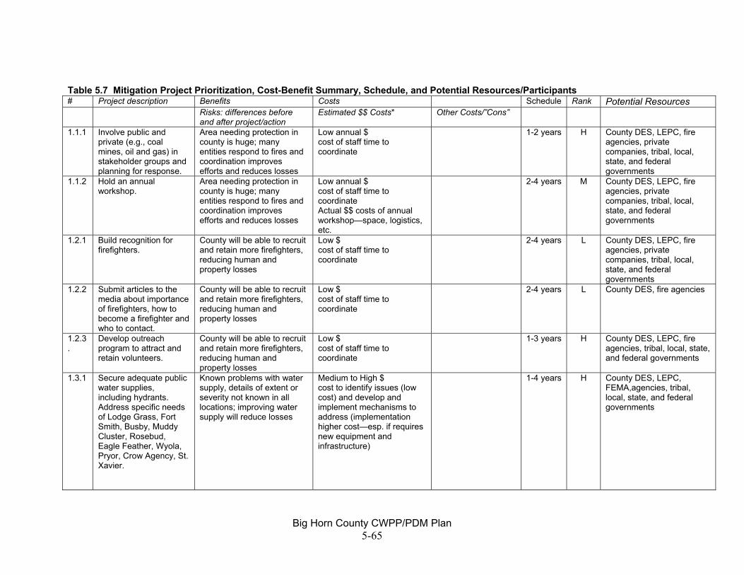
Big Horn County CWPP/PDM Plan 5-65
Table 5.7 Mitigation Project Prioritization, Cost-Benefit Summary, Schedule, and Potential Resources/Participants # Project description Benefits Costs Schedule Rank Potential Resources Risks: differences before
and after project/action Estimated $$ Costs* Other Costs/”Cons”
1.1.1 Involve public and private (e.g., coal mines, oil and gas) in stakeholder groups and planning for response.
Area needing protection in county is huge; many entities respond to fires and coordination improves efforts and reduces losses
Low annual $ cost of staff time to coordinate
1-2 years H County DES, LEPC, fire agencies, private companies, tribal, local, state, and federal governments
1.1.2 Hold an annual workshop.
Area needing protection in county is huge; many entities respond to fires and coordination improves efforts and reduces losses
Low annual $ cost of staff time to coordinate Actual $$ costs of annual workshop—space, logistics, etc.
2-4 years M County DES, LEPC, fire agencies, private companies, tribal, local, state, and federal governments
1.2.1 Build recognition for firefighters.
County will be able to recruit and retain more firefighters, reducing human and property losses
Low $ cost of staff time to coordinate
2-4 years L County DES, LEPC, fire agencies, private companies, tribal, local, state, and federal governments
1.2.2 Submit articles to the media about importance of firefighters, how to become a firefighter and who to contact.
County will be able to recruit and retain more firefighters, reducing human and property losses
Low $ cost of staff time to coordinate
2-4 years L County DES, fire agencies
1.2.3.
Develop outreach program to attract and retain volunteers.
County will be able to recruit and retain more firefighters, reducing human and property losses
Low $ cost of staff time to coordinate
1-3 years H County DES, LEPC, fire agencies, tribal, local, state, and federal governments
1.3.1 Secure adequate public water supplies, including hydrants. Address specific needs of Lodge Grass, Fort Smith, Busby, Muddy Cluster, Rosebud, Eagle Feather, Wyola, Pryor, Crow Agency, St. Xavier.
Known problems with water supply, details of extent or severity not known in all locations; improving water supply will reduce losses
Medium to High $ cost to identify issues (low cost) and develop and implement mechanisms to address (implementation higher cost—esp. if requires new equipment and infrastructure)
1-4 years H County DES, LEPC, FEMA,agencies, tribal, local, state, and federal governments

Big Horn County CWPP/PDM Plan 5-66
# Project description Benefits Costs Schedule Rank Potential Resources Risks: differences before
and after project/action Estimated $$ Costs* Other Costs/”Cons”
1.3.2 Work with coalbed methane companies to identify water sources associated with development.
Water could be readily available through this source. At least one company has already offered information on this
Low $ cost to identify issues and develop and implement mechanisms to address
2-4 years M County DES, LEPC, fire agencies, private companies, tribal, local, state, and federal governments
1.3.3.
Equip water supplies with standardized connections.
Making sure that water supplies can be accessed by fire equipment will reduce losses
Medium to High $ cost to identify issues and develop and implement mechanisms to address
H County DES, LEPC, FEMA, fire agencies, private companies, tribal, local, state, and federal governments
1.4.1 Provide information on the access requirements for firefighting equipment to homeowners throughout the county.
Improving accessibility to homes will reduce losses. Access is already reviewed as part of county review for new subdivisions
Low $ (public info) Medium-High $ (access changes) cost of staff time to coordinate (low) Costs to individual homeowners to improve access (higher costs)
People may still choose not to improve access
2-5 years M County DES, LEPC, fire agencies, tribal, local, state, and federal governments
1.4.2 Encourage homeowners to work with fire departments to provide adequate access.
Improving accessibility to homes will reduce losses. Access is already reviewed as part of county review for new subdivisions
Low $ (public info) Medium-High $ (access changes) cost of staff time to coordinate Costs to individual homeowners to improve access
People may still choose not to improve access
2-5 years M County DES, LEPC, fire agencies, tribal, local, state, and federal governments
1.4.3 Identify and address problems with access on existing county roads (e.g., such as some county roads in the Pine Ridge area).
Reduce losses Medium-High $ 1-3 years H County Road Department, Fire Departments

Big Horn County CWPP/PDM Plan 5-67
# Project description Benefits Costs Schedule Rank Potential Resources Risks: differences before
and after project/action Estimated $$ Costs* Other Costs/”Cons”
1.5.1 Annually review equipment and identify gaps.
Adequate equipment will reduce losses
Low $ (review) Medium-High $ (cost of equipment as needed) cost of staff time to coordinate Costs of new equipment, repairs, etc.
1-2 years, then ongoing
H LEPC, fire agencies, tribal, local, state, and federal governments
1.5.2 Continue to work to identify funding sources.
Funding is critical Low annual $ cost of staff time to coordinate and prepare grant applications
1-2 years, then ongoing
H LEPC, fire agencies, tribal, local, state, and federal governments
1.6.1 Continue to provide training.
Well trained staff will reduce losses to property and human life
Low to Medium annual $ cost of staff time to coordinate costs of individuals to attend training costs of training—speakers, locations, etc.
Ongoing H LEPC, fire agencies, tribal, local, state, and federal governments
1.6.2 Continue to assure adequate gear and communications upgrades as necessary.
Adequate equipment will reduce losses
Low $ (review) Medium-High $ (cost of equipment as needed) cost of staff time to coordinate Costs of new equipment, repairs, etc.
Ongoing H Fire agencies, tribal, local, state, and federal governments
1.7.1 Develop a detailed map of critical infrastructure and other information for firefighting.
This type of system has made a huge difference in nearby Stillwater County—helping responders to get to scene; providing warnings and evacuation info to residents, etc. DES Coordinator recently received some training and is familiar with Stillwater County system
Medium to High $ cost to obtain GIS software/hardware; cost to train staff, cost to continually update
1-2 years, then ongoing
H County DES, LEPC, fire agencies, tribal, local, state, and federal governments, FEMA, BLM, private companies

Big Horn County CWPP/PDM Plan 5-68
# Project description Benefits Costs Schedule Rank Potential Resources Risks: differences before
and after project/action Estimated $$ Costs* Other Costs/”Cons”
1.7.2 Develop and update annually contact information for fire-fighting resources.
Area needing protection in county is huge; many entities respond to fires and coordination improves efforts and reduces losses
Low annual $ cost of staff time to coordinate
1-2 years, then ongoing
H County DES, LEPC, fire agencies, tribal, local, state, and federal governments
1.7.3 Identify resources to update and coordinate the maps and contact information.
Funding and staffing is critical
Low to medium annual $ costs of staff time to coordinate
2-4 years, then annual
M County DES, LEPC, fire agencies, tribal, local, state, and federal governments
2.1.1 Information and education about personal safety in wildfire situation.
Will result in less loss of human life and injury
Low $ costs of staff time to coordinate
1-2 years H County DES, LEPC, fire agencies, tribal, local, state, and federal governments
2.1.2 Make sure steps to report a fire are clear to the public.
Will result in less loss of human life and injury
Low $ costs of staff time to coordinate
Most residents already are familiar with systems
2-4 years M County DES, LEPC, fire agencies, tribal, local, state, and federal governments
2.1.3 Annually provide a workshop for individuals who may find themselves as first responders to fire.
Will reduce loss of life and injury
Low annual $ costs of staff time to coordinate
1-2 years H County DES, LEPC, fire agencies, tribal, local, state, and federal governments
2.2.1 Annually review 911 system and need for exercises, training, etc.
Responders will get refresher course, promoting efficient coordinated response
Low annual $ costs of staff time to coordinate
1-2 years, then ongoing
H County DES, LEPC, fire agencies, tribal, local, state, and federal governments
2.3.1 Public education on reducing post-fire impacts.
Reduce environmental impacts
Low $ costs of staff time to coordinate
2-4 years M County DES, LEPC, fire agencies, tribal, local, state, and federal governments
2.3.2 Public agencies to develop and follow post-fire procedures.
Reduce environmental impacts
Low $ costs of staff time to coordinate
3-5 years M tribal, local, state, and federal governments

Big Horn County CWPP/PDM Plan 5-69
# Project description Benefits Costs Schedule Rank Potential Resources Risks: differences before
and after project/action Estimated $$ Costs* Other Costs/”Cons”
2.4.1 Identify safe areas and evacuation plans.
Not all communities have identified safe shelters or evacuation plans; need an assessment of each—having these in place and working; and having people informed about them could save lives
Low to High $ cost of staff time to coordinate; additional funds may be needed to equip locations as emergency safe shelters
2-4 years H County DES, LEPC, fire agencies, tribal, local, state, and federal governments
3.1.1 Continue to mow and/or plow firebreaks around communities at risk.
Not a major change from current situation, but ensures good work continues. Currently being done, primarily by the BIA fire agencies
Medium annual $ In high vegetation/high fire danger years, could increase areas needing to be mowed
Ongoing H tribal, local, state, and federal governments
3.1.2 Continue to mow along roads.
Not a major change from current situation, but ensures good work continues
Medium annual $ In high vegetation/high fire danger years, could increase areas needing to be mowed
Ongoing H County Road Dept., tribal govt, towns, and BIA
3.1.3 Assess need for fire breaks around communication facilities and implement as necessary.
Unclear if this is currently being addressed; loss of communication will negatively affect response. Assume that facility owners already concerned about this and being pro-active.
Low to Medium $ staff time to investigate, coordinate fire breaks, cost of fire breaks
2-5 years M County DES, LEPC, fire agencies, tribal, local, state, and federal governments, communication facility owner/operators
3.2.1 Continue to implement actions for Muddy Cluster in the Northern Cheyenne Hazard Mitigation Plan.
Not a major change from current situation, but ensures good work continues
Medium to High $ costs to implement the plan
Ongoing H Northern Cheyenne, BIA
3.2.2 Continue to implement actions in Crow Fire Management Plan.
Not a major change from current situation, but ensures good work continues
Medium to High $ costs to implement the plan
Ongoing H Crow, BIA

Big Horn County CWPP/PDM Plan 5-70
# Project description Benefits Costs Schedule Rank Potential Resources Risks: differences before
and after project/action Estimated $$ Costs* Other Costs/”Cons”
3.2.3 Complete the Hazard Assessment and Mitigation Plan for Crow Reservation.
Needed to address fire protection requirements
Medium $ 1-2 years H Crow, BIA
3.2.4 Work with Pine Ridge and Sarpy area landowners to identify options to address high fuel areas.
Could result in less loss of life/injury to humans, livestock and damage to property
Low $ staff time to coordinate
Residents may not want to participate
1-2 years H County DES, LEPC, fire agencies, FEMA, BLM, local, tribal, state, and federal governments
3.2.5 Address fuel build-up and un-managed fuels in Lodge Grass.
Current issue is serious—changes would result in significantly reduced risk
Low to Medium $ staff time to coordinate
Town resources are extremely limited
1-2 years H Lodge Grass, FEMA
3.2.6 Identify and address hazard areas along the Big Horn River.
Could result in less loss of life/injury to humans, livestock and damage to property
Low to Medium staff time to coordinate
Residents may not want to participate
2-5 years M County DES, LEPC, fire agencies, tribal, local, state, and federal governments
3.2.7 Work with landowners and residents in other areas of the county to identify other specific areas of fuel build-up and means to address.
Could result in less loss of life/injury to humans, livestock and damage to property
Low to Medium $ staff time to coordinate
Residents may not want to participate
2-5 years M County DES, LEPC, fire agencies, tribal, local, state, and federal governments
3.2.8 Work with BNSF to mow or reduce fuel-build up with prescribed burns.
Could result in less loss of life/injury to humans, livestock and damage to property
Low $ staff time to coordinate
Railroad may not want to participate
1-2 years H County DES, LEPC, fire agencies, tribal, local, state, and federal governments, BNSF
4.1.1 Identify and fund a staff person to provide public education on wildfire and fire-related issues.
Would really expand and focus efforts
Medium annual $ time to coordinate funding and hire new position
Need to build political support
2-4 years M tribal, local, state, and federal governments
4.1.2 Programs for school-age children to prevent fire experimentation and arson.
Starting disaster prevention awareness with youth could last individuals a life time; students may also “educate” their parents
Low $ Generally low dollar cost—many materials already available
Will require staff time to coordinate
1-2 years H County DES, LEPC, fire agencies, tribal, local, state, and federal governments, public schools

Big Horn County CWPP/PDM Plan 5-71
# Project description Benefits Costs Schedule Rank Potential Resources Risks: differences before
and after project/action Estimated $$ Costs* Other Costs/”Cons”
4.1.3 Education to make properties defensible, and on understanding wildfire, and role of wildfire (or other disturbance) in long-term land health/productivity.
Could result in less loss of life/injury to humans, livestock and damage to property
Low $ Generally low dollar cost—many materials already available
1-2 years H County DES, LEPC, fire agencies, tribal, local, state, and federal governments, public schools
4.1.4 Sponsor community clean up day or other special events.
Could result in less loss of life/injury to humans, livestock and damage to property
Low $ staff time to coordinate Generally low dollar cost—many materials already available
Difficulty in developing volunteer activities
3-5 years M County DES, LEPC, fire agencies, tribal, local, state, and federal governments, public schools
5.1.1 Review and revise as necessary subdivision regulations to address fire safety needs.
For new subdivisions, could result in less potential risk
Low annual $ staff time to coordinate; fire staff time to review subdivisions
Limited resources of various departments—esp. volunteer departments
1-2 years and ongoing
H County DES, communities, county planning board
5.1.2 Review subdivision applications to make sure they meet fire requirements.
For new subdivisions, could result in less potential risk
Low annual $ staff time to coordinate; f fire staff to review subdivisions
Limited resources of various departments—esp. volunteer departments
Ongoing H Fire agencies
5.1.3 Develop a building code for fire safety purposes.
Could reduce risk for all new development (not just subdivisions)
Medium $ staff time to coordinate
Potential issue with public acceptance of new regulations
2-4 years H County DES, communities, county planning board
5.2.1 Publication informing new and existing residents about wildfire issues and response times.
Starting disaster prevention awareness with youth could last individuals a life time; students may also “educate” their parents
Low $ Generally low dollar cost—many materials already available
Will require staff time to coordinate
1-2 years H County DES, LEPC
5.2.2 Work with tribal governments and housing authorities so that new developments are built in defensible areas.
Could reduce risk for new development
Low annual $ staff time to coordinate
1-2 years and ongoing
H Tribal governments, fire agencies

Big Horn County CWPP/PDM Plan 5-72
# Project description Benefits Costs Schedule Rank Potential Resources Risks: differences before
and after project/action Estimated $$ Costs* Other Costs/”Cons”
6.1 Familiarize responders with special needs of historic sites
Would reduce risk to these sites. Already being done to some extent, on a site-by-site basis
Low annual $ staff time to coordinate
2-4 years and ongoing
M tribal, local, state, and federal governments, fire agencies, historical society
6.2 Expand public awareness of need to protect historic sites from fire.
Would reduce risk to these sites
Low annual $ staff time to coordinate
2-4 years and ongoing
M County DES, LEPC, fire agencies, tribal, local, state, and federal governments, public schools, historical society
6.3 Continue to work with landowners and others on incident basis to protect sites.
Would reduce risk to these sites. Already being done on a site-by-site basis
Low annual $ staff time to coordinate
Ongoing H Fire agencies and landowners
6.4 Develop and incorporate policies into fire agency standard operating procedures.
Would reduce risk to these sites
Low to medium $ staff time to coordinate
1-2 years H County DES, LEPC, fire agencies, tribal, local, state, and federal governments, public schools, historical society
*Estimated costs: Low = $ 10,000 or less, Medium = $ 10-100,000, High = $ 100,000 or greater
Big Horn County CWPP/PDM Plan 5-73
Project Implementation The following sections identify how the projects will be implemented. Overall, the County DES Coordinator will play a primary role, in conjunction with the County Fire Department, in ensuring that implementation is an on-going process. Roles and Responsibilities The goals in this Community Wildfire Protection Plan will be realized through implementation of the projects. The plan contains a variety of types of projects. Due to the variety, many individuals and agencies will play a role in project implementation. The Big Horn County Local Emergency Planning Committee will review the CWPP annually, identify work plans, and recommend changes as necessary. Individual property owners will be responsible for educating themselves and taking appropriate action to create defensible space around their structures, both residential and commercial. For-profit businesses may be involved in sharing expertise and cooperation, as in the case of the Fidelity Exploration on projects involving discharged water reservoirs for fire suppression purposes. The Big Horn County News and other local media may be asked to run features about firefighters to assist in recruiting efforts and articles on other topics as well. County responsibilities fall in the area of education on existing regulations and providing coordination. The County DES and County Fire Department are likely to be coordinators on many projects. The various fire agencies in the county have a variety of roles to play in implementing the projects. It is assumed that most projects will involve some sort of role for the fire agencies. For example, they will need to be consulted as part of developing educational materials and the presentation and distribution of that material will be more effective if they are involved. Identifying specific fuel-reduction and defensible space projects should also involve the fire agencies. The fire agencies should participate in the annual review of the CWPP (see Plan Maintenance and Coordination) below. The Department of Natural Resources and Conservation will continue to provide assistance to local fire departments in the form of grants, technical expertise, and resources. The Bureau of Land Management (BLM) provide technical assistance, project funds, suppression assistance, educational materials, and training. The BLM will schedule and carry out fuel reduction projects in cooperation with neighboring land owners including other agencies and private individuals. The Federal Emergency Management Agency (FEMA) may provide grant funds to accomplish projects and may be involved in post-disaster assistance in the event of a catastrophic fire.

Big Horn County CWPP/PDM Plan 5-74
Schedule Projects will be accomplished as resources, either at the local, state or federal levels, become available. Those projects with a higher priority ranking would be considered first. Implementation of the plan will be the responsibility of the LEPC and the Big Horn County DES Coordinator acting in coordination with the county fire warden on behalf of the county. In selecting projects to compete for funding, emphasis should be placed on the relative benefits compared to the cost of the project. The cost of the project should be considered and weighed against the dollar value or other measure of assets protected or potential reduction of damages. Where possible a basic cost benefit and/or value analyses should be completed during the planning of the project. No firm schedule has been established for accomplishing the listed projects, however, it is the intent that the LEPC will monitor progress and set work priorities annually. Funding Guidelines County DES will work with local, state, and federal agencies to identify funding and other resources for the projects in this CWPP and will share that information with the various parties involved in project implementation. Accomplishment of projects depends on the availability of resources and funding. Many of the projects can proceed through the efforts of an individual or individual agency or organization. Not all of the projects will require specific funding, for example, the County DES will likely be able to coordinate some public education efforts. Other projects, for example fuel reduction and structural defensibility projects in Pine Ridge or other areas may require bringing many parties to the table and aligning priorities and funding from several sources. These projects will proceed as the circumstances allow. As required by the National Fire Plan, federal agencies are to align their funding and staff resources with the priorities expressed in this community wildfire protection plan. As a result, accomplishment of many of the projects may depend on funding and staffing of the BLM.

Big Horn County CWPP/PDM Plan 5-75
Plan Maintenance and Coordination The maintenance and review of the CWPP will be part of the overall maintenance and coordination for the PDM plan, which is described in Chapter 6. Each year starting in January 2007, the Big Horn County Local Emergency Planning Committee (LEPC), which includes representation from fire agencies, will meet to review the CWPP/PDM Plan and recommend any needed changes. The primary emphasis of such review will be on the goals, objectives, and specific actions/projects portion of the plan. The LEPC will:
• review the work of the past year, identifying key factors that may have affected accomplishing priority projects, and identifying completed projects
• identify any needed changes or additions to the mitigation strategy (new or changed goals, objectives, actions/projects)
• clarify priorities for projects for the upcoming year and the work tasks needed to accomplish those projects

Big Horn County CWPP/PDM Plan 5-76
THIS PAGE INTENTIONALLY BLANK.

Big Horn County CWPP/PDM Plan 6-1
CHAPTER 6: PLAN MAINTENANCE AND COORDINATION RESPONSIBLE PARTIES The Big Horn County Commissioners will be responsible for ensuring that the CWPP/PDM Plan is kept current and also for evaluating its effectiveness. With the adoption of this plan, the commissioners designate the Big Horn County Disaster and Emergency Services Coordinator and the Chair of the Local Emergency Planning Committee (LEPC) as the co-leads in accomplishing this ongoing responsibility on their behalf. REVIEW TRIGGERS Any of the following three situations could trigger review of the plan’s effectiveness or currency and update of the CWPP/PDM Plan.
1. The occurrence of a major natural disaster either in the county or nearby. 2. The passage of time. 3. A change in state or federal regulations with which the county must comply.
CRITERIA FOR EVALUATING THE PLAN When review of the CWPP/PDM plan is triggered by one of the three situations listed above, the plan will also be evaluated for effectiveness and comprehensiveness. The criteria against which the plan will be evaluated will include, but not be limited to:
• Whether any potential natural hazards have developed that were not addressed in the plan,
• Whether any disasters have occurred which were not addressed in the plan, • Whether any unanticipated development has occurred that could be vulnerable to
natural disasters, and • Whether any additional project ideas have been developed.
PROCEDURES Should a major natural disaster occur in Big Horn County the LEPC shall meet following the disaster to review the after action report. Upon review of this report, any changes needed to the CWPP/PDM Plan will be recommended to the County Commission and made by the County Disaster and Emergency Services Coordinator following their concurrence. In the absence of a major natural disaster, each year starting in January 2007, the LEPC will meet to review the CWPP/PDM Plan and recommend any needed changes. The primary emphasis of such review will be on the goals, objectives, and specific actions/projects portion of the plan. The LEPC will:
• review the work of the past year, identifying key factors that may have affected accomplishing priority projects, and identifying completed projects

Big Horn County CWPP/PDM Plan 6-2
• identify any needed changes or additions to the mitigation strategy (new or changed goals, objectives, actions/projects)
• clarify priorities for projects for the upcoming year and the work tasks needed to accomplish those projects
The LEPC meeting will be noticed in local newspapers and the public and individuals who served on the Steering Committee for development of the original plan will be encouraged to attend. In the interim, the County Disaster and Emergency Services Coordinator will maintain a file into which comments or input on changes to the plan can be kept. The comments in this file will be provided at the LEPC/public meeting to review the plan. Finally, should state or federal regulations with which the County must comply be significantly changed, the County Disaster and Emergency Services Coordinator will notice and hold an LEPC meeting. At this meeting he/she will inform the LEPC of the new requirements and together with the LEPC, determine whether changes to the CWPP/PDM Plan are warranted. Every five years, beginning in 2011, the CWPP/PDM Plan will be updated and submitted to Montana Disaster Emergency Services and subsequently to the Federal Emergency Management Agency (FEMA) for approval. INCORPORATION INTO OTHER PLANS Staff of Hardin, Lodge Grass, and Big Horn County have been made aware of the CWPP/Pre-Disaster Mitigation Plan by the County Disaster and Emergency Services Coordinator and through the planning process. The projects in the CWPP/PDM Plan can be incorporated as appropriate into existing plans, annual budgets, and any Growth Policy that may be updated or developed for Big Horn County or the municipalities of Hardin and Lodge Grass. The County Disaster and Emergency Services Coordinator was extensively involved in the preparation of the CWPP/PDM Plan. .

Big Horn County CWPP/PDM Plan 7-1
SOURCES
Aber, Jesse. Montana Department of Natural Resources and Conservation. Staff for the Montana Drought Advisory Committee. Personal communication, April 2005.
Berkeley Lab. Research News. February 2, 2005. http://www.lbl.gov/Science-Articles/Archive/EETD-power-interruptions.html
Big Horn County. Big Horn County Growth Policy—Inventory of Existing Characteristics. January 2000. Big Horn County. Big Horn County Homeland Security Strategy for Weapons of Mass
Destruction Terrorism Events. July 2004. Billings Gazette. “Beartooth Repairs on Schedule, Budget.” July 30, 2005. Billings Gazette. “Cooler Temps Calm Area Fires.” August 18, 2003. Bruckner, Roger. USDA Farm Services Agency. Big Horn County Executive Director.
Personal communication with Anne Cossitt. July 2005. Bureau of Reclamation Website. Dams, Projects, and Power Plants.
http://www.usbr.gov/dataweb/html/yellowtail.html. October 2005. Coleman, Ed. Complaint Management Section Chief, Enforcement Division. Montana
Department of Environmental Quality. Statistics on spills January 1, 1997-April 15, 2005.
Collins, Steve. BIA, Crow Forestry. Personal communication. Summer and Fall, 2005. Cook, Calvin. Montana Department of Transportation. Personal communication and
traffic statistics. April 2005. Dannenberg, Mike. Bureau of Land Management. Personal communication regarding
wildfire. Summer 2005. Federal Railroad Administration website. http://safetydata.fra.dot.gov/OfficeofSafety/.
April 2005. FEMA 386-2. August 2001. State and Local Mitigation Planning How-To Guide—
Understanding Your Risks: Identifying Hazards and Estimating Losses. Fire Management Plan. See U.S. Bureau of Reclamation, Fire Management Plan… Flatness, Lonnie. Facilities Manager, BIA, Lame Deer. Phone conversation, October
2005. Hert, Theresa. Hardin City Clerk. Phone conversation and information submitted by
email. October 2005. Jelinski, J. Montana Local Government Information Center. Personal communication.
March 2005. Larson, Jim. Stillwater County GIS Department. Personal communication, September
2005. McKee Engineering, Red Lodge, Montana. Loren Culp. Personal communication, December 2005. McKenna, Sally. Deputy State Fire Marshall. Billings, Montana. Personal
communication with Anne Cossitt. July 2005. Montana Department of Livestock. 2001. Drought Relief Activities of the Montana
Department of Livestock. http://nris.state.mt.us/drought/committee/reports/DAClivestock 2001summ.html
Montana Department of Military Affairs, Disaster and Emergency Services. October 2004.
Montana Department of Natural Resources and Conservation. Water rights information via website. http://nris.mt.gov/dnrc/waterrights/default.aspx October 2005.
Montana Department of Revenue. Montana Drought Advisory Committee. 2004. The Governor’s Report—Drought in
Montana, May 2004. http://nris.state.mt.us/drought/committee/gov04rpt.pdf

Big Horn County CWPP/PDM Plan 7-2
National Response Center website. http://www.nrc.uscg.mil/nrchp.html. May 2005.Montana Agricultural Statistics Service. October 2004. Montana Agricultural Statistics. Montana Department of Labor and Industry. Labor Market Inforamtion for Big Horn County. March 2005.
Montana Natural Resource Information System. http://nris.state.mt.us/ National Timber Tax Website.
http://www.timbertax.org/statetaxes/states/proptax/montana.asp, October 2005. Redden, Matt. Big Horn County Road and Fire. Personal communication regarding
wildfire and roads. Summer-Fall 2005. Roessler, Jim. Bureau of Indian Affairs, Rocky Mountain Regional Office. Personal
communication regarding wildfire. Rugg, Trish. Big Horn County Electric. Phone conversation. October 2005. Scarlett, Jim. NOAA Office in Billings, Montana. Personal communication with Anne
Cossitt. June 2005. SHELDUS. Spatial Hazard Events and Losses Database for the United States.
http://www.cas.sc.edu Siroky, Laurence. Chief of Water Operations, MT DNRC. Personal Communication with
Anne Cossitt, April 2005. Smith, Mark. Engineering Manager. State Revolving Loan Program, Montana
Department of Environmental Quality. Personal communication. Oct 2005. Stickney, Michael. Director, Earthquake Studies Office. Montana Bureau of Mines and
Geology. Email dated June 17, 2005. Storey, Ron. Big Horn County Resident and participant at the Steering Committee
Meetings. Personal communication, December 2005. Taft, Craig. Big Horn County Sanitarian, Floodplain Administrator, and Subdivision
Administrator. Personal conversations periodically from Jan-Oct 2005. Tauscher, Tom. Facilities Manager at Yellowtail Dam. Phone conversation. October
2005. University of Wisconsin-Madison. Forest Ecology and Management website.
http://silvis.forest.wisc.edu/Library/WUIDefinitions2.asp. September 2005. US Bureau of the Census. http://www.census.gov/ U.S. Bureau of Economic Analysis (BEA). http://www.bea.doc.gov August 2005. U.S. Bureau of Indian Affairs. Fire Management Plan for the Crow Indian Reservation.
March 1999. U.S. Bureau of Indian Affairs. Wildfire Hazard Assessment and Mitigation Plan for Lame
Deer and Muddy Cluster on the Northern Cheyenne Reservation, Montana. March 2002.
U.S. Census Bureau. Census 2000 data. U.S. Army Corps of Engineers. Cold Regions Research and Engineering Laboratory.
http://www.crrel.usace.army.mil/icejams/index.htm. October 2005 USDA. 2002 Census of Agriculture for Big Horn County. USDA. “Disaster Declaration Summary” MT FSA PN082. September 2, 2004. USDA Extension. “Estimated Cost for Livestock Fencing.” July, 2005.
http://www.extension.iastate.edu/Publications/FM1855.pdf USDA FSA Damage Assessment Report for Big Horn County submitted in April 2005. USDA. Farm Service Agency. News Release, “ECP Authorized for Producers in 10
Montana Counties.” May 2, 2005USDA Soil Conservation Service. Soil Survey of Big Horn County Area, Montana. 1977.
US Department of the Interior and State of Montana. Oil and Gas Environmental Impact Statement and Proposed Amendment of the Powder River and Billings Resource Management Plans. January 2003.

Big Horn County CWPP/PDM Plan 7-3
USDA website. www.nass.usda.gov USGS. National Landslide Overview Map of the United States. USGS Open File Report 97-289. http://landslides.usgs.gov/ USGS. Quarternary Fault and Fold database. http://earthquakes.usgs.gov/qfaults/mt/index.html Western Regional Climate Center. Vandersloot, Larry. Hardin Public Works Director. Phone conversation. July 2005. Van West, Carroll. A Traveler’s Companion to Montana History. 1986. Yellowstone Science. Volume 13, Number 3, Summer 2005. Zelt, Ronald B., Greg Boughton, Kirk A. Miller, Jon P. Mason, and Laura M. Gianakos.
1999. Environmental Setting of the Yellowstone River Basin, Montana, North Dakota, and Wyoming. Water-Resources Investigations Report 98-4269. http://pubs.usgs.gov/wri/wri984269/