Embed Size (px)
Citation preview
Biological Assessment
1. INTRODUCTION .........................................................................................................1
1.1 PROJECT SETTING ............................................................................................1
DESCRIPTION OF PROPOSED ACTION .........................................................................3
1.2 INTRODUCTION ..................................................................................................3 1.3 DESCRIPTION OF BUILD ALTERNATIVES .......................................................4
2. PROTECTED SPECIES RESEARCH.........................................................................6
2.1 METHODS............................................................................................................6
3. VIRGINIA SPIRAEA (SPIRAEA VIRGINIANA) ...........................................................9
3.1 DESCRIPTION .....................................................................................................9 3.2 FIELD SURVEY..................................................................................................10 3.3 IMPACTS............................................................................................................13 3.4 AVOIDANCE AND MINIMIZATION....................................................................13 3.5 MITIGATION.......................................................................................................13
4. SMALL WHORLED POGONIA (ISOTRIA MEDEOLOIDES) ....................................13
4.1 DESCRIPTION ...................................................................................................13 4.2 FIELD SURVEY..................................................................................................14 4.3 IMPACTS............................................................................................................16 4.4 AVOIDANCE AND MINIMIZATION....................................................................16 4.5 MITIGATION.......................................................................................................16
5. INDIANA BAT (MYOTIS SODALIS) ..........................................................................18
5.1 DESCRIPTION ...................................................................................................18 5.2 DISTRIBUTION ..................................................................................................18 5.3 HABITAT REQUIREMENTS ..............................................................................18
5.3.1 Hibernacula .................................................................................................18 5.3.2 Roosting ......................................................................................................19 5.3.3 Foraging ......................................................................................................19
5.4 VIRGINIA POPULATION....................................................................................20 5.5 FIELD SURVEY..................................................................................................20 5.6 IMPACTS............................................................................................................21 5.7 AVOIDANCE AND MINIMIZATION....................................................................22 5.8 MITIGATION.......................................................................................................22
6. SECONDARY AND CUMULATIVE EFFECTS..........................................................22
6.1 POTENTIAL INDIRECT EFFECTS: VIRGINIA SPIRAEA ................................23 6.2 POTENTIAL INDIRECT EFFECTS: SMALL WHORLED POGONIA.................23 6.3 POTENTIAL INDIRECT EFFECTS: INDIANA BAT ...........................................23
7. CONCLUSIONS.........................................................................................................24
8. REFERENCES ..........................................................................................................25
Coalfields Expressway
i
Biological Assessment
LIST OF ABBREVIATIONS BCIAC Buchanan County Industrial Access Connector CTB Commonwealth Transportation Board DACS Virginia Department of Agriculture and Consumer Services DCIAC Dickenson County Industrial Access Connector DCR Virginia Department of Conservation and Recreation DEIS Draft Environmental Impact Statement DGIF Virginia Department of Game and Inland Fisheries DMME Virginia Department of Mines, Minerals, and Energy FEIS Final Environmental Impact Statement FHWA Federal Highway Administration MSL Mean Sea Level NEPA National Environmental Policy Act (of 1969) USFWS United States Fish and Wildlife Service USGS United States Geological Service VDOT Virginia Department of Transportation
Coalfields Expressway
ii
Biological Assessment
Biological Assessment
COALFIELDS EXPRESSWAY LOCATION STUDY VIRGINIA DEPARTMENT OF TRANSPORTATION
LOCATION: Wise, Dickenson, and Buchanan Counties, Virginia
Contact Person: Jeff Rodgers Phone Number: (804)371-6785
1. INTRODUCTION The purpose of this biological assessment is to review the proposed Coalfields Expressway in sufficient detail to determine whether the proposed action may affect any of the federally threatened or endangered species listed below. This biological assessment is prepared in accordance with legal requirements set forth under Section 7 of the Endangered Species Act (16 U.S.C. 1536 (c)), and follows the standards established in 23 CFR 771. The species considered in this document are: Threatened or Endangered Species
Virginia spiraea (Spiraea Virginiana) T Small whorled pogonia (Isotria medeoloides) T Indiana bat (Myotis sodalis) E
1.1 PROJECT SETTING The study area is located in Wise, Dickenson, and Buchanan counties in Southwest Virginia (see Exhibit 1). The study area comprises a portion of the Cumberland Mountain section of the Appalachian Plateau physiographic region, which is characterized by steep slopes, V-shaped valleys, and narrow
Coalfields Expressway
1
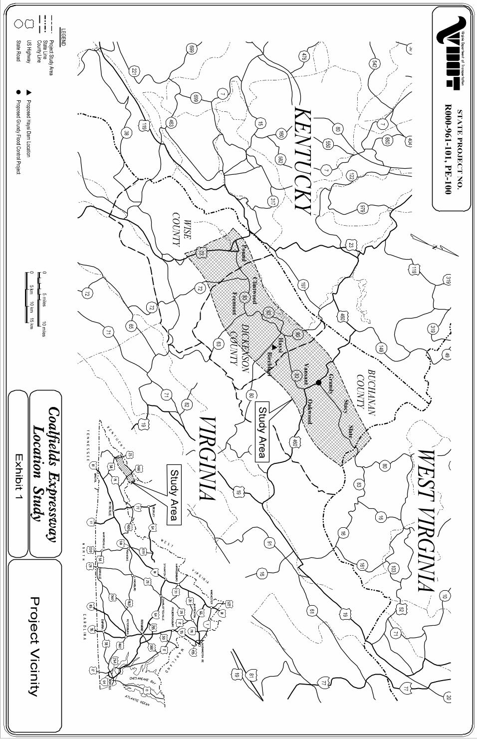
Biological Assessment floodplains. Compared to other mountainous areas of Virginia, elevations in the study area are relatively low. Elevation varies from 295 meters (966 feet) above mean sea level (MSL) near Harmon Junction to 750 meters (2460 feet) above MSL near the West Virginia State line. The project area is located entirely within the Big Sandy River Subbasin. Major water bodies in the study area include the John W. Flannagan Reservoir, the Pound River, the Russell Fork, and the Levisa Fork. The study area contains several small communities located within valleys, including Pound, Georges Fork, Clintwood, Fremont, Clinchco, Birchleaf, Haysi, Vansant, Grundy, Harmon Junction, Oakwood, Stacy, and Slate. Populations in these communities are relatively low; Grundy is the most populous with a 1990 population of 1305. The project area falls within the large eastern coalfields region of Kentucky, West Virginia, and Virginia, and coal mining has long-served as the cornerstone of the local economy. Other large employers include government, manufacturing, and truck and rail transportation. Breaks Interstate Park, one of only two interstate parks in the nation, is located on the Virginia/Kentucky border in Dickenson County, Virginia.
DESCRIPTION OF PROPOSED ACTION
1.2 INTRODUCTION Over the course of the project, eleven preliminary alternatives were developed for consideration. The Draft Environmental Impact Statement (DEIS) retained the No-Build Alternative and five Build Alternatives (A-E) for further study. On August 17, 2000, the Commonwealth Transportation Board (CTB) endorsed an alternative (F1), which consisted of a combination of segments from the different build alternatives. The CTB Approved Alternative F1 includes the Buchanan County Industrial Access Connector (BCIAC), which would provide access to a proposed regional airport and land planned for industrial use. The Final Environmental Impact Statement (FEIS) evaluates impacts to the No-Build Alternative, the five build alternatives in the DEIS, the CTB Approved Alternative F1, and Alternative F2 (Alternative F1 without the BCIAC). For purposes of this assessment, only Alternative F1 requires discussion.
Coalfields Expressway
3
Biological Assessment
1.3 DESCRIPTION OF BUILD ALTERNATIVES This section describes the CTB Approved Alternative F1, shown on Exhibit 2. CTB Approved Alternative F1 – Alternative F1 was chosen based on a range of concerns. Segments 204F1, 239, and 237, collectively referred to as the BCIAC, were included in this alternative to provide access to a proposed regional airport and land intended for industrial development. Since definitive locations for the airport and industrial development have not yet been determined, this access is based on information available at this time. Segment 204F1 would also provide an intersection with the proposed US Route 460 Connector (See the Coalfields Expressway Final Environmental Impact Statement VDOT, 2001) Alternative F1 begins at Route 23 north of the intersection between Route 23 and Business Route 23/Route 83 in the Town of Pound. It then continues easterly on a new location, traversing higher ground north of Route 83. It then turns southeasterly to the Route 83 corridor and follows the general alignment of Route 83 to a point west of the Town of Clintwood. It then turns south of Clintwood on new location. Near the east town limits of Clintwood, it turns in a northerly direction then continues easterly. Connections that would serve the Clintwood area are provided at Route 72 west of Clintwood, Route 83 to the south, and Route 672 to the east. Continuing easterly, Alternative F1 crosses the Cranes Nest River and then turns in a northerly direction and has two connections with Route 63 before turning in a more easterly direction. It connects with Route 63 again before crossing the Russell Fork about two kilometers (one mile) north of the Town of Haysi. Alternative F1 continues northerly on new location and passes about six kilometers (three miles) south of the entrance to Breaks Interstate Park. This location is about two kilometers (one mile) farther south of the Park than Segment 203. A connection to Route 80 south of the Park is provided. It then continues in a northerly direction into Buchanan County and follows the Route 609 corridor near the Levisa Fork. It then roughly parallels the Levisa Fork for about three kilometers (two miles) before crossing the river and Route 460. A connection about one kilometer (0.5 miles) long provides access to Route 460 north of the Town of Grundy. Alternative F1 follows the Route 656 corridor for almost six kilometers (four miles). It then turns in a more easterly direction, continuing on new location and traversing higher ground well north of Route 83. A connection at Route 643
Coalfields Expressway
4

Biological Assessment Exhibit 2: CTB Approved Alternative
Coalfields Expressway
5
Biological Assessment would provide access to Route 83. It terminates near Route 83 at the Virginia/West Virginia State line and could connect to a location for the Coalfields Expressway in West Virginia. The BCIAC, comprised of segments studied in the DEIS connects with the CTB Approved Alternative F1 east of Breaks Interstate Park in Buchanan County. It then runs southeasterly for approximately 5 kilometers (3 miles) before shifting east. It continues in an easterly direction crossing Route 614 before changing to a more northeasterly direction. Continuing northeasterly, the BCIAC connects back with the CTB Approved Alternative F1 just east of Route 604.
2. PROTECTED SPECIES RESEARCH Under the Endangered Species Act (ESA) of 1973, any federal action that would likely result in a negative impact to federally protected plants or animals is subject to review by the FWS. Even in the absence of federal actions, the FWS has the power, through the provisions of Section 9 of the ESA, to exercise jurisdiction on behalf of a protected plant or animal. The FWS and other wildlife resource agencies also exercise jurisdiction in accordance with the Fish and Wildlife Coordination Act (48 Statute 401, as amended: 16 U.S.C. 661 et seq.). The Commonwealth of Virginia also designates plant and animal species deemed threatened and endangered within the state. Based solely on statewide populations, these designations do not consider total populations of these species throughout its geographic range.
2.1 METHODS Early in the planning process, VDOT began coordinating with agencies involved with federal and state listed species. The following agencies received scoping letters requesting their comments on the project: • US Fish and Wildlife Service (FWS); • Virginia Department of Conservation and Recreation (DCR); • Virginia Department of Game and Inland Fisheries (DGIF); and • Virginia Department of Agriculture and Consumer Services (DACS). Scoping responses from the agencies served as a basis for further work. This work included database searches, further agency coordination, review of
Coalfields Expressway
6
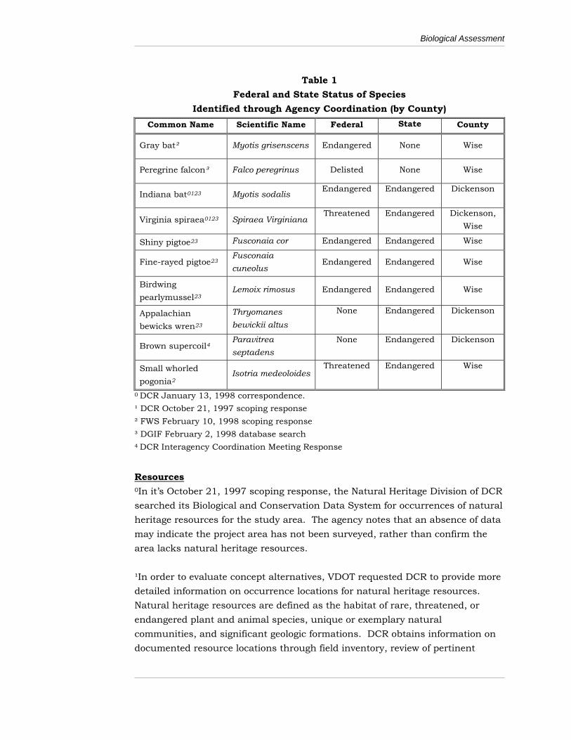
Biological Assessment mapping resources, and collection and research of Nature Conservancy recovery plans. (In discussing this report’s information sources, the following section provides more information on research methods used.) Table 1 lists federal and state threatened and endangered species identified through agency coordination. These species are listed by county, however, and they may not occur within the study area. This section also discusses resources used for the table and provides information on each of the federally listed species. Initially, the information received from the natural resource agencies was not location specific. Since evaluation of concept alternatives required more detailed information, VDOT requested that DCR’s Division of Natural Heritage (DCR) provide occurrence locations for its natural heritage resources. Natural heritage resources are defined as the habitat of rare, threatened, or endangered plant and animal species, unique or exemplary natural communities, and significant geologic formations. DCR obtains information on documented resource locations through field inventory, review of pertinent scientific literature, review of museum and herbarium collections, and contributions from private individuals engaged in similar inventory work. Once locations of the build alternatives had been determined, DCR mapped potential habitat areas for Virginia spiraea (Spiraea virginiana ) and small whorled pogonia (Isotria medeoloides) to create a methodology for field surveys. Later in the process, DCR and DGIF assisted FWS and the Department of Mines, Minerals, and Energy (DMME) in identifying potential survey locations for the Indiana bat. Survey methods and results are discussed in the following sections.
Coalfields Expressway
7
Biological Assessment
Table 1 Federal and State Status of Species
Identified through Agency Coordination (by County) Common Name Scientific Name Federal State County
Gray bat² Myotis grisenscens Endangered None Wise
Peregrine falcon³ Falco peregrinus Delisted None Wise
Indiana bat0123 Myotis sodalis Endangered Endangered Dickenson
Virginia spiraea0123 Spiraea Virginiana Threatened Endangered Dickenson,
Wise
Shiny pigtoe23 Fusconaia cor Endangered Endangered Wise
Fine-rayed pigtoe23Fusconaia cuneolus
Endangered Endangered Wise
Birdwing pearlymussel23
Lemoix rimosus Endangered Endangered Wise
Appalachian bewicks wren23
Thryomanes bewickii altus
None Endangered Dickenson
Brown supercoil4Paravitrea septadens
None Endangered Dickenson
Small whorled pogonia2
Isotria medeoloides Threatened Endangered Wise
0 DCR January 13, 1998 correspondence. ¹ DCR October 21, 1997 scoping response ² FWS February 10, 1998 scoping response ³ DGIF February 2, 1998 database search 4 DCR Interagency Coordination Meeting Response Resources 0In it’s October 21, 1997 scoping response, the Natural Heritage Division of DCR searched its Biological and Conservation Data System for occurrences of natural heritage resources for the study area. The agency notes that an absence of data may indicate the project area has not been surveyed, rather than confirm the area lacks natural heritage resources. ¹In order to evaluate concept alternatives, VDOT requested DCR to provide more detailed information on occurrence locations for natural heritage resources. Natural heritage resources are defined as the habitat of rare, threatened, or endangered plant and animal species, unique or exemplary natural communities, and significant geologic formations. DCR obtains information on documented resource locations through field inventory, review of pertinent
Coalfields Expressway
8
Biological Assessment scientific literature, review of museum and herbarium collections, and contributions from private individuals engaged in similar inventory work. DCR provided locations of two Virginia spiraea communities and one Indiana bat capture location. It also provided locations and descriptions of ten conservation sites. This term refers to a natural area that includes one or more occurrence of natural heritage resources, and is notable for its diversity. None of the build alternatives would impact the conservation sites, spiraea communities, or the location of the Indiana bat capture. ²In its February 10, 1998 scoping response, FWS provided a listing of federally protected species in Wise, Dickenson, and Buchanan counties. ³As part of an information sharing agreement, VDOT has access to the DGIF database for endangered and threatened species. The database search, which included both federal and state species (excluding insects), was done by USGS quadrangle. The search included the fifteen quadrangles covering the study area, as well as adjacent quadrangles (32 total). VDOT’s correspondence of February 2, 1998 contains the search results. 4In its Interagency Coordination Meeting on October 20, 1998, VDOT solicited comments from agencies regarding the project. In comments it provided later, DCR provided information on species added to the Biological and Conservation Data System since the October 21, 1997 scoping response.
3. VIRGINIA SPIRAEA (SPIRAEA VIRGINIANA)
3.1 DESCRIPTION Spiraea virginiana is currently distributed in isolated populations in Georgia, Tennessee, North Carolina, Virginia, West Virginia and Kentucky. Virginia spiraea is a large perennial shrub (1 – 3 m) that is characterized by narrow elliptic leaves that are remotely toothed and glaucous beneath. Virginia spiraea is a deciduous shrub with yellowish/greenish petals that flowers in late May to late June. Virginia spiraea can be distinguished from common associates by profuse branching patterns, flower color, and inflorescence. Virginia spiraea spreads clonally and forms dense clumps, which spread in rock crevices and ground boulders. The root system and vegetative characteristics
Coalfields Expressway
9

Biological Assessment allow it to thrive under appropriate disturbance regimes, such as along rocky, flood-scoured riverbanks in gorges or canyons. This plant is noted as a disturbance-adapted shrub that can tolerate flooding, inundation, erosion, scouring, deposition, and human interventions. Virginia spiraea grows vigorously in full sun on sandstone substrates and acidic moist soils along the banks of second and third order streams or on depositional point bars. Periodic flooding and scouring of the area is essential to this plant’s survival because it eliminates arboreal competitors, herbaceous vegetation, and creates riverwash deposits. Frequent inundation of the area allows dispersal of seeds to colonize new sites. A Virginia spiraea community is documented near the Russell Fork River near Breaks Gorge and another near the Pound River downstream of John W. Flannagan Dam. The CTB Approved Alternative F1 would not impact these communities.
3.2 FIELD SURVEY The study area contains areas that match the habitat requirements described above. Therefore, under contract from VDOT, DCR’s Division of Natural Heritage conducted a field survey to determine potential impacts to the Virginia spiraea from the five proposed build alternatives in the DEIS. In October 1998, a DCR staff botanist visited 12 sites identified as potentially containing suitable habitat for the Virginia spiraea. No Virginia spiraea or any other state or federal listed plant species were found at the survey sites, although suitable spiraea habitat did exist at several locations. The sites surveyed and a summary of each are listed below. Exhibit 3 shows these survey locations. Site 1: Pound River The river channel is 3.3 –4.9 meters (10-15 feet) wide and moderately sunny banks with few shoals or gravel bars and with relatively steep forested banks. There is no suitable habitat for spiraea at this location. Site 2: Freemont The channel is wider than Site 1, some cobble shoals and islands exist, but the area is moderately to heavy shaded with thick growth of the exotic plant Polygonum cupidatum. Marginal habitat for the spiraea exists at this location
Coalfields Expressway
10
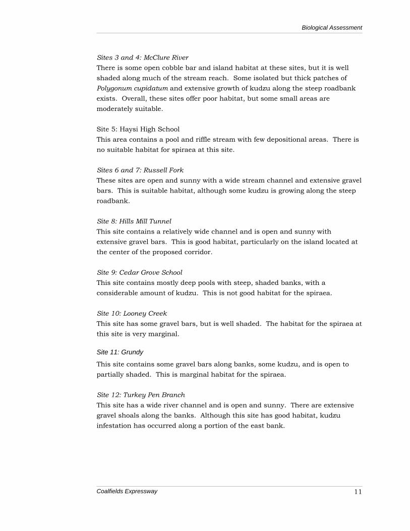
Biological Assessment Sites 3 and 4: McClure River There is some open cobble bar and island habitat at these sites, but it is well shaded along much of the stream reach. Some isolated but thick patches of Polygonum cupidatum and extensive growth of kudzu along the steep roadbank exists. Overall, these sites offer poor habitat, but some small areas are moderately suitable. Site 5: Haysi High School This area contains a pool and riffle stream with few depositional areas. There is no suitable habitat for spiraea at this site. Sites 6 and 7: Russell Fork These sites are open and sunny with a wide stream channel and extensive gravel bars. This is suitable habitat, although some kudzu is growing along the steep roadbank. Site 8: Hills Mill Tunnel This site contains a relatively wide channel and is open and sunny with extensive gravel bars. This is good habitat, particularly on the island located at the center of the proposed corridor. Site 9: Cedar Grove School This site contains mostly deep pools with steep, shaded banks, with a considerable amount of kudzu. This is not good habitat for the spiraea. Site 10: Looney Creek This site has some gravel bars, but is well shaded. The habitat for the spiraea at this site is very marginal.
Site 11: Grundy
This site contains some gravel bars along banks, some kudzu, and is open to partially shaded. This is marginal habitat for the spiraea. Site 12: Turkey Pen Branch This site has a wide river channel and is open and sunny. There are extensive gravel shoals along the banks. Although this site has good habitat, kudzu infestation has occurred along a portion of the east bank.
Coalfields Expressway
11

Biological Assessment
Exhibit 3: Virginia Spiraea Survey Locations
Coalfields Expressway
12
Biological Assessment
3.3 IMPACTS Although suitable habitat for the Virginia spiraea does exist the species was not found at any of the survey sites. Therefore, the CTB Approved Alternative F1 would not impact this species.
3.4 AVOIDANCE AND MINIMIZATION Avoidance and minimization measures are not needed since the CTB Approved Alternative F1 would not impact the Virginia spiraea.
3.5 MITIGATION Mitigation measures are not needed since the CTB Approved Alternative F1 would not impact the Virginia spiraea.
4. SMALL WHORLED POGONIA (ISOTRIA MEDEOLOIDES)
4.1 DESCRIPTION Isotria medeoloides is currently distributed in isolated populations in 15 states. Flowering plants are 4 – 10 inches high and the vegetative plants are shorter. The stems are robust, hollow, smooth, pale green and glaucous. The leaves are pale green, glaucous, and borne in a single whorl of 5 or 6 at the top of the stem. One or two flowers form in the center of the whorl. In Virginia, the small whorled pogonia has been documented from eight counties on the Piedmont and Coastal Plain and from Lee County in southwest Virginia. The plant occurs in very ordinary looking third growth upland forests on terrain that is almost level or gently to moderately sloping in northerly or easterly directions. The understory is distinctly open. Many of the colonies occur on land that has been previously cultivated. Soils are acidic sandy loams with low to very low nutrient contents by agricultural standards. Flowering typically occurs in late-April to mid-May. Flowering is so synchronized that the total flowering period within a colony occurs within two and one-half weeks. Some colonies are composed of mostly vegetative plants,
Coalfields Expressway
13
Biological Assessment others mostly of flowering plants. Small whorled pogonia is self-pollinated and rarely produces more than one stem per plant. Populations of small whorled pogonia in Virginia are particularly threatened by the development of housing subdivisions. Large deer populations also are a threat because the plant usually does not reappear the next year when its whorl is grazed early in the season. Some colonies have survived selected timbering, but clearcutting and other practices resulting in drastic changes in light factors or significant increase in interspecific competition would likely cause a colony to decline. In its scoping response, the FWS included Isotria medeoloides as potentially
occurring in Wise County. However, as Exhibit 1 shows, the study area only comprises a small portion of Wise County. This portion lies in a different drainage than the rest of the county, and shares physical characteristics of neighboring Dickenson and Buchanan counties more than the rest of Wise County. The more specific research conducted by DCR indicated that the study area contains no known communities of small whorled pogonia.
4.2 FIELD SURVEY In a December 8, 1998 correspondence, FWS stated that, due to the scope, complexity, and questionable status of the pogonia in the study area, they agreed that VDOT would only need to survey the final alignment to ensure the project would not impact the pogonia. The agency stated that it understands that VDOT would be willing to make alignment shifts to the preferred alternative to avoid any pogonia populations that may have been found during the survey. In July 2000, DCR conducted preliminary sampling for the small whorled pogonia in the study area. This initial survey focused on sites with the greatest potential for species occurrences. The goal was to determine the likelihood of encountering the species in the area since surveys had never been conducted in that region. DCR surveyed eight sites as part of the preliminary survey. The small whorled pogonia was not found although one area of good habitat was located and intensively surveyed. Other sites generally contained small areas of habitat of moderate potential. The majority of the land surveyed contained habitat with either low or no potential for small whorled pogonia. In order to ensure compliance with the Endangered Species Act (ESA), VDOT contracted with DCR and George Mason University to conduct thorough small whorled pogonia surveys on the CTB Approved Alternative F1. In March 2001,
Coalfields Expressway
14
Biological Assessment 23 sites having potential for small whorled pogonia habitat were identified for survey (see Exhibit 4.13). In June and July 2001, a DCR staff botanist along with VDOT field personnel surveyed 17 of these sites. In June 2001, a George Mason University professor of biology surveyed the remaining six sites having potential to contain suitable small whorled pogonia habitat. Both botanists were recognized by FWS as qualified to conduct small whorled pogonia surveys in Virginia. Furthermore, all surveys were conducted between June 1 and July 15—the survey period recommended by FWS. Despite the presence of suitable habitat, no small whorled pogonia or any other state or federal listed plant species were found at the survey sites. The DCR botanist surveyed Sites 1b, 31, 32a, 41a, 41b, 42c, 26, 27, 28b, 30a, and 30b. Unlike the preliminary surveys conducted in Year 2000, many of the sites surveyed contained habitat that, on the ground, was assessed to be potential habitat for small whorled pogonia. This habitat, usually small in area within the larger site, was in the gentler slopes in the upper slope or ridgeline areas of the sites. When found, the appropriate habitat was intensively searched for small whorled pogonia. DCR will not complete specific site summaries until Spring 2002. However, summaries for the remaining sites (surveyed by the George Mason University botanist) are included below. Site 10a: Topography consisted of a shallow basin with slight elevations to the north and south. To the east was a fairly sharp slope down to the Cranes Nest River. To the west, a drainage basin formed a gentle slope. The forest was relatively undisturbed and had a mixed canopy of mature trees. The subcanopy had typical acidic woodland species. The large whorled pogonia (Isotria verticillata), was observed, as well as the common lily family species that most resembles the small whorled pogonia, the Indian cucumber (Medeola virginica). While this site had suitable habitat neither the small whorled pogonia or any other state or federal listed plant species were found at this site. Site 11: Topography consisted of a ridge with drainage basins to the east and west and their slopes. The forest was relatively undisturbed. Although the site had a high diversity of plant species, none of the species observed were state or federally listed.
Coalfields Expressway
15

Biological Assessment Site 11b: The site consisted of a ridge and its adjacent slopes. On the ridge top was a home with a typical yard environment. No plant species of concern was observed at this site. Site 11c: Topography consisted of a ridge with rather steep slopes, particularly the western slope. The top of the ridge, near the highway, had buildings and a cemetery. The large whorled pogonia was observed at this site however, no plant species of concern were observed. Site 11d: This site was disturbed, with extensive cutting of trees, roads to remove trees and homes. On the west was a rock ledge, the top of which, and extending over most of the wooded edge of the upper forest, was covered with poison ivy. There is not suitable habitat for small whorled pogonia at this location. Site 12a: This site consisted of a ridge and surrounding slopes. Located at the top of the ridge were various county facilities. The surrounding slopes were extensive and had a great diversity of plant species. No plant species of concern were observed at this site.
4.3 IMPACTS Although suitable habitat for the small whorled pogonia does exist the species was not found at any of the survey sites. Therefore, the CTB Approved Alternative F1 would not impact this species.
4.4 AVOIDANCE AND MINIMIZATION Avoidance and minimization measures are not needed since the CTB Approved Alternative F1 would not impact the small whorled pogonia.
4.5 MITIGATION Mitigation measures are not needed since the CTB Approved Alternative F1 would not impact the small whorled pogonia.
Coalfields Expressway
16
Biological Assessment Figure 4: Small Whorled Pogonia Survey Sites
Coalfields Expressway
17
Biological Assessment
5. INDIANA BAT (MYOTIS SODALIS)
5.1 DESCRIPTION Myotis sodalis is a medium sized bat with a forearm length of 35-41 mm and a head and a body length of 41-49 mm. Weights range from 6 to 9 grams. The pelage (the hairy or furry covering) is fine and fluffy; the upper parts are a dull, grayish chestnut. This species closely resembles the little brown bat (Myotis lucifugus) and the northern long-eared bat (Myotis septentrionalis).
5.2 DISTRIBUTION The Indiana bat is a migratory species that occupies much of the eastern half of the United States. During winter months, Indiana bats are restricted to suitable hibernacula (caves and mines), primarily located in karst areas of the east-central U.S. Over 85 percent of the known population of this species have been documented in Indiana, Kentucky, and Missouri (USFWS, 1999). Smaller populations have been documented in Alabama, Arkansas, Connecticut, Florida, Georgia, Illinois, Iowa, Maryland, Massachusetts, Michigan, Mississippi, New Jersey, New York, North Carolina, Ohio, Oklahoma, Pennsylvania, South Carolina, Tennessee, Vermont, Virginia, West Virginia, and Wisconsin (USFWS, 1999). Based on censuses taken at hibernacula, the total, known Indiana bat population in 1997 was estimated at 353,000 (USFWS, 1999). Summer captures of reproductively active Indiana bats in the Midwest, generally north of the major cave areas suggests that many female Indiana bats migrate north in the spring and south in the fall (USFWS, 1999). Male Indiana bats have been found throughout the entire range of the species and appear to roost singly or in small groups (USFWS, 1999).
5.3 HABITAT REQUIREMENTS
5.3.1 Hibernacula Indiana bats arrive at hibernation sites in October and November where ideal sites are 50ºF (10ºF) or below (USFWS, 1999). The species require that specific roost sites in caves and mines attain a certain temperature to hibernate (Brack and Little, 2001). There are a limited number of caves or mines, and a limited
Coalfields Expressway
18
Biological Assessment number of sites in these caves or mines, that provide these conditions (USFWS, 1999). Cave (or mine) morphology strongly affects its suitability for hibernation (Buecher, 1995; Humphrey, 1978; Tuttle and Taylor, 1989) by affecting airflow into and through the cave, and thus cave temperatures.
5.3.2 Roosting Indiana bat roost sites primarily consist of ephemeral, standing dead and dying trees with loose bark. “The suitability of any tree as a roost site is determined by (1) its condition (dead or alive), (2) the quantity of loose bark, (3) the tree’s solar exposure and location in relation to other trees, and (4) the tree’s spatial relationship to water sources and foraging areas” (USFWS, 1999). Also, trees used as roosts have generally been found to exceed six inches in diameter at breast height (dbh) (FWS, 1997). The presence of Indiana bats in a particular area within its geographic range appears to be at least partially related to the availability of natural roost structures. Roosts used in the fall and spring are similar to those used in the summer. However, spring use of coal mines by the Indiana bat in Virginia has recently been documented (Brack and Little, 2001). Indiana bats breed in the fall and males generally roost in trees nearby during the day and fly to their hibernacula during the night (USFWS, 1999).
5.3.3 Foraging Early researchers considered floodplain and riparian forest to be the primary foraging habitats used in the summer by Indiana bats (Humphrey, Richter, and Cope, 1977). However, more recent studies show that upland forests, old fields, and pastures with scattered trees have been used by this species for foraging. (Gardner, Garner, and Hofmann, 1991). Specifically, foraging habitat consists of floodplains, riparian areas, the canopy of upland forests, clearings with early successional vegetation, borders of croplands, wooded fencerows, and farm ponds in pastures (Clark, Bowles, and Clark, 1987; Gardner, Garner, and Hofmann, 1991). In floodplain areas, Indiana bats primarily forage in and around solitary trees and the edges of forests. In riparian areas, they typically forage in and around riparian and floodplain trees (USFWS, 1999).
Coalfields Expressway
19
Biological Assessment
5.4 VIRGINIA POPULATION Virginia’s earliest population estimate taken at hibernacula in 1960 were 5,620 (USFWS, 1999). More recent surveys conducted between 1995 and 1997 estimate 1,840 Indiana bats within the state, approximately 0.5 percent of the entire known population. Virginia’s population of Indiana bats have been found in only eight caves in five counties, including Wise County. As recently as 1995, one Indiana bat was captured in the north-central portion of the study area. One concept alternative could have impacted this area, but was eliminated from consideration partially for this reason.
5.5 FIELD SURVEY Due to the possibility of the Indiana bat being located within the study area, the Department of Interior, in their June 23, 2000 DEIS comment letter, recommended conducting surveys. Although surveys for the Indiana bat have historically focused on roosting habitat and hibernacula, the Interior Department’s FWS now has concerns with summer foraging areas. Much of the forested area within the study area is potential foraging habitat for the Indiana bat. In order to comply with Section 7 of the ESA, the FWS, FHWA, and VDOT agreed on a survey approach for the Indiana bat. This approach required assessing potential impacts from the CTB Approved Alternative F1 on both winter and summer habitat. The protocol, completed in compliance with FWS requirements, identified the timing, level of effort, field methods, equipment employed, and data to be acquired. The FWS reviewed and approved the survey protocol, as indicated in correspondence dated April 2, 2001. As part of the winter habitat assessment, VDOT collected information from state agencies on known cave and mine portal locations that may serve as habitat for the species. Due to a lack of limestone geology in the project area, natural caves were not a concern. Information on mine portal locations was obtained from DMME. Through coordination with FWS, DCR, DMME, and DGIF, it was determined that 186 portals should be investigated on-site to determine habitat suitability. The project action area surveyed was 33 meters (100 feet) beyond Alternative F1’s preliminary construction limits. In cut areas where potential exists for blasting, field surveys included 164 meters (500 feet) beyond preliminary construction limits.
Coalfields Expressway
20
Biological Assessment The suitability for bat habitat at each portal was evaluated using the following criteria: diameter of entrance (<1’ diameter); estimation of length and internals dimensions; stability-evidence of collapse or flooding; airflow and temperature; presence of guano or insect remains; presence of obstructions such as vegetation or spider webs; and the likelihood of predation. Forty-four open portals were located along the project action area for the proposed Coalfields Expressway. Nine of the portals were determined not to provide suitable bat habitat due to the portal lacking one or more suitability criterion. The majority (95%) of the mine openings were located in Buchanan County. No mine openings were located in Wise County, and only two openings were located in Dickenson County. The remaining 35 mine openings were evaluated according to their proximity to each other. It was determined that some openings were likely connected to the same mine system and could be combined resulting in a total of 21 sites sampled for bats. At sites with one or more entrances, a combination of sampling techniques was used to sample for bats. Harp traps were deployed at 12 portals, mist nets were erected at 16, and the remaining seven entrances were blocked with bird exclusion netting. Environmental Solutions & Innovations (ESI) conducted the bat survey led by Virgil Brack, Jr., Ph.D., a member of the Indiana bat recovery team. The survey took place from late April to early May, 2001. (For more information, see A Spring Staging Survey for Endangered Bats at Mine Portals in Wise, Dickenson, and Buchanan Counties, Virginia ([ESI, 2001]).
5.6 IMPACTS No federally threatened or endangered bats were captured. A total of 118 bats were captured at 11 of the 21 sites. Two sites yielded 51% of the total bat capture. Three species of bats were captured—the Northern long-eared bat (Myotis septentrionalis], the Eastern pipistrelle bat [Pipistrelle subflavus], and the Eastern small footed bat (Myotis leibii]. The Northern long-eared bats represented the majority (66%) of the total bat capture. The Eastern pipistrelle bat represented 22% of the total bat capture while the Eastern small footed bat represented 12% of the total bat capture. Based on options outlined in a February 12, 2001 letter from the FWS, VDOT has assumed the presence of the Indiana bat during the non-hibernation period. VDOT conducted an analysis to demonstrate that sufficient suitable Indiana bat foraging and roosting habitat will remain within 3.2 kilometers (two miles) of the project corridor after the project is constructed. To accomplish this, the
Coalfields Expressway
21
Biological Assessment Expressway centerline was offset approximately 3.2 kilometers (two miles) on both sides providing a study area boundary. Areas that appeared forested with scrub or young trees (e.g. recently reclaimed surface mined land) were not considered forested for this analysis. Using 1997 digital orthophotos, an electronic planemeter and hand measurements, forestland estimates were calculated. The summer habitat assessment determined that an estimated 18,981 hectares (46,907 acres) of forestland would remain within 3.2 kilometers (2.0 miles) of the CTB Approved Alternative F1 after project construction. Stated differently, the project would impact an estimated 3.1% of the forestland within 3.2 kilometers (2.0 miles) of the project corridor. In a letter dated July 5, 2001, the FWS agreed that based on the surveying findings and the forestland estimates the project would not likely affect the Indiana bat.
5.7 AVOIDANCE AND MINIMIZATION VDOT will take measures to avoid the likelihood of adverse effects to the species. In lieu of conducting intensive summer surveys, no clearing of forests with potential roost trees within the project action area will occur between April 1 and November 15 of any year. However, clearing and grubbing of other vegetation (e.g. shrubs, grasses, understory trees) may occur at any time.
5.8 MITIGATION Mitigation is not required since the CTB Approved Alternative F1 would not adversely affect the Indiana bat.
6. SECONDARY AND CUMULATIVE EFFECTS Council on Environmental Quality (CEQ) guidelines broadly define both secondary and cumulative impacts. Secondary impacts are those effects that are “caused by an action and are later in time or farther removed in distance, but are still reasonably foreseeable” (40 CFR 1508.8). Generally, these impacts are induced by the initial action, and comprise a wide variety of secondary effects such as changes in land use, water quality, economic vitality, and population density. Cumulative impacts are impacts that result from the incremental consequences of an action when added to other past and
Coalfields Expressway
22
Biological Assessment reasonably foreseeable future actions (40 CFR 1508.7). Both types of effects are often grouped into the broad category of indirect effects.
6.1 POTENTIAL INDIRECT EFFECTS: VIRGINIA SPIRAEA The project is expected to help the area’s localities in their economic development efforts. Analyses conducted for the Coalfields Expressway DEIS contains projections for industrial, residential, and commercial development that could be induced by the project. This development is not anticipated to occur near rivers and major streams that could provide habitat for the Virginia spiraea. The Coalfields Expressway would span all major streams and, therefore, would not affect flow patterns important to spiraea habitat. Therefore, no indirect effects to spiraea communities are anticipated.
6.2 POTENTIAL INDIRECT EFFECTS: SMALL WHORLED POGONIA As discussed in previous sections, extensive surveys have not revealed the presence of the small whorled pogonia. It is unlikely that this species exists in the study area and, therefore, indirect impacts are not anticipated.
6.3 POTENTIAL INDIRECT EFFECTS: INDIANA BAT After project construction, the possibility exists for vehicles to collide with bats.. Studies documenting the effects of interstate highways on wildlife suggest that the effects of highways on small, medium, and large mammal populations have been limited to immediate loss of habitat. It was also found that highway-related mortality of wildlife is density dependent (Adams and Geis, 1981, Michael, 1975). Adams and Geis (1981) surveyed 756 kilometers (470 miles) of roadway within the range of the Indiana bat. During that survey, five of the approximately 775 road wildlife mortalities were bats, with none being Indiana bats. As discussed in Section 6.4, an estimated 1,840 Indiana bats exist within five of Virginia’s counties, representing approximately 0.5 percent of the entire known population. Considering this low density, and the fact that the survey conducted for this project did not discover Indiana bats, one can assume that road wildlife mortality from the Coalfields Expressway would not have an adverse effect on Indiana bat populations. Highway construction in forested areas would produce a forest edge habitat. Indiana bats have been documented foraging in both forested and open areas, and adverse indirect effects from forest fragmentation are not expected.
Coalfields Expressway
23
Biological Assessment Cumulative impact analysis requires consideration of other reasonably foreseeable projects in estimating project effects. VDOT, in conjunction with FHWA, is proposing to construct the Route 460 Connector in Buchanan County. The proposed four-lane highway would extend from an interchange with the Coalfields Expressway near Harmon for approximately 4.9 kilometers (3.1 miles) to link with the eastern terminus of Kentucky’s Route 460 project. The CTB Approved Alternative F1 would impact an estimated 583.8 hectares (1442.7 acres) of forestland. Industrial and residential development that the project may induce would impact an estimated 194 hectares (478 acres) and 378 hectares (938 acres), respectively. Forested impacts from the Route 460 Connector are estimated at 46.5 hectares (115 acres). Cumulatively, these impacts total 1203 hectares (2974 acres). Considering the amount of forestland covering this rural area, these impacts would not greatly affect the area’s forested resources and, therefore, Indiana bat foraging and roosting habitat. The Cumberland Plateau Planning District Commission, in a 1993 land use survey referenced in the Dickenson and Buchanan county comprehensive plans, estimated that the two counties collectively have over 475,000 acres of forestland. Therefore, if the growth projections and associated forested area impacts prove accurate, they would constitute approximately 0.6% of forestland in those two counties alone. The extensive survey for potential hibernacula did not discover Indiana bats. Therefore, it is unlikely that Indiana bats use this area during the winter.
7. CONCLUSIONS Based on the results of the surveys and analyses discussed in this report, VDOT is of the opinion that the Coalfields Expressway would not adversely affect federally threatened and endangered species. Therefore, formal consultation for compliance with Section 7 of the ESA should not be necessary.
Coalfields Expressway
24
Biological Assessment
8. REFERENCES Adams, L.W. and A.D. Geis. 1981. Effects of Highways on Wildlife (Report
Number FHWA/FD-81/06) A Report to the Federal Highway Administration.
Brack, V., Jr., and D. Little. 2001. An Autumn Survey for the Endangered
Indiana Bat (Myotis sodalis) at Mine Portals Along Alternate Corridors for U.S. Route 33 Nelsonville Bypass (HOC/ATH-33-17.00/0.00), Hocking and Athens Counties, Ohio. Report to Ohio Department of Transportation.
Buecher, R.H. 1995. Monitoring the cave environment. Pp. 41-46, in
Proceedings of the 1995 National Cave Management Symposium. (G.T. Rea, ed.). Indiana Karst Conservancy, Inc. Indianapolis, Indiana, 318 pp.
Clark, B.K., J.B. Bowles, and B.S. Clark. 1987. Summer habitat of the Endangered Indiana bat in Iowa. Amer. Midl. Nat. 118:32-39. Environmental Solutions & Innovations, LLC. 2001. A Spring Staging Survey for
Endangered Bats at Mine Portals in Wise, Dickenson, and Buchanan Counties, Virginia. Prepared for The Virginia Department of Transportation.
Gardner, J.E., J.D. Garner, and J.E. Hofmann. 1991. Summer roost selection
and roosting behavior of Myotis sodalis (Indiana bat) in Illinois. Final Report. Illinois Natural History Survey, Illinois Department of Conservation.
Humphrey, S.R., A.R. Richter, and J.B. Cope. 1977. Summer habitat and
ecology of the endangered Indiana bat, Myotis sodalis. J. of Mammal. 58:334-346.
Humphrey, S.R. 1978. Status, winter habitat, and management of the endangered Indiana bat, Myotis sodalis. Florida Scientist 41:65-76. Michael, E. D. 1975. Effects of highways on wildlife. Final research report. West
Virginia Dept. of Highways Project No. 42. Terwilliger, K. (Coord.). 1991. Virginia Endangered Species. The McDonald and
Coalfields Expressway
25
Biological Assessment Woodward Publishing Company, Blacksburg, VA.
Tuttle, M.D., and D.A.R. Taylor. 1989. Bats and mines. Bat Conservation International, Austin, Texas, Res. Pub. 3 (revised):1-50. United States Department of Transportation, Federal Highway Administration.
1987. Guidance for Preparing and Processing Environmental and Section 4(f) Documents – T6640.8A. Washington, D.C.
United States Fish and Wildlife Service, Region 5. 1991. Virginia Spiraea Recovery Plan – Technical/Agency Draft. United States Fish and Wildlife Service, Region 5. 1992. Small Whorled Pogonia
Recovery Plan, First Revision.
United States Fish and Wildlife Service, Region 3. 1999. Indiana Bat Revised Recovery Plan – Technical/Agency Draft.
Coalfields Expressway
26