Embed Size (px)
Citation preview
Board of Directors Meeting December 11, 2014 • 1 pm – 5 pm
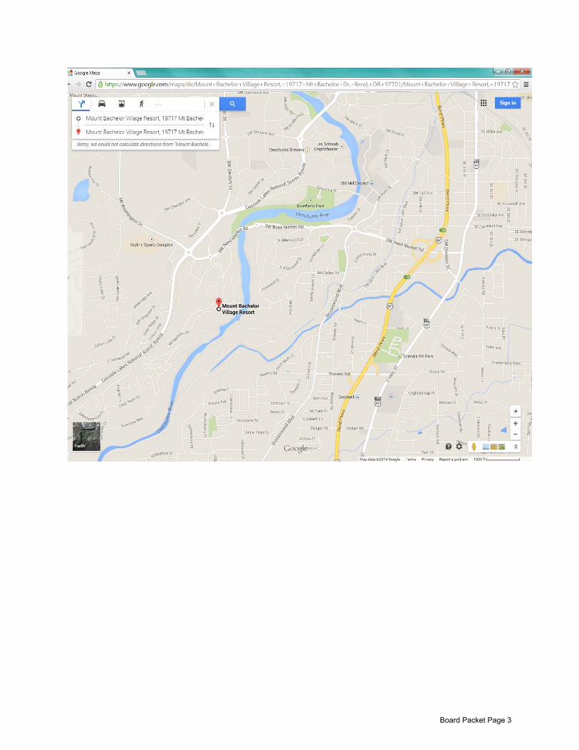
Mt. Bachelor Village Resort 19717 Mt. Bachelor Dr.
Bend, OR 97701
Board Packet Page 1

Board Packet Page 2
Board Packet Page 3

Deschutes River Conservancy Board of Directors – December 2014
John Allen – Forest Supervisor USFS – Deschutes National Forest 63095 Deschutes Market Road Bend, OR 97701 (541) 383-5512 fax-(541) 383-5531 [email protected] Rick Allen - Jefferson County RL Allen Group, LLC, President 384 SW 5th
Madras, OR 97741 Street
(541) 475-2220 fax-(541) 475-5662 (541) 815-4380 cell [email protected] Ron Angell – At Large 18160 Cottonwood Rd. #721 Sunriver, OR 97707 (541) 593-3242 [email protected] Arya Behbehani – Hydropower Portland General Electric Company 121 SW Salmon St. 3WTCBR05 Portland OR 97204 (503) 464-8141 [email protected] Bob Bell - At Large 56245 Twin Rivers Dr. Bend, OR 97707 (541) 593-1143 [email protected] Bruce Bischof – At Large 747 SW Mill View Way Bend, OR 97702 (541) 389-1292 cell-(541) 480-7560 [email protected] Linda (Bo) Bonotto – At Large 885 NW Chelsea Loop Bend, OR 97701 [email protected] Mike Britton – Irrigation North Unit Irrigation District 2024 NW Beech St Madras, OR 97741 (541) 475-3625 [email protected] Robert A. Brunoe – Confederated Tribes of the Warm Springs Reservation of Oregon P.O. Box C Warm Springs, OR 97761 (541) 553-2051 fax-(541) 553-1994 (541) 980-2898 cell [email protected]
Mark Capell – At Large COCO 129 SE Third St Bend, OR 97702 (541) 330-0555 [email protected] Doug DeFlitch – Department of Interior Bureau of Reclamation 1375 SE Wilson Ave., Ste 100 Bend, OR 97702 (541) 389-6541 Ext. 226 [email protected] Nancy Gilbert US Fish and Wildlife Service 63095 Deschutes Market Road Bend, OR 97701 (541) 383-7146 [email protected] Kyle Gorman – State of Oregon Oregon Water Resources Dept. 231 SW Scalehouse Lp., Ste 103 Bend, OR 97702 (541) 306-6885 [email protected] Ellen Grover – Secretary, Non Voting Karnopp, Petersen LLP 1201 NW Wall St., Suite 300 Bend, OR 97701 (541) 382-3011 fax-(541) 388-5410 [email protected] Jay Henry – At Large (541) 460-0460 cell [email protected] Craig Horrell – At Large COID District Manager 1055 SE Lake Ave. Redmond, OR 97756 (541)480-7773 [email protected] Julie A. Keil (Chair) – At Large (503) 703-7033 cell [email protected] Michael LaLonde – At Large Deschutes Brewery, Inc. 901 SW Simpson Ave. Bend, OR 97702 (541) 385-8606 [email protected]
Board Packet Page 4
Richard Macy - Irrigation North Unit Irrigation District 5287 SW Macy Lane Culver, OR 97734 (541) 788-3504 [email protected] Jim Manion – Tribal Warm Springs Power Enterprises P.O. Box 960 Warm Springs, OR 97761 (541) 553-1046 fax-(541) 553-3436 (541) 325-1464 cell [email protected] Jade Mayer (Treasurer) – At Large Brooks Resources 409 NW Franklin Ave. Bend, OR 97701 (541) 382-1662 fax-(541) 385-3285 [email protected] Gregory McClarren - Environment 65491 Bay Breeze Rd North Bend, OR 97459 (541) 923-6670 cell (541) 633-0228 [email protected] Damien Nurre - Recreation & Tourism 906 NE 11th
Bend, OR 97701 St.
(541) 323-3007 (541) 390-6697 cell [email protected] Ron Ochs – Sherman/Wasco County 10464 NE Hwy 97 Madras, OR 97741 (541)475-6927 fax-(541) 475-6097 [email protected] Betty Roppe –Crook County 387 NE Third St Prineville, OR 97754 541 447-6815 [email protected] Jim Rozewski – At Large Rozewski & Co. 806 NW Brooks St Bend, OR 97701 (541) 385-3296 fax-(541) 389-5388 [email protected] John Shelk – Timber Ochoco Lumber Company P.O. Box 668 NE Combs Flat Rd. Prineville, OR 97754 (541) 447-6296 fax-(541) 447-8992 (541) 410-4316 cell [email protected]
William Smith – Land Development William Smith Properties Inc. 15 SW Colorado Ave. Bend, OR 97702 (541) 382-6691 fax-(541) 388-5414 (541) 480-0357 cell [email protected] Mike Tripp - Environment 1020 NW Foxwood Bend, OR 97701 (541) 312-2193 [email protected] Alan Unger – Deschutes County 1300 NW Wall St., Suite 200 Bend, OR 97701 (541) 388-6569 (541) 419-0556 cell [email protected] Ted Wise – ODFW Oregon Dept of Fish & Wildlife 61374 Parrell Rd Bend, OR 97702 (541) 388-6363 [email protected]
DRC Staff
Tod Heisler Executive Director (541) 382-4077 Ext. 19 (541) 480-2388 cell [email protected] Hoyt Wilson Finance & Administration Director (541) 382-4077 Ext. 12 [email protected] Bea Armstrong Director of Development & Communications (541) 382-4077 Ext 23 (541) 419-7892 cell [email protected] Kate Fitzpatrick Program Director (541) 382-4077 Ext. 18 [email protected] Genevieve Hubert Leasing & Transfers Program Manager (541) 382-4077 ext. 16 [email protected] Brett Golden Director of Program Operations (541) 382-4077 Ext. 14 [email protected] Board Packet Page 5
Zachary Tillman Program Manager (541) 382-4077 Ext. 21 [email protected] Kelsey Wymore Program Associate (541) 382-4077 Ext. 15 [email protected] Marisa Hossick Outreach Manager (541) 382-4077 ext. 25 [email protected] Debbie Conners Office Coordinator (541) 382-4077 Ext. 10 [email protected]
Staff Accountant Tara MacMillan
(541) 382-4077 ext. 24 [email protected]
700 NW Hill Street #1 DRC Address
PO Box 1560 Bend, OR 97709 541-382-4077 fax (541) 382-4078 www.deschutesriver.org
Board Packet Page 6

Term
Cou
ntC
lass
Rep
rese
ntin
gN
ame
Expi
res
Com
men
ts1
IH
ydro
elec
tric
Prod
uctio
nAr
ya B
ehbe
hani
Jun.
201
72
ILi
vest
ock/
Gra
zing
Vaca
nt3
ITi
mbe
rJo
hn S
helk
Sep.
201
54
ILa
nd D
evel
opm
ent
Bill
Smith
Sep.
201
55
IIrr
igat
ed A
gric
ultu
reR
icha
rd M
acy
Sep.
201
56
IIrr
igat
ed A
gric
ultu
reM
ike
Britt
onJu
n. 2
017
7I
Envi
ronm
ent
Gre
gory
McC
larr
enSe
p. 2
015
8l
Envi
ronm
ent
Mik
e Tr
ipp
Sep.
201
69
IR
ecre
atio
n/To
uris
mD
amie
n N
urre
Sep.
201
510
IIC
onfe
dera
ted
Trib
es o
f War
m S
prin
gsBo
bby
Brun
oeM
ar. 2
017
11II
Con
fede
rate
d Tr
ibes
of W
arm
Spr
ings
Jim
Man
ion
Sep.
201
512
IID
ept o
f Int
erio
r (BO
R)
Dou
g D
eFlit
chSe
p. 2
016
13II
Dep
t of A
gric
ultu
re (U
SFS)
John
Alle
nD
ec. 2
014
14II
Ore
gon
Dep
t of F
ish
and
Wild
life
Ted
Wis
eJu
n. 2
017
15II
Ore
gon
Wat
er R
esou
rces
Dep
tKy
le G
orm
anJu
n. 2
015
16II
Des
chut
es C
ount
yAl
an U
nger
Mar
. 201
517
IIC
rook
Cou
nty
Betty
Rop
peJu
n. 2
015
18II
Sher
man
/Was
co C
ount
yR
on O
chs
Jun.
201
519
IIJe
ffers
on C
ount
yR
ick
Alle
nSe
p. 2
015
20ll
Cen
tral O
rego
n C
ities
Org
aniz
atio
nM
ark
Cap
ell
Jun.
201
521
IIIAt
larg
eJi
m R
ozew
ski
Jun.
201
522
IIIAt
larg
eJa
de M
ayer
Jun.
201
523
IIIAt
larg
eBr
uce
Bisc
hof
Sep.
201
624
IIIAt
larg
eJu
lie K
eil
Dec
. 201
625
IIIAt
larg
eBo
b Be
llSe
p. 2
016
26III
At la
rge
Mic
hael
LaL
onde
Sep.
201
727
IIIAt
larg
eR
on A
ngel
lJu
n. 2
015
28III
At la
rge
Jay
Hen
ryJu
n. 2
015
29III
At la
rge
Nan
cy G
ilber
tJu
n. 2
016
30III
At la
rge
Bo B
onot
toJu
n. 2
017
31Bo
ard
Secr
etar
yEl
len
Gro
ver
32Ex
-Offi
cio
Cra
ig H
orre
ll
DR
C B
oard
of D
irect
ors
by C
lass
Board Packet Page 7

Board Packet Page 8
AGENDA Board of Directors Meeting
1:00 AM – 5:00 PM, Thursday, December 11, 2014 Mt. Bachelor Village, Bend
1:00 1. Introductions (Julie)
a. Approve Board Meeting Minutes (Tab 1) b. Board elections:
• John Allen- USDA Forest Service 1:15 2. Communication and Development (Bea) (Tab 2) 1:45 3. Finance & Audit (Hoyt) (Tab 3)
a. Review FY14 Financials, unaudited 2:15 4. Program Updates (Tab 4)
a. Leasing and Groundwater Mitigation Bank (Action Item: 2015 Program Approvals)
b. Crooked River i. COID West-F Lateral
ii. COID-NUID Pilot Mitigation Transfer c. Whychus Creek
i. TSID Piping d. Basin Study e. Consulting
3:00 BREAK 3:15 5. Strategic Issues Discussion (Tab 5)
a. DRC Strategic Plan b. Habitat Conservation Plan
5:00 ADJOURN
Board Packet Page 9

Board Packet Page 10
Meeting Minutes
Board of Directors Meeting 9:00 AM – 2:00 PM, Thursday, September 11, 2014
Becky Johnson Center, Redmond
Board Members Attending: Bruce Bischof, Mike Britton, Bobby Brunoe, Doug DeFlitch, Nancy Gilbert, Kyle Gorman, Jay Henry, Craig Horrell, Julie Keil, Michael LaLonde, Richard Macy, Jim Manion, John Allen, Damien Nurre, Betty Roppe, Mike Tripp, Alan Unger, Ted Wise Board Members Absent: Rick Allen, Ron Angell, Arya Behbehani , Linda (Bo) Bonotto, Bob Bell, Mark Capell, Gregory McClarren, Jim Rozewski, John Shelk, Ellen Grover, Jade Mayer, Ron Ochs, Bill Smith, Clay Trenz Staff Attending: Bea Armstrong, Debbie Conners, Kate Fitzpatrick, Brett Golden, Tod Heisler, Marisa Hossick, Gen Hubert, Anna Pakenham, Hoyt Wilson, Kelsey Wymore, Zachary Tillman Guests Attending: Shawn Gerdes, Jeremy Giffin Ryan Houston, Lauren Mork, Jeff Wieland, Dave Dunahay, Patrick Erger (BOR), Pamela Thalacker
1 Introductions
1.1 Approve Board Meeting Minutes
Action Item: Betty Roppe moved to approve the minutes from the prior Board Meeting. Bobby Brunoe seconded. All in favor.
1.2 Board Elections
Tod introduced the Board to the prospective Board Members. These Board Members and their associated Board positions include:
Craig Horrell, Ex Oficio – Central Oregon Irrigation District
Michael LaLonde, At‐Large Board Members briefly discussed prospective Board Members.
Action Item: Jay Henry moved to approve Craig Horrell. Kyle Gorman seconded. All in favor. Action Item: Richard Macy moved to approve Michael LaLonde. Nancy Gilbert seconded. All in favor.
2 Strategic Issues Discussion
Tumalo Creek and Middle Deschutes Flow‐Temperature Study (presentation by Upper Deschutes Watershed Council) Ryan Houston introduced the Board to this issue. He briefly reviewed the geography of the middle Deschutes River, the potential sources of cold water in this reach, and monitoring locations in the reach.
Board Packet Page 11
Ryan reviewed temperature trends in this reach in relation to temperature standards. He commented on improvements in stream flow and their relationship to stream temperature. Ryan noted that temperatures in the Deschutes River meet or exceed state standards when the river enters the City of Bend. Increasing stream flows from Tumalo Creek into the Deschutes River will reduce temperatures in the river downstream from the City of Bend. Ryan reviewed several scenarios that increased stream flows in the creek and the river. He reviewed their impacts on temperature and stream flow. He demonstrated that restoring a smaller volume of Tumalo Creek water would reduce stream temperatures more than restoring a larger volume of Deschutes River water. Ryan suggested that next steps would include refining and validating their analyses, comparing their results to other models’ results, and refining restoration targets and priorities. The Board discussed this issue. They commented on the accuracy of the Upper Deschutes Watershed Council’s analysis. They discussed warming rates relative to water volume downstream from the Tumalo Creek confluence. They discussed the potential cost‐savings of restoring a smaller volume of stream flow to Tumalo Creek instead of a larger volume to the Deschutes River. They commented on the potential to affect summer stream flows in the upper Deschutes River. They commented on the natural thermal potential of the river and its relationship to the TMDL process. The group discussed channel capacity and shading and agreed to bring that up at a future meeting.
2.1 Deschutes Basin Study
Kate Fitzpatrick briefly provided an overview of the Basin Study. The DRC expects that the Basin Study will provide the information necessary to forge a long term management plan to help meet water supply goals in the basin. Study participants are evaluating several approaches to apply in the Basin Study. They’re evaluating the relative value of investments in obtaining better information about the system and in developing water supply options. Instream goals and stream flow targets have not been fully developed. The Board discussed the interplay between inexpensive, culturally challenging supply options (i.e. on‐farm efficiencies) and expensive, culturally easy supply options (i.e. new off‐channel storage). The Board discussed their expectations for future funding for large infrastructure projects such as storage. They discussed the potential costs and benefits of developing programs now without the future climate projections that the Basin Study will provide. They discussed the various investments that the Basin Study could make in developing water supply options. The Board discussed how they should interact with Basin Study participants. DRC staff will provide a quarterly update to the Board at their quarterly meetings. The Board discussed Kate Fitzpatrick’s role as a process coordinator, and they recommended that she clearly separate her coordinator and DRC roles if possible. The Board discussed how much authority staff should have to advocate for the organization’s interests. If DRC staff expects that their position or interest will differ from the position or interest previously supported by the Board, staff will review this position or interest with the Executive Committee as necessary.
Board Packet Page 12
2.2 Habitat Conservation Plan
Tod Heisler briefly reviewed the Habitat Conservation Plan with the Board of Directors. He commented on the potential for conflict between the voluntary Basin Study and the regulatory Habitat Conservation Plan. A participant commented on the different goals of these two efforts; the Basin Study will address broad goals and the Habitat Conservation Plan will only minimize and mitigate for the impacts of the applicants on the included species. Participants highlighted two upcoming meetings related to the Habitat Conservation Plan, a Working Group meeting on September 16 and a Stakeholder Group meeting on November 4. Board Members commented that both the applicants and the other interests were managing multiple processes, and that all sides will require patience.
3 Executive Director Report
3.1 DRC Strategic Planning
Tod Heisler reminded the Board about the DRC’s strategic planning process. He briefly reviewed an outline and major strategic planning concepts with the Board. The Board briefly discussed the concepts that Tod presented.
3.2 Consulting
Tod Heisler reported on Watershed Strategies’ consulting engagements. He noted that consulting requires a very small portion of DRC staff resources. He also noted that, when Watershed Strategies no longer adds value in a basin due to the completion of its work or two extenuating circumstances, we disengage from that basin. Tod also commented that Watershed Strategies has provided a new revenue stream to the DRC.
4 Program Updates
4.1 Whychus Creek
4.1.1 TSID Piping
The DRC is continuing to work with TSID on water conservation projects. Phase V is complete, restoring 1.3 cfs instream, in addition to four previous phases and a phase VI going in this winter. There will be future phases after that. TSID recently completed a 0.7 MW hydropower plant at the upper end of Phase 4 at Watson Reservoir. A second hydropower plant is planned at McKenzie Reservoir. The Sokol dam came out last week at Pine Meadow Ranch’s diversion, south of Sisters on Deschutes National Forest land. This project eliminated the dam, added a new, fish friendly point of diversion and removed the last concrete barrier in Whychus Creek. It highlighted the collaboration between the landowner, Upper Deschutes Watershed Council, Deschutes River Conservancy, and Deschutes National Forest. Long‐term landowner relationship paid off. 1 cfs of conserved water is permanently protected instream. The project opened up 13 miles of habitat in the 45‐mile long creek. The Forest Service will be restoring 2 miles downstream of the dam. The Oregon Water Resources Department did a fantastic job of processing the conserved water application this year.
4.2 Crooked River
4.2.1 COID Piping: Juniper Ridge, Substitute
The North Unit Water Supply Program conserves Deschutes River water, allocates the conserved water to lands in North Uni t Irrigation District that historically received water pumped from the Crooked River, and allocates the associated Crooked River water rights instream. The third phase of this program,
Board Packet Page 13
Central Oregon Irrigation District’s Juniper Ridge Phase 2 project, has been protested by landowners. The district and landowners are currently in mediation to assess whether a solution may be possible. The outcome of this will be known by March 25th. In the meantime, we are working with Central Oregon Irrigation District to develop an alternate project to implement this winter, the West F Lateral. The district is finalizing loss estimates on this lateral. Initial estimates are 7‐8 cfs, and it looks to be a very cost‐effective project.
4.2.2 COID‐NUID Pilot Mitigation Transfer
This project will pilot an approach to transfer water between uses and users under the North Unit Water Supply Program. It will transfer 40 acres of urbanized Deschutes River water rights from Central Oregon Irrigation District to North Unit Irrigation District, transfer the associated Crooked River water rights instream, and generate mitigation credits. Under the proposed arrangement, North Unit Irrigation District or its patrons would continue to pay assessments to Central Oregon Irrigation District for those water rights. This project is pending a review by Reclamation.
4.2.3 Crooked River Legislation
This legislation will provide one path for the McKay Water Rights Switch. The Senate legislation has passed out of committee and is pending a vote on the floor. The House legislation has passed but will need to be reconciled with any Senate legislation. The DRC will wait for the outcome of the legislation this year and will readdress strategy with Ochoco Irrigation District and the Board in March.
4.3 Leasing Program
All but two leases have final ordered. The lease in TID that hasn’t final ordered has been protected under a water management agreement. Leasing volume and rates are slightly down but the number of leasing participants are staying constant. Smaller properties being leased, partially because it is a dryer year. Some of the larger acres have gone back into protection. There are funding challenges with the program due to the cyclical nature of leasing. We will be working with districts towards more consistent goals. Oregon Watershed Enhancement Board and National Fish and Wildlife Program have a new joint funding program for water acquisitions. We are testing this out with the leasing program. This should facilitate an easier process to secure these sources of funding for leasing. Participants suggested that the Program Committee discuss leasing strategy at their next meeting.
4.4 Upper Deschutes Winter Flow Management
Two topics have been discussed: a ramp down experiment to mitigate potential fish casualties this fall; a winter flow pilot that increases minimum flows below Wickiup. The ramp down has been a very successful collaboration between the districts, TU, UDRC, USFS, ODFW to change the ramp down from 3‐4 days to 12 days, to give fish a time to seek the main channel and/or salvage fish if necessary. The ramp down will allow USFS and others to assess river conditions and side channels at different levels. This is a great step. It will be important to make progress on the longer‐term solution of increasing winter flows. We will continue to talk about this in a small group with water managers this winter, being conscious of bandwidth amidst many asks to the irrigation districts. It will be useful to work on relationships with district boards at times when we are not asking things of them to continue to strengthen them.
Board Packet Page 14
From a fisheries/recreation perspective, this will be received well if it is communicated as a step in a longer‐term effort towards a tangible solution. The constituency from the upper River, many of whom have provided significant funding to support this effort, will need to see something tangible. It is getting more difficult to keep their support. The board members who represent this constituency are committed to a collaborative approach, have come to appreciate the challenges the districts face, but will be challenged if there is not something tangible to show people. DRC should be conscious of downplaying what is not happening (i.e. “greenwashing”). Several reps from the flyfishing community see this as a great and tangible step.
5 Communication and Development
5.1 DRC Board Communications Committee
Bea discussed the different perspectives and lenses that Board Members bring with them to Board Meetings. She commented on the potential for those perspectives and lenses to contribute to collaboration or conflict. Bea discussed the shift from a project‐by‐project approach to a programmatic approach. That shift, which roughly coincided with the reintroduction of steelhead, brought additional challenges for communication. She suggested that the DRC has both internal (staff and Board) communications gaps and external (general public) communications gaps. Examples of internal communications gaps over the past year include:
an upper Deschutes River fish kill;
a newsletter that discussed the upper Deschutes River; and
an independent film on the Deschutes River that Board Members participated in. Examples of external communications gaps over the past year include:
understanding about the upper Deschutes River fish kill;
understanding the Habitat Conservation Plan; and
understanding about what the DRC does and how it does it. The Communications Committee will discuss and identify how to address these types of communications issues.
5.2 FY14 Unrestricted Revenue Forecast
Bea highlighted the success of our fundraising efforts, particularly RiverFeast, this year. She referred Board Members to the Board Packet for additional information.
6 Finance & Audit
6.1 Review FY14 financials (6/30/13)
Hoyt Wilson reviewed FY14 Q3 financial statements with the Board. The Board recommends that the DRC maintain a reserve equal to 90% of its fixed costs for a year; the current reserve exceeds that recommendation. Hoyt commented that these statements do not include a buyout off the Climate Trust contract. The DRC spent approximately $22,000 in unrestricted funds in this buyout (in addition to approximately $90,000 that was in escrow).
Board Packet Page 15

Hoyt noted that the DRC’s revenues and expenses will be lower than expected in FY14 due to the delay in the Juniper Ridge II project. Hoyt reviewed revenues and expenses.
6.2 Review and approval of FY15 budget
Hoyt reviewed the FY15 budgets with the Board of Directors. The Board discussed changes between FY14 and FY15 budgets. Hoyt discussed the assumptions made in the FY15 budgets.
Action Item: Bobby Brunoe moved to approve the FY15 budget. Kyle Gorman seconded. All in favor.
Board Packet Page 16
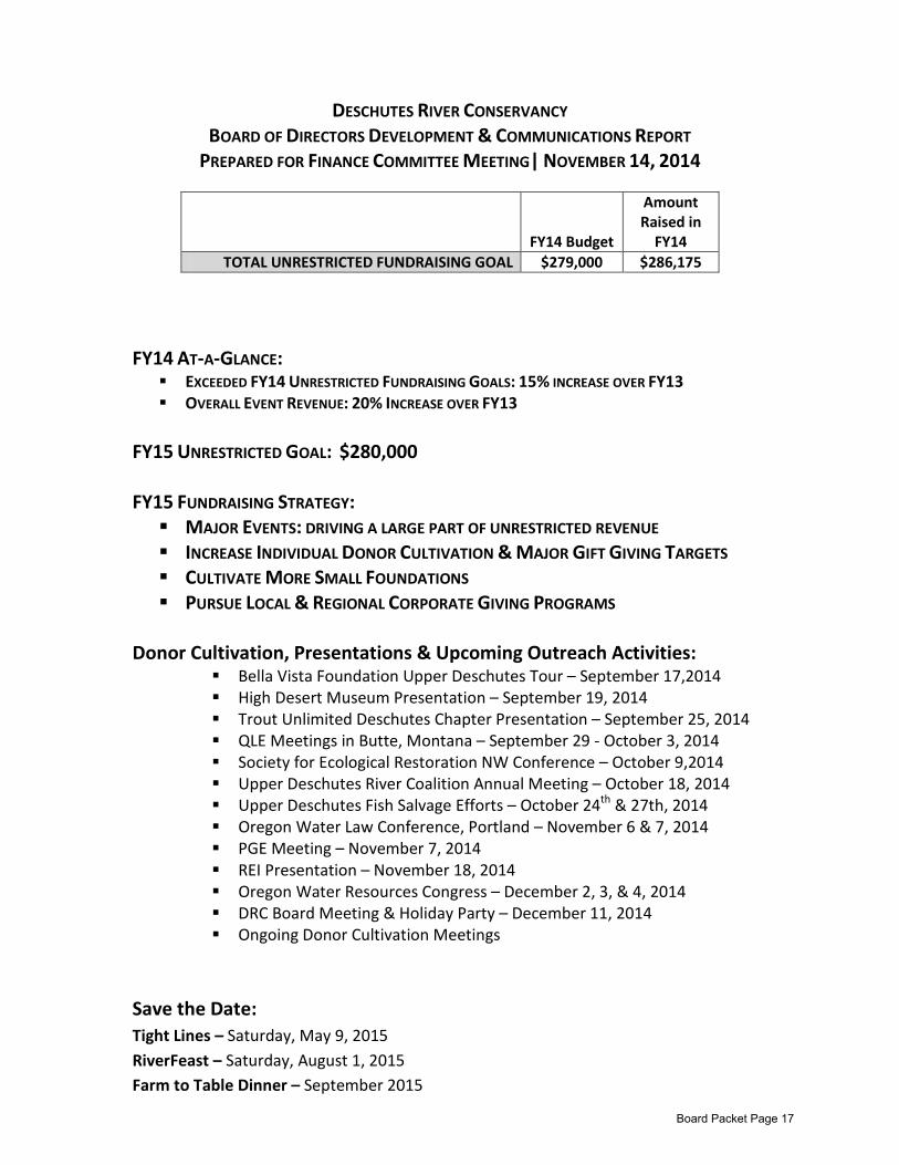
DESCHUTES RIVER CONSERVANCY
BOARD OF DIRECTORS DEVELOPMENT & COMMUNICATIONS REPORT PREPARED FOR FINANCE COMMITTEE MEETING| NOVEMBER 14, 2014
FY14 AT-A-GLANCE: EXCEEDED FY14 UNRESTRICTED FUNDRAISING GOALS: 15% INCREASE OVER FY13 OVERALL EVENT REVENUE: 20% INCREASE OVER FY13
FY15 UNRESTRICTED GOAL: $280,000 FY15 FUNDRAISING STRATEGY: MAJOR EVENTS: DRIVING A LARGE PART OF UNRESTRICTED REVENUE INCREASE INDIVIDUAL DONOR CULTIVATION & MAJOR GIFT GIVING TARGETS CULTIVATE MORE SMALL FOUNDATIONS PURSUE LOCAL & REGIONAL CORPORATE GIVING PROGRAMS
Donor Cultivation, Presentations & Upcoming Outreach Activities: Bella Vista Foundation Upper Deschutes Tour – September 17,2014 High Desert Museum Presentation – September 19, 2014 Trout Unlimited Deschutes Chapter Presentation – September 25, 2014 QLE Meetings in Butte, Montana – September 29 - October 3, 2014 Society for Ecological Restoration NW Conference – October 9,2014 Upper Deschutes River Coalition Annual Meeting – October 18, 2014 Upper Deschutes Fish Salvage Efforts – October 24th
Oregon Water Law Conference, Portland – November 6 & 7, 2014 & 27th, 2014
PGE Meeting – November 7, 2014 REI Presentation – November 18, 2014 Oregon Water Resources Congress – December 2, 3, & 4, 2014 DRC Board Meeting & Holiday Party – December 11, 2014 Ongoing Donor Cultivation Meetings
Save the Date: Tight Lines – Saturday, May 9, 2015 RiverFeast – Saturday, August 1, 2015 Farm to Table Dinner – September 2015
FY14 Budget
Amount Raised in
FY14 TOTAL UNRESTRICTED FUNDRAISING GOAL $279,000 $286,175
Board Packet Page 17
Website Statistics
• 3,068 unique visitors from September 1st to November 20th.
• 7,245 page views from September 1st to November 20th.
• 74.54% of visits are from new visitors.
Social Media Statistics
• 81 new subscribers on Facebook from September 1st to November 20th raising total number to 1,310, an increase of 4.88%.
• Facebook messages were seen by an average of 78 DRC subscribers per day from September 1st to November 20th. An average of 8 subscribers are engaging with DRC messages per day (liking, commenting, sharing).
• 37 new DRC subscribers on Twitter from September 1st to November 20th raising total number to 708, a 12% increase. 37 subscribers clicked through to links provided in our tweets.
• Above average open rate on e-newsletters sent out in September and October. 35.2% compared to the industry average of 21.2%. Combined, 159 people clicked on a link in the e-newsletter to read more on the DRC website or blog.
Print Media Coverage
• Bulletin: 11 articles
• Sisters Nugget: 1 article
• KTVZ: 2 articles
Board Packet Page 18
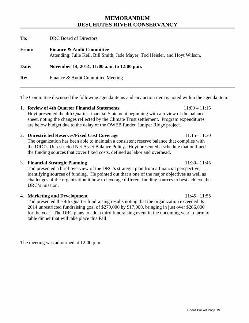
MEMORANDUM DESCHUTES RIVER CONSERVANCY
To: DRC Board of Directors From: Finance & Audit Committee
Attending: Julie Keil, Bill Smith, Jade Mayer, Tod Heisler, and Hoyt Wilson.
Date: November 14, 2014, 11:00 a.m. to 12:00 p.m. Re: Finance & Audit Committee Meeting The Committee discussed the following agenda items and any action item is noted within the agenda item:
1. Review of 4th Quarter Financial Statements 11:00 – 11:15 Hoyt presented the 4th Quarter financial Statement beginning with a review of the balance sheet, noting the changes reflected by the Climate Trust settlement. Program expenditures are below budget due to the delay of the OWEB funded Juniper Ridge project.
2. Unrestricted Reserves/Fixed Cost Coverage 11:15– 11:30 The organization has been able to maintain a consistent reserve balance that complies with the DRC’s Unrestricted Net Asset Balance Policy. Hoyt presented a schedule that outlined the funding sources that cover fixed costs, defined as labor and overhead.
3. Financial Strategic Planning 11:30– 11:45 Tod presented a brief overview of the DRC’s strategic plan from a financial perspective, identifying sources of funding. He pointed out that a one of the major objectives as well as challenges of the organization it how to leverage different funding sources to best achieve the DRC’s mission.
4. Marketing and Development 11:45– 11:55 Tod presented the 4th Quarter fundraising results noting that the organization exceeded its 2014 unrestricted fundraising goal of $279,000 by $17,000, bringing in just over $286,000 for the year. The DRC plans to add a third fundraising event in the upcoming year, a farm to table dinner that will take place this Fall.
The meeting was adjourned at 12:00 p.m.
Board Packet Page 19
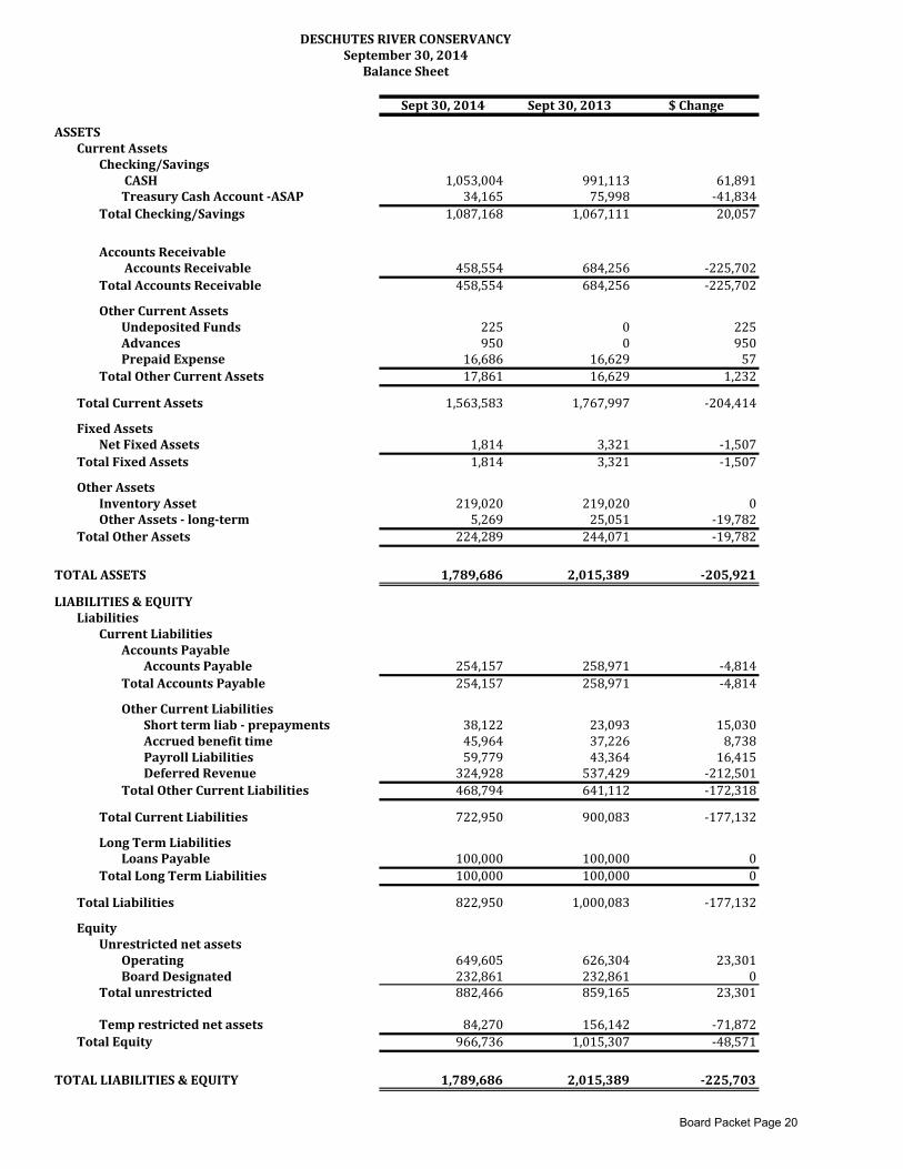
Sept30,2014 Sept30,2013 $Change
ASSETSCurrentAssets
Checking/SavingsCASH 1,053,004 991,113 61,891TreasuryCashAccount‐ASAP 34,165 75,998 ‐41,834
TotalChecking/Savings 1,087,168 1,067,111 20,057
AccountsReceivableAccountsReceivable 458,554 684,256 ‐225,702
TotalAccountsReceivable 458,554 684,256 ‐225,702
OtherCurrentAssetsUndepositedFunds 225 0 225Advances 950 0 950PrepaidExpense 16,686 16,629 57
TotalOtherCurrentAssets 17,861 16,629 1,232
TotalCurrentAssets 1,563,583 1,767,997 ‐204,414
FixedAssetsNetFixedAssets 1,814 3,321 ‐1,507
TotalFixedAssets 1,814 3,321 ‐1,507
OtherAssetsInventoryAsset 219,020 219,020 0OtherAssets‐long‐term 5,269 25,051 ‐19,782
TotalOtherAssets 224,289 244,071 ‐19,782
TOTALASSETS 1,789,686 2,015,389 ‐205,921
LIABILITIES&EQUITYLiabilities
CurrentLiabilitiesAccountsPayable
AccountsPayable 254,157 258,971 ‐4,814TotalAccountsPayable 254,157 258,971 ‐4,814
OtherCurrentLiabilitiesShorttermliab‐prepayments 38,122 23,093 15,030Accruedbenefittime 45,964 37,226 8,738PayrollLiabilities 59,779 43,364 16,415DeferredRevenue 324,928 537,429 ‐212,501
TotalOtherCurrentLiabilities 468,794 641,112 ‐172,318
TotalCurrentLiabilities 722,950 900,083 ‐177,132
LongTermLiabilitiesLoansPayable 100,000 100,000 0
TotalLongTermLiabilities 100,000 100,000 0
TotalLiabilities 822,950 1,000,083 ‐177,132
EquityUnrestrictednetassets
Operating 649,605 626,304 23,301BoardDesignated 232,861 232,861 0
Totalunrestricted 882,466 859,165 23,301
Temprestrictednetassets 84,270 156,142 ‐71,872TotalEquity 966,736 1,015,307 ‐48,571
TOTALLIABILITIES&EQUITY 1,789,686 2,015,389 ‐225,703
DESCHUTESRIVERCONSERVANCYSeptember30,2014
BalanceSheet
Board Packet Page 20
FY14
Budget
FY14‐YTD
9‐30‐2014
%to
Bud
FY14
Budget
FY14‐YTD
9‐30‐2014
%to
Bud
FY14
Budget
FY14‐YTD
9‐30‐2014
%toBud
FY14
Budget
FY14‐YTD
9‐30‐2014
%to
Bud
Income
Federal
522,297
628,778
120%
522,297
617,235
118%
‐
1,753
09,791
State
892,327
308,550
35%
892,327
308,550
35%
‐
‐
0%0
‐
Foundation&corporation
1,314,777
794,425
60%
1,275,777
764,405
60%
39,000
30,020
77%
0‐
PrivateRevenue
360,060
514,465
143%
72,516
210,418
290%
240,000
254,402
106%
47,544
49,645
104%
In‐kind
‐
‐
‐
0TotalIncome
3,089,461
2,246,218
73%
2,762,917
1,900,608
69%
279,000
286,175
103%
47,544
59,435
125%
Expense
Personnelcharges
848,507
825,644
97%
456,005
473,468
104%
203,184
195,760
96%
189,318
156,416
83%
Projects&TransExpenses
1,949,800
1,142,634
59%
1,949,800
1,142,634
59%
‐
‐
0‐
Subcontractors‐DRCprojects
110,206
128,533
117%
110,206
128,533
117%
‐
‐
0‐
WaterProjects‐otherdirect
13,873
19,742
142%
13,873
19,742
142%
‐
‐
0‐
Marketing&Dev
77,610
77,217
99%
‐
77,610
77,217
99%
0‐
In‐kind
‐
‐
‐
‐
‐
0‐
General&Administration
88,782
101,018
114%
‐
‐
‐
88,782
101,018
114%
Subtotalexpensesbeforeadmin
allocation
3,088,778
2,294,789
74%
2,529,884
1,764,377
70%
280,794
272,978
97%
278,100
257,434
93%
AdminAllocationAccounts
‐
‐
232,956
198,199
85%
‐2,400
‐
0%‐230,556
‐198,199
86%
Totalexpenses
3,088,778
2,294,789
74%
2,762,840
1,962,576
71%
278,394
272,978
98%
0200
NetOrdinaryIncome
683
(48,571)
77
(61,969)
606
13,197
0200
‐
RestrictedAssetsOffsetting
Expenses
97,824
85,854
11,970
‐
‐
NetIncomePlusRestrictedOffset
49,253
23,885
25,167
200
LessReleaseofRestrictedNetAssets
(97,824)
YTDChangeinNetAssets
(48,571)
NetAssetsBOY
1,015,307
NetAssetsEOY
966,736
Total
Program
sMarketing/Development
DESCHUTESRIVERCONSERVANCY
September30,2014
Statem
entofActivities
Administration
Board Packet Page 21
$‐
$500
$1,000
$1,500
$2,000
$2,500
$3,000
$3,500
$4,000
$4,500
Sept 20
12Sept 20
13Sept 2014
$1,174
$552
$629
$1,020
$629
$309
$1,464
$815
$684
$272
$228
$186
$270
$114
$110
$216
$246
$328
YTD
Revenue Source Comparison
Individuals & Corporations
Foundation
Other (includes consulting & leasing trans rev)
Pelton
State
Federal
in $1,000
Board Packet Page 22
$315,650
$260,764
$257,434
$‐
$50,000
$100,000
$150,000
$200,000
$250,000
$300,000
$350,000
Sept 2012
Sept 2013
Sept 2014
3 Year YTD
Administration Expense
Comparison
Board Packet Page 23
$3,767,149
$2,068,621
$1,764,377
$‐
$500,000
$1,000,000
$1,500,000
$2,000,000
$2,500,000
$3,000,000
$3,500,000
$4,000,000
Sept 2012
Sept 2013
Sept 2014
3 Year YTD
Program
Expense
Comparison
Board Packet Page 24
Program Committee Meeting
November 13, 2014, 1:00 to 4:00 PM
Meeting Notes Board Member Attending Mike Britton (phone), Nancy Gilbert, Kyle Gorman, Mike Kasberger (phone), Julie Keil, Gregory McClarren, Betty Roppe (phone), Mike Tripp, Ted Wise Guests Attending Jeremy Giffin Staff Attending Bea Armstrong, Brett Golden, Tod Heisler, Gen Hubert, Zach Tillman, Kelsey Wymore 1 Introductions Kate Fitzpatrick convened the meeting. Attendees introduced themselves. 2 Program Approvals
2.1 Leasing Program Gen Hubert briefly reviewed the Leasing Program and how the program fits within the Deschutes River Conservancy’s restoration strategies. Participants discussed approaches to maintaining or increasing lease outputs with irrigation districts, and they generally agreed that staff should ultimately seek long-term agreements on lease outputs with irrigation districts. Participants discussed the relationship between the DRC’s priorities and leasing, particularly leasing outside of the DRC’s proposed priority areas.
Action: Recommend that the Board of Directors approve a one-year Leasing Program renewal. Gregory McClarren moved. Kyle Gorman seconded. All in favor
2.2 Mitigation Program Gen Hubert briefly reviewed the Mitigation Program with participants. Participants discussed temporary credit costs.
Action: Recommend that the Board of Directors approve a one-year Mitigation Program renewal. Julie Keil moved. Gregory McClarren seconded. All in favor.
3 Strategic Issues
3.1 DRC Strategic Plan (draft plan) Tod Heisler introduced the draft ten-year strategic plan to meeting participants. He reviewed the strategy at a relatively high level. Participants discussed whether the DRC should consider large-scale instream transfers as a part of this strategy. Participants recommended that the strategy include an opening for additional reaches, including the lower Deschutes River.
Board Packet Page 25
Upper Deschutes River Participants discussed the relative values of water in the upper Deschutes River and the middle Deschutes River. They discussed how these two reaches aligned with the DRC’s strategic priorities. Staff and participants reviewed the upper Deschutes River reach strategy. Participants discussed the strategy, and they ultimately recommended that the strategy include three elements:
1. More natural flow passed to junior users, 2. Through increased efficiency among senior users, and 3. Associated agreements to maintain stream flows downstream from Wickiup Reservoir.
Participants recommended that staff include some of the actions, such as reservoir operations, developed through the Deschutes Water Planning Initiative. Tumalo Creek Staff and participants reviewed the Tumalo Creek reach strategy. Participants recommended that staff:
• change language to, “concur with a self-imposed cap on the City of Bend’s diversion”; • work with Tumalo Irrigation District on reducing winter stock runs and with City of Bend on
understanding or limiting the impacts of their diversions on winter stream flow; and • improve the “maintain leasing as needed” language.
Middle Deschutes River Staff and participants reviewed the middle Deschutes River reach strategy. Staff prioritized the restoration of stream flows from Tumalo Creek and into the Deschutes River. Participants recommended that the DRC consider using Deschutes River leases to maintain stream flows when Tumalo Creek flows are not adequate or when Deschutes River flows are relatively cool. Lower Crooked Staff and participants discussed the strategy for the lower Crooked River and its tributaries. Participants discussed the potential for leasing in these reaches. Whychus Creek Staff and participants discussed the strategy for Whychus Creek. Staff discussed how the DRC and the district manage stream flows and water rights in Whychus Creek. Participants recommended that staff include strategic (emphasis theirs) transfers of water rights outside of TSID in this strategy.
3.2 HCP Comments (draft comments) Tod Heisler asked participants to comment on:
• whether the approach had merit enough to move forward; • what issues questions or concerns they have that require further investigation; and • what process they wanted to follow to address those issues, questions and concerns.
Tod reviewed the phased permit concept proposed in the DRC’s draft comments. The comments come in response to the draft conservation measures released by the HCP applicants in August. Staff has not submitted these comments to anyone beyond the Board of Directors yet, but they would submit them to the applicants and the associated federal regulatory agencies. An HCP applicant indicated that they’re looking for long-term certainty, and they don’t yet see that in this process. They see a risk in timing of permit issuance between phases. They’re concerned that
Board Packet Page 26
they’d need to go through an ESA and NEPA consultation at the end of each phase. Also, the applicants have committed to the traditional approach. Their constituents may not support an alternate approach. They recommend discussing this approach with the applicants’ consultant, Marty Vaughn. Nancy Gilbert confirmed that the initial ESA and NEPA consultation would carry forward to future phases. Nancy Gilbert commented that, with the Oregon spotted frog, they’ll need some kind of adaptive management approach. An applicant asked whether a phased approach would limit the applicants’ ability to finance their projects, since it wouldn’t provide long-term protection. Participants commented that this approach would provide long-term protection. Staff and participants agree that the draft comments are a concept and need to be refined prior to any submission. Staff will discuss them with the applicants and their consultant prior to submitting them. The Program Committee recommended that, pending the Executive Committee’s recommendation, staff continue to pursue this approach with the applicants in advance of the Board Meeting. Participants recommended that staff review this approach with applicant’s consultant prior to bringing it to the Board for approval. 4 Program Updates
4.1 Basin Study Kate Fitzpatrick reviewed the status of the Basin Study and the general approach that it has espoused with participants.
4.2 Communications Committee Bea reviewed the work of the Communications Committee. Upper Deschutes Fish Salvage Bea Armstrong highlighted the success of the fish salvage at enrolling multiple partners. Participants and staff commended the agencies and the districts for their work on this effort.
4.3 Crooked River West F Lateral Kate Fitzpatrick reviewed the West F lateral with participants. The district will be constructing this piping project this winter and may be interested in a second phase. Staff and participants discussed the desire for a long-term strategy to implement conservation projects in Central Oregon Irrigation District. COID-NUID Pilot Mitigation Transfer Kate Fitzpatrick reviewed this status of this project. Reclamation will align the Environmental Assessment with the 1920 Contract by the end of next week.
4.4 Whychus Creek Zach Tillman reviewed the status of the various Whychus Creek projects with participants.
Board Packet Page 27
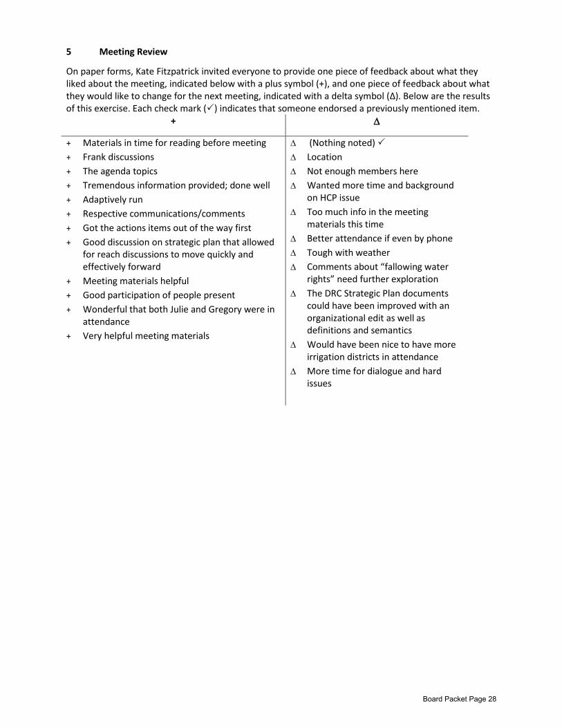
5 Meeting Review
On paper forms, Kate Fitzpatrick invited everyone to provide one piece of feedback about what they liked about the meeting, indicated below with a plus symbol (+), and one piece of feedback about what they would like to change for the next meeting, indicated with a delta symbol (∆). Below are the results of this exercise. Each check mark () indicates that someone endorsed a previously mentioned item.
+ ∆
+ Materials in time for reading before meeting + Frank discussions + The agenda topics + Tremendous information provided; done well + Adaptively run + Respective communications/comments + Got the actions items out of the way first + Good discussion on strategic plan that allowed
for reach discussions to move quickly and effectively forward
+ Meeting materials helpful + Good participation of people present + Wonderful that both Julie and Gregory were in
attendance + Very helpful meeting materials
∆ (Nothing noted) ∆ Location ∆ Not enough members here ∆ Wanted more time and background
on HCP issue ∆ Too much info in the meeting
materials this time ∆ Better attendance if even by phone ∆ Tough with weather ∆ Comments about “fallowing water
rights” need further exploration ∆ The DRC Strategic Plan documents
could have been improved with an organizational edit as well as definitions and semantics
∆ Would have been nice to have more irrigation districts in attendance
∆ More time for dialogue and hard issues
Board Packet Page 28
Annual Leasing 2015 Program Proposal
Board Meeting December 11, 2014
Deschutes River Conservancy
Genevieve Hubert PO Box 1560, Bend, Oregon, 97709
(541) 382-4077, ext. 16 (541) 382-4078 fax [email protected]
DRC Board of Directors Action: Staff ask the DRC Board of Directors to approve continuing the Instream Leasing Program through 2015, including:
1. pricing and payment structure 2. payment eligibility criteria 3. volume targets 4. reach targets
Program Information
Name of Project/Program: Instream Leasing Program 2015 Program Start Date: October 2014 Program End Date: November 2015 Program Annual Cash Cost: $250,000 Annual District In-Kind: $43,950 Total Annual Program Cost: $293,950
Project Summary This program will improve instream flows through the leasing of water from landowners and irrigation districts. Leasing does not require a long-term commitment from landowners, it educates landowners about the economic value of their water rights, and it increases instream flows at a low cost per unit of water restored. Leases can extend from 1-5 years, and landowners can opt out of the program at any time. Leased water is temporarily transferred to instream use through Oregon’s instream leasing program. During the 2014 irrigation season, the DRC leased 21,495 acre-feet of water at an average transaction cost of $3.10 per acre-foot and $1067 per cubic foot per second (cfs), and an average of $3.72 per acre-foot for lease payment and state fees. The total average price per acre-foot including administration of the program was $8.50 in 2014. The total average price per acre-foot including state and other fees, staff time and general administration of the program. The total average cost is expected to be no more than $10.00. This project will increase instream flows by approximately 75 cfs across the Deschutes Basin, including priority reaches such as Whychus Creek, Tumalo Creek, the middle Deschutes River and the lower Crooked River. The DRC expects a lower percentage of donated leases in 2015 which will result in a
Board Packet Page 29
higher average per acre-foot cost than in prior years. DRC staff will return to the board for additional approval within the 2015 timeframe if any of the following occur:
1. The $250,000 budget is going to be exceeded by more than 10%; 2. More than 20% of the lease program is to be dedicated to supplying temporary mitigation
credits; 3. A lease payment exceeds the maximum $20 per acre foot or $60 per acre; or 4. The average total cost of the leasing program exceeds $10 per acre foot.
Related Programs Groundwater Mitigation: The DRC’s instream leasing program and Groundwater Mitigation Bank are closely related. A DRC Groundwater Mitigation Bank proposal for 2015 is attached. The Deschutes Groundwater Mitigation Program was initiated to provide for new consumptive uses of groundwater while maintaining the state scenic waterway. Instream leases provide temporary mitigation credits that can be sold to new groundwater users seeking a source of mitigation to satisfy their state issued requirement to offset their new consumptive use of water. Instream leases can be submitted to the state to be approved as mitigation projects. These projects generate credits that can be sold to groundwater applicants who have a mitigation requirement. Typically, less than 15-20% of the leasing program is submitted to create a mitigation credit supply, and only 10-15% of the water protected by the leasing program is actually utilized (as credits sold) for this purpose. The remaining, unsold mitigation water is supported by our non-mitigation funders, such as Blue Water or the National Fish and Wildlife Foundation. If mitigation demands increased, over time, an additional 2,500 or more acres could be submitted as or changed to mitigation leases to supply credits. Leasing and Transfers Relationship: Permanent instream transfers are also closely tied to the instream leasing program. Leasing is used to establish relationships with landowners and districts to vet a water right for potential future permanent transfer, and to satisfy the state beneficial use requirements to support the future permanent transfer of the water right. Hundreds of acres have moved through the instream leasing program to culminate in the permanent transfer of the water right instream. With the 2012 transfer of 680 acres of Central Oregon Irrigation District water instream (as mitigation for the City of Redmond) – more than a thousand acres will have moved through leasing to be permanently protected instream in Whychus Creek, the Crooked, the Little Deschutes and the mainstem Deschutes Rivers. The DRC has 7 transfers currently in the state process. These were submitted from 2009 to 2012. A number of these transfers could finalize to provide permanent water instream during 2015. The DRC does not currently have a “lease with the option to buy” program because most of the DRC’s irrigation district partners do not have their respective board’s approval to allow water to permanently exit their districts. The most recent water purchases for permanent transfer instream have been of non-district water rights. The water right is purchased outright and then leased instream without further payment until the water is finalized by the state and is permanently protected instream. The finalizing of current transfers by the state and the submission of additional water for transfer by Central Oregon Irrigation District in 2014/2015 could affect leasing instream numbers again in 2015. Though lease numbers have a possibility of remaining low in 2015 due to transfers, permanent instream water will increase. A separate proposal to continue the DRC’s 2015 Transfers Program will be reviewed by the Program Committee at a future meeting.
Board Packet Page 30
Ecological Function
How does this project specifically improve water quality and/or quantity? Supply sufficient detail to match the project’s complexity and technical difficulty so that its viability can be evaluated. Environmental analysis by the Confederated Tribes of Warm Springs, Environmental Defense, the Deschutes National Forest, the Oregon Department of Fish and Wildlife, and the Bureau of Reclamation each found that fluctuating river levels resulting from irrigation management is a key obstacle to maintaining healthy aquatic ecosystems in the Deschutes Basin. Although DRC efforts have allowed for restoration of perennial flows in some priority stream reaches, water levels are still far below ecological targets. The temporary acquisition of water for instream flows through the Leasing Program helps to further restore natural flows in dewatered streams, allowing for the protection and restoration of important habitat for fish and wildlife. The DRC expects the 2015 Leasing Program to temporarily transfer approximately 25,000 acre-feet of water to instream use in the Deschutes Basin, increasing instream flows by as much as 75 cfs. The priority dates and season of use for this water varies with each lease agreement, but all instream leases maintain the priority dates of the original water right. They are protected through Oregon’s instream leasing regulations. Describe the current conditions at the project site. Is there data or recent research that supports the need for this project? The Leasing Program extends across the Deschutes Basin and its tributaries. Current conditions for major reaches appear in Appendix A at the end of this document. The middle Deschutes, Little Deschutes, and Tumalo Creek are home to resident trout that are affected by inadequate instream flow. Certain reaches are also water quality limited and are ODEQ 303(d) listed. Whychus Creek, Ochoco Creek and Trout Creek are home to resident and anadromous fish which suffer similar limitations relating to stream flow quantity, flow extremes and water quality. Parts of these reaches are also ODEQ 303(d) listed. How does the project complement other basin efforts? The project complements the following efforts:
• State instream water rights in the affected reaches • The OWRD groundwater mitigation program which is implemented through water leasing and
permanent instream transfers • PGE/CTWS efforts to restore anadromous fish to the upper Deschutes Basin • Fulfilling objectives of local watershed assessments and the NPCC 2004 Deschutes Subbasin
Plan (described in 2C. below) • DRC’s efforts to permanently protect stream flow using instream transfers and conserved water
If there are any negative ecological impacts, can they be mitigated? There are no direct negative ecological impacts of the Leasing Program. Weeds, noxious and otherwise, can move in to areas that are disturbed or are not watered. The Leasing Program alone does not lead to the spread of weeds. Nonetheless, the DRC encourages all program participants to practice proper land stewardship and provides educational information and contact information for the prevention and control of weeds.
Feasibility
A portion of the DRC’s programmatic and transaction funding comes from federal sources. All federally
Board Packet Page 31

funded projects must comply with the National Environmental Policy Act. Does the applicant have the capacity and willingness to work with the DRC and a federal entity such as Reclamation, the Forest Service, NRCS, BLM, etc., to initiate and complete NEPA certification? If known, how will NEPA certification be met? No direct federal funds are used for this project, though National Fish and Wildlife Foundation funds may include federal dollars that pass through to the DRC. The DRC will work to complete NEPA certification when necessary. Historically, the DRC has obtained a Categorical Exclusion for the Leasing Program. Does the project incorporate consultation with and approval from local, state or federal agencies with jurisdiction over the affected resources? Each instream lease application requires the approval of the Oregon Water Resources Department. Leases are public noticed by the State and are open for comment for a period of 21 days after the issue of the public notice. Is this project part of a watershed assessment action plan? Has this project been prioritized over other similar type projects? Local watershed action plans specify flow restoration as a key component of watershed restoration. The 2004 Deschutes Subbasin Plan provides almost 80 pages of site specific findings, objectives and management strategies (pp. MP-11 to MP-87) many of which involve increasing stream flow in reaches adversely affected by irrigation diversions. Key habitat objectives or strategies that are relevant to this project include:
• Lower Westside Deschutes – increase minimum stream flows in lower Deschutes River tributaries and mainstem Deschutes (relevant to Upper Deschutes) (MP-12)
• Lower Eastside Deschutes - increase minimum stream flows 25% (MP-23) • White River – increase minimum stream flows by 25% by 2030 (MP-35) • Lower Crooked River – increase minimum stream flows to provide efficient fish passage to
all historic fish habitat in the assessment unit and provide connectivity between spawning and rearing habitats in the assessment unit and Deschutes River (MP-45)
• Upper Crooked River – increase minimum stream flows (MP-54) • Whychus Creek – Increase instream minimum flow to meet instream water right of 33 cfs
below Indian Ford Creek (MP-73) • Deschutes River (Big Falls to Bend) – improve the river’s flow regime by increasing the
minimum summer flow to meet instream water rights (MP-77) • Tumalo Creek – Increase the minimum summer flow (MP-79) • Deschutes River (Bend to Wickiup) – increase minimum stream flow to meet instream water
right (MP-80) • Little Deschutes River – increase minimum streamflow (MP-82)
Timeline Is this project a one-year or multi-year project? If the project is multi-year, please fill in the table below and describe the sequencing of project activities by year. This project is a long term, multi-year program managed on an annual basis with minor year-to-year fluctuations. The DRC maintains leases with 1 to 5 year terms. The five year leases have an option to opt-out of the program in the spring of each year, prior to the start of the irrigation season.
Board Packet Page 32
Leasing timeline:
Program projections November Secure program funding November Secure updated MOU’s with districts November -January Districts promote program in newsletter November - March Submit leases on a rolling basis January - June Program monitoring April - October Payment to District and landowners August-October Program evaluation September-October
The DRC has worked with the districts to improve lease submission dates and has worked with the Oregon Water Resources Department to ensure timely processing of lease applications. In an effort to continue to improve timeliness of lease processing, the DRC has moved up all aspects of the leasing timeline and has revised the lease payment schedules with districts to encourage early submission. Leases submitted after April 15 of each year may be subject to reduced, pro-rated or non-payment. Those partners who submit leases early receive priority for lease payment. The payment timeline to districts for re-distribution to lessors has also been revised to better reflect lease final orders and to manage the funding of leases more accurately and efficiently. Partnerships Does the project involve voluntary participation of the landowner? Please identify the landowner(s) directly involved with the project. This program requires the voluntary participation of landowners across the Deschutes Basin. The DRC works with 9 irrigation districts as well as individual landowners. Consistently, close to 200 landowners participate in the program each year. Community Support How does the project build understanding and educate the community? Does this project affect the local economy in a positive or negative way? Is this project socially acceptable to the local community? If negative social or economic impacts are inevitable, how can they be mitigated? This project/program educates landowners about the economic value of their water rights, and increases their awareness of stream restoration efforts in the basin. The Leasing Program positively affects the local economy by allowing landowners to maintain their water rights without irrigating their land and by providing an income to landowners who lease their water. Instream leasing is socially acceptable because it only temporarily removes water from the land. Please describe how the local community and affected parties have been made aware of the need for the proposed project and its anticipated outcomes. The DRC has run the Leasing Program since 1999, and participating landowners have become increasingly aware of the economic and ecological benefits of leasing their water. The DRC sends letters to each irrigation district that describe the benefits of participating in the leasing program. The districts distribute or make this information available to their patrons. Ongoing marketing by the DRC provides the public with consistent information on the leasing program. These marketing efforts include: newsletters, brochures, the DRC website, regular press releases, meetings, participation in farm fairs, and outreach. The Leasing Program is a valuable resource for educating the public and building relationships that may result in acquisitions of permanent water for streamflow restoration.
Board Packet Page 33
Are there potential legal issues that relate to any aspect of the proposed project? If so, please describe what steps are being taken to resolve the problem and how the issue affects the proposed project’s feasibility. There are no known legal issues that relate to this project. Cost Effectiveness Activities and Costs As shown in Table 1, the DRC expects the total cost of this program to average $250,000 annually including leasing, fees, general and administrative costs plus $43,950 in in-kind district contributions for a total of $293,950. The Groundwater Mitigation Bank is combined with the Leasing Program in this budget. In-kind contributions are comprised of irrigation district staff time and resources devoted to managing the leasing process within their respective district.
Table 1. Proposed Annual Budget
Lease Pricing: The amount paid for an instream lease varies by reach, by water right, by lessor and by timing of when the lease was submitted. Instream lease payments to landowners vary from donated at $0 up to $20 per acre-foot and from $0 to $60 per acre. Individual leases vary in per acre duty, ranging from 1 acre-foot per acre to 6 acre-feet per acre. The per acre duty, protectability of the water right, term of the lease, reach importance, and mitigation benefit are all factors that affect the amount paid for an instream lease. DRC’s instream lease program is unique in the amount of water it leases and the number of lessors participating on an annual basis. Due to this large volume and the limited amount of funding available, the DRC is unable to pay all lessors. However, the large volume of leasing also ensures that the DRC’s continues to be a very cost effective program. Up to 50% of the instream leasing participants are not paid to lease their water in any particular year. These are considered “donated” leases, even though there is not a legal tax benefit that can be claimed by the landowner for donating without lease payment. These donated leases include:
• water rights held by public entities (cities, districts, counties, etc) • small acreages (less than 5-10 acres). These are pooled together to save in state fees
and constitute a high percentage of DRC’s donated leases within irrigation districts
Organization
Federal or Non-Federal
Amount Transaction State Fees StaffEquipment,
Subcon., Training, G&A
Restoration Fund
Avion Blue Water Donations Non-Federal 13,500.00$ 11,890.00$ 860.00$ -$ 750.00$ -$ Bonneville Env Foundation Non-Federal 15,000.00$ 6,050.00$ -$ 7,950.00$ 1,000.00$ -$ Deschutes Brewery Non-Federal 30,000.00$ 6,240.00$ 2,350.00$ 17,450.00$ 3,960.00$ -$ DRC Groundwater Mit Bank Non-Federal 56,500.00$ 23,570.00$ 2,200.00$ 16,275.00$ 11,045.00$ 3,900.00$ NFWF - CBWTP Federal 64,500.00$ 36,600.00$ 8,000.00$ 17,400.00$ 2,500.00$ -$ OWEB through NFWF Non-Federal 64,500.00$ 19,200.00$ 2,000.00$ 35,000.00$ 8,300.00$ -$ Pelton Fund Non-Federal 6,000.00$ 3,000.00$ 600.00$ 1,400.00$ 1,000.00$ -$
Subtotal Cash 250,000.00$ 106,550.00$ 16,010.00$ 95,475.00$ 28,555.00$ 3,900.00$ District In-Kind (labor/mapping) Non-Federal 43,950.00$
Total Cash & In-Kind 293,950.00$
Board Packet Page 34

• junior water that may not provide a benefit • water rights on outlying tributaries that are difficult to monitor • lessors with lands enrolled in a federal conservation program (CREP) • lessors with a legitimate weed complaint • leases submitted after April 15 (reviewed individually, may be prorated)
Lessors in two irrigation districts, Tumalo and Three Sisters, are paid only for the water measured instream. These two districts are on streams that can have highly variable flows, but also have good stream gage data. Leases may at times receive a higher payment per acre or acre-foot by the mitigation bank. Multi-year leases that provide a large and stable supply of mitigation credit on the Little Deschutes River and in multiple mitigation zones are paid $10-15 per acre foot (for a total of $40-$60/acre). A limited number of acres in North Unit Irrigation District have been leased to provide a specific number of difficult to obtain Crooked River mitigation credits and were paid $20/acre foot (for a total of $20/acre) by mitigation buyers. A long term Mud Springs Creek - Trout Creek lease receives a per acre payment at $42/acre or $7/acre-foot for 6 acre-feet per acre. What are the project deliverables? The DRC expects the 2015 leasing program to transfer 25,000 acre-feet of water and 75 cfs to temporary instream use in the Deschutes Basin with projections shown in Table 2.
Table 2. 2015 Instream Lease Reach Goals and Approximate Projections
Reaches with permanent transfers pending and where lease water will eventually convert to permanent instream protections: Little Deschutes, Crooked River and Whychus Creek. *Some protected water carries through multiple reaches, only the original reach is included in the total cfs listed in Table 2. Financing, Cost-Share and Match Requirement What are the sources of financing for the project? Does the project leverage DRC funding to its fullest extent? Please list other groups that have been contacted for support, the amount requested from each and the date project funding will be determined. Would this project proceed without DRC funding? Table 3 below outlines the sources of financing for this project. Other sources of financing for this project include in-kind donations of water by landowners and irrigation districts and in-kind donations of lease processing by irrigation districts. The project would not proceed without DRC funding.
Board Packet Page 35
Table 3. Expected Finance Sources
The leasing budget has been fairly stable from 2008-2015 with only an 11% variability during the 8 year timeframe. The program has consistently come in under budget at year end. The DRC typically budgets conservatively with respect to the leasing program due to uncertainties in some funding sources and proposals with potential new funding sources. Variations in the budget also relate to the expected ratio of donated versus paid leases. Table(s) 4. Budget Comparison From 2006-2015
*The 2006 budget did not include the Ground Water Mitigation Bank (GMB). From 2007 to present, the Ground Water Mitigation Bank (GMB) budget has been combined with the leasing budget due to their close connection and GMB’s large contribution to staff time and restoration leasing. DRC leases a large amount of water that does not receive lessor payment. The average cost of $10.00/acre-foot in the “Leasing Expenditures” Table 4 above is calculated on the full cost of the program, including lease payment, fees, staff, monitoring, subcontractors, and some general administrative costs. Transaction cost is just over 50% of the total cost per acre-foot, due in large part to the high number of leases that do not receive a payment. Salary allocation and G&A expense average 50% or less of total program cost. In-kind funding has been recognized in the budget and program proposal from 2007 through 2015, but the method for estimating and calculating in-kind was updated in 2007 and again in 2010. In-kind is not included in the cash budget totals listed above. In-kind funding from the irrigation districts dedicating staff to work on instream leases is estimated to be a minimum of $43,950 annually with additional in-kind from landowners donating instream leases. Landowner donation amounts are calculated based on the amount the landowners pay for district assessments minus the amount the DRC pays for the
DRC Leasing Budget Leasing Expenditure AmountYear $ All Funders Lease Payments $106,700.002006* $160,000.00 OWRD state fees, other fees $16,000.002007 $342,795.00 Direct salary allocation $95,000.002008 $267,957.00 G&A expense (estimate) $19,300.002009 $266,150.00 Other fees, equip, subcon $13,000.002010 $276,500.00 Total $250,000.002011 $245,256.002012 $253,812.00 Average total cost per acre-foot $10.002013 $260,329.00 Average total cost per cfs $3,333.332014 $246,990.00 Estimated annual acre-feet instream 25,000 2015-2019** $250,000.00 Estimated annual cfs instream 75
Board Packet Page 36
instream lease. The in-kind from lessors is estimated at $60,000. Lessors also receive the benefit of protecting their water right from forfeiture by using instream leasing to satisfy the state’s beneficial use requirement for their water right. In 2013, the ratio of donated leases within the program decreased with the large permanent transfer instream of previously donated water (COID – City of Redmond). In addition, state fees increased in 2008 and again in 2014. Combined, these have caused an increase in average transaction costs.
Cost-Effectiveness What is the cost per unit deliverable for the project? Does the project utilize the most cost-effective techniques to achieve desired results and if not, why? Leasing water is a cost effective technique to temporarily and immediately improve instream flows. In some reaches, very little water is available for permanent transfer instream (federal and or district restrictions), but a dependable instream leasing program provides consistent and cost effective results. The DRC has developed a strong working relationship with area irrigation districts, and they have provided in-kind contributions by processing a large number of the leases. Additional in-kind contributions come from participating landowners or public entities donating all or a portion of the value of their water right. The total lease program cost per acre-foot is estimated at $10.00, including all programmatic expenses. If capital improvement to private property is an aspect of this proposal, please describe 1) whether or not the landowner is contributing more or less than 25% of the cash cost; and 2) what level of in-kind contribution are involved as a percent of the total cost. Not applicable. Monitoring and Evaluation
How will the project’s success be determined? What elements will be monitored/evaluated? By whom and how often will it occur? Who will fund the monitoring of the project? If DRC funds will be used for monitoring please include budget information on what the funds will be used for and the amount that will be used.
Success will be based on the contribution of the leased water to instream flows and its cost effectiveness. The DRC staff will aggregate the deliverables of this project with other instream water rights and monitor flows at the appropriate gages as part of DRC’s regular flow monitoring program.
What baseline data will be used to document the project’s effectiveness?
Historic streamflow data are used by the DRC as the baseline from which to compare instream flows from this and other flow restoration projects.
Who is physically and financially responsible for maintaining the project and for how long? How often will the project be evaluated for needed maintenance?
The DRC is financially responsible for maintaining the Leasing Program. The program is evaluated annually and during the program year.
Board Packet Page 37
References – Proposal and Appendix A: CRWC, Crooked River Watershed Council, Whitman, Tina (July 2002). Crooked River Watershed Assessment. Prineville, OR DEQ. Oregon Department of Environmental Quality (2004/2006). Water Quality Assessment Database. http://www.deq.state.or.us/wq/assessment/rpt0406/results.asp NPCC, Northwest Power and Conservation Council (2004). Deschutes Subbasin Plan. Northwest Power and Conservation Council. Portland, OR ODFW, Oregon Department of Fish and Wildlife (1996). Fies, Ted, Fortune, J., Lewis, B., Manion, M., & Marx, S. Oct 1996. Upper Deschutes River Subbasin Fish Management Plan. ODFW, Oregon Department of Fish and Wildlife (2010). Conservation and Recovery Plan for Oregon Steelhead Populations in the Middle Columbia River Steelhead Distinct Population Segment. Salem, OR: Oregon Department of Fish and Wildlife. 797 pp. ODFW, Oregon Department of Fish and Wildlife (2012). Conservation and Recovery Plan for Oregon Steelhead Populations in the Middle Columbia River Steelhead Distinct Population Segment: 1st Annual Implementation Progress Report. February 5 2010 - June 30, 2011. Salem, OR: Oregon Department of Fish and Wildife. 56 pp. UDWC, Upper Deschutes Watershed Council, Yake, Kolleen (2003). Upper Deschutes Subbasin Assessment. Bend, OR
Board Packet Page 38

APPENDIX A Leasing includes, but is not limited to the following reaches. Middle Deschutes: The middle Deschutes River extends for approximately 45 miles between the City of Bend and Lake Billy Chinook. Throughout the majority of this reach, the river is confined to a narrow, rocky canyon and access to the river is severely restricted by the presence of steep cliffs. Inadequate streamflow, largely due to irrigation diversions, has been identified as the primary limiting factor with regard to native fish distribution and productivity in the middle Deschutes River. In fact, according to the 2004 Deschutes Subbasin Plan "…stream flow extremes, especially low or intermittent flows, are probably the most significant factors limiting fish production in much of the Deschutes River Subbasin today. The quantity of stream flow affects all fish life stages including spawning, incubation, rearing, and migration." The middle Deschutes River is water quality limited for temperature, dissolved oxygen and pH according ODEQ 303(d) criteria. Irrigation diversions are responsible for seasonal temperature extremes, high erosion rates and low dissolved oxygen levels, all of which contribute to poor conditions for fish. The middle Deschutes supports habitat for spawning, rearing and adult life stages of redband trout (Oncorhynchus mykiss) as well as brown trout, chisel mouth, northern pikeminnow, sculpin, and sucker. Although not federally listed under the ESA, redband trout are identified as a Sensitive species for Region 6 of the USFS. Rearing and feeding bull trout (Salvelinus confluentus), a federally listed Threatened Species, are present downstream of Big Falls, in the vicinity of the Whychus Creek/Deschutes River confluence. This population is not within the area proposed as Critical Habitat (unit 6, subunit I) by the U.S. Fish and Wildlife Service. Increased flow is expected to improve habitat conditions for trout because additional instream flow will result in improved water quality. Tumalo Creek: The waters of Tumalo Creek support juvenile rearing, adult migration, spawning, and adult holding for redband trout (O. mykiss); this species is not federally listed under the ESA but is identified as a Sensitive species for Region 6 of the USFS. Water temperatures of Tumalo Creek are very cold and at the confluence with the Deschutes River it can greatly decrease the warmer temperatures of the Deschutes. Enhanced flows in the reach below the Tumalo Feed Canal diversion at RM 2.5 have already improved temperatures in Tumalo Creek during the summer. The Subbasin Plan identifies increasing minimum summer flow in as a key management strategy (NPCC 2004, MP-79). Whychus Creek: The Northwest Power and Conservation Council’s Deschutes Subbasin Plan, the Upper Deschutes Watershed Council’s Upper Deschutes Subbasin Assessment and the Oregon Department of Fish and Wildlife Upper Deschutes River Subbasin Fish Management Plan have identified low summer flows as the most significant limiting factor in the restoration of the Whychus Creek fisheries because the low summer flows lead to high water temperatures and very limited habitat for native fish. Whychus Creek supports habitat for spawning, rearing and adult life stages of redband trout (O. mykiss). Although not federally listed under the ESA, redband trout are identified as a Sensitive species for Region 6 of the USFS. Rearing and feeding bull trout (S. confluentus), a federally-listed Threatened species, are present downstream of Alder Springs in the vicinity of the Whychus Creek / Deschutes River confluence. Both summer steelhead (O. mykiss) and spring/summer Chinook (O. tshawytscha) were historically present in the Whychus Creek watershed (Mid-Columbia ESU). Anadromous fish were extirpated in the upper Deschutes Basin, including Whychus Creek, with the construction of the Pelton / Round Butte Dam complex. Steelhead fry were reintroduced into Whychus Creek in the summer of 2007. Reintroduced anadromous fish will benefit from restoration efforts that improve streamflow and habitat. Steelhead Populations De-listing Middle Columbia River steelhead under the Endangered Species requires all populations to be
Board Packet Page 39
viable. Steelhead in Whychus Creek contribute to the Deschutes Westside population (ODFW 2010: 4-6). The Oregon Department of Fish and Wildlife (ODFW) identifies the Deschutes Westside population as “high risk” (ODFW 2012: 3). The Deschutes Westside population is part of the Cascade Eastern Slope Tributaries Major Population Group (MPG; ODFW 2010: 4-6). Viability criteria for the Deschutes Westside population need to improve substantially for this MPG to be viable (ODFW 2010: 5-15). This MPG must rate as viable for Mid-C steelhead to rate as viable. The Pelton Round Butte Dam complex blocked anadromous fish passage to the upper Deschutes Basin since the 1960s. Fisheries managers established adult fish passage at the the complex in 2012. With the establishment of passage, restoring habitat in Whychus Creek offers the best opportunity to move the Deschutes Westside population from “high risk” to “viable.” De-listing Mid-C steelhead requires this move. Importance of Stream Flow ODWF’s Mid-C steelhead recovery plan identifies the primary factors limiting recovery and viability for each population. Limiting factors for the Deschutes Westside population include low flows, high water temperatures, degraded channel structure and complexity, and impaired or blocked fish passage (ODFW 2010: 1-46). The DRC’s stream flow restoration work addresses each of these factors. ODFW identifies the restoration of low stream flows in Whychus Creek as a highest priority habitat strategy for the Deschutes Westside population (ODFW 2010: 1-47). The DRC has demonstrated clear improvements in stream flow in Whychus Creek since 2002 (Golden 2014, Appendix A). Spring, summer and fall stream flows downstream from major irrigation diversions have increased since flow restoration work has begun. Stream flow in Whychus Creek is moving closer to ODFW’s clearly defined minimum stream flow targets. The DRC recognizes that climate change will affect the timing and magnitude of stream flow in Whychus Creek, affecting the creek’s ability to reach stream flow targets. DRC is exploring both temporary and permanent approaches to provide flexibility to meet changing needs within relatively inflexible water law structure. Lower Deschutes: The lower Deschutes River extends from Lake Billy Chinook at RM 100 to the mouth. This stretch is designated as a National Wild and Scenic River and a State Scenic Waterway. High water temperatures in important tributaries such as Buck Hollow, Bakeoven, Trout and Willow Creeks, typically exceed State water quality criteria for salmonids in the summer months. Additional limitations in these streams include reduced riparian habitat, lack of cover, intermittent flows, and seasonal flow extremes. The Westside Assessment Unit is State water quality limited for temperature and pH (NPCC 2004, 7-3). The lower Deschutes River and its tributaries support spring and fall Chinook salmon (Oncorhynchus tshawytscha), summer steelhead, Pacific lamprey (Lampetra tridentata), bull trout and resident redband rainbow trout. Summer steelhead have been ESA listed since 1999. Lower Deschutes River flow targets, based on fish habitat needs, are met less than 50% of the time on a daily average during key summer months. The Deschutes Subbasin Plan identified increasing flows to meet these flow targets as an objective needed to meet the Plan’s vision (NPCC 2004, MP-13). Lower Deschutes Trout Creek: The Trout Creek Watershed Assessment (BPA/TCWC 2002) lists Mud Springs Creek to Lower Trout Creek as fully approriated and as a the dominant source of water below the Trout Creek Sagebrush Creek confluence. Flows protected in Mud Springs help maintain connectivity between Lower Trout Creek and Upper Trout Creek. Summer steelhead spawn in Trout Creek from late February to the end of May - peaking in April and May. Outmigration occurs from March through June, peaking in April and May (BPA/TCWC 2002). The USDA Forest Service Trout Creek Watershed Analysis Report (1995) listed a limited number of steelhead and redband trout in Upper Trout Creek below the culvert at road 2730 (fish barrier).
Board Packet Page 40
Stream sedimentation and temperature are listed as limiting factors to salmonid spawning activity. ODFW's "Lower Deschutes River: Discharge and the Fish Environment" (1967)identifies instream flow as a critical factor for maintaining resident and anadromous salmonid populations in the lower Deschutes River, and highlights that reductions in flow will reduce salmon and trout spawning and rearing habitat. The Trout Creek stream reach addressed in this proposal is identified on the Oregon Department of Environmental Quality’s 303(d) list. The multiple water quality limitations in this reach are largely attributed to low streamflows. The Deschutes Subbasin Plan identifies the lack of instream flow as a priority limiting factor for aquatic life and habitat, with subsequent planning meetings identifying the restoration of instream flow as a priority restoration strategy. Temperature is a significant limiting factor. Increased flows from leasing help address temperature, water quality and habitat issues during the summer irrigation season. Lower Crooked River: The Lower Crooked River extends from the Ochoco and Bowman dams downstream to the confluence with the Deschutes River at Lake Billy Chinook. During summer months, diversions near the City of Prineville reduce streamflows and result in high temperatures in the stretch from these large diversions to the area where natural springs improve water quality below Hwy 97 (RM 34 to RM 57). This reach also suffers from water quality issues associated with sediment, turbidity, high pH, high bacteria, high biological oxygen demand, and low dissolved oxygens (NPCC 2004, 4-15). The Lower Crooked River is inhabited by several species of fish. Indigenous non-game fish found in this area include longnose and speckled dace, sculpin, northern squawfish, chiselmouth, as well as bridgelip and largescale sucker. Foraging and rearing bull trout are present in the Crooked River below Opal Springs Dam as well as indigenous game fish including redband trout and mountain whitefish, the latter being the most numerous species of fish in this segment of the river. The project area was also historically inhabited by anadromous Mid-Columbia River summer steelhead trout (O. mykiss). This species perished in the Crooked River subbasin with the construction of the Pelton-Round Butte dam complex at the confluence of the Crooked, Deschutes, and Metolius Rivers. Reintroduction of anadromous fish to the Crooked River basin occurred in 2008. Instream flow restoration through water leasing will provide a valuable contribution to the restoration effort through improved connectivity. The Subbasin Plan identifies restoration of streamflow to 80 cfs below Bowman Dam as a key strategy to support the reintroduction of anadromous fish (NPCC 2004, MP-47). Ochoco Creek Subbasin: Ochoco Creek Subbasin restoration is currently focused on Mill Creek, Marks Creek and Ochoco Creek from Ochoco Reservoir to the confluence with the Crooked River. Ochoco Creek is covered in the Lower Crooked River reach above. The Oregon Water Resources Department has instream water rights recorded for Mill and Marks Creek (Whitman 2002). Both of these streams are flashy systems that suffer from sediment loading and from reduced flows during the irrigation season. Ochoco National Forest has implemented projects to repair road slumps in the Mill Creek watershed and bridge replacement in Marks Creek. Riparian conditions in both creeks are also affected by agriculture with 88% of Mill Creek and 25% of Marks Creek river miles going through private land (Whitman 2002). Both Creeks support native inland Columbia basin redband trout (O. mykiss gairdneri) with upper reaches with early stream surveys listing them in moderate to good condition (Whitman 2002). Even though DEQ (1999) lists Mill and Marks creek as having excellent chemical water quality (Whitman 2002); both are affected by low streamflows and high temperatures during the summer and Mill Creek has been 303d water quality limited but neither Creek is currently listed (DEQ 2004/2006). Other species present in these watersheds are: California wolverine (Gulo gulo), Columbia spotted frog (Rana luteiventris), Western toad (Bufo boreas), Bald Eagle (Haliaeetus leucocephalus) and numerous other upland game birds, buteos, elk, deer and turkey. Mill and Marks Creeks are listed as Priority Management Areas for fish habitat by the Crooked River Watershed Council (Whitman 2002).
Board Packet Page 41
Ground Water Mitigation Bank Proposal
2015
Board Meeting December 11th, 2014
DRC Board of Directors Action: Staff ask the DRC Board to approve the continuation of the DRC Groundwater Mitigation Bank (GMB) and temporary mitigation credit pricing with no changes for calendar year 2015. Name of Project/Program: DRC Groundwater Mitigation Bank Project Start Date: January 2015 Project End Date: December 2015 Average Annual Project Cost: $56,500 Price per Mitigation Credit: $105/credit, $250 new account set-up fee Expected Credit Sales: Average 600 credits (annual sales) Funded by an Average of: 34 Mitigation Credit Buyers Current Credit Sales (range): 2.0 (small irrigator) to 128.4 (QM/Deschutes Valley Water) Status: Secured Program Summary In 1996, new groundwater rights in the Deschutes Basin were “conditioned”. A USGS Study published in 1998 confirmed a surface water/groundwater connection in the Deschutes Basin “study area” south of Madras. Following this study, the state issued a moratorium on new groundwater rights (permits) in the “study area” while mitigation rules were developed. The intent of the moratorium and the mitigation rules is to protect the Wild and Scenic lower Deschutes River.
The Deschutes Basin Groundwater Mitigation Program (GMP) Rules, after a challenge by Water Watch, were legislatively approved in 2002 closely followed by the approval by OWRD of the Deschutes River Conservancy mitigation bank (GMB) charter. There are now two state chartered banks in the basin, DRC’s GMB is the only bank authorized to sell temporary mitigation credits generated from instream leases. The GMP study area is divided into seven Zones of Impact: the Middle, Little and Upper Deschutes zones, Whychus, Crooked, and Metolius zones are associated with localized impacts. The much broader General Zone is associated with more diffuse impacts. The GMB typically sells credits in all zones except the Metolius Zone of Impact (Table 1). The full GMP distribution by zone and use can be found in Figures 3 and 4. In addition, the GMP Rules list potential types of mitigation projects: Temporary (instream leasing), Permanent Transfers (instream or well-to-well), Conserved Water, Aquifer Recharge, and Storage. Mitigation projects create mitigation credits based on consumptive use and zone of impact. New groundwater permit applications are assigned a mitigation obligation based on consumptive use and zone of impact. The Deschutes Basin GMP has a 200 cfs cap in Final Orders. Approximately 124 cfs of this cap has been filled with Final Orders (Figure 5). The original program sunset was set for 2015, at which time it would either be renewed as-is, renewed with changes, or repealed. HB-3623 extended the sunset 15 years out to 2029, with periodic reviews. The DRC began selling temporary mitigation credits through the GMB in 2003. Customers purchase
Board Packet Page 42
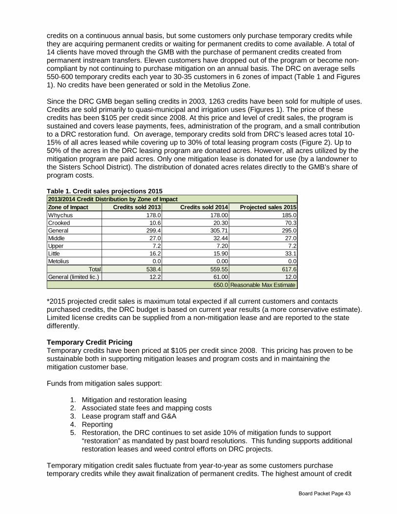
credits on a continuous annual basis, but some customers only purchase temporary credits while they are acquiring permanent credits or waiting for permanent credits to come available. A total of 14 clients have moved through the GMB with the purchase of permanent credits created from permanent instream transfers. Eleven customers have dropped out of the program or become non-compliant by not continuing to purchase mitigation on an annual basis. The DRC on average sells 550-600 temporary credits each year to 30-35 customers in 6 zones of impact (Table 1 and Figures 1). No credits have been generated or sold in the Metolius Zone. Since the DRC GMB began selling credits in 2003, 1263 credits have been sold for multiple of uses. Credits are sold primarily to quasi-municipal and irrigation uses (Figures 1). The price of these credits has been $105 per credit since 2008. At this price and level of credit sales, the program is sustained and covers lease payments, fees, administration of the program, and a small contribution to a DRC restoration fund. On average, temporary credits sold from DRC’s leased acres total 10-15% of all acres leased while covering up to 30% of total leasing program costs (Figure 2). Up to 50% of the acres in the DRC leasing program are donated acres. However, all acres utilized by the mitigation program are paid acres. Only one mitigation lease is donated for use (by a landowner to the Sisters School District). The distribution of donated acres relates directly to the GMB’s share of program costs. Table 1. Credit sales projections 2015
*2015 projected credit sales is maximum total expected if all current customers and contacts purchased credits, the DRC budget is based on current year results (a more conservative estimate). Limited license credits can be supplied from a non-mitigation lease and are reported to the state differently. Temporary Credit Pricing Temporary credits have been priced at $105 per credit since 2008. This pricing has proven to be sustainable both in supporting mitigation leases and program costs and in maintaining the mitigation customer base. Funds from mitigation sales support:
1. Mitigation and restoration leasing 2. Associated state fees and mapping costs 3. Lease program staff and G&A 4. Reporting 5. Restoration, the DRC continues to set aside 10% of mitigation funds to support
“restoration” as mandated by past board resolutions. This funding supports additional restoration leases and weed control efforts on DRC projects.
Temporary mitigation credit sales fluctuate from year-to-year as some customers purchase temporary credits while they await finalization of permanent credits. The highest amount of credit
2013/2014 Credit Distribution by Zone of ImpactZone of Impact Credits sold 2013 Credits sold 2014 Projected sales 2015Whychus 178.0 178.00 185.0Crooked 10.6 20.30 70.3General 299.4 305.71 295.0Middle 27.0 32.44 27.0Upper 7.2 7.20 7.2Little 16.2 15.90 33.1Metolius 0.0 0.00 0.0
Total 538.4 559.55 617.6General (limited lic.) 12.2 61.00 12.0
650.0 Reasonable Max Estimate
Board Packet Page 43
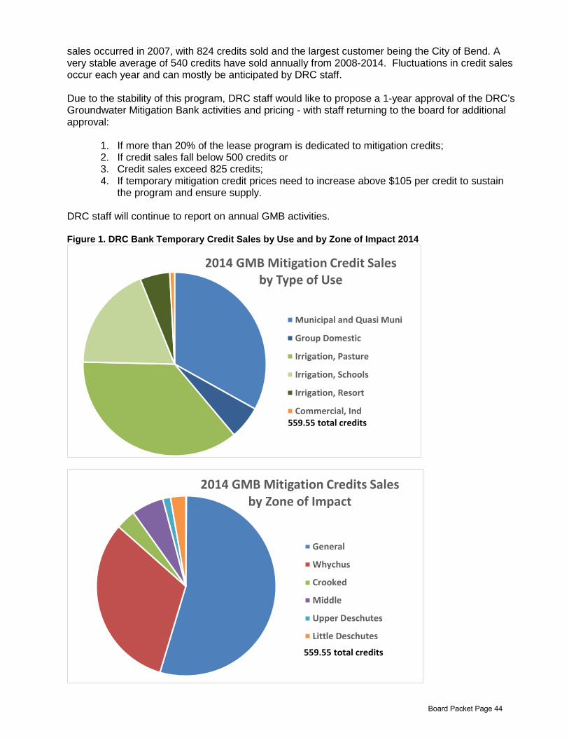
sales occurred in 2007, with 824 credits sold and the largest customer being the City of Bend. A very stable average of 540 credits have sold annually from 2008-2014. Fluctuations in credit sales occur each year and can mostly be anticipated by DRC staff. Due to the stability of this program, DRC staff would like to propose a 1-year approval of the DRC’s Groundwater Mitigation Bank activities and pricing - with staff returning to the board for additional approval:
1. If more than 20% of the lease program is dedicated to mitigation credits; 2. If credit sales fall below 500 credits or 3. Credit sales exceed 825 credits; 4. If temporary mitigation credit prices need to increase above $105 per credit to sustain
the program and ensure supply. DRC staff will continue to report on annual GMB activities. Figure 1. DRC Bank Temporary Credit Sales by Use and by Zone of Impact 2014
2014 GMB Mitigation Credit Sales by Type of Use
Municipal and Quasi Muni
Group Domestic
Irrigation, Pasture
Irrigation, Schools
Irrigation, Resort
Commercial, Ind559.55 total credits
2014 GMB Mitigation Credits Sales by Zone of Impact
General
Whychus
Crooked
Middle
Upper Deschutes
Little Deschutes
559.55 total credits
Board Packet Page 44
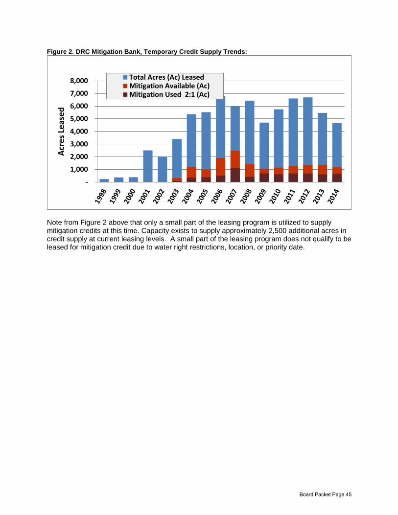
Figure 2. DRC Mitigation Bank, Temporary Credit Supply Trends:
Note from Figure 2 above that only a small part of the leasing program is utilized to supply mitigation credits at this time. Capacity exists to supply approximately 2,500 additional acres in credit supply at current leasing levels. A small part of the leasing program does not qualify to be leased for mitigation credit due to water right restrictions, location, or priority date.
-
1,000
2,000
3,000
4,000
5,000
6,000
7,000
8,000
Acr
es L
ease
d
Total Acres (Ac) LeasedMitigation Available (Ac)Mitigation Used 2:1 (Ac)
Board Packet Page 45
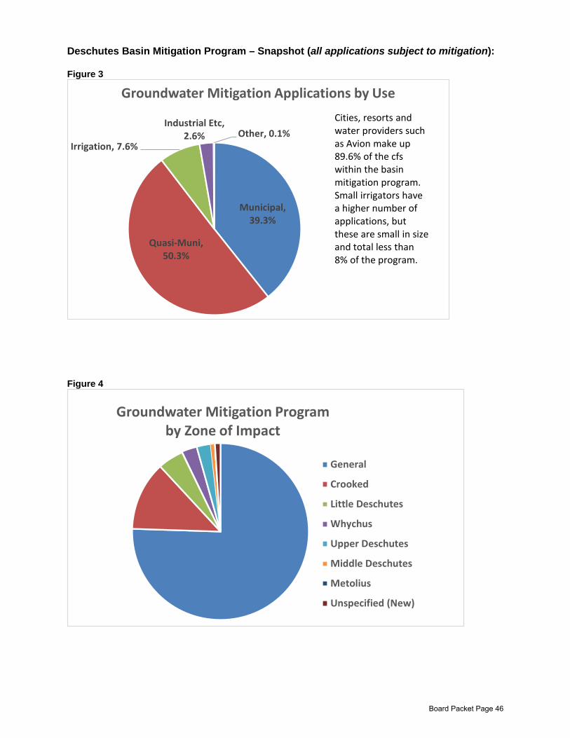
Deschutes Basin Mitigation Program – Snapshot (all applications subject to mitigation): Figure 3
Figure 4
Municipal, 39.3%
Quasi-Muni, 50.3%
Irrigation, 7.6%
Industrial Etc, 2.6% Other, 0.1%
Groundwater Mitigation Applications by Use
Cities, resorts and water providers such as Avion make up 89.6% of the cfs within the basin mitigation program. Small irrigators have a higher number of applications, but these are small in size and total less than 8% of the program.
Groundwater Mitigation Program by Zone of Impact
General
Crooked
Little Deschutes
Whychus
Upper Deschutes
Middle Deschutes
Metolius
Unspecified (New)
Board Packet Page 46
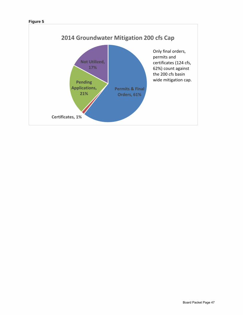
Figure 5
Permits & Final Orders, 61%
Certificates, 1%
Pending Applications,
21%
Not Utilized, 17%
2014 Groundwater Mitigation 200 cfs Cap
Only final orders,permits and certificates (124 cfs, 62%) count against the 200 cfs basin wide mitigation cap.
Board Packet Page 47
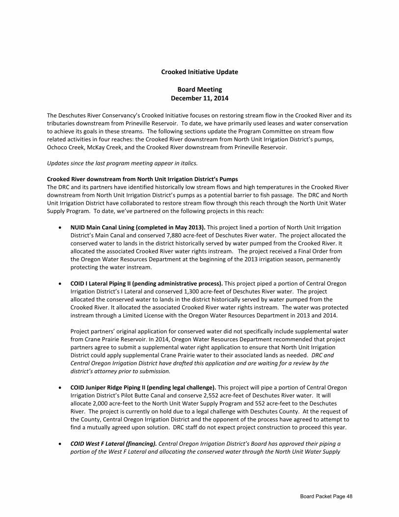
Crooked Initiative Update
Board Meeting
December 11, 2014
The Deschutes River Conservancy’s Crooked Initiative focuses on restoring stream flow in the Crooked River and its tributaries downstream from Prineville Reservoir. To date, we have primarily used leases and water conservation to achieve its goals in these streams. The following sections update the Program Committee on stream flow related activities in four reaches: the Crooked River downstream from North Unit Irrigation District’s pumps, Ochoco Creek, McKay Creek, and the Crooked River downstream from Prineville Reservoir. Updates since the last program meeting appear in italics. Crooked River downstream from North Unit Irrigation District’s Pumps The DRC and its partners have identified historically low stream flows and high temperatures in the Crooked River downstream from North Unit Irrigation District’s pumps as a potential barrier to fish passage. The DRC and North Unit Irrigation District have collaborated to restore stream flow through this reach through the North Unit Water Supply Program. To date, we’ve partnered on the following projects in this reach:
• NUID Main Canal Lining (completed in May 2013). This project lined a portion of North Unit Irrigation District’s Main Canal and conserved 7,880 acre-feet of Deschutes River water. The project allocated the conserved water to lands in the district historically served by water pumped from the Crooked River. It allocated the associated Crooked River water rights instream. The project received a Final Order from the Oregon Water Resources Department at the beginning of the 2013 irrigation season, permanently protecting the water instream.
• COID I Lateral Piping II (pending administrative process). This project piped a portion of Central Oregon Irrigation District’s I Lateral and conserved 1,300 acre-feet of Deschutes River water. The project allocated the conserved water to lands in the district historically served by water pumped from the Crooked River. It allocated the associated Crooked River water rights instream. The water was protected instream through a Limited License with the Oregon Water Resources Department in 2013 and 2014. Project partners’ original application for conserved water did not specifically include supplemental water from Crane Prairie Reservoir. In 2014, Oregon Water Resources Department recommended that project partners agree to submit a supplemental water right application to ensure that North Unit Irrigation District could apply supplemental Crane Prairie water to their associated lands as needed. DRC and Central Oregon Irrigation District have drafted this application and are waiting for a review by the district’s attorney prior to submission.
• COID Juniper Ridge Piping II (pending legal challenge). This project will pipe a portion of Central Oregon Irrigation District’s Pilot Butte Canal and conserve 2,552 acre-feet of Deschutes River water. It will allocate 2,000 acre-feet to the North Unit Water Supply Program and 552 acre-feet to the Deschutes River. The project is currently on hold due to a legal challenge with Deschutes County. At the request of the County, Central Oregon Irrigation District and the opponent of the process have agreed to attempt to find a mutually agreed upon solution. DRC staff do not expect project construction to proceed this year.
• COID West F Lateral (financing). Central Oregon Irrigation District’s Board has approved their piping a portion of the West F Lateral and allocating the conserved water through the North Unit Water Supply
Board Packet Page 48
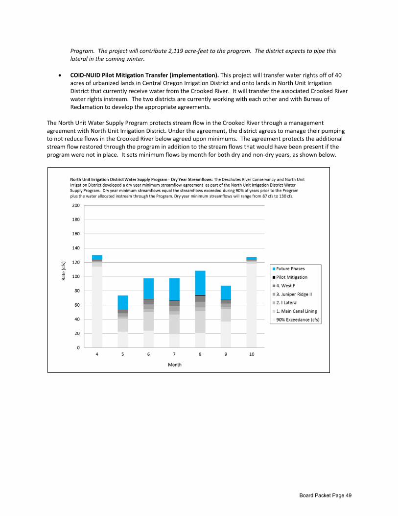
Program. The project will contribute 2,119 acre-feet to the program. The district expects to pipe this lateral in the coming winter.
• COID-NUID Pilot Mitigation Transfer (implementation). This project will transfer water rights off of 40 acres of urbanized lands in Central Oregon Irrigation District and onto lands in North Unit Irrigation District that currently receive water from the Crooked River. It will transfer the associated Crooked River water rights instream. The two districts are currently working with each other and with Bureau of Reclamation to develop the appropriate agreements.
The North Unit Water Supply Program protects stream flow in the Crooked River through a management agreement with North Unit Irrigation District. Under the agreement, the district agrees to manage their pumping to not reduce flows in the Crooked River below agreed upon minimums. The agreement protects the additional stream flow restored through the program in addition to the stream flows that would have been present if the program were not in place. It sets minimum flows by month for both dry and non-dry years, as shown below.
Board Packet Page 49
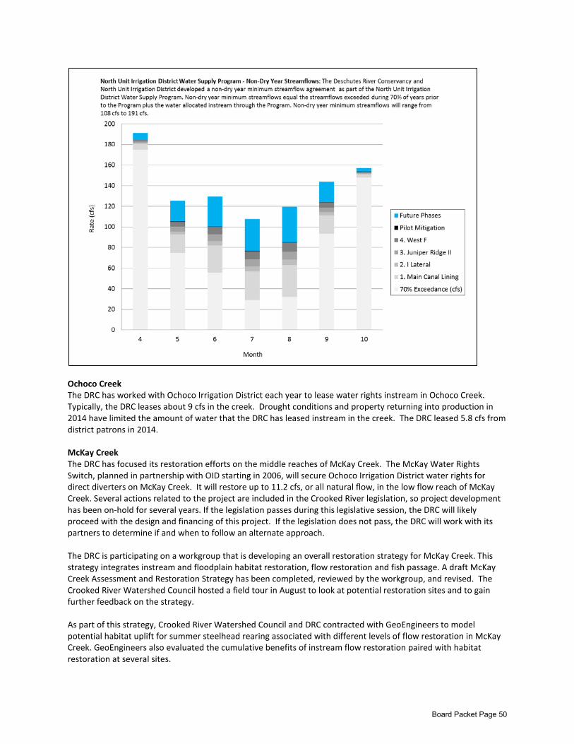
Ochoco Creek The DRC has worked with Ochoco Irrigation District each year to lease water rights instream in Ochoco Creek. Typically, the DRC leases about 9 cfs in the creek. Drought conditions and property returning into production in 2014 have limited the amount of water that the DRC has leased instream in the creek. The DRC leased 5.8 cfs from district patrons in 2014. McKay Creek The DRC has focused its restoration efforts on the middle reaches of McKay Creek. The McKay Water Rights Switch, planned in partnership with OID starting in 2006, will secure Ochoco Irrigation District water rights for direct diverters on McKay Creek. It will restore up to 11.2 cfs, or all natural flow, in the low flow reach of McKay Creek. Several actions related to the project are included in the Crooked River legislation, so project development has been on-hold for several years. If the legislation passes during this legislative session, the DRC will likely proceed with the design and financing of this project. If the legislation does not pass, the DRC will work with its partners to determine if and when to follow an alternate approach. The DRC is participating on a workgroup that is developing an overall restoration strategy for McKay Creek. This strategy integrates instream and floodplain habitat restoration, flow restoration and fish passage. A draft McKay Creek Assessment and Restoration Strategy has been completed, reviewed by the workgroup, and revised. The Crooked River Watershed Council hosted a field tour in August to look at potential restoration sites and to gain further feedback on the strategy. As part of this strategy, Crooked River Watershed Council and DRC contracted with GeoEngineers to model potential habitat uplift for summer steelhead rearing associated with different levels of flow restoration in McKay Creek. GeoEngineers also evaluated the cumulative benefits of instream flow restoration paired with habitat restoration at several sites.
Board Packet Page 50
Crooked River downstream from Prineville Reservoir The federal Crooked River legislation could play a primary role in restoring stream flows in this reach of the Crooked River. Slightly different legislation exists in both the House and the Senate, and both bills meet multiple needs. The Senate bill (S1771), introduced by Senators Merkley and Wyden, allocates all of the uncontracted water in Prineville Reservoir for fish in the river downstream. It directs Reclamation to release that water on a schedule determined by the State of Oregon and the Confederated Tribes of Warm Springs solely for the benefit of fish. The House bill (HR2640), introduced by Congressman Walden, does not authorize the release of the uncontracted storage. The House has unanimously passed Crooked River legislation three times, most recently in October 2014. The Senate bill was introduced in November 2013 and passed out of the Senate Energy and Natural Resources Committee this summer. Once the full Senate passes it, Congress would be able to “conference” the differing House and Senate bills. Time is now incredibly limited, however, and the two bills may not pass by the end of this Congress. It is unclear if the stakeholders will ask Congress to pursue legislation in the next Congress.
Board Packet Page 51
Whychus Initiative Update
Board Meeting
December 11, 2014
The Deschutes River Conservancy’s Whychus Initiative focuses on restoring stream flow in Whychus Creek and its tributaries. To date, we have primarily used leases and water conservation in Three Sisters Irrigation District (TSID) to achieve DRC goals, however opportunities for out-of-district water acquisitions and/or conservation projects occasionally arise. The following sections update the Program Committee on stream flow related activities. They have not changed from the prior update to the Program Committee in August 2014. Whychus Creek Flow Restoration Program The DRC and its partners have identified historically low stream flows and the high stream temperatures they cause as the primary limiting factor for reintroduced steelhead trout and Chinook salmon in Whychus Creek. To date, the there have been four permanent instream transfers and sixteen conserved water projects implemented, with the instream leasing program operating on an ongoing basis. The following projects are currently under implementation:
• TSID Water Conservation. Whychus Creek is a very small system characterized by a large seasonal fluctuation in flow, which drops precipitously in June/July each year. As a result, there are very few senior water rights (~20 cfs), with TSID’s 1895 water rights for 120 cfs taking the remaining water in the creek. With so few water rights with which to restore flows in the creek, ongoing water conservation in TSID remains the DRC’s most crucial tool for achieving its flow goals.
o Main Canal Piping. TSID began piping its Main Canal in 2010, starting at the District diversion south of Sisters. Phases 1-3 reached four miles to the TSID office at Watson Reservoir near the rodeo grounds. It is anticipated to take an additional five phases (4-9) to reach from Watson Reservoir to McKenzie Reservoir, between Sisters and Redmond, north of Highway 126. Phase Five was completed in April, 2014, bringing the total water instream from the Main Canal to 10.7 cfs. Phase Six will be constructed during winter 2014-15 and will conserve an additional 1.33 cfs for instream use.
o Hurtley Lateral Piping. The original conserved water application for this project was protested by Water For Life on largely ideological grounds. The application was withdrawn and resubmitted in December, 2013. No protest has been filed to date and the application is expected to be finalized during 2014. This project will protect approximately ½ cfs in Whychus Creek.
o Uncle John Ditch Piping. The Uncle John conserved water application was submitted in the May, 2013. Processing has been delayed by outstanding transfers involving the water rights associated with the conserved water application. These other transfers must be completed before the conserved water application can be finalized. It is anticipated that this application will be finalized during 2014. This project will protect approximately 2.5 cfs in Whychus Creek.
• Pine Meadow Ranch Water Acquisition (Sokol). This acquisition of conserved water from a private, non-district landowner was approved by the DRC Board in September, 2013. In December, 2013, the DRC acquired 1 cfs of senior water rights for $404,000 (equivalent to $950/acre-foot), and the conserved water application received a final order in April, 2014. The project has multiple benefits beyond the increased stream flow, including removal of a passage barrier, opening up 13 miles of upstream habitat and additional habitat restoration of 1.5 miles of stream coordinated by the UDWC and USFS. The
Board Packet Page 52
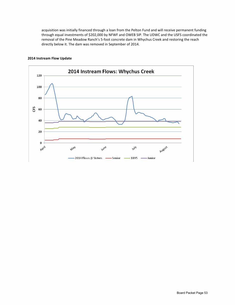
acquisition was initially financed through a loan from the Pelton Fund and will receive permanent funding through equal investments of $202,000 by NFWF and OWEB SIP. The UDWC and the USFS coordinated the removal of the Pine Meadow Ranch’s 5-foot concrete dam in Whychus Creek and restoring the reach directly below it. The dam was removed in September of 2014.
2014 Instream Flow Update
Board Packet Page 53
Basin Study Update
Board Meeting
December 11, 2014
Overview What is a Basin Study? Basin Studies are part of the Bureau of Reclamation’s WaterSmart Grant Program. They are awarded on a competitive basis. Eligible applicants include states, tribes, water districts, cities or other local governmental entities with water management authority located in the 17 Western Reclamation States. Basins that have implemented basin studies include the Yakima, the Colorado, the Hood River, and the Henry’s Fork in Idaho.
The following description is excerpted from Reclamation’s website (http://www.usbr.gov/WaterSMART/bsp/):
Funding is available for comprehensive water studies that define options for meeting future water demands in river basins in the western United States where imbalances in water supply and demand exist or are projected. Each study includes four key segments:
• State-of-the-art projections of future supply and demand by river basin. • An analysis of how the basin’s existing water and power operations and infrastructure will
perform in the face of changing water realities. • Development of options to improve operations and infrastructure to supply adequate water in
the future. • Recommendations on how to optimize operations and infrastructure in a basin to supply
adequate water in the future. What is the Deschutes Basin Study Work Group? Water interests have a long history of collaborative planning in the Deschutes Basin. The Deschutes Water Alliance (DWA) produced a series of reports in 2006 that estimated supply and demand imbalances and outlined potential solutions. The DWA successfully applied for a Basin Study in 2010, yet was unable to implement it due to cost-share issues. All of the interests around water in the basin have now come together under the name Basin Study Work Group (BSWG) to secure and manage a Deschutes Basin Study. BSWG’s purpose is to obtain and manage a Basin Study with the Bureau of Reclamation toward the goal of developing and implementing a plan that addresses the long-term water needs of agriculture, municipalities, instream flow, and others in the Upper Deschutes River Basin. The Basin Study Work Group (BSWG) has a steering committee (members listed below) that makes decisions by consensus, as well as three reach-based subgroups (Deschutes, Crooked and Whychus) that make recommendations to the larger group. Membership to the subgroups is open to anyone
Board Packet Page 54

interested. The Deschutes Basin Board of Control submitted a Basin Study proposal on behalf of the BSWG to Reclamation in February 2014 and was awarded a Basin Study in June 2014. It is a $1.5 million study, with $750,000 committed from Reclamation, and $750,000 committed by the State through Oregon Water Resources Department. No water management decisions will be made under the Basin Study, but it will provide information useful for coming to future water management agreements. The Deschutes Basin Board of Control is the fiscal agent and the cost-share partner on behalf of the BSWG.
What are the benefits of being involved in the Basin Study? The Basin Study will provide additional resources to understand the extent of water supply and demand imbalance into the future and to assess possible solutions. Being involved ensures that there is local input into this planning process.
DRC Role and Connection The Basin Study is critical to the DRC’s mission because it is the path to a long-term management agreement in the Deschutes Basin that restores instream flow targets while meeting other needs, particularly in one of our priority reaches, the Upper Deschutes River below Wickuip Reservoir.
The DRC is co-coordinator of the Basin Study Work Group, and anticipates continuing this role throughout the Basin Study. The DRC will also continue to provide technical expertise to the Basin Study, as appropriate.
The Deschutes Water Planning Initiative (DWPI) has made significant progress over the last two years assessing the supply and demand imbalance in the upper Deschutes basin, and developing supply options and scenarios to meet flow, agricultural and municipal goals. The DWPI work will feed directly into the Basin Study.
Timeline The Basin Study was awarded in June 2014. The BSWG is now working in partnership with Reclamation over an estimated six months to develop a MOA and Plan of Study. The study is estimated to run from April 2015 through April 2017. After the study is complete, basin partners can use the information to negotiate, sign and implement a regional long-term water management plan that meets instream flow targets and meets goals of agriculture and municipalities.
Funding The Basin Study will bring $1.5 million into the basin to implement the Plan of Study. To-date, the DRC has been funding DRC’s participation. It has also financed BSWG facilitation and has cost-shared with the Deschutes Water Alliance the participation of GSI consultants for its technical coordination role. DRC funding has included a Bureau of Reclamation Collaborative Watershed Management Planning grant, as well as support from the Oregon Community Foundation, Bellavista Foundation, the National Fish and Wildlife Foundation/Wells Fargo Community Grant, the Lamb Foundation , Oregon Department of Fish and Wildlife and the Meyer Memorial Trust. DRC expects to continue to cost-share its involvement. The DRC recently signed a subcontractor agreement with GSI Water Solutions who is subcontracted to DBBC to receive State money to help develop the Plan of Study through March 2015. These funds will help pay for DRC process coordination and facilitation by The Mary Orton Company.
Progress Report The BSWG has reached agreement on the preferred approach for the Basin Study, which is based on the following concepts:
Board Packet Page 55
• Agricultural, instream and municipal (or domestic water supplier) goals are met incrementally and simultaneously throughout the study (i.e. all boats row together).
• The analysis will be framed to maximize cost-effective efficiencies within the current water distribution system to meet baseline targets
• More expensive options (i.e. new storage) will be analyzed to achieve benefits beyond baseline targets over the longer planning horizon.
From here on out, the Basin Study Work Group will be focused on identifying and prioritizing specific Plan of Study elements. Relationship with other Entities/Processes
• Basin Scale Opportunity Assessment The goal of this U.S. Department of Energy-funded initiative was to develop an approach to hydropower and environmental assessment that emphasizes sustainable energy systems within the context of basin-wide environmental protection and restoration, focusing on low-impact or small hydropower and related renewable energy (from: http://basin.pnnl.gov/). The main outcome of this work was the development of a hydrologic modeling tool called Riverware that the Basin Study may use.
• Habitat Conservation Plan The Habitat Conservation Plan has a very specific purpose, to enable the Deschutes Basin Board of Control and the City of Prineville to obtain an incidental take permit from the US Fish and Wildlife Services and NOAA under the Endangered Species Act. Its purpose is narrower in scope than the BSWG activities. All efforts will be made to find synergies with the HCP process.
• Crooked River Legislation Ochoco Irrigation District, the City of Prineville, and other stakeholders are currently involved in proposed Federal legislation that affects water management in the Crooked River subbasin. Members of the BSWG Steering Committee and the Crooked River Subgroup need to ensure that Basin Study activities are consistent with their interests in the Crooked River Legislative process.
• Deschutes Water Alliance The Deschutes Water Alliance is a member of the BSWG. The BSWG was created to be the group involved in the Basin Study because it has more inclusive membership than the DWA.
Board Packet Page 56

Basin Study Work Group Structure
Chair: • Suzanne Butterfield, Swalley Irrigation District
Co-coordinators: • GSI Water Solutions (Technical) • Deschutes River Conservancy (Process)
Facilitation: • The Mary Orton Company
Steering Committee Members1: • North Unit Irrigation District • Central Oregon Irrigation District • Ochoco Irrigation District • Swalley Irrigation District • Three Sisters Irrigation District • Tumalo Irrigation District • Lone Pine Irrigation District • Deschutes County • Upper Deschutes River Coalition • Central Oregon Flyfishers • Trout Unlimited • Department of Environmental Quality • Upper Deschutes Watershed Council • City of Prineville • Central Oregon Cities Organization • Deschutes Water Alliance • Crooked River Watershed Council • Oregon Department of Fish and Wildlife • WaterWatch • US Forest Service • Oregon Water Resources Department • US Fish and Wildlife Services • City of Bend • Deschutes River Conservancy • Deschutes Reintroduction Network
Subgroups:
• Deschutes River (Chair: Craig Horrell, COID) • Crooked River (Chair: Betty Roppe) • Whychus Creek(Chair: Marc Thalacker)
1 The BSWG now operates under an official charter. The charter identifies additional parties that may want to participate on the BSWG steering committee, and letters of invitation will be distributed shortly.
Board Packet Page 57

Board Packet Page 58
Deschutes River Conservancy
Strategic Plan 2015-2025
Executive Summary
1 Mission
The mission of the Deschutes River Conservancy (DRC) is to restore streamflow and improve water quality in the Deschutes Basin
2 Vision
By the year 2025, we envision a future that looks like the following:
• Local governments and NGOs have executed and are implementing a regional water management agreement that balances water for irrigators, municipalities and rivers.
• Flows are well on their way to meeting targets.
• Instream, riparian, and floodplain habitat enhancements are in full scale implementation, enabled by and complementing flow restoration.
• Trust among basin stakeholders is high. The DRC Board is respected and highly functional.
• Citizens are knowledgeable of and are champions of the DRC’s flow restoration strategies.
3 Values
• Open. Value and seek out diverse perspectives. • Consensus-based. Work to overcome differences and make consensus decisions.
• Collaborative. Deploy cooperative, non-regulatory approaches. Committed to helping all parties achieve their respective goals.
• Innovative. Proactively seek new approaches for solving old problems.
• Non-litigious. Do not engage in litigation.
• Adaptive. Adapts and refines goals and strategies based on evolving information and opportunities
• Partnership-based. Leverage partners’ strengths to complement flow restoration with the physical habitat restoration and land conservation necessary to achieve watershed-scale outcomes.
Board Packet Page 59

Strategic Goals and Priorities
Program Goals Achieve watershed scale flow restoration:
• Upper Deschutes • Whychus Creek • Lower Crooked • Tumalo Creek
Facilitate water management agreement among local governments. Implement existing strategies in Whychus Creek, Lower Crooked, and Tumalo Creek.
Strengthen Partnerships Numerous partnerships need to be maintained, built, or strengthened to generate support, leverage funding and maximize conservation outcomes. Partners include the Tribes, state and federal agencies, local governments, irrigation districts, state and federal legislators, NGOs, fishing clubs, and more.
Organizational Goals Build Trust Improve levels of trust among board members and between board members and staff. Transform from board of competing interests to fully collaborative forum.
Grow Communications Capacity
Educate members of the public and enroll them to support river restoration.
Expand Institutional/Public Funding
Replace Pelton Fund with other hydro mitigation revenue. Pursue feasibility of public bonding.
Board Packet Page 60
Deschutes River Conservancy
Strategic Plan 2015 - 2025
1 Mission
The mission of the Deschutes River Conservancy (DRC) is to restore streamflow and improve water quality in the Deschutes Basin
2 Vision
By the year 2025, we envision a future that looks like the following:
• Local governments and NGOs have executed and are implementing a regional water management agreement that balances water for irrigators, municipalities and rivers.
• Flows are well on their way to meeting targets.
• Instream, riparian, and floodplain habitat enhancements are in full scale implementation, enabled by and complementing flow restoration.
• Trust among basin stakeholders is high. The DRC Board is respected and highly functional.
• Citizens are knowledgeable of and are champions of the DRC’s flow restoration strategies.
3 Values
• Open. Value and seek out diverse perspectives. • Consensus-based. Work to overcome differences and make consensus decisions.
• Collaborative. Deploy cooperative, non-regulatory approaches. Committed to helping all parties achieve their respective goals.
• Innovative. Proactively seek new approaches for solving old problems.
• Non-litigious. Do not engage in litigation.
• Adaptive. Adapts and refines goals and strategies based on evolving information and opportunities
• Partnership-based. Leverage partners’ strengths to complement flow restoration with the physical habitat restoration and land conservation necessary to achieve watershed-scale outcomes.
4 Strategic Overview
Long-term flow restoration can be most effective when it leverages the opportunities inherent in water management challenges. In much of the Deschutes Basin, the porous, fractured basalt geology, uneven distribution of water between users, and expanding urban areas create both water management challenges and opportunities to restore stream flow. The DRC’s flow restoration strategy focuses on
Board Packet Page 61
removing the barriers to more efficient use and distribution rather than on developing additional water supply.
These opportunities vary across the basin. Along the Deschutes River and its tributaries, preliminary planning by the Deschutes Water Planning Initiative suggests that there is already enough water available to meet most instream and out-of-stream needs during most years. Excessive canal losses, well understood in the Deschutes Basin, limit the amount of water reaching agricultural lands. At the same time, farms in the Bend and Redmond area have become increasingly fragmented, in many cases beyond the point of commercial agricultural viability. The desire for a rural lifestyle has driven water use, often inefficient, on these properties. Increased efficiency, tighter control within districts, and improved management of existing water supplies remain the best opportunity for meeting the water needs of rivers and growing cities in Central Oregon.
Over the last two decades, tourism and recreation have replaced timber and agricultural production as the primary economic drivers in parts of the Deschutes Basin. This shift has created opportunities for and greatly increased interest in streamflow restoration among local communities. Streamflow restoration provides opportunities for strengthening local economies through increased tourism and recreation. Local and regional communities and their elected officials’ priorities should extend beyond their water supplies to restoration of the river.
The DRC recognizes that improving streamflows is one component of restoring stream structure and function in many reaches. These reaches may require large-scale habitat restoration, barrier removal, or riparian land protection. We design and implement comprehensive watershed restoration strategies in partnership with local organizations and agencies to address these challenges.
5 Collaborative Approach
The DRC believes that a coordinated, collaborative approach offers the greatest opportunities to restore flows throughout the Deschutes Basin. This approach requires the participation and active engagement of all parties, and, by design, it must benefit all parties. For example, achieving flow targets requires simultaneously addressing the needs of out-of-stream water users. Collaboration fails if one party attempts to achieve its goals at the expense of another’s.
Fortunately, the residents of the basin have a long history of working together to meet water management challenges. This collaborative approach has resulted in truly unique achievements like a tribal water rights settlement that holds existing water right holders harmless, the creation of a groundwater mitigation program that allows municipal water use to expand while protecting river flows, and the historic reintroduction of anadromous fish to the upper basin as a component of a hydroelectric relicensing agreement. These examples of past collaboration are demonstrative of the basin’s unique ability to come together and work constructively on matters of basin-wide importance.
Since 2006, the DRC and its partners have collaborated to engage instream, agricultural and municipal interests in a process to identify their unmet water needs and to develop and analyze water management strategies to address those needs. These efforts have been conducted cooperatively in
Board Packet Page 62
partnership with the Deschutes Water Alliance, through the DRC’s Deschutes Water Planning Initiative, and now under the Deschutes Basin Study. A truly collaborative effort, the Basin Study seeks to lay out alternative approaches for meeting the goals of irrigation, municipal, and instream interests. In summary, these goals are as follows:
1. Irrigation • Sustainability for irrigation districts, including:
o Increased water security for junior water rights, especially in dry years; o Increased financial security for districts affected by land fragmentation and
urbanization; and o Reduced legal liabilities associated with federal regulation and with public safety.
2. Municipal
• Achieve a reliable, affordable supply of mitigation credits to meet the growing domestic water supply needs of cities
3. Instream
• Streamflows are adequate to support functioning stream and river systems. Under the DRC’s collaborative approach, we focus on restoring flow while addressing our partners’ goals. This approach provides the greatest opportunities for success in a region with multiple unmet demands. We recognize that alternate approaches, such as the Deschutes Basin Habitat Conservation Plan, provide alternate paths to meeting some of these goals. To the extent possible, the DRC will strive to ensure that the strategies developed through these approaches complement and do not conflict with the strategies developed through our collaborative approach.
6 Geography
The DRC focuses on restoring flow and improving water quality in the Deschutes Basin. While the DRC’s mission encompasses the entire basin, we’ve prioritized restoration opportunities in the upper Deschutes Basin above the Pelton Round Butte complex (see Figure 1). This geography encompasses the Deschutes River from its headwaters to Lake Billy Chinook and its tributaries, including the Tumalo Creek and Whychus Creek. It also encompasses the Crooked River downstream from Prineville Reservoir and its tributaries, specifically Ochoco and McKay Creeks.
7 Streamflow Objectives
The DRC’s overarching goal is to restore the flow necessary to provide for functioning stream and rivers in the Deschutes Basin. We have adopted flow restoration objectives in these priority reaches to help us meet our overarching goal. The DRC’s priority flow restoration objectives include:
• Meet minimum flow targets in the following reaches: o Deschutes River downstream from Wickiup Reservoir (Upper Deschutes – increased fall,
winter, and spring flows); o Tumalo Creek; o Deschutes River downstream from the City of Bend (Middle Deschutes);
Board Packet Page 63
o Whychus Creek; o Crooked River downstream from Prineville Reservoir; and o Crooked River downstream from North Unit Irrigation District’s pumps.
• Move towards a natural flow regime in:
o Deschutes River downstream from Wickiup Reservoir (Upper Deschutes – reduced summer flows);
o McKay Creek; and o Ochoco Creek.
The DRC’s partners have focused on restoring flow in additional reaches. Restoring conditions in these reaches may occur in partnership with or separate from the DRC. Partners have identified the need to move towards a more natural hydrograph in:
• Little Deschutes downstream from Crescent Creek (increased fall, winter, and spring flows); and • Crescent Creek (increased fall, winter and spring flows).
The DRC has not yet prioritized flow restoration or identified clear objectives in these reaches. However, the Deschutes Basin Study and the Deschutes Basin Habitat Conservation Plan will inform the DRC’s Board and staff as to the ecological importance of moving towards a more natural hydrograph in these reaches. These processes will likely suggest desired hydrographs and strategies for achieving them, and the Board may adopt their suggestions.
The DRC recognizes that other reaches in the basin have ecological and cultural importance. Given the limited resources available, the organization has focused on restoring streamflows in the priority reaches described above. As opportunities arise outside of these priority areas, the DRC will evaluate them as appropriate.
The DRC has historically adopted the instream water rights applied for by the Oregon Department of Fish and Wildlife as minimum flow targets. In some reaches, these baseline flow targets may not be best suited to support functioning stream and river ecosystems.
DRC staff and board members are participating in several processes, particularly the Deschutes Water Planning Initiative and the Deschutes Basin Study, to better identify and understand flow needs in the Deschutes River and its tributaries. We expect that these processes will identify inform flow targets and that associated modeling will identify how we can reach those targets in our priority reaches. These new targets may or may not align with the instream water rights referenced above.
Where appropriate, the DRC expects to adopt these collaboratively developed targets as they’re identified, evaluated, and demonstrated to be achievable. In the absence of any new agreed upon targets, the DRC will continue to use the instream water rights applied for by the Oregon Department of Fish and Wildlife in most of its priority reaches.
The DRC’s flow targets vary by reach and by season. The following sections outline flow targets for priority reaches in the upper Deschutes Basin.
Board Packet Page 64

Figure 1. The DRC has prioritized the restoration of streamflow in the upper Deschutes Basin, focusing on the Deschutes and Crooked Rivers and their tributaries.
Board Packet Page 65
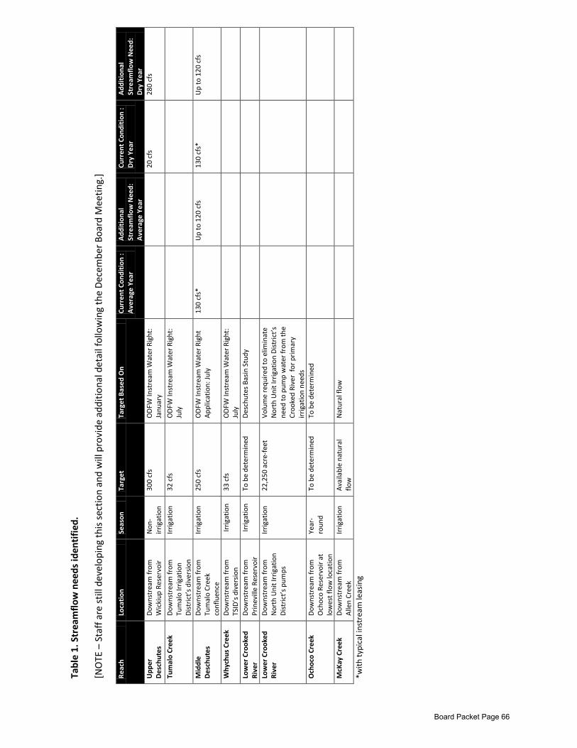
Tabl
e 1.
Str
eam
flow
nee
ds id
enti
fied.
[NO
TE –
Sta
ff a
re s
till d
evel
opin
g th
is s
ectio
n an
d w
ill p
rovi
de a
dditi
onal
det
ail f
ollo
win
g th
e D
ecem
ber B
oard
Mee
ting.
]
Reac
h Lo
cati
on
Seas
on
Targ
et
Targ
et B
ased
On
Curr
ent C
ondi
tion
: A
vera
ge Y
ear
Add
itio
nal
Stre
amflo
w N
eed:
A
vera
ge Y
ear
Curr
ent C
ondi
tion
: D
ry Y
ear
Add
itio
nal
Stre
amflo
w N
eed:
D
ry Y
ear
Upp
er
Des
chut
es
Dow
nstr
eam
from
W
icki
up R
eser
voir
N
on-
irrig
atio
n 30
0 cf
s O
DFW
Inst
ream
Wat
er R
ight
: Ja
nuar
y
20
cfs
28
0 cf
s
Tum
alo
Cree
k D
owns
trea
m fr
om
Tum
alo
Irrig
atio
n D
istr
ict’
s di
vers
ion
Irrig
atio
n 32
cfs
O
DFW
Inst
ream
Wat
er R
ight
: Ju
ly
Mid
dle
Des
chut
es
Dow
nstr
eam
from
Tu
mal
o Cr
eek
conf
luen
ce
Irrig
atio
n 25
0 cf
s O
DFW
Inst
ream
Wat
er R
ight
A
pplic
atio
n: Ju
ly
130
cfs*
U
p to
120
cfs
13
0 cf
s*
Up
to 1
20 c
fs
Why
chus
Cre
ek
Dow
nstr
eam
from
TS
ID’s
div
ersi
on
Irrig
atio
n 33
cfs
O
DFW
Inst
ream
Wat
er R
ight
: Ju
ly
Low
er C
rook
ed
Rive
r D
owns
trea
m fr
om
Prin
evill
e Re
serv
oir
Irrig
atio
n To
be
dete
rmin
ed
Des
chut
es B
asin
Stu
dy
Low
er C
rook
ed
Rive
r D
owns
trea
m fr
om
Nor
th U
nit I
rrig
atio
n D
istr
ict’
s pu
mps
Irrig
atio
n 22
,250
acr
e-fe
et
Volu
me
requ
ired
to e
limin
ate
Nor
th U
nit I
rrig
atio
n D
istr
ict’
s ne
ed to
pum
p w
ater
from
the
Croo
ked
Rive
r fo
r prim
ary
irrig
atio
n ne
eds
Och
oco
Cree
k D
owns
trea
m fr
om
Och
oco
Rese
rvoi
r at
low
est f
low
loca
tion
Year
-ro
und
To b
e de
term
ined
To
be
dete
rmin
ed
McK
ay C
reek
D
owns
trea
m fr
om
Alle
n Cr
eek
Irrig
atio
n A
vaila
ble
natu
ral
flow
N
atur
al fl
ow
*with
typi
cal i
nstr
eam
leas
ing
Board Packet Page 66
8 Methods & Tools
We expect to apply both new and existing tools across irrigation district and hydrologic boundaries to meet irrigation, municipal and instream goals. Meeting these goals will require a willingness to be adaptive and apply different tools to meet different objectives in different years. It will also require a willingness at the local, state, and federal level to address legal and administrative barriers that currently hamper flexible water management in the Deschutes Basin.
Restoring flows in the Deschutes River and its tributaries as outlined above will require a combination of temporary and permanent transactions and agreements. We expect that the following tools will play a role in flow restoration over the next decade:
Conserved Water. Canal piping will continue to provide conserved water for flow restoration. Canal piping is relatively expensive, though, and we expect to focus on projects and programs that benefit multiple users. Potential examples include:
• Conserving Deschutes River water, allocating that water to lands in North Unit Irrigation District currently served by the Crooked River, and allocating the associated Crooked River water rights instream;
• Conserving Deschutes River water to improve district reliability in association with management agreements that maintain flows in the upper Deschutes River; and
• Conserving Deschutes River water, allocating that water to lands in Tumalo Irrigation District currently served by Tumalo Creek, and allocating the associated Tumalo Creek water rights instream.
Instream Leasing. Instream leasing will provide for cost-effective flow restoration in reaches across the Deschutes Basin. Over the next decade, we will engage irrigation districts in long-term agreements to maintain a base level of instream leasing. We will work with each irrigation district to identify and implement tools, such as pricing, policy, and management changes, which facilitate instream leasing while benefiting the district and its patrons. Water Rights Transfers. Transferring water rights off of urbanizing lands to either instream or out-of-stream uses will maximize the productivity of water in the Deschutes Basin. As with conserved water, the greatest benefits will come from projects and programs that meet multiple needs. As an example, transferring senior Deschutes River water rights off of urbanizing lands, placing those water rights on lands in North Unit Irrigation District that currently have Crooked River water rights, and transferring the Crooked River water rights instream for mitigation meets agriculture, instream, and municipal needs simultaneously. In-District Efficiency. Operational and on-farm efficiencies provide a significant unrealized water supply in the region. Investments in infrastructure, management, education, and social marketing may allow water users to draw from this supply without reducing irrigated acreage.
Board Packet Page 67
Management Agreements. Managing water differently to benefit multiple uses and users will be a major component of a comprehensive restoration strategy. These agreements may occur between districts, between districts and their patrons, or between districts and instream interests. For example, Central Oregon Irrigation District’s hydropower revenue will increase with increased winter flows in the upper Deschutes River. However, increased upper Deschutes River flows increase the risk of North Unit Irrigation District’s storage in Wickiup Reservoir not filling. If Central Oregon Irrigation District agrees to provide a drought year supply of water to North Unit Irrigation District in exchange for higher winter flows, both districts benefit.
Reservoir Operations. The Deschutes Water Alliance’s 2006 report on reservoir operations and preliminary DWPI analysis suggested that operating the three reservoirs on the Deschutes River and its tributaries upstream from Bend differently could benefit instream and out-of-stream users, and could result in increased overall storage. Optimization may include operating the reservoirs as one large storage pool, prioritizing storage in reservoirs with lower leakage rates, optimizing the storage potential of Crescent Lake, and adapting the 1938 inter-district agreement that dictates how the reservoirs fill to best accommodate needs. We embrace these recommended changes and the recommendations from the Deschutes Water Planning Initiative. Along the Crooked River, releasing water from Prineville Reservoir into the Crooked River is one of the only tools to increase flows downstream from the reservoir. Efforts to-date have failed to allocate uncontracted storage in Prineville Reservoir. The DRC supports efforts that to allocate uncontracted storage for fish and wildlife flows that maintain broad support from all major stakeholder groups.
New Off-channel Storage. Off-channel storage like Monner Reservoir, a potential reservoir site near Madras that Reclamation assessed in the 1970s, would help to meet both instream and district goals. Barriers to new storage include high expense and a potentially lengthy administrative and political process to get new storage projects approved, designed and implemented. New storage should be considered as an option to move beyond the benefits provided by other tools. Tribal Reserved Water Rights. The Confederated Tribes of Warm Springs (CTWS) have reserved rights for up to 200 cfs of Deschutes River, Metolius River, and Pelton Lakes water for use on or off their reservation. These water rights offer the opportunity to contribute to the DRC’s mission while meeting CTWS’s interests through a variety of approaches. DRC staff will continue to work with CTWS to evaluate how to best leverage these water rights.
9 Approach
The diagram below depicts the DRC’s approach to restoring flow throughout the Deschutes Basin (see Figure 2). As mentioned above, this approach assumes that baseline instream, agricultural, and
Board Packet Page 68

municipal water needs can be met through improved efficiency and redistribution rather than new supply in most years. Over the next 15 years, the DRC and its partners will implement a suite of interconnected actions focusing on long-term lease and transfer agreements, reservoir optimization, improving on-farm and conveyance efficiency, and other water management policies and practices intended to meet multiple needs. We expect that these actions will require a relatively modest investment.
These actions will meet baseline needs during most, but not all years. They may not provide the flow necessary to support functioning streams in all locations. Meeting baseline needs during the driest years and providing for fully functioning streams in all locations and during all years will require major investments in major infrastructure, particularly off-channel storage. The Deschutes Basin Study will provide new information and insight as to the best suite of actions to meet the goals.
Figure 2. The DRC’s approach relies on a suite of interconnected actions that simultaneously meet multiple needs.
Board Packet Page 69

10 Flow Restoration Strategies by Reach
10.1 Upper Deschutes Over the next ten years, the DRC will focus intensely on restoring stream flows in the Deschutes River and its tributaries between Wickiup Reservoir and the City of Bend. The DRC and its partners have successfully restored flows in the Deschutes River downstream from Bend, Tumalo Creek, Whychus Creek, and the lower Crooked River through a combination of conserved water projects, instream leasing and instream transfers. While this project-by-project approach to restoring flow has succeeded to-date, the large scope and scale of the flow challenges in the Upper Deschutes requires a different approach.
This scaled approach will require the redistribution of water across district boundaries, taking into consideration the needs of commercial agriculture, lifestyle farms, urban centers, and the rivers while creating assurances for each of these interests. The key to redistribution is pursuit of a strategy that finds water efficiencies and coordinates the movement of water resources between irrigation districts.
Restoring stream flow in this reach requires passing more natural flow to junior users who currently rely on stored water by increasing efficiency among senior users and by implementing associated agreements to maintain stream flows downstream from Wickiup Reservoir. Upper Deschutes flow restoration will rely on a complicated set of inter-district transfers and agreements that support the following strategic movement of water:
1. Urban districts with senior water rights reduce their diversions and pass Deschutes River live flow to junior users as necessary to ensure their needs are met;
2. All associated Deschutes River irrigation districts consent to a water management agreement between senior and junior users;
3. North Unit Irrigation District junior water rights are more reliably served by Deschutes River live flow, reducing their dependence on water stored in Wickiup Reservoir; and
4. North Unit irrigation District and other districts agree to minimum flow agreement of 300 cfs below Wickiup Reservoir; and
Six irrigation districts draw water from the Deschutes River, its tributaries, and three reservoirs (Table 2). Central Oregon Irrigation District and North Unit Irrigation District encompass 86% of the total irrigated acreage in this region. Restoring flow in the upper Deschutes River depends on cooperative agreements between these two districts. These districts’ needs are complementary, creating opportunities that can benefit all parties. Given the complex relationships between irrigation districts and their water supplies, all related districts on the Deschutes River also need to be parties to these agreements.
North Unit Irrigation District primarily serves relatively efficient agricultural producers. The district, which holds the most junior water rights out of the Deschutes River districts, needs improved water reliability to better serve its commercial farmers. Central Oregon Irrigation District, one of the senior water rights holders in this region, primarily serves small-acreage lifestyle farms. The district faces the erosion of its revenue base due to urbanization. Inter-district leasing, transfers, voluntary diversion
Board Packet Page 70
reductions, trading of conserved water, and others water management tools that move water between these two districts could meet both of their needs.
Table 2. Six districts divert water from the Deschutes River in and around the City of Bend Irrigation District Predominant Priority Date Swalley Irrigation District 1899 Central Oregon Irrigation District 1900 Lone Pine Irrigation District 1900 Tumalo Irrigation District 1905 Arnold Irrigation District 1905 Central Oregon Irrigation District 1907 North Unit Irrigation District 1913
Moving water and water rights from Central Oregon Irrigation District to North Unit Irrigation District reduces the latter’s reliance on stored water from Wickiup Reservoir. A water management agreement that encompasses both live flow and stored water could maintain streamflows in the Deschutes River downstream from Wickiup Reservoir while moving water from Central Oregon Irrigation District to junior users. Sharing live flow will require inter-district agreements, while sharing reservoir storage will require additional agreements with state and federal agencies. These agreements will reflect a shift from a relatively insular, district-by-district approach to water management to a basin-scale approach that meets all water users’ needs.
The DRC and its partners made significant progress on developing strategies to restore the Upper Deschutes over the past several years through the Deschutes Water Planning Initiative (DWPI). The DWPI analyzed the above tools as well as other tools that will be important, such as reservoir optimization in Wickiup, Crane Prairie and Crescent Lake (i.e. adjusting management of these to best capture available supply and serve water demands). This work is being continued in the Basin Study and will be at the forefront of DRC’s strategy.
10.2 Tumalo Creek Restoring relatively cool streamflow in Tumalo Creek improves conditions in Tumalo Creek and in the Deschutes River downstream from the its confluence with the creek. Flow restoration in Tumalo Creek helps to attain flow targets in both of these reaches. In addition, flow restoration in Tumalo Creek contributes cold water to the Deschutes River and helps to meet state temperature standards with much less water than would otherwise be needed solely from Deschutes River flow restoration.
The Tumalo Creek flow restoration strategy has several components:
1. Pipe Tumalo Irrigation District’s Tumalo Feed Canal; 2. Pipe Tumalo Irrigation District’s laterals; 3. Support a self-imposed cap on the City of Bend’s diversion from Bridge Creek; 4. Maintain instream leasing in Tumalo Creek to supplement streamflows provided through other
actions; 5. Tumalo Irrigation District agrees to divert from the Deschutes River instead of Tumalo Creek in
July, August, and September.
Board Packet Page 71
The DRC’s flow restoration strategy in Tumalo Creek centers on piping Tumalo Irrigation District’s (TID’s) Tumalo Feed Canal. This piping makes the rest of the strategy possible. If the DRC can help raise public funds to capitalize this project, the district would pipe the rest the district laterals – pressurizing its system and taking patrons off pumps in the process. Once the whole system is piped, TID will have excess capacity to divert additional Deschutes River water, opening up the possibility of using conserved or urbanized water from other Deschutes River irrigation districts and leaving additional Tumalo Creek water instream. This suite of actions would enable TID to stop diverting from Tumalo Creek altogether in July, August and September.
Execution of this strategy would enable the DRC to exceed the state’s instream water right on Tumalo Creek in the summer and to reduce the instream need in the Deschutes River during this same time.
Lastly, the Tumalo Creek strategy should include the negotiation of a cap on the City of Bend’s diversion. The City has indicated a willingness to do so, but nothing formal is yet established.
10.3 Middle Deschutes The Middle Deschutes flow restoration strategy focuses on meeting temperatures standards in the Deschutes River downstream of Tumalo Creek. The DRC acknowledges that reduced streamflows in the Deschutes River downstream from the City of Bend impair more than just water temperature. Given limited resources, the organization has focused on addressing temperatures rather than simply increasing streamflows. The organization’s strategy has two components:
1. Increase flows from Tumalo Creek; and 2. Convert the leasing program from annual leases to long term leases.
To date, Middle Deschutes flow restoration has been accomplished through the conservation, leasing and transfers of water from Deschutes River diverters (Table 2). These tools have protected streamflows in the river below the North Canal Dam in Bend. Ongoing monitoring suggests that they have not improved water quality to the extent that they have improved stream flows. Deschutes River stream temperatures are relatively warm prior to reaching the Middle Deschutes, and increasing streamflows below North Canal Dam may not be the best approach to reducing downstream temperatures.
This strategy focuses on increasing the flows entering the Deschutes River from Tumalo Creek. Water temperatures in Tumalo Creek are typically lower than those in the Deschutes River, and increasing Tumalo Creek stream flows will reduce temperatures in the Middle Deschutes. The ongoing conserved water projects desired by Deschutes River irrigators that traditionally have generated flows downstream of North Canal dam in Bend will be used to help achieve flow targets in the lower Crooker River and upper Deschutes River.
Annual water leasing from the Deschutes River diverters provides a large portion of stream flow in the Middle Deschutes. These leases are cost-effective but not assured each year. Creating long-term
Board Packet Page 72

assurances for the Middle Deschutes will entail the conversion of leases to permanent transfers or, more likely, the establishment of long term leasing agreements.
10.4 Lower Crooked & Tributaries The strategy for achieving flow objectives in the Lower Crooked and its tributaries has a four-pronged approach:
1. Releases of uncontracted storage in Prineville Reservoir; 2. Retirement of all non-district McKay Creek water rights; 3. Increasing flows below North Unit Irrigation District’s pumps through the North Unit Water
Supply Program; and 4. Optimizing leasing with Ochoco Irrigation District to maximize protected flows in Ochoco Creek.
An improved flow regime for fish and wildlife below Bowman Dam can likely only be achieved through federal legislation. Legislation currently before the Senate Energy and Natural Resources Committee would provide a mechanism for the Bureau of Reclamation, Oregon Department of Fish & Wildlife, and the Confederated Tribes of Warm Springs to more flexibly use uncontracted storage in Prineville Reservoir to meet the needs of fish and wildlife. This or a similar legislative effort will be needed to restore streamflows below the dam during the winter storage season and below the Ochoco Irrigation District diversion during the irrigation season.
Restoration of flows in McKay Creek is possible if the landowners are provided an alternative source of water. The strategy on McKay entails an expansion of Ochoco Irrigation District to include McKay Creek landowners. Once within the district and after new piping infrastructure is in place the McKay landowners can receive water from the irrigation district and their McKay Creek water rights can be transferred permanently instream.
Increasing flows in the downstream reach of the Lower Crooked River entails reducing NUID’s dependence on its Crooked River pumps. This can be accomplished by finding an alternative source of water for the NUID acres containing Crooked River water rights. As mentioned above, Deschutes water generated from irrigation efficiency projects within Deschutes River irrigation districts can be transferred to NUID Crooked River acres and the corresponding Crooked River water rights can be transferred instream. This strategy is already being deployed under the NUID Water Supply Initiative.
The Crooked River water rights transferred instream are junior rights. In order to assure an even water right exchange (Deschutes for Crooked), it is necessary to condition the water rights instream transfer with a management agreement. The total volume of the exchange is targeted at 22,250 acre feet and, when fully implemented, will protect up to 220 cfs through Smith Rock State Park.
10.5 Whychus Creek Flow Restoration Strategy In Whychus Creek, the water rights protected instream exceed the 33 cfs target for July, August and September. Given the junior priority date associated with the majority of these protected rights, the actual amount of water instream rarely achieves this 33 cfs threshold in July, August and September. During these summer months, actual flows (wet water) have the potential to fluctuate between widely. The DRC’s objective is to achieve 33 cfs of wet water, not paper water in Whychus Creek below the TSID
Board Packet Page 73
diversion. The strategy to achieve the remaining 8-13 cfs is a continuation of the DRC’s current work. The strategy encompasses the following:
1. Acquiring paper water rights sufficient to assure that the state’s instream water rights are fully met with “wet” water.
2. Piping the remaining canals and laterals in Three Sisters Irrigation District. 3. Converting the leasing program from annual leases to long term leases. 4. Permanent transfers of senior water rights outside TSID 5. Permanent transfer of City of Sisters water rights instream for mitigation 6. Development of a TSID drought plan, including a minimum flow agreement
Three Sisters Irrigation District (TSID) has piped forty of its sixty miles of canals, contributing 24 cfs of conserved water instream. Its 1895 priority date makes it a straddle right on Whychus Creek requiring regulation when flows drop in mid-late summer. TSID has purchased the equipment and hired the crew necessary to complete piping of the entire district. When the remaining phases of TSID piping are completed (ending at McKenzie Reservoir), they will contribute an additional 3 cfs of conserved water instream and bring the total permanently protected paper water rights on the creek to approximately 36 cfs. This amount of paper water should translate into approximately 23 cfs in most years and 18 cfs in the driest years.
Growing and extending the water leasing program is also an important aspect of the strategy. TSID envisions the possibility of entering into long term instream lease agreements some of which might be used to create long term groundwater mitigation credits. Leasing in Whychus Creek has restored 6-8 cfs of paper water rights instream each year, primarily with 1895 priority dates. This amount of paper water translates into approximately 3-4 cfs of water instream during most years.
Permanent transfers of water rights outside TSID are still possible. A few of these water rights may become available for purchase opportunistically by restoration buyers. The DRC will strategically purse these opportunities as they appear. Over the next decade, permanent transfers for mitigation by the City of Sisters are more likely. The City owns approximately 150 acres of senior water rights on the edge of town. Their long term plan is to irrigate these acres with effluent from their nearby sewage treatment facility and to transfer the existing water right instream for restoration and/or mitigation. This action could amount to another 3 cfs of senior water instream over the ten to twenty years.
To date, the DRC has identified how to restore approximately 30 cfs of wet water instream through water conservation, leasing, and transfers during most years. The DRC has explored alternate approaches to meeting the 33 cfs target in Whychus Creek during all years, including management agreements, drought year leasing, and surface-groundwater exchange agreements. The DRC expects to explore these alternate approaches and identify how to meet the 33 cfs target during most years.
11 Financing
DRC staff project that executing the restoration strategy described above will cost approximately $50M. Financing this effort will require a comprehensive approach that leverages new and existing funders.
Board Packet Page 74
The DRC expects to apply the following financing strategies to maximize progress towards its objectives over the next ten years:
1. Anadromous reintroduction reaches (Crooked River, Whychus Creek, and tributaries): • Aggressively leverage investments in anadromous reintroduction areas and extend Pelton
Fund investments through 2025; • Secure Bonneville Power Administration/Tribal Accord investments to replace investments
by the declining Pelton Fund; • Enter into a long-term agreement with Three Sisters Irrigation District to support leasing
investments in Whychus Creek; and • Promote Whychus Creek and the Crooked River as equal in priority to other Mid-Columbia
Steelhead reaches under the Columbia Basin Water Transactions Program.
2. All reaches: • Maintain Columbia Basin Water Transactions Program investment at current levels; • Increase Oregon Watershed Enhancement Board investments through the development of
new Focused Investment Partnerships; • Expand private investments from individuals, corporations, and foundations; • Build a coalition to advance state and local financing to implement a regional water
management agreement, possibly through state and local bonding; and • Generate steady consulting revenue to offset fixed payroll and administrative costs.
Board Packet Page 75
12 Communications Strategy
12.1 Situation Analysis The DRC operates in an extremely delicate social and political environment. Few area residents understand the complexity of managing the river, especially considering the number of different players at the table. Much of the public is primarily interested in the river due to its recreational value and a well-meaning, if not necessarily well-informed, environmental ethic. Many are largely unaware of how much of the region’s economy depends upon irrigation. As the 2013 fish kill episode clearly demonstrated, much of the general public lacks awareness of the DRC’s actual mission, assuming it to be an environmental advocacy organization, rather than a collaborative entity responsible for convening all stakeholders with a vested interest in water.
12.2 Communications Goals The DRC has identified the following outreach goals:
Short-term outcomes, mission of the organization • The general public and specific interest groups become more aware and educated about the
problem with how our river is currently being managed and fully engaged in the solutions.
• Effectively channel the community concern to assist with our current collaborative efforts to balance the needs of everyone that depends upon the river – fish, farmers, cities, recreation and Tribes - while maintaining our quality of life in this region.
Long term outcome, mission of the organization • The general public, targeted interest groups and all stakeholders feel heard, validated, and fully
compelled to devise viable solutions that benefit everyone. With positive negotiations, everyone wins.
• A sense of pride in how our river is being managed is uniformly felt by the citizens of Central Oregon.
Long term outcome, positioning of the DRC • The DRC is respected by ALL stakeholders as the trusted voice for the river and its many uses.
DRC’s role is to bring balanced, level-headed reasoning and education to the general public, targeted interest groups and all stakeholders about what it will take to have a fully functioning, healthy river in this region. The DRC is seen or perceived as a political or controversial entity, but rather as a trusted and credible organization.
12.3 Role of the DRC Board To better assist with inclusive stakeholder representation through DRC messaging, DRC staff and Board formed a new Communications Committee in FY14. The main goal and objective of the DRC Communications Committee is to ensure balanced and fair messaging that meets the needs of DRC partners and stakeholders. Following are the main objectives of the committee:
• Collectively work to help the general public better understand the DRC brand, our work in the Deschutes Basin and greater water management strategies.
Board Packet Page 76

• Create a consistent Communications Plan and Messaging Platform that meets the needs of the DRC stakeholders and is well vetted by the DRC Board of Directors.
• Committee will strive to have proactive communications as opposed to reactive communications in the event of a significant water related PR challenge (such as a fish kill or changing water temperatures and streamflows in the Deschutes).
• Should immediate PR challenges arise, this committee will constructively work together to help bridge the communication gap that often arises when conveying the more technical aspects of the DRC’s work to the lay person.
12.4 Key Message Points • There is enough water for all, provided that we use it wisely and adapt our approaches to river
management.
• The river can be, and should be, a thriving ecosystem that provides necessary resources for wildlife and recreational opportunities for people.
• The river is, and must remain, a cornerstone of Central Oregon economy.
• DRC is experienced, knowledgeable and effective, and can be trusted.
12.5 Targeted Audiences and Stakeholder Groups Targeted audiences and stakeholder groups are identified as groups and individuals with a specific stake or interest in the river.
Agricultural Interests: • Irrigation Districts
Critical constituent for DRC to partner with to effectively restore flows in all reaches in the Deschutes Basin. DRC cannot achieve streamflow goals if the districts are not fully on board with the solutions.
• Farmers/Ranchers Highly important demographic that the DRC needs to reach so they understand and support the DRC’s approach to working with the districts to restore streamflows.
Recreational Interests (Fly Fisherman, Boaters, Birders, Hikers): • Highly important for both public awareness supporting efforts and as a fundraising source. Tribal Interests: • Critical partner to the DRC in all project and initiative negotiations. The Tribes are an
instrumental funder and key political ally.
Community: • Local residents:
Highly important for credibility and public awareness support as well as all unrestricted fundraising efforts.
• Regional & State residents:
Board Packet Page 77
While less critical in many regards, this group contains potential donors and the continuing interest in the river basin reflects a larger interest on the part of at least one influential body of Oregon residents – including the Legislature.
DRC Staff: • Staff awareness of all programs is essential. To the extent possible, all major public
communications efforts should be reviewed by staff prior to dissemination; staff should be informed of outreach at the time of transmission to public outreach channels (it’s always best for staff to hear it from you, rather than on the radio).
Regional businesses/corporations: • This group is a medium to high priority for the DRC, primarily as a fundraising/co-sponsoring
constituency. All recreation and tourism businesses and industries are high priority.
Governments: • Local
Local governments are a high priority for the DRC. It will be incumbent upon the DRC to make sure that appropriate government officials are kept abreast of coverage and progress.
• State Maintaining strong relationships with state government agencies and elected officials will facilitate the DRC’s achieving its mission. While specific outreach mechanisms won’t be targeted towards elected officials, it’s important to ensure awareness and support.
• Federal
The Bureau of Reclamation is an important stakeholder group. Funding the Deschutes Basin Study will be integral in developing a greater water management strategy for the Deschutes Basin.
12.6 Vehicles for Communication: • Creation of a style and usage guideline document to steer consistency of messaging to ensure
that, to the extent possible, all stakeholders are fairly represented in DRC presentations, print and e-newsletters, at DRC events, and through all social media efforts.
• Establishment of a once-per-quarter placement goal for guest op/eds placed in The Bulletin, representing (over time) all major stakeholders represented on the DRC’s Board.
• Development of a high profile award, celebrating individual achievement in helping the river, to be given annually – the Bob Main Award.
• Support for expansion of the “Billion Gallon Club.” • Establishment of a target of one major news placement (along with appropriate story pitches)
regarding the river and the DRC’s efforts every two months, to be covered by one or more of the following: The Bulletin, Cascade Business News, The Source Weekly, Oregon Public Broadcasting, and/or at least one of the local TV or affiliates.
• Placement of DRC spokespeople (staff or Board) on local talk radio at least once per quarter; coaching as necessary to prep them.
• Maintain strong presence with social media platform: E-newsletter, Facebook and Twitter. • Press releases and press conferences as the opportunity presents.
Board Packet Page 78

• Outreach Fairs and booths as the opportunity presents. 12.7 Metrics for Measuring Success:
• Increased public awareness & education.
• Positive public/community engagement.
• Unrestricted fundraising goals are consistently met. • Clear buy-in from stakeholders and project partners that leads to the implementation of viable
solutions to address river management challenges.
• A sense of pride in how our river is being managed is uniformly felt by all citizens of Central Oregon.
13 Organizational Structure and Roles
13.1 DRC Board Structure, Process, and Role The DRC is a federally-authorized organization comprised of a disparate set of private, public, and community interests. All projects implemented by the organization require a consensus decision of this diverse board.
13.1.1 Board Composition
Private Interests Public Interests Community At-Large Irrigated Agriculture Environmental Timber Ranching Real Estate Development Recreation and Tourism Hydroelectric Production
Confederated Tribes of Warm Springs State or Oregon: Water Resources Department Department of Fish & Wildlife Federal Government Bureau of Reclamation U.S. Forest Service Ten community members
Ten community members
13.2 Board Structure
13.2.1 Officers
The Board elects four officers: Chairman, Vice-Chairman, Secretary, and Treasurer. Officers are elected to two-year terms and are eligible to be elected to two consecutive terms.
13.2.2 Committees
The DRC has four board committees (Figure 3). Each committee advises the Board of Directors on relevant issues. Board members who serve on these committees are appointed by the board. Executive Committee The Executive Committee seeks broad participation among DRC board members and undergoes periodic turnover of membership. The committee is comprised of up to seven members including the four
Board Packet Page 79

officers (Chair, Vice Chair, Secretary, and Treasurer) plus three additional members, if necessary, to assure broad representation. The Executive Committee is represented by irrigation, tribal and environmental interests in order to capture the diversity of the board composition.
Figure 3. Four committees advise the DRC Board of Directors. Program Committee The core members of the Program Committee should be those board members with technical expertise who can think and operate at a basin scale. The Program Committee plays a dual role: 1) review and approval of projects and transactions and 2) exploration of strategic programmatic issues confronting the organization. The core Membership of Program Committee includes:
• State Agencies: ODFW, OWRD • Federal Agencies: USFS, USBOR • Tribal representative • Irrigation representative • Environment representative • Hydropower representative • Central Oregon Cities representative • Other technical expertise
Finance & Audit Committee The Finance & Audit Committee is comprised of the Treasurer, Chair, and member(s) as appointed by the Board. This committee is tasked with the routine review of the organization’s finances, assessing problems and opportunities and making recommendations to the Board. The committee also engages an independent auditor each year to perform annual audit services. The auditors report directly to the Finance & Audit Committee. Communications Committee By virtue of its composition and purpose, members of the DRC Board of Directors have different and, occasionally, competing interests. This diversity presents a challenge in messaging -- a message that serves the interests of one stakeholder group may be perceived negatively by another. The purpose of
Board Packet Page 80
the communications committee is to work to overcome this challenge and to achieve the following goals:
• The general public and specific interest groups become more aware and educated about the problem with how our river is currently being managed and fully engaged in the solution.
• Effectively channel the community concern to assist with our collaborative efforts to balance the needs of everyone that depends upon the river – fish, farmers, cities, recreation and Tribes - while maintaining our quality of life in this region.
13.3 Role of the Board At its retreat in March 2014, the DRC board decided that it should spend less time reviewing and discussing detailed technical proposals and more time discussing the major strategic issues facing the organization. These discussions are intended to focus on issues that have significant potential impact on the organization’s mission. This requires board members to participate openly in dialogue and for members of the Board to work on collaborative solutions.
The process for vetting and addressing issues is as follows:
1. Any issue that is perceived to have an impact, positive or negative, on the DRC mission comes first to the Program Committee for exploration and assessment. The role of committee is to assess the meaning of the issue to the DRC. What is the impact? Why does it matter? Who is affected? In what ways? What does it cost us? Why is it happening? What are root causes? What are possible approaches to deal with it?
2. From this exploration of the issue, if warranted, the Program Committee forwards the issue to the whole board for further discussion and policy decision, if appropriate.
The DRC Board has made great strides in recent years reforming its committee structure and decision processes. Future success hinges upon our ability to tackle the tough issues, those that have been around for decades and to reach consensus about resolving them. Perfecting the communication process and expectation envisioned above will be critical to the DRC’s future success.
The Board represents a microcosm of the basin, all its conflicting and compatible interests together in one small place. The DRC Board needs to provide the forum where the water management controversies and conflicts get vetted, discussed and resolved and where opportunities get identified and pursued. If DRC board members, representing their broad interests, cannot figure out how to make progress on the most intractable issues, it is unrealistic to think that the basin at-large can do so. It all comes down to leadership. The DRC Board needs to take a leadership role in finding collaborative ways to fix decades-old water management challenges and to not shy away from the difficult conversations that will be required to do so. Once board members have reached a consensus on difficult issues, it will be critical that they support and/or participate in the implementation of solutions as well.
Board Packet Page 81
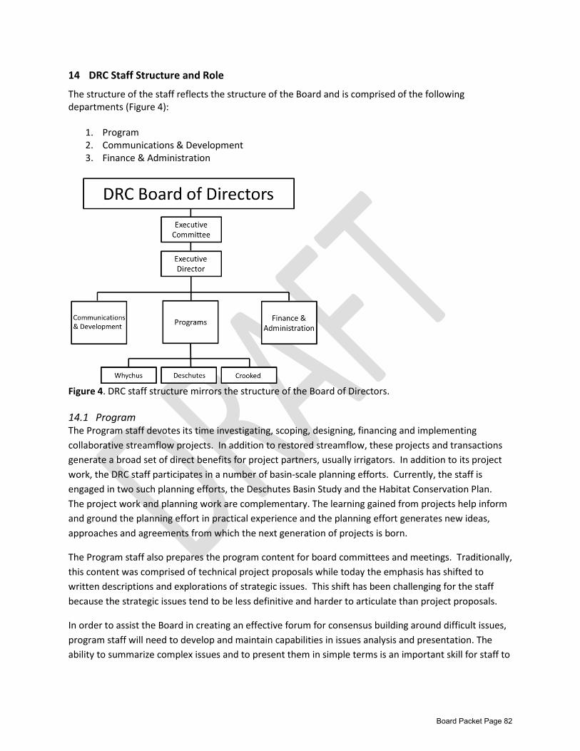
14 DRC Staff Structure and Role
The structure of the staff reflects the structure of the Board and is comprised of the following departments (Figure 4):
1. Program 2. Communications & Development 3. Finance & Administration
Figure 4. DRC staff structure mirrors the structure of the Board of Directors. 14.1 Program The Program staff devotes its time investigating, scoping, designing, financing and implementing collaborative streamflow projects. In addition to restored streamflow, these projects and transactions generate a broad set of direct benefits for project partners, usually irrigators. In addition to its project work, the DRC staff participates in a number of basin-scale planning efforts. Currently, the staff is engaged in two such planning efforts, the Deschutes Basin Study and the Habitat Conservation Plan. The project work and planning work are complementary. The learning gained from projects help inform and ground the planning effort in practical experience and the planning effort generates new ideas, approaches and agreements from which the next generation of projects is born.
The Program staff also prepares the program content for board committees and meetings. Traditionally, this content was comprised of technical project proposals while today the emphasis has shifted to written descriptions and explorations of strategic issues. This shift has been challenging for the staff because the strategic issues tend to be less definitive and harder to articulate than project proposals.
In order to assist the Board in creating an effective forum for consensus building around difficult issues, program staff will need to develop and maintain capabilities in issues analysis and presentation. The ability to summarize complex issues and to present them in simple terms is an important skill for staff to
Board Packet Page 82
develop and maintain. Also, considering the large size of the board, better articulation by the staff of what they need from the board in order to advance issues will be increasingly important.
14.2 Communications & Development The staff in this area focus on two essential roles: raising the unrestricted resources of the organization and communicating the organization’s priorities and activities to key audiences. The two roles are tightly related; if we fail to communicate with particular segments of the public, then our ability to raise funds is significantly diminished. The very nature of the DRC’s multi-stakeholder composition has made it difficult to convey clear and straight forward messages to the public, particularly those segments that support the organization financially.
Given the disparity of interests represented on the Board, it is critical that the Board work closely with staff to generate unambiguous messages that serve to galvanize public support for the key initiatives and goals of the organization. When the messages are too broad and attempt to be everything to all people, they do not fully resonate with the DRC’s targeted audiences and often go unheard.
Conveying impactful messages that support the DRC’s streamflow restoration mission in a manner in which all board members can universally support has been challenging. Illustrative stories that highlight the complexity of the demands on the river occasionally make some board members uncomfortable, but are essential in order to help the public understand, and support, needed future changes in how the river is managed. The public must understand that there is no simple solution, and that the positions of all stakeholders have merit. The public must also understand that the best way to solve this complex problem is through a collaborative effort, one in which the stakeholders do not compete but collaborate to serve their individual and mutual interests.
14.3 Finance and Administration The staff in this department fulfills the essential financial budgeting, accounting and reporting responsibilities as well as the general administration of the office. Finance staff work directly with auditors to facilitate the annual audit and with the major institutional donors on progress and status reports.
In order to advance the long range program strategy of the organization, DRC staff will have to perfect a system of financial forecasting to guide a process of enrolling major funding sources. Elements of the DRC’s current long range financial strategy appear in earlier sections of this strategic plan.
Board Packet Page 83
MEMORANDUM From: Tod Heisler, Executive Director To: DRC Board Date: November 20, 2014 RE:
Habitat Conservation Plan, Cornerstone of Long Term Deschutes Basin Restoration
Introduction The Deschutes River Conservancy and its many partners have pursued for many years a collaborative approach to restoring streamflows and improving water quality in the Deschutes Basin. This incentive-based, non-regulatory approach has worked remarkably well capitalizing on the strengths of irrigation districts, the goodwill of landowners, the cooperation of agencies and NGOs and large infusions of capital from a variety of private and public funding sources. This is a formula that has worked remarkably well. Together, we have enabled the districts to increase the efficiency and productivity of their water rights while achieving significant streamflow restoration: 120 cfs through conservation, 13 cfs through permanent transfers, and 60cfs through leasing amounting to nearly 200 cfs of protected flow. For many years this cooperative approach was deployed with little threat of disruption by the Endangered Species Act (ESA). This changed with the reintroduction of Mid-Columbia Steelhead and the imminent listing of the Oregon Spotted Frog. Today, the existence of these protected species poses the potential for both threats and opportunities to the collaborative approach enjoyed by the DRC and its partners. The DRC’s explicit interest is to maximize potential opportunities for sustained basin restoration while reducing the barriers and threats to its progress. As a member of the Deschutes Basin Habitat Conservation Plan Working Group, the DRC was given an opportunity to comment on the first draft of the conservation measures offered by the HCP applicants, irrigation districts and the City of Prineville. In lieu of detailed comments on the specific language contained in this draft, the DRC Executive Committee recommended that the staff explore ways in which the HCP could be developed as a cornerstone of basin-wide restoration and to create strong incentives for continued successful collaborative work. To this end, this memo explores the potential of a phased HCP permitting process that provides the applicants certainty of time for protection against take of listed species while forming the foundation for continuing collaborative watershed restoration work. In essence, this type of approach will provide strong incentives for all parties to continue working together to meet their individual and mutual interests and that the benefits accruing from such efforts will be better than any one party could achieve on its own. This memo is meant to start a discussion rather than make definitive recommendations; details on this approach will need to be worked out. The Interest of the DRC – Why We Care The DRC has an interest in ensuring that the collaborative and regulatory processes complement and support each other. HCP conservation measures are an important component of a larger basin strategy that envisions broader, complementary actions. A less integrated, less complementary HCP strategy would present two risks for the DRC. First, there is the possibility that HCP applicants would focus
Board Packet Page 84

exclusively on regulatory commitments, and would lack the time, energy and resources to continue the broader collaborative basin work. Secondly, if a more narrowly defined HCP strategy is unsuccessful, and partners do not receive a permit, protracted litigation and/or lack of certainty around regulatory issues could imperil and delay collaborative efforts in the basin for years to come. Issue Background The Deschutes Basin Board of Control and the City of Prineville (the applicants) are undertaking a Habitat Conservation Planning Process with the US Fish and Wildlife Services and National Marine Fisheries Service. The goal of a Habitat Conservation Plan (HCP) is to secure an Incidental Take Permit from Federal regulatory agencies that exempts them from potential liabilities under the Endangered Species Act (ESA). The main species of concern in the HCP process are recently-reintroduced summer steelhead and the Oregon spotted frog, both listed as threatened under the ESA. The applicants seek protection to continue their water management activities in the presence of these listed species.
Habitat conservation plans vary to some degree in content; however, there are certain elements that are universally required. Inclusion of the following is required of every HCP:
1. Analysis of impacts that have the potential to occur as a result of the proposed taking of a threatened or endangered species;
2. Steps to be taken by the permit-holder to “…monitor, minimize, and mitigate for such impacts;” 3. Sufficient funding for implementing these steps; 4. A plan of action for handling any unanticipated circumstances; 5. A discussion of potential alternative actions taken into consideration by the permittee that
would not result in the take of a listed species, and basis for not choosing these alternatives.
The HCP process began in 2010. The USFWS has contributed Section 6 Grant funding, and the HCP parties have provided an equal match to these funds, in the form of their own funds and in-kind work. The applicants have contracted with Biota Pacific to produce fifteen priority studies. The applicants produced draft mitigation measures in August 2014 for discussion. The expected schedule is to finish studies in 2014, draft chapters and complete NEPA in 2015, undergo public review in 2016, and issue findings in 2017 related to the HCP, the Incidental Take Permit and the Final Environmental Impact Statement. It is the in the applicants’ interest to limit its mitigation obligations to the extent possible.
Simultaneously, the DRC is engaged with these same partners in a Basin Study Work Group process designed to manage a Bureau of Reclamation Basin Study grant. The Basin Study will analyze a wide range of strategies to meet broad instream, agricultural and municipal goals in the upper Deschutes Basin. The study will generate information and develop water management solutions that are broader in scope than the applicants’ obligations under the Habitat Conservation Plan. The goal is to use information developed in the Basin Study to agree to a long-term water management plan for the basin that meets multiple needs, including meeting instream flow targets.
Overview The DRC suggests that the applicants, USFWS, and NOAA Fisheries consider a phased permit approach to the Deschutes Basin Habitat Conservation Plan. This concept draws from previously approved HCPs that
Board Packet Page 85
incorporate phased permitting, adaptive management and other elements to provide certainty to the applicants while meeting identified environmental outcomes. The following sections outline the suggested approach.
Context The irrigation districts that comprise the Deschutes Basin Board of Control (DBBC) have achieved outstanding streamflow restoration results over the last decade in the Deschutes Basin. Working in partnership with other basin stakeholders, the districts have protected more water instream than has been achieved in any other basin in Oregon. These impressive results include the following water instream: 46,564 acre-feet (120 cfs) through conservation; 4,462 acre-feet (12.83 cfs) through permanent transfers; and 20,501 acre-feet (60 cfs) through instream leasing. The result is 71,528 acre-feet (192.83) protected instream, as well as complementary efforts to improve fish passage and habitat (Newton Consultants; Deschutes Water Alliance Accomplishments, Upper Deschutes Basin, Oregon; October 8, 2013).
By working effectively with a wide array of partners, the districts have maximized both funding opportunities and watershed benefits. Currently, the DBBC is actively engaged in the Basin Study Work Group, the collaborative group co-managing a Bureau of Reclamation Basin Study. This Basin Study will provide the information and analysis needed, including a climate change assessment, for the basin partners to implement the interconnected suite of projects and programs to reach long-term instream, agricultural and municipal water supply needs. The Study will be complete in 2017. Basin partners are committed to continuing to implement projects and experiment with new tools in the interim.
The Phased HCP Permit Concept The phased permitting concept gives the applicants certainty of protection from take of covered species in return for accomplishing specific streamflow objectives. These objectives would increase over time and be adaptively managed, allowing the applicants sufficient time to meet them. The security of the associated incidental take permits tie to the achievement of instream objectives rather than the performance of specific projects. The objectives need not be met solely through the actions of the districts but through collaboration with other implementers and both public and private funding partners. The issuance of incidental take permits by Federal services would be based on commitments by the DBBC, including conditions such as a suite of potential actions, financing, and agreements with basin stakeholders to participate.
The DRC understands that the Habitat Conservation Plan is a process designed to provide certainty for applicants under the Endangered Species Act, and that the requirement is to minimize and mitigate, to the maximum extent practicable, the applicants’ impacts to specific covered species. Conservation measures in the HCP will contribute to basin conservation goals, but will not, and should not be expected to, to solve all of the basin’s issues. However, closer alignment between regulatory actions and basin-wide collaborative work should result in a more broadly-supported HCP, reduced risks of opposition or litigation, and maximized funding opportunities for the applicants.
Board Packet Page 86
Elements of the approach include:
1. Phased Permitting. This could be an incremental issuance (or incremental review) of the permit based on meeting specified outcomes. An example would be conducting NEPA on a 50-year permit, issuing the Incidental Take Permit on 10-year increments based on achieving objectives through continued collaborative work. The Plan is refined as necessary based on a robust adaptive management plan.
2. Adaptive Management. This concept is closely related to the phased permitting concept.
Habitat Conservation Plans entail a compromise between regulatory certainty and scientific uncertainty. This compromise is controversial because many HCPs are thought to inadequately address scientific uncertainty.i
Adaptive management is the systematic acquisition and application of reliable information to improve natural resource management over time. Incorporating adaptive management into HCPs is meant to accommodate scientific uncertainty alongside continued demonstrable progress
3. Options Identification. A suite of options, or tools, are identified in the HCP. The applicants may select which options best meet their needs to meet identified outcomes.
Examples Other HCPs have implemented elements of this approach, including phased permitting and the incorporation of robust adaptive management plans.
The Edwards Aquifer Authority Recovery Implementation Program This HCP issued a phased permit to incorporate adaptive management. The duration of the permit is 15 years. Phase I commits to meet certain outcomes over the first seven years. Phase II commitments are dependent on the results of the Adaptive Management Plan.
Habitat Conservation Plan for the Northern Spotted Owl Boise Cascade Corporation was issued an HCP and incidental take permit for the Northern spotted owl until it is determined that the owl site is no longer occupied, but incidental take was only authorized during the first five years of the permit term.
Montana Department of Natural Resources and Conservation Forested State Trust Lands Habitat Conservation Plan This HCP incorporates a robust effectiveness monitoring program. Five-year Monitoring reports are submitted. Based on evaluation of the reports, the management actions identified through adaptive management can be revised into HCP conservation commitments and implemented. The plan states, “The results of monitoring, research, or simply a few years of experience with implementing the HCP may cause either party to want to propose a change in the HCP. The HCP may be adapted through several processes including CMRs, adaptive management, new research results, and modifications.” This plan also requires an annual update.
Broughton Land Company Environmental Assessment and Native Fish Habitat Conservation Plan
Board Packet Page 87
This plan incorporates adaptive management. Biennial progress meetings are used to address situations where adaptive management may be implemented. The Plan also specifies procedures to deal with ‘changed’ circumstances (“no surprises” policy).
All HCPs are required to address “changed” and “unforeseen” circumstances, which often identifies a process to incorporate information learned through monitoring. Some plans provide the ability to refine or shift conservation measures to better meet species needs.
While none of these examples reflect the specific context of the Deschutes Basin, we believe incorporating adaptive management alongside a phased approach that leverages resources and outcomes of a broader collaborative effort is the optimal path for the DBBC, ecological outcomes, and the basin as a whole.
Benefits This kind of approach would provide the following benefits:
For Applicants 1. Applicants would gain the broad public support for their HCP needed to pass public scrutiny
under the NEPA process, thereby minimizing the risk of opposition or third-party lawsuits. Broad public support would increase the chances that the applicants would obtain the certainty they desire in an incidental take permit.
2. Adaptive management would be built into the HCP, allowing for optimal ecological outcomes in the face of current uncertainty and evolving information. This is particularly important as the scientific uncertainties around the Oregon spotted frog leaves the districts vulnerable to challenges by the public or third parties
3. Through close cooperation with collaborative efforts, the applicants will be able to leverage private and public funding opportunities to match their own financial commitments.
For Conservation Interests 1. Aligning district regulatory commitments with the ongoing collaborative conservation work in
the basin will result in greater investment and better instream outcomes. 2. Building adaptive management into the HCP will create the flexibility needed to refine or adapt
the plan based on new science or monitoring efforts. This creates better conservation outcomes.
For the Deschutes Basin 1. Meeting instream and out of stream basin water needs and achieving ecological outcomes in
the Deschutes Basin depend on highly interdependent relationships and interconnected actions. No party can meet their needs without the cooperation of the other parties. Aligning district regulatory commitments with broader water management planning in the basin optimizes available resources and funding and ultimately increases the basin’s ability to meet multiple goals in the long term.
Board Packet Page 88
i Wilhere, George F.2002. Adaptive management in Habitat Conservation Plans. Conservation Biology. 16:1, p20-29.
Board Packet Page 89