Embed Size (px)
Citation preview
Braya longii (Long’s braya), Braya fernaldii (Fernald’s braya), and Disturbance on Newfoundland’s Great Northern Peninsula
by Hilary Janes
A thesis in partial fulfillment of the requirements for the degree of Bachelor of Science (Geography)
Department of Geography Memorial University of Newfoundland
January 1999
St. John’s Newfoundland and Labrador
i
Acknowledgements
The author would like to thank her advisor, Karyn Butler, for her invaluable guidance during
the writing of this thesis. Thanks also to Luise Hermanutz for involving the author in the Braya
Recovery Project and for providing the materials needed to complete this thesis. Finally, the author
would like to thank Stephen Rowe for his assistance with the mapping and GIS portions of this
project.
ii
Table of Contents
Page #
List of Figures iv
List of Tables v
Abstract vi
Chapter 1: Introduction 1
1.1 Background Information 1
1.2 Study Objectives 3
1.3 Overview of Methods 4
Chapter 2: Literature Review 5
2.1 Organization of literature Review 5
2.2 Limestone 5
2.3 Disturbance 7
2.4 Braya 11
Chapter 3: Study Area 17
3.1 Yankee Point 19
3.2 Savage Point 19
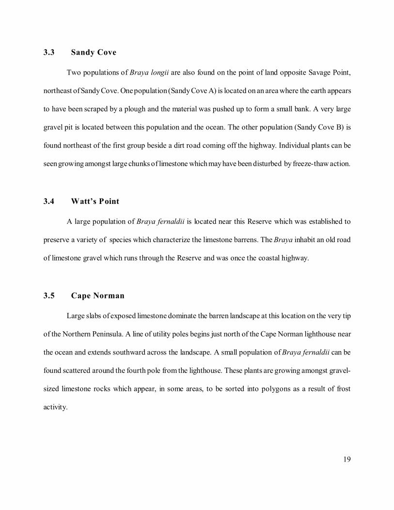
3.3 Sandy Cove 20
3.4 Watt’s Point 20
3.5 Cape Norman 20
3.6 Burnt Cape 21
Chapter 4: Methods 22
iii
Page #
Chapter 5: Results 26
5.1 Yankee Point 33
5.2 Savage Point 34
5.3 Sandy Cove 35
5.4 Watt’s Point 36
5.5 Cape Norman 37
5.6 Burnt Cape 38
Chapter 6: Discussion and Conclusions 39
6.1 Density 39
6.2 Disturbance 42
6.3 Conclusions 33
References 44
iv
List of Figures
Page #
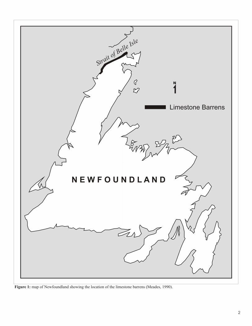
Figure 1: map of Newfoundland showing the limestone barrens 2 ecoregion
Figure 2: a portion of the limestone barrens at Watt’s Point 6
Figure 3: a specimen of Braya fernaldii in fruit at Burnt Cape 12
Figure 4: map of study area showing Fernald’s original Braya 13 populations that still exist, those that have disappeared and potential sites searched by Braya Recovery Team
Figure 5: quarrying at Sandy Cove 15
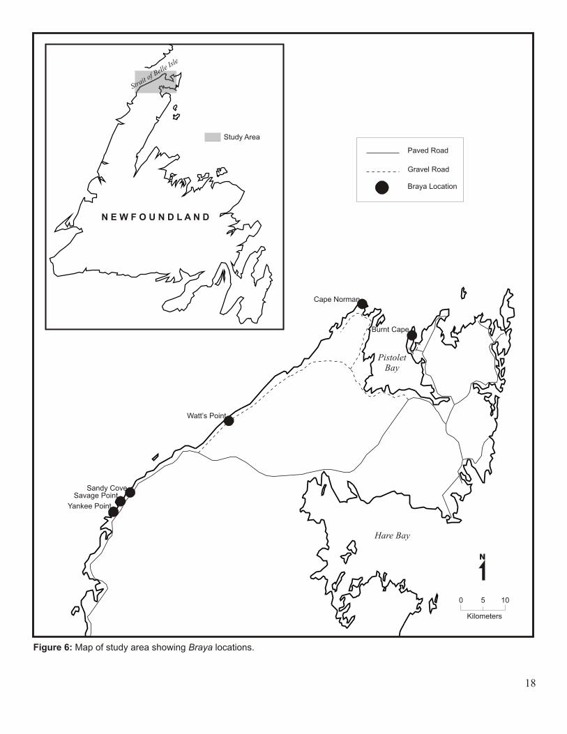
Figure 6: map of study area showing Braya locations 18
Figure 7: measuring population density at Burnt Cape using a 25 1 m square quadrat
Figure 8: temporal change in total area of disturbance at each study 28 site (1948 - 1995)
Figure 9: location of Braya population and area of disturbance at 29 Yankee Point
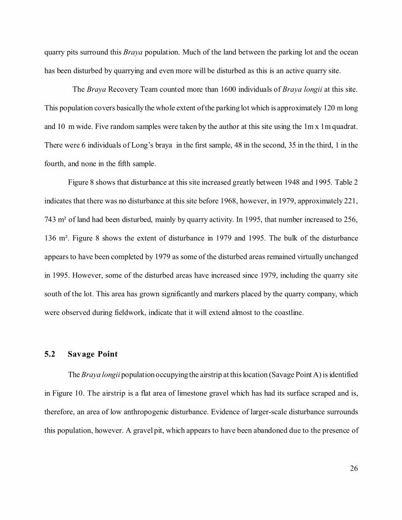
Figure 10: locations of Braya populations and area of disturbance at 29 Savage Point and Sandy Cove
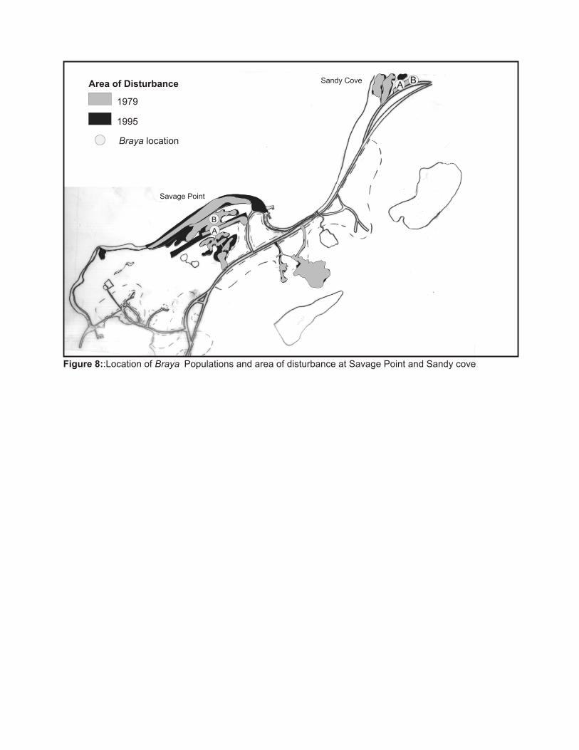
Figure 11: location of Braya population and area of disturbance at 30 Watt’s Point
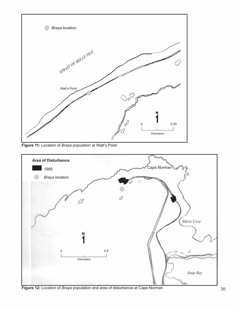
Figure 12: location of Braya population and area of disturbance at 30 Cape Norman
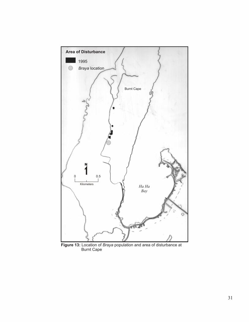
Figure 13: location of Braya population and area of disturbance at 31 Burnt Cape
v
List of Tables
Page #
Table 1: description of aerial photos of study sites (1948-!995) 23
Table 2: area of disturbance at each Braya site (m²) 27
Table 3: habitat disturbance level and density measurements (per m²) 32 of Braya populations for each study site
vi
Abstract: Braya longii (Long’s braya) and Braya fernaldii (Fernald’s braya) are small arctic-alpine
plants which grow only on the limestone barrens of northern Newfoundland. They thrive in areas
which are subjected to small-scale disturbance, such as frost heaving, because it prevents other plants
from establishing in preferred Braya habitat. Braya longii and B. fernaldii also grow well in areas that
have been disturbed slightly by anthropogenic activity. Unfortunately, extensive limestone quarrying
on Newfoundland’s Great Northern Peninsula has destroyed a significant amount of Braya habitat and,
as a result, a very limited number of small populations still exist. In 1997, COSEWIC designated
Braya longii as endangered and Braya fernaldii as threatened.
In this study the temporal change in anthropogenic disturbance at each study site is investigated
through the use of a Geographic Information System. The results generated by this method indicate
that the amount of man-made disturbance on the Northern Peninsula has increased dramatically over
the last 50 years. This information is necessary to emphasize the need to protect Braya populations
from further large-scale anthropogenic disturbance. This study also uses population density
measurements to examine the effect of different levels of disturbance (anthropogenic and natural) on
the vitality of Braya populations. Such information may provide an understanding of the preferred
habitat of Braya which may aid in the future management of these populations.
1
Chapter 1: Introduction
1.1 Background Information
During the summers of 1924 and 1925, Harvard botanist, M.L. Fernald, and his companion,
Bayard Long, undertook an extensive survey of the flora of Newfoundland. On the Great Northern
Peninsula, in particular, they documented a variety of spectacular plant species. Some of Fernald’s and
Long’s interesting discoveries included two species of Braya, an arctic genus which had not previously
been found so far south. At the time of their discovery Fernald considered these two species, known
as Braya longii (Long’s braya) and Braya fernaldii (Fernald’s braya), “common” along the Strait of
Belle Isle (Fernald, 1926).
Braya longii and B. fernaldii grow only on the limestone barrens found along the Strait of
Belle Isle and on the northern portion of Newfoundland’s Great Northern Peninsula (Figure 1). They
typically occupy areas of limestone gravel that have been disturbed by frost heaving and may also be
found in areas of small-scale anthropogenic disturbance. Such disturbances are critical to the survival
of these species since they eliminate competition from preferred Braya habitat. However, Braya longii
and B. fernaldii cannot tolerate large-scale anthropogenic disturbance, such as quarrying, as it destroys
potential Braya habitat and removes populations. Extensive limestone quarrying on the Great Northern
Peninsula has already destroyed many Braya populations and the few remaining populations are at risk
of being eliminated. If quarrying is allowed to continue at the sites occupied by Braya populations
there is a good possibility that these two species will become extinct.
Braya longii and B. fernaldii are not protected by legislation in Canada or Newfoundland even
though they were designated as endangered and threatened, respectively, by COSEWIC (Committee
on the Status of Endangered Wildlife in Canada) in 1997. Recently, a Braya Recovery Team was
3
formed to monitor the remaining Braya populations and to help find a way to preserve them. This
team is seeking habitat protection in the form of reserves, stewardship initiatives, and education
programs and is currently undertaking an immediate (provincial) preservation for the seriously “at risk”
populations (Hermanutz, 1998). In 1997, Burnt Cape, one of the Braya fernaldii sites, was designated
as a “Provisional Reserve” by the Newfoundland government and should attain full Reserve status in
the near future. Such status will protect this area and the plants inhabiting it from future quarrying.
1.2 Study Objectives
The main objective of this study is to classify disturbance at each of the Braya sites as either
natural, high anthropogenic, or low anthropogenic based on aerial photo analysis. The amount of each
type of disturbance that was created at each site between 1948 and 1995 will then be quantified.
Analyses of the different levels of disturbance and of the increase in disturbance on Newfoundland’s
limestone barrens over the last 50 years should provide an indication of the long-term stability and
viability of this type of habitat. Hopefully, this information will aid the Braya Recovery Team in
obtaining protection for Braya longii and B. fernaldii.
Another objective of this study is to provide information about the effects of different levels
of disturbance (natural and anthropogenic) on the vitality of Braya populations through the
comparison of population densities. Such information will help provide a better understanding of the
dependence of Braya on different types of disturbance and of the historical population dynamics of
these Braya species.
4
1.3 Overview of Methods
In order to quantify the amount of disturbed habitat at each of the Braya sites areas of
disturbance, such as gravel pits, were identified on aerial photos that were taken in 1948, 1968, 1979,
and 1995. Classification of these disturbed areas as either natural, high anthropogenic, or low
anthropogenic was attempted by analysing the aerial photos with a stereoscope. Ground-truthing at
each of the study sites was later conducted to determine whether or not disturbed areas had been
classified correctly. The aerial photos were then traced onto mylar sheets and the disturbed areas were
outlined. Once the outlines had been imported into a Geographic Information System the areas of
disturbance were digitized and then queried to determine the total area of disturbance at each site for
each of the four years.
The vitality of Braya populations growing in naturally and anthropogenically disturbed areas
was determined by taking density measurements. At each study site, the type of disturbance was noted
and a one meter square quadrat was randomly tossed throughout the Braya population five times.
After each toss the number of plants within the quadrat was counted. The results of the density
measurements were then compared to determine whether populations had the greatest densities in
areas of natural, high anthropogenic, or low anthropogenic disturbance.
5
Chapter 2: Literature Review
2.1 Organization of the Literature Review
The literature review is divided into three components: limestone, disturbance, and Braya.
Since Braya longii and B. fernaldii grow in limestone a section describing this type of rock and the
characteristics of the limestone barrens, where these species are found, is essential. Information on the
role of disturbance in ecosystems and a description of disturbance-tolerant plants have also been
included since Braya longii and B. fernaldii thrive in areas of small-scale disturbance. Finally, a section
on the Braya species is necessary to provide information about the physical appearance, biology, and
geography of these plants, as well as background information about the quarrying problem on the
Great Northern Peninsula and its effect on Braya populations.
2.2 Limestone
Limestone is formed by the compaction of coral plant and animal remains on the bottoms of
the world’s oceans. It is composed predominantly of calcium carbonate and is the most common form
of carbonate rock (Trudgill, 1985). Limestone often has a calcium carbonate content between 95%
and 99% which makes it a rock of very high purity. Apart from calcium carbonate, limestone may also
be composed of dolomite and very small amounts of other minerals, such as aluminum and sulphur.
The chemical and physical properties of a rock determine the effectiveness of weathering and
erosion processes. The high content of calcium carbonate in limestone means that it may be easily
weathered and is highly soluble in acidic waters. Also, the frequency and number of penetrable joints
and bedding planes within the rocks provide lines of access to percolating water, facilitate freeze-thaw
6
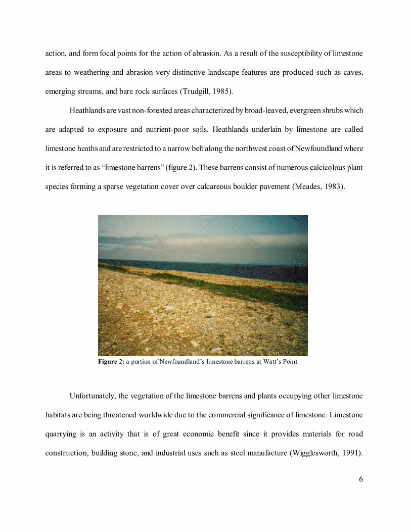
Figure 2: a portion of Newfoundland’s limestone barrens at Watt’s Point
action, and form focal points for the action of abrasion. As a result of the susceptibility of limestone
areas to weathering and abrasion very distinctive landscape features are produced such as caves,
emerging streams, and bare rock surfaces (Trudgill, 1985).
Heathlands are vast non-forested areas characterized by broad-leaved, evergreen shrubs which
are adapted to exposure and nutrient-poor soils. Heathlands underlain by limestone are called
limestone heaths and are restricted to a narrow belt along the northwest coast of Newfoundland where
it is referred to as “limestone barrens” (figure 2). These barrens consist of numerous calcicolous plant
species forming a sparse vegetation cover over calcareous boulder pavement (Meades, 1983).
Unfortunately, the vegetation of the limestone barrens and plants occupying other limestone
habitats are being threatened worldwide due to the commercial significance of limestone. Limestone
quarrying is an activity that is of great economic benefit since it provides materials for road
construction, building stone, and industrial uses such as steel manufacture (Wigglesworth, 1991).
7
However, this excavation and removal of large limestone deposits is destroying potential habitat for
many plant species whose survival depends on the availability of this type of environment.
Many plant species throughout the world have become extinct as a result of extensive
limestone quarrying. On the island of Malta, for instance, the quarrying of limestone has had an
enormous impact on the landscape and on the wildlife which inhabit it. Much of the vegetation on the
South coast of Malta, including the national plant, is being threatened and one species of the Maltese
orchid has already disappeared (Balm, 1996). In Australia measures are being taken to prevent the
extinction of one species, the limestone caladenia (Caladenia calcicola). This plant is now considered
endangered due to the loss of its habitat by limestone quarrying. Only three populations of this
limestone native are thought to exist and are believed to be very small. Between 1980 and 1984 the
previously largest known population was almost entirely destroyed by quarrying (Action Statement,
1998).
2.3 Disturbance
Plant communities in nature are constantly changing. Over time, there are fluctuations in the
density, age-structure, and species composition of a population as old plants die and new ones are
established. Natural communities also vary across the landscape as differences in the physical
characteristics, resource availability, and microclimatological conditions of a region create spatial
discontinuities in the distributions of populations. One major cause of this temporal and spatial
heterogeneity in plant communities is disturbance (Sousa, 1984).
For the first half of the 20th century, ecologists generally believed that ecosystems progressed
steadily and predictably along well-defined successional pathways until they reached a stable, self-
8
sustaining state. This “climax” condition was considered to be the “normal” state for communities in
a particular geographical region (Sprugel, 1991). In the 1970s that attitude began to change due to
a number of studies which proved that natural disturbance plays an important role in natural
ecosystems (White, 1979; Sousa, 1979). It was then understood that climax is not necessarily the
“normal” condition for an ecosystem since natural disturbance is so common that a system rarely ever
reaches a stable state.
Natural disturbance is defined by Pickett and White (1985) as “any discrete event in time that
disrupts ecosystem, community, or population structure and changes resources, substrate availability,
or the physical environment”. According to White (1979), the main types of disturbance that affect
North American vegetation include wind, fire, ice storms, temperature fluctuations, cryogenic
movement of soil, precipitation variability, and natural catastrophes such as landslides and hurricanes.
Such agents of change, which are external to the plant community, are described as exogenous
disturbances. Other types of disturbance are created within the community as a result of plant
processes, such as predation and outbreaks of disease, and are classified as endogenous disturbances.
Disturbances caused by the forces of nature can obviously have a great impact on plant
communities but so can disturbances caused by humans. Through the development of technology
humans have had an increasingly profound effect on the earth’s landscapes. The impact of humans on
vegetation has been accelerating rapidly due to activities such as mining, draining of wetlands for
agricultural and fuel usage, and clearing extensive areas of natural vegetation for agricultural and other
purposes (Bazazz, 1983).
Seagrass populations throughout the world, for example, are diminishing rapidly due to human
disturbance. Over the last ten years 90 000 hectares of seagrass loss has been documented. This is
9
mainly a result of a reduction in water quality caused by human activities, such as nutrient and
sediment loading from runoff and sewage disposal, dredging and filling, pollution, upland
development, and certain fishing practices. Since seagrasses are aquatic plants which grow completely
submerged, pollinating via the water, any reduction in water clarity leads to a decline in their
productivity and, therefore, to a decline in population numbers (Short and Wyllie- Echeverria, 1996).
In some cases, anthropogenic disturbance may actually benefit plant communities. Bazazz
(1983) suggests that there are similarities between some natural and man-made disturbances. Fire that
is started by lightning, for instance, may have the same positive impact on a plant community as a fire
that is started by a human. More often, however, anthropogenic disturbance is detrimental to an
ecosystem. Most human activities produce large-scale disturbances which elicit negative responses
similar to those produced by large-scale natural catastrophes, such as hurricanes and landslides
(Mooney and Godron, 1983). As a result, humans are causing the disappearance of many plant species
and, consequently, are contributing to a steady decline in the world’s biotic diversity.
Whether vegetation benefits from, or is harmed by, a disturbance depends largely on the
magnitude and frequency of the disturbance (White, 1979; Bazazz, 1983). Disturbances show
continuous gradients with respect to magnitude. The effects of wind on a forest, for instance, can vary
from simple pruning of branches to extensive blowdowns caused by hurricanes. The frequency of
disturbance also varies widely in natural systems. Areas that are in the path of tropical storms, for
instance, experience disturbance that occurs at regular intervals, while fires in the forests of the
American midwest normally only occur every 100 to 200 years. Disturbances should not occur so
often or so infrequently that many species are eliminated but at a rate sufficient to allow continued
10
recruitment and persistence of species (Sousa, 1984).
The “intermediate disturbance hypothesis” (Connell, 1978) suggests that optimum species
richness can only be obtained in a community if it is exposed to some intermediate level of disturbance.
Intermediate disturbance can maintain the species diversity of a site by removing some individuals and
making more resources, such as space and nutrients, available for new plants and the surviving
individuals. In one study, Sousa (1979) shows how disturbance increases the species diversity of a
rocky intertidal community in southern California. As a result of wave action, boulders which had
originally only been colonized by a species of green algae became covered by a mixture of green and
several types of red algae within a few months. The boulders that were not exposed to this
disturbance, however, remained covered mainly by one type of red algae after a period of two to three
years.
Plant species that have become adapted to disturbance are called r-strategists. These species
are generally good colonizers because they have high reproductive potential and are tolerant of
environmental extremes. Disturbance-adapted species also have fast initial growth rates but are
intolerant of competition and, because they exist in disturbed habitats, have short life spans (Bazzaz,
1996; White, 1979). Trees that grow in flood plains, for example, are r-strategists because they exhibit
certain characteristics which have allowed them to survive in such a highly disturbed habitat. These
include fast growth rates, large yearly seed crops, light wind and water dispersed seeds, ability to
sprout when damaged, and high flood tolerance (Koevenig, 1976).
While some plant species develop adaptations which allow them to exploit disturbed areas,
other plants depend on some form of disturbance to create conditions that are suitable for growth and
reproduction of offspring (Sousa, 1984). Grasses, for example, only flourish where they are pruned
11
by grazers. Once they have been cropped, grass leaves continue to form because the meristem is
located very close to the ground where it cannot be eaten. Since the leaf tip is the oldest part of the
grass plant and the base is the youngest, frequent grazing ensures that new leaves are constantly being
produced and that grass populations are always young and healthy (Owen, 1980). The lodgepole pine
(Pinus contorta) is another species whose success is dependent on disturbance. The seeds of this
coniferous tree are held in serotinous cones whose scales are sealed by resin bonds and are released
only if these bonds are broken by the heat from a fire (Muir and Lotan, 1985).
2.4 Braya
Braya longii and B. fernaldii (Figure3) are members of the mustard family, or family
Brassicaceae. They are Newfoundland endemics and grow only on the limestone barrens found along
the Strait of Belle Isle and on the northern half of the Great Northern Peninsula. The two species of
Braya and other tundra-like vegetation characteristic of these regions are specifically adapted to the
extreme exposure and low winter temperatures to which they are subjected. Braya longii and Braya
fernaldii have stout taproots which allow them to reach adequate moisture and keep them anchored
in the shallow well-drained soils of the limestone heath.
These two species of Braya are caespitose perennials, approximately 1 to 10 centimeters tall,
with linear-spatulate leaves and a cluster of small white flowers arranged singly along a stalk (Figure
2). Both species are very similar in appearance and it is often difficult to distinguish one from the
other, however, some small physical differences exist between the two. Braya longii, for example, is
generally somewhat larger than B. fernaldii in terms of height, petal size, and sepal length. Also, the
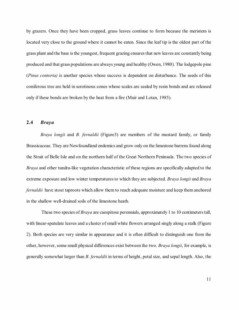
12
Figure 3: a specimen of Braya fernaldii in fruit at Burt Cape
siliques of Braya fernaldii have soft hairs while B. longii has smooth, hairless siliques (Meades,
1996a, 1996b).
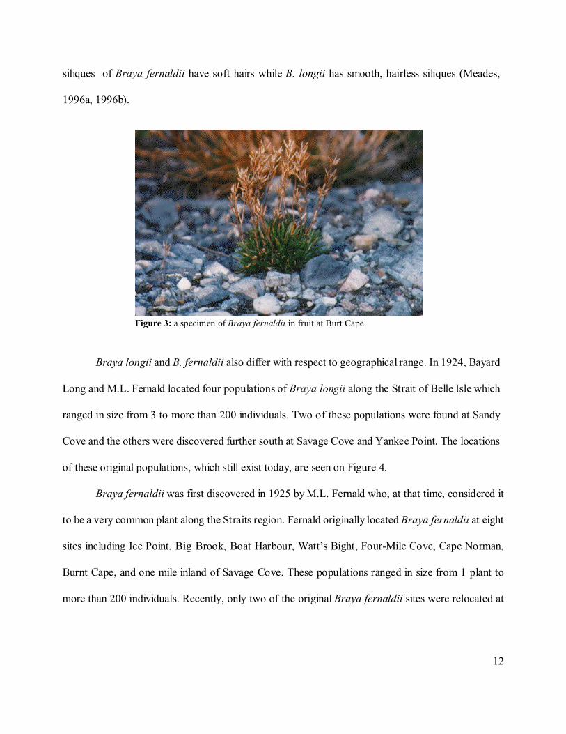
Braya longii and B. fernaldii also differ with respect to geographical range. In 1924, Bayard
Long and M.L. Fernald located four populations of Braya longii along the Strait of Belle Isle which
ranged in size from 3 to more than 200 individuals. Two of these populations were found at Sandy
Cove and the others were discovered further south at Savage Cove and Yankee Point. The locations
of these original populations, which still exist today, are seen on Figure 4.
Braya fernaldii was first discovered in 1925 by M.L. Fernald who, at that time, considered it
to be a very common plant along the Straits region. Fernald originally located Braya fernaldii at eight
sites including Ice Point, Big Brook, Boat Harbour, Watt’s Bight, Four-Mile Cove, Cape Norman,
Burnt Cape, and one mile inland of Savage Cove. These populations ranged in size from 1 plant to
more than 200 individuals. Recently, only two of the original Braya fernaldii sites were relocated at
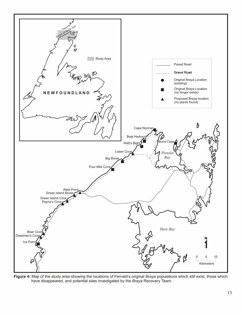
14
Cape Norman and Burnt Cape. Figure 4 also shows the locations of the existing populations of Braya
fernaldii and the original sites at which populations have not recently been relocated.
Braya longii and B. fernaldii, like all North American brayas, are calciphiles. This means that
they will only inhabit calcareous substrates such as the limestone barrens of Newfoundland. These two
species are most robust and grow in greatest numbers in recently disturbed areas. On the limestone
barrens where Braya is found, large sorted polygons are formed as a result of intense frost activity in
the soil. This type of disturbance is essential for the survival of Braya populations because it prevents
other species from establishing in its preferred habitat. If a seed source is nearby, Braya will colonize
such disturbed areas very quickly and will become the dominant plant. Over time, however, as the site
stabilizes, the number of Braya plants decreases as competition from other species causes them to be
displaced. In areas of minimal disturbance, Braya occurs only as scattered individuals (Meades, 1996a,
1996b).
Braya longii and B. fernaldii have also been known to colonize areas of the limestone barrens
that have been anthropogenically disturbed, such as abandoned roadbeds and quarry sites. Over the last
20 years, however, anthropogenic disturbance on Newfoundland’s limestone barrens has been so
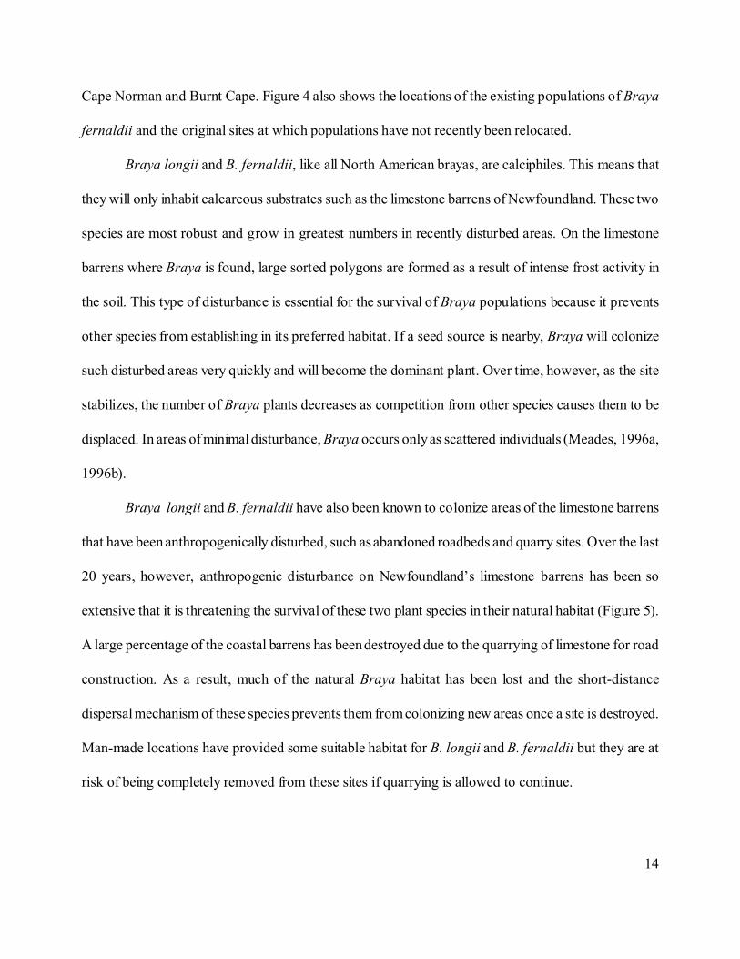
extensive that it is threatening the survival of these two plant species in their natural habitat (Figure 5).
A large percentage of the coastal barrens has been destroyed due to the quarrying of limestone for road
construction. As a result, much of the natural Braya habitat has been lost and the short-distance
dispersal mechanism of these species prevents them from colonizing new areas once a site is destroyed.
Man-made locations have provided some suitable habitat for B. longii and B. fernaldii but they are at
risk of being completely removed from these sites if quarrying is allowed to continue.
15
Figure 5: quarrying at Sandy Cove
On the COSEWIC list of plants designated at risk in Canada, Braya longii is considered
endangered, meaning that it is facing imminent extinction, and Braya fernaldii is considered threatened,
or likely to become endangered if limiting factors are not reversed (COSEWIC, 1997). Regardless of
these classifications neither one of these species is protected by legislation in Canada or Newfoundland.
Some steps are being taken to protect several of the Braya populations. A proposal has been
made to make Sandy Cove, where one of the main Braya longii populations are found, exempt from
quarrying but no protection has yet been granted. One Braya fernaldii site exists near Watt’s Point
Ecological Reserve and it has been suggested that the reserve boundary be extended to include this
population (Meades, 1996a, 1996b). This move would protect it from future quarrying, however, it
would still be threatened by the ATV users which frequently drive across the Reserve. Quarrying is no
longer allowed on Burnt Cape, the site of another Braya fernaldii population, which was designated
as a “Provisional” Reserve in 1997 and will attain full Reserve status soon.
16
Chapter 3: Study Area
Research for this project was conducted at six locations along the Strait of Belle Isle Barrens:
Yankee Point, Savage Point, Sandy Cove, Watt’s Point, Cape Norman, and Burnt Cape (Figure 6).
This ecoregion occupies the northwest and northernmost portions of Newfoundland’s Great Northern
Peninsula. The terrain of this region is primarily flat and undulating and does not exceed an elevation
of 60 meters. The soil covering the limestone barrens is very shallow and extensive areas of bedrock
lie exposed (Meades, 1990).
Extreme cold characterizes the climate of this region. The average daily temperature for the
month of February is -9 degrees celsius and may go as low as -16 degrees celsius. In July, the mean
daily temperature is approximately 13 degrees celsius but may reach 17 degrees celsius. Pack ice, which
can be seen off the coast from December to June, retards the arrival of spring to the Straits region more
severely than anywhere else in Newfoundland (South, 1983).
The Strait of Belle Isle ecoregion receives approximately 760 mm. to 900 mm. of precipitation
which is considered to be relatively low. Regardless, this region experiences an average of 186 days per
year with measurable snow, the greatest number recorded for the island. Snow cover is continuous from
January to the end of March and frost can occur at any time throughout the year. Fog frequency along
the Straits is also high.
The vegetative season for this ecoregion is less than 110 days, the shortest of any of
Newfoundland’s ecoregions. The type of vegetation which grows along the Strait of Belle Isle clearly
reflects its cold climate as it has the most tundra-like vegetation on the island. This landscape is
completely without tall trees but tuckamore of white spruce (Picea glauca), black spruce (P. mariana),
17
and balsam fir (Abies balsamea) are common. The rocky coastal barrens support a unique mixture of
arctic-alpine species, Gulf of St. Lawrence endemics and, due to the presence of limestone, calciphiles.
The six study sites are the Braya sites which were located by the Braya Recovery Team in July
of 1998. The study areas are discussed below starting with Yankee Point and moving northward.
3.1 Yankee Point
The first study site is located on the headland northeast of Mistaken Cove, known to local
residents as Yankee Point. The population of Braya longii found at this site is located on a parking lot
of limestone gravel which was quarried from the site. Unfortunately, the parking area sits adjacent to
a dirt road which is traveled frequently by large trucks carrying gravel. Much of the land between the
Braya habitat and the coast has been disturbed by extensive quarrying. The absence of vegetation in
the gravel pits and the presence of quarrying machinery indicate that this is an active quarry site.
3.2 Savage Point
The piece of land between Savage Cove and Sandy Cove is the second study site and will be
referred to as Savage Point. Two populations of Braya longii are located at this site. One group
(Savage Point A) is found on a flat area of limestone gravel which is an old airstrip. The second
population (Savage Point B) is located west of the airstrip. The limestone at this site is in large chunks
and appears to be disturbed to some degree by frost heaving. However, several large piles of rock seen
throughout the area may be evidence of anthropogenic disturbance.
19
3.3 Sandy Cove
Two populations of Braya longii are also found on the point of land opposite Savage Point,
northeast of Sandy Cove. One population (Sandy Cove A) is located on an area where the earth appears
to have been scraped by a plough and the material was pushed up to form a small bank. A very large
gravel pit is located between this population and the ocean. The other population (Sandy Cove B) is
found northeast of the first group beside a dirt road coming off the highway. Individual plants can be
seen growing amongst large chunks of limestone which may have been disturbed by freeze-thaw action.
3.4 Watt’s Point
A large population of Braya fernaldii is located near this Reserve which was established to
preserve a variety of species which characterize the limestone barrens. The Braya inhabit an old road
of limestone gravel which runs through the Reserve and was once the coastal highway.
3.5 Cape Norman
Large slabs of exposed limestone dominate the barren landscape at this location on the very tip
of the Northern Peninsula. A line of utility poles begins just north of the Cape Norman lighthouse near
the ocean and extends southward across the landscape. A small population of Braya fernaldii can be
found scattered around the fourth pole from the lighthouse. These plants are growing amongst gravel-
sized limestone rocks which appear, in some areas, to be sorted into polygons as a result of frost
activity.
20
3.6 Burnt Cape
A population of Braya fernaldii is located at this site in an area of limestone gravel which used
to be a limestone quarry. These plants are growing beside a dirt road that winds through the cape.
Burnt Cape has been quarried extensively but in 1997 this area was designated as a “Provisional”
Reserve by the Newfoundland government and quarrying was banned from the area. During the summer
of 1998, local residents began filling in many of the gravel pits on Burnt Cape, while being careful not
to disturb the Braya site, as part of a program to rehabilitate the area.
21
Chapter 4: Methods
In order to study disturbance over time on the Great Northern Peninsula aerial photos of each
of the study sites that were taken between 1948 and 1995 were obtained. The numbers of these aerial
photos and a description of each are provided in Table 1. Disturbance areas are visible on the photos
because they are much lighter than the surrounding undisturbed areas as much of the vegetation has
been removed and the limestone is now exposed. An attempt was made to classify each area of
disturbance into one of three categories: natural (frost heaving), high anthropogenic (surficial material
had been removed, such as gravel pits), or low anthropogenic (gravel surface had been scraped). A
stereoscope, which revealed the depth of the disturbance, aided in the identification and classification
of disturbed areas. Each of the photos were then traced onto a mylar sheet and the disturbed areas were
outlined. Aerial photos of most of the Northern Peninsula were taken in 1948, 1968, 1979, and 1995.
Study sites were traced four times if photos for each of these years were available, however, those sites
for which a set of photos was missing were only traced three times.
Field work at each of the study areas took place during the first week of July, 1998 when the
Braya Recovery Team made its first trip to the Northern Peninsula. The team located populations of
Braya at Yankee Point, Savage Point, Sandy Cove, Watt’s Point, Cape Norman, and Burnt Cape
(Figure 6). The team also visited other sites where Braya populations had been previously discovered
by Fernald, but was unable to find them. An attempt was made to locate new populations at potential
sites which were identified on the aerial photos by their similar appearance to known Braya locations.
However, no new populations were found. Potential sites investigated by the Braya Recovery Team
are shown in Figure 4 and include Deadman’s Cove, Bear Cove, Payne’s Cove, Green Island Cove,
Green Island Brook, West Point, and Lower Cove.
22
The Braya Recovery Team counted the number of Braya individuals at each site and some
individuals were tagged so that populations can be monitored. Samples of these tagged plants were
taken for electrophoresis and possible transplantation at Memorial University’s Botanical Garden. The
author also did some ground-truthing to determine the level of habitat disturbance at each study site.
Areas of low anthropogenic disturbance generally had only the top layer of gravel removed, such as
gravel roads. Sites at which large amounts of material had been removed to create a pit were considered
areas of high anthropogenic disturbance. Areas which appeared to be disturbed by frost action were
considered to have been naturally disturbed. Natural disturbance was identified by the presence of frost
polygons. These are circles or polygonal shapes which are formed by the sorting of soil material
according to size in areas of shallow frost activity (Hallett, 1990).
Another trip to the Northern Peninsula was taken during the first week of August, 1998. At
each of the six study sites the size of the area occupied by Braya populations was measured. Several
measurements of the tagged plants were also taken to provide baseline data for future monitoring of
these populations, including leaf size, stalk length, and number of flowers per stem. Density
measurements of the Braya populations were taken by the author at each site by randomly tossing a
meter square quadrat throughout the population and counting the number of Braya plants it contained
(figure 7). Five random samples were taken at each site. These measurements were then used to
determine whether Braya populations grow more vigorously in areas of natural, high anthropogenic,
or low anthropogenic disturbance.
23
Table 1: Description of aerial photos of study sites
Location Year Photo # Black and Whiteor Colour
Scale
Yankee Point 1948 NFL 2 - 22 B/W 1: 39,600
Yankee Point 1968 20532 - 4 B/W 1:15,840
Yankee Point 1979 79021 - 174 Colour 1:12,500
Yankee Point 1995 95014 - 65 Colour 1:12,500
Savage Point &Sandy Cove
1968 205321 - 179 B/W 1:15,840
Savage Point &Sandy Cove
1979 79021 - 170 Colour 1:12,500
Savage Point &Sandy Cove
1995 95012 - 72 Colour 1:12,500
Watt’s Point 1948 NFL 2 - 91 B/W 1:39,600
Watt’s Point 1968 20523 - 155 B/W 1:15,840
Watt’s Point 1995 95008 - 140 Colour 1:12,500
Cape Norman 1948 NFL 2 - 165 B/W 1:39,600
Cape Norman 1968 20529 - 80 B/W 1:15,840
Cape Norman 1995 95004 - 4 Colour 1:12,500
Burnt Cape 1948 NFL 2 - 157 B/W 1:39,600
Burnt Cape 1968 20528 - 135 B/W 1:15,840
Burnt Cape 1979 79015 - 70 Colour 1:12,500
Burnt Cape 1995 95009 - 56 Colour 1:12,500
24
Figure 7: measuring population density at Burnt Cape using a 1 m square quadrat
When the field work was completed the outlines of each of the aerial photos were imported into
a Geographic Information System to calculate the total area of disturbance over time at each site. The
outlines were scanned in .tiff format and imported into MAPINFO 4.5. All scanned images were then
geo-referenced to North American Datum 27, zone 21. Each image was then geometrically corrected
and the disturbance areas were digitized as polygons. The polygons were then queried to determine
the actual area of disturbance. For each study site the polygon areas were added together to produce
the total area of disturbance. In order to show the temporal change in disturbance at each study area
an overlay was performed.
25
Chapter 5: Results
Levels of disturbance at each Braya site could be clearly identified in the field, however, even
with the use of a stereoscope it was not possible to distinguish between areas of low anthropogenic and
natural disturbance on the aerial photos. Also, since no global positioning system was used in the field
it was difficult to determine the exact location and size of each area of disturbance on the aerial photos.
As a result, the area of each type of disturbance could not be calculated. Instead, the total area of
disturbance at each site between 1948 and 1995 was determined. These results are provided in Table
2 and in Figure 8 which shows the increase in disturbance at each site over the last fifty years.
Figures 9 to 13 are outlines of each study site showing the areas that were disturbed between
1948 and 1995. The approximate locations of the Braya populations found at each site are also
displayed in these figures. Since Yankee Point, Savage Point, and Sandy Cove are the only areas that
experienced disturbance in more than one year, overlays were done for these three areas only. The
overlaid areas of disturbance at these sites are seen in Figures 9 and 10. The results of the density
measurements and the level of disturbance observed at each site during field investigations are provided
in Table 3.
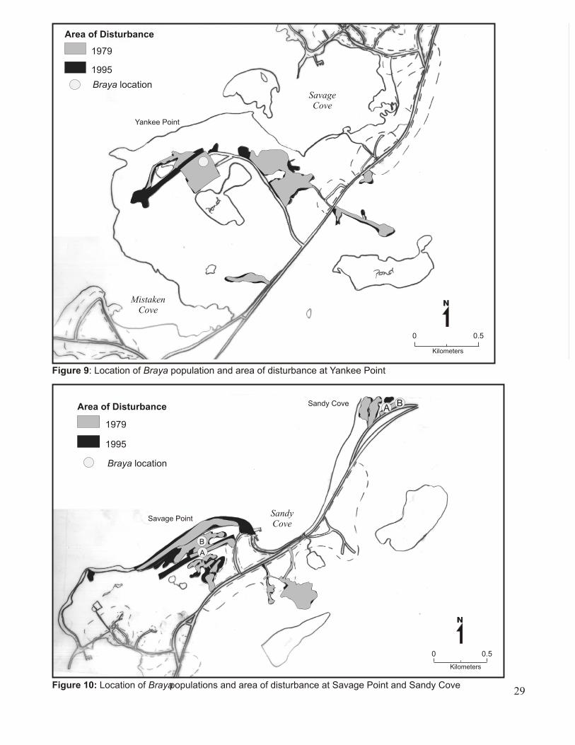
5.1 Yankee Point
The approximate location of the population found at this site can be seen in Figure 9. This
population occupies an abandoned parking lot of limestone gravel. The foundation of a building that
has recently been knocked down remains in one corner of the lot. The parking lot is an area of low
anthropogenic disturbance because the surface of the earth has only been scraped, however, large
26
quarry pits surround this Braya population. Much of the land between the parking lot and the ocean
has been disturbed by quarrying and even more will be disturbed as this is an active quarry site.
The Braya Recovery Team counted more than 1600 individuals of Braya longii at this site.
This population covers basically the whole extent of the parking lot which is approximately 120 m long
and 10 m wide. Five random samples were taken by the author at this site using the 1m x 1m quadrat.
There were 6 individuals of Long’s braya in the first sample, 48 in the second, 35 in the third, 1 in the
fourth, and none in the fifth sample.
Figure 8 shows that disturbance at this site increased greatly between 1948 and 1995. Table 2
indicates that there was no disturbance at this site before 1968, however, in 1979, approximately 221,
743 m² of land had been disturbed, mainly by quarry activity. In 1995, that number increased to 256,
136 m². Figure 8 shows the extent of disturbance in 1979 and 1995. The bulk of the disturbance
appears to have been completed by 1979 as some of the disturbed areas remained virtually unchanged
in 1995. However, some of the disturbed areas have increased since 1979, including the quarry site
south of the lot. This area has grown significantly and markers placed by the quarry company, which
were observed during fieldwork, indicate that it will extend almost to the coastline.
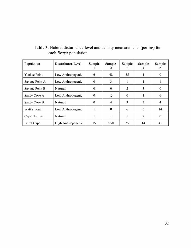
5.2 Savage Point
The Braya longii population occupying the airstrip at this location (Savage Point A) is identified
in Figure 10. The airstrip is a flat area of limestone gravel which has had its surface scraped and is,
therefore, an area of low anthropogenic disturbance. Evidence of larger-scale disturbance surrounds
this population, however. A gravel pit, which appears to have been abandoned due to the presence of
32
Table 3: Habitat disturbance level and density measurements (per m²) for
each Braya population
Population Disturbance Level Sample1
Sample 2
Sample 3
Sample4
Sample5
Yankee Point Low Anthropogenic 6 48 35 1 0
Savage Point A Low Anthropogenic 0 3 1 1 1
Savage Point B Natural 0 0 2 3 0
Sandy Cove A Low Anthropogenic 0 13 0 1 6
Sandy Cove B Natural 0 4 3 3 4
Watt’s Point Low Anthropogenic 1 0 6 6 14
Cape Norman Natural 1 1 1 2 0
Burnt Cape High Anthropogenic 15 >50 35 14 41
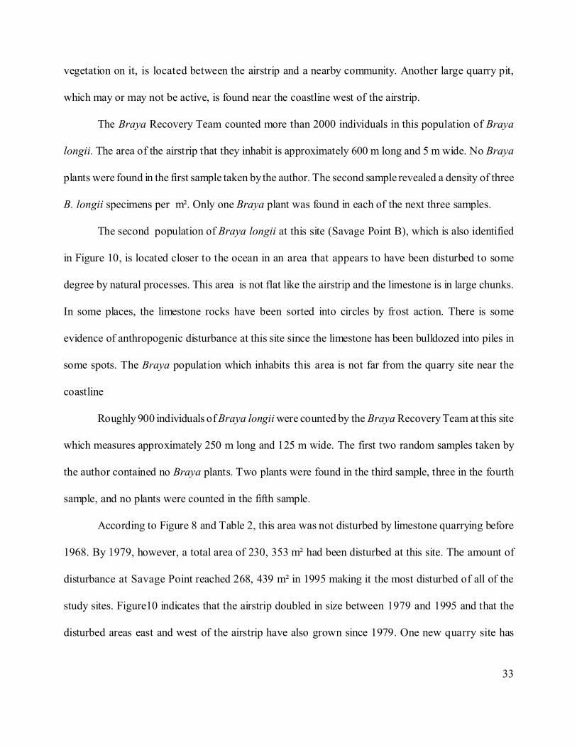
33
vegetation on it, is located between the airstrip and a nearby community. Another large quarry pit,
which may or may not be active, is found near the coastline west of the airstrip.
The Braya Recovery Team counted more than 2000 individuals in this population of Braya
longii. The area of the airstrip that they inhabit is approximately 600 m long and 5 m wide. No Braya
plants were found in the first sample taken by the author. The second sample revealed a density of three
B. longii specimens per m². Only one Braya plant was found in each of the next three samples.
The second population of Braya longii at this site (Savage Point B), which is also identified
in Figure 10, is located closer to the ocean in an area that appears to have been disturbed to some
degree by natural processes. This area is not flat like the airstrip and the limestone is in large chunks.
In some places, the limestone rocks have been sorted into circles by frost action. There is some
evidence of anthropogenic disturbance at this site since the limestone has been bulldozed into piles in
some spots. The Braya population which inhabits this area is not far from the quarry site near the
coastline
Roughly 900 individuals of Braya longii were counted by the Braya Recovery Team at this site
which measures approximately 250 m long and 125 m wide. The first two random samples taken by
the author contained no Braya plants. Two plants were found in the third sample, three in the fourth
sample, and no plants were counted in the fifth sample.
According to Figure 8 and Table 2, this area was not disturbed by limestone quarrying before
1968. By 1979, however, a total area of 230, 353 m² had been disturbed at this site. The amount of
disturbance at Savage Point reached 268, 439 m² in 1995 making it the most disturbed of all of the
study sites. Figure10 indicates that the airstrip doubled in size between 1979 and 1995 and that the
disturbed areas east and west of the airstrip have also grown since 1979. One new quarry site has
34
developed in this area since 1979 while the disturbed areas west of the highway have remained
approximately the same size.
5.3 Sandy Cove
The approximate location of the population of Braya longii which occupies the scraped area
at this site (Sandy Cove A) can be seen on Figure 10. A bank of pushed up earth near this population
indicates that this area has been scraped by the blade of a bulldozer so it is classified as an area of low
anthropogenic disturbance. In fact, an abandoned blade is sitting on top of this bank. This site is not
quite as rocky as the other Braya locations and has several patches of exposed peat. Several large
gravel pits are located east of this population and extend almost to the coastline. Quarrying machinery
can be seen in one of the gravel pits which may be an indication that it is still active.
Five hundred individuals of Braya longii were counted at this site by the Braya Recovery Team.
The area that they inhabit is small, measuring approximately 25 m long and 12 m wide. The first random
sample taken by the author contained no individuals of Braya longii but the second sample contained
13 plants. No Braya plants were counted in the third sample, only one was found in the fourth sample,
and 6 Braya specimens were counted in the fifth sample.
The other population of Braya longii found at Sandy Cove (Sandy Cove B) is located just east
of the Sandy Cove A population and is also identified on Figure 10. This site sits adjacent to a gravel
road which comes off the highway and is classified as an area of natural disturbance as it appears to
have been disturbed to some degree by frost activity. The limestone in this small area has been shattered
into large chunks but there is no sign of frost sorting.
35
This site is approximately 38 m long and 18 m wide and is occupied by 600 plants which were
counted by the Braya Recovery Team. No Braya individuals were found in the author’s first random
sample. Four plants were found in the next sample, 3 plants were found in the second and third samples,
and the last sample contained 4 plants.
Figure 8 shows that the total area of disturbance created at this site between 1948 and 1995 is
much smaller than that created at Yankee Point and Savage Point. Similar to the two previous study
sites, however, disturbance is not evident at Sandy Cove in 1948 and 1968. In 1979 and 1995, the total
area of disturbance was 41, 457 m² and 42, 339 m², respectively. Only a small portion of Sandy Cove
is visible on the outline and a great deal of this area has been destroyed by quarrying. The majority of
the disturbance had been created by 1979 with minimal growth occurring between 1979 and 1995.
5.4 Watt’s Point
The population of Braya fernaldii found at Watt’s Point inhabits a portion of the old coastal
highway. To the west of this limestone gravel road is the ocean and areas of exposed limestone can be
seen east of the road. The Braya population is located approximately 9 km in from the start of the
gravel road near the modern highway. Driving along the road up to the site disturbance can be seen on
the sides of the road in the form of large ditches caused by the bulldozing of material to create the old
highway. This disturbance, however, cannot be seen on the aerial photos and was, therefore, not
included in the calculation of the amount of disturbance at this site. Figure 11 is an outline of the Watt’s
Point area which indicates the approximate location of the Braya site. According to Figure 8 and Table
2, disturbance as a result of quarrying could not be seen on any of the aerial photos of Watt’s Point.
36
More than 800 individuals of Braya fernaldii were counted by the Braya Recovery Team at this
site. This population inhabits an area of the gravel road which is roughly 300 m long and 2 m wide.
Only one Braya specimen was found in the first random sample taken by the author and no plants could
be seen in the second sample. The next two samples each produced six plants and fourteen individuals
were counted in the fifth sample.
5.5 Cape Norman
At this site a small population of Braya fernaldii are hidden amongst a great landscape of
exposed limestone. The approximate location of this population is given in Figure 12. This population
is located on a north-facing slope south of the Cape Norman lighthouse in an area of limestone gravel.
In places, these rocks are arranged in polygons as a result of frost heaving, therefore, it is classified as
an area of natural disturbance. There is no evidence of quarrying in the immediate vicinity.
Vegetation in this area is sparse and the population of approximately 75 individuals of Braya
fernaldii were counted by the Braya Recovery Team within a 60 m radius. Four Braya plants were
counted in the author’s first sample, one in the second sample, and three plants were found in the third
sample. The fourth sample contained 10 plants and the fifth sample contained no Braya individuals.
According to Figure 8, the amount of disturbed area at Cape Norman has not increased much
over the last fifty years. This area appears to have been unaffected by limestone quarrying until 1979,
at least, and only 8710 m² of disturbance had been created anthropogenically by 1995. An overlay of
this area could not be done since disturbance is only visible in the 1995 aerial photo.
37
5.6 Burnt Cape
The approximate location of the population of Braya fernaldii located at this site is identified
in Figure 13. This population is found in an abandoned quarry pit amongst limestone gravel adjacent
to an unpaved road. Since it appears that a considerable amount of material has been removed from this
site it is classified as an area of high anthropogenic disturbance. The area occupied by the plants is
relatively flat, though some are growing on the gentle slopes of the pit.
The Braya Recovery Team counted approximately 900 plants at this site. They occupy an area
that is roughly 100 m long and 15 m wide. Fifteen individuals were counted in the first random sample
taken by the author and more than 50 plants were found in the second sample. The third sample
contained 35 plants, the fourth had 14 plants, and 41 plants were counted in the fifth sample.
Figure 8 indicates that the line of increasing disturbance for Burnt Cape is similar to that of
Cape Norman. Table 2 shows that, in 1995, the total area of disturbance at Burnt Cape was 6872 m².
The photos of this area that were taken prior to 1995 reveal no quarry-related disturbance. An overlay
of disturbance areas could not be done for this site because disturbance was only visible on the 1995
aerial photo.
38
Chapter 6: Discussion and Conclusions
6.1 Density
Five of the eight populations of Braya which were studied occur in areas that have been
anthropogenically disturbed, four of which are areas of low disturbance and one of which is an area of
high disturbance. The other three populations are located in areas that appear to have been disturbed
by natural forces. The results of the density measurements indicate that Braya populations generally
have the greatest densities in areas of anthropogenic disturbance and the lowest densities in naturally
disturbed areas. The population with the highest population density is found in the area of high
anthropogenic disturbance and the populations which grow in naturally disturbed areas have very low
densities. In areas of low anthropogenic disturbance Braya population densities range from very low
to fairly high.
The population at Burnt Cape, which has the greatest number of plants per square meter, occurs
on the only study site that has a high level of anthropogenic disturbance. The population with the
second greatest density is found at Yankee Point, which is an area of low anthropogenic disturbance.
The densities of the remaining Braya populations are considerably lower than those of the Burnt Cape
and Yankee Point populations. The Sandy Cove A and Watt’s Point populations had similar plant
densities as at least one of the samples taken at each site contained between ten and fifteen Braya
individuals. Both of these sites are areas of low anthropogenic disturbance. The populations of Braya
that are found at Savage Point and Cape Norman and the Sandy Cove B population had the lowest
densities with less than five plants in each sample. The Sandy Cove B, Savage Point B, and Cape
Norman populations are located in areas of natural disturbance but the Savage Point A population is
found in an area of low anthropogenic disturbance.
39
The explanation for high Braya population densities in the areas of high anthropogenic
disturbance and low population densities in the naturally disturbed areas may be related to the age of
the disturbance at each site. As mentioned previously, Braya grows most vigorously in recently
disturbed areas. Over time, as the area becomes more stable, other plants will become dominant and
the number of Braya individuals will decrease. Since the ages of the naturally disturbed areas are
unknown it is possible that they are much older than the anthropogenically disturbed areas and,
therefore, have become dominated by species other than Braya longii and B. fernaldii. The vitality of
Braya populations growing in anthropogenically disturbed may also be explained by the fact that
nutrient availability is greater in areas of large-scale anthropogenic disturbance than in areas of natural
disturbance (Hermanutz, 1998).
When discussing these results it should be considered that the conditions of the Braya sites and
the size and density of the populations prior to their documentation in the 1990s are unknown. Before
the study sites were disturbed by human activity the Braya populations must have grown in areas of
natural disturbance. It is possible that, at that time, the populations were larger and healthier than they
are today. It is also possible that the “naturally” disturbed areas in which some of the populations are
found were not created exclusively by natural forces. They may have been disturbed previously by
human activity which could have caused frost heaving to occur. Patterned ground only occurs in
exposed areas which are subjected to low temperatures, such as the limestone barrens of northern
Newfoundland (Wilson, 1952). In areas such as these, it also requires low plant cover. The first stage
of quarrying involves the scraping of the top layer of earth at a site and, consequently, the removal of
any vegetation growing in it. Quarrying may, therefore, be beneficial to Braya populations as it
promotes frost heaving and creates areas of potential habitat.
40
The results of this study may indicate that Braya populations have the greatest densities when
growing in an area of high anthropogenic disturbance, however, these populations are not
representative of historically accurate populations (Hermanutz, 1998). Populations of Braya that
existed prior to the generation of anthropogenic disturbance on the Great Northern Peninsula were
probably more like the populations that are growing in naturally disturbed areas today. In order to
produce more historically accurate populations further research on the mechanism of disturbance on
the limestone barrens is essential.
Although a certain degree of anthropogenic disturbance may help to increase Braya numbers
extensive quarrying may lead to the extirpation of the remaining populations. One incident has been
documented by a visitor to Burnt Cape in which a bulldozer was burying a population of Braya
fernaldii with peat as it created a new quarry (Meades, 1996). This type of disturbance cannot be
beneficial to any plant. Obviously, the number of Braya populations has decreased since quarrying
began on the Great Northern Peninsula because many of the populations located by Fernald have
disappeared. Figure 4 indicates that, of the seven original Braya fernaldii populations discovered by
Fernald, only two remain at Cape Norman and Burnt Cape. The populations at Ice Point, Four-Mile
Cove, Big Brook, Watt’s Bight, and Boat Harbour no longer exist, probably as a result of human
activity.
Presently, quarrying is ongoing at Yankee Point, Savage Point, and Sandy Cove which means
that the Braya populations located at these sites are at a high risk of suffering the same fate as the
majority of Fernald’s original populations. The protection of the Braya populations discussed in this
study is of great importance since the results of intensive surveying of the Northern Peninsula for more
populations by the Braya Recovery Team indicate that they are the last.
41
6.2 Quantifying Area of Disturbance
The results of the disturbance area calculations indicate that anthropogenic disturbance on the
Great Northern Peninsula has increased greatly between 1948 and 1995. Until at least 1968 quarrying
did not occur at any of the study sites. In fact, as of 1974, quarrying had not begun on the Great
Northern Peninsula even though extensive deposits of commercially promising limestone had been
located at Burnt Cape and near Cape Norman (DeGrace, 1974).
Between 1974 and 1979, Yankee Point, Savage Point, and Sandy Cove had been greatly
disturbed and field observations prove that the majority of this disturbance was created by quarrying.
Watt’s Point, Cape Norman, and Burnt Cape remained undisturbed in 1979. Between 1979 and 1995,
disturbance increased slightly at Yankee Point, Savage Point, and Sandy Cove and relatively small areas
of land at Cape Norman and Burnt Cape had been anthropogenically disturbed. As of 1995, no
disturbance as a result of quarrying had occurred at Watt’s Point.
At some sites, including Burnt Cape and Watt’s Point, the total area of disturbance which was
calculated from the air photos is smaller than the actual area of disturbance at each of these sites.
During the field trips to these locations during the summer of 1998 a considerable amount of
disturbance could be seen which is not visible on the air photos. At Burnt Cape, which was once a
central quarrying location, gravel pits could not be distinguished on the aerial photos from areas of
naturally exposed limestone which are prominent throughout the area. In other cases, areas of
disturbance may have been too small to decipher at the 1 : 12,500 scale of the most recent aerial
photos. This was a problem at Watt’s Point where areas of disturbance observed during fieldwork were
not visible on the aerial photos. Also, disturbance may have existed prior to 1979 at some sites but
42
because the older aerial photos were taken in black and white and at such small scales disturbed areas
could not be seen.
6.3 Conclusions
Disturbance, either naturally or anthropogenically generated, is essential to the survival of
Braya longii and Braya fernaldii. The results of this study indicate that the density of Braya
populations is greater in areas of high anthropogenic than in low anthropogenic or naturally disturbed
areas. However, this may be due to the fact that the naturally disturbed areas are older and more stable
than the areas that have been disturbed by human activities, such as quarrying. The fact that the past
conditions of the Braya sites are unknown should also be considered since Braya populations may have
been healthier prior to the creation of anthropogenically disturbed areas on the Great Northern
Peninsula in the late 1970s.
The study results also indicate that disturbance has increased significantly at most of the Braya
sites between 1948 and 1995. Due to the disappearance of several of Fernald’s original Braya
populations and the inability of the Braya Recovery Team to locate new populations, the importance
of protecting the existing populations must be emphasized. In particular, the Braya populations at
Yankee Point, Savage Point, and Sandy Cove should be considered for immediate preservation since
ongoing quarrying at these sites is a threat to their survival.
43
References
Action Statement Number 23: Limestone caladenia (Caladenia calcicola). Http://www.nre.vic.gov.au/plntanml/naqtive/actstats/content/as23.htm.
Balm, R. (1996) Big holes in a small place. Geography 81(1): 82-91.
Bazazz, F.A. (1983) Characteristics of populations in relation to disturbance in natural and man-modified ecosystems. Disturbance and ecosystems: components of response, edited byMooney and Godron. Springer- Verlag, New York, NY.
Bazazz, F.A. (1996) Plants in changing environments. Cambridge University Press, New York,N.Y.
Connell, J.H. (1978) Diversity in tropical rainforests and coral reefs. Science 199:1302-1310.
Committee on the Status of Endangered Wildlife in Canada (COSEWIC). (1997) Vascular plants,mosses and lichens designated at risk in Canada.
DeGrace, J.R. (1974) Limestone resources of Newfoundland and Labrador. Department of Minesand Energy Mineral Division.
Fernald, M.L. (1926) Two summers of botanizing in Newfoundland. Rhodora 28(328): 49-204.
Hallet, B. (1990). Spatial self-organization in geomorphology: from periodic bedforms andpatterned ground to scale-invariant topography. Earth-Science Reviews 29: 57-75.
Hermanutz, L. (1998) Population dynamics of the endangered and threatened Braya species (B. Longii and B. fernaldii). Report for the Endangered Species 1998 Recovery Fund.
Koevenig, J.L. (1976) Effect of climate, soil physiography, and seed germination on the distributionof river birch (Betula nigra). Rhodora 78: 420-437.
Meades, W.J. (1983) Heathlands. In Biogeography and ecology of the island of Newfoundland,edited by G.R. South. Dr. W. Junk Publishers, The Hague.
Meades, S.J. (1990) Natural regions of Newfoundland and Labrador, a contract report submitted to Protected Areas Association of Newfoundland and Labrador.
Meades, S.J. (1996a) Status report on plants at risk in Canada: Long’s braya. Committee on theStatus of Endangered Wildlife in Canada (COSEWIC).
44
Meades, S.J. (1996b) Status report on plants at risk in Canada: Fernald’s braya. Committee on theStatus of Endangered Wildlife in Canada (COSEWIC).
Meades, S.J. (1996). The end of quarrying at Burnt Island. Sarracenia 6(2): 7-17.
Mooney, H.A. and Godron, M., eds. (1983) Disturbance and ecosystems. Springer-Verlag, Berlinand New York.
Muir, P.S. and Lotan, J.E. (1985) Disturbance history and serotiny of Pinus contorta in westernMontana. Ecology 66(5): 1658-1668.
Owen, D.F. (1980) How plants may benefit from the animals that eat them. Oikos 35: 230-235.
Pickett, S.T.A. and White, P., eds. (1985). The ecology of natural disturbance and patch dynamics.Academic Press, Inc., Orlando, Florida.
Short, F.T. and Wyllie-Echeverria, S. (1996). Natural and human induced disturbance of seagrasses. Environmental Conservation 23(1): 17-27.
Sousa, W.P. (1979) Experimental investigations of disturbance and ecological succession in a rockyintertidal algal community. Ecological Monographs 49(3): 227-254.
Sousa, W.P. (1984). The role of disturbance in natural communities. Ann. Rev. Ecol. Syst. 15: 353-391.
South, G.R., ed. (1983) Biogeography and ecology of the island of Newfoundland. Dr. W. Junk Publishers, The Hague.
Sprugel, D.G. (1991) Disturbance, equilibrium, and environmental variability: what is “natural”vegetation in a changing environment? Biological Conservation 58: 1-18.
Trudgill, S. (1985) Geomorphology texts: limestone geomorphology. Longman Inc., New York.
White, P.S. (1979) Pattern, process, and natural disturbance in vegetation. The Botanical Review 45:229-299.
Wigglesworth, P. (1991) Limestone quarrying and nature conservation. The Planner 77(14): 5-7.
Wilson, J.W. (1952). Vegetation patterns associated with soil movement on Jan Mayen Island. J. ofEcology 40(2): 249-264.