Embed Size (px)
Citation preview

Building European Operational Capabilities
GMES
ESA plans linked to IGOLO. Arino, rome, 14 September 2004

• User process (100 + 100)
• Project now and in short term future
• Environmental convention (UNFCCC/Kyoto)
• GLOBCOVER
• ATSR/AATSR World Fire Atlas
• Global Monitoring for Food Security
• Operationalisation: GMES and the Sentinels
• IGOL perequation and topics
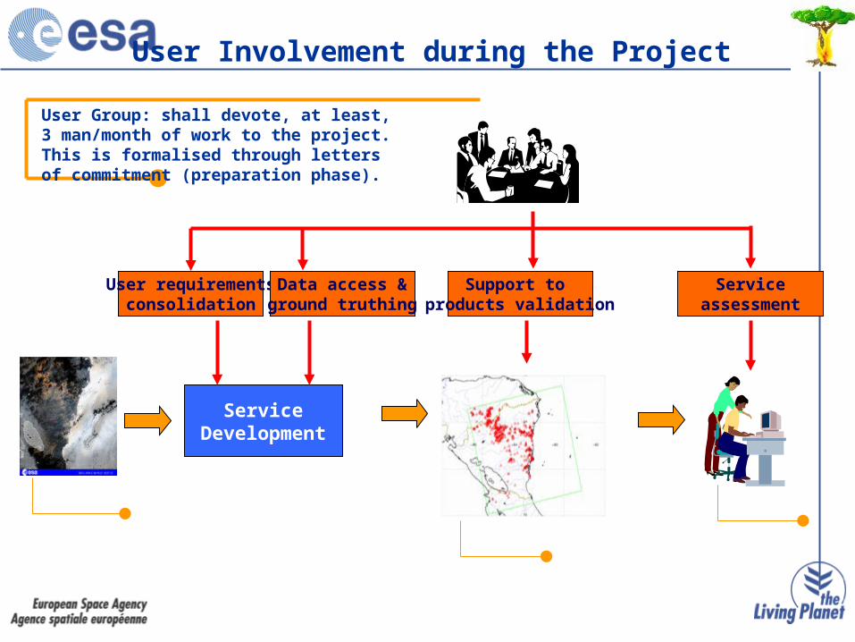
User requirementsconsolidation
ServiceDevelopment
User Group: shall devote, at least, 3 man/month of work to the project. This is formalised through letters of commitment (preparation phase).
EO data
Products
Service
Data access &ground truthing
Support to products validation
Serviceassessment
User Involvement during the Project

Projects name: KYOTOINV, GLOBWETLAND, DESERTWATCH, ALPINE
Usernames: UNFCCC, RAMSAR, UNCCD, , ALPINE CONVENTION, NPoCs
International Scientific Programs NGOs
National Governmental Ministries, Agencies
Environmental conventions
Intergovernmental Organisations
Projects name:GLOBCARBON, MEDSPIRATION, TEMIS, GLOBICE, GLOBCOLOUR
Usernames: IGBP, GODAE, GOFC, WCRP, IOCCG
Projects name: DUDES,, GLOBCOVER, CONTRAIL, EPIDEMIO, GLOBAER, BeGO
Usernames: EC, UNEP, FAO, EUROCONTROL, WHO, ECMWF, UNESCO
Projects name: ITALSCAR, SLAM, COASTCHART, TEMIS
Usernames: CPA, ENV MINISTRIES, HYDROGRAPHIC OFFICES, MET OFFICES
Projects name: HUMAN, URBEX
Usernames: MSF, WWF
User’s Portfolio
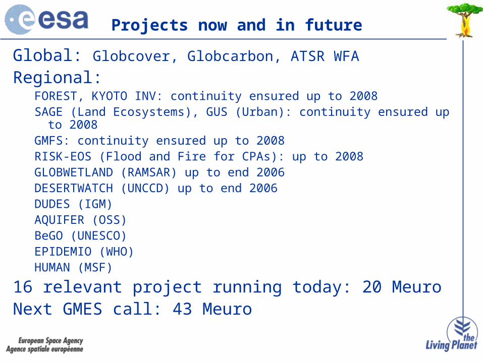
Global: Globcover, Globcarbon, ATSR WFA
Regional: FOREST, KYOTO INV: continuity ensured up to 2008SAGE (Land Ecosystems), GUS (Urban): continuity ensured up to 2008GMFS: continuity ensured up to 2008RISK-EOS (Flood and Fire for CPAs): up to 2008GLOBWETLAND (RAMSAR) up to end 2006DESERTWATCH (UNCCD) up to end 2006DUDES (IGM)AQUIFER (OSS)BeGO (UNESCO)EPIDEMIO (WHO)HUMAN (MSF)
16 relevant project running today: 20 MeuroNext GMES call: 43 Meuro
Projects now and in future
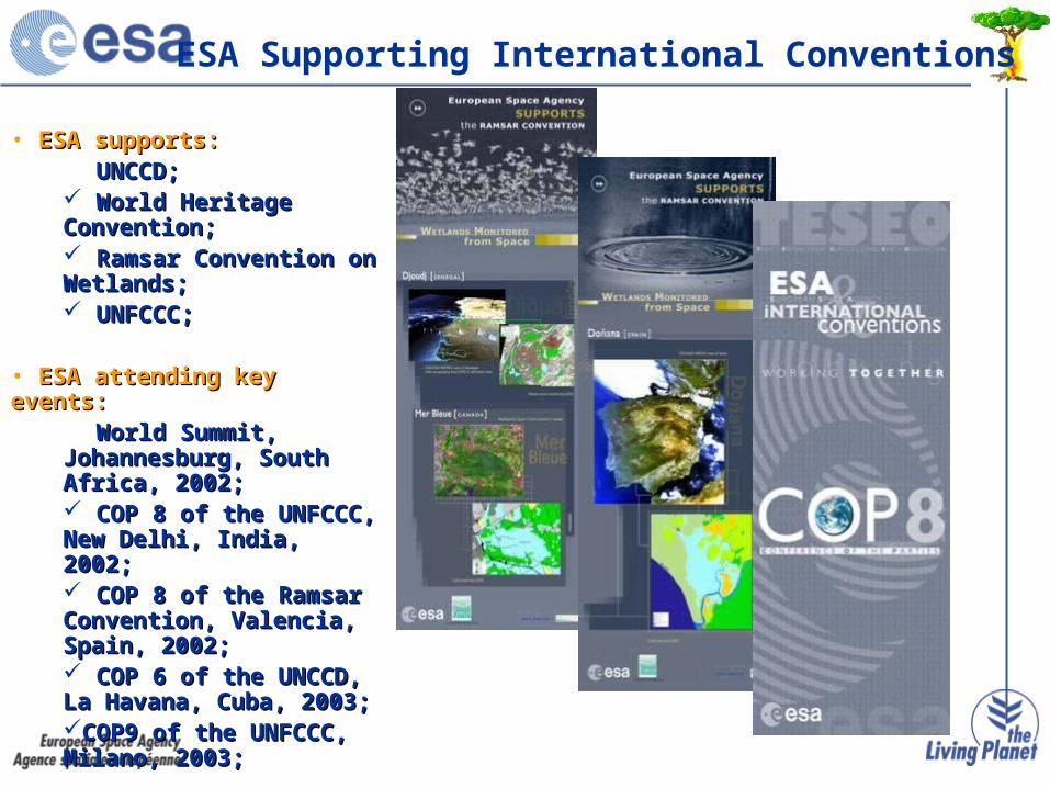
• ESA supports:ESA supports: UNCCD;UNCCD; World Heritage World Heritage Convention;Convention; Ramsar Convention on Ramsar Convention on Wetlands;Wetlands; UNFCCC;UNFCCC;
• ESA attending key events:ESA attending key events: World Summit, World Summit, Johannesburg, South Johannesburg, South Africa, 2002;Africa, 2002; COP 8 of the UNFCCC, COP 8 of the UNFCCC, New Delhi, India, 2002;New Delhi, India, 2002; COP 8 of the Ramsar COP 8 of the Ramsar Convention, Valencia, Convention, Valencia, Spain, 2002;Spain, 2002; COP 6 of the UNCCD, La COP 6 of the UNCCD, La Havana, Cuba, 2003;Havana, Cuba, 2003;COP9 of the UNFCCC, COP9 of the UNFCCC, Milano, 2003;Milano, 2003;
ESA Supporting International Conventions
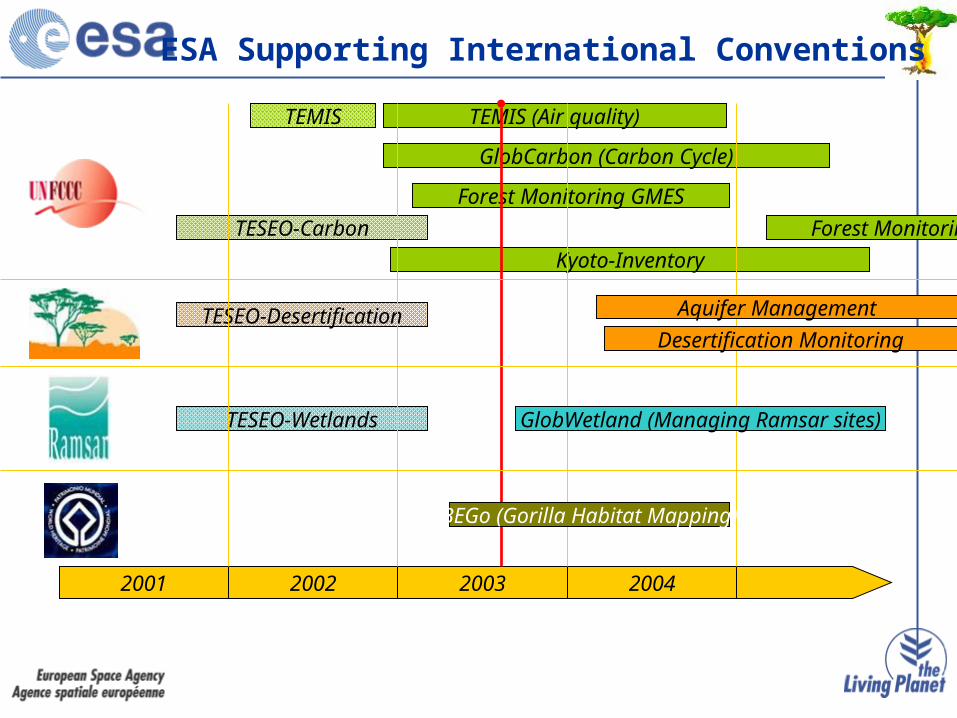
ESA Supporting International Conventions
2001 2002 2003 2004
TESEO-Carbon
TESEO-Desertification
TESEO-Wetlands
TEMIS (Air quality)
Kyoto-Inventory
GlobCarbon (Carbon Cycle)
Forest Monitoring GMES
GlobWetland (Managing Ramsar sites)
BEGo (Gorilla Habitat Mapping)
Aquifer Management
Desertification Monitoring
TEMIS
Forest Monitoring GMES

Soil data
Carbon estimates per sample plot
field data and default values
Forest inventory field data (sample plots)
Biomass Expansion Factores (BEF)
IN-SITU DATA
Germany Greece French Guiana
EO STRATIFICATION Forest type & land use derived from optical and SAR data
FOREST MONITORINGLULUCF – Services for National Greenhouse Gas Reporting
Current Users:Current Users:
BMVEL - Germany; NOA - Greece; MAPAAR - France
Responsible for UNFCCC and Kyoto Protocol reporting (Art. 3.3, 3.4)
Services:Services:
Maps and Statistics for Land Use, Land Use Change and Forestry (LULUCF)
1990 baseline assessment of Forest and Land use area
Carbon Stock and annual changes
Error Budget and Minimum reliable estimate
Utility:Utility:
Consistent 1990 baseline assessment
Cost reduction and highest level of reliability
Compliance with COP decisions and LULUCF Good Practice Guidance Guidlines
CARBON BUDGET
5 892 075 tons6 546 750 tonsCarbon stock
212 850 ha215 000 haForest area
Minimum reliable estimate
Average estimate
SAMPL
E

• Land Use Map• Land Use Change /ARD Map
• 0,5 ha minimum mappable unit• 1:50000 scale• 95% thematic accuracy• Statistic data associated• Prototype on 13 test sites• Full/half coverage for I, CH, NL,
SP• Forest Map
KYOTO-INVServices for national reporting on LULUCF activities under the Kyoto Protocol
Wetland
Forest
Unproductive
Water
Urban_Area
Grassland
Annual_Crop

Italian Land Use Change: Tuscany 89-02
KYOTO-INVServices for national reporting on LULUCF activities under the Kyoto Protocol
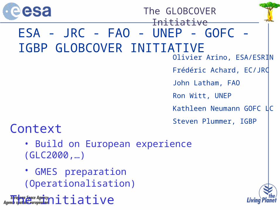
ESA - JRC - FAO - UNEP - GOFC - IGBP GLOBCOVER INITIATIVE
Context• Build on European experience (GLC2000,…)
• GMES preparation (Operationalisation)
The initiative
Specifications
Olivier Arino, ESA/ESRIN
Frédéric Achard, EC/JRC
John Latham, FAO
Ron Witt, UNEP
Kathleen Neumann GOFC LC
Steven Plummer, IGBP
The GLOBCOVER Initiative

•Why GLOBCOVER (O. Arino)
•The IGOS Land theme and the GOFC strategy (S. Briggs)
•The GLOBCARBON example (S. Plummer)
•Building on GLC2000 and preparing GMES (A. Belward)
•The MERIS FR data collection (H. Laur)
•The MERIS FR processor status (A. Buongiorno)
•The MERIS FR data quality (S. Delwart)
•The UNEP requirements (R, Witt)
•The FAO requirements (J, Latham)
•The GLOCOVER specification (F. Achard)
•The GOFC LC role in GLOBCOVER (Katleen Newmann)
The GLOBCOVER User Requirements: April 2004

The GLOBCOVER Initiative
Partnership: ESA - JRCPrograms: GOFC - IGBPUsers: FAO, UNEP, UN Conventions (CCD, CB)
Objectives: Global Land Cover Map in 2005 by usingENVISAT MERIS data at 300m (15 bands)
Schedule: Definition phase Spring 2004 Invitation To Tender July 2004
KO December 2004First Monthly Mosaic September 2005GLOBCOVER V1 September 2006GLOBCOVER V2 September 2007Validation September 2008
Implementation: One European consortium industry/companies
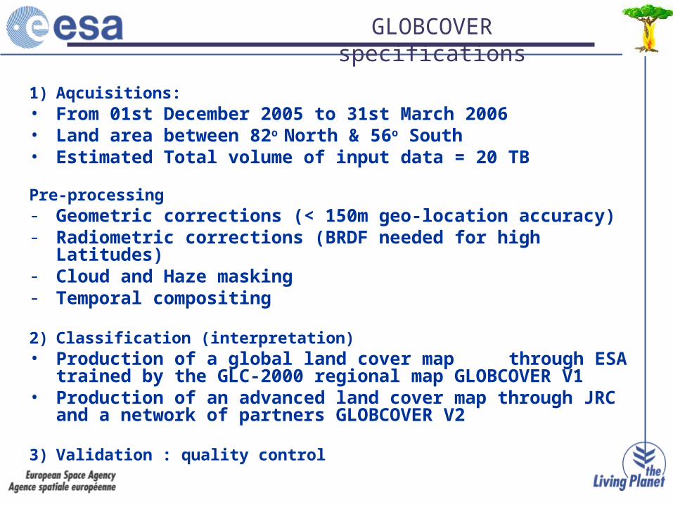
1) Aqcuisitions: • From 01st December 2005 to 31st March 2006• Land area between 82o North & 56o South• Estimated Total volume of input data = 20 TB
Pre-processing - Geometric corrections (< 150m geo-location accuracy)- Radiometric corrections (BRDF needed for high Latitudes)- Cloud and Haze masking- Temporal compositing
2) Classification (interpretation)• Production of a global land cover map through ESA
trained by the GLC-2000 regional map GLOBCOVER V1• Production of an advanced land cover map through JRC and a
network of partners GLOBCOVER V2
3) Validation : quality control
GLOBCOVER specifications

GLC 2000 regional map
GLOBCOVER V1
MERIS FR FS
GLOBCOVER strategy
MERIS Advanced Products (1/3 km)
GLOBCOVER V2

GLOBCOVER Validation
GOFC leadership
Implemented by companies for GLOBCOVER V1 and by JRC for GLOBCOVER V2
Comparison of the GLOBCOVER global product
with “reference” data (GLC-2000 map, others)
Comparison with regional maps
Use of High Resolution Images sampling

World Fire Atlas
308 or 312K – 3.7μm channel
Global
1995-present
ATSR-2 + AATSR
1km*1km
3-day repeat
monthly files in ascii format (Date, Lat and Long)
http://earth.esa.int/ionia
Underestimation, industrial sites not masked, night-time
Seasonal distribution of fires in 2000
Jan. Dec.
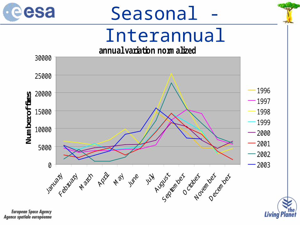
annual variation normalized
0
5000
10000
15000
20000
25000
30000
Num
ber o
f fire
s 1996
1997
1998
1999
2000
2001
2002
2003
Seasonal - Interannual

0
2000
4000
6000
8000
10000
12000
Nov-
95Ma
r-96
Jul-9
6No
v-96
Mar-9
7Ju
l-97
Nov-
97Ma
r-98
Jul-9
8No
v-98
Mar-9
9Ju
l-99
Nov-
99Ma
r-00
Jul-0
0No
v-00
Mar-0
1Ju
l-01
Nov-
01Ma
r-02
Jul-0
2No
v-02
Mar-0
3Ju
l-03
Nov-
03
Brazil Canada China
Finland/Norway/Sweden India Russia
South Africa South-east of Asia
Countries

Climate zone

1 Tree Cover, broadleaved, evergreen
2 Tree Cover, broadleaved, deciduous, closed
3 Tree Cover, broadleaved, deciduous, open
4 Tree Cover, needle-leaved, evergreen
5 Tree Cover, needle-leaved, deciduous
6 Tree Cover, mixed leaf type
7 Tree Cover, regularly flooded, fresh
8 Tree Cover, regularly flooded, saline, (daily variation)
9 Mosaic: Tree cover / Other natural vegetation
10 Tree Cover, burnt
11 Shrub Cover, closed-open, evergreen (with or without sparse tree layer)
12 Shrub Cover, closed-open, deciduous (with or without sparse tree layer)
13 Herbaceous Cover, closed-open
14 Sparse Herbaceous or sparse shrub cover
15 Regularly flooded shrub and/or herbaceous cover
16 Cultivated and managed areas
17 Mosaic: Cropland / Tree Cover / Other Natural Vegetation
18 Mosaic: Cropland / Shrub and/or Herbaceous cover
Vegetation: GLC2000
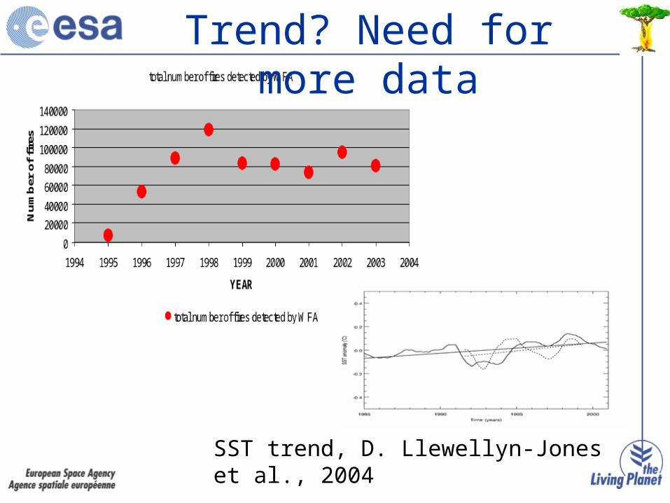
Trend? Need for more data
SST trend, D. Llewellyn-Jones et al., 2004

• World Fire Atlas:
http://shark1.esrin.esa.it/ionia/FIRE/AF/ATSR/
•Koeppen and biomass classification:
http://www.fao.org/SD/EIdirect/climate/EIsp0002.htm
•GLC2000 classification:
http://www.gvm.sai.jrc.it/glc2000/defaultGLC2000.htm
•ECMWF:
http://data.ecmwf.int/data/d/era40_daily/
•TEMIS (O3, NO2, SO2):
http://www.temis.nl
Data access: public

Global Monitoring for Food Security provides operational services to support decision making in famine relief and agricultural development
Services• Continental scale crop season monitoring
Regional early warning Planning of FAO/WFP Crop and Food Supply Assessement Missions
• National scale resource base mapping and crop production forecastingHigh resolution crop type/area + agrometeorological modelling More accurate information for national ministries and international donors
User Group• Southern African Development Community Regional Early Warning Unit, Zimbabwe• Ministry of Agriculture and Centre de Suivi Ecologique, Senegal• Sudan Meteorological Authority, Khartoum• AGRHYMET/CILSS, Niger• Ministry of Agriculture, Malawi• Food and Agriculture Organization, Rome• World Food Programme, Rome• European Commission DG-JRC
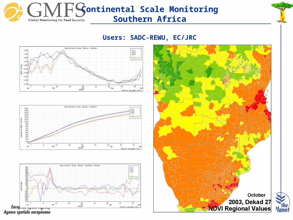
Continental Scale MonitoringSouthern Africa
Users: SADC-REWU, EC/JRC
Support to Crop and Food Supply Assessment Missions
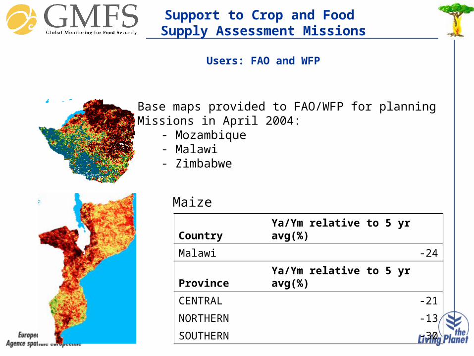
Users: FAO and WFP
Base maps provided to FAO/WFP for planning Missions in April 2004:
- Mozambique- Malawi- Zimbabwe
Country Ya/Ym relative to 5 yr avg(%)
Malawi -24
Province Ya/Ym relative to 5 yr avg(%)
CENTRAL -21
NORTHERN -13
SOUTHERN -30
Maize

Sub-national production forecastSenegal, 2003
User: Ministry Agriculture, Senegal
Millet yield forecasts 2003relative to 10-year average
Peanut yield forecasts 2003relative to 10-year average
Average = + 5%
Average = - 6%

Malawi - Nchisi, Acreage and planting time Malawi - Nchisi, Acreage and planting time (sub-national coverage)(sub-national coverage)
Acreage (ha) at sub-district level
0
5000
10000
15000
20000
25000
30000
35000

• Sentinel 1: C band interferometric radar
• Sentinel 2: SPOT/LANDSAT continuity
• Sentinel 3: Medium Resolution/Altimeter, SST
• Sentinel 4: Polar Orbiting Atmospheric
• Sentinel 5: Geostationary Atmospheric
GMES and the SentinelsGMES and the Sentinels

• Land Cover Land Use and Change
• Natural and Managed Ecosystems
• Cross cutting (Soil and Elevation)
• Improve Science (in situ, validation)
• Operationalisation (socio ecomomic value and data)
IGOL Topics and ParagoneIGOL Topics and Paragone