Embed Size (px)
Citation preview
OWNER’S MANUALand Use of Byram’s Trails
BE SAFE. BE CONSIDERATE.
BE RESPECTFUL OF NATURE.
C Trails are open from dawn to dusk.
C Pets must be leashed, and owners must bag and carryout pet waste.
C Motor vehicles, including but not limited to All TerrainVehicles (ATVs), dirt bikes, snowmobiles or othermotorized vehicles, are prohibited. Police may impoundsuch vehicles until violations are heard in municipalcourt.
C Horses are allowed on certain trails; check traildescriptions.
C Bicyclists must ridesafely and remain ondesignated trails. Allstate and localb i c y c l e s a f e t yregulations apply.
C Protect plants andanimals. Do notdamage, destroy, orr e m o v e r o c k s ,plants, trees or othernatural features.
C Possess ing o rconsuming alcoholwithin the trailsystem is prohibited.
C Any use of paintball equipment is prohibited.
C Hunting occurs throughout Byram Township, and sometrails are closed during hunting season (see text on TheHighlands Trail). Wear orange on all trails during huntingseason (September through January).
C Some trails cross private lands. Be respectful of privateproperty and nearby homes; stay on designated trails.
C Do not drop matches or cigarettes; do not light fires.
C Take your litter home.
C Tell someone where you are going and when you expectto return. Prepare for weather changes.
C Do not park your car on or blocking the trail.
C Trail use is governed by the park system rules of ByramTownship.
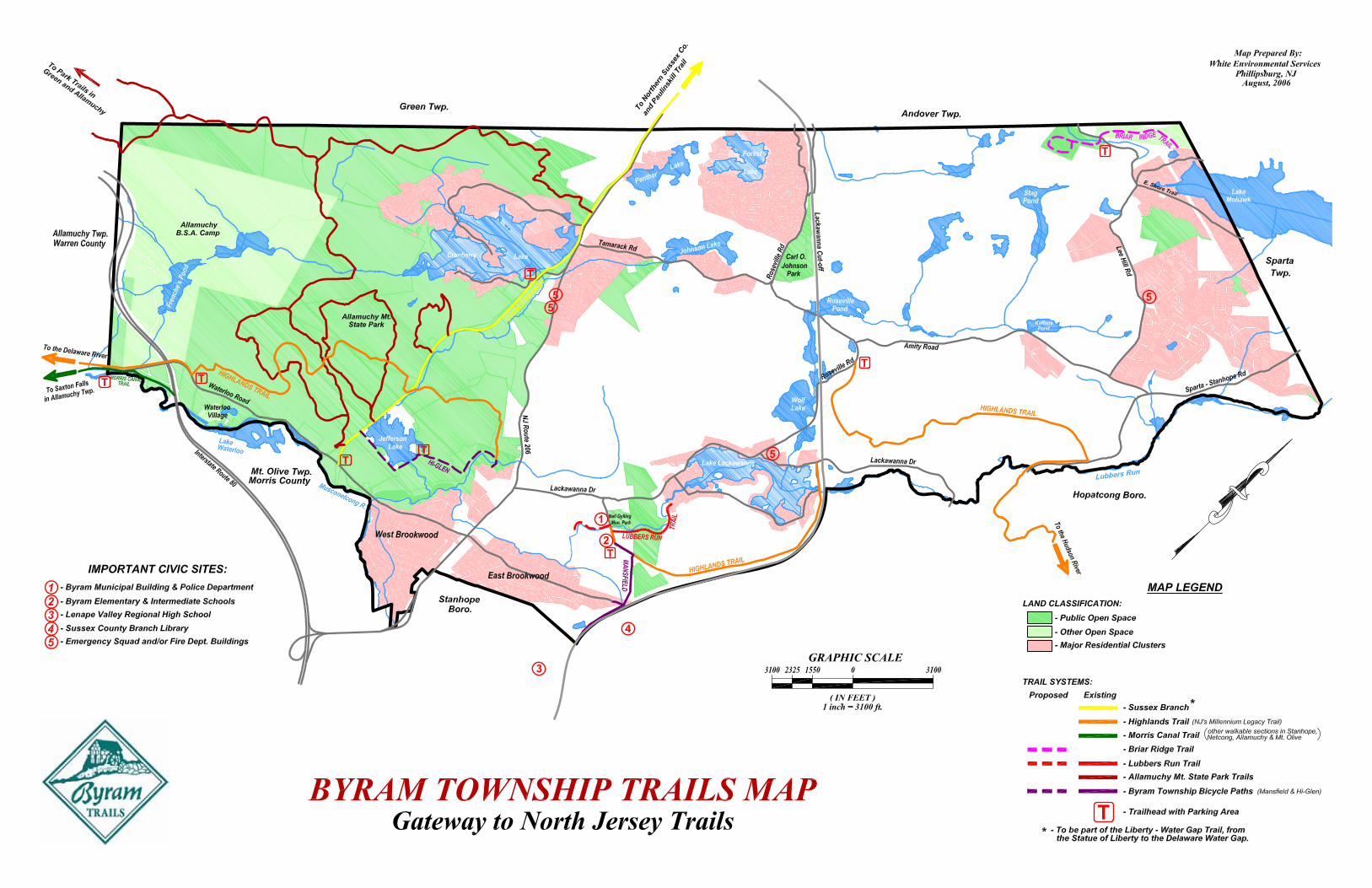
BYRAM TOWNSHIP’S TRAILS
Lubbers Run Trail: Approx. 0.6 mile, from Mansfield Drive to theoutskirts of the Lake Lackawanna community. This winding woods trailcrosses a small feeder to Lubbers Run, offers a cleared path directly tothe Lubbers shoreline opposite the Township’s Neil Gylling Park, and thentravels parallel to the stream through light-filled forests, with severalsubstantial beech stands. Located mostly on lands protected by the NJNatural Lands Trust. Continuous sizable rock-outcrops delineate theLubbers Run corridor and provide stream views. On the other side of thetrail is an extensive wetlands system. Five different landscapes—stream,marsh, rock outcrops, upland forests, wetlands—parallel the entire lengthof the path and provide distinct habitats, home to several threatened andendangered birds and plants (stay on the trail). The trail ends at LakeDrive, where a new 5-home subdivision is planned.
Township Bike/Foot Paths: Two trails, each about a mile long, with theMansfield Bike Trail now completed and the Hi-Glen Bike Trailscheduled for completion in 2007. The Mansfield Bike Path connectsMansfield Drive, near the Byram schools, with Sparta-Stanhope Road,near Lenape Valley Regional High School and less than a half mile fromthe Sussex County Branch Library in Hopatcong. A wide, surfaced trailthrough open woods and crossing two streams, with a steep ascentwhere the trail approaches Sparta-Stanhope Road. At this end, the trailis level with the Lackawanna Cutoff right-of-way, which parallels the pathfor a while. A connecting path gives access to the East Brookwoodneighborhood. Benches along the trail. Joined by the Highlands Trail;also by other ATV trails on private property, which are not for public use.
Briar Ridge Trail: Approx. 1.5 mile. From Whippoorwill Road, up asteep incline to a view of the south end of Lake Mohawk, descendingthrough open forests to Andover-Mohawk Road. Across the road, the trailcontinues, passing by an extensive wetlands and then looping around onthe higher forested elevations. Part of the proposed North Byram TrailNetwork. These parcels were preserved by the Township in 2005-2006.Briar Ridge is an historic name for the small mountain range west of LakeMohawk. (Proposed section on map is not yet open for public use.)
Allamuchy Mountain State Park Trails: Many miles of trails, used byBoy Scouts (at the Scout Camp), mountain bikers, walkers, cross-country
skiers, hunters. The terrain isgenerally fairly rough, with largeboulders, cliffs, steep rocky hills.Reminiscent of the DelawareWater Gap trails, with manyspectacular views, for instancefrom atop the steep cliffstructure of Wolf’s Den. Walk orbike to Waterloo Village,C ranbe r r y L a k e , LakeTranquility (in Green Twp.) onmostly well-maintained trails.Some trails created illegally byoff-road vehicles have looserocks and eroded places. A bigarea and you can get lost, sotake a compass and map.
BYRAM TOWNSHIP’S TRAILS
Sussex Branch Trail: Total 22 miles from Waterloo Road in Byram northto Branchville Borough; about 3.5 miles in Byram. This site of SussexCounty’s first railroad is now an easy trail for hiking, biking, horseback-riding and cross-country skiing. Beautiful all year long, with forests oneither side, Cranberryand Jefferson lakes, awonderful waterfall,side trails (some to thea r e a ’ s m a n yabandoned mines), andDragon Brook criss-crossing the path. Theoriginal narrow bed ofthe first mule-drivenrailroad is still visible inthe woods, on its routefrom Andover’s ironmines to the forges atWaterloo Village.
The Highlands Trail: Three sections, crossing almost the entire lengthof Byram in a northeast-southwest direction, and linking with the SussexBranch Trail and the Township’s two bike trails. (The partially completedregional Highlands Trail runs from the Hudson to the Delaware River.)The first two sections are on private property, so stay on the trail. Thefirst section, about 3.5 miles, enters Byram near Hudson Farm (locatedin Hopatcong) on Sparta-Stanhope Road and quickly rises to themountain ridge. Mostly mixed forests, with a view of the Lubbers Runvalley and some large boulders, as in the nicknamed ‘Rock-Rock’ section
of the trail. Somestreams in wet weatherthat must be crossed.Descends to RosevilleR o a d n e a r t h eabandoned Rosevilleiron mine (on privateproperty). This sectionis closed for huntingfrom Sept. 1 throughFeb. 1. Horses areallowed in this firstsection. The secondsection, about 2 mileslong, parallels LubbersRun and the elevated
Lackawanna Cutoff railbed (an historic marvel from 1908-1911) throughmixed hardwood forests, with substantial wetlands to one side of the trailand sometimes rocky footing. Exits on Mansfield Bike Trail and MansfieldDrive. The third section, about 12 miles long, is about a mile away byroad, out of the High Glen neighborhood opposite ShopRite. Forested,with small rocky ridges, streams, including Dragon Brook (which must becrossed to access Sussex Branch Trail). Walk 0.1 mile south on SussexBranch and bear right into the woods, crossing streams, old roads, andoffering a spectacular view of the Musconetcong Valley; descend toWaterloo Road near Waterloo Village.
Morris Canal Trail: Less than 0.5 mile of the trail is in Byram. There areother walkable sections in Allamuchy, Mt. Olive, Stanhope and Netcong.Part of a project to establish a much longer trail along the famous MorrisCanal, operating from1831 to 1924 acrossnorthern NJ, 102 milesconnecting Phillipsburgon the Delaware Riverwith Jersey City on theHudson. The trailfollows the waterway,often on the path usedby the towing mules.Cur ren t l y wa lke rscannot enter historicWaterloo Village via thetrail. In Byram and into Allamuchy, the trail is in the woods, closelyparalleling Waterloo Road. Various publications describe the canal andits trails.
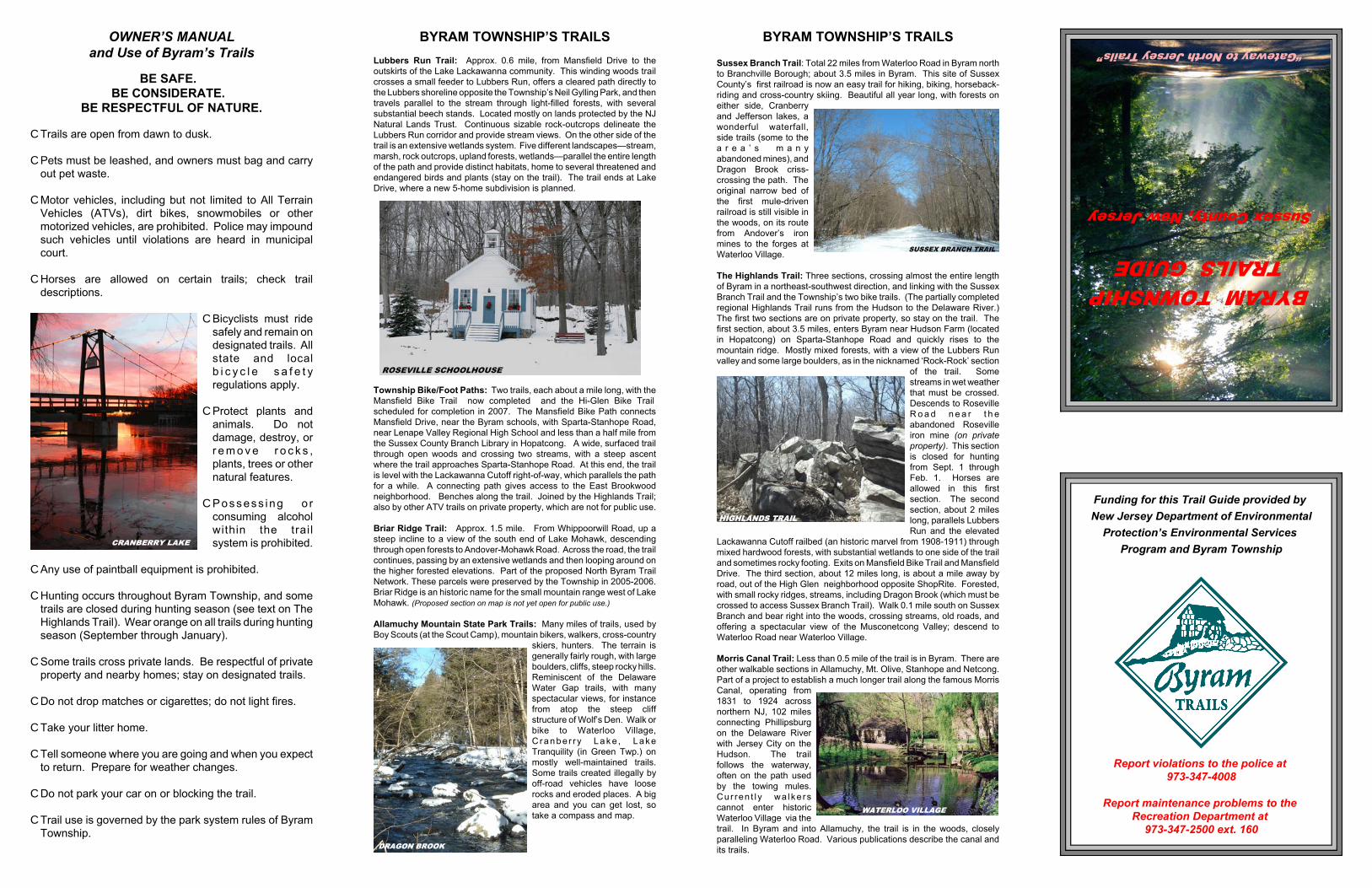
BYRAM TOWNSHIPTRAILS GUIDE
Sussex County, New Jersey
“Gateway to North Jersey Trails”
Funding for this Trail Guide provided by
New Jersey Department of Environmental
Protection’s Environmental Services
Program and Byram Township
Report violations to the police at 973-347-4008
Report maintenance problems to the Recreation Department at
973-347-2500 ext. 160