Embed Size (px)
Citation preview

Canal Estates Management Plan
File 48599E
December 2014
Shoalhaven City Council Canal Estates Management Plan
Contents Summary
1 Introduction ................................................................................................................................................... 3
1.1 Background ........................................................................................................................................... 3
1.2 Purpose of this Plan .............................................................................................................................. 3
1.3 Where This Plan Applies ........................................................................................................................ 3
1.4 History, Designs and Tenure of the Canal Estates ................................................................................. 7
1.5 Consultation .......................................................................................................................................... 7
2 Objective of This Plan ................................................................................................................................. 8
3 Legislation .................................................................................................................................................... 8
4 Management Issues and Actions .............................................................................................................. 9
4.1 Revetment Wall and Beach Management ............................................................................................ 9
4.1.1 Revetment Walls .......................................................................................................................... 9
4.1.2 Beaches ...................................................................................................................................... 10
4.1.3 Sand Sources .............................................................................................................................. 12
4.1.4 Asbestos in Revetment Walls ..................................................................................................... 12
4.2 Sediment Build-up ............................................................................................................................... 13
4.3 Boating and Navigation ....................................................................................................................... 14
4.3.1 Impacts of Boating ...................................................................................................................... 14
4.3.2 Water Depth ............................................................................................................................... 15
4.4 Vegetation ........................................................................................................................................... 17
4.4.1 Trees ........................................................................................................................................... 18
4.4.2 Saltmarsh and Reeds .................................................................................................................. 19
4.4.3 Seagrass and Algae ..................................................................................................................... 19
4.5 Private Structures and Public Facilities ............................................................................................... 20
4.6 Foreshore Access ................................................................................................................................ 20
4.7 Water Quality ...................................................................................................................................... 21
5 Funding ....................................................................................................................................................... 23
6 Review of This Plan .................................................................................................................................. 24
7 References ................................................................................................................................................. 24
APPENDIX 1 Department of Public Works standard typical canal cross section, June 1977 APPENDIX 2 Legislation APPENDIX 3 St Georges Basin – Canal Profile (Conceptual)

Shoalhaven City Council Canal Estates Management Plan
Page 1
Summary This plan sets out Council and resident / ratepayer responsibilities in relation to management of canal estates where Shoalhaven City Council owns the canals at the following locations:
• Riviera Keys Canal Estate, Sussex Inlet
• Paradise Crescent / Lagoon Crescent, Sussex Inlet
• Panorama Waters Estate, St Georges Basin (SGB)
• Lake Conjola Entrance Road, Lake Conjola Council is responsible for:
• Maintaining the canal design profile and providing sand / beach support as required in Riviera Keys, Lake Conjola and SGB canal estates
• Removal of litter
• Maintenance of stormwater drains and outlets
• Maintenance of navigable access into the canals
The resident is responsible for:
• Revetment wall maintenance (other than sand / beach support in Riviera Keys, Lake Conjola and SGB)
• Minimising environmental and water quality impacts from their use of their adjoining land and use of the sand beaches and navigable waterways
• Any maintenance of the beach adjoining their premises in the drainage
reserve exceeding Council’s minimum maintenance standard in the same way that Council acknowledges that residents maintain the verge at the front of their property
Management Actions
1. Council will maintain the canal profile to ensure that the risk of revetment wall failure is low (as reasonably practicable) and that asbestos cement walls are not exposed to the atmosphere.
2. Council will implement a periodical monitoring program to measure the rate of beach erosion throughout the Riviera Keys Estate – Sussex Inlet.

Shoalhaven City Council Canal Estates Management Plan
Page 2
3. Council will undertake an annual asset assessment at all canal estates.
4. Council will encourage residents to maintain riparian vegetation to minimise
beach erosion.
5. Council will remove sediment in the canals where accumulation is:
a. causing a problem to navigation or
b. causing ongoing water quality issues.
6. Council will add an assessment criterion to appendix 10 of Council’s Tree Management Policy stating that assessments can take into account the fact that the original design of canals did not provide for vegetation / trees within the canals confines.
7. Council will continue to work with NSW Roads and Maritime Services to minimise the impact of boating on beach erosion.
8. Council will aim to re-classify the Paradise Lagoon / Lagoon Crescent canal at
Sussex Inlet from community to operational land and this will be included in the new Planning Works Program to be considered in a future amendment to the Shoalhaven Local Environmental Plan (LEP).
9. Council will amend Chapter 23 “Jetties Wharf and Boating Facilities” Policy of
Shoalhaven Development Control Plan 2014 to recognise that public pedestrian access along the beach areas in the canals is no longer practical.
10. Council will review public boating facilities in the Sussex Inlet canals and this will include: • Removal of broken concrete located at the edge of Cater Island Reserve
• Removal of the jetty in a poor state of repair located off Wilson Corlis
Reserve – Sandpiper Way Sussex Inlet
• Consider the need for a new jetty and / or walkway linking Cater Island
• Support in principle public infrastructure being provided in the canal estates subject to the facilities being provided for broad public benefit.
11. With respect to the Riviera Keys Estate, Council will proceed as a high priority
with :
o an aquatic assessment, a riparian vegetation assessment, canal bed substrate assessment and an assessment of the suitability of sand reuse within the canals to allow preparation of a draft “Review of Environmental Factors” required to enable dredging works to be undertaken

Shoalhaven City Council Canal Estates Management Plan
Page 3
o further community consultation with the Riviera Keys Estate residents / owners will be required with respect to these more detailed investigations.
Introduction
1.1 Background Canal estates are residential developments where artificial waterways (canals) have been excavated for the purposes of providing navigable water access to dwellings. The constructed canals are generally inundated by and / or drain to a natural, tidal waterway. Most canal estate developments in the City of Shoalhaven also involved the use of fill material to raise the level of the land on which the dwellings are located. Canal estates, being artificial waterways created for a specific purpose, are managed in a different way to natural waterways by Shoalhaven City Council and other government agencies.
1.2 Purpose of this Plan This plan sets out Council and resident / ratepayer responsibilities in relation to management of canal estates where Shoalhaven City Council owns the canals.
1.3 Where This Plan Applies This plan applies to the artificial canals owned by Shoalhaven City Council in canal estates at the following locations:
• Riviera Keys Canal Estate, Sussex Inlet (North of Chris Creek)
• Paradise Crescent / Lagoon Crescent, Sussex Inlet
• Panorama Waters Estate, St Georges Basin
• Lake Conjola Entrance Road, Lake Conjola The locations of the canal estates are shown in Figures 1 to 3 noting that the exact property boundaries are not shown.

Shoalhaven City Council Canal Estates Management Plan
Page 4
Figure One: Riviera Keys (north side of Chris Creek) and Paradise Lagoon / Lagoon Crescent Sussex Inlet

Shoalhaven City Council Canal Estates Management Plan
Page 5
Figure Two: St Georges Basin – Panorama Crescent

Shoalhaven City Council Canal Estates Management Plan
Page 6
Figure Three: Lake Conjola
Shoalhaven City Council Canal Estates Management Plan
Page 7
Exclusions
a) The canal immediately to the north of Jacobs Drive is in private ownership and therefore is not managed by Council. The owner of this canal has recently submitted a proposal to dedicate ownership of the canal to Council. This proposal is currently being assessed.
b) Alamein Drainage Canal – South Sussex Inlet.
1.4 History, Designs and Tenure of the Canal Estates New canal estate developments were prohibited in NSW in 1997 (State Environmental Planning Policy No 50 - Canal Estate Development). The canal estates in the City of Shoalhaven were approved and constructed prior to this date. In most of the canal estates to which this plan applies, the rear boundaries of private property lots is at the location of the revetment wall installed at the time of estate construction. At Panorama Waters Estate in St Georges Basin there is a six metre wide public reserve between the rear property boundary and the canal noting that the conceptual plan shown in Appendix 3 does not accurately show the boundary of the drainage reserve. Shoalhaven City Council owns the canals at the estates by virtue of their dedication at the time of subdivision as drainage reserves under section 340E of the then Local Government Act 1919 (now repealed). Sections 49(3) and 51 of the current Local Government Act 1993 provide that a drainage reserve is held by Council for drainage purposes but may be used for any other purpose that is not inconsistent with its use for drainage purposes. The current Local Government Act 1993 also requires public land to be classified as either operational or community land. Most canals have been as classified as operational land by Shoalhaven City Council, although the Paradise Crescent / Lagoon Crescent canal at Sussex Inlet is currently classified as community land and therefore prohibits private wharves and jetty structures. This is an anomaly in the planning process and it is desirable that all canal estates be classified as operational.
1.5 Consultation Shoalhaven City Council wrote to all property owners with canal frontage (as well as properties adjoining Chris Creek Sussex Inlet) in May 2014 inviting comment on issues that should be addressed in the proposed canal estates management plan. In addition, the Sussex Inlet community / resident based “Safe Navigation Action Group” distributed surveys identifying issues that could be included in the management plan. Consultation shows that there is strong support for maintenance works to be undertaken to replenish the sand beaches.

Shoalhaven City Council Canal Estates Management Plan
Page 8
Further detailed consultation will be required with Riviera Keys’ residents / owners prior to any sand replenishment / dredging work being undertaken.
2 Objective of This Plan The objective of this plan is to describe Council and resident / ratepayer responsibilities in relation to the following issues:
• Beach management
• Revetment wall maintenance
• Removal of sediment accumulation
• Boating Impacts
• Riparian / canal vegetation
• Public facilities
• Foreshore access
• Water quality Note: Management of private structures such as wharves, jetties and boat launching ramps is covered by Council’s Shoalhaven Development Control Plan 2014.
3 Legislation Legislation and planning instruments that need to be considered for management of the canal estates includes:
• NSW Environmental Planning and Assessment Act 1979
• NSW SEPP (Infrastructure) 2007
• NSW SEPP No 71 - Coastal Protection
• Shoalhaven Local Environmental Plan 2014
• NSW Local Government Act 1993
• NSW Fisheries Management Act 1994
• NSW Native Vegetation Act 2003

Shoalhaven City Council Canal Estates Management Plan
Page 9
• NSW Threatened Species Conservation Act 1995
• NSW Water Management Act 2000
• Commonwealth Environment Protection and Biodiversity Conservation Act 1999
Reference is made to relevant legislation where appropriate throughout this plan. Appendix 2 contains a summary of relevant provisions of some environmental legislation. Reference should also be made to the estuary Management Plans for St Georges Basin and Lake Conjola.
4 Management Issues and Actions
4.1 Revetment Wall and Beach Management
4.1.1 Revetment Walls
Revetment walls are permanent structures designed to hold back tidal waters and protect the land of property owners against embankment erosion and subsidence.
Revetment wall types within the canal estates are described below: Sussex Inlet - Riviera Keys The rear boundaries of private property lots are at the location of the revetment wall installed at the time of estate construction. The revetment walls construction relies on a “dry beach” for partial support. Some of the beaches have eroded and require to be reinstated to support the wall as designed. See Appendix 1 for typical canal design profile that shows a revetment wall comprising of 10mm corrugated sheeting being provided at the property boundary with a concrete capwall on top. However the boundary location shown on the plan is not necessarily accurate.

Shoalhaven City Council Canal Estates Management Plan
Page 10
Sussex Inlet - Paradise / Lagoon Crescent Comprises of a number of different types of revetment wall “submerged” type construction that appear to have been built to no uniform design standard. As the walls are of the “submerged” type, they do not rely on a dry beach for support and therefore no works are required by Council within the drainage reserve. Sussex Inlet Road / Cater Crescent Comprises of a number of different types of revetment wall “submerged” type construction that appear to have been built to no uniform design standard. As the walls are of the submerged type, they do not rely on a dry beach for support and therefore no works are required by Council. St Georges Basin The revetment walls are not exposed and are well supported. No beach replenishment is required. See Appendix 3 for design profile noting that the boundary indicated on the plan is not accurate. Lake Conjola Revetment wall and canal profile design is similar to Riviera Keys Sussex Inlet. The walls are well supported and no beach replenishment is required. Revetment Wall Ownership
Shoalhaven City Council accepts responsibility for maintenance of revetment walls that are provided for broad public benefit and this includes council-managed foreshore / public land. With respect to the Riviera Keys Estate, the boundary dividing the drainage canal and the private lots is at the location of the revetment wall and therefore there is joint ownership between Council and the private property owner. With respect to maintenance of the walls, Council accepts responsibility for the beach / sand support to ensure that the risk of wall failure remains low. Maintenance of revetment walls on the south side of Chris Creek and Paradise Lagoon are the responsibility of the adjacent property. In cases where beach erosion threatens the stability of “dry beach” revetment walls by, for example, eroding beach support, Council will consider the most appropriate solution on a case by case basis, in consultation with the adjacent property owner.
4.1.2 Beaches Whilst many beaches demonstrate erosion to varying degrees, there are some locations in the Riviera Keys Estate, where the asbestos cement walls supporting the capwall have been exposed.

Shoalhaven City Council Canal Estates Management Plan
Page 11
The NSW Public Works, Canal Subdivisions Conditions and Guidelines, (1992) recommended that when beach erosion reaches 50% of the erosion limits in Table 1, nourishment of the beach or reinstatement of the eroded profile should be undertaken to re-establish the profile to its design dimensions.
Table 1: Minimum Erosion Allowances for Revetment Walls.
Canal Cross-Section Minimum Erosion Allowance in
Front of Revetment Wall (mm) Dry Beach 300 Intertidal Beach 450 No Beach - Submerged Slope 300 No Beach - Vertical Wall 300
In the Riviera Keys estate there are numerous locations where the erosion allowance has exceeded 300mm.
Generally erosion is greater at locations that are exposed to increased boating activities and impacts. It is also noted that some residents have been pro- active in maintaining their beach profile (with imported sand). It would appear that over time since the canals were built, the canal profiles are slowly evolving to a natural profile with native riparian vegetation being dominant at the canal edge at some locations. This is not necessarily an unsatisfactory situation however it is recognised that this “natural” look and profile does not match and look likes the original design and constructed profile that some residents may prefer. Beach Nourishment Whilst one option is to maintain all beaches to their original design profile, it is not necessary where the A/C sheeting is not exposed and it is noted that not all residents may want this.

Shoalhaven City Council Canal Estates Management Plan
Page 12
Beach nourishment with sand will generally be considered as the first option. There will be some locations in the canal development where it will not be possible to "hold" a sandy beach due to the level and type of wave and current exposure. In such locations it may be necessary to adopt an alternate canal edge treatment. Possible solutions considered include:
• rock or other ‘hard’ protection
• foreshore vegetation or other ‘environmentally friendly’ option In many cases riparian vegetation has established on some beaches which provides beach stability. This is to be encouraged. Council will maintain beaches in the canals to ensure that asbestos cement walls are not exposed to the air. Council encourages residents to maintain and provide riparian vegetation to minimise beach erosion Council will implement a periodical monitoring program commencing at an annual frequency to measure the rate of beach erosion throughout the Riviera Keys Estate to guide future decision making
4.1.3 Sand Sources Sand that has moved within the canals is likely to have mixed with accumulated organic material. This resultant material might not be suitable for use to replenish eroded sand on beaches because of issues with odours, presence of silt, grain size and stability, visual impacts or impacts on recreational amenity. Council will assess whether accumulated sand in the canals is suitable for use to replenish eroded beaches and if this would be a cost effective approach. Dredging of sand within the canal system is preferable subject to the sand being assessed as being suitable for reuse. If the sand source within the canal estate is not considered acceptable, Council will consider accessing sand from outside the canal estates as part of a navigation improvement program or an alternate source.
4.1.4 Asbestos Cement in Revetment Walls At Riviera Keys Estate, asbestos cement sheeting was used in construction of revetment walls at the boundaries between private property lots and canals in stages 2, 3A and 3B. Stages 1 and 3C used pier and capping with no asbestos cement sheet. It is not known whether asbestos cement sheeting was used at Lake Conjola. Asbestos cement sheeting is not likely to have been used at Panorama Waters Estate as it was built in the late 1980s.
Shoalhaven City Council Canal Estates Management Plan
Page 13
A/C walls remaining buried below the surface in the wet intertidal environment are considered to be of a low risk to environmental health. Legislative requirements apply to the removal and management of asbestos cement.
4.2 Sediment Build-up A hydro-survey survey was carried out by Council in February 2014. It showed that water depths in the canals are generally close to design levels shown in Appendix 1. Notwithstanding this it is noted that there are some areas where sediment (i.e. sand / silt / organic matter) has accumulated and is causing a problem for the enjoyment of the canals by adjoining owners Build-up of sediment can lead to the following problems in the canals, depending how much and where it is:
• reduced tidal flushing and consequent water quality issues
• perceived reduced visual amenity if silt / mud flats are exposed at low tide
• Restrictions to navigability (see “Boating” section below)
• Restricted access If removal of sediment is required from time to time, options for disposal of dredge spoil include:
• Use as replenishment against the revetment walls in the canal foreshores (if suitable)
• Relocation to “hollows” in the canal bed Disposal off-site is expensive and shall only be considered as a last resort if alternate disposal locations are not available within the canal bed. Assessment of the suitability of the material for a particular purpose will need to include an analysis of at least the following characteristics of the material:
• grain size / fines content
• organic material content
• pollutants
• appearance
• odour
• value as a growing medium (e.g. drainage, structure, pH)

Shoalhaven City Council Canal Estates Management Plan
Page 14
If removal of sediment is required from time to time, whether from stormwater sediment plumes or elsewhere, Council will in each case consider the most appropriate method of spoil disposal. Plumes of sediment are present at the outlets of some stormwater drains. It is likely that much of this sediment entered the canals some time ago as sediment generally enters stormwater systems especially during development of land in the catchment (but is also known to be exported from fully developed catchments). Clause 111 of SEPP (Infrastructure) allows routine maintenance works of stormwater systems to be carried out by Council without development consent, including maintenance dredging to remove sediment build-up in a stormwater canal or at exit points into natural waterways that affects the efficiency of the stormwater management system. Council will consider removal of stormwater sediment plumes where they interfere with the effectiveness of the stormwater drainage system, unduly interfere with navigation or unacceptably reduce the visual amenity of nearby residents. Council will remove sediment where accumulation:
a) is causing a problem to navigation or
b) causing ongoing water quality issues
4.3 Boating and Navigation
4.3.1 Impacts of Boating The impact of boating and boat wake is identified as an important issue by canal residents. The impact of boating via boat wake is likely to be the biggest contributing factor to canal beach erosion. Boating in canal estates is controlled by NSW Roads and Maritime Services (RMS) although Council as the land owner also has the authority to control and regulate use of its land. In response to this plan, RMS has advised that:
• there is sufficient signage around the canals to inform people of the speed restrictions – our data shows there are around 20 signs in the canal estate, and we do not believe that additional signs will be effective. We are happy to conduct a review of the location, condition and visibility of signage; however for every complaint we receive that there are insufficient signs we receive another that there are too many!
• where people do not comply with speed restrictions it is not our experience that they are unaware of the speed limits, rather that they are aware and choose not to comply

Shoalhaven City Council Canal Estates Management Plan
Page 15
• most of the vessel masters that receive warnings or penalties in the canal area are owners of properties in the canal estate or their tenants / guests, few people navigate through the canals that are not staying in a residence there
• speeding and wash in the canal estates, while of obvious concern to residents
and landowners, are not frequent offences in relation to the number of offences detected in the main channel of Sussex Inlet, nor does boating activity in the canal estates represent as serious a safety risk as that observed in the main channel, ocean bar and St Georges Basin. For this reason, while it is our practice to look in on the canal estate during patrols of Sussex Inlet, it is unlikely to be the focus of our patrols.
• Management options for boating activity in the canals are limited with our
current resourcing, essentially we can erect signage and conduct patrols from time to time, and perhaps look at some kind of education strategy – we are happy to take suggestions on how this might be done, but it is not our belief that education will have much of an effect, since people found speeding in the canals generally know they are breaking the rules (as stated above).
4.3.2 Water Depth Water depth has the potential to become an issue if sediment builds up in the canals and also in approach channels connecting the canals to the main estuaries. The survey of Riviera Keys canal depths carried out by Council in 2014 indicates depth of the canals is generally acceptable for navigation. There may be some shallow water areas in Chris Creek downstream of River Road and the privately owned canal north of Jacobs Drive, i.e. outside the main canal estate. Council will consider maintenance dredging of canals and approach navigation channels to an agreed design depth when navigation becomes unacceptably difficult. A depth criterion that triggers dredging needs to be conservative, to limit the frequency with which dredging would be triggered and hence moderate costs. A depth criterion of 0.6 metres at mid-tide is to be used. For most vessels up to six metres in length, this gives a full tidal cycle from mid-tide through high tide to the subsequent mid-tide when the channel would be navigable. Many smaller vessels would still be able to use the channel at almost all tidal states. Council would not consider dredging because of minor inconvenience to owners of large boat that might be caused by occasional times at very low tides when an area is not navigable. There might sometimes be an inconvenience to some boaters, requiring them to manhandle their boat for a short distance or wait a short time for the water level to rise a little further.

Shoalhaven City Council Canal Estates Management Plan
Page 16
Removal of sand from canals or approach channels would only be considered if:
• at mid-tide, the channel is less than 0.6 metres deep
• Council considers it appropriate at the time and there are sufficient funds available
• approvals can be obtained from NSW Government agencies for sand removal
and disposal, subject appropriate consultation and environmental impact assessment
Mid-tide is defined as the mean water level of canal or approach waterway. At Sussex Inlet that is 0.205m AHD (Table 1). Therefore, the water in the channel would be 0.6 metres deep at mid-tide if the bed of the creek was at -0.395m AHD Figure 5). The depth of the channel will be measured by surveyors by following the creek along the deepest part of the channel (called the thalweg). If, at any point in this longitudinal survey, the creek bed at the thalweg is higher than -0.395m AHD, then the depth criterion is satisfied.
Table 1: Tidal planes in Sussex Inlet near Riviera Keys, m AHD (Manly Hydraulics Lab, 2012)
Higher High Water (Spring Solstices) 0.486 Mean High Water Springs 0.366 Mean High Water 0.335 Mean High Water Neaps 0.304 Mean Tide Level 0.205 Mean Low Water Neaps 0.106 Mean Low Water 0.075 Mean Low Water Springs 0.044 Indian Spring Low Water -0.041
Figure 5: Cross section of channel explaining depth criterion for considering dredging
*The thalweg is the line that follows the deepest route along the channel.
depth at least 0.6m measured at thalweg*
mid-tide water level (0.205m AHD in
Sussex Inlet)
bed level (-0.395m AHD in Sussex Inlet)

Shoalhaven City Council Canal Estates Management Plan
Page 17
Using the depth criterion, Council will carry out a detailed analysis of whether dredging is required in areas of the canals or approach waterways and, if so, these will be costed. If approach waterways require dredging and approval is obtained, Council will establish and appropriate depth profile. The approach channels connecting the canals to the main estuaries are generally natural waterways and for any proposed works in those waterways, Council would need to seek approvals from various NSW Government agencies. Council will monitor the depth criterion to establish how frequently it triggers dredging and if necessary modify it.
4.4 Vegetation Vegetation can provide important habitat for many animals, including birds, fish and invertebrates. As can be seen in Figure 6, the root systems of trees and reeds are very effective in achieving bank stability. Vegetation in canals also helps treat contaminants in the waterbody. Nevertheless, unlike natural foreshore areas, the canal estates were created with an expectation that residents would have substantial views of the waterways. The original designs on the canals did not include foreshore vegetation. Some residents of canal estates prefer not to have foreshore vegetation in front of their houses for access, visual, nuisance and amenity reasons. Council acknowledges that private property owners currently manage foreshore vegetation in the beach areas in the manner they prefer and at their own expense in a similar way to management of resident activities on nature strips between the front private properties and the road carriage way.

Shoalhaven City Council Canal Estates Management Plan
Page 18
Figure 5: Root systems of trees hold banks together
4.4.1 Trees Casuarinas, mangroves and other trees have colonised or been planted in some foreshore areas. Some trees have failed in past extreme winds, most likely due to the erosion around the root ball areas. Council will continue to assess removal of trees from foreshore areas of canals using Council’s Tree Management Policy (POL12/85). The tree management policy provides for removal of trees from private and public land under certain circumstances, primarily based on risk management. Under the policy, the proposed removal of trees from private or public land always requires Council approval on land within 20 metres of the edge of a water body. On public land, the authorised removal of trees could be carried out at Council’s or the applicant’s expense, depending on the situation. As set out in the tree management policy, Council will not remove trees from canal foreshores unless it is warranted on a ‘risk management’ basis. Generally Council will promote remedial actions rather than tree removal. Coppice management of casuarinas can retain stabilising benefits of roots while allowing for view.
Shoalhaven City Council Canal Estates Management Plan
Page 19
Council will allow property owners to remove trees at their own expense from public foreshore areas adjacent to their property in the circumstances set out in the tree management policy and if in compliance with any legislative requirements (Part V of the EP&A Act). Council will consider adding an assessment criterion to appendix 10 of the tree management policy stating that assessments can take into account the fact that the original design of canals did not provide for vegetation/trees within the canals confines. As an exception to general policy, NSW Fisheries will consider approving mangrove trimming for aesthetic purposes (e.g. to preserve a water view) in existing residential canal estates.
4.4.2 Saltmarsh and Reeds Saltmarsh plants and reeds have colonised some foreshore areas in the canals. Council will not remove saltmarsh or reeds from canal foreshores. Council will carry out an assessment of whether foreshore vegetation in the canals can be considered to be Coastal Saltmarsh, an endangered ecological community under the Threatened Species Conservation Act, or saltmarsh as defined by the Fisheries Management Regulation. Council will carry out an assessment under Part V of the EP&A Act for volunteer activities, including an assessment of whether vegetation removal would significantly affect an endangered ecological community.
4.4.3 Seagrass and Algae Seagrass has colonised suitable habitat in the canals and provides valuable fish habitat. Macro algae grow in some areas of the canals from time to time, in response to environmental factors such as degree of flushing, nutrient levels and temperature. Detached seagrass fronds wash up on foreshores in front of houses from time to time, affecting amenity for residents. Council will not remove live or dead seagrass or algae from canals. Private property owners are allowed by Fisheries NSW to remove up to 20kg / day of dead or dislodged seagrass or macro algae from foreshore areas. Canal estates are not considered key fish habitat so restrictions on harming seagrass are different to natural waterways. As an exception to general policy, Fisheries NSW will approve proposals for permanent berthing over TYPE 1 or 2 seagrass within existing canal estates.

Shoalhaven City Council Canal Estates Management Plan
Page 20
4.5 Private Structures and Public Facilities There are many privately owned boat ramps, jetties, pontoons and other structures in the canals. Private property owners require Council approval for such structures and will be considered in accordance with Council’s adopted Development Control Plan. Public waterways boating infrastructure is not provided in the canals except for the following assets in the Riviera Keys Estate:
• An informal boat launching ramp near Cater Island Sussex Inlet and
• An informal boat launching ramp (not maintained by Council) off Cater Crescent in “Cater Crescent Reserve North”
• A small jetty in a state of poor repair located off Wilson Corlis Reserve
(Sandpiper Way) Provision of new infrastructure for broad public benefit in the canals is not a high priority in Council’s Waterways Infrastructure Asset Management Plan however Council may support an upgrading of facilities at the above mentioned locations subject to:
• The project having local community /neighbour support
• Cost of the project being sponsored and funded by the local community Council will remove the jetty in a poor state of repair located off Wilson Corlis Reserve Council will remove the broken concrete located at the edge of Cater Island Reserve.
4.6 Foreshore Access Some people have expressed that they would like to be to continue to walk around the water’s edge of the canals on the beach. The large numbers of structures such as jetties and boat ramps makes this difficult to achieve. The absence of a beach in some areas or at some tides adds to the difficulty. Access is already available along a number of public reserves on the foreshore of canals and large lengths of foreshore along the natural waterway of Sussex Inlet. Achieving pedestrian access along the whole of canal foreshores is not generally considered to be practical outcome. Exceptions include Panorama Waters Estate or other areas where a foreshore reserve is present. Council will amend its Wharves and Jetties Policy to recognise that public pedestrian access across the beach areas is impractical.

Shoalhaven City Council Canal Estates Management Plan
Page 21
4.7 Water Quality A number of issues have been raised by the community with respect to water quality in the canals:
• following rain there can be discolouration of water
• impact of new housing developments upstream
• scum, rubbish and detached seagrass can accumulate on beaches
• overuse of fertilisers can lead to increased nutrient loads and algal blooms
• The limited flushing in some canals can result in slow recovery from such impacts
Council regularly tests water quality at a number of locations in or near canal estates. Prior to the construction of the sewerage system, when septic tanks were located close to the waterways, testing indicated there were problems from time to time with bacterial contamination.

Shoalhaven City Council Canal Estates Management Plan
Page 22
A summary of water quality is as follows: Riviera Keys Canal Estate, Sussex Inlet Good
Paradise Crescent/Lagoon Crescent Sussex Inlet
Good but with inputs of higher nutrients from Badgee Lagoon after rain events
Panorama Waters Estate, St Georges Basin
Mostly good but some poorer water quality from urban run-off typical after rain
Lake Conjola Entrance Road, Lake Conjola downstream of Patimores Lagoon
Poor on occasions in the past (probably the result of defective septic disposal systems and/or the illegal discharge of effluent). Now rated as “good” due to the provision of reticulated sewerage.
Council will continue existing monitoring of water quality and will respond as necessary to identified pollution. Council will continue existing education and enforcement activities so that people understand how important it is to prevent the pollution of stormwater. Residents will help improve water quality and reduce algal blooms through responsible behaviours (see table)
Actions to do more often Actions to avoid Sweep the gutters and driveways regularly and place the sweepings on the garden or in the compost
Washing the car in the street or driveway
Do not allow soil or mulch to be washed or blown off the garden
Hosing dirt off hard surfaces like paths and driveways into gutters or canals
Clean up pet droppings and dispose of them thoughtfully
Dropping packaging or cigarette butts on the ground
Rake up leaves or lawn clippings and use them as mulch on the garden or place them in the compost
Leaving rubbish where bins are already full
Grass or replant areas of disturbed soil
Hosing or dumping leaves and grass clippings into gutters or canals
Use the minimum amount of detergent for cleaning outside
Using too much fertiliser - follow the instructions
Wash cars on the lawn or gravel and use minimal detergent. Empty the soapy water down the sink or toilet. Alternatively, take the car to a car wash where the water gets treated and recycled
Piling sand and soil on areas where it can be washed into the stormwater system or canals

Shoalhaven City Council Canal Estates Management Plan
Page 23
Make sure sewerage pipes are not connected illegally to stormwater
Using pesticides, fertiliser and herbicides when rain is forecast for the same day
Install a rainwater tank Disposing of oil or chemicals into the gutters or canals
Replace concrete or other hard surfaces with permeable surfaces such as timber decks and pavers with gaps between pavers
Pouring paint, solvent or cleaners in the gutter or where they may enter drains or canals
Get involved with bushcare or landcare projects that restore or protect local waterways
Covering large areas with impervious surfaces e.g. bitumen, concrete
Scum and seagrass wrack accumulate in particular areas as a result of prevailing wind and water currents. Floating litter can accumulate in the same places. Little can be done about the scum that is common in estuarine waters from time to time as a result of breakdown of naturally occurring organic matter such as algae or other plant material and agitation by wind and waves. Detached seagrass fronds wash up on foreshores in front of houses from time to time, affecting amenity for residents. Council will not remove live or dead seagrass or collect litter from canals. Private property owners are allowed by Fisheries NSW to remove up to 20kg / day of dead or dislodged seagrass or macro algae from foreshore areas.
5 Funding The management strategies and actions in this plan have not been subject to detailed assessment or costing and are currently not funded. However one funding option for the Riviera Keys Estate that could be considered is:
• Council fund:
o Investigation and approval costs
o Establishment costs for all dredges, barges and other equipment o Essential maintenance work including sand replenishment to manage risk
associated with providing sand against exposed A/C revetment walls • Ratepayer / Resident fund:

Shoalhaven City Council Canal Estates Management Plan
Page 24
o Any extra sand replenishment above and beyond Council’s identified maintenance commitment
In practice the quantity of sand and cost could be negotiated directly between the resident and the dredging contractor. The cost of this would in effect be subsidised by Council funding the establishment / fixed costs of the dredging contractor establishing itself in the area. Alternatively through the dredging tender process, Council could request a specified contract rate per cubic metre. This is considered to be a fair and equitable option to meet the needs of those ratepayers who desire a sand beach and those who may not. Funding of Councils commitment may also necessitate a review of Council’s Wharves and Jetties Policy – licence fees that currently generate approximate $29,000 per annum income. The licence jetty fee for 2014 / 15 is $175 for a 2 year licenced period and is significantly less than licence fees charged by the Crown for jetties located on Crown land waterways in Sussex Inlet and the Shoalhaven.
6 Review of This Plan The monitoring of implementation of this plan and review of priority projects should be undertaken annually at a time that allows budgetary input into Council’s annual operational plan. A more significant review of the plan’s success in achieving its objectives should be considered to coincide with Council’s four year delivery program cycle in response to new information, challenges in implementation or changing external factors such as changes in technology, land use, the environment, legislation and community values.
7 References Manly Hydraulics Laboratory (2012): OEH NSW Tidal Planes Analysis 1990- 2010 Harmonic Analysis. Report No. MHL 2053 NSW Department of Environment and Climate Change (2009): Environmentally friendly seawalls: A guide to improving the environmental value of seawalls and seawall-lined foreshores in estuaries. NSW Department of Primary Industries (2013): Policy and Guidelines for Fish Habitat Conservation and Management NSW Public Works Department (1992): Canal Subdivisions Conditions & Guidelines. Report No. 91021 ISBN No. 0-7305-7534-9

Shoalhaven City Council Canal Estates Management Plan
December 2014
APPENDIX 1 Department of Public Works standard canal design, June 1977
Page intentionallly left blank, please see following pages
Shoalhaven City Council Canal Estates Management Plan
December 2014
APPENDIX 2 Legislation
Page intentionally left blank, please see following pages

Shoalhaven City Council Canal Estates Management Plan
December 2014
APPENDIX 3 St Georges Basin – Canal Profile (Conceptual)
Page intentionally left blank, please see following pages

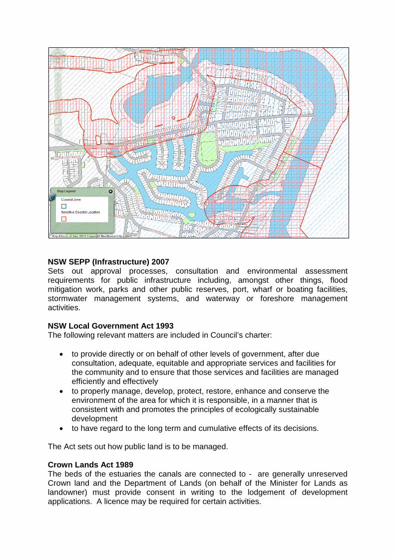
Appendix 2 Legislation NSW Environmental Planning and Assessment Act 1979 Sets out the process for development applications. In cases where development consent is not required, section 111 in Part 5 of the Environmental Planning and Assessment Act requires that Council must examine and take into account to the fullest extent possible all matters affecting or likely to affect the environment by reason of a proposed activity. Section 112 requires that an assessment must also be made of whether the proposed activity is likely to have a significant effect on the environment, or on threatened species, populations or ecological communities, or their habitats and therefore whether or not an environmental impact statement or a species impact statement is required. Shoalhaven Local Environmental Plan 2014 Sets out land use zoning, requirements for development consent and matters for consideration. NSW SEPP No 71 - Coastal Protection The canal estates are within the coastal zone as defined in the Coastal Protection Act 1979 (see map below) so the provisions of SEPP No 71 apply in cases where development consent is required. Clause 8 of SEPP No 71 sets out matters for consideration that are to be taken into account by a consent authority when it determines a development application to carry out development in the coastal zone. Clause 11 of SEPP No 71 requires that development applications be referred to the Department of Infrastructure, Planning and Natural Resources if they would be within 100m below mean high water mark of the sea, a bay or an estuary (cl. 9(1)(c)). That department would consider whether Council can determine the development application or whether it would be determined by the Minister. In cases where development consent is not required, such as for activities approved or carried out under Part 5 of the Environmental Planning and Assessment Act, there are no relevant provisions in SEPP No 71.
NSW SEPP (Infrastructure) 2007 Sets out approval processes, consultation and environmental assessment requirements for public infrastructure including, amongst other things, flood mitigation work, parks and other public reserves, port, wharf or boating facilities, stormwater management systems, and waterway or foreshore management activities. NSW Local Government Act 1993 The following relevant matters are included in Council’s charter:
• to provide directly or on behalf of other levels of government, after due consultation, adequate, equitable and appropriate services and facilities for the community and to ensure that those services and facilities are managed efficiently and effectively
• to properly manage, develop, protect, restore, enhance and conserve the environment of the area for which it is responsible, in a manner that is consistent with and promotes the principles of ecologically sustainable development
• to have regard to the long term and cumulative effects of its decisions. The Act sets out how public land is to be managed. Crown Lands Act 1989 The beds of the estuaries the canals are connected to - are generally unreserved Crown land and the Department of Lands (on behalf of the Minister for Lands as landowner) must provide consent in writing to the lodgement of development applications. A licence may be required for certain activities.

NSW Fisheries Management Act 1994 One of the objects of the Fisheries Management Act is to protect key fish habitats (i.e. not all fish habitats). In the 2013 Policy and Guidelines for Fish Habitat Conservation and Management, Fisheries NSW have defined key fish habitat. In order to reduce red tape for individuals wanting to undertake works in modified waterways, such as canal estates, these waterways are not captured by the definition, thereby removing the need to adhere to the policies and guidelines. Despite the above comments, canal estates are captured by the Act with respect to fishing rules. NSW Water Management Act 2000 Under clause 38 of the Water Management (General) Regulation 2011, activities carried out by public authorities on waterfront land are exempt from the need for a controlled activity approval. Therefore, so long as the works are carried out by or on behalf of Council and that Council maintains responsibility for the carrying out of the works, Council does not require a controlled activity approval from the NSW Office of Water. Section 91E of the Act requires that application be made to the NSW Office of Water for a controlled activity approval for certain activities in, on or under waterfront land. Activities on private properties might require Controlled Activity Approval. NSW Native Vegetation Act 2003 The Native Vegetation Act does not apply in urban areas, including residential zones (listed in Part 3 of Schedule 1 of the Act). In other areas, approval from NSW Local Land Services may be required for removal of vegetation. Threatened Species Conservation Act 1995 This Act lists the threatened species, populations and ecological communities, the critical habitat and key threatening processes that need to be considered under the Environmental Planning and Assessment Act. If a significant impact on threatened species or ecological communities or their habitats is likely, a species impact statement must be completed and concurrence obtained from the Director-General of the Office of Environment and Heritage. National Parks and Wildlife Act 1974 The National Parks and Wildlife Act protects all Aboriginal objects and Aboriginal places in NSW. It is an offence to dig up or damage any Aboriginal object or place without the permission of the NPWS. This Act also contains provisions relating to offences for threatened species and protected flora and fauna. Under Part 8A, it is a defence to prosecution for harming or picking threatened species or endangered ecological communities or damaging their habitat if the action was essential for the carrying out of an activity by a determining authority within the meaning of Part 5 of the EP&A Act if the determining authority has complied with that Part.

Protection of the Environment Operations Act 1997 Sets out offences in relation to pollution. Australian Environment Protection and Biodiversity Conservation Act 1999 The EPBC Act is Australian legislation that protects matters of national environmental significance. It acts in parallel with the NSW legislation and requires separate assessments of significance, should listed species or processes be potentially impacted by the works. Under Part 9 of the EPBC Act an action that could have a significant impact on a matter of national environmental significance may only be taken with approval of the Australian Government Minister for the Environment.