Embed Size (px)
Citation preview
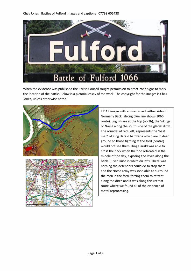
Chas Jones Battles of Fulford images and captions 07798 606438
Page 1 of 9
When the evidence was published the Parish Council sought permission to erect road signs to mark the location of the battle. Below is a pictorial essay of the work. The copyright for the images is Chas Jones, unless otherwise noted.
Fulford is now a southern suburb of York. The land where the houses are planned has not been built over in the intervening millennium as it is floodland. The University of York is at the centre of the image. I have a license to use this image. You may not reproduce it.
LIDAR image with armies in red, either side of Germany Beck (strong blue line shows 1066 route). English are at the top (north), the Vikings or Norse along the south side of the glacial ditch. The roundel of red (left) represents the ‘best men’ of King Harald hardrada which are in dead ground so those fighting at the ford (centre) would not see them. King Harald was able to cross the beck when the tide retreated in the middle of the day, exposing the levee along the bank. (River Ouse in white on left). There was nothing the defenders could do to stop them and the Norse army was soon able to surround the men in the ford, forcing them to retreat along the ditch and it was along this retreat route where we found all of the evidence of metal reprocessing.
Chas Jones Battles of Fulford images and captions 07798 606438
Page 2 of 9
Shieldwall battle of this era were very compact – Fulford shieldwalls were about 550 m long and at Hastings about 470m. The proposal is to lay a road along the line of Germany Beck with an extensive, raised junction which will cover a third of the shieldwall. The access road would run along the beck and look down on the rest of the shiledwall, destroying the very surface on which the English stood in 1066, and preventing any view across the ditch to where the Viking army assembled before advancing across the ditch and utterly destroying the near pristine preservation of this ancient landscape. The battle of Fulford will be invisible.
How the false information about the overbuilding, re-landscaping and even the suggestion that the beck was constructed in the 13th or 15th century has survived and provided the basis for the published decisions of the City Council and English Heritage is hard to comprehend when it can be so easily refuted. We have even provided those responsible with the contemporary notes from the meetings where this false story was agreed. Neither party has even acknowledged that they agreed what the notes refer to as their ‘story’. Demonstrably false information remains the basis for the present planning decision.
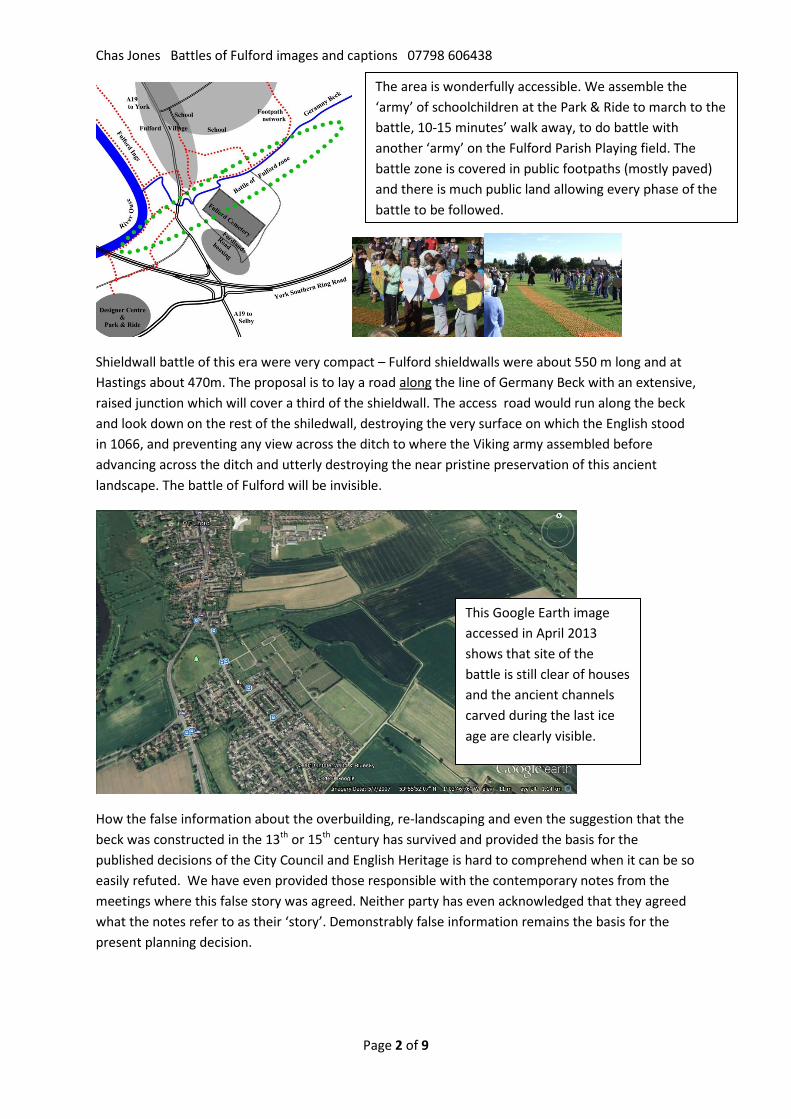
The area is wonderfully accessible. We assemble the ‘army’ of schoolchildren at the Park & Ride to march to the battle, 10-15 minutes’ walk away, to do battle with another ‘army’ on the Fulford Parish Playing field. The battle zone is covered in public footpaths (mostly paved) and there is much public land allowing every phase of the battle to be followed.
This Google Earth image accessed in April 2013 shows that site of the battle is still clear of houses and the ancient channels carved during the last ice age are clearly visible.
Chas Jones Battles of Fulford images and captions 07798 606438
Page 3 of 9
Activities The project set out to reconstruct the landscape as this was recognised as a key to interpreting the ancient literature. This involved drilling many holes but gave us a clear picture of the land and enabled us to understand the literature. We can see why the English were slow to respond when King Harald crossed the beck – The Ings were still flooded and there was a two kilometre detour to confront them. And we could understand how King Harald’s attack came as a surprise because he would have been in dead ground. Plus the way the muddy ford at the centre of the battle had evolved became obvious and we have an explanation for why material left after the battle would have been buried.
.
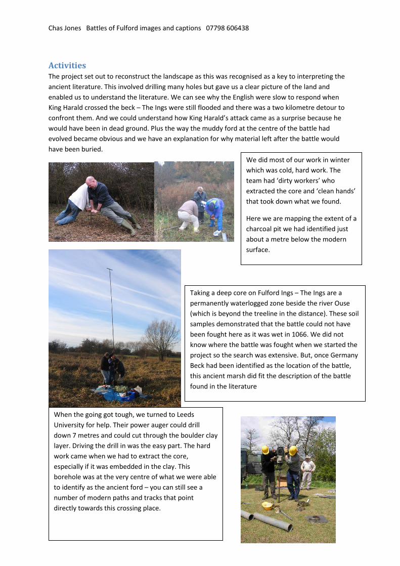
We did most of our work in winter which was cold, hard work. The team had ‘dirty workers’ who extracted the core and ‘clean hands’ that took down what we found.
Here we are mapping the extent of a charcoal pit we had identified just about a metre below the modern surface.
Taking a deep core on Fulford Ings – The Ings are a permanently waterlogged zone beside the river Ouse (which is beyond the treeline in the distance). These soil samples demonstrated that the battle could not have been fought here as it was wet in 1066. We did not know where the battle was fought when we started the project so the search was extensive. But, once Germany Beck had been identified as the location of the battle, this ancient marsh did fit the description of the battle found in the literature
When the going got tough, we turned to Leeds University for help. Their power auger could drill down 7 metres and could cut through the boulder clay layer. Driving the drill in was the easy part. The hard work came when we had to extract the core, especially if it was embedded in the clay. This borehole was at the very centre of what we were able to identify as the ancient ford – you can still see a number of modern paths and tracks that point directly towards this crossing place.
Chas Jones Battles of Fulford images and captions 07798 606438
Page 4 of 9
Before and after conservation.(YAT photo)
But this fitted the picture that emerged as an extensive collection of billets was located along with tools and hearth debris in several small areas beside the beck. These unique assemblages very strongly suggests that we have found the place where weapons were gathered after the battle and the job of making new weapons and consolidating the valuable iron into tradable billets was undertaken.
Why did they survive at Fulford? We know from the historic record that the Norse army was wiped out five days after the battle. This might explain why so much material was abandoned at Fulford in
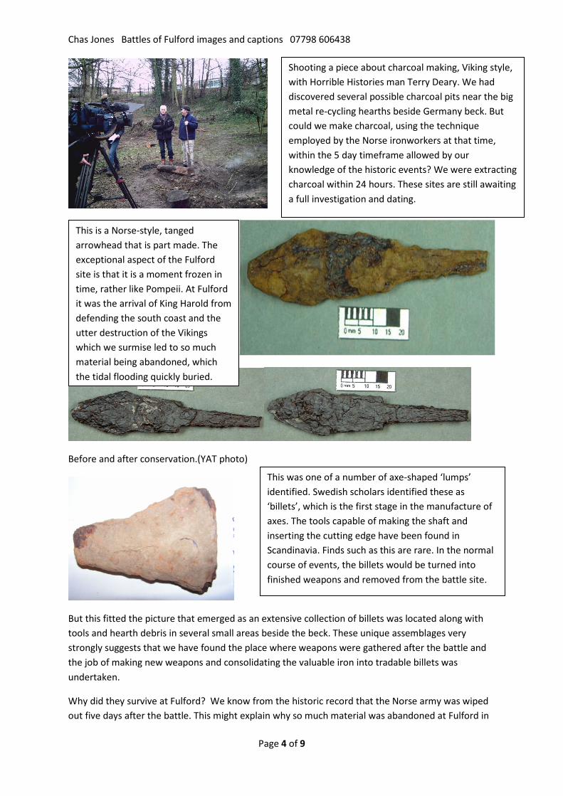
Shooting a piece about charcoal making, Viking style, with Horrible Histories man Terry Deary. We had discovered several possible charcoal pits near the big metal re-cycling hearths beside Germany beck. But could we make charcoal, using the technique employed by the Norse ironworkers at that time, within the 5 day timeframe allowed by our knowledge of the historic events? We were extracting charcoal within 24 hours. These sites are still awaiting a full investigation and dating.
This is a Norse-style, tanged arrowhead that is part made. The exceptional aspect of the Fulford site is that it is a moment frozen in time, rather like Pompeii. At Fulford it was the arrival of King Harold from defending the south coast and the utter destruction of the Vikings which we surmise led to so much material being abandoned, which the tidal flooding quickly buried.
This was one of a number of axe-shaped ‘lumps’ identified. Swedish scholars identified these as ‘billets’, which is the first stage in the manufacture of axes. The tools capable of making the shaft and inserting the cutting edge have been found in Scandinavia. Finds such as this are rare. In the normal course of events, the billets would be turned into finished weapons and removed from the battle site.
Chas Jones Battles of Fulford images and captions 07798 606438
Page 5 of 9
a pattern not found elsewhere. No other battle has so far yielded this type of find and it is only the historic and landscape setting that has ensured their survival.
All these metal items were found on or very near the surface. Permission to revisit the areas of the hearths to carry out more work and look for dating evidence was refused. There are no plans to undertake a proper investigation of these areas.
The city archaeologist, John Oxley and the developer’s archaeologist, Paula Ware, have so far deployed their professional credibility to deny the relevance and the latter has never acknowledged the existence of the 150+ items related to the hearth areas. I assume their rationale is ‘if they don’t exist, there is nothing to investigate’. Neither archaeologist has approached me to inspect or offered to help assess any of this material.
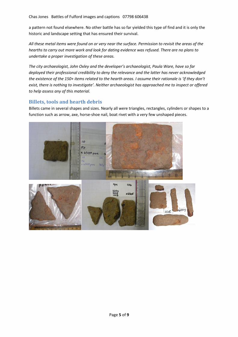
Billets, tools and hearth debris Billets came in several shapes and sizes. Nearly all were triangles, rectangles, cylinders or shapes to a function such as arrow, axe, horse-shoe nail, boat rivet with a very few unshaped pieces.
Chas Jones Battles of Fulford images and captions 07798 606438
Page 6 of 9
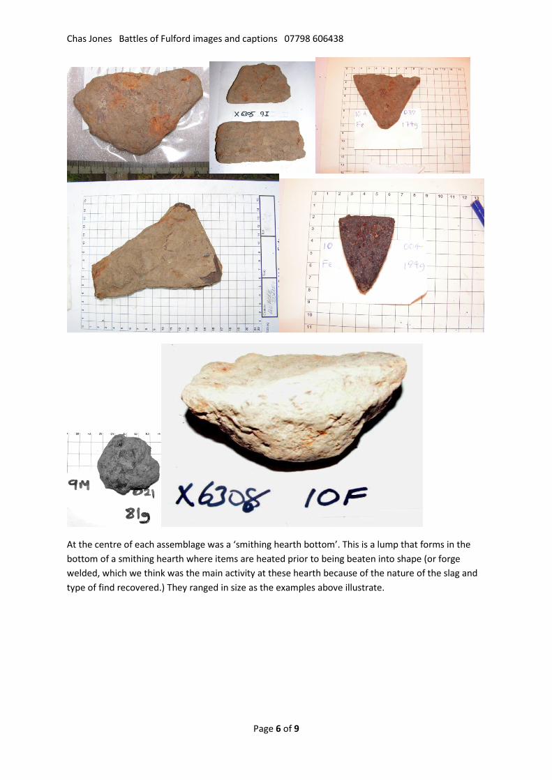
At the centre of each assemblage was a ‘smithing hearth bottom’. This is a lump that forms in the bottom of a smithing hearth where items are heated prior to being beaten into shape (or forge welded, which we think was the main activity at these hearth because of the nature of the slag and type of find recovered.) They ranged in size as the examples above illustrate.
Chas Jones Battles of Fulford images and captions 07798 606438
Page 7 of 9
What accounts for this? The suggestion offered here is that the workers ‘did a runner’ when they heard that their base at Riccall was under attack and their leader, King Harald, had been killed at Stamford Bridge.
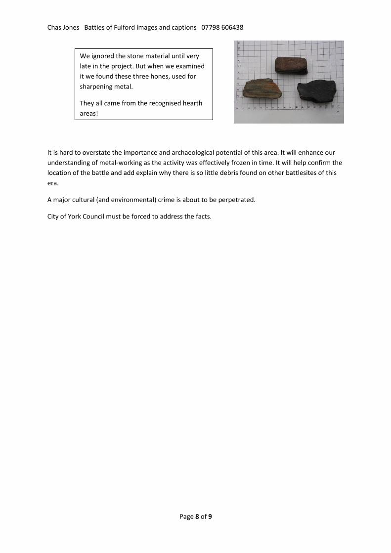
This collection of anvils is so far unique in England. They were driven into a log and provided the surface on which hot metal was beaten into shape. The small image left shows a reconstructed hearth with anvils of different size and shape driven into a log.
The pattern we found match those found in the few catalogues that exist from Russia and Poland.
Extensive quantities of slag were recovered around the hearth areas. This is important as it very strongly suggests that the hearths are in their original position since we always found the hearth items and billets together. This class of item was not found elsewhere, and we searched a wide area in our hunt for the battle of Fulford, so there was plenty of evidence to use for this comparison.
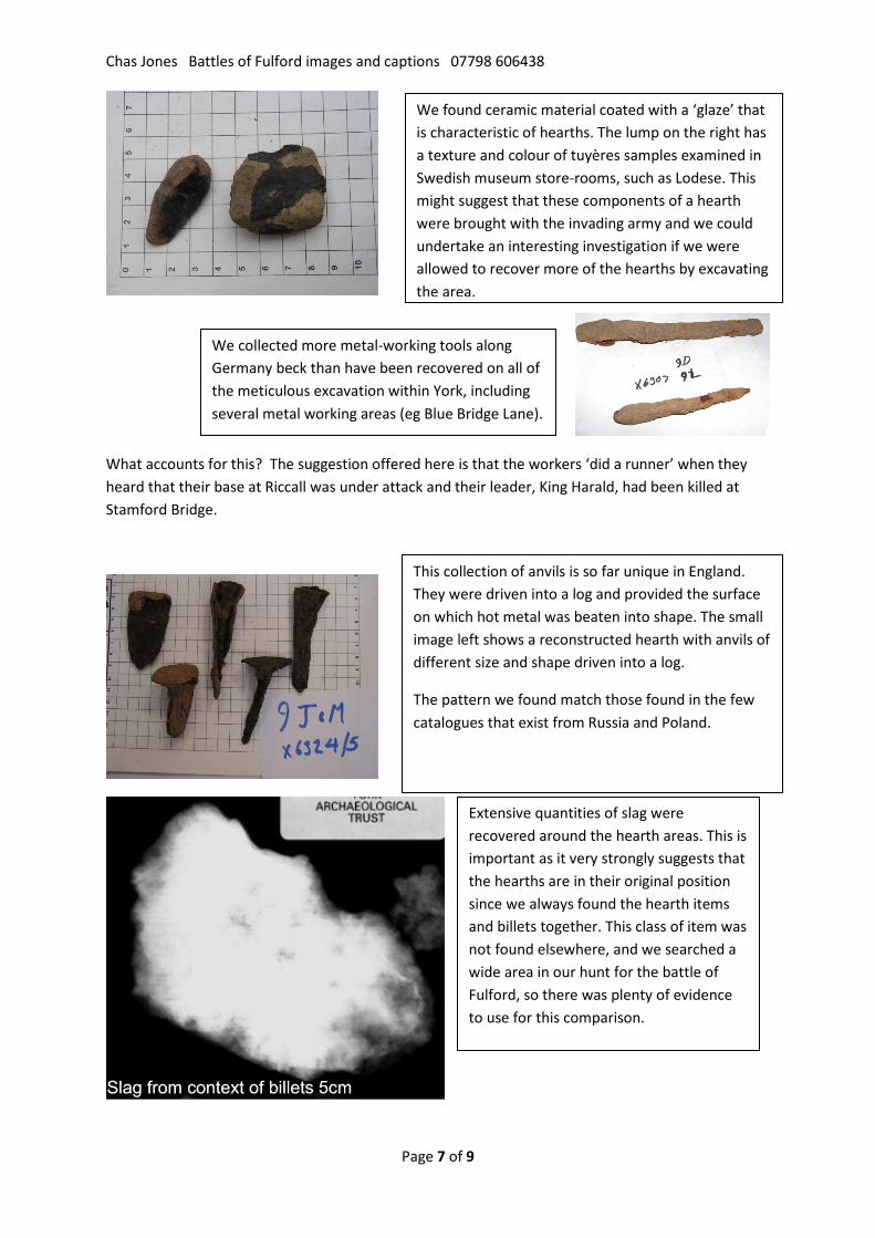
We found ceramic material coated with a ‘glaze’ that is characteristic of hearths. The lump on the right has a texture and colour of tuyères samples examined in Swedish museum store-rooms, such as Lodese. This might suggest that these components of a hearth were brought with the invading army and we could undertake an interesting investigation if we were allowed to recover more of the hearths by excavating the area.
We collected more metal-working tools along Germany beck than have been recovered on all of the meticulous excavation within York, including several metal working areas (eg Blue Bridge Lane).
Chas Jones Battles of Fulford images and captions 07798 606438
Page 8 of 9
It is hard to overstate the importance and archaeological potential of this area. It will enhance our understanding of metal-working as the activity was effectively frozen in time. It will help confirm the location of the battle and add explain why there is so little debris found on other battlesites of this era.
A major cultural (and environmental) crime is about to be perpetrated.
City of York Council must be forced to address the facts.
We ignored the stone material until very late in the project. But when we examined it we found these three hones, used for sharpening metal.
They all came from the recognised hearth areas!
Chas Jones Battles of Fulford images and captions 07798 606438
Page 9 of 9
A word about water voles
Germany Beck is, or rather was, an excellent habitat for water voles. They were constant companions when we were mapping the base of the beck looking for fording places. We were very careful not to disturb the bank and avoided work in the summer because it is illegal to interfere with their habitat.
I reported their existence and even appealed to the chief executive of York City Council to put in place some protection when my appeals for action were ignored by the council officers. When one colony was destroyed, as I had feared it would be, I reported it to the police who investigated and identified the culprit. However they were not prosecuted. (Full details of the correspondence are on the fulfordbattle.com website).
A year later I reported that an area nearby had survived and was recolonizing the area.
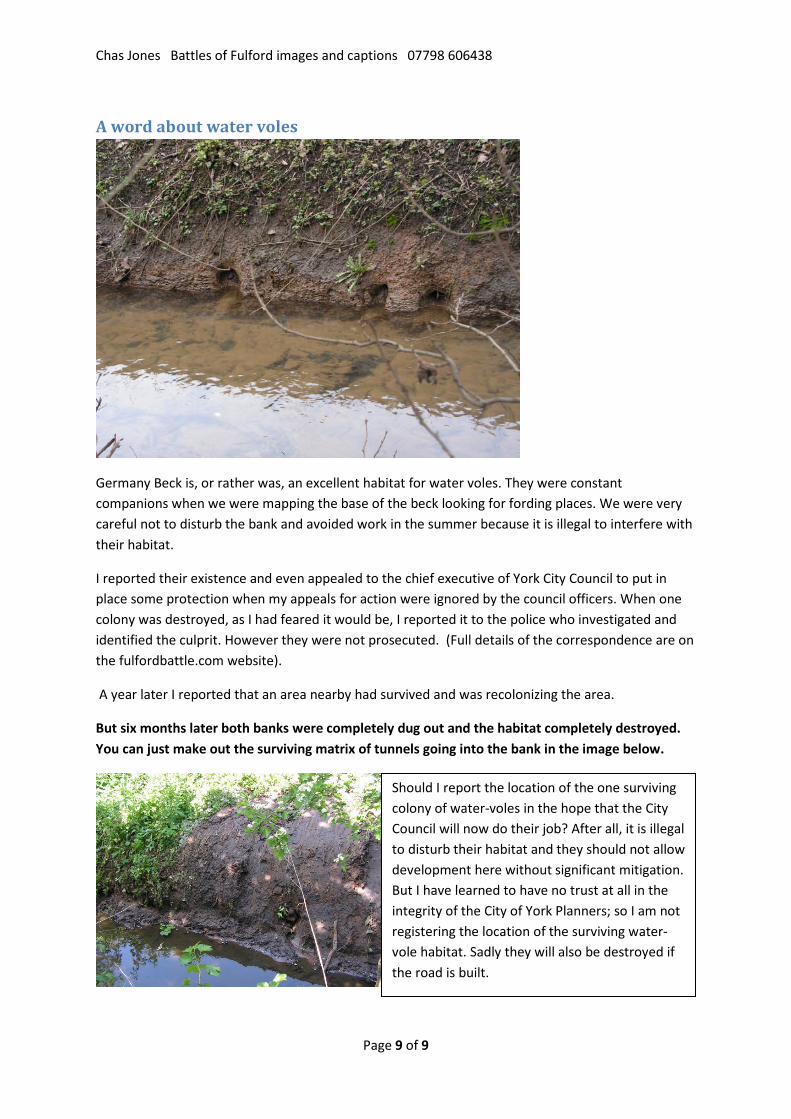
But six months later both banks were completely dug out and the habitat completely destroyed. You can just make out the surviving matrix of tunnels going into the bank in the image below.
Should I report the location of the one surviving colony of water-voles in the hope that the City Council will now do their job? After all, it is illegal to disturb their habitat and they should not allow development here without significant mitigation. But I have learned to have no trust at all in the integrity of the City of York Planners; so I am not registering the location of the surviving water-vole habitat. Sadly they will also be destroyed if the road is built.