Embed Size (px)
Citation preview
A Model-Driven Approach of Integrated Metadata-Spatial
Data Management in the Context of Spatial Data
Infrastructures
Christine Najar
© Atlas der Schweiz - interaktiv
GroupGeoInformation Technologies
ETH Zurich Introduction Concept Results [email protected]
INDEX
I. Introduction to ETH Zurich and GeoInformation Technologies GroupII. Integrating Metadata and Spatial Data
1. Introduction1.1 Basic Concepts and Terms1.1 Current Situation of Metadata1.2 Hypothesis1.3 Objectives1.4. Approach
2. Concept of Integrating Spatial Data and Metadata3. Results
GroupGeoInformation Technologies
ETH Zurich Introduction Concept Results [email protected]
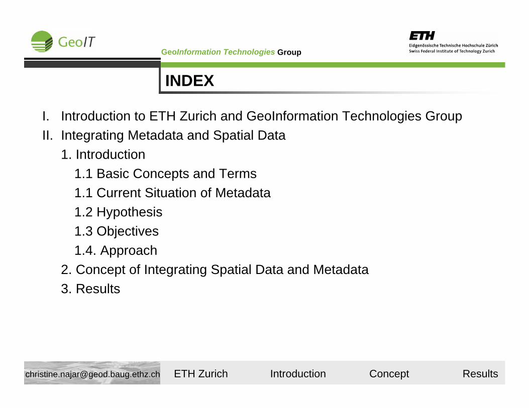
ETH Zürich (Swiss Federal Institute of Technology)
ETH Zurich Statistics*
Numbers for the year 2004: 12 500 Students (29% female)Of which 2 600 are phd students12% of the students(non phd students) are foreigners
51% of the phd students are foreigners
ETH Zurich
ETH Lausanne
* Taken from ETH Zurich yearly report 2005
ETH Zurich
GroupGeoInformation Technologies
ETH Zurich Introduction Concept Results [email protected]
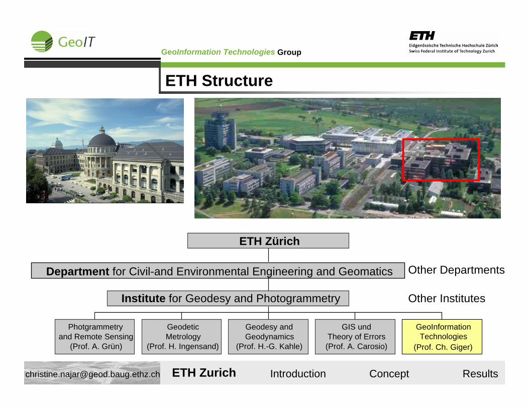
ETH Structure
Other Departments
Other Institutes
Photgrammetryand Remote Sensing
(Prof. A. Grün)
GeodeticMetrology
(Prof. H. Ingensand)
Geodesy andGeodynamics
(Prof. H.-G. Kahle)
GIS undTheory of Errors(Prof. A. Carosio)
GeoInformationTechnologies
(Prof. Ch. Giger)
Institute for Geodesy and Photogrammetry
Department for Civil-and Environmental Engineering and Geomatics
ETH Zürich
ETH Zurich
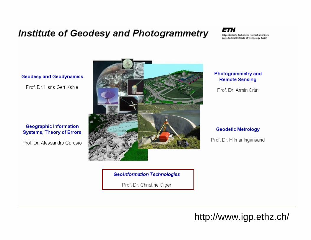
http://www.igp.ethz.ch/
GroupGeoInformation Technologies
ETH Zurich Introduction Concept Results [email protected]
Visit at the University of Melbourne
Common research and paper on a framework for comparing different national SDIs with eachother. Focused on metadata management and Web services (Case studies are ASDI and E-Geo.ch)(together with Abbas Rajabifard and Ian Williamson)Discuss with my thesis with experts for inputs and exchange of experiences as well as literature.
Last but not Least....Establish contacts and worldwide partnerships in the area of SDI and modelling.
Integrating Metadata and Spatial Data in Spatial Data
Infrastructures (SDIs): a Modelling Approach
Christine Najar
© Atlas der Schweiz - interaktiv
GroupGeoInformation Technologies
ETH Zurich Introduction Concept Results [email protected]
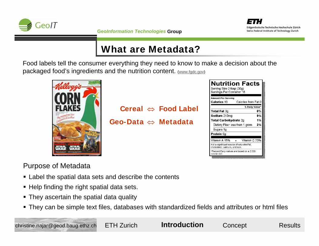
What are Metadata?Food labels tell the consumer everything they need to know to make a decision about the packaged food’s ingredients and the nutrition content. (www.fgdc.gov)
Cereal ⇔ Food Label
Geo-Data ⇔ Metadata
Purpose of MetadataLabel the spatial data sets and describe the contentsHelp finding the right spatial data sets.They ascertain the spatial data qualityThey can be simple text files, databases with standardized fields and attributes or html files
Introduction
GroupGeoInformation Technologies
ETH Zurich Introduction Concept Results [email protected]
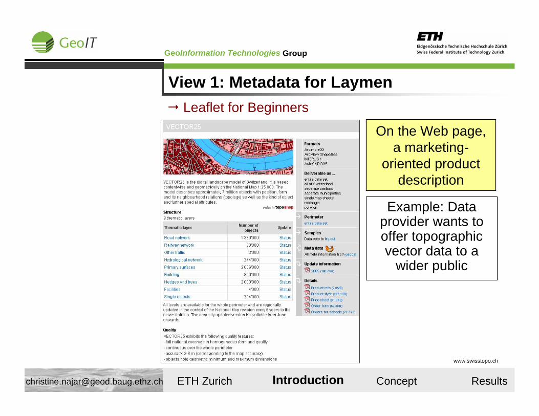
View 1: Metadata for Laymen
Example: Data provider wants to offer topographic vector data to a
wider public
On the Web page, a marketing-
oriented product description
www.swisstopo.ch
Leaflet for Beginners
Introduction
GroupGeoInformation Technologies
ETH Zurich Introduction Concept Results [email protected]
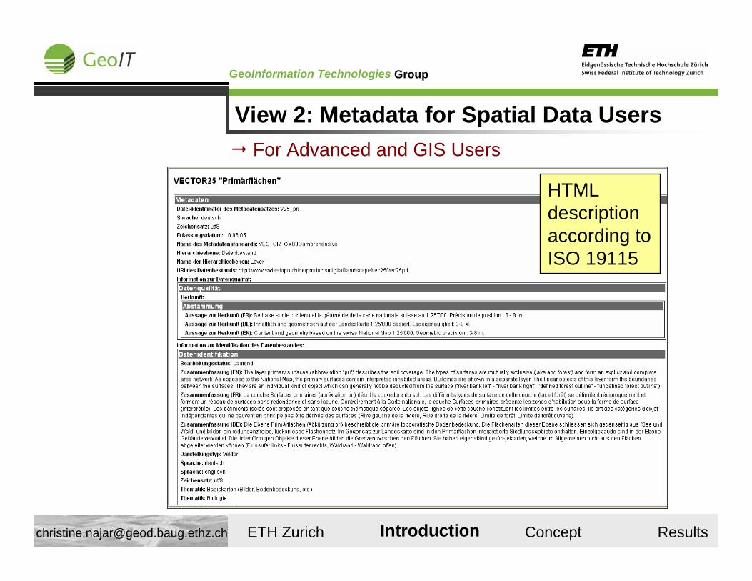
View 2: Metadata for Spatial Data Users
HTML description according toISO 19115
For Advanced and GIS Users
Introduction
GroupGeoInformation Technologies
ETH Zurich Introduction Concept Results [email protected]
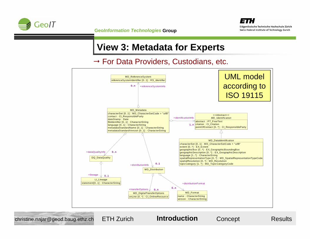
View 3: Metadata for Experts
MD_DataIdentificationcharacterSet [0..1] : MD_CharacterSetCode = "utf8"extent [0..*] : EX_ExtentgeographicBox [0..*] : EX_GeographicBoundingBoxgeographicDescription [0..*] : EX_GeographicDescriptionlanguage [1..*] : CharacterS tringspatialRepresentationType [0..*] : MD_SpatialRepresentationTypeCodespatialResolution [0..*] : MD_ResolutiontopicCategory [1..*] : MD_TopicCategoryCode
LI_Lineagestatement[0..1] : CharacterString
MD_Identif icationabstract : PT_FreeTextcitation : CI_CitationpointOfContact [0..*] : CI_ResponsibleParty
<<Abstract>>
MD_ReferenceSystemreferenceSystemIdentifier [0..1] : RS_Identifier
DQ_DataQuality
0..1+lineage 0..1
MD_MetadatacharacterSet [0..1] : MD_CharacterSetCode = "utf8"contact : CI_ResponsibleP artydateStamp : DatefileIdentifier [0..1] : CharacterStringlanguage [0..1] : CharacterStringmetadataStandardName [0..1] : CharacterStringmetadataStandardVers ion [0..1] : CharacterString
1..n
+identificationInfo
1..n
0..n +referenceSystemInfo0..n
0..n+dataQualityInfo 0..n
MD_Formatname : CharacterStringvers ion : CharacterString
MD_DigitalTransferOptionsonLine [0..*] : CI_OnlineResource
MD_Distribution
0..1+distributionInfo 0..1
0..n
+dis tributionFormat
0..n0..n+transferOptions 0..n
UML model according toISO 19115
For Data Providers, Custodians, etc.
Introduction
GroupGeoInformation Technologies
ETH Zurich Introduction Concept Results [email protected]
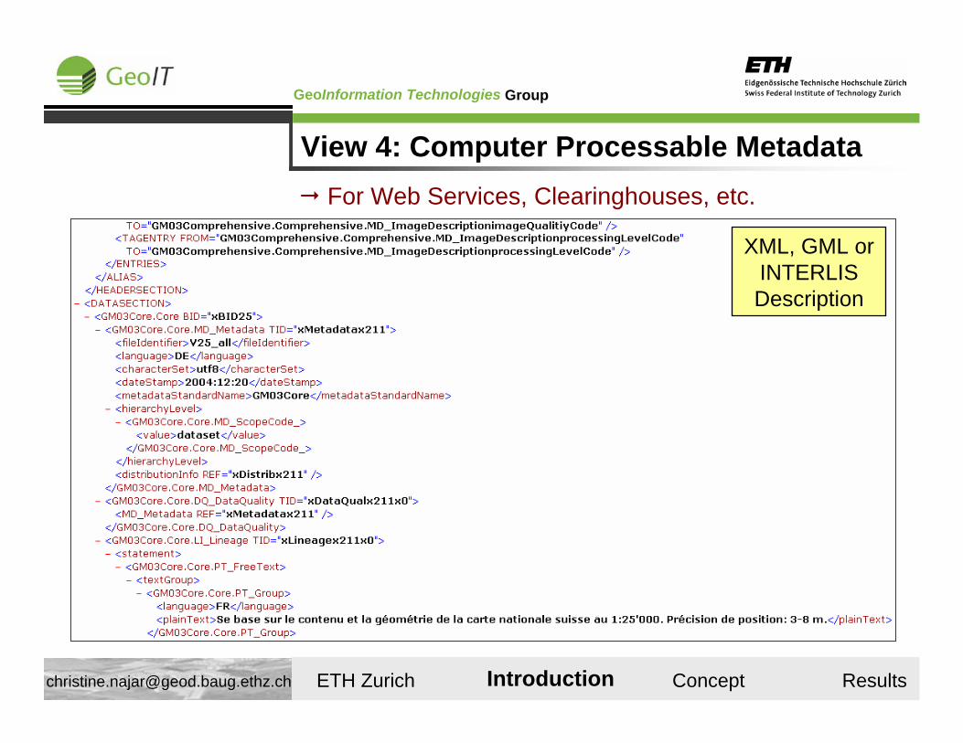
View 4: Computer Processable MetadataFor Web Services, Clearinghouses, etc.
XML, GML or INTERLIS Description
Introduction
GroupGeoInformation Technologies
ETH Zurich Introduction Concept Results [email protected]
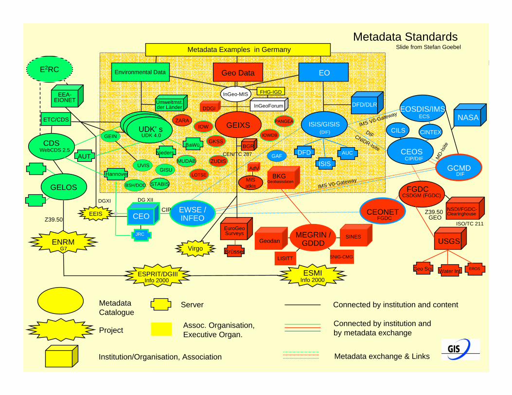
Metadateninformationssysteme
Chaosfolie
Metadata Examples in GermanyMetadata Standards
Slide from Stefan Goebel
EOEnvironmental Data Geo Data
MetadataCatalogue
Project
Institution/Organisation, Association
Server
Assoc. Organisation,Executive Organ.
Connected by institution and content
Connected by institution and by metadata exchange
Metadata exchange & Links
DFD/DLR
CEO
NASAISIS/GISIS
EOSDIS/IMS
CEOS
GCMD
EWSE /INFEO
CILS CINTEX
ISIS
AUC
JRC
CIP
ECSIMS V0-Gateway
DIF
MD-
Isite
DIFCNIDR-Isite
IMS V0-Gateway
CIP/DIF
(DIF)
DG XII
GAF DFD
EuroGeoSurveys
GeodanSINES
LISITT SNIG-CMG
USGS
NSDI/FGDC-Clearinghouse
GEIXS
FGDC
CEONET
MEGRIN /GDDD
Brüssel
Geo Sci. Water Inf. EROS
GEO
CSDGM (FGDC)
FGDCISO/TC 211
BKG
IOW
GKSS
PANGEAZARA
ZUDIS
LOTSE
IOWDB
MISatkis
Z39.50
CEN/TC 287BGR
AdV
DDGI
Geobasisdaten
InGeoForum
InGeo-MIS FHG-IGD
ENRM
ESMIESPRIT/DGIIIInfo 2000 Info 2000
Z39.50
G7
DGXI
EEIS
Virgo
Umweltmst.der Länder
UDK’ s
EEA-EIONET
ETC/CDS
GELOS
CDSUDK 4.0
E2RC
GISU
BSH/DOD STABIS
MUDAB
GEIN
UVIS
UDK’ s
WebCDS 2.5
Hannover
Nieders.BaWü
AUT
GroupGeoInformation Technologies
ETH Zurich Introduction Concept Results [email protected]
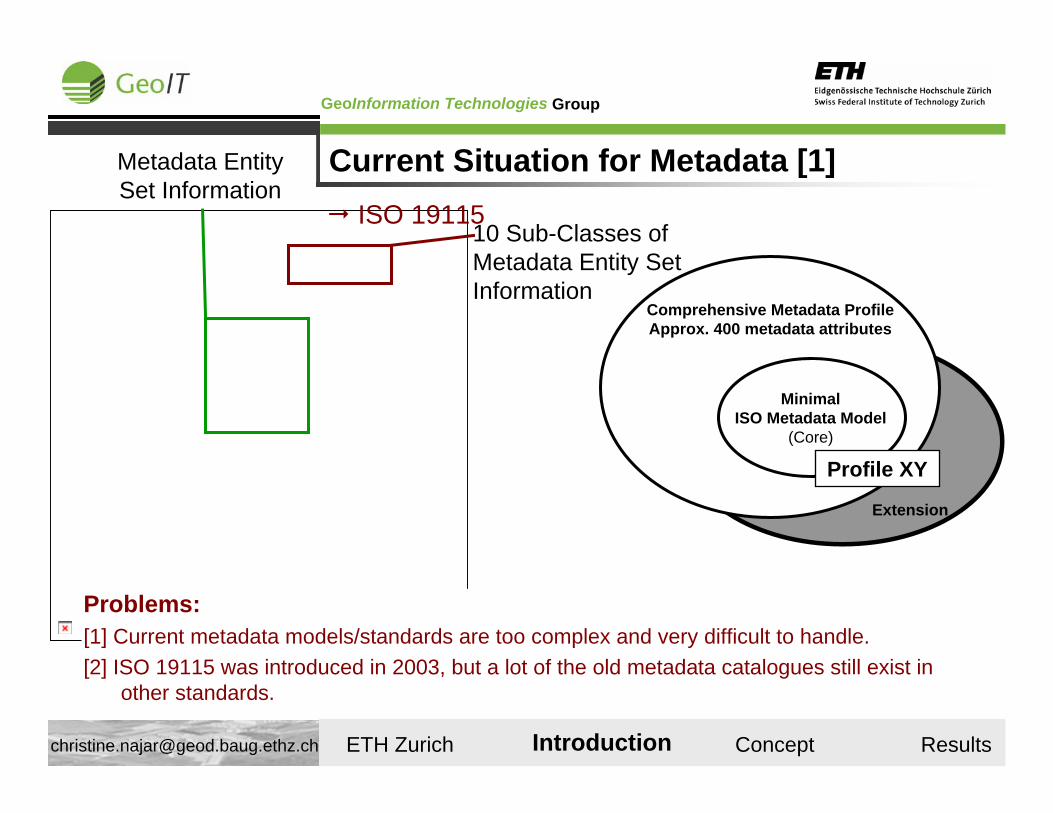
Current Situation for Metadata [1]
Comprehensive Metadata ProfileApprox. 400 metadata attributes
MinimalISO Metadata Model
(Core)
Profile XY
Extension
10 Sub-Classes of Metadata Entity Set Information
Metadata Entity Set Information
Problems:[1] Current metadata models/standards are too complex and very difficult to handle.[2] ISO 19115 was introduced in 2003, but a lot of the old metadata catalogues still exist in
other standards.
Introduction
ISO 19115
GroupGeoInformation Technologies
ETH Zurich Introduction Concept Results [email protected]
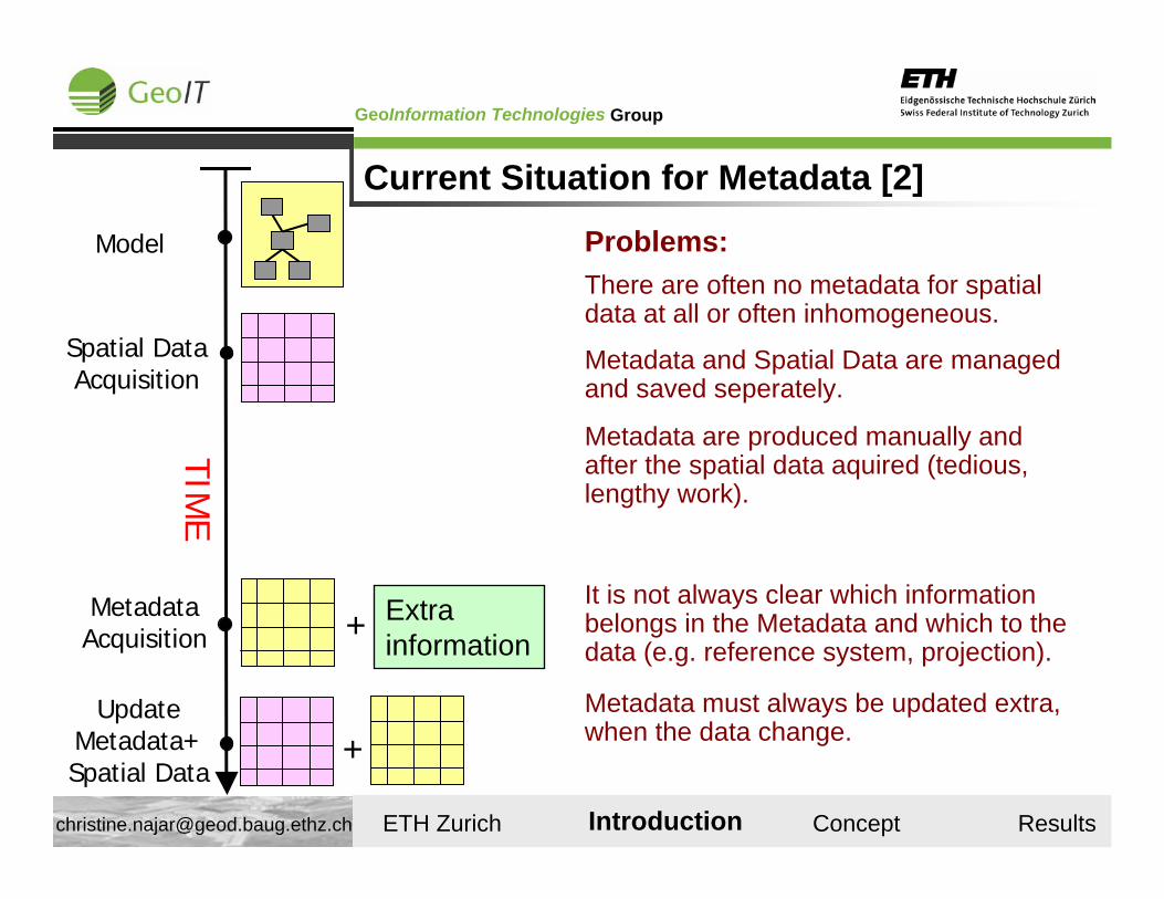
Current Situation for Metadata [2]
TIME
Spatial DataAcquisition
Model
UpdateMetadata+Spatial Data
+Metadata must always be updated extra, when the data change.
There are often no metadata for spatial data at all or often inhomogeneous.
Metadata are produced manually and after the spatial data aquired (tedious, lengthy work).
Extra information
MetadataAcquisition +
It is not always clear which information belongs in the Metadata and which to the data (e.g. reference system, projection).
Metadata and Spatial Data are managed and saved seperately.
Introduction
Problems:
GroupGeoInformation Technologies
ETH Zurich Introduction Concept Results [email protected]
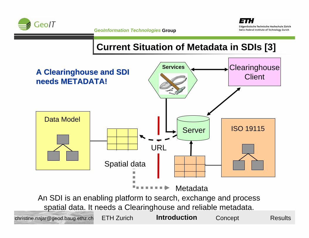
Current Situation of Metadata in SDIs [3]
ISO 19115
AA Clearinghouse and SDI Clearinghouse and SDI needsneeds METADATA!METADATA!
Services
URL
ClearinghouseClient
Server
Spatial data
Data Model
An SDI is an enabling platform to search, exchange and process spatial data. It needs a Clearinghouse and reliable metadata.
Introduction
Metadata
GroupGeoInformation Technologies
ETH Zurich Introduction Concept Results [email protected]
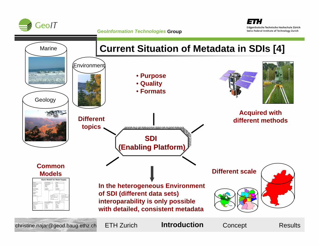
Current Situation of Metadata in SDIs [4]
SDI (Enabling Platform)
SDI SDI (Enabling Platform)(Enabling Platform)
• Purpose• Quality • Formats
Different scale
Marine
Environment
Geology
Acquired with different methods
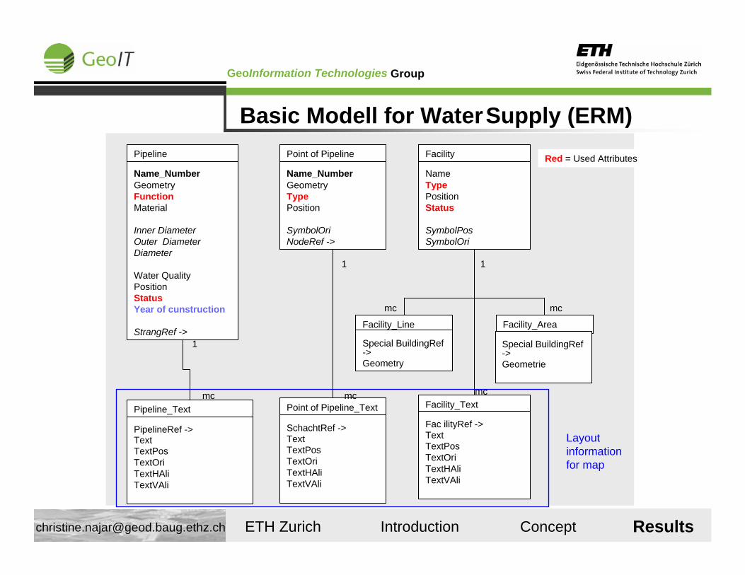
Basic Modell for WaterSupply
Pipeline_Text
PipelineRef ->TextTextPosTextOriTextHAliTextVAli
Pipeline
Name_NumberGeometryFunctionMaterial
Inner DiameterOuter DiameterDiameter
Water QualityPositionStatus
StrangRef ->
mc
1
Point of Pipeline
Name_NumberGeometryTypePosition
SymbolOriNodeRef ->
Point of Pipeline_Text
SchachtRef ->TextTextPosTextOriTextHAliTextVAli
mc
1
Facility_Text
Fac ilityRef ->TextTextPosTextOriTextHAliTextVAli
Facility_Line
Special BuildingRef->Geometry
Facility_Area
Special BuildingRef ->Geometrie
Facility
NameTypePositionStatus
SymbolPosSymbolOri
mc mc
mc
1
Common Models
Different topics
In the heterogeneous Environment of SDI (different data sets) interoparability is only possible with detailed, consistent metadata
Introduction
GroupGeoInformation Technologies
ETH Zurich Introduction Concept Results [email protected]
Problem
The objective of SDI to facilitate interoperability is limited by inadequate metadata.
Introduction
GroupGeoInformation Technologies
ETH Zurich Introduction Concept Results [email protected]
Spatial Data Metadata
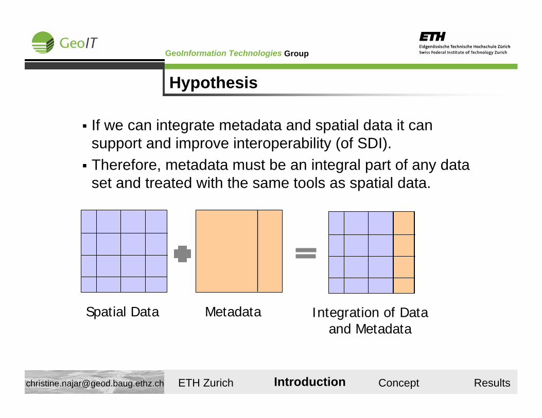
If we can integrate metadata and spatial data it can support and improve interoperability (of SDI).Therefore, metadata must be an integral part of any data set and treated with the same tools as spatial data.
Hypothesis
Integration of Dataand Metadata
Introduction
GroupGeoInformation Technologies
ETH Zurich Introduction Concept Results [email protected]
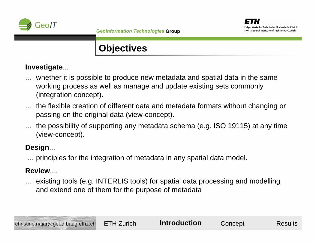
Objectives
Investigate...... whether it is possible to produce new metadata and spatial data in the same
working process as well as manage and update existing sets commonly (integration concept).
... the flexible creation of different data and metadata formats without changing or passing on the original data (view-concept).
... the possibility of supporting any metadata schema (e.g. ISO 19115) at any time (view-concept).
Design...... principles for the integration of metadata in any spatial data model.
Review....... existing tools (e.g. INTERLIS tools) for spatial data processing and modelling
and extend one of them for the purpose of metadata
Introduction
GroupGeoInformation Technologies
ETH Zurich Introduction Concept Results [email protected]
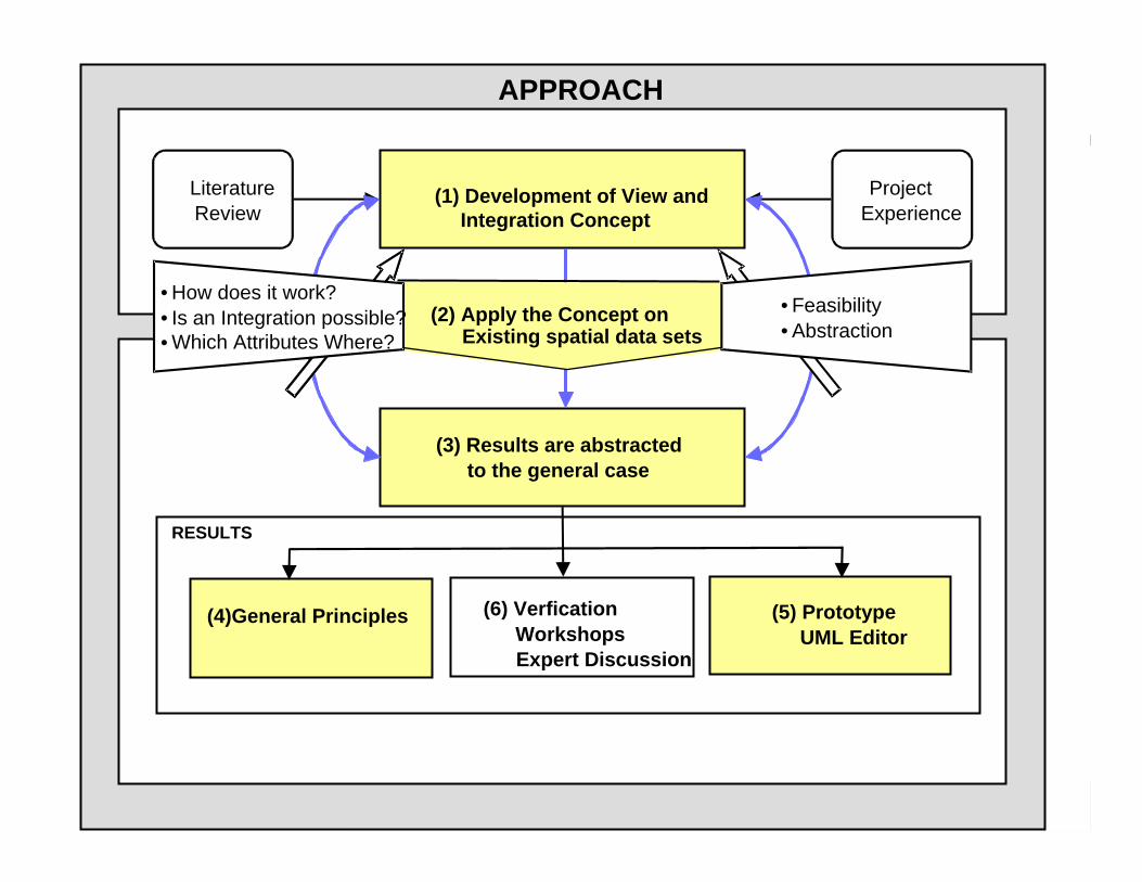
Approach
APPROACH
(1) Development of View andIntegration Concept
LiteratureReview
ProjectExperience
(3) Results are abstractedto the general case
(5) PrototypeUML Editor
(4)General Principles
RESULTS
(6) Verfication WorkshopsExpert Discussion
(2) Apply the Concept onExisting spatial data sets
• How does it work?• Is an Integration possible?Which Attributes Where?
• Feasibility• Abstraction•
GroupGeoInformation Technologies
ETH Zurich Introduction Concept Results [email protected]
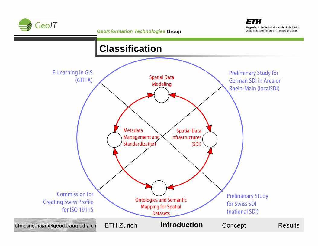
Classification
Metadata Management and Standardization
Spatial Data Infrastructures
(SDI)
Ontologies and Semantic Mapping for Spatial
Datasets
Spatial Data Modeling
Commission for Creating Swiss Profile
for ISO 19115
Preliminary Study for Swiss SDI (national SDI)
Preliminary Study for German SDI in Area or Rhein-Main (localSDI)
E-Learning in GIS (GITTA)
Introduction
GroupGeoInformation Technologies
ETH Zurich Introduction Concept Results [email protected]
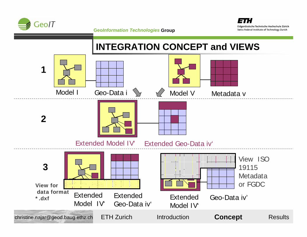
Model I Geo-Data i
1
Model V Metadata v
Extended Model IV‘ Extended Geo-Data iv‘
2
INTEGRATION CONCEPT and VIEWS
ExtendedModel IV‘
Geo-Data iv’
3View ISO 19115 Metadata or FGDC
ExtendedModel IV‘
ExtendedGeo-Data iv‘
View fordata format*.dxf
Concept
GroupGeoInformation Technologies
ETH Zurich Introduction Concept Results [email protected]
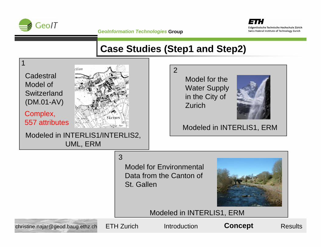
Cadestral Model of Switzerland (DM.01-AV)
1
Complex,557 attributes
Modeled in INTERLIS1/INTERLIS2, UML, ERM
Model for the Water Supply in the City of Zurich
Modeled in INTERLIS1, ERM
2
Case Studies (Step1 and Step2)
Concept
Model for Environmental Data from the Canton of St. Gallen
Modeled in INTERLIS1, ERM
3
GroupGeoInformation Technologies
ETH Zurich Introduction Concept Results [email protected]
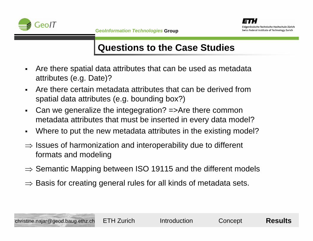
Questions to the Case Studies
Are there spatial data attributes that can be used as metadata attributes (e.g. Date)?Are there certain metadata attributes that can be derived from spatial data attributes (e.g. bounding box?)Can we generalize the integegration? =>Are there common metadata attributes that must be inserted in every data model?Where to put the new metadata attributes in the existing model?
⇒ Issues of harmonization and interoperability due to different formats and modeling
⇒ Semantic Mapping between ISO 19115 and the different models
⇒ Basis for creating general rules for all kinds of metadata sets.
Results
GroupGeoInformation Technologies
ETH Zurich Introduction Concept Results [email protected]
Basic Modell for WaterSupply (ERM)
Pipeline_Text
PipelineRef ->TextTextPosTextOriTextHAliTextVAli
Pipeline
Name_NumberGeometryFunctionMaterial
Inner DiameterOuter DiameterDiameter
Water QualityPositionStatusYear of cunstruction
StrangRef ->
mc
1
Point of Pipeline
Name_NumberGeometryTypePosition
SymbolOriNodeRef ->
Point of Pipeline_Text
SchachtRef ->TextTextPosTextOriTextHAliTextVAli
mc
1
Facility_Text
Fac ilityRef ->TextTextPosTextOriTextHAliTextVAli
Facility_Line
Special BuildingRef->Geometry
Facility_Area
Special BuildingRef ->Geometrie
Facility
NameTypePositionStatus
SymbolPosSymbolOri
mc mc
mc
1
Layout information for map
Red = Used Attributes
Results
GroupGeoInformation Technologies
ETH Zurich Introduction Concept Results [email protected]
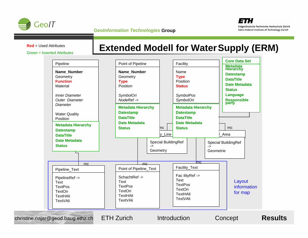
Extended Modell for WaterSupply (ERM)
Pipeline_Text
PipelineRef ->TextTextPosTextOriTextHAliTextVAli
Pipeline
Name_NumberGeometryFunctionMaterial
Inner DiameterOuter DiameterDiameter
Water QualityPositionStatusYear of cunstruction
StrangRef ->
mc
1
Point of Pipeline
Name_NumberGeometryTypePosition
SymbolOriNodeRef ->
Point of Pipeline_Text
SchachtRef ->TextTextPosTextOriTextHAliTextVAli
mc
1
Facility_Text
Fac ilityRef ->TextTextPosTextOriTextHAliTextVAli
Facility_Line
Special BuildingRef->Geometry
Facility_Area
Special BuildingRef ->Geometrie
Facility
NameTypePositionStatus
SymbolPosSymbolOri
mc mc
mc
1
Layout information for map
Red = Used Attributes
Green = Inserted Attributes
Results
Metadata HierarchyDatestampDataTitleDate MetadataStatus
Metadata HierarchyDatestampDataTitleDate MetadataStatus
Metadata HierarchyDatestampDataTitleDate MetadataStatus
Core Data SetMetadata HierarchyDatestampDataTitleDate MetadataStatusLanguageResponsible party
GroupGeoInformation Technologies
ETH Zurich Introduction Concept Results [email protected]
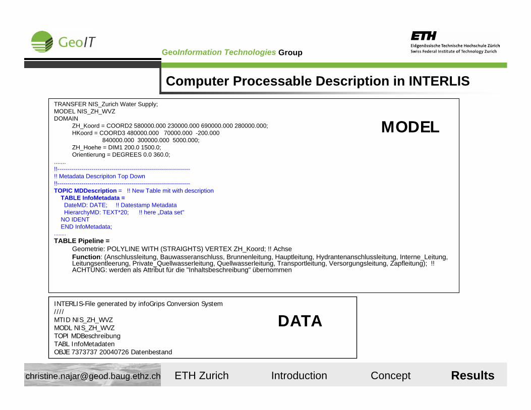
Computer Processable Description in INTERLISTRANSFER NIS_Zurich Water Supply;MODEL NIS_ZH_WVZDOMAIN
ZH_Koord = COORD2 580000.000 230000.000 690000.000 280000.000;HKoord = COORD3 480000.000 70000.000 -200.000
840000.000 300000.000 5000.000;ZH_Hoehe = DIM1 200.0 1500.0;Orientierung = DEGREES 0.0 360.0;
.......!!------------------------------------------------------------------!! Metadata Descripiton Top Down!!------------------------------------------------------------------TOPIC MDDescription = !! New Table mit with description
TABLE InfoMetadata =DateMD: DATE; !! Datestamp MetadataHierarchyMD: TEXT*20; !! here „Data set"
NO IDENTEND InfoMetadata;
........TABLE Pipeline =
Geometrie: POLYLINE WITH (STRAIGHTS) VERTEX ZH_Koord; !! AchseFunction: (Anschlussleitung, Bauwasseranschluss, Brunnenleitung, Hauptleitung, Hydrantenanschlussleitung, Interne_Leitung, Leitungsentleerung, Private_Quellwasserleitung, Quellwasserleitung, Transportleitung, Versorgungsleitung, Zapfleitung); !! ACHTUNG: werden als Attribut für die "Inhaltsbeschreibung" übernommen
INTERLIS-File generated by infoGrips Conversion System////MTID NIS_ZH_WVZMODL NIS_ZH_WVZTOPI MDBeschreibungTABL InfoMetadatenOBJE 7373737 20040726 Datenbestand
DATA
MODEL
Results
GroupGeoInformation Technologies
ETH Zurich Introduction Concept Results [email protected]
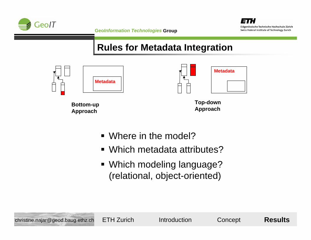
Rules for Metadata Integration
Metadata
Bottom-up Approach
Metadata
Top-down Approach
Where in the model?Which metadata attributes?Which modeling language? (relational, object-oriented)
Results
GroupGeoInformation Technologies
ETH Zurich Introduction Concept Results [email protected]
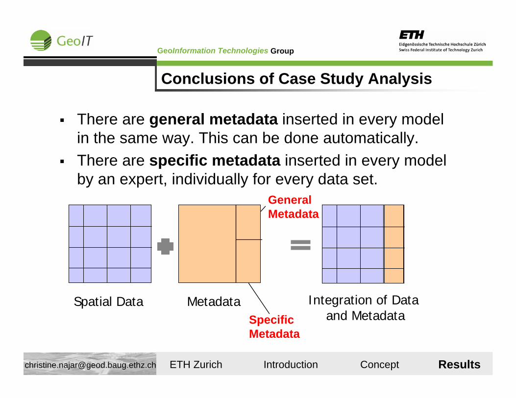
Spatial Data Metadata
General Metadata
Specific Metadata
Integration of Dataand Metadata
There are general metadata inserted in every model in the same way. This can be done automatically. There are specific metadata inserted in every model by an expert, individually for every data set.
Conclusions of Case Study Analysis
Results
GroupGeoInformation Technologies
ETH Zurich Introduction Concept Results [email protected]
Conclusion: Tendencies
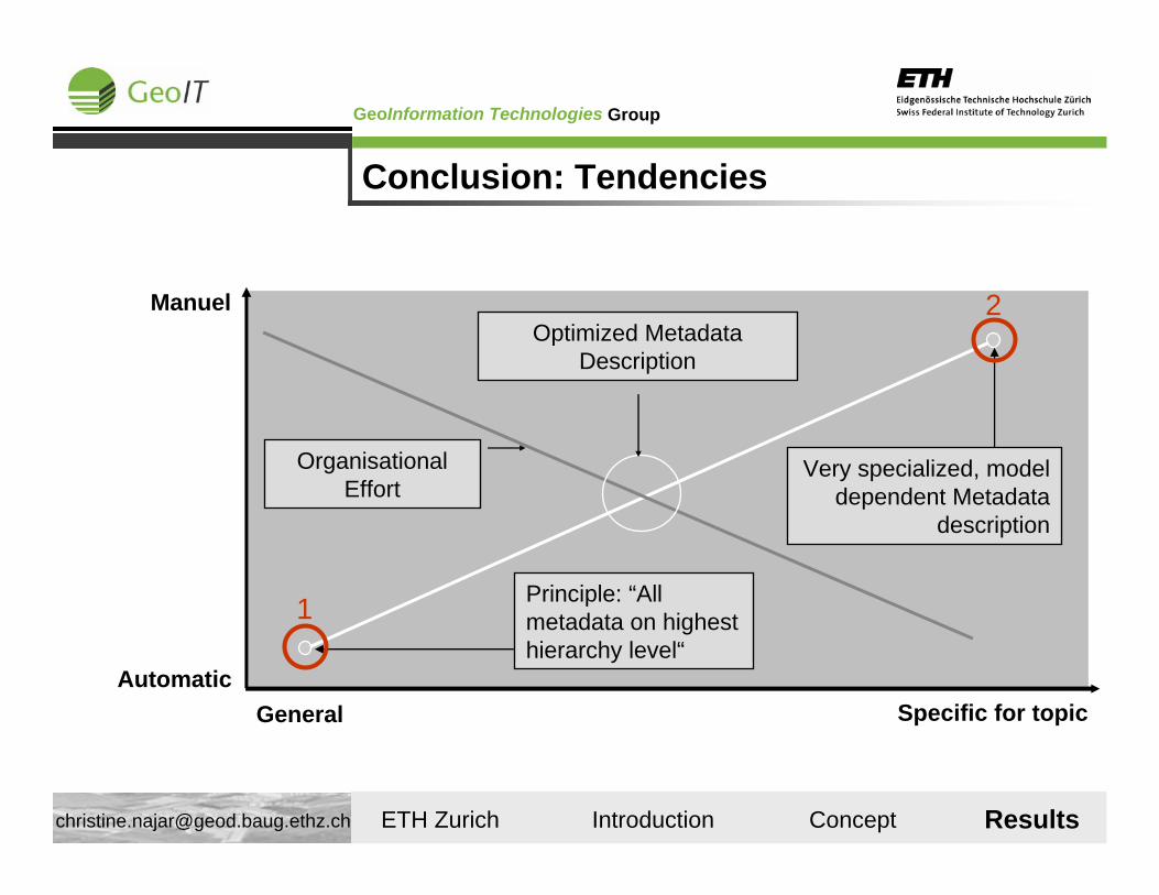
General Specific for topicAutomatic
Manuel
Principle: “All metadata on highest hierarchy level“
Optimized Metadata Description
Very specialized, model dependent Metadata
description
1
2
OrganisationalEffort
Results
GroupGeoInformation Technologies
ETH Zurich Introduction Concept Results [email protected]
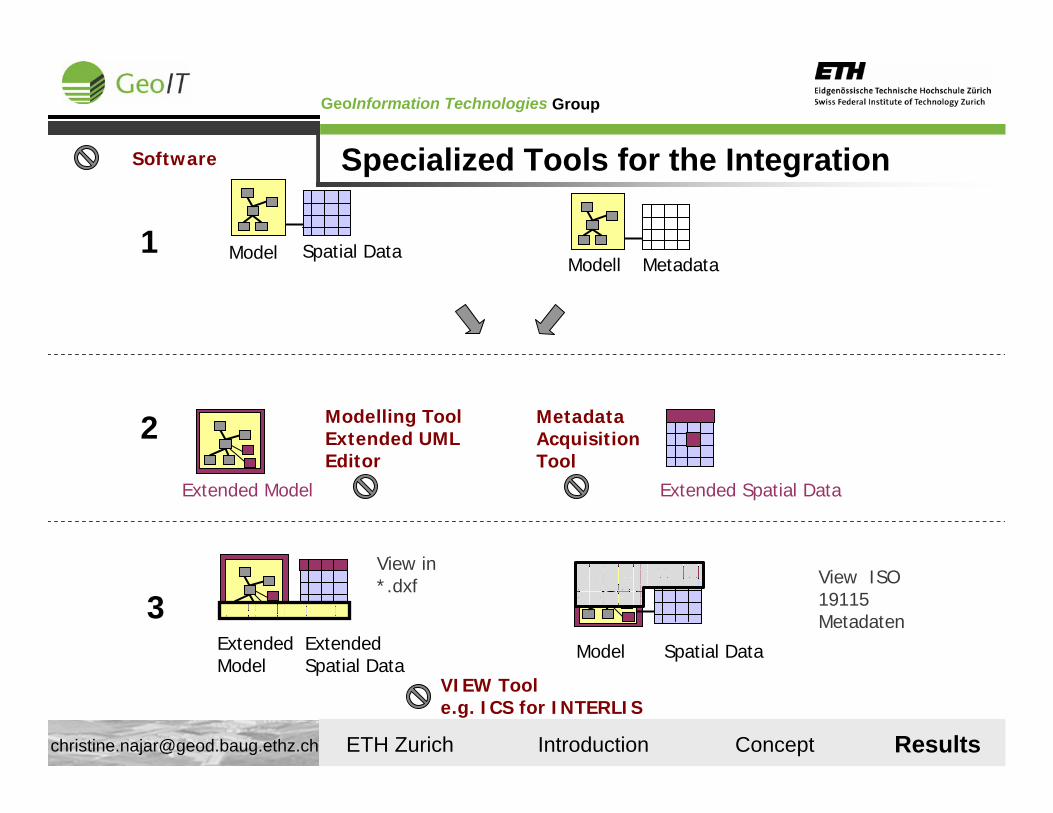
Model Spatial Data1Modell Metadata
2
Extended Model Extended Spatial Data
Modelling ToolExtended UMLEditor
MetadataAcquisition Tool
Model Spatial Data
3View ISO 19115 Metadaten
ExtendedModel
ExtendedSpatial Data
View in *.dxf
VIEW Toole.g. ICS for INTERLIS
Specialized Tools for the IntegrationSoftware
Results
GroupGeoInformation Technologies
ETH Zurich Introduction Concept Results [email protected]
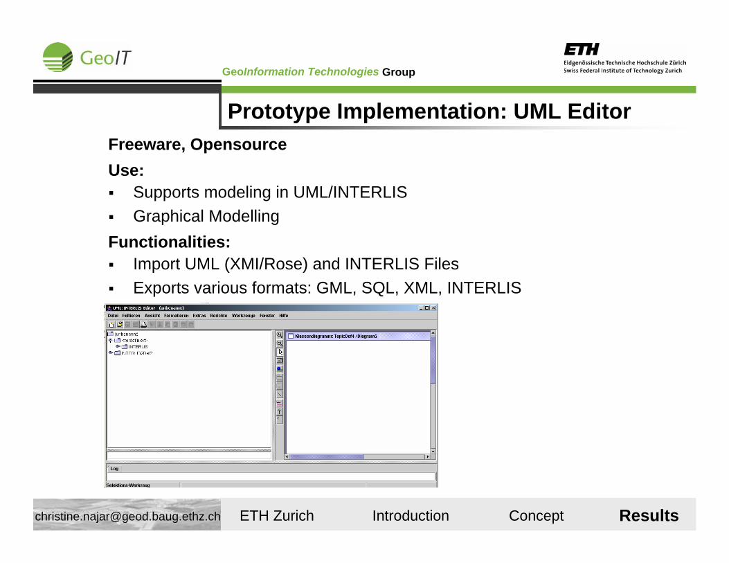
Prototype Implementation: UML EditorFreeware, OpensourceUse:
Supports modeling in UML/INTERLISGraphical Modelling
Functionalities:Import UML (XMI/Rose) and INTERLIS FilesExports various formats: GML, SQL, XML, INTERLIS
Results
GroupGeoInformation Technologies
ETH Zurich Introduction Concept Results [email protected]
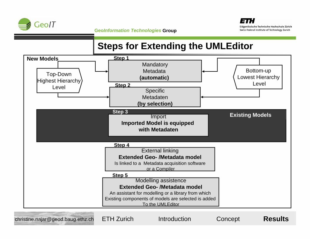
New Models
Top-DownHighest Hierarchy
Level
Bottom-upLowest Hierarchy
Level
Existing ModelsImportImported Model is equipped
with Metadaten
Step 3
SpecificMetadaten
(by selection)
Step 2
MandatoryMetadata
(automatic)
Step 1
External linkingExtended Geo- /Metadata model
Is linked to a Metadata acquisition softwareor a Compiler
Step 4
Modelling assistenceExtended Geo- /Metadata model
An assistant for modelling or a library from which Existing components of models are selected is added
To the UMLEditor
Step 5
Steps for Extending the UMLEditor
Results
GroupGeoInformation Technologies
ETH Zurich Introduction Concept Results [email protected]
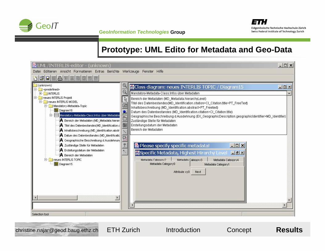
Prototype: UML Edito for Metadata and Geo-Data
Results
GroupGeoInformation Technologies
ETH Zurich Introduction Concept Results [email protected]
Conclusions I
+ The integration of metadata and spatial data is feasible.+ Common management and update of Spatial Data
and Metadata is feasible+ Flexible creation of views can help solve interoperability issues between
different modeling languages and formats.+ It is possible to support different Metadata Standards (the users don‘t
have to be constrained to one certain standard)
Results
GroupGeoInformation Technologies
ETH Zurich Introduction Concept Results [email protected]
Conclusions II
+ There are metadata attributes that can be derived from spatial data. - Yet, this cannot be generalized for all spatial data sets:
it depends on the specific spatial data (Unless Standardized Models exist for every information community).
+ We can generalize and automatize the integration: there are common metadata attributes that can be inserted in every model and data set at the same spot automatically.
- There is always human intelligence needed for deeling semantic mapping.
+ Metadata can be processed by existing tools for spatial data- We need more and better tools to do this efficiently.
Results

GroupGeoInformation Technologies
ETH Zurich Introduction Concept Results [email protected]
Good-Bye Melbourne...
Thank you very much for the great time!
www.geoit.ethz.ch