Embed Size (px)
Citation preview
©Oxford Archaeology Ltd i 22 January 2019
Church Scar to Fairhaven Coastal
Protection Scheme, Lytham St
Annes, Lancashire Geoarchaeological Investigation Report
January 2019
Client: VolkerStevin Ltd
Issue No: V 1
OA Reference No: 2018-19/1966
NGR: SD 34590 27270

Church Scar to Fairhaven Coastal Protection Scheme, Lytham St Annes,
Lancashire V 1
©Oxford Archaeology Ltd iii 22 January 2019
Client Name: VolkerStevin Ltd
Document Title: Church Scar to Fairhaven Coastal Protection Scheme, Lytham St
Annes, Lancashire
Document Type: Geoarchaeological Investigation Report
Report No.: 2018-19/1966
Grid Reference: SD 34590 27270
Site Code: CFC18
Invoice Code: L11189
Receiving Body: Lancashire Historic Environment Record
OA Document File Location: X:\Paul\Projects\L11189_Churchscar_to_Fairhaven\Report
OA Graphics File Location: X:\Paul\Projects\L11189_Churchscar_to_Fairhaven\OAN_CAD
Issue No: V 1
Date: 22/01/2019
Prepared by: Mairead Rutherford (Project Officer)
James Hodgson (Assistant Supervisor)
Checked by: Paul Dunn (Project Manager)
Edited by: Paul Dunn (Project Manager)
Approved for Issue by: Alan Lupton (Operations Manager)
Signature:
Disclaimer:
This document has been prepared for the titled project or named part thereof and should not be relied upon or used for any other project
without an independent check being carried out as to its suitability and prior written authority of Oxford Archaeology being obtained. Oxford
Archaeology accepts no responsibility or liability for the consequences of this document being used for a purpose other than the purposes for
which it was commissioned. Any person/party using or relying on the document for such other purposes agrees and will by such use or reliance
be taken to confirm their agreement to indemnify Oxford Archaeology for all loss or damage resulting therefrom. Oxford Archaeology accepts
no responsibility or liability for this document to any party other than the person/party by whom it was commissioned.
OA South
Janus House
Osney Mead
Oxford
OX2 0ES
OA East
15 Trafalgar Way
Bar Hill
Cambridge
CB23 8SG
OA North
Mill 3
Moor Lane Mills
Moor Lane
Lancaster
LA1 1QD
t. +44 (0)1865 263 800 t. +44 (0)1223 850 500 t. +44 (0)1524 880 250
w. oxfordarchaeology.com
Oxford Archaeology is a registered Charity: No. 285627
Church Scar to Fairhaven Coastal Protection Scheme, Lytham St Annes,
Lancashire V 1
©Oxford Archaeology Ltd iv 22 January 2019
Church Scar to Fairhaven Coastal Protection Scheme, Lytham St
Annes, Lancashire
Geoarchaeological Investigation Report
Written by Mairead Rutherford and James Hodgson
With il lustrations by Mark Tidmarsh
Contents
Summary ............................................................................................................................................................... vii
Acknowledgements ............................................................................................................................................... viii
1 INTRODUCTION ....................................................................................................... 1
1.1 Scope of work............................................................................................................................................... 1
1.2 Location, topography and geology................................................................................................................ 1
1.3 Palaeoenvironmental and Geoarchaeological Background ........................................................................... 2
2 EVALUATION AIMS AND METHODOLOGY ............................................................... 3
2.1 Aims ............................................................................................................................................................. 3
2.2 Methodology ................................................................................................................................................ 3
3 RESULTS .................................................................................................................. 5
3.1 Introduction and presentation of results ...................................................................................................... 5
3.2 Stratigraphic Sequence ................................................................................................................................. 5
4 DISCUSSION ............................................................................................................ 6
4.1 Deposit Model .............................................................................................................................................. 6
4.2 Recommendations ....................................................................................................................................... 6
APPENDIX A BIBLIOGRAPHY ........................................................................................... 7
APPENDIX B DEPOSIT MODEL DATASET – LOCATION DETAILS ...................................... 8
APPENDIX C DEPOSIT MODEL DATASET – LITHOLOGY ................................................... 9
APPENDIX D BOREHOLES BH01 TO BH06 RECORDING SHEETS .................................... 11
APPENDIX E SITE SUMMARY DETAILS .......................................................................... 16
APPENDIX F WRITTEN SCHEME OF INVESTIGATION .................................................... 17
Church Scar to Fairhaven Coastal Protection Scheme, Lytham St Annes,
Lancashire V 1
©Oxford Archaeology Ltd v 22 January 2019
List of Figures
Fig. 1 Site location map
Fig. 2 Borehole location plan and Deposit Model

Church Scar to Fairhaven Coastal Protection Scheme, Lytham St Annes,
Lancashire V 1
©Oxford Archaeology Ltd vii 22 January 2019
Summary
Oxford Archaeology North was commissioned by VolkerStevin Ltd, on behalf
of VBA Joint Venture Ltd, to undertake a geoarchaeological investigation along
the route of the proposed coastal defense upgrades in Lytham St Annes, at
Fairhaven Lake, Granny’s Bay and Church Scar (SD 335273 to SD 357268).
The primary aim of the investigation was to identify the presence or absence
of palaeoenvironmental deposits of archaeological and/or geoarchaeological
significance and to establish the depositional environment (nature, extent,
depth and age) represented by the deposits. Records from a total of 19
geotechnical interventions, comprising data from six newly drilled boreholes
for the current project, and also including historical borehole data from an
additional 13 interventions, have been used to compile the geoarchaeological
database and to construct a deposit model for the site.
The data show that no peat was recorded from the six new interventions. Thin
peat deposits are present however, in BGS (British Geological Survey)
boreholes close to but outside the north-west extremity of the Scheme and to
the north (but outside) the central portion of the Scheme.
Church Scar to Fairhaven Coastal Protection Scheme, Lytham St Annes,
Lancashire V 1
©Oxford Archaeology Ltd viii 22 January 2019
Acknowledgements
Oxford Archaeology would like to thank Sam Trueman of VolkerStevin Ltd for
commissioning this project and to Robin Metcalf, Jonathan Cartney, Jason
Proudfoot and Alex Briggs of VolkerStevin Ltd for facilitating the fieldwork.
Thanks are also due to the drilling crew provided by Socotec.
The project was managed for Oxford Archaeology by Paul Dunn, whilst James
Hodgson and Mike Birtles undertook the fieldwork. Deposit modelling was by
Mairead Rutherford. The illustrations were produced by Mark Tidmarsh and
Mairead Rutherford and James Hodgson wrote the report.
Church Scar to Fairhaven Coastal Protection Scheme, Lytham St Annes,
Lancashire V 1
©Oxford Archaeology Ltd 1 22 January 2019
1 INTRODUCTION
1.1 Scope of work
1.1.1 Oxford Archaeology (OA) North was commissioned by VolkerStevin Ltd, on behalf of
VBA Joint Venture Ltd, to undertake a geoarchaeological investigation along the route
of the proposed Fairhaven to Church Scar Coastal Protection Scheme on the Fylde
Coast near Lytham St Annes, Lancashire (Fig 1 NGR SD 335 273 to SD 357 268).
1.1.2 The proposed scheme involves the repair, replacement and improvement of ‘time-
expired’ coastal defences along approximately 2km of the coastline of the Ribble
Estuary. The works are in place to offer protection from coastal erosion from the Irish
Sea in addition to improving the appearance of the surrounding area.
1.1.3 An Environmental Statement (ES) was produced by VBA Joint Venture Ltd (2016),
which informed the Scheme design with regard to Cultural Heritage. This ES
highlighted the need for a geoarchaeological investigation along the route of the
Scheme. A limited number (6) of purposive deep geoarchaeological boreholes
distributed along the length of the Scheme, was proposed, in order to check for the
presence of potentially significant peat and alluvial sequences that might underlie the
beach deposits, and if present, to collect samples for geoarchaeological and
palaeoenvironmental assessment. A Written Scheme of Investigation was produced by
Atkins Ltd (Appendix F) and OA North were subsequently commissioned by
VolkerStevin Ltd to undertake the geoarchaeological investigation.
1.2 Location, topography and geology
1.2.1 The Scheme is situated at Lytham St Annes, Lancashire (centered on NGR SD 34590
27270) and encompasses three locations, from west to east, at Fairhaven Lake,
Granny’s Bay and Church Scar, although Granny’s Bay was not included in the current
development.
1.2.2 The site is currently a promenade footpath situated on the top of sand dunes. Along
the Fairhaven section the site is bounded by Fairhaven Lake to the north and to the
south by the coast. Along the Church Scar section, the site is bounded by housing
fronting onto Clifton Drive and to the south by the coast.
1.2.3 The bedrock geology of the site is mapped as mudstones of the Singleton Mudstone
Member, formed approximately 242 to 252 million years ago during the Triassic Period
(BGS 2018a). The superficial deposits of the site are mapped as wind-blown sands
formed up to 3 million years ago in the Quaternary Period (ibid).
1.2.4 To the west of the Scheme beneath Fairhaven Dunes, sand deposits preserve layers of
sediment comprising peat and sand (Tooley 1974). These layers record the processes
of marine transgressions and sea-level changes that occurred during the Holocene and
are, in part, designated a Site of Special Scientific Interest (Lytham Coastal Changes
SSSI).
Church Scar to Fairhaven Coastal Protection Scheme, Lytham St Annes,
Lancashire V 1
©Oxford Archaeology Ltd 2 22 January 2019
1.3 Palaeoenvironmental and Geoarchaeological Background
1.3.1 Existing ground investigations within the proposed development area (Ian Farmer
Associates Ltd 2014) include eleven boreholes that penetrated to depths of
approximately -6.69m OD (Fig 2), (Appendix B). The sediments in these boreholes
comprised deposits of mainly sands and sandy gravels, underlain by finer grained
clayey sandy silts. No peat deposits were identified in these boreholes.
1.3.2 Data from c 16 British Geological Survey (BGS) boreholes within the Scheme area
(SD32NW67 to approximately SD32NE84) exist for the coastal area south of Clifton
Drive, but access to these data is either confidential or restricted (BGS 2018b). Outside
the Scheme, BGS boreholes recorded peat deposits at elevations of +4.31 to +3.67m
OD (SD32NW2, shown as BH18 on Fig 2) and +2.85 to +2.45m OD (SD32NW3, shown
as BH19 on Fig 2) (Appendix B). A further cluster of BGS boreholes occurs to the east
of Lytham and includes records for peat at elevations between -3.8m OD to -4.4m OD
(for example, SD32NE36, BGS2018(b)). These deposits occur between overlying sands
and underlying clay deposits.
1.3.3 A geoarchaeological and palaeoenvironmental study of 25 boreholes, running roughly
south/south-west to north/north-east from just above the high water mark at Starr
Hills, Lytham, towards Hey Houses, identified a sequence of biogenic (peat and organic
clay) deposits intercalated between clays, silts and sands of marine and estuarine
origin (Tooley 1974, Fig. 6). The core data closest to the Scheme (LC14 SD33522747),
were taken at Fairhaven Dunes, approximately 160m north-west and outside of the
Scheme area. Other samples were taken across an area of approximately 22km2 inland
of Lytham St Annes (Tooley 1974). The data were interpreted as indicative of 10 marine
transgressive episodes, all but one of which was at -4m OD or above.
1.3.4 Tooley’s work (1974) recorded the deepest peat layer, 0.09m thick, at -11m OD
(borehole LC14a) and pollen samples from this layer have been interpreted to indicate
a wooded palaeoenvironment of pine and birch, with hazel-type, grasses and pollen
of the goosefoot family, dated broadly to the early Mesolithic period. Pollen
assemblages from this and other boreholes (eg BH LC2, located approximately 2km
inland of the Scheme), have been interpreted to suggest saltmarsh and brackish water
conditions. The ten marine transgressive sequences identified by Tooley (1974, 28)
range in age from the early Mesolithic to approximately the medieval period.
Church Scar to Fairhaven Coastal Protection Scheme, Lytham St Annes,
Lancashire V 1
©Oxford Archaeology Ltd 3 22 January 2019
2 EVALUATION AIMS AND METHODOLOGY
2.1 Aims
2.1.1 The geoarchaeological investigation aimed to:
i. identify the presence/absence of palaeoenvironmental deposits of
archaeological and geoarchaeological significance;
ii. establish the depositional environment (nature, extent, depth and age of
deposits) represented by the deposits;
iii. assess the geoarchaeological and archaeological significance of the deposits;
iv. propose work on the core samples proportionate to the impact of the Scheme
and the geoarchaeological and palaeoenvironmental potential of the samples;
v. obtain (where possible) continuous borehole samples through the sediment
sequence at suitable locations in the proposed development area;
vi. describe and interpret the sediments geoarchaeologically, in the field and/ or
laboratory;
vii. model the sediments in the form of a schematic section through the subsurface
deposits;
viii. report on the results, and make specific and proportionate recommendations
for further work. In the event that peat or organic-rich deposits are present,
recommendations would be likely to include palaeoenvironmental assessment
(eg pollen, plant macrofossils) and scientific dating (as appropriate), to
determine the preservation, quality and significance of suitable deposits.
2.2 Methodology
2.2.1 The methodology adopted during the fieldwork followed that set out in the Written
Scheme of Investigation (Appendix F) at all times, and, as such, was fully compliant
with current guidelines and established industry best practice (CIfA 2014a: 2014b:
Historic England 2015a: 2015b).
2.2.2 Six boreholes were located by VolkerStevin Ltd along the line of the Scheme in
proximity to the development area and in locations considered safe and convenient to
access.
2.2.3 The boreholes penetrated to a depth of 12m (below ground level), approximately -3
to -4m OD, to ensure recovery of any potential organic deposits that may have been
present (based on recovery of peat deposits at comparable depths from available BGS
borehole data (BGS 2018b, Fig 2).
2.2.4 The lithological data derived from these six boreholes, as well as selected data from
11 geotechnical logs from a previous study (Ian Farmer Associates 2014) and from two
boreholes from the BGS online database (www.bgs.ac.uk/data/boreholescans) were
entered into geological modelling software (Rockworks™ v17.0) to allow interpretation
of broad stratigraphic units.
2.2.5 It should be noted that although some data derived from paper records, the detail in
the geotechnical logs for this Scheme is considered sufficient to provide a preliminary
Church Scar to Fairhaven Coastal Protection Scheme, Lytham St Annes,
Lancashire V 1
©Oxford Archaeology Ltd 4 22 January 2019
indication of the nature of the sub-surface stratigraphy and deposit survival from
which inferences about the likely environments of deposition can be made.
2.2.6 Lithostratigraphic descriptions including sediment type, colour, nature of boundary
contact and degree of compaction of the sediments, following Historic England
guidelines (2015b), for the six boreholes undertaken during the current project, are
presented on borehole proforma sheets (Appendix D).
Church Scar to Fairhaven Coastal Protection Scheme, Lytham St Annes,
Lancashire V 1
©Oxford Archaeology Ltd 5 22 January 2019
3 RESULTS
3.1 Introduction and presentation of results
3.1.1 A deposit model has been created from 19 geotechnical logs (Fig 2). The model shows
variation in the lithostratigraphic sequences at the western extreme (outside the
Scheme area), with peat deposits present in this location at approximately +2.85 to
+2.45m OD in borehole SD32NW3 (BH19 on Fig 2).
3.1.2 Within the central portion of the model (Fig 2), BGS borehole SD32NW2 (BH18 on Fig
2) recorded peat at an altitude of +4.31m to +3.67m OD; this borehole is also outside
the Scheme area.
3.1.3 Boreholes BH01 to BH03 and BH04 to BH06 from the current study fall within clusters
of boreholes in the eastern and western parts of the Scheme, respectively (Fig 2), and
show very similar lithological sequences to those of previous geotechnical
interventions from adjacent locations.
3.1.4 Lithological data from BH01-BH02 show a sequence of clays overlain by gravel and
sands and made ground. The sequence from BH03 is slightly different in that clays are
overlain by silts followed by sand deposits.
3.1.5 The lithological sequences available from BH-04 to BH-06 show sand deposits overlain
by gravels and made ground.
3.2 Stratigraphic Sequence
3.2.1 No dating is available for the peat sequences in BGS boreholes SD32NW2 and
SD32NW3 (BH18 and BH19 on Fig 2), therefore it is not possible to correlate these
peats chronostratigraphically.
3.2.2 The stratigraphic sequence illustrated on Fig 2 and based on the depth profiles of
available data, suggests the deepest recorded deposits are of clays, overlain by a series
of sand/clay/silt units prior to deposition of relatively thin peat deposits (between
0.40-0.64m thickness), occurring at the western end and north of the central area, all
outside the demarcated Scheme area. Previous palaeoenvironmental work suggests
these sands, clays and silts are probably marine or estuarine (tidal flat) deposits and
that the peats represent saltmarsh or freshwater deposits that accumulated following
periods of sea-level change (Tooley 1974). The peats represent relatively stable, low
energy conditions.
3.2.3 Where peat units have not been deposited, the stratigraphic succession appears to be
dominated by either sand or sand and gravel deposition, the latter probably reflecting
high energy storm deposition (eg BH04 to BH06). Sand deposition within the upper
parts of boreholes (eg BH02 to BH03) possibly represents wind blown deposits.
Church Scar to Fairhaven Coastal Protection Scheme, Lytham St Annes,
Lancashire V 1
©Oxford Archaeology Ltd 6 22 January 2019
4 DISCUSSION
4.1 Deposit Model
4.1.1 The deposit modelling has resulted in a broad characterisation of the nature and
extent of the sub-surface stratigraphy along the route of the Scheme. The modelling is
based on new as well as historical records from various phases of geotechnical ground
investigations. The distribution of new interventions across the Scheme, in
combination with previous work, provided adequate cover for the western and
eastern parts, but gaps are present within the central portion, Granny’s Bay area. The
deposit model could be improved by access to currently confidential borehole data
held by the BGS.
4.1.2 Given the available data, the interventions were considered deep enough to
determine the presence or absence of peat deposits. BGS borehole data (although
outside the Scheme area) recorded peat at approximately +4m OD to -4m OD (see
Section 1.3.2 above). Nine of Tooley’s (1974) “Lytham 10” transgressive sequences
were described from no deeper than -4.0m OD (see Sections 1.3.3 and 1.3.4 above).
4.1.3 The sediment sequences on a superficial level are relatively consistent with the BGS
mapping of the area (BGS 2018a). No peat deposits were found to be present within
the six new geotechnical interventions; however, thin peats (c 0.40-0.64m thick) are
present outside the Scheme area.
4.2 Recommendations
4.2.1 No further work is recommended on the sediments recovered from the six new
boreholes, as no peat deposits were recovered; therefore, no palaeoenvironmental
assessment is appropriate.
Church Scar to Fairhaven Coastal Protection Scheme, Lytham St Annes,
Lancashire V 1
©Oxford Archaeology Ltd 7 22 January 2019
APPENDIX A BIBLIOGRAPHY
British Geological Survey, 2018a Geology of Britain Viewer
(http://mapapps.bgs.ac.uk/geologyofbritain/home.html) (accessed November 2018)
British Geological Survey, 2018b BGS borehole logs/Geoindex
www.bgs.ac.uk/data/boreholescans (accessed November 2018)
Chartered Institute for Archaeologists (CIfA), 2014a ‘Code of conduct’, Reading
Chartered Institute for Archaeologists (CIfA), 2014b ‘Standard and guidance for the creation,
preparation, transfer and deposition of archaeological archives’, Reading
Historic England, 2015a ‘Management of research projects in the historic environment: The
MoRPHE project managers guide’, London
Historic England, 2015b Geoarchaeology: Using an earth sciences approach to understand the
archaeological record.
Ian Farmer Associates Ltd, 2014 Factual report on Ground Investigation, Fylde Headlands par
study 1 Lytham-St-Annes. Report W14/4/1475.
Tooley, M J, 1974 Sea-level changes during the last 9000 years in North-West England, The
Geographical Journal 140, 18-42.
VBA Joint Venture, 2016 Fairhaven to Church Scar Coast Protection Scheme, Environmental
Statement, unpubl rep.
Church Scar to Fairhaven Coastal Protection Scheme, Lytham St Annes,
Lancashire V 1
©Oxford Archaeology Ltd 8 22 January 2019
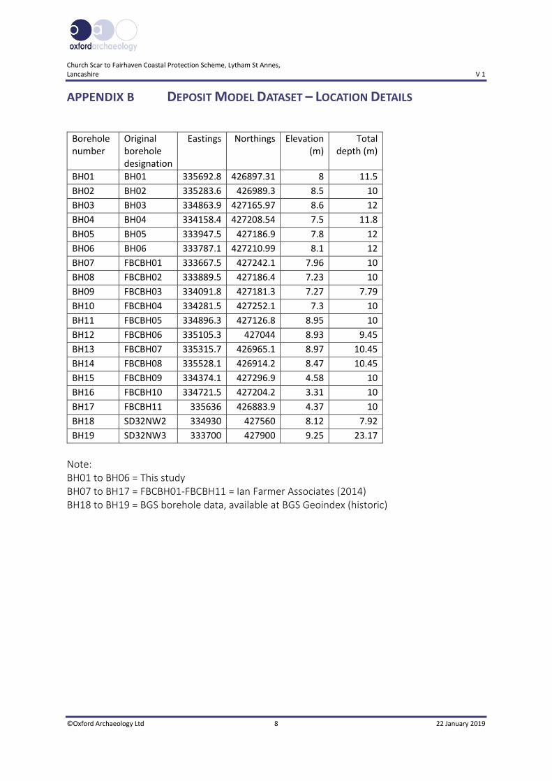
APPENDIX B DEPOSIT MODEL DATASET – LOCATION DETAILS
Borehole
number
Original
borehole
designation
Eastings Northings Elevation
(m)
Total
depth (m)
BH01 BH01 335692.8 426897.31 8 11.5
BH02 BH02 335283.6 426989.3 8.5 10
BH03 BH03 334863.9 427165.97 8.6 12
BH04 BH04 334158.4 427208.54 7.5 11.8
BH05 BH05 333947.5 427186.9 7.8 12
BH06 BH06 333787.1 427210.99 8.1 12
BH07 FBCBH01 333667.5 427242.1 7.96 10
BH08 FBCBH02 333889.5 427186.4 7.23 10
BH09 FBCBH03 334091.8 427181.3 7.27 7.79
BH10 FBCBH04 334281.5 427252.1 7.3 10
BH11 FBCBH05 334896.3 427126.8 8.95 10
BH12 FBCBH06 335105.3 427044 8.93 9.45
BH13 FBCBH07 335315.7 426965.1 8.97 10.45
BH14 FBCBH08 335528.1 426914.2 8.47 10.45
BH15 FBCBH09 334374.1 427296.9 4.58 10
BH16 FBCBH10 334721.5 427204.2 3.31 10
BH17 FBCBH11 335636 426883.9 4.37 10
BH18 SD32NW2 334930 427560 8.12 7.92
BH19 SD32NW3 333700 427900 9.25 23.17
Note:
BH01 to BH06 = This study
BH07 to BH17 = FBCBH01-FBCBH11 = Ian Farmer Associates (2014)
BH18 to BH19 = BGS borehole data, available at BGS Geoindex (historic)
Church Scar to Fairhaven Coastal Protection Scheme, Lytham St Annes,
Lancashire V 1
©Oxford Archaeology Ltd 9 22 January 2019
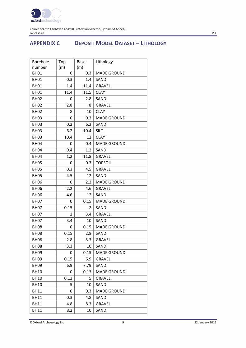
APPENDIX C DEPOSIT MODEL DATASET – LITHOLOGY
Borehole
number
Top
(m)
Base
(m)
Lithology
BH01 0 0.3 MADE GROUND
BH01 0.3 1.4 SAND
BH01 1.4 11.4 GRAVEL
BH01 11.4 11.5 CLAY
BH02 0 2.8 SAND
BH02 2.8 8 GRAVEL
BH02 8 10 CLAY
BH03 0 0.3 MADE GROUND
BH03 0.3 6.2 SAND
BH03 6.2 10.4 SILT
BH03 10.4 12 CLAY
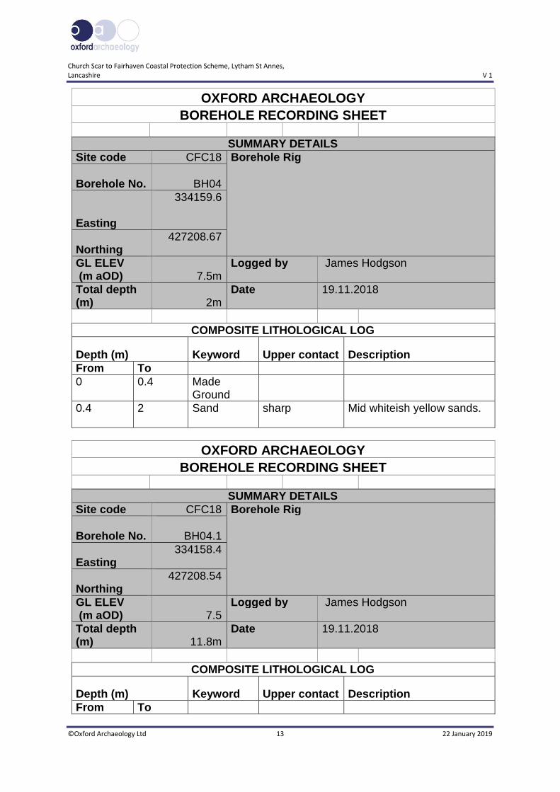
BH04 0 0.4 MADE GROUND
BH04 0.4 1.2 SAND
BH04 1.2 11.8 GRAVEL
BH05 0 0.3 TOPSOIL
BH05 0.3 4.5 GRAVEL
BH05 4.5 12 SAND
BH06 0 2.2 MADE GROUND
BH06 2.2 4.6 GRAVEL
BH06 4.6 12 SAND
BH07 0 0.15 MADE GROUND
BH07 0.15 2 SAND
BH07 2 3.4 GRAVEL
BH07 3.4 10 SAND
BH08 0 0.15 MADE GROUND
BH08 0.15 2.8 SAND
BH08 2.8 3.3 GRAVEL
BH08 3.3 10 SAND
BH09 0 0.15 MADE GROUND
BH09 0.15 6.9 GRAVEL
BH09 6.9 7.79 SAND
BH10 0 0.13 MADE GROUND
BH10 0.13 5 GRAVEL
BH10 5 10 SAND
BH11 0 0.3 MADE GROUND
BH11 0.3 4.8 SAND
BH11 4.8 8.3 GRAVEL
BH11 8.3 10 SAND
Church Scar to Fairhaven Coastal Protection Scheme, Lytham St Annes,
Lancashire V 1
©Oxford Archaeology Ltd 10 22 January 2019
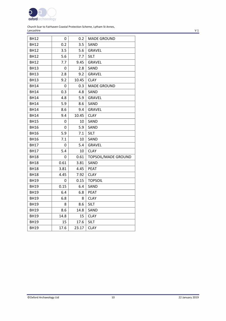
BH12 0 0.2 MADE GROUND
BH12 0.2 3.5 SAND
BH12 3.5 5.6 GRAVEL
BH12 5.6 7.7 SILT
BH12 7.7 9.45 GRAVEL
BH13 0 2.8 SAND
BH13 2.8 9.2 GRAVEL
BH13 9.2 10.45 CLAY
BH14 0 0.3 MADE GROUND
BH14 0.3 4.8 SAND
BH14 4.8 5.9 GRAVEL
BH14 5.9 8.6 SAND
BH14 8.6 9.4 GRAVEL
BH14 9.4 10.45 CLAY
BH15 0 10 SAND
BH16 0 5.9 SAND
BH16 5.9 7.1 SILT
BH16 7.1 10 SAND
BH17 0 5.4 GRAVEL
BH17 5.4 10 CLAY
BH18 0 0.61 TOPSOIL/MADE GROUND
BH18 0.61 3.81 SAND
BH18 3.81 4.45 PEAT
BH18 4.45 7.92 CLAY
BH19 0 0.15 TOPSOIL
BH19 0.15 6.4 SAND
BH19 6.4 6.8 PEAT
BH19 6.8 8 CLAY
BH19 8 8.6 SILT
BH19 8.6 14.8 SAND
BH19 14.8 15 CLAY
BH19 15 17.6 SILT
BH19 17.6 23.17 CLAY
Church Scar to Fairhaven Coastal Protection Scheme, Lytham St Annes,
Lancashire V 1
©Oxford Archaeology Ltd 11 22 January 2019
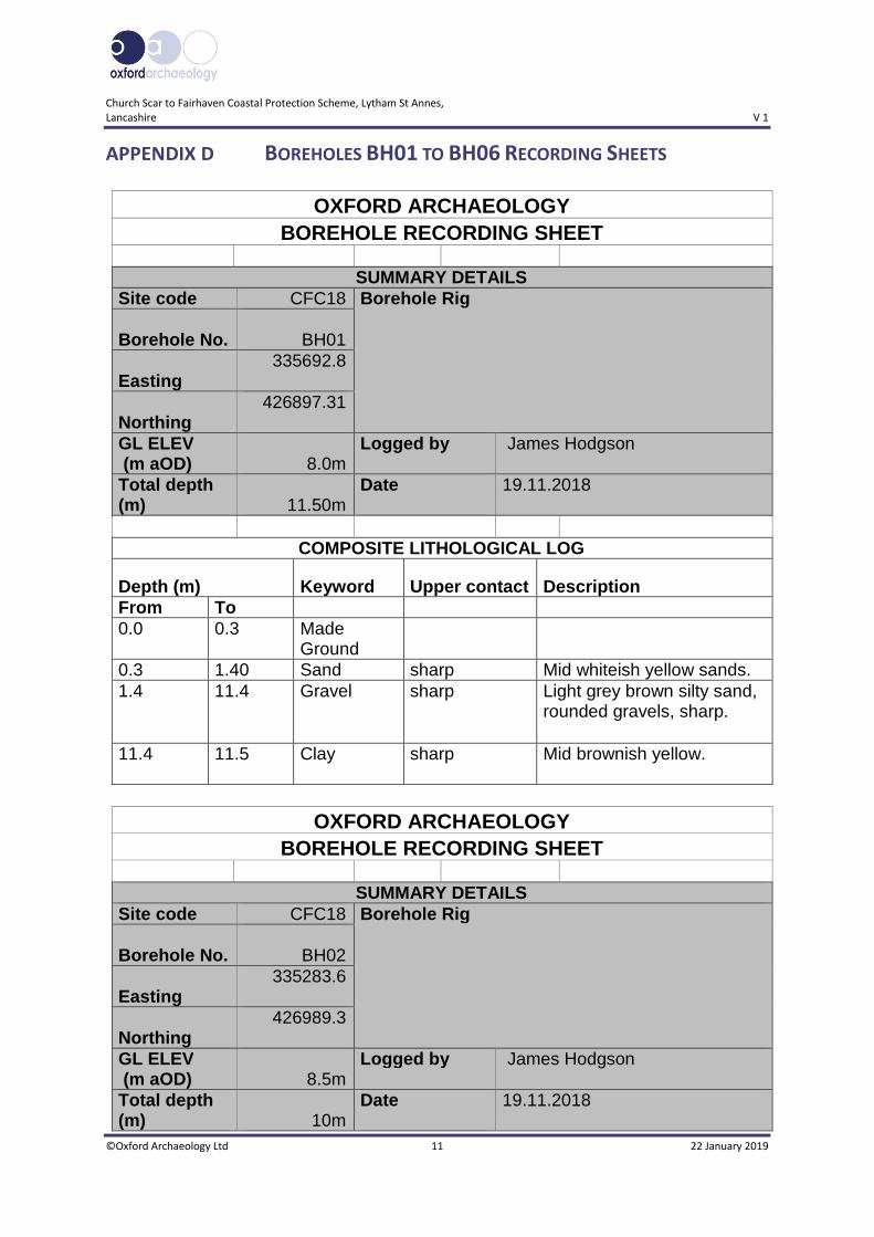
APPENDIX D BOREHOLES BH01 TO BH06 RECORDING SHEETS
OXFORD ARCHAEOLOGY BOREHOLE RECORDING SHEET
SUMMARY DETAILS Site code CFC18 Borehole Rig
Borehole No.
BH01
Easting 335692.8
Northing 426897.31
GL ELEV (m aOD) 8.0m
Logged by James Hodgson
Total depth (m) 11.50m
Date
19.11.2018
COMPOSITE LITHOLOGICAL LOG
Depth (m) Keyword Upper contact Description From To 0.0 0.3 Made
Ground
0.3 1.40 Sand sharp Mid whiteish yellow sands. 1.4 11.4 Gravel sharp Light grey brown silty sand,
rounded gravels, sharp.
11.4 11.5 Clay sharp Mid brownish yellow.
OXFORD ARCHAEOLOGY BOREHOLE RECORDING SHEET
SUMMARY DETAILS Site code CFC18 Borehole Rig
Borehole No.
BH02
Easting 335283.6
Northing 426989.3
GL ELEV (m aOD) 8.5m
Logged by James Hodgson
Total depth (m) 10m
Date
19.11.2018
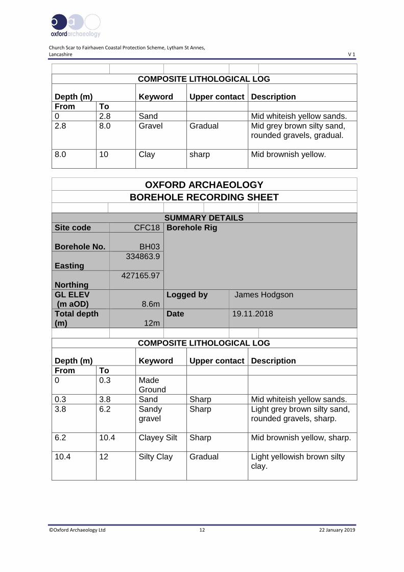
Church Scar to Fairhaven Coastal Protection Scheme, Lytham St Annes,
Lancashire V 1
©Oxford Archaeology Ltd 12 22 January 2019
COMPOSITE LITHOLOGICAL LOG
Depth (m) Keyword Upper contact Description From To 0 2.8 Sand Mid whiteish yellow sands. 2.8 8.0 Gravel Gradual Mid grey brown silty sand,
rounded gravels, gradual.
8.0 10 Clay sharp Mid brownish yellow.
OXFORD ARCHAEOLOGY BOREHOLE RECORDING SHEET
SUMMARY DETAILS Site code CFC18 Borehole Rig
Borehole No.
BH03
Easting 334863.9
Northing 427165.97
GL ELEV (m aOD) 8.6m
Logged by James Hodgson
Total depth (m) 12m
Date
19.11.2018
COMPOSITE LITHOLOGICAL LOG
Depth (m) Keyword Upper contact Description From To 0 0.3 Made
Ground
0.3 3.8 Sand Sharp Mid whiteish yellow sands. 3.8 6.2 Sandy
gravel Sharp Light grey brown silty sand,
rounded gravels, sharp.
6.2 10.4 Clayey Silt Sharp Mid brownish yellow, sharp.
10.4 12 Silty Clay Gradual Light yellowish brown silty clay.
Church Scar to Fairhaven Coastal Protection Scheme, Lytham St Annes,
Lancashire V 1
©Oxford Archaeology Ltd 13 22 January 2019
OXFORD ARCHAEOLOGY BOREHOLE RECORDING SHEET
SUMMARY DETAILS Site code CFC18 Borehole Rig
Borehole No.
BH04
Easting
334159.6
Northing 427208.67
GL ELEV (m aOD) 7.5m
Logged by James Hodgson
Total depth (m) 2m
Date
19.11.2018
COMPOSITE LITHOLOGICAL LOG
Depth (m) Keyword Upper contact Description From To 0 0.4 Made
Ground
0.4 2 Sand sharp Mid whiteish yellow sands.
OXFORD ARCHAEOLOGY BOREHOLE RECORDING SHEET
SUMMARY DETAILS Site code CFC18 Borehole Rig
Borehole No.
BH04.1
Easting 334158.4
Northing 427208.54
GL ELEV (m aOD) 7.5
Logged by James Hodgson
Total depth (m) 11.8m
Date
19.11.2018
COMPOSITE LITHOLOGICAL LOG
Depth (m) Keyword Upper contact Description From To
Church Scar to Fairhaven Coastal Protection Scheme, Lytham St Annes,
Lancashire V 1
©Oxford Archaeology Ltd 14 22 January 2019
0 0.4 Made Ground
0.4 1.2 Sand Sharp Mid whiteish yellow sands. 1.2 5.6 Gravel Gradual Rounded gravels with very
little if any sand, gradual.
5.6 11.8 Sandy Gravel
Sharp Mid grey brown silty sand, rounded gravels.
OXFORD ARCHAEOLOGY BOREHOLE RECORDING SHEET
SUMMARY DETAILS Site code CFC18 Borehole Rig
Borehole No.
BH05
Easting 333947.5
Northing 427186.9
GL ELEV (m aOD) 7.8m
Logged by James Hodgson
Total depth (m) 12m
Date
19.11.2018
COMPOSITE LITHOLOGICAL LOG
Depth (m) Keyword Upper contact Description From To 0 0.3 Made
Ground
0.3 4.5 Gravel Sharp Rounded gravels with very little if any sand, sharp.
4.5 12.0 Silty Sand Sharp Mid yellowish brown sand.
Church Scar to Fairhaven Coastal Protection Scheme, Lytham St Annes,
Lancashire V 1
©Oxford Archaeology Ltd 15 22 January 2019
OXFORD ARCHAEOLOGY BOREHOLE RECORDING SHEET
SUMMARY DETAILS Site code CFC18 Borehole Rig
Borehole No.
BH06
Easting 333787.1
Northing 427210.99
GL ELEV (m aOD) 8.1m
Logged by James Hodgson
Total depth (m) 12m
Date
19.11.2018
COMPOSITE LITHOLOGICAL LOG
Depth (m) Keyword Upper contact Description From To 0 0.6 Made
Ground Mid whiteish yellow sands
w/ clay inclusions.
0.6 2.2 Made Ground
Sharp Ash, slag, sand & gravel mix. Dark blackish grey, sharp.
2.2 4.6 Gravel Gradual Rounded gravels with very little if any sand, gradual.
4.6 12 Silty Sand Gradual Mid yellowish brown sand.

Church Scar to Fairhaven Coastal Protection Scheme, Lytham St Annes,
Lancashire V 1
©Oxford Archaeology Ltd 16 22 January 2019
APPENDIX E SITE SUMMARY DETAILS
Site name: Church Scar to Fairhaven Coastal Protection Scheme, Lytham St
Annes, Lancashire
Site code: CFC18
Grid Reference SD 34590 27270
Type: Geoarchaeological Investigation
Date and duration: 17th – 24th October 2018, 6 days
Area of Site The extent of the works is approximately 2km of coastline.
Location of archive: The archive is currently held at OA, Mill 3, Moor Lane Mills, Moor
Lane, Lancaster, LA1 1QD, and will be deposited with Lancashire
Historic Environment Record in due course.
Summary of Results: Oxford Archaeology North was commissioned by VolkerStevin
Ltd, on behalf of VBA Joint Venture Ltd, to undertake a
geoarchaeological investigation along the route of proposed
coastal defense upgrades in Lytham St Annes, at Church Scar,
Fairhaven Lake and Granny’s Bay (SD 335273 to SD 357268).
The primary aim of the investigation was to identify the
presence or absence of palaeoenvironmental deposits of
archaeological and geoarchaeological significance and to
establish the depositional environment (nature, extent,
depth and age) represented by the deposits. Records from
a total of 19 geotechnical interventions, comprising data
from six newly drilled boreholes for the current project,
and also including historical borehole data from an
additional 13 interventions, have been used to compile the
geoarchaeological database and to construct a deposit
model for the site.
The data show that no peat was recorded from the six new
interventions. Thin peat deposits are present however, in
BGS (British Geological Survey) boreholes outside the
north-west extremity of the Scheme and to the north (but
outside) the central portion of the Scheme.
Church Scar to Fairhaven Coastal Protection Scheme, Lytham St Annes,
Lancashire V 1
©Oxford Archaeology Ltd 17 22 January 2019
APPENDIX F WRITTEN SCHEME OF INVESTIGATION
Fairhaven to Church Scar Coastal Protection Scheme Written Scheme of Investigation for Geoarchaeological Borehole Investigation Volker Stevin
March 2018
Contains sensitive information
Fairhaven to Church Scar Coastal Protection Scheme Written Scheme of Investigation for Geoarchaeological Borehole Investigation
Contains sensitive information Atkins 5158758-VBA-XX-ZZ-RP-0001 Version 1
Notice
This document and its contents have been prepared and are intended solely for Insert Client’s information and use in relation to Fairhaven to Church Scar Coastal Protection Scheme.
Atkins assumes no responsibility to any other party in respect of or arising out of or in connection with this document and/or its contents.
This document has 13 pages including the cover.
Document history
Job number: Insert Number Document ref: Insert reference
Revision Purpose description Originated Checked Reviewed Authorised Date
Rev 1.0 Draft AB / DRN AFM AH 14/03/18
Rev 2.0 Final AB / DRN AFM AH AH 14/03/18
Client signoff
Client Volkers
Project Fairhaven to Church Scar Coastal Protection Scheme
Document title Written Scheme of Investigation for Geoarchaeological Borehole Investigation
Job no. 5158758. 022
Copy no. 001
Document reference
5158758-VBA-XX-ZZ-RP-0001
Fairhaven to Church Scar Coastal Protection Scheme Written Scheme of Investigation for Geoarchaeological Borehole Investigation
Contains sensitive information Atkins 5158758-VBA-XX-ZZ-RP-0001 Version 1
Table of contents
Chapter Pages
Executive summary 4
1. Introduction 5 Project background 5 Scope of document 5
2. Geoarchaeological background 5 Introduction 5 Solid geology 5 Superficial geology and geoarchaeological background 6 Geoarchaeological potential 7
3. Aims and objectives 7 Aims 7 Objectives 7
4. Methodology 8 Borehole methodology and expected difficulties 8 Geoarchaeological recording methodology 9 Deposit modelling 9 Reporting 10
5. References 10
Appendix A. 12 A.1. Drilling methodology 12 Cable Percussive (CP) 12
Fairhaven to Church Scar Coastal Protection Scheme Written Scheme of Investigation for Geoarchaeological Borehole Investigation
Executive summary
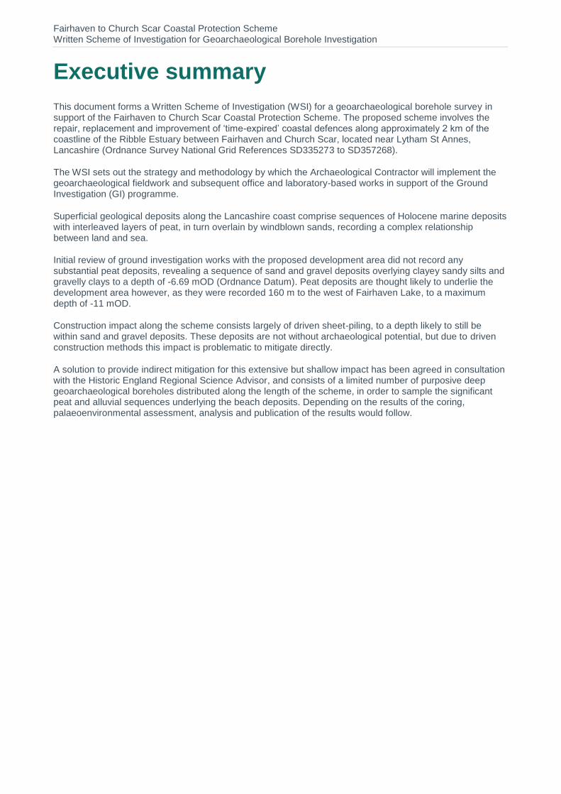
This document forms a Written Scheme of Investigation (WSI) for a geoarchaeological borehole survey in support of the Fairhaven to Church Scar Coastal Protection Scheme. The proposed scheme involves the repair, replacement and improvement of ‘time-expired’ coastal defences along approximately 2 km of the coastline of the Ribble Estuary between Fairhaven and Church Scar, located near Lytham St Annes, Lancashire (Ordnance Survey National Grid References SD335273 to SD357268).
The WSI sets out the strategy and methodology by which the Archaeological Contractor will implement the geoarchaeological fieldwork and subsequent office and laboratory-based works in support of the Ground Investigation (GI) programme.
Superficial geological deposits along the Lancashire coast comprise sequences of Holocene marine deposits with interleaved layers of peat, in turn overlain by windblown sands, recording a complex relationship between land and sea.
Initial review of ground investigation works with the proposed development area did not record any substantial peat deposits, revealing a sequence of sand and gravel deposits overlying clayey sandy silts and gravelly clays to a depth of -6.69 mOD (Ordnance Datum). Peat deposits are thought likely to underlie the development area however, as they were recorded 160 m to the west of Fairhaven Lake, to a maximum depth of -11 mOD.
Construction impact along the scheme consists largely of driven sheet-piling, to a depth likely to still be within sand and gravel deposits. These deposits are not without archaeological potential, but due to driven construction methods this impact is problematic to mitigate directly.
A solution to provide indirect mitigation for this extensive but shallow impact has been agreed in consultation with the Historic England Regional Science Advisor, and consists of a limited number of purposive deep geoarchaeological boreholes distributed along the length of the scheme, in order to sample the significant peat and alluvial sequences underlying the beach deposits. Depending on the results of the coring, palaeoenvironmental assessment, analysis and publication of the results would follow.
Fairhaven to Church Scar Coastal Protection Scheme Written Scheme of Investigation for Geoarchaeological Borehole Investigation
Contains sensitive information Atkins 5158758-VBA-XX-ZZ-RP-0001 Version 1
1. Introduction
Project background 1.1. This report is a Written Scheme of Investigation (WSI) for geoarchaeological works in support of
the proposed Fairhaven to Church Scar Coastal Protection Scheme. The proposed scheme involves the repair, replacement and improvement of ‘time-expired’ coastal defences along approximately 2 km of the coastline of the Ribble Estuary between Fairhaven and Church Scar, located near Lytham St Annes, Lancashire (Ordnance Survey National Grid References SD335273 to SD357268).
1.2. The proposed scheme comprises three adjacent locations at Fairhaven Lake, Granny’s Bay and Church Scar (Figure 1). Existing coastal defences at Fairhaven Lake and Church Scar form strategic headlands that protect properties within the hinterland to the rear, and in addition preserve sand dunes that are themselves important for protecting the outer Ribble Estuary from coastal erosion and flooding. These defences were constructed in the 1890s and have been continuously damaged by wave action and require immediate replacement. This will involve the installation of new pre-cast concrete revetments constructed in front of the existing defences, with sheet piles installed at the base of the revetment to protect against scour and erosion. The sheet piles will be required along the entire length of the revetments and will penetrate 5m into the foreshore sediment, concealed by a concrete capping beam and covered in beach sands. New defences of a similar design will also be constructed at Granny’s Bay.
1.3. The construction of new coastal defences and, in particular the insertion of sheet piled toes at Fairhaven Lake, Granny’s Bay and Church Scar, have the potential for localised disturbance and/or loss of nationally important palaeoenvironmental deposits and unknown archaeological deposits in the area. Consequently, a programme of mitigation works has been agreed in consultation with the Historic England Regional Science Advisor, consisting of a limited number of purposive deep geoarchaeological boreholes distributed along the length of the scheme, in order to sample the significant peat and alluvial sequences underlying the beach deposits. Depending on the results of the coring, palaeoenvironmental assessment, analysis and publication of the results would follow.
Scope of document 1.4. This WSI sets out the strategy and methodology by which the Archaeological Contractor will
implement the geoarchaeological borehole survey and subsequent works.
1.5. In format and content this document conforms with current best practice and to the guidance outlined in Management of Research Projects in the Historic Environment (MoRPHE, EH 2015) and the Chartered Institute for Archaeologists’ (CIfA) Standard and Guidance: archaeological watching brief (CIfA 2014) and Geoarchaeology. Using Earth Sciences to Understand the Archaeological Record (Historic England 2015).
2. Geoarchaeological background
Introduction 2.1. An overview of the historic environment is provided in the Environmental Statement (VBA Ltd.
2016), and it is not intended here to repeat this in detail, but rather to highlight those key elements of geoarchaeological relevance with the proposed scheme likely.
Solid geology 2.2. The solid geology across the site has been mapped by the British Geological Survey (BGS) (BGS
Online Geology of Britain Viewer) and comprises predominately red-brown mudstones and
Fairhaven to Church Scar Coastal Protection Scheme Written Scheme of Investigation for Geoarchaeological Borehole Investigation
Contains sensitive information Atkins 5158758-VBA-XX-ZZ-RP-0001 Version 1
siltstones of the Sidmouth Mudstone Member laid down 251.2 to 227 million years ago during the Triassic epoch.
Superficial geology and geoarchaeological background 2.3. The bedrock is overlain by superficial sediments of Holocene age (11,500 years ago to present),
comprising clays and silts with interleaved peat deposits, in turn overlain by wind-blown (Aeolian) sands.
2.4. Fine-grained minerogenic deposits (clays and silts) reflect former tidal flats and saltmarsh accumulating under rising sea-levels whilst the interleaved peat deposits represent semi-terrestrial plan communities formed during marine regressive episodes.
2.5. Peat deposits are widely recorded along the Lancashire coast. The majority of these peat deposits date to the Mesolithic, with rare peats of Windermere interstadial date recorded palaeochannels preserved within the intertidal zone at Cleveleys 10 km to the north of Lytham (Eadie, 2012).
2.6. Peat deposits have previously been identified in the area of Lytham, including approximately 160 m to the west of Fairhaven Lake (Tooley, 1974), where the lowest peat was recorded at -11 mOD. The sequence of minerogenic and biogenic sediments revealed by Tooley (1974) record a complex record of land-sea interactions, including as many as ten inundation phases between 9300 and 830 years BP.
2.7. Existing ground investigations within the proposed development area in 2014 involved eleven boreholes penetrating to depths of between -0.52 (BH03) and -6.69 mOD (BH10). The deposits in these boreholes largely comprised deposits of sands and sandy gravels, with finer grained clayey sandy silts identified at -2 mOD (BH09) and -2.59 to -3.39 mOD (BH10), with slightly gravelly clays recorded below -1.03 mOD in borehole BH11.
2.8. No peat deposits were identified in these boreholes; the depth of peats recorded by Tooley (1974) would suggest peat deposits, if present, are likely to occur as much as 5m below the maximum depth achieved during ground investigations.
2.9. However, where peat deposits do survive they represent an important archive of palaeoenvironmental material (e.g. pollen, plant macrofossils) with the potential to provide information on prehistoric vegetation, climate, landscape and human-environment interactions. Mesolithic artefacts may also be contained within or below these deposits.
2.10. Windblown deposits at Lytham St Anne form part of an extensive habitat of sand dunes and dune grassland along the Lancashire coast, with relict dunes and dry dune slacks located further inland, constrained by more recent urban development since the 19th century (VBA Ltd. 2016).
2.11. Sand dunes form in relatively low energy environments on gently shelving shorelines where sand deposited by the sea dries out on the upper shore at low tide and onshore wind is sufficiently strong enough to carry the sand inland above the tidal limit (Bell and Brown, 2008). The process of dune formation can be highly episodic with phases of sand deposition separated by phases of stabilisation and soil formation.
2.12. Much of the coastline of Lancashire is dominated by relict dunes systems, many under threat from coastal erosion. At Ainsdale, 10 km to the south of the Site, the deposits include a series of peat layers dating from approximately 7000 to 3000 cal. BP, overlain by windblown sands that includes occasional thin peats dating to the 1st millennium cal. BC and 12-13th century AD (May, 2003).
2.13. Windblown deposits are significant as they can bury and preserve sites and deposits of archaeological and geoarchaeological potential, including buried land surfaces (e.g. stabilisation horizons separating periods of dune formation) and underlying palaeoenvironmental deposits that may contain a range of palaeoenvironmental remains.
Fairhaven to Church Scar Coastal Protection Scheme Written Scheme of Investigation for Geoarchaeological Borehole Investigation
Contains sensitive information Atkins 5158758-VBA-XX-ZZ-RP-0001 Version 1
2.14. The North West Rapid Coastal Zone Assessment highlights the general lack of prehistoric evidence recovered from the Ribble Estuary when compared with Merseyside to the south, with only occasional finds of flint flakes from the southern shores of the estuary (Eadie 2012). Although no known prehistoric artefacts or traces of activity have been identified within or surrounding the proposed development area, estuaries are well known to have been important foci for human activity, and the possibility of recovering prehistoric remains should not be discounted.
Geoarchaeological potential 2.15. The geoarchaeological potential of the deposits will depend greatly on, and can be further
refined, dependant on the results of the proposed Ground Investigation (GI) works. The geoarchaeological potential of the deposits will be relatively low in the absence of peat or organic-rich sediments, as is suggested by recent ground investigations.
2.16. However, in the presence of geoarchaeologically relevant deposits, key research themes (see Brennand et al. 2007) include:
Environment and landscape, with specific reference to the environmental context of human occupation;
Climate change, particularly the influence of sea-level rise in determining the formation of sediments and impact on human occupation. Archaeology can provide a broader time-depth feeding into the impact of current and projected coastal erosion and flooding.
3. Aims and objectives
Aims 3.1. The geoarchaeological investigation aims to:
Identify the presence/absence of palaeoenvironmental deposits of archaeological and geoarchaeological significance;
Establish the depositional environment (nature, extent, depth and age of deposits) represented by the deposits;
Assess the geoarchaeological and archaeological significance of the deposits;
Propose work on the core samples proportionate to the impact of the scheme and the geoarchaeological and palaeoenvironmental potential of the samples.
Objectives 3.2. These aims will be addressed by achieving the following objectives:
Obtain (where possible) continuous borehole samples through the sediment sequence at suitable locations in the proposed development area;
Describe and interpret the sediments geoarchaeologically, in the field and/ or laboratory;
Model the sediments in the form of a schematic section through the subsurface deposits;
Report on the results, and make specific and proportionate recommendations for further work. In the event that peat or organic-rich deposits are present, recommendations would be likely to include palaeoenvironmental assessment (e.g. pollen, plant macrofossils) and
Fairhaven to Church Scar Coastal Protection Scheme Written Scheme of Investigation for Geoarchaeological Borehole Investigation
Contains sensitive information Atkins 5158758-VBA-XX-ZZ-RP-0001 Version 1
scientific dating (as appropriate), to determine the preservation quality and significance of suitable deposits (see 4.7 and 4.8).
4. Methodology
Borehole methodology and expected difficulties 4.1. It is proposed that six boreholes will be attempted by a specialist contractor under the direction of
an experienced geoarchaeologist. Boreholes will be located along the line of the scheme in proximity to the development area and in locations that are both safe and convenient to access. Coring would continue down to refusal or to the base of archaeologically significant deposits.
4.2. Potential areas for drilling are shown on Figure 1; however, as long as there is distribution along the scheme length the exact location of coring locations is not critical to the results, so we suggest liaising with the Client to identify safe and mutually satisfactory locations.
4.3. After examination of the existing GI reports, and consultation with specialist geotechnical subcontractors, the presence of significant depths of medium to dense non-cohesive blown sands at and below the water table across the development area is considered likely to present difficulties for recovering intact cores. Consequently, the borehole methodology proposes using a combination of cable percussive and window sampling techniques to increase the likelihood of recovering at least some intact cores through deposits of interest. A combination of cable percussion and window sampling techniques is proposed; the methodology for which is outlined in Appendix A.
Fairhaven to Church Scar Coastal Protection Scheme Written Scheme of Investigation for Geoarchaeological Borehole Investigation
Contains sensitive information Atkins 5158758-VBA-XX-ZZ-RP-0001 Version 1
Figure 1 Suggested areas for borehole locations
Geoarchaeological recording methodology 4.4. Cores retrieved during fieldwork will be returned to and opened in the Wessex Archaeology
laboratory and described by a suitably experienced geoarchaeologist following Hodgson (1997), including where possible information such as;
Depth;
Texture;
Composition;
Colour;
Inclusions;
Structure (bedding, ped characteristics etc);
Contact between deposits.
4.5. Interpretations will be made regarding the likely depositional environments and formation processes of the sampled deposits. The data will be tabulated by borehole and depth.
Deposit modelling 4.6. Existing data from the area (including previous GI logs and BGS data) will be collated, interpreted
and entered into industry standard software (Rockworks™ v17.0) along with results from the purposive geoarchaeological survey.
Fairhaven to Church Scar Coastal Protection Scheme Written Scheme of Investigation for Geoarchaeological Borehole Investigation
Contains sensitive information Atkins 5158758-VBA-XX-ZZ-RP-0001 Version 1
4.7. Outputs suited to the nature of the results will be created using a combination of Rockworks and ArcGIS, and may include Digital Elevation Models (DEMs), thickness plots and schematic sections through the subsurface deposits, mapping the lateral extent and depth of key sedimentary units along the borehole transect. Deposit modelling will aid the interpretation of past depositional environments alongside the results of palaeoenvironmental assessment and scientific dating.
Reporting 4.8. A combined, integrated report of the results of the geoarchaeological survey and modelling works
will be presented in a stand-alone format, and include suitable recommendations for any further works likely to be required. These may include assessment of borehole samples, and subsequently analysis and publication.
4.9. The report will, as a minimum, include the following elements:
non-technical summary
project background
a plan of the Site at an appropriate scale showing the geoarchaeological sample locations
an outline description of the aims of the archaeological work and the methodology used in order to achieve the aims, including a critical review of the methods (i.e. a confidence rating of the results)
a descriptive text outlining the results of the work
a summary of the likely palaeoenvironmental and archaeological potential of the deposits, and the depositional environments represented, together with an assessment of their significant in a local and regional context
recommendations for targeted and proportionate further work on core samples, should this be warranted
supporting figures, including schematic transects or other deposit model outputs appropriate to the results
tabulation of the sediment data and interpretations by borehole and depth
details of the archive and its proposed location
4.10. Following the completion of all site works, the need for any other forms of publication will be assessed, in consultation with the Local Planning Authority.
4.11. Details of the Site will be submitted online to the OASIS (Online Access to the Index of Archaeological Investigations) database, and a full record will be produced within six months of the completion of all site work.
5. References
BELL, M.G. AND BROWN, A.D. (2008). SOUTHERN REGIONAL REVIEW OF GEOARCHAEOLOGY: WINDBLOWN
SEDIMENTS. ENGLISH HERITAGE, RESEARCH DEPARTMENT REPORT SERIES NO. 5-2009.
BRENNAND, M., CHITTY, G. AND NEVELL, M. (2007). RESEARCH AND ARCHAEOLOGY IN NORTH WEST ENGLAND: AN
ARCHAEOLOGICAL RESEARCH FRAMEWORK FOR NORTH WEST ENGLAND, VOLUME 2 RESEARCH AGENDA AND
STRATEGY. ARCHAEOLOGY NORTH WEST VOLUME 9. COUNCIL FOR BRITISH ARCHAEOLOGY.
Fairhaven to Church Scar Coastal Protection Scheme Written Scheme of Investigation for Geoarchaeological Borehole Investigation
Contains sensitive information Atkins 5158758-VBA-XX-ZZ-RP-0001 Version 1
BRITISH GEOLOGICAL SURVEY. GEOLOGY OF BRITAIN VIEWER. HTTP://WWW.BGS.AC.UK/DISCOVERINGGEOLOGY/GEOLOGYOFBRITAIN/VIEWER.HTML (ACCESSED 8.01.18)
CIFA 2014A STANDARD AND GUIDANCE FOR ARCHAEOLOGICAL WATCHING BRIEFS, UPDATED DECEMBER 2014.
EADIE, G. (2012). THE NORTH WEST RAPID COASTAL ZONE ASESSMENT (NWRCZA), PHASE 2 PROJECT REPORT. ENGLISH HERITAGE. HTTPS://HISTORICENGLAND.ORG.UK/IMAGES-BOOKS/PUBLICATIONS/NWRCZA-PHASE2-PROJECT-REPORT/ (ACCESSED 8.01.18).
IAN FARMER ASSOCIATES LTD. (2014). FACTUAL REPORT ON GROUND INVESTIGATIONS, FYLDE HEADLANDS PAR
STUDY, LYTHAM-ST-ANNES. REPORT W14/41475.
HISTORIC ENGLAND. 2015C. GEOARCHAEOLOGY: USING EARTH SCIENCES TO UNDERSTAND THE ARCHAEOLOGICAL
RECORD. 2ND EDITION. SWINDON: HISTORIC ENGLAND. [ONLINE]. [ACCESSED 9 MARCH 2016]. AVAILABLE FROM: HTTPS://CONTENT.HISTORICENGLAND.ORG.UK/IMAGES-BOOKS/PUBLICATIONS/GEOARCHAEOLOGY-EARTH-SCIENCES-TO-UNDERSTAND-ARCHAEOLOGICAL-RECORD/HEAG067-GEOARCHAEOLOGY.PDF/
HODGSON, J M, 1997, SOIL SURVEY FIELD HANDBOOK, HARPENDEN, SOIL SURVEY TECHNICAL MONOGRAPH 5
MAY, V.J. (2003). AINSDALE, IN MAY, V.J AND HANSON, J.D (EDS) COASTAL GEOMORPHOLOGY OF GREAT BRITAIN. GEOLOGICAL CONSERVATION REVIEW 28. JOINT NATURE CONSERVATION COMMITTEE, PETERBOROUGH. HTTP://JNCC.DEFRA.GOV.UK/PAGE-3012#DOWNLOAD (ACCESSED 8.01.18).
TOOLEY, M.J. (1974). SEA-LEVEL CHANGES DURING THE LAST 9000 YEARS IN NORTH-WEST ENGLAND. THE
GEOGRAPHICAL JOURNAL 140, 18-42.
VBA LTD. (2016). FAIRHAVEN TO CHURCH SCAR COAST PROTECTION SCHEME: ENVIRONMENT STATEMENT.
Fairhaven to Church Scar Coastal Protection Scheme Written Scheme of Investigation for Geoarchaeological Borehole Investigation
Contains sensitive information Atkins 5158758-VBA-XX-ZZ-RP-0001 Version 1
Appendix A.
A.1. Drilling methodology It is proposed to use a combination of Cable Percussive techniques to advance the borehole to depth, and Window Sample techniques in attempt to recover an intact core of the soil.
Cable Percussive (CP) The drilling rig is towed to site and moved between borehole positions, by 4-wheel drive vehicle. The lead driller will ensure the drilling rig will be erected on a suitably flat surface. Once in position, the rig will be unhitched from the vehicle. The front legs will then be manhandled into the correct position and the cross bars and side stays put in place to provide a rigid ‘A’ frame. The CP rig will stay set up on location throughout the borehole. The main drill string consists of sinker bars and one of the following drill tools: clay cutter, shell or chisel. The drill string is attached directly to the winch drum via a wire rope. The actual drilling action is obtained by raising the drill string and then allowing the drill string to drop freely to penetrate the strata. The drill string is then raised and the tool emptied, this process is repeated until the required depth is reached. If required, temporary steel casing will be inserted into the ground to support the hole. Upon reaching the required test depth, the cable percussive drilling shall stop and window sampling drilling shall continue as below.
Window Sampling (WS) A tracked Terrier with diesel driven trip hammer (weighing 63kg) will be used on this contract. The rig will be transported to site by a 4-wheel drive vehicle supported by a trailer. The Lead Driller will set up the rig over the CP borehole. The window sample tool assembly shall be lowered to the base of the CP borehole. A trip hammer is mounted on a mast approximately 3.00m high and is used to drive a 1.00m long hollow sample tube with plastic liner insert into the ground. Once each successive metre of excavation or refusal has been completed the sample tube is hydraulically removed from the ground and the lined sample is recovered and sealed for later analysis. The borehole will then be advanced to the next test depth by the CP rig. This process is repeated until the required depth is achieved or an obstruction is encountered. Between each test, the WS rig mast will be lowered and mechanically tracked off the drill location to allow the CP rig to continue on.

© Atkins Ltd except where stated otherwise. The Atkins logo, ‘Carbon Critical Design’ and the strapline ‘Plan Design Enable’ are trademarks of Atkins Ltd.