Embed Size (px)
Citation preview

132
City Expansion and Agricultural Land Loss within the Peri-Urban
Area of Osun State, Nigeria
Mubarak Lasisi1
Ayobami Popoola2
Alaba Adediji1
Oluwatola Adedeji3
Kayode Babalola1.
Abstract
Urban encroachment into arable land along the peri-urban areas of Osun State, Nigeria prompted
this investigation. The study is aimed at determining rate, pattern and effects of uncontrolled spatial
expansion in the city. This study examines the trend in eight (8) peri-urban communities in Olorunda
and Osogbo LGAs which were purposely selected. A multi-stage sampling technique was adopted
in administering 230 questionnaires on randomly selected peri-urban farmers. Primary data
collected were analysed using SPSS while Geographical Information Systems (GIS) data acquisition
and sources were used to capture vegetation change, with 3 Landsat imageries sourced for the
study. Findings revealed that 72% of interviewed farmers had a fear of losing their farmland to
developmental projects as 16.1% of farmers had previously lost between 1 and 2 acres of farmland
to such projects. Land modelling change detected that settlement/built-up-areas have increased
from 978.03 hectares (6.60865%) in 1986 to 2976.39 hectares (20.11178%) in 2014, to the
detriment of farmland/vegetative cover. As a result farmland/vegetative cover reduced from 9277.71
hectares (62.69045%) in 1986 to 7995.33 hectares (54.02527%) in 2014. The study discovered that
such a degree of city encroachment and expansions into vegetative land cover is greatly impeding
agricultural activities and farm production. Thus, the paper advocates that the government and land
administrators formulate and implement policies in this direction.
Key words: Agricultural land; Vegetal Land Cover; Encroachment; Housing and Spatial
Expansion.
1 Department of Urban and Regional Planning, University of Ibadan, Oyo State, Nigeria.
² Department of Town and Regional Planning, University of KwaZulu-Natal, Durban, South Africa.
3 Department of Geography, Obafemi Awolowo University, Ile-Ife, Nigeria.
Corresponding author: [email protected]
Ghana Journal of Geography Vol. 9(3), 2017 pages 132–163

Ghana Journal of Geography Vol. 9(3), 2017 pages 132–163
133
Introduction
The unprecedented rate of urbanization and the sprawling pattern of development have resulted in
the quick disappearance and/or total alteration of fertile agricultural lands in peri-urban areas,
especially within the Global South. It was estimated that approximately 14 million hectares of land
(approx. 475,000 ha/yr.) in developing/Global South countries would be converted into various land
uses/development between 1990 and 2020 (Naab et al. 2013). Approximately 400,000 hectares of
vegetative land cover has been lost (Adesina, 2005), with more expected to be lost due to various
physical developmental projects in most urban settlements (Appiah, 2014; Dekolo and Olayinka,
2014; Mugish and Nyandwi, 2015). Such loss could be due to dormitory and satellite towns (Zasada,
2011) which result in the outward expansion of built-up areas beyond visible and invisible city
borders into green areas mainly used for farming (Brennan, 1999; Kwasi, 2004; Oyesiku, 2010).
Urbanization in sub-Saharan Africa is altering traditional livelihood strategies and displacing
agricultural land uses in many areas (Angel et al., 2005; Adeboyejo and Abolade, 2007). Olima
(2003) opined that population growth rate in both urban and rural areas is not commensurate with
the quantity of land supply. Land is fixed in nature and so does not increase with increasing
population growth. Expansion of cities affects the areas surrounding them (i.e., the suburbs) by
altering the natural resource base and converting vegetal land cover to new uses, thus challenging
the environment and dwellers’ livelihoods (Gündel, 2006).
Since the early 1950s, rapid urbanization has been a feature of Nigeria. The Human Development
Report (2004) and Oyesiku and Alade (2010) observed that almost half of the Nigeria population
(45.9% of 120.9 million) reside in urban areas. Mabogunje (2002); Gbadegesin et al. (2010); and
UNDP (2011) observed that urban population growth between 1953 and 2007 rose from 10.6% to
about 50% of the total population. This exponential population growth caused overcrowding and a
distortion in cityscape (Ogu, 1999). Besides rapid urban population increase in existing cities, more
urban centres emerge with the creation of new states (Osuocha, 2006).
To buttress this assertion, the 1991 National Population Census recorded 359 urban settlements,
each with a population of at least 20,000, and it was estimated that the figure increase to 450 urban
centres in 2000. In 2004, urban centres in Nigeria were estimated to be about 853 with the same
20,000 urban population thresholds (UNDP, 2011). Therefore, it could be deduced that all states
and their local government headquarters have already assumed an urban status in Nigeria.
The success of urban/peri-urban agricultural practices in many cities depends on how well it is
integrated into other urban management policies, land uses and planning. Evidence presented by
Amoateng et al. (2013); Mok, et al. (2014); Mugish and Nyandwi, (2015); and Kleemann, et al.
City Expansion and Agricultural Land Loss within the Peri-Urban Area of Osun State, Nigeria
134
(2017) shows that housing development on arable farmland in UPA areas in most cities has become
an issue on the global agenda in recent times. Maxwell (1995); Lawry et al. (2014) and Odhiambo
(2015) observe that a plethora of reasons including rapid urbanization, insecurity of land tenure and
lax land use regulation or enforcement has limited growth of UP agriculture.
Zasada (2011) opined further that farming in peri-urban areas is expected to be an integral part of
the cultural landscape; it often provides environmental amenities, accessible green open spaces and
recreational services. However, this pleasant living environment currently attracts new projects
which in turn drive up housing development and increase land prices and rents. The concern in this
regard is the decline in availability of agricultural land due to population pressure and urbanisation.
Against this background, there is the need for adequate understanding the interplay between trends
of urbanization and undermining agricultural land use within peri-urban areas. On this note, this
study aims to understand the magnitude of agricultural land loss along the peri-urban areas of
Osogbo due to city expansion.
Conceptual Underpinnings and Literature Review
The concept of the Peri-Urban
Earlier in the 19th century, Johann Heinrich von Thünen (1783-1850) developed a theoretical model
that describes the processes of local land-use patterns. The model explains five concentric zones
with distinct characteristics and functions. The core ring served as the city centre (urban area), and
subsequent rings as the peri-urban areas, fringes and rural settings (predominantly agrarian
communities and zones surrounding the city centre). Farming activities occur in the ring closest to
the city where dairying and intensive farming (vegetables, fruits, perishable goods, milk and other
dairy products) were cultivated with highest profits. However, the agricultural model explains the
locations and costs of agriculture in and around the urban centre where land is expected to be readily
available for cultivation purposes that exist at the transition zones. Basically, the concept of peri-
urban agriculture is directly associated with the agricultural model, within which the transition
zones/peripheries and the fringes are areas of high agricultural land uses and practices.
The Council of Europe (CEMAT, 2007) defined peri-urban areas as: “areas that are in some form
of transition from strictly rural to urban. These areas often form the immediate urban-rural interface
and may eventually evolve into fully urban. Similarly, Birley and Lock (1999) conceived peri-urban
areas as those immediately surrounding cities, where farmlands are being developed for urban uses.
The Organisation for Economic Co-operation and Development (OECD) (2007) described peri-
urban as the ‘grey area’ which is neither entirely urban nor rural in the traditional sense. Buxton
(2007) saw it as a ‘middle band’ of land with an unbalanced mixture of urban and rural functions,but

Ghana Journal of Geography Vol. 9(3), 2017 pages 132–163
135
often continually affected by incessant push and pull tendencies from the cities. The result is a
heterogeneous mosaic of environmental and productive ecosystems working in combination with
the prevailing socio-economic peculiarities (Ravetz et al., 2013; Appiah et al., 2014) which are fast
changing, with complex patterns of land use and landscape fragmented between local and regional
boundaries (Piorr et al., 2011) creating a clash in boundary identity (Johnson, 1974).
Adjekumhene (2002) saw a peri-urban area as a space characterised by emerging multidimensional
physical development as a result of interaction between urban and rural land uses. In this zone, rural
activities and modes of life are in rapid retreat, with extensive urban land use intrusion, that is, urban
area physically and functionally expanding into the rural area (Amoateng et al., 2013). These areas
exhibit peculiar characteristics that make them distinct in development, including accelerated
development of urban residential and urban commercial uses and decrease in rural primary
activities, rapid but unplanned growth with inadequate service infrastructure, middle and low
income residents, and serving as receptacles for the growing rental market (Buxton, 2007; Hewitt,
1989; Government of Swaziland, 199; Johnson, 1974).
Drescher and Iaquinta (2000) observed four interrelated categories within the peri-urban region to
include: village peri-urban; diffused peri-urban; in-place peri-urban and absorbed peri-urban. Brook
and Davila (2000) considers the peri-urban interface as the meeting of rural and urban activities; in
effect, a process rather than a place with increased competition for land and water between
agricultural and non-agricultural uses, and rural and urban dwellers (Gould 1988; NRI/UST 1997).
Studies by Amoateng et al. (2013) and Drabkin (1977) indicate that peri-urban areas are
experiencing unplanned physical growth characterised by an unregulated pattern of physical
development, resulting in complex organic urban growth. Such areas often and predominantly
expand with horizontal developments, turning potential areas of activity and human attraction into
a “mini-city”. This growth results in land use changes which, according to Sarfo-Mensah and Adam
(1998), can classified into two major forms: land used for agriculture at the expense of fallow and
forest land; and land used for building development, especially housing, at the expense of
agricultural land. This finding supports the view that residential development remains a major driver
of peri-urbanization (suburbanization) (Drabkin 1977).
Land Governance
Governance is a mechanism, and institutions, through which citizens/groups articulate their
interests, exercise their legal rights, meet their obligations and mediate their differences (UNDP,
1997). The principles of sustainability, subsidiary, equity, efficiency, transparency, civil

City Expansion and Agricultural Land Loss within the Peri-Urban Area of Osun State, Nigeria
136
engagement/citizenship and security (in space and tenure) are the underlying principles of good
urban governance identified by Egunjobi et al. (2008).
Land governance is basically about determining and implementing sustainable land policies (World
Bank, 2009). Hence it is seen as the process by which decisions are made regarding the access to
and use of land, the manner in which these decisions are implemented and the way conflicting
materials on land are protected (FAO, 1998-2006). Arguably, proper land governance is key to
achieving sustainable development.
Land marketing within the peri-urban areas of sub-Saharan Africa where land is rapidly being
converted from agricultural to residential use has increased tremendously (Chirisa 2010). Since the
land market is complex and diverse, characterised by a high level of uncertainty and widespread
disputes, there is a need for proper land governance. Hence, land under threat of urbanisation within
the peripheries can integrate urban and peri-urban agriculture with the accelerating urbanisation
(SPFS, 2001).
According to Aluko (2010), land governance is about the policies, processes and institutions by
which land, property and natural resources are managed. These include decisions on access to land,
land rights, land use, and land development. Under the effective rule of law and good governance,
physical planning is meant to systematically control the development towns and cities through
preparation of land use developmental plans, master plans, land-use zoning, and layout. Good
governance is a fulcrum upon which effective urban management rests; it plays a decisive role in
the formulation of land policies which will serve as a guide for all the land administrators and
forestall discrepancies with respect to the issue of land governance in its application to urban
planning.
Appiah et al. (2014) and Lambin et al. (2003) observed that access to and use of land is usually
constrained by policies and other institutional prohibitions both at the local and national levels. With
customary land holdings, individuals, groups, societies, families and kinsmen are custodians of the
land often dictate its use (Bugri, 2008; Arko-adjei, 2011). Likewise, the laid down developmental
plans by the federal, state or district powers dictate the use of land at the national and institutional
stage through master plan allocations (Appiah, et al., 2014; Kasanga and Kotey, 2001). However,
in all ramifications, there is the need to consider the collective interests of the larger population in
taking any decisions of land use and modification.
The Smart Growth Concept
This concept emerged as an answer to the enduring problem of sprawling development and its many
negative consequences. Its historical antecedents are varied and numerous, dating back decades

Ghana Journal of Geography Vol. 9(3), 2017 pages 132–163
137
from national land use efforts, state growth management laws, housing reforms and anti-
exclusionary zoning mandates (Burchell, et al., 2000). The concept seeks ways of directing growth
in an intentional, comprehensive way so as to develop sustainable communities. The concept
attempts to coordinate development within the city centre with an attempt to bring about the
sustainable development of the adjoining suburbs through mixed land uses, compact building
design, diversity of transport options, walkable communities, and a reliance on participatory
planning to promote a strong sense of place (US, EPA, 2002).
Participatory planning in this regard is all inclusive for the people and their choice of activities
(agriculture inclusive). Nelson and Wachter (2002) state that the foundation for the smart growth
concept is mixed land use, especially the protection of lands for recreation, conservation of natural
resources, and open space, to make existing communities attractive and liveable enough to steer
growth away from the countryside (Smart Growth America, 2000).
From the foregoing, it can be observed that the smart growth concept does not seek to stop
development; rather, it seeks to accommodate all land-uses (including agriculture). APA (2002) saw
the concept as a comprehensive space management approach that embraces traditional and
indigenous activities and land uses,through nature appreciation, land conservation, and
revitalization of older suburbs (Parfrey, 2002) towards supporting environmental sustainability and
creating synergies, allowing great development opportunities to their inhabitants (Monzon, 2015).
This concept remains relevant towards understanding the effect of urbanization on agricultural land
across space.
Literature Review
Rural dwellers remain outnumbered by urbanites in developing regions (UN, 2004), with about 70%
of more than 400 cities found in regions of the globe (Cohen, 2006). Characterized by increasing
human population, economic dearth, unemployment, migration along the suburbs and expansion of
the metropolitan periphery and adjoining rural areas (World Bank 2000; Abdissa, 2005; Naab et al.,
2013), loss of agricultural land is now the reality (Masika, et. al. 2002). Land deficiencies within
the urban land-use component increase the index of livelihood vulnerability of suburban poor who
are mostly farmers (Olima, 2003), as land uses for residential, industry and commercial, civic and
cultural purposes tend to dominate agricultural lands in the urban space (Naab et al., 2013).
Population and food demand is increasing, yet cultivable land continues to decline (Francis and
Youngberg, 1990; Masanja, 1999; Titilola, 2000; Donahue and Troch, 2003; BrainCelhay et al.,
2009; Magaso, 2009; Asamoah, 2010; Chirisa, 2010; Doos, 2012; Acheampong and Anokye 2013;
Kleemann et al., 2017). Land owners within the urban and peri-urban areas remain focused on the

City Expansion and Agricultural Land Loss within the Peri-Urban Area of Osun State, Nigeria
138
economic value of lands and invest their landed property in activities with higher future earnings
and returns than agriculture practices (Irwin and Geogeghan, 2001; Webster, 2002). They have little
understanding of their role as critical assets for city-building with respect to food production
(Malizia, 2005; Chapman; 2005; Apte, 2008). It is a process of survival as indicated by Ilbery (1987)
and Bryant and Johnston (1992), but to the detriment of food security (Mougeot, 2000; World
Vision, 2003).
According to Ewuim et al. (1998) and FAO (1999), urban and peri-urban agriculture occurs within
and surrounding the boundaries of cities throughout the world at a time when densification and its
impact are highest, thus limiting access to land for farming, which often triggers food insecurity
(Ayuk, 2001; Okuneye, 2002). This development, according to Wilken (1991), Okuneye (2002),
Edeoghon et al (2008), and Awotodunbo (2012), calls for increased investment efforts in the form
of new legislation on agricultural land use and management practices aimed at promoting good land
management and sustainable environmentally sound agricultural practices.
The relationship between uncontrolled urbanization and urban agricultural land loss in Africa has
been well established by Jayne et al. (2003) and Headey and Jayne (2014). Rimal, (2013) provided
a descriptive effect of loss of land in Asia. He forecast that the loss of cultivated lands by 2050
would amount to 5.7 percent of the total land under cultivation in 2000. The study further indicated
that Southeast Asia might lose more than 10 percent of its cultivated lands; Western Asia and North
Africa close to 10 percent; South and Central Asia 8 percent; and East Asia close to 7 percent.
Earlier studies (Roca, 1993; Tyler, 1994; Feder, 1997) also revealed that road expansion and
industrialization have accounted for over 1million hectares and 400,000 hectares of agricultural
farmland loss in China and USA respectively. India as a country has experienced a 16.31% decline
in agricultural land use along the fringes and city centre due to rapid urbanization (Kavitha, et al.,
2015), resulting in a reduction in agricultural land holdings (Fazal, 2000).
The loss of global wetland used for UPA is declining as land reclamation remains an inevitable
process of city urbanization (Bren d’Amour et al., 2017), subjecting UPA to continued
displacement, land and environmental degradation, inadequate research and extension services and
neglect due to unfavourable economic and political policies on urban and peri-urban agriculture
(RUAF 2004; CIAS 2004; Adedayo and Tunde, 2013). Satterthwaite et al. (2010) state that urban
expansion inevitably covers some agricultural land while changes in land values and land markets
around cities often result in land being left vacant as the owners anticipate the gains they will make
from selling it or using it for non-agricultural uses.

Ghana Journal of Geography Vol. 9(3), 2017 pages 132–163
139
Despite little attention given to faming in the periphery, its relevance to improving livelihood cannot
be under-emphasized, as it remains an integral part of peri-urban land-use (Mascarenhas 1999;
Kessler et al. 2004; Anosike and Fasona 2004; Nabulo 2004; Dima and Ogunmokun 2004;
Rahaman, 2008). Poor physical accessibility to land and urban dynamics and the resultant persistent
loss of forest and agricultural resources in cities and peri-urban areas can be said to be due to weak
land-use planning framework (Agbola and Ojeleye, 2007; Dekolo, et al., 2013).
As reinstated by ISOCARP (2015) and Pothukuchi and Kaufman (2000), planners and
environmentalists can strengthen agriculture by compiling data on community food systems;
analysing the connections between food and other planning concerns; assessing the impact of
current planning on the local food system; integrating food security into community goals and
educating future planners about food system issues. These can be done through the application of
GIS and remote sensing (Aronoff, 2005; Lesschen et al., 2005; Ademiluyi, et al., 2008), principal
component analysis (Turan, et al., 2010), vegetative indices (Muttitanon and Tripathi, 2005),
clustering and post-classification comparison (Araya, 2009).
This reflects the fact that food cannot be disconnected from planning discipline (Sustain, 2011), as
our towns and cities historically have been built around the supply and distribution of food (Steel,
2008). It is against this backdrop that the nexus between city expansion and agricultural land loss
within the peri-urban area of Osun State, Nigeria remains an imperative discussion towards food
security, improved land-use planning and liveable settlement.
Study Locations
The study was conducted in Urban/Peri-Urban communities of Osun State. Osun State is situated in
a tropical rain forest zone which lies between latitude 7030’ 0”N and longitude 40 30’0” E with a
land area of approximately 14,875 Sqm2. The state has a population of 4,137,627, with a housing
population of 3,423,535 and a density of 240/km2 (620/sq mi) (NPC, 2006). Osun State comprises
30 LGAs, with Osogbo, an emerging city, as the state capital. The study covers only two LGAs of
the state which are Osogbo Local Government Area (the state capital) with her headquarters at “Oke
Baale”, and Olorunda Local Government Area, with its headquarters at “Igbonna”. Both LGAs have
experienced drastic development, such that theirs geographic boundaries can hardly be
differentiated (Fig. 1). Osogbo falls within the tropical rain forest zone and well drained.
The two LGAs (study area: Osogbo and Olorunda) are identical in developmental activities.
Nonetheless, as a result of rapid growth and urbanisation within their urban space, the fringes and
peripheries surrounding both LGAs have started experiencing substantial developmental activities
which often start as an urban sprawl of residential development towards the exurban.

City Expansion and Agricultural Land Loss within the Peri-Urban Area of Osun State, Nigeria
140
Figure 1: Map of the Study Area in the National Context.
Source: Extracted from Diva GIS 2014) and modified by the Author 2014.
Materials and Methodology
This research adopted a descriptive survey and a case study approach. Both quantitative and
qualitative data were obtained through primary and secondary sources. Primary data were sourced
through structured questionnaire and key informant interviews, field survey and observations. Key
informant interviews were purposively conducted with two officials (Field Officers, Agricultural
Extension Officers and coordinating agricultural officers) of selected agriculture institutions and
agencies; Department of Agriculture and Rural Development in Osogbo and Olorunda LGA, Osun
State Agency for Agriculture Development Corporation (OSSADEC), Osun State Agricultural
Development Programme (OSSADEP), Ministry of Agriculture; and Ministry of Lands Physical
Planning and Urban Development, Osogbo Local Planning Authority and Olorunda Local Planning
Authority. Contribution from key informants compliments the data gathered from secondary
sources.
A multi-stage sampling strategy was adopted to stratify farmers within and various communities
under each LGA for the study. Firstly, the selected LGAs in Osogbo and Olorunda and their
respective administrative wards/communities were all identified (table 1.1). The second stage was
the classification and stratification of identified administrative wards/communities into urban and
Ghana Journal of Geography Vol. 9(3), 2017 pages 132–163
141
peri-urban communities. Thereafter, a purposive sampling and selection of the studied group (peri-
urban administrative wards and communities) were carried out.
At the third stage, total numbers of registered farmers in purposely selected peri-urban
wards/communities were retrieved from the Agriculture department at the headquarters of each
LGA considered for the study (Jagun A, Jagun B,Otun Jagun C and D, Otun Jagun E,Dagbolu, Oba
Oke, Oba Ile and Ilie). These wards/communities eventually represented the sample frame for the
study. Finally, a sampling of 50% (0.5) of registered farmers in the peri-urban areas formed the
sample size of 230 farmers for the study. Randomly, household questionnaires were administered
to selected farmers for the study.
Table 1: Sample size of the study
Osogbo Lga Olorunda Lga
Admin
Ward
Communities Admin
Ward
Communities
Urban Centres (Communities)
1 Ataoja A 1 Oke Onitii, Ago Wande, Ayetoro and School
of Nursing
2 Ataoja B 2 Igbona market, Balogun Agoro, Station road,
Latona area
3 Ataoja C 3 Oriaye, Olubi, Akogun areas
4 Ataoja D 4 Radio station Akogun, Gbeja, Mubarak,
Atelewo areas
5 Ataoja E 5 Odo eran, Youth centre, Irepodun, Fiwasaye,
Olayiwola, Ifaology
6 Aketa 6 Oluode, Owode, Abaku
7 Alagbaa 7 Sabo area, Owoope
Peri-Urban Centers (Communities)
8 Areago 8 Kola Balogun, Oke Ayo, Dagbolu, Testing
Ground, Oke-Odo, Kobo-n-gbogbo-e,
Otaefun, Powerline areas
9 Jagun A 9 Oba Oke
10 Jagun B 10 Oba Ile
11 Baba Kekere A and B 11 Ilie
12 Otun Jagun A
13 Otun Jagun B
14 Otun Jagun C and D
15 Otun Jagun E
Source: Field data.
Both descriptive and inferential statistics using SPSS (IBM.20) were used to present and discuss
findings. Geographical Information Systems (GIS) and Remote Sensing (RS) data were used to
capture the changes in vegetation land cover and land uses within the peri-urban areas. Three (3)
Landsat imageries for the years 1986, 1996 and 2014 were acquired and analysed to identify the

City Expansion and Agricultural Land Loss within the Peri-Urban Area of Osun State, Nigeria
142
changes over time. This technique has been used in studies by Badlani, et al. (2017); Van der Linden
(2015); Addo (2010), Seto and Fragkias (2005); Dekolo and Nwokoro (2013) to investigate land
use/land cover changes in urbanising regions.
Landsat data were acquired from the global land-cover website at the University of Maryland, USA
(GLCF, 2015). The images comprise a thematic mapper (TM) image acquired on 18th December
1986, an Enhanced Thematic Mapper plus (ETM +) image acquired on 6th December 2006 and an
Operational Land Imager (OLI) acquired on 5th of February 2014 as shown in Table 1.2. The satellite
data have 30m spatial resolutions and the TM and ETM Plus images have a spectral range of 0.45-
2.35 micro meter with bands 1,2,3,4,5,6,7 and 8 while the Operational Land Imager (OLI) extends
to band 12.
Table 2: Shows the Characteristics of Landsat Imagery
S/N Data Type Date Spatial Resolution
1 Landsat Thematic Mapper (TM) 18th December 1986 30 meters
2 Landsat Enhanced Thematic Mapper Plus (ETM+) 7th December 2006 30 meters
3 Landsat Operational Land Imager (OLI) 5th February 2014 30 meters
Source: Field data
Spatial and statistical analyst extensions in ArcGIS 10.2 version were used to perform the spatial
analyses, while supervised classification was performed using IDRISI taiga for the years 1986-2014.
The satellite imageries were pre-processed to correct the error during scanning, transmission and
recording of the data. The pre-processing steps used were:
1. Radiometric correction to compensate the effects of atmosphere;
2. Geometric correction, i.e. registration of the image to make it usable with other maps or
images of the applied reference system; and
3. Noise removal to remove any type of unwanted noise due to the limitation of transmission
and recording processes.
Both Landsat ETM+ and Landsat TM images were captured under clear conditions (0% cloud
coverage for both images), uniform atmospheric conditions within the images were assumed and no
atmospheric corrections were applied. Pre-data processing of images was done by the USGS in
order to rectify any geometric or radiometric distortions to the level of a 1G product. The correction
process employs both digital elevation models and ground control points to achieve a product that
is free from distortions related to the Earth (e.g. curvature, rotation), satellite (e.g. attitude deviations
from nominal), and sensor (e.g. view angle effects). The USGS also geometrically corrected and

Ghana Journal of Geography Vol. 9(3), 2017 pages 132–163
143
geo-referenced both images to the WGS1984 datum and Universal Transverse Mercator (UTM)
Zone 31N coordinate system (Landsat Project Science Office, 2001; USGS, 2010b).
Image Compositing: follows a false Colour Composite operation performed using IDRISI Tiaga
software and the Landsat bands were combined in the order of band 4, band 3 and band 2 for
Landsat TM and ETM+ while Landsat OLI was composited in the order of band 4, band4 and band
3 due to a change in the sensor.
Image classification involves false colour composite, further Classified using the maximum
likelihood classification technique. A supervised classification was performed by creating a training
sample and based on a spectral signature curve, various land use classes were created, namely
Settlements, Vegetation, Water body, and Exposed surfaces. The classified map was generated for
the years 1986; 2006 and 2014 respectively. In order to verify the result, thorough ground-trotting
of the study area was carried out.
Results and discussion of findings
Demographic and Socio-Economic Characteristics
Field observation and interview with officials revealed that farmers in the study area are mainly
indigenes (Yorubas’ from Osogbo) most of whom are born in the rural communities where they
have access to land owned by families and communities. Land approved by the government for
farming activities is also acquired by commercial agricultural farmers. However, farmers of varying
age and gender were identified. 36 of farmers were within the active young age of below 30 years;
38.7% were between 31 and 40 years, and 34.1% fell within the ages of 41 - 50 years. Farmers
within the age range of 51 - 60 years accounted for 6.9% while those above 60 years of age
represented the remaining 2.8%. From the sample, 71.4% are male and 26.3% females. From the
foregoing it can be deduced that more youths and females of (26.3% which represent 1:4 of male)
are starting to embrace farming practices in the urban and peri-urban areas, mostly undertaken by
aged people and males. Invariably, this could contribute to meaningful agricultural practices and
food security.
Acquah-de Graft and Onumah (2011) reaffirmed the role education plays in the functioning of a
farm. In view of this, from the sample, 9.2% obtained Islamic school education, 19.4% had primary
school education, 39.6% had secondary school education, while the remaining 13.4% are graduates
of tertiary institutions. This finding revealed that many of the farmers will be able to communicate
with and understand explanations from agricultural extension officers. As stated by an official of
the Osun State Agency for Agriculture Development Corporation, “Many of the farmers come for
training, workshops and seminars that we organise and invite them for”.

City Expansion and Agricultural Land Loss within the Peri-Urban Area of Osun State, Nigeria
144
Of the large percentage of the youth engaged in farming practices indicated above, 83.4% are
married, which implies that they are responsible and mature people with families to cater for, and
therefore they will take farming more seriously. Data gathered show that 7.4% are single farmers.
Those who were separated constituted 2.8%; 0.5% were divorced and 6.0% were widowed. This
implies that farming is more prominent among married youth and that the other groups form a small
but significant percentage of farmers, hence there may still be hope for the future of farming in the
area if encroachment and housing expansion/development does not hinder it (Table 1.3).
Table 3: Socio-Economic Characteristics.
Age of Respondent Respondents % Sex of
Respondent
Respondents %
<30 36 16.6% Male 155 71.4%
31 - 40 84 38.7% Female 57 26.3%
41 - 50 74 34.1% No Response 5 2.3%
51 - 60 15 6.9% Total 217 100.0%
61 above 6 2.8%
No response 2 .9%
Total 217 100.0%
Highest Level of
Education
Respondents % Marital Status Respondents %
No Formal Education 40 18.4% Single 16 7.4%
Primary Education 42 19.4% Married 181 83.4%
Secondary Education 86 39.6% Separated 6 2.8%
Tertiary Education 29 13.4% Divorced 1 .5%
Islamic Education 20 9.2% Widowed 13 6.0%
Total 217 100.0% Total 217 100.0%
Primary Occupation Respondents % Monthly
Income Status
Respondents %
Civil Servant 20 9.2% 1 - 10,000 18 8.3%
Private Employed 9 4.1% 11,000 -
20,000
56 25.8%
Retired 21 9.7% 21,000 -
40,000
87 40.1%
Unemployed 37 17.1% 41,000 -
50,000
46 21.2%
Student/Apprentice 6 2.8% Above 50,000 3 1.4%
Trading 61 28.1% No Response 7 3.2%
Farming 39 18.0% Total 217 100.0
Artisan 24 11.1%
Total 217 100.0%
Source: Field data
Kareem and Raheem (2012) observe that larger numbers of peri-urban farmers are either full-time
or part-time farmers. Responses from some sampled farmers revealed that farming was their

Ghana Journal of Geography Vol. 9(3), 2017 pages 132–163
145
predominant activity, but many had a secondary source of livelihood. Eighteen percent indicated
farming as their primary means of livelihood; 28.1% had ventured into commercial trading activities
as a secondary source of livelihood. Among the farmers interviewed, 11.1% were artisans, and 2.8%
were students/apprentices. Those who were gainfully employed in the public sector and by private
businesses were also engaged in farming (for commercial or consumption purposes); they
represented 9.2% and 4.1% of the sample respectively. Also, 26.8% of the sampled people engaged
in farming in the study area were either retired or unemployed. With the farmers earning between
#21,000 - #40,000 (40.1%), #11,000 - #20,000 (25.8%), #41,000 - #50,000 (21.2%), above
#50,000(1.4%) and below #10,000(8.3%). This implies that respondents are relatively comfortable
as many earn about the minimum wage of #18000.
Characteristics of Urban/Peri-Urban Agricultural practices
Peri-urban farming can be at a subsistence/consumption or commercial level (Morton, 2007;
Mandere, et al., 2010). The study established that 39.6% of farming is done for commercial
purposes, 23.0% for consumption, and 14.7% for both consumption and commercial purposes.
Twenty-nine farmers claimed to have put their plot of land to active and productive use for income
generation, 1.4% to prevent wastage of space and 3.2% as a means of land security. FAO (2001)
and RUAF (2016) observed peri-urban agriculture to be largely characterised by the growing of
plants and rearing of animals, but on different scales: 12.0% engage on a commercial level, 20.3%
in subsistence farming, 24.0% in peasant farming and 38.2% on a small scale commercial level (See
table 4). Peasant farming and small scale commercial agriculture are often common because most
farmers operate on family lands, communal lands or personal lands that are not large enough when
compared to those that engage in commercial farming in the study area.
Table 4: Form of Farming Practices
Form of Farming Practices Respondents Percentage
Subsistence Farming 44 20.3%
Large Scale Commercial Farming 26 12.0%
Peasant Farming 52 24.0%
Small Scale Commercial Farming 83 38.2%
No Response 12 5.5%
Total 217 100.0%
Source : Field data
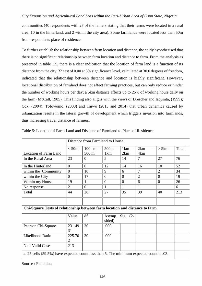
Urban encroachment on the hinterland occurs so fast that many farmers have lost their farmlands
located at the transition areas of the city. This compels farmers to travel daily from to their farmlands
located in the rural areas, and to the periphery of the expanding city centre from home. As presented
in table 1.5, farmers whose farms were located more than 5km away lived on the fringe and in rural
City Expansion and Agricultural Land Loss within the Peri-Urban Area of Osun State, Nigeria
146
communities (40 respondents with 27 of the famers stating that their farms were located in a rural
area, 10 in the hinterland, and 2 within the city area). Some farmlands were located less than 50m
from respondents place of residence.
To further establish the relationship between farm location and distance, the study hypothesised that
there is no significant relationship between farm location and distance to farm. From the analysis as
presented in table 1.5, there is a clear indication that the location of farm land is a function of its
distance from the city. X2 test of 0.00 at 5% significance level, calculated at 30.0 degrees of freedom,
indicated that the relationship between distance and location is highly significant. However,
locational distribution of farmland does not affect farming practices, but can only reduce or hinder
the number of working hours per day; a 5km distance affects up to 25% of working hours daily on
the farm (McCall, 1985). This finding also aligns with the views of Drescher and Iaquinta, (1999);
Cox, (2004); Tofowomo, (2008) and Taiwo (2013 and 2014) that urban dynamics caused by
urbanization results in the lateral growth of development which triggers invasion into farmlands,
thus increasing travel distance of farmers.
Table 5: Location of Farm Land and Distance of Farmland to Place of Residence
Source : Field data
Location of Farm Land
Distance from Farmland to House
< 50m 100 m -
500 m
500m -
1km
1km -
2km
2km -
4km
> 5km Total
In the Rural Area 23 0 5 14 7 27 76
In the Hinterland 0 0 12 14 16 10 52
within the Community 0 10 9 6 7 2 34
within the City 0 17 0 0 2 0 19
Within my House 19 1 0 0 6 0 26
No response 2 0 1 1 1 1 6
Total 44 28 27 35 39 40 213
Chi-Square Tests of relationship between farm location and distance to farm.
Value df Asymp. Sig. (2-
sided)
Pearson Chi-Square 231.49
3a
30 .000
Likelihood Ratio 225.70
2
30 .000
N of Valid Cases 213
a. 25 cells (59.5%) have expected count less than 5. The minimum expected count is .03.
Ghana Journal of Geography Vol. 9(3), 2017 pages 132–163
147
Rate of Urbanization and Farmland Encroachment.
A number of studies (Lopez et al., 2001; Bhatta, 2010; and Bankole and Bakare, 2011) have shown
the effect of uncontrolled and unplanned urbanization, in the form of sprawl, on vegetation and
agricultural land-uses, subjecting peri-urban areas to multiple activities (Appiah et al., 2014) which
are mostly informal. This study findings revealed that 27.2% of the farmers’ lands were registered
with the government and there were authorized statutory documents to this effect, while 60.4% of
farmlands had not been registered with the government; about 12.4% failed to indicate their farm
status. Nonetheless, the state does not have any land designated for farming within the urban and
peri-urban areas, as farm lands are owned by individuals/families.
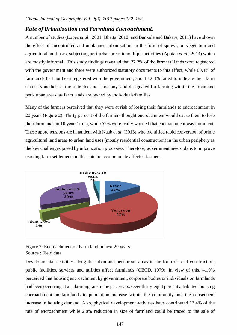
Many of the farmers perceived that they were at risk of losing their farmlands to encroachment in
20 years (Figure 2). Thirty percent of the farmers thought encroachment would cause them to lose
their farmlands in 10 years’ time, while 52% were really worried that encroachment was imminent.
These apprehensions are in tandem with Naab et al. (2013) who identified rapid conversion of prime
agricultural land areas to urban land uses (mostly residential construction) in the urban periphery as
the key challenges posed by urbanization processes. Therefore, government needs plans to improve
existing farm settlements in the state to accommodate affected farmers.
Figure 2: Encroachment on Farm land in next 20 years
Source : Field data
Developmental activities along the urban and peri-urban areas in the form of road construction,
public facilities, services and utilities affect farmlands (OECD, 1979). In view of this, 41.9%
perceived that housing encroachment by government, corporate bodies or individuals on farmlands
had been occurring at an alarming rate in the past years. Over thirty-eight percent attributed housing
encroachment on farmlands to population increase within the community and the consequent
increase in housing demand. Also, physical development activities have contributed 13.4% of the
rate of encroachment while 2.8% reduction in size of farmland could be traced to the sale of

City Expansion and Agricultural Land Loss within the Peri-Urban Area of Osun State, Nigeria
148
farmland by family members, communities and or land speculators, among other land tenure
associated problems. Other ways in which agricultural farmlands were at risk included: 21.2%
farmland sold off in exchange for money, 16.6% land lost due to land tenure systems triggered by
communal and or familial clashes, 15.7% government acquired land and 14.3% who personally
developed part of their farmland for housing.
Urban dynamics and development contribute to the extinction or shrinking of farmlands (Fred et al.
2004). Table 1.6 reveals that in the past 20 years existing farmlands were used for other purposes
or were vacant open spaces. For instance, 30.9% were vacant 20 years ago, and 23.0% were just
open spaces. 17.5% were used for compound farming or poultry on fenced residences while only
16.6% of existing farmlands were fenced to avoid intruders gaining access. About ten percent has
been used as farmland for 20 years now. Currently, 49.8% of respondents used their land for farming
activities alone, and 21.7% for both farming and housing, a practice that is often common among
farmers engaged in poultry, aquaculture and domestic animal rearing. About 12.9% carried out
farming and other commercial activities, whereas only 2.3% of farmlands had been turned into
outright residential spaces because farming became less lucrative or due to old age. Therefore,
current usage of land may vary from one study area to another and from one individual farmer to
the other, as indicated in table 1.7.
Table 1.6:Peri-urban land use dynamics in the last 20 years
Source : Field data.
Table 1.7: Current peri-urban Land use dynamics 2014.
Peri-urban land use 20yrs Ago Respondents %
Vacant Land 67 30.9%
Fenced Property 36 16.6%
Open Spaces 50 23.0%
Residential Land Development 38 17.5%
Farmland 21 9.7%
No Response 5 2.3%
Total 217 100.0%
Current Uses of Land 2014 Respondents %
Farming Only 108 49.8%
Residential and Farming 47 21.7%
Residential Only 5 2.3%
Farming and Mixed uses 25 11.5%
Farming and Commercial 28 12.9%
No Response 4 1.8%
Total 217 100.0%

Ghana Journal of Geography Vol. 9(3), 2017 pages 132–163
149
Source : Field data
Planning is futuristic. The study attempted to project the status of existing farmlands in the next 10
years from the farmers’ perspective. Above thirty percent farmers perceived that their farmland
would still be used for farming, 32.3% envisaged encroachment in the form of residential layouts,
22.6% expected a mixed land use (farmland and residential development), 11.1% mixed land use
(farmland and commercial development) while the remaining 1.4% expected their land to be used
for commercial purposes within the next 10 years.
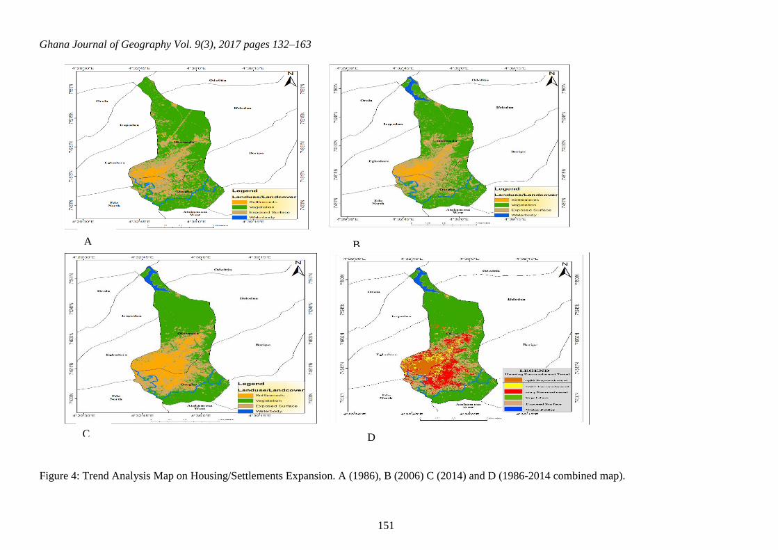
Spatio-temporal Analysis of Farmland and Settlement Expansion
A supervised classification was performed by creating a spectral signature curve of various land use
classes created (Settlements, Vegetation, Water body, and Exposed surfaces). The classified map
was generated for the years 1986, 2006 and 2014 with ground-truthing for verification. Land
Modelling Change actually indicates how vegetation has been covered up by housing expansion. As
shown in Table 7 it was observed that settlement has been on the increase from 6.60865% in 1986
to 20.11178% in 2014 while vegetation has been decreasing, from 62.69045% in 1986 to as low as
54.02527% in 2014. Other factors contributing to encroachment on agricultural farmlands include
water bodies and exposed surfaces. Due to fish farming, snail rearing, canal dredging and drainage
construction in the study area, water bodies have also changed from 0.81% in 1986 to 1.94% in
2014. Though this is still a negligible increase in amount of water bodies, it still claims part of the
land cover. Hence exposed surfaces include open spaces, tarred and un-tarred roads, walkways,
drainages, bare grounds, play grounds, cleared sites, development sites, grazing lands and any other
lands that are not covered with vegetation. Exposure surface also has shown tremendous increase in
percentage over the years as indicated in Table 8 below.
Table 1.8: Changes in the Land uses; Encroachment Trends on Vegetation Cover
Area (Hectares) Area (Percentage)
Landuse/Landcover
Year
1986
Year
2006
Year
2014
Year
1986
Year
2006
Year
2014
Settlement 978.03 1206.45 2976.39 6.60865% 8.152108% 20.11178%
Vegetation 9277.71 8615.34 7995.33 62.69045% 58.21475% 54.02527%
Exposed Surface 4423.5 4690.17 3539.88 29.89005% 31.69197% 23.91934%
Water body 120 287.28 287.64 0.810852% 1.941181% 1.943613%
Total 14799.24 100%
Source: Field data
Table 7 shows that there has been a drastic change in settlements, vegetation, exposed surfaces, and
water bodies. Therefore, table 8/figure 3 shows gains and losses of various land uses resulting from

City Expansion and Agricultural Land Loss within the Peri-Urban Area of Osun State, Nigeria
150
human developmental activities to provide shelter and for aesthetics. Thus, basic net changes
occurred from the core towards the fringe/suburbs whereby loss of vegetation recorded 1402
hectares of land, exposed surfaces had shrunk to the extent of 884 hectares while settlements had
increased tremendously by 1998 hectares of land at the expense of agricultural farmlands, farming
practices and activities, thus threatening food security of the state
Figure 3: Gains and losses in Hectares between 1986 and 2014
Source: Field data
Table 9: Land use changes in hectares
Source: Field data
Figure 4 shows the extent of housing expansion on agricultural farmlands (Vegetative Cover). This
has indicated the trends of 30 years, how physical development has caught up with suburbs, fringes,
and peripheries from the city centre (Osogbo), Osun State. The settlement (built-up areas) was
observed to have moved towards the Eastern and Northern parts of the city with little expansion
towards the South. This is so because the city is located at the South-Western part of the state, so it
is built-up already.
Gains and losses between 1986 and 2014 Net change between 1986 and 2014
Land use/Land cover Gains Losses Land use/Land cover Change in Hectares
Settlements -178 2176 Settlements 1998
Vegetation -2441 1039 Vegetation -1402
Exposed surfaces -2692 1808 Exposed surfaces -884
Water body 0 288 Water body 288
Ghana Journal of Geography Vol. 9(3), 2017 pages 132–163
151
Figure 4: Trend Analysis Map on Housing/Settlements Expansion. A (1986), B (2006) C (2014) and D (1986-2014 combined map).
A B
C D

City Expansion and Agricultural Land Loss within the Peri-Urban Area of Osun State, Nigeria
152
Conclusions and Recommendations
City expansion has resulted from increased urban population and physical development. The rates at
which large expanses of agricultural lands in the urban fringes are taken up by human activities and
development are alarming. Many arable lands have been converted into built-up areas (settlements),
with significant value added to housing production to meet the immediate housing demand for Osogbo,
Olorunda and their environs. Farmlands and farmers in the rural fringes continue to lose their farmlands
to various developmental projects with no compensation or consideration for their livelihood and food
production.
In the next 10 years, development would have caught-up with arable lands in the fringes of Osogbo
and its environs. Housing encroachments were observed to be uncontrolled due to weak government
response to the trend of unplanned city expansion,leaving peri-urban farmers exposed to the negative
shocks of urbanization.
Recommendations
The registration of land for agricultural activities by farmers is suggested by the study to help curtail
the loss or fear of losing their farmlands.
There is an urgent need to carry out the Master Plan Renewal to secure the agricultural lands,
particularly the government owned farm settlements in the state.
It is very important to consider vertical development as against the dominant horizontal development
to curtail the increasing land demand and supply that will edge out land for agriculture.
New residential developments along the peri-urban areas should protect the rights of existing
agricultural land by conserving arable lands to support farming activities.
Integrating UPA into residential layout designs remains an option towards maintaining secure tenure
for farmers and farming activities.
There should be proper compensation for forced eviction, encroachment, and conversion of farmlands
into housing development and physical infrastructure, and relocation must be organised for the affected
farmers to continue their farming practices.

Ghana Journal of Geography Vol. 9(3), 2017 pages 132–163
153
References
Abdissa, F. K. (2005) Urban Expansion and the Livelihood of the Peri-Urban Agricultural Community:
The Case of Addis Ababa. Unpublished Thesis, The School of Graduate Studies of Addis Ababa
University.
Acheampong, R. A., and Anokye, P. A. (2013). Understanding Households’ Residential Location
Choice in Kumasi’s Peri-Urban Settlements and the Implications for Sustainable Urban
Growth. Research on Humanities and Social Sciences, 3(9), 60-70.
Acquah-de Graft, H., and Onumah, E. (2011). Farmers’ Perceptions and Adaptations to
Climate Change: An Estimation of Willingness to Pay. AGRIS, 3(4): 31-39.
Addo, K. A. (2010) Urban and Peri-Urban Agriculture in Developing Countries Studied using Remote
Sensing and In Situ Methods. Remote Sensing 2010, 2, 497-513; doi:10.3390/rs2020497
www.mdpi.com/journal/remotesensing
Adeboyejo, T. and Abolade, O. (2007), Household Responses to Urban Encroachment on the Rural
Hinterland in the Ogbomoso Urban Fringe, Nigeria.
http://www.populationenvironmentresearch.org/workshops.jsp#w2007
Ademiluyi, I. A., Okude, A. S., and Akanni, C. O. (2008), Appraisal of Landuse and Landcover
Mapping in Nigeria, African Journal of Agricultural Research, 3(9), 581-586.
Adesina F.A, (2005). Geo-information and Natural Resources Exploitation in Africa; United Nations
Economic and Social Council. Paper Delivered in Fourth Meeting of the Committee on
Development Information, Addis Ababa on 23-28 April.
Adjekumhene I. (2002). The Impact of Development on the Environment. Paper presented at the
Annual Seminar of the general practice division of Ghana institution of surveyors on
19Septenber 2002. KNUST, Kumasi.
Agbola, T. and Ojeleye, D. (2007), “Climate Change and Food Production in Ibadan, Nigeria”,
African Crop Science Conference Proceedings, El-Mina, Egypt Vol.8, pp.1423-1433.
Aluko, O. (2010). Rule of Law, Planning and Sustainable Development in Nigeria, Journal of
Sustainable Development in Africa, 12(7), 88-95, Clarion University of Pennsylvania, Clarion
Pennsylvania.
American Planning Association (APA), (2002). Planning for Smart Growth of the State Of
States. Chicago: American Planning Association. Policy Guide on Smart Growth. Retrieved
from Http://Www.Planning.Org/Policyguides/Smartgrowth.Htm (Accessed 27 September,
2017).
Amoateng, P., Cobbinah, P. B., and Owusu-Adade, K. (2013). Managing physical development in peri-
urban areas of Kumasi, Ghana: A case of Abuakwa. Journal of Urban and Environmental, 7(4),
96-109. http://dx.doi.org/10.4090/juee.2013.v7n1.096109.
City Expansion and Agricultural Land Loss within the Peri-Urban Area of Osun State, Nigeria
154
Angel, S., Sheppard, S., and Civco, D. (2005). The Dynamics of Global Urban Expansion. Washington,
DC: World Bank.
Anosike, V., and Fasona, M. (2004). Gender Dimensions of Urban Commercial Farming in
Lagos, Nigeria. Urban Agriculture Magazine, 12, 27-28.
Appiah, D. O. Bugri, J. T. Forkuo, E. K. and Boateng, P. K. (2014). Determinants of Peri-Urbanization
and Land Use Change Patterns in Peri-Urban Ghana. Journal of Sustainable Development; Vol.
7, No. 6; 2014 ISSN 1913-9063 E-ISSN 1913-9071 Published by Canadian Center of Science
and Education
Appiah, D. O., Osman, B., and Boafo, J. (2014). Land Use and Misuse; Human Appropriation of Land
Ecosystems Services in Ghana. International Journal of Ecosystem, 4(1), 24-33.
Apte, P. M. (2008), Planning and Development of Peri Urban Areas: Financing and Management of
Infrastructure. Paper submitted to the 56th National Town and Country Planners Congress of
ITPI at Kolkata, India, December 2007 URL: http://www.wikio.com/article/78882466.
Araya, 2009Araya, Y. H. 2009. Urban Land Use Change and Modeling: A Case Study of Setubal and
Sesimbra, Portugal. University of Munster, Institute for Geo-informatics. Munster: University
of Munster.
Arko-Adjei, A. (2011). Adapting land administration to the institutional framework of customary
tenure; the case of peri-urban Ghana. Sustainable Urban Areas, 39, 284. The Netherlands.
Aronoff, S. (2005), Remote Sensing for GIS Managers,Redlands, ESRI Press.
Asamoah, B. (2010). Urbanisation and Changing Patterns of Urban Land Use in Ghana: Policy and
Planning Implications for Residential Land Use in Kumasi. Unpublished MSc Dissertation,
Department of Planning, KNUST.
Awotodunbo, A.A. (2012). Improving Climate Change Coping Strategies among Crop Farmers in
Nigeria. Paper presented at the Agricultural Extension Society of Nigeria (AESON) Conference
Proceedings, Vol 17, Pp. 1-10. ISSN: 1595 – 1421.
Ayuk, E.T. (2001). Social, economic and policy dimensions of soil organic matter management
in sub-Saharan Africa: Challenges and opportunities. Nutrient cycling in agro-ecosystem. 61:63
183-195 (www.springerlink.com/ content/gt87- 225276n/138) viewed on l0th November 2007.
Badlani, B., Patel, A.N., Patel, K. and Kalubarme, M.H. (2017) Urban Growth Monitoring using
Remote Sensing and Geo-Informatics: Case Study of Gandhinagar, Gujarat State (India).
International Journal of Geosciences, 8, 563-576. https://doi.org/10.4236/ijg.2017.84030.
Bankole, M. O. and Bakare, H. O. (2011). Dynamics of urban land use changes with remote
sensing: Case of Ibadan, Nigeria. Journal of Geography and Regional Planning, Vol 4, No 11,
pp 632-643.

Ghana Journal of Geography Vol. 9(3), 2017 pages 132–163
155
Bhatta, B. (2010). Analysis of urban growth and sprawl from remote sensing data, Springer Journal,
Vol. 20, No 170, pp 43- 57.
Birley, M. and Lock, K. (1999) The Health Impacts of Peri-urban Natural Resource Development.
International Centre for Health Impact Assessment, Liverpool School of Tropical Medicine.
Retrieved from http://agris.fao.org/agris-search/search.do?recordID=XF2015011384 accessed
on 14/06/2017.
Brain, I., Celhay, J.,Prieto, J. and Sabatini, F. (2009). Living in slums residential location preferences
in Santiago. Land Lines 24(4). Lincoln Institute of Land Policy: Cambridge, MA.
Bren d’Amour,C.,Reitsmac, F., Baiocchid, G., Barthele,S., Güneralpg, B., Karl-Heinz Erbh ,
Haberlh, H., Creutziga,F. and Setoi, K. (2017). Future urban land expansion and implications
for global croplands. Proceedings of the National Academy of Sciences of the United Stated of
America, vol. 114 (34) pp 8939-8943. Retrieved from
http://www.pnas.org/content/114/34/8939.full.pdf accessed on 29/09/2017.
Brennan, E M (1999) Population, Urbanization, Environment and Security: A Summary of the Issues,
Washington DC, Woodrow Wilson International Center for Scholars Comparative Urban
Studies Occasional Papers Series, 22.
Brook R. and Davila J. (eds).(2000). The peri urban interface. A tale of two cities. Gwasg Francon,
Bethesda, Wales.
Bryant, C.R. and Johnston, T. R. (1992). Agriculture in the City’s Countryside. Belhaven Press,
London.
Bugri, J. T. (2008). The Dynamics of Tenure Security, Agricultural Production and Environmental
Degradation in Africa: evidence from stakeholders in north-east Ghana. Land Use Policy, 25,
271-285. http://dx.doi.org/10.1016/j.landusepol.2007.08.002
Burchell, Robert W., Listokin, D. and Galley, C. (2000). Smart Growth: More Than a Ghost of
Urban Policy Past, Less than a Bold New Horizon. Housing Policy Debate, Vol. 1, No 4, pp
821-79.
Buxton, M. (2007). Change in Peri-urban Australia: Implications for Land Use Policies, Australia:
Department of Environment and Heritage Publishing Unit.
Chapman, L. S. (2005). Closing thoughts. The Art of Health Promotion, May/June 2005: pp 13-14.
Chirisa, I. (2010) Peri-urban dynamics and regional planning in Africa: Implications for building
healthy cities. Journal of African Studies and Development Vol. 2 (2) pp. 015-026.
CIAS. (2004). Women on Dairy Farms; Juggling Roles and Responsibilities. Centre for
Integrated Agricultural Systems (CIAS). Retrieved March 21, 2017, from http://www.cias.
wisc.edu/archives/

City Expansion and Agricultural Land Loss within the Peri-Urban Area of Osun State, Nigeria
156
Cohen, B. (2006). Urbanization in developing countries: Current trends, future projections, and key
challenges for sustainability. Technology in Society, 28(1–2), pp. 63–80
http://dx.doi.org/10.1016/j.techsoc.2005.10.005
Cox, W. (2004). Constraints on Housing Supply: Natural and Regulatory," Economics Journal
Watch, Vol. 8, No 1, pp 13-27.
Dima, S. J. and Ogunmokun, A.A (2004) Urban and Peri-urban Agriculture in Namibia. In:
Urban Agriculture Magazine no. 12, RUAF.
Dekolo, S. O and Olayinka, D. N. (2014). Monitoring peri-urban land use change with multi temporal
Landsat imagery. Retrieved from https://www.researchgate.net/publication/265476498
accessed on 13 August, 2017.
Dekolo, S. O. and Nwokoro I. I. C. and Oduwaye, O. A. (2013) Peri-urban Land Use Change in the
Lagos Megacity. Retrieved from https://www.researchgate.net/publication/265476845
accessed on 13 August, 2017.
Drabkin, D. H. (1977). Land Policy and Urban Growth, London: Pergamon Press.
Drescher. A. W. and Iaquinta D. L. (2000). Defining Peri-urban: Understanding Rural- Urban
Linkages and their Connection to Institutional Contexts, Paper Presented at the Tenth World
Congress, IRSA, Rio.
Drescher, A.W. and Iaquinta, D. L. (1999). Urban and Peri-Urban Food Production. Available at
FAO/AGPC.
Edeoghon, C.O., Ajayi, M. T. and Ugboya, T.O. (2008) Awareness and Use of Sustainable
Agricultural Practices by Arable Crop Farmers in Ikpoba Okha Local Government Area of Edo
State. Journal of Sustainable Development in Agriculture and Environment Vol. 3(2):55-63
April. 2008 ISSN 0794-8867
Egunjobi, L., Jelili, M. O. and Adedibu, A. A. (2008). Regional Development Planning in Nigeria: The
General and the Particular. Journal of Social Science, 16 (2), pp.135-140.
Ewuim, S.C., Nzegwu, N.Y. and Anasos H.U.(1998). Sustainability in traditional agriculture in the
tropics. In Badejo, A. and Togun, A. (Eds.). Strategies and tactics of sustainable agriculture in
the Tropics. College Press Ltd. Oyo State, Nigeria: 1:32-44.
Fazal, S. (2000). Urban expansion and loss of agricultural land – A GIS based study of Saharanpur
City, India. Environment and Urbanization , 12(2), pp. 133-149.
Feder, B. (1997). Sowing preservation—Towns are slowing invasion of farms by bulldozers.
New York Times, pp. 1-19.
Food and Agricultural Organization (FAO) Reports 1998-2006 Report by Joint CILSS/FAO/news
net/SIMA/WFP food market assessment mission to Benin, Niger and Nigeria titled Special
Report on market, prices, food situation and prospects for Benin, Niger and Nigeria.

Ghana Journal of Geography Vol. 9(3), 2017 pages 132–163
157
Food and Agriculture Organization (FAO) and International Institute of Tropical Agriculture
(lITA) (1999). Agricultural policies for sustainable management and use of natural resources
in Mrica. FAO and lIT A 81 pp.
Food and Agricultural Organization FAO (1999). Spotlight Issues in urban agriculture Studies suggest
that up to two-thirds of the city and peri-urban households are involved in farming
http://www.fao.org/ag/magazine/9901sp2.htm.
Food and Agriculture Organization (FAO) (2001). Urban and Peri-Urban Agriculture: A Briefing
Guide for the Successful Implementation of Urban and Peri-urban Agriculture in Developing
Countries and Countries of Transition. FAO Revision 2, Handbook Series 3: 1-84.
Francis, C.A and Youngberg, G. (1990) Sustainable agriculture: An overview. In Francis, C.A,
Flora, C.B. and King, L.D. (Eds). Sustainable Agriculture in Temperate Zones. John Wiley and
Sons, New York. Pp.1-23.
Fred, L.Lupala, J.Meshack, M. and Kiunsi, R. (2004). Managing Urbanisation and Risk Accumulation
Processes: Cases from Dares Salaam. Tanzania, University College of Lands and Architectural
Studies.
Gbadegesin, J. T., Oladokun, T. T. and Ayorinde, O. I. (2010). Urban Renewal as a tool for Sustainable
Urban Development in Nigeria: Issues and Challenges. Journal of Sustainable Development
and Environmental Protection, 1 (1), 57–68.
Gould, W.T. (1988). Rural-urban interaction and rural transformation in tropical Africa, in Rimrner,
D., (Eds.). Rural transformation in tropical Africa. Belhaven Press, London, England.
Government of Swaziland (1997) The Draft Peri-Urban Growth Policy, 1997, Retrieved on
http://www.ecs.co.sz/periurban/pup_periurban_policy.htm accessed on 09/08/2010.
Gündel, S. (2006). A Report on Synthesis of Urban and Peri-Urban Agricultural Research.
Commissioned by the Renewable Natural Resources Research Strategy (RNRRS) Programme.
Headey, D.D and Jayne, T.S. (2014) Adaptation to land constraints: Is Africa different? Food
Policy 48 (2014) 18–33.
Hewitt, M. (1989) Defining rural areas: Impact on Health Care Policy and Research. Health Program,
Office of Technology Assessment, Congress of the United States, Washington, DC.
Ilbery, B., 1987. The development of farm diversification in the UK: evidence from Birmingham’s
urban fringe. Journal of the Royal Agricultural Society of England 148, 21–35.
Irwin, E. G. and Geoghegan, J. (2001). Theory, Data, Methods: Developing Spatially Explicit
Economic Models of Land Use Change. Agriculture, Ecosystems and Environment, 85, 7-23.
http://dx.doi.org/10.1016/S0167-8809(01)00200-6.
ISOCARP (2015). “Hungry city, insatiable metropolis’ ISOCARP workshop October 19-20,
2015

City Expansion and Agricultural Land Loss within the Peri-Urban Area of Osun State, Nigeria
158
Jayne, T.S., Yamano, T., Weber, M., Tschirley, D., Benfica, R., Chapoto, A., Zulu, B., (2003).
Smallholder income and land distribution in Africa: implications for poverty reduction
strategies. Food Policy 28 (3), 253–275.
Johnson, J.H. (1974) Suburban Growth, Geographical Process at the Edge of the Western City,
Aberdeen: Aberdeen University Press.
Kareem, R. O. and Raheem, K. A. (2012). Review of Urban Agriculture as a Tool for Building Food
Security in Nigeria: Challenges and Policy Options. Journal of Sustainable Development in
Africa. Vol. 14 (3): 1-12.
Kasanga, K. and Kotey, N. (2001). Land management in Ghana: Building on tradition and modernity.
London: International Institute for Environment and Development. Retrieved from:
http://pubs.iied.org/pdfs/9002IIED.pdf accessed on 14 August, 2016.
Kavitha, A., Somashekar, R.K. and Nagaraja, B.C (2015). Urban expansion and loss of
Agriculture land - A case of Bengaluru city. International Journal of Geomatics and
Geosciences Vol. 5 (3).
Kessler, A., F. Streiffeler and E. Obuobie. (2004) Women in Urban Agriculture in West Africa.
In: Urban Agriculture Magazine no. 12, RUAF.
Kleemann, J., Nana Inkooma, J., Thiel, M., Shankard, S., Lautenbache, S.and Fürst, C. (2017). Peri-
urban land use pattern and its relation to land use planning in Ghana, West Africa. Landscape
and Urban Planning 165 (2017) 280–294.
Kwasi N. G. (2004). Urbanization Process – Environmental and Health Effects in Africa. Population
Environment Research Network (PERN) Cyber seminar, Urban Expansion: The Environmental
and Health Dimension.
Lambin, E. F., Geist, H. J. and Lepers, E. (2003). Dynamics of Land-Use and Land Cover Change in
Tropical Regions. Annual Review of Environmental Resources, 28, 205-241.
Lawry, S, Samii C, Hall, R, Leopold, A, Hornby, D, Mtero, F. (2014). The Impact of Land Property
Rights Interventions on Investment and Agricultural Productivity in Developing Countries: A
Systematic Review. Campbell Systematic Reviews 2014: 1
Lesschen, J. P., Verburg, P. H., and Staal, S. J. 2005. Statistical methods for Analysing the Spatial
Dimension of Changes in Land Use and Farming Systems. The International Livestock
Research Institute. Nairobi, Kenya: LUCC Focus 3Office.
Lopez, T. D. and Thomlinson, J. H. (2001). Urban expansion and the loss of prime agricultural lands
in Puerto Rico, Ambio: A Journal of the Human Environment Vol 30, No. 1, pp 49-54.
Mabogunje, A. L. (2002) Reconstructing the Nigeria City: The New Policy on Urban Development
and Housing, Amole, D. et al (eds), The City In Nigeria, (2002), Proceedings of a National
Conference. Obafemi Awolowo University Ile – Ife, Nigeria, pp 1 – 9.

Ghana Journal of Geography Vol. 9(3), 2017 pages 132–163
159
Magaso, L. A. (2009). City Fathers taking us for a ride. Herald, the Zimpapers: Harare.
Malizia E. E. (2005). City and Regional Planning: A Primer for Public Health Officials. The Art of
Health Promotion, pp 1-12.
Mandere, M. N., Ness, B. and Anderberg, S. (2010). Peri-urban development, livelihood change and
household income: A case study of peri-urban Nyahururu, Kenya. Journal of Agricultural
Extension and Rural Development, 2(5), 73-83.
Mascarenhas, O. (1999). Gender Aspects of Urbanization and Natural Resource Management. In: D.
Masika R., de Haan A. and Baden Lee-Smith, (Eds.). (1999). Women Managing Resources: African
Research on Gender, Urbanization and Environment. Mazingira Institute, Nairobi.S. (2002).
Urbanisation and Urban Poverty: A Gender Analysis. Report prepared for the Gender Equality
Unit, Swedish International Development Cooperation Agency (SIDA). Report of NRSP
Project R8491.
Maxwell, D. (1995) Labour, land, food and farming: a household analysis of urban agriculture in
Kampala, Uganda, Unpublished PhD Dissertation, University of Wisconsin-Madison, United
Mok, H., Williamson, V. G., Grove, J. R., Burry, K., Barker, S. F. and Hamilton, A. J. (2014).
Strawberry fields forever? Urban agriculture in developed countries: a review. Agron. Sustain.
Dev. (2014) 34:21–4.
Monzon, A. (2015). Smart Cities Concept and Challenges: Bases for the Assessment of Smart
City Projects. In M.Helfert., K.Krempels., C.Klein., B. Donnellan. and O. Gusikhin. (Eds.)
Smart Cities, Green Technologies, and Intelligent Transport Systems. 4th International
Conference, SMARTGREENS, 2015 and 1st International Conference VEHITS 2015, Lisbon,
Portugal, May 20-22, 2015, Revised Selected papers. Springer.
Morton, J. F (2007). The Impact of Climate Change on Smallholder and Subsistence Agriculture. The
National Academy of Sciences of the USA
Mougeot, L. J. (2000). Urban agriculture; Definition, presence, potentials and Risks, and Policy
Challenges. IDRC, Cities feeding people series. Report 31.
Mugish, J. and Nyandwi, E. (2015). Kigali City Peri-Urbanization and its Implications on Peri-Urban
Land Use Dynamics: Cases of Muyumbu and Nyakaliro. GeoTechRwanda 2015 – Kigali, 18-
20 November 2015.
Muttitanon, W. and Tripathi, N. K. (2005). Land Use/Land Cover Changes in the Coastal Zone of Ban
Don Bay, Thailand Using Landsat 5 TM Data. International Journal of Remote Sensing, 11,
pp.2311-2323.
Naab, F. Z., Dinye, R. D. and Kasanga, R. K. (2013). Urbanisation and its Impact on Agricultural
Lands in Growing Cities in Developing Countries: A Case Study of Tamale in Ghana. Modern
Social Science Journal, 2, No. 2, 256-287.

City Expansion and Agricultural Land Loss within the Peri-Urban Area of Osun State, Nigeria
160
Nabulo, G., G. Nasinyama, D. Lee-Smith and D. Cole. (2004) Gender Analysis of Urban
Agriculture in Kampala, Uganda. In: Urban Agriculture Magazine no. 12, RUAF.
Nelson, A. C., and Wachter, S. (2002). Smart Growth and Housing Policy. Retrieved from
Http://Www.Huduser.Org/Publications/Pdf/Brd/ 08Nelson.Pdf (Accessed 27 September 2017)
New Society Publisher, Canada.
NRI/UST 1997 (1997). Kumasi Natural Resource Management Research Project. Inception Report 1.
DFID Project R6799. NRI Greenwich/UST Kumasi, pp. 134.
Odhiambo, M. O. (2015). Land Policies and their Implications for Smallholder Agriculture in Africa:
A Review of Policies in Six Countries. AGRA.
Ogu, V. I. (1999). Evolutionary Dynamics of Urban Land Use Planning and Environmental
Sustainability in Nigeria, Planning Perspectives, 14(4), 347-368, Routledge, London.
Okuneye, P. A. (2002) Rising Cost of Food Prices and Food Insecurity in Nigeria and its
Implication for Poverty Reduction. CBN Economic and Financial Review, Vol. 39 N0. 4.
Olima, W. H. A., (2003). Urbanisation and Housing Challenges. Cities in Africa Conference.
Rapporteur’s report.
Organisation for Economic Co-operation and Development (OECD) 1979. Agriculture in the
planning and management of peri-urban areas Vol 1, No. 94.
Organisation for Economic Co-operation and Development (OECD), (2007) The Growing Peri-Urban
Phenomenon, Report of One Week Conference held in France.
Osuocha, I. L. (2006). Towards sustainable urban growth: A critical review of city development
strategies(1986-2006). (Unpublished thesis) Department of Architecture, Imo State University,
Owerri.
Oyesiku, K and Alade, W. (2010). Historical Development of Urban and Regional Planning in Nigeria
State of Planning Report, Nigerian Institute of Town Planners.
Parfrey, N. D. (2002). What Is Smart Growth? Retrieved from
Http://www.Sierraclub.Org/Sprawl/Community/Smartgrowth.Asp (Accessed 27 September,
2017).
Piorr A, Ravetz, J and Ivan Tosics (2011) Peri-urbanization in Europe: Towards a European policy to
sustain urban-rural futures; Synthesis report of the PLUREL project; PLUREL Consortium;
Copenhagen http://www.plurel.net/images/Peri_Urbanisation_in_Europe_printversion.pdf
Pothukuchi, K and Kaufman, J.L (2000). The food system A strange to the planning field, JAPA
Vol.66 No.2, Spring 2000, pp. 113-124.
Rahaman, S. A. (2008). Women’s involvement in agriculture in Northern and Southern Kaduna
State. Journal of Gender Studies, 17,pp.17-26.http://dx.doi.org/10.1080/09589230701838347.

Ghana Journal of Geography Vol. 9(3), 2017 pages 132–163
161
Ravetz, J., Fertner, C. and Nielsen, T. S. (2013). Remaking Cities Contradictions of the recent urban
environment. In K. Nilsson, S. Pauliet, S. Bell, C. Aalbers, and S. Nielsen (Eds.), Peri-urban
futures: Scenarios and models for land use change in Europe (pp. 13-44). Routledge.
Publications, New York, USA and Canada.
Resource Centre for Urban Agriculture and Food Security (RUAF) (2016). Urban agriculture what and
why. Available at www.ruaf.org/urban-agriculture-what-and-why. Retrieved on the 10th
January, 2017.
Rimal, B. (2013). Urbanization and the Decline of Agricultural Land in Pokhara Sub-
metropolitan City, Nepal. Journal of Agricultural Science, Vol. 5 (1).
Roca, Z. (1993), Urbanization and rural women: Impact of rural-to-urban migration: UN.
RUAF (2004). Women Feeding Cities; Gender Mainstreaming In Urban Food Production and Food
Security Proceedings of the Workshop Jointly organised by ETC-RUAF and CGIAR-Urban
Harvest in collaboration with IWMI-Ghana 20-23 September 2004 Accra, Ghana
Sarfo-Mensah, P.; Adam, M. 1998. PRA analysis of land use changes in peri-urban Kumasi, Ghana.
in: Drechsel, P. and Gyiele, L. (Eds). Going on farm: Approaches, experiences and lessons
from Africa. IBSRAM proceedings 19, Bangkok, Thailand.
Satterthwaite, D., McGranahan, G. and Tacoli, C. (2010). Urbanization and its implications for food
and farming. Philosophical Transactions of the Royal Society B: Biological
Sciences, 365(1554), pp.2809–2820. http://doi.org/10.1098/rstb.2010.0136
Seto, K. C. and Fragkias, M. (2005). Quantifying Spatiotemporal Patterns of Urban Land-use Change
in Four Cities of China with time series landscape metrics. Landscape Ecology (2005) 20:871–
888. DOI 10.1007/s10980-005-5238-8.
Smart Growth America. (2003). What Is Smart Growth? Retrieved from
Http://Www.Smartgrowthamerica.Org/Whatissg.Html (Accessed 27 September, 2017).
SPFS (Special Program for Food Security) 2001 Urban and Peri-Urban Agriculture. Retrieved from
http://www.fao.org/spfs/ accessed on 17 September, 2016.
Steel, C (2008). Hungry city: How food shapes our lives, Chatto and Windus, pp. 400
Sustain (2011). Good planning for good food: How the planning system in England can support
healthy and sustainable food, January 2011, pp. 31.
Taiwo, O.J. (2013). Farmers’ choice of wetland agriculture: checking wetland loss and
degradation in Lagos State, Nigeria. GeoJournal 78:103–115.
Taiwo, O.J. (2014).Determinants of peri-urban and urban agricultural locational choice
behaviour in Lagos, Nigeria. Land Use Policy 39:320–330.

City Expansion and Agricultural Land Loss within the Peri-Urban Area of Osun State, Nigeria
162
Titilola, S. T. (2000). Environment and sustainable agricultural development in Nigeria.
Retrieved from
(www.jsdafrica.com/jsda/spring%20/200/artic1es/environment%and%sustainable)
accessed on 13 November 2007.
Tofowomo, A. (2008). The Planning Implications of Urban Sprawl in Akure. Proceedings of the
44th International Society of City and Regional Planners (ISOCARP) Congress, on the 23rd-
26th September, 2008.
Turan, S. O., Kadiogullari, A. I., and Gunlu, A. (2010), Spatial and Temporal Dynamics of Land Use
Pattern Response to Urbanization in Kastamonu. African Journal of Biotechnology, 9(5), 640-
647.
Tyler, P. E. (1994). Nature and economic boom devouring Chinas farmland. New York Times,
pp 1-8.
United Nations Development Programme. (1997). Governance for Sustainable Human Development,
UNDP, New York.
United Nations Development Programme, (2011) Project facts, Nigeria: Assessment of good urban
governance. Global Programme on Governance Assessments. Retrieved fromOctober 2011.
http://www.beta.undp.org/content/dam/undp/documents/partners/civil_society/Africa%20For
um%20on%20Civil%20Society%20and%20Governance%20Assessments/Fast_Facts_Nigeria
.p accessed on 21 July, 2017.
United Nations. (2004). World urbanization prospects: the 2003 revision Data tables and highlights.
New York: United Nations; 2004.
U.S. Environmental Protection Agency. (2002). National Award for Smart Growth Achievement
2002 Winners. Publication EPA 231-F-02-002. Washington, DC: U.S. Environmental
Protection Agency.
USGS. (2010) West Africa land use and land cover trends project. Land cover applications and global
change. U.S. Department of the Interior U.S. Geological Survey. Retrieved from:
http://lca.usgs.govWorld accessed on 21 July, 2017.
Van der Linden, S. (2015). Mapping Urban and Change Detection. 6th ESA Advanced Training Course
on Land Remote Sensing. Humboldt-Universität zu Berlin, Germany.
Webster, D. (2002). On the Edge: Shaping the Future of Peri-Urban East Asia; Stanford University;
Stanford. Retrieved from http://iis-db.stanford.edu/pubs/20031/Webster2002.pdf accessed on
21 July, 2017.
Wilken, G.C. (1991). Sustainable agriculture is the solution but what is the problem? Occasional
Paper No 14, United States Agency for International Development, Washington DC. Pp. 1-19.

Ghana Journal of Geography Vol. 9(3), 2017 pages 132–163
163
World Bank, (2000). World Development Report 1999/2000. Entering the 21st Century. New York,
World Bank.
World Bank. (2009). World Development Report 2009: Reshaping economic geography. World Bank,
Washington, DC.
Zasada, I. (2011). Multifunctional peri-urban agriculture-A review of societal demands and the
provision of goods and services by farming. Land Use Policy 28 (2011) 639–648.