Embed Size (px)
Citation preview

Report No: 2005R035
Cornwall Industrial Settlements Initiative
ROCHE
(Hensbarrow Area)
2005

ii

CORNWALL INDUSTRIAL SETTLEMENTS INITIATIVE Conservation Area Partnership
Name: ROCHE Study Area: Hensbarrow
Council: Restormel District Council NGR: SX 06 84
Location: Mid Cornwall, 6 miles north-west of St Austell.
Existing CA? No
Main periods of industrial settlement growth:
1820s; c.1900 Main industry:
Tin-streaming; china clay
Industrial history and significance Roche was a churchtown, an administrative, ecclesiastical, manorial and service centre. It was never simply, perhaps hardly at all, an industrial settlement, although tin-streaming was still important in the 18th/early 19th centuries, and may partly have stimulated the creation of the location/smallholding settlement here. Later industry was located away from the village – industrial settlements sprung up close to the actual works. Roche remained a place of some quality and pretensions, as befitted its historical role, with a remarkable collection of high status sites and variety of buildings. Workshops, trades and services served the traditional part industrial/mainly agricultural economy, but there was an undoubted increase in scale because of the 19th century growth in the clay industry. Roche’s significance in an industrial context is as a measure of the complexity and diversity of the traditional churchtown settlement as it was affected by industrial development in its hinterland, as a control against which to measure such complexity (or lack of it) in the more purely industrial settlements.
Other comments Priority issues in Roche are the urgent need to review the future of Tregarrick farm, farmhouse and adjacent cottage; their potential loss would tear the very heart out of the historic settlement. A longer term issues is the mitigation of the effects of traffic and traffic management running through the village. Recommendations Historic areas
• Proposed conservation area
• Prepare full CA appraisals
• Protect open areas that contribute to character
• Protect historic landscapes around the village
• Article 4 Direction to control PD on single dwelling houses and alteration and partial demolition of small buildings in CA
• Article 4 Direction to control alteration and partial demolition of walls in CA
iii

Historic buildings
• Review Statutory List.
• Prepare list of locally significant buildings Policy and management
• Full survey of archaeological potential and additional policy requiring archaeological investigation and recording prior to development
• Limit or restrict development on outskirts
• Recognise back-land areas and rear lanes as an important aspect of Roche’s character
• Promote interpretation of settlement and links to adjoining sites
• Further study (1): historic patterns of ownership
• Further study (2): architectural, development and social history of the Tregarrick Farm complex
• Further study (3): development and design of the Old Rectory/church ornamental landscape complex
• Designation of the grounds of the Old Rectory/glebe complex as an Historic Garden Of Local Importance
• Undertake a full survey of existing trees and ornamental landscapes and take protection measures
• Institute management plans for the surviving agricultural landscapes and the 19th century ornamental landscapes
• Undertake a fully integrated review of existing policies of traffic and traffic management measures and produce design guidance specific to the B 3274 in its passage through the village
• Review design and development briefs for specific sites, particularly the Tregarrick Farm brief.
• Site-specific design guidance for the village, based on a detailed audit of materials, designs, details and character, both of standing buildings and of street paving materials.
• Concentrate restoration/enhancement schemes on some of Roche’s important focal points
• Develop a co-ordinated policy for the restoration, retention, conversion, and/or re-use of commercial properties
iv

Conservation Area Partnership
Cornwall Industrial Settlements Initiative ROCHE
(Hensbarrow Area)
The Cahill Partnership
and
Historic Environment Service
Cornwall County Council
2005
Report No: 2005R035
v

Acknowledgements
This report presents the results of an assessment carried out by the Cahill Partnership following desktop research by Bryn Perry Tapper (CAU). Assistance was also provided by Terry Clarke, Restormel District Council. The report text and map drafts were prepared by the Cahill Partnership and edited by Peter Herring (CISI Project Manager CAU). The report maps were produced by John Brinkhoff (CCC Planning Directorate Technical Services Section) from roughs prepared by the Cahill Partnership.
Front cover illustration: Roche from the air (CCC HES F41/P54 – 24/06/1993)
©Cornwall County Council 2005 Cornwall Archaeological Unit, (Historic Environment Service), Planning, Transportation and Estates, Cornwall County Council, Kennall Building, Old County Hall, Station Road, Truro, Cornwall TR1 3AY. All rights reserved. No part of this document may be reproduced, stored in a retrieval system, or transmitted in any form or by any means without the prior permission of the publisher.
vi
Contents Page
1 Introduction .................................................................................................................9 1.1 Background................................................................................................................................9 1.2 Project Aims ..............................................................................................................................9 1.3 Project methodology ................................................................................................................9 1.4 Date of Assessment ..................................................................................................................9
2 Location and setting .................................................................................................. 10 2.1 Geographical location ............................................................................................................10 2.2 Landscape setting....................................................................................................................10
3 History and physical development (Fig 2) ................................................................ 10 3.1 Pre-1809 ...................................................................................................................................10
3.1.1 Economic activity...............................................................................................................10 3.1.2 Extent of settlement...........................................................................................................12
3.2 1809-41 .....................................................................................................................................13 3.2.1 Economic activity...............................................................................................................13 3.2.2 Extent of settlement...........................................................................................................14
3.3 1841-1880.................................................................................................................................14 3.3.1 Economic activity...............................................................................................................14 3.3.2 Extent of settlement...........................................................................................................16
3.4 1880-1906.................................................................................................................................17 3.4.1 Economic activity...............................................................................................................17 3.4.2 Extent of settlement...........................................................................................................18
3.5 1906-1946.................................................................................................................................19 3.5.1 Economic activity...............................................................................................................19 3.5.2 Extent of settlement...........................................................................................................19
3.6 Post 1946..................................................................................................................................20 3.6.1 Economic activity...............................................................................................................20 3.6.2 Extent of settlement...........................................................................................................20
4 Current Character (Figs 3 & 4) ..................................................................................20 4.1 General .....................................................................................................................................20 4.2 Distinct areas of character in Roche ....................................................................................21
4.2.1 Churchtown/Glebe............................................................................................................21 4.2.2 Fore Street ...........................................................................................................................23 4.2.3 The lower town...................................................................................................................24 4.2.4 Chapel Road/Tremodrett Lane........................................................................................26
4.3 Built environment ...................................................................................................................26 4.3.1 Public/ecclesiastical buildings ..........................................................................................27 4.3.2 Housing................................................................................................................................27 4.3.3 Industrial, commercial and outbuildings.........................................................................29 4.3.4 Materials and local details..................................................................................................31
4.4 Landscape, panoramas and views.........................................................................................32 4.4.1 Landscape setting, greenery and open spaces ................................................................32 4.4.2 Vistas, views, glimpses and streetscape ...........................................................................33
5 Industrial significance................................................................................................33 6 Designations (Fig 4)...................................................................................................34
6.1 Scheduled monuments ...........................................................................................................34 6.2 Historic buildings....................................................................................................................34 6.3 Historic area designations ......................................................................................................34 6.4 Other designations..................................................................................................................34
vii

7 Current issues and forces for change .........................................................................35 7.1 Designation review .................................................................................................................35
7.1.1 Conservation area ...............................................................................................................35 7.1.2 Historic buildings ...............................................................................................................35
7.2 Archaeological potential.........................................................................................................36 7.3 Open areas ...............................................................................................................................37 7.4 The setting of Roche Rock ....................................................................................................37 7.5 Tregarrick Farm development...............................................................................................38 7.6 Other historic buildings and streetscapes............................................................................38 7.7 The Road..................................................................................................................................39 7.8 Island Settlement.....................................................................................................................39
8 Recommendations .....................................................................................................40 8.1 Historic areas ...........................................................................................................................40 8.2 Historic buildings ....................................................................................................................41 8.3 Policy and management .........................................................................................................41
9 References ..................................................................................................................44 9.1 Primary Sources.......................................................................................................................44 9.2 Publications..............................................................................................................................44
Appendix: Gazetteer of archaeological sites and historic buildings .................................45
List of figures Location map Historical development Surviving historic components Gazetteer sites, existing designations and recommendations
Abbreviations in main text
AGHV Area of Great Historic Value AGSV Area of Great Scientific Value AONB Area of Outstanding Natural Beauty CA Conservation Area CAU Cornwall Archaeological Unit (Historic Environment Service, CCC) CCC Cornwall County Council CISI Cornwall Industrial Settlements Initiative GPDO General Permitted Development Order HES Historic Environment Service, Cornwall County Council HERS Heritage Economic Regeneration Scheme (English Heritage) HLF Heritage Lottery Fund (ing) LB Listed Building OALS Open Areas of Local Significance to Settlement Character OS Ordnance Survey PD Permitted Development SPG Supplementary Planning Guidance THI Townscape Heritage Initiative (Heritage Lottery Fund) [1] Site number on Figure 4 and in the gazetteer (Appendix)
viii
1 Introduction 1.1 Background Cornwall’s industrial settlements are the subject of a Conservation Area Partnership under the heading Cornwall Industrial Settlements Initiative (CISI). This partnership between English Heritage (with the Heritage Lottery Fund), Cornwall County Council, and the District Councils is intended to assess the character and significance of the County’s industrial settlements. These include villages, ports and towns associated with Cornwall’s 19th century industrial revolution, based on metalliferous mining, slate and granite quarrying, and china clay extraction. The historic importance and distinctive character of such settlements has previously been undervalued, and their existing status does not adequately represent the industrial history of the county. CISI is aimed at redressing this imbalance.
1.2 Project Aims The aim of CISI is to produce a settlement by settlement analysis in order to obtain an overview of the history, present character and importance of Cornwall’s industrial settlements. This will help determine where, for example, new Conservation Areas should be designated (and existing ones revised), and could provide the basis for Conservation Area Statements (to be drawn up subsequently for District Conservation Officers).
1.3 Project methodology The methodology involved historical research, followed by a site visit(s). For the historical research, a date range of 1750 to 1945 was chosen, as this represented the period of industrial growth and decline in Cornwall. Archaeological and historical sources housed at CCC (see Section 9.1) were consulted, together with Listed Building data supplied by the District Councils. Using this information, Ordnance Survey base maps were hand coloured to show: the different phases of historical development; surviving historic components from each development phase; archaeological sites, key historic buildings, and statutory designations. These maps (which formed the basis for Figures 2-4), together with copies of the primary sources consulted, were bound into a folder for each settlement, for use during site visits.
The focus of the site visits was to assess settlement character and consider ways in which this could be protected and enhanced in the future. This was achieved using a checklist drawn from Conservation Area Practice: English Heritage’s guidance on the management of Conservation Areas (1995) and Conservation Area Management - A Practical Guide (published by the English Towns Forum, 1998). The maps compiled during the historical phase were enhanced during the site visits, particularly with information relating to the survival and significance of historic buildings, and a general photographic record (colour prints) was made of each settlement. Meetings on site were arranged with the District Conservation Officers in order to discuss current initiatives and recommendations for future management.
1.4 Date of Assessment Roche was assessed as part of CISI during March 2003
9

2 Location and setting 2.1 Geographical location Roche is situated in central Cornwall about half a mile or so south of the A30 where it passes over Goss Moor, 6 miles north-west of St Austell and about 8 miles from Bodmin. Victoria (Roche Station) with its station and industrial estates is also about half a mile north-eastwards. Roche is on an ancient corssoroads of routes between St Austell and St Columb Major – Padstow, and Bodmin.
2.2 Landscape setting This parish is located on the edge of the high ground north of St Austell, surrounded by moorland wastes, and slightly elevated above Goss Moor to the north. The clay villages of Stenalees and Bugle are to the south-east. Tin was once extensivley worked on Goss Moor, and on the moorland slopes to the south of the churchtown; there was localised iron ore extraction in Roche in the 19th century. Both the rivers Par and Fal rise in this parish, as does a small stream that rises at Holy Well (Victoria) and flows into the River Camel. The chief villages hsitorically were the Churchtown, Belovely, Tregoss (both scarcely more than hamlets) and Trezaise; Roche Station/Victoria has been since the mid 20th century an ever expanding economic and population centre.
Roche sits on a locally prominent ridge, a spur of the high ground that rises to the height of over 300m above sea level at Hensbarrow Beacon; it overlooks a subsidiary valley of the headwaters of the Fal, various source streams of which meet in Goss Moor. This is good agricultural and grazing land enclosed by medieval field systems. The most striking landscape feature is the Rock itself, from which Roche takes its name. This extrusion of schorl sits to the south-east of the churchtown with Hensbarrow and the china clay works of Goonbarrow rising up beyond: Roche is adjacent to the northern extremity of the china clay area that stretches south, west and east from here.
3 History and physical development (Fig 2) This section should be read in conjunction with the mapped historical development in Figure 2.
3.1 Pre-1809 3.1.1 Economic activity
Churchtown
Roche churchtown is one of a number that ring the high ground of the Hensbarrow uplands. Its role as an ecclesiastical, administrative and local market and service centre was well-established and stable by the 11th century. There is the suggestion of an early Christian ‘lan’ site at the church, with a circular burial ground forming the nucleus of the present churchyard and a relevant place name (lantonan). There are Norman remains in the church itself, although Domesday records only Tremodret, the more distant of the two principal local manors: the principal churchtown manor of Tregarrick or Treroach was not recorded until the 12th century.
There appears to have been at Roche a more than locally significant religious/pilgrimage centre which may well have advanced the prosperity and function of the church and churchtown. There are a number of local springs and river sources, including the head waters of both the Par and Fal rivers - the place name Pentivale may suggest a holy spring rather than simply the head spring of the Fal - and there are recorded and surviving holy wells (Tremodret/Victoria) as well as a supposedly tidal and magical pool near Roche Rock. Another aspect of this cult/pilgrimage
10

centre is the Rock itself, crowned with its 14th century hermit’s cell, which gave its name to manor, family, village and parish.
Agricultural/service centre
By the late middle ages, Roche stood within an ancient landscape of agricultural fields, remains of which survive on all sides of the village. The church overlooks the crossing point of a principal east-west route through central Cornwall (Broad Lane/Harmony Road is the precursor to the 18th century turnpike road now followed by the A30 to the north of Roche) with an important north-south route from Padstow to St Austell bay and Mevagissey over the Hensbarrow uplands. It is about mid-way between a number of established late medieval centres (St Columb, Bodmin, and St Austell).
The stream valleys near the churchtown were long important for communications and for milling (grist mills for grain and fulling or tucking mills for cloth - Tremodret tucking mill is recorded in 1270).
The late medieval intensification of mining throughout the Hensbarrow/Blackmore area led to intensification and increase in agricultural activity which remained fairly constant right up to and into the 19th century. Enclosure, spread of agricultural land onto both the uplands and Goss moor and the increase of cash farming, all led to an increase in activity in the local service/marketing centres like Roche churchtown, as well as stimulating the creation of large agricultural holdings – the large farms at Tregarrick, Higher Trerank, the Rectory and elsewhere in Roche were already a major element in the make-up of the growing churchtown by the time they are first recorded in the 16th/17th centuries.
There were three well-established cattle (and pony) fairs by the late middle ages at Roche, continuing throughout the 19th century, while the Tregarrick manorial pound was located near the church.
Tin
The valleys have also been exploited since at least the late middle ages for tin streaming and associated stamping mills. It is difficult to talk of a truly pre-industrial phase in Roche’s history.
Roche was at the centre of the Blackmore stannary, the dominant tin-producing area in the south-west in the 14th/15th centuries. It stood at an important communications node and with extensive and rich tin streaming grounds in the upper Par and Fal valleys to the east and to the north and west (on Goss Moor), and with a major elluvial system on the slopes of Hensbarrow beacon itself, traces of which survive to the south of Roche.
Lode-back and shallow mining of local tin deposits such as at Great Beam (or Old Beam) on the parish boundary at what became Bugle are recorded by the 16th century. By 1691 reference is made in tin bounds in Trezaise to an old tin shaft, suggesting early development of deeper mining techniques in the area.
Post medieval to early 19th century activity is difficult to quantify. Tin streaming and mining declined markedly from the 16th century onwards, although there is evidence of continuing (if less productive) 18th century tin workings on Goss Moor and stream working around Roche well into the 19th century (including perhaps in the valley running through he present heart of the village).
11

China clay
By 1809, the developing china clay industry had scarcely impacted upon Roche. The major 18th century areas of activity were almost exclusively in the western part of the Hensbarrow uplands, in the parishes of St Dennis and St Stephens. Here were the early quarries and pits exploited by Cookworthy and his successors, and the first of the larger scale works developed by the Staffordshire potters. As a whole the industry remained small: in 1807 Trethosa pit (St Stephen’s) was one of the largest works but, only about nine feet deep, it produced only 300 tons per year.
We should not look, therefore, for much effect on the settlement at Roche; the vast impact china clay had in the later 19th/20th centuries tends to give a distorted view of its landscape and settlement importance at this early stage, although it may already have begun to make local demands for transport, servicing and infrastructure (including a stimulus to agriculture). 3.1.2 Extent of settlement
Like the old farming and manorial sites around it, the churchtown stands on the upper slopes of the valleys of the Fal headwaters which cut into the anciently enclosed plateau forming the gently sloping outer mantle of the main upland area to the south. Not surprisingly, therefore, the churchtown by 1809 included at least three large agricultural holdings (Tregarrick manorial farm, the glebe lands, Trerank farm) in addition to the church, churchyard and rectory (slightly separated from the churchtown by the glebe, in a way not unusual in many Cornish churchtowns). Associated with the manorial farm at Tregarrick were also the manorial pound and the fairpark. There was also at least one old-established inn (the Roche Rock Inn is said to have 16th century origins).
Amongst these larger complexes were individual cottages and commercial properties; the churchtown had probably been much like this for some considerable period. The 15th century rebuilding of the parish church reflects the wealth and activity generated by early commercialisation of local industry and agriculture.
The churchtown had already expanded by 1809 beyond its old nucleated core (marked approximately by the cottages north of Tregarrick Farm); buildings and plots running down Fore Street kept very close to the roadside, restricted on the west by the presence of the glebe lands. The properties on the east side of Fore Street show the regular plot sizes and depth running parallel to the road which they retain to this day, and hint at some degree of controlled development.
At the bottom of the hill was a second settlement hub which had developed on the major stream and road crossing point, with a mixed farming, workshop and cottage group, culminating in a farm complex newly enclosed from the edges of Goss Moor (now Parkwoon Close).
At a time (1801) when the whole parish only had a population of 954, the village would have seemed relatively more dominant locally than it did in the later 19th century.
The early development of evangelical Anglicanism and Methodism in Roche is a marked element of its history. It was partly explained by the personal impact of early supporters of Wesley (Trethewey of Trezaise, who held meetings at their house in that hamlet); perhaps even more significant was the friendship of the Anglican Rector himself, Samuel Furley, supported by the evangelical Clapham Sect, who eventually purchased the living of the church. The parish church and Methodist chapel were to retain extraordinarily close and friendly links in Roche throughout the 19th century. The mix of industry, commercial interests and independent farmers which distinguished Roche from other, perhaps simpler agricultural and more conservative settlements was important for the early hold of evangelical Protestantism in Roche. This is much more like
12
early, pre-industrial non-conformist patterns which developed amongst the commercial and skilled artisan classes in the towns of Cornwall than the typical miners’ or agricultural workers’ Methodism of later 19th century Cornwall.
3.2 1809-41 3.2.1 Economic activity
‘Roche….chiefly consists of open uncultivated commons; the inhabitants find employment on the small farms and in the stream-works.’
C S Gilbert, 1820
Agricultural/service centre
At the beginning of this period Roche depended on farming and tin streaming; its traditional role as parochial focus and agricultural service centre, with fairs, inns, smithies, mills, pound for stray animals and church to maintain the celebratory round of the farming year, continued almost without change, although these functions remain difficult to quantify or qualify compared with the increasing industrial activity in the village and parish.
Tin
Although tin production had declined since the high Middle Ages, it remained important, with tin streamers recorded in leasing agreements as resident in Roche. The overseers of the poor derived an income in the 1820s and 1830s from tin streaming sets, and the leasing and exploration of such sets was actively pursued throughout the period. At least one stream works on Goss Moor had a bob engine (giving its name to the set) showing some degree of investment in the industry, but it continued to decline in scale and importance.
At the same time, deep mining was developing, although most concerns were small, intermittent and not very successful. Great Beam was being worked as deep mine (rather than shallow lode-back or surface working) before 1830. By 1841 shafts had been sunk below 70 fathoms, with other mines worked at Belowda/Belovely and at the Cornubia/Roche Rock Mine, where, 70 tons of tin having been raised by 1836, a long period of closures, re-opening and further closure then set in.
Meanwhile, Great Beam was being worked from the early 1840s for clay – a sign of changing emphasis in local industry.
China clay
Between 1820 and 1858 there was a huge rise in demand for china clay for the pottery, textiles and paper industries. This was met largely by the opening of many new small pits, rather than deepening or intensifying production at old pits. In 1820 there were only 12 works in the Hensbarrow area; by 1845 this had quadrupled, while new china clay shipping facilities were developed at Pentewan harbour in 1826. Production in the industry as a whole grew from 2000 tons per annum to some 13000 tons by 1838.
While most new pits were still in the west and south of the wider area, this was also the period when the first of the major works in Roche opened – a lease dated 1828 gives permission to explore Littlejohns ground for clay, the first reference to what would become one of the principal china clay works. Wheal Prosper began production in the same period.
The dates, scale and impact of these early pits in Roche are difficult to quantify, but the population of Roche parish grew from 1,425 in 1811 to 2,041 in 1841, the biggest rise being
13

between 1831 (1,630) and 1841. Clay workings around Trezaise, Great Wheal Prosper and Gracca stimulated this growth. 3.2.2 Extent of settlement
The population increase between 1811 and 1841 was spread through a large parish. Much, if not most of it, was taken up by the creation of large numbers of smallholdings and groups of rural cottages outside the churchtown, by and large much closer to the clay pits.
However, this process also affected the churchtown, particularly in the creation of smallholdings and cottage holdings around the edge of the village and especially on the moor and waste which still came right up to the settlement – although whether this was for industrial workers or a more purely agricultural development is questionable. In any case, this period saw the doubling of the settlement, the creation of nearly all its streets and roads, the creation of Roche as it remained largely until the late 20th century.
To the north and east of the cross-roads and in the valley bottom, grids of small fields and attendant cottages were laid out along Edgecumbe Road, Broad lane, Chapel Road and Tremodrett Lane; this was land-lord controlled speculative development, not the traditional squatter or tin-streaming encroachment on waste or common land. The new Methodist Chapel, school, burial ground, cottage and shrubberies built here in 1835 gives a good indicative date for the whole process.
The (Wesleyan) Methodist Chapel itself replaced one built in 1810 in Manchester Square (by the crossroads), later used as a schoolroom. There was also a private school in a cottage near the new Methodist chapel.
The obvious prosperity and strength of the Methodist community was matched by that of the Anglican Church. The Rev Thomas Fisher (1819-34) rebuilt the church in 1822 in imitation, it is said, of the Methodist preaching chapel, and enlarged the churchyard. Parson Fisher also rebuilt the rectory (1822), imparked and landscaped the glebe lands, created the rookery plantation and the Avenue as a formal link to the church, and built a parish school and cottages near the Rectory gate. It is also clear that the old main east-west route that passed just north of the rectory was re-routed to the north, creating a new road – Harmony Road. The central junction in the lower town thus became a focus of all the new roads and developments, creating a new village focus.
Surviving buildings indicate that Roche was a favoured residential village – large private houses were built there in addition to the Rectory and Tregarrick (Harmony Cottage, 13-15 Fore Street, 1 Tremodret Lane). Cottages, inns and workshops of this date still survive, although anonymous in the historical record.
Roche churchtown by 1841 retained the impression of a service, agricultural and marketing centre; undoubtedly increasing in size and influenced by the general increase in economic activity in the Hensbarrow district, it was not really an ‘industrial’ settlement, but a service centre for an increasingly industrialised area.
3.3 1841-1880 3.3.1 Economic activity
Agricultural/service centre
Although never developing a formal market, Roche fairs remained extremely important and more than local occasions, held three times a year on the traditional fairpark for cattle, but also including ponies and large numbers of geese raised on Goss Moor, with the pleasure fair held along Fore Street.
14

The largest single group of ‘tradesmen’ in contemporary trade directories remained the farmers and the exceptionally large class of ‘cow keepers;’ very much a local phenomenon, many of these latter doubled as carters, market gardeners, clay agents etc, and were presumably dependent upon the extensive grazing rights on the moors, the three annual cattle fairs, the increasing demand from the local industrial population and the proximity of the railway station..
Anecdotal evidence suggest that many of the smiths, carpenters and wagon builders active in Roche built agricultural wagons and equipment as much as, perhaps even rather than ‘industrial’ goods (Creswell Payne), although as the following quote shows, as always, industry and agriculture were difficult to separate:-.
‘At some distance from both their cottages and their work the Tin-streamers build little turfen shelters for the nest of their store-geese. As soon as they are hatched, therefore, the goslings find suitable food in the neighbouring pools, marshes, rills and scattered patches of grass. As harvest approaches some two or three thousand young geese are sold off the moors to farmers who fatten them on the stubbles of several surrounding parishes.’ Henwood 1873 in Creswell Payne, p. 59.
Tin/iron
Despite Henwood’s description of tin-streamers in 1873, the decade 1870-80 probably saw the last of the traditional tin streaming on Goss Moor.
The scattered local tin mines continued in a somewhat desultory and sporadic fashion; they had a noticeable, if ultimately limited, economic impact on the district, enough for the 1856 Post office Directory of Cornwall to declare ‘This is a mining district’. Beam Mine was active in 1844, Cornubia Tin Mining Co. (Ltd.) was working Roche Rock mine, while the Rocks mine (nearer Bugle) was said to be unusually rich in tin - it nonetheless opened and closed at least three times in the period. Other mines included Wheal Gray, Belowda/Belovely (which in the ten years up to 1880 only produced 10 tons of tin) and those working Tremoels and Rosemellon tin lodes. The tin slump of 1870s killed them all off unless they could turn to clay, and by 1878 not a single tin mine was working in the area.
Iron
Unusually, a group of iron mines was active just to the west and south-west of Roche churchtown; that at Coldreath produced 14, 570 tons of iron ore in the 1850-70s, especially between 1856-64; Dyehouse sold 344 tons of iron ore in 1858 and Colbiggan produced 4,000 tons up to 1874. Just as with tin, however, the 1870s saw a slump, and by 1878, no iron mines were working locally either.
China clay
‘China clay is dug out in immense quantities from this neighbourhood and forms a large article of commerce in this and the adjoining parishes’ 1856 Post office Directory
This statement is qualified by other sources (Lake) which make it clear that the area was notable for the large quantities of tin which had been raised in the parish, and only latterly much china clay. But this was undoubtedly the great period of expansion in the clay industry in Roche parish.
The industry as a whole increased output from 65, 600 tons in 1856 to 552,384 tons per year by 1900, a growth associated with technical changes and increasing use of coal-fired pan-kilns, waterwheels, adit driving, pipelines, steam engines etc., all demanding an increased scale of materials, engineering and building skills, transport and supply. In Roche parish the pits were, for the most part, some distance from the churchtown, sited to the south and east (Wheal Prosper, Goonbarrow etc), and the chief settlement impact was actually the further development
15
of the entirely new settlements near the pits themselves. Having said this, most of the increasing output in the later 19th century was achieved by increasing technical improvements; the numbers actually employed in the clay industry did not continue to rise, and eventually declined in the late century, despite ever increasing tonnages of clay produced.
However the stimulus to trade and manufacture also affected Roche churchtown. At least one resident was described as a grocer and brick maker, and Roche was well placed to turn some of the traditional skills and trades of a rural centre to the new demands of the clay industry: Farmers and cow-keepers also worked as carriers, the large numbers of which are a feature of late 19th century trade directories of Roche. Their direct involvement with the clay industry is shown by the fact that, by the 1880s, at least three were described in directories as ‘cow keeper and clay agent’. Clearly the cottagers and former tin streamers-cum-agricultural labourers were turning to new forms of labouring.
Every 1000 tons of clay shipped to the tramways and railheads represented some 3-400 wagonloads. Roche stood in a gap between two mineral tramways, from Bugle to Par (1847), and Hendra, St Dennis, to Newquay (1849), until the opening of the Newquay rail link to Par in 1874, with a station at Victoria (Roche Station), 1 mile to the north-east of the village where there were sidings and a depot for clay. The output of the Littlejohn works was brought through the village and the station. Between 1872 and 1874 the old Treffry Tramway system was rebuilt and extended as a modern steam railway; the Cornwall Mineral Railway quickly captured the clay traffic from the broad gauge main line Company, as their new route to Fowey was shorter, and they also had a direct route to Par dock. Fowey developed rapidly as the major deep-water china-clay port, a position it holds to this day. The large pits in the south-east of the parish were already served by the Treffry tramway at Carbis. Despite these attempts to improve communications in the area, until well into the 20th century large quantities of china-clay were still moved laboriously from the works high on the Hensbarrow Moors to Charlestown and Par by horse-drawn wagons
Other rural crafts noted in Roche at this time servicing both the clay industry (heavily dependent on heavy wagons and wooden barrels for transport) and local farmers and tradesmen included wheelwrights, smiths, carpenters as well as shopkeepers, grocers, general merchants, boot/shoe makers etc, all traditionally concentrated in the churchtown.
Other industries
There seems to have been limited diversification in the local industries, although some other minerals were exploited – what became the Polpuff Quarry at Trezaise opened in the late 1870s, digging feldspar–rich pegmatite used for glass making and pottery glazes. 3.3.2 Extent of settlement
Despite the increasing scale of activity around Roche, the settlement itself expanded only modestly over this period. While this may disguise some increased density of buildings and occupation within the built up area, it accurately reflects a stagnation and eventual decline in the population of the parish from a peak in 1841 (2,041) to 1,681 in 1881.
At a relatively early stage, the continuation of the development of smallholdings in Edgecumbe Road, Broad Lane and Tremodrett Lane changed to providing cottages in much smaller gardens. This reflects a change in emphasis from new smallholdings relative to new cottages seen throughout Hensbarrow in 1840-80 as compared to 1805-40.
The village was slightly enlarged by the new schools, further extensions to the churchyard and to the farm complex at Tregarrick Manor Farm. There was extensive redevelopment and increased
16
density of building in the central junction area with new cottages and larger houses, commercial premises and the Temperance Hall.
The character and social mix of the village is revealed by trade directories: - it continued to have a much greater mix of classes and trades (and quality houses for them) than the more purely ‘industrial’ settlements around it, with several gentry and professional people, including the rector, Methodist ministers, a surgeon, mine purser, school teacher and agent, and one or two ‘private residents’. This was a favoured residential village with large private houses. This reflects rising prosperity associated with the growth of local investment in agriculture, industry and the railway; secondary wealth created by increased servicing, carrying, farming and food supply and local investment by tradesmen and shopkeepers in the increasing number of small clay pits: what was said of St Austell in the mid 19th century may also have been true in a small way of Roche:-
‘……. to see new mansions that have been lately built by persons who only a few years since were standing behind the counter or working at their trades and are now independent gentlemen’ Mining Journal, 10th November 1866 in B 53.
There was a wide range of craftsmen, inn keepers (The Roche Rock and Commercial Inns), traders, shopkeepers, drapers, grocer, merchants and so-on typical of a mid 19th century churchtown. As the social, service, religious and trading centre for the extensive agricultural area around, the facilities in the churchtown continued to expand: a National school was built in 1856; a Board School was built in 1871, the Methodist school in 1874 (the chapel restored in 1877, by Silvanus Trevail). In a village where the Anglican hold remained strong, however, it was Thomas Pearce, the rector in 1841-63 in whose memory the combined village hall, Temperance Hotel, and working men’s institute was set up.
While these facilities developed, the industrial element in the local population was still scarcely noticeable. As the mid 19th century development of the clay works (and the tram and rail systems that served them) entered the same sort of scale in the Roche parish area as elsewhere in Hensbarrow, it actually expanded the newer settlements, Trezaise, Carbis, Bugle, Victoria etc, and this was where most of the workers lived, not at Roche churchtown. These had a much more overtly industrial character than Roche – they were, for instance, where the Bible Christian and Primitive Methodist chapels were, much more typical of working class and industrial populations in Cornwall. The Wesleyan Methodists in the churchtown were, at this time, made up of small farmers, agricultural workers, shopkeepers and tradesmen as much if not more than clay workers (a pattern continued into the 20th century – see Phillipps, 1994).
3.4 1880-1906 3.4.1 Economic activity
Agricultural/service centre
The continuing importance of the cattle and pony fairs was one factor in Roche acquiring a branch of the Cornish bank opening on Saturdays and, significantly, fair days.
Tin
As for tin, there was a brief revival of deep mining around Roche in about 1900; Bunny Hill, for instance, worked 1902-7, quite successfully for tin and wolfram, but closed soon after. As with other local ventures the company was unable to meet the cost of pumping out the deepening levels.
17

China clay
The clay industry continued expanding, albeit rather in fits and starts. The area around Trezaise developed significantly as a part of the continued overall expansion of the clay industry, which produced a total of 552,384 tons per annum by 1900 (compared with 65, 600 tons in 1856). The pattern already set in the mid 19th century continued, with ever wider use of dry-kilns, steam engines etc. and increasing rail and tramway access, more local sidings (especially round Carbis, which became a local centre of all sorts of processing and trans-shipping activities), although well into the 20th century large quantities of china-clay were still moved laboriously from the works by horse-drawn wagons.
Other industries
Brick-making on an industrial scale was established in Roche parish, at Carbis, in 1883, the Carbis brick and Tile works near Roche station becoming one of the most important in the area.
The continuing expansion of traditional industries and crafts to meet both industrial and agricultural demand is reflected in the presence of four saw mills in Roche in the later 19th century. 3.4.2 Extent of settlement
Despite the expanding scale of the clay industry at this time, the population of Roche parish continued to decline, from 1,681 in 1881 to 1,624 in 1901.
As with the range of industrial and economic activity, the character of Roche as a settlement was already long established by 1880 and continued pretty much unchanged for the rest of the 19th century. The numbers of gentry, private residents and professional men (surgeon, teachers, mine engineer, clay merchants) in the village continued to rise, while many of the surrounding farmers and landowners clearly looked to the village for professional services. The importance of this farming community is reflected by the continuing importance of the cattle and pony fairs and the branch of the Cornish bank that opened on Saturdays and fair days, although this undoubtedly also reflected commercial activity generated by servicing the china clay industry too.
The full range of services available to the locals by the 1890s included the train station, with post office, omnibus services, the Methodist Chapel, the significantly rebuilt parish Church (1893), the Temperance Hall, which also acted as the village hall and working men’s institute and a range of shops (including the Co-op), trades and services (surgeon, bank, auctioneer, watchmaker) beyond the usual craftsmen and grocers shops.
The ever increasing numbers of farmers and cow keepers who doubled as carriers and clay agents hint at the influence of the clay industry elsewhere in the parish and wider area, much of the new or rebuilt housing near the temperance hall in the centre of the village may have been for clay workers, but the reminiscences of the parish historian hardly suggests it was dominant in Roche:-.
Fifty years ago there were several flourishing business – carpenters and builders, blacksmiths etc….At the carpenters’ one used to witness the whole process of the making of agricultural wagons, carts etc......There were at least four saw-pits in Roche…’
Creswell Payne, writing in 1949 of Roche in about 1900.
18

3.5 1906-1946 3.5.1 Economic activity
Tin
Much was hoped for from the introduction of modern methods of dredging the alluvial tin deposits on Goss Moor; between 1910 and 1915 £120,000 was invested in gas and steam-worked dredging with scarcely any return.
Such tin as was produced locally was mainly a by-product of the clay working; although hardly enough to be recorded, sufficient was produced to keep at least one set of tin stamps associated with Old Beam mine/clay works by Bugle working until 1944.
China clay
By now demand for china clay was world-wide, and more changes in technology and organisation kept production on the increase. These included the high-pressure hose first used in the Hensbarrow area in 1877 but only accepted practice by the mid 1920s; the introduction in 1911 of filter presses as an adjunct to the pan kiln effecting great savings in drying time and coal; increasing use of electricity. The rail system further expanded creating more sidings and reaching more pits; at the same time, after 1918, the use of casks was phased out, cooperages closed and, perhaps particularly relevant to Roche, the availability of cheap motor-lorries after the Great War meant the end of the horse teams and their wagoners.
The growing demand for the products of the industry was curtailed by the two world wars and the trade depression of the 1930s; the clay industry came almost to a standstill as export markets disappeared. The industry re-organised, in a series of amalgamations, with the largest company (English China Clays Ltd) controlling 50% of the industry's production in 1919 and (as English Clays, Lovering, Pochin & Co) 75% in 1932.
Other industries
The Carbis brick and Tile works continued to thrive throughout the period. A new venture was the Roche Glass Mine or Polpuff glass works set up in 1920 exploiting the old Trezaise pegmatite quarry. The quarry had been re-opened in 1917, during the First World War, to provide feldspar for electrical porcelain. 3.5.2 Extent of settlement
The parish population grew modestly in the first half of the 20th century, from 1,624 in 1901 to 1,965 in 1931. The increase was reflected in the continuing provision of significantly large areas of housing, first started around 1900. By 1946, with most of the new housing only recently built, this had created the largest increase in the size of the settlement since the 1830s, much of it indeed infilled the grid of plots which had been laid out along Chapel Road at that time. As well as individual bungalows or villa-style houses, there were improved cottages built in small estates – that along Tremodret Lane at least was specifically built for clay workers; a second, larger estate was built isolated from the main village along harmony Road.
There were too many houses simply to meet the local population rise, many were for families re-housed as the older farms and hamlets of the moors continued to be swallowed up by the advancing clay pits and dumps. This was less a reflection of an industrial character in Roche itself, more an example of the developing phenomenon of the island settlement – settlement development concentrated in established population centres rather than scattered around close to the works, as had been the pattern before.
19

3.6 Post 1946 3.6.1 Economic activity
After the 1939 to 1945 war china clay production was effectively in the hands of one large company; pits continued to close or merge, the remaining ones becoming much larger and deeper, their waste spreading out over huge areas but at the same time employing more technology and far fewer people (handfuls rather than dozens or hundreds as in the 19th century). Production at the end of the 20th century stood at about 3 million tons per year, and the hugely expanded scale of the industry has not only destroyed vast acreages of countryside, but there has been an increased loss of cottages, rows, entire hamlets and re-settlement of population within the so-called Island Settlements, like Roche. The process had already begun before 1946, so that, notwithstanding an overall population growth in the parish (1,660 in 1951 to 2,360 in 1991), the council houses and modern housing estates represent a shift rather than a growth in the industrial population. 3.6.2 Extent of settlement
Post-war growth in Roche has been almost entirely in the provision of extensive housing estates, a process still ongoing. Much of the earliest housing from 1946 was in the form of the ‘Cornish Unit’, a standardised housing type, some of the earliest of which were built here at Roche, using china clay sand as aggregate. The size of the settlement has increased beyond any reference to its historical bounds or character. It has expanded at a much greater rate relative to population growth in the rest of the area, in part a reflection of the slightly elevated level of services and shops it has always provided, in part a reflection of the ever decreasing availability of land outside the island settlement – Roche has always had the added advantage of being just slightly outside the main extraction areas, and therefore rather more attractive than some alternative settlements.
4 Current Character (Figs 3 & 4) 4.1 General Roche was always a churchtown – an ecclesiastical, administrative, marketing and service centre rather than overtly an industrial settlement. There was certainly an industrial element in the population (the terraced housing in Tremodrett Road and Chapel Road [102-106] was reputedly built for clay workers), and much of the economic prosperity and employment here was linked to the dominant china industry. However the numerous smithies, wheelwrights, saw pits, workshops and shops also clearly served a thriving agricultural population. The population of the village has always been agricultural (including the part-time smallholders, also active as industrial labourers and carriers), commercial and what was termed in 19th century trade directories as ‘private’ or ‘gentry’, which included Anglican and non-conformist clergy, school teachers, retired businessmen and professionals. This historic range of people, of uses of buildings, of scales of wealth, all still informs the very varied character of the village today – very far in character indeed from many of the ‘industrial’ villages of the Hensbarrow area.
Historically there were three main aspects to Roche’s character. First was the churchtown set amid its fossilised medieval landscape, with church, rectory, large farms and Inn; second was the lower town, with shops, houses, cottages smallholdings and chapels; thirdly, and joining the two is the late 19th century rebuilt commercial core around the central road junction (and spreading up Fore Street). These divisions are to some extent still maintained and visible today, preserved in part by the Local Plan development boundary and other designations, and by the ability of the generously scaled plots and open, low density grid of the early 19th century ‘location’ settlement to absorb a large degree of 20th century development. Only in recent years has housing spread
20

beyond this grid and the historic limits of the settlement, and encroached upon virgin greenfield land, the remnant open fields of the medieval landscape.
The scale of recent development in and around Roche is hard to grasp. The historic village was not small geographically – it spread over a relatively wide area, but densities were low, for the most part. The most striking characteristic of Roche is that there are very few tightly packed terraces and buildings away from the central crossroads. The village is mostly made up of individual, detached buildings standing in good sized, often very generous plots. The total number of buildings and population was not, therefore, large; a few hundreds have in the last 2-3 decades turned into a population of some 2000 and growing - the size of many a small Cornish town.
As a result, the range of shops and facilities in Roche has remained quite large, including a Co-op store, butchers, baker, newsagent, post office, hairstylist, video shop, garages, two pubs, takeaway food shops, sports and recreation grounds, village and church halls, Infant/Junior school, various clubs and associations and a GP's surgery.
Despite this concentration, the negative impact of the main road running through the village has had the effect of creating a sense of a lack of focus in the townscape and downgrading the appearance of many of these shops and facilities. The traffic, and the engineering and management measures that have been put into place to control it, are without exception negative in their effect on the character and appearance of the village core.
The main road is, unfortunately, what most people see and know of Roche, but there is much else of often startling quality, both of individual buildings, and whole areas and streetscapes. There are distinct sub-areas with discernibly different characteristics much of it scarcely touched by the noise and pollution of the through-roads. These areas do sometimes merge (Fore Street in particular acts as a link between the churchtown and the lower town), sometimes there is a quite abrupt transition, a matter of yards, from one to the other (in appearance, in the types of buildings, in the levels of noise and pollution – as between Fore Street and Tremodrett Road or Victoria Road and Chapel Road).
4.2 Distinct areas of character in Roche 4.2.1 Churchtown/Glebe
The churchtown itself is split between that side that focuses on the top roundabout (the junction of Fore Street, Trezaise Road and the road to Carbis and Bugle) and the other side along the western fringes of the village.
Around, or in close proximity, to the dangerous junction by the War Memorial are the church and churchyards, war memorial, commercial premises, public toilet, the Rock Inn car park, the playing fields, and most worrying perhaps, the village school; a little further away is housing and the public cemetery. This junction area should be part of a publicly accessible space; it is the focus of much of the social and recreational activity in the village, the part most visited perhaps by outsiders and visitors. Instead it is an over-engineered traffic junction with site lines and sweeping approaches which make it easier for traffic to pass through at excessive speed – as a brief observation on site quickly reveals – and which creates a barrier between the various parts of the churchtown. However, with more than just a superficial observation, it is clear that, despite the effect of the road, the ancient nucleated churchtown focused on the church is still remarkably intact, as either standing fabric or as archaeologically recorded and sensitive sites. Here are church, glebe and rectory, manorial pound (in the pub car-park), the church farm (Trerank), the village inn and the manorial farm (Tregarrick); this is the historic heart of Roche, for centuries, indeed, this was Roche.
21

The churchtown was historically more obviously a nucleated settlement, with buildings on the west side of Fore Street (roughly where the entrance to the new vicarage now is) emphasising the direct historical, visual and physical relationship with the Rock Inn and Tregarrick Farmhouse and the adjacent cottage. These latter two buildings are integral parts of the churchtown, rather than merely the top end of Fore Street; they are built on a different alignment to the rest of Fore Street, and both site and standing fabric are of considerably greater antiquity. This group (including the farm buildings) is, with the exception only of the church and churchyard, the oldest in the village in terms of its archaeological significance and its surviving buildings, containing at least late 18th century/early 19th century fabric, probably much earlier, and in the case of the Rock Inn by repute at least 16th century.
In a slightly wider context, Roche Rock must also be considered as part of the context, at least, of the churchtown. Roche was the centre of a pilgrimage network (see History); the visual, physical and metaphysical link between the parish church and the chapel on the Rock is an important part of the character of the churchtown (the parish church is dedicated to St Gonand of the Rock), and in return, of the setting of the Rock, perhaps the most famous monument in central Cornwall. Sadly what was once an unimpeded view, with a direct relationship between these two vastly important sites, is being gradually eroded by the intrusiveness of the road and, perhaps even more damagingly, by the poorly sited and badly detailed boundaries, bland buildings and, worst of all, excessive spotlights towers of the Trezaise Road Sports facilities; all could have been laid out, designed and built on this same site with much greater sensitivity. It now has the appearance and all the charm of an open prison.
Given the low level of attainment in the public realm, it is hardly surprising that other aspects of the streetscape here are beginning to show loss of character and quality (the car-parking area to the housing estate south of the church, and the forecourt and back-yard of the early 20th century commercial buildings [55] immediately adjacent to the churchyard). Neither enhances the setting of the church or the streetscape. Similarly, there has been significant loss of enclosure and historic hedges to the pub car-park, while, no matter that the Rock Inn itself remains an attractive building, the signage, especially the free-standing signs in the grounds, are garish and intrusive. Throughout this area, the loss of hedgerows and trees has been the most consistent element of damage; much of the historic character, and quality could easily be restored by attention to this simple element of landscaping and enclosure.
Immediately away from this unnecessarily, but remediably, damaged streetscape is a timeless, ancient world of old lanes, high Cornish hedges, huge, impressive, mature trees and historic structures. The church, exposed on the roadside, becomes part of a veiled, protected space, inward-looking and enclosed. Adjacent are the old house plots and townplace of Higher Trerank – one of the oldest sites in the village, still with two fine 19th century houses, a number of part-ruinous outbuildings, which may be themselves even older, and mature, decorous gardens, into which even a modern bungalow comfortably sits. The unmetalled track bounded by its high, thick hedges, runs out into open countryside; the china clay dumps beyond are at some distance, emphasising that industry was always at some remove.
The rural character, the dominance of trees above all, continues down the Avenue, laid out in the 1820s to connect the church with the new Rectory. The Glebe Field between the rectory and church was turned, in effect, into a small area of parkland (the medieval stone cross in the Glebe Field is perhaps in its original position). The Avenue, Glebe Field and Old Rectory are a single complex with the church – the church is treated almost as an eye-catcher at the end of the ornamental grounds. The glebe was, theoretically, inalienable land belonging to the church that could not be sold or developed; it is part of the context and setting of the Old Rectory, of the church, of Fore Street, acting as an informal open space, almost (in visual terms) as a village green. It retains its park-like character today, despite the top end being enclosed for the building
22
of a new vicarage – an appropriate use perhaps, although the building itself is lacking in character. The rest of the Glebe Field remains as an open paddock; the current use (for horses) is appropriate, as long as the access, facilities and stabling do not become excessive.
The Old Rectory itself is the largest, most elegant, most impressive of local buildings (as befits a living in the hands of aristocratic, but evangelical, Clapham Sect of London). Around it is a complete miniature park, with avenue, eye-catcher, ha-ha, pleasure grounds, walled garden, follies (the medieval crosses), outbuildings, agricultural buildings (including the surviving piggery [40]), even that most treasured of status symbols in any parkland, the re-routing of the public road away from the grounds (Harmony Road was laid out as replacement in the 1830s for the old road, now a footpath north of the Rectory).
Something of this genteel, park-like character extends the churchtown/rectory area into other, later, parts of the village (see below – ‘the lower town’), around the grounds of the large houses at the western end of Harmony Road, for instance, or, closer to the heart of the village, number 1 Tremodrett Road [78]. This early 19th century house with its large enclosed garden is scarcely less grand than the rectory itself and as far from an industrial cottage as it is possible to get, a telling reminder of the wealth and social status of many of Roche’s inhabitants at the time. 4.2.2 Fore Street
The first stage of growth away from the churchtown was along Fore Street. There is a change in date, alignment and character north of the Tregarrick Farm Cottage [68] – the immediately adjoining cottage row is perhaps up to 100 year later than the Cottage. Much of the current character of Fore Street, all the way down to its junction with Harmony Road/Victoria Road, dates from the major changes of the first decades of 19th century. At this date the church was heavily altered (1822), new Rectory was built (1822) and the old east-west road re-routed into the newly created Harmony Road. It is clear that much of Fore Street was re-built at the same time – most of the surviving buildings are of a similar style and date (stone built, four-square with round arched central doorways); the plots have a regularity, especially on the east side of Fore Street, suggesting an element of planned development. Evidence of earlier buildings and streetscapes may have been lost with the demolition or very severe alteration of cottage rows on the west side of the street (although there was always limited development here due to the presence of the glebe). Despite the one-sided effect this gives to the streetscape, the sloping length of Fore Street retains a sense of a true village street, with a real mix of commercial and residential buildings.
Free-standing, detached buildings of a variety of styles, sizes and uses step up the hill. The streetscape retains much of its old sense of enclosure along its lower stretches, with walled front gardens, some, like those to no 1 Tremodrett Road [77] [78] or the rectory [36], on a grand scale, and with greenery and trees making a particular impact, whether along the roadside or in rear gardens and in the hedgerows backing properties on both sides; the impressive mature trees here are surprisingly striking. This sense of enclosure has been damaged in recent years, particularly by the loss of buildings and walls between the Sunday school [34] and the Old Bank [33], now a wide, bare pavement graced by a forlorn bus-shelter. In the higher reaches of Fore Street enclosure has also been lost, by the opening-up and tarmac surfacing of forecourts and side yards of several of the commercial premises for parking (a result especially of the unattractiveness of the main road for pausing or parking), and, even more damaging and much less remediable, the over-engineered, and intrusive suburban estate-style access road to the Shires slashed through the previously unaltered streetscape of Fore Street; not only is the road-splay insensitively done, but the openness and destructive loss of the rear hedges and trees is a loss of context and setting for the streetscene.
23
However, the underlying structure and grain of the townscape, and the number of good historic buildings that survive, easily overcome these negative elements, providing a continuity of streetscape along the whole length of Fore Street. The overall similarity in scale, the regular rhythm of the plots and their detached buildings, the continuity of traditional forms all combine to make this a quality historical street, even when buildings have been rebuilt or enlarged, as with the rebuilding of the commercial single storey ‘sheds’, an entirely appropriate and historical tradition in Roche as in other Cornish rural streetscapes (see Bugle, for instance).
There are exceptionally good residential buildings here, including the very grand no 1 Tremodrett Road [78], the elegant Old Bank House [33] and its near-twin on the other side of the road no. 17 [73], and the remarkable, semi-detached pair [76], unique in a least a local context. All are well-detailed in a modest classical manner, with an interesting range of textures and traditional materials. Despite this residential element, commercial use extends along the whole street – even the residential buildings have small lean-to shops attached, all of historic interest (Old Bank House, [32][33]), some of outstanding historical and architectural interest, like the charmingly detailed small shop attached to no.17 [73]; to the rear of many buildings are extensive ranges of outbuildings and workshops [74. 4.2.3 The lower town
The phrase ‘lower town’ has little basis in local usage, but is used here as a convenient description of that area, centred on the junction of Harmony Road, Fore Street, Victoria Road and Edgecumbe Road, and morphologically characterised by the grid-like early 19th century ‘location’, that was developed here and still underlies the settlement morphology.
This area has seen the most change from its pre-industrial origins. There is little here of the 18th/19th century farming hamlet that once stood roughly where the Temperance Hall is now. New road alignments, new roads indeed, created a new place, with grid-patterns of small, regular fields relating to the new Chapel Road, and Harmony Road, and to new enclosures taken out of former open common land along Edgecumbe Road and Victoria Road. Originally with a scatter of smallholdings, each owning just 2 or 3 of the attached small fields, this sort of settlement is a repeated feature of the industrial boom period in the early 19th century in Cornwall. The area may not have been developed for industrial workers per-se; the inhabitants often seem to have divided their time between agriculture and industry (which at this time would have been almost exclusively tin-streaming, evidence for which may exist along Tremodrett Road), and many were purely agricultural – a reflection of the increasing scale, density and profits of agriculture in this increasingly commercial period. Whatever the status of the inhabitants, this settlement pattern is distinct from the more obviously agricultural smallholdings that were also created in Cornwall – they were larger, more diffusely scattered, a rural settlement pattern. This sort of ‘location’ (as they are still termed in those parts of America settled by Cornish miners) is still recognisably part of a nucleated settlement, albeit with a very diffuse character and a very open ‘grain’.
The nature of the settlement morphology here naturally lent itself to increasing infill and development – already in evidence by 1900, much accelerated in the later 20th century Post War period: the holdings were geared up to a sort of horticultural use rather than what we would recognise as farming today – too large for gardens, too small for farms, they were either swallowed up into larger units (some still operating as farms on the fringes of the village area), or were given over to development. Although the sheer scale of the 20th century infill in this area is beyond anything that could be considered appropriate to the scale and character of the historic village, at least it is appropriate in its location, particularly in those instances where the old grid of plots and boundaries has been respected, a process which also incidentally preserves the large Cornish hedges and mature planting which softens much of this development, and thus still forms a backdrop to the older core.
24
The new roads and grids were laid out in the 1820s and 1830s. Later 19th century redevelopment started with the creation of the new Temperance Hall in the 1880s, and the central crossroads area saw continuing redevelopment from then on. The major factor in this redevelopment seems to have been the creation of the railway station at Victoria, which stimulated commercial development, in the form of shops and workshops, many of which survive. As this was a passenger station, this was also a natural area of the village for large houses for those who might commute or have business interests elsewhere; these could easily be placed in the large plots already existing. The earliest of these ‘suburban’ cottage-villas are perhaps those in Tremodrett Road – larger than cottages, smaller than the fully-fledged villas seen along Fore Street [78] or Harmony Road [19]. Chapel Road has the best surviving sequence, especially of the early 20th century, others are in Victoria Road, which remains as a relatively pleasant heavily planted approach dropping down into the village centre. As the station was also a major transfer point for china clay brought by road from the clay works to the south and west of Roche, this was also a convenient part of the village for terraces of workers' housing; these are seen most obviously near the central junction, close to the shops (and close to what must already have been around 1900 an undesirably busy road for the better-off to live near), in Harmony Road and Edgecumbe Road, and at the east end of Chapel Road and Tremodrett Road.
By the turn of the 20th century, there was the tight concentration of buildings seen around the central junction. This is a varied, sometimes bizarre, almost unclassifiable group; long, rendered buildings gable end to the road jostle with the tall, four-square stone and brick commercial bravura of 13-17 Edgecumbe Road [10], and with the long rendered terraces of cottages. Amid the rather dour and traffic-grimed frontages are remains of traditional shopfronts (but with little detailing surviving) and single-storey commercial buildings; many of the buildings on the east side of the junction survive from an earlier period, albeit heavily disguised by later alterations. All have been poorly served by traffic volumes and traffic management measures which demonstrate no awareness of the spatial qualities or townscape potential of the area. Signs, posts, street lights, white lines, road widening, demolition to improve sight-lines, the sheer noise and dust, have become the dominate characteristics here.
The creation of a real sense of place, and of a much more pleasant environment is even so still achievable, partly through environmental and public realm improvements to the streetscape and frontage buildings, but also because much of the historic streetscape and underlying and background historical topography survives. The central area still appears surprisingly attractive form Victoria Road as it sweeps downhill into the core – the very fine slate roofs of the Co-op building [86] and the Temperance Hall [11] frame a view of the gabled elevations of the Hall and the ornate frontage of the tall commercial block [10] adjacent. This is an interesting focal group despite the road.
Despite the somewhat bleak, unenclosed setting of some post-war developments like the Cornish Unit developments along Edgecumbe Road, or the sheltered housing development in Harmony Road (the forlorn setting of the relocated Longstone, symbol of the hopeless destruction of the ancient Hensbarrow country), many historic buildings are scattered amid the later developments – old cottages and smallholdings [1][6][85][87] - many with small walled forecourts or hedgerows with their dominant canopy of mature trees adding to the surviving interest and quality of the townscape. Just one or two of the smallholdings have been lost to development – notably that on the north side of the main junction (although a small outbuilding [5] survives in an adjoining garden).
Along Harmony Road, despite much rebuilding, this variety of built form and streetscape is also apparent; there remains here a variety of individual buildings of interest – the single storey buildings on the site of an old smithy on the north side [15], the commercial sheds on the south side [31][32], resplendent in sloping slated roofs or bright red corrugated iron. Further out, along
25

Harmony Road, the bleak, suburban turning into the Marshall Close estate and the bare tarmac settings of late 20th century bungalows and housing gives way to a varied group of largish houses; when built they stood slightly outside the main village, all have pretensions to greater status than the workaday core, with the elegant dressed stone classical elevation of number 22 Harmony Road [19] dominant. This house, with its ornate cornicing, its genteel proportions, well-built outbuildings and strongly demarcating boundary walls, is part of the group of overtly better-class houses that distinguish Roche (see also [38][66][76][78]). Harmony Cottage [21], although like 41 harmony Road [25] a simple early 19th century farm in origin, has seen aggrandisement not only of the buildings (in 1856, as a ‘private residence’, it was lived in by one John Johns, Esq.) and farmyard, but of the grounds – creating a park-like lawn and plantation bordered by well-built walls. The whole area is much like the small-scale parkland associated with the Old Rectory. Here trees and landscaping form a natural transition zone between the rather bare, poorly enclosed and exposed streetscape of Harmony Road and the open countryside. The fact that early 20th century housing [24] was placed at some remove, a jump of a field away, reflects the strongly defined character of this area. 4.2.4 Chapel Road/Tremodrett Lane
Although these two roads form part of the smallholding/’location’ development of the rest of the lower town, they have been much less unsympathetically altered, and in fact today form some of the most attractive streetscapes not only in Roche, but in any of the clay country settlements. Separated from the main road by slight changes in level (in Tremodrett Road in particular this is perhaps a result of ancient tin-streaming hollowing out the small valley), by turns in the street and pinch-points between buildings, these streets become immediately quieter and gentler than those blighted by the main road. The pattern of large, regular plots (largely undivided) still defines the streetscape; boundaries are still largely made up of hedgerows, many with shrubs and mature trees. Tremodrett Road in particular retains old hedges and trees that once bordered the stream and leats that ran though the shallow valley here. Where these have been replaced they have been replaced with well-built walls, mostly in stone, but some of brick and terracotta of great interest in their own right. The streets benefit from not being major through routes.
The buildings are varied, but all of quality, whether well-built four-square stone houses [112], arts and crafts/’neo-geo’ influenced early 20th century villas and bungalows [89], or early 20th century public housing, still showing traditional scale, detailing and materials [102-104]. For the most part they sit well back in generous plots, with mature gardens or substantial grassy areas –but all fronting directly the street and relating to the underlying grid. Interestingly, and perhaps appropriately, the only non-residential buildings that are off-set to this pattern are the exceptionally good, listed, chapel/school/graveyard group [90-92] (apart from one or two good outbuildings, occasionally strikingly punctuating the streetscene with bright corrugated iron cladding [100]).
The outer edges of this pleasant, green and quiet streetscape have gradually been overtaken by the spread of 20th century housing estates; the hedges and trees of the old closes maintain a sense of a place apart, however. Both roads meet at the eastern end of the village by early 20th century industrial housing of the best quality [102] and a pretty smallholding group [100][101], together forming a suitable gateway the village; beyond it a line of not unpleasant early 20th century bungalows stretches off, leading to the eye down to views over the countryside and down the lane to the ancient manorial site at Tremodrett.
4.3 Built environment Roche has an unusual range of buildings, and an unusual number of genuine quality and architectural and historic interest. Its role as an administrative, ecclesiastical and manorial centre
26
for a large and prosperous parish, and as a favoured residential village, together with its antiquity as a settlement, make it very different from more purely industrial settlements nearby (like Bugle, for instance). 4.3.1 Public/ecclesiastical buildings
The church of St Gonand stands sentinel amid the dense trees of the churchyard, its strikingly tall tower visible over a wide area, a partner to the 15th century chapel atop Roche Rock; the remote ruin of the Chapel of St Michael (an inevitable designation on such a precipitous outcrop) on the Rock, is a two storey structure (chapel over priests room) with a third plinth stage, licensed in 1409. As Pevsner (1970) says ‘the carrying up of the granite blocks remains a feat to be wondered at’. The chapel and the rock, and the tower of St Gonand’s church are ancient landmarks still dominating the local landscape.
The church, although with Norman antecedents, is basically 15th century in date; after its virtual destruction in 1822, the interior was extensively and sensitively reconstructed in 1890 by J.D. Sedding, one of the most significant 19th century architects working extensively in Cornwall. The lovely churchyard contains a wealth of old headstones and chest-tombs (several listed), walls and structures (including an important early Christian cross, a scheduled monument). There are two other crosses in the Glebe Field and the grounds of the Old Rectory, they form an important group in central Cornwall. More of the built fabric and archaeology of the churchtown survives than is at first apparent, apart from surviving buildings (see below), the ancient curving churchyard enclosure survives in part, together with later walls and extensions, the very hedges defining the lanes and enclosures in the area are themselves built structures of great importance and significance, and the site of the manorial pound [60] is known in the Rock Inn car-park.
The quality of the church is matched by that of the Methodist Chapel [91] in Chapel Road (the church was gutted in 1822 to provide a rival preaching space to the multiplying Methodist chapels in the area). Built in 1835, it is an elegant dressed granite box with a pediment/gable of two storeys with round-arched windows to the roadside; the interior is the work of Silvanus Trevail who altered it in 1877 when he extended the adjoining schoolroom.
There are a few other public buildings in Roche, but there is less than in some comparable industrial settlements of similar size – no other chapel, no Literary or Mechanics Institute building (although the Temperance Hall provided accommodation for some of these uses), no Masonic Lodge. Most of the public buildings owe more, indeed, to the established, Anglican order than they do to non-conformist ‘industrial’ independence. The rendered, gabled Temperance Hall [11] of 1884 with its lancet windows, for instance, built in memory of Thomas Pearce, rector 1841-63, the church Sunday School/hall [34] in Fore Street of 1887, stone built with brick detailing, again in a simple village-gothic lancet style, the simple stripped-down detailing of the Board School (now Roche Junior School) [58] of 1871, with its equally stripped down rendered 20th century neo-geo headmaster’s house [59]. None are architecturally outstanding, although all have a simple, modest merit, and are appropriate to their setting. Rather less sympathetic, but of some interest in its early use of concrete frame and panelling, is the utilitarian post-war Victory Hall in Victoria Road. 4.3.2 Housing
It is perhaps in the range of the housing types in the village that Roche is so distinct from neighbouring settlements.
There are first the agricultural holdings. Primary amongst these are Tregarrick Farm [66], the largest and most imposing of the numerous farm and smallholding houses around the village, and indeed vying with the ‘gentry’ houses like the Old Rectory in scale and interest. A tall, wide
27

double pile house, a major element of the streetscape of Fore Street, it is stone built with a rendered upper floor (probably replacing slate-hanging); the proportions and the disposition of fenestration hints at a substantially older building than the superficially 19th century frontage suggests. Scarcely les important is the small cottage [68] standing just to the north of the farmyard entrance. This, with its timber lintels, low proportions, large projecting stack with bread oven and small, widely spaced windows, appears to be the oldest domestic building identified in Roche, at least late 18th century in date, perhaps earlier; it is certainly older than and substantially different in scale and detail to the early 19th century smallholdings scattered around Roche.. Together with the outstanding non-residential buildings adjoining and in the farmyard (see below), these two houses at Tregarrick, part of the ancient churchtown, form one of the most significant and historically important groups in the whole area.
The Rock Inn, although never a domestic building, is very similar in scale and detail to these older houses (it too is part of the old churchtown); it is a rendered L-shaped building complex, with the same low proportions, widely spaced square windows and projecting stacks; this is at least 18th century in date (the projecting hipped wing is early-mid 19th century), and the pub has the reputation of preserving some older fabric (dating reputedly back to the 16th century).
In contrast to these older buildings are the several early 19th century smallholding- and farm-houses in and around the village [1][6][21][25][52][87][95][101][107][109][114]. These are remarkably consistent in size and form; they are taller, more symmetrical than the Fore Street cottages; although one or two have projecting stacks, most have only simple brick chimneys. All have (or had) rectangular (rather than the earlier square) shaped sash windows, some [52] have round-arched stair windows to rear. Although several are now completely rendered, all are stone built, many slate hung on the first floor. The pair in Victoria Road [87] amply illustrates the different range of changes that the group has undergone. They are recognisably later than the early group at the churchtown/higher end of Fore Street. The semi-ruinous cottage [85] used for some time as an outbuilding, in Chapel Road, opposite the Co-op is likely to be of this group, although, with its low proportions and projecting stack, there is the possibility that it too is a survivor from the earlier village, predating the creation of smallholdings in the 1820s-30s.
These early 19th century farm cottages share many characteristics with the houses/commercial premises around Fore Street [34][73][76], even the former Commercial Inn (now ‘Poachers’) [72], which retains its 19th century character despite being altered, with detail lost by rendering. They too are typified by squared, roughly coursed stonework, a symmetrically of design, tall, detached, although there is also a greater use of round-arched central doorways and of brick for segmental widow lintels, and an elegant, classically-derived urbanity. Some of the buildings around the central road junction subsequently altered by render and shopfronts [81] [83] may originally have been similar in appearance.
Quite distinctly different are the later 19th century four-square stone houses in Tremodrett Road [112], these are very finely constructed of dressed stone, with machine-sawn granite lintels, (even though one at least was clearly a smallholding, with its attached barn/challhouse). Other later 19th century houses around the village are similar in their size and quality of detailing – and have a similar ambiguity as to whether they are purely residential [98], agricultural [53], or even commercial [84] in origin (perhaps in truth they are all a mixture).
Much less easy to categorise, but merging and emerging from these elegant, simple 19th century village houses, are the several grander houses (to which number perhaps Tregarrick farmhouse should be added) – a major feature of the character of the village. The Old Rectory [38], in effect a small country house, is the most imposing, a hipped, simple classical stone building of 1822, of 5 bays, with extensive rear ranges. Full descriptions exist in the Listing information, although the detached cottage/coach house [39], and a small detached piggery [40] beyond that, should also
28
be considered part of the complex. Two other houses approach the rectory in quality, no. 22 Harmony Road [19], with coursed stonework, 6 bays, modillion eaves, a charming bracketed door hood, the door-offset from centre; it looks 18th century but, as far as can be told from map evidence, is mid 19th century, perhaps re-using elements from an earlier house elsewhere, with a later 19th century rendered wing to rear. Like the Old Rectory, it is surrounded by a complex of outbuildings and walled enclosures that add to its quality; what a pity that the windows have been replaced by the most tawdry PVCu fixtures. Number 1 Tremodrett Road is a similarly classical, broad, hipped building in large grounds with extensive rear wings of various dates.
The ‘polite’ architectural element in Roche thus forms a significant element of the character of the village; it ranges from high status houses, to the main-street commercial and residential buildings; it even influenced changes in later years to some of the surrounding buildings – nos. 13/15 Fore Street, although a semi-detached pair, were designed to look like a single, elegantly grand house. One, at least, of the smallholdings (Harmony Cottage [21]) had already been enlarged and its grounds treated as if they are landscaped gardens, or small scale parkland by the mid 19th century – a telling contrast with the humble farm cottage nearby [25] which it originally more closely resembled. Tregarrick, of course, as an ancient manorial home farm was of high status before much else in Roche had been built.
Even into the early 20th century, Roche continued to be a favoured residential village – the station at Victoria adding to its attractions in this respect, and there are late 19th/early 20th century houses and villas (and bungalows) showing the usual eclectic mix of details and materials, perhaps not as architecturally polite or with such grand pretensions as some of the earlier houses, but still generally providing a higher standard of accommodation than the old cottages [29][88][99][106], and some are of real, if quirky, architectural interest, particularly the group in Chapel Road with their classically-influenced detailing [89].
Finally there are, even in this largely non-industrial village, a number of those late 19th /early 20th century stone or rendered terraces to be found in so many of the clay villages [4][14][102-105]. Although they can now appear rather dour and grey, particularly along the busy main roads, in fact they have some interesting details and good use of materials, seen especially in some of the outbuildings with their large slates on roofs with crested ridge tiles. They maintain traditional proportions and details, shapes and orientation – addressing the streets and following the lines of the enclosure grid. The short terraces in Chapel Road and Tremodrett Road [102-105; 121] in particular are attractive and pleasantly set in their grounds and in the street, the geometries of the terraces, rear wings, outbuildings and enclosing walls and hedges are a major positive element of the townscape here. 4.3.3 Industrial, commercial and outbuildings
The essential townscape of Roche is a mix of commercial, farming and purely residential buildings. Its streetscapes are varied, and unpredictable in this respect; it would be a significant, potentially catastrophic, loss if this mix were to be lost, if it were arbitrarily decided that the road frontages should all be commercial or all residential, if all the myriad and entrancing outbuildings, sheds and lean-tos glimpsed all through the village were to be removed or tidied up, their multifarious textures, details and materials homogenised by poor modern replacements, or unjustified bias against humble materials like corrugated iron, render or painted timber.
There are no obviously industrial buildings or structures in Roche, in contrast with other china clay villages (Bugle, Stenalees or Nanpean, for instance). The abrupt change in slope, and evidence from 1946 aerial photographs, suggests possible archaeological evidence for tin-streaming south of Tremodrett Road (on land now heavily built upon), along which a leat [75] runs, and some of the outbuildings to the rear of properties on the south side of the road, and to the rear of nos. 13/15 Fore Street [74] may just have origins linked to this. part from this, the
29
smithies and workshops, and later garages, in Roche are not industrial as such – they are the normal trades and crafts expected in a typical churchtown or rural market centre.
The commercial buildings of Roche form an important sub-group within the village, and have a wider importance. The sort of simple single storey shed used for workshops, retail shops and garages throughout the village were formerly much more common in rural centres like this. A few survive in nearby Bugle, but Roche has an historically important collection. These range from the large barn-like building in Harmony Road [31], with its striking red corrugated iron roof, to smaller timber chalets [59][80]. Although of limited aesthetic or architectural pretension, these buildings have an historical importance as they show how a significant number of village shops appeared – and in Roche there is a continuing tradition of this sort of commercial property, as recently rebuilt premises follow the same simple shed-like pattern [58], entirely appropriate to the historic character and historic streetscene. An alternative approach to providing shop space was to add a lean-to to a residential property – the large shop [32] added to Old bank House is an historic building occupying an important focal point in the streetscene. These lean-tos could be a delightful addition – that added to no. 17 Fore Street [73] has an extremely rare small bay window, and a patterned glazed side window; these are unusual early-mid 19th century survivals.
There were also purpose-built commercial properties; the two pubs [62] [66] in the village have already been discussed, largely because of their similarities with residential properties. By the late 19th century, commercial buildings were more recognisably distinct – the large two storey gable block which looms over the Commercial Inn (Poachers) is a good example of the change in scale; despite its size, this is a well-proportioned and traditionally styled building, once adorned with a first floor veranda.
Around the central junction it is difficult to fully asses the constructional or architectural qualities of the commercial buildings, or the shopfronts [81][83][86], since nearly all have been so thoroughly altered, in not one instance to their benefit, and the general streetscape has been so dulled and downgraded by the impact of the main road. One building which stands out here, as indeed it does in nearly all views into and over the roofscape and streetscape of the lower town, is the large late 19th century block of 13-17 Edgecumbe Road [10]; this was a speculative commercial development of flats over shops, of 3 tall storeys with attic marked by two large gables, 8 narrow bays wide, more window than wall with brick and stone construction and detailing. It is the finest building in the central junction area, the only commercial building of any pretension in the village, forms a fine group with the (somewhat disguised) qualities of the Temperance Hotel group and is one of the best of its type anywhere in the clay country. It would not be out of place in St Austell town centre. Quite what it is (thankfully) doing here remains something of a mystery, but may be an indication of what was hoped for Roche at the height of the economic boom years around 1900. The quality and attractiveness of this building could be an inspiration for major enhancement of the streetscape and the surrounding commercial buildings.
If commercial buildings in Roche have suffered from the impact of the road and traffic, the outbuildings have fared much better, precisely because they are tucked away, they have been less altered as money has been directed towards the principal buildings; they retain some of the best examples of historic materials and traditional construction details, add enormous textural qualities to the townscape, and enliven the many cross-views and glimpses that are so characteristic of the village. The most impressive and without a doubt most significant group is the farm complex associated with Tregarrick farm [61][63][64][67]. Although many of the standing buildings are mid 19th century in date, any of them is likely to have 18th century or earlier origins, particularity those closely sited to the farmhouse, and the main barn itself [63].
30
The single-storey stone building attached to Tregarrick farmhouse [64] may be a former smithy; it is certainly an old building of considerable historic and streetscape value.
Elsewhere, there are good outbuildings associated with other farms and smallholdings, whether traditional stone-built buildings [22][54] or later, corrugated iron clad barns and sheds [100][113], as well good ranges to the rear of commercial buildings – like those to the rear of Edgecumbe Road [11], the slaughterhouse range [79] to the rear of the butchers [81] - or to the rear of larger houses [18][39][40][74].
An adjunct to the large house-grounds are the tall, well-built stone walls which emphasises the sense of enclosure which is so much a part of the character of the village; these can be on quite an impressive scale [20][36], with ornamental gateways [77], and are major features even on the main road frontages of the village. More humble houses were nearly all fronted with low stone (or in later examples rendered concrete) walls; many of them clearly originally had iron or timber railings too. These walls are a particular feature in Chapel Road (including some bright brick examples [96] [98]) and Tremodrett Road and the lower reaches of Fore Street; these small walls set up an important rhythm along these roads; sometimes the old hedged boundaries of the grid of enclosures survive, especially along Chapel Road. Their loss is noticeable elsewhere in Fore Street, Harmony Road and around the central road junction (such walls were still visible here in early 20th century photographs), creating an open streetscape out of character with rest of the village. 4.3.4 Materials and local details
Roche has traditionally been a stone-built village. There is a mixture of materials to be seen, including irregular, but generally flattish killas rubble, although most stonework is of roughly dressed squared granitic blocks. The silvery-grey stone appears to be a variety of petuntse or china-stone, an altered granite still hard enough to use for building; this attractive local stone is a distinctive feature of the clay country. Granite is also used, most elegantly as ashlar in the Old Rectory (is this again petuntse?), but especially in later buildings, where the sharp-edged, sawn materials contrasts with the more local product.
A unique feature of Roche is the use of the very dark, glassy basaltic-looking material (schorl - from Roche Rock itself?), used in great square, roughly dressed blocks, seen best perhaps on nos. 13/15 Fore Street [76]; this is one of the most localised uses of any building material in Cornwall. This building is a wonderful showpiece of the various materials used in Roche, rough-coursed petuntse, the schorl blocks, white brick detailing, slate roofs, slate-hanging to the rear and on the outbuildings [74].
The slate hanging in Roche tends to be of large scantling slates [52] [102], also used for roofing, although most roofs are of smaller sized slates; no. 1 Tremodrett Road has a fine patterned slate roof with bands of fish-scale tiles. The traditional slate roofs survive reasonably well in Roche although there has been significant replacement in recent years. Because of the local topography, the way the village sits within the slopes of gentle but pronounced valley, the roofscape is extremely important in Roche, it is not just the prominent buildings that stand out, nearly all buildings can be seen from above from somewhere, and nearly all can be seen from the back as well as the front. Even in the central junction area, the fine slate roofs and crested ridge tiles of the Co-op, the Temperance Hall and no. 13-17 Edgecumbe Road are an important feature.
Brick (and terracotta) plays a less significant role in Roche; it is used extensively for chimneys, of course, although some of the earlier buildings have stone stacks, but also, as white brick, is used very widely in Roche for architectural dressings, particularly lintels and quoins; the brick walls in Chapel Road have been mentioned already as an unusual feature; one of the most attractive and
31
immediately visible uses of crested ridge tiles is actually on the low roofs of the outbuildings to 51-57 Tremodrett Road [102].
Materials like corrugated iron render or painted timber are an essential component of the variety and textural complexity within the village, used as they are cheek by jowl with more polite materials and building forms. Their contribution to character cannot be underestimated.
The standard facing material from the late 19th century onwards has been render, often of a harsh texture and dull grey or brown colour. This is sometimes used with moulded or applied architectural detail (best seen in Chapel Road [89]) and often painted; both treatments show that this need not be a dour or unattractive, material when sensitively, and traditionally, treated. The insensitive, non-traditional and inappropriate treatment of all the local materials, including render, can be seen on some recent developments with their out-of-place ‘civic trust’ pastel colour schemes, fussy stucco surrounds and details, and most particularly the red-brown interlocking tiled roofs – a feature never before seen in Roche, nor, until recently anywhere lese in Cornwall, and a disastrously inappropriate choice of material for the setting of Roche Rock.
4.4 Landscape, panoramas and views 4.4.1 Landscape setting, greenery and open spaces
The immediate context of Roche, is, as it always has been, agricultural land, an anciently enclosed landscape with remnant mediaeval field systems still discernable. Field systems have been identified on every side of the churchtown (See Herring and Smith)
The ever spreading tide of development is changing the very nature of Roche’s relationship with its countryside setting. Throughout its hundreds of years of history there has been a direct connection: development in the village was rarely more than one building deep along the roads; houses stood individually in generous plots, there was little to stop views through to the hedgerows and mature trees that close off every view and glimpse in the village, and beyond that the open countryside. These hedgerows and trees still in many cases shield the old core from the expanding development, but all too often, especially where the unnecessary wide suburban-estate style access roads intrude into the historic streetscape, there are views directly into the new developments. The uncharacteristic density of development, the lack of relationship to topography and historic boundary patterns, the complete lack of appropriate landscaping to match the historic setting is all too evident – all seen most damagingly off Fore Street.
Trees are perhaps as dominant in the character of Roche as are buildings – as seen most clearly in the setting of the church and Old Rectory, in fact along the whole western fringe of the village. Throughout the village, the mix of formal ornamental species, of planted shelter-belts, of hedgerow trees, of simpler garden trees permeating every streetscape creates a character immediately and obviously distinct from the tightly-packed, hard streetscapes associated with industrial settlements; it also highlights the denuded character of the main road running through the village.
There are few areas of formal public green space in Roche. This is becoming more of an issue as the village becomes more removed from its immediate backdrop of countryside. The open space around the Victory Hall is bleak and given over to parking and tarmac; the playing fields to the south of the village are remote form most of the potential users in Roche, and suffer from a lack of landscaping and planting around the edges, and no matter how valuable a resource, little positive can be said about their impact in the setting of the churchtown and most particularly of Roche Rock. The small area of green in front of the post-war housing in Edgecumbe Road and Harmony Road do little to add to the quality of the streetscape. Nonetheless, much of Roche appears to be green and open due to the generous garden plots, enhanced by the well-planted grounds of larger houses - the Old Rectory grounds and Glebe Field in particular are an
32

extremely important green element – visually they act almost like a village green, but they remain inaccessible. 4.4.2 Vistas, views, glimpses and streetscape
Beyond the spreading housing estates are still wide swathes of open countryside; the landscape here is relatively flat, the valleys are gently sloping, so that there are long views over fields and trees to the distant monuments of the china clay industry, particularly the white peaks of the ever-growing dumps to the east and south. These close off all views except to the north where the Castle-an-Dinas/Belowda Beacon hills stand lowering over Goss moor – a reminder that Roche anciently stood at the meeting point of various landscapes and routes, and should not be thought of simply, or even primarily, as a china clay settlement. The roads on the outer edges of the village all have long, straight vistas along them terminating in white crests of clay dumps; a direct visual link given greater impact by the re-routing and straightening of older routes in the mid 19th century (certainly that to Carbis past The Rock) .
Within this low-relief landscape, the two landmarks of the church and the Rock stand on a locally prominent ridgeline; still dominant in wider views of the village, their intervisiblity, their relationship to the village itself, is being increasingly threatened by new development. The setting of the Rock in particular is under serious thereat from increased development.
The sloping topography, relatively gentle as it is, is sufficient to create picturesque slopes along Fore Street, a scene of stepped roofs, and to reveal the roofscape of the whole village to various viewpoints, generally creating streetscape views of great interest and potential. There is rarely a long view, horizons are very immediate (Fore Street, Chapel Road and Tremodrett Road are closed off by small changes in slope), the roads turn or close off at critical points, creating short views, allowing only glimpses into and across the main road. Only around the central junction is there a concentration of views along roads; the buildings here are (potentially) good, but the streetscape in this focal space is scarcely worthy of the attention thus drawn to it.
But perhaps most characteristic of Roche are the glimpses, the side views into the back yards and outbuildings of the centre, into secret gardens, the unfolding views along short lengths of road like Tremodrett Road, the glorious informal walk along the Avenue into the twisting lanes of the churchtown. Everywhere these views and glimpses are framed and overshadowed by the dominant canopy of trees.
In this context, the bare, blasted and insensitive impact of traffic management and road ephemera seem even more destructive. There is virtually no street furniture of historic interest – granite kerbstones outside the Co-op store perhaps; old photographs show more, but road-widening has removed it all. The main roads are now an overdone array of road markings, grey steel street lights, sight-line realignments, signs. The side streets remain thankfully simple and free of clutter (even the telegraph poles in roads like Chapel Road seem to enhance the timeless quality of the streetscape rather than clutter it up), and here is preserved something of the historic hierarchy of surfacing and treatment – simple macadamised surface to the lesser roads, gravel to the side lanes, simple grassy tracks into the individual plots. The recent tendency to open up frontages, remove enclosing walls and tarmac forecourts is destructive to the qualities of this streetscape.
5 Industrial significance Roche was a churchtown, an administrative, ecclesiastical, manorial and service centre. It was never simply, perhaps hardly at all, an industrial settlement, although tin-streaming, which may have been locally significant in the Middle Ages, was undoubtedly still important in the 18th/ealry 19th centuries, and may partly have stimulated the creation of the
33

location/smallholding settlement here. Later industry was located away from the village – industrial settlements sprung up close to the actual works, although some, like Trezaise almost merged with the churchtown itself. Even when, in the later 19th century, more clearly industrial housing was built, the principal reason for locating much of this housing here was still the service element, the pull of the railway station about a mile away.
All the workshops, trades and services in Roche would have been there without the china clay industry, serving the traditional part industrial/mainly agricultural economy, but there was an undoubted increase in scale of activity because of the growth in the clay industry through the 19th century. An increase in agricultural production, an increase in the carrying trade (clay was shifted largely in horse drawn wagons until well into the 20th century), an increase in shops, and services – Roche would scarcely have merited a bank without this background.
Roche remained a place of some quality and pretensions, as befitted its historical role, and its role as a service and administrative centre for a prosperous industrial and agricultural area. Within its bound is a remarkable collection of high status sites and buildings, some ancient (crosses, church, Rock Chapel), some agricultural/manorial (Tregarrick Farm and Farm complex), many more linked to commerce and trade. Perhaps Roche’s greatest significance in an industrial context, therefore, is as a measure of the complexity and diversity of the traditional churchtown settlement as it was affected by industrial development in its hinterland, as a control against which to measure such complexity (or lack of it) in the more purely industrial settlements.
6 Designations (Fig 4) 6.1 Scheduled monuments There are two scheduled monument in the study area, Roche Rock chapel and the early medieval High Cross in the churchyard.
6.2 Historic buildings There are 12 listed buildings in Roche, of which one (The Church of St Gonand) is grade II*, the others are Grade II:
• Two further medieval crosses in the Glebe field and rectory grounds • Four tombs/headstones in the churchyard • Stile in churchyard • The Old Rectory • Wesleyan Methodist Chapel • Wesleyan Sunday school • Chest tomb in chapel burial ground
6.3 Historic area designations There is no conservation area in Roche, but the village is designated as an Area of Local Architectural and Historic Value. The grounds of Harmony Cottage and no. 1 Tremodrett Road are designated as areas of special character (resisting the infill of large gardens/grounds).
6.4 Other designations The village is contained within a development envelope which is drawn more or les to the current limits of development, although it, rightly, excludes the churchyard, Glebe and rectory grounds. It also includes fields to the east of the churchtown (Tregarrick) allocated for affordable housing, but which affect the setting of Roche Rock. Other designated affordable
34
housing areas are along Victoria Road, north of the Victory Club, and a small area north of the Cemetery which separates the distinct settlement development area of Trezaise from the Churchtown.
The churchtown area is surrounded either by undesignated open countryside, or else by Informal Open Space (churchyard, cemetery), Formal Open Space (playing field and sports ground) and educational/open space (on both side of the Carbis road around the School). Beyond this, the area around the Rock, with its scheduled monument, is designated as a SSSI, a site of importance for nature conservation and an area proposed for Green Tourism.
The green around the re-located Longstone (Harmony Close) is designated as an Informal Open Space, as is a newly created open space south of Tremodrett Road associated with the recent housing developments there.
Also associated with these developments are two small car parks proposed to the rear of Fore Street, behind the Commercial Inn (Poachers) and in the grounds of Tregarrick farm.
Fore Street below Tregarrick, and the central junction area, are together identified as a district centre (a focus for commercial and shopping provision), and the main roads (Fore Street/ Victoria Road in particular) are proposed for traffic calming/local safety measure schemes.
7 Current issues and forces for change 7.1 Designation review 7.1.1 Conservation area
Roche has a web of Local Plan designations greater than many nearby settlements – a reflection of its complexity and quality (see historic area designations as well). The Local Plan is at great pains to stress the quality of both village and parish and refers to a long-standing recommendation for a conservation area: Policy 32, dealing with the Areas of Local Architectural and Historical value, commits the Borough to reviewing conservation area designation (subject to further research) and potential listing within the 18 identified settlements in the Borough; in addition, Roche is one of just a handful of these which are clearly identified as having additional significance to the history and character of the whole county. Some 5 years have passed since the Local Plan was adopted, it is to be hoped that this current report will allow designation to proceed without further delay.
Conservation area designation, and subsequent analysis, and the application of Article 4 Directions, must be a priority to effectively manage the very important historical resource and the sensitive amenity of the Roche for the benefit of locals and the wider community. 7.1.2 Historic buildings
That there are only three listed buildings in Roche, aside from the various crosses and grave-yard monuments and stile, is a misleading measure against which to judge the architectural and/or historical significance of its built fabric. The settlement abounds with examples of both ancient and more recent, but architecturally significant, houses, commercial buildings, outbuildings and walls and a variety of other buildings and structures of interest.
A fuller understanding of the stock of historic structures in Roche as elsewhere in Cornwall, is urgently required – local list surveys, thematic surveys, detailed recording as part of Article 4 Directions should all be viewed not only as a first stage to Listing, but as an end in themselves, as critically important elements in the creation of policies, in prioritising action, in targeting funding strategies, and as a means of successfully managing change and promoting opportunities.
35
The following suggested additions are not an exhaustive review, but are given only to indicate that there is a case for reviewing the existing statutory list - there are others not given here which on closer inspection might also be included; the intention here is to give an idea of the scale of any potential listing exercise.
Primary consideration should be given to the group at Tregarrick farm, the farmhouse and attached buildings [64] [66], the farm complex [61] [63] [67], and the early cottage (perhaps the oldest in Roche) on the north side of the farm entrance [68]. The farmhouse and adjacent smithy are datable to at least the 18th century with what appear to be early 19th century alterations and additions to the rear. The farmhouse, as well as its own intrinsic interest, is one of the largest houses in Roche; standing close to the Church it dominates this part of the local streetscape and is very clearly superior in origins and character to many of the more humble buildings around it.
The cottage, with its external stack, off-centre door and evidence of a raised roofline dates it to the 18th century and with a strong possibility that it may be even earlier. It is part of an exceptionally interesting and important group of historic buildings that define the local townscape and are central to understanding the history and current character of Roche. The way it sits in relation to the main road the farmhouse, the access lane between and the fields to the rear is an essential element of its historic character. Some elements of the farm courtyard (and the ranges immediately to the rear of the farmhouse) are shown on the 1809 OS drawings and more distinctly on the 1841 Tithe map. While it is difficult without closer analysis of the buildings to identify exactly which parts of the surviving buildings these refer to, the centre section of the main barn (see photos) clearly pre-dates mid-later 19th century additions (including the later wheel house at the rear which has now partially collapsed). The quality of the stonework and construction throughout the complex, of whatever date, reflects the high status of the site; those parts that appear to be earliest have extraordinarily fine detailing including ashlared voussoirs and dressed and coursed stonework. This quality of work one would expect to find only on residential buildings (or perhaps in their immediate curtilage) of the highest status. This is not a simple 19th century farm building.
This complex both on the street front and in the rear courtyard is highly visible and has a direct physical and visual relationship with the rest of Roche, the rock and the Church. These historical relationships cannot be ignored in assessing the character of the site.
The whole group of early 19th century smallholdings/farms should be examined – the least altered of them (for instance the western cottage of the pair in Victoria Road [87]) may be considered appropriate for listing.
Residential buildings of quality include no.1 Tremodrett Road [76] and walls [77], 22 Harmony Road [19] (although the fenestration is badly altered, the fundamental fabric and design of the building remain intact), walls and outbuildings [18] [20]. The boundary wall of the Old rectory [36], the outbuildings [39] and piggery [40] should all be considered for listing.
Commercial buildings for consideration should undoubtedly include the Rock Inn [62], the Commercial Inn (Poachers) may have older elements in its fabric than at first appears [72]; 13/15 Edgecumbe Road [10]; the Old bank House (with attached shop) [32] [33], and the extremely rare quality house and shop ensemble at no. 17 Fore Street [73]. Other structures of interest include the Finger post, B3274 [57], and the former dame school [94] in Chapel Road.
7.2 Archaeological potential. There are several identified individual sites of interest within the village; most relate to 19th century workshops, smithies etc. identified from OS maps, but may preserve below-ground evidence of earlier activity, particularly within the pre-1809 area of the village. More particular
36

archaeological interest is centred around Roche Rock and around the churchyard and associated hedges, enclosures and lanes, as also the glebe field and rectory grounds – not only for early Christian (or even earlier) occupation, but for the site of the pre-1822 rectory. Also of interest is the site of the manorial pound [60] in the Rock Inn car-park, the sites of buildings/cottage rows on the west side of Fore Street [44], and the potential for any below ground evidence of the pre-1809 buildings that stood in and around the area now occupied by the Temperance Hall group. The opportunity to examine the leats and the valley alongside Tremodrett Road has been squandered with their recent development, but there may still be significant evidence of tin streaming here, such as appears to be visible on the 1946 aerial photographs.
Recognition of archaeological potential has increased in recent years – the proposed area of further housing development east of Tregarrick has been the subject of a recent study (Cole 2004), recognising that this was an medieval manorial site; investigation has revealed evidence of Neolithic occupation (and also identified the existing historic buildings in Fore Street and the farmyard as important to the character and history of Roche and worthy of retention). One important aspect of this investigation has also been the recognition of the archaeological and landscaped importance of the remnant medieval field system which surrounds the churchtown.
7.3 Open areas The designation of open areas of significance would aid in the management, preservation and enhancement of the village, in its current status and in the future as a designated conservation area. Consideration should be given to the designation of the Old Rectory, Avenue and glebe field as an historic garden/park of local Importance (Policy 30). It is a landscape of outstanding importance - a miniature country house and park, which may even merit consideration under national standards. It is rare that such a group (House, walled gardens, pleasure grounds, ha-ha, follies and medieval crosses, park-paddock, Avenue, all using the church as an eye catcher) exists on this diminutive scale. Its importance to the village should be recognised by designation as an open area of local significance, or similar, as an informal open space (notwithstanding it stands outside the development boundary, it is still an integral part of the village make-up, not truly part of the surrounding agricultural landscape).
Consideration should also be given to further protecting the historic character of the village and its setting by designating the fields bordering the western side of the village, and especially that between Harmony Cottage and the Harmony Meadow estates to prevent future development here.
The full appreciation of the extensive, open grain of the village, with its generous gardens and plots, should be recognised by either extending the Area of Special Character designation to cover much, if not most, of the historic core away from the central road junction area, or applying a separate policy (in conjunction with Article 4 Directions) protecting against subdivision of garden plots, loss of walls and creation of hard standings.
The grounds of the Victory Hall/club should be designated as open space, and a plan drawn up for their enhancement.
7.4 The setting of Roche Rock The destruction of the setting of, arguably, the most famous and most important monument and landmark in central Cornwall (Roche Rock) would be unacceptable. Any view from Tremodrett Road or Chapel Road shows the destruction of the setting of the Rock and its relationship to the village that has already taken place – the alien roofscape of the Shires development, brown interlocking tiles and half-hipped roofs, of no local or Cornish tradition or reference, has been allowed to creep onto the skyline interfering with the view of the Rock. The potential development of Tregarrick and the fields to the east may just be achievable in an acceptably low-
37

density, sensitive, well-landscaped layout that respects both the village and the Rock, but it needs to be significantly different to layouts, buildings and landscaping already produced, which seriously draw into question the adequacy of Policies 6, 1 and 16 of the Local plan, designed to avoid just this sort of intrusive development.
On the other side of the Rock, its relationship with the churchtown has been severely compromised by the intrusive provision of the sports field facilities. There is little evidence here that the Local Plan designations with their well-meaning policies and wordings have had any effect on the ground in planning decisions or on the appropriateness of recent developments.
7.5 Tregarrick Farm development Recognition and designation of sites, areas and buildings of importance in Roche is not merely an academic exercise. Of immediate concern is that the joint development brief issued 2003 for the Tregarrick development identifies Tregarrick Farm [66] and the adjacent cottages [68] for demolition – on no proven grounds (engineers reports) of decay or unsuitability for repair/re-user, and for little better reason than that repair would be expensive (with no details, and no viable costings showing relative value after repair) and that an improved access could be provided to new housing in the fields beyond (and then not the principal access for the site).
In what surely must be regarded as a departure from the Local Plan policies (Policies 6 and 32 in particular), these proposals suggest the demolition of two of the oldest, most interesting, most important secular buildings in Roche. It is impossible to understand how this meets the requirements of national policies, and more immediately, local plan policies concerned with the historic environment; the justification for designating an Area of Local Architectural and Historic Value given in the Local Plan highlights the importance of the church/Old Rectory group, and says: ‘The area also includes many of the fine local buildings which make up the older part of the village’. This must include these, the oldest and best buildings which make up the oldest part of the village (the Churchtown). To further suggest, as is done in the brief, that ‘There are potential benefits to the street scene of Fore Street by removing the existing farmhouse, nearby cottage, Churchtown garage and associated buildings, replacing them with a range of high quality buildings’ turns on its head all clear visible evidence to the contrary, including every conceivable policy recommendation, any commitment to sustainable development or to the Borough’s historic heritage, any logical planning or townscape assessment and the independent assessment of the Borough’s own archaeological consultant (Cole 2004). It is rare that an historic environment as obvious and as sensitive, with individual buildings of such clear local, and, potentially, national, interest and significance have been so badly served by a development brief, particularly one derived in part from the local authority. There would appear to be a clear conflict between the adopted Local Plan and this supplementary planning guidance. They are incompatible; one of them must clearly be wrong.
7.6 Other historic buildings and streetscapes Roche has a wide variety of building types, materials, shapes and sizes. It would be all too easy to extend the sort of ill-conceived assessment already seen at Tregarrick to other historic buildings in the streetscape – to regard the commercial buildings as simply ugly sheds, instead of appreciating their historical interest and role in the townscape, the variety of their materials and structures, the sheer visual joy that a bright splash of red corrugated iron can give, and to not appreciate that this sort of building is a vanishing aspect of traditional streetscapes in Cornwall – nor indeed that some of these humbler materials can be of interest - corrugated iron is itself an historic material, some 160 years old! There is a danger that misconceived enthusiasm for modernisation (which has not serve the village at all well so far) as much as misunderstood historicism will homogenise the streetscape, removing all semblance of individuality of character, of texture and variety of both buildings and uses. At the same time, there is an undoubted need
38
to develop enhancement and management schemes to improve the appearance of the physical fabric, particularly around the central junction, and to improve the attractiveness and accessibility of the village’s commercial properties.
This can only be achieved by improving the road. The traffic and planning issues in Roche appear to be blighting the village; the threatened cottage at Tregarrick [68] is empty and boarded, the nearby garage has also been threatened with removal; further down Fore Street, the commercial premises above the Commercial Inn/Poachers are also boarded up, all the properties and forecourts along the road are dirty, dingy and unattractive, through no other reason than the intractable nuisance of the road.
Alongside these public realm improvements should run schemes and initiatives to reinstate, and improve shopfronts and commercial premises, and to review the signs and adverts on some premises in Roche (the Rock Inn and the Co-op store in particular).
7.7 The Road Should the Goss Moor by-pass and the proposed new route to St Austell come into being, measures to restrict heavy commercial traffic through Roche should immediately be pursued; the volume of light traffic may remain high, but there is no doubt that the heavy lorries, particularly those passing out along Harmony Road, are a specific and enormous blight on the village.
Even with the high traffic flows passing through the village, it is not necessary to have the road so dominant in its physical and visual impact on Roche; it is a classic instance of a road designed to move vehicle traffic that pays no heed to the fact that it is also a street, a space through which and around which people live and on which a community is centred. The roundabouts and signage are totally at odds with the qualities of the surrounding village streetscapes, both in the village centre and at the churchtown. Any proposed works on the road should concentrate not simply on traffic management, but on streetscape enhancement, on making a sense of place rather than a fast through-route, recognising the varying qualities and characteristics of the different parts of the village through which it passes. Better designed materials, layouts, signs, lights, pavement widths, planting, traffic calming measures, on-street parking, could all improve the streetscape of Roche, and encourage repair, redecoration of buildings, access and viability of commercial buildings, and avoid further loss of forecourts to parking, without lessening the free-flow of traffic.
Perhaps the major priority in Roche, aside from the immediate protection of those critically important historic buildings currently under threat from redevelopment, is to pursue a management and enhancement programme for the public realm associated with a re-assessment of the traffic management regime in the village.
7.8 Island Settlement Roche is an Island Settlement (Cornwall County Council Minerals Local Plan). The area outside the island settlements and their buffer zones is already either all taken up for industrial land, or is likely to be so. The pressures for relocating housing and services within the settlement area will only increase as the surrounding countryside and settlements are swallowed up by the expanding clay industry. The challenge will be to provide development that is appropriate to the existing quality of the village and its countryside hinterland. The recent development in Roche is insufficiently appropriate in this respect in terms of site layout, access road, relationship to the main road and surrounding countryside, landscaping, and design of the buildings themselves. Roche demands the highest standards in all these issues; the challenge appears to be great but the underlying robustness of the historic core should be sufficient to guaranty that, with sensitive public control and guidance, it can be met.
39
8 Recommendations 8.1 Historic areas
Recommendation: 1 Conservation Area
Designate CA, replacing and extending the existing area of local architectural and historic character, as indicated on Figure 4.
Reason: To recognise the areas of special architectural and historic importance in Roche, and to promote policies and schemes for the preservation and enhancement of those areas.
Recommendation: 2 Conservation Area Appraisal
Prepare a full and detailed conservation area appraisal to accompany CA designation.
Reason: To accord with statutory requirements and departmental policy advice, to ensure a full and adequate understanding of the special historic and architectural importance of the CA, the range of historic fabric and archaeological potential, and to establish effective parameters for management and policy proposals.
Recommendation: 3 Protect open areas that contribute to character
Further designation of protected open areas that contribute to the character and setting of the conservation area, particularly around the church, Glebe and Old rectory grounds and to the west of the village; use a combination of Local Plan designations (OALS/area of great landscape value/ area of local architectural and historic character etc) and Minerals Local Plan designations (buffer zone/ area of special environmental concern).
Reason: To retain both the discrete identity of Roche, and to manage and protect the setting of the conservation area
Open areas of local significance, or similar designations (land to be kept free of development/rural gap etc.) are an extremely important and useful policy both to contain the spread of development around settlements and to act, in effect, as a secondary layer of management and control round a conservation area, preserving the setting of such an area.
Recommendation: 4 Protect historic landscapes around the village
Pursue designations recognising the intrinsic value and importance of historic landscapes, including the remnant medieval field systems and associated farmsteads and hamlets.
Reason: To preserve and enhance the valuable historic landscapes and the historic context of Roche within the wider environment of the expanding village and the China Clay industry.
Recommendation: 5 Article 4 Directions (Walls)
Article 4 Directions to control the demolition of walls and hedges, especially for the creation of hard standings.
Reason: To protect the character of Roche against inappropriate incremental alterations and demolition.
Recommendation: 6 Article 4 Directions (Buildings)
Extend Article 4 Directions to control the demolition and alterations to individual houses, to prevent demolition of freestanding outbuildings and to prevent the loss of such features as unlisted shop fronts, especially when now in residential use.
40

Reason: To protect the character of Roche against inappropriate incremental alterations and demolition.
8.2 Historic buildings
A fuller understanding of the stock of historic structures in Roche as elsewhere in Cornwall, is urgently required – local list surveys, thematic surveys, detailed recording as part of Article 4 Directions should all be viewed not only as a first stage to Listing, but as an end in themselves, as critically important elements in the creation of policies, in prioritising action, in targeting funding strategies, and as a means of successfully managing change and promoting opportunities, and to raising the sense of value of the settlement and its components in the eyes of its inhabitants and owners.
Recommendation: 7 Statutory listed building review
Review the statutory list of buildings of special architectural or historic interest for the Roche area.
Reason: To update the statutory list to reflect changes in understanding of the historic environment, in order to preserve or enhance the special character of the buildings and the area.
Recommendation: 8 Non-statutory historic buildings survey (Local list)
Prepare a list of locally significant structures which contribute substantially to the character of the settlement, based on the combined criteria of both listing and Article 4 Directions, and backed up by a Buildings-at-Risk survey, detailed Article 4 Directions and substantive and enforceable policies in the local plan. This could also back up applications for grant aid.
Reason: To ensure a full and accurate record of the historic fabric of the settlement, to strengthen existing Local Plan commitments to prevent proposals that would harm the historic heritage of the village and guide development and promote change that will preserve and enhance the character of the village.
8.3 Policy and management
Recommendation: 9 Archaeology
Undertake a full survey of archaeological potential (including industrial archaeology) in Roche, backed up by an additional policy requiring proper recording of archaeologically sensitive sites before development.
Reason: To comply with and strengthen existing Local Plan commitments to prevent proposals that would harm the archaeological heritage of the village, and thereby preserve its special character.
Recommendation: 10 Limit or restrict development
Further development on the outskirts should be avoided or limited in extent and, where necessary, fully integrated into the historic topography and settlement form (including the highest standards of landscaping), and should be limited to those sites identified in the Local Plan; furthermore, existing housing land allocations should be reviewed.
Reason: To retain both the discrete identity of Roche and the setting of Roche Rock, and comply with existing Local Plan commitments.
41

Recommendation: 11 Back-land and trackways
Recognise the importance to historic character of back-land areas, tracks and lanes as an important aspect of Roche’s character; preserve and enhance their informal qualities and important surviving buildings.
Reason: To preserve and enhance the special character of Roche, especially in areas unlikely to attract private investment and attention.
Recommendation: 12 Interpretation and Promotion
The high quality of the architecture and the historic and archaeological topography of the village and surrounding area would merit a village trail, especially if integrated with existing interpretive information (such as that developed by the Wheal Martyn Museum), explaining and promoting not only the village, but its links with the surrounding landscapes and settlements (medieval to industrial).
Reason: To present Roche’s heritage to a wider audience and to attract new visitors and associated regeneration initiatives.
Recommendation: 13 Further study (1)
Undertake a more in depth study of the historic pattern of ownership and development of properties within the village; undertake fuller analyses of resources such as census returns.
Reason: to determine exactly the historic role and functions of the settlement and to increase our understanding of how much the settlement was influenced by the clay industry and how much by landowners.
Recommendation: 14 Further study (2)
Undertake an in-depth study of the architectural, development and social history of the Tregarrick Farm complex.
Reason: To determine its full historic and architectural significance; to quantify its full importance to the history, streetscape, character and appearance of Roche, and to set parameters to guide any future changes to the site.
Recommendation: 15 Further study (3)
Study in detail the development and design of the Old Rectory/church ornamental landscape complex.
Reason: To ensure the full and accurate understanding, interpretation and protection of this complex of more than local significance.
Recommendation: 16 Gardens of Local Importance Consider designation of the ground of the Old Rectory/glebe complex as an historic garden of local importance. It may even merit consideration under national standards Reason: To ensure the preservation and enhancement of this historically significant complex.
Recommendation: 17 Trees and ornamental landscapes
Undertake a full survey of existing trees and ornamental landscapes and take protection measures where appropriate.
Reason: To ensure that the contribution made by existing trees to the townscape on both private and public land is recognised and protected where necessary.
42

Recommendation: 18 Landscape management plan
Institute management plans for the surviving agricultural landscapes and the 19th century ornamental landscapes in the village based on a thorough understanding of their individual characteristics and their impact in the wider context, agreeing maintenance and replanting schemes where required.
Reason: To ensure that the contribution made by existing trees and landscapes to character on both private and public land is recognised and protected where necessary.
Recommendation: 19 Road enhancement/design guidance
Undertake a fully integrated review of existing policies of traffic and traffic management measures and produce design guidance specific to the B 3274 in its passage through the village, based on a detailed audit of surrounding landscapes, buildings, materials and streetscape as well as an imaginative approach to enhancement and improvement of streetscape; any scheme to be thoroughly grounded on the creation of a street and a sense of place rather than the mere exigencies of traffic management.
Reason: To preserve and enhance the special character of Roche, and promote change that will preserve and enhance the character of the settlement.
Recommendation: 20 Review design and development briefs
Review design and development briefs for specific sites, offering site-specific guidance, based on a detailed audit of materials, designs, details and character and context with particular reference to the impact of current proposals on the historic streetscape and character of the village; the review of the Tregarrick farm brief is of critical importance in this respect.
Reason: To preserve and enhance the special character of Roche, and promote change that will preserve and enhance the character of the settlement.
Recommendation: 21 Design guidance
Produce design guidance specific to the village, based on a detailed audit of materials, designs, details and character, both of standing buildings and of street paving materials.
Reason: To preserve and enhance the special character of Roche, and promote change that will preserve and enhance the character of the settlement.
Recommendation: 22 Restoration/enhancement schemes
Concentrate restoration/enhancement schemes on some of Roche’s important focal points, particularly the area around the Victoria Road/Harmony Road/Edgecumbe Road/Fore Street junction, the Fore Street, the churchtown, and at gateway points (Churchtown Roundabout/harmony Road/Chapel Road/Tremodrett Road junction).
Reason: To recognise and enhance the importance of gateways and focal points in the development of Roche’s townscape and act as a catalyst for drawing down regeneration grants from schemes such as the Heritage Lottery Fund’s Townscape Heritage Initiative (THI).
Recommendation: 23 Commercial property strategy
Develop a co-ordinated policy for the restoration, retention, conversion, and/or re-use of commercial properties in Roche, covering such issues as recognition of historic structures, including some of the important outbuildings, design and maintenance of forecourts, parking, access etc, shopfronts, signage and presentation within the streetscape.
43

Reason: To preserve and enhance this important element of the character of the conservation area, enrich the character of the existing townscape, and act as a catalyst for drawing down regeneration grants.
9 References 9.1 Primary Sources 1699 Gascoyne Map
1809 OS drawings
1841 Tithe Map
1880 OS 25 inch map
1905 OS 25 inch map
1946 RAF air photographs
Post Office Directory, 1856
Kelly’s Directory, 1893
Cornwall Historic Environment Record (computerised database of archaeological sites maintained by CCC HES)
9.2 Publications Barton R M, 1966, A History of the Cornish China-Clay industry
Cole, R, 2004, Tregarrick Farm, Roche, Archaeological Assessment, Cornwall Archaeological Unit
Cornwall County Council, 1988, Minerals Local Plan
Creswell Payne, H M, 1946 edn. The Story of the Parish of Roche,
Herring, P & Smith J R, 1991, The Archaeology of the St Austell China Clay Area
Lysons, D & S, 1814, Topographical and Historical Account of the County of Cornwall, London
Phillipps, K, 1994, Catching Cornwall in Flight
Polsue, J, 1872, Lake’s Parochial History of the County of Cornwall, vol. IV
Restormel Borough Council, 2001, Local Plan, 2001-2011
44
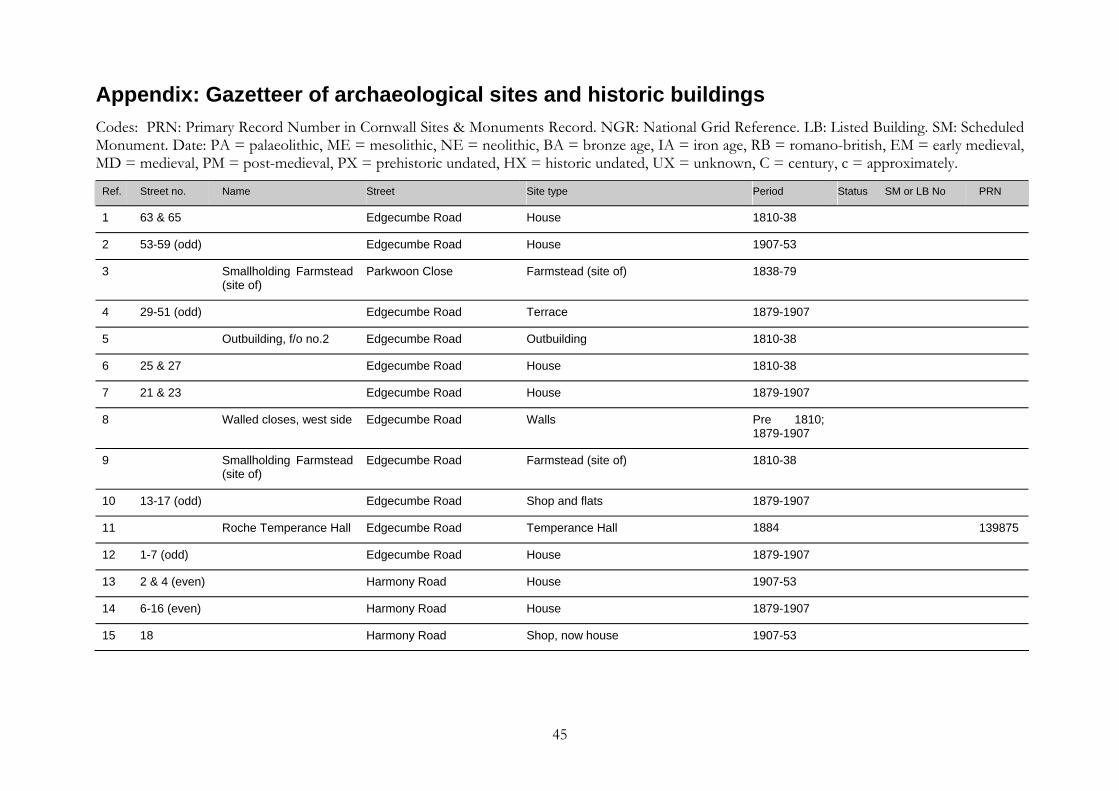
Appendix: Gazetteer of archaeological sites and historic buildings Codes: PRN: Primary Record Number in Cornwall Sites & Monuments Record. NGR: National Grid Reference. LB: Listed Building. SM: Scheduled Monument. Date: PA = palaeolithic, ME = mesolithic, NE = neolithic, BA = bronze age, IA = iron age, RB = romano-british, EM = early medieval, MD = medieval, PM = post-medieval, PX = prehistoric undated, HX = historic undated, UX = unknown, C = century, c = approximately.
Ref. Street no. Name Street Site type Period Status SM or LB No PRN
1 63 & 65 Edgecumbe Road House 1810-38
2 53-59 (odd) Edgecumbe Road House 1907-53
3 Smallholding Farmstead (site of)
Parkwoon Close Farmstead (site of) 1838-79
4 29-51 (odd) Edgecumbe Road Terrace 1879-1907
5 Outbuilding, f/o no.2 Edgecumbe Road Outbuilding 1810-38
6 25 & 27 Edgecumbe Road House 1810-38
7 21 & 23 Edgecumbe Road House 1879-1907
8 Walled closes, west side Edgecumbe Road Walls Pre 1810; 1879-1907
9 Smallholding Farmstead (site of)
Edgecumbe Road Farmstead (site of) 1810-38
10 13-17 (odd) Edgecumbe Road Shop and flats 1879-1907
11 Roche Temperance Hall Edgecumbe Road Temperance Hall 1884 139875
12 1-7 (odd) Edgecumbe Road House 1879-1907
13 2 & 4 (even) Harmony Road House 1907-53
14 6-16 (even) Harmony Road House 1879-1907
15 18 Harmony Road Shop, now house 1907-53
45

Ref. Street no. Name Street Site type Period Status SM or LB No PRN
16 Smithy (site of) Harmony Road Smithy C19 21553
17 20 Harmony Road House 1838-79
18 Stables r/o no.22 Harmony Road Stables 1879-1907
19 22 Harmony Road House 1838-79
20 Walls and gates to no.22
Harmony Road Walls and gates 1838-79
21 Harmony Cottage Harmony Road House 1810-38
22 Farm buildings r/o/ Harmony Cottage
Harmony Road Farm buildings 1810-38
23 Farm buildings (site of) Harmony Road Farm buildings (site of) 1838-79
24 34-80 (even) Harmony Road House (Estate) 1907-53
25 41 Harmony Road House 1838-79
26 House (site of) Harmony Road House (site of) 1810-38
27 Farmstead Little Trerank Farmstead Pre-1810
28 29 & 31 Harmony Road House 1907-53
29 Course of old road Glebe Drive Course of old road Pre-1810
30 The Long Stone, Harmony Close
Harmony Road Standing Stone BA 21505
31 Garage Harmony Road Garage 1907-53
32 2 Fore Street Commercial premises 1838-79
33 4 The Old Bank Fore Street House, sometime bank 1810-38
34 Sunday School/Hall Fore Street Sunday School 1887 139876
46

Ref. Street no. Name Street Site type Period Status SM or LB No PRN
35 10-16 (even) Fore Street House 1810-38
36 Walls and Ha-Ha, The Old Rectory grounds
Fore Street Walls and Ha-Ha c.1822
37 Cross, The Old Rectory grounds
Fore Street Cross MD 139877
38 The Old Rectory Fore Street Vicarage Pre-1810, rebuilt 1822
LB II SW95NE 1/10001
139872
39 Outbuildings, The Old Rectory grounds
Fore Street Outbuildings c.1822
40 Piggery, The Old Rectory grounds
Fore Street Piggery c.1822
41 Cross, The Old Rectory grounds
Fore Street Cross MD LB II SW95NE 5/238
3304313/15
42 Cross, The Glebe Filed (The Sentries)
Fore Street Cross MD LB II SW95NE 5/237
19829
43 The avenue, The Old Rectory grounds
Fore Street Avenue (garden feature) c.1822
44 Buildings (site of) Fore Street Buildings (site of) Pre-1810
45 St Gonand’sChurchyard; possible lann site
Fore Street Lann EM 19830.1
46 Cock monument, St Gonand’s Churchyard
Fore Street Pedestal tomb C19 LB II SW95NE 5/235
47 St Gonand’s Church Fore Street Church MD LB II* SW95NE 5/230
19830
48 Yelland monument, St Gonand’s Churchyard
Fore Street Pedestal tomb C19 LB II SW95NE 5/231
47

Ref. Street no. Name Street Site type Period Status SM or LB No PRN
49 Cross in St Gonand’s Churchyard
Fore Street Cross MD SAM 343 19830.2
50 Chest tomb, StGonand’s Churchyard
Fore Street Chest tomb C19 LB II SW95NE 5/232
51 Stile, St Gonand’s Churchyard
Fore Street Stile C18/early C19
LB II SW95NE 5/236
52 Higher Trerank House Pre-1810
53 Higher Trerank House 1838-79
54 Outbuildings andbuilding fragments, f/o The Bungalow
Higher Trerank Outbuildings and building fragments Pre-1810
55 2 Trezaise Road Shop 1907-53
56 4 Trezaise Road House 1907-53
57 Finger post B 3274 Trezaise Road 1907-53
58 Roche Junior & infant School
Fore Street School 1871 33102
59 Chy-an-Garrek House 1907-53
60 Pound (Pinfold) (site of) Fore Street Pound MD, PM 19838
61 Walled closes, east side of Fore Street
Fore Street Walls Pre-1810
62 Rock Inn Fore Street Public House Pre-1810 139870
63 Tregarrick farm,courtyard farm buildings
Fore Street farm buildings Pre-1810; extended 1838-79
64 Outbuilding, Tregarrick farm
Fore Street Outbuilding Pre-1810
48
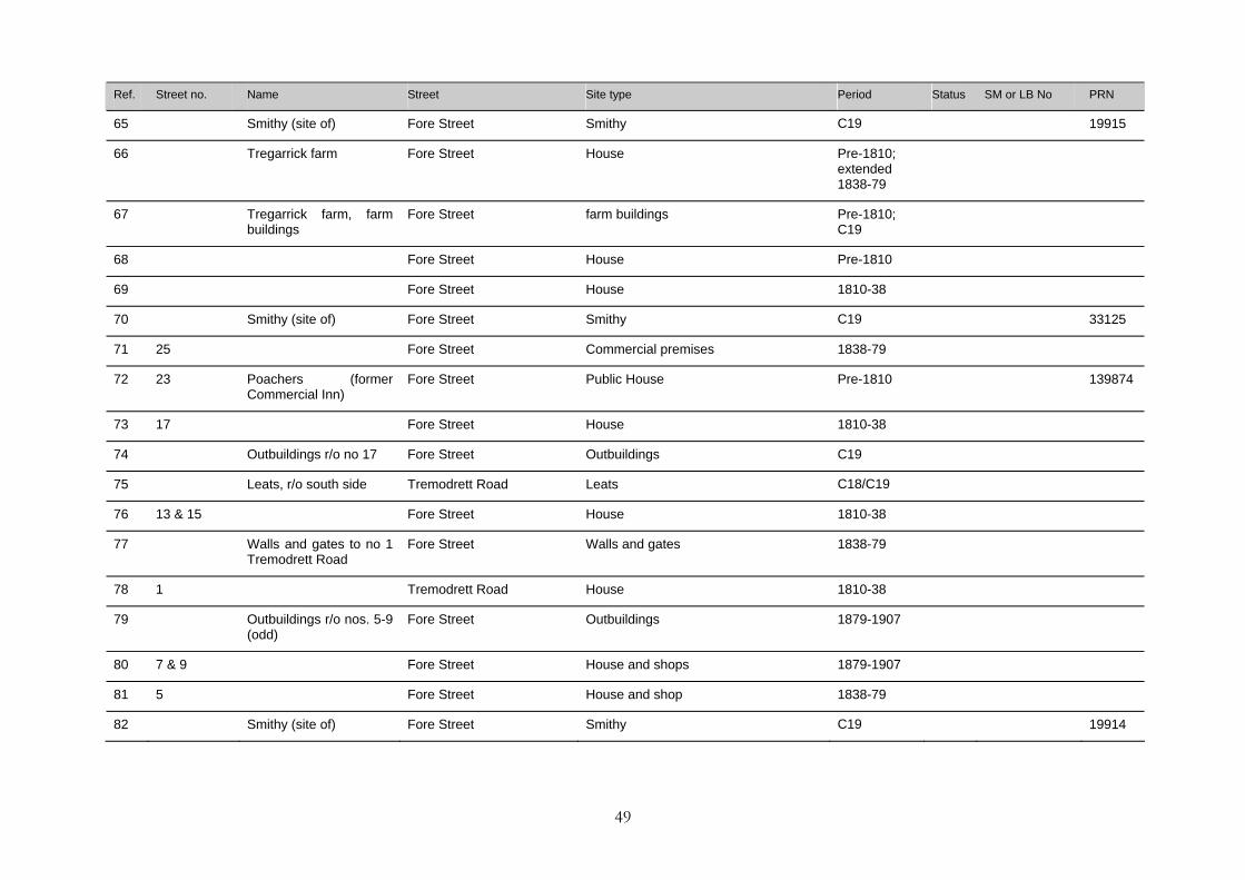
Ref. Street no. Name Street Site type Period Status SM or LB No PRN
65 Smithy (site of) Fore Street Smithy C19 19915
66 Tregarrick farm Fore Street House Pre-1810; extended 1838-79
67 Tregarrick farm, farm buildings
Fore Street farm buildings Pre-1810; C19
68 Fore Street House Pre-1810
69 Fore Street House 1810-38
70 Smithy (site of) Fore Street Smithy C19 33125
71 25 Fore Street Commercial premises 1838-79
72 23 Poachers (formerCommercial Inn)
Fore Street Public House Pre-1810 139874
73 17 Fore Street House 1810-38
74 Outbuildings r/o no 17 Fore Street Outbuildings C19
75 Leats, r/o south side Tremodrett Road Leats C18/C19
76 13 & 15 Fore Street House 1810-38
77 Walls and gates to no 1 Tremodrett Road
Fore Street Walls and gates 1838-79
78 1 Tremodrett Road House 1810-38
79 Outbuildings r/o nos. 5-9 (odd)
Fore Street Outbuildings 1879-1907
80 7 & 9 Fore Street House and shops 1879-1907
81 5 Fore Street House and shop 1838-79
82 Smithy (site of) Fore Street Smithy C19 19914
49
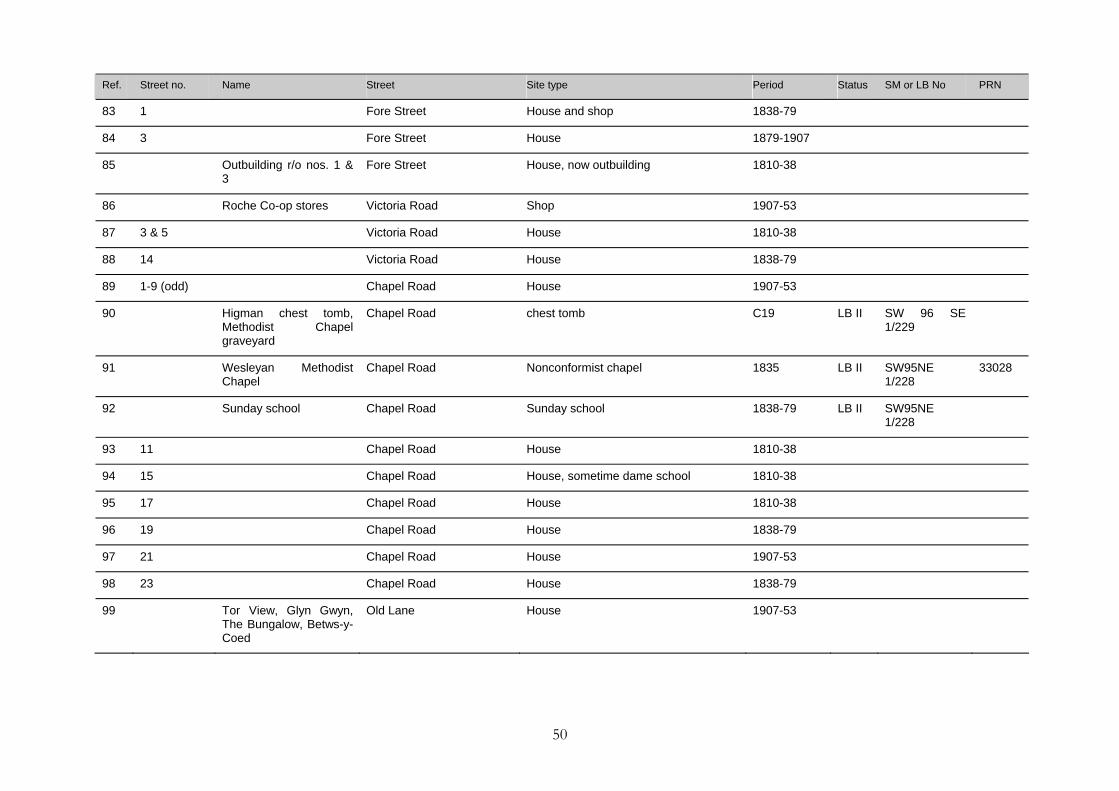
Ref. Street no. Name Street Site type Period Status SM or LB No PRN
83 1 Fore Street House and shop 1838-79
84 3 Fore Street House 1879-1907
85 Outbuilding r/o nos. 1 & 3
Fore Street House, now outbuilding 1810-38
86 Roche Co-op stores Victoria Road Shop 1907-53
87 3 & 5 Victoria Road House 1810-38
88 14 Victoria Road House 1838-79
89 1-9 (odd) Chapel Road House 1907-53
90 Higman chest tomb, Methodist Chapel graveyard
Chapel Road chest tomb C19 LB II SW 96 SE 1/229
91 Wesleyan MethodistChapel
Chapel Road Nonconformist chapel 1835 LB II SW95NE 1/228
33028
92 Sunday school Chapel Road Sunday school 1838-79 LB II SW95NE 1/228
93 11 Chapel Road House 1810-38
94 15 Chapel Road House, sometime dame school 1810-38
95 17 Chapel Road House 1810-38
96 19 Chapel Road House 1838-79
97 21 Chapel Road House 1907-53
98 23 Chapel Road House 1838-79
99 Tor View, Glyn Gwyn, The Bungalow, Betws-y-Coed
Old Lane House 1907-53
50
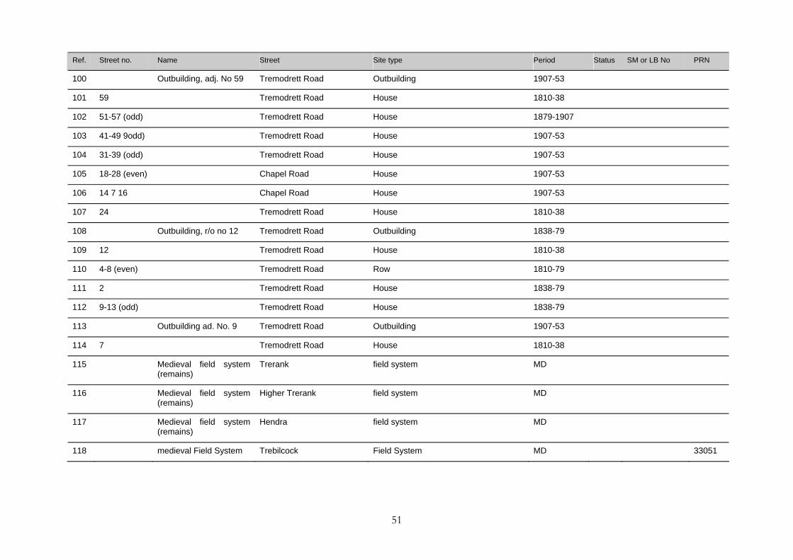
Ref. Street no. Name Street Site type Period Status SM or LB No PRN
100 Outbuilding, adj. No 59 Tremodrett Road Outbuilding 1907-53
101 59 Tremodrett Road House 1810-38
102 51-57 (odd) Tremodrett Road House 1879-1907
103 41-49 9odd) Tremodrett Road House 1907-53
104 31-39 (odd) Tremodrett Road House 1907-53
105 18-28 (even) Chapel Road House 1907-53
106 14 7 16 Chapel Road House 1907-53
107 24 Tremodrett Road House 1810-38
108 Outbuilding, r/o no 12 Tremodrett Road Outbuilding 1838-79
109 12 Tremodrett Road House 1810-38
110 4-8 (even) Tremodrett Road Row 1810-79
111 2 Tremodrett Road House 1838-79
112 9-13 (odd) Tremodrett Road House 1838-79
113 Outbuilding ad. No. 9 Tremodrett Road Outbuilding 1907-53
114 7 Tremodrett Road House 1810-38
115 Medieval field system (remains)
Trerank field system MD
116 Medieval field system (remains)
Higher Trerank field system MD
117 Medieval field system (remains)
Hendra field system MD
118 medieval Field System Trebilcock Field System MD 33051
51

Ref. Street no. Name Street Site type Period Status SM or LB No PRN
119 War Memorial Trezaise Road War Memorial 1907-53
120 4-8 (even) Victoria Road House 1907-53
121 19-29 (odd) Tremodrett Road House 1907-53
122 Headstone, St Gonand’s Churchyard
Fore Street Headstone C18 LB II SW95NE 5/234
123 Cottage row (site of) Fore Street Buildings (site of) Pre-1810
124 Roche Rock, Settlement (site of) and Chapel
Roche Settlement (site of); Chapel PX, C14 SAM LB I
52


![The Roman Rural Settlement Project · British] rural settlements, ... Farmstead morphology. Enclosed Farms Penhale Round, Fraddon, Cornwall (© J Stanley) • All or majority of domestic](https://img.pdfslide.net/doc/110x75/5f55325df1be735cbc7a9ec8/the-roman-rural-settlement-project-british-rural-settlements-farmstead-morphology.jpg)