Embed Size (px)
Citation preview

MASTER PLAN- 2021
(FINAL)
for
HAMPI LOCAL PLANNING AREA
REPORT
HAMPI WORLD HERITAGE AREA MANAGEMENT AUTHORITY
HUDA BUILDING, ISR ROAD HOSPET

Contents
i. Preface
ii. Acknowledgement
Part A
1. Introduction a. Hampi World Heritage Site 1
b. L.P.A. 1
c. Core, Buffer & Peripheral zone 4
d. Soil 5
e. Geology 5
f. Ground Water 6
g. Seismic zone 6
2. Regional studies
a. Location 7
b. Physical setting 8
c. Natural Features 9
1. Hillocks & Forest areas 9
2. Water bodies 10
d. Cultural Heritage 12
e. Settlement pattern 13
f. Demography – Local Planning area 14
g. Community Facilities 16
h. Transportation & communication 18
i. Existing land utilization - 2006 20
3. Economic Base
a. Occupation pattern – Local Planning Area 22
b. Agriculture 23
c. Tourism 23
4. Tourism 24
5. Heritage buildings & Heritage precincts 28
6. Statement of Significance & vision statement 31
7. Policies 33
8. Development plans
a. Base map 35
b. Hampi 39
c. Kaddirampura 42
d. Anegundi 48
e. Kamalapura 52
9. Plan proposals and Development options 58
10. Phasing and finance 64
11. Implementation 67

Part B
Zonal regulations 1 – Introduction 72 2 – Definitions 74 3 - Annexure-1 87 4 - General regulations 106 5 – Areas of special control 123 6 – Annexure - ii 126 7 - Group housing 132 8 - Subdivision regulations 135 9 - Parking regulations 142 10 – Building line 144 11 - Heritage regulations 145
Annexures 152

MASTER PLAN- 2021 (FINAL)
FOR
HAMPI LOCAL PLANNING AREA
LIST OF MAPS
SL NO
TITLE
1 LOCATION
2 LOCAL PLANNING AREA AND ITS ENVIRONS
3 CORE, BUFFER AND PERIPHERAL ZONE
4 DEMOGRAPHY
5 CLIMATOLOGY
6 COMMUNITY FACILITIES
7 SETTLEMENT PATTERN
8 EXISTING LAND UTILISATION - 2006
9 PRESENT CIRCULATION PATTERN
10 PROBLEMS AND PROPOSALS
11 HAMPI : EXISTING LANDUSE - 2006 PROPOSED LANDUSE - 2021
SL NO
TITLE
12 KADDIRAMPURA: EXISTING LANDUSE - 2006 PROPOSED LANDUSE - 2021
13
ANEGUNDI: EXISTING LANDUSE – 2006 PROPOSED LANDUSE – 2021
13.a ANEGUNDI HERITAGE ZONE AND BUILDINGS
14
KAMALAPURA: COMMUNITY FACILITIES EXISTING LANDUSE – 2006 PROPOSED LANDUSE - 2021 TOWN LEVEL DISTRICT 1 DISTRICT 2 CIRCULATION PATTERN PHASING
14.a KAMALAPURA HERITAGE ZONE AND BUILDINGS 15 WATER BODIES (CANALS,TANKS AND RIVERS) 16 PROPOSED LAND UTILISATION – 2021 17 ARCHITECTURAL REGULATIONS

PREFACE
The Master plan was prepared by the Hampi World Heritage Area
Management Authority (HWHAMA) as part of its mandate to protect
cultural, natural heritage and regulate development in the Local Planning
Area. The plan was prepared under Karnataka Town and Country Planning
(KTCP) Act – 1961 with the assistance of the Department of Town and
Country Planning, Government of Karnataka.
The Hampi World Heritage Area Management Authority constituted
under Hampi World Heritage Area Management Authority Act 2002 shall
be a Planning Authority for the Local Planning Area under section 81 D
and 81 E of KTCP Act - 1961. The Local Planning Area for ‘Hampi’ has
been first declared on 1-12-2004 and has been extended on by including
entire revenue villages vide G.O.No Na Aa E 161 Be Ma Pra 2006 dated 4-
1-2007. As per this notification there are only 29 revenue villages within
the Local Planning Area.
The ‘Heritage Area’ defined under the Hampi World Heritage Area
Management Authority Act, 2002 shall be Local Planning Area declared
under section 4 (A) of KTCP Act - 1961. The Local Planning Area
measures 236.46 Sq km out of which nearly 172 Sq km of area lies to the
south of the River and 64 Sq kms of area to the north of the river
comprising 29 revenue villages, 14 from Hospet taluka and 15 from
Gangavati taluka. The Core Zone which measures 41.8 Sq km is protected
by Buffer and Peripheral zone.
This planning exercise differs to other local planning areas. People
live within the archaeological area and continue with their respective
traditional practices such as agriculture, rituals etc., giving the character
of a living heritage site. Transformations within the traditional cultural
patterns such as agriculture, transportation etc., and growing needs of
the local people and visitors is leading to a conflict with the conservation
needs of predominant archaeological nature of the World Heritage Site.
The master plan aims to strike a balance between preservation of

heritage and development needs of local people. It is one of the first such
exercises being taken up for a world heritage site in India.
The Master plan (provisional) was submitted to the Government and
subsequently approved vide GO no: Na Aa E 85 Be Ma Pra 2007
Bangalore Dated 14-5-2007. A notification in this regard is given in the
official Gazette dated 12 July 2007 calling for objections and suggestions
from the people of the Local Planning Area. The time given was sixty days
under the provisions of KTCP Act. Authority received 134 objections which
were scrutinized and discussed and decisions were taken in the Authority
meeting dated 30th November 2007 and accordingly maps and report with
Zonal Regulations are prepared for the final approval.
During the process of finalizing the Master Plan, objections and
suggestions by the stakeholders including feed back from various Central
and State government agencies, Individuals, Grama Panchayats, Elected
representatives, District level meetings, Tourism conclave, Exhibition of
the master plan at Kamalapur and Anegundi, Consultation with
international agencies such as UNESCO were taken into consideration.
For the 4 settlements in the core area i.e. Hampi, Kaddirampura,
Kamalapura and Anegundi detail surveys were conducted out on a priority
because of their sensitive nature and are undergoing rapid
transformation. A detailed mapping exercise using ISRO base map, total
station survey map are taken up, based on which proposals were worked
out for these four settlements. It was resolved in the Authority meeting
dated 30th November 2007 to submit the Master Plan so prepared for
Hampi Local Planning Area to the Government for final approval.
Chairman
Hampi World Heritage Area Management Authority, Hospet

ACKNOWLEDGEMENTS
We take this opportunity to express our deep sense of gratitude to
all the members of HWHAMA and others who have cooperated by
furnishing various information and made valuable suggestions from time
to time in the preparation of ‘Master Plan’ for Hampi Local Planning Area.
Our special thanks to Shri Shantappa B. Honnur, Joint Director of
Town Planning, for his involvement in the preparation of the Master Plan
(Provisional) and Shri T. V. Murali, Assistant Director of Town Planning,
Bellary for his sincere and continuous hard work to complete this
important task of preparation of ‘Master Plan’ for Hampi Local Planning
Area without whom this work would not have been completed.
Our sincere thanks to Shri Mukund, Director of Town Planning,
Government of Karnataka for his encouragement and valuable
suggestions to the Planning Team at every stage of preparation of the
Master Plan
Our sincere thanks to RRSSC-B/ISRO team: Government of India
for giving us satellite derived base map and land utilization map for L.P.A
which is the important input in preparation of Master Plan maps. So our
sincere thanks goes to the following team members:
1. Shri P.G. Diwakar, Head, RRSSC-B/ISRO, Bangalore
2. Shri Uday Raj, Scientist, RRSSC-CMO/ISRO, Bangalore
3. Dr Sudha Ravindranath, Scientist, RRSSC-B/ISRO, Bangalore
Our sincere thanks to Prof. Nalini Thakur and Prof. E.F.N. Reberio
Ex. Chief Planner, Government of India, whose guidelines in Integrated
Management Plan have guided this Master Plan.
We also acknowledge the excellent advice of UNESCO Team
comprising of Mrs. Minja yang, Director of UNESCO, Ms. Nicole Bolomey,
Project Specialist, UNESCO and Mr. Paul Trouilloud, Conservation
Architect and Town Planner, French Ministry of Culture.

We are thankful to Dr. Halakatti, Senior Archaeologist, ASI,
Bangalore and Shri Ranganath, Senior Conservation Assistant, ASI,
Kamalapura for their cooperation by providing required information and
interface to the Planning Team. We are also thankful to the Officers of
State Archaeology and Museum Department for their valuable
suggestions.
We are also grateful to the Shri Aravind Srivastava, Deputy
Commissioner of Bellary and Chairman of HWHAMA, for his continuous
perseverance and guidance to the team of HWHAMA to finalize this unique
planning exercise and Shri K. Ramanna Naik, Deputy Commissioner of
Koppal, and officers of the Revenue Department, Government of
Karnataka for their support and valuable suggestions to this important
task.
And we are thankful to all Officers of the Government of Karnakata
for their continuous support and to the resource persons of the Hampi
Kannada University for their valuable suggestions.
We thank the Officers and the staff of the HWHAMA who have really
worked hard and supported the entire process of completing the Master
Plan
Lastly, we thank all those who have helped the HWHAMA directly or
indirectly in the preparation of Master Plan.
Commissioner
Hampi World Heritage Area Management Authority, Hospet

INTRODUCTION

PART A
MASTER PLAN – HAMPI LOCAL PLANNING AREA 1
Chapter 1
INTRODUCTION a. HAMPI WORLD HERITAGE SITE
The site was inscribed as Hampi Group of Monuments in 1986.
Fourteen monuments were covered initially in this inscription and later all
the 56 monuments protected by the ASI are considered for World
Heritage. The discussions between the Government of India (GOI) and
Government of Karnataka (GOK) to comply with the guidelines of World
Heritage Centre regarding the protective measures culminated in a
measure initiated by the GOK. In exercise of the powers conferred under
sub-section 3 of section 19 of the Karnataka Ancient and Historical
Monuments and Archaeological Sites and Remains Act, 1961, the
Notification dated 22nd October 1988 declared that the archaeological
sites and remains in specified areas in the villages of Hampi, Krishnapura,
Kaddirampura, Singanathanahalli, Kamalapura, Venkatapura,
Bukkasagara and Nimbapura in Hospet taluka of Bellary district and
Anegundi and Virupapura Gadda in Gangavathi taluka of Raichur (now in
Koppal) district as protected area.
The site was included in the endangered list in 1999 due to the
developments being carried out in an unplanned manner causing negative
impact to the significance of the site. This led to the various corrective
measures by the GOK and GOI including the establishment of a site
management mechanism through the enactment of Hampi World Heritage
Area Management Authority Act – 2002 which recognizes the protected
area under Archaeological Act as Core zone.
b. LOCAL PLANNING AREA
The area governed by HWHAMA is based on the core zone declared
as “Protected area” under the provisions of state archeology act vide
notification number ITY 137 KMU 84 dated 22nd Oct 1988 which includes
8 villages of Hospet taluk and 2 villages of Gangavathi taluk. The

PART A
MASTER PLAN – HAMPI LOCAL PLANNING AREA 2
“Heritage area” defined under the Hampi World Heritage Area
Management Authority Act, 2002 shall be a Local Planning Area declared
under section 4(A) of Karnataka Town and Country Planning Act- 1961.
The Local Planning Area for ‘HWHAMA’ has been first declared on
1-12-2004. It was felt during many discussions with various experts
including UNESCO that the revision of the Local Planning Area boundary
has to be done by including entire revenue villages. And accordingly it
was decided to extend the Local Planning Area by including entire
revenue villages and excluding the Kariganuru village and a proposal
was sent to the Government for approval. Accordingly the
Government has approved the proposal and the Local Planning Area
was revised by including entire revenue villages vide Notification No:
NaAaE 161 Be Ma Pra 2006 dated 4-1-2007. The Local Planning Area
comprises of 29 villages, 14 from Hospet taluka and 15 from Gangavati
taluk covering an area of 236.46 Sq kms. Out of which 172.56 Sq Kms of
area lies to the south of the River which houses 45908 persons at the rate
of 266 persons per Sq Kms and 63.90 Sq Kms of area to the north of the
river housing 14033 persons at the rate of 220 persons per Sq km which
reveals the densification of villages at the southern part of the river.
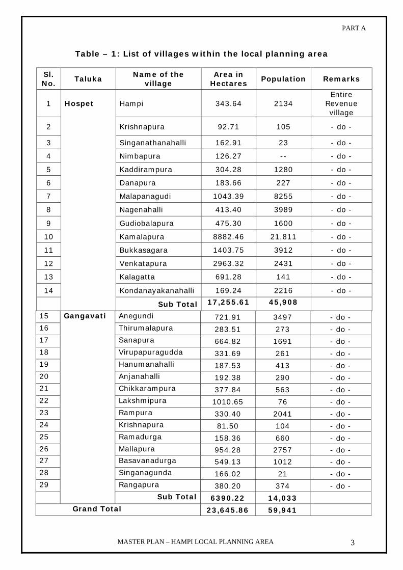
The details of villages that are coming within the ‘Heritage Area’
or the Local Planning Area’ of Hampi are given in the Table 1 below.
PART A
MASTER PLAN – HAMPI LOCAL PLANNING AREA 3
Table – 1: List of villages within the local planning area
Sl. No.
Taluka Name of the
village Area in
Hectares Population Remarks
1 Hampi 343.64 2134 Entire
Revenue village
2 Krishnapura 92.71 105 - do -
3 Singanathanahalli 162.91 23 - do -
4 Nimbapura 126.27 -- - do -
5 Kaddirampura 304.28 1280 - do -
6 Danapura 183.66 227 - do -
7 Malapanagudi 1043.39 8255 - do -
8 Nagenahalli 413.40 3989 - do -
9 Gudiobalapura 475.30 1600 - do -
10 Kamalapura 8882.46 21,811 - do -
11 Bukkasagara 1403.75 3912 - do -
12 Venkatapura 2963.32 2431 - do -
13 Kalagatta 691.28 141 - do -
14 Kondanayakanahalli 169.24 2216 - do -
Hospet
Sub Total 17,255.61 45,908
15 Anegundi 721.91 3497 - do - 16 Thirumalapura 283.51 273 - do - 17 Sanapura 664.82 1691 - do - 18 Virupapuragudda 331.69 261 - do - 19 Hanumanahalli 187.53 413 - do - 20 Anjanahalli 192.38 290 - do - 21 Chikkarampura 377.84 563 - do - 22 Lakshmipura 1010.65 76 - do - 23 Rampura 330.40 2041 - do - 24 Krishnapura 81.50 104 - do - 25 Ramadurga 158.36 660 - do - 26 Mallapura 954.28 2757 - do - 27 Basavanadurga 549.13 1012 - do - 28 Singanagunda 166.02 21 - do - 29 Rangapura 380.20 374 - do -
Gangavati
Sub Total 6390.22 14,033 Grand Total 23,645.86 59,941

PART A
MASTER PLAN – HAMPI LOCAL PLANNING AREA 4
The Hampi World Heritage Area Management Authority, constituted
under Hampi World Heritage Area Management Authority Act, 2002, shall
be the Planning Authority for the Local Planning Area under section 81 D
and 81 E of Karnataka Town and Country Planning Act 1961.
Jurisdiction of HWHAMA c. CORE, BUFFER AND PERIPHERAL ZONE
The area governed by HWHAMA is based on the Core zone
declared as “ Protected area” under the provisions of state archaeology
act vide Notification number ITY 137 KMU 84 dated 22nd Oct 1988 which
includes 8 villages of Hospet taluk and 2 villages of Gangavathi taluk. The
schedule of the notification is given in the Table - 2 below

PART A
MASTER PLAN – HAMPI LOCAL PLANNING AREA 5
Table - 2: Schedule of Notification District Taluk Village Area Remarks
Hampi Entire village
Krishnapura Entire village
Kaddirampura Entire village
Singanathahalli Entire village
Kamalapura Part village Venkatapura Part village Bukkasagara Part village
Bellary Hospet
Nimbapura Entire village
Anegundi Entire village
Koppal Gangavathi Virupapura gudda
Entire village
All the Ancient monuments (excluding 56 monuments already protected by the Archeological survey of India in the area) are included for protection
The ‘Core Zone’ measures 41.8 Sqkm and is protected by Buffer
zone and peripheral zone. The Core zone contains four larger
settlements like Kamalapura, Anegundi, Hampi and Kaddiramapura.
These villages are considered important and detailed studies, plans have
been prepared after carrying out various surveys. d. Soil: The most prevalent soil in the area is reddish sandy loam which is
characterized on the banks of river Tungabhadra the reddish brown soil
occur at the fringes of the hills due to the decomposition of rocks.
However black cotton soil also occurs in the area.
e. Geology1:
Geology formations are of archean origin occurring in elongated
bands of Dharwar formations which is source for rich mineral wealth. The
Economic minerals associated with this formation are hematite iron ore,
1 Department of Mines and Geology

PART A
MASTER PLAN – HAMPI LOCAL PLANNING AREA 6
red oxide of iron, manganese ore, white clay, soap stone etc., content of
iron in the ore available in this region ranges from 65% to 70%.
f. Ground Water:
One ground water study well has been established in Kamalapura
Town. Average ground water level details are given in the Table - 3
below.
Table - 3: Ground water levels2
Ground water level in mtrs Town 1997 1998 1999 2000 2001 2002 2003 2004 2005
Kamalapura 1.98 1.83 1.88 1.98 2.31 3.11 3.05 3.70 3.56 The table indicates the ground water level in the town. There is no
much variation in the ground water level. Since 1997 and situation is not
that critical. Situation in Kamalapura town has also witnessed gradual
depletion of ground water level from 1.98 m during 1997 to 3.45 m in
2005. Hence necessary action need to be taken to rejuvenate or recharge
the ground water adopting various methods like Rain water harvesting,
construction of new tanks, check dams, etc.
g. Seismic Zone
The seismic hazard map of India was updated in 2000 (3) by the
bureau of Indian standards (BIS). According to the new map the state of
Karnataka lies in zone II & III. Interestingly, the Bellary region, which
experienced a strong earthquake in 1840’s, has been down graded to
Zone II. The 1984 BIS Zoning map has placed Bellary region in Zone III.
Bellary region which falls in Zone II seismic Zone is referred to as
low damage risk Zone the probable intensity is MM VI.
2 Department of Mines & Geology, Ground water division

REGIONAL STUDIES

PART A
MASTER PLAN – HAMPI LOCAL PLANNING AREA 7
Chapter - 2
REGIONAL STUDIES
a. LOCATION
The Hampi World Heritage Site is located in the State of Karnataka in
Southern India. The site is spread over two districts of the state,
Gangavati taluk of Koppal district and Hospet taluk of Bellary district, and
divided by the mighty River Tungabhadra in to two parts. Hampi is
situated at 15° 20' 12" North latitude and 76° 27' 32" East longitude. The
altitude of the place is 467.000 mtrs above MSL. Also the place is situated
at a distance of 346 kms away from the state capital i.e. Bangalore.
Distance to important cities in the state like Hubli is 150 kms, Gulbarga
400 kms, Mangalore 420 kms and Mysore 510 kms.
The place is connected by a state highway which passes through the
Local Planning Area and the nearest railways station is at Hospet city
which connects the state capital and other important cities in the state
and cities in the other states too.
HAMPI WORLD HERITAGE SITE

PART A
MASTER PLAN – HAMPI LOCAL PLANNING AREA 8
b. PHYSICAL SETTING
The Tungabhadra River traverses the Hampi landscape. Flowing in a
northeasterly direction the river has cut its way through weaker, more
fractured rocky terrain, creating a narrow gorge. For some distance,
granite hills hem the river, the highest of which are Matanga hill on the
south bank, rising 115 meters above the river, and Anjanadri hill near the
north bank, almost 140 meters high. Flooding has worn away the rocks
that border the river, creating islands, lagoons and small pools. A parallel
valley to the south marks an alternate course where the river overflowed
during wet periods. Yet further south, the granite outcrops gradually
disappear and the landscape opens out in to a broad plain. This continues
for more than 10 kilometers before ending at the rising slopes of the
Sandur hills beyond the modern town of Hospet. These hills are rich in
iron and manganese and are now subject to intensive strip mining.
View of Landscape around Hampi Village from Matanga Hill

PART A
MASTER PLAN – HAMPI LOCAL PLANNING AREA 9
c. NATURAL FEATURES
View of the Tungabhadra River amidst the rocky landscape
1. Hillocks and Forest areas
The most important physical and natural feature of the site is its
outstanding rocky hillocks characterized by granite boulders and
forests giving the historic reference to the entire site. The rocky
hillocks with forest areas are spread over the entire site. There are
some hillocks of religious and mythological reference like Hemakuta,
Ratnakuta and Matanga hills in Hampi and Krishnapura village,
Anjanadri in Anjanhalli village. These rocky formations have to be
preserved as an outstanding natural landscape and preserve the
Heritage value of the site. The total area under rocky hillocks which
includes hills, rocky outcrops and quarries is 5713.05 Ha which is
24.16% and forests which include land scrubs are 5354.06 Ha which is
22.64% of the Local Planning Area. No development is allowed in the
forest areas and hillocks. (Refer annexure 7)

PART A
MASTER PLAN – HAMPI LOCAL PLANNING AREA 10
2. Water bodies
This includes both manmade and natural structures other than the
River. At Hampi, the historic water system has been developed to
utilize every source of water. Within this system, there are two sub -
systems, one for irrigation and the other for domestic supply. The
system demonstrates the local knowledge of the natural topography of
the site. The River Tungabhadra is the main source of water. The water
system includes both natural and manmade features such as Tanks,
Wells, Stepped wells, Bridges, Canals, Embankments, Dams, Water
gates, Anecuts and Aqueducts. The Anecuts (used for diverting the
water into the canals), Watergates, Spill channels, Canals and
Reservoirs form a part of the irrigation system. The canals are of two
types - perennial and seasonal. The Aqueducts, well designed Tanks
form part of the domestic water supply system. The remains and parts
of this system can be seen all over the site.
The irrigation activity in the area dates back to the Vijayanagara &
even earlier times. During Vijayanagar period there were important
tanks and irrigation canals like Turtha, Basavanna, Raya, Kalaghatta
and Anegundi canals. Most of these canals are old and needs proper
maintenance. Among all these historic canals ‘Turtha’ canal is an
important right bank canal which mainly irrigates the lands around
Hampi. ‘Turtha-anecut’ and ‘Sanapur Anecut’ were constructed across
river Tungabhadra is located to the north east of Virupaksha temple.
The Anegundi canal is located to the north of River Tungabhadra and
starts from Sanapur Anecut. This canal mainly meets the
requirements of the residents of Anegundi and agriculturalists of
Sanapur, Virupapura Gadda, Hanamanahalli, Ramdurga, Singanagunda
and Sangapura etc., The total length of various historic Vijayanagara
canals and area irrigated by each canals are given in Table -4 below:

PART A
MASTER PLAN – HAMPI LOCAL PLANNING AREA 11
Table – 4: Statement showing the details of Historic Canals
In addition to the above historic Vijayanagara canals the area to the south
of River Tungabhadra is irrigated by Tungabhadra Right Bank canal and
the area to the north of the River is irrigated by Left Bank Canal. The list
of Historic and Modern Canals is given in the Table – 5 below.
Table – 5: Names of the Historic canals & Modern canals
Historic canals Modern canals
1. Raya Canal – Vijayanagara 8. Right bank main canal
2. Hosur Canal – Vijayanagara 9. Basavanna Canal
3. Kalaghatta Canal – Vijayanagara 10. Left Bank high level Canal
4. Hiriya Canal – Vijayanagara 11. Left Bank Main Canal
5. Anegundi Canal – Vijayanagara
6. Ramasagara Canal – Vijayanagara
7. Premogal Canal - Chalukya
Sl
no
Name of the canal Length in
Kms
Total area
irrigated in Ha
1
2
3
4
5
Raya Canal
Basavanna Canal
Kalaghatta
Turtha
Anegundi
27.20
16.00
7.20
18.00
37.00
2,226.70
1,240.48
237.25
931.58
N.A.
Total 105.20 4636.01

PART A
MASTER PLAN – HAMPI LOCAL PLANNING AREA 12
i. Tungabhadra River:
The torrential River Tungabhadra is traversing through Local
Planning Area, which divides the planning area into two parts, which
forms natural /administrative boundary of Bellary/ Koppal districts.
The River has important monuments on either side, added to the
natural beauty of the location. Floods occur mostly in the month of
August when the Dam gates are opened.
ii. Kamalapura tank:
The Kamalapura Tank is one of the oldest and Vijayanagara
period Tank in the Local Planning Area and is still irrigating the
lands around Kamalapura. The tank is located in Sy no 879 of
Kamalapura village covering an area of 192.72 Hectares. The tank
was fed by river canal with water directly from perennial River
Tungabhadra. The Tank receives water from ‘Raya-Canal’ and was
meeting the varied requirements of the residents of Vijayanagara
City. It is the biggest tank in the entire Local Planning Area and is
located on the Hospet–Kamalapura road i.e. to the south of
Kamalapura Town. The Tank is nearly irrigating 290.00 Ha of land.
iii. Allikere tank:
This tank is located to the southeast of Kamalapura town near
Hampi Kannada University. The tank is located in Sy no 874 of
Kamalapura village and covers an area of 2.38 Ha.
d. CULTURAL HERITAGE
Archaeological Survey of India protects 56 monuments and
monuments within the protected area spread in an area of 41.8 Sq km
are protected by the Department of Archaeology and Museums (GOK).
Research works on Hampi establish the fact that the potential of the site

PART A
MASTER PLAN – HAMPI LOCAL PLANNING AREA 13
Typology of Cultural Resource
4, 0%
13, 1%
52, 6%
202, 22%
1, 0%
90, 10%
190, 21%26, 3%
13, 1%
6, 1%
5, 1%
61, 7%
9, 1%
1, 0%
81, 9%
42, 5%
23, 2%
2, 0%
1, 0% 100, 11%
Cave and Cavern
Riverside Feature
Complexes
Temples
Mosque
Shrine
Mandapa
Memorial Structures
Streets of special functions
Residential Complexes for religious andpilgrimageWalls
Gateway
Defense Check Post
Stable
Water Structures
Sculptures
Fragment
Unique Feature
Rock Painting
Unknown
is more than the notified ASI & State Archaeology monuments both
spatially and in terms of the diversity of the cultural resources.
Typologies of Cultural Resources at Hampi
These are the types of buildings, structures and other natural
and manmade features found on the site. The main typologies are
Complexes, Temples, Shrines, Mandapa, Dargah, Colonnades,
Gateway, Watchtower, Lookout, Cavern, Sculpture/ Relief, Water
structure, Engineering structures, Gravestone, Tomb etc.
Source: Integrated management plan, Archeological Survey of India e. SETTLEMENT PATTERN
There are 28 villages and 1 town in the Local Planning Area out of
which 13 villages are on the south side of the River i.e. in the Hospet
taluk and 15 villages on the north side of the River i.e. in the Gangavati
taluk. Other than these settlements, small hamlets are scattered in the
Local Planning Area mostly belonging to the settling nomadic communities
(Lambani Thanda). Except Nimbapur revenue village all other revenue
villages have habitations. The biggest settlement in the Local Planning
Area is Kamalapura followed by Anegundi, both of which have historical
background.

PART A
MASTER PLAN – HAMPI LOCAL PLANNING AREA 14
f. DEMOGRAPHY
1. Population Growth:
As per 2001 census the Hampi Local Planning Area has 59,941
population comprising 27 rural settlements and one urban
settlement. The Local Planning Area has registered the highest
decadal growth rate of 28.78% during 1971 and 1981 as against
the lowest decadal growth rate of 18.63% during 1991 and 2001.
The population of Hampi Local Planning Area has been otherwise
growing steadily registering for about 20% of growth rate.
2. Projected population
The study of the population growth of different villages has
revealed that some villages like Hampi, Ramapura and Mallapura
have registered high growth of population compared to other
villages, which have been slowly growing. Hampi village has
registered high growth of population because of radical socio-
economic transformation due to activities generated by tourism
sector. In other words it is characterized by the developments
around famous Virupaksha Temple like many guest houses, shops,
resorts, hotels/restaurants, travel agencies, money exchangers and
tourist homes etc., and enjoys the excellent river view. This has
resulted in high growth of population in Hampi Village. The other
two villages Ramapur and Mallapur have registered highest growth
of population after 1991. This is because of the rehabilitation
schemes at these villages.
Anegundi and Kaddiramapura are among the core zone
villages. Anegundi has 3497 people as per 2001 census. The village
has registered the slowest growth of population for past 3 to 4
decades. Kaddiramapura is another village located on the Hospet-

PART A
MASTER PLAN – HAMPI LOCAL PLANNING AREA 15
Hampi road with 1280 population as per 2001 census. This village
has also registered the slowest growth of population.
Kamalapura is the only town, which has the status of census
town and has population of 21,311 as per 2001 census. The town
has registered highest growth rate during 1971–1981 (25.88%) as
against the lowest growth rate of 4.2% during 1991-2001. The
growth of the town has been slow but is expected to be high in
coming years.
Table – 6: GROWTH OF POPULATION
Sl No.
Village 1971 1981 1991 2001 2011* 2021*
1 Hampi 777 1247 1594 2134 2900 3800 2 Kamalapur 13879 17471 20451 21311 24000 27,000 3 Kaddi Ramapur 1109 1708 1234 1280 1600 1800 4 Anegundi 3023 3258 3279 3497 3750 4000
Local Planning Area
31,489
40,551 50,579
62,157
75,000
90,000
Growth rate….% - 28.78 24.79 18.63 20.66 20.00
Source: District Census handbook * Projected population For more details refer Annexure 11
3. Literacy and sex ratio:
The study of various demographic characteristics especially
literacy in Local Planning Area villages reveals that, the literacy
level is very low compared to the other parts of the state. The
literacy is very low in Hospet taluk compared to Gangavathi taluk.
Among all the villages Virupapura Gadda(56%), Hampi(52%), and
Anegundi(45%) are having the highest literacy rate.
As regards to the sex ratio, the Local Planning Area enjoys
better sex ratio as per 2001 census compared to the state’s average
of 963. Out of 29 villages of Local Planning Area only 5 villages in
Gangavathi taluka namely Krishnapura, Laxmipura, Hanumanahalli,
Ramapura and Mallapura are below the state’s average. The
highest sex ratio of 1625 females per 1000 males is noticed in
Singanagunda Village as per 2001 census. The study of sex ratio
PART A
MASTER PLAN – HAMPI LOCAL PLANNING AREA 16
reveals that the lowest ever sex ratio was being registered in 1981
in Ramadurga. Mallapura, Basanadurga, Singanadurga, Ramapura
and Rangapura are also having poor sex ratio which varies from 237
to 800 during 1971 to 1991, but considerably improved during
2001. Refer annexure 11
g. COMMUNITY FACILITIES
A study of Physical and Social infrastructure in Hampi Local
Planning Area reveal the level of social, cultural and economical
values of the community. The details of various facilities available in
the planning area are explained below.
1. Educational facilities:
The study of educational facilities reveals that the entire Local
Planning Area has … no of Anganawadi’s, twelve government
primary schools, out of which eleven are government, one is
private. There are two government and two private high schools in
the Local Planning Area.
Kamalapura town has two primary and higher primary
schools, two high Schools, one college and Hampi Kannada
University. The students of Local Planning Area mainly depend on
Hospet, Kampli and Gangavati for their higher and technical
education. (Refer annexure 8)
2. Health facilities: One Primary health center at Anegundi village and
Kamalapura town is functioning. Some villages like Bukkasagara,
Nagenahalli, Venkatapura, Anegundi, Sanapura, Chikkarampura,
Anjanhalli, and Hanumanhalli private doctors/clinics are functioning.
In case of any kind of emergency to the local population and visitors
the nearest medical assistance can be availed at Hospet or
Gangavati except a basic first aid in the existing primary health
centre at Kamalapura. (Refer annexure 9)

PART A
MASTER PLAN – HAMPI LOCAL PLANNING AREA 17
3. Utilities and other services
i. Water supply
Drinking water supply system is available only with few
panchayats. Remaining village panchayats are dependent mainly on
the river water or on the wells. A comprehensive water supply
project shall be planned.
ii. Sanitation
Major villages such as Kamalapura, Bukkasagara have open
drains. A infrastructure plan for the drainage system in all the
villages is lacking which is resulting in the construction of drainage
in an isolated manner whenever funds are available to the local
body.
iii. Solid waste management
The local bodies are responsible for the solid waste management.
With the available resources and knowledge the solid waste is
collected and disposed. A comprehensive solid waste management
plan is needed for the world heritage site.
iv. Electricity
Most of the villages on the north side of the river are lacking
continuous power supply due to non availability of sub station. The
electrical wiring system is done over the ground in the
Archaeological area. It is proposed to lay the cables under ground.
Care has to be taken while laying the electrical cables not to effect
the Archaeological remains. Only in the Hampi Bazaar an attempt
was made to lay the cables underground.
(Refer annexure 10)

PART A
MASTER PLAN – HAMPI LOCAL PLANNING AREA 18
h. TRANSPORTATION AND COMMUNICATION
Hampi World Heritage site is located 12 Kms from Hospet urban
area on Hospet – Kampli State Highway and the site is also connected
by Hampi – Bellary and Koppal - Gangavathi Major district roads. The
major transportation needs of the area are originated either from rural
economy or from tourism. The traffic volumes on the regional road
network are a result of the above two main functions overlapping. The
increasing traffic volume and uncontrolled movement of both types of
traffic are potentially harmful to the monuments and archaeological
remains.
1. Present Traffic Patterns
i. Rural Transport Flows
The rural economy generates traffic movements and volumes
that are directly related to the production of agricultural products.
Patterns are most visible in the form of trucks and tractors
transporting bananas and sugar cane out of the area, paddy to the
mills, and fertilizer into the area, apart from the traditional bullock
carts on all roads and tracks.
In addition to the major crop-related traffic flows, there are
flows related to intra-regional trade and socio-economic needs such
as visits to health, education and administrative facilities that would
be largely reflected in the statistics on bus and motorcycle trips. As
motorization is as yet very low in rural India, private car trips
account for the smallest portions of the daily movements recorded in
the annual traffic census on all major roads.

PART A
MASTER PLAN – HAMPI LOCAL PLANNING AREA 19
Table - 7
Details of Agricultural produce (2005)
Sl No
Description Inward Quintals
Dispatched to places
1. Paddy 2,64,285 Bangalore Challakere, Chitradurga, Maharashtra and other places
2 Rice 46,740 - do -
3 Maize 11,540 West Bengal, Tamilnadu, Andhra Pradesh and other places
4 Banana 1,10,400 Challakere, Chitraduga, Bellary, Locally & other places.
5 Onion 7,120 Bangalore, Challakere, Chitradurga, Bellary, Locally & Other places
6 Chilli 4,685 Hubli, Maharastra Source: APMC, Hospet
ii. Tourism Traffic
Tourism has added two types of traffic to the existing traffic flows
generated by agricultural economy and settlements. There are number
of trips of tourists from Hospet to the World Heritage Site. In addition
to these there are trips caused by the traders catering to the tourist
bazaar around Virupaksha Temple as well as the entrepreneurs in the
"Hampi Village".
iii. Characteristics of roads:
We are considering mainly all-weather roads and not all
those earth roads and tracks that exist in the Heritage Area as
part of the transport system. The district roads are narrow,
barely wide enough for heavy vehicles, typically with
characteristics that limit speed and capacity, such as soft
shoulders, deficient drainage, and uneven or damaged surfaces,
as well as narrow and precarious passages in villages. Given the
mix of slow and fast moving traffic on rural roads, most district
roads can be said to be operating near their capacity. The same
can be stated for some of the roads inside the World Heritage
Site. In case of Kamalapura - Kampli road (State Highway) with

PART A
MASTER PLAN – HAMPI LOCAL PLANNING AREA 20
its much neglected maintenance, the surface conditions are so
bad that the road is being operating even beyond its capacity.
The internal roads in the historic villages are narrow and defined
by the buildings abutting the roads.
i. EXISTING LAND UTILIZATION - 2006
The study of entire Local Planning Area reveals that, it has an
outstanding natural landscape traversed by the torrential River
Tungabhadra. The area is characterized by rocky hillocks, water tanks,
historic canals; Archaeological remains and is rich in Agriculture. The
physical surveys conducted in Hampi, Anegundi, Kaddiramapura and
Kamalapura has revealed that the World Heritage site has attracted
many activities and influencing the land use pattern. The existing land
utilization analysis of Local Planning Area is given in Table – 8 below.
Table – 8
Existing land utilization- 2006 – Local Planning Area
Sl no
Land use Area in ha. %
1 AGRICULTURE 7969.01 33.70 2 BARREN LAND 780.69 3.30 3 DEVELOPED AREA 482.31 2.04 HAMPI UNIVERSITY 90.05 0.38 4 HILLS 4618.66 19.53 5 LAND SCRUB 650.31 2.75 6 CANAL 115.84 0.49 7 MONUMENT AREA 30.95 0.13 8 PLANTATION 808.55 3.42 9 POWER HOUSE 3.83 0.02 10 QUARRIES 802.54 3.39 11 RESERVED FOREST 4703.75 19.90 12 RIVER / TANKS 368.44 1.56 13 ROCKY OUTCROPS 291.85 1.23 14 WATER LOGGED AREA 34.54 0.15 15 TRANSPORTATION AND
COMMUNICATION 1894.67 8.01
TOTAL 23646.00 100.00
PART A
MASTER PLAN – HAMPI LOCAL PLANNING AREA 21
The natural landscape of the area is characterized by the rocky hillock
which is 291.85 Ha and 1.23 % of the total Local Planning Area. The area
under Agriculture is 7969.01 Ha. The area under monument use is 30.95
Ha which accounts for about 0.13 % of the total Local Planning Area. The
entire Local Planning Area having 28 villages and a town are developed in
an area of 482.31 Ha. The natural characteristics of the area is reflected
in River, water bodies which is 368.44 Ha and forest area which accounts
to 4703.75 Ha of the total Local Planning Area respectively.

ECONOMIC BASE

PART A
MASTER PLAN – HAMPI LOCAL PLANNING AREA
22
Chapter 3
Economic base
The economic base of the ‘Local Planning Area’ is essentially
characterized by rural economy of the two Talukas, which are rich in
agriculture dominated by the cash crops and tourism activities generated
by the Hampi World Heritage Site. Rainfall intensity in Bellary and
Koppal Districts is in the modest range of 500 - 700 mm per year. The
Tungabhadra irrigation scheme, which consists of the dam and
extensive irrigation canals, was completed in the early 1950s.
a. OCCUPATIONAL PATTERN:
The occupational pattern of the Local Planning Area is basically rural
in character. There are 27,991 (53.32%) workers as against 31,969
non-workers (46.68%) in the Heritage Area. The study of composition
of workers and non-workers reveals that the dependants are slightly
more than the working population. Among the total number of
workers there are 24,849 main workers accounting for about 88.77%
and remaining 3142 (11.23%) are marginal workers. It is also seen
that the marginal workers are more in Gangavathi taluka (20.59%)
than in Hospet taluka (8.21%). Most of the people in Hampi, Anegundi
and Virupapaura Gadda are dependent on Tourism in the World
Heritage Site in the form of Guest house owners, shops selling goods,
guides, local transportation etc.
Skilled crafts persons1 are found in most of the villages within the
present core zone. Though there are very few opportunities for the
traditional skills, their presence implies the self-sustaining properties of
each village. The list of the traditional craftsperson in the L.P.A is as
follows
1. Earth-workers, Well-sinkers, Tank-diggers and Stone-dressers
(Vodda)
2. Stone-carvers for Temples (Shilpi) 1 Bellary District Gazette

PART A
MASTER PLAN – HAMPI LOCAL PLANNING AREA
23
3. Carpenters (Badagi)
4. Weavers
5. Potters (Kumbars)
6. Traditional Gypsies (Lambani)
(Refer annexure 12)
b. Agriculture:
Gangawati Taluk is referred to as the "rice bowl of Karnataka" and was
true even 600 years ago (90% of the paddy growing areas of Koppal District
are in this Taluk). Similarly, the part of Hospet Taluk that lies in the World
Heritage Site is one of the largest commercial banana plantations in the
region, with exports of bananas over long distances up to the Goa coast.
Both Taluks have important sugar cane productions on altogether 5000 ha.
The rich agricultural conditions are clearly visible in the lush green valley
areas with paddy fields, banana and sugar cane plantations, surrounded by
the granite boulders that provided the material for the Hampi monuments,
apart from giving the landscape its characteristic shape. Details are given
in the Table – 9 below.
Table – 9 : Area under Paddy and Sugarcane cultivation
Agricultural Bellary Hospet % Koppal Gangawati %
Paddy (ha) 55,102 12,111 22 68,847 61,212 88
Sugar cane 6,595 3,756 56 1,956 1,218 62 Irrigated land 150,731 20,870 14 85,200 48,861 57
Source: District Statistical Summaries for Bellary and Koppal, 2000
c. Tourism
Tourism in Hampi World Heritage Site is currently an un-organized
sector due to un-planned growth. A community based Tourism strategy
shall be prepared for the Local Planning Area to develop a integrated
sustainable system between conservation and development which
eventually caters to the needs of the locals and the visitors. Details are
dealt in next chapter.

TOURISM

PART A
MASTER PLAN – HAMPI LOCAL PLANNING AREA 24
Chapter 4:
TOURISM
Hampi World Heritage Site is one of the important destinations in
south India with the following significant cultural and natural heritage in
the area
1. More than 1600 State Archaeology protected monuments
2. 56 A.S.I protected monuments
3. 5 Historic canals and associated water systems
4. More than 100 kms of Fortifications
5. More than 100 kms of Historic pathways
6. 41.8 Sq kms of protected area
7. Natural areas such as hillocks, irrigated valleys, river, water bodies
etc
8. Flora and Fauna
9. Intangible heritage
The serene, majestic and imposing environment of Hampi World Heritage
Site welcomes the tourists to the world’s largest ‘open-air museum’1.
“Once the proud ‘City of Victory’ is now a ‘City of ruins’. However,
the ruins of these historical monuments have stood the ravages of
man and time and still evoke the memories of regal splendor.
There were opulent palaces, marvelous temples, massive
fortifications, ceremonial places, baths, markets, aqueducts,
pavilions and stables for royal elephants.”2
All the above features are mostly concentrated in an area of 25 sq
kms. As on today an average, there are 2000 visitors per day visiting the
site and its surroundings, out of which Pilgrims comprise of 80 % of the
1 Periodic report submitted to World Heritage Center 2 City of Victory, Edited George Mitchel

PART A
MASTER PLAN – HAMPI LOCAL PLANNING AREA 25
visitors. From the current trends only a few of them get to see all the
above Cultural and Natural areas due to lack of accessibility and other
facilities for visitors.
Above all, Hampi is a sacred site. 80% of the visitors are pilgrims.
The Virupaksha temple at Hampi, dedicated to the lord Shiva is one of the
main living temples. Hampi, the sacred center or the pilgrimage center is
on the banks of river Tungabhadra. The place is also linked to myths and
legends especially with the story of Kishkinda. This association with
mythology attracts lots of tourists from different parts of India especially
from states such as Gujarat, Rajasthan to see places like Pampa Sarovar,
Anjanadri Parvat etc. In the process of pilgrimage, most of the pilgrims
witness the magnificent ruins wherein we find royal palaces, temples,
massive fortifications, ceremonial places, baths, markets, aqueducts,
pavilions and stables for royal elephants, etc. .
The growth of tourist population has been very much consistent
throughout the year with December and January being the most favorite
months and the June being the lowest. The average number of tourists
visiting Hampi is 45,000 per month in 2000 to 65,000 during 2005 has
been growing steadily every year.
For tourist statistics and details Refer annexure 13
The following are some of the key aspects in the tourism sector.
a. Visitor Management:
1. Visitor movement:
The World Heritage Site of Hampi can be approached from 5
different entry points from all the cardinal directions. The commonly
used approach is from Hospet, which is located just 12 Kms away.
Hospet is the second largest city in Bellary district and is well
connected by National Highway, state highway and good rail
network. The nearest Airport is at Toranagallu which is 30 Km.
from Hospet. To reach Hampi either one has to take their own

PART A
MASTER PLAN – HAMPI LOCAL PLANNING AREA 26
/rented vehicle or take public transport buses from Hospet. To see
the site, due to its vast expanse, people usually hire vehicles (Two
and three wheelers, bicycles) to see the site. Large scale
unorganized movement of polluting vehicles over the archaeological
area is an important issue impacting the environs of Hampi.
Transportation compatible for pedestrians, handicapped persons
is needed. Non polluting vehicles for visitor movement and diversion
of the vehicular traffic away from the protected area are required.
2. Visitor accommodation:
There are good private hotels in Hospet which is mainly taking
care of the tourist’s lodging/hotel requirements. In addition to the
lodging facilities available in Hospet, there exist KSTDC hotel in
Kamalapur, Hospet and private guesthouses/resorts in Hampi and
Virupapur Gadda. In addition to the hotels and lodges, there are
home stays in Anegundi developed with the support of UNDP funds.
For Tourist accommodation details refer annexure 15
b. Improvement of the surroundings of destination
The entry points to the site from various directions shall be
developed and integrated with the proposed nodes by Department of
Tourism. Development of Areas for leisure and recreation such as the
development of historic bund of Kamalapura tank shall be taken up
along with the improvement of infrastructure in terms of services
(Water supply, sewerage system, electricity, firefighting, street
furniture)
c. Presentation of Historic buildings
The cultural heritage of Hampi has to be properly showcased to the
visitors to understand the place. The natural features, structures and
areas which are significant in the Local Planning Area have to be
appropriately presented and interpreted.

PART A
MASTER PLAN – HAMPI LOCAL PLANNING AREA 27
d. Solid waste management
Solid Waste Management in the settlements and visitor areas within
the Local Planning Area is very poor. This is leading to unhygienic
conditions in the world heritage site. Solid waste management and
public conveniences in the settlements and visitor areas within the
Local Planning Area needs to be improved.
e. Accessibility
Most of the cultural and natural areas are inaccessible from the
main highways and nearby settlements. The accessibility to the site
and within the site (inter state linkage, regional linkage & circulation
network within the site) has to be improved. Different kinds of access
identified are
1. Road connectivity
2. Access to monuments
3. Special routes
4. Thematic routes
f. Activities directly related to Tourism
There is a lot of other potential areas rather than visits to the few
temples and monuments such as adventure activities which as of now
are carried out only during the Hampi Utsav. Activities such as
adventure sports, cultural events, traditional art and craft forms, and
traditional sports are some of the main attractions. Infrastructure
needed for these activities needs to be developed which can increase
the average length of stay of the visitors.
g. Interpretation
A proper interpretation of the site is lacking except the basic
information available at the A.S.I site museum at Kamalapura. More
interpretative tools are required to understand the complex nature of
the site.

HERITAGE BUILDINGS AND HERITAGE PRECINTS
PART A
MASTER PLAN – HAMPI LOCAL PLANNING AREA 28
Chapter 5
Heritage Precincts and Heritage Buildings
Local Planning Area has historic settlements such as Kamalapura,
Anegundi etc. These settlements represent the cultural pattern of the
people from the past through spatial organization with in and between;
built form and open spaces. The precinct/ zone, is an area within the
historic settlement consisting of heritage buildings and historic open
spaces. Heritage precincts/ zone and heritage buildings were identified in
two villages (Kamalapura & Anegundi), within the core zone. Refer Map
13.a and Map and 14.a for heritage precincts.
The heritage buildings and historic open spaces identified are not
protected either by Archaeological Survey of India or state Department of
Archaeology and Museums. In order to retain these important buildings
and historic open spaces embodying the local cultural values this is
defined under the section 2 (i-ea) & 2 (i-eb) of Karnataka Town and
Country Planning Act – 1961.
There are 81 buildings identified as heritage buildings in
Kamalapura, 70 buildings in Anegundi. The scale of the heritage buildings
varies depending on the occupation and other social criteria of the owner
of the building. The heritage buildings are mostly residential except a few
shops, school, and community chowdies. The buildings are mainly with
stone walls made with mud or lime mortar, internally supported
commonly by wooden columns. Traditionally system of building
maintenance is still in practice by some of the owners.
PART A
MASTER PLAN – HAMPI LOCAL PLANNING AREA 29
Following measures of conservation are needed for the maintenance
of the heritage building
a. Preservation
Deals directly with repairs that are carried out to prevent further
decay, damage and destruction caused by water in all its forms by
chemical agents and by all types of pests and micro organisms
For example: Traditional maintenance of the buildings at regular
intervals such as white washing during festivals, annual roof
consolidation works etc to prevent water seepage and pest control.
b. Consolidation
It is the physical addition or application of compatible and
supportive materials into the actual fabric of structural property in
order to ensure its continued durability or structural integrity
For example: Repairs to structural members especially with building
systems using wood, lime and mud mortar, bricks to ensure
structural stability.
c. Restoration
It is a process to revive the original concept or legibility of the
cultural property. It includes reintegration of details and features
based upon respect for original material, archaeological evidence,
original design and authentic documents
For example: To use authentic design, building material, skills in
case of repair or replacement of an architectural element such as
wooden column, masonry wall etc.
d. Rehabilitation
It is a practice to preserve buildings by keeping them in use by way
of modernization with or without adaptive alteration.
For example: Up-gradation of services or an interior of a heritage
building to meet the modern day needs so that usage of the
building is continued.

PART A
MASTER PLAN – HAMPI LOCAL PLANNING AREA 30
The technology adopted in the heritage buildings is not commonly
used due to which there is a scarcity in the skilled workmanship. In order
to provide a continuous supply of building materials and workmanship
needed for the conservation and maintenance of heritage buildings,
alternative building technology and materials shall be developed by the
building center of HWHAMA in consultation with other agencies.
Detailed heritage regulations are framed which forms a part of
Zonal Regulations. For implementation of Heritage regulations HERITAGE
FUND will be created with the support of grant from govt and also from
private sources subject to the approval of government.
Refer Part B for the heritage regulations

STATEMENT OF SIGNIFICANCE AND VISION

PART A
MASTER PLAN – HAMPI LOCAL PLANNING AREA 31
Chapter - 6
Statement of significance and Vision1
The entire stretch of the site of Vijayanagara, the metropolitan
capital city of the 16th century represents a synthesis of timeframe
spanning from prehistoric to its height of glory – as the most magnificent
capital of its time, the Vijayanagara period – and continuity since adding a
new layer of agricultural and rural beauty. This large area is scattered
with remains from all these periods and little fortified villages living on
subsistence agriculture. The spectacular archaeological and architectural
remains of the core of the capital strewn over a spread of 25 sq kms, with
large temple complexes with their bazaar streets, gigantic platforms and
other structures located within valleys of the most outstanding landscape
of boulders with the river Tungabhadra flowing through it, makes it a
perfect picture. It consists of myriad heritage components, temple
complexes, villages, building typologies, structures, single items of
archaeological and historical value and fragments reform into a number of
historic knowledge systems such as water systems, defense systems,
circulation network systems etc. The cultural value is further reinforced by
the living traditions that have evolved over time, including local building
traditions and occupational trends.
The current criterion2 for inscription that highlights the authenticity
and integrity of the site is as follows:
1. Criteria I: Masterpiece of human genius
2. Criteria III: Exceptional testimony to a civilization, which has
disappeared
3. Criteria IV: Outstanding example for a type of building or
architectural ensemble
1 The Statement of Significance is from IMP of A.S.I 2 Criteria of World Heritage Center

PART A
MASTER PLAN – HAMPI LOCAL PLANNING AREA 32
Other Values and Significance of Hampi as per IMP – at National,
Regional and Local levels
1. Geological value
2. Pre-historic value
3. Historic and Architectural value
4. Hampi as Sacred Landscape
5. Intangible heritage and Traditional knowledge systems
VISION
Vision of the Master Plan for Hampi – 2021 is to plan
for a sustainable development of the Local Planning
Area retaining the significance of the World Heritage
Site.
The plan envisages accommodating the continuing
cultural practices of the world heritage site of Hampi, a
primary value for a living heritage site, leading to the
recognition of the site as a cultural landscape.

POLICIES

PART A
MASTER PLAN – HAMPI LOCAL PLANNING AREA 33
Chapter 7
POLICIES
The primary goal of the master plan is to address the conservation and
development needs in an integrated manner.
a. Cultural heritage policy
1. To increase the perception of heritage from monuments to a holistic
view of cultural landscape including the natural heritage, intangible
heritage, vernacular architecture and historic open spaces etc
2. To protect the unprotected heritage based on the expanded definition
of heritage i.e. including the intangible heritage, vernacular houses
and historic open paces etc.
3. To develop a support mechanism for assisting the respective agency,
individual for retaining the significance of the heritage precincts and
buildings
4. To identify and protect the sub-terrain archaeology
b. Management policy
To clearly determine the role of the HWHAMA as a nodal agency to
regulate, monitor all the developments in the world heritage area
c. Development policy
1. Expansion zones for accommodating the growth of settlements have
to be in continuity with the existing settlements
2. To develop infrastructure facilities in all the villages which serves in
an integrated manner to the locals and visitors
3. To retain the significance of the world heritage site while planning for
new development
4. To adopt non destructive methods while proposing any kind of
activity in a historic structure or archaeological areas

PART A
MASTER PLAN – HAMPI LOCAL PLANNING AREA 34
5. To promote the continuity in the traditional practices and occupations
such as agriculture etc.
6. To reorganize the existing unplanned development.
d. Tourism policy
1. To identify the sacred nature of the site.
2. To recognize the vast potential of the cultural and natural resources
that can be offered to any visitor.
3. To develop activities for visitors within the carrying capacity of the
world heritage site.
4. To allow participation of the local people in tourism industry in a
balanced and integrated manner.

DEVELOPMENT PLANS

PART A
MASTER PLAN – HAMPI LOCAL PLANNING AREA 35
Chapter 8
Development Plans
8.a Base map:
1. Local Planning Area
Remote Sensing (RS) in conjunction with Geographical Information
System (GIS) is emerging as an important tool for carrying out specific
archaeology related applications. These techniques are used especially in
the preparation of Base maps, layers for Heritage Site Management,
Inventory of the cultural resources, Predictive location modelling studies
and so on. Multi-spectral high resolution satellite images, digital data from
microwave sensors with possibilities of subsurface penetration, derived
elements from satellite stereo models along with softcopy
photogrammetry and GPS technologies are extensively used for the
management of heritage sites world over.
In the Preparation of Master Plan for Hampi, remote sensing
and GIS techniques have been effectively used to arrive at a scientifically
accurate base map and many other thematic maps to aid in planning and
decision making. Different satellite sensor data with varied spatial
resolutions have been used to extract the baseline and other natural
resource information required in the preparation of the Master Plan. The
same has been integrated into GIS environment for easy visualization,
query and analysis.
In preparing base maps at 1:10,000 scale or better, there is a need
for high-resolution satellite data, which has been successfully utilized
under the project. For the Master plan, Stereo data of CARTOSAT -1
satellite (Band A and Band F) with spatial resolution of 2.5 mtrs of March
2006 was used. The entire study area of Hampi was covered in two stereo
pairs of CARTOSAT-1. These data sets have been accurately Geo-

PART A
MASTER PLAN – HAMPI LOCAL PLANNING AREA 36
referenced using GPS based ground reference system and mosaiced to
generate a single image of the entire study area.
Geo-referencing of high-resolution satellite data requires accurate
Ground Control Points (GCPs) to establish strong relationship with ground
coordinate system and for final product generation. To meet this
requirement, a Differential GPS (DGPS) survey was conducted and
accurate GPS readings from 26 points were collected as a part of this
project that were well spread out across the study area. Using these
DGPS points and photogrammetric data processing techniques, a Digital
Elevation Model (DEM) was extracted and a Geo-referenced ortho image
was created. The ortho image is projected on UTM projection with WGS84
spheroid. The output image was fused with multi-spectral data of IRS 1D
and a hybrid value-added-image at a high-resolution was generated. This
image has been suitably enhanced using image enhancement techniques
and a final satellite data product has been generated for interpretation.
Using the various image interpretation techniques such as size,
shape, texture, association, etc., the output image was interpreted
extracting information on various features and themes as required under
the project. Some of the important resources information extracted as
GIS layers includes the land use/land cover, canal network, transport
network, settlement, and important monuments. Proper codification of
the attributes was done for various features. The GIS layers were
generated in Shape file format which can be easily converted into
AUTOCAD compatible format for making the final base map prints.
Satellite Images used are shown in the Table - 10 below

PART A
MASTER PLAN – HAMPI LOCAL PLANNING AREA 37
Table – 10
SL Satellite Image Resolution (M) Date
1 Cartosat BAND –A 2.5 10 Feb 2006
2 Cartosat BAND - F 2.5 10 Feb 2006
3 Cartosat BAND - A 2.5 21 Feb 2006
4 Cartosat BAND - F 2.5 21 Feb 2006
5 IRS 1D PAN 5.8 Mar 2006
6 IRS 1D LISS III 23.0 Mar 2006
In addition to the resource information extraction, the satellite
Ortho image has been used for Geo-referencing of the 29 village cadastral
maps, falling in the Hospet taluk of Bellary district and the Gangavathy
Taluk of Koppal District. Each of the village cadastral map was digitized
and Geo-referenced with respect to the Ortho image. The cadastral
survey numbers and the village names were included as attributes. Using
various GIS analysis techniques, a final Geo-referenced mosaiced
cadastral map of the entire study area was generated. This has also been
provided in Shape file format for easy integration with the resources
information.
Highlights of the Satellite derived Master Plan:
i. The Master Plan of Hampi is generated using RS & GIS techniques and
hence is available in a digital form.
ii. The resources information depicted in the Master Plan can be
periodically updated using latest remote sensing data.
iii. The GIS database of the resources information generated in the Master
Plan forms the base for integrating any other socio economic data,
field survey data and so on.

PART A
MASTER PLAN – HAMPI LOCAL PLANNING AREA 38
iv. Monitoring mechanism of the various schemes taken up in the study
area as well as awarding of various developmental projects could be
handled and made transparent with the digital version of Master Plan.
2. Villages
Extensive survey work was conducted for four core zone villages
that is for Hampi, Kaddiramapura, Anegundi and Kamalapura. Total
station equipments were used to conduct the survey work to gather the
relevant information which is necessary to prepare base map as well as
existing land use map. Later, the total station surveyed data was put into
autocad format and accordingly land use maps are prepared for these
four villages.

HAMPI

PART A
MASTER PLAN – HAMPI LOCAL PLANNING AREA 39
8.b HAMPI Hampi historically known as Virupaksha pura, is a traditional
settlement with temple, bazaar abutted by other residential structures.
The place has undergone lot of transformations in the past due to its
continued use of the Virupaksha temple from the last 10 centuries. Hampi
settlement is now the focal point in the visitor movement.
1. DEMOGRAPHY1
Year 1971 1981 1991 2001 2011* 2021*
Persons 777 1247 1594 2134 2900 3800
* Projected Population 2. OCCUPATION – 2001
Total workers Main workers Marginal Workers Non-workers 920 885 35 1214
3. COMMUNITY FACILITIES
i. Education
Pr. School Hr. Primary School High School
Govt. Private Govt. Private Govt. Pvt. Total
- - 01 - - - 01
ii. Utilities & Services
Open Wells
Bore wells
Latrine Community
Latrine
Avg
LPC
D s
upply
In u
se
Not
in u
se
In u
se
Not
in u
se
Min
i W
/S S
chem
e
Pip
ed W
/S S
chem
e
No o
f public
tap
s
No o
f H
.H t
aps
Nirm
ala
Gra
ma
yoja
na
oth
ers
Exi
stin
g
required
55 3 2 14 - 3 2 21 66 48 121 4 1
1 Source: District census hand book

PART A
MASTER PLAN – HAMPI LOCAL PLANNING AREA 40
4. EXISTING LAND USE - 2006
The existing land use of Hampi Village is exclusively Archaeological and
has famous Virupaksha temple, a bazaar and many historical and
Archaeological monuments. The socio-economic transformations have
been radically changing and the village is acting as a ‘Reception center’
to visitors. The village suffers from rapid uncontrolled developments
especially the ‘Virupaksha Bazaar’. Details of existing land use analysis
are given in the Table -11 below and refer Map no 11.1
Table - 11 Sl. No Land use Area... Ha. %
1. Residential 2.59 15.95 2. Commercial 1.43 8.81 3. Public & Semi Public 0.31 1.88 4. Monuments 3.56 21.92
5. Transportation & Communication 4.30 26.50
6. Vacant 4.05 24.94 Total 16.24 100.00 Water Sheet 3.71 Grand total 19.95
The village is basically commercially predominant and mainly includes
shops, restaurants/hotels, guest houses, internet shops and other uses.
The area under commercial use is 1.43 Ha which accounts for 8.81% of
the total developed area which is very high. The area under residential
development is 2.59 Ha which is 15.95% of the total developed area. The
village has been under the process of social transformation, which is
mainly shifting its activities towards commercial. The village is basically
predominant with monuments under which is 3.56 Ha which is 21.92% of
the total developed area. The main monuments include Virupaksha
temple, bazaar, and other monuments including mantapas. The area
under traffic and transportation is 4.30 Ha (26.50%) which is very less
compared with other settlements. It is also observed lot of vacant land of
4.05 Ha (24.94%) is available within the developed area.

PART A
MASTER PLAN – HAMPI LOCAL PLANNING AREA 41
5. PROPOSED LAND USE - 2021
The proposed land use analysis of the village reveals that the village
is developed in 16.24 Ha and proposed to have 40.43 Ha of conurbation
area. The existing village is adjacent to the historic Virupaksha temple
and these developments affect the temple and other Archaeological
monuments. Due to geographical and archaeological limitations, it is
proposed to have natural expansion of the Hampi village at Prakash Nagar
for residential use only. The monuments in and around Hampi especially
in Ratnakuta and Hemakuta hills will have to be preserved as an
significant testimony of the last civilization. To protect the inherent
characteristics of Hampi village it is proposed to have no development
areas in the form of open spaces and this includes river buffer, hillocks
etc. The area under this use is 13.01 Ha which is 32.18% of the total
proposed area. The area under commercial use includes only temple
related activities which will be decided by the concerned archaeological
department and the area under this use is 0.77 Ha (1.90%), and the area
under transportation is 9.16 Ha (22.66%). The area in front of the
Panchayat is proposed for Parking node and Mobile trading zone. Details
of proposed land use analysis – 2021 is given in the Table – 12 below.
Table – 12
Sl. No Land use Area … Ha %
1. Residential 13.67 33.81
2. Commercial 0.77 1.90
3. Public & Semi Public 0.30 0.74
4. Monuments 3.52 8.71
5. Park, open space & Burial Ground 13.01 32.18
6. Transportation & Communication 9.16 22.66
Total 40.43 100.00 Water Sheet 0.38
Grand total 40.81 Refer Map no 11.2

KADDIRAMPURA
PART A
MASTER PLAN – HAMPI LOCAL PLANNING AREA 42
8.c KADDIRAMPURA
1. INTRODUCTION
Kaddirampura is a rehabilitated village, with a population of
1280 as per 2001 census is 70 Km from district head quarters i.e.
Bellary & is at a distance of 8 km from Hospet City. The village is
situated along Hospet-Hampi road & is well connected by road to
Kamalalpura and Hampi. Kaddirampura is just 3 km away & very
close to Hampi.
The extent of revenue village is about 304.15 hectares. The
village may be divided into 2 divisions one, Northern part comprises
of old village & two, southern part comprises of recent residential
developments i.e., GOK sponsored Ashraya Schemes. These recent
developments are in Malapanagudi revenue village limits but it is
very adjacent to the existing Kaddirampura village which is
surrounded by lush green fields, predominantly of paddy, sugar
cane, banana grooves & vast track of fertile land which provide
enduring natural settings in the area.
Kaddirampura which lies on the road leading from Hampi to
Hospet is home to a recently renovated temple dedicated to god
Murugan, son of Shiva decorated with brightly painted plaster
sculptures.
Of Historical and archaeological interest are two Mohammedan
tombs that stand beside the road on the other side of the village
(Southern end) towards Hospet. Tomb is typical of 14th – 15th
century Bahamani architecture, suggesting contacts between
Vijayanagar & the sultanate kingdom at that time. There are some
mantapas & ruined temples in the agriculture fields & at old
gramthana which are also of archaeological importance.
2. HISTORICAL BACKGROUND
According to Bukkaraya’s epigraphy of 1366 AD, Kaddirampura
was called as Rampura where as 1505 AD epigraphy it was called
PART A
MASTER PLAN – HAMPI LOCAL PLANNING AREA 43
Kaderampura. This name has got modified over a period of time to
Kadeerampura & then to Kaddirampura. As far as local say goes
during Vijayanagar regime they used to prepare swords (Khadga) in
this village. Hence Khadgrampura later it got modified to
Kaddirampura.
3. TOPOGRAPHY
Kaddirampura has got good fertile land in the proximity of the
village. Agriculture is the main occupation of the villagers &
agriculture products like paddy, sugarcane, Banana are grown in
abundance which will be supplied to Kamalapura, Hospet & other
nearby town & cities. Terrain of the area is predominantly plain with
lush green fields, which has been fed by excellent network of canal
system. Cattle’s rearing is also one of the major household activities
in the village. Since sugarcane is grown in abundance there are 4-5
cane crushers in & around the village which functions seasonally.
Because of the above mentioned facts village has got a very good
economic base dominated by agriculture & its allied activities. Along
Hospet - Hampi road there are some shops which cater to the day
to day needs of the villagers. For all other commercial purposes
villagers are depending on the nearby town Kamalapura. Every
Monday is the shandy day at Kamalapura town. Since Agriculture is
the main occupation some farm houses have come up in the
agriculture fields recently.
4. DEMOGRAPHY1
i. Growth of population
As per 2001 census the population of Kaddirampura village is
1280 persons. The growth of population & percentage of increase
in population from 1951 to 2001 is indicated below
1 Source: District census hand book

PART A
MASTER PLAN – HAMPI LOCAL PLANNING AREA 44
Year 1971 1981 1991 2001 2011* 2021*
Persons1109 1708 1234 1280 1600 1800
* Projected Population
It is seen from the table that the village has shown growth in
population during 1951 to 1981. During 1981 to 2001 there was
sudden decrease in population. As per 2001 census there are
254 house holds in the village.
ii. Occupation - 2001
The following table gives the details of occupational structure
of Kaddirampura village as per 2001 census.
Main workers : 688 Cultivators : 72
Marginal works : 07 Agriculture labourers
: 525
Non workers : 539 Household industry : 01
Other workers : 24
2001 census data indicates dominance of agriculture laborers in the
village. The work participation rate in the village as per 2001 census
is Males - 56.6% and Females - 39.3%.
5. COMMUNITY FACILITIES
Details of Community facilities in Kaddirampura village such
as educational, health, administrative is given below.
i. Education
One Higher primary school
: Class rooms : 10 Playground : Available Toilet block : Available No of students : 142
One Anganawadi : No of children : 30 Centre has got water supply & toilet facilities

PART A
MASTER PLAN – HAMPI LOCAL PLANNING AREA 45
ii. Water supply
There are 2 open wells, 3 hand pumps, 1 O.H.T. & 3 Cisterns
in the village which forms the main source of drinking water to
the population. As a part of distribution system it has got 09
public taps at various locations which satisfactorily caters to the
need of drinking water to the villagers.
iii. Sanitation
Village has got one public toilet along Kamalapura road which
is in a shabby condition with no proper maintenance. Garbage is
being dumped in front of this block creating unhygienic situation
around it. So it has to be put to better use & care has to be
taken to keep the surroundings of the toilet block clean by gram
panchayat Hampi.
Toilet facilities is very poor in the village, people are making
use of open spaces for the toilet purpose. Some more toilet
blocks are to be provided for the community at various locations
in the villages.
Garbage is being dumped along the Hospet – Hampi road and
with in the village at various locations. Suitable site has to be
identified to dispose off this solid waste generated in the village
in a scientific manner.
iv. Health
No health facilities in available in the village but villagers do
feel that they must be provided with basic Health facilities like
P.H.C in the village.
v. Library
As on today no library is functioning in the village. But people
do feel that Government must take initiative to provide them
library which will improve literacy rate & also helps people to get
connected to other part of the state & country.

PART A
MASTER PLAN – HAMPI LOCAL PLANNING AREA 46
6. EXISTING LAND USE - 2006
Major portion of the land in the existing village is being made use
for residential purpose and the Panchayat has allotted sites to the
poor under Ashraya scheme at the south – west part of the village.
There are some commercial establishments spread along the Hospet
– Hampi road. One can find schools, sub post office, bus stand
along the main road. Temples of god Hanuman, Mari swamy mutt, a
village deity Durgamma are some of religious places in the village.
To the west of Murugan temple open space is available which is
being made use for Hampi Utsav observed 3rd to 5th of November
every year.
In the recently developed Ashraya colony most of them are
hutments. Some of the Hutments are being demolished to construct
new buildings by adopting latest construction techniques. This trend
is found more around the ASI monument (Mohammedan Tomb).
The village is developed in 12.43 Ha of land with gross density
of 108 persons per Ha. The area under residential use is 6.04 Ha
which is 48.54% of the total developed area. Details of existing land
use analysis – 2006 is given in the Table – 13 below.
Table - 13
Sl. No Land use Area….Ha %
1. Residential 6.04 48.54 2. Commercial 0.38 3.02 3. Public & Semi Public 0.64 5.18 4. Monuments 1.88 15.13 5. Park, open space & Burial
Ground 0.00 0.00
6. Transportation & Communication
2.90 23.35
7. Vacant 0.59 4.77 Total 12.43 100.00 Water Sheet 0.01 Grand total 12.44
Refer Map no 12.1

PART A
MASTER PLAN – HAMPI LOCAL PLANNING AREA 47
7. PROPOSED LAND USE - 2021
For the natural expansion/growth of the village sufficient open
plots are available in the existing village. Land is available at the
south west part of the village adjacent to existing Ashraya colony
which is suitable for settlement or for any rehabilitation proposals.
The village is developing linearly. It is expected that the excess and
future population due to restrictions on Hampi village will have to be
accommodated in Kaddiramapura. Taking into account of such
possibility the total area to accommodate the future population of
the village by 2021, the conurbation area of 23.24 Ha is identified
and planned at the rate of 120 persons per Ha. The future
expansion areas are mostly identified to the west of village. The
proposed land use analysis - 2021 of Kaddiramapura village is given
Table - 14 below.
Table – 14 Sl. No Land use Area…Ha % 1. Residential 13.28 57.14 2. Commercial 0.63 2.71 3. Public & Semi Public 1.15 4.95 4. Monuments 1.88 8.08 5. Park, open space & Burial
Ground 0.57 2.46
6. Transportation & Communication
5.73 24.66
Total 23.24 100.00 Water Sheet 0.02 Grand total 23.26
Refer map 12.2
The area reserved for residential purpose is 13.28 Ha which is
57.14 % of the total urbanisable land. The area under commercial
use is 0.63 Ha which is 2.71%. 1.15 Ha (4.95 %) is under public
and semi-public use. The area under Park open space and burial
ground is 0.57 Ha which is 2.46% and 5.73 Ha area which is 24.66
% is under transportation and communication use.

ANEGUNDI

PART A
MASTER PLAN – HAMPI LOCAL PLANNING AREA 48
8.d ANEGUNDI 1. HISTORY
The village of Anegundi and Tungabhadra river falls within the core
zone of Hampi world heritage site. Anegundi history dates back to Pre-
Vijayanagara and to the time of Ashoka in the 3rd century B.C. Even after
the collapse of the empire in 1565 AD, it continued to be the seat of the
Devaraya Dynasty. When Vijayanagara was founded in the mid- 14th
century by the Sangama brothers, Harihara and Bukka, Anegundi was
already well established as the cradle city from where they actually ruled
then later shifted the capital to Hampi.
2. ABOUT THE VILLAGE
The main focus of the town is a square onto which faces the
Ranganatha temple (dedicated to Anantashayana). On the opposite side
of the square is the Gagan Mahal, built in a typical late Vijayanagara
courtly style with arched windows and Pyramidal towers, now
accommodates local Panchayat office. A fourteenth century gateway
marks the northern exit of the town. Another interesting early structure is
the Jain temple facing on to the main street running south from the
square. A complex of shrines known as Chintamani Mutt is built up to the
boulders to the south east of Anegundi. Yet other structures stand within
fortified citadel including gateways, barracks, step wells and royal
memorials, all dating to the pre-Vijayanagara period.
3. DEMOGRAPHY
i. Population
Year 1971 1981 1991 2001 2011* 2021*
Persons3023 3258 3279 3497 3750 4000
* Projected Population
ii. Occupation – 2001 Total workers Main workers Marginal Workers Non-workers
1587 1143 444 1910

PART A
MASTER PLAN – HAMPI LOCAL PLANNING AREA 49
4. COMMUNITY FACILITIES i. Education Pr. School Hr. Primary School High School
Govt. Private Govt. Private Govt. Pvt. Total
03 - 01 - 01 - 05
ii. Health
Community Health Center
Primary health Center
Primary Health unit
Private Doctors
N.A 01 N.A 04
iii. Utilities & Services
Open Wells
Bore wells
Latrine
Community Latrine
Avg
LPC
D s
upply
In u
se
Not
in
use
In u
se
Not
in
use
Min
i W
/S s
chem
e
Pip
ed W
/S S
chem
e
No o
f public
tap
s
No
of
house
hold
ta
ps
Nirm
ala
Gra
ma
yoja
na
oth
ers
Exi
stin
g
required
43 - - 8 1 1 2 22 60 76 20
10 55
5. EXISTING LAND USE ANALYSIS – 2006
The ‘Royal Village’ of pre-Vijayanagar Empire is located on the
northern bank of River Tungabhadra. Today, the village is having fortified
wall around. The village has developed in 23.19 Ha of land with a gross
density of 170 persons per Ha. Unlike Hampi which is more commercial
in nature, Anegundi is a natural village with residential and Archeological
land uses.
The area under residential land use is 10.85 Ha which is 52.57% of the
total developed area and commercial developments very few catering to
the needs of the village only. Details of existing land use analysis - 2006
is given in the Table – 14 below.

PART A
MASTER PLAN – HAMPI LOCAL PLANNING AREA 50
Table - 14
Sl. No Land use Area … Ha %
1. Residential 9.32 40.18 2. Commercial 0.47 2.03 3. Public & Semi Public 2.03 8.77 4. Monuments 2.17 9.38 5. Park, Historic open space
(HOS) & Burial Ground 1.26 5.43
6. Transportation & Communication
4.59 19.78
7. Vacant 3.34 14.41 Total 23.19 100.00 Water Sheet 0.00 Grand total 23.19
Refer Map no 13.1
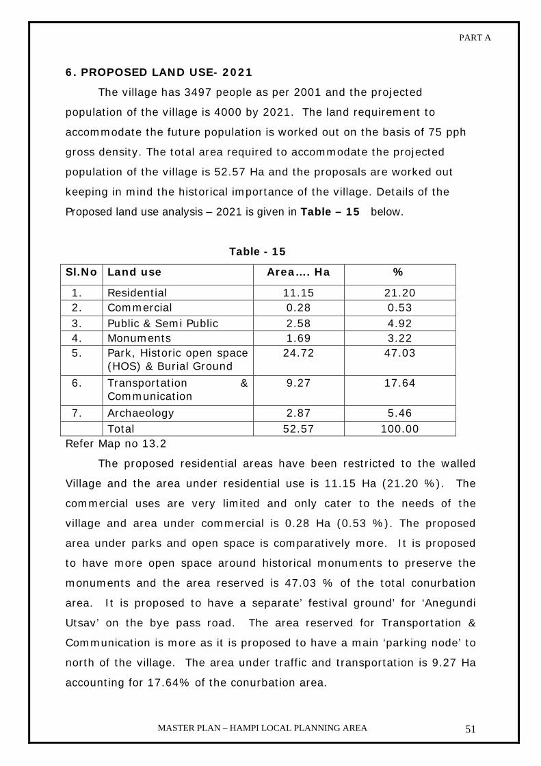
PART A
MASTER PLAN – HAMPI LOCAL PLANNING AREA 51
6. PROPOSED LAND USE- 2021
The village has 3497 people as per 2001 and the projected
population of the village is 4000 by 2021. The land requirement to
accommodate the future population is worked out on the basis of 75 pph
gross density. The total area required to accommodate the projected
population of the village is 52.57 Ha and the proposals are worked out
keeping in mind the historical importance of the village. Details of the
Proposed land use analysis – 2021 is given in Table – 15 below.
Table - 15
Sl.No Land use Area…. Ha %
1. Residential 11.15 21.20 2. Commercial 0.28 0.53 3. Public & Semi Public 2.58 4.92 4. Monuments 1.69 3.22 5. Park, Historic open space
(HOS) & Burial Ground 24.72 47.03
6. Transportation & Communication
9.27 17.64
7. Archaeology 2.87 5.46 Total 52.57 100.00
Refer Map no 13.2
The proposed residential areas have been restricted to the walled
Village and the area under residential use is 11.15 Ha (21.20 %). The
commercial uses are very limited and only cater to the needs of the
village and area under commercial is 0.28 Ha (0.53 %). The proposed
area under parks and open space is comparatively more. It is proposed
to have more open space around historical monuments to preserve the
monuments and the area reserved is 47.03 % of the total conurbation
area. It is proposed to have a separate’ festival ground’ for ‘Anegundi
Utsav’ on the bye pass road. The area reserved for Transportation &
Communication is more as it is proposed to have a main ‘parking node’ to
north of the village. The area under traffic and transportation is 9.27 Ha
accounting for 17.64% of the conurbation area.

KAMALAPURA

PART A
MASTER PLAN – HAMPI LOCAL PLANNING AREA 52
8.e KAMALAPURA
1. INTRODUCTION
Kamalapura town is the only town in the Local Planning Area. The town
is well connected with roadways to nearby cities and villages. The State
Highway passes through the Town limits. Kamalapura is about 12 kms
away from Hospet. Kamalapura was a fortified settlement during the
Vijayanagara period. A part of the remains of the fortifications are evident today.
Kamalapura is the only the town of the status of census town and has a strategic
location in the World Heritage Area on the south of the river Tungabhadra.
The importance of the town in the L.P.A is that it is very near to a
number of notified monuments both of national and state importance and
houses nearly 30% of the population of the Local Planning Area.
2. HISTORY
Kamalapura was so called by this name at least from 1531 AD
according to an inscription. Another inscription of the year 1541 AD
mentions this village Kamalapura and also refers to the tank of this
village. Kamalapura contains the remnants of an old Hindu fort with large
circular bastions one each at four corners. The corner bastions have
almost disappeared now flanking the entrance doorway of the fort are two
large and fine bas relief of Ganda Bherunda. The Nagareshwera temple
within the fort is note worthy for its finely carved wooden screen. This
town contains a number of small temples many of which people still
worship.
3. DEMOGRAPHY
i. Growth of Population
As per the census 2001, the total population of the town is 21830 out
of which the female population is 10894, having 996 females per 1000
males which is also better than the state average. This is very healthy
trend, considering the fact that if 48.2% of the population only is

PART A
MASTER PLAN – HAMPI LOCAL PLANNING AREA 53
literate. The work participation rate is 26.3%. This gives a very
progressive picture of the town.
Year 1971 1981 1991 2001 2011* 2021*
Persons13879 17471 20451 21830 24000 27,000 * Projected population
ii. Occupation
Total workers Main workers Marginal Workers Non-workers
8901 8400 501 12929
4. COMMUNITY FACILITIES
i. Education
There are 9 Primary Schools, 1 High School, 1 First Grade and
Hampi Kannada University.
ii. Administration
The Town Panchayat is administrating the Town. The Town
Panchayat is providing basic amenities within its limited resources to
the growing population to meet the increased public demand for civic
Amenities and infrastructure facilities.
Other Govt Offices that are located in the town are given below
1. Hampi Kannada University
2. Archeology Department
3. KEB (Sub-Division)
4. Police Station
5. Post Office
6. Telegraph Office
7. Primary Health Centre
8. Veterinary Department
iii. Animal Husbandry
The town consists of Veterinary Hospital, Poultry Farms and Market.
PART A
MASTER PLAN – HAMPI LOCAL PLANNING AREA 54
iv. Banking
There are four banks in the town namely State Bank of India, Bank
of India, BDCC Bank and Co-Operative Banks.
v. Health
There are 3 private Nursing Homes, 2 Government Hospitals, 4
Private Hospitals and 1 Veterinary Hospital.
vi. Religious place
There are 15 Temples, 10 mosques and 2 Churches.
vii. Market
There are 4 Markets - 1 is a daily and 1 is weekly, one is the mutton
market and another is beef market.
5. TRANSPORTATION AND COMMUNICATION
Kamalapura has well connected roads from nearby towns and
villages. State Highway from Hospet passes through the city limits of
Kamalapura. There are 2 Bus Stands and one Telephone Exchange.
6. EXISTING LAND USE – 2006
The developments in the town are congested and the roads are narrow.
The developed area of the town is 298.77 Ha with a gross density of 80 persons
per Ha. The major residential areas of the town are in old area and the new
developments are towards Kannada University and also towards the eastern
part of the town. The residential area of the town is 95.87 Ha accounting for
about 32.09 % of the total area. The commercial area of the town is mainly
characterized by tourism development like hotels and restaurants and other
commercial activities accounting 3.11 % of the total area. The town has only
0.42 Ha of land under industrial use. The town has also public and semi-public as
well as Archaeological uses accounting for about 52.78 % of the total developed
area. The Kannada University is located to the south east (4 Kms.) of the town.
The town has famous Pattabhirama Temple within the developed area. The town
has also parks and open space and burial grounds and area under this use is
27.96 Ha which is 9.36 % of the total developed area. The area under

PART A
MASTER PLAN – HAMPI LOCAL PLANNING AREA 55
transportation and communication is 3.11 Ha which accounts for 1.04 %
of the total area. Though the town has compact development in old area,
it is observed that a considerable vacant land of 2.0 Ha within the
developed area is also found. Details of the exisiting land use analysis –
2006 is given in the Table – 16 below.
Table – 16
Sl. No Land use Area…Ha % 1. Residential 95.87 32.09 2. Commercial 9.29 3.11 3. Industrial 0.42 0.14 4. Public & Semi Public 151.32 50.65 5. Monuments 6.39 2.13
6. Park, open space & Burial Ground
27.96 9.36
7. Public Utility 2.41 0.81
8. Transportation & Communication
3.11 1.04
9. Vacant 2.00 0.67 Total 298.77 100.00 Water Sheet 34.67 Grand total 333.44
Refer Map no 14. 2

PART A
MASTER PLAN – HAMPI LOCAL PLANNING AREA 56
7. PROPOSED LAND USE – 2021
The projected population of Kamalapur town is 30,000 by 2021 and
to accommodate this future population nearly 671.18 Ha of land required
at the rate of 64 persons per Ha of gross density. The identification of
land for future development is done in consultation with ‘Archeological
Survey of India’, State Department of Archaeology and UNESCO. The area
towards Kannada University on Bellary road and to the north of the town
has been identified as areas for ‘future expansion’.
The Hampi Kannada University area (192.00 Ha) is not taken into
account for the purpose of density. This is comparatively more and would
exaggerate the entire land use analysis. Since the area is basically
archaeologically significant area, care has been taken to freeze
developments around historical monuments. It is because of this reason
the parks and open space is considerably high and it accounts for about
9.45 % of the conurbation area. The proposed area under residential land
use is 120.53 Ha which is 19.17 % of the conurbation area and the major
future residential areas are proposed near Kannada University, north of
the town and vacant lands within the developed area. The area under
commercial use is 12.48 Ha which is 1.98 % of the conurbation area and
the major commercial developments are encouraged away from the
‘World Heritage Site’ and along the main roads of the old town and some
new commercial proposals are also proposed along Bellary road. The area
proposed under transportation and communication is 115.55 Ha (18.37
%) and includes road widening, proposed diversion of state highway,
main Bus Terminal on Bellary road and mini parking node at the entrance
of the ‘World Heritage Site’. Details of the proposed land use analysis –
2021 is given in the Table- 17 below.
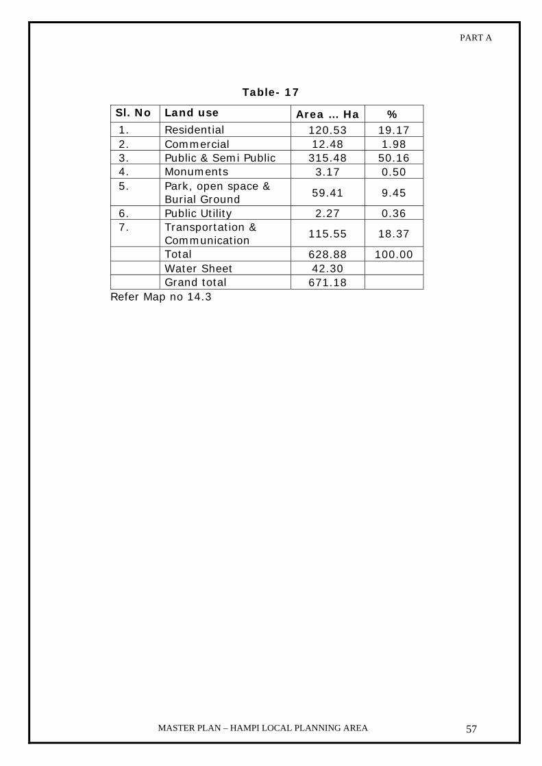
PART A
MASTER PLAN – HAMPI LOCAL PLANNING AREA 57
Table- 17
Sl. No Land use Area … Ha % 1. Residential 120.53 19.17 2. Commercial 12.48 1.98 3. Public & Semi Public 315.48 50.16 4. Monuments 3.17 0.50 5. Park, open space &
Burial Ground 59.41 9.45
6. Public Utility 2.27 0.36 7. Transportation &
Communication 115.55 18.37
Total 628.88 100.00 Water Sheet 42.30 Grand total 671.18
Refer Map no 14.3

PLAN PROPOSALS AND
DEVELOPMENT OPTIONS

PART A
MASTER PLAN – HAMPI LOCAL PLANNING AREA 58
View of the cable bridge during the floods Traditional mode of transport
Chapter 9
PLAN PROPOSALS AND DEVELOPMENT OPTIONS
SECTOR PLANS
a. Transportation
1. Linkage between the southern and northern parts of the
World Heritage Site (WHS)
The only physical link bridging the southern and northern parts of
the WHS are the two bridges, (one at T.B. Dam and another at
Kampli), which are located at 12 kms equidistant from Kamalapura on
two opposite directions. There used to be one historic bridge which is
now in ruinous state and beyond repairs at Hampi. In this context the
state government decided to build a cable stayed bridge at the
southern gate of Anegundi, whose construction started in 1998 and
stopped in 1999. After finding out that the large cable bridge
(unfinished) is not a good solution as it negatively impacts the
landscape and can trigger a chain of unwanted developments on both
sides of the river, it was concluded to find a permanent solution at the
down stream from the present location.
The traditional mode of transport across the river by using a
bamboo coracle (Harigolu) shall be continued. A section of the
community i.e. the Boatmen, craftsmen to build the boats are
dependent on the traditional mode of transportation.

PART A
MASTER PLAN – HAMPI LOCAL PLANNING AREA 59
Eco friendly mode of transport Parking and Mobile trading zone at Hampi
2. Diversion of state highway
The southern side of the LPA has a good transportation system as a
state highway passes through the site. However there is also a
negative impact due to state highway passing through the
archaeological area. It is proposed to divert the highway from the
south of Kamalapura settlement by by-passing the archaeological area.
3. Visitor movement
i. Circulation system:
Vehicular movement in the archaeological area is causing
damage to the monuments and archaeological remains. It is
proposed to regulate the movement of vehicles in the core zone
through a circulation system with the following components
Types of Nodes
Interchange Node: A point where visitors leave their vehicles and
change into different mode of transport.
Stoppage Node: A point where visitors will stop for viewing a
monument
Destination point: A point where visitors go for a specific activity
such as pilgrimage or recreation
b. Community facilities
A detailed plan for developing infrastructure shall be taken up. The
following are the sectors.

PART A
MASTER PLAN – HAMPI LOCAL PLANNING AREA 60
1. Social Infrastructure
i. Education
Up-gradation and improvement of existing education facilities to the
required standards shall be taken up. Infrastructure for education
need to be developed in the land designated for public and semi
public use in the development plans of the respective villages.
ii. Health
The basic health facilities in the LPA have to be provided. The health
facilities for the visitors in case of any emergency have to be
provided at key locations in the visitor movement areas. For local
population infrastructure for health need to be developed in the land
designated for public and semi public use in the development plans
of the respective villages.
2. Physical Infrastructure
i. Water supply
An integrated water supply scheme for all the villages has to be
developed to serve the settlements of the LPA
ii. Sanitation
As of now there is no underground drainage system in the LPA.
An underground drainage system for Kamalapura Town, which is
the only Urban area within the Local Planning Area, to be planned,
designed and implemented in a phased manner.
For rest of the LPA villages a system needs to be developed for the
disposal of sanitation waste in eco friendly manner.
iii. Solid Waste Management
A plan has to be prepared for the management of solid waste
disposal. A Land filling site is already been identified in the outskirts
of Kamalapura town i.e. Sy no 683 part to an extent of 4.0 acres
which is earmarked in the proposal map.

PART A
MASTER PLAN – HAMPI LOCAL PLANNING AREA 61
iv. Electricity
Infrastructure needed for upgrading the electrical system to meet
the requirements of the World Heritage Site shall be provided by the
respective departments.
c. Tourism
1. Visitor movement:
A circulation system is mentioned above for the proposed visitor
movement. Different kinds of access identified and proposed for
development to facilitate visitor movement are as follows
a. Road connectivity
b. Access to monuments
c. Special routes
d. Thematic routes
2. Visitor accommodation:
The concept of home stay has to be promoted to enhance the
experience of a living heritage site. At a regional level urban areas
surrounding the LPA can continue to be the places for accommodation.
The Department of Tourism proposal to develop the 228 acres of land
in Kamalapura has been identified as Tourism hub where
accommodation facilities can come up. Based on the concept of home
stay guest houses at Hampi have to be reorganized.
3. Improvement of the surroundings of destination The surroundings of the entry points and other destination points
proposed are to be developed in the Hampi World Heritage Site.
4. Activities directly related to Tourism A base camp, two Auxiliary camps, Water sports at Kamalapura and
Sanapur lake are proposed for the development of Adventure sports at
the Hampi World Heritage Site.
f. Interpretation Interpretation center is being proposed at Kamalapura town and the
location is marked in the proposal map. Detailed project has to be
worked out and implemented accordingly.

PART A
MASTER PLAN – HAMPI LOCAL PLANNING AREA 62
g. PROPOSED LAND UTILIZATION–2021 FOR L.P.A
As per 2001 census the Local Planning Area has population of about
60,000 and the projected population will be 90,000 by 2021. The
proposed land use for the entire Local Planning Area has been worked out
on basis of future population and other requirements. While working out
the proposals the following important characteristics and potentiality of
the site have been considered.
i. Outstanding natural landscape and Archaeological remains.
ii. Archaeologically and environmentally highly sensitive areas.
iii. Conservation and protection of both monuments and natural areas.
iv. Historic urban fabric
v. Growth of settlements and development options.
vi. Sub-terrain Archaeology.
vii. Tourism potentials and requirements.
viii. Traffic and transportation needs.
The proposed land use analysis has been worked out for different
uses. It is decided to protect and conserve the natural beauty of the area
i.e., rocky hillocks, forests and water bodies. The area under Monuments
is also maintained at 172.61 Ha. Some of the barren agricultural lands
adjacent to the settlements have been identified for future development
requirements. It is estimated that by 2021 the Local Planning Area
requires nearly 440.37 Ha of land for the future development of all
settlements. This land includes land reserved for main Terminal, parking
nodes and 92.31 Ha of ‘Tourism Hub’ in sy.no.1080 of Kamalapura by
State Tourism Department. The areas under forest and water bodies and
river have been maintained as it is. Details of proposed Land utilization –
2021 for LPA is given in the Table – 18 below.

PART A
MASTER PLAN – HAMPI LOCAL PLANNING AREA 63
Table - 18
SL NO LANDUSE AREA … Ha % 1 AGRICULTURE 7357.61 31.12 2 BARREN LAND 728.23 3.08 3 URBANISABLE AREA 1068.33 4.52 4 HILLS 4928.64 20.84 5 LAND SCRUB 534.99 2.26 6 CANAL 122.51 0.52 7 MONUMENT AREA 172.61 0.73 8 PLANTATION 746.67 3.16 9 POWER HOUSE 2.98 0.01 10 QUARIES 796.08 3.37 11 RESERVED FOREST 4672.06 19.76 12 RIVER TANKS 1340.32 5.67 13 ROCKY OUTCROPS 118.10 0.50 14 WATER LOGGED AREA 34.54 0.15 15 TRANSPORT AND
COMMUNICATION 928.40 3.92
16 PUBLIC UTILITY 1.62 0.01 17 TOURISM HUB 92.31 0.38 TOTAL 23646.00 100.00

PHASING AND FINANCE

PART A
MASTER PLAN – HAMPI LOCAL PLANNING AREA 64
Chapter 10
Phasing and Finance
Phasing
Phasing is only for providing infrastructure facilities and the
execution part of Master Plan has to be carefully and systematically
programmed to achieve continuity and integration in development.
The plan period is conveniently divided into two phases.
Hampi Master Plan is prepared for the year 2021 AD the first
phase period is proposed upto 2011 AD and the second phase
period is proposed up to 2021 AD. Infrastructure and other facilities
has to be developed and upgraded for the existing developed area
by 2011 AD. Excluding the present developed area remaining area
has to be developed by 2021 AD in the next Phase.
Finance
A. Land Acquisition:
For the effective implementation of the proposals made in the
master plan of the Hampi, the acquisition of the land earmarked for
public and semi public, parks, play ground and open spaces and
public utilities will have to be acquired to provide for the basic
amenities proposed in the plan for the growing population. The total
area proposed for public & semi public use in the Master plan is
319.51 hect. The additional area required to be acquired for the
said purpose is 44.81 hect. The total area proposed for park, open
spaces and play ground is 97.71 hect. The existing area under this
component is 29.22 hect. The additional area proposed for the
purpose is 68.49 hec. The total area proposed for transportation &
communication is 139.71 hect whereas the existing area under this
component is 14.6 hect. The additional area required for proposed
roads including widening of existing roads is 125.11 hect. The total

PART A
MASTER PLAN – HAMPI LOCAL PLANNING AREA 65
area proposed for Residential use is 158.66 hect, whereas the
existing area under this component is 113.82 hect. The additional
area required for the purpose is 44.81 hect. The total area proposed
for commercial use is 14.16 hect. The additional area required for
the purpose is 2.59 hect.
The total area proposed for acquisition works out to be 406.05
hect as per the proposals in the Master Plan.
B. Financial Implication:
Implementation of any plan involves finance. The
implementation of Master Plan includes development of various use
areas envisaged in the plan. The development of the town includes
the cost of the land acquisition and development of infrastructure in
various use area. As implementation part of Master plan has to be
done by various agencies (Private participation and public sector
involvement) at different stages.
To implement any plan, it is necessary to work out the cost
involved for the proposals made in the Master plan. Accordingly and
estimate is drawn up which requires nearly 8124.2 Lakhs out of
which more than 50% of the amount will have to be generated by
Government & Semi-Government organizations and the remaining
has to be generated by the private sector.
The estimated costs involved in various uses are calculated as
follows:

PART A
MASTER PLAN – HAMPI LOCAL PLANNING AREA 66
Table 5 – Cost of the implementation Sl.N
o
Land u
se
Pro
pose
d a
rea
hec
t.
Exi
stin
g a
rea
hec
t
Are
a re
quired
in
hec
t
Land a
cquis
itio
n
rate
in lak
hs
Appro
xim
ate
cost
of
land a
cquis
itio
n
Add r
ate
of la
nd
dev
elopm
ent
in
lakh
s
Appro
xim
ate
cost
of
dev
elopm
ent
in
lakh
s
Tota
l
1. Residential 158.63 113.82 44.81 5 224.05 15 672.15 896.2
2. Commercial 14.16 11.57 2.59 -do- 12.95 -do- 38.85 51.80
3. Industries 0.42 0 -do- -do-
4. Parks, Open
spaces, Play
grounds &
burial grounds
97.71 29.22 68.49 -do- 342.45 -do- 1027.35 1369.8
5. Public and
Semi-public
319.51 154.3 165.21 -do- 826.05 -do- 2478.15 3304.2
6. Transportation
&
Communication
139.71 14.6 125.11 -do- 625.55 -do- 1876.65 2502.2
Total 729.72 323.93 406.21 2031.05 6093.15 8124.2
Total cost involved in land acquisition: 2031.05 Lakhs
Total cost of development in all sectors: 6093.15 Lakhs
Grand Total: 8124.2 Lakhs
It is not possible for any one public agency to meet this
demand. External funding agencies, Private sector participation,
Tourism sector and Development agencies will have to be co-opted
to meet the demand required for the implementation of the Master
Plan proposals.

IMPLEMENTATION

PART A
MASTER PLAN – HAMPI LOCAL PLANNING AREA 67
Chapter 11
Implementation All planning will be a failure if sustained efforts are not made
to enforce and implement the master plan for the Hampi Local
Planning Area. There are various provisions regarding control of
development and use of land contained in the KTCP Act of 1961
Hampi World Heritage Area Management Authority Act 2002,
Municipal Act, Panchayat Act, Housing Board Act, Public Works
code, etc., in implementing the plan. The coordinated approach is
the only solution for the conservation and planned development of
the planning area.
For the effective implementation of the Master Plan various
agencies are identified and shall be involved in the process.
SL No
Name of agency Description of schemes
1.
Hampi World Heritage Area Management Authority, Town & Village Panchayats
Improvement schemes, Town/Village extension schemes, Formations of roads, Development of land for commercial use, Civic amenities and Traffic improvement schemes.
2. Karnataka Housing Board
Development of land for residential use.
3.
Public Works Department & National Highways Department
Formation of Highways, roads, Construction of Quarters for Govt. Employees, Construction of building for various departments and Traffic improvement schemes.
4.
Karnataka Urban Water Supply & Drainage Board, Zilla & Taluk Panchayat
Formulation and implementation of Drinking Water supply and Under ground drainage schemes.
5. KPTCL Electricity supply and maintenance
6. Education Department
Construction of schools and educational institutions.
7. Horticulture and social forestry
Plantation of trees and maintenance of greenery
8. Archaeology Department
Conservation & Preservation of monuments & its surrounding areas.

PART A
MASTER PLAN – HAMPI LOCAL PLANNING AREA 68
Enforcement and implementation:
As required under Sec 14 of KTCP Act 1961, the process of
implementation of Master Plan involves legal, financial and
administrative aspects; where the Hampi World Heritage Area
Management Authority is incharge of the functions to prepare the
plan, Kamalapur Town Panchayat and the Village Panchayats are
the agencies for enforcement and implementation of the plan. The
success of enforcement and implementation of the plan depend
upon the co-operation and co-ordination between various planning,
enforcing and implementing agencies.
Enforcement of zonal Regulations:
Zonal regulations are intended for controlling the use of the
land and are also intended to prevent congestion by prescribing
setback around buildings, restricting the heights, coverage, FAR
etc., The regulations are also required for sub division of land and
for parking spaces to be provided to prevent traffic hazards. The
zonal regulations are put under four categories namely;
i. Regulations to control the use of land
ii. Regulations governing set backs, FAR etc.,
iii. Regulations for sub-dividing the land
iv. Prescribing the width of the roads and parking spaces.
v. Regulations for heritage buildings/precincts.
vi. Regulations for the area around monuments & natural areas
under Areas of special control.

PART-B
ZONAL REGULATIONS

CONTENTS
1 – Introduction 72 2 – Definitions 74 3 - Annexure-1 87 4 - General regulations 106 5 – Areas of special control 123 6 – Annexure - ii 126 7 - Group housing 132 8 - Subdivision regulations 135 9 - Parking regulations 142 10 – Building line 144 11 - Heritage regulations 145

PART B
MASTER PLAN – HAMPI LOCAL PLANNING AREA 72
1. INTRODUCTION
In order to conserve the cultural heritage and the natural environs
of the Hampi world heritage area and to promote public health, safety and
the general social welfare of the community, it is necessary to apply
planned management and reasonable limitation on the development of
land and buildings. This is to ensure that most appropriate, economical
and healthy development of the local planning area takes place in
accordance with the land use plan, and its continued maintenance over
the years. For this purpose, the town is divided in to a number of use
zones, such as residential, commercial, industrial, public and semi public
etc. Each zone has its own regulations, as the same set of regulations
cannot be applied to the entire area.
Zonal Regulations provides for protection of archaeological
monuments and the area surrounding it, heritage buildings/ precincts and
residential areas from the harmful invasions of commercial and industrial
uses and at the same time promotes the orderly development of other
areas, by suitable regulations on spacing of buildings to provide adequate
light, air, protection from fire, etc. It prevents over crowding in buildings
and on land to ensure adequate facilities and services.
Zoning is not retrospective. It does not prohibit the uses of land
and buildings that are lawfully established prior to the coming into effect
of these Zonal Regulations. If these uses are contrary to the newly
proposed uses, they are termed non-conforming uses and are gradually
eliminated over years without inflicting unreasonable hardship upon the
property owner.
The Zonal Regulations and its enforcement ensure proper land use
and development and form an integral part of the Master Plan. It also
ensures solutions to problems of development under local conditions.
PART B
MASTER PLAN – HAMPI LOCAL PLANNING AREA 73
The Zonal Regulations for Hampi Local Planning Area prepared under
the clause (iii) of sub-section (2) of section 12 of the Karnataka Town and
Country Planning Act, 1961 are detailed below.
a) Establishment of Zones and Zonal Maps:
a. The local planning area is divided into use zones such as
residential, commercial, public and semi public etc., as shown in
the enclosed maps.
b. Zonal boundaries and interpretations of Zonal Regulations.
i. Where there is uncertainty as regards the boundary of the
zones in the approved maps, it shall be referred to the
authority and the decision of the authority in this regard
shall be final.
ii. For any doubt that may arise in interpretation of the
provisions of the Zonal Regulations, the authority shall
consult the Director of Town Planning Bangalore.
b) Annexure-I appended to these regulations sets out the uses of
land:
a. Those are permitted.
b. Those may be permitted under special circumstances by the
Authority in different zones.
c) The regulations governing minimum size of plot, maximum plot
coverage, minimum front, rear and side setbacks, minimum road
widths and maximum number of floors and height of structures are set
out in different chapters in these regulations.

PART B
MASTER PLAN – HAMPI LOCAL PLANNING AREA 74
2. DEFINITIONS
In these Zonal Regulations, unless the context otherwise requires,
the expressions given below shall have the meaning indicated against
each of them.
2.1 ‘Act’ means the Karnataka Town and Country Planning Act, 1961
and HWHAMA Act means Hampi World Heritage Area Management
Authority Act. 2002
2.2 ‘Addition and / or Alteration’ means a structural change
including an addition to the area or change in height or the removal
of part of building, or any change to the structure, such as the
construction or removal or cutting of any wall or part of a wall,
partition, column, beam, joist, floor including a mezzanine floor or
other support, or a change to or closing of any required means of
access ingress or egress or a change to fixtures or equipment as
provided in these Zonal Regulations.
2.3 ‘Agriculture’ includes horticulture, farming, growing of crops,
fruits, vegetables, flowers, grass, fodder, trees of any kind or
cultivation of soil, breeding and keeping of live stock including
cattle, horses, donkeys, mules, pigs, fish, poultry and bees, the use
of land which is ancillary to the farming of land or any purpose
aforesaid but shall not include the use of any land attached to a
building for the purpose of garden to be used along with such
building; and ‘agriculture’ shall be construed accordingly.
2.4 ‘Amenity’ includes roads, street, open spaces, parks, recreational
grounds, playgrounds, gardens, water supply, electric supply, street
lighting, sewerage, drainage, public works and other utilities,
services and conveniences.

PART B
MASTER PLAN – HAMPI LOCAL PLANNING AREA 75
2.5 ‘Apartment’ means a room or suite or rooms, which are occupied
or which is intended or designed to be occupied by one family for
living purpose.
2.6 ‘Apartment building / multi dwelling units’ means a building
containing four or more apartments / dwelling units, or two or more
buildings, each containing two or more apartments with a total of
four or more apartments / dwelling units for all such buildings and
comprising or part of the property.
2.7 ‘Applicant’ means any person who gives notice to the Authority
with an intention to erect or re-erect or alter a building.
2.8 ‘Archaeology Act’ means
a. Ancient Monuments & Sites & Remains Act, 1958
b. The Karnataka Ancient & Historical Monuments &
Archaeological sites & Remains Act, 1961
2.9 ‘Balcony’ means a horizontal cantilever projection including a
handrail or balustrade, to serve as passage or sit out place.
2.10 ‘Basement storey or cellar’ means any storey, which is partly /
wholly below the ground level. The basement height should not
project more than 1.5 mtrs above the average ground level.
2.11 ‘Building’ includes;
2.11.a A house, out-house, stable, privy, shed, well, verandah, fixed
platform, plinth, door step and any other such structure whether
of masonry, bricks, wood, mud, metal or any other material
whatsoever;
2.11.b A structure on wheels simply resting on the ground without
foundation;

PART B
MASTER PLAN – HAMPI LOCAL PLANNING AREA 76
2.11.c A ship, vessel, boat, tent and any other structure used for
human habitation or used for keeping animals or storing any
article or goods on land.
2.12 ‘Building line’ means the line up to which the plinth of buildings
may lawfully extend within the plot on a street or an extension of a
street and includes the line prescribed, if any, or in any scheme.
2.13 ‘Chajja’ means a continuous sloping or horizontal cantilever
projection provided over an opening or external wall to provide
protection from sun and rain.
2.14 ‘Chimney’ means a structure usually vertical containing a passage
or flue by which the smoke, gas, etc., of a fire or furnace are carried
off and by means of which a draught is created.
2.15 ‘Civic Amenity’ means a market, a post office, a bank, a bus stand
or a bus depot, a fair price shop, a milk booth, a school, a
dispensary, a maternity home, a child care center, a library, a
gymnasium, a recreation center run by the Government or local
authority, a center for educational, religious, social or cultural
activities or philanthropic service run by a co-operative society or
society registered under the Karnataka Societies Registration Act,
1960 (Karnataka Act 17 of 1960) or by a trust created wholly for
charitable, educational or religious purposes, a police station, an
area office or a service station of the local authority or the
Karnataka Urban Water Supply and Drainage Board or the
Karnataka Electricity Board and such other amenity as the
Government may by notification specify
2.16 ‘Commercial building’ means a building or part of a building,
which is used as shops, and/or market for display and sale of
merchandise either wholesale or retail, building used for transaction
of business or the keeping of accounts, records for similar purpose;

PART B
MASTER PLAN – HAMPI LOCAL PLANNING AREA 77
professional service facilities, corporate offices, software services,
offices of commercial undertakings and companies petrol bunk,
restaurants, lodges, nursing homes, cinema theatres, multiplex,
kalyana mantapa, community hall (run on commercial basis) banks,
clubs run on commercial basis. Storage and service facilities
incidental to the sale of merchandise and located in the same
building shall be included under this group, except where exempted.
2.17 ‘Common wall’ means;
a. A wall built on land belonging to two adjoining owners, the wall
being the joint property of both owners.
b. If two adjoining owners build a dividing wall on their property, they
are not common walls and no part of the footings of either wall shall
project on to the land of the adjoining owner, except by legal
agreement between the owners.
c. Any such ‘common’ or ‘dividing’ wall shall be considered for the
purpose of these byelaws, as being equivalent to an external wall as
far as the thickness and height are concerned.
2.18 ‘Corner plot’ means a plot facing two or more intersecting streets.
2.19 ‘Corridor’ means a common passage or circulation space including
a common entrance hall.
2.20 ‘Courtyard’ means a space permanently open to the sky either
interior or exterior of the building within the site around a structure
2.21 ‘Covered Area’ means area covered by building / buildings
immediately above the plinth level, but does not include the space
covered by;
a. Garden, rocky area, well and well structures, plant, nursery, water
pool, swimming pool (if uncovered) platform around a tree, tank,

PART B
MASTER PLAN – HAMPI LOCAL PLANNING AREA 78
fountain, bench with open top and unenclosed sides by walls and
the like.
b. Drainage, culvert, conduit, catch-pit, gully-pit, chamber gutter and
the like;
c. Compound or boundary wall, gate, un-storied porch and portico,
Chejja, slide, swing, uncovered staircase, watchman booth, pump
house. The area covered by watchman booth / pump house shall
not exceed three square meters;
d. Sump tank and electric transformer.
2.22 ‘Cross wall’ means an internal wall within the building up to the
roof level or lintel level.
2.23 ‘Cultural Heritage’ shall be considered as
a. Monuments: Architectural works, works of monumental sculpture
and painting, elements or structures of an archaeological nature,
inscriptions, cave dwellings and combinations of features, which are
of outstanding universal value from the point of view of history art
or science;
b. Groups of buildings: Groups of separate or connected buildings
which, because of their architecture, their homogeneity or their
place in the landscape, are of outstanding universal value from the
point of view of history, art or science;
c. Sites: Works of man or the combined works of nature and of man,
and areas including archaeological sites which are of outstanding
universal value from the historical, aesthetic, ethnological or
anthropological points of view.
2.24 ‘Density’ means concentration of population expressed in terms of
number of persons per hectare in a particular area.

PART B
MASTER PLAN – HAMPI LOCAL PLANNING AREA 79
2.25 ‘Detached building’ means a building, the walls and roof of which
are independent of any other building with open spaces on all sides,
except the portion covered by the garage.
2.26 ‘Development’ with its grammatical variations - means the carrying
out of building, engineering, mining or other operations in, or over
or under land or the making of any material change in any building
or land or in the use of any building or land and includes sub-
division of any land.
2.27 ‘Drain’ means any pipe or other construction emanating from a
plumbing fixture unit, traps, gullies, floor traps, etc., which carries
water, or waste water in a building and connects to the drainage
system.
2.28 ‘Drainage’ means the removal of any waste liquid by a system
constructed for this purpose.
2.29 ‘Dwelling unit / Tenement’ means an independent housing unit
with separate facility for living, cooking and sanitary requirements.
2.30 ‘Exit’ means a passage, channel or means of egress from any floor
to a street or other open space of safety.
2.31 ‘External wall’ means an outer wall of the building not being a
partition wall even though adjoining a wall of another building and
also a wall abutting on an interior open space of any building.
2.32 ‘First floor’ means the floor immediately above the ground floor, on
which second and other floors follow subsequently.
2.33 ‘Floor’ means the lower surface in a storey on which one normally
walks in a building. The general term ‘floor’ does not refer basement
or cellar floor and mezzanine.

PART B
MASTER PLAN – HAMPI LOCAL PLANNING AREA 80
2.34 ‘Floor Area Ratio’ (FAR) means the quotient of the ratio of the
combined gross areas of all floors, except the areas specifically
exempted under these regulations, to the total area of the plot, viz.
Total floor area of all the floors. Floor Area Ratio =
Plot Area
2.35 ‘Footing’ means the projecting courses at the base of a wall to
spread the weight over a large area.
2.36 ‘Foundation’ means that part of structure which is below the lowest
floor and which provides support for the superstructure and which
transmits the load of the superstructure to the bearing strata.
2.37 ‘Frontage’ means the measurement of the side of any site abutting
the road.
2.38 ‘Garage’ means a structure designed or used for the parking of
vehicles.
2.39 ‘Government’ means the Government of Karnataka.
2.40 ‘Ground floor’ means immediately above the level of the adjoining
ground level on all sides or above the basement floor.
2.41 ‘Group Housing’ means apartments or group of apartment and / or
more than two buildings on a plot with one or more floors and with
one or more dwelling units in each floor. They are connected by an
access of not less than 3.5 m in width, if they are not approachable
directly from the road.
2.42 ‘Habitable room’ means a room occupied or designed for
occupancy by one or more persons for study, living, sleeping,
cooking, eating, but does not include bath rooms, water closet
compartments, laundries, serving and storage pantries, corridors,

PART B
MASTER PLAN – HAMPI LOCAL PLANNING AREA 81
cellars, attics and spaces that are not used frequently or during
extended periods.
2.43 ‘Hazardous Building’ means a building or part thereof used for:
a. Storage handling, manufacture of processing of radioactive
substances or of highly combustible or explosive materials or of
products which are liable to burn with extreme rapidity and or
producing poisonous fumes or explosive emanations;
b. Storage, handling, manufacture or processing of which involves
highly corrosive, toxic or noxious alkalis, acids, or other liquids,
gases or chemicals producing flame, fumes and explosive mixtures,
etc. or which result in division of matter into fine particles capable
of spontaneous ignition.
2.44 ‘Head room’ where a finished ceiling is not provided the lower side
of the joists or beams or tie beams shall determine the clear
headroom.
2.45 ‘Height of Building’ means the vertical distance measured in the
case of flat roofs from the average road level of the site to the top
of the roof and in the case of pitched roofs up to the point where
the external surface of the outer wall intersects a finished surface of
the sloping roof and in case of gable facing the street, the mid point
between the eave-level and the ridge. Architectural features, service
no other function except that of decoration shall be excluded for the
purpose of measuring height. Water tank, chimneys, lift room, stair
case room, and parapet are also excluded for the purpose of
measuring height.
2.46 ‘Heritage Area’ means the whole of the area-comprising core,
buffer and peripheral zones and is co-terminus with the word ‘Local
Planning Area’ declared under KTCP Act 1961.

PART B
MASTER PLAN – HAMPI LOCAL PLANNING AREA 82
2.47 ‘Heritage building’ means a building possessing architectural,
aesthetic, historic or cultural values, which is declared as heritage
building by the HWHAMA within whose jurisdiction such building is
situated.
2.48 ‘Heritage Precinct / zone ’ means an area comprising heritage
building or buildings and precincts thereof or related places declared
as such by the HWHAMA within whose jurisdiction such Precinct /
zone is situated.
2.49 ‘Land use’ includes the purpose to which the site or part of the site
or the building or part of the building is in use or permitted to be
used by the Authority. Land use includes zoning of land use as
stipulated in the Master plan and the Zoning Regulations.
2.50 ‘License’ means a permission or authorization in writing by the
Authority to carry out work regulated by the Zonal Regulations.
2.51 ‘Lift’ means an appliance designed to transport persons or materials
between two or more levels in a vertical or substantially vertical
direction by means of a guided car platform.
2.52 ‘Local Authority’ means City Municipal council, Town Panchayat or
Grama Panchayat
2.53 ‘Loft’ means a residual space above normal floor level, which may
be constructed or adopted for storage purposes.
2.54 ‘Master Plan’ means Master Plan prepared for the Local Planning
Area of Hampi approved by the Government under the Karnataka
Town and Country Planning Act, 1961.
2.55 ‘Mezzanine floor’ means an intermediate floor between two floors,
above ground level with area of mezzanine floor restricted to 1/3 of
the area of that floor and with a minimum height of 2.20mts.

PART B
MASTER PLAN – HAMPI LOCAL PLANNING AREA 83
2.56 ‘Natural environs’ includes the rivers, riverbeds, rocks, water
bodies, wild life and vegetation in the Heritage Area.
2.57 ‘Natural Heritage’ shall be considered as
a. Natural features consisting of physical and biological formations or
groups of such formations, which are of outstanding universal value
from the aesthetic or scientific point of view;
b. Geological and physiographical formations and precisely delineated
areas, which constitute the habitat of threatened species of animals
and plants of outstanding universal value from the point of view of
science or conservation;
c. Natural sites or precisely delineated natural areas of outstanding
universal value from the point of view of science, conservation or
natural beauty.
2.58 ‘Non-combustible materials’ means a material, which neither
burns nor gives off inflammable vapours in sufficient quantity to
ignite a pilot flame.
2.59 ‘Occupancy or use group’ means the principal occupancy for
which a building or a part of the building is used or intended to be
used. For the purpose of classification of a building according to
occupancy, occupancy shall be deemed to include subsidiary
occupancies, which are contingent upon it.
2.60 ‘Open space’ means an area forming an integral part of the plot,
left open to sky in a building.
2.61 ‘Owner’ includes the person for the time being receiving or entitled
to receive, whether on his own account or as an agent, power of
attorney holder, trustee, guardian, manager or receiver for another
person or for any religious or charitable purpose, the rent or profits
of the property in connection with which the word is used.

PART B
MASTER PLAN – HAMPI LOCAL PLANNING AREA 84
2.62 ‘Parapet’ means a low wall or railing built along the edge of a roof.
2.63 ‘Parking space’ means an area enclosed or unenclosed, covered or
open sufficient in size to park vehicles together with a drive-way
connecting the parking space with a street or any public area and
permitting the ingress and egress of the vehicles.
2.64 ‘Penthouse’ means a covered space not exceeding 10 square
meters on the roof of a building, which shall have at least one side
completely open.
2.65 ‘Plinth’ means the portion of a structure between the surface of the
surrounding ground and surface of the floor immediately above the
ground.
2.66 ‘Plinth area’ means the built up covered area of the building /
buildings immediately above plinth level.
2.67 ‘Plinth level’ means the level of the floor of a building immediately
above the surrounding ground.
2.68 ‘Plot or site’ means a parcel (piece) of land enclosed by definite
boundaries.
2.69 ‘Porch or portico’ means a roof cover supported on pillars or
cantilevered projection for the purpose of pedestrian or vehicular
approach to a building.
2.70 ‘Prohibited area’ means 100 mtrs radius area around the
monument as declared under the provisions of the archaeology act.
2.71 ‘Public and semi-public building’ means a building used or
intended to be used either ordinarily or occasionally by the public
such as offices of State or Central Government or Local authorities,
a church, temple, chapel, mosque or any place of public worship,
dharmashala, college, school, library, theatre for cultural activities,
public concert room, public hall, hospital run by public institutions,

PART B
MASTER PLAN – HAMPI LOCAL PLANNING AREA 85
public exhibition hall, lecture room or any other place of public
assembly.
2.72 ‘Residential building’ means a building used or constructed or
adopted to be used wholly for human habitation and includes
garages, and other out-houses necessary for the normal use of the
building as a residence.
2.73 ‘Registered architect/engineer / supervisor’ means a qualified
Architect / Engineer / Supervisor registered by the Authority.
2.74 ‘Regulated area’ means area falling between the 100 mtrs to 300
mtrs radius from the monument as declared under the provisions of
the archaeology act.
2.75 ‘Room height’ means the vertical distance measured between the
finished floor surface and the finished ceiling surface. Where a
finished ceiling is not provided, the under side of the joists or beams
or tie beams shall determine the upper point of measurement.
2.76 ‘Row Housing’ means a row of houses with only front, rear and
interior open spaces.
2.77 ‘Semi-detached Building’ means a building detached on three
sides with open spaces as specified in these regulations.
2.78 ‘Service Apartments’ means fully furnished room or suite or
rooms with kitchen which is intended to be rented out on
daily/weekly/monthly basis.
2.79 ‘Service Road’ means a road / lane provided at the front, rear or
side of a plot for service purposes.
2.80 ‘Service industry’ means an industry where services are offered
with or without power. If power is used, aggregate installed capacity
shall not exceed 10 HP or the site area shall be minimum of 200 sq
m. Service industries shall be permitted as given in Schedule I.

PART B
MASTER PLAN – HAMPI LOCAL PLANNING AREA 86
2.81 ‘Set back’ means the open space prescribed under these Zonal
Regulations between the plot boundary and the plinth of the
building.
2.82 ‘Stair case room’ means a room accommodating the stair and for
purpose of providing protection from weather and not used for
human habitation.
2.83 ‘Storey’ means the space between the surface of one floor and the
surface of the other floor vertically above or below.
2.84 ‘To abut’ in relation to the building or any portion of it means to
touch the road boundary or the adjoining plot or building.
2.85 ‘To erect’ means to construct a whole or a part of a new building on
any site whether previously built upon or not; including additions or
alterations to an existing building.
2.86 ‘Water closet’ means a privy with arrangements for flushing the
pan with water but does not include a bathing room.
2.87 ‘Zonal Regulations’ means Zoning of Land use and Regulations
prepared under the Karnataka Town and Country Planning Act, 1961
prescribing the uses permissible in different land use zones, the
open spaces around buildings, plot coverage, floor area ratio, height
of the building, building lines, parking, etc.
Note: - The words and expressions not defined in these regulations shall
have the same meaning as in the Karnataka Town and Country Planning
Act, 1961 and National Building Code of India 1983.
PART B
MASTER PLAN – HAMPI LOCAL PLANNING AREA 87
3. ANNEXURE – I
The Local Planning Area is divided into following zones under the
provisions of HWHAMA Act 2002.
(A) CORE ZONE (B) BUFFER ZONE & PERIPHERAL ZONE
For the purpose of these regulations, the above-mentioned zones are
divided into following use zones:
1. Residential zone
2. Commercial zone
3. Industrial zone
4. Public and semi public zone
5. Public utility zone
6. Monument area zone
7. Parks, playgrounds, open spaces and burial ground zones
8. Heritage zone
Note: Please refer to Heritage Regulations
9. Transportation and communication zone.
10.Agriculture zone.
Uses of land that are permitted and those that are permitted under
special circumstances by the Hampi World Heritage Area Management
Authority in different zones of the local planning area shall be as follows.

PART B
MASTER PLAN – HAMPI LOCAL PLANNING AREA 88
(A) CORE ZONE
I. Hampi - (Refer to map no – 11.2)
1. Residential
Uses permitted:
Dwellings, old age homes, educational hostels, orphanages,
anganawadis, nursery schools with a minimum sital area of 500 sq
mts, lower primary school with minimum sital area of 1000 sq mts,
milk booths, STD booths.
Uses permitted under special circumstances:
Higher primary schools with a minimum sital area of 2000 sqmts,
public library, parks and playgrounds, hospitals for human care
(with minimum sital area of 500 sq mts), service industries with
power up to 10 hp listed in schedule 1 pay and use toilets, vehicle
parking, places of worship.
Convenience Shop, Computer institutes, Internet parlours, doctors
consulting room, offices of professionals not exceeding 15 sq mts
(with minimum sital area of 200 sq.mtrs. provided applicant himself
is a professional).
2. Commercial
Hampi Bazaar:
Uses permitted:
Trades confirming to the needs of the temple as decided by ASI /
Department of Archaeology and museums in consultation with
HWHAMA

PART B
MASTER PLAN – HAMPI LOCAL PLANNING AREA 89
3. Monument area
Uses permitted:
No developments in monument area shall be permitted except the
conservation and preservation activities to be taken by
ASI/Department of Archaeology and museums/ Hampi Authority or
owner of the monument subject to the approval of the proposal by
the concerned archaeology department, Parks and open spaces,
natural landscaping, planting of saplings.
4. Parks, playgrounds and open spaces
Uses permitted:
Parks play grounds, pathways, boulevards, natural landscaping,
planting of saplings, cemetries, public toilets, parking, STP’s wet
wells, public use (ancillary to park, open space and playground
which shall not exceed 5% of total area), kiosks (not exceeding 15
sq.m).
5. Transportation and communication.
Uses permitted:
Road, bus stations, bus depot, bus shelters, vehicle parking area,
shelters for non-conventional transport modes like horse buggies,
carriages, cycle stand, etc., traffic nodes, and terminal facilities,
parks, playgrounds, public toilets, kiosks (not exceeding 15 sq.m).

PART B
MASTER PLAN – HAMPI LOCAL PLANNING AREA 90
II. Kaddirampura (Refer to map no – 12.2)
1. Residential
Uses permitted:
Dwellings, old age homes, educational hostels, orphanages,
anganawadis, nursery schools with a minimum sital area of 500 sq
mts, lower primary school with minimum sital area of 1000 sq mts,
milk booths, STD booths.
Uses permitted under special circumstances:
Higher primary schools with a minimum sital area of 2000 sqmts,
public library, parks and playgrounds, hospitals for human care
(with minimum sital area of 5000 sq mts.) Service industries with
power up to 10 hp listed in schedule 1.
Convenience shop, computer institutes, internet parlours, doctors
consulting room, offices of professionals not exceeding 15 sq mts
(with minimum sital area of 200 sq.mtrs. provided applicant himself
is a professional), pay and use toilets, vehicle parking, places of
worship.
2. Commercial
Uses permitted:
Offices, shop and service establishments like hair dressing saloons,
laundries, dry cleaning and tailoring shops, hostels, banks,
canteens, restaurants, advertising signs, computer offices and
institutes and all uses permitted in the residential zone.
Uses permitted under special circumstances:
Automobile (two wheeler) workshops, manufacturing
establishments, employing not more than 10 labours (power not
more than 20 hp) community halls, markets, and cold storage

PART B
MASTER PLAN – HAMPI LOCAL PLANNING AREA 91
Note: office complexes, commercial complexes should have sufficient
toilet for visitors in each floor and should be shown on plan. It shall
have waste disposal arrangements.
3. Industrial
Uses permitted:
Modification, alterations of the existing jaggery mill is permitted.
4. Public and semi public
Uses permitted:
All central, state quasi govt offices and institutional offices,
educational, hostel facilities for students, cultural and religious
institution including libraries, reading rooms, medical and health
institutions, utilities and services, water supply installations
including disposal works, substations ,banks and quarters for
essential staff, old age homes and orphanages and all uses
permitted under parks and play grounds.
Note: banks, clubs, canteens, dwellings required for maintenance, and
functioning of public and semi public uses in the zone may be
permitted when they are run on non commercial basis in their own
premises and ancillary to the respective institutions.
Uses permitted under special circumstances:
Vehicle Parking, crematorium, burial grounds, museum, aquarium,
horticultural nursery
5. Monument area
Uses permitted:
No developments in monument area shall be permitted except the
conservation and preservation activities to be taken by
ASI/Department of Archaeology and museums/ Hampi Authority or

PART B
MASTER PLAN – HAMPI LOCAL PLANNING AREA 92
owner of the monument subject to the approval of the proposal by
the concerned archaeology department, Parks and open spaces,
natural landscaping , planting of saplings.
6. Parks, playgrounds and open spaces
Uses permitted:
Parks play grounds, pathways, boulevards, natural landscaping ,
planting of saplings, cemetries, public toilets, parking, STP’s wet
wells, public use (ancillary to park, open space and playground
which shall not exceed 5% of total area), kiosks(not exceeding 15
sq mtrs).
Uses permitted under special circumstances:
Art gallery, horticulture, nursery, hopcom centres, milk booths,
museums (built up area shall not be more than 20 % of the plot
area)
7. Transportation and communication.
Uses permitted:
Road, bus stations, bus depot, bus shelters, vehicle parking area,
shelters for non-conventional transport modes like horse buggies,
carriages, cycle stand, etc., traffic nodes, and terminal facilities,
parks, play grounds, public toilets, kiosks (not exceeding 15 sq.m).

PART B
MASTER PLAN – HAMPI LOCAL PLANNING AREA 93
III. Anegundi (Refer to map no – 13.2)
1. Residential
Uses permitted:
Dwellings, old age homes, educational hostels, orphanages,
anganawadis, nursery schools with a minimum sital area of 500 sq
mts, lower primary school with minimum sital area of 1000 sq mts,
milk booths, STD booths.
Uses permitted under special circumstances:
Higher primary schools with a minimum sital area of 2000 sqmts,
public library, parks and playgrounds, hospitals for human care
(with minimum sital area of 5000 sq mts). Service industries with
power up to 10 hp listed in schedule 1.
Convenience shop, computer institutes, internet parlors, doctors
consulting room, offices of professionals not exceeding 15 sq mts
(with minimum sital area of 200 sq.mtrs. provided applicant himself
is a professional), pay and use toilets, vehicle parking, places of
worship.
2. Commercial
Uses permitted:
Offices, shop and service establishments like hair dressing saloons,
laundries, dry cleaning and tailoring shops, hostels, banks, canteens
and restaurants, advertising signs, computer offices and institutes
and all uses permitted in the residential zone.
Uses permitted under special circumstances:
Automobile (two wheeler) workshops, traditional craft workshops
employing not more than 10 labours (power not more than 20 hp)
community halls, markets, cold storage.

PART B
MASTER PLAN – HAMPI LOCAL PLANNING AREA 94
Note: office complexes, commercial complexes should have sufficient
toilet for visitors in each floor and should be shown on plan. It shall
have waste disposal arrangements.
3. Public and semi public
Uses permitted:
All central, state quasi govt offices and institutional offices,
educational, hostel facilities for students, cultural and religious
institution including libraries, reading rooms, medical and health
institutions, utilities and services, water supply installations
including disposal works, substations, banks and quarters for
essential staff, old age homes and orphanages and all uses
permitted under parks and play grounds.
Note: banks, clubs, canteens, dwellings required for maintenance, and
functioning of public and semi public uses in the zone may be
permitted when they are run on non commercial basis in their own
premises and ancillary to the respective institutions.
Uses permitted under special circumstances:
Parking lots, crematorium, burial grounds, museum, aquarium,
horticultural nursery
4. Monument area
Uses permitted:
No developments in monument area shall be permitted except the
conservation and preservation activities to be taken by
ASI/Department of Archaeology and museums/ Hampi Authority or
owner of the monument subject to the approval of the proposal by
the concerned archaeology department, Parks and open spaces,
natural landscaping , planting of saplings.

PART B
MASTER PLAN – HAMPI LOCAL PLANNING AREA 95
5. Archaeology
Please refer 5. Areas of Special control of zonal regulations
6. Parks, playgrounds and open spaces
Uses permitted:
Parks play grounds, pathways, boulevards, natural landscaping ,
planting of saplings, cemetries, public toilets, parking, STP’s wet
wells, public use (ancillary to park, open space and playground
which shall not exceed 5% of total area), kiosks(not exceeding 15
sq mtrs).
Uses permitted under special circumstances:
Art gallery, horticulture, nursery, hopcom centres, milk booths,
museums (built up area shall not be more than 20 % of the plot
area)
7. Heritage zone:
Refer 11. Heritage Regulations
8. Transportation and communication.
Uses permitted:
Road, bus stations, bus depot, bus shelters, parking area, shelters
for non-conventional transport modes like horse buggies, carriages,
cycle stand, etc., traffic nodes, and terminal facilities, parks, play
grounds, public toilets, kiosks (not exceeding 15 sq mtrs).

PART B
MASTER PLAN – HAMPI LOCAL PLANNING AREA 96
IV. Kamalapura (Refer to map no – 14.3)
1. Residential
Uses permitted:
Dwellings, old age homes, educational hostels, orphanages,
anganawadis, nursery schools with a minimum sital area of 500 sq
mts, lower primary school with minimum sital area of 1000 sq mts,
milk booths, STD booths.
Uses permitted under special circumstances:
Higher primary schools with a minimum sital area of 2000 sqmts,
public library, parks and playgrounds, hospitals for human care
(with minimum sital area of 5000 sq mts.) service industries with
power up to 10 hp listed in schedule 1.
Convenience shop, computer institutes, internet parlours, doctors
consulting room, offices of professionals not exceeding 15 sq mts
(with minimum sital area of 200 sq.mtrs. provided applicant himself
is a professional), pay and use toilets, vehicle parking, places of
worship.
2. Commercial
Uses permitted:
Offices, shop and service establishments like hair dressing saloons,
laundries, dry cleaning and tailoring shops, hostels, hotels, banks,
restaurants, advertising signs, computer offices and institutes and
all uses permitted in the residential zone.
Uses permitted under special circumstances:
Automobile (two wheeler) workshops, manufacturing
establishments, employing not more than 10 labours (power not
more than 20 hp) community halls, markets, cold storage.

PART B
MASTER PLAN – HAMPI LOCAL PLANNING AREA 97
Note: office complexes, commercial complexes should have sufficient
toilet for visitors in each floor and should be shown on plan. It shall
have waste disposal arrangements.
3. Public and semi public
Uses permitted:
All central, state quasi govt offices and institutional offices,
educational, hostel facilities for students, cultural and religious
institution including libraries, reading rooms, medical and health
institutions, Interpretation Center (Interpretation and visitor
reception activities), utilities and services, water supply installations
including disposal works, substations, banks and quarters for
essential staff, old age homes and orphanages and all uses
permitted under parks and play grounds.
Note: banks, clubs, canteens, dwellings required for maintenance, and
functioning of public and semi public uses in the zone may be
permitted when they are run on non commercial basis in their own
premises and ancillary to the respective institutions.
Uses permitted under special circumstances:
Parking lots, crematorium, burial grounds, museum, aquarium,
horticultural nursery
4. Monument area
Uses permitted:
No developments in monument area shall be permitted except the
conservation and preservation activities to be taken by
ASI/Department of Archaeology and museums/ Hampi Authority or
owner of the monument subject to the approval of the proposal by

PART B
MASTER PLAN – HAMPI LOCAL PLANNING AREA 98
the concerned archaeology department, Parks and open spaces,
natural landscaping, planting of saplings.
5. Parks, playgrounds and open spaces
Uses permitted:
Parks play grounds, pathways, boulevards, natural landscaping,
planting of saplings, cemetries, public toilets, parking, STP’s wet wells,
public use ancillary to park, open space and playgrounds (shall not
exceed 5% of total area), kiosks (not exceeding 15 sq.m)
Uses permitted under special circumstances:
Art gallery, horticulture, nursery, hopcom centers, milk booths,
museums (built up area shall not be more than 20 % of the plot area)
6. Heritage zone:
Refer 11. Heritage Regulations
7. Public utility
Uses permitted
Water supply installations including treatment plants, storage
reservoirs, OHT, drainage and sanitary installations including treatment
plants and disposal works, drying beds, dumping yards, electric power
plants, high and low tension transmission lines, sub-stations.
Uses permitted under special circumstances:
Canteens, offices, banking counter, dwellings required for proper
maintenance and functioning of public utility and other ancillary users,
in their own premises as an ancillary to the respective institutions not
exceeding 5% of the total area.

PART B
MASTER PLAN – HAMPI LOCAL PLANNING AREA 99
8. Transportation and communication.
Uses permitted:
Road, bus stations, bus depot, bus shelters, parking area, shelters for
non-conventional transport modes like horse buggies, carriages, cycle
stand, etc., traffic nodes, and terminal facilities, parks, play grounds,
public toilets, kiosks (not exceeding 15 sq.m).
Uses permitted under special circumstances:
Post office, telegraph offices, telephone exchanges, shops
V. Agriculture zone (within core zone):
Uses permitted:
Agriculture, horticulture, dairy farming, traditional jaggery mills,
gardens, orchards, nurseries and other stable crops, grazing pastures
Uses permitted under special circumstances:
NOTE: All uses permitted under special circumstances in this
zone is subject to site suitability, feasibility and location study.
Park, open spaces and play grounds, graveyards/burial grounds, Govt
housing for economically weaker section and rehabilitation schemes,
pump houses, bore wells (subject to NOC of ASI and Department of
Archaeology and museums) sewage treatment plant (STP), wet wells,
public toilets, kiosks, vehicle parking, traffic nodes (designed by
Tourism Dept), way side tourist facilities, Solid waste disposal site.

PART B
MASTER PLAN – HAMPI LOCAL PLANNING AREA 100
(B) BUFFER AND PERIPHERAL ZONE
1. REGULATIONS FOR DEVELOPMENT OF VILLAGES
i. Kondanayakanahalli and Malapanagudi
Residential developments and other uses at the discretion of the
authority may be permitted within the area, which includes,
1.Kondanayakanahalli Entire revenue village
2.Malapanagudi Part revenue village
Boundary Description
West: Kondanayakanahalli village boundary
South: L.P.A boundary
North & East: Along Northern boundary of Sy nos 01, 2/b, along
Basavanna canal, along Eastern boundary of Sy no
67/b, 72, 73 of Malapanagudi village till it reach LPA.
Developments shall be permitted with the following conditions.
5) FAR = 2.00
6) Maximum number of floors permissible is G+3 floor
7) Setbacks and coverage are as per the table No. 4 & 5
8) Maximum height of the building shall be 15.0 mtrs.
ii. Hosa Malapanagudi and Galemmanagudi
Residential developments and other uses at the discretion of the
authority may be permitted within the area, which includes,
Malapanagudi Part revenue village
Boundary Description
West: Along Basavanna canal
South: Along southern boundary of Sy nos 64,56,54 of
Malapanagudi village

PART B
MASTER PLAN – HAMPI LOCAL PLANNING AREA 101
East: Along eastern boundary of Sy nos 54,303,301,299 of
Malapanagudi village
North: State highway no 49
Developments shall be permitted with the following conditions.
1) FAR = 1.50
2) Maximum height of the building shall be 8.0 mts.
3) Maximum number of floors permissible is G+1 floor
4) Setbacks and coverage are as per the table No. 4 & 5
iii. Other Village/settlements
Within 100 mts from the existing developed area ( an envelope
which forms the boundary of the existing built-up area) of the
village/settlement, residential development and other uses at the
discretion of the authority may be permitted with the following
conditions.
1) FAR = 1.50
2) Maximum height of the building shall be 8.0 mtrs.
3) Maximum number of floors permissible is G+1 floor
4) Setbacks and coverage are as per the table No. 4 & 5
2. Agriculture zone (in Buffer and Peripheral zone):
Uses permitted:
Agriculture, horticulture, dairy farming, traditional jaggery mills,
gardens, orchards, nurseries and other stable crops, grazing pastures
Uses permitted under special circumstances:
NOTE: All uses permitted under special circumstances in this
zone shall be subject to site suitability, feasibility and location
study.
Park, open spaces and play grounds, graveyards/burial grounds,
Housing schemes for economically weaker section and rehabilitation
schemes of Govt, pump houses, bore wells (subject to NOC of ASI

PART B
MASTER PLAN – HAMPI LOCAL PLANNING AREA 102
and Department of Archaeology and museums within 300 mtrs radius
from the monument) sewage treatment plant, wet wells, public
toilets, kiosks, vehicle parking, way side tourist facilities, storage of
farm products, farm houses with the plot area limitation of 1.2 hect
(as per the provisions of Revenue Act 1961), solid waste disposal
site, communication towers, substations.
Tourism projects (approved by Tourism Dept) may be permitted only
in the peripheral zone with the following conditions.
1) FAR = 0.60
2) Maximum height of the building shall be 8.0 mts.
3) Maximum number of floors permissible is G+1 floor
4) Setbacks are as per the table No. 4
5) Maximum Coverage =30%
3. Tourism hub
Uses permitted:
Uses as designed and proposed by Tourism Dept and approved by
the Authority

PART B
MASTER PLAN – HAMPI LOCAL PLANNING AREA 103
SCHEDULE – I
Illustrative list of service industries those are permissible in residential
zone under special circumstances by the Authority and as well as that are
permissible in Commercial zone.
Sl.
No. Description
1 Bread and bakeries
2 Confectionery, candies and sweets
3 Biscuit making
4 Ice cream
5 Cold storage (small scale)
6 Aerated water and fruit beverages
7 Flour mills with 5 HP in residential zone and 10 HP in retail
business zone
8 Automobile two wheelers and cycle servicing and repairs
9 Furniture (wooden and steel)
10 Printing, book binding, embossing, etc.
11 Laundry, dry cleaning and dyeing facilities
12 General jobs and machine shops
13 Household utensil repair, welding, soldering, patching and
polishing (kalai)
14 Photograph, printing (including sign board printing)
15 Vulcanising
16 Tailoring
17 Handlooms (small scale)
18 Velvet embroidery shops
19 Art weavers and silk screen printing and batik work
20 Jewellery, gold ornaments and silver wares

PART B
MASTER PLAN – HAMPI LOCAL PLANNING AREA 104
21 Mirrors and photo frames
22 Umbrella assembly
23 Bamboo and cane products
24 Sports goods and its repair shops
25 Musical instruments repair shops
26 Optical lens grinding, watch and pen repairing
27 Radio repair shop
28 Rubber stamps
29 Card board box and paper products including paper (manual only)
30 Cotton and silk printing/ screen printing
31 Webbing (narrow, fabrics, embroidery, lace manufacturing)
32 Ivory, wood carving and small stone carving
33 Coffee curing units
34 Candles and wax products
35 Household kitchen appliances
36 Washing soaps small scale only
37 Fruit canning and preservation
38 Electric lamp fitting / Assembly of Bakelite switches.
39 Shoe making, repairing
40 Power looms (silk reeling unit up to 10 HP)
41 Areca nut processing unit
42 Beedi rolling
43 Agarbathi rolling
44. Assembly and repair of measuring instruments (excluding
handling of mercury and hazardous materials)
45. Clay & modelling with plaster of Paris.
46. Diary products e.g. cream, ghee, paneer, etc.
47. Enameling vitreous (without use of coal)

PART B
MASTER PLAN – HAMPI LOCAL PLANNING AREA 105
48. Milk cream separation
49. Manufacture of jute products / banana fiber products
50. Manufacture of Bindi
51. Photo copying of drawings including enlargement of drawings and
designs.
52. Packaging of shampoos
53. Packaging of hair oil
54. Utensil washing powder (only mixing and packaging)
55. Manufacture of coconut products
56. Manufacture of Sugar cane products
57. Manufacture of paddy/husk products
58. Manufacture of agriculture allied products

PART B
MASTER PLAN – HAMPI LOCAL PLANNING AREA 106
4. GENERAL REGULATIONS
1. These regulations are formulated without prejudice to
a. Ancient Monuments & Sites & Remains Act, 1958
b. The Karnataka Ancient & Historical Monuments &
Archaeological sites & Remains Act, 1961
2. No development, demolition, alteration or repair shall be carried out
without prior permission of the authority.
3. In future all service lines shall be put under ground and existing lines
in a time bound programme shall be put under ground. Special care
must be taken not destroy archaeology.
4. Except drinking water storage facility (subject to site suitability and
location study) no development activities on the rocks, boulders,
hillocks and rocky outcrop shall be permitted.
5. No alienation / conversion ( as per the provisions of land revenue act ,
1961 ) of ecologically sensitive areas like river islands, tank bed areas,
forest areas and river front areas in the Local Planning Area shall be
done.
6. The new construction shall be in context with the surroundings and as
specified in the architectural guidelines.
7. No Moving, Destroying, Breaking, Quarrying, Mining, Painting and
Writing on the boulders, rocks, hillocks and Rocky outcrops shall be
permitted.
8. No signs / or out door display structures shall be permitted without
permission of Hampi authority.
9. NOC to be obtained from ASI/Department of Archaeology and
museums (DAM) for issuing permission to all the developments within
the core zone
10. ASI/DAM shall be informed about the permission accorded for any
development by the authority and the archaeology department
concerned must ensure on the site inspection during / after

PART B
MASTER PLAN – HAMPI LOCAL PLANNING AREA 107
excavation and necessary action shall be taken according to the
archaeological evidence to be found on the site.
11. All roads must be aligned with trees of suitable species with regard to
local ecology and landscape.
12. The following shall be considered while enforcing the set backs of all
types of building:
i. The front and rear set backs shall be with reference to depth of
the site.
ii. Left and right set backs shall be with reference to width of the
site.
iii. No side set backs shall be insisted upon only in the case of
reconstruction of existing building where traditional row housing
type of development exists and in areas specifically provided
under the Zonal Regulations.
iv. The provision of set backs should be read with tables prescribed
for floor area ratio, coverage etc., for different type of buildings.
v. When the building lines are fixed, the front set back shall not be
less than the building line fixed or the minimum front set back
prescribed whichever is higher.
vi. In the case of corner sites both the sides facing the road shall be
treated as front side and regulations applied accordingly to
maintain the building line on these two roads and to provide better
visibility.
vii. In case where the building line is not parallel to the property line,
the front and rear set backs shall not be less than the specified set
backs at any point.
viii. In case of irregular plots set backs are to be calculated according
to the depth or width at the points where the depth or width are
varying. In such cases, average set backs should not be fixed at
as they may effect minimum set back at any point.

PART B
MASTER PLAN – HAMPI LOCAL PLANNING AREA 108
ix. The left and right set-backs may be interchanged in exceptional
cases due to existing structures like: open well and also
considering the topography of the land
x. In case of any addition of floors the structural stability of the
existing building has to be certified by the licensed Engineer.
xi. Set backs should be provided in the owners plot, public open
space or conservancy lanes adjoining the plot should not be
considered as setbacks.
xii. Lifts: Lifts shall be provided for buildings with more than ground
plus three floors.
xiii. Height of building: In the reckoning of height of buildings,
headroom, lift room, water tanks on terrace may be excluded.
xiv. Corridor: The minimum width of corridor for different building or
type is as given in the Table 1
TABLE – 1
Sl.
No. Building use or type
Min width of the
corridor in mts
1 Residential building 1.0
2
Assembly buildings such as auditorium, Kalyana
Mantapas, cinema theatre, religious building,
temple, mosque or church and other buildings of
public assembly or conference.
2.0
3 Institutional buildings such as:
a) Government office 2.0
b) Government Hospitals 2.4
c) Educational Buildings such as Schools, Colleges,
Research Institutions. 2.0
d) Commercial buildings such as private office,
nursing homes, lodges, etc. 2.0
e) All other buildings 1.5

PART B
MASTER PLAN – HAMPI LOCAL PLANNING AREA 109
xv. Minimum height of compound wall shall be 1.2 mts to a maximum if
1.8 mts above ground level.
xvi. In case of corner plot maximum height of compound wall shall be
1.2 mts.
xvii. Road width:
a. Road width means distance between the boundaries of a road
including footways and drains.
b. In case of roads having service roads in addition to the main roads
the width of road shall be aggregate width of service roads and
main roads for determining FAR and Number of floors.
13. Means of Access:
The means of exclusive access, which would be other than
through public roads and streets, shall not be of more than 30 mtrs
length from the existing public roads and streets. The minimum
width of such access shall be 3.5 mtrs FAR and height of buildings
coming up on such plots shall be regulated according to the width of
public street or road. If the means of access exceeds 30 mtrs in
length, FAR shall be regulated with reference to the width of such
access road. Construction of buildings on plots with common
access/lanes from the public road/street shall be regulated
according to width of such common access roads/lanes.
14. Staircase:
The minimum width of staircases shall be 1.00 m. The
maximum number of risers on a flight shall be limited to 12. Size of
treads shall not be less than 30 cm and the height of risers shall not
be more than 15cm.
15. Ramp:
Ramp shall be provided with a minimum width of 3.50 meters
and a slope of not steeper than 1 in 8. Ramp shall be provided after
leaving a clear gap of minimum 2.0m from the edge of the

PART B
MASTER PLAN – HAMPI LOCAL PLANNING AREA 110
neighboring properties.
16. GARAGES:
a. For garages no side or rear setbacks are to be insisted. One
upper floor not exceeding 3.0 mtrs in height shall be permitted
provided no openings are provided towards neighboring buildings
and at least one opening for light and ventilation is provided
towards the owner’s property.
b. For garages shall be permitted in the rear right hand corner of
the plot. In cases of buildings constructed or sanctioned prior to
the enforcement of these regulations, where space is not
available on the right side, it may be permitted on the left side
provided minimum setback exists in the adjoining property of the
left side.
c. In case of corner plots, the garage shall be located at the rear
corner diagonally opposite to the road intersection.
d. The maximum width of the garage shall not exceed 4.0 mtrs.
e. The garages shall not be constructed or reconstructed within
4.5mts from road edge. This may be relaxed in cases where the
garage forms part of the main building with minimum setback for
the plot.
17. DESCRIPTIONS:
1. APPLICATION OF LAND USE
a. The proposed land use indicated towards the roadside of a
property shall be the land use for the entire property (one
property depth) without identifying it for different uses by
measuring as per the scale of the maps. This is applicable only to
the built-up area as shown in the existing land use map.
b. Different uses permitted in a given zone may be allowed in
different floors of the building. In such cases, the regulations
applicable to the use of the ground floor of the building shall
apply to the entire building. When mixed land uses are permitted
PART B
MASTER PLAN – HAMPI LOCAL PLANNING AREA 111
in the ground floor, the predominant use among them shall be
considered as the use of the ground floor.
c. In case of prohibited area zone (i.e. 100 mtrs area around the
monument) even though the land use is designated in the
proposal, the regulations for the prohibited area zone prevails.
(Please refer 5. Areas of Special Control)
18. PLOTS FACING THE ROADS PROPOSED FOR WIDENING:
In case of a plot facing the road proposed for widening, the
applicant / owner of the plot shall have to furnish an undertaking
that the required land as indicated in the master plan for road
widening will be handed over to the local authority, free of cost at
any time when required for the purpose of widening the road in
question before sanction is accorded to the building plan.
a. Ramp or parking is not allowed in the land required for road
widening;
b. The FAR shall be allowed as applicable to the total area of the site
without deducting the area to be taken over for road widening,
provided at least 60% of the sital area is available for use as a
building site after the proposed road widening; and set back shall
be determined for the remaining portion of the plot;
c. Existing road width along the site shall be considered for calculating
the FAR subject to clause12 (xvii (b)) and the proposed road width
shall not be the factor for this purpose.
19. EXEMPTIONS IN OPEN SPACE:
The following exemptions in open space shall be permitted
a. Cantilever Portico: A cantilever portico of 3.0 m width (maximum)
and 4.5 m length (maximum) may be permitted in the ground floor
within the side set back. No access is permitted to the top of the
portico for using it as a sit out. Height of the portico shall be open

PART B
MASTER PLAN – HAMPI LOCAL PLANNING AREA 112
to sky. The portico when allowed shall have a clear open space of
one meter from the boundary of the property.
b. Balcony: The projection of the balcony shall be measured
perpendicular to the building up to the outermost edge of the
balcony. Cantilever projection of the balcony shall be permitted not
exceeding 1/3 of the setback subject to a maximum of 1.1 m in the
first floor and 1.75 m in and above the second floor. No balcony is
allowed at the ground floor level. The length of the balcony shall be
limited to 1/3 of the length of each side of the building.
c. Cross wall: A cross wall connecting the building and the boundary
wall may be permitted limiting the height of such wall of 1.5 m.
d. Height limitation: The height of the building shall be governed by
the limitation of the FAR, coverage, setbacks and the width of the
street facing the plot as stipulated in the respective tables. If a
building abuts two or more streets of different widths, then the
height of the building shall be regulated according to the width of
the wider road.
e. Basement floor:
1. If the plinth of the ground floor of the building is constructed
leaving more set back than the minimum prescribed, the
basement floor may extend beyond this plinth of the building,
but no part of the setbacks shall be used for basement.
2. Every basement storey shall be at least 2.4 m in height from the
floor to the bottom of the roof slab / beam / ceiling (whichever is
less) and this height of basement floor shall not exceed 2.75 m.
3. One basement in the intensely populated area is permitted, if the
area of the plot is 200 sq mtrs and above with a minimum road
width of 12mts.
4. The basement storey should not project more than 1.50 m above
the average ground level.

PART B
MASTER PLAN – HAMPI LOCAL PLANNING AREA 113
f. Activities allowed in Basement floors:
1. In case of three star hotel and above if extra area is available in
the basement after meeting the requirements of parking facilities
and other necessary Items as provided in Zonal regulations, the
same can be used for health club, shopping arcade, dining area
without kitchen facilities, offices, conference hall, gym rooms,
massage rooms, subject to reckoning such areas for FAR.
2. In case of other commercial buildings, the spare area in the
basement after catering the requirements of parking facilities
and other necessary items as provided in the zonal regulations /
byelaws, can be used for other purposes incidental to the
commercial complex, such as restaurants, shopping arcade,
health club, offices, subject to reckoning such areas for FAR.
3. In case of public, semi-public buildings, the extra area available
in the basement after fulfilling the required parking facilities as
per zonal regulations can be used for:
a. Canteen, conference hall, indoor games, stores in educational
institutions, government offices of Local bodies and other
statutory organizations.
b. X-ray rooms, radiology rooms, consulting rooms,
physiotherapy, medical stores and canteens in government
and private hospitals including nursing homes.
4. In case of multi-storied residential apartments, the extra area
available in the basement after meeting the requirements of
parking facilities, can be used for other purposes incidental to the
residential requirement, such as shopping to a maximum of 5%
of the total built up area, health club, gym rooms, indoor games,
subject to reckoning such areas for the purposes of FAR.
5. In case of other residential buildings, the extra area available
after catering to the requirements of parking can be used for
play home, gym rooms, indoor games and professional

PART B
MASTER PLAN – HAMPI LOCAL PLANNING AREA 114
consulting rooms (to a maximum of 20 Sq mtrs) subject to
reckoning such areas for the purpose of FAR.
(NOTE: The uses to be permitted in basement are subject to providing of
adequate ventilation and safety requirements).
20. DISTANCE OF BUILDING FROM ELECTRICAL LINES:
No building shall be erected below an electrical line, as well as
within the horizontal distance from the electrical line indicated in the
Table-2. The vertical distance below the level of the electrical line
and the topmost surface of the building corresponding to the
minimum horizontal distance shall be as indicated in Table-2. The
minimum vertical clearance is not applicable if the horizontal
distance exceeds the minimum prescribed.
TABLE – 2
Distance of buildings from electrical lines
Sl.
No
Electrical lines Vertical
clearance
in mtrs
Horizontal
clearance
in mtrs
1 Low and medium voltage lines up to 11
KV 2.5 1.2
2 High voltage lines up to and including 11
KV 3.7 1.2
3 High voltage lines above 11 and up to
and including 33 KV 3.7 2.0
21. SOLAR WATER HEATER REQUIREMENTS:
Solar water heaters shall be provided as per the table for different
categories of buildings
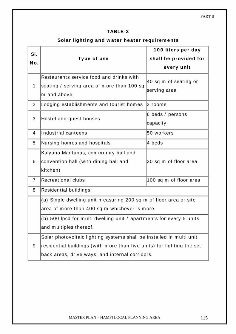
PART B
MASTER PLAN – HAMPI LOCAL PLANNING AREA 115
TABLE-3
Solar lighting and water heater requirements
Sl.
No. Type of use
100 liters per day
shall be provided for
every unit
1
Restaurants service food and drinks with
seating / serving area of more than 100 sq
m and above.
40 sq m of seating or
serving area
2 Lodging establishments and tourist homes 3 rooms
3 Hostel and guest houses 6 beds / persons
capacity
4 Industrial canteens 50 workers
5 Nursing homes and hospitals 4 beds
6
Kalyana Mantapas, community hall and
convention hall (with dining hall and
kitchen)
30 sq m of floor area
7 Recreational clubs 100 sq m of floor area
8 Residential buildings:
(a) Single dwelling unit measuring 200 sq m of floor area or site
area of more than 400 sq m whichever is more.
(b) 500 lpcd for multi dwelling unit / apartments for every 5 units
and multiples thereof.
9
Solar photovoltaic lighting systems shall be installed in multi unit
residential buildings (with more than five units) for lighting the set
back areas, drive ways, and internal corridors.

PART B
MASTER PLAN – HAMPI LOCAL PLANNING AREA 116
22. FACILITIES FOR PHYSICALLY HANDICAPPED PERSONS:
Public and semi public buildings having covered area of 300
sq m and above shall be designed and constructed to provide
facilities to the physically handicapped persons as prescribed in the
Schedule-II of these Zonal Regulations.
SCHEDULE – II
Facilities for physically handicapped persons
1. These Zoning Regulations shall apply to the physically handicapped
persons having the following disabilities:-
a. Non-ambulatory disabilities: Impairments that regardless of
cause or manifestation, for all practical purposes, confine
individuals to wheelchairs;
b. Semi-ambulatory disabilities: Impairments that cause
individuals to walk difficulty or insecurity. Individuals using braces
or crutches, amputees, arthritics, spastics, and those with
pulmonary land cardiac ills may be sent ambulatory.
c. Hearing disabilities: Deafness or hearing handicaps that make
an individual insecure in public areas because he is unable to
communicate or hear warning signals.
d. Sight disabilities: Total blindness or impairments affecting sight
to the extent that the individual functioning in public areas is
insecure or exposed to danger.
2. Access path / walk way: The width of access path / walk way from
plot entry and surface parking to the building entry shall not be less
than 1.80 m. It shall not have a gradient exceeding 5%.
3. Surface parking: At least two car spaces shall be provided at surface
level near entrance with maximum travel distance of 30.00 m from
the building entrance.
4. Space for wheel chair users: Adequate space shall be kept for the
free movement of wheel chairs. The standard size of wheel chairs shall

PART B
MASTER PLAN – HAMPI LOCAL PLANNING AREA 117
be taken as 1050 mm x 750 mm the doors shall have a minimum
width of 900 mm to facilitate the free movement of wheel chairs.
5. Approval to plinth level: At least one entrance shall have approach
through a ramp. The ramp shall have a minimum width of 1.80 m with
maximum gradient of 1:10
6. Entrance landing: Entrance landing shall be provided adjacent to
ramp with the minimum dimension of 1.80 m x 2.00 m.
7. Corridors: The minimum width of corridors shall be 1.80 m.
8. Staircase: The minimum width of staircases shall be 1.50 m. The
minimum number of risers on a flight shall be limited to 12. Size of
treads shall not be less than 30 cm and the height of risers shall not
be more than 15 cm.
9. Lifts:
a. Wherever lifts are required to be installed as per byelaws,
provision of at least one lift shall be made for the wheel chair
users with the following cage dimensions recommended for
passenger lifts of 13 persons capacity by Bureau of Indian
Standards.
i. Clear internal depth 1100 mm (1.10 m)
ii. Clear internal width 2000 m (2.00 m)
iii. Entrance door width 900 mm (0.90)
b. The lift lobby shall have a minimum inside measurement of 1.80
m x 1.80 m.
10. Toilets: One special water closet in a set of toilets shall be provided
for the use of handicapped persons with wash basin keeping in view
the following provisions.-
a. The minimum size of toilet shall be 1.50 m x 1.75 m.
b. The maximum height of the W.C. set shall be 0.50 m above
the floor.
11. Handrails: Handrails shall be provided for ramps, staircases, lifts
and toilets. The height of handrails shall be normally 800 mm above

PART B
MASTER PLAN – HAMPI LOCAL PLANNING AREA 118
the floor level. If the building is meant for the predominant use of
children, the height of handrails may be suitably altered.
12. Guiding/ Warning floor material: The floor material to guide or to
warn the visually impaired persons with a change of colour or material
with conspicuously different texture and easily distinguishable from the
rest of the surrounding floor materials is called guiding or warning floor
material. The material with different texture shall give audible signals
with sensory warning when person moves on this surface with walking
stick. The guiding / warning floor material is meant to give the
directional effect or warn a person at critical places. This floor material
shall be provided in the following areas;
a. The access path to the building and to the parking area;
b. The landing lobby towards the information board, reception, lifts,
staircase and toilets;
c. At the beginning / end of walkway where there is vehicular traffic;
d. At the location abruptly changing in level and at the beginning /
end of ramp;
e. At the entrance / exit of the building.
13. Proper signage: Appropriate identification of specific facilities within
a building for the handicapped persons should be done with proper
signage. Visually impaired persons make use of other senses such as
hearing and touch to compensate for the lack of vision; where as visual
signals shall benefit those with hearing disabilities.
Signs should be designed and located such that they are easily
legible by using suitable letter size (not less than 20 mm size). For
visually impaired persons, information board in Braille should be
installed on the wall at a suitable height and it should be possible to
approach them closely. To ensure safe walking there should not be any
protruding sign, which creates obstruction in walking.
PART B
MASTER PLAN – HAMPI LOCAL PLANNING AREA 119
The symbols / illustrations should be in contrasting colour and properly
illuminated so that with limited vision one may be able to differentiate
amongst primary colours.
23. RAIN WATER HARVESTING:
a. Every building with a plinth area of exceeding 100 sq m and built on
a site measuring not less than 200 sq m shall have rain water
harvesting structures having a minimum total capacity as detailed in
Schedule-III.
Provided that the authority may approve the rainwater harvesting
structures of specifications different from those in Schedule-V,
subject to the condition that minimum capacity of rainwater
harvesting is being ensured in each case.
b. The owner of every building shall ensure that the rainwater
harvesting structure is maintained in good repair for storage of water
for non-potable purposes or recharge of ground water at all times.
SCHEDULE – III
Rain Water Harvesting
Rainwater harvesting in a building site includes storage or recharging
into ground of rainwater falling on the terrace or on any paved or
unpaved surface within the building site.
The following systems may be adopted for harvesting the rainwater
drawn from terrace and the paved surface.
a. Open well of a minimum of 1.00 m dia. and 6.00 m in depth into
which rainwater may be channeled and allowed after filtration for
removing silt and floating material. The well shall be provided with
ventilating covers. The water from the open well may be used for
non-potable domestic purposes such as washing, flushing and for
watering the garden, etc.
b. Rainwater harvesting for recharge of ground water may be done
through a bore well around which a pit of one meter width may be

PART B
MASTER PLAN – HAMPI LOCAL PLANNING AREA 120
excavated up to a depth of at least 3.00 m and refilled with stone
aggregate and sand. The filtered rainwater may be channeled to the
refilled pit for recharging the bore well.
c. An impervious storage tank of required capacity may be constructed
in the setback or other than, space and the rainwater may be
channeled to the storage tank. The storage tank may be raised to a
convenient height above the surface and shall always be provided
with ventilating the surface and shall always be provided with
ventilating covers and shall have draw off taps suitably place so that
the rain water may be drawn off for domestic, washing, gardening
and such other purposes. The storage tanks shall be provided with an
overflow.
d. The surplus rainwater after storage may be recharged into ground
through percolation pits, trenches, or combination of pits and
trenches. Depending on the geomorphologic and topographical
condition, the pits may be of the size of 1.20 m width x 1.20 m
length x 2.00 m to 2.50 m depth. The trenches can be or 0.60 m
width x 2.00 m to 6.00 m length x 1.50 m to 2.00 depth. Terrace
water shall be channelled to pits or trenches. Such pits or trenches
shall be backfilled with filter media comprising the following
materials. -
1. 40 mm stone aggregate as bottom layer up to 50% of the depth;
2. 20 mm stone aggregate as lower middle layer up to 20% of the
depth;
3. Course sand as upper middle layer up to 20% of the depth;
4. A thin layer of fine sand as top layer;
5. Top 10% of the pits / trenches will be empty and a splash is to
be provided in this portion in such a way that roof top water falls
on the splash pad;
6. Brick masonry wall is to be constructed on the exposed surface
of pits / trenches and the cement mortar plastered;

PART B
MASTER PLAN – HAMPI LOCAL PLANNING AREA 121
7. The depth of wall below ground shall be such that the wall
prevents lose soil entering into pits / trenches. The projection of
the wall above ground shall at least be 15 cm;
8. Perforated concrete slabs shall be provided on the pits /
trenches.
e. If the open space surrounding the building is not paved, the top
layer up to a sufficient depth shall be removed and refilled with course
sand to allow percolation of rainwater into ground.
The terrace shall be connected to the open well / bore well / storage
tank /recharge pit /trench by means of H.D.P.E. / P.V.C. pipes through
filter media. A valve system shall be provided to enable the first
washings from roof or terrace catchments, as they would contain
undesirable dirt. The mouths of all pipes and opening shall be covered
with mosquito (insect) proof wire net. For the efficient discharge of
rainwater, there shall be at least two rain water pipes of 100 mm dia
for a roof area of 100 sq m
Rainwater harvesting structures shall be sited as not to endanger
the stability of building or earthwork. The structures shall be designed
such that o dampness is caused in any part of the walls or foundation
of the building or those of an adjacent building.
24. SIGNS AND OUTDOOR DISPLAY STRUCTURES/INCLUDING
STREET FURNITURE
HWHAMA shall frame regulations and/or guidelines to regulate
signs, outdoor display structures and street furniture. Till such
regulations and guidelines are framed, the following guidelines may be
followed:
a. National Building code to apply: The display or advertising signs
and outdoor display structures on buildings and land shall be in
accordance with: Part X – Signs and Outdoor Display Structures,
National Building Code of India.
PART B
MASTER PLAN – HAMPI LOCAL PLANNING AREA 122
b. Additional conditions – In addition to sub-regulation (a), above,
the following provisions shall apply to advertising signs in different
land use zones.
1. Residential Zone: The following non-flashing neon signs
with illumination not exceeding 40-watt light.
i. One nameplate with an area not exceeding 0.1 SQM. for
each dwelling unit;
ii. For other uses permissible in the zone, one identification
sign or bulletin board with an area not exceeding 10 SQM.
Provided the height does not exceed 1.5m.
iii. “For sale” or “For rent” signs for real estate, not exceeding
2.0 Sq Mtr in area provided they are located on the
premises offered for sale or rent. Non flashing business
signs placed parallel to the wall and not exceeding 1 mtr in
height per establishment.
2. Commercial Zones: Flashing or non-flashing business signs
parallel to the wall not exceeding 1 m in height provided such
signs do not face residential buildings.
c. Prohibition of advertising signs and outdoor display
structures in certain cases: Notwithstanding the provisions of
sub-regulations of (a) & (b), no advertising sign or outdoor display
structures shall be permitted on buildings of architectural,
aesthetic, historical or heritage importance as may be decided by
the Authority.

PART B
MASTER PLAN – HAMPI LOCAL PLANNING AREA 123
5. AREAS OF SPECIAL CONTROL
The historical monuments in any planning area reflect the past glory
of the region. As they attract tourists both from inside and outside the
country. While permitting developments around historical monuments,
care has to be taken to see that their aesthetic environs are not affected.
In order to preserve aesthetic environs around these monuments it is
necessary to declare the areas surrounding these monuments as zones of
special control and impose the following special regulations around these
monuments.
1. Definition:
a) Prohibited area: 100 mtrs radius area around the monument is
declared as prohibited area zone as per the provisions of
archeological act.
Uses permitted: Parks, open spaces and play grounds, natural
landscaping, planting of saplings, repairs, modifications, alterations,
re-construction of existing building, adding toilet and bathing
facilities to the existing building subject to the regulations
mentioned below.
b) Regulated area: Area falling between the 100 mtrs to 300 mtrs
radius from the monument is declared as regulated area as per the
provisions of the archaeology act.
Uses permitted: The land use proposals shown on the map
prevails hence annexure - 1 may be referred subject to the
regulations mentioned below.
Note:
1) Any permission to be given in the prohibited area and
regulated area is subject to NOC from the Archaeology
Department concerned.
PART B
MASTER PLAN – HAMPI LOCAL PLANNING AREA 124
2) Any subsequent amendments to the Archaeology act
concerned regarding prohibited area and regulated area such
amendments shall mutatis mutandis apply.
c) Archaeology: - It is a zone earmarked in Anegundi village (please
refer map no 13.2) which is archeologically sensitive. Further
ASI/DAM shall carry out a study of the archaeologically sensitive
areas in the core zone and the same shall be reported to the
Authority.
Uses permitted: Parks, open spaces and play grounds, natural
landscaping, planting of saplings, repairs, modifications, alterations,
re-construction of existing building, adding toilet and bathing
facilities to the existing building subject to the regulations
mentioned in clause 2 of this chapter.
Note: - Any permission to be given in the archaeologically sensitive area
is subject to NOC from the Archaeology Department concerned.
2. Regulations:
For the existing buildings in the areas of special control following
regulations are to be followed.
a) Re-roofing & Re plastering modification and alterations (all without
involving change in construction area), addition of facilities like
bathroom, toilet to the existing buildings may be permitted.
b) Building up to and inclusive of first floor or up to a height of 8.0 mtrs
from the ground level, which ever is less, are permissible, beyond the
distance of 100 mtrs and up to 300 mtrs from the premises of the
monuments.
c) In any case no building shall be permitted within 300 mtrs of the
protected monument above the height of monument.
d) In case of the said land is required by ASI / Department of
Archaeology and Museums for better management of the monument,
concerned Archaeology Department shall initiate and frame a proposal
PART B
MASTER PLAN – HAMPI LOCAL PLANNING AREA 125
to acquire and rehabilitate the inhabitants in consultation with
HWHAMA.
e) In case the concerned Archaeology Department prepares any generic
guidelines (subject to the approval of Authority) for the existing
buildings in prohibited area / regulated area, modification or
reconstruction only, without involving change in constructed area may
be permitted subject to these regulations.
f) No development is permitted in Eco-Sensitive Areas like River Islands,
Tank Bed Areas, Rocky outcrops, Hillocks and Forest Areas.
g) A Buffer of 100 m (45 m in Hampi and Anegundi settlements) is
assumed all along the flow of the river on the banks, which shall be,
treated as no development zone.

PART B
MASTER PLAN – HAMPI LOCAL PLANNING AREA 126
6. ANNEXURE -II
The minimum set back required on all the sides of a building, maximum
plot coverage, maximum FAR, maximum number of floors, maximum
height of building that are permissible for different dimensions of sites
and width of roads are set out in Tables given below.

PART B
MASTER PLAN – HAMPI LOCAL PLANNING AREA 127
TABLE –4 Exterior open spaces / setbacks (minimum) for residential, commercial, public and
Semi - public, traffic and transportation, public utility buildings up to 15.0 mtrs in height
Minimum in Mtrs Minimum in Mtrs Depth of
site in
Mtrs
Residential Commercial
T& T, P.U &
public & semi
Public
Width of
site in
Mtrs
Residential Commercial
T& T, P.U &
public &
semi Public
Front Rear Front Rear Front Rear Left Right Left Right Left Right
Up to 6 1.00 0 1.00 0 1.50 0 Up to 6 0 1.00 0 0 0 1.00
Over 6
Up to 9 1.00 1.00 1.50 0 1.50 1.50
Over 6
Up to 9 1.00 1.00 0 1.00 1.00 1.50
Over 9
Up to 12 1.00 1.00 1.50 1.00 2.00 1.50
Over 9
Up to 12 1.00 1.00 1.00 1.50 1.50 1.75
Over 12
Up to 18 1.50 1.00 2.00 1.50 2.50 1.50
Over 12
Up to 18 1.50 2.00 1.50 2.00 1.75 2.50
Over 18
Up to 24 2.00 1.50 3.00 2.50 3.00 2.00
Over 18
Up to 24 2.00 3.00 2.00 2.50 2.50 3.00
Over 24 2.50 2.00 3.50 3.00 4.00 3.00 Over 24 2.50 3.00 2.50 3.00 3.00 4.00
Note: T&T: Traffic and Transportation and P.U: Public Utility

PART B
MASTER PLAN – HAMPI LOCAL PLANNING AREA 128
Note: i. When car garage is proposed on the right side, the minimum
set backs shall be 3.0 m;
ii. For residential sites up to 120 sq. m;
a. Open staircase shall be permitted in the side setbacks, but
there shall be a minimum open space of 0.50 m from the
side boundary and 1.0 m from the front and rear boundary
of the site;
b. Toilets minimum of 1 m x 1.5 m and not exceeding 1.4
percent of the plot area permissible in rear set back only;
c. When minimum set back of 1.5 m is left on the right side,
a scooter garage may be permitted at the back side
limiting the depth of the garage to 3.0 m.

PART B
MASTER PLAN – HAMPI LOCAL PLANNING AREA 129
TABLE – 5
Maximum Plot Coverage, Floor Area Ratio & Road Widths for Different Sital Areas
Residential Building Commercial Building
Public & semi public, Traffic
& Transportation, Public
utility building Plot area in
sq m Max.
Plot
coverage
FAR
Min
Road width
in Mtrs
Max
Plot
coverage
FAR
Min
Road
width in
Mtrs
Max
Plot
coverage
FAR
Min
Road
width in
Mtrs
Up to 240 80% 1.50 Up to 6 80% 1.25 Over 9 60% 1.25 Up to 6
Over 240 Up to
500 70% 1.40 Over 9 70% 1.30 Over 9 60% 1.25 Over 9
Over 500 Up to
750 65% 1.30 Over 12 60% 1.40 Over 9 55% 1.10 Over 9
Over 750 Up to
1000 60% 1.20 Over 12 55% 1.45 Over 9 55% 1.10 Over 12
Over 1000 60% 1.10 Over 12 50% 1.50 Over 12 50% 1.00 Over 12

PART B
MASTER PLAN – HAMPI LOCAL PLANNING AREA 130
Note:
1. Setbacks and coverage are irrespective of the road widths.
2. Floor Area Ratio and number of floors are with reference to road
widths when the site do not face the roads of required width, noted
against each (excluding residential building), the floor area ratio
applicable to corresponding width of roads is applicable.
3. For plots more than 750 sq m bell mouth entrance shall be provided.
TABLE – 5
Construction excluded from FAR computation
The following constructions are excluded from FAR computation:
1. Staircase floor area in all the floors
2. Lift floor area in all the floors
3. Architectural features
4. Chimneys
5. Overhead tanks with its headroom not exceeding 1.5 m
6. Fire escape staircase
7. Garbage shaft/ ducts
8. Meter room
9. Air-conditioning plant
10. Electric sub-station
11. Pump room
12. Service ducts
13. Generator room
14. Watchman’s booth
15. Lumber room
16. Pent house
17. Swimming Pool in any floor
18. Corridor
19. Effluent treatment plant, car parking under a building on stilts or in a
basement or cellar floors.

PART B
MASTER PLAN – HAMPI LOCAL PLANNING AREA 131
20. Escalators, main sanitary duct, open balcony, machine rooms.
TABLE – 7
Height restrictions to the buildings in Core Zone
Sl.
No
Village Name Height
in mtrs
1 Hampi 8.0
2 Anegundi 8.0
3 Kamalapura 8.0
4 Kaddirampura 8.0
Note: The height of the building in the regulated area (i.e. 100 mtrs to 300 mtrs
distance from the monument) is governed by the height of the monument
i.e. in any case the height of the building permitted in the regulated area
shall not be more than the height of the monument.

PART B
MASTER PLAN – HAMPI LOCAL PLANNING AREA 132
7. GROUP HOUSING
Approval of Group Housing Project
The following norms shall be adopted while approving building plans for
Group Housing;
1. The approach road to a group housing project must have a
minimum width of 12 m;
2. The minimum area for group housing shall be 0.40 Ha.
3. The layout plan showing the general arrangement of residential
building blocks, and dimensions of the plots earmarked for each
building block, access roads, parks, open spaces and civic amenity
areas, shall be obtained prior to according approval to the building
plan;
4. Set backs should be provided with reference to the depth and width
of total plot area;
5. The floor area ratio (FAR) shall be with reference to the width of the
public road abutting the property and the FAR shall be calculated for
the net area of the plot as prescribed in Table - 8 after deducting
the area reserved for the parks, open spaces and civic amenities in
the plot;
6. The coverage shall be with reference to the total area of the layout;
7. The distance between any two buildings shall not be less than 1/3rd
of the height of the taller building;
8. 25% of the total area be reserved for civic amenity, parks and open
spaces, subject to a minimum of 15% for parks and open spaces.

PART B
MASTER PLAN – HAMPI LOCAL PLANNING AREA 133
TABLE – 8
Maximum plot coverage, FAR, minimum setbacks and minimum
road width for Group Housing
Minimum setbacks in
meters Plot area
Minimum
road width
in m
Maximum
Plot
coverage
Maximum
FAR Front Rear Left Right
Between
0.40 and
0.80 ha
12 60% 2.00 8.0 6.0 6.0 6.0
Above 0.80
ha 15 60% 2.50 9.0 8.0 8.0 8.0
Note:
1. Where the sital area of group housing exceeds 4000 sq mtrs,
approval of layout showing the general arrangement of residential
building blocks, and dimensions of plot earmarked for each building
block, means of access roads and civic amenity areas should
precede the approval to building plan.
2. Parking requirement shall be as per Table – 14. In addition, 5% of
the total area shall be reserved for visitors parking separately.
3. Internal roads, park and open space area may be maintained by the
owner / developer himself for the specified purpose only.
5. C.A. sites reserved in the development plan shall be handed over
free of cost to the Authority by a relinquishment deed. Preference
may be given to the owner/developer of the respective project for
allotment of C.A. area reserved in the Group Housing project.

PART B
MASTER PLAN – HAMPI LOCAL PLANNING AREA 134
TABLE – 9
Semi-detached houses
01.Minimum combined area of
the neighboring plots 140 sq mtrs
02. Building coverage
03. Floor area ratio
04. Maximum number of floors
05. Minimum road width
As applicable to individual plots
06.Front set back for back to
back plots
Shall be equal to the sum of front and
rear set backs of individual plots.
07.Side set backs for plots joined
at the side.
On a plot on which a semi-detached
building is proposed, the side set back
for each unit shall be the total of the
left and right set backs to be left in
case of individual plots.
TABLE – 10
Row Housing (Maximum 12 units, minimum 3 units)
1 Minimum combined area of plot 162 sq m
2 Maximum area of each plot 108 sq m
3 Building coverage
4 Floor area ratio
5 Number of floors
6 Minimum road width
As applicable to individual plots
7 Set backs minimum
Front: 2.00 m
Rear: 1.50 m
Side: 2.00 m only for end units

PART B
MASTER PLAN – HAMPI LOCAL PLANNING AREA 135
8. SUB-DIVISION REGULATIONS
The purpose of these regulations is to guide the development of
new areas in accordance with the land use plan. As long as this is done on
sound planning principles with adequate space standards, the future of
the planning area is assured. This will not necessitate costly corrective
measures, which would become necessary, if sub-standard growth is
allowed to take place. These sub-division regulations are confined to
standards of size of plots, street widths and community facilities.
In sanctioning the sub-division of a plot under section 17 of the
Karnataka Town and Country Planning Act, 1961, the Planning Authority
shall among other things see that the following planning standards are
followed for sub-division of plot.
SIZE OF PLOTS:
No building plot resulting from a sub-division after these regulations
come into force is smaller in size than 54 sq mtrs in residential zone. In
specific cases of sites for housing schemes for economically weaker
sections, low income groups, slum clearance and Ashraya housing, the
authority may relax the above condition.

PART B
MASTER PLAN – HAMPI LOCAL PLANNING AREA 136
TABLE – 11
Standards for roads
Sl.
No.
Category of streets Minimum right of way in mtrs
1 Cul-de-sac 7.5 mtrs (maximum length 183
mtrs with sufficient turning radius)
2 Loop street 7.5 mtrs (maximum length 183
mtrs)
3 Service road 9.0 mtrs
4 Residential street
a) Up to length of 200
m
7.5 mtrs
b) Above 200 m up to
300 m
9.0 mtrs
c) Above 300 m 12.0 mtrs
5 Collector street (minor
roads)
15.0 mtrs
6 Major roads (feeder
streets)
18.0 mtrs
7 Arterial roads 24.0 mtrs
8 Commercial 12.0 mtrs

PART B
MASTER PLAN – HAMPI LOCAL PLANNING AREA 137
TABLE –12
Civic Amenities
Particulars Population per
unit Area in ha.
a) Educational Facilities:
i) Nursery School (age group
3 to 6 years) 1,000 Minimum 0.20
ii) Basic primary and Higher
primary school (age group 6
to 14 years)
3,500 to 4,500 (Including play
ground) 1.00
iii) Higher secondary school
(age group 14 to 17 years) 15,000
Minimum 2.00
(including play
ground)
iv) College 50,000
Minimum 3.0 to
4.0 (including play
ground)
b) Medical Facilities:
i) Dispensary 5,000 0.10
ii) Health Center 20,000 0.40 (including
staff quarters)
c) Other facilities:
i) Post and Telegraph 10,000 0.15 (including
staff quarters)
ii) Police Station 10,000 0.20
iii) Religious Building 3,000 0.10
iv) Filling Station 15,000 0.05

PART B
MASTER PLAN – HAMPI LOCAL PLANNING AREA 138
TABLE – 13
Parks, Play ground and Open Spaces
Sl.
No. Category Population per unit
Area in
hectares
1. Tot-lot 500 Minimum 0.05
2. Children park 2,000 Minimum 0.20
3. Neighbourhood play
ground 1,000 Minimum 0.20
4. Neighbourhood park 5,000 Minimum 0.80
Areas for Open Spaces and Civic Amenities:
1. Approval of Residential Layouts:
The areas for open space and Civic Amenities while sanctioning of layout
for residential purpose shall be subject to the following conditions:
i. The area earmarked for residential sites shall be a maximum of
55% of the total extent.
ii. Balance area shall be earmarked for roads, parks, and playgrounds
and civic Amenities and the area under parks and playgrounds shall
not be less than 10% of the total extent.
iii. If by incorporating major roads proposed in the Master Plan, the
area under roads exceeds 45%, in such case the reservation under
parks and civic amenities may be relaxed.
iv. A maximum of 3% of the total area from out of the residential area
may be earmarked for convenient shops on the request of the
owner.
v. The area reserved for parks and open spaces, civic amenities and
roads shall be handed over to the Planning Authority / Local
Authority as the case may be free of cost through a registered
relinquishment deed before taking up development of the layout.

PART B
MASTER PLAN – HAMPI LOCAL PLANNING AREA 139
I. Exemption for open space and civic amenities in sub-division of
land.
i. Subject to the provisions of Master Plan in respect of land use,
proposed roads and minimum road width, whenever the total extent
of land of the private residential layout for approval by the Planning
Authority is 4000 sq. m (0.40 hectares) and below, reservation of
open space and civic amenities areas as per the Zonal
Regulations/Sub Division Rules may be dispensed with.
ii. In lieu of this, the Planning Authority may collect the market value
of converted equivalent land as fixed by the Sub-Registrar.
iii. The value to be recovered from the land owner in lieu of open space
and civic amenities shall be in addition to the fee to be collected
under Section 18 of the K.T.C.P. Act, development charges and any
other fees/charges prescribed by the Government from time to
time.
iv. The Planning Authority shall deposit the amount so collected under
a separate Head of Account and the amount shall be utilised only for
acquisition of areas reserved as parks and open spaces in the
approved Master Plan. The Planning Authority shall, under no
circumstances divert this amount for any other purposes.
v. In case the land owner refuses to pay the market value of the
equivalent land in lieu of open space and civic amenity to be
reserved, the Planning Authority shall approve the Sub-Division
reserving equivalent land separately and shall take possession of
such an extent of equivalent land free of cost from the land owner
and the Authority may dispose the same through auction for the
purpose decided by the Authority.
PART B
MASTER PLAN – HAMPI LOCAL PLANNING AREA 140
II. Approval of Non-Residential private layouts.
A. If the private Non-Residential layout for approval consists of
only one single unit, approval shall be given subject to the
following conditions:
i. 5% of the total extent of land shall be reserved for vehicle
parking and this shall be in addition to the parking space
prescribed in the Zonal Regulations as per the total floor area of
the building.
ii. 10% of the total extent shall be earmarked as open space.
iii. The area reserved for vehicle parking and open space shall be
maintained by the landowner and this land shall not be used for
any other purpose by the landowner.
iv. The Planning Authority shall collect the fee under section 18 of
K.T.C.P. Act and development charges applicable and any other
fees and charges prescribed by the Government from time to
time.
B. If the private Non-Residential layout for approval consists of
two or more number of plots, the following conditions shall apply:
i. 5% of the total extent of land shall be reserved for vehicle
parking and this shall be in addition to the parking space
prescribed in the Zonal Regulations as per the total floor area of
the building.
ii. 10% of the total extent of land shall be earmarked as open
space.
iii. The area earmarked for parking and open space and roads shall
be handed over to the local authority at free of cost for
maintenance
iv. The Planning Authority shall collect the fee under section 18 of
K.T.C.P. Act and development charges and any other fees and
charges prescribed by the Government from time to time.

PART B
MASTER PLAN – HAMPI LOCAL PLANNING AREA 141
III. Approval of single plot for Residential purpose.
Any extent of land can be approved as single plot subject to the
following conditions.
i. The land in question shall be converted for non-agricultural
purpose.
ii. The land shall have access from the public road and the use of
land shall be in accordance with the Zonal Regulations of the
Master Plan.
iii. The necessary development charges shall be paid to the
concerned Planning Authority/ Local Authority. This fee is in
addition to recovery of fee under section 18 of K.T.C.P Act and
other fees/charges prescribed by the Government from time to
time.
iv. If the owner of Single plot desires to sub-divide the plot at
subsequent dates, he shall obtain approval by the Authority
treating it as sub-division of land and the norms applies
accordingly as prescribed in the Zoning Regulations.
IV. Redevelopment schemes
Slums, unplanned areas, poorly serviced infrastructure areas and any
other area, which have significant impact on its environs are to be taken
up within the planning area for improvement and detailed out for
implementation.
Following regulations shall apply for all redevelopment schemes within the
local planning area of Hampi:
i. Minimum of 10% area shall be reserved for park and open
spaces
ii. Minimum area of 5% shall be reserved for civic amenities
iii. The respective authorities shall maintain the area so reserved.
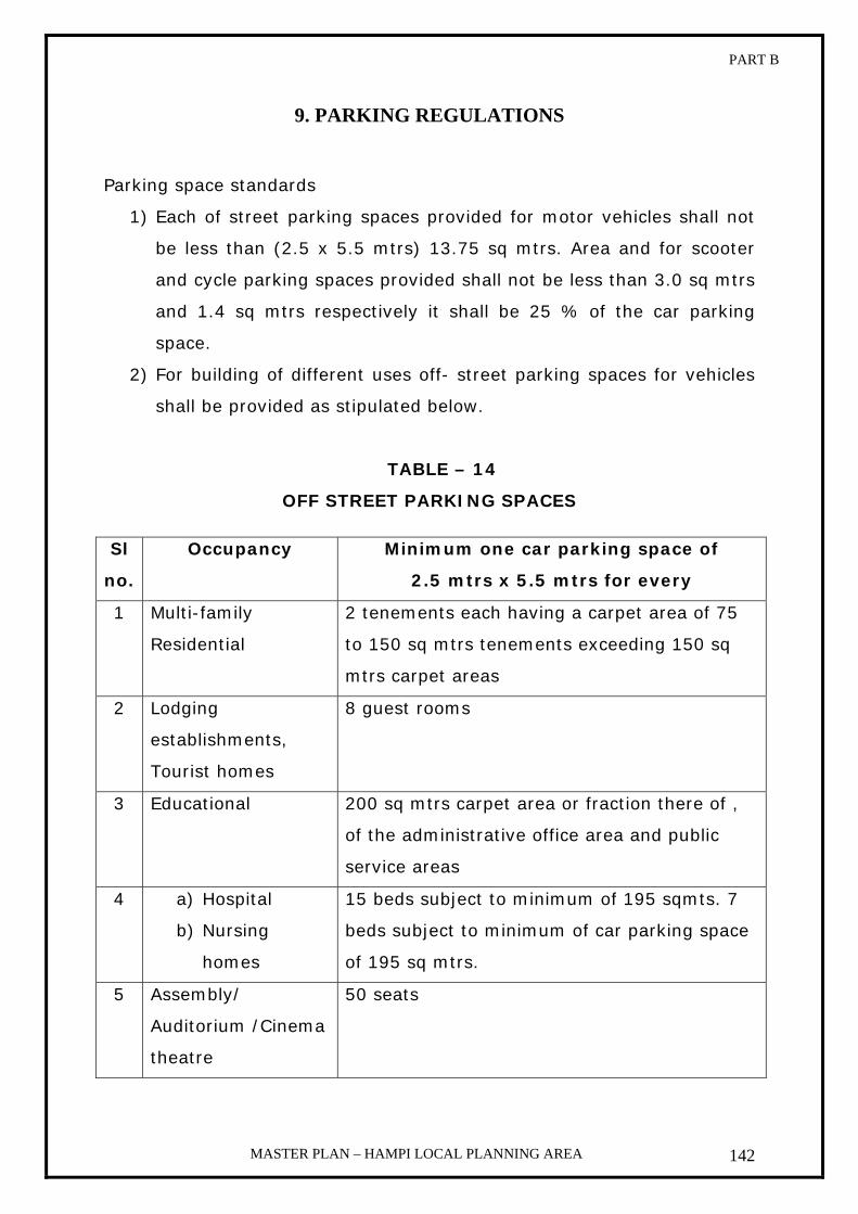
PART B
MASTER PLAN – HAMPI LOCAL PLANNING AREA 142
9. PARKING REGULATIONS
Parking space standards
1) Each of street parking spaces provided for motor vehicles shall not
be less than (2.5 x 5.5 mtrs) 13.75 sq mtrs. Area and for scooter
and cycle parking spaces provided shall not be less than 3.0 sq mtrs
and 1.4 sq mtrs respectively it shall be 25 % of the car parking
space.
2) For building of different uses off- street parking spaces for vehicles
shall be provided as stipulated below.
TABLE – 14
OFF STREET PARKING SPACES
Sl
no.
Occupancy Minimum one car parking space of
2.5 mtrs x 5.5 mtrs for every
1 Multi-family
Residential
2 tenements each having a carpet area of 75
to 150 sq mtrs tenements exceeding 150 sq
mtrs carpet areas
2 Lodging
establishments,
Tourist homes
8 guest rooms
3 Educational 200 sq mtrs carpet area or fraction there of ,
of the administrative office area and public
service areas
4 a) Hospital
b) Nursing
homes
15 beds subject to minimum of 195 sqmts. 7
beds subject to minimum of car parking space
of 195 sq mtrs.
5 Assembly/
Auditorium /Cinema
theatre
50 seats

PART B
MASTER PLAN – HAMPI LOCAL PLANNING AREA 143
6 Govt. or semi public
buildings
150 sq mtrs carpet area of fraction thereof
7 Retail business 100 sq mtrs carpet area of fraction thereof
8 Storage 100 sq mtrs upto 500 sq mtrs area and every
200 sq mtrs thereafter
9 Kalyana mantapa 30 sq mtrs of auditorium floor area
10 Office building 100 sq mtrs of floor area
11 Restaurant serving
food and beverage
75 sq mtrs of floor area
12 Hostels 15 rooms
Note on off-street parking:
1. Up to 100 sq m in the case of shops, parking spaces need not be
insisted.
2. Off- street parking space shall be provided with adequate vehicular
access to a street, and the area of drive aisles and such other
provision required for adequate maneuvering of vehicles shall be
exclusive of the parking spaces stipulated in these Zonal
Regulations
3. Prescribed minimum setbacks are not to be taken as part of parking
requirement.
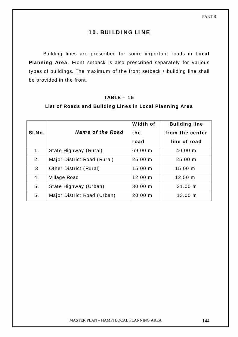
PART B
MASTER PLAN – HAMPI LOCAL PLANNING AREA 144
10. BUILDING LINE
Building lines are prescribed for some important roads in Local
Planning Area. Front setback is also prescribed separately for various
types of buildings. The maximum of the front setback / building line shall
be provided in the front.
TABLE – 15
List of Roads and Building Lines in Local Planning Area
Sl.No. Name of the Road
Width of
the
road
Building line
from the center
line of road
1. State Highway (Rural) 69.00 m 40.00 m
2. Major District Road (Rural) 25.00 m 25.00 m
3 Other District (Rural) 15.00 m 15.00 m
4. Village Road 12.00 m 12.50 m
5. State Highway (Urban) 30.00 m 21.00 m
5. Major District Road (Urban) 20.00 m 13.00 m

PART B
MASTER PLAN – HAMPI LOCAL PLANNING AREA 145
11. HERITAGE REGULATIONS
1. Objective
2. Definition
3. Applicability
4. Heritage committee
5. Listing and Notification of Heritage Building and Heritage precinct/
Zone
6. Permissible & Non Permissible uses
7. General regulations
8. Architectural regulations
PART B
MASTER PLAN – HAMPI LOCAL PLANNING AREA 146
1. OBJECTIVE
The objective of these regulations shall be the conservation of
buildings, structures, areas and precincts of aesthetic and / or of
architectural and / or of cultural significance.
2. DEFINITION
a. Heritage building: It is a building possessing architectural, aesthetic or cultural
values, which is declared as heritage building by the Authority
as per section 2 (i-ea) of KTCP Act - 1961, and includes
structure, which is in ruins or in dilapidated nature
b. Heritage precinct/ zone:
Heritage precinct means an area comprising heritage building
or buildings and precincts there of or related places declared
as such by the Authority as per section 2(i-eb) of KTCP Act -
1961.
c. Historic open space:
It is a vacant plot / space possessing aesthetic or cultural
values, which is declared as historic open space by the
authority
3. APPLICABILITY
These regulations shall apply to all buildings, open spaces in
heritage precinct/ zone and also to heritage buildings outside
heritage zone declared under section 2(i-ea) and (i-eb) of the
Karnataka Town & Country Planning Act, 1961.
4. HERITAGE COMMITTEE
For the Local Planning Area, there shall be a Heritage Committee
consisting of the following members

PART B
MASTER PLAN – HAMPI LOCAL PLANNING AREA 147
1. Chairman, HWHAMA Chairman
2. Senior Conservation Assistant,
Kamalapura Circle, or representative of
ASI
Member
3. Deputy Director, Kamalapura,
Department of Archaeology & Museums
Member
4. Superintending Engineer, Public Works
Department, Bellary
Member
5. Planning officer, HWHAMA Member
6. Conservation Architect, HWHAMA Member
7. Commissioner, HWHAMA Member Convener
The terms of reference of the committee shall be, inter-allia
a. To prepare/ update the list of heritage buildings and heritage
precincts to which these regulations will apply
b. To advice whether development permissions would be granted
under these regulations and the conditions under which the
permission may be accorded.
c. To provide technical advice wherever necessary, for the
conservation of heritage buildings & heritage precincts.
d. To advice on any other issues as may be required from time to time
during the course of scrutinizing the proposals in the overall interest
of heritage conservation.
e. To advice in preparing the guidelines to design elements and
conservation principles to be adhered to for the purposes of these
regulations.
f. To advice in framing the modalities and formalities in allowing the
public private participation in taking up the conservation projects
g. To advice regarding financial assistance to the owner if any required
for carrying out maintenance and also for providing necessary
architectural and engineering services to the owner of the heritage
building
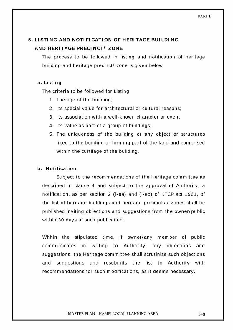
PART B
MASTER PLAN – HAMPI LOCAL PLANNING AREA 148
5. LISTING AND NOTIFICATION OF HERITAGE BUILDING
AND HERITAGE PRECINCT/ ZONE
The process to be followed in listing and notification of heritage
building and heritage precinct/ zone is given below
a. Listing
The criteria to be followed for Listing
1. The age of the building;
2. Its special value for architectural or cultural reasons;
3. Its association with a well-known character or event;
4. Its value as part of a group of buildings;
5. The uniqueness of the building or any object or structures
fixed to the building or forming part of the land and comprised
within the curtilage of the building.
b. Notification
Subject to the recommendations of the Heritage committee as
described in clause 4 and subject to the approval of Authority, a
notification, as per section 2 (i-ea) and (i-eb) of KTCP act 1961, of
the list of heritage buildings and heritage precincts / zones shall be
published inviting objections and suggestions from the owner/public
within 30 days of such publication.
Within the stipulated time, if owner/any member of public
communicates in writing to Authority, any objections and
suggestions, the Heritage committee shall scrutinize such objections
and suggestions and resubmits the list to Authority with
recommendations for such modifications, as it deems necessary.

PART B
MASTER PLAN – HAMPI LOCAL PLANNING AREA 149
c. Approval:
With the recommendation of heritage Committee, Authority
will approve with such modifications as it deems necessary and the
final list will be published.
6. PERMISSIBLE & NON-PERMISSIBLE USES
Uses in Annexure - 1 of zonal regulations shall apply mutatis
mutandis to the chapter except to Historic Open Space.
7. GENERAL REGULATIONS
a. The building byelaws in 4. General Regulations to 10. Building Line
of zonal regulations are applicable mutatis mutandis to the Heritage
precinct/zone & Heritage buildings except Historic Open Space
b. Construction of Katta (Traditional Platform) with colonnade
supporting the roof is permissible in the front setback. This is
applicable to the buildings in the Heritage Zone.
c. No development is permitted in a Historic Open Space except for
providing civic amenities subject to the approval of the authority.
d. No internal change in form and spatial layout of a Heritage building
is permissible
8. ARCHITECTURAL REGULATIONS
Architectural regulations deal with the architectural elements, colour
for addition, modification and new construction in a heritage
precinct/ Zone and including for preservation for a heritage building.
a. Architectural elements
All the elements of a building above the ground i.e. in the
superstructure as listed below
1. Plinth
2. Walls (Masonry walls, colonnade, arcade)
3. Openings (Doors, Windows, skylights, ventilators)
4. Roof

PART B
MASTER PLAN – HAMPI LOCAL PLANNING AREA 150
5. Parapet wall
6. Boundary walls
The dimensions to be followed for the architectural elements to be
included in any new construction shall be as per table below
Table - 16
Sl no
Element Width Depth Height
1 Plinth As per design As per
design 0.45 mtrs from road
level
2 Wall As per design As per
design 3.0 mtrs from finished
floor level (F.F.L)
a. Wall facing the street with wooden colonnade
As per design (The distance between two
columns shall be 2.0 mtrs)
As per design
3.0 mtrs from F.F.L including the cornice, column capital, trunk
and base
b. Wall facing the street with arcade
As per design (The distance between
two springing points shall be 2.0
mtrs)
As per design
2.7 mtrs from F.F.L, springing point varies
as per the design
3 Opening
a. Door As per design As per
design 2.1 mtrs from F.F.L
b. Window Minimum of 1.0
mtrs As per design
2.1 mtrs is Lintel ht & 0.75 mtrs is Sill ht
from F.F.L
c. Sky light As per design As per
design As per design
d. Ventilator As per design As per
design As per design
e. Chajja 0.15 mtrs outside the edge on both
sides
As per design
As per design
4 Roof As per design As per
design As per design
5 Parapet As per design As per
design 0.75 mtrs from
finished terrace level
6 Boundary wall As per design As per
design 1.5 mtrs

PART B
MASTER PLAN – HAMPI LOCAL PLANNING AREA 151
b. Colour The colour scheme for the exterior architectural elements in a
heritage building should be as per the table below.
Table: 17
Sl no
Element Color
1 Plinth Lime or cement based white, Gober
2 Wall
White in combination with Lime or cement based colors - Gober, Gopi, Terracotta or shades of maroon, Spanish gold, Lime green, Indigos and blues, traditional streaking white wash with terracotta
a. Colonnade Natural wood, Indigo blue, Lime green, Maroon With touches of vermilion and yellow
b. Arcade Mainly white with a combination of Natural wood, Indigo blue, Lime green, Maroon, Spanish gold, Gober,
3 Opening
a. Door Natural wood, Oil paints Indigo and shades of blue, Lime green, Shades of Maroon with touches of vermilion and yellow
b. Window Natural wood, Oil paints, Indigo and shades of blue, Lime green, Maroon, Grays, Gopi Yellow ochre with touches of vermilion and yellow
c. Sky light White, Gober, Gopi Yellow ochre d. Ventilator White e. Chajja White, Terracotta, Gopi, yellow ocher 4 Roof White 5 Parapet White, Gober 6 Boundary wall White, Gober
7 Inner side of boundary walls
The main house wall to be White and the inner wall may be Lime or cement based colors - Gober, Gopi Yellow ochre, Terracotta or shades of maroon, Spanish gold, Lime green, Indigos and shades of blue, traditional streaking white wash with terracotta
Assistant Director Commissioner Chairman
Of Town Planning HWHAMA, Hospet HWHAMA, Hospet

ANNEXURE
MASTER PLAN – HAMPI LOCAL PLANNING AREA
ANNEXURES

ANNEXURE
MASTER PLAN – HAMPI LOCAL PLANNING AREA
List of annexure
1. Local planning area Notification
2. Notification under Section 10 (1) of KTCP act 1961 declaring
intention to prepare Master plan
3. Notification under Section 5 of KTCP Act 1961 declaring the Existing
Land Use
4. Govt. Order of Provisionally approved Master plan
5. Notification under section 13 (1) of KTCP Act 1961 calling for
Objections and Suggestions
6. Objections received during the notification period and decisions
drawn by the Authority
7. List of Survey no of Forests and Hillocks
8. Education facilities
9. Health Facilities
10. Utilities and Services
11. Population growth
12. Details of workers and non workers
13. Tourism Statistics


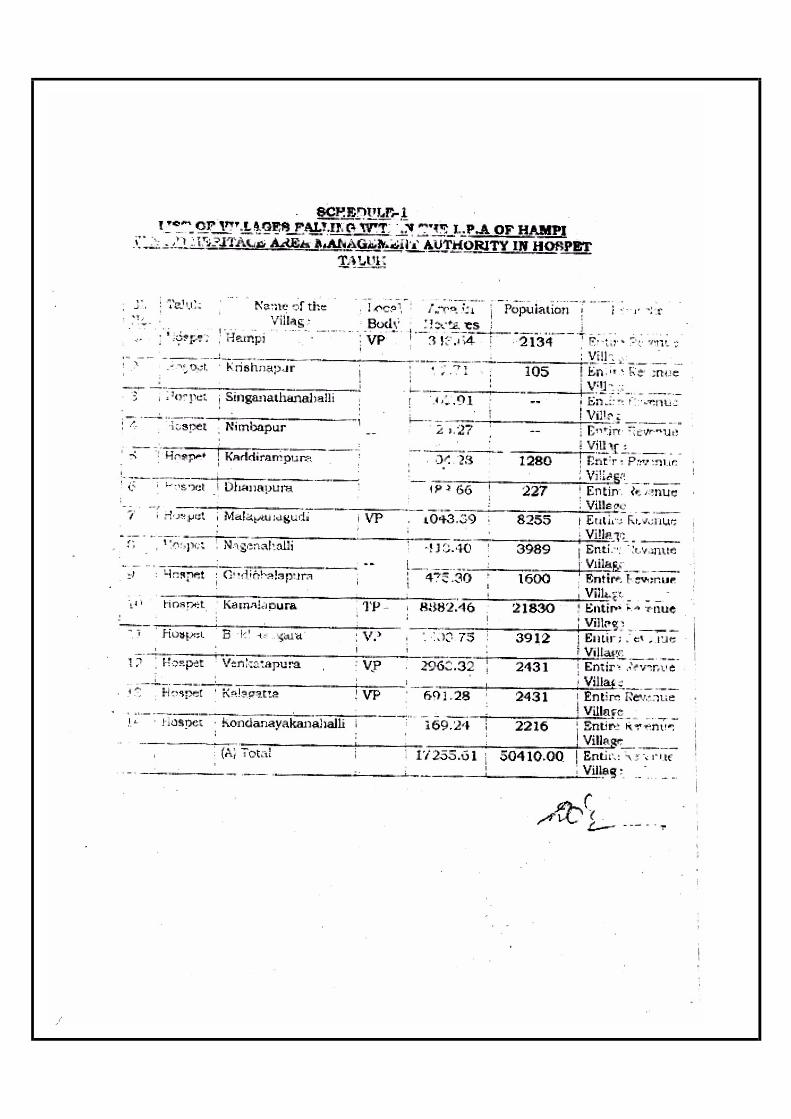


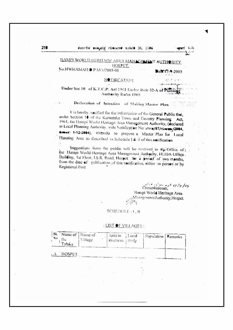


1
ÌÐ�¼ ÁÆÐ÷ »Ð¤Ð�»Ð¤Ù »Ðõ·ÙÓÆÐ ºÀÐþÌÐ²Ñ »Ñõ¸°‘ѤÐ, ÌÙÖÊлÙÓªÙÌÐ�¼ ÁÆÐ÷ »Ð¤Ð�»Ð¤Ù »Ðõ·ÙÓÆÐ ºÀÐþÌÐ²Ñ »Ñõ¸°‘ѤÐ, ÌÙÖÊлÙÓªÙÌÐ�¼ ÁÆÐ÷ »Ð¤Ð�»Ð¤Ù »Ðõ·ÙÓÆÐ ºÀÐþÌÐ²Ñ »Ñõ¸°‘ѤÐ, ÌÙÖÊлÙÓªÙÌÐ�¼ ÁÆÐ÷ »Ð¤Ð�»Ð¤Ù »Ðõ·ÙÓÆÐ ºÀÐþÌÐ²Ñ »Ñõ¸°‘ѤÐ, ÌÙÖÊлÙÓªÙ ‘ФЮÐÔ ÀЦÑÊÐå¤ý »Ñöº‘ФЮÐÔ ÀЦÑÊÐå¤ý »Ñöº‘ФЮÐÔ ÀЦÑÊÐå¤ý »Ñöº‘ФЮÐÔ ÀЦÑÊÐå¤ý »Ñöº––––Ù Ë÷ӑЧ˷Р„‘ÙùӻвÙÙ Ë÷ӑЧ˷Р„‘ÙùӻвÙÙ Ë÷ӑЧ˷Р„‘ÙùӻвÙÙ Ë÷ӑЧ˷Р„‘Ùùӻвٖ–––ÐÎÐÔ/ÊÐÃÌÙ ÊÐ֛йÙÐÎÐÔ/ÊÐÃÌÙ ÊÐ֛йÙÐÎÐÔ/ÊÐÃÌÙ ÊÐ֛йÙÐÎÐÔ/ÊÐÃÌÙ ÊÐ֛йٖ–––ÐÎÐ ÁÀФÐÐÎÐ ÁÀФÐÐÎÐ ÁÀФÐÐÎÐ ÁÀФÐ
‘Ðõ.‘Ðõ.‘Ðõ.‘Ðõ. ÊÐ�ÊÐ�ÊÐ�ÊÐ�
ƒ£þ·Ñ¤Ð¤Ð ÌÙÊФÐÔ ÁÎÑÊЃ£þ·Ñ¤Ð¤Ð ÌÙÊФÐÔ ÁÎÑÊЃ£þ·Ñ¤Ð¤Ð ÌÙÊФÐÔ ÁÎÑÊЃ£þ·Ñ¤Ð¤Ð ÌÙÊФÐÔ ÁÎÑÊÐ ––––ÑõÀÐÔÑõÀÐÔÑõÀÐÔÑõÀÐÔ ÊÐ.¹Ð�/ ÊÐ.¹Ð�/ ÊÐ.¹Ð�/ ÊÐ.¹Ð�/ ÀÐÔ¹Ù.¹Ð�ÀÐÔ¹Ù.¹Ð�ÀÐÔ¹Ù.¹Ð�ÀÐÔ¹Ù.¹Ð�
ÁËêÓ±þÁËêÓ±þÁËêÓ±þÁËêÓ±þ „‘ÙùӻвÙ/ÊÐÃÌÙ„‘ÙùӻвÙ/ÊÐÃÌÙ„‘ÙùӻвÙ/ÊÐÃÌÙ„‘ÙùӻвÙ/ÊÐÃÌÙ ÈФÑÈФÑÈФÑÈФÑ
1.
…�®ÙÖÓ ‹É�¦ÐÔ ÌÙÖÓªÙÄý(»ÙõÿÚ) ÅÁÔªÙ®ý, 102, ÊБÙÚÄÑ‘ýþ ¤Ùˮٺú Á�®ý ©¹ÐÄý ¤ÙÖÓ®ý, ÀÐÔÔ¤ÐÔ–ÙÓÆý »ÑÎÑô, ¾Ù�–ÐÎÐÖ¤ÐÔ
ÌÙÖÊÐ ÀÐÔûйЖÐÔ¯
ÊÐ.¹Ð�: 48c/4B
4.00 Š‘ФÙ
ÊзЧ ¡ÁÔÓ¹ÐÔ ½»°Ð¤ý ¢ÙÖÓ¹ý¹ÐÅö ½¤ÐÔ´ê·ÐÔì ƒ£þ·Ñ¤Ð¤ÐÔ ÊÐÀÙþ ¹Ð�:48 ÌÙÖÊÐ ÀÐÔûйР–ÐÔ¯�¦ÐÔÅö 2001¹ÙÓ ÊÑŹÐÅö “§Ó¸Ë·ÐÔì, »ÐõÀÑÊÙÖÓ·ÐôÀÐÔ …Äє٠ÀÐÔ³ÐÔê »Ð§ÊФРÀЦÑŹÐô ÀÐÔ�®ÐÏÂÔ�·Ð ÌÙÖÓ©Äý ºÁÔþÊÐÃÔ »Ð¤ÐÀѺ–Ù »Ð®Ù¸·ÐÔì, Êиõ ¡ÁÔÓ¹ÐÔ NA „—·ÐÔì ¿Åç�–ý ‘ЩåÅ‘ÙÜ »Ð¤ÐÀѺ–Ù »Ð®Ù¸·ÐÔì ÌÙÖÓ©Äý ¤ÙÊѪýþ ‘ЩåÃÔ »Ð¤ÐÀѺ–Ù ÊÐÌÐ »Ð®Ù¸¤ÐÔÀÐÕ·Ñ— ´ÏÊÐÔ³Ñê ƒ·ÙÓ ‡·ÙìÓÆБÙÜ ‘ÑÂÔì§ÊÐÃÔ ‘ÙÖÓ§·Ñì¤Ù.
‘ÙÖ�®Ð¹Ñ�¦ÐԑйРÌÐÏü ÀÐÔ³ÐÔê ÀÐÔûйЖÐÔ¯ »Ðõ·ÙÓÆБÙÜ »ÐõÊÑêÀйٖÐÎйÐÔî ³Ð�¦Ð¦Ñ§ÊÐÔÀÑ–Ð »Ð§ÇÓÅË ÊÐÖ‘Ðê ‘ÐõÀÐÔ ÀÐÍÊÐÄÑ–ÐÔÀÐÕ·ÐÔ
2. ¤ÙڳРÊÐ�˜Ð (§) ‘ÐÀÐÔÄÑ»ÐԤР-583221 ÌÙÖÊлÙÓªÙ ³Ñ//
‘ÐÀÐÔÄÑ»ÐԤРÊÐ.¹Ð�: 166/1
- ÀЦÑÊÐå¤ý »Ñöº¹ÐÅö ¡¹Ð ÊÐ�»Ð‘Ðþ Êо°Ù–ÐÎйÐÔî ¹Ð®ÙË ÁÀФвÙ�¦ÐÔ¹ÐÔî ºÓ®ÐÃÔ ‘ÙÖÓ§¤ÐÔ³Ñê¤Ù. ÀЦÑÊÐå¤ý »Ñö¹Ð¹ÐÅö ‘ÙÃÀÐÕ ÊÐÀÙþ ¹Ð�½¤ÐÔ–ÐÎйÐÔî ¹ÐÀÐÔָˤÐÔÀÐÕ¸Ãö. (–ÑõÀÐÔ Êо°Ù ¸¹Ñ�‘Ð:1-8-2007 ¤Ð�·ÐÔ ¡¤ÐÔ—·ÐÔì ÁÀФв٠ºÓ¯·Ù)
„‘Ùùӻв٠ƒ¹Ð÷�¦ÐÔ ÊÐ.¹Ð�–ÐÎйÐÔî ƒÎÐÀЯÊÐÃÔ ‘ÐõÀÐÔ ÀÐÍË·Ù.
3. ÇõÓ.¼.ŠÊý.¹Ñ–ФѢý –ÐÔ»Ðê ͧ�¦ÐÔ ¹Ñ–Ч‘ФÐÔ ÀÐÔ¹Ù.¹Ð�:35 ÀÑ®ýþ ¹Ð�:31 Š.Ë.„¼°ÓÊý ¤ÐÊÙê ÌÙÖÊлÙÓªÙ
ÀÐÔûйЖÐÔ¯ RS ¹Ð�: 52 B/7
2.00 Š‘٤Р0.60 ÊÙ�ªýú
¢ÙÖÓ¹ý–ÐÎÐ ½–ÙÞ ÁÀФв٠ºÓ®ÐÔÀÐÕ·ÐÔ. �¦Ð¦ÑÀÐ §Ó´�¦ÐÔ „‘ÙùӻвٖÐÎйÐÔî ÊÐÅöÊоÙÓ‘Ù�·ÐÔ ´ÏÊÐÔÀÐÕ·ÐÔ. »ÐõÊÑêÁ³Ð ¡ÁÔӹйÐÔî ÌÙÖÓªÙÄý ¤ÙÊÑþªý–Ñ— “§Ó¸ÊÐÄÑ—·Ù. ÈÙ®ÐÔôÄý-2¤Ð »Ðõ‘ѤРÊÐÀÙÓþ:52 ½»°Ð¤ý ¢ÙÖÓ¹ý¹ÐÅö ½¤ÐÔÀÐÕ·Ù�·ÐÔ »Ðõ‘ЩÀÑ—·Ù. „·Ð¤Ù Êиõ ¡ÁÔÓ¹ÐÔ »Ù§»°ÙÓ§�¦ÐÔÃö ¢ÙÖÓ¹ý¹ÐÅö ½¤ÐÔÀÐշЧ�·Ð ½»°Ð¤ý ¢ÙÖÓ¹ýº�·Ð »Ù§»°ÙÓ§�¦ÐÔÃö ¢ÙÖÓ¹ý–Ù ÀЖÑþÂÔÊÐ ¾ÙÓ‘Ù�·ÐÔ ‘ÙÖÓ¤ÐÄÑ—·Ù.
‘ÙÖ�®Ð¹Ñ�¦ÐԑйÐÌÐÏü ÀÐÔ³ÐÔê ÀÐÔûйЖÐÔ¯ »Ðõ·ÙÓÆБÙÜ »ÐõÊÑêÀйٖÐÎйÐÔî ³Ð�¦Ð¦Ñ§ÊÐÔÀÑ–Ð »Ð§–бÒÊÐÄÑ–ÐÔÀÐÕ·ÐÔ.
4. ÇõÓ.ŠÊý.ÇõÓºÀÑÊФѡ ³Ð�·Ù.ŠÊý. ¹Ñ¤Ñ�¦ÐÔ± ¤Ñ¡ Ã’ùÿó –ÙÊýåÌÛÊý ÌÐ�¼
ÌÐ�¼ - - ÀЦÑÊÐå¤ý »Ñö¹ý ÀÐôÀÐÌѧ‘Ð ·ÐØÉåÂÔ�·Ð ƒÊÐ�–гÐÀÑ—·ÐÔì ÊÐëÏÓ�¦ÐԤРÊÐÃÌÙ–ÐÎйÐÔî »Ð§–бÒˤÐÔÀÐÕ¸Ãö ÌÐ�¼ »Ðõ·ÙÓÆзÐÅö ÊÐ±é ‘Ùږѧ‘Ù–Ñ— º–и»Ð¯Ë·ÐÔì …·Ð§�·Ð »Ð§ÊФРÀЦÑŹÐô ÀÐÔ³ÐÔê »ÐõÀÑÊÙÖÓ·ÐôÀÐÔ–ÐÏ–Ù ·°Ð‘ÙÜ�¦ÐÔÔ�ªÑ—¤ÐÔ³Ðê·Ù.ÇõÓ.Á¤ÐֻёÐù ·ÙÓÀÑÃ�¦ÐÔÀÐÕ £ÓÀÐ�³Ð ·ÙÓÀÐÊÑë¹ÐÀÑ—·ÐÔì ·°ÑÁÔþ‘Ð ¾°ÑÀйٖÐÎйÐÔî ÊÐÌÐ –ÐÀÐԹзÐÅö©Ôå‘ÙÖÎÐüÃÔ ‘ÙÖÓ§¤ÐÔ³Ñê¤Ù. ÌÐ�¼–Ù Á¡�¦ÐԹЖФРÊÑÀЦÑõ¡ô·Ð ÊÐÀÐÔ�¦ÐÔ·ÐÅö ƒ�³Ð¤Ð ¤ÑÉåÿõÓ�¦ÐÔ ÀЦѤÐԑЪÙå�¦Ð¦Ñ—¸·ÐÔì …·Ð¹ÐÔî ÀÐÔÔ�¸¹Ð ¼ÓÏ–Ù–ÐÖ ÊÐÌÐ ‡ÏË‘ÙÖÎÐüÃÔ ‘ÙÖÓ§¤ÐÔ³Ñê¤Ù. ƒ¹ÙÓ‘Ð ‘ÐÔ©Ô�½–ÐÎÐÔ �¦Ð¦Ñ³Ñõ¶þ–ÐÎÐ ¾ÙÓ¯‘Ù–ÐÎйÐÔî †®Ù§Ë·ÐÔì …·Ð§�·ÐÄÙÓ ³ÐÀÐÔó £ÓÀйÐÀйÐÔî ºÀÐþÍÊÐÔ´ê·Ñì¤Ù. …ÀФйÐÔî p‘ÐÜÄÙ¿ñË·ÐìÅö Êиõ�¦ÐÔÀФР£ÓÀйБÙÜ ·Ñ§ …Ãö·Ð�³Ñ–ÐÔ³Ðê·Ù. „·ÐԷЧ�·Ð ÌÐ�¼ ÀЦÑÊÐå¤ý »Ñö¹Ð ¤Ð›Ð¹Ù ÀЦѯ·Ð‘ÙÜ ³ÐÀÐÔó Á¤ÙÖÓ·°ÐÀйÐÔî ´ÏˤÐÔ³Ñê¤Ù. ³ÐÀÐÔó £ÓÀÐ Á¤ÐÔÀÐÀФٖÐÖ ÌÐ�¼�¦ÐÔ¹ÐÔî ¿®ÐÔÀÐÕ ÃöÀÙ�·ÐÔ ´ÏˤÐÔ³Ñê¤Ù. ÀЦÑÊÐå¤ý »Ñö¹Ð¹ÐÅö ¤ÐµÐ�¦Ð¦Ñ³Ùõ�¦ÐÔ¹ÐÔî ÀЦѳÐõ ¹ÐÀÐÔָ˷ÐÔì ‡Ï·Ð »Ñ¤Ð�»Ð§‘Ð ‡³ÐúÀЖÐÎйÐÔî ³ÙÖӧˤÐÔÀÐÕ¸Ãö. ÀЦÑÊÐå¤ý »Ñö¹Ð¹ÐÅö ƒ¹Ð¸°‘ÐسРÀÐÔ³ÐÔê ƒ¹ÙÚ´‘Ð ›Ð©ÔÀЫ‘Ù–ÐÎÐ ½–ÙÞ ´ÏˤÐÔÀÐÕ¸Ãö. ÌÐ�¼�¦ÐÔ ÊÐëÏÓ�¦ÐԤР»Ñ¤Ð�»Ð§‘Ð £ÓÀйзРÌБÑÜ—¤ÐÔ³Ðê·Ù. …·Ð§�·ÐÄÙÓ ³ÐÎÐÀѤИЩå ÊÙÓ³ÐÔÀÙ�¦ÐÔ¹ÐÔî ‘Ð©å·Ð�³Ù �¦ÐÔÔ¹ÙÊÙÖÜÓ¤ÐÀФÐÔ ºÈÙÓ·°Ð ÌÙÓ§¤ÐÔ³Ñê¤Ù. ¹Ð�³Ð¤Ð † ÁÈÐ�¦ÐÔÀйÐÔî ³Ù¤ÐÀÐÕ–ÙÖÏˤÐÔ³Ñê¤Ù. ÌÐ�¼�¦ÐÔ¹ÐÔî ‘Ð©åÃÔ ÊÐëÏÓ�¦ÐԤРÊÐÌБѤÐÁÃö·ÙÓ
ÊÐëÏÓ�¦ÐÔ ¡¹Ð§–Ù –ÑõÀÐÔ Êо°Ù–ÐÎÐÅö ÁÀФв٠ºÓ¯ ÊÐÃÌÙ/„‘ÙùӻвٖÐÎйÐÔî »Ð®Ù�¦ÐÔÃÔ ‘ÐõÀÐÔ ÀÐÍË·Ù. »ÐõÀÑÊÙÖÓ·ÐôÀÐÔ‘ÙÜ ‡³ÙêÓ¡¹Ð ÀÐÔ³ÐÔê ÊÑó¤Ð‘ЖÐÎÐ ÊÐ�¤Ð‘Ðù²Ù ÀЦÑÊÐå¤ý »Ñö¹ýº�·Ð »Ðõ·ÙÓÆзÐÅö �¦ÙÖÓ£³Ð ¾ÙÎÐÀбҖÙ�¦ÐÔ¹ÐÔî ÊѸ°ÊÐ ½ÌÐÔ·Ñ—·Ù. ÌÐ�¼ ½¢Ñ§¹ÐÅö „¶þ‘Ð ›Ð©ÔÀЫ‘Ù ¹Ð®ÙÊÐÃÔ ¾°Ñ¤Ð´Ó�¦ÐÔ »ÐԤѳгÐ÷ ÊÐÀÙÓþ‘Ðù²Ñ …Äє٠ƒÀФÙÖ�¸–Ù ÊÐÀЦÑÄÙÖÓœË ÊÐëÏÓ�¦ÐÔ »Ð¤Ð�»Ð¤Ù�¦ÐÔ¹ÐÔî –ÐÀÐԹзÐÅö©Ôå‘ÙÖ�®ÐÔ º�¦ÐÔÀÐÔ–ÐÎйÐÔî ¤ÐÖ¼ÊÐÄÑ–ÐÔÀÐÕ·ÐÔ. ƒ¹ÙÚ´‘Ð ›Ð©ÔÀЫ‘Ù–ÐÎÐ ½–Ù—¹Ð ÁÈÐ�¦ÐÔÀÐÕ ÀЦÑÊÐå¤ý »Ñöº¹Ð ÀÑô¼ê�¦ÐÔÅö ½¤ÐÔÀÐÕ¸Ãö. ³ÐÎÐÀѤИЩå ÊÙÓ³ÐÔÀÙ ½–ÙÞ †–Ñ–ÐÄÙÓ NOC ºÓ¯·ÐÔì ÀÐÔÔ�¸¹Ð ‘ÐõÀÐÔÀйÐÔî ÄÙÖÓ‘ÙÖÓ»Ð�¦ÙÖÓ— …ÄÑ”Ù�¦ÐÔÀФÐÔ ÊÐÖ‘Ðê ‘ÐõÀÐÔ ³Ù–Ù·ÐÔ‘ÙÖÎÐü¾ÙÓ‘Ñ—¤ÐÔ³Ðê·Ù. †
2
ÊÑ·°ÐôÁÃö „·ÐԷЧ�·Ð ÀЦÑÊÐå¤ý »Ñö¹Ð¹ÐÔî ¤Ð·ÐÔì»Ð¯ÊÐÃÔ ‘ÙÖÓ§‘Ù ÀÐô‘Ðê»Ð¯Ë·Ñì¤Ù. ÀÙÔÓŹР‘Ѥб–ÐÏ�·Ð ÀЦÑÊÐå¤ý »Ñö¹Ð¹ÐÔî ´¤ÐÊÐܧÊÐÔÀÐ ‘ÙÖÓ§‘Ù�¦ÐÔ „‘ÙùӻвÙ�¦ÐÔ¹ÐÔî º¤Ñ‘Ч˷Ù.
5. ÇõÓ.„¤ý.Á.ÆÐ�‘ФФѡ ³Ð�·Ù. „¤ý. Á.ÊÐÔ½ñ¤Ñ¡ ¹ÐÀÐÔÊÙê –ÙÊýåÌÛÊý ÌÐ�¼
ÌÐ�¼ - - ------ ³Ð·ÙÓÀÐ ---------- ------ ³Ð·ÙÓÀÐ ----------
6. Š.¡�¦ÐÔÀÐÔó –Ð�®Ð.Š.ƒ¹Ð�³Ð¤Ñ¡ ÌÐ�¼
ÌÐ�¼ - - ÀЦÑÊÐå¤ý »Ñö¹ý ¡¹Ð»Ð¤ÐÀÑ— …¤ÐÔÀÐÕ Ãö, ÊÐëÏÓ�¦ÐԤРƒ¿°»Ñõ�¦ÐÔÀйÐÔî ‘Ð®Ù–Ð±ÒÊÐÄÑ—·Ù. ÊÐ±é ‘Ùږѧ‘Ù–ÐÎÐ ÊÑë»Ð¹Ù »ÐõÊÑë»ÐÁ·ÐÔì ÊÑë»Ð¹Ù�¦Ð¦Ñ·ÐÅö »Ð§ÊФБÙÜ ·°Ð‘ÙÜ�¦ÐÔÔ�ªÑ–ÐÔ³Ðê·Ù. …·Ð§�·Ñ— »ÐõÀÑÊÙÖÓ·ÐôÀÐÔ ¾ÙÎÐÀбҖ٠ÀÐÔ³ÐÔê ÊÑó¤Ð‘ЖÐÏ–Ù ·°Ð‘ÙÜ ‡�ªÑ–ÐÔ³Ðê·Ù. ÌÐ�¼�¦ÐÔÔ ÊÑó¤Ð‘ÐÀÐÃö …·ÐÔ £ÀÐ�³Ð ·ÙÓÀÐÊÑë¹Ð † ½–ÙÞ …´ÌÑÊзР»ÐÔ©»ÐÔ©–ÐÎÐÅö�¦ÐÔÖ ‡·ÑÌФв٠…¤ÐÔ³ÐêÀÙ. ÀЦÑÊÐå¤ý »Ñöº¹ÐÅö ´ÏˤÐÔÀÐ�³Ù ÀÑô»Ñ¤Ð ÀÐÍÀÑ©Ô–ÐÎÐÔ …Ãö·ÙÓ ÌÙÖÓ·ÐÅö …·Ð¹ÐÔî ¹Ð�¿‘ÙÖ�¯¤ÐÔÀÐ ‘ÐÔ©Ô�½–ÐÎÐÔ ¹ÑÆÐÀÑ–ÐÔ³Ðê·Ù. (‘ÐõÀÐÔ ÊÐ�”Ùô 4 ÀÐÔ³ÐÔê 5¤ÐÅö ´ÏˤÐÔÀÐ „‘ÙùӻвٖÐÎÐÔ † ƒ£þ�¦ÐÔÅö pÎЖÙÖ�¯¤ÐÔ³Ðê·Ù).
------ ³Ð·ÙÓÀÐ ----------
7. ƒ·°Ðô‘Ðù¤ÐÔ ÀÐÔ³ÐÔê ÊÐÀÐþ ÊзÐÊÐô¤ÐÔ ÌÑ–ÐÖ ÊÑÀÐþ¡º‘ФÐÔ –ÑõÀÐÔ »Ð�›Ñ�¦ÐÔ „¹Ù–ÐÔ�¸
„¹Ù–ÐÔ�¸ - - –ÑõÀÐÔ Êо°Ù�¦ÐÔÅö ÌÐ�¼ ÀЦÑÊÐå¤ý »Ñö¹ý ‘ÐÔ§³ÐÔ ¾Ñ—·Ñ¤Ð¤Ð ÊÐÃÌÙ ÊÐ֛йٖÐÎйÐÔî ‘Ñ�¦ÐÔþ·ÐÇþ–ÐÎÐÔ/ ƒ·°ÐÜ‘Ðù¤ÐÔ –ÑõÀÐÔ »Ð�›Ñ�¦ÐÔ³ý ‘Ñ�¦Ð¦ÑþÃ�¦ÐÔ „¹Ù–ÐÔ�¸ …ÀФÐÔ † ‘ÙÎЗ¹Ð�³Ù ÊÐÅöˤÐÔ³Ñê¤Ù. i. „¹Ù–ÐÔ�¸�¦ÐÔÅö ÆÙÓ 48% ÀÑÊБÑÜ— …·ÐÔì ÆÙÓ 52 ”ÑÅ ¢Ñ–Ù …¤ÐÔ³Ðê·Ù. …·Ð¤ÐÅö
ÊÑÀÐþ¡º‘ФÐÔ ÀÐÔ¹Ù–ÐÎйÐÔî ‘Ð©åÃÔ ƒ¹ÐÔÀÐÔ´ ºÓ®Ð¾ÙÓ‘Ñ— ‘ÙÖÓ§·Ñì¤Ù. ÌÑ–ÐÖ G+1–Ù ƒ¹ÐÔÀÐÔ´ ‘ÙÖÓ§·Ñì¤Ù.
ii. „ÆÐõ�¦ÐÔ ÀÐÔ¹Ù–ÐÏ–Ù ƒÀБÑÆÐ ‘ÙÓϤÐÔ³Ñê¤Ù. ÀЦÑÊÐå¤ý »Ñö¹ý¹ÐÅö ‘ÙÓÀÐà p�·Ù¾ÑÁ …·ÐÔì ÀÑÊÐêÀÐÀÑ— 120 ¾ÑÁ–ÐϤÐÔ³ÐêÀÙ. …·Ð¤ÐÅö 28 ›ÑÅê�¦ÐÔÅö¤ÐÔÀÐÕ·Ñ— ´ÏˤÐÔ³Ñê¤Ù.
iii. ‘ÐØÉ ¾°ÐÖÁÔ�¦ÐÔÅö ƒ´ ‘ÐõÀÐÔ±·Ð ½–ÙÞ ‘ÐØ–ÙÖÎÐÔüÀÐ ‘ÐõÀÐÔ–ÐÎÙÓ¹ÐÔ Š�·ÐÔ ‘ÙÓϤÐÔ³Ñê¤Ù. iv. »ÐõÀÑ˖Ч–Ñ— ÀÐÔ¹Ù–ÐÎÐÅö ƒ´¶·ÙÓÀÙ×Ó¾°ÐÀÐ �¦ÙÖÓ¡¹Ù ƒ¯�¦ÐÔÅö „ÊÐ’ê ‡ÎÐüÀЧ–Ù
ÊÐÌБѤРºÓ®ÐÃÔ ‘ÙÓϤÐÔ³Ñê¤Ù. v. »ÑõµÐÁÔ‘Ð, »Ûõ®°ÐÆÑÄÙ, ÊÑ�ÊÐÜØ´ ÆÑÄÙ–ÐÎйÐÔî ³Ù–Ù�¦ÐÔÔÀÐÕ·ÐÔ, ÊБÑþ§ ÆÑÄÙ–ÐÎйÐÔî
ƒ¿°ÀÐØ¸í »Ð¯ÊÐÔÀÐÕ·ÐÔ. vi. ÊБÑþ§ „ÊÐï³Ùõ�¦ÐÔ¹ÐÔî ÀÙÔÓÃÔì¢Ùþ–Ù ‹§ÊÐÔÀÐÕ·ÐÔ, ÊÐ�›Ñ§ „ÊÐï³Ùõ, ÌÙ§–Ù „ÊÐï³Ùõ ÀÐÔ³ÐÔê
„�¦ÐÔÔÀÙÓþ¸‘ý „ÊÐï³Ùõ p·Ð—ÊÐÃÔ ‘ÙÓϤÐÔ³Ñê¤Ù. vii. ›Ð¤Ð�¯ ÀÐôÀÐÊÙë ÆÐÔ·Ðì ‘ÐÔ¯�¦ÐÔÔÀÐ ºÓ§¹Ð ÀÐôÀÐÊÙë »ÐÖ¤ÙÚÊÐÃÔ ‘ÙÓϤÐÔ³Ñê¤Ù. viii. ‘ÐØÉ ƒ¿ÀÐظí–Ñ— „·°ÐÔº‘Ð ³Ð�³Ðõ¢Ñä¹Ð, ‡»Ð‘ÑÃÔÀÙ ·ÐÔ¤ÐËë, ÊÑÀÐ�¦ÐÔÀÐ ‘ÐØÉ
ƒ¿°ÀÐظí–ÙÖÏÊÐÔÀÐÕ·ÐÔ, ‘ÐØÉ ÀЦÑÍ´ ‘ÙÓ�·Ðõ ‘ÙÓϤÐÔ³Ñê¤Ù. ix. ¹Ð¸ ·Ð�®Ù�¦ÐÔ¹ÐÔî ÊÐïÈÐåÀÑ— ¹ÐÀÐÔÖ¸ÊÐÔÀÐÕ·ÐÔ, ¾°Ñ§ ÀÑÌйЖÐÎÐ ºÈÙÓ·°Ð …³Ð¤Ù ÁÀФвÙ
ºÓ®ÐÃÔ ‘ÙÖÓ§·Ñì¤Ù.
1) ƒ�ÆÐ (i) ¤Ð ÊÐÃÌÙ�¦ÐÔ¹ÐÔî †–Ñ–ÐÄÙÓ ÀÐÔÌÑ�¦ÙÖÓ¡¹Ù�¦ÐÔÅö ƒÎÐÀЯÊÐÄÑ—·Ù. 2) „ÆÐõ�¦ÐÔ ÀÐÔ¹Ù–ÐÏ–Ù ƒÀБÑÆÐ ‘ÐÅïÊÐÄÑ—·Ù, ¹Ð‘Ùù�¦ÐÔÅö ¾ÑÁ–ÐÎйÐÔî ƒÎÐÀЯÊÐÃÔ ‘ÐõÀÐÔ ÀÐÍË·Ù. 3) ÀЦÑÊÐå¤ý »Ñö¹ý ÀÑô¼ê–Ù ½¤ÐÔÀÐÕ¸Ãö. 4) ƒ�ÆÐ (iv) ¹ÐÔî »Ñõ °‘Ѥи�·Ð »Ð§ÇÓÅË ÊÐÖ‘Ðê ‘ÐõÀÐÔ ‘ÙÚ–ÙÖÎÐüÄÑ–ÐÔÀÐÕ·ÐÔ. 5) ƒ�ÆÐ (v, vi ÀÐÔ³ÐÔêvii) ÀЦÑÊÐå¤ý »Ñö¹ý ƒ¹ÐÔÊÑå¹Ð–ÙÖÓÏÊÐÔÀÐ ÌÐ�³Ð·ÐÅö, ÊÐëÏÓ�¦ÐÔ ÊÐ�ÊÙë ÊÐÌБѤзÙÖ�¸–Ù ‘ÐõÀÐÔ ÀÐÍÊÐÄÑ–ÐÔÀÐÕ·ÐÔ. 6) ƒ�ÆÐ (viii) ÀЦÑÊÐå¤ý »Ñö¹ý ÀÑô¼ê�¦ÐÔÅö ½¤ÐÔÀÐÕ¸Ãö. 7) ¹Ð¸ ·Ð�®Ù�¦ÐÔ¹ÐÔî ¹Ð‘Ùù�¦ÐÔÅö –ÐÔ¤ÐÔ´Ë·ÐÔì, ‡Ï·Ð�³Ù ÀÑÌйЖÐÎÐ ºÈÙÓ·°ÐÀÐÕ ÀЦÑÊÐå¤ý »Ñö¹ý ÀÑô¼ê�¦ÐÔÅö ½¤ÐÔÀÐÕ¸Ãö.
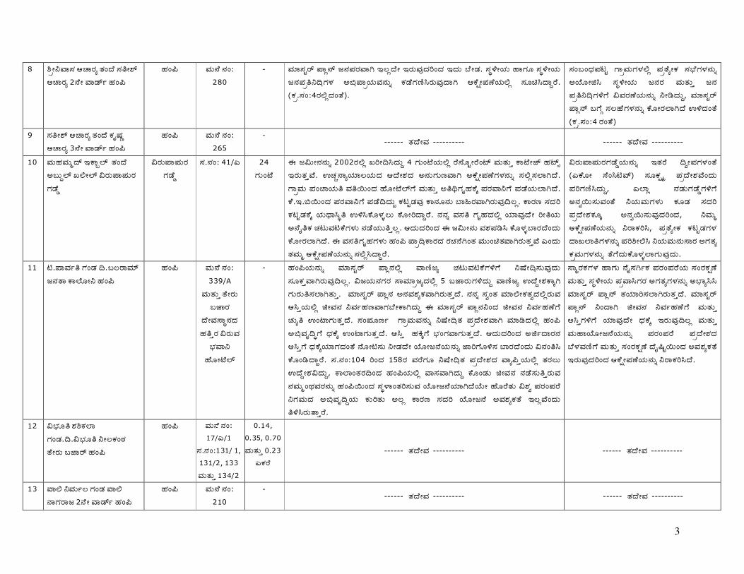
3
8 ÇõÓºÀÑÊÐ „›Ñ¤Ðô ³Ð�·Ù ÊдÓÆý „›Ñ¤Ðô 2¹ÙÓ ÀÑ®ýþ ÌÐ�¼
ÌÐ�¼ ÀÐÔ¹Ù ¹Ð�: 280
- ÀЦÑÊÐå¤ý »Ñö¹ý ¡¹Ð»Ð¤ÐÀÑ— …Ãö·ÙÓ …¤ÐÔÀÐշЧ�·Ð …·ÐÔ ¾ÙÓ®Ð. ÊÐëÏÓ�¦ÐÔ ÌÑ–ÐÖ ÊÐëÏÓ�¦ÐÔ ¡¹Ð»Ðõ º¸°–ÐÎÐ ƒ¿°»Ñõ�¦ÐÔÀйÐÔî ‘Ð®Ù–Ð±ÒˤÐÔÀÐÕ·Ñ— „‘ÙùӻвÙ�¦ÐÔÅö ÊÐ֜˷Ñì¤Ù. (‘Ðõ.ÊÐ�:4¤ÐÅö·Ð�³Ù).
ÊÐ�½�·°Ð»Ð©å –ÑõÀÐÔ–ÐÎÐÅö »Ðõ³ÙôÓ‘Ð Êо°Ù–ÐÎйÐÔî ƒ�¦ÙÖÓ£Ë ÊÐëÏÓ�¦ÐÔ ¡¹Ð¤Ð ÀÐÔ³ÐÔê ¡¹Ð »Ðõ´º¸°–ÐÏ–Ù ÁÀФвÙ�¦ÐÔ¹ÐÔî ºÓ¯·ÐÔì, ÀЦÑÊÐå¤ý »Ñö¹ý ½–ÙÞ ÊÐÃÌÙ–ÐÎйÐÔî ‘ÙÖÓ¤ÐÄÑ—·Ù ‡Ï·Ð�³Ù (‘Ðõ.ÊÐ�:4 ¤Ð�³Ù)
9 ÊдÓÆý „›Ñ¤Ðô ³Ð�·Ù ‘ÐØÈÐé „›Ñ¤Ðô 3¹ÙÓ ÀÑ®ýþ ÌÐ�¼
ÌÐ�¼ ÀÐÔ¹Ù ¹Ð�: 265
- ------ ³Ð·ÙÓÀÐ ---------- ------ ³Ð·ÙÓÀÐ ----------
10 ÀÐÔÌÐÀÐÔó·ý …‘ÑñÄý ³Ð�·Ù ƒ½ÔìÄý “ÅÓÄý Á¤ÐԻѻÐԤР–ЮÙç
Á¤ÐԻѻÐԤР–ЮÙç
ÊÐ.¹Ð�: 41/Š 24 –ÐÔ�ªÙ
† ¡ÁÔӹйÐÔî 2002¤ÐÅö “§Ó¸Ë·ÐÔì 4 –ÐÔ�ªÙ�¦ÐÔÅö ¤ÙÊÙÖåÓ¤Ù�ªý ÀÐÔ³ÐÔê ‘ÑªÙÓ¢ý ÌЪýú …¤ÐÔ³ÐêÀÙ. ‡›Ðà¹Ñô�¦Ð¦ÑÃ�¦ÐÔ·Ð „·ÙÓÆзРƒ¹ÐÔ–ÐÔ±ÀÑ— ƒ‘ÙùӻвٖÐÎйÐÔî ÊÐÅöÊÐÄÑ—·Ù. –ÑõÀÐÔ »Ð�›Ñ�¦ÐÔ´ ÀдÂÔ�·Ð ÌÙÖÓªÙÄý–Ù ÀÐÔ³ÐÔê ƒ´¶–ÐØÌБÙÜ »Ð¤ÐÀѺ–Ù »Ð®Ù�¦ÐÔÄÑ—·Ù. ‘Ù.….¿ÂÔ�·Ð »Ð¤ÐÀѺ–Ù »Ð®Ù¸·ÐÔì ‘Ð©å®ÐÀÐÕ ‘ѹÐÖ¹ÐÔ ¾ÑͤÐÀÑ—¤ÐÔÀÐÕ Ãö. ‘Ѥб ÊзЧ ‘Щå®Ð‘ÙÜ �¦ÐÔµÑËë´ ‡ÏË‘ÙÖÎÐüÃÔ ‘ÙÖÓ§·Ñì¤Ù. ¹Ð¹Ðî ÀÐÊд –ÐØÌзÐÅö �¦Ð¦ÑÀÐÕ·ÙÓ §Ó´�¦ÐÔ ƒ¹ÙÚ´‘Ð ›Ð©ÔÀЫ‘Ù–ÐÎÐÔ ¹Ð®Ù�¦ÐÔÔ´êÃö. „·ÐԷЧ�·Ð † ¡ÁÔÓ¹ÐÔ ÀÐÆÐ»Ð¯Ë ‘ÙÖÎÐü¾Ñ¤Ð·Ù�·ÐÔ ‘ÙÖÓ¤ÐÄÑ—·Ù. † ÀÐÊд–ÐØÌЖÐÎÐÔ ÌÐ�¼ »Ñõ¸°‘ѤзР¤Ð›Ð¹Ù—�³Ð ÀÐÔÔ�œ³ÐÀÑ—¤ÐÔ³ÐêÀÙ Š�·ÐÔ ³ÐÀÐÔó „‘ÙùӻвÙ�¦ÐÔ¹ÐÔî ÊÐÅöË·Ñì¤Ù.
Á¤ÐԻѻÐԤЖЮÙç�¦ÐÔ¹ÐÔî …³Ð¤Ù ¸÷ӻЖÐÎÐ�³Ù (Š‘ÙÖÓ ÊÙ�Ë«Àý) ÊÐÖ‘Ðùÿó »Ðõ·ÙÓÆÐÀÙ�·ÐÔ »Ð§–бÒË·ÐÔì, ŠÄÑö ¹Ð®ÐԖЮÙç–ÐÏ–Ù ƒ¹Ð÷ÂÔÊÐÔÀÐ�³Ù º�¦ÐÔÀÐÔ–ÐÎÐÔ ‘Ð֮РÊзЧ »Ðõ·ÙÓÆБÐÖÜ ƒ¹Ð÷ÂÔÊÐÔÀÐշЧ�·Ð, ºÀÐÔó „‘ÙùӻвÙ�¦ÐÔ¹ÐÔî º¤Ñ‘ЧË, »Ðõ³ÙôÓ‘Ð ‘Щå®Ð–ÐÎÐ ·Ñ“ÄÑ´–ÐÎйÐÔî »Ð§ÇÓÅË º�¦ÐÔÀÐÔ¹ÐÔÊѤРƒ–гÐô ‘ÐõÀÐÔ–ÐÎйÐÔî ³Ù–Ù·ÐÔ‘ÙÖÎÐüÄÑ–ÐÔÀÐÕ·ÐÔ.
11 «.»ÑÀÐþ´ –Ð�®Ð ¸.½Ã¤ÑÀЦý ¡¹Ð³Ñ ‘ÑÄÙÖÓº ÌÐ�¼
ÌÐ�¼ ÀÐÔ¹Ù ¹Ð�: 339/A
ÀÐÔ³ÐÔê ³ÙÓ¤ÐÔ ½¢Ñ¤Ð
·ÙÓÀÐÊÑë¹Ð·Ð Ìдê¤Ð Á¤ÐÔÀÐ
¾°ÐÀѺ ÌÙÖÓªÙÄý
- ÌÐ�¼�¦ÐÔ¹ÐÔî ÀЦÑÊÐå¤ý »Ñö¹ÐÅö Àѱҡô ›Ð©ÔÀЫ‘Ù–ÐÏ–Ù ºÈÙÓ¸°ÊÐÔÀÐÕ·ÐÔ ÊÐÖ‘ÐêÀÑ—¤ÐÔÀÐÕ Ãö. Á¡�¦ÐԹЖФРÊÑÀЦÑõ¡ô·ÐÅö 5 ½¢Ñ¤ÐÔ–ÐÏ·ÐÔì Àѱҡô ‡·ÙìÓÆБÑÜ— –ÐÔ¤ÐÔ´ÊÐÄÑ—³ÐÔê. ÀЦÑÊÐå¤ý »Ñö¹Ð ƒ¹ÐÀÐÆÐô‘ÐÀÑ—¤ÐÔ³Ðê·Ù. ¹Ð¹Ðî ÊÐ÷�³Ð ÀЦÑÅӑгÐ÷·ÐÅö¤ÐÔÀÐ „Ëê�¦ÐÔÅö £ÓÀйРºÀÐþÌбÀіоÙÓ‘Ñ—·ÐÔì † ÀЦÑÊÐå¤ý »Ñö¹Ðº�·Ð £ÓÀйРºÀÐþÌвٖ٠›ÐÔô´ ‡�ªÑ–ÐÔ³Ðê·Ù. ÊÐ�»ÐÖ±þ –ÑõÀÐÔÀйÐÔî ºÈÙÓ¸°³Ð »Ðõ·ÙÓÆÐÀÑ— ÀЦѯ·ÐÅö ÌÐ�¼ ƒ¿°ÀÐظí–Ù ·°Ð‘ÙÜ ‡�ªÑ–ÐÔ³Ðê·Ù. „Ëê ÌÐ’Ü–Ù ¾°Ð�–ÐÀÑ–ÐÔ³Ðê·Ù. „·ÐԷЧ�·Ð ƒ£þ·Ñ¤Ð¹Ð „Ëê–Ù ·°Ð‘ÙÜ�¦Ð¦Ñ–зÐ�³Ù ¹ÙÖÓ«ÊÐÔ ºÓ®Ð·ÙÓ �¦ÙÖÓ¡¹Ù�¦ÐÔ¹ÐÔî ¢Ñ§–ÙÖÏÊÐ ¾Ñ¤Ð·Ù�·ÐÔ Á¹Ð�´Ë ‘ÙÖ�¯·Ñì¤Ù. ÊÐ.¹Ð�:104 §�·Ð 158¤Ð ÀФٖÐÖ ºÈÙÓ¸°³Ð »Ðõ·ÙÓÆзРÀÑô¼ê�¦ÐÔÅö ³Ð¤ÐÃÔ ‡·ÙìÓÆÐÁ·ÐÔì, ‘ÑÄÑ�³Ð¤Ð¸�·Ð ÌÐ�¼�¦ÐÔÅö ÀÑÊÐÀÑ—·ÐÔì ‘ÙÖ�®ÐÔ £ÓÀйР¹Ð®ÙÊÐÔ´ê¤ÐÔÀÐ ¹ÐÀÐÔó�µÐÀФйÐÔî ÌÐ�¼ÂÔ�·Ð ÊÐëÎÑ�³Ð§ÊÐÔÀÐ �¦ÙÖÓ¡¹Ù�¦Ð¦Ñ—·Ù�¦ÙÔÓ ÌÙÖ¤Ù³ÐÔ ÁÆÐ÷ »Ð¤Ð�»Ð¤Ù º–ÐÀÐÔ·Ð ƒ¿°ÀÐظì�¦ÐÔ ‘ÐÔ§³ÐÔ ƒÃö ‘Ѥб ÊзЧ �¦ÙÖÓ¡¹Ù ƒÀÐÆÐô‘г٠…ÃöÀÙ�·ÐÔ ´ÏˤÐÔ³Ñê¤Ù.
ÊÑó¤Ð‘ЖÐÎÐ ÌÑ–ÐÔ ¹ÙÚÊЗþ‘Ð »Ð¤Ð�»Ð¤Ù�¦ÐÔ ÊÐ�¤Ð‘Ðù²Ù ÀÐÔ³ÐÔê ÊÐëÏÓ�¦ÐÔ »ÐõÀÑ˖ФРƒ–гÐô–ÐÎйÐÔî ƒ¾°ÑôËË ÀЦÑÊÐå¤ý »Ñö¹ý ³Ð�¦Ð¦Ñ§ÊÐÄÑ—¤ÐÔ³Ðê·Ù. ÀЦÑÊÐå¤ý »Ñö¹ý º�·Ñ— £ÓÀйРºÀÐþÌвٖ٠ÀÐÔ³ÐÔê „Ëê–ÐÏ–Ù �¦Ð¦ÑÀÐÕ·ÙÓ ·°Ð‘ÙÜ …¤ÐÔÀÐÕ¸Ãö ÀÐÔ³ÐÔê ÀÐÔÌÑ�¦ÙÖÓ¡¹Ù�¦ÐÔ¹ÐÔî »Ð¤Ð�»Ð¤Ù »Ðõ·ÙÓÆзР¾ÙÎÐÀбҖ٠ÀÐÔ³ÐÔê ÊÐ�¤Ð‘Ðù²Ù ·ÙÚÉåÂÔ�·Ð ƒÀÐÆÐô‘г٠…¤ÐÔÀÐշЧ�·Ð „‘ÙùӻвÙ�¦ÐÔ¹ÐÔî º¤Ñ‘Ч˷Ù.
12 Á¾°ÐÖ ÆÐÇ‘ÐÄÑ –Ð�®Ð.¸.Á¾°ÐÖ´ ºÓÑÐ�¬Ð ³ÙÓ¤ÐÔ ½¢Ñ¤ý ÌÐ�¼
ÌÐ�¼ ÀÐÔ¹Ù ¹Ð�: 17/Š/1
ÊÐ.¹Ð�:131/ 1, 131/2, 133 ÀÐÔ³ÐÔê 134/2
0.14, 0.35, 0.70 ÀÐÔ³ÐÔê 0.23
Š‘Ф٠------ ³Ð·ÙÓÀÐ ---------- ------ ³Ð·ÙÓÀÐ ----------
13 ÀÑÅ ºÀÐÔþà –Ð�®Ð ÀÑÅ ¹Ñ–Фѡ 2¹ÙÓ ÀÑ®ýþ ÌÐ�¼
ÌÐ�¼ ÀÐÔ¹Ù ¹Ð�: 210
- ------ ³Ð·ÙÓÀÐ ---------- ------ ³Ð·ÙÓÀÐ ----------

4
14 Á¾°ÐÖ »Ð�»Ñ»Ð´, ³Ð�·Ù Á¾°ÐÖ ½ÊÐ�¦ÐÔô ¡¹Ð³Ñ ‘ÑÄÙÖÓº ÌÐ�¼
ÌÐ�¼ ÀÐÔ¹Ù.¹Ð�: 353 ÀÐÔ³ÐÔê 426 ÊÐ.¹Ð�: 109
0.18 ------ ³Ð·ÙÓÀÐ ---------- ------ ³Ð·ÙÓÀÐ ----------
15 £.ƒ¹Ðî»ÐÖ±þÀÐÔ –Ð�®Ð.¸.£. ÁÓ¤ÙÓÆлÐï ³ÙÓ¤ÐÔ ½¢Ñ¤ý ÌÐ�¼
ÌÐ�¼ ÀÐÔ¹Ù ¹Ð�: 103
- ------ ³Ð·ÙÓÀÐ ---------- ------ ³Ð·ÙÓÀÐ ----------
16 ÀÐÔÌÑ·ÙÓÀÐÀÐÔó –Ð�®Ð Š�. ÊÐÖ–Ð֤лÐï ¡¹Ð³Ñ ‘ÑÄÙÖÓº ÌÐ�¼
ÌÐ�¼ ÀÐÔ¹Ù ¹Ð�: 159 & 160
- ------ ³Ð·ÙÓÀÐ ---------- ------ ³Ð·ÙÓÀÐ ----------
17 Š�.Á¡�¦ÐÔ ‘ÐÔÀЦѤý ³Ð�·Ù Š�. ÊÐÖ–Ð֤лÐï ¡¹Ð³Ñ ‘ÑÄÙÖÓº ÌÐ�¼
ÌÐ�¼ ÀÐÔ¹Ù ¹Ð�: 355
- ------ ³Ð·ÙÓÀÐ ---------- ------ ³Ð·ÙÓÀÐ ----------
18 Š�.ÆѤзÐÀÐÔó –Ð�®Ð.Š�. ÁÓ¤Ð�¦ÐÔô ¡¹Ð³Ñ »Ñöªý ÌÐ�¼
ÌÐ�¼ ÀÐÔ¹Ù ¹Ð�: 250 »Ñöªý ¹Ð�:10 ÊÐ.¹Ð�:69/2 ÀÐÔ³ÐÔê 91/1
1.71 ÀÐÔ³ÐÔê 1.00 Š‘Ф٠------ ³Ð·ÙÓÀÐ ---------- ------ ³Ð·ÙÓÀÐ ----------
19 Á¾°ÐÖ ºÓÃÀÐÔó –Ð�®Ð Á¾°ÐÖ´ »Ð�»Ñ»Ð´ ³ÙÓ¤ÐÔ ½¢Ñ¤ý ÌÐ�¼
ÌÐ�¼ ÀÐÔ¹Ù ¹Ð�: 70 & 71 ÊÐ.¹Ð�:140
& 155
3.59 ÀÐÔ³ÐÔê 1.30 Š‘Ф٠------ ³Ð·ÙÓÀÐ ---------- ------ ³Ð·ÙÓÀÐ ----------
20 Á¾°ÐÖ ÀÐÔسÐÔô�¡�¦ÐÔ ³Ð�·Ù Á¾°ÐÖ »Ð�»Ñ»Ð´ 2¹ÙÓ ÀÑ®ýþ ÌÐ�¼
ÌÐ�¼ ÀÐÔ¹Ù ¹Ð�: 208 & 321/ Š ÊÐ.¹Ð�: 33/
Š/1-29
0.48 ÀÐÔ³ÐÔê 1.60 Š‘ФÙ
------ ³Ð·ÙÓÀÐ ---------- ------ ³Ð·ÙÓÀÐ ----------
21 Á¾°ÐÖ º¡Å�–лÐï ³Ð�·Ù Á¾°ÐÖ »Ð�»Ñ»Ð´ 2¹ÙÓ ÀÑ®ýþ ÌÐ�¼
ÌÐ�¼ ÀÐÔ¹Ù ¹Ð�: 17/Š ÊÐ.¹Ð�:
131/2 ÀÐÔ³ÐÔê134/2
0.70 ÀÐÔ³ÐÔê 0.73 Š‘ФÙ
------ ³Ð·ÙÓÀÐ ---------- ------ ³Ð·ÙÓÀÐ ----------
22 Á¾°ÐÖ »Ð¤ÐÀÙÔÓÆÐ÷¤Ð ³Ð�·Ù Á¾°ÐÖ »Ð�»Ñ»Ð´ ÌÐ�¼
ÌÐ�¼ ÀÐÔ¹Ù ¹Ð�: 208/Š
ÊÐ.¹Ð�:131/2 ÀÐÔ³ÐÔê134/2
0.95 ÀÐÔ³ÐÔê 0.49 Š‘ФÙ
------ ³Ð·ÙÓÀÐ ---------- ------ ³Ð·ÙÓÀÐ ----------
23
¼.¤Ñ¡‘ÐÔÀЦѤý Ë�–ý ³ÑÂÔ „¤ý. ƒ�½Ö¾ÑÂÔ ÌÐ�¼
ÌÐ�¼ - - ÀЦÑÊÐå¤ý »Ñö¹Ð ¡¹Ð»Ð¤ÐÀÑ—Ãö·ÙÓ …¤ÐÔÀÐշЧ�·Ð º¤Ñ‘Ч˷Ù. ÊÐëÏÓ�¦ÐԤРƒ¿°»Ñõ�¦ÐÔÀйÐÔî ‘Ð®Ù–Ð±ÒËÄÑ—·Ù. (‘ÐõÀÐÔ ÊÐ�;11¤ÐÅö ºÓ¯·Ð „‘ÙùӻвٖÐÎÐÔ † ƒ£þ�¦ÐÔÅö pÎЖÙÖ�¯¤ÐÔ³ÐêÀÙ.)
¤Ñ¡ô ÊБÑþ¤ÐÀÐÕ ÌÐ�¼ »Ñõ¸°‘ѤÐÀйÐÔî ¤ÐœË·ÐÔì, ‘ÑÂÔ·Ù ƒ¯ ÀЦÑÊÐå¤ý »Ñö¹ý ³Ð�¦Ð¦Ñ§ÊÐÄÑ—·Ù. …·ÐÔ º�¦ÐÔÀЦÑÀÐÏ–ÐÏ–Ù ƒ¹ÐÔÊѤÐÀÑ—·Ù. ÌÑ–Ñ— ÀЦÑÊÐå¤ý »Ñö¹ý ´¤ÐÊÐܧÊÐÔÀÐ ‘ÙÖÓ§‘Ù�¦ÐÔ

5
„‘ÙùӻвÙ�¦ÐÔ¹ÐÔî º¤Ñ‘Ч˷٠24 ÇõÓ.ŠÊý.ÇõÓºÀÑÊÐ ³Ð�·Ù ŠÊý.
¹Ñ¤Ñ�¦ÐÔ± ¤Ñ¡Ô, ÌÐ�¼ ÌÐ�¼ - -
----- ³Ð·ÙÓÀÐ ---------- ------ ³Ð·ÙÓÀÐ ----------
25
¢Ù.¤ÑÀÐÔ›Ð�·Ðõ ÆÙ«å „Å�¦Ð¦ÑÊý ¤ÑÀÐÔ±é, ³Ð�·Ù ÌйÐÔÀÐÔ�³Ð ÆÙ«å ÇõÓ ¤ÑÀÐÔ ©Ö§Êýå ÌÙÖÓÀЦý ÌÐ�¼
ÌÐ�¼ ÀÐÔ¹Ù ¹Ð�: 181,181/2
& 182
- 1) ÊзЧ�¦ÐÔÀФÐÔ ‘ÙÃÀÐÕ ·ÐÔÈÐå ÆÐ’ê–ÐÏ�·Ð ÀÐÔ³ÐÔê ‘ÑÇóÓ§ ¡¹Ð§�·Ð ÌÐ�¼�¦ÐÔÅö ÀÑÊÐÀÑ—¤ÐÔÀÐ ¹ÐÀÐÔó�µÐÀЧ–Ù ³ÙÖ�·Ð¤Ù ÀЦѮÐÔÀÐ ÊÐÃÔÀÑ— ÌÐ�¼ ÀЦÑÊÐå¤ý »Ñö¹ý–Ù ÊБÑþ¤ÐÀÐÕ ³Ñ³ÑÜÅ‘Ð ƒ¹ÐÔÀÙÖӷй٠ºÓ¯¤ÐÔÀÐÕ·Ñ— ´ÏˤÐÔ³Ñê¤Ù. 2) ³ÐÖ–ÐÔ ÊÙÓ³ÐÔÀÙÂÔ�·Ð ªÑõ¼°‘ý ¢ÑËê�¦Ð¦Ñ— ÊÑó¤Ð‘ЖÐÏ–Ù ·°Ð‘ÙÜ�¦Ð¦Ñ–ÐÔÀÐÕ·Ñ— ´ÏˤÐÔ³Ñê¤Ù. 3) ÀЦÑÊÐå¤ý »Ñö¹Ð¹ÐÅö ÌÐ�¼�¦ÐÔÔ §Ë»Ðù¹ý ÊÙ�©¤ý „— »Ð§ÀгÐþ¹Ù –ÙÖ�¯·Ù Š�·ÐÔ ½¤Ù�¦ÐÔÄÑ—·ÐÔì, ‘Ѥб …·Ð¹ÐÔî ¤Ð·ÐÔì–ÙÖÏÊÐÃÔ ‘ÙÖÓ§‘ÙÂÔ¤ÐÔ³Ðê·Ù. 4) Êиõ »Ñö¹Ð¹ÐÅö ÊÑó¤Ð‘ЖÐÏ�·Ð 100 ÁÔÓ ƒ�³Ð¤Ð·ÐÅö ÀÐÔ³ÐÔê ¹Ð¸ÂÔ�·Ð 45 ÁÔÓ –ÐÎÐ ƒ�³Ð¤Ð·ÐÅö ¡¹ÐÀÐÊд …¤Ð¾Ñ¤Ð·Ù�·ÐÔ ´ÏË ÌÐ�¼ ¡¹Ð¤Ð¹ÐÔî ‘Ð¯ç¤Ñ�»ÐԤР–ÑõÀÐÔ‘ÙÜ ÊÐëÎÑ�³Ð§ÊÐÃÔ ‡·ÙìÓÇË·ÐÔì † –ÑõÀÐÔÀÐÕ ÊÐ±é –ÑõÀÐÔÀÑ—·ÐÔì �¦Ð¦ÑÀÐÕ·ÙÓ ÀÐÔÖþ°ÐֳРÊÛ‘Ð�¦ÐÔþ–ÐÎйÐÔî ÌÙÖ�¸¤ÐÔÀÐÕ¸Ãö. 5) ƒ£þ�¦ÐÔÅö ‘ѱÒˤÐÔÀÐ „Ëê�¦ÐÔ¹ÐÔî ƒ£þ·Ñ¤Ð¤Ð¹Ð ³Ð�·Ù “§Ó¸Ë·ÐÔì ÊÐëÏÓ�¦ÐÔ »Ð�›Ñ�¦ÐÔ´ÂÔ�·Ð »Ð¤ÐÀѺ–Ù »Ð®Ù·Ð¹Ð�³Ð¤ÐÀÙÓ ‘Щå®ÐÀйÐÔî ‘Ð©åÄÑ—·Ù. † ‘Щå®ÐÀйÐÔî ÊÑ÷¸°Ó¹Ð »Ð¯Ë‘ÙÖ�®ÐÅö £ÓÀйРºÀÐþÌвٖ٠³ÙÖ�·Ð¤Ù�¦Ð¦Ñ–ÐÔ³Ðê·Ù. 6) ÀЦÑÊÐå¤ý »Ñö¹ÐÅö ¤ÐµÐ�¦Ð¦Ñ³Ùõ ÀÐÔ³ÐÔê ÊÑÀÐþ¡º‘Ð ÊÐÀЦѤÐ�¾°Ð–ÐÎÐÔ ¹Ð®Ù�¦ÐÔÔ´ê·ÐÔì …·Ð¹ÙîÃö ºÈÙÓ¸°Ë·ÐìÅö Í�·ÐÖ–ÐÎÐ ÊÐ�ÊÐÜØ´�¦ÐÔ¹ÐÔî ¹ÑÆÐÀЦѯ·Ð�³Ñ–ÐÔ³Ðê·Ù. 7) ¤ÐÊÙê ¤Ð›Ð¹Ù�¦ÐÔ ½–ÙÞ ÁÀФвÙ�¦ÐÔ¹ÐÔî ºÓ¯¤ÐÔÀÐÕ¸Ãö. ¾°ÐÖÁÔ ‡»Ð�¦ÙÖӖзР½–ÙÞ ´ÏˤÐÔÀÐÕ¸Ãö. ÀЦÑÊÐå¤ý »Ñö¹Ð „·°ÐÔº‘ÐÀÑ— ³Ð�¦Ð¦Ñ§Ë·Ð�³ÐÌÐ �¦ÙÖÓ¡¹Ù�¦Ð¦Ñ—¤ÐÔÀÐÕ¸Ãö. …·ÐÔ ÌÐ�¼–Ù ÌÙÖ�·Ñ±Ò‘Ù�¦Ð¦Ñ–ÐÔÀÐÕ Ãö. „·ÐԷЧ�·Ð ÌÐ�¼–Ù ƒ¹ÐÔ‘ÐÖÃÀÑ–ÐÔÀÐ�³ÐÌÐ ÀЦÑÊÐå¤ý »Ñö¹Ð¹ÐÔî ³Ð�¦Ð¦Ñ§ÊÐÃÔ ‘ÙÖÓ§·Ñì¤Ù.
1) „‘Ùùӻв٠ÊÐÀÐÔ�¡ÊÐÀÑ—¤ÐÔÀÐÕ¸Ãö. 2) ³Ð¡ä¤ÙÖ�¸–Ù ÊÐÀЦÑÄÙÖÓœË ÊÐ�½�·°Ð»Ð©å ÄÙÖÓ‘ÙÖÓ»Ð�¦ÙÖÓ …ÄÑ”Ù�¦ÐÔÔ †–Ñ–ÐÄÙÓ ‘ÐõÀÐÔ ‘ÙÚ–ÙÖ�¯¤ÐÔ³Ðê·Ù. 3) ƒ�ÆÐ (3)¤Ð ½–ÙÞ »Ð§ÇÓÅË, ‘ÐõÀÐÔ ÀÐÍÊÐÄÑ–ÐÔÀÐÕ·ÐÔ 4) »ÐԤѳгÐ÷ ‘ÑÂÔ·Ù�¦ÐÔ º�¦ÐÔÀÐÔ–ÐÎйÐ÷�¦ÐÔ »ÐõÊÑêÀйٖÐÎйÐÔî ƒÎÐÀЯÊÐÄÑ–ÐÀÐÕ·ÐÔ 5) ‘Щå®Ð–ÐÎйÐÔî ÊÑ÷¸°Ó¹Ð »Ð¯ÊБÙÖÎÐÔüÀÐ »ÐõÊÑêÀйÙ�¦ÐÔÔ ÀЦÑÊÐå¤ý »Ñö¹ý¹ÐÅö …¤ÐÔÀÐÕ¸Ãö. 6) ƒ�³ÐÌÐ »ÐõÊÑêÀйٖÐÎÐÔ …¤ÐÔÀÐÕ¸Ãö. 7) ÊÑó¤Ð‘ЖÐÎÐ ÊÐ�¤Ð‘Ðù²Ù ÀÐÔ³ÐÔê �¦ÙÖÓ¡¹Ñ ·ÐØÉåÂÔ�·Ð ÀЦÑÊÐå¤ý »Ñö¹ý ³Ð�¦Ð¦Ñ§ÊÐÄÑ–ÐÔÀÐÕ·ÐÔ
26 Š.¡�¦ÐÔÀÐÔó –Ð�®Ð.Š.ƒ¹Ð�³Ð¤Ñ¡ 2¹ÙÓ ÀÑ®ýþ, ÌÐ�¼
ÌÐ�¼ - - ‘Ðõ.ÊÐ�:6¤Ð�³Ù …¤ÐÔ³Ðê·Ù ------ ³Ð·ÙÓÀÐ ----------
27 ÇõÓ.Š.ƒ»Ðï�¦ÐÔô ³Ð�·Ù.¸. ¤ÐÔ·Ðõÿ»Ðï ÀÙÔÓ¹ý ½¢Ñ¤ý ÌÐ�¼
ÌÐ�¼ ÀÐÔ¹Ù ¹Ð�: 108
- ‘Ðõ.ÊÐ�:25 ¤Ð�³Ù …¤ÐÔ³Ðê·Ù ------ ³Ð·ÙÓÀÐ ----------
28 ÇõÓÀÐÔ´.Á.¤ÐÔ·ÐõÀÐÔó –Ð�®Ð.¸.Á. –Ð�–Ñ·°Ð¤Ð ÀÙÔÓ¹ý ½¢Ñ¤ý ÌÐ�¼
ÌÐ�¼ ÀÐÔ¹Ù ¹Ð�: 17, 229 &
241
- -------- ³Ð·ÙÓÀÐ ---------- ------ ³Ð·ÙÓÀÐ ----------
29 ÇõÓÀÐÔ´.‘Ñ‘ÐÔ¾ÑÎÐ ÇÀÐÀÐÔó –Ð�®Ð ¸.‘Ù.ÌйÐÔÀÐÔ�³Ð»Ðï –ÑõÀÐÔ »Ð�›Ñ�¦ÐÔ³ý Ìдê¤Ð ÌÐ�¼
ÌÐ�¼ ÀÐÔ¹Ù ¹Ð�: 211
- -------- ³Ð·ÙÓÀÐ ---------- ------ ³Ð·ÙÓÀÐ ----------

6
30 ÇõÓ.Á¾°ÐÖ´ ½ÊÐÀФѡ ³Ð�·Ù Á¾°ÐÖ »Ð�»Ñ»Ð´ –ÑõÀÐÔ »Ð�›Ñ�¦ÐÔ Í�·Ù 3¹ÙÓ ÀÑ®ýþ ÌÐ�¼
ÌÐ�¼ ÀÐÔ¹Ù ¹Ð�: 209
-
-------- ³Ð·ÙÓÀÐ ---------- ------ ³Ð·ÙÓÀÐ ----------
31 ÇõÓ.ÌÙ›ý.‘ÐÔ¾ÙӤлÐï ³Ð�·Ù Š¹ý. ¹Ñ¤Ñ�¦ÐԲѻÐï ÀÙÔÓ¹ý ½¢Ñ¤ý ÌÐ�¼
ÌÐ�¼ ÀÐÔ¹Ù ¹Ð�: 226/¿
- -------- ³Ð·ÙÓÀÐ ---------- ------ ³Ð·ÙÓÀÐ ----------
32 ¡–зÐÞ¤ÐÔ ÊÐÀÐþ¡¹Ð Êз°ÐÀÐÔþ ¼Ó¬Ð ‰ÔÉÀÐÔÔ“ »ÐÀÐþ³Ð „¹Ù–ÐÔ�¸
„¹Ù–ÐÔ�¸ ÊÐ.¹Ð�:49/2 - ÊÐëÏÓ�¦ÐÔ ¡¹Ð¤Ð ÀÐÔ¹Ù ÀÐÔ³ÐÔê ¾°ÐÖÁÔ�¦ÐÔ¹ÐÔî ‡ÏË‘ÙÖÎÐüÃÔ ƒÀБÑÆÐ ºÓ®ÐÔÀÐÕ·ÐÔ. Êиõ�¦ÐÔÀФйÐÔî �¦Ð¦ÑÀÐÕ·ÙÓ ‘Ѥб‘ÐÖÜ ÌÙÖ¤ÐÌёоѤзÐÔ. „¹Ù–ÐÔ�¸ ÊÙÓ³ÐÔÀÙ�¦ÐÔ¹ÐÔî »ÐÖ±þ –ÙÖÏË ÊÐ�›Ñ¤Ð‘ÙÜ ƒ¹ÐÔÀÐÕ ÀЦѯ‘ÙÖ®ÐÔÀÐÕ·ÐÔ. …·Ð§�·Ð »Ð�»Ñ ÊФÙÖÓÀФÐ, „�¡¹ÙÓ�¦ÐÔ »ÐÀÐþ³Ð ·ÐÔ–Ðþ·ÙÓÀÐÊÑë¹Ð–ÐÏ–Ù, »ÐõÀÑÊÙÖÓ·ÐôÀÐÔ ›Ð©ÔÀЫ‘Ù–ÐÎÐÔ ÌÙ›Ñà–ÐÔ³Ðê·Ù. ³Ð¼ï·ÐÅö ³ÐÖ–ÐÔ ÊÙÓ³ÐÔÀÙ�¦ÐÔ¹ÐÔî ¤Ð˜ÐÔ¹Ð�·Ð¹Ð ´ÓµÐþ¤Ð ÀÐԬзРÌдê¤Ð ºÀЦÑþ± ÀЦѮÐÔÀÐÕ·ÐÔ. »Ð¤Ð�»Ð¤Ñ ¼Ó¬Ð–ÐÎÑ·Ð Á·Ñô¤Ð±ô –ÐÔ¤ÐÔ¼Ó¬Ð, –Ñ�¦ÐÔ´õ ¼Ó¬Ð, ‘ÙÖ©Ôå¤ÐÔ ÊÑ÷ÁÔ ÀÐԬРÀÐÔ³ÐÔê ÊÐÀÐþ¡ä¹Ð ¼Ó¬Ð–ÐÎйÐÔî �¦Ð¦ÑÀÐÕ·ÙÓ ‘Ѥб‘ÐÖÜ ÊÐëÎÑ�³Ð§ÊоѤзÐÔ. † ‘Ѥб–ÐÏ�·Ð ÀЦÑÊÐå¤ý »Ñö¹Ð ½·ÐÄÑÀв٠ÀЦѮÐÃÔ ‘ÙÖÓ§·Ù.
ÊÐëÏÓ�¦ÐÔ ¡¹Ð¤Ð ÀÑÊзРÀÐÔ¹Ù ÀÐÔ³ÐÔê ¾°ÐÖÁÔ�¦ÐÔ¹ÐÔî ‡ÏË‘ÙÖÎÐüÃÔ ÊÐ�»ÐÖ±þ ƒÀБÑÆÐ ºÓ¯·Ù. ÊÐëÏÓ�¦ÐÔ ¡¹Ð¤Ð¹ÐÔî ÌÙ֤ЖЮ٠ÌÑ‘ÐÃÔ �¦Ð¦ÑÀÐÕ·ÙÓ »ÐõÊÑêÀй٠…¤ÐÔÀÐÕ¸Ãö. ³ÐÖ–ÐÔ ÊÙÓ³ÐÔÀÙ ‘ÙÃÊÐÀÐÕ ÄÙÖÓ‘ÙÖÓ»Ð�¦ÙÖÓ— …ÄÑ”Ù�¦ÐÔ ÀÑô¼ê�¦ÐÔÅö¤ÐÔ³Ðê·Ù »Ð¤Ð�»Ð¤Ñ ¼Ó¬Ð–ÐÎйÐÔî ÊÐëÎÑ�³Ð§ÊÐÔÀÐ »ÐõÊÑêÀй٠…¤ÐÔÀÐÕ Ãö.
33
Š.¡�¦ÐÔÀÐÔó, –Ð�®Ð.Š. ƒ¹Ð�³Ð¤Ñ¡, 2¹ÙÓ ÀÑ®ýþ, ÌÐ�¼
ÌÐ�¼ ÀÐÔ¹Ù ¹Ð�: 173
- ÌÐ�¼ ÀЦÑÊÐå¤ý »Ñö¹Ð¹ÐÔî ¹Ñ¹ÐÔ ´¤ÐÊÐܧÊÐÔ³ÙêÓ¹Ù. ‘Ѥб …·ÐÔ ÊÐëÏÓ�¦ÐԤРƒºË‘Ù–ÐÏ–Ù ƒ¹ÐÔ–ÐÔ±ÀÑ—Ãö † �¦ÙÖÓ¡¹Ù�¦ÐÔÅö ÊÐ±é ‘Ùږѧ‘Ù–ÐÏ–Ù ƒÀБÑÆÐÁ·ÐÔì …·Ð§�·Ð »Ð§ÊФРÀÐÔ³ÐÔê »ÐõÀÑÊÙÖÓ·ÐôÀÐÔ‘ÙÜ ƒ¹Ñ¹ÐÔ‘ÐÖÃÀÑ–ÐÔ³Ðê·Ù. † �¦ÙÖÓ¡¹Ù�¦ÐÔÔ ÊÑ�ÊÐÜØ´‘Ð ‘Ñ�¦ÐÔþ‘ÐõÀÐÔ–ÐÏ–Ù ƒ¯ç ‡�©Ô ÀЦѮÐÔ³Ðê·Ù. † �¦ÙÖÓ¡¹Ù�¦ÐÔÅö ƒ¹Ð¸°‘ÐسРÀÐÔ³ÐÔê ƒ‘ÐõÀÐÔ±–ÐÎйÐÔî ³Ù–Ù�¦ÐÔÃÔ �¦ÙÖÓ¡¹Ù�¦ÐÔ¹ÐÔî ¤Ðּ˷Ù. † „‘ÙùӻвٖÐÎйÐÔî »Ð§–бÒË † ÀЦÑÊÐå¤ý »Ñö¹Ð¹ÐÔî »Ð§ÈÐܧÊÐÃÔ ‘ÙÖÓ§·Ù. ÆгÐÀЦѹЖÐÏ�·ÐÃÖ …Åö £ÓÀйРÊÑ—ÊÐÔ´ê·ÐÔì Í�¸¹Ð’Ü�³ÐÃÖ †–Ð ÌÙ›Ñà— ‘ÐÔ©Ô�½–ÐÎÐÔ ¾ÙÎÙ¸¤ÐÔ³ÐêÀÙ. ÌÐ�¼ »Ðõ·ÙÓÆÐÀйÐÔî »ÐõÀÑË ³Ñ±ÀÑ— ÀЦѯ ¹ÐÀÐÔó £ÓÀйРÀÐÔ©å ÊÐÔ·°Ñ§ÊÐÃÔ ƒ¹ÐÔÀÐÕ ÀЦѯ ‘ÙÖ®ÐÔÀÐÕ·ÐÔ.
------ ³Ð·ÙÓÀÐ ----------
»Ñ¤Ð�»Ð§‘Ð ‘Ùږѧ‘Ù–ÐÎйÐÔî ÀЦѳÐõ ‘ÐÅïÊÐÃÔ ‘ÐõÀÐÔ ÀÐÍÊÐÄÑ–ÐÔÀÐÕ·ÐÔ.
34 ÇõÓ.ŠÊý.·ÙÓÀÐ¤Ñ¡Ô ³Ð�·Ù ŠÊý. ÀÙ�‘Щ¤Ñ¡Ô 2¹ÙÓ ÀÑ®ýþ ÌÐ�¼
ÌÐ�¼ ÀÐÔ¹Ù ¹Ð�: 173/Š
- -------- ³Ð·ÙÓÀÐ ---------- ------ ³Ð·ÙÓÀÐ ----------
35 ÇõÓÀÐÔ´.ŠÊý.¤ÐÔ·ÐõÀÐÔó –Ð�®Ð ¸.ŠÊý.Á¤ÐԻёÐù»Ðï, ÀÙÔÓ¹ý ½¢Ñ¤ý ÌÐ�¼
ÌÐ�¼ ÀÐÔ¹Ù ¹Ð�: 177
- ‘Ðõ.ÊÐ�:25 ¤Ð�³Ù …¤ÐÔ³Ðê·Ù ------ ³Ð·ÙÓÀÐ ----------
36 ÇõÓÀÐÔ´.ÌÙ›ý.¾°ÐÔÀйÙÓÆÐ÷§ –Ð�®Ð ÌÙ›ý.‘ÐÔ¾ÙӤлÐï ÀÙÔÓ¹ý ½¢Ñ¤ý ÌÐ�¼
ÌÐ�¼ ÀÐÔ¹Ù ¹Ð�: 207
- -------- ³Ð·ÙÓÀÐ ---------- ------ ³Ð·ÙÓÀÐ ----------

7
37 ÇõÓ.Š�.£ÓÀйýÄÑÄý Ë�–ý ³Ð�·Ù. ¹Ð¤ÐË�ÌÐ Ë�–ý –ÑõÀÐÔ »Ð�›Ñ�¦ÐÔ³ý Ìдê¤Ð ÌÐ�¼
ÌÐ�¼ ÀÐÔ¹Ù ¹Ð�: 217
- -------- ³Ð·ÙÓÀÐ ---------- ------ ³Ð·ÙÓÀÐ ----------
38 ÇõÓ.Š�.¡�¦ÐÔ¤ÑÀÐÔ Ë�–ý ³Ð�·Ù. ¸.Š�.ͤÐÄÑÄý Ë�–ý —Ó³Ñ ¤ÙÊÙÖåÓ¤Ù�ªý ÀÙÔÓ¹ý ½¢Ñ¤ý ÌÐ�¼
ÌÐ�¼ ÀÐÔ¹Ù ¹Ð�: 123
-
-------- ³Ð·ÙÓÀÐ ---------- ------ ³Ð·ÙÓÀÐ ----------
39
¼.»Ð¤ÐÀÙÔÓÆÐ÷¤Ð»Ðï ³Ð�·Ù ‘ÙÖ©õ½ÊлÐï 2¹ÙÓ ÀÑ®ýþ ÌÐ�¼
ÌÐ�¼ ÀÐÔ¹Ù ¹Ð�: 403
- ÀЦÑÊÐå¤ý »Ñö¹ý ¡¹Ð»Ð¤ÐÀÑ— …Ãö·ÙÓ …¤ÐÔÀÐշЧ�·Ð …·ÐÔ ¾ÙӮР…·Ð¹ÐÔî ¤ÐœÊÐÔÀÑ–Ð ÊÐëÏÓ�¦ÐԤРÌÑ–ÐÖ ¡¹Ð»Ðõ º¸°–ÐÎÐ ƒ¿°»Ñõ�¦ÐÔÀйÐÔî ‘Ð®Ù–Ð±ÒÊÐÄÑ—·Ù. …·Ð¤ÐÅö ÊÐ±é ‘Ùږѧ‘Ù–ÐÏ–Ù ƒÀБÑÆÐ ºÓ¯·ÐÔì …·Ð§�·Ð »Ð§ÊФРÀÐÔ³ÐÔê »ÐõÀÑÊÙÖÓ·ÐôÀÐÔ‘ÙÜ ·°Ð‘ÙÜ�¦Ð¦Ñ–ÐÔ³Ðê·Ù. ÊÑó¤Ð‘ЖÐÎÐÖ ‡Ï�¦ÐÔÔÀÐÕ¸Ãö. ÌÐ�¼�¦ÐÔÔ ÊÐëÏÓ�¦ÐÔ§–Ù ¾°ÑÀйѳÐó‘Ð ÊÐ�½�·°ÐÁ·ÐÔì † ÊÐëÎÐÀйÐÔî ¿©Ôå ÌÙÖÓ–ÐÔÀÐ »ÐõÀÙÔÓ�¦ÐÔÀÙÓ …Ãö. † �¦ÙÖÓ¡¹Ù�¦ÐÔ¹ÐÔî ‘Ð¹Ðî®Ð·ÐÅö º¤ÐּˤÐÔÀÐÕ¸Ãö.
------ ³Ð·ÙÓÀÐ ----------
»Ñ¤Ð�»Ð§‘Ð ‘Ùږѧ‘Ù–ÐÎйÐÔî ÀЦѳÐõ ‘ÐÅïÊÐÃÔ ‘ÐõÀÐÔ ÀÐÍÊÐÄÑ–ÐÔÀÐÕ·ÐÔ.
40 »Ñ�®ÐÔ¤Ð�–Ð ´»Ñï£ ¹Ð¤Ð–ÐÔ�·Ð, ³Ð�·Ù ´»Ñï£ 2¹ÙÓ ÀÑ®ýþ ÌÐ�¼
ÌÐ�¼ ÀÐÔ¹Ù ¹Ð�: 1/41
- -------- ³Ð·ÙÓÀÐ ---------- ------ ³Ð·ÙÓÀÐ ----------
41 ‘Ù.ÇÀФÑÀÐÔ ÌÐ�¼ - - -------- ³Ð·ÙÓÀÐ ---------- ------ ³Ð·ÙÓÀÐ ---------- 42 –ÑõÀÐÔ »Ð�›Ñ�¦ÐÔ´ ‘Ñ�¦Ð¦ÑþÃ�¦ÐÔ
ÀÐÔûйЖÐÔ¯ ÀÐÔûйÐ
–ÐÔ¯ - - ÀÐÔûйЖÐÔ¯ –ÑõÀÐÔ »Ð�›Ñ�¦ÐÔ³ý ÀЦÑÊÐå¤ý »Ñö¹Ð ‘йÐî®Ð ƒ¹ÐÔÀÑ·Ð ºÓ®Ð¾ÙÓ‘Ù�·ÐÔ ‘ÙÖÓ§·Ù.
† �¦ÙÖÓ¡¹Ù�¦ÐÔ ÀЦÑÍ´�¦ÐÔ¹ÐÔî –ÑõÀÐÔ »Ð�›Ñ�¦ÐÔ³ý ÊзÐÊÐô§–Ù ºÓ®Ð·ÙÓ …¤ÐÔÀÐշЧ�·Ð –ÑõÀÐÔ »Ð�›Ñ�¦ÐÔ´�¦ÐÔÔ † �¦ÙÖÓ¡¹Ù�¦ÐÔ¹ÐÔî ´¤ÐÊÐܧÊÐÔ³Ðê·Ù.
†–Ñ–ÐÄÙÓ ÀЦÑÊÐå¤ý »Ñö¹ý¹Ð ‘йÐî®Ð ƒ¹ÐÔÀÑ·Ð ºÓ¯·Ù. –ÑõÀÐÔ Êо°Ù–ÐÎйÐÔî „�¦ÙÖӣ˷ÐÔì ÊÐëÏÓ�¦ÐÔ �¦ÙÖÓ¡¹Ñ »Ðõ·ÙÓÆзР¡¹Ð¤Ð¹ÐÔî ÀÐÔ³ÐÔê ¡¹Ð »Ðõ º¸°–ÐÏ–Ù �¦ÙÖÓ¡¹Ù�¦ÐÔ ½–ÙÞ ÀЦÑÍ´�¦ÐÔ¹ÐÔî ºÓ®ÐÄÑ—·Ù. ‘ÑÂÔ·Ù ƒ¯ ÀЦÑÊÐå¤ý »Ñö¹ý ³Ð�¦Ð¦Ñ§Ë¤ÐÔÀÐշЧ�·Ð, ÀЦÑÊÐå¤ý »Ñö¹ý ´¤ÐÊÐܧÊÐÔÀÐ ºÀÐÔó „‘ÙùӻвÙ�¦ÐÔ¹ÐÔî º¤Ñ‘Ч˷Ù.
43
ÇõÓ.½Ã·ÙÓÀФѢý ¬Ñ‘ÐÖ¤ý ³Ð�·Ù ‘ÑŤÑÀЦý ¬Ñ‘ÐÖ¤ý Á¤ÐԻѻÐԤР–ЮÙç
Á¤ÐԻѻÐԤР–ЮÙç
ÊÐ.¹Ð�: 47/¿
1 Š‘Ф٠20
–ÐÔ�ªÙ
Á¤ÐԻѻÐԤЖЮÙç –ÑõÀÐÔ·Ð ¡ÁÔÓ¹ÐÔ ÊÐ.¹Ð�:47/¿ ÁËêÓ±þ 1.20 –ÐÔ�ªÙ ¡ÁÔӹйÐÔî 9-5-2001¤ÐÅö ¹ÙÖ�·ÑÂԳР·Ñ“ÄÙ »Ðõ‘ѤР“§Ó¸ÊÐÄÑ—·Ù. 1) –ÑõÀÐÔ »Ð�›Ñ�¦ÐÔ´ ÀдÂÔ�·Ð »Ð¤ÐÀѺ–Ù »Ð®Ù¸¤ÐÔ³ÙêÓ¹Ù. ‘Щå®Ð‘ÙÜ ‘ФР»ÑÀд
ÀЦѯ¤ÐÔ³ÙêÓ¹Ù. …·Ð¤ÐÅö ‘ÙÃÀÐÕ –ÐÔ¯ÊÐÃÔ–ÐÎйÐÔî ‘Ð«å·ÐÔì »ÐõÀÑ˖Ч–Ñ— ƒ¹ÐÔ‘ÐÖà ÀЦѯ ‘ÙÖ®ÐÄÑ—·Ù. ƒ·Ð‘ÙÜ »Ð¤ÐÀѺ–Ù�¦ÐÔ¹ÐÔî ÊÐÌÐ »Ð®Ù�¦ÐÔÄÑ—·Ù.
2) ÊзЧ ‘Щå®ÐÀйÐÔî ‘Ù®ÐÀÐÃÔ ¹ÙÖÓ«ÓÊÐÔ ½�·Ð ÀÙÔÓÄÙ …·Ð¹ÐÔî ³Ù–Ù·Ð�¦ÐÔ·Ð�³Ù ¤Ñ¡ô ‡›Ðà ¹Ñô�¦Ð¦ÑÃ�¦ÐÔ·ÐÅö 3255/05 §ªý ƒ£þ�¦ÐÔ¹ÐÔî ·Ñ“ÄÙ ÀЦѯ·Ù. ¹Ñô�¦Ð¦ÑÃ�¦ÐÔÀÐÕ ÊÐëÏÓ�¦ÐÔ »Ñõ¸°‘Ѥи�·Ð ÊÐÀÐÔÊÙô�¦ÐÔ¹ÐÔî ½–ÙÌЧˑÙÖÎÐüÃÔ ÊÐ֜ˤÐÔ³Ðê·Ù. „·ÐԷЧ�·Ð ¹Ð¹Ðî¹ÐÔî † ¡ÁÔÓº�·Ð ÊÐëÎÑ�³Ð§ÊзÙÓ …¤ÐÃÔ ‘ÙÖÓ§·Ù.
3) ƒ·Ð¤Ù �¦Ð¦ÑÀÐÕ·ÙÓ ·Ñ“ÄÙ–ÐÎйÐÔî ÊÐÅöˤÐÔÀÐÕ¸Ãö.
·Ñ“ÄÙ–ÐÎйÐÔî º�¦ÐÔÀЦѹÐÔÊѤР‘ÐõÀÐÔ ‘ÙÚ–ÙÖÎÐüÄÑ–ÐÔÀÐÕ·ÐÔ.

8
44 ÇõÓ.‘Ù.ÀÙ�‘Щ¤ÑÀÐÔ¤ÑÀý ³Ð�·Ù ÊÐÔ½ñ¤ÑÀý Á¤ÐԻѻÐԤЖЮÙç
Á¤ÐԻѻÐԤР–ЮÙç
ÊÐ.¹Ð�: 44/1/¿/1
20 –ÐÔ�ªÙ
ÊзЧ�¦ÐÔÀФÐÔ ÊÐ.¹Ð�:44.1:¿:1¤Ð 0.20 Š‘Ф٠ÀЦÑÅӑФї¤ÐÔÀÐÕ·Ñ— ´ÏÊÐÔ³Ñê, ÊзЧ ¢Ñ–Ù–Ù ÀÐÊд ‡·ÙìÓÆБÙÜ ¸¹Ñ�‘Ð:13-2-94¤Ð�·ÐÔ ¾°ÐÖ »Ð§ÀгÐþ¹Ù ÀЦѯË, ¹Ð�³Ð¤Ð ÊзЧ ¢Ñ–Ù–Ù ¸¹Ñ�‘Ð:24-3-99¤ÐÅö Àѱҡô ‡·ÙìÓÆБÙÜ ¾°ÐÖ »Ð§ÀгÐþ¹Ù ÀЦѯˤÐÔÀÐÕ·Ñ— ´ÏˤÐÔ³Ñê¤Ù. –ÑõÀÐÔ »Ð�›Ñ�¦ÐÔ´ …�·Ð Á¹ÑôÊБÙÜ ƒ¹ÐÔÀÐÔ´ »Ð®Ù¸·ÐÔì ÌÙÖÓªÙÄý ‘Щå®Ð‘ÙÜ –ÑõÀÐÔ »Ð�›Ñ�¦ÐÔ³ý …�·Ð »Ð¤ÐÀѺ–Ù »Ð®Ù¸¤ÐÔÀÐÕ·Ñ— ´ÏˤÐÔ³Ñê¤Ù. † ÊÐ�½�·°Ð ÊзЧ ‘Щå®ÐÀйÐÔî ³Ù¤ÐÀÐÕ–ÙÖÏÊÐ ¾Ñ¤Ð·Ñ— „‘Ùùӻв٠ÊÐÅöˤÐÔ³Ñê¤Ù. „·Ð¤Ù �¦Ð¦ÑÀÐÕ·ÙÓ ·Ñ“ÄÙ–ÐÎйÐÔî ÊÐÅöˤÐÔÀÐÕ Ãö.
------ ³Ð·ÙÓÀÐ ----------
45 ÇõÓ.‘Ù.Á.ÊÐÔ½ñ¤ÑÀý ³Ð�·Ù ‘Ù.ÀÙ�‘Щ¤ÑÀÐÔ¤ÑÀý Á¤ÐԻѻÐԤЖЮÙç
Á¤ÐԻѻÐԤР–ЮÙç
ÊÐ.¹Ð�: 47/3 1.-00 Š‘Ф٠20
–ÐÔ�ªÙ
ÊзЧ�¦ÐÔÀФÐÔ ÊÐ.¹Ð�:47/¿/¤Ð 1.2Š‘Ф٠¡ÁÔÓº¹Ð ÀЦÑÅӑйї¤ÐÔÀÐÕ·ÐÔ·Ñ— ´ÏˤÐÔ³Ñê¤Ù. ÊзЧ ¢Ñ–Ù�¦ÐÔÅö –ÑõÀÐÔ »Ð�›Ñ�¦ÐÔ´ …�·Ð »Ð¤ÐÀѺ–Ù »Ð®Ù·ÐÔ ‘Щå®Ð ºÁÔþˤÐÔÀÐÕ·Ñ— ´ÏÊÐÔ³Ñê, ÊзЧ ‘Щå®Ð‘ÙÜ ³Ù¤ÐÀÐÕ ÀЦѮÐÃÔ ¹ÙÖÓ«ÊÐÔ ½�·Ð ¹Ð�³Ð¤Ð W.P.No 3255/05¤ÐÅö ÌÙÚ‘ÙÖÓªýþ–Ù ·ÑÀÙÀЦѮÐÄÑ—·Ù. ÊÐëÏÓ�¦ÐÔÀÑ— ÊÐÀÐÔÊÙô ½–Ù�¦ÐԧˑÙÖÎÐüÃÔ ºÀÙÓÆйРºÓ®ÐÄÑ—¤ÐÔ³Ðê·Ù. ƒ·Ð¤Ð�³Ù ³ÐÌÐÇÓÄÑì¤Ð¤ÐÔ –Ð�–ÑÀд …ÀЧ–Ù ÀÐÔ¹ÐÁ ÊÐÅöˤÐÔ³ÙêÓ¹Ù Š�·ÐÔ ´ÏˤÐÔ³Ñê¤Ù. ÌÑ–ÐÖ ÊзЧ ‘Щå®Ð‘ÙÜ ³Ù¤ÐÀÐÕ –ÙÖÏÊоѤзї „‘Ùùӻв٠ÊÐÅöˤÐÔ³Ñê¤Ù. ƒ·Ð¤Ù �¦Ð¦ÑÀÐÕ·ÙÓ ·Ñ“ÄÙ–ÐÎйÐÔî ÊÐÅöˤÐÔÀÐÕ¸Ãö.
------ ³Ð·ÙÓÀÐ ----------
46 ÇõÓ.„¤ý.Á.»Ð·ÑóÀд –Ð�®Ð. ¸. ÆÐ�‘Ð¤Ð¤Ñ¡Ô Á¤ÐԻѻÐԤЖЮÙç
Á¤ÐԻѻÐԤР–ЮÙç
ÊÐ.¹Ð�: 43/3 4 –ÐÔ�ªÙ
ÊзЧ�¦ÐÔÀФÐÔ ÊÐ.¹Ð�:43/3¤Ð 0.04 Š‘Ф٠¡ÁÔÓº¹Ð ÀЦÑÅӑйї¤ÐÔÀÐÕ·ÐÔ·Ñ— ´ÏˤÐÔ³Ñê¤Ù. ÊзЧ ¢Ñ–Ù�¦ÐÔÅö –ÑõÀÐÔ »Ð�›Ñ�¦ÐÔ´ …�·Ð »Ð¤ÐÀѺ–Ù »Ð®Ù·ÐÔ ‘Щå®Ð ºÁÔþˤÐÔÀÐÕ·Ñ— ´ÏÊÐÔ³Ñê, ÊзЧ ‘Щå®Ð‘ÙÜ ³Ù¤ÐÀÐÕ ÀЦѮÐÃÔ ¹ÙÖÓ«ÊÐÔ ½�·Ð ¹Ð�³Ð¤Ð W.P.No 3255/05¤ÐÅö ÌÙÚ‘ÙÖÓªýþ–Ù ·ÑÀÙÀЦѮÐÄÑ—·Ù. ÊÐëÏÓ�¦ÐÔÀÑ— ÊÐÀÐÔÊÙô ½–Ù�¦ÐԧˑÙÖÎÐüÃÔ ºÀÙÓÆйРºÓ®ÐÄÑ—¤ÐÔ³Ðê·Ù. ƒ·Ð¤Ð�³Ù ³ÐÌÐÇÓÄÑì¤Ð¤ÐÔ –Ð�–ÑÀд …ÀЧ–Ù ÀÐÔ¹ÐÁ ÊÐÅöˤÐÔ³ÙêÓ¹Ù Š�·ÐÔ ´ÏˤÐÔ³Ñê¤Ù. ÌÑ–ÐÖ ÊзЧ ‘Щå®Ð‘ÙÜ ³Ù¤ÐÀÐÕ–ÙÖÏÊоѤзї „‘Ùùӻв٠ÊÐÅöˤÐÔ³Ñê¤Ù. ƒ·Ð¤Ù �¦Ð¦ÑÀÐÕ·ÙÓ ·Ñ“ÄÙ–ÐÎйÐÔî ÊÐÅöˤÐÔÀÐÕ¸Ãö.
------ ³Ð·ÙÓÀÐ ----------
47
ÇõÓ.¿.½ÊÐ±é ³Ð�·Ù ¸.ÊÐÔ�‘лÐï 2¹ÙÓ ÀÑ®ýþ ÌÐ�¼
ÌÐ�¼ ÀÐÔ¹Ù ¹Ð�: 190/¿
- † ÀЦÑÊÐå¤ý »Ñö¹Ð ¡¹Ð»Ð¤ÐÀÑ— …¤ÐÔÀÐÕ¸Ãö. ÊÐëÏÓ�¦ÐÔ ÌÑ–ÐÖ ÊÐëÏÓ�¦ÐÔ ¡¹Ð »Ðõ´º¸°–ÐÎÐ ƒ¿°»Ñõ�¦ÐÔ–ÐÎйÐÔî ‘Ù®Ù–Ð±ÒÊÐÄÑ—·Ù. …·Ð¤ÐÅö ÊÐ±é ‘Ùږѧ‘Ù–ÐÏ–Ù ƒÀБÑÆÐ Á·ÐÔì …·Ð§�·Ð »Ð§ÊФБÙÜ ÀÐÔ³ÐÔê »ÐõÀÑÊÙÖÓ·ÐôÀÐÔ‘ÙÜ ·°Ð‘ÙÜ�¦Ð¦Ñ–ÐÔ³Ðê·Ù. »Ñõ °‘ѤзРÀÑô¼ê�¦ÐÔÅö 28 ÊÑÁ¤Ð ›Ð·ÐԤРÌÙ‘ÙåÓ¤ý »Ðõ·ÙÓÆÐÀйÐÔî º–и»Ð¯Ë·ÐÔì 75% ¤ÐÈÐÔå »Ðõ·ÙÓÆзР¡¹Ð§–Ù † �¦ÙÖÓ¡¹Ù�¦ÐÔÖ ƒ¹ÐÀÐÆÐô‘ÐÀÑ—¤ÐÔ³Ðê·Ù. ÊÑó¤Ð‘зР100ÁÔÓ »Ðõ·ÙÓÆÐÀйÐÔî º¡þ¹ÐÀÑ—ÊÐÔÀÐÕ·ÐÔ ÊÐÀÐÔ�¡ÊÐÀÑ—¤ÐÔÀÐÕ Ãö.
¤Ñ¡ô ÊБÑþ¤ÐÀÐÕ ÌÐ�¼ »Ñõ °‘ѤÐÀйÐÔî ¤ÐœË·ÐÔì …·Ð‘ÑÜ— ÀЦÑÊÐå¤ý »Ñö¹ý ³Ð�¦Ð¦Ñ§Ë·Ù. …·ÐÔ º�¦ÐÔÀЦÑÀÐÏ–Ù ƒ¹ÐÔÊѤÐÀÑ—·Ù. ÊÑó¤Ð‘зРÊÐÔ³Ðê 100 ÁÔÓ »Ðõ·ÙÓÆÐÀÐÕ ‘ÑÂÔì§ÊÐÔÀÐÕ·ÐÔ. »ÐԤѳгÐ÷ ‘Ñ�¦ÙÔì–Ù ƒ¹ÐÔÊѤÐÀÑ—·Ù.
48 «.ÊÙÖÓÀÐÔ±é ³Ð�·Ù «.ÁӤлÐï 2¹ÙÓ ÀÑ®ýþ ÌÐ�¼
ÌÐ�¼ ÀÐÔ¹Ù ¹Ð�: 268
- -------- ³Ð·ÙÓÀÐ ---------- ------ ³Ð·ÙÓÀÐ ----------
49 ÇõÓ.¼.ÊгÐô� ³Ð�·Ù ¸.ÇõÓ.–ÐÔÄѾý Ë�–ý C/o.ÇõÓ.ÌÙ›ý.Š�.Á¡�¦ÐÔ ‘ÐÔÀЦѤý ÀÐ’ÓäÐÔ 401/¿
‘ÐÀÐÔÄÑ»ÐԤРÊÐ.¹Ð�: 26 30.16 Š‘ФÙ
‘ÐÀÐÔÄÑ»ÐԤР–ÑõÀÐÔ·Ð ÊÐ.¹Ð�.26 ÁËêÓ±þ 30.16 ¡ÁÔÓº¹Ð ÀЦÑÅӑк·ÐÔì ‘ÙÖÓ¤ý ¢ÙÖÓ¹ý ÀÐÔ³ÐÔê »ÙõÿÚÀЦý „‘ÑôþÄÑ£‘ÐÄý ¢ÙÖÓ¹ý¹ÐÅö † ¡ÁÔÓ¹ÐÔ ½¤ÐÔ³Ðê·Ù. † �¦ÙÖÓ¡¹Ù�¦ÐÔÅö 29 –ÑõÀÐÔ–ÐÎÐÔ …·ÐÔì † –ÑõÀÐÔ–ÐÏ–Ù ÀÐÔÖþ°ÐֳРÊÛ‘Ð�¦ÐÔþ–ÐÎйÐÔî p·Ð—ÊÐÔÀÐÕ·ÐÔ ƒÀÐÆÐôÁ¤ÐÔ³Ðê·Ù. † �¦ÙÖÓ¡¹Ù�¦ÐÔÔ „�–Ðö ¾°ÑÈÙ�¦ÐÔÅö·ÐÔì ÌÐÏü�¦ÐÔ ¡¹Ð§–Ù ƒµÐþÀÑ–ÐÔÀÐÕ¸Ãö.
‘йÐî®Ð ¾°ÑÈÙ�¦ÐÔÅö �¦ÙÖÓ¡¹Ù ÁÀФÐÀйÐÔî ºÓ¯·Ù. ƒ£þ·Ñ¤Ð¤Ð ¡ÁÔӹйÐÔî ÊÑ÷¸°Ó¹Ð »Ð¯Ë‘ÙÖÎÐÔüÀÐ »ÐõÊÑêÀй٠…¤ÐÔÀÐÕ¸Ãö. ÊÑó¤Ð‘ЖÐÎÐ ÊÐ�¤Ð‘Ðù²Ù ·ÐØÉåÂÔ�·Ð ÀÐÔ³ÐÔê �¦ÙÖÓ¡¹Ñ ·ÐØÉåÂÔ�·Ð

9
Š¹ý.Ë.‘ÑÄÙÖÓº 1¹ÙÓ ÀÐÔÔ“ô¤ÐÊÙê ÌÙÖÊлÙÓªÙ
…·Ð¹ÐÔî ‘Ð¹Ðî®Ð‘ÙÜ ¾°ÑÈÑ�³Ð§Ë ‘ÙÖ®ÐÔÀÐÕ·ÐÔ. ¹Ð¹Ðî ¡ÁÔÓ¹ÐÔ ÊÑ÷¸°Ó¹Ð »Ð¯Ë‘ÙÖÎÐü¾Ñ¤Ð·ÐÔ. �¦ÙÖÓ¡¹Ù�¦ÐÔ ÀФи »ÐÔ© 106¤ÐÅö Agricultural zone …·ÐÔì …·Ð¹ÐÔî ¹Ð¹Ð–Ù ‡ÏË‘ÙÖ®ÐÃÔ ‘ÙÖÓ§‘Ù …¤ÐÔ³Ðê·Ù.
ÀЦÑÊÐå¤ý »Ñö¹ý ³Ð�¦Ð¦Ñ§ÊÐÄÑ—·Ù. –ÑõÀÐÔ–ÐÏ–Ù ÀÐÔÖþ°ÐֳРÊÛ‘Ð�¦ÐÔþ–ÐÎйÐÔî p·Ð—ÊÐÔÀÐ ‘Ñ�¦ÐÔþÀÐÕ ÀЦÑÊÐå¤ý »Ñö¹ý ƒ¹ÐÔÀÙÖӷйÙ�¦Ð¦Ñ·Ð ¹Ð�³Ð¤Ð ÊÐëÏÓ�¦ÐÔ ÊÐ�ÊÙë–ÐÎÐ ÀÐÔÖÑРƒ¹ÐÔÈÑæ¹Ð –ÙÖÏÊÐÃÔ ‘ÐõÀÐÔÀÐÍÊÐÄÑ–ÐÔÀÐÕ·ÐÔ.
50 ÇõÓ.ÀÙÚ.¤ÑÀÐÔ›Ð�·Ðõ ÌÙÖÊлÙÓªÙ ³ÑÃÖ‘ÐÔ „ªÙÖÓ ›ÑÑФРÊÐ�˜Ð ÆÐõÁÔ‘Ð ¾°ÐÀйР4¹ÙÓ ÀÑ®ýþ ÌÙÖÊлÙÓªÙ
ÌÙÖÊлÙÓªÙ - - �¦ÙÖÓ¡¹Ñ »Ðõ·ÙÓÆзÐÅö „ªÙÖÓ§‘Ñù ›ÑÑЧ–Ù �¦Ð¦ÑÀÐÕ·ÙÓ ƒ¹ÐÔ‘ÐÖÖÐÎйÐÔî ‘ÐÅïˤÐÔÀÐÕ¸Ãö. �¦ÙÖÓ¡¹Ñ »Ðõ·ÙÓÆÐÀÐÕ –ÐÔ®Ðç¾Ù©å–ÐϤÐÔÀÐշЧ�·Ð ¾Ñô©§ ›ÑųРÀÑÌйЖÐÎÐÔ ƒÀÐÕ–ÐÎÐ ÊÑÀÐÔþµÐô¸�·Ð Š³Ðê¤Ð·Ð »Ðõ·ÙÓÆÐÀйÐÔî ‹¤ÐÅ‘ÙÜ ÊÑô·°ÐÀÑ–ÐÔÀÐÕ¸Ãö. ÊÑó¤Ð‘ЖÐÎÐ ÁÓ‘Ðù²Ù–Ù ¸÷›Ð‘Ðõ, ´õ›Ð‘Ðõ ÌÑ–ÐÖ ŠÄÑö ³Ð¤ÐÌзРÀÑÌйЖÐÎйÐÔî ºÅöÊÐÃÔ ³Ð�–ÐԷѱÀйÐÔî º–и »Ð¯ÊоÙÓ‘ÐÔ. �¦ÙÖÓ¡¹Ñ »Ðõ·ÙÓÆзÐÅö „ªÙÖÓ–ÐÏ–Ù ´¤ÐÔ–Ñ®ÐÃÔ ƒÀБÑÆÐ ºÓ®Ð¾ÙÓ‘ÐÔ. ¾ÑôªÑ§ »ÙªÙÖõÓÄý ÊÙÓ§·Ð�³Ù ŠÄÑö ½–Ù�¦ÐÔ …�·°Ð¹Ð ÀÑÌйЖÐÏ–Ù »Ð¤ÐÀѺ–Ù ºÓ®ÐÔÀÐÕ·ÐÔ.
ÁÈÐ�¦ÐÔ·Ð ½–ÙÞ ³Ð¡ä¤ÙÖ�¸–Ù ›ÐœþË ÀФи ºÓ¯·Ð ¹Ð�³Ð¤Ð »Ð§ÇÓÅË ‘ÐõÀÐÔÀÐÍÊÐÄÑ–ÐÔÀÐÕ·ÐÔ.
51 ÇõÓ.Š.ÀÐÔÄÙöÓÆлÐï ³Ð�·Ù.Š.½ÊлÐï „¹Ù–ÐÔ�¸ ÀÐÔ³ÐÔê ¼.¤Ñ˜ÐÀÙÓ�·Ðõ ³Ð�·Ù ¤ÑÀÐÔ¤ÑÀý „¹Ù–ÐÔ�¸
„¹Ù–ÐÔ�¸ ÊÐ.¹Ð�: 206 215
3.00 Š‘Ф٠0.06 –ÐÔ�ªÙ
„¹Ù–ÐÔ�¸ –ÑõÀÐÔ·Ð ÊÐÀÙÓþ ¹Ð�:206, 215 ¹Ð¹Ðî ÊÐ÷�³Ð ¡ÁÔÓ¹ÐÔ „—·ÐÔì …·Ð¹ÐÔî �¦Ð¦ÑÀÐÕ·ÙÓ ‘Ѥб‘ÐÔÜ ¿©Ôå ‘ÙÖ®ÐÔÀÐÕ Ãö. Í�·Ù † ¡ÁÔӹйÐÔî ÀÐÔÔº¤Ñ¾Ñ·ý ‘Ð֮Р¤ÐÊÙê–Ñ— ³Ù–Ù·ÐÔ‘ÙÖ�¯·ÐÔì ÊЧ�¦Ð¦Ñ·Ð §Ó´�¦ÐÔÅö »Ð§ÌѤÐÀйÐÔî ºÓ¯¤ÐÔÀÐÕ¸Ãö.
ÊзÐô ƒ£þ·Ñ¤Ð¤Ð ¡ÁÔӹйÐÔî ÊÑ÷ °Ó¹Ð »Ð¯Ë‘ÙÖÎÐÔüÀÐ »ÐõÊÑêÀй٠…¤ÐÔÀÐÕ¸Ãö
52 ÇõÓ.„¤ý.¤Ñ¡‘ÐÔÀЦѤý Ë�–ý ³Ð�·Ù.„¤ý.ƒ¹Ðî½Ô¾ÑÂÔ »Ñ»ÐÔôäý ÊÐ֤Тý –ÙÊýå ÌÛÊý ÌÐ�¼
ÌÐ�¼ ÀÐÔ¹Ù ¹Ð�: 139 & 150
& 283
0.16 Š‘ФÙ
ÌÐ�¼ –ÑõÀÐÔ·Ð ÀÐÔ¹Ù ¹Ð�:139,150 ÀÐÔ³ÐÔê 292 ¹Ð¹Ðî ÊÐ÷�³Ð „Ëê …·ÐÔì …·Ð¹ÐÔî ¿©Ôå‘ÙÖ®ÐÔÀÐÕ Ãö. …Åö¤ÐÔÀÐ ƒ´¶–ÐØÌЖÐÎйÐÔî ÀÐÔ³ÐÔê ƒ�–Я–ÐÎйÐÔî ‘ÐÀÐÔÄÑ»ÐԤБÙÜ ÊÐëÎÑ�³Ð§ÊÐÃÔ ‡·ÙìÓÇË·ÐÔì, ‘ÐÀÐÔÄÑ»ÐԤзÐÅö 30X40 Š¤Ð®ÐÔ ºÀÙÓÆйР60X40 ¤ÙÊÙÖåÓ¤Ù�ªý 30X40 ÀÐÔ¹Ù–Ñ— ÀÐÔ³ÐÔê ÊÐÖ‘Ðê »Ð§ÌѤÐÀйÐÔî ºÓ®ÐÔÀÐÕ·ÐÔ. ¹Ñ¹ÐÔ †—¤ÐÔÀÐ ÀÐÔ¹Ù ÀÐÔ³ÐÔê ƒ´¶–ÐØÌБÙÜ 10-00 ÑÐù ÀÙ›ÐàÀЦѯ¤ÐÔ³ÙêÓ¹Ù. ‘Ðõ.ÊÐ�:4¤ÐÅö¤ÐÔÀÐ ƒ�ÆЖÐÎйÐÔî ´ÏˤÐÔ³Ñê¤Ù.
† ÁÈÐ�¦ÐÔ·Ð ½–ÙÞ »ÐõÀÑÊÙÖÓ·ÐôÀÐÔ …ÄÑ”Ù�¦ÐÔÀФÐÔ ÊÐÖ‘Ðê ‘ÐõÀÐÔ ‘ÙÚ–ÙÖÎÐüÀÐÀЧ·Ñì¤Ù. »Ñõ¸°‘Ѥи�·Ð ÊÑ÷ °Ó¹Ð »Ð¯Ë‘ÙÖÎÐÔüÀÐ �¦Ð¦ÑÀÐÕ·ÙÓ »ÐõÊÑêÀй٠ÊзÐô …¤ÐÔÀÐÕ Ãö.
53 ‘Ù.ÀÙ�‘Щ¤ÑÀÐÔ ¤ÑÀý ÊÑÂÔ »Ñö¢Ñ –ÙÊýåÌÛÊý ÀÐÔ³ÐÔê ¤ÙÊÙÖå¤Ù�ªý Á¤ÐԻѻÐԤЖЮÙç
Á¤ÐԻѻÐԤР–Яç
ÊÐ.¹Ð�: 44/1/¿
- Á¤ÐԻѻÐԤЖЮÙç –ÑõÀÐÔ·Ð ÊÐ.¹Ð�:44/1¿ ÊÑÂÔ »Ñö¢Ñ ÀÐÊд ‡»ÐÌѤЖÐØÌÐÀйÐÔî ºÁÔþË·ÐÔì …·Ð‘ÙÜ ¾°ÐÖ »Ð§ÀгÐþ¹Ù ÀÐ¦Ñ¯Ë ‘ÙÖ�¯¤ÐÔ³ÙêÓ¹Ù. ŠÄÑö …ÄÑ”Ù�¦ÐÔ »Ð¤ÐÀѺ–Ù�¦ÐÔ¹ÐÔî »Ð®Ù¸¤ÐÔ³ÙêÓ¹Ù. † –ÑõÀÐÔÀÐÕ »ÐõÀÑÊÙÖÓ·ÐôÀÐÔÀÐÕ ¾ÙÎÐÀбҖ٠ÌÙÖ�¸·ÐÔì �¦Ð¦ÑÀÐÕ·ÙÓ ‘ÐõÀÐÔ ¡¤ÐÔ—ÊоѤзÙ�·ÐÔ ‘ÙÖÓ§·Ñì¤Ù.
·Ñ“ÄÙ–ÐÎйÐÔî »Ð§ÇÓÅË ‡³Ðê§ÊÐÔÀÐÕ·ÐÔ.
54 ÇõÓ.Š¹ý.–ÐÔ¤ÐԤѡ ¤ÑÀÐÕ ÌÑ–ÐÖ …³Ð¤Ð¤ÐÔ ÊÐÅöË·Ð ÊÐ��¦ÐÔÔ‘Ðê ƒ£þ ƒ¹Ù–ÐÔ�¸
„¹Ù–ÐÔ�¸ - - „¹Ù–ÐÔ�¸ –ÑõÀÐÔ·Ð ³ÐÔ�–о°Ð·Ðõ ¹Ð¸ ÀÐÔ·°Ðô·ÐÅö¤ÐÔÀÐ ¹ÐÀнØ�·ÑÀйР¹Ð®ÐԖЮÙ�¦ÐÔÔ ÇõÓ ÀÐÔ·°Ð÷›Ñ�¦ÐÔþ ÀÐÔÌÑ ÊÐ�ÊÑë¹Ð ÀÐÔ³ÐÔê ¤Ñ˜ÐÀÙÓ�·Ðõ ÊÑ÷ÁÔ ÀÐԬБÙÜ ÊÙÓ§·Ð »ÐԤѳйÐÀÑ·Ð ½Ø�·ÑÀйЖÐϤÐÔ³ÐêÀÙ. …ÀÐ ê–ÐÖ º³Ðô »ÐÖ¢Ù ÀÐÔ³ÐÔê ÀÑÉþ‘Ð „¤Ñ·°Ð¹Ù ¡¤ÐÔ–ÐÔ´ê·ÐÔì ‘ÐØÈÑé·ÙÓÀФÑ�¦ÐԹР–ÐÔ¤ÐÔ–ÐÎÑ·Ð ÀÑôÊÐ ´ÓµÐþ¤Ð ½Ø�·ÑÀйÐÀÐ× Á¤ÐÔ³Ðê·Ù. † ½Ø�·ÑÀйЖÐÎÐÔ ‘йÑþ©‘Ð ·°ÑÁÔþ‘Ð Œ´ÌÑË‘Ð ÊÑÀЦѣ‘Ð ÀЦÛÃô–ÐÎйÐÔî ÊÐ�ÊÐÜØ´�¦ÐÔ¹ÐÔî ¿�¿ÊÐÔÀÐ »Ðõ ӑЖÐÎÑ—ÀÙ. † ½Ø�·ÑÀйЖÐÎÐÔ 700 ÀÐÈÐþ–ÐÏ�·Ð …¤ÐÔ³ÐêÀÙ. …ÀÐÕ–ÐÏ–Ù ¾°Ñ¤Ð³Ñ·Ðô�³Ð ÇÈÐô§¤ÐÔ³Ñê¤Ù. „¤Ñ·°Ð¹Ù ÊÐÀÐÔ�¦ÐÔ·ÐÅö ÌÙ›ÐÔà ¡¹Ð »ÑÄÙÖÞÓÎÐÔ³Ñê¤Ù. † ½Ø�·ÑÀйЖÐÏ—¤ÐÔÀÐ ÌБÐܹÐÔî ÌÑ–ÐÖ ƒÅö ¸¹Ð º³Ðô ¹Ð®Ù�¦ÐÔÔ´ê¤ÐÔÀÐ ÊÐ�»Ñõ·Ñ�¦ÐÔ ½·ÐìÀÑ·Ð »ÐÖ¢Ù�¦ÐÔ¹ÐÔî
ÀЦÑÊÐå¤ý »Ñö¹ý¹ÐÅö ·°ÑÁÔþ‘Ð ÊÐ÷³Ð�³Ðõ·Ð Á›Ñ¤ÐÀÐÕ ÀЦÑÊÐå¤ý »Ñö¹ý¹Ð ÀÑô¼ê–Ù ½¤ÐÔÀÐÕ¸Ãö.

10
¹Ð®Ù�¦ÐÔÔÀÐ�³Ù ¹ÙÖÓ¯ ‘ÙÖÎÐÔüÀÐÕ·ÐÔ �¦Ð¦ÑÀÐÕ·ÙÓ §Ó´�¦ÐÔÅö ·°ÑÁÔþ‘Ð ÊÐ÷³Ð�³Ðõ‘ÙÜ ›ÐÔô´�¦Ð¦Ñ–зÐ�³Ù ¹ÙÖÓ¯‘ÙÖÎÐÔüÀÐÕ·ÐÔ. …ÀÐÕ–ÐÎйÐÔî ÊÐ�¤Ð’ùÊÐÔÀÐ ‘Ñ�¦ÐÔþ‘ÙÜ ¾Ù�½ÅÊÐÔ³ÙêÓÀÙ.
55
ÇõÓÀÐÔ´ Š�.ºÀÐÔþà –Ð�®Ð ÇõÓ.ƒ£³ý ‘ÐÔÀЦѤý ¢ÙÚ¹ý ÀгÐþ‘ФÐÔ, Á¤ÐԻёÐù ½¢Ñ¤ý ÌÐ�¼
ÌÐ�¼ - - ÀЦÑÊÐå¤ý »Ñö¹ý ¡¹Ð»Ð¤ÐÀÑ— …Ãö·ÙÓ …¤ÐÔÀÐշЧ�·Ð …·ÐÔ ¾ÙӮР…·Ð¹ÐÔî ¤ÐœÊÐÔÀÑ–Ð ÊÐëÏÓ�¦ÐԤРÌÑ–ÐÖ ¡¹Ð»Ðõ º¸°–ÐÎÐ ƒ¿°»Ñõ�¦ÐÔÀйÐÔî ‘Ð®Ù–Ð±ÒÊÐÄÑ—·Ù. …·Ð¤ÐÅö ÊÐ±é ‘Ùږѧ‘Ù–ÐÏ–Ù ƒÀБÑÆÐ ºÓ¯·ÐÔì …·Ð§�·Ð »Ð§ÊФРÀÐÔ³ÐÔê »ÐõÀÑÊÙÖÓ·ÐôÀÐÔ‘ÙÜ ·°Ð‘ÙÜ�¦Ð¦Ñ–ÐÔ³Ðê·Ù. ÊÑó¤Ð‘ЖÐÎÐÖ ‡Ï�¦ÐÔÔÀÐÕ¸Ãö. ÌÐ�¼�¦ÐÔÔ ÊÐëÏÓ�¦ÐÔ§–Ù ¾°ÑÀйѳÐó‘Ð ÊÐ�½�·°ÐÁ·ÐÔì † ÊÐëÎÐÀйÐÔî ¿©Ôå ÌÙÖÓ–ÐÔÀÐ »ÐõÀÙÔÓ�¦ÐÔÀÙÓ …Ãö. † �¦ÙÖÓ¡¹Ù�¦ÐÔ¹ÐÔî ‘Ð¹Ðî®Ð·ÐÅö º¤ÐּˤÐÔÀÐÕ¸Ãö.
ÀЦÑÊÐå¤ý »Ñö¹ý¹ÐÅö »ÐõÀÑÊÙÖÓ·ÐôÀÐÔ‘ÙÜ ·°Ð‘ÙÜ�¦Ð¦Ñ–ÐÔÀÐ �¦Ð¦ÑÀÐÕ·ÙÓ »ÐõÊÑêÀй٠…¤ÐÔÀÐÕ¸Ãö. ÀЦÑÊÐå¤ý »Ñö¹ý¹ÐÔî ‘Ð¹Ðî®Ð·ÐÅö¾°ÑÈÑ�³Ð§ÊÐÄÑ—·Ù
56 1) ÇõÓ.–ÐÔ´ê –ÐÁ�¦ÐÔ»Ðï 2) ÇõÓ.–ÐÔ´ê ÇõÓ‘Ð�¬Ð ³Ð�·Ù ¸.–ÐÔ´ê ³ÙÖÓ©å»Ðï Á¤ÐԻёÐù»Ðï ½¢Ñ¤ý ÌÐ�¼
ÌÐ�¼ - -
-------- ³Ð·ÙÓÀÐ ---------- ------ ³Ð·ÙÓÀÐ ----------
57 ÀÙÖÓÌйРœ‘Ðܾ°Ð©å ¢ÙÖÓÉ »ÐÔ¤ÙÖÓͳФÐÔ ÌÐ�¼
ÌÐ�¼ - - 1) ÌÐ�¼�¦ÐÔÔ »ÐÔ±ô ÊÐëÎÐÀÑ—·ÐÔì …Åö–Ù º³ÐôÀÐ× ÊÑÁ¤Ñ¤ÐÔ ¾°Ð‘Ðê¤ÐÔ ÊÑ÷ÁÔ–ÐÎÐ ·ÐÆÐþ¹Ð‘ÙÜ ¹Ð¸�¦ÐÔÅö ÊÑî¹Ð »Ð֢Ѹ°–ÐÏ–Ù „–ÐÁÔÊÐÔ ê·ÐÔì …Åö ƒ¹ÙÓ‘Ð ‡³ÐúÀЖÐÎÐÔ ¹Ð®Ù�¦ÐÔÔ³ÐêÀÙ. ·ÙÓÀÐÊÑë¹Ð·Ð »Ð‘ÐÜ·ÐÅö „›Ðþ‘Ч–Ù ÌÑ–ÐÖ …³Ð¤Ð ˽ñ�¸ ÀЖÐþ·ÐÀЧ–Ù ÀÑËÊÐÃÔ ŠÄÑö ÊÛ‘Ð�¦ÐÔþ–ÐÎйÐÔî ÀЦѯ‘ÙÖ®ÐÔÀÐÕ·ÐÔ. † ½–ÙÞ ÊÐÖ‘Ðê ‘ÐõÀÐÔ‘ÙÚ–ÙÖÎÐÔüÀÐÕ·ÐÔ. 2) ‘ÐÀÐÔÄÑ»ÐԤР–ÑõÀÐÔ·ÐÅö ºÁÔþÊоÙÓ‘Ù�¸¤ÐÔÀÐ »ÐõÀÑÊÐ ÀЦÑÍ´ ‘ÙÓ�·Ðõ ÀÐÔ³ÐÔê ÀÑô»Ñ¤Ð ÀÐÔÏ–Ù–ÐÎйÐÔî ÌÐ�¼ ÀÐÔ³ÐÔê ‘Ð¯ç¤Ñ�»ÐԤРÀÐÔ·°Ðô ºÁÔþÊÐÃÔ ‘ÙÖÓ§·Ñì¤Ù.
1) ·°ÑÁÔþ‘Ð ·Ð´ê …ÄÑ”Ù�¦ÐÔÀФÐÔ ƒ›Ðþ‘ФÐÔ ÀÐÔ³ÐÔê …³Ð¤Ù ˽ñ�¸ ÀЖÐþ·ÐÀЧ–Ù ÊÛ‘Ð�¦ÐÔþ–ÐÎйÐÔî ‘ÐÅïÊÐÃÔ ‘ÐõÀÐÔÀйÐÔî ‘ÙÚ–ÙÖÎÐÔü³Ñê¤Ù. 2) † ½–ÙÞ ³Ð¡ä¤ÙÖ�¸–Ù ÊÐÀЦÑÄÙÖÓœË ´ÓÀЦÑþ¹Ð ‘ÙÚ–ÙÖ�¯·ÐÔì ÊÐÃÌÙ�¦ÐÔ¹ÐÔî º¤Ñ‘Ч˷Ù.
58 ÊÑÀÐþ¡º‘ФÐÔ, ÌÐ�¼ ÁÆÐ÷ »Ð¤Ð�»Ð¤Ù�¦ÐÔ Á¤ÙÖÓ¸° ÌÙÖӤѩ ÊÐÁÔ´, 8¹ÙÓ ÀÑ®ýþ ‘ÙÖ�®Ð¹Ñ�¦ÐԑйРÌÐÏü
‘ÙÖ�®Ð ¹Ñ�¦ÐԑйРÌÐÏü
- - ‘ÙÖ�®Ð¹Ñ�¦ÐԑйРÌÐÏü –ÑõÀÐÔÀÐÕ 1995-96 ÊÑŹÐÅö ÌÙÖÊлÙÓªÙ ¹Ð–ФРÊо°Ù–Ù ÊÙÓ§·Ù. …·Ð¹ÐÔî ÁÆÐ÷ »Ð¤Ð�»Ð¤Ù–Ù ÊÙӧˑÙÖÎÑü¾Ñ¤Ð·ÐÔ. ƒ¹Ð�³ÐÆÐ�¦ÐԹЖÐÔ¯ –ÑõÀÐÔÀйÐÔî ÁÆÐ÷ »Ð¤Ð�»Ð¤ÙÂÔ�·Ð ‘ÙÚ¿®ÐÄÑ—·Ù. …·ÐÔ ÊÐÌÐ ÌÙÖÊлÙÓªÙ ¹Ð–ФРÊо°Ù–Ù ÊÙÓ§ÊÐÔÀÐÕ·ÐÔ. † –ÑõÀÐÔ·ÐÅö¤ÐÔÀФÙÃö¤ÐÖ ¤ÙڳѼ ÀЖÐþ·ÐÀФÐÔ. ƒ·Ð§�·Ð † –ÑõÀÐÔÀйÐÔî ÌÐ�¼ »Ñõ¸°‘Ѥи�·Ð ‘ÙÚ¿®ÐÃÔ ‘ÙÖÓ§‘Ù …¤ÐÔ³Ðê·Ù.
†–Ñ–ÐÄÙÓ ÊФБѤи�·Ð ‘ÙÖ�®Ð¹Ñ�¦ÐԑйРÌÐÏü –ÑõÀÐÔÀйÐÔî ÊÐëÏÓ�¦ÐÔ �¦ÙÖÓ¡¹Ñ »Ðõ·ÙÓÆзÐÅö (LPA) ƒ�·Ð¤Ù ÌÐ�¼ »Ñõ °‘ѤБÙÜ ÊÙӧˤÐÔÀÐշЧ�·Ð ‘ÙÚ¿®ÐÔÀÐ »ÐõÆÙî …Ãö.
59 ÇõÓ.‘Ù.ÌйÐÔÀÐÔ�³Ð ³Ð�·Ù –ÐÔ¤ÐԤѡ»Ðï 2¹ÙÓ ÀÑ®ýþ ÌÐ�¼
ÌÐ�¼ ÀÐÔ¹Ù ¹Ð�: 339
- ÌÐ�¼ –ÑõÀÐÔ·Ð ÀÑ®Ðþ ¹Ð�:2¤ÐÅö ÀÐÔ¹Ù ¹Ð�:339 ¹Ð¹Ðî ÊÐ÷�³Ð „ËêÂÔ·ÐÔì, �¦ÙÖÓ¡¹Ù�¦ÐÔÅö † ÊÐëÎÐÀйÐÔî ³Ù–Ù·ÐÔ‘ÙÖ�®Ð¤Ù £ÓÀйÙÖÓ»Ñ�¦ÐÔ‘ÙÜ ƒÀБÑÆÐÁÃö ·Ð�³Ñ–ÐÔ³Ðê·Ù. ‘Ѥб …·Ð¹ÐÔî ¹Ñ¹ÐÔ ´¤ÐÊÐܧÊÐÔ³ÙêÓ¹Ù.
ÊÑ÷ °Ó¹Ð »Ð¯Ë‘ÙÖÎÐÔüÀÐ »ÐõÊÑê»Ð …¤ÐÔÀÐÕ¸Ãö.
60
»Ð¤Ð½õÌÐó�¦ÐÔô –ÐԤлÐï�¦ÐÔô ÊÑ÷ÁÔ 2¹ÙÓ ÀÑ®ýþ ÌÐ�¼
ÌÐ�¼ ÀÐÔ¹Ù ¹Ð�: 183
- ÀЦÑÊÐå¤ý »Ñö¹ý ¡¹Ð»Ð¤ÐÀÑ— …Ãö·ÙÓ …¤ÐÔÀÐշЧ�·Ð …·ÐÔ ¾ÙӮР…·Ð¹ÐÔî ¤ÐœÊÐÔÀÑ–Ð ÊÐëÏÓ�¦ÐԤРÌÑ–ÐÖ ¡¹Ð»Ðõ´º¸°–ÐÎÐ ƒ¿°»Ñõ�¦ÐÔÀйÐÔî ‘Ð®Ù–Ð±ÒÊÐÄÑ—·Ù. …·Ð¤ÐÅö ÊÐ±é ‘Ùږѧ‘Ù–ÐÏ–Ù ƒÀБÑÆÐ ºÓ¯·ÐÔì …·Ð§�·Ð »Ð§ÊФРÀÐÔ³ÐÔê »ÐõÀÑÊÙÖÓ·ÐôÀÐÔ‘ÙÜ ·°Ð‘ÙÜ�¦Ð¦Ñ–ÐÔ³Ðê·Ù. ÊÑó¤Ð‘ЖÐÎÐÖ ‡Ï�¦ÐÔÔÀÐÕ Ãö. ÌÐ�¼�¦ÐÔÔ ÊÐëÏÓ�¦ÐÔ§–Ù ¾°ÑÀйѳÐó‘Ð ÊÐ�½�·°ÐÁ·ÐÔì † ÊÐëÎÐÀйÐÔî ¿©Ôå ÌÙÖÓ–ÐÔÀÐ »ÐõÀÙÔÓ�¦ÐÔÀÙÓ …Ãö. † �¦ÙÖÓ¡¹Ù�¦ÐÔ¹ÐÔî ‘Ð¹Ðî®Ð·ÐÅö º¤ÐּˤÐÔÀÐÕ¸Ãö. ³ÐÖ–ÐÔ ÊÙÓ³ÐÔÀÙ�¦ÐÔ¹ÐÔî »ÐÖ±þ–ÙÖÏÊÐÃÔ ƒ¹ÐÔÀÐÔ ·ÙÖ¤Ù´·ÐÔì …·ÙÖ�·ÐÔ Á»Ð�¦Ð¦ÑþÊÐ ÊÐ�–д Š�·ÐÔ ´ÏˤÐÔ³Ñê¤Ù. ‘Ѥб ÌÐ�¼ ÀЦÑÊÐå¤ý »Ñö¹ý ¤Ð·ÐÔì–ÙÖÏÊÐÃÔ
ÊБÑþ¤ÐÀÐÕ ÌÐ�¼ »Ñõ¸°‘ѤÐÀйÐÔî ¤ÐœË·Ù. ‘ÑÂÔ·Ù ƒ¯ ÀЦÑÊÐå¤ý »Ñö¹ý ³Ð�¦Ð¦Ñ§ÊÐÄÑ—·Ù. –ÑõÀÐÔ Êо°Ù–ÐÎÐÅö ÊÐëÏÓ�¦ÐÔ§–Ù ÀЦÑÊÐå¤ý »Ñö¹ý ½–ÙÞ ÀÐÔ¹ÐÀЧ‘Ù ÀЦѯ‘ÙÖ®ÐÄÑ—·Ù. »Ñ¤Ð�»Ð§‘Ð ‘Ùږѧ‘Ù–ÐÎйÐÔî ÀЦѳÐõ ‘ÐÅïÊÐÃÔ ‘ÐõÀÐÔ ÀÐÍÊÐÄÑ–ÐÔÀÐÕ·ÐÔ. ³ÐÖ–ÐÔ ÊÙÓ³ÐÔÀÙ ‘Ñ�¦ÐÔþÀÐÕ ÄÙÖÓ‘ÙÖÓ»Ð�¦ÙÖÓ— …Äє٠ÀÑô¼ê–Ù ÊÙÓ§·ÐÔì

11
´ÏˤÐÔ³Ñê¤Ù. ÊзЧ …ÄÑ”Ù�¦ÐÔÀФÐÔ ‘ÐõÀÐÔ ‘ÙÚ–ÙÖÎÐü¾ÙÓ‘Ñ—·Ù. 61 ÇõÓ.¿.·ÙÖ®Ðç¹Ñ–ÙÓÆý ³Ð�·Ù.¿.
½�®Ù»Ðï »ÐõÊйÐî –ÙÊýå ÌÛÊý ¡¹Ð³Ñ »Ñöªý ÌÐ�¼
ÌÐ�¼ ÀÐÔ¹Ù ¹Ð�: 406
- -------- ³Ð·ÙÓÀÐ ---------- -------- ³Ð·ÙÓÀÐ ----------
62 ÇõÓ.¼.–ÙÖÓ²Ù»Ðï, ¡¹Ð³Ñ ‘ÑÄÙÖÓº ÌÐ�¼
ÌÐ�¼ ÀÐÔ¹Ù ¹Ð�: 58 - -------- ³Ð·ÙÓÀÐ ---------- -------- ³Ð·ÙÓÀÐ ----------
63 ÇõÓ.¿.Š�.›Ð�·ÐõÆÙÓ“¤Ð�¦ÐÔô ³Ð�·Ù.¿. Š�.ÁӤо°Ð·Ðõ�¦ÐÔô Á¤ÐԻёÐù ½¢Ñ¤ý ÌÐ�¼
ÌÐ�¼ - - -------- ³Ð·ÙÓÀÐ ---------- -------- ³Ð·ÙÓÀÐ ----------
64 ÇõÓ.„¤ý.Á¤ÐԻёÐù –Û®Ð, ³Ð�·Ù.„¤ý. ½ÊÐÀйР–Û®Ð, ¡¹Ð³Ñ ‘ÑÄÙÖÓº Ã’ùÿó ÌÙ§ªÙÓ¢ý ÀÐÊд –ÐØÌÐ ÌÐ�¼
ÌÐ�¼ - -
-------- ³Ð·ÙÓÀÐ ---------- -------- ³Ð·ÙÓÀÐ ----------
65 ÇõÓ.ÀÙÚ.·ÙÓÀÙ�·Ðõ»Ðï ³Ð�·Ù ÀÙÚ.»Ð�»Ð±é ¡¹Ð³Ñ »Ñöªý ÌÐ�¼
ÌÐ�¼ ÀÐÔ¹Ù ¹Ð�: 296
- -------- ³Ð·ÙÓÀÐ ---------- -------- ³Ð·ÙÓÀÐ ----------
66 ÇõÓ.„¤ý.½ÊÐÀФѡ –Û®Ð, ³Ð�·Ù. ½ÊÐÀйЖۮÐ, ³ÙÓ¤ÐÔ ¿Ó¸�¦ÐÔ Š®Ð¾°Ñ–зРÀÐÔ�©»Ð·ÐÅö, ÀÙÔÓ¹ý ½¢Ñ¤ý, ÌÐ�¼
ÌÐ�¼ - -
-------- ³Ð·ÙÓÀÐ ---------- -------- ³Ð·ÙÓÀÐ ----------
67 ÇõÓ.Ë.ÌÙ›ý.ÆÐ�‘Ðõ»Ðï ³Ð�·Ù Ë.ÌÙ›ý. –Ð�–лÐï ¾°ÐÔÀйÙÓÆÐ÷§ ÊÐÌБѧ ÊÐ�˜Ð·Ð ½Ï, ÁÈÐÔé –ÙÊýå ÌÛÊý ÌÐ�¼
ÌÐ�¼ ÀÐÔ¹Ù ¹Ð�: 165
-
-------- ³Ð·ÙÓÀÐ ---------- -------- ³Ð·ÙÓÀÐ ----------
68 ÇõÓ.‘ÐÔ¾ÙӤлÐï ¤ÑÀÐÔ»Ðï ¤ÑµÙÖÓ®ý, ³Ð�·Ù ¤ÑÀÐÔ»Ðï ¤ÑµÙÖÓ®ý 2¹ÙÓ ÀÑ®ý ÌÐ�¼
ÌÐ�¼ ÀÐÔ¹Ù ¹Ð�:306
- -------- ³Ð·ÙÓÀÐ ---------- -------- ³Ð·ÙÓÀÐ ----------
69 ÇõÓ.¿.ÊÐ±é ¹Ñ–ÙÓÆý ³Ð�·Ù.¿. ½�®Ù»Ðï 2¹ÙÓ ÀÑ®ýþ ÌÐ�¼
ÌÐ�¼ ÀÐÔ¹Ù ¹Ð�: 326
- -------- ³Ð·ÙÓÀÐ ---------- -------- ³Ð·ÙÓÀÐ ----------
70 ÇõÓ.¿.ÇÀÐÀÐÔó –Ð�®Ð ¿.ÊÐ±é ¹Ñ–ÙÓÆý ÊÐÖ¤ÙÓÆý ¤ÙÊÙÖåÓ¤Ù�ªý ÀÐÔ³ÐÔê ÀÐÊд –ÐØÌÐ 2¹ÙÓ ÀÑ®ýþ ÌÐ�¼
ÌÐ�¼ ÀÐÔ¹Ù ¹Ð�: 195/Š»°ý
-
-------- ³Ð·ÙÓÀÐ ---------- -------- ³Ð·ÙÓÀÐ ----------

12
71 ÇõÓ.ÀÐÔ·ý¤Ñ¡›Ð�·ÑõÆÐõÀÐÔ Rep by: ŠÊý.¼.˜ÙÓÀÙ¤ý ›Ð�·ý ÀÐôÀÐÊÑë»Ð‘ФÐÔ, ¤Ð³Ðî‘ÐÖ© ÌÐ�¼
ÌÐ�¼ ÀÐÔ³ÐÔê
‘ÐØÈÑé»ÐÔ¤Ð
ÊÐ.¹Ð�: 156/2
60
- † „ÆÐõÀÐÔÀÐ× 1960¤ÐÅö ÊÑë»Ð¹Ù�¦Ð¦Ñ—·ÐÔì ¢ÙڹРÊÐÀÐÔÔ·Ñ�¦ÐÔ‘ÙÜ ÊÙÓ§·Ð ÊÐ�ÊÙë�¦Ð¦Ñ—¤ÐÔ³Ðê·Ù. † „ÆÐõÀÐÔÀÐÕ ÊÐ.¹Ð�:156/2 ÀÐÔ³ÐÔê ‘ÐØÈÑé»ÐԤР–ÑõÀÐÔ·Ð ÊÐ.¹Ð�60¤ÐÅö pÎЖÙÖ�¯¤ÐÔ³Ðê·Ù. ÊÑÀÐþ¡º‘РͳзÐØÉåÂÔ�·Ð † �¦ÙÖÓ¡¹Ù�¦ÐÔ¹ÐÔî ƒÀЦѹдê¹ÐÅö®ÐÃÔ p³ÑêÂÔÊÐÔ³ÙêÓÀÙ.
»Ð§ÇÓÅÊÐÄÑ–ÐÔÀÐÕ·ÐÔ. „·Ð¤Ù ƒÀЦѹд¹ÐÅö®ÐÃÔ ‘ÙÖÓ§¤ÐÔÀÐշйÐÔî º¤Ñ‘Ч˷Ù.
72 ƒ·°Ðô‘Ðù¤ÐÔ ÇõÓ.Š�.–ÙÖÓÁ�·Ð –ÑõÀÐÔ »Ð�›Ñ�¦ÐÔ³ý ‘Ñ�¦Ð¦ÑþÃ�¦ÐÔ ÌÐ�¼
ÌÐ�¼ - - i) „¹Ù–ÐÔ�¸�¦ÐÔÅö »ÐõÀÑÊÙÖÓ·ÐôÀÐÔ …ÄÑ”ÙÂÔ�·Ð ƒ´¶ �¦ÙÖÓ¡¹Ù ¢Ñ§–ÙÖÏÊÐÃÔ ƒÅö�¦ÐÔ ¡¹Ð§–Ù Ìб‘Ñ˹РÌÑ–ÐÔ ³Ñ�´õ‘Ð ¹Ù¤ÐÀÐÕ ºÓ®ÐÔÀÐÕ·Ñ— ´ÏˤÐÔ³Ñê¤Ù. „·Ð¤Ù ÌÐ�¼�¦ÐÔÅö �¦Ð¦ÑÀÐÕ·ÙÓ ÀÐÔÖþ°ÐֳРÊÛþ°Ðô ºÓ¯¤ÐÔÀÐÕ¸ÄÙö�·ÐÔ ´ÏˤÐÔ³Ñê¤Ù. ii) »ÐÔ.ÊÐ�:101¤ÐÅö �¦ÙÖÓ¡¹Ñ »Ðõ·ÙÓÆÐÀйÐÔî 9 ¾°Ñ–ЖÐÎÑ— Á�–Я˷Ù, 10¹ÙÓ ¾°Ñ–ÐÀÑ— ¼Å—õÓÀЦý ¢ÙÖÓ¹ý Š�·ÐÔ Á�–Ð¯Ë ¾°Ð‘Ñ긖ÐÏ–Ù ÀÐÔÖþ°ÐֳРÊÛþ°Ðô ‘ÐÅïË‘ÙÖ®ÐÔÀÐÕ·ÐÔ ÊÐÖ‘Ðê Š�·ÐÔ ´ÏˤÐÔ³Ñê¤Ù. iii) »ÐÔ.ÊÐ�:107¤ÐÅö ÁÁ·°Ð ‘Ðؖѧ‘Ù �¦ÙÖÓ¡¹Ù–Ù »Ð¤ÐÀѺ–Ù ºÓ®ÐÔÀÐÕ·ÐÔ ƒ¹ÑÀÐÆÐô‘Ð ÊзЧ ‘Ùږѧ‘Ù …�·Ð »Ð§ÊФРÀЦÑŹÐô ÀÑ�¦ÐÔÔ ÀЦÑŹÐô ‡�ªÑ–ÐÔ³Ðê·Ù Š�·ÐÔ ´ÏˤÐÔ³Ñê¤Ù. iv) ÌÐ�¼�¦ÐÔÅö ÆÙӑЮР60 ¤ÐÈÐÔå ¡¹ÐÀÐÊд »Ðõ·ÙÓÆÐÀйÐÔî ‘ÙÓ�·Ðõ »ÐԤѳгÐ÷ …Äєٖ٠ÌÐÊÑê�³Ð¤Ð …¤ÐÔÀÐ ½–ÙÞ »ÐõÊÑê»ÐÁ·ÐÔì, ÀЦѹÐô £ÄÑö¸°‘ѧ–ÐÎÐÔ ¡¹Ð¤Ð¹ÐÔî p‘ÐÜÄÙ¿ñÊÐÔÀÐÕ¸Ãö ÀÙ�·ÐÔ ÌÙÓÏ·Ð ÀЦÑÍ ÊÐëÏÓ�¦ÐÔ ¡¹Ð§–Ù –ÙÖ�·Ðà ‡�©ÔÀЦѯ·Ù Š�·ÐÔ ´ÏˤÐÔ³Ñê¤Ù. v) ÊÐëÏÓ�¦ÐÔ ¡¹Ð¤Ð ½·ÐÔ‘ÐÔ †—¤ÐÔÀÐ §Ó´�¦ÐÔÅö�¦ÙÔÓ ÀÐÔÔ�·ÐÔÀЧ�¦ÐÔÔ ¾ÙÓ‘Ù�·ÐÔ ‡·ÙìÓÆи�·Ð ÌÑ–ÐÖ ÊÐëÏÓ�¦ÐÔ ¡¹Ð¤Ð ÀÐÔÖþ°ÐֳРÊÐ�Á·°Ñ¹Ð·Ð ÌБÐÔÜ–ÐÏ�·Ð ÊÐͳР„Ëê ÌБÐÔÜ–ÐÎйÐÔî ‘ÐË·ÐÔ‘ÙÖÎÐÔüÀÐ ƒµÐÀÑ ÀÐÔ©Ô‘ÐÔ –ÙÖÏÊÐÔÀÐ �¦ÙÖÓ¡¹Ù–Ù »Ð�›Ñ�¦ÐÔ´�¦ÐÔÔ ÊÐÀÐÔó´ÊÐÔÀÐÕ Ãö Š�·ÐÔ ´ÏˤÐÔ³Ñê¤Ù.
i) ÊзЧ ÁÈÐ�¦ÐÔÀÐÕ »ÐõÀÑÊÙÖÓ·ÐôÀÐÔ …Äєٖ٠ÊÐ�½�¸°Ë·ÐÔì ÊзЧ …ÄÑ”Ù�¦ÐÔ¹ÐÔî ÊÐ�»Ð’þÊÐ ½ÌÐÔ·Ñ—·Ù. ii) »ÐõÀÑ˖Ч–Ù ÀÐÔ³ÐÔê ¾°Ð‘Ñ기‘ЖÐÏ–Ù ƒ–гÐô ÀÐÔÖþ°ÐֳРÊÛþ°Ðô–ÐÎÐ ½–ÙÞ pªÑå¤Ù�¦Ð¦Ñ— ÀЦÑÊÐå¤ý »Ñö¹ý¹ÐÅö »ÐõÊÑê¼Ë·ÐÔì ÊÐ�½�¸°Ë·Ð …ÄÑ”ÙÂÔ�·Ð † ½–ÙÞ ÊÐÖ‘Ðê ‘ÐõÀÐÔÀйÐÔî ‘ÙÚ–ÙÖÎÐüÄÑ–ÐÔÀÐÕ·ÐÔ. iii) ÊзЧ ÊÐÃÌÙ�¦ÐÔ¹ÐÔî »Ð§–бÒË·Ù. iv) ‘ÙÓ�·Ðõ »ÐԤѳгÐ÷ …ÄÑ”Ù�¦ÐÔ »ÐõÊÑêÀзР½–ÙÞ ÀЦÑÍ´ …¤ÐÔÀÐÕ¸Ãö. v) ‘ÑÂÔ·Ù ƒ¯ ÀЦÑÊÐå¤ý »Ñö¹ý ƒ¹ÐÔî ³Ð�¦Ð¦Ñ§ÊÐÄÑ—·Ù.
73
ÇõÓÀÐÔ´ ‘Ù.Ë·ÐìÅ�–ÐÀÐÔó –Ð�®Ð ½ÊÐÀФѡ ÀÐÔÔ“ô ¤ÐÊÙê ÌÐ�¼
ÌÐ�¼ ÀÐÔ¹Ù ¹Ð�: 223
- ÀЦÑÊÐå¤ý »Ñö¹ý ¡¹Ð»Ð¤ÐÀÑ— …Ãö·ÙÓ …¤ÐÔÀÐշЧ�·Ð …·ÐÔ ¾ÙӮР…·Ð¹ÐÔî ¤ÐœÊÐÔÀÑ–Ð ÊÐëÏÓ�¦ÐԤРÌÑ–ÐÖ ¡¹Ð»Ðõ º¸°–ÐÎÐ ƒ¿°»Ñõ�¦ÐÔÀйÐÔî ‘Ð®Ù–Ð±ÒÊÐÄÑ—·Ù. …·Ð¤ÐÅö ÊÐ±é ‘Ùږѧ‘Ù–ÐÏ–Ù ƒÀБÑÆÐ ºÓ¯·ÐÔì …·Ð§�·Ð »Ð§ÊФРÀÐÔ³ÐÔê »ÐõÀÑÊÙÖÓ·ÐôÀÐÔ‘ÙÜ ·°Ð‘ÙÜ�¦Ð¦Ñ–ÐÔ³Ðê·Ù. ÊÑó¤Ð‘ЖÐÎÐÖ ‡Ï�¦ÐÔÔÀÐÕ Ãö. ÌÐ�¼�¦ÐÔÔ ÊÐëÏÓ�¦ÐÔ§–Ù ¾°ÑÀйѳÐó‘Ð ÊÐ�½�·°ÐÁ·ÐÔì † ÊÐëÎÐÀйÐÔî ¿©Ôå ÌÙÖÓ–ÐÔÀÐ »ÐõÀÙÔÓ�¦ÐÔÀÙÓ …Ãö. † �¦ÙÖÓ¡¹Ù�¦ÐÔ¹ÐÔî ‘Ð¹Ðî®Ð·ÐÅö º¤ÐּˤÐÔÀÐÕ¸Ãö. ‘Ðõ.ÊÐ�:25¹ÐÔî ÊÙÓ§ÊÐÔÀÐÕ·ÐÔ.
‘Ðõ.ÊÐ�: 60 ¤Ð�³Ù
74 ÇõÓ.£.¿°ÓÀÐÔ±é –Û®Ð ³Ð�·Ù ÁӤо°Ð·Ðõ±é –ۮРÀÙÔÓ¹ý ½¢Ñ¤ý ÌÐ�¼
ÌÐ�¼ ÀÐÔ¹Ù ¹Ð�: 115
- -------- ³Ð·ÙÓÀÐ ---------- -------- ³Ð·ÙÓÀÐ ----------
75 ÇõÓ.‘Ù.¿.ÀÙÓ·ÐÀÐÔÖ´þ ³Ð�·Ù ¸.‘Ù. ¿.ÀÑÊÐÔÅ�–лÐï –ÑõÀÐÔ »Ð�›Ñ�¦ÐÔ³ý Ìдê¤Ð 3¹ÙÓ ÀÑ®ýþ ÌÐ�¼
ÌÐ�¼ ÀÐÔ¹Ù ¹Ð� 391/2
-
-------- ³Ð·ÙÓÀÐ ---------- -------- ³Ð·ÙÓÀÐ ----------

13
76 ÇõÓ.Á.ƒ»Ðï�¦ÐÔô, ³Ð�·Ù ÌйÐÔÀÐÔ�³Ð»Ðï 3¹ÙÓ ÀÑ®ýþ –ÑõÀÐÔ »Ð�›Ñ�¦ÐÔ³ý Ìдê¤Ð ÌÐ�¼
ÌÐ�¼ ÀÐÔ¹Ù ¹Ð�: 227
- -------- ³Ð·ÙÓÀÐ ---------- -------- ³Ð·ÙÓÀÐ ----------
77
ÇõÓ.œ¤Ð�£ÓÁ ³Ð�·Ù.¤ÑÀÐÔ‘ÙÖÓ©�¦ÐÔô Á¤ÐԻѻÐԤЖЮÙç
Á¤ÐԻѻÐԤР–ЮÙç
ÊÐ.¹Ð�: 41/Š & ÀÐÔ¹Ù ¹Ð�:
48
0.20 –ÐÔ�ªÙ
ÊзЧ�¦ÐÔÀФÐÔ ÊÐ.¹Ð�.41/Š ¤Ð 0.20 Š‘Ф٠ÀЦÑÅӑФї¤ÐÔÀÐÕ·Ñ— ´ÏÊÐÔ³Ñê, ÊзЧ ¢Ñ–Ù�¦ÐÔÅö »Ð�›Ñ�¦ÐÔ´ ‘Ð�ÙÓ§ÂÔ�·Ð »Ð¤ÐÀѺ–Ù »Ð®Ù·ÐÔ ‘Щå®Ð ºÀЦÑþ± ÀЦѯ¤ÐÔÀÐÕ·Ñ— ´ÏˤÐÔ³Ñê¤Ù. ÌÑ–ÐÖ ÊзЧ ‘Щå®ÐÀйÐÔî ¸Ó»Ð‘ý Š¹ÐÔîÀÐÀЧ–Ù ÅÓÊý ‘ÙÖ«å¤ÐÔÀÐÕ·Ñ— ´ÏˤÐÔ³Ñê¤Ù. ÊзЧ ‘Щå®Ð·Ð §ºÀÐÄý–Ñ— (07-08 ¹ÙÓ ÊÑÅ–Ù) ƒ£þ ÊÐÅöˤÐÔÀÐÕ·Ñ— ´ÏˤÐÔ³Ñê¤Ù. ÌÐ�¼ ÀЦÑÊÐå¤ý »Ñö¹ý¹ÐÅö Á¤ÐԻѻÐԤЖЮÙç ‹§�¦ÐÔÅöº�¦ÐÔÀÐÔ ¾ÑͤÐ, ƒ¹ÙÚ´‘Ð ›Ð©ÔÀЫ‘ЖÐÎÐÔÎÐü ‘Щå®Ð–ÐϤÐÔÀÐÕ·Ñ— ´ÏÊÐÔ³Ñê, »ÐÖ¤Ñ ‘Щå®Ð–ÐÎйÐÔî ³Ù¤ÐÀÐÕ –ÙÖÏÊÐÃÔ »ÐõÊÑêÀй٠…¤ÐÔÀÐÕ·Ñ— ´Ï·ÐÔ ½�¸·ÐÔì † ÊÐ�½�·°Ð, ÊзЧ ¢Ñ–Ù�¦ÐÔÅö �¦Ð¦ÑÀÐÕ·ÙÓ ¾ÙÓ¤Ù ‡·ÙìÓÆБÙÜ ‘ÑÂÔ¸§ÊÐÃÔ „‘Ùùӻв٠ÊÐÅöˤÐÔ³Ñê¤Ù. �¦Ð¦ÑÀÐÕ·ÙÓ ·Ñ“ÄÙ ÊÐÅöˤÐÔÀÐÕ¸Ãö.
1) ·Ñ“ÄÙ–ÐÎйÐÔî »Ð§ÇÓÅË ‘ÐõÀÐÔ ÀÐÍÊÐÄÑ–ÐÔÀÐÕ·ÐÔ.
2) Á¤ÐԻѻÐԤЖЮÙç�¦ÐÔ¹ÐÔî …³Ð¤Ù ¸÷ӻЖÐÎÐ�³Ù (Š‘ÙÖÓ ÊÙ�Ë«ÓÀý) ÊÐÖ‘Ðùÿó »Ðõ·ÙÓÆÐÀÙ�·ÐÔ »Ð§–бÒË·ÐÔì, ŠÄÑö ¹Ð®ÐԖЮÙç–ÐÏ–Ù ƒ¹Ð÷ÂÔÊÐÔÀÐ�³Ù º�¦Ð¦ÑÀÐÔ–ÐÎÐÖ ‘Ð֮РÊзЧ »Ðõ·ÙÓÆБÙÜ ƒ¹Ð÷ÂÔÊÐÔ³Ðê·Ù.
78 ÇõÓ.¸Ó»Ð‘ý ³Ð�·Ù.‘Ù.–ÐÔ¤ÐÔ ¤Ñ¢Ñ›Ñ¤ý Á¤ÐԻѻÐԤЖЮÙç
Á¤ÐԻѻÐԤР–ЮÙç
ÊÐ.¹Ð�: 43/2/7
0.10 –ÐÔ�ªÙ
ÊзЧ�¦ÐÔÀФÐÔ ÊÐ.¹Ð�.43/2/7 ¤Ð 0.10 Š‘Ф٠ÀЦÑÅӑФї¤ÐÔÀÐÕ·Ñ— ´ÏÊÐÔ³Ñê, ÊзЧ ¢Ñ–Ù�¦ÐÔÅö »Ð�›Ñ�¦ÐÔ´ ‘Ð�ÙÓ§ÂÔ�·Ð »Ð¤ÐÀѺ–Ù »Ð®Ù·ÐÔ ‘Щå®Ð ºÀЦÑþ± ÀЦѯ¤ÐÔÀÐÕ·Ñ— ´ÏˤÐÔ³Ñê¤Ù. ÌÑ–ÐÖ ÊзЧ ‘Щå®ÐÀйÐÔî ¸Ó»Ð‘ý Š¹ÐÔîÀÐÀЧ–Ù ÅÓÊý ‘ÙÖ«å¤ÐÔÀÐÕ·Ñ— ´ÏˤÐÔ³Ñê¤Ù. ÊзЧ ‘Щå®Ð·Ð §ºÀÐÄý–Ñ— (07-08 ¹ÙÓ ÊÑÅ–Ù) ƒ£þ ÊÐÅöˤÐÔÀÐÕ·Ñ— ´ÏˤÐÔ³Ñê¤Ù. ÌÐ�¼ ÀЦÑÊÐå¤ý »Ñö¹ý¹ÐÅö Á¤ÐԻѻÐԤЖЮÙç ‹§�¦ÐÔÅöº�¦ÐÔÀÐÔ ¾ÑͤÐ, ƒ¹ÙÚ´‘Ð ›Ð©ÔÀЫ‘ЖÐÎÐÔÎÐü ‘Щå®Ð–ÐϤÐÔÀÐÕ·Ñ— ´ÏÊÐÔ³Ñê, »ÐÖ¤Ñ ‘Щå®Ð–ÐÎйÐÔî ³Ù¤ÐÀÐÕ –ÙÖÏÊÐÃÔ »ÐõÊÑêÀй٠…¤ÐÔÀÐÕ·Ñ— ´Ï·ÐÔ ½�¸·ÐÔì † ÊÐ�½�·°Ð, ÊзЧ ¢Ñ–Ù�¦ÐÔÅö �¦Ð¦ÑÀÐÕ·ÙÓ ¾ÙÓ¤Ù ‡·ÙìÓÆБÙÜ ‘ÑÂÔ¸§ÊÐÃÔ „‘Ùùӻв٠ÊÐÅöˤÐÔ³Ñê¤Ù. �¦Ð¦ÑÀÐÕ·ÙÓ ·Ñ“ÄÙ ÊÐÅöˤÐÔÀÐÕ¸Ãö.
-------- ³Ð·ÙÓÀÐ ----------
79 ÇõÓ.Š¹ý –ÙÖÓ»Ñà ÊÑ÷ÁÔ ³Ð�·Ù Š¹ý.¤ÑÀÐÔÀÐÔÖ´þ Á¤ÐԻѻÐԤЖЮÙç
Á¤ÐԻѻÐԤР–ЮÙç
ÊÐ.¹Ð�: 40 4.00 Š‘Ф٠25
–ÐÔ�ªÙ
ÊзЧ�¦ÐÔÀФÐÔ ÊÐ.¹Ð�.40 ¤Ð 4.25 Š‘Ф٠ÀЦÑÅӑФї¤ÐÔÀÐÕ·Ñ— ´ÏÊÐÔ³Ñê, ÊзЧ ¢Ñ–Ù�¦ÐÔÅö »Ð�›Ñ�¦ÐÔ´ ‘Ð�ÙÓ§ÂÔ�·Ð »Ð¤ÐÀѺ–Ù »Ð®Ù·ÐÔ ‘Щå®Ð ºÀЦÑþ± ÀЦѯ¤ÐÔÀÐÕ·Ñ— ´ÏˤÐÔ³Ñê¤Ù. ÌÑ–ÐÖ ÊзЧ ‘Щå®ÐÀйÐÔî ¸Ó»Ð‘ý Š¹ÐÔîÀÐÀЧ–Ù ÅÓÊý ‘ÙÖ«å¤ÐÔÀÐÕ·Ñ— ´ÏˤÐÔ³Ñê¤Ù. ÊзЧ ‘Щå®Ð·Ð §ºÀÐÄý–Ñ— (07-08 ¹ÙÓ ÊÑÅ–Ù) ƒ£þ ÊÐÅöˤÐÔÀÐÕ·Ñ— ´ÏˤÐÔ³Ñê¤Ù. ÌÐ�¼ ÀЦÑÊÐå¤ý »Ñö¹ý¹ÐÅö Á¤ÐԻѻÐԤЖЮÙç ‹§�¦ÐÔÅöº�¦ÐÔÀÐÔ ¾ÑͤÐ, ƒ¹ÙÚ´‘Ð ›Ð©ÔÀЫ‘ЖÐÎÐÔÎÐü ‘Щå®Ð–ÐϤÐÔÀÐÕ·Ñ— ´ÏÊÐÔ³Ñê, »ÐÖ¤Ñ ‘Щå®Ð–ÐÎйÐÔî ³Ù¤ÐÀÐÕ–ÙÖÏÊÐÃÔ »ÐõÊÑêÀй٠…¤ÐÔÀÐÕ·Ñ— ´Ï·ÐÔ ½�¸·ÐÔì † ÊÐ�½�·°Ð, ÊзЧ ¢Ñ–Ù�¦ÐÔÅö �¦Ð¦ÑÀÐÕ·ÙÓ ¾ÙÓ¤Ù ‡·ÙìÓÆБÙÜ ‘ÑÂÔ¸§ÊÐÃÔ „‘Ùùӻв٠ÊÐÅöˤÐÔ³Ñê¤Ù. ·Ñ“ÄÙ ÊÐÅöˤÐÔ³Ñê¤Ù.
-------- ³Ð·ÙÓÀÐ ----------
80 Minja Yanga, Director and UNESCO Representative, B-5/29 Safdarjung Enclave New Delhi - 110029
UNESCO ÌÐ�¼ »Ñõ¸°‘ѤÐÀÐÕ ÀЦÑÊÐå¤ý »Ñö¹Ð ¤ÐœË¤ÐÀÐշйÐÔî ÊÑ÷–д˷ÐÔì † ‘ÙÎБÐ�®Ð ƒ�ÆЖÐÎÐ ½–ÙÞ ÊÐÃÌÙ–ÐÎйÐÔî ºÓ¯¤ÐÔ³Ñê¤Ù. i. ÁÆÐ÷ »Ð¤Ð�»Ð¤Ù »Ðõ·ÙÓÆзРÊÐ�¤Ð‘Ðù²Ù ÀÐÔ³ÐÔê IMP �¦ÐÔÅö »Ðõ·ÙÓÆзРºÀÐþÌвÙÓ�¦ÐÔ ½–ÙÞ
»ÐõÊÑê¼Ë¤ÐÔÀÐ ƒ�ÆЖÐÎйÐÔî ƒÎÐÀЯˑÙÖÎÐÔüÀÐ�³Ù ´ÏˤÐÔ³Ñê¤Ù. ii. Land use, Water Shade map ÀÐÔ³ÐÔê Visual protection ÁÈÐ�¦ÐÔ–ÐÎÐ ½–ÙÞ
ƒ·°Ðô�¦ÐԹЖÐÎÐ ƒÀÐÆÐô‘гÙÂÔ¤ÐÔ³Ðê·Ù.
1) IMP ¹ÐÅö »ÐõÊÑê¼ÊÐÄÑ·Ð ƒ�ÆЖÐÎйÐÔî ÀЦÑÊÐå¤ý »Ñö¹Ð¹ÐÅö ƒÎÐÀЯˑÙÖÎÐüÃÔ ‘ÐõÀÐÔ ÀÐÍË·Ù.
2) ÊзЧ ƒ·°Ðô�¦ÐԹЖÐÎйÐÔî ‘ÙÚ–ÙÖÎÐüÃÔ ‘ÐõÀÐÔ ÀÐÍÊÐÄÑ–ÐÔÀÐÕ·ÐÔ.
3) ÀÐÃ�¦ÐÔ º�¦ÐÔÀÐÔ–ÐÎйÐÔî »Ð§ÈÐܧË

14
iii. ¹Ð‘Ùù–ÐÎÐÅö ÁÁ·°Ð ÀÐÃ�¦ÐÔ–ÐÎйÐÔî ÊÐïÈÐåÀÑ— –ÐÔ¤ÐÔ´ÊÐÔÀÐÕ·ÐÔ, view corridor –ÐÎÐ –ÐÔ¤ÐÔ´ÊÐÔÁ‘Ù ÀÐÔ³ÐÔê ÊÐ�¤Ð‘Ðù²Ù ÀÐÔ³ÐÔê ¹ÙÚÊЗþ‘Ð/ÊÑ�ÊÐÜØ´‘Ð »Ð¤Ð�»Ð¤Ù ÀÐÔ³ÐÔê ÀÐÊÐ »Ðõ·ÙÓÆЖÐÎÐ ¹Ð®ÐÔÀÙ ÊÛÌÑ·Ðþ³Ù ‘Ñ�¦ÐÔÔì‘ÙÖÎÐÔüÀÐ º«å¹ÐÅö ‘Щå®Ð º�¦ÐÔÀÐÔ–ÐÎйÐÔî ¤ÐœÊÐÔÀÐ�³Ù ‘ÙÖÓ§¤ÐÔ³Ñê¤Ù.
iv. ¾°ÐÖ ‡»Ð�¦ÙÖӖЖÐÎйÐÔî ÊЧ�¦Ð¦Ñ·Ð §Ó´�¦ÐÔÅö ÀÑô”ÑôºÊÐÔÀÐÕ·ÐÔ. v. º“¤ÐÀÑ·Ð ÀÐÔ³ÐÔê ÊЧ�¦Ð¦Ñ·Ð ÀÐÔÖùБÙù ³Ð�¦Ð¦Ñ§ÊÐÔÀÐÕ·ÐÔ. vi. ¾°Ñ—ӷѤФРÊÐÃÌÙ–ÐÎйÐÔî »Ð®Ù�¦ÐÔÔÀÐÕ·ÐÔ.
ÀÐÔÔ�·ÐÔÀЧÊÐÔ³Ñê ÀЦÑÊÐå¤ý »Ñö¹Ð¹ÐÔî ƒ�´ÀÐÔ–ÙÖÏÊÐÔÀÐ ÌÐ�³Ð·ÐÅö ŠÄÑö §Ó´�¦ÐÔ ÊÐÌБѤРºÓ®ÐÃÔ ³Ð�¦Ð¦Ñ§¤ÐÔÀÐÕ·Ñ— ´ÏˤÐÔ³Ñê¤Ù.
³Ð�¦Ð¦Ñ§ÊÐÃÔ ‘ÐõÀÐÔ ÀÐÍË·Ù. 4) & 5) º“¤ÐÀÑ·Ð ¹Ð‘Ùù–ÐÎйÐÔî ³Ð�¦Ð¦Ñ§ÊÐÃÔ
‘ÐõÀÐÔ ÀÐÍË·Ù. 6) ‘Ñ�¦ÙÔì�¦ÐÔ¹Ð÷�¦ÐÔ ‘ÐõÀÐÔ ÀÐÍË·ÐÔì ÌÐ�¼, „¹Ù–ÐÔ�¸, ‘Яç¤Ñ�»ÐԤРÀÐÔ³ÐÔê ‘ÐÀÐÔÄÑ»ÐԤзÐÅö ÊÑÀÐþ¡º‘Ð Êо°Ù–ÐÎйÐÔî „�¦ÙÖÓ£Ë ÀЦÑÊÐå¤ý »Ñö¹ý ½–ÙÞ ÁÀФЖÐÎйÐÔî ºÓ¯·Ù.
81
ÇõÓ.‘Ù.½ÊлÐï ³Ð�·Ù.Á¤ÐԻёÐù»Ðï –Û§ ÀÐÊд –ÐØÌÐ ¡¹Ð³Ñ ‘ÑÄÙÖÓº ÌÐ�¼
ÌÐ�¼ - - ÀЦÑÊÐå¤ý »Ñö¹ý ¡¹Ð»Ð¤ÐÀÑ— …Ãö·ÙÓ …¤ÐÔÀÐշЧ�·Ð …·ÐÔ ¾ÙӮР…·Ð¹ÐÔî ¤ÐœÊÐÔÀÑ–Ð ÊÐëÏÓ�¦ÐԤРÌÑ–ÐÖ ¡¹Ð»Ðõ º¸°–ÐÎÐ ƒ¿°»Ñõ�¦ÐÔÀйÐÔî ‘Ð®Ù–Ð±ÒÊÐÄÑ—·Ù. …·Ð¤ÐÅö ÊÐ±é ‘Ùږѧ‘Ù–ÐÏ–Ù ƒÀБÑÆÐ ºÓ¯·ÐÔì …·Ð§�·Ð »Ð§ÊФРÀÐÔ³ÐÔê »ÐõÀÑÊÙÖÓ·ÐôÀÐÔ‘ÙÜ ·°Ð‘ÙÜ�¦Ð¦Ñ–ÐÔ³Ðê·Ù. ÊÑó¤Ð‘ЖÐÎÐÖ ‡Ï�¦ÐÔÔÀÐÕ¸Ãö. ÌÐ�¼�¦ÐÔÔ ÊÐëÏÓ�¦ÐÔ§–Ù ¾°ÑÀйѳÐó‘Ð ÊÐ�½�·°ÐÁ·ÐÔì † ÊÐëÎÐÀйÐÔî ¿©Ôå ÌÙÖÓ–ÐÔÀÐ »ÐõÀÙÔÓ�¦ÐÔÀÙÓ …Ãö. † �¦ÙÖÓ¡¹Ù�¦ÐÔ¹ÐÔî ‘Ð¹Ðî®Ð·ÐÅö º¤ÐּˤÐÔÀÐÕ¸Ãö.
ÊБÑþ¤ÐÀÐÕ ÌÐ�¼ »Ñõ¸°‘ѤÐÀйÐÔî ¤ÐœË·Ù. ‘ÑÂÔ·Ù ƒ¯ ÀЦÑÊÐå¤ý »Ñö¹ý ³Ð�¦Ð¦Ñ§ÊÐÄÑ—·Ù. »Ñ¤Ð�»Ð§‘Ð ‘Ùږѧ‘Ù–ÐÎйÐÔî ÀЦѳÐõ ‘ÐÅïÊÐÃÔ ‘ÐõÀÐÔ ÀÐÍÊÐÄÑ–ÐÔÀÐÕ·ÐÔ. �¦ÙÖÓ¡¹Ù�¦ÐÔ¹ÐÔî ‘Ð¹Ðî®Ð·ÐÅö ƒ¹ÐÔÀÑ·Ð –ÙÖÏÊÐÄÑ—·Ù. –ÑõÀÐÔ Êо°Ù–ÐÎÐÅö ÊÐëÏÓ�¦ÐÔ§–Ù ÀЦÑÊÐå¤ý »Ñö¹ý ½–ÙÞ ÀÐÔ¹ÐÀЧ‘Ù ÀЦѯ‘ÙÖ®ÐÄÑ—·Ù. »Ð§ÊФРÀÐÔ³ÐÔê »ÐõÀÑÊÙÖÓ·ÐôÀÐÔ–ÐÏ–Ù ·°Ð‘ÙÜ�¦Ð¦Ñ–ÐÔ¸Ãö. »ÐõÀÑÊÙÖÓ·ÐôÀÐÔ ¾ÙÎÙÊÐÃÔ † ÀЦÑÊÐå¤ý »Ñö¹ý –ÐÔ§�¦Ð¦Ñ—·Ù.
82 ÇõÓ.ƒ£³ý ¢ÙÚ¹ý »Ð·Ðó ¡¹Ð¤ÐÄý ÊÙÖåÓ¤ý ÀÙÔÓ¹ý ¤ÙÖÓ®ý ÌÐ�¼
ÌÐ�¼ ÀÐÔ¹Ù ¹Ð�: 136
- -------- ³Ð·ÙÓÀÐ ---------- -------- ³Ð·ÙÓÀÐ ----------
83 ÇõÓ.‘Ù.ÀÐÔ�¡Ô¹ÑµÐ ³Ð�·Ù . ‘Ù. Á¤ÐֻёÐù»Ðï ¡¹Ð³Ñ »Ñöªý, ÌÐ�¼
ÌÐ�¼ - - -------- ³Ð·ÙÓÀÐ ---------- -------- ³Ð·ÙÓÀÐ ----------
84 ÇõÓ Á.ÌйÐÔÀÐÔ�³Ð»Ðï ³Ð�·Ù ¸. ƒ�£Ó¹Ð»Ðï ÀÐôÀÐÊÑ�¦ÐԖѤФÐÔ ‘ÙÖ�®Ð¹Ñ�¦ÐԑйРÌÐÏü
‘ÙÖ�®Ð ¹Ñ�¦ÐԑйРÌÐÏü
ÊÐ.¹Ð�: 18 06.00 Š‘ФÙ
‘ÙÖ�®Ð¹Ñ�¦ÐԑйРÌÐÏü –ÑõÀÐÔÀÐÕ 1995-96 ÊÑŹÐÅö ÌÙÖÊлÙÓªÙ ¹Ð–ФРÊо°Ù–Ù ÊÙÓ§·Ù. …·Ð¹ÐÔî ÁÆÐ÷ »Ð¤Ð�»Ð¤Ù–Ù ÊÙӧˑÙÖÎÑü¾Ñ¤Ð·ÐÔ. ƒ¹Ð�³ÐÆÐ�¦ÐԹЖÐÔ¯ –ÑõÀÐÔÀйÐÔî ÁÆÐ÷ »Ð¤Ð�»Ð¤ÙÂÔ�·Ð ‘ÙÚ¿®ÐÄÑ—·Ù. …·ÐÔ ÊÐÌÐ ÌÙÖÊлÙÓªÙ ¹Ð–ФРÊо°Ù–Ù ÊÙÓ§ÊÐÔÀÐÕ·ÐÔ. † –ÑõÀÐÔ·ÐÅö¤ÐÔÀФÙÄÑö¤ÐÔ ¤ÙڳѼ ÀЖÐþ·ÐÀФÐÔ. ƒ·Ð§�·Ð † –ÑõÀÐÔÀйÐÔî »Ñõ °‘Ѥи�·Ð ‘ÙÚ¿®ÐÃÔ ‘ÙÖÓ§‘ÙÂÔ¤ÐÔ³Ðê·Ù.
†–Ñ–ÐÄÙÓ ÊÐëÏÓ�¦ÐÔ �¦ÙÖÓ¡¹Ñ »Ðõ·ÙÓÆзÐÅö¤ÐÔÀÐշЧ�·Ð ‘ÙÖÓ§¤ÐÔÀÐշйÐÔî º¤Ñ‘Ч˷Ù.
85
ÇõÓ.ÆФб»Ðï –Û®Ð, ³Ð�·Ù ½ÊÐÀйР–Û®Ð, 2¹ÙÓ ÀÑ®ýþ ÌÐ�¼
ÌÐ�¼ ÀÐÔ¹Ù ¹Ð�: 149 & 196
ÀЦÑÊÐå¤ý »Ñö¹ý ¡¹Ð»Ð¤ÐÀÑ— …Ãö·ÙÓ …¤ÐÔÀÐշЧ�·Ð …·ÐÔ ¾ÙÓ®Ð. …·Ð¹ÐÔî ¤ÐœÊÐÔÀÑ–Ð ÊÐëÏÓ�¦ÐԤРÌÑ–ÐÖ ¡¹Ð»Ðõ º¸°–ÐÎÐ ƒ¿°»Ñõ�¦ÐÔÀйÐÔî ‘Ð®Ù–Ð±ÒÊÐÄÑ—·Ù. …·Ð¤ÐÅö ÊÐ±é ‘Ùږѧ‘Ù–ÐÏ–Ù ƒÀБÑÆÐ ºÓ¯·ÐÔì …·Ð§�·Ð »Ð§ÊФРÀÐÔ³ÐÔê »ÐõÀÑÊÙÖÓ·ÐôÀÐÔ‘ÙÜ ·°Ð‘ÙÜ�¦Ð¦Ñ–ÐÔ³Ðê·Ù. ÊÑó¤Ð‘ЖÐÎÐÖ ‡Ï�¦ÐÔÔÀÐÕ¸Ãö. ÌÐ�¼�¦ÐÔÔ ÊÐëÏÓ�¦ÐÔ§–Ù ¾°ÑÀйѳÐó‘Ð ÊÐ�½�·°ÐÁ·ÐÔì †
‘ÐõÀÐÔ ÊÐ�”Ùô:81 ¤Ð�³Ù

15
ÊÐëÎÐÀйÐÔî ¿©Ôå ÌÙÖÓ–ÐÔÀÐ »ÐõÀÙÔÓ�¦ÐÔÀÙÓ …Ãö. † �¦ÙÖÓ¡¹Ù�¦ÐÔ¹ÐÔî ‘Ð¹Ðî®Ð·ÐÅö º¤ÐּˤÐÔÀÐÕ¸Ãö.
86 ÇõÓ.„¤ý.ÀÙ�‘ЪÙÓÆý ³Ð�·Ù „¤ý. ‘ÐØÈÐéÀÐÔÖ´þ, 2¹ÙÓ ÀÑ®ýþ ¡¹Ð¤ÐÄý ÊÙÖåÓ¤ý ÌÐ�¼
ÌÐ�¼ ÀÐÔ¹Ù ¹Ð�:137
- -------- ³Ð·ÙÓÀÐ ---------- -------- ³Ð·ÙÓÀÐ ----------
87 ÇõÓ.„¤ý.ÀÙ�–Щ¤ÐÀÐÔ±Ò ·ÑÊÐ ³Ð�·Ù.«.Š¹ý.¤Ñ¡–ÙÖÓ»Ðà ·ÑÊÐ, ¤Ð�¡¹ý –ÙÊýå ÌÛÊý 3¹ÙÓ ÀÑ®ýþ ÌÐ�¼
ÌÐ�¼ ÀÐÔ¹Ù ¹Ð�: 213
- i) ƒ£þ·Ñ¤Ð¤Ñ·Ð ÇõÓ.„¤ý.ÀÙ�–Щ¤ÐÀÐÔ±Ò ·ÑÊÐ ³Ð�·Ù.«.Š¹ý.¤Ñ¡–ÙÖÓ»Ðà ·ÑÊÐ …ÀФÐÔ „‘Ùùӻв٠ÊÐÅöË ®ÙÖÓ¤ý ¹Ð�:213 ¢Ñ–Ù�¦ÐÔÅö –ÙÊÐåÌÛÊý ºÁÔþË·ÐÔì »ÙÖÓÅÊý ƒµÑ§Ó«ÂÔ�·Ð »°Ñ¤Ð�:C »Ð®Ù¸·ÐÔì ƒ·Ð¤Ð�³Ù –ÙÊýåÌÛÊý ¹Ð®ÙÊÐÔ´ê¤ÐÔÀÐÕ·Ñ— ´ÏˤÐÔ³Ñê¤Ù. ii) ÀЦÑÊÐå¤ý »Ñö¹ý ƒ£þ·Ñ¤Ð§–Ù ÀЦѤБÐÀÑ—·ÐÔì ƒÀФРÌÐ’Ü–Ù ·°Ð‘ÙÜ�¦Ð¦Ñ—¤ÐÔÀÐÕ·Ñ— ´ÏˤÐÔ³Ñê¤Ù. ÀЦÑÊÐå¤ý »Ñö¹ý KTCP Act 1961 »Ðõ‘ѤР…¤ÐÔÀÐÕ¸Ãö ÀÙ�·ÐÔ ´ÏˤÐÔ³Ñê¤Ù. iii) ÌÑÅ ¾°ÐÖ ‡»Ð�¦ÙÖÓ–ÐÀйÐÔî ÀЦÑÊÐå¤ý »Ñö¹ý¹ÐÅö ÊЧ�¦Ð¦Ñ— ƒÎÐÀЯˤÐÔÀÐÕ Ãö KTCP Act 1961 »Ðõ‘ѤР…¤ÐÔÀÐÕ¸Ãö ÀÙ�·ÐÔ ´ÏˤÐÔ³Ñê¤Ù.
i) ·Ñ“ÄÙ–ÐÎйÐÔî »Ð§ÇÓÅË ‘ÐõÀÐÔ ÀÐÍÊÐÄÑ–ÐÔÀÐÕ·ÐÔ.
ii) ÊзЧ „‘ÙùӻвÙ�¦ÐÔÅö ÊÐåÈÐå³Ù …¤ÐÔÀÐÕ¸Ãö. iii) ¹Ð‘Ùù–ÐÎÐÅö¹Ð ¹ÐÖô¹Ð³Ù–ÐÎйÐÔî ÊЧ»Ð¯ÊÐÄÑ—·Ù
88 Š�.ÆÐ�‘ФлÐï, ³Ð�·Ù †¤Ð»Ðï ÌЧ‘ÐØÈÐé –ÙÊýå ÌÛÊý 2¹ÙÓ ÀÑ®ýþ ÌÐ�¼
ÌÐ�¼ ÀÐÔ¹Ù ¹Ð�: 302
- -------- ³Ð·ÙÓÀÐ ---------- -------- ³Ð·ÙÓÀÐ ----------
89 ÇõÓ.„¤ý.ÀÙ�–Щ¤ÐÀÐÔ±Ò ·ÑÊÐ ³Ð�·Ù.«.Š¹ý.¤Ñ¡–ÙÖÓ»Ðà ·ÑÊÐ, ÊÙåÓÈйЧ ÆÑ»ý 2¹ÙÓ ÀÑ®ýþ, ÀÙÔÓ¹ý ½¢Ñ¤ý ÌÐ�¼
ÌÐ�¼ ÀÐÔ¹Ù ¹Ð�: 140
-
-------- ³Ð·ÙÓÀÐ ---------- -------- ³Ð·ÙÓÀÐ ----------
90 ÇõÓÀÐÔ´ Á.ÊФÐÊÐ÷´ –Ð�®Ð „¤ý. ÀÙ�–Щ¤ÐÀÐÔ±Ò ·ÑÊÐ ¤Ð�¡¹Ð –ÙÊýå ÌÛÊý 3¹ÙÓ ÀÑ®ýþ, ÌÐ�¼
ÌÐ�¼ ÀÐÔ¹Ù ¹Ð�: 221
- -------- ³Ð·ÙÓÀÐ ---------- -------- ³Ð·ÙÓÀÐ ----------
91 ÇõÓ.Š�.ÆÐ�‘ФлÐï ³Ð�·Ù †¤Ð»Ðï 3¹ÙÓ ÀÑ®ýþ ÌÐ�¼
ÌÐ�¼ ÀÐÔ¹Ù ¹Ð�: 239
- -------- ³Ð·ÙÓÀÐ ---------- -------- ³Ð·ÙÓÀÐ ----------
92 ÇõÓÀÐÔ´ ¿.ƒ¹ÐÔÊÐÖ�¦ÐÔÀÐÔó –Ð�®Ð ¸.¿.³Ñ�¦ÐÔ»Ðï –ÙÖÓ¼ –ÙÊýå ÌÛÊý ¡¹Ð³Ñ »Ñöªý 3¹ÙÓ ÀÑ®ýþ ÌÐ�¼
ÌÐ�¼ ÀÐÔ¹Ù ¹Ð�: 296
-
-------- ³Ð·ÙÓÀÐ ---------- -------- ³Ð·ÙÓÀÐ ----------
93 ÇõÓÀÐÔ´ ¹Ñ–ФгÐîÀÐÔó –Ð�®Ð. ¤ÑÀÐÔ‘ÐØÈÐé»Ðï, ’Ó³Ðþ²Ñ –ÙÊýå ÌÛÊý, 3¹ÙÓ ÀÑ®ýþ ÌÐ�¼
ÌÐ�¼ ÀÐÔ¹Ù ¹Ð�: 238
- -------- ³Ð·ÙÓÀÐ ---------- -------- ³Ð·ÙÓÀÐ ----------

16
94 ÇõÓÀÐÔ´.Š.¡�¦ÐÔÀÐÔó, –Ð�®Ð Š. ƒ¹Ð�³Ð¤Ñ¡Ô, ·ÙÓÀÑ –ÙÊýå ÌÛÊý 2¹ÙÓ ÀÑ®ýþ ÌÐ�¼
ÌÐ�¼ ÀÐÔ¹Ù ¹Ð�: 173
- -------- ³Ð·ÙÓÀÐ ---------- -------- ³Ð·ÙÓÀÐ ----------
95 ÇõÓ.·ÙÖ®Ðç ¹Ñ–ÙÓÆý, ³Ð�·Ù. ¿.½�®Ð»Ðï, »ÐõÊйÐî –ÙÊýå ÌÛÊý, 3¹ÙÓ ÀÑ®ýþ ¡¹Ð³Ñ »Ñöªý ÌÐ�¼
ÌÐ�¼ ÀÐÔ¹Ù ¹Ð�: 406
-
-------- ³Ð·ÙÓÀÐ ---------- -------- ³Ð·ÙÓÀÐ ----------
96 ÇõÓÀÐÔ´ ¿.�¦ÐÔÃöÀÐÔó –Ð�®Ð ¿. –ÙÖÓÁ�·Ð ¤ÑÀÐÔ –ÙÊýå ÌÛÊý 2¹ÙÓ ÀÑ®ýþ ÌÐ�¼
ÌÐ�¼ ÀÐÔ¹Ù ¹Ð�: 198
- -------- ³Ð·ÙÓÀÐ ---------- -------- ³Ð·ÙÓÀÐ ----------
97 ÇõÓÀÐÔ´ ¿.»Ð·ÑóÀд, –Ð�®Ð ¿.ÊÙÖÓÀÙÔÓÆÐ÷¤Ð »Ð·Ðó –ÙÊýå ÌÛÊý, 3¹ÙÓ ÀÑ®ýþ ÌÐ�¼
ÌÐ�¼ ÀÐÔ¹Ù ¹Ð�: 260
- -------- ³Ð·ÙÓÀÐ ---------- -------- ³Ð·ÙÓÀÐ ----------
98 ÇõÓ.Š.‘ÐØÈÐé�¤Ñ¡Ô, ³Ð�·Ù Š.ƒ¹Ð�³Ð¤Ñ¡Ô ÀЦѹÐÊÐ –ÙÊýå ÌÛÊý, 3¹ÙÓ ÀÑ®ýþ ÌÐ�¼
ÌÐ�¼ ÀÐÔ¹Ù ¹Ð�: 279
- -------- ³Ð·ÙÓÀÐ ---------- -------- ³Ð·ÙÓÀÐ ----------
99 ÇõÓÀÐÔ´ Š�.¹ÐÀÐÔþ·Ñ ¾ÑÂÔ –Ð�®Ð.Š�.»Ðõ³Ñ»Ð Ë�–ý ¤Ñ’ –ÙÊýå ÌÛÊý 4¹ÙÓ ÀÑ®ýþ ÌÐ�¼
ÌÐ�¼ ÀÐÔ¹Ù ¹Ð�: 308/Š
- -------- ³Ð·ÙÓÀÐ ---------- -------- ³Ð·ÙÓÀÐ ----------
100 ÇõÓ.¿.´»ÙïÓ ÊÑ÷ÁÔ ³Ð�·Ù ¸.¿.«¿¤Ù¯ç, ªÑ�¦Ð¦ýú ÆÑ»ý 1¹ÙÓ ÀÑ®ýþ ÌÐ�¼
ÌÐ�¼ ÀÐÔ¹Ù ¹Ð�: 09 - -------- ³Ð·ÙÓÀÐ ---------- -------- ³Ð·ÙÓÀÐ ----------
101 ÇõÓÀÐÔ´ ¿.ÇÀÐÀÐÔó –Ð�®Ð ÊÐ±é ¹Ñ–ÙÓÆý ÊÐÔ¤ÙÓÆÐ –ÙÊýå ÌÛÊý, 2¹ÙÓ ÀÑ®ýþ ÌÐ�¼
ÌÐ�¼ ÀÐÔ¹Ù ¹Ð�: 195 Š»°ý
- -------- ³Ð·ÙÓÀÐ ---------- -------- ³Ð·ÙÓÀÐ ----------
102 ÇõÓÀÐÔ´.¹ÐÊФгý ƒ�¡ÔÀЦý –Ð�®Ð ÇõÓ.ŠÊý.ŠÊý.…»°Ñþ¹ý –Û³ÐÀÐÔ –ÙÊýå ÌÛÊý Á¤ÐԻѻÐԤР–ЮÙç
Á¤ÐԻѻÐԤР–ЮÙç
ÊзЧ�¦ÐÔÀФÐÔ ÊÐ.¹Ð�:41/Š¤Ð 1.20Š‘Ф٠ÀЦÑÅӑФї¤ÐÔÀÐÕ·Ñ— ´ÏÊÐÔ³Ñê, ÊзЧ ¢Ñ–Ù�¦ÐÔÅö ÌÙÖÓªÙÄý ‘Щå®Ð ºÁÔþË·ÐÔì, ÊÐ�½�¸°Ë·Ð ·Ñ“ÄÙ–ÐÎÐÔ “§Ó¸ »Ð³Ðõ NA order »Ð¤ÐÀѺ–Ù ¹Ð‘Ùù ‘ФР»ÑÀд ¤ÐÇÓ¸ …³Ñô¸ ÊÐÅöˤÐÔ³Ñê¤Ù. ÀЦÑÊÐå¤ý »Ñö¹ý ¹ÐÅö ÊзЧ�¦ÐÔÀЧ–Ù �¦Ð¦ÑÀÐÕ·ÙÓ ³ÙÖ�·Ð¤Ù „–зÐ�³Ù ƒÎÐÀЯÊÐÃÔ „‘Ùùӻв٠ÊÐÅöˤÐÔ³Ñê¤Ù.
·Ñ“ÄÙ–ÐÎйÐÔî »Ð§ÇÓÅË ‘ÐõÀÐÔ ÀÐÍÊÐÄÑ–ÐÔÀÐÕ·ÐÔ.
103 1) £.–ÐÁ�¦ÐÔ»Ðï 2) £.ÇõÓ‘Ð�¬Ð»Ðï 3) £.›Ð�·ÐõÆÙÓ“¤Ð 4) Á.ŠÊý.‘ÙÖªÙõÓÆý
ÌÐ�¼ - - ÌÐ�¼�¦ÐÔÅö¤ÐÔÀÐ ”ÑÊЗ „Ëê–ÐÎÐÔ ÊФБѤзР„Ëê–ÐÎÐÔ ÀÐÔ³ÐÔê ÁÁ·°Ð ÀÐԬЖÐÎÐ „Ëê–ÐÎÐ ½–ÙÞ ÀФи�¦ÐÔÅö ‹¹ÐÔ ´ÏˤÐÔÀÐÕ¸Ãö. ÌÐ�¼�¦ÐÔÔ ·°ÑÁÔþ‘Ð ‘ÙùÓ³ÐõÀѤÐÔÀÐÕ·Ð §�·Ð …·Ð¹ÐÔî ÀЦÑô¹ÙÓ¡ÀÙÔ�ªý »Ñö¹ý¹ÐÅö ÊÙÓ§ÊÐ ¾Ñ¤Ð·ÐÔ. ÌÐ�¼ –ÑõÀÐÔ »Ð�›Ñ�¦ÐÔ´ ‘ÙÓ�·Ðõ ÊÑë¹ÐÀÑ—·ÐÔì …·Ð¤Ð ½–ÙÞ �¦ÙÖÓ¡¹Ù–ÐÎÐÅö »ÐõÊÑêÀй٠…¤ÐÔÀÐÕ¸Ãö. „¹Ù–ÐÔ�¸ ÊÙÓ³ÐÔÀÙ �¦ÐÔÔ¹ÙÊÙÖÜÓ ³Ð³Ð÷–ÐÏ–Ù
ÀЦÑÊÐå¤ý »Ñö¹ý¹ÐÅö „Ëê ½–ÙÞ ƒÀБÑÆÐÁÃö. ¾°ÐÖ ‡»Ð�¦ÙÖӖзР½–ÙÞ ÀЦѳÐõ ÁÀФÐÂÔ¤ÐÔ³Ðê·Ù. ·°ÑÁÔþ‘Ð ›Ð©ÔÀЫ‘Ù–ÐÎÐ ½–ÙÞ º½þ�·°ÐÁÃö. ÊÙÓ³ÐÔÀÙ ½–ÙÞ NOC ºÓ¯·Ù. PWD �¦ÐÔÀФÐÔ ‘ÐõÀÐÔ

17
5) ÌйÐÔÀÐÔ�³Ð»Ðï Á¤ÐÔ·ÐìÀÑ—·Ù. ƒ·ÐԷЧ�·Ð …·Ð¹ÐÔî ‘ÙÚ¿®Ð¾ÙÓ‘ÐÔ. ÀÐÍÊÐÔÀÐÕ·ÐÔ. 104 ÇõÓ.Ë.¾°ÑÊÐܤý ¹Ñ�¦ÐÔÔç, 8¹ÙÓ
ÀÙÔÓ¹ý, Š�.¢Ù.¹Ð–ФРÌÙÖÊлÙÓªÙ ‘ÙÖ�®Ð
¹Ñ�¦ÐԑйРÌÐÏü ÊÐ.¹Ð�:45:2 ÌÑ–ÐÖ 45:3
3.62 ÌÑ–ÐÖ
4.00 Š‘ФÙ
‘ÙÖ�®Ð¹Ñ�¦ÐԑйРÌÐÏü ÊÐ.¹Ð�:45/2¤ÐÅö 3.62 ÀÐÔ³ÐÔê 45/3¤ÐÅ 4.00 Š‘Ф٠p©Ôå 7.62 Š‘Ф٠¢Ñ–Ù ÌÙÖÊлÙÓªÙ ÀЦÑÊÐå¤ý »Ñö¹ý¹ÐÅö Àѱҡô ‡·ÙìÓÆБÑÜ— ‘ÑÂÔì§ÊÐÄÑ—³ÐÔê. †–ÐÃÖ ÊÐÌÐ ¾ÙÓ¤Ù ‡·ÙìÓÆБÙÜ ‘ÑÂÔì§Êз٠Àѱҡô ‡·ÙìÓÆБÙÜ ‘ÑÂÔì§ÊÐÃÔ ‘ÙÖÓ§·Ñì¤Ù
‘ÙÖ�®Ð¹Ñ�¦ÐԑйÐÌÐÏü ÀÐÔ³ÐÔê ÀÐÔûйЖÐÔ¯ »Ðõ·ÙÓÆБÙÜ »ÐõÊÑêÀйٖÐÎйÐÔî ³Ð�¦Ð¦Ñ§ÊÐÔÀÑ–Ð »Ð§–бÒÊÐÄÑ–ÐÔÀÐÕ·ÐÔ.
105 ¯.»ÐõÊÑ·ý ¾Ñ½Ô ÇõÓ.Ã’ùÿó –ÙÖÓÃç¹ý ¿Ó›ý §ÊѪýúþ Á¤ÐԻѻÐԤЖЮÙç
Á¤ÐԻѻÐԤР–ЮÙç
ÊÐ.¹Ð�: 41 „
2.20 Š‘ФÙ
ÊзЧ�¦ÐÔÀФÐÔ ÊÐ.¹Ð�:41 „¤Ð 2.20 Š‘Ф٠¡ÁÔÓº–Ù ÀЦÑÅӑФї·ÐÔ, Àѱҡô ‡·ÙìÓ‘ÙÜ ¾°ÐֻЧÀгÐþ¹Ù „—¤ÐÔÀÐÕ·Ñ— ´ÏˤÐÔ³Ñê¤Ù. »Ð�›Ñ�¦ÐÔ´ …�·Ð »Ð¤ÐÀѺ–Ù »Ð®Ù·ÐÔ ©Ö§Êýå ÌÙÖÓªÙÄý ÀÐÔ³ÐÔê ¹ÙÚÊЗþ‘Ð »Ðõ‘ÐØ´ œ’³ÑúÃ�¦ÐÔ ¹Ð®ÙÊÐÔ ê¤ÐÔÀÐÕ·Ñ— ´ÏˤÐÔ³Ñê¤Ù. ÀЦÑÊÐå¤ý »Ñö¹ý¹ÐÅö¤ÐÔÀÐ�³Ù �¦Ð¦ÑÀÐÕ·ÙÓ ƒÍ³Ð‘ФР›Ð©ÔÀЫ‘Ù ƒ¹ÙÚ´‘Ð ›Ð©ÔÀЫ‘Ù–ÐÎÐÔ …¤ÐÔÀÐÕ¸ÃöÀÙ�·ÐÔ ´ÏÊÐÔ³Ñê ÊзЧ ‘Щå®Ð‘ÙÜ �¦Ð¦ÑÀÐÕ·ÙÓ ·°Ð‘ÙÜ ¾Ñ¤Ð·Ð ÌÑ–Ù ‘ÑÂÔì§ÊÐÃÔ ‘ÙÓϤÐÔ³Ñê¤Ù. ÌÑ–ÐÖ ‘Щå®Ð »Ð¤ÐÀѺ–Ù ¹ÐÁӑЧÊÐÃÔ –ÑõÀÐÔ »Ð�›Ñ�¦ÐÔ´–Ù „·ÙÓÆÐ ºÓ®ÐÃÔ ‘ÙÖÓ§·Ñì¤Ù.
·Ñ“ÄÙ–ÐÎйÐÔî »Ð§ÇÓÅË ‘ÐõÀÐÔ ÀÐÍÊÐÄÑ–ÐÔÀÐÕ·ÐÔ. W.P.No. 3255/05¤Ð „·ÙÓÆÐ »Ðõ´�¦ÐÔ¹ÐÔî ‘ÐÏÊÐÃÔ ‘ÙÖÓ§·Ù.
106 ÇõÓ.ŠÊý.¤Ñ˜ÐÀÙÓ�·Ñõ›Ñ¤ý ³Ð�·Ù.¸.¾°Ð–ÐÀÐ�³Ñ›Ñ¤ý ‘ÐÀÐÔÄÑ»ÐÔ¤Ð
ÀÙ�‘ЪѻÐԤРÊÐ.¹Ð�:143 - ÊÐ.¹Ð�:143 ¹Ð¹Ðî ÊÐ÷�³Ð „Ëê�¦Ð¦Ñ—·ÐÔì † ¡ÁÔӹйÐÔî ÊÑ÷ °Ó¹Ð »Ð¯Ë‘ÙÖÎÐüÃÔ ‡·ÙìÓÇË·ÐÔì …·Ð¹ÐÔî ‘ÙÚ¿®ÐÃÔ ‘ÙÖÓ¤ÐÔ³ÙêÓ¹Ù. p�·ÐÔ ÀÙÓÎÙ ÊÑ÷ °¹Ð »Ð¯Ë ‘ÙÖ�®ÐÅö ÊФБѤзÐÅö ‡·ÙÖôÓ–Ð ‘ÙÖ¯ÊÐÔÀÐÕ·ÐÔ.
ÊзÐô ¾°ÐÖÊÑ÷¸°Ó¹Ð·Ð »ÐõÊÑê»Ð …¤ÐÔÀÐÕ Ãö.
107 ÀÐÔ·°ÐԑФý £.ƒ»Ñï£â »Ñõ¢Ù‘ýå ®ÙÚ¤Ù‘Ðå¤ý, ÀÙÔÚÊÐÖ¤ÐÔ ÌÙ§ªÙÓ¢ý ÊÙ�©¤ý ÊÐ.¹Ð�:91 ÃųѸõ»ÐԤР‘ÑõÊý œ‘ÐÜ ÌÐÏü, «.¹Ð¤ÐË»ÐԤР¤ÙÖÓ®ý, ÀÙÔÚÊÐÖ¤ÐÔ
ÀÙÔÚÊÐÖ¤ÐÔ - - i) ÌÙÖÊлÙÓªÙ-½ÎÑü§ ÌÑÅ ¤ÙÚÄÙ÷ ÀЦіÐþ¸�·Ð ©Ö§ÊÐ� ÌоýÀФٖ٠¤ÙÚÄÙ÷ Å�‘ý ƒÎÐÀÐ¯Ë ÌÐ�¼�¦ÐÔÅö ¤ÙÚÄÙ÷ ºÄÑì± ÊÑë¼ÊÐÃÔ »ÐõÊÑê¼Ë, ƒ·Ð‘ÙÜ ÌÐ�¼ ÌÙÊЧ®ÐÃÔ ÊÐÃÌÙ ºÓ¯¤ÐÔ³Ñê¤Ù. ii) »Ñ·Ð›Ñ§ ÀЦіÐþ ÀÐÔ³ÐÔê ‘ÐÔ·ÐÔ¤Ù Êѧ–Ù ÀÐôÀÐÊÙë–Ñ— ©Ö§ÊÐ� Ìоý¹ÐÅö 8.00 Š‘Ф٠¢Ñ–Ù�¦ÐÔ¹ÐÔî –ÐÔ¤ÐÔ´ÊÐÔÀÐÕ·ÐÔ ÀÐÔ³ÐÔê 25.00 Š‘Ф٠¢Ñ–Ù�¦ÐÔ¹ÐÔî ‘ÙÖÓ¤ý ÌÙ§ªÙÓ¢ý¹ÐÅö –ÐÔ¤ÐÔ´ÊÐÃÔ ÊÐÃÌÙ ºÓ¯¤ÐÔ³Ñê¤Ù.
† ½–ÙÞ ÊÐÀÐÔ–Ðõ ƒ·°Ðô�¦ÐԹРÀÐÔ³ÐÔê ³Ð¡ä¤ÙÖ�¸–Ù ›ÐœþË, »Ð§ÇÓÅË ‘ÐõÀÐÔ ÀÐÍÊÐÄÑ–ÐÔÀÐÕ·ÐÔ.
108 ¤ÙÖÓ¢ýÀÙÔÓ§ ÁÆÐ÷¹Ñµý, œÓ»°ý »°Ð�‘Ðù¹Ð§ …‘Ù÷ÓÈйýú ¾Ù�–ÐÎÐÖ¤ÐÔ
¾Ù�–ÐÎÐÖ¤ÐÔ - - † �¦ÙÖÓ¡¹Ù�¦ÐÔÅö ÁÀФÐÀÑ·Ð ƒ�ÆЖÐÎйÐÔî ³ÙÖӧˤÐÔÀÐÕ¸Ãö. »ÐõÀÑÊÙÖÓ·ÐôÀÐÔ·Ð ½–ÙÞ ÌÙœà¹Ð ÀЦÑÍ´–ÐÎйÐÔî ÀÐÔ³ÐÔê ƒ¿°ÀÐظí–ÐÎйÐÔî ‘ÙÚ–ÙÖÎÐÔüÀÐÕ·ÐÔ. ÌÐ�¼�¦ÐÔÅö ƒ¹Ð¸°‘ÐسРƒ´‘ÐõÀÐÔ–ÐÎйÐÔî ³Ù¤ÐÀÐÕ–ÙÖÏÊÐÔÀÐÕ·ÐÔ. ÀÐÔÖþ°ÐֳРÊÛ‘Ð�¦ÐÔþ–ÐÎйÐÔî ƒ¿°ÀÐØ¸í »Ð¯ÊÐÔÀÐÕ·ÐÔ.
ÊзЧ ƒ�ÆЖÐÎйÐÔî †–Ñ–ÐÄÙÓ ÀЦÑÊÐå¤ý »Ñö¹ý¹ÐÅö †–Ñ–ÐÄÙÓ ƒÎÐÀЯÊÐÃÔ ‘ÐõÀÐÔ ÀÐÍË·Ù.
109 ÇõÓÀÐÔ·ý ¤ÑÀÐÔ›Ð�·ÑõÆÐõÀÐÔ, Rep by:ÀЦÑô¹Ù£�–ý ©õËå ¤Ð³Ðî‘ÐÖ© ÌÐ�¼
ÌÐ�¼ - - Êиõ�¦ÐÔÀФÐÔ ¤Ð³Ðî‘ÐÖ© ÀÐÔ³ÐÔê ÀЦѳÐ�–Ð ÍÄý ƒ¹ÐÔî ‹§�¦Ð¦Ñ „»°ý ÊÙïÓÈÐÄý ‘Ð�ªÙÖõÓÄý¹ÐÅö ÊÙӧˤÐÔÀÐ ½–ÙÞ »ÑõÀÐÔÔ“ô³Ù ‹¹ÐÔ Š�·ÐÔ ‘ÙÓϤÐÔ³Ñê¤Ù.
Œ´ÌÑË‘Ð ÀÐÔ³ÐÔê ÊÐ�¤Ð‘Ðù²Ù ·ÐØÉåÂÔ�·Ð ƒÎÐÀЯÊÐÄÑ—·Ù.
110 ÇõÓ.ËӳФÑÀЦý Ë�–ý, ¤ÙڳРÊÐ�˜Ð (§) ‘ÐÀÐÔÄÑ»ÐÔ¤Ð
‘ÐÀÐÔÄÑ»ÐԤР- - † �¦ÙÖÓ¡¹Ù�¦ÐÔÔ ƒ¹ÙÓ‘Ð ÊÐÀÐÔÊÙô–ÐÏ�·Ð ‘ÐÖ¯·ÐÔì ÊÐëÏÓ�¦ÐÔ ÊÐÀÐÔÊÙô–ÐÎйÐÔî ½–ÙÌЧÊÐÔÀÐ ½–ÙÞ ‹¹ÐÔ ´ÏˤÐÔÀÐÕ¸Ãö. † �¦ÙÖÓ¡¹ÙÂÔ�·Ð ÀÐôÀÐÊÑ�¦ÐԖѤФйÐÔî p‘ÐÜÄÙ¿ñÊоѤзÐÔ. ÊÐëÏÓ�¦ÐÔ¤ÙÖ�¸–Ù ÊÐÀЦÑÄÙÖÓœË �¦ÙÖÓ¡¹Ù�¦ÐÔ¹ÐÔî ³Ð�¦Ð¦Ñ§ÊÐÔÀÐÕ·ÐÔ. † ½–ÙÞ Times of India »Ð´õ‘Ù�¦ÐÔ 26-8-2007¤Ð ÊÐ�œ‘Ù „‘ÙùӻвٖÐÎйÐÔî –ÐÀÐÔºË »Ð§ÌѤРÊÐÖœÊÐÔÀÐÕ·ÐÔ.
ÀЦÑÊÐå¤ý »Ñö¹ý¹ÐÔî ÊÐÀÐÔ³ÙÖÓųРƒ¿°ÀÐظí–Ñ— ³Ð�¦Ð¦Ñ§Ë·Ù. …·Ð§�·Ð ÊÐëÏÓ�¦ÐÔ ¡¹Ð§–Ù ‡»Ð�¦ÙÖÓ–ÐÀÑ–ÐÔ³Ðê·Ù. ÊÐëÏÓ�¦ÐԤйÐÔî p‘ÐÜÄÙ¿ñÊÐÔÀÐ »ÐõÊÑêÀй٠…Ãö.
111 £.»ÐõÊѹÐ�·Ð ¤Ð¥Ô½‘ý, –ÐÔÄѾý ¡ÔôÀÙÓäýú 97, ÀЦÛ�ªý ¤ÙÖÓ®ý, ‘ÐÔ¹ÐÖ¤ý ºÓק
ºÓק (‘ÐÖ¹ÐÖ¤ÐÔ)
- - i) ÊзЧ�¦ÐÔÀФÐÔ ÌÐ�¼ ÀЦÑÊÐå¤ý »Ñö¹ý¹ÐÔî ÊÐëÏÓ�¦ÐÔ ¡¹Ð§�·Ð/ÀÐÔ¬Ð/„ÆÐõÀÐÔ/…³Ð¤Ù ÀÙô’ê–ÐÏ�·Ð ƒµÐÀÑ �¦ÐÔÔ¹ÙÊÙÖÜÓ/ »Ð¤Ð�»Ð¤Ù ½–ÙÞ ´ÎÐÔÀÐÏ‘Ù …¤ÐÔÀÐ ÀÙô’ê–ÐÎйÐÔî ÊÐ�»Ð’þË ³Ð�¦Ð¦Ñ§Ë¤ÐÔÀÐÕ¸ÃöÀÙ�·ÐÔ „‘Ùùӻв٠ÊÐÅöˤÐÔ³Ñê¤Ù. ii) ‘ѹÐÖ¹ÐÔ ¾ÑͤР»ÐõÀÑÊÙÖÓ·ÐôÀÐÔ ›Ð©ÔÀЫ‘Ù–ÐÎÐÔ/ ƒ¿°ÀÐظí–ÐÎйÐÔî ‘ÐÖ®ÐÄÙÓ ³Ð®Ù–ЩåÃÔ
i) �¦ÐÔÔ¹ÙÊÙÖÜÓ ³Ð¡ä¤ÐÔ ÁÁ·°Ð …ÄєٖÐÎÐ ƒ¸°‘ѧ–ÐÎÙÖ�¸–Ù ÀÐÔ³ÐÔê ³Ð¡ä¤ÙÖ�¸–Ù ›ÐœþË ³Ð�¦Ð¦Ñ§ÊÐÄÑ—·Ù. ÊÐëÏÓ�¦ÐÔ ¡¹Ð¤Ð ÊÐÃÌÙ/„‘ÙùӻвٖÐÎйÐÔî ‘ÙÖÓ¤ÐÃÔ –ÑõÀÐÔ

18
³Ð¹ÐÖóÑРÊзЧ »Ðõ·ÙÓÆзР»ÑÁ³ÐõÿôÀйÐÔî ÊÐëÏÓ�¦ÐÔ ·°ÑÁÔþ‘Ð ÀÐÔÔ“�®Ð¤Ð¹ÐÔî ¾°Ñ— ÀЦѯ‘ÙÖ�®ÐÔ ‘ѻѮÐÃÔ ‘ÐõÀÐÔ ÀÐÍÊÐÔÀÐ�³Ù ÊÐÃÌÙ ºÓ¯¤ÐÔ³Ñê¤Ù. ƒÅöÀФٖ٠�¦ÐÔµÑËëÓ ‘ѻѯ‘ÙÖÎÐüÃÔ ÀÐÔ³ÐÔê ÊÐÀЦѹѷРº�¦ÐÔÀÐÔ–ÐÎйÐÔî ¤ÐœÊÐÃÔ ‘ÙÖÓ§·Ñì¤Ù. † �¦ÙÖÓ¡¹Ù�¦ÐÔÅö ÊÐëÏÓ�¦ÐԤйÐÔî ÊÐëÎÑ�³Ð§ÊÐÔÀÐ ½–ÙÞ �¦Ð¦ÑÀÐÕ·ÙÓ »ÐõÊÑê»ÐÁ¤ÐÔÀÐÕ¸Ãö. ÊÐëÏÓ�¦ÐԤйÐÔî, ÀÐԬѸ°»Ð´–ÐÎйÐÔî ÀÐÔ³ÐÔê ŠÄÑö ·°ÑÁÔþ�¦ÐԤйÐÔî ÊÐ�»Ð’þË ÀÐôÀÐËë³Ð §Ó´�¦ÐÔÅö �¦ÙÖÓ¡¹Ù�¦ÐÔ¹ÐÔî ³Ð�¦Ð¦Ñ§ÊÐÃÔ ÊÐÃÌÙ …¤ÐÔ³Ðê·Ù.
Êо°Ù–ÐÎйÐÔî „�¦ÙÖÓ£ÊÐÄÑ—³ÐÔê. ii) ‘ѹÐÖ¹ÐÔ ¾ÑͤРƒ¿°ÀÐظí/
›Ð©ÔÀЫ‘Ù–ÐÎйÐÔî ³Ð®Ù�¦ÐÔÃÔ ƒÀÐÆÐô ‘ÐõÀÐÔ ÀÐÍÊÐÄÑ–ÐÔÀÐÕ·ÐÔ.
112 ¾°Ñ¤Ð´Ó�¦ÐÔ »ÐԤѳгÐ÷ ÊÐÀÙÓþ‘Ðù²Ñ …ÄÑ”Ù, ¾Ù�–ÐÎÐÖ¤ÐÔ ÀÐسÐê ¾Ù�–ÐÎÐÖ¤ÐÔ
¾Ù�–ÐÎÐÖ¤ÐÔ - - ‘ÐõÀÐÔ ÊÐ�”Ùô: 80 ¤Ð�³Ù ‘ÐõÀÐÔ ÊÐ�”Ùô: 80 ¤Ð�³Ù
113 ƒ·°Ðô‘Ðù¤ÐÔ ¯.ÀÙ�‘ЪÙÓÆý –ÑõÀÐÔ »Ð�›Ñ�¦ÐÔ³ý ‘Ñ�¦Ð¦ÑþÃ�¦ÐÔ ÁÆÐ÷ »Ð¤Ð�»Ð¤Ù »Ðõ·ÙÓÆÐ „¹Ù–ÐÔ�¸
„¹Ù–ÐÔ�¸ - - „¹Ù–ÐÔ�¸ –ÑõÀÐÔ »Ð�›Ñ�¦ÐÔ´�¦ÐÔÔ ‘ÙÖӤР¢ÙÖÓ¹ý¹ÐÅö ½¤ÐÔ´ê·ÐÔì. ÆÙÓ.48% ÀÑÊБÑÜ— ½ÎÐË‘ÙÖ�¯·ÐÔì ÆÙÓ.52% ”ÑÅ ¢Ñ–ÐÁ·ÐÔì † ”ÑÅ ¢Ñ–зÐÅö ÊÑÀÐþ¡º‘ФÐÔ ÀÐÔ¹Ù–ÐÎйÐÔî ‘Ð«å‘ÙÖÎÐüÃÔ ‘ÙÖÓ§‘Ù …¤ÐÔ³Ðê·Ù. ÀÐÔ¹Ù ‘ЩÔåÀÑ–Ð £+1 ‘Ыå‘ÙÖÎÐüÃÔ ƒÀБÑÆÐ ºÓ®ÐÔÀÐÕ·ÐÔ. „ÆÐõ�¦ÐÔ ÀÐÔ¹Ù–ÐÎйÐÔî ‘Ð«å‘ÙÖÎÐüÃÔ ƒÀБÑÆÐ ºÓ®Ð¾ÙÓ‘ÐÔ. ÀЦÑÊÐå¤ý »Ñö¹ý¹ÐÅö p�·ÙÓ ¾ÑÁ�¦ÐÔ¹ÐÔî ³ÙÖӧ˷ÐÔì „·Ð¤Ù …ÀÐÕ–ÐÎÐ ÊÐ�”Ùô 120 »ÐõÊÐÔê³Ð 28 ‡»Ð�¦ÙÖӖзÐÅöÀÙ. ÀÐÔ¹Ù ‘Ыå‘ÙÖÎÐüÃÔ …¤ÐÔÀÐ º½�·°Ðþ–ÐÎÐ ½–ÙÞ ´ÏˤÐÔÀÐÕ¸Ãö. ƒ´‘ÐõÀÐÔ± –ÙÖ�®Ð ‘ÐØÉ ¾°ÐÖÁÔ�¦ÐÔÅö ‘ÙÚ–ÙÖÎÐÔüÀÐ ‘Ñ�¦ÐÔþ‘ÐõÀÐÔ–ÐÎÙÓ¹ÐÔ. »ÐõÀÑ˖Ч–Ñ— ÀÐÔ¹Ù–ÐÎÐÅö ƒ´¶–ÐØÌЖÐÎйÐÔî ºÁÔþË‘ÙÖÎÐüÃÔ ÊÐÌБѤÐÀйÐÔî ºÓ®Ð¾ÙÓ‘ÐÔ. Á·Ñô¾°ÑôÊÐ, ÊÑÀÐþ¡º‘Ð „¤ÙÖÓ–Ðô, ‘ÐÔ¯�¦ÐÔÔÀÐ ºÓ¤ÐÔ, ‘ÐØÉ ÀÑÌйЖÐÏ–Ù ³Ð�–ÐԷѱ ¾°Ñ§ ÀÑÌйЖÐÎÐ ºÈÙÓ·°Ð † ŠÄÑö ÀÐÔÖþ°ÐֳРÊÛ‘Ð�¦ÐÔþ–ÐÎйÐÔî p·Ð—ÊÐÔÀÐÕ·ÐÔ. »ÐÔ© 136 ÀÐÔ³ÐÔê 185¤Ð »ÑÂÔ�ªý ¹Ð�:6 ¹Ð¸ ·Ð�®Ù�¦ÐÔ¹ÐÔî ÊÐïÈÐåÀÑ— ÁÀЧÊоÙÓ‘Ù�·ÐÔ ‘ÙÖÓ§·Ñì¤Ù.
„¹Ù–ÐÔ�¸ –ÑõÀÐÔ·Ð »Ð¤Ð�»Ð¤Ù ÊÐ�¤Ð‘Ðù²Ù ÀÐÔ³ÐÔê ÊÐÀÐÔ³ÙÖÓųРƒ¿°ÀÐظí–ÙÖÊÐܤР† ÀЦÑÊÐå¤ý »Ñö¹Ð¹ÐÔî ³Ð�¦Ð¦Ñ§Ë·Ù. –ÑõÀÐÔ·Ð ¡ÁÔӹйÐÔî ÁÁ·°Ð ¾°ÐÖ ‡»Ð�¦ÙÖӖБÑÜ— ½ÎÐÊÐÃÔ ƒÀБÑÆÐÁ·Ù. £+1 ÀÐÔ¹Ù�¦ÐÔ¹ÐÔî ‘Ð©åÃÔ »Ð§–бÒÊÐÄÑ—·Ù. „ÆÐõ�¦ÐÔ ÀÐÔ¹Ù–ÐÎйÐÔî ÀÐÃ�¦ÐÔ º�¦ÐÔÀÐÔ–ÐÏ–Ù ƒ¹ÐÔÊѤÐÀÑ— ‘Ыå‘ÙÖÎÐüÃÔ ƒÀБÑÆÐÁ·Ù. ¾ÑÁ–ÐÎйÐÔî ÊÐÀÙÓþ–Ù ƒ¹ÐÔ–ÐÔ±ÀÑ— ³ÙÖӧ˷Ù. ‘ÐØÉ ¾°ÐÖÁÔ�¦ÐÔÅö ‘ÙÚ–ÙÖÎÐÔüÀÐ ƒ¿°ÀÐظí–ÐÏ–Ù ÀÐÃ�¦ÐÔ º�¦ÐÔÀЦÑÀÐÏ–ÐÎÐÅö ÀЦÑÍ´ÂÔ·Ù. ƒ´‘ÐõÀÐÔ±·Ð ½–ÙÞ ÊÐ�½�·°Ð»Ð©å …ÄÑ”Ù�¦ÐÔÀФÐÔ ‘ÐõÀÐÔ ‘ÙÚ–ÙÖÎÐÔü³Ñê¤Ù. ÀÐÔ¹Ù–ÐÎÐÅö ƒ¶´ –ÐØÌЖÐÎйÐÔî ºÁÔþË ‘ÙÖÎÐüÃÔ »Ð§ÇÓÅÊÐÄÑ–ÐÔÀÐÕ·Ð. ÀÐÔÖþ°ÐֳРÊÛ‘Ð�¦ÐÔþ–ÐÎÐ ½–ÙÞ ÊÐ�½�·°Ð»Ð©å …ÄÑ”Ù�¦ÐÔÀФÐÔ ‘ÐõÀÐÔ ‘ÙÚ–ÙÖÎÐÔü³Ñê¤Ù.
114 ÇõÓ.‘Ù.Š�.¤ÐÔ·Ðõ�¦ÐÔô ³Ð�·Ù.‘Ù.Š�.ÁÓ¤Ð�¦ÐÔô ÌÐ�¼
ÌÐ�¼ - - Êиõ�¦ÐÔÀФÐÔ ÊÐÔÀЦѤÐÔ 40-50 ÀÐÈÐþ–ÐÏ�·Ð ÊБÑþ¤Ð¸�·Ð ÀÐÔ�¡Ö¤Ñ·Ð ºÀÙÓÆйзÐÅö ÀÐÔ¹Ù ‘Ыå‘ÙÖ�®ÐÔ Êбé»ÐÔ©å ÀÑô»Ñ¤Ð ÀЦѯ £ÓÀйР¹Ð®ÙÊÐÔ ê¤ÐÔÀÐÕ·Ñ— ´ÏÊÐÔ³Ñê ÊзЧ ÀÐØ´ê–Ù ·°Ð‘ÙÜ ½¤Ñ·Ð ÌÑ–Ù ÀЦÑÊÐå¤ý »Ñö¹ý ³Ð�¦Ð¦Ñ§ÊÐÃÔ ‘ÙÖÓ§·Ñì¤Ù. –ÑõÀÐÔÊÐë¤ÐÔ …¤ÐÔÁ‘Ù–Ù ÀÐÔ³ÐÔê Êбé»ÐÔ©å ÀÑô»Ñ¤Ð ÀÐÔ³ÐÔê ‘Ùږѧ‘Ù–Ù ³ÙÖ�·Ð¤Ù�¦Ð¦Ñ–зÐ�³Ù ´·ÐÔì»Ð¯ ÀЦѮÐÃÔ ‘ÙÖÓ§·Ñì¤Ù.
-------- ³Ð·ÙÓÀÐ ----------
115 „¤ý.Á.ÊÐÔ¢Ñ³Ñ –Ð�®Ð.„¤ý.Á.¹Ñ–Ð¤Ñ¡Ô ÌÐ�¼
ÌÐ�¼ - - -------- ³Ð·ÙÓÀÐ ---------- -------- ³Ð·ÙÓÀÐ ----------
116 ¿.ÊÐÔ¾°Ð·ÐõÀÐÔó –Ð�®Ð.¿.ÇÀÐÆÐ�‘ФРÌÐ�¼
ÌÐ�¼ - - -------- ³Ð·ÙÓÀÐ ---------- -------- ³Ð·ÙÓÀÐ ----------

19
117 ¿.›Ð�·Ðõ‘ÐÄÑ –Ð�®Ð.¿.´õÄÙÖӑйѵРÌÐ�¼
ÌÐ�¼ - - -------- ³Ð·ÙÓÀÐ ---------- -------- ³Ð·ÙÓÀÐ ----------
118 ¿.´õÄÙÖӑйѵР³Ð�·Ù.¿.¤ÑÀÐÔÊÑ÷ÁÔ ÌÐ�¼
ÌÐ�¼ - - -------- ³Ð·ÙÓÀÐ ---------- -------- ³Ð·ÙÓÀÐ ----------
119 ¢Ù.¹Ñ–Фѡ ³Ð�·Ù.¡.ÈбÔó“»Ðï ÌÐ�¼
ÌÐ�¼ - - -------- ³Ð·ÙÓÀÐ ---------- -------- ³Ð·ÙÓÀÐ ----------
120 ¿.¤Ñ˜ÐÀÙÓ�·Ðõ ³Ð�·Ù.¿. ¹Ñ¤Ñ�¦ÐÔ± ÊÑ÷ÁÔ ÌÐ�¼
ÌÐ�¼ - - -------- ³Ð·ÙÓÀÐ ---------- -------- ³Ð·ÙÓÀÐ ----------
121 ‘Ù.³ÙÖÓ©»Ðï, ³Ð�·Ù.‘Ù.‘ÙÖ©õ ½ÊлÐï ‘Ð¯ç¤Ñ�»ÐÔ¤Ð
‘Яç¤Ñ�»ÐԤР- - -------- ³Ð·ÙÓÀÐ ---------- -------- ³Ð·ÙÓÀÐ ----------
122 ¿.¹Ð¤ÐË�ÌÐ ³Ð�·Ù.¿.ƒ§�¦ÐÔ»Ðï ÊÐ.»Ñõ.ÆÑÄÙ Í�·ÐԖЮ٠ÌÐ�¼
ÌÐ�¼ - - -------- ³Ð·ÙÓÀÐ ---------- -------- ³Ð·ÙÓÀÐ ----------
123 ¢Ù.ÁÓ¤ÙÓÆý ÁÓ¤ÙÓÆý ‘ÐÖÄý ¯õ�‘ýú ÌÐ�¼
ÌÐ�¼ - - -------- ³Ð·ÙÓÀÐ ---------- -------- ³Ð·ÙÓÀÐ ----------
124 ¿.¹Ð–ÙÓ�·Ðõ ³Ð�·Ù Ë·Ðì»Ðï ÌÐ�¼ ÌÐ�¼ - - -------- ³Ð·ÙÓÀÐ ---------- -------- ³Ð·ÙÓÀÐ ---------- 125 ¿.ƒ�½Ô¢Ñ –Ð�®Ð.ÄÙÓªý.¿.
¤ÑÀÐÔ›Ð�·Ðõ ³ÙÓ¤ÐÔ ½¢Ñ¤Ð ÌÐ�¼ ÌÐ�¼ - -
-------- ³Ð·ÙÓÀÐ ---------- -------- ³Ð·ÙÓÀÐ ----------
126 „¤ý.Á.¹Ñ–Фѡ ³Ð�·Ù.„¤ý.Á.ÊÐÔ½ñ¤Ñ¡ ÌÐ�¼
ÌÐ�¼ - - -------- ³Ð·ÙÓÀÐ ---------- -------- ³Ð·ÙÓÀÐ ----------
127 «.ÑÐùÿó± ÆÙ«å ÌÐ�¼ ÌÐ�¼ - - ‘Ðõ.ÊÐ�:81 ÀÐÔ³ÐÔê 82¤Ð�³Ù …¤ÐÔ³Ðê·Ù. -------- ³Ð·ÙÓÀÐ ---------- 128
¡–зÐÔÞ¤ÐÔ ÇõÓ ÇõÓ ÇõÓ ·Ð�¦Ð¦Ñ¹Ð�·Ð »ÐÔ§ ÀÐÔÌÑ ÊÑ÷ÁÔÓ£ ÇõÓ –Ñ�¦ÐÔ´õ ¼Ó¬Ð ÀÐÔÌÑ ÊÐ�ÊÑë¹Ð ÌÙÓÀÐÔ‘ÐÖ© ÌÐ�¼
ÌÐ�¼ - - ¤Ð³Ðî‘ÐÖ© ÀÐÔ³ÐÔê ÀЦѳÐ�–Ð »ÐÀÐþ³ÐÀйÐÔî ÀÐÔ³ÐÔê Á¤ÐֻёÙùÓÆÐ÷¤Ð ·ÙÓÀÐÊÑë¹Ð·Ð ÊÐÔ³ÐêÀÐÔÔ³Ðê »Ðõ·ÙÓÆÐÀйÐÔî ÁÆÙÓÈÐ ÀÐÃ�¦ÐÔ–ÐÎÙ�·ÐÔ ¤ÐœÊÐÔÀÐÕ·ÐÔ. –ÑÂÔ´õ ¼Ó¬ÐÀÐÕ »ÐԤѳйРÀÐÔ�©»Ð–ÐÎйÐÔî ¹ÑÆÐ»Ð¯Ë ÌÙÖÊзї ‘ЩåÄÑ—·Ù Š�½ „¤ÙÖÓ»ÐÀÐÕ ÁÔ³Ðô „¤ÙÖÓ»ÐÀÑ—¤ÐÔ³Ðê·Ù. –ÑÂÔ´õ ¼Ó¬ÐÀÐÕ »ÐԤѳйР‘Ñø�·ÐÃÖ ÌÐ�¼�¦ÐÔÅö·ÐÔì, ƒ¹Ù–ÐÔ�¸ ÀÐÔ³ÐÔê Á¡�¦ÐԹЖФРÊÐ�ÊÑë¹Ð–ÐÏ–Ù ÀЦіÐþ·ÐÆÐþ¹Ð ÀЦѮÐÔ³ÐêųÐÔê. ÀÐԬзРÌВܹР„Ëê ½–ÙÞ »Ð§ÇÓù٠ÀЦѮÐÔÀÐÕ·ÐÔ ƒµÐþÁÃö·Ñ—·Ù. ÀФи�¦ÐÔÅö¹Ð Š¤Ð®Ð¹ÙÓ ¾°Ñ–ÐÀйÐÔî ‘ÙÚ¿®ÐÔÀÐÕ·ÐÔ
»ÐԤѳгÐ÷ ‘Ñ�¦ÙÔì ƒ¯�¦ÐÔÅö ÀÐÃ�¦ÐÔ–ÐÎйÐÔî –ÐÔ¤ÐÔ´Ë·Ù. ÀФи�¦ÐÔÅö¹Ð ƒ�ÆЖÐÎÐ ½–ÙÞ ‘ÐõÀÐÔ ÀÐÍÊÐÔÀÐÕ·ÐÔ.
129 ŠÄý.‘Ù.ÇõÓºÀÑÊÐ ÀÐÔÖ´þ ŠÊý. ÇÀйÐ�·Ð ÄÑ ƒÊÙÖÓË�¦ÙÔÓªý 40/2, 1¹ÙÓ ÀÐÔÌЯ, 2¹ÙÓ ‘ÑõÊý, ƒ›Ðà�¦ÐÔô ÆÙ«å ÄÙÓ�¦ÐÔ®ªý „¤ý.Š�.Á. Š‘ÐúªÙ�Èйý ¾Ù�–ÐÎÐÖ¤ÐÔ
¾Ù�–ÐÎÐÖ¤ÐÔ - -
-------- ³Ð·ÙÓÀÐ ---------- -------- ³Ð·ÙÓÀÐ ----------

20
130 ®Ñ.(ÇõÓÀÐÔ´) ÀÐÊÐÔ�·°Ð¤Ð »°ÐÅ¡³ý, ÍÊÙÖåÓ§�¦ÐÔ¹ý ÀÐÔ³ÐÔê Š¼–Ðõ¼°Êýå �¦Ð¦Ñ·ÐÀЗ§ ÀÙÔÚÊÐÖ¤ÐÔ
ÀÙÔÚÊÐÖ¤ÐÔ - - �¦ÙÖÓ¡¹Ù�¦ÐÔÅö ÊÐÀÐÔÊÙô–ÐÎÐ »Ð§ÌѤÐÀйÐÔî ÊÐ֜ˤÐÔÀÐÕ Ãö. �¦ÙÖÓ¡¹Ù�¦ÐÔÅö �¦Ð¦Ñ³Ñõ¶þ–ÐÏ–Ù ÀÐÔÖà ÊÛþ°Ðô p·Ð—ÊÐÔÀÐ ½–ÙÞ »ÐõÊÑê»Ð Á¤ÐÔÀÐÕ Ãö.
ÀÐÔÖà ÊÛþ°Ðô–ÐÎÐ ½–ÙÞ ÊÐ�½�¸°Ë·Ð …ÄÑ”Ù�¦ÐÔÀФÐÔ ‘ÐõÀÐÔ‘ÙÚ–ÙÖÎÐÔüÀФÐÔ
131 «.«.–ÐÔ´ê ÌÐ�¼ »°Ùõ�®ýú ¹ÙªýÀБýþ …�·Ð ÌÐ�¼
ÌÐ�¼ - - † �¦ÙÖÓ¡¹Ù�¦ÐÔÔ �¦ÐÔÔ¹ÙÊÙÖÜÓ ÀЦіÐþ·ÐÆÐþ·Ð�³Ù …¤ÐÔÀÐÕ Ãö. »ÑõœÓ¹Ð ÊÑó¤Ð‘ЖÐÎÐ ÊÐ�¤Ð‘Ðù±·Ð ½–ÙÞ �¦ÙÖÓ¡¹Ù�¦ÐÔÅö ‹¹ÐÔ ‘ѱÒˤÐÔÀÐÕ¸Ãö. ÊÐëÏÓ�¦ÐÔ¤ÙÖ�¸–Ù ÀЦѳÐԑг٠¹Ð®ÙË �¦ÙÖÓ¡¹Ù�¦ÐÔ¹ÐÔî ¤ÐÖ¼ÊÐÔÀÐÕ·ÐÔ. ÊÐëÏÓ�¦ÐԤР„Ëê–Ù �¦Ð¦ÑÀÐÕ·ÙÓ §Ó´�¦ÐÔ ·°Ð‘ÙÜ�¦Ð¦Ñ–Ð ¾Ñ¤Ð·ÐÔ.
‘Ù.«.Ë.¼. ‘Ñ�¦ÙÔì ƒ¹Ð÷�¦ÐÔ ³Ð¡ä¤ÙÖ�¸–Ù �¦ÐÔÔ¹ÙÊÙÖÜÓ ¤ÐÀФйÐÔî ÊÐ�»Ð’þË ÊÐÃÌÙ�¦ÐÔ¹ÐÔî »Ð®Ù·ÐÔ ³Ð�¦Ð¦Ñ§Ë·Ù. „Ëê–Ù ·°Ð‘ÙÜ�¦Ð¦Ñ–ÐÔÀÐ »ÐõÊÑêÀй٠…Ãö.
132
¼.»Ð¤ÐÀÙÔÓÆÐ÷¤Ð»Ðï ÌÐ�¼ ÌÐ�¼ ÀÐÔ¹Ù ¹Ð�: 403
- ÀЦÑÊÐå¤ý »Ñö¹Ð ¡¹Ð»Ð¤ÐÀÑ— …¤ÐÔÀÐÕ¸Ãö. ÊÐëÏÓ�¦ÐԤРƒ¿»Ñõ�¦ÐÔ ‘ЮٖбÒÊÐÄÑ—·Ù. ÌÐ�¼�¦ÐÔ¹ÐÔî ÊÑó¤Ð‘ÐÀÑ— »Ð§–бÒÊÐÄÑ—·Ù. ÇõÓ.Á¤ÐֻёÙùÓÆÐ÷¤Ð ÊÑ÷ÁÔ ·ÙÓÀÐÊÑë¹ÐÀÐÕ £ÓÀÐ�³Ð ·ÙÓÀÐÊÑë¹ÐÀÑ—·ÐÔì ¡¹ÐÀÐÊд …Ãö·ÙÓ …·ÐìÅö ÊÑó¤Ð‘ÐÀÑ–ÐÔ³Ðê·Ù. ÌÐ�¼�¦ÐÔÖ »ÑõœÓ¹Ð »Ñ¤Ð�»Ð§‘Ð Œ´ÌÑˑР͹ÐîÄÙÓ …·ÐÔì …ÀÐÕ–ÐÎйÐÔî �¦ÙÖÓ¡¹Ù�¦ÐÔÅö ‘ѱÒˤÐÔÀÐÕ¸Ãö. ƒ‘ÐõÀÐÔ ƒ¹ÙÚ´‘Ð ‘ѹÐÖ¹ÐÔ ¾ÑͤР‘Ñ�¦ÐÔþ–ÐÏ–Ù �¦ÙÖÓ¡¹Ù�¦ÐÔÅö ´ÏˤÐÔÀÐÕ Ãö. † �¦ÙÖÓ¡¹Ñ ÀФи�¦ÐÔÖ ‘йÐî®Ð·ÐÅö …¤ÐÔÀÐÕ Ãö. �¦ÙÖÓ¡¹Ù�¦ÐÔÅö »ÐõÀÑÊÙÖÓ·ÐôÀÐÔ ƒ¿°ÀÐظí ÀÐÔ³ÐÔê ÇõÓ‘ÙùÓ³Ðõ·Ð ƒ¿°ÀÐØ¸ì –Ð±¹Ù–Ù ³Ù–Ù·ÐÔ ‘ÙÖ�¯¤ÐÔÀÐÕ Ãö. ÊÐëÏÓ�¦ÐÔ ¡¹Ð¤Ð ¾ÙÓ¯‘Ù ½–ÙÞ �¦ÙÖÓ¡¹Ù�¦ÐÔÅö ‘ѱÒˤÐÔÀÐÕ¸Ãö.
‘Ù.«.Ë.¼. ‘Ñ�¦ÙÔì ƒ¹Ð÷�¦ÐÔ ³Ð¡ä¤ÙÖ�¸–Ù �¦ÐÔÔ¹ÙÊÙÖÜÓ¤ÐÀФйÐÔî ÊÐ�»Ð’þË ÊÐÃÌÙ�¦ÐÔ¹ÐÔî »Ð®Ù·ÐÔ ³Ð�¦Ð¦Ñ§Ë·Ù. „Ëê–Ù ·°Ð‘ÙÜ�¦Ð¦Ñ–ÐÔÀÐ »ÐõÊÑêÀй٠…Ãö.
133 ÇõÓ.‘Ù.ÇÀФÑÀÐÔ ÌÐ�¼ ÌÐ�¼ - - -------- ³Ð·ÙÓÀÐ ---------- -------- ³Ð·ÙÓÀÐ ---------- 134 1) ƒÆÙÖÓ‘Ð ‘ÐÔÀЦѤÐ
2) ¡�¦ÐÔ·ÙÓÀÐ�¦ÐÔô 3) Ã’ùÿó·ÙÓÁ ÌÐ�¼
ÌÐ�¼ - - ÀЦÑÊÐå¤ý »Ñö¹Ð¹ÐÔî ÊÑ÷–Ð´Ë ƒ¹ÙÓ‘Ð »ÐԤѳйРƒÀÐÆÙÓÈЖÐÎйÐÔî ¾°ÐÖÁÔ ƒ¯ÂÔÅö·Ðì·Ð¹ÐÔî ÊÐ�ÆÙÖÓ¸°ÊоÙÓ‘Ñ—¤ÐÔ³Ðê·Ù. ÊÐëÏÓ�¦ÐÔ§–Ù ¾ÙÓ¤Ù ‘ÑÄÙÖÓº ÀЦѯ ÀÐÔÖà ÊÛþ°Ðô–ÐÎйÐÔî p·Ð—Ë ÌÐ�¼�¦ÐÔ ÀÐÔ¹ÐóµÐ »ÐÔÈÐÜ¤Ð±Ò ÊÐÔ³ÐêÀÐÔÔ³ÐêŹРÌÐÎÙ ‘Щå®Ð–ÐÎйÐÔî ³Ù¤ÐÀÐÕ –ÙÖÏÊÐÔÀÐÕ·ÐÔ. ÌÐ�¼–Ù ½¤ÐÔÀÐÀЧ–Ù ÀÐÔÖà ÊÛþ°Ðô–ÐÎйÐÔî p·Ð—ÊÐÔÀÐÕ·ÐÔ. ÌÙÖÊБЩå®Ð–ÐÎÐÔ ¾Ñ¤Ð·Ð�³Ù º�¦ÐÔ�´õÊÐÔÀÐÕ·ÐÔ ÀÐÔ³ÐÔê ÊÐ�ÆÙÖÓ·°Ð¹Ñ ‘ÙÓ�·ÐõÀйÐÔî ÊÑë¼ÊÐÔÀÐÕ·ÐÔ.
»ÐԤѳгÐ÷ …ÄÑ”Ù�¦ÐÔÀФÐÔ »ÐԤѳйРƒÀÐÆÙÓÈЖÐÎйÐÔî ÊÐ�ÆÙÖÓ¸°ÊÐÔÀÐ ‘ÙÃÊÐÀйÐÔî ‘ÙÚ–ÙÖÎÐÔü³Ñê¤Ù. ÌÐ�¼�¦ÐÔ ÊÑó¤Ð‘ЖÐÎÐ ½–ÙÞ ‘ÐõÀÐÔÀйÐÔî »ÐԤѳгÐ÷ ‘Ñ�¦ÙÔì º�¦ÐÔÀÐÔ–ÐÎЯ�¦ÐÔÅö ÀÐÍÊÐÄÑ–ÐÔÀÐÕ·ÐÔ. ÀÐÔ³ÐÔê ÊÛþ°Ðô–ÐÎйÐÔî ‘ÐÅïÊÐÄÑ–ÐÔÀÐÕ·ÐÔ. ÌÙÖÊÐ ‘Щå®Ð–ÐÎÐ ½–ÙÞ º�¦ÐÔÀÐÔ–ÐÎйÐÔî ÀЦÑÊÐå¤ý »Ñö¹Ð¹ÐÅö ¤ÐœÊÐÄÑ—·Ù.

Annexure
Sl.No Name of Village Forest Area Hills Area Remarks1 singanagudda2 Krishnapura3 mallapura 28 GOT 428.9.0
38 GOT 289.32.04 Lakshmipura 10 GOT 173.20.0
10 (GAR) 260.13.011 GOT 6.20.011 (GAR) 10.10.012 GOT 166.30.012 (GAR) 250.16.013 (GAR) 398.30.014 GOT 142.0.014 (GAR) 213.0.025 GOT 174.33.025 (GAR) 262.16.0
5 Ramapura 19/P- 23 387.21.019/P- 25 390.26.019/P- 33 390.26.019/P- 34 390.26.0119/P- 37 390.26.219/P- 38 390.26.319/P- 43 389.26.019/P- 44 390.26.0
6 Basavanadurga 32 159.2.032 105.35.0
39- 1 296.19.039- 1 166.45.0
7 Ramadurga
8 Anegundi 193 132.15.0193 81.33.0194 116.12.0204 541.24.0210 12.32.0
9 Chikka Rampura 33 138.7.0136 256.32.0136 154.20.0
10 Anjanahalli 1 (GAR) 0.36.0187.0.0
11- 1 125.0.0
GANGAVATHI TALUKASurvey No
List of Survey no's of Forests & Hillocks ANNEXURE 7
MASTER PLAN - HAMPI LOCAL PLANNING AREA

Annexure
11- 1 311.33.011- 12 311.1.011- 23 312.33.011- 24 312.33.011- 25 312.33.011- 27 312.33.011- 27-1 312.33.011- 29 312.33.011- 31 312.33.011- 32 312.33.011- 34 312.33.011- 37 312.33.011- 38 312.33.011- 39 312.33.011- 4 321.33.011- 40 312.33.011- 41 312.33.011- 42 312.33.011- 43 312.33.011- 47 312.33.011- 48 311.10.011- 49 312.33.011- 50 312.30.011- 51 312.33.011- p-6 308.21.0
11 Rangapura 3-r-p- 21 136.29.03-r-p- 21 138.14.0
4 340.36.04 227.31.0
12 Sanapura 1 430.27.013 276.70.013 183.30.038 126.25.0
13 Hanumana halli 1 (GAR) 23.17.020 (GAR) 60.7.020 (GOT) 45.5.0
14 Virupapura gadda 2- 18 244.36.0
15 Tirumalapura 34 294.7.034 201.21.0
MASTER PLAN - HAMPI LOCAL PLANNING AREA

Annexure
Sl.No Name of Village Sry No Forest area Hill Area Remarks1 Hampi 2-1 5.40.0
4-1 0.25.04-4 0.55.09 0.95.013 0.60.014 0.60.023 29.82.031 7.75.0
33-2 0.55.037-1 0.20.040 2.27.0
48-2 1.13.050-1 2.48.056 0.78.057 0.50.0
58-1 0.27.067 0.21.072 0.84.0
73-2 0.40.081-2 0.60.0110-1 0.53.0115-2 0.20.0133 0.80.0157 296.38.0
2 Krishnapura 9-1 1.68.0
3 Singanathanahalli 4-5 0.90.06-3 0.52.011-2 0.40.015-5 0.90.015-6 0.80.015-8 0.50.031 1.97.0
35-2 0.32.038-4 0.54.040-4 0.52.041 1.40.042 26.5.0
43-p 88.57.0
4 77 Nimbapura 22-2 1.0.029 5.90.063 17.15.0
5 Kaddirampura 162-P1 3.61.0
6 82 Danapura 10 21.80.0
HOSPET TALUKA
MASTER PLAN - HAMPI LOCAL PLANNING AREA

Annexure
11-8 0.9.035-B 2.56.037 2.52.039 0.32.0
42-B 0.50.054-A 2.81.058-C 0.21.0127-A 0.25.0127-C 1.92.0129-I 22.73.0129-3 0.81.0137 3.80.0
7 Malapanagudi 61-A2 13.43.068 1.16.0
75-A 5.2.094 2.82.098 0.50.0
121-1A 4.53.0121-3 0.38.0126 10.34.0134 2.42.0137 0.68.0142 0.50.0150 16.62.0
150-2C 11.22.0218 77.78.0223 6.90.0228 0.33.0312 0.71.0
8 Nagenahalli
9 Gudiobulapura 2-1 312.96.0
10 Bukkasagara 2 1.49.085 32.72.0115 1.13.0143 0.75.0185 0.45.0205 1.83.0210 0.15.0227 0.20.0
238-A 20.67.0274 10.88.0286 1.95.0289 12.16.0309 0.79.0318 0.45.0366 3.45.0380 0.60.0
MASTER PLAN - HAMPI LOCAL PLANNING AREA

Annexure
404 0.30.0421 0.72.0452 0.64.0504 18.50.0
549-B 7.97.0550 3.56.0
551-D 208.97.0551-A 64.97.0
11 76 Venkatapura 25 189.17.029 0.55.0159 3.22.0160 1.26.0
224-B 107.56.0225 41.58.0271 1.35.0345 0.62.0402 2.18.0414 1.1.0416 0.82.0
416-1 0.82.0476-A 0.53.0492-1 9.30.0492-3 38.33.0492-5 2.25.0492-6 0.28.0511-1 8.76.0563 2.20.0593 9.60.0
595-A 0.90.0642 6.46.0650 2.40.0688 1.98.0763 1.57.0854 127.81.0855 68.37.0856 33.92.0860 187.0.0861 91.78.0
871-1A 200.32.0871-8 637.13.0903 2253.6.0
12 Kalagatta 87 3.57.0218 102.12.0238 2.63.0241 1.53.0311 67.72.0320 6.25.0340 0.26.0356 300.37.0
MASTER PLAN - HAMPI LOCAL PLANNING AREA

Annexure
13 Kondanayakana halli 36-1 1.35.045-1 0.20.0
14 Kamalapura 36 23.17.051 24.41.0
80-2 193.28.0672-2A 114.36.0
701 11.43.0703 1.76.0712 13.44.0736 1.46.0745 22.40.0747 21.47.0
809-G part 132.46.01200-36 1710.73.0
1227 5.62.01303-G 63.62.01356 11.28.01383 5.63.01381 4.10.01405 22.15.0
1080-E1 32.25.01080-E3 575.75.01080-E4 17.00.001080-G 101.56.0
MASTER PLAN - HAMPI LOCAL PLANNING AREA

ANNEXURE
MASTER PLAN – HAMPI LOCAL PLANNING AREA
ANNEXURE 8
Education facilities
Sl. no
Name of Village Pr. School
Govt Pvt
Hr.Pri.School
Govt Pvt
High School
Govt. Pvt.
TOTAL.
1. Hampi - - 01 - - - 01
2. Singanathanahalli - - - - - - -
3. Malapanagudi 01 - 01 01 - 01 04
4. Hosa Malapanagudi 01 - 01 - - 01 03
5. Danapura 01 - - - - - 01
6. Bukkasagar - - 02 - 01 - 03
7. Kaddirampura - - 01 - - - 01
Sl.no
Name of Village Pr. School
Govt Pvt
Hr. PrSchool
Govt. Pvt.
High School
Govt. Pvt.
TOTAL
8. Nagenahalli 01 - 01 - - - 02
9. Kalaghatta 01 - - - - - 01
10. Krishnapur 01 - - - - - 01
11. Venkatapura - - 01 - - - 01
12. Venkatapura Camp 01 - - - - - 01
13. Anegundi 03 - 01 - 01 - 05
14. Sanapur - - 01 - - - 01
15. Chikkarampura 02 - - - - - 02
16. Anajanahalli - - - - - - -
17. Gudioblapura - - 01 - - - 01
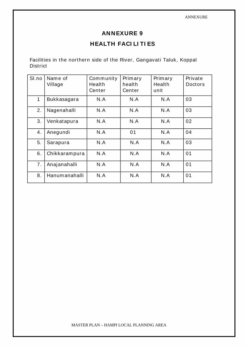
ANNEXURE
MASTER PLAN – HAMPI LOCAL PLANNING AREA
ANNEXURE 9
HEALTH FACILITIES
Facilities in the northern side of the River, Gangavati Taluk, Koppal District Sl.no Name of
Village Community Health Center
Primary health Center
Primary Health unit
Private Doctors
1 Bukkasagara N.A N.A N.A 03
2. Nagenahalli N.A N.A N.A 03
3. Venkatapura N.A N.A N.A 02
4. Anegundi N.A 01 N.A 04
5. Sarapura N.A N.A N.A 03
6. Chikkarampura N.A N.A N.A 01
7. Anajanahalli N.A N.A N.A 01
8. Hanumanahalli N.A N.A N.A 01
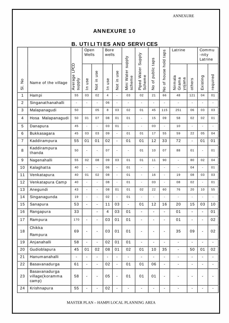
ANNEXURE
MASTER PLAN – HAMPI LOCAL PLANNING AREA
ANNEXURE 10
B. UTILITIES AND SERVICES Open Wells
Bore wells
Latrine Commu-nity Latrine
Sl. N
o
Name of the village
Ave
rage
LPCD
su
pply
In u
se
Not
in u
se
In u
se
Not
in u
se
Min
i W
ater
supply
sc
hem
e
Piped
Wat
er S
upply
Sch
eme
No o
f public
tap
s
No o
f house
hold
tap
s
Nirm
ala
Gra
ma
yoja
na
oth
ers
Exi
stin
g
required
1 Hampi 55 03 02 4 - 03 02 21 66 48 121 04 01
2 Singanathanahalli - - - 06 - - - - - - - - -
3 Malapanagudi 50 05 8 03 02 01 45 115 251 06 03 03
4 Hosa Malapanagudi 50 01 07 08 01 01 - 15 09 58 02 02 01
5 Danapura 45 - - 03 01 - - 03 - 10 - - -
6 Bukkasagara 45 03 03 09 - 01 01 17 55 59 22 05 04
7 Kaddirampura 55 01 01 02 - 01 01 12 33 72 - 01 01
8 Kaddirampura thanda
50 - - 07 - - 01 10 07 88 01 - 01
9 Nagenahalli 55 02 08 09 03 01 01 11 90 - 80 02 04
10 Kalaghatta 40 - - 06 - 01 - - - - 04 - 01
11 Venkatapura 40 01 02 08 - 01 - 16 - 19 08 03 03
12 Venkatapura Camp 40 - - 08 - 01 - 03 - 08 02 - 01
13 Anegundi 43 - - 08 01 01 02 22 60 76 20 10 55
14 Singanagunda 19 - - 02 - 01 - - - - - - -
15 Sanapura 53 - - 11 03 - 01 12 16 20 15 03 10
16 Rangapura 33 - 4 03 01 - - - 01 - - 01
17 Rampura 170 - - 03 01 01 - - - 01 - - 02
18 Chikka
Rampura 69 - - 03 01 01 - - - 35 09 - 02
19 Anjanahalli 58 - - 02 01 01 - - - - - - -
20 Gudioblapura 45 01 02 08 01 02 01 10 35 - 50 01 02
21 Hanumanahalli - - - - - - - - - - - - -
22 Basavanadurga 61 - - 02 - 01 01 06 - - - - -
23 Basavanadurga village(koramma camp)
58 - - 05 - 01 01 01 - - - - -
24 Krishnapura 55 - - 02 - - - - - - - - -

ANNEXURE
MASTER PLAN – HAMPI LOCAL PLANNING AREA
ANNEXURE 11
GROWTH OF POPULATION
Sl No Village 1971 1981 1991 2001 2011*
2021*
Hospet Taluka
1 Hampi 777 1247 1594 2134 2900 3800
2 Krishnapura 56 114 64 105
3 Singanathanhalli 55 43 29 23
4 Nimbapura 0 37 6 0
5 Kaddirampura 1109 1708 1234 1280 1600 1800
6 Danapura 121 289 258 227
7 Kondanayakanahalli 1238 1644 2216 2,216
8 Malapanagudi 3793 5356 6868 8255 10500 12500
9 Nagenahalli 1870 0 3236 3989
10 Gudi Obalapur 697 1145 1372 1600
11 Venkatapura 1131 1527 2059 2431 3000 3600
12 Kamalapura 13879 17474 20451 21311 24,000 27,000
13 Bukkasagara 2224 2936 3314 3912 4500 5500
14 Kalghatta 0 243 216 141
Total 26,950 33,763 42,917 48,124
Gangavati Taluka
1 Anegundi 3023 3258 3279 3497 3750 4000
2 Thirumalapur 67 109 240 273
3 Sanapur 759 1276 1394 1691
4 Virupapura gudda 60 105 285 261
5 Hanumanahalli 125 250 373 413
6 Anjanhalli 30 344 264 290

ANNEXURE
MASTER PLAN – HAMPI LOCAL PLANNING AREA
7 Chikkaramapura 11 245 323 563
8 Laxmipura 0 0 0 76
9 Ramapura 164 324 431 2041 3000 3600
10 Krishnapura 4 13 114 104
11 Ramadurga 18 20 95 660
12 Mallapura 224 447 513 2757 3500 4500
13 Basandurga 17 232 212 1012
14 Singandurga 9 120 13 21
15 Rangapura 28 45 126 374
Total 4539 6788 7662 14033
Grand Total 31,489 40,551 50,579 62,157
Note: * Projected Population

ANNEXURE
MASTER PLAN – HAMPI LOCAL PLANNING AREA
ANNEXURE 12
DETAILS OF WORKERS AND NON-WORKERS – 2001
LOCAL PLANNING AREA VILLAGES
Name of the village Total
workers Main
workers Marginal Workers
Non-workers
1. Hampi 920 885 35 1214 2. Krishnapura 57 57 0 48 3. Singanathanhalli 15 15 0 8 4. Nimbapura 5. Kadirampura 610 588 22 670 6. Danapura 144 144 0 83 7. Kondanyakanhalli 8. Mallapanagudi 4260 3239 1021 3995 9. Nagenahalli 1887 1869 18 2102 10.Gudioblapura 1012 998 14 588 11.Venkatapura 1310 1295 15 1121 12.Kamalapura (TP) 8901 8400 501 12929 13.Bukkasagara 1974 1862 112 1938 14.Kalghatta 81 81 0 60
Total 21,171 19,433 1738 24,756 15 Anegundi 1587 1143 444 1910 16.Tirmalapura 161 86 75 112 17.Sanapura 711 708 3 980 18.Virupapuragadda 132 26 106 129 19.Hanmanhalli 213 25 188 200 20.Anjanhalli 181 18 163 109 21.Chickrampura 293 132 161 270 22.Laxmipura 32 32 0 44 23.Rampura 1061 1058 3 980 24.Krishnapura 43 43 0 61 25.Ramdurga 338 338 0 322 26.Mallapura 1285 1146 139 1472 27.Basavandurga 567 450 117 445 28.Singangunda 7 7 0 14 29.Rangapura 209 204 5 165 Total 6820 5416 1404 7213 Grand Total 27991 24849 3142 31969

ANNEXURE
MASTER PLAN – HAMPI LOCAL PLANNING AREA
Annexure 13
Tourism Statistics
List of hotels
• Hotel Mayur Bhuvaneshwari : 32 Rooms
• Yatri Nivas : 6 Rooms & 2 Dormitories
• KSIDC – Hotel Mayur Vijayanagar : 21 Rooms
• KSTDC Approved Hotels - : 6 Hotels – 376 in Hospet
• 7 Hotels – Not approved by KSTDC : 629 Rooms
• Lodging Facilities at Hampi:
Total Guest House - 47
Total Licenses Cancelled - 9
Running Guest Houses 38
(Source: Department of Tourism, Hospet office)
Details of Tourist Traffic at Hampi Village
Volumes per Remarks
• Indian visitors on weekdays
• on auspicious and holidays
• Foreign visitors (mainly
800-1,000
1,000-1,500
100 per day
Source: Hampi Panchayat, Virupaksha temple ticket counter and police station
where foreign visitors register
GROWTH OF TOURIST POPULATION: year 2000
Month
Indian
tourists
Foreign
tourists
Total
%
Remarks
January 61,621 1,981 63,602 13.2
February 41,262 1,806 43,068 8.9
March 40,165 1,067 41,232 8.6
April 55,350 463 55,813 11.6
May 41,356 338 41,694 8.7
Consistent distribution of Indian and foreign
tourists over the year, with a culmination in
December-January, as part of the high season from October to May,

ANNEXURE
MASTER PLAN – HAMPI LOCAL PLANNING AREA
June 15,500 284 15,784 3.3
July 23,700 444 24,144 5.0
August 33,040 704 33,744 7.0
September 21,225 414 21,639 4.5
October 30,870 533 31,403 6.5
November 45,450 1,223 46,673 97
December 61,045 1,189 62,234 12.9
Totals 470,584 10,446 481,030 [99.9
with another peak in April (festival). The
lowest numbers in June coincide with the hottest
season.
Source: Hampi Panchayat, Virupaksha temple ticket counter and police station
where foreign visitors register
GROWTH OF TOURIST POPULATION 2000 TO 2005 YEAR POPULATION
2000 481030
2001 574622
2002 456946
2003 665564
2004 370258
2005 804893