Embed Size (px)
Citation preview
Curriculum Guide: The President’s Travels
Unit 9 of 19:
The Panama Canal
441 Freedom Parkway, Atlanta, GA, 30312 | 404-865-7100 | www.jimmycarterlibrary.gov

Geography Activities
World Map activity
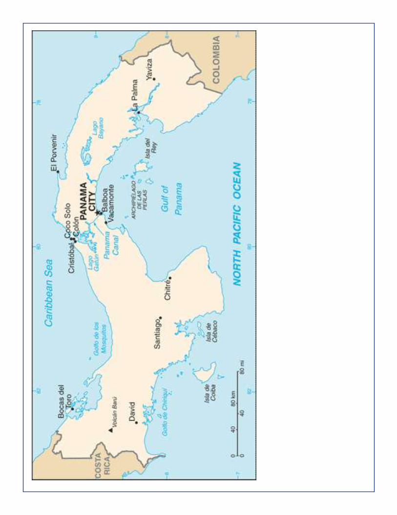
Students will create a hand-drawn map that identifies Latin American countries, physical features, and the Panama Canal. 1. Project a blank map of North and South America on a screen for students to see. 2. Provide students with unlined paper and have students sketch a map of North and South America using the sample map as a model. 3. Then using their map and an atlas, students will label the following places on their sketch map: Caribbean Sea, Gulf of Mexico, Pacific Ocean, Panama Canal, Cape Horn, the countries of Bolivia, Brazil, Colombia, Cuba, Costa Rica, Mexico, Panama, Venezuela, and the United States.
Jimmy Carter Library and Museum
Pictures from the CIA world fact book
Panama Canal

Scavenger Hunt Activity The Panama Canal (http://www.pancanal.com/index.html) website details both the history and current operations for this important transit waterway. Students will explore the website
and learn about the Canal.
Activity 1 1. Students will access the multimedia animation athttp://www.pancanal.com/eng/general/howitworks/index.ht
ml that describes the Transit, Operations, and Dimensions of the Canal. Student should view each animation and understand how the canal works especially noting the locks system and route.
2. Have students complete a scavenger hunt using the questionsbelow. All answers can be found on the Panama Canal website.
Scavenger Hunt
1. What were the major obstacles in constructing the waterway?
2. Who had the idea of building a canal the Isthmus of Panama?
3. What is the length of the waterway?
4. How long does it take for a complete transit?5. How many vessels have transited the Canal since its
inauguration?
6. Who was the first person to swim the Panama Canal in its
entirety?
7. How many vessels use the Canal every year?
8. What hours does the Canal operate?
9. Which vessel made the fastest transit through the Canal?
10. What region in the world is the majority of the vessels fromthe eastern United States through the Panama Canal going towards?
Georgia Performance Standards
SS6G1 The student will locate selected features of Latin America and the Caribbean.
a. Locate on a world and regionalpolitical-physical map: Amazon River, Caribbean Sea, Gulf of Mexico, Pacific Ocean, Panama Canal, Andes Mountains, Sierra Madre Mountains, and Atacama Desert.
b. Locate on a world and regionalpolitical-physical map the countries of Bolivia, Brazil, Colombia, Cuba, Haiti, Mexico, Panama, and Venezuela.
Grade Eight | SS8H12 (B.) B. Describe the role of Jimmy Carter in Georgia as state senator, governor, president, and past president.
SSWG7 The student will describe the interaction of physical and human systems that have shaped contemporary Latin America.
Answers to Scavenger Hunt 1. There were 4 major obstacles to the construction of a canal through Panama: A very complex mountain chain formation; The difficulties posed by the tropical jungle, with its annual average rainfall of 105 inches, and an average temperature of 80 degrees; The tendency of rivers to overflow; and The most mortal of all, malaria and yellow fever diseases, which were endemic in the area 2. The dream of building a canal through the Isthmus of Panama to join the Atlantic andthe Pacific dated back to the beginning of the sixteenth century, when Vasco Núñez de Balboa crossed Panama in 1515, and discovered that only a narrow strip of land separated both oceans. 3.The length of the Panama Canal is 80 kilometers (50 miles) from the deep waters of the Atlantic to the deep waters of the Pacific. 4. A ship takes an average of 8 to 10 hours to transit the Panama Canal.5.At the end of fiscal year 2006, 943,042 vessels had used the waterway since its opening on August 15, 1914. 6.Richard Halliburton swam the Panama Canal in 1928 and paid only 36 cents in tolls. 7.Some 13 to 14 thousand vessels use the Canal every year 8. It operates 24 hours a day, 365 days a year9. The fastest transit was made by the U.S. Navy hydrofoil Pegasus, which crossed the Canal from Miraflores to Gatun in 2 hours 41 minutes in June 1979. 10. Most of ships are going to the Far East.

Directions: Complete this worksheet about Panama using the map on page X.
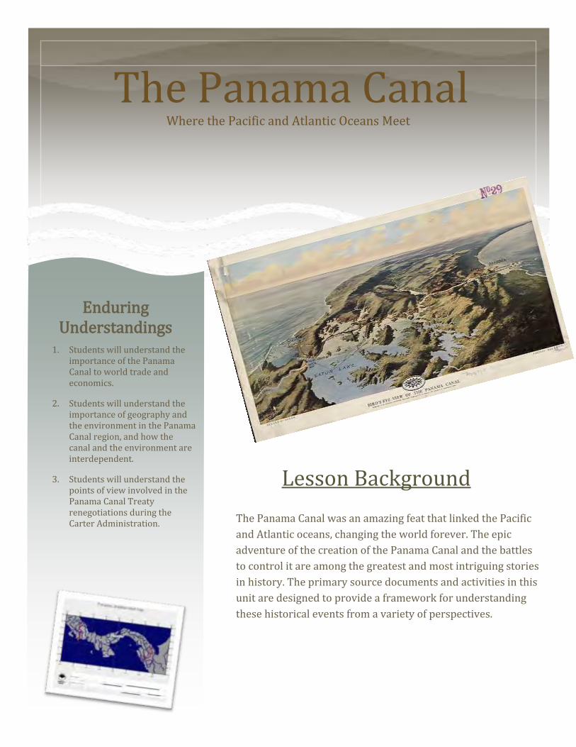
The Panama Canal Where the Pacific and Atlantic Oceans Meet
Lesson Background
The Panama Canal was an amazing feat that linked the Pacific
and Atlantic oceans, changing the world forever. The epic
adventure of the creation of the Panama Canal and the battles
to control it are among the greatest and most intriguing stories
in history. The primary source documents and activities in this
unit are designed to provide a framework for understanding
these historical events from a variety of perspectives.
Enduring Understandings
1. Students will understand the importance of the Panama Canal to world trade and economics.
2. Students will understand the importance of geography and the environment in the Panama Canal region, and how the canal and the environment are interdependent.
3. Students will understand the points of view involved in the Panama Canal Treaty renegotiations during the Carter Administration.

THE PANAMA CANAL MIDDLE SCHOOL LESSON
Choosing the Site: Nicaragua or Panama?
Did you know that the original canal was supposed to
be in Nicaragua? Geography played a major role in the
choice of Panama as the final canal site. In 1905 the
Nicaraguan volcano Momotumbo erupted 20 miles from
the proposed site. Promoters of the Panamanian site
mailed postage stamps from Nicaragua featuring the
volcano to interested parties to remind people of the
dangers of Nicaragua’s geography. The ploy worked.
Ironically, the volcano has not erupted since 1905, and
a new canal is currently being proposed in Nicaragua1.
The Panama Canal shares the watershed with people,
rivers, lakes and tributaries that the people and wildlife
of Panama rely on for their water needs. As the climate
changes, and water needs increase, tough decisions need
to be made about canal expansion and competing uses for
the water in the Panama Canal watershed. The expansion
project will employ water saving basins at each new lock.
For more information on the Panama Canal and the
watershed, read the articles found at the links below:
NPR: Shallow Water Ahead for Panama Canal
http://www.npr.org/templates/story/story.php?storyId=87851345 The Panama News: Questions raised en route to viable
watershed management:
http://www.thepanamanews.com/pn/v_08/issue_19/ne
ws_01.html
The Nature Conservancy:
http://www.parksinperil.org/wherewework/centralame
rica/panama/protectedarea/chagres.html
The Canal Watershed

THE PANAMA CANAL MIDDLE SCHOOL LESSON
In 1904, the U.S. Senate approved a treaty giving the
United States authority to build a canal across the
Isthmus of Panama and control a ten-mile wide canal
zone. Panamanians rioted in protest of U.S. control of
the canal in 1964 leading to a renegotiation of the
treaty. In 1977 President Jimmy Carter and
Panamanian leader Brigadier General Omar Torrijos
Herrera signed two treaties, the Permanent Neutrality
Treaty, and the Panama Canal Treaty. The neutrality
treaty stated that the canal would be neutral and
opened to vessels from all nations. The Panama Canal
Treaty stated that the U.S. and Panama would jointly
control the canal until December 31, 1999, at which
time Panama would take complete control of the
canal. Many people were upset when the Carter
Administration entered into negotiations to hand over
control of the Canal to Panama. Many people feared
that an unstable government would not be able to
manage an asset so important to world trade, and
U.S. access to the canal would be restricted or
denied. Furthermore, the transfer of the canal was
seen as diminishing U.S. power in the region. The
canal transferred to Panamanian control in 1999. To
this date fears about the transfer have not be
realized2.
Things Left Behind
The Treaties: From Manifest Destiny and American Imperialism, to Latin American Independence
When the U.S. left the Panama Canal Zone, a few things were left behind. Among these items were landmines, explosives, and hazardous materials from chemical weapons. These items pose a hazard to people and wildlife that come in contact with them. Due to the density of the rainforest in the region, it is not seen as feasible to search for and remove them. For more information on this issue visit: http://www.cotf.edu/earthinfo/camerica/panama/PCtopic5.html

THE PANAMA CANAL MIDDLE SCHOOL LESSON
Activities Time Line Create an interactive time line related to the history of the
Panama Canal from the building of the canal to the present,
noting important events.
Links for interactive timeline creation: http://www.classtools.net/samples/timeline http://timerime.com/en/timeline/611275/Charlie+Pearsalls+Panama+Canal+Time+line+from+1880+to+2000/
Plan a trip through the Panama Canal. Where would your trip
start? How many different modes of transportation would
you take? What ports of call and sites would you see? How
many time zones will you cross? Create an imaginary trip and
travel blog complete with trip timeline and pictures of sights
you would see with Travelpod.
Links:
http://travelpod.com
http://www.panamacanalcruise.com/cruise_port/Panama_
Canal_(Full_Transit).cfm
Make a model of the Panama Canal. Make a simple model
to demonstrate the hydraulics and buoyancy principles the
canal employs, or a complicated model like the ones in the
links below.
Links:
http://juniorengineering.usu.edu/lessons/swim/swiminstructio
n.php
http://www.youtube.com/watch?v=QITIv8ZRE-Q
Plan It
Map It
Build It
Use the map included in the resources section of this lesson
to map the route ships had to take from Europe, the East
Coast of the United States, or Africa to get to the West Coast
of the United States, the Hawaiian Islands, or Japan. Use one
color to show this route, and another color to trace the
route through the Panama Canal.

THE PANAMA CANAL MIDDLE SCHOOL LESSON
Activities (continued)
Watershed Stakeholders Complete the watershed stakeholder activity detailed at the end of this lesson. What is your interest in the use of the watershed? What are the competing uses? How can you share this important
limited resource with others who also depend on it?
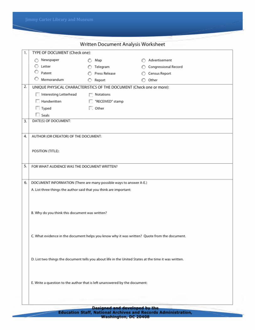
Analyze the documents in the Analyze It activity folder. Use the
document analysis sheets to examine these primary sources.
Analyze It
Stratovolcanoes Research stratovolcanoes like Momotumbo in Nicaragua. How many volcanoes are in Panama? Where are they located? What types of volcanoes are they?
http://www.volcano.si.edu/world/volcano.cfm?vnum=1404-09
View the Discovery Education videos on the Panama Canal, and geography of the region. Information on the videos is included at the end of this lesson. *See notes on how to access these videos in the references section of this lesson.
Discovery Education Videos

THE PANAMA CANAL MIDDLE SCHOOL LESSON
WATERSHED STAKEHOLDERS
PROCEDURE
1. Copy and cut out the stakeholder cards so that there are enough for each student (or
pair/group of students) to represent a different stakeholder .
2. Students (or groups of students) will use their stakeholder card to complete the rest of
the lesson activities.
SCENARIO
There is a proposal for new land development in the Panama Canal Zone. Some
cattle ranchers want the trees in the surrounding rainforest cut down to
provide grazing land for cattle. Environmental groups want to preserve the
trees to prevent erosion and sedimentation in the Canal Zone. Still others want
to build condos and hotels in the area to take advantage of the tourist trade and
beautiful views in the area. The development will also affect the amount of
water available for various uses in the Canal Zone. It seems like everyone has a
different idea of how the land and water in the area should be used. Use the
stakeholder card that you or your group picked to make an argument for how
the land and water should be used. Once you have formulated your persuasive
argument, present it to the class. Once everyone has presented their
arguments, students/groups should pick a competing use proposal to respond
to. Argue for your position, while explaining why the competing use should be
denied.
Lesson Questions 1. Why is the Panama Canal important?
2. What were some of the issues related to
control of the canal and Canal Zone?
3. What are the competing uses of the
Panama Canal watershed?
4. Why are the issues of soil erosion and
watershed management important for
the Panama Canal watershed?
THE PANAMA CANAL MIDDLE SCHOOL LESSON
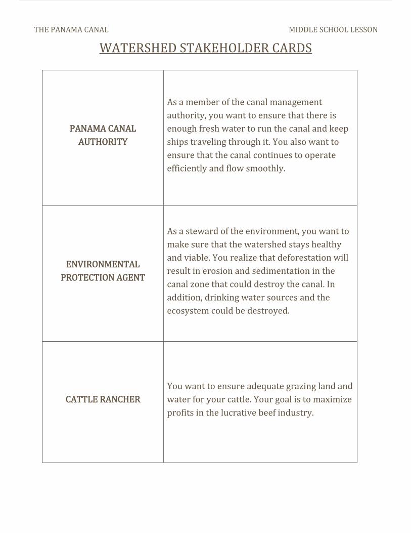
WATERSHED STAKEHOLDER CARDS
PANAMA CANAL
AUTHORITY
As a member of the canal management
authority, you want to ensure that there is
enough fresh water to run the canal and keep
ships traveling through it. You also want to
ensure that the canal continues to operate
efficiently and flow smoothly.
ENVIRONMENTAL
PROTECTION AGENT
As a steward of the environment, you want to
make sure that the watershed stays healthy
and viable. You realize that deforestation will
result in erosion and sedimentation in the
canal zone that could destroy the canal. In
addition, drinking water sources and the
ecosystem could be destroyed.
CATTLE RANCHER
You want to ensure adequate grazing land and
water for your cattle. Your goal is to maximize
profits in the lucrative beef industry.
THE PANAMA CANAL MIDDLE SCHOOL LESSON
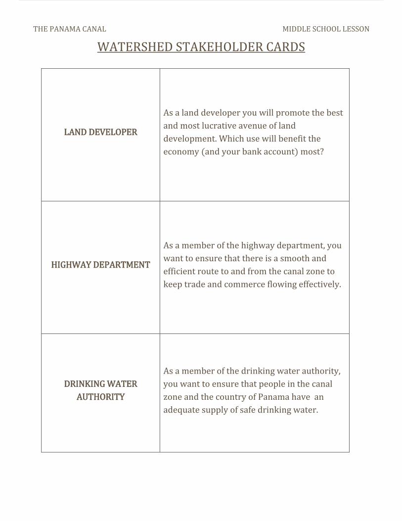
WATERSHED STAKEHOLDER CARDS
LAND DEVELOPER
As a land developer you will promote the best
and most lucrative avenue of land
development. Which use will benefit the
economy (and your bank account) most?
HIGHWAY DEPARTMENT
As a member of the highway department, you
want to ensure that there is a smooth and
efficient route to and from the canal zone to
keep trade and commerce flowing effectively.
DRINKING WATER
AUTHORITY
As a member of the drinking water authority,
you want to ensure that people in the canal
zone and the country of Panama have an
adequate supply of safe drinking water.

THE PANAMA CANAL MIDDLE SCHOOL LESSON
WATERSHED STAKEHOLDER CARDS
HYDROELECTRIC POWER
COMPANY
As an employee of the hydroelectric power
company you want to ensure that the canal
zone and the country of Panama has adequate
electricity to meet the needs of residents and
industry.
RAILROAD TYCOON
As a railroad tycoon, you want to ensure the
development and use of railroads in the canal
zone to transport people and goods.
REAL ESTATE AGENT You want to provide choice real estate options
to tourists and residents in the canal zone.

THE PANAMA CANAL MIDDLE SCHOOL LESSON
STANDARDS
6th Grade
S6E5. Students will investigate the scientific view of how the earth’s surface is formed. f. Explain the effects of physical processes (plate tectonics, erosion, deposition, volcanic eruption, gravity) on geological features including oceans (composition, currents, and tides). S6E3. Students will recognize the significant role of water in earth processes. a. Explain that a large portion of the Earth’s surface is water, consisting of oceans, rivers, lakes, underground water, and ice. b. Relate various atmospheric conditions to stages of the water cycle. c. Describe the composition, location, and subsurface topography of the world’s oceans. d. Explain the causes of waves, currents, and tides.
.
7th Grade
S7L4. Students will examine the dependence of Organisms on one another and their environments. c. Recognize that changes in environmental conditions can affect the survival of both individuals and entire species. e. Describe the characteristics of Earth’s major terrestrial biomes (i.e. tropical rain forest, savannah, temperate, desert, taiga, tundra, and mountain) and aquatic communities (i.e.freshwater, estuaries, and marine).
SS8H12 The student will explain the importance of significant social, economic, and political developments in Georgia since 1970. b. Describe the role of Jimmy Carter in Georgia as state senator, governor, president, and past president.
SS6G1 The student will locate selected features of Latin America and the Caribbean. a. Locate on a world and regional political-physical map: Amazon River, Caribbean Sea, Gulf of Mexico, Pacific Ocean, Panama Canal, Andes Mountains, Sierra Madre Mountains, and Atacama Desert. b. Locate on a world and regional political-physical map the countries of Bolivia, Brazil, Colombia, Cuba, Haiti, Mexico, Panama, and Venezuela
8th Grade

THE PANAMA CANAL MIDDLE SCHOOL LESSON
References
Discovery Education videos: The Discovery Education service is currently provided to Georgia teachers
and homeschoolers free of charge by Georgia Public Broadcasting. For more information on how to
access these resources visit the GPB site: http://www.gpb.org/education
Book: The Path Between the Seas by David McCullough
Panama Canal websites:
http://www.pancanal.com
http://www.archives.gov/exhibits/treasures_of_congress/text/page25_text.html
Tour the Canal http://www.pdf4me.net/pdf-data/panama-canal.php
http://www.cotf.edu/earthinfo/camerica/panama/PCtopic5.html
http://panamacanalmuseum.org/index.php/history/interesting_facts/
http://www.eclipse.co.uk/~sl5763/panama.htm
Watershed Issues: http://www.panama-guide.com/article.php/20051027201647939 http://www.thepanamanews.com/pn/v_08/issue_19/news_01.html http://www.npr.org/templates/story/story.php?storyId=87851345
Geographical Impact Maps:
http://people.hofstra.edu/geotrans/eng/ch2en/conc2en/suez.html

PHOTO CREDITS
Panama Canal map on page 1: Retrieved from"http://commons.wikimedia.org/wiki/File:Panama_Canal_Rough_Diagram.png" Categories: Geographic diagrams | Maps of the Panama Canal | 1900s diagrams | Gatun Lake | Chagres River Momotombo pictures: Retrieved from"http://en.wikipedia.org/wiki/Momotombo" Categories: Stratovolcanoes | Active volcanoes | Mountains of Nicaragua | Volcanoes of Nicaragua | Nicaragua geography stubs
Panama Canal expansion map:
Retrieved from "http://commons.wikimedia.org/wiki/File:Acpfigure1.jpg" Category: Maps of the Panama Canal This page was last modified on 4 June 2010, at 12:28. Text is available under the Creative Commons Attribution/Share-Alike License The copyright holder of this file allows anyone to use it for any purpose, provided that PanCanal.com (http://www.pancanal.com) is listed as the source
Canal watershed pictures:
Retrieved from "http://commons.wikimedia.org/wiki/File:Panama_Canal_approaching_Gaillard_Cut.jpg" Category: Panama Canal
Retrieved from "http://commons.wikimedia.org/wiki/File:Panama_canal_1912.jpg" Category: Panama Canal
Picture of soldiers:
Retrieved from "http://commons.wikimedia.org/wiki/File:Unpacking_explosives.jpg" Categories: United States Air Force in the Iraq War | Explosive ordnance disposal | October 2006 | C-4 explosive | Forward Operating Base Falcon Mr. and Mrs. Carter passing through the Panama Canal: courtesy of the Jimmy Carter
Presidential Library and Museum
THE PANAMA CANAL MIDDLE SCHOOL LESSON

The Panama Canal Making the world smaller
Whose canal is it, anyway? Though few Americans today are
concerned with the Panama Canal, its
ownership was one of the most contested
issues of Jimmy Carter’s presidency. In 1914,
the United States finished the canal, which had
been started by the French in 1881. Prior to its
completion, numerous political machinations
and engineering marvels were required.
President Theodore Roosevelt negotiated
for the United States to have access to the land
for the canal, but it would take a revolution on
the part of Panama to make this a reality. Once
Panama gained its independence from
Colombia, the new nation gave the United
States control of the Canal Zone.
Within forty years, ownership of the canal
was a political issue, and presidents from
Eisenhower onward worked to find a solution.
President Carter finally garnered enough
support, after a lengthy battle in Congress, for a
gradual transition of control. Panama regained
control of the Canal Zone at the end of 1999.
Sixth Grade GPS: SSG1a: Locate on a world and regional political-physical map: Panama Canal. SSG3: Explain the impact of location, climate, distribution of natural resources, and population distribution on Latin America and the Caribbean.
US History GPS: SSUSH14c: Explain U.S. involvement in Latin America, as reflected by the Roosevelt Corollary to the Monroe Doctrine and the creation of the Panama Canal.
Fifth Grade GPS: SS5H3c: Explain how William McKinley and Theodore Roosevelt expanded America’s role in the world; include . . . the building of the Panama Canal.

Begin by using a world
map to show that until the
canal was built, the fastest sea
route from New York to San
Francisco was around the tip
of South America – the
treacherous waters of Cape
Horn.
Briefly discuss why that
voyage was dangerous and
time-consuming, and let
students infer why many
countries had an interest in
finding a safer, shorter path
from Atlanta to Pacific.
To help students
understand the differences in
the two voyages, tell them that
they will engage in a short
simulation of the two trips,
and decide for themselves if
the canal is helpful.
Place students’ desks or
tables in two clumps, roughly
resembling North and South
America. Place chairs or other
“obstacles” at the end of South
America.
Give students large
(empty) boxes to carry, and
have half of the class move to
the “Atlantic” side of the room,
and the other half to the
“Pacific.” Then, they should try
to change “oceans,” while
carrying their boxes, by going
around South America.
Repeat the exercise after
creating a “canal” through the
middle of the desks. Which
method was preferable?
Debrief students, and have
them describe why the canal
would improve
transportation.
Activity #1: Why was there a need for the canal?
Students can create a flip
books showing the changes in
landscape and geographical
features that are visible as one
travels through the canal.
The trip can begin at
either ocean, and continue to
the other ocean. Students
should indicate changing
elevation as they move
through the canal. They
should also note the
geographical features at both
endpoints of the canal.
Activity #2: A Trip Through the Canal
Background:
Understanding the history of the Panama Canal can be tricky. The following websites provide reliable background information:
*A history of the canal from thePanama Canal Authority: http://www.pancanal.com/eng/history/history/index.html.
*Information from PBS onPresident Theodore Roosevelt’s role and legacy in building the canal: http://www.pbs.org/wgbh/amex/tr/panama.html.
*Background from theSmithsonian – this includes a great series of annotated primary source photographs ideal for using with students: http://www.sil.si.edu/Exhibitions/Make-the-Dirt-Fly/whybuild.html.
The photo above shows one of the locks used to move ships through the Panama Canal.

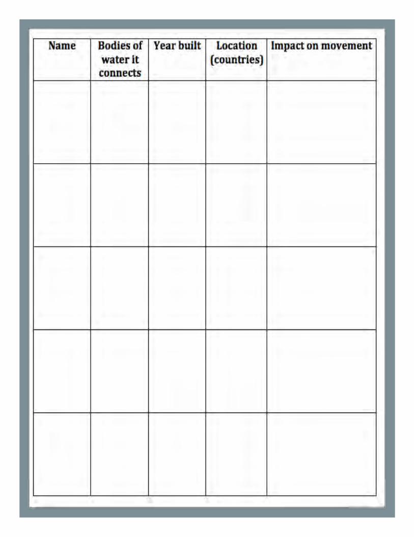
Canals Around the World Thousands of years of building connections.
Manmade canals have existed for
thousands of years. Canal builders in ancient
China were so successful that some of their
work is still in use today. In modern times,
canals have greatly facilitated international
commerce; they have created faster and safer
paths for sea traffic.
In this activity, students will identify canals
around the world, and determine how they
have improved economic productivity.
1) Students need access to research
materials or the Internet to complete
this activity. They will also need a
printable world map, and a copy of the
chart on the following page.
2) Students will identify canals that are
currently in use today. On the chart, they
should list the canal’s name, what bodies of
water it connects, the year it was built, the
country/countries in which it is located, and
how it makes movement easier.
3) Students should add each canal to the map
by drawing its approximate location and
labeling it.
4) Finally, students will discuss similarities and
differences between the different canals. The
following are possible questions:
a. What do most canal locations have in
common?
b. How do canals impact economic activity?
c. Are canals still being built today? Why or
why not?
Map of Panama from the CIA World Factbook

On the following pages are
several political cartoons from
different eras. Each cartoon
discusses the contemporary
issues regarding the Panama
Canal.
Students should first
evaluate each political cartoon
on its own. The NARA
worksheet following the
cartoons can help students do
this.
From there, students
should identify the issues
being discussed in each
cartoon. Are they the same, or
different? How do the issues
change across time? Would a
modern audience be able to
recognize what was being
satirized in the older
cartoons? Why or why not?
Then, students can
evaluate cartoons about
modern issues. (Possible
sources for modern cartoons
are listed in the box on the
left.)
Are they similar to, or
different from, the older
cartoons about the Panama
Canal? Do modern cartoons
require as much knowledge
about the event as the older
cartoons?
Finally, have students
analyze what issues are
discussed in political cartoons.
Is everything “fair game,” or
are certain issues off limits to
cartoonists?
Comparing Political Cartoons – Past and Present
Students can create a flip
books showing the changes in
landscape and geographical
features that are visible as one
travels through the canal.
The trip can begin at
either ocean, and continue to
the other ocean. Students
should indicate changing
elevation as they move
through the canal. They
should also note the
geographical features at both
endpoints of the canal.
Activity #2: A Trip Through the Canal
Finding Political Cartoons:
As always, make sure to preview any cartoons before using them with students. Not all material is appropriate for all classrooms.
*Cartoons from MikeLuckovich, cartoonist for the Atlanta Journal-Constitution: http://blogs.ajc.com/mike-luckovich/.
*Cartoons from the AmericanAssociation of Editorial Cartoonists (AAEC) – updated daily with cartoons from around the country: http://editorialcartoonists.com.
*Time Magazine highlightsthe best cartoons weekly: http://www.time.com/time/cartoonsoftheweek/.
The photo above shows one of the locks used to move ships through the Panama Canal.

From the New York Herald, 1904.


Helpful Links:
*Collection of Panama Canal documents from the Jimmy Carter PresidentialLibrary: http://www.jimmycarterlibrary.gov/documents/panama/listofdocs.phtml.
*Official website of the Panama Canal Authority:http://www.pancanal.com/eng/index.html.
*Make the Dirt Fly! An interactive website/online exhibition at theSmithsonian: http://www.sil.si.edu/Exhibitions/Make-the-Dirt-Fly/.
*Interactive Tour of the canal from PBS’s NewsHour:http://www.pbs.org/newshour/bb/latin_america/panamacanal/canal_sound1.html.

Jimmy Carter Library and Museum
The Panama Canal the debate about a new treaty
Activities
Analysis of Political
Cartoons
Examine two political cartoons to understand the Panama Canal treaty debate.
Analysis of Primary
documents
Strom Thurmond’s letter and advertisements
The role and work of the President: persuading Congress and Ronald Reagan
The Panama Canal Treaty required two sets of negotiations – with Panama and the U. S. Congress.
President Carter signed the new Panama Canal Treaty in September 1977 – negotiating with Panama proved to be the easy part. It took the president, his staff, state department officials, and many others seven more months of intense talks with senators to get the treaty ratified. Persuading the House of Representatives to pass supporting legislation required another 17 months.
Opponents to the Panama Canal Treaty savaged President Carter, claiming bad judgment and a lack of patriotism.
Early in 1977, public opinion polls suggested that 78% of Americans opposed a treaty that would allow Panama to control and operate the Canal. A broad program to educate the public about the terms of the treaty helped sway opinion in its favor. But many politicians and citizens opposed the treaty to the end. Twenty senators who supported the treaty lost their Senate seats as their next election.
Georgia Performance Standards on p. X
Analysis of Primary
documents

Jimmy Carter Library and Museum
Activity One: Analyzing Political Cartoons Using the political cartoons on page X and page X, have students
complete the Political Cartoon Analysis worksheet found on page X for
each cartoon. The first political cartoon illustrates the public
opposition toward President Carter and the Panama Canal Treaty. The
second cartoon shows Theodore Roosevelt helped to create the
Panama Canal. After completing each worksheet individually, have
students meet in pairs and share the information that they have
written for each cartoon. Then, have students discuss the similarities
and differences between the two cartoons. Use the questions below to
guide their discussion. They should write down their answers and
turn in the paper once the activity is completed.
Questions
1. How are the two cartoons similar?
2. How are the two presidents shown? Is it in a positive or negative
way?
3. How is the Panama Canal issue represented in each cartoon?
4. Why is the environment of each cartoon so different?
Georgia Performance Standards
SSCG12: The student will analyze the various roles played by the President of the United States; include Commander-In-Chief of the Armed Forces, chief executive, chief agenda setter, representative of the nation, chief of state, foreign policy leader, and party leader. SSCG20: The student will describe the tools used to carry out United States foreign policy (diplomacy; economic, military, and humanitarian aid; treaties; sanctions and military intervention).
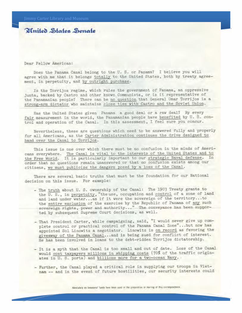
Activity Two: Analyzing political ads Using the two political advertisements on pages X and X form a group in opposition to the Panama Canal Treaty, complete the Document Analysis worksheet (page X) to help understand the points of view of those against the treaty. Then read the letter from Senator Strom Thurmond (page 10-11), which outlines his views against the Panama Canal treaty, and President Carter. You may also assign the Document Analysis worksheet to be completed on the Thurmond Letter.
Summarizer activity: Create a bubble map of five reasons why many Americans did not want President Carter to sign the treaty. This activity can be done by each student and then discussed with the entire class. See page X for the bubble map.
United States President Carter signs the Panama Canal Treaty with the leader of Panama, Omar Torrijos.

Jimmy Carter Library and Museum

Jimmy Carter Library and Museum

Jimmy Carter Library and Museum

Jimmy Carter Library and Museum
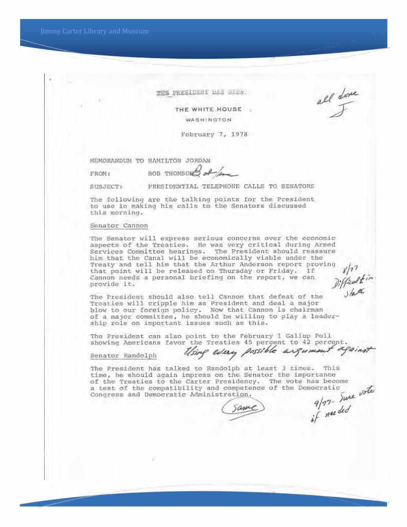
Activity Three: The roles of a President
During this activity, students will examine the roles of a
President from foreign policy to national politics. President
Carter had to negotiate with foreign leaders and with leaders in
the United States Congress.
1. Have students break up into groups and give each group one
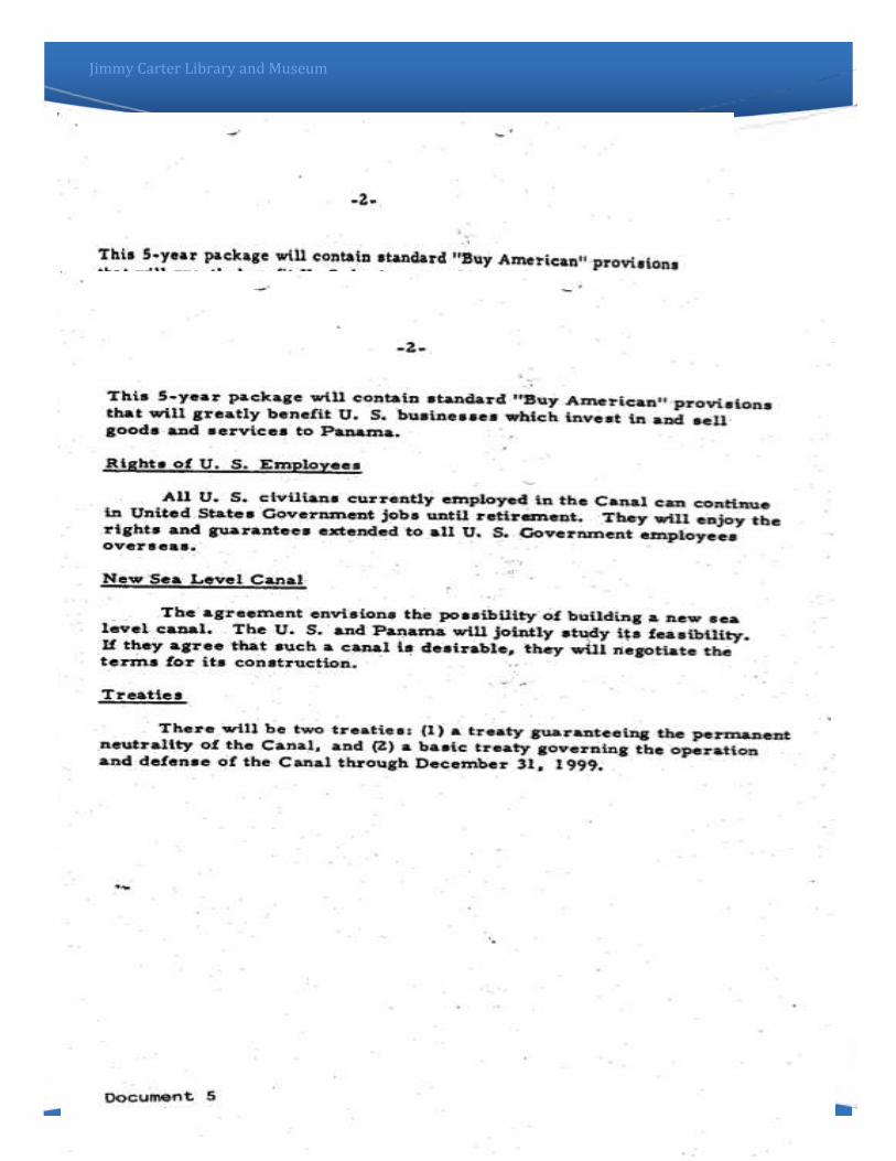
of the following documents:
A. Memo from Bob Thomson to Hamilton Jordan about
Presidential Telephone Calls to Senators (pages X-X)
B. Letter from Landon Butler to Governor Harriman about
statements of support of the Treaty (pages X-X)
C. President Carter letter to the US Congress (pages X-X)
D. Letter from Sol Linowitz to Cyrus Vance about meeting with
Ronald Reagan (pages X-X)
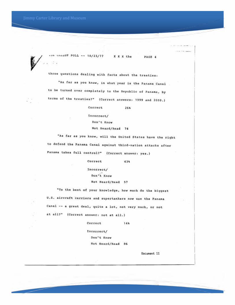
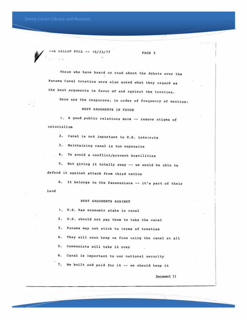
E. Gallup Poll concerning the Panama Canal (pages X-X)
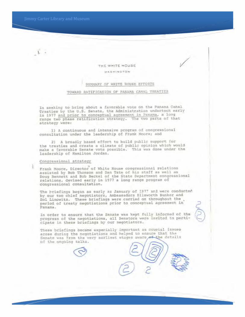
F. Summary of White House Efforts towards ratification of
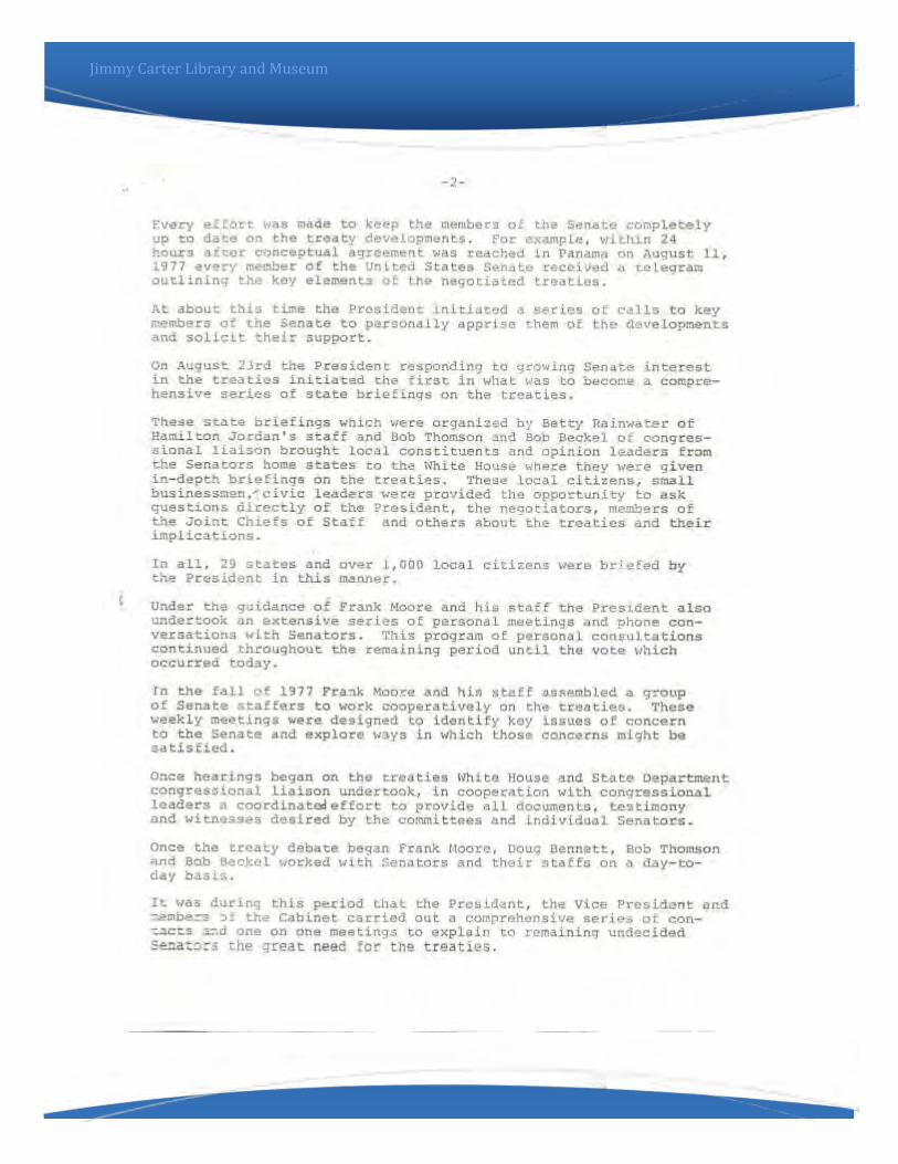
Panama Canal Treaties (pages X-X)
2. Each group will read their document and then complete the
Document Anaylsis Worksheet found on page X on this lesson.
3. Groups will then create a poster explaining the importance of
and content of their document. Students will explain to class
their findings.
4. Concluding Activity: Students will create a pros/cons list of
the Panama Canal treaties from the documents that the have
read. Then, they should choose a to argue using facts and
information gained from these activities.
5. Extending Activity: Hold a classrroom debate about the
Panama Canal treaties. Students can prepare position papers to
be read and students in opposition can read their papers in
response to one another.
There is an interactive timeline that explains the events surrounding the Panama Canal negotiations. Students should go to Exhibits and find the Panama Canal Treaties exhibit to find out more about the history of the Panama Canal.

Jimmy Carter Library and Museum

Jimmy Carter Library and Museum
Jimmy Carter Library and Museum
Jimmy Carter Library and Museum

Jimmy Carter Library and Museum

Jimmy Carter Library and Museum
Opposition to Treaty
2
3
4 5
1
Jimmy Carter Library and Museum

Jimmy Carter Library and Museum

Jimmy Carter Library and Museum

Jimmy Carter Library and Museum

Jimmy Carter Library and Museum

Jimmy Carter Library and Museum
Jimmy Carter Library and Museum

Jimmy Carter Library and Museum

Jimmy Carter Library and Museum

Jimmy Carter Library and Museum

Jimmy Carter Library and Museum

Jimmy Carter Library and Museum

Jimmy Carter Library and Museum

Jimmy Carter Library and Museum

Jimmy Carter Library and Museum
Jimmy Carter Library and Museum
Jimmy Carter Library and Museum

Jimmy Carter Library and Museum
Jimmy Carter Library and Museum
Jimmy Carter Library and Museum

Jimmy Carter Library and Museum

Jimmy Carter Library and Museum