Embed Size (px)
Citation preview
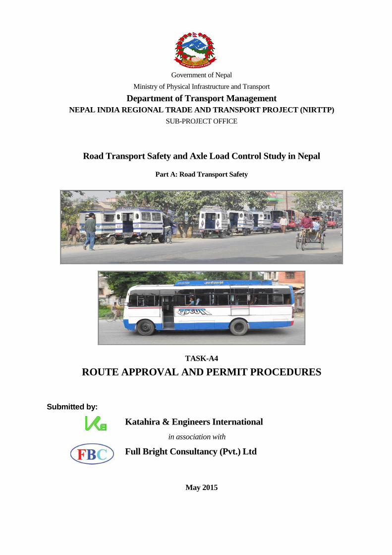
Government of Nepal
Ministry of Physical Infrastructure and Transport
Department of Transport Management
NEPAL INDIA REGIONAL TRADE AND TRANSPORT PROJECT (NIRTTP)
SUB-PROJECT OFFICE
Road Transport Safety and Axle Load Control Study in Nepal
Part A: Road Transport Safety
TASK-A4
ROUTE APPROVAL AND PERMIT PROCEDURES
Submitted by:
Katahira & Engineers International
in association with
Full Bright Consultancy (Pvt.) Ltd
May 2015

TASK A-4/Route Approval and Permit Procedures
KEI in association with FBC Road Transport safety and Axle Load Control Study in Nepal
i
TABLE OF CONTENTS
CHAPTER 1 RATIONALE FOR ROUTE SELECTION AND PERMIT PROCEDURE.................. 1-1
1.1 Rationale ....................................................................................... 1-1
1.2 Past Procedure for Issuing route permits in Nepal ..................................................................... 1-1
1.3 Recent improvements in issuing route permits in Nepal ........................................................... 1-2
CHAPTER 2 REVIEW OF INTERNATIONAL PRACTICE FOR ROUTE PERMIT ...................... 2-1
2.1 Route Permit Procedure in Neighbouring Countries ................................................................. 2-1
2.1.1 India ........................................................................................................................................... 2-1
2.1.2 Sri Lanka .................................................................................................................................... 2-2
2.1.3 Pakistan ...................................................................................................................................... 2-3
2.2 Route Permit Procedure in Other and Advanced Countries ...................................................... 2-5
2.2.1 Japan .......................................................................................................................................... 2-5
2.2.2 United Kingdom ........................................................................................................................ 2-7
CHAPTER 3 RECOMMENDED ROUTE ASSESSMENT, SELECTION ........................................... 3-1
3.1 Route Assessmentand selection ....................................................................................... 3-1
3.1.1 Existing Practice of Route Assessment and Selection in Nepal ................................................. 3-1
3.1.2 Recommended Procedure for Route Assessment and Selection ................................................ 3-2
3.1.3 Assessing route accessibility to motorized vehicles in general .................................................. 3-4
3.1.4 Assessing Route Accessibility based on Vehicle Dimensions, Operational Capability .......... 3-19
3.1.5 Route Inspection and Test Runs ............................................................................................... 3-23
3.1.6 Certifying the Route ................................................................................................................. 3-24
CHAPTER 4 ROUTE PERMITTING ....................................................................................................... 4-1
4.1 Current situation ....................................................................................... 4-1
4.2 rationalising the local, Short, Medium and Long Routes .......................................................... 4-3
4.3 Theoretical Models for permit monitoring, demand assessment ............................................... 4-9
4.3.1 Four Step Travel Forecasting ..................................................................................................... 4-9
4.3.2 Tamin‟s Trip Distribution Model –cum- Modal Choice from Passenger Counts .................... 4-12
4.3.3 Simple Steps to Calculate the Number of Buses Required, Route Allocation ......................... 4-13
4.3.4 Practical Aspects Affecting Route Allocation ......................................................................... 4-18
4.3.5 Bus Stop Planning, Integration with Cycle and Pedestrian Routes .......................................... 4-19
4.3.6 Promoting Public Passenger Transport Routes ........................................................................ 4-21
4.4 Applying and Assessing for Route Permits ............................................................................. 4-21
CHAPTER 5 ARRANGEMENTS OF ROUTES IN THE URBAN AREAS ......................................... 5-1
5.1 Re-assign Permits to Tally Vehicle Size According to the Route ............................................. 5-1
5.2 Update the Urban Routes ....................................................................................... 5-3
5.3 Develop Institutional Structure of Operation ............................................................................. 5-6
TASK A-4/Route Approval and Permit Procedures
KEI in association with FBC Road Transport safety and Axle Load Control Study in Nepal
ii
5.4 Scientific Means to Control Permits ....................................................................................... 5-6
5.4.1 Stagger Transport Services to Different Time ........................................................................... 5-6
5.4.2 Restraining against Capacity ...................................................................................................... 5-6
5.4.3 At Different Locations ............................................................................................................... 5-8
5.4.4 Combinations of Different Vehicles .......................................................................................... 5-8
5.5 Threshold Criteria Recommended for Public Passenger Transport Route ................................ 5-8
5.5.1 Data Collection .......................................................................................................................... 5-9
5.5.2 Demand Analysis ..................................................................................................................... 5-10
5.5.3 Estimating the Maximum Threshold for Permits ..................................................................... 5-11

TASK A-4/Route Approval and Permit Procedures
KEI in association with FBC Road Transport safety and Axle Load Control Study in Nepal
iii
LIST OF TABLES
Table 3-1 Carriageway, Shoulder and Roadway of Different Roads ....................................................... 3-6
Table 3-2 Minimum Radius, Carriageway Width of Horizontal Curves for Strategic Roads ................. 3-9
Table 3-3 Minimum Radius, Carriageway Width of Horizontal Curves for Rural Roads....................... 3-9
Table 3-4 Minimum Radius, Carriageway Width of Horizontal Curves for Urban Roads ................... 3-10
Table 3-5 Hairpin Bends Design Parameters ......................................................................................... 3-10
Table 3-6 Maximum Gradients Applicable in Various Road Networks ................................................ 3-12
Table 3-7 Pavement Evaluation based on IRI ........................................................................................ 3-13
Table 3-8 Characteristics of Pavement Damage Assessed during SDI Surveys .................................... 3-14
Table 3-9 Pavement Evaluation based on SDI ....................................................................................... 3-14
Table 3-10 Clearance, Design Loading Required .................................................................................. 3-18
Table 3-11 Capacity, Dimension of Various Vehicles Commonly Plying in Nepal ............................. 3-19
Table 3-12 Carriageway Width Required to Accommodate Turning .................................................... 3-21
Table 4-1 Route Permit Provisions in MVTMA 1993 and MVTMR 1997 ............................................ 4-1
Table 4-2 Description of the Type Category Recommended for Bus Sub-mode .................................... 4-6
Table 4-3 Tentative Extent of the Street Networks in Selected Cities of Nepal ...................................... 4-7
Table 4-4 Recommended Range, Type of Vehicle Applicable for Routes .............................................. 4-8
Table 4-5 Sample of Bus Ridership Observed in an In-vehicle Public Transport Survey ..................... 4-15
Table 4-6 Sample of Bus Trips Observed .............................................................................................. 4-16
Table 5-1 Design Capacities (in PCUs/day) of Different Types of Strategic Roads ............................... 5-7
Table 5-2 Design Capacities (both directions) of Different Road Types ................................................. 5-7
Table 5-3 Design Capacities of Different Types of Urban Roads ........................................................... 5-8

TASK A-4/Route Approval and Permit Procedures
KEI in association with FBC Road Transport safety and Axle Load Control Study in Nepal
iv
LIST OF FIGURES
Figure 2.1 Flowchart Showing Permit Procedure for City/ .................................................................... 2-7
Figure 3.1 Steps for Route Assessment ................................................................................................... 3-4
Figure 3.2 Minimum Turning Path for Trucks ........................................................................................ 3-8
Figure 3.3 Climbing Lanes Provided on a Two-lane Highway ............................................................. 3-11
Figure 3.4 Deep Undulation Created in Poorly Maintained Road in Nepal .......................................... 3-13
Figure3.5 Bridge Inventory Search, DOR ............................................................................................. 3-15
Figure 3.6 Typical Cross-section of a Two-lane RCC Bridge (Arch) ................................................... 3-16
Figure 3.7Typical Cross-section of a Single-lane Truss Bridge with Footpaths (30 m span) ................ 3-17
Figure 3.8 Typical Cross-section of a Single-lane Truss Bridge without Footpaths (30 m span) .......... 3-17
Figure 3.9 Typical Cross-section of a Pipe Culvert on Single-lane Road .............................................. 3-18
Figure 3.10 Standard Lateral and Vertical Clearances in Bridges ......................................................... 3-19
Figure 3.11 Sample Turning Template for Bus ..................................................................................... 3-22
Figure 4.1 Appropriate Vehicle Size for Public Passenger Transport...................................................... 4-4
Figure 4.2 Proposed Classification of Public Passenger Transport Vehicles ........................................... 4-6
Figure 4.3 Example of the Four Step Travel Forecasting Model Adopted in Japan .............................. 4-12
Figure 4.4 Example of Load Profile of a Colombo Bus Route, Sri Lanka ............................................ 4-15
Figure 4.5 Queue Jump Indented Bus Layby ......................................................................................... 4-20
Figure 4.6 Steps to Permit ...................................................................................................................... 4-23
Figure 5.1 Safa Tempo Figure 5.2 Basanti ...................................................................................... 5-1
Figure 5.3 An Example of Primary and Secondary Routes ..................................................................... 5-2
Figure 5.4 Establishing, Re-assigning Urban Routes ............................................................................... 5-4
Figure 5.5 Example of Different Route Hierarchies and Interchange between them .............................. 5-5
Figure 5.6 Sequence of Activities to Adopt for Establishing Threshold for Passenger Transport ........... 5-9

TASK A-4/Route Approval and Permit Procedures
KEI in association with FBC Road Transport safety and Axle Load Control Study in Nepal
v
ABBREVIATIONS AND ACRONYMS
AADT : Annual Average Daily Traffic
AC : Air condition
ADB : Asian Development Bank
CBD : Chief business district
CNG : Compressed natural gas
DoLIDAR : Department of Local Infrastructure Development and Agricultural Roads
DOR : Department of Roads
DOTM : Department of Transport Management
FBC : Full Bright Consultancy
FNNTE : Federation of Nepalese National Transport Entrepreneurs
FTTE : Federation of Truck Tanker Transport Enterpreneurs (Nepal)
GoN : Government of Nepal
IDA : International Development Association
IPT : Intermediate public transport (informal public transport)
IRI : International Roughness Index
JICA : Japan International Cooperation Agency
KCR : Karachi Circular Railway (Pakistan)
KEI
kph
:
:
Katahira & Engineers International
Kilometers per seconds
km : kilometer
LRN
m
mm
:
:
:
Local Road Network
meters
millimeter
MLIT : Ministry of Land, Infrastructure, Transportation and Tourism (Japan)
MLIT : Ministry of Land Infrastructure, Transportation and Toursim (Japan)
MoPIT : Ministry of Physical Infrastructure and Transport (Nepal)
MVTMA : Motor Vehicle and Transport Management Act
MVTMR : Motor Vehicle and Transport Management Rule
NIRTTP : Nepal India Regional Trade and Transport Project
NRS : Nepalese Rupees
NTRC : National Transport Research Centre (Pakistan)
ODA : Official Development Assistance
PPIAF : Public Private Infrastructure Advisory Facility (a multi-lateral collaboration
group)
PTV : Public Transport Victoria (Australia)
SMEDA : Small and Medium Enterprise Development Authority (Pakistan)
SRN : Strategic Road Network
STLB : Sri Lanka Transport Board
ToR
TSM 1997
:
:
Terms of Reference
Traffic Sign Manual 1997, DoR
UK : United Kingdom
UN : United Nations
US : United States
VOC
VKT
:
:
Vehicle Operating Cost
Vehicle Kilometer Travelled
WB : World Bank
WHO : World Health Organization

TASK A-4/Route Approval and Permit Procedures
KEI in association with FBC Road Transport safety and Axle Load Control Study in Nepal
E-i
EXECUTIVE SUMMARY
Route assessment involve a systematic process to evaluate a new or existing route before it is opened for
public transport service and require systematic and scientific assessment (desk study and site inspection).
Route permit follows the administration of public transport services after a route is selected and opened for
public transport service. If the permit procedure is unsystematic, the transport service can be inefficient and
therefore scientific procedure is necessary.
The purpose of this study is to review the existing provisions that prevails in route selection and permit
procedures for public passenger transport vehicles in the country and to recommend scientific procedure in
the whole permit administration with reference to (i) road geometry and pavement conditions; (ii) vehicle
dimensions and turning radius; (iii) arrangement of routes in urban areas based on the time of day, different
locations and combination of different vehicles and (iv) develop a threshold criteria to control public
transport route.
The methodology that was adopted for this study involved review of the existing legal provision stipulated in
the Motor Vehicle Transport Management Act 1992 (2049) and the Motor Vehicle Transport Management
Regulation 1997 (2054); desk research on available literature, state-of-the-arts practice, report and research
that has relevance to route permit administration drawn from both neighbouring as well as developed
countries; research on studies and application of academic theories of various aspects that can impact
management of public passenger transport vehicles and finally consultant‟s best knowledge into the subject
matter.
In addition, interaction with stakeholders (Department of Transport Management, Federation of Nepalese
National Transport Entrepreneurs, Transport Labour Association, Traffic Police, etc.) took place during the
tenure of this study to gauge their views, requirements and accordingly fine tune the recommendations
outlined in thus study.
Chapter 2 presents a literature review of the existing procedure in other countries that revealed that transport
services are regulated in a roughly similar manner with Nepal. Public transport vehicles are however de-
regulated in Japan and UK.
Chapter 3 reviews route assessment that is involved when selecting a new route before establishing the route
for public transport services. It reviews the existing practice for route assessment in Nepal and then outline a
recommended procedure to improve the process. This chapter formalise the formation of a DoTM Route
Selection Committee; outlines the road and vehicle design elements that should be reviewed through desk
study followed by actual test run before making an informed decision whether or not to certify and open the
new route for the public.
Chapter 4 discuss on route permit procedure that follows after route assessment for new routes. It reviews the
current practice in Nepal as per Motor Vehicle and Transport Management Act 1992 and Motor Vehicle and
Transport Management Regulation 1997 and the regulatory mechanism that Department of Transport
Management employs. This review clearly indicated that the Department lacks the enabling policy provisions
and scientific tools to monitor permit regulation compliance and the need for re-structuring of the routes.

TASK A-4/Route Approval and Permit Procedures
KEI in association with FBC Road Transport safety and Axle Load Control Study in Nepal
E-ii
Other aspects that also influence public passenger routes are also discussed. Finally, a procedure to assess
route permits including the formation of a Route Permit Committee, its membership structure and
modification in the permit certificate to better align public transport operators with the prescribed schedule are
recommended.
Chapter 5 discusses the issues pertaining to passenger transport routes in Nepalese cities that are of concern to
DoTM. Amongst these issues, impact of policy options such as re-assignment of the urban routes according to
the vehicle size, institutionally re-structuring passenger transport services and feasibility of different options to
improve permits is analysed. Amongst these options, re-assignment of routes to tally with the type of vehicle
size was assessed to be logical and necessary for application in Nepalese cities. Lastly a logical procedure to
establish a threshold criteria against which the Department of Transport Management could control route
permit is recommended.
Both the issues pertaining to route selection and route permit is presented and measures to assist the
Department of Transport Management is presented.
It is recommended that new route assessment is also given due importance with mandatory desk study as well
as site inspection before the route is opened for public transport.
Following route assessment, route permit should be issued after due process as per the regulations. Re-
structuring of the routes, institutional development within and adoption of some simple tools to improve
monitoring of permit is recommended.

TASK A-4/Route Approval and Permit Procedures
KEI in association with FBC Road Transport safety and Axle Load Control Study in Nepal
E-iii
d'Vo–;+If]k
;/sf/L kIfåf/f gofF jf k|of]udf /x]sf ;8sdf ;jf/L oftfoft ;+rfng ug{ lbg] :jLs[t hf/L ug{ k"j{ pQm
af6f]sf] a}1fflgs tj/af6 af6f] d"NofÍsg ug{ cfjZs /xG5 . af6f] Ohfht k|Kt ul/;s]kl5 dfq pQm ;8sdf
;fj{hlgs ;jf/Lx? ;+rfng ug{ kfOG5 . af6f] O{hfht lbg] sfo{ Jojl:yt gePdf oftfoft Joj:Yfdf c;/ kg]{]
x'Fbf Jojl:yt / a}1lgs ljlwsf] cfhZostf /xG5 .
o; cWoogsf] p2]Zo eg]sf] af6f] lgwf{/0f ubf{ / af6f] O{hfht k|bfg ubf{ ckgfOg] ljlwx?sf] k'g{jfnf]sg ug]{,
af6f] O{hfhtsf] Joj:yfkg j}1flgs lsl;dn] lgoGq0f ug{ s'g} clwstd kl/df0fnfO[ cfwf/ dfgL ug{ dfkb08
l;kmfl/z ug'{ /x]sf] 5 . ;fy} lgDgfg';f/ kIfx?nfO{ larf/ u/L af6f] O{hfht sf] ;Dk"0f{ k|zf;lgsf sfo{nfO{
a}1flgs tj/n] ug{ u/fpg klg cWoog u/L l;kmfl/z ug{' klg o; cWoogsf] pb]Zo /x]sf] 5 .
!= ;8ssf] HofldtLo cfsf/ / ;txsf] cj:yf
@= ;jf/L;fwgsf] ;fOh / ;8sdf /xg] 3'DtLsf] cfwf/df
#= zx/L If]qx?df af6f] O{hfht k|bfg j}1flgs tj/n] ug{] ;DaGwdf txfF ljleGg k|sf/ Pj+ cfsf/sf
;fj{hlgs ;jf/Lx?sf] ;ld>0fsf] cfwf/df cyjf k|To]s k|sf/ ;fj{hlgs ;jf/Lx?nfO{ lbgsf] cnucnu
;dodf ;+rfng ug{} pkfox? pk/ ;efJotf cWoog ug]{ .
o; cWoogsf nfuL xfndf laWodfg /x]sf] ;jf/L tyf oftfoft Joj:yf P]g, @)$(, ;jf/L tyf oftfoft
Joj:yf lgodfjnL @)%$ df pNn]lvt sfg"gL k|fjwfgx?sf] Joj:yfx?sf] cWoogÙ, ljleGg ;fwf/0f, cg';Gwfg
Pj+ pRr txsf k|rngljwLx?Ù l5dsL Pj+ ljsl;t d"n'sx?df ;fa{hlgs oftfoftx?sf] af6f] O{hfht jf
Joj:yfg ug}{ ;jfndf xfn ckgfOPsf k|rngx?sf] k'g{jfnf]sgÙ ;DalGwt ljifox?df k|fl1s cfwf/x? Pj+
ljz]if1sf] cg'ej Pa+ dfGotf, cfbL, sf] cfwf/df th{'df ul/Psf] lyof] . ;fy} cWoogsf] l;nl;nfdf ljleGg
;/f]sf/jfnfx? -oftfoft Joj:yf ljefu, 6«flkms k|x/L, g]kfn /fli6«o oftfoft Joj;foL dxf;+3, oftfot dhb'/
;+3, cfbL_ ;+u klg cfjZos 5nkmn u/L, lghx?sf] ;Nnfx;'emfjx?sf] cfwf/df klg l;kmfl/zx?nfO{ ;+zf]wg
ul/Psf] 5 .
cWofo @ df ;fj{hlgs ;jf/L Joj:yfkgsf] af/]df cGo b]zdf ul/g] k|rlnt ljlwx? k'g{jfnf]sg ul/Psf] 5
h;af6. l5d]sL b]zx?df s]xL leGgtf afx]s nueu g]kfndf ljBdfg Joj:yf cg'?k g} lgoGq0f ul/g] b]lvof] .
hfkfg / ;+o'Qm clw/fHo df eg] ;fj{hlgs oftfoft ;]jfx?nfO{ k"0f{ :jtGq ?kn] Go"gtd lgoGq0f ul/b} cfPsf]
b]lvof] .
cWofo # df xfn} lgdf{0f ;DkGg ePsf ;8sdf ;j{;fwf/0fx?sf nfuL ;fj{hlgs oftfoft ;+rfng ug{ af6f]
vf]nfpg' cufa} ul/g kg]{ af6f]] d'NofÍgsf] Pj+ lgwf{/0f ul/g xfn ckgfOg] ljlwnfO{ k'g{jfnf]sg ul/Psf] 5 . o;
k'gjf{nf]sgsf] cfwf/df af6f] d"NofËsg nfO{ cem+ Jojl:yt Pj+ j}1flgs tj/n] ug]{ k|s[of l;kmfl/z ul/Psf] 5 .
o; ;DaGwdf oftfoft Joj:yf ljefun] cgf}krfl/s ?kdf ckgfOb} cfPsf] af6f] lgwff{/0f ;ldltsf]] Joj:yfnfO{
cf}krfl/s agfOPsf], af6f] d"NofËsg ubf{ ;8ssf] l8hfOgsf kIfsf] k'g{jfnf]sg Pj+ ;8ssf] :ynut lgl/If0f
b'a} u/L ltgaf6 k|fKt cfwf/df dfq ;fj{hlgs oftfoft ;]jf To; ;8sdf ;+rfng ug{ pko'Qm x'g]gx'g] cfsng
u/L ckgfOg] Pp6f pko'Qm af6f] lgwf{/0f k2tL ;dfj]z ul/Psf] 5 .
cWofo $ df gofF ;8sx?df af6f] k/LIf0f kZrft v'nf x'g] af6f] Ohfht ;DaGwL ljlwsf] af/]df pNn]v ul/Psf]
5 . o; cGt{ut ;jf/L tyf oftfoft Joj:yf P]g @)$( / ;jf/L tyf oftfoft Joj:yf lgodfjnL @)%$ df
pNn]v ul/Psf] ljlwx? Pj+ oftfoft Joj:yf ljefun] af6f] O{hfht k|bfg ubf{ xfn ckgfpb}{ cfPsf] ljwL

TASK A-4/Route Approval and Permit Procedures
KEI in association with FBC Road Transport safety and Axle Load Control Study in Nepal
E-iv
;d]tnfO{ k'g[jfnf]sg ul/Psf] 5 . of] k'gjfnf]sgsf] cfwf/df ljefu ;+u af6f] Ohfht sf] k|s[ofnfO{ k|efjsf/L
lglt Pj+ a}1flgs ljwLx? sld /x]sf] dxz'; ul/Psf] / af6f] -?6_ x?sf] kg{:yfkg ug{ kg]{ k|i6 b]lvPsf] 5 .
ctM af6f] Ohfht k|bfg ubf{ ckgfpg kg{] Jojl:yt ljlw, To;sf nfuL cfjZos sfjf{xL a9fpg u7g ul/g kg{}
af6f] O{hfht ;ldtL, tLgsf] ;b:otfsf] :j?k s:tf] x"g kg]{ / oftfoft Joj;foLx?nfO{ cfÎgf] ;]jf O{hfhtdf
lgb]{lzt ;dotflnsf -;do zf/0fL_ ;+u cfa2 ug{u/fpg ;'wfl/t k|s[of l;kmfl/z ul/Psf] 5 .
cWofo % df ofq'afxs ;fj{hlgs ;jf/Lsf] Joj:yfkg ;DaGwdf ljefun] cf}nfPsf] gLltug kIfx? h:t}
;fj{hlgs ofq'jfxs ;jf/L] af6f] -?6_ x?sf] k'g{;+/rgf, ljleGg ?6x?nfO{ pko'Qm ;fj{hlgs ;jf/Lsf] cfsf/
cg'?k k'g{:yfkgf ug{] pkfo af/] j0f{g ul/Psf] 5 . ;fy} af6f] Ohfht k2QLnfO{ ;'wf/ ug{ ljleGg pkfox?sf]
klg ;+efJotf cWoog o; cWofodf ul/Psf] 5 . oL pkfox? dWo] ;fj{hlgs ofq'jfxs ;fjf/Lx?nfO{ zx/L
?6x?df ;jf/Lsf] cfsf/ cg'?k ljt/0f ug]{ cjwf/0ff g]kfnsf]\ zx/x?df nfu' ug{ ;a}eGbf pko'Qm b]lvG5 .
cGtdf af6f] OhfhtnfO{ Jojl:yt tj/n] cg'udg ug{ O{hfhtnfO{ s'g} Ps clwstd dfkb08;+u bfhL ug{
l;kmfl/; ul/Psf] 5 .
o; cWoog k|ltj]bgdf oftfoft Joj:yf ljefunfO{ af6f] lgwf{/0f / af6f] Ohfht ;DaGwL kIfx?df cjnDag
ug{ kg{{ af/] a0f{g ul/Psf] 5 . gofF ;8sdf ;fj{hlgs oftfoft ;+rfng ug'{ k"j{ Tof] ;8sx?df af6f]
d"'NofÍsgsf nfuL To;sf] l8hfOgsf] lj:t[t cWoog Pj+ ;f] kZrft ;8ssf] :ynut lgl/If0f u/] kZrft dfq
af6f} lgwf{/0f ug{ kg{] b]lvG5 . af6f] lgwf{/0f eP kZrft dfq af6f} Ohfht lbg'kg}{ l;kmfl/z ul/Psf] 5 . ?6x?sf]
k'g{;+/rgf, ljefusf] ;+:yfut ljsf; / af6f] O{hfhtsf] cg'udgsf] ;'wf/ ug{ s]xL ;dfGo k2QLx? klg o;
k|ltj]bgdf l;kmfl/z ul/Psf] 5 .

TASK A-4/Route Approval and Permit Procedures
KEI in association with FBC Road Transport safety and Axle Load Control Study in Nepal
1-1
CHAPTER 1 RATIONALE FOR ROUTE SELECTION AND PERMIT
PROCEDURE
1.1 RATIONALE
A route selection opens a network of road or path for operation of public transport services. A
route permit in turn regulates the public transport services along the route concerned taking into
consideration the demand-supply conditions and other consideration.
If the process of route selection involve careful network planning, assessment of road environment,
it scientifically establishes that the route in question is accessible for motorized vehicles and
identifies the types of vehicles that can access it in an efficient and safe manner. Ideally, a new
route is first assessed in terms of the following factors before it is opened for the public use:
i. Whether the route is accessible for motorized vehicles
ii. The degree of accessibility possible in the route in question
a. Over the year (dry weather, all season)
b. Whether the route is accessible for all vehicles or specific vehicles only owing to
geometric condition, terrain, seasonal changes or land-use (urban, rural, school/
pedestrianized zones, market centres, CBD, etc.)
Based on the route assessment above, the route is opened to the public and permits are issued for
public transport services. If the route permit is also scientifically issued, it will efficiently regulate
public transport services along the route in question to run safely and efficiently including
compliance with the following requirements.
i. Ensures the required demand-supply balance of transport services.
ii. Monitors to ensure the quality of service desired
Ensure that the appropriate types of public transport vehicles access the route
Adherence to the operating restrictions that apply (e.g. operations during day time only; prohibition
during weekend or weekly roadside markets, etc.);
Driving behaviour and operational codes to adhere to.
If the route permit procedure is unsystematic, the transport services in turn can be inefficient,
unsafe and poor and therefore, a scientific route selection and permit procedure is necessary
1.2 PAST PROCEDURE FOR ISSUING ROUTE PERMITS IN NEPAL
As per the Vehicle Transport and Management Act 2049 (1993) or VTMA, the Department of
Transport Management (DoTM) has been identifying and publishing routes for public transport all
over Nepal for public information. DoTM issued route permits, valid for four months at a time, to

TASK A-4/Route Approval and Permit Procedures
KEI in association with FBC Road Transport safety and Axle Load Control Study in Nepal
1-2
applicants who wanted to operate transport service in any of these published routes when the
following provisions is satisfied.
i. Insurance for driver, vehicle crew
ii. Insurance for passengers‟ luggage
iii. Third party insurance
iv. Renewed vehicle fitness certification
v. Renewed vehicle registration certification
Compliance with the stipulated vehicle standard for medium to long distance services, where
applicable.
Confirmation that there will be no adverse impact to the demand- supply balance of the transport
services as well as pollution from vehicle emission.
If during the course of application review, adverse impact to the demand-supply situation and
emission pollution is perceived if the permit was granted, it can reject the application after due
consultation with the Transport Management Committee (TMC)1. The permits were renewed for
another four month interval upon receipt of such application within one month after the expiry of
the existing permit if all the requirements stipulated above were still maintained and met. A
transport operator could also apply for another route permit to replace its existing permit if the
operator want to operate its services along a different route. In addition, a transport operator could
acquire multiple route permit if DoTM determined that such action would not adversely impact the
transport services along the existing routes
MVTM-A 1993 also allowed short term route permits (not exceeding seven days) to public
transport operators that wanted to temporarily use a route different from its approved route.
A record of all the permits issued was maintained at the concerned ZTMO as provisioned in
VTMA 2049 and its regulation, VTMR 2054 (1997)2.
1.3 RECENT IMPROVEMENTS IN ISSUING ROUTE PERMITS IN NEPAL
The current practice in route permit for public transport vehicles including database management
still follow the same procedure as outlined in the previous section. However, DoTM has recently
taken a few policy decision as follows to improve route permits regulation in the country.
i. It has stopped issuing route permits for new transport operator within Kathmandu Valley in
light of the increasing traffic congestion.
ii. It has cancelled route permits of public vehicles involved in crashes
1 The TMC is a body formed in each of the district where the Zonal Transport Management Office (ZTMO) is located.
It comprises of the Chief District Officer (as the chairman); ZTMO Chief (as the member secretary); District Police
Chief and representative from the transport entrepreneurs and transport labourers as members.
2 VTMR 2054 = Vehicle Transport and Management Regulation, GoN.

TASK A-4/Route Approval and Permit Procedures
KEI in association with FBC Road Transport safety and Axle Load Control Study in Nepal
2-1
CHAPTER 2 REVIEW OF INTERNATIONAL PRACTICE FOR ROUTE
PERMIT
2.1 ROUTE PERMIT PROCEDURE IN NEIGHBOURING COUNTRIES
2.1.1 India
In India, public transport services are regulated by segregating the various services into contract
carriage, stage carriage and goods carriage as stipulated in India‟s Central Motor Vehicle Act 1988
including its 2001 amendment and applying different conditions for operating each of these category
of services. These three carriages are defined as follows.
i. “Contract carriage” comprise public vehicles carrying up to 12 passengers between two points
without any fixed schedule or stops permitted in between the two points.
ii. “Stage carriage” are public vehicles carrying more than six passengers excluding the driver
with stops between the routes permitted.
iii. “Good carriage” are public vehicles that transport goods through any routes.
There is no further distinction employed to differentiate the different types of public passenger
transport vehicles whose size and seating capacities can be diverse (e.g. bus, minibus or microbus)
beyond these three categories and particular regulation specific to each category is applied for the
public vehicles according to the service they provide (e.g. taxis fall under contract carriage, intra/inter
-regional bus service will fall into stage carriage). There is full freedom to operate any passenger
vehicle (e.g. bus, minibus, microbus, etc.) in any local, medium or long distance route as long as the
vehicle in question meets the minimum seat capacity prescribed and any stage permit can also be
converted into a contract carriage permit.
There is no entry or exit barriers for public transport vehicles to operate in India but the Central
Government can direct a State/Regional Transport Authority to limit the number of stage or contract
carriage permits for an area with a population 500,000 or more within a certain limit if the Central
Government has concerns on the traffic levels, road conditions or other matters.
Regardless of the Central Government directive, the Regional Transport Authority is also free to
specify the minimum and maximum number of daily trips that a stage carriage has to provide.
Similarly, it can fix the maximum number of passengers and luggage weight that a contract carriage
vehicle can carry generally, at specific occasions, specific times or seasons. During application for a
stage permit, the applicant (transport operator) must specify the minimum, maximum number of daily
trips; schedule of normal trips proposed and vehicle type and seating capacity to use in addition to the
route or routes sought. There are numerous check and balance to ensure that a stage carriage vehicle
is operating optimally with other requirement it must abide to such as (i) maintaining time schedule
with occasional deviation lying within the prescribed range; (ii) maintaining the prescribed number of
stops and (iii) not picking-up and dropping off passengers at undesignated stops.

TASK A-4/Route Approval and Permit Procedures
KEI in association with FBC Road Transport safety and Axle Load Control Study in Nepal
2-2
While State Government formulates routes for stage carriage, Regional Transport Authorities can
limit contract or stage permits within a certain threshold or mandate a stage carriage operator to be
bound within a minimum and maximum number of trips daily, there is no details available about how
these limits are set nor of the procedure guiding route rationalization in India. The frequency of
services by each stage carriage vehicle will automatically be according to the daily trips that is
prescribed if operators strictly comply with it. Operators can increase their service frequency without
increasing their fleet size provided the distance covered by variation or extension does not exceed 24
km but the rationale behind this limit is not clear. Therefore, public passenger transport services in
India is regulated through a set of rules that the operator must comply but beyond these conditions,
permits are still issued arbitrarily to a large extent in India. . Within these bounds, there are other
provisions as follows that positively regulates public transport in India if they are enforced.
i. The Regional Transport Authority can also stipulate the (a) vehicle type, body specification to
comply; (b) issue of tickets with the fares clearly indicated and their record; (c) reserve the
right to change the conditions of the permit and (d) require the permit holder to provide all
statistics, other data in relation to their services.
ii. Good carriage permit can use their tractor truck to rent and draw any trailer, semi-trailer
subject to the operating conditions that may be prescribed.
iii. Comply with the speed limit applicable, fares (passengers, freights), gross vehicle weight-limit
and driving hours prescribed.
iv. Compliance with liability in case of crash, third party insurance and claim tribunals.
v. Compliance with the requirement to paint or affix the name, address of the operator outside of
the vehicle.
There is still the perception that there is more emphasis on revenue collection from public
transportation services than in upgrading the services.
2.1.2 Sri Lanka
Sri Lanka followed the mixed competition model for regulating public passenger transport since 1979
with both the Sri Lanka Transport Board (STLB) and private operators competing for service. During
1979 -1983, it fully deregulated public transport to allow full entry to the private sector. However,
this measure resulted in numerous private bus operators holding single or few fleet (few operators are
in the form of a company running fixed routes) resulting in deteriorating quality of service.
Sri Lanka instituted a dedicated National Transport Commission to regulate the private bus transport
as per its National Transport Commission Act, 1991. While this act has effective regulatory
provisions for permits, the Commission is mostly confined to administer the permits but has been
unable to fulfill its other wide-ranging responsibilities as a regulator and lack mechanism, data to
assess passenger demand, fare levels, routing, scheduling, etc.

TASK A-4/Route Approval and Permit Procedures
KEI in association with FBC Road Transport safety and Axle Load Control Study in Nepal
2-3
In Sri Lanka, private bus operators need route permits with relatively few government regulation
except for stringent requirement on safety, insurance and vehicle inspection. The private operators are
free to fix their own schedule and fare (subject to a maximum limit stipulated by the government).
Despite this opportunity, private operators have very limited knowledge of their actual daily
operations, cost/revenue and their services are not integrated with other modes (e.g. railways, other
services).
The Government provides grants to SLTB for new bus purchases, cover salary shortfalls and subsidy
to uneconomic rural routes. Since the NTC has not institutionally developed, the provincial regulators
have also not developed resulting in bus services that are either over/under priced or supplied.
With the World Bank‟s assistance, NTC has launched an ITS3 pilot project on inter-provincial bus
services, involving about 70 buses. The core application is automatic provision of location data to the
NTC Control Centre using GPS and GPRS units. Subject to the successful implementation of this
pilot project, NTC intends to make ITS installation mandatory as part of the permit conditions and to
use these devices to monitor route and service quality compliance.
2.1.3 Pakistan
Pakistan 4 also segregates different types of public vehicles according to the service they provide i.e.
(i) contract carriage, (ii) stage carriage and (iii) public carrier instead of applying particular regulation
to cater to diverse size of public vehicles of various types. Contract carriage rules applies to public
vehicles carrying up to ten passengers excluding the driver that are hired for any door-to-door
transport with restriction to pick/drop passengers enroute (e.g. taxis). Stage carriage regulation
includes any public vehicles with carrying capacities more than six passengers excluding the driver
and can pick or drop passengers along the route. A public carrier permit applies to freight transport
and any stage carriage permit can also operate as a contract carriage subject to additional
requirements.
The private sector predominantly operate public bus services in Pakistan but the government owned
Road Transport Corporation also exists. The Department of Transport is responsible for coordinating,
planning and monitoring the sector and the Regional or Provincial Transport Authority is authorized
to reform the permit administration as necessary. However, the Department of Transport is
institutionally weak in effectively guiding, coordinating nationally, managing, planning, securing
investment and providing technical input to the public transport sector in Pakistan. Close and
effective coordination horizontally and collaboration with the other agency that is responsible for
road development and land-use do not exist.
3 ITS = intelligent transport system
4 With reference to the Provincial Motor Vehicles Ordinance, 1978 (amended)

TASK A-4/Route Approval and Permit Procedures
KEI in association with FBC Road Transport safety and Axle Load Control Study in Nepal
2-4
The private sector led transport operators are free to fix their own schedules and decide their
operation but over the years the private operators have become disorganized with too many single
operators (none in the form of a company). Even though franchised bus routes5 operated in the past,
they could not sustain for long as (i) the services could not keep pace with the city size; (ii) the quality
of service did not improve despite the increase in the frequency of service; (iii) there was no
investment from the private sector and (iv) government‟s weak institutional capacity to resolve
conflicts that emerged from this initiative and (iv) low priority from the government in terms of
investment towards public transport sector compared to that was accorded to road infrastructure.
Though the Regional or Provincial Transport Authority can decide whether to grant or deny a permit
application based on the number of permits the applicant already holds, the limit on the number of
permits permissible for the area or revise the maximum limit to the number of permits for an area,
there are no mechanisms to guide the means to do these analysis.
Despite the past shortcoming, Regional or Provincial Transport Authority can adopt the following
intervention in order to reform the permit administration within their jurisdiction area.
i. It can prohibit or restrict permits throughout a province or any area in order to mitigate further
road deterioration along the route or prevent uneconomic competition amongst operators.
ii. It can fix the minimum or maximum passenger fares or freight charges to apply.
iii. It can also cancel permits generally or in specific area in order to enable the government‟s
Road Transport Corporation to operate transport services and also has unlimited powers to
cancel permits.
iv. Public transport vehicles registered in one province can ply in another province through
general or special resolution/order thus facilitating administrative task and allowing
reassignment of such vehicles to another area where transport service is deficient provided that
these activities are effectively monitored and recorded. If these reassignments are not properly
documented, this practice can instead lead to over-supply over a route.
v. Mandate operators (stage, contract carriage) to maintain and submit data on financial,
statistical returns and produce the same on demand to the inspecting officer deputed from the
authority;
vi. Contract carriage application for non-urban routes require to submit a bank guarantee and the
financial security fee to cover for any compensation towards passenger fatality or injury in a
road crash.
vii. Can (a) specify conditions when freights are allowed and (b) inspect permit documents on site
for monitoring purposes and (c) revise taxi-meter standards, their inspection, testing and
sealing for contract carriages.
viii. Can (a) prescribe a cut-off time to start transport service from the date of permit issue and (b)
mandate issue of tickets to passengers for stage carriages.
5 Franchised route or routes involve contracting of the bus services to private operator subject to a pre-defined quality of
service and maximum fare that can be applied.

TASK A-4/Route Approval and Permit Procedures
KEI in association with FBC Road Transport safety and Axle Load Control Study in Nepal
2-5
2.2 ROUTE PERMIT PROCEDURE IN OTHER AND ADVANCED COUNTRIES
2.2.1 Japan
Roads including expressway, highway and municipal roads in Japan are basically used fairly and
equally by the public. Normal vehicles can generally drive on any roads with exception of large
vehicles prohibited due to the steep curve or narrowness of the road as prescribed in the national
traffic law. One of the reasons for this is that road condition is always kept good and safe with daily
maintenance by each road operator to the level where road assessment is no longer required.
Therefore, route assessment procedures are usually not applied except for special cases that are
mentioned hereafter.
In Japan, the Enforcement Regulations for Road Vehicles Act stipulate business of passenger vehicles
and trucks. In this regulation, route permit is described for application for the special purpose vehicles
only. Bus services along long routes that use the expressways will also be considered a special
purpose vehicle for which the permit procedure discussed below applies. MLIT (Ministry of Land,
Infrastructure, Transportation and Tourism) receives application from the owners of the special
purpose vehicles (regardless whether individual owner or operator with fleet of different vehicles)
and give permission if the conditions stipulated below are satisfied after judgment. Items necessary
for route permit for special purpose vehicle is as follows.
(1) Passenger vehicle (including bus)
i. Business plan: origin and end point of the route, distance, elapsed district, garage site and
capacity, specification of vehicle such as length, height, width and weight, total number of
vehicles, names and sites of stops and business office.
ii. Service plan: operating system (time schedule, frequency, etc.)
iii. Business area: areas covered by service among the designated zones Ministry defined
iv. Fee: basis of the fee, cost accounting
(2) Truck (Freight vehicle)
Business plan: number of vehicles by types, garage site and capacity, specification of vehicle such as
length, height, width and weight, names and sites of business office, contents of cargoes, facilities and
their capacity for drivers‟ rest and sleep, storage sites and their capacity for cargoes
i. Service plan: operating system (service routes, time schedule, frequency; maximum and
minimum in a day)
ii. Business area: areas covered by service among the designated zones Ministry defined
iii. Inspection of transportation safety: inspection plan with permission by concerned bodies
regarding transportation safety (vehicles and facilities for transportation)
Figure 2.1 illustrates the route permit procedure involved for city bus services on local or short
distance routes in Japan. In Japan, the number of buses required is decided by the bus operators

TASK A-4/Route Approval and Permit Procedures
KEI in association with FBC Road Transport safety and Axle Load Control Study in Nepal
2-6
themselves but at least six buses are necessary for new permit to start operation. Bus operators make
business plan (operating system, fares, number of service, etc.) based on the passenger demand
forecast for each route and then determine required number of buses.
When new routes are opened, the local transportation director of MLIT passes around the submitted
applications to the road administrator and transportation administrator (prefectural police) and seek
their opinion. The road administrator provides his/her opinions from viewpoint of distance, width and
structure of the road (especially considering weight of bus).
Because the route application form is submitted after the bus operators has consulted with the pre-
road administrator, road administrator is unable to answer the problem smoothly.
In the case of Japan, transportation administrators gives an opinion on the main installation of the bus
stop rather than the road administrator. Examples of opinion that can emerge are dangerous degree of
a bus stop, of position, causes of congestion and possibility of bus passage due to road regulation, etc.
The presence or absence of the residents and number of residence if any and the presence or absence
of public institutions along the route will be important reference material for management decisions
of bus operation to open routes. In case there are no bus services in a populated area nor any bus
services run by public institutions, the local government sometimes requests the main government for
a new bus route.

TASK A-4/Route Approval and Permit Procedures
KEI in association with FBC Road Transport safety and Axle Load Control Study in Nepal
2-7
Figure 2.1 Flowchart Showing Permit Procedure for City/
Local/Short Distance Bus Services
2.2.2 United Kingdom
With the passage of the British Transport Act, 1985 all the public bus services were fully deregulated
and privatized throughout the United Kingdom except in the Greater London Metropolitan Area
(GLMA). Most of the bus operators in the UK are private but some are community-based not-for-
profit organisations or an entity of the local government. Currently there is minimal entry barrier for
public bus service in the UK. Transport for London (TfL), a local government body, regulates bus
services in GLMA. In this area, the model of competition was adopted (modified version of route
franchising model6). This model worked well in the GLMA as there was a strong regulator, public
6 Route franchising model adopts contracts public transport services to private operators through competitive bids with
the quality of service and maximum fare applicable stipulated

TASK A-4/Route Approval and Permit Procedures
KEI in association with FBC Road Transport safety and Axle Load Control Study in Nepal
2-8
subsidy available and a strong political commitment to back the scheme, etc., that were pre-requisites
to ensure the success of this model in public transportation services.
Bus services outside London must abide to the requirement of the local Traffic Commissioner. All
operators outside London are free to develop their own routes, schedules and do not need acquire
route permits. They however need to register the new routes and the only ground on which any new
routes could be denied is based on concern regarding the prevailing traffic. The government
regulator role is to coordinate, monitor the public bus services and ensure that socially necessary but
uneconomical routes are also maintained. After deregulation, heavy competition have taken place for
local and sub-urban bus services but most of the operators have cited to be resorting to add more
buses than to reduce the fares. Therefore, routes, operation schedules for public bus services are
entirely managed by the transport operator.
Since deregulation, competition in the long-distance bus routes have taken place primarily in the
economically attractive routes with fare competition between operators. Numerous features such as
innovative fare structure, introduction of rapid and express services, increase in service frequency and
utilization of opportunities through the new motorway system have taken place.
The British Transport Act 1985 made positive impact to the public transportation sector such as (a)
separation of publicly owned bus companies from for-profit bus companies and (b) local government
cross-subsidy for unprofitable routes with the profitable ones but requirement for cross subsidy to be
secured through competitive bidding. The British Transport Act 2000 introduced certain provision for
collaboration between the local authorities and bus operators to improve services and operation of
variable route services (demand responsive transport7).
7 Demand responsive transport is an advanced, user-oriented form of public transport employing small to medium
vehicles where the routing, scheduling is flexible between pick-up and drop-off locations dictated by passengers. It is
used in rural areas of areas where passenger demand is low for regular bus service or for specialized groups (e.g.
persons with disability) and therefore qualify as socially necessary transport that are fully or partially funded by the local
transit authority.

TASK A-4/Route Approval and Permit Procedures
KEI in association with FBC Road Transport safety and Axle Load Control Study in Nepal
3-1
CHAPTER 3 RECOMMENDED ROUTE ASSESSMENT, SELECTION
3.1 ROUTE ASSESSMENTAND SELECTION
An assessment of the route is necessary to determine if it can be opened for public transport services
in an efficient and safe manner. This route assessment and selection should always take place prior to
issuing route permits.
3.1.1 Existing Practice of Route Assessment and Selection in Nepal
As per MVTMA 1993, DoTM need to open new routes for transport service and notifies them in the
official gazette for public information. In reality, in the case of new routes, the process of establishing
the route and issuing permit generally takes place at the same time following demand from interested
transport operators who desire to run their service in the route in question. Under the current rules and
regulation, there is more emphasis in administrating route permits with scant details about route
assessment and its selection even though both would involve common desk-study items. The
following steps are adopted for route assessment and selection for public transport services in Nepal
in parallel to issuing route permit.
i. Step 1- A transport operator who wants to operate its service in a new route applies for route
establishment and permit to the Transport Management Committee (TMC)8
ii. Step 2- The TMC assess the application and forwards it to DoTM at the Centre for
endorsement.
a. Alternatively, the TMC can formally request DoTM to open a new route in parallel to
issuing a temporary route permit if it is deemed necessary to allow operation of public
transport for some time.
ZTMO can also issue intermittent route permit for freight valid for up to seven days
within their jurisdictional area if an operator needs a permit to adopt a route different from
his/her designated route.
i. Step 3- DoTM sets up a committee to review the application.
ii. Step 4 - The DoTM committee above reviews the route including the recommendation from
the TMC
iii. Step 5 - The DoTM completes its desk study and test ride through the route.
iv. Step 6 - The committee finalise its assessment, fix the fare to apply and then send its
approval to open the route.
8 As per MVTMA 1993, a Transport Management Committee is established in each zone to monitor if public transport
services are operating systematically within its jurisdictional area. It is chaired by the Chief District Officer with the
Chief/ZTMO acting as the member secretary and one representative each from the transport entrepreneurs, transport
labourers, police.

TASK A-4/Route Approval and Permit Procedures
KEI in association with FBC Road Transport safety and Axle Load Control Study in Nepal
3-2
All the steps above are neither explicitly outlined nor the list of items to review, test runs for route
assessment and permit are formalized in MVTMR 1997. Only administrative documentation
requirements such as insurance coverage for the vehicle crew, valid vehicle inspection certificate and
valid vehicle registration are stipulated in MVTA 1993. The act however has reserved the authority
for the ZTMO to deny a route permit application if the latter determines that there would be an over-
supply in transport services, adverse environmental impact or other impact that would be detrimental
to the public interest. In denying a permit application, the concerned ZTMO has to consult with the
concerned TMC. A clear guideline on the aspects to review (e.g. road geometric design, terrain, road
condition, assessment of vehicles that can safely and efficiently ply along the route, formalization for
establishing the DoTM committee and its composition, etc., is lacking.
3.1.2 Recommended Procedure for Route Assessment and Selection
As discussed previously, route assessment and selection currently takes place when there is an
application for route permits on new routes. DoTM should also pro-actively conduct route
assessment through its own initiative rather than being prompted only when a permit is sought for
new routes. It is thus recommended that a clear guideline on the aspects to review (e.g. road
geometric design, terrain, road condition, assessment of vehicles that can safely and efficiently ply
along the route), formalization for establishing the DoTM committee and its composition, etc., along
with test runs through the route should be introduced in Nepal. This would make the process of route
assessment and selection more systematic and consistent throughout Nepal.
The DoTM Route Selection Committee is the most important body whose expertise will significantly
influence the quality of route assessment. This committee should have the necessary experience,
skills as follows.
b. Knowledge about road geometry, condition and their relevance to the type of access to be
accorded to vehicles
c. Knowledge about operation and configuration of all types of vehicles with special reference
to negotiation limits around curve and along grade and brake limitation
d. Knowledge of the maximum dimension and axle-load limits that apply
e. Knowledge of heavy vehicle issues, legal requirement and permit systems
f. Knowledge of road safety concepts and principles
The route assessment and selection should therefore adopt the following procedure in order to be
scientific and systematic.
STEP 1: Concerned agencies such as DoR, DoLIDAR, DDC, VDC, etc., should mandatorily notify
DoTM about completion of any new road under their jurisdiction. Alternatively, the concerned TMC
may also recommend DoTM for route selection and permit following receipt of an application for
permit over a new route from a transport operator. The concerned road agencies should avail all the
road design details of the route concerned to the DoTM.

TASK A-4/Route Approval and Permit Procedures
KEI in association with FBC Road Transport safety and Axle Load Control Study in Nepal
3-3
i. STEP 2: DoTM should establish a Route Selection Committee with the following composition
to assess and select the new route.
Director, DoTM Chairman
Senior Divisional Engineer (civil9), DoTM Member
Mechanical Engineer, DoTM Member secretary
Officer, DoTM Member
Representative, Traffic Directorate, Police HQ Member
Highway engineer- , DoR/ DoLIDAR10
Member
ii. STEP 3: The Route Selection Committee should start compiling the necessary documents and
review the following aspects prior to the test ride and route selection.
Review the road design including geometry, pavement condition and surface, to assess the
accessibility and safety that motorized vehicles can get in general.
Assess the specific vehicles that can access the routes safely based on geometric features
and distance involved through correlation with the capability of different types of vehicles.
Assess the Level of Service that can be expected along the route in terms of time of travel,
distance, comfort and safety.
iii. STEP 4: The Route Selection Committee should make test runs along the route in various
vehicles to refine its desk-study and to also to confirm the following aspects.
Determine the restrictions that may apply to all or specific types of vehicles during
monsoons
Determine if vehicular should be restricted during any specific time in certain season
when visibility is obscured (e.g. misty fog during certain times at high precipitation areas
in hill roads, winter fog during morning and evenings, etc.).
Variable speed limit that may apply depending on the time of the day, season, etc.
iv. STEP 5: Based on its desk study and test runs in above steps, the Committee should decide
whether to open the route, open the route with certain restriction or recommend some
improvement to the route prior to opening to run public transport.
v. STEP 6: DoTM should notify the public about the route selection.
Figure 3-1 illustrates the various steps involved for route assessment and selection.
9 Will be available in DoTM under the new organization proposed where the Senior Divisional Engineer (Gazette 2
nd
Class rank) will head the proposed Road Safety and Transport Improvement Section. 10
To include either highway engineer either from DoR or DoLIDAR depending on the type of road involved in the route.

TASK A-4/Route Approval and Permit Procedures
KEI in association with FBC Road Transport safety and Axle Load Control Study in Nepal
3-4
Figure 3.1 Steps for Route Assessment
The detailed assessment of the road design, vehicular capability to traverse the route as part of the
desk study is the most important aspect of the route assessment process. Though a lot of agencies
continuously develop new roads, their database management is often poor and therefore details of the
road designs along the route concerned may not be completely available. In such event, it would be
first necessary to confirm the standard design that applies to the roads along a new route. The
following discussion will thus provide a useful guide in each of these aspects.
3.1.3 Assessing route accessibility to motorized vehicles in general
The geometric design of the each road network along the route if available, can provide prior insight
on the road geometry to expect along the route prior to the test rides. The Route Selection Committee
should proceed as follows.
TASK A-4/Route Approval and Permit Procedures
KEI in association with FBC Road Transport safety and Axle Load Control Study in Nepal
3-5
i. Collect whatever details of the road designs, plans that is available from the concerned agency
(DoR, DoLIDAR, DDC, VDC or municipality) concerning the route in question.
ii. Geometric details such as radius of the horizontal curves, gradients, road cross-section
(carriageway width, shoulder width/surface, footpath width/type), design speed11
, cross section
of the cross-drains (culverts, causeways), side-drains, etc., are particularly important as these
influence accessibility to types of vehicle as well as safety along the route.
iii. Compile the details of all the bridges such as cross-section (carriageway, footpath), weight-
limit, vertical clearance, approach road geometry, etc.
iv. Alternately, if geometric design of all/any of roads along the route is not available (as is often
the case in Nepal), proceed as follows.
v. First identify the road network involved along the route (strategic12
, local13
, urban)
i. Identify the road class that individual roads along specific network belong to (e.g. national
highway, feeder road, district road, village road or urban road).
vi. Refer to the design standard applicable for each of these specific roads to gather geometric
details.
For various types of road network, the following design standards apply.
Nepal Road Standard 2070 (2014) or NRS 2070 -for strategic roads
Nepal Road Standard 2059 (2003 -Draft) –for strategic roads
Nepal Road Standard 2045 (1988) or NRS 2045 – for strategic roads
Design Standard for Feeder Roads -3rd Rev., 2053 (1997) or DSFR 2053 –for strategic
roads
Nepal Rural Roads Standard 2068 (2012) or NRRS 2068
Nepal Urban Road Standard 2068 (2012) or NURS 2068
The general assumption when referring to these road design standards is that the roads along the route
will conform to the applicable standard substantially with some exception. However, this assumption
may not always be true as a major section of the roads may be non-compliant with the applicable
design standard. The actual observation during the test rides will refine the route assessment in terms
11
The design speed is the basic parameter that governs the geometric details of the road, particularly, the minimum
radius of the horizontal curves; vertical curves visibility (stopping sight distance); lateral clearance, etc.
12 Strategic roads include all the national highways and feeder roads that fall under DoR’s jurisdiction. National
highways are the main roads connecting east to west, north to south across the country and are of longer span. Feeder
roads are important roads of localized nature linking the district headquarters, major economic centers with the national
highways.
13 Local road network include all the roads developed through local government and comprises the district road and
village road. The district road links a VDC headquarter or the nearest economic centre to the district headquarter via a
neighboring district headquarter or the strategic road network. Village roads are the lower tier local roads, agricultural
roads that link other locations in the village.

TASK A-4/Route Approval and Permit Procedures
KEI in association with FBC Road Transport safety and Axle Load Control Study in Nepal
3-6
of accessibility, comfort and safety of travel along the route. The various geometric details of each of
the road design standards above is shown below to assist the Route Selection Committee during its
desk study in context to route selection for a new route for public transport.
(1) Road Cross-sections
The width of the carriageway or area of the road available for vehicles to travel normally, is the most
basic feature of the road that gives idea of the types of vehicles that can access the road concerned.
The standard width of the carriageway in the various design standards that governs different class of
roads above all accommodate the largest vehicle (design vehicle) that can be expected in Nepal.
Similarly, the shoulders, which, are the strip of the road way on both sides of the carriageway, allows
vehicles to pull over for emergencies, park if permitted or use as footpaths for pedestrians. In the
urban roads, these shoulders are mostly replaced by footpaths provided raised above and segregated
with kerbs from the carriageway and to restrict the use the side area exclusively for pedestrians. As
traffic increases, vehicles need more overtaking opportunity in the same direction or passing
opportunities for opposing traffic. The width of the roadway, which comprise the width of the
carriageway and the shoulders can also give useful guide the route assessment team whether such
opportunities is feasible between two design vehicle or between a combination of a design vehicle
and a narrow vehicle (car, motorcycle, cycle, microbus, minibus, etc.).The geometric details of
different road class in different road network (strategic, local, urban) is given in Table 3-1
Carriageway, Shoulder and Roadway of Different Roads to Table 3-4.
Table 3-1 Carriageway, Shoulder and Roadway of Different Roads
Road
Network Road Type, Cross-section
Carriageway
Width(m)
Shoulder
width each
side(m)
Roadway
width(m)
Strategic roads
(NRS
2045/2070
Single lane - difficult terrain or low traffic (<100
vpd) 3 0.75 4.5
Single lane 3.75 1.5 6.75
Intermediate lane 5.5 2 9.5
Double lane without kerbs 7 2.5 12
Double lane with kerbs 7.5^ 2.5 12.5
Four lane without median 14 3.75 21.5
Four lane with median≥ 3 m wide 14 3.75 24.5
Multi-lane (N lanes total) without median
2.5~ 3.75
~
Local roads
(NRRS 2068)
District Roads
Hill
Single lane - difficult terrain/low
traffic (<100 vpd)
3 0.75 4.5
Single lane 3.75 0.75 5.25
Intermediate lane 5.5 0.75 7
Terai
Single lane -low traffic (<100 vpd) 3 1.5 6
Single lane 3.75 1.5 6.75
Intermediate lane 5.5 1 7.5
Village Roads
Hill Single lane 3 0.5 4

TASK A-4/Route Approval and Permit Procedures
KEI in association with FBC Road Transport safety and Axle Load Control Study in Nepal
3-7
Road
Network Road Type, Cross-section
Carriageway
Width(m)
Shoulder
width each
side(m)
Roadway
width(m)
Terai Single lane 3 0.75 4.5
Carriageway
Width(m)
Pedestrian
Traffic
(pph*) Footpath
width (m)
F
Roadway
width(m) One
dir.
Both
dir
Single lane -local access road 3 2400 800 2
Single lane – collector street 3.5 3600 2400 2.5
Intermediate lane –collector
street
5.5+ 4800 3200 3
Double lane without kerbs 7 6000 4000 4
Double lane with kerbs 7.5
Three lanes without kerbs 10.5
Three lanes with kerbs 11
Four lane without median 14
Four lane with median≥ 3 m
wide
14
Multi-lane (N lanes total)
without median
Note: Strategic roads are functionally classified from Class I to IV.
Class I are high standard, divided carriageway, access controlled road with ADT≥ 20,000 PCUs over 20 years period.
Class II roads are those with ADT 5000-20000 PCUs over a 20 years perspective period.
Class III roads are those with ADT 2000 to 5000 PCUs over a 20 years perspective period.
Class IV roads are those with ADT less than 2000 PCUs over a 20 years perspective period
^Not specified in NRS 2070, figures are those taken from NRS 2045.
*pph = number of pedestrians per hour
+ Not specified in NURS 2068, figures are assumed from NRS 2070/2045.
(2) Horizontal Curves
Heavy vehicles may not be able to access the route if there are a number of narrow horizontal curves
along the route whose radius is less than the minimum turning radius that is required for heavy
vehicles. The minimum radius of the horizontal curves for all the roads that are part of the strategic
and local road network consider design vehicle that accommodates the largest heavy vehicles that can
be expected in Nepal. Also, the carriageway along horizontal curves should be wider than the
straight section of the road as vehicles require more space while turning owing to difference between
the track paths of the front and rear wheels of the vehicles and this is particularly significant for heavy

TASK A-4/Route Approval and Permit Procedures
KEI in association with FBC Road Transport safety and Axle Load Control Study in Nepal
3-8
vehicles owing to the longer wheelbase14
and width as illustrated in Error! Reference source not
found..
Figure 3.2 Minimum Turning Path for Trucks
Source: Geometric Design of Highways and Streets2001; American Association of State Highways & Transportation Officials,
USA
14
Wheelbase is the shaft length between the front and rear axle of a vehicle.
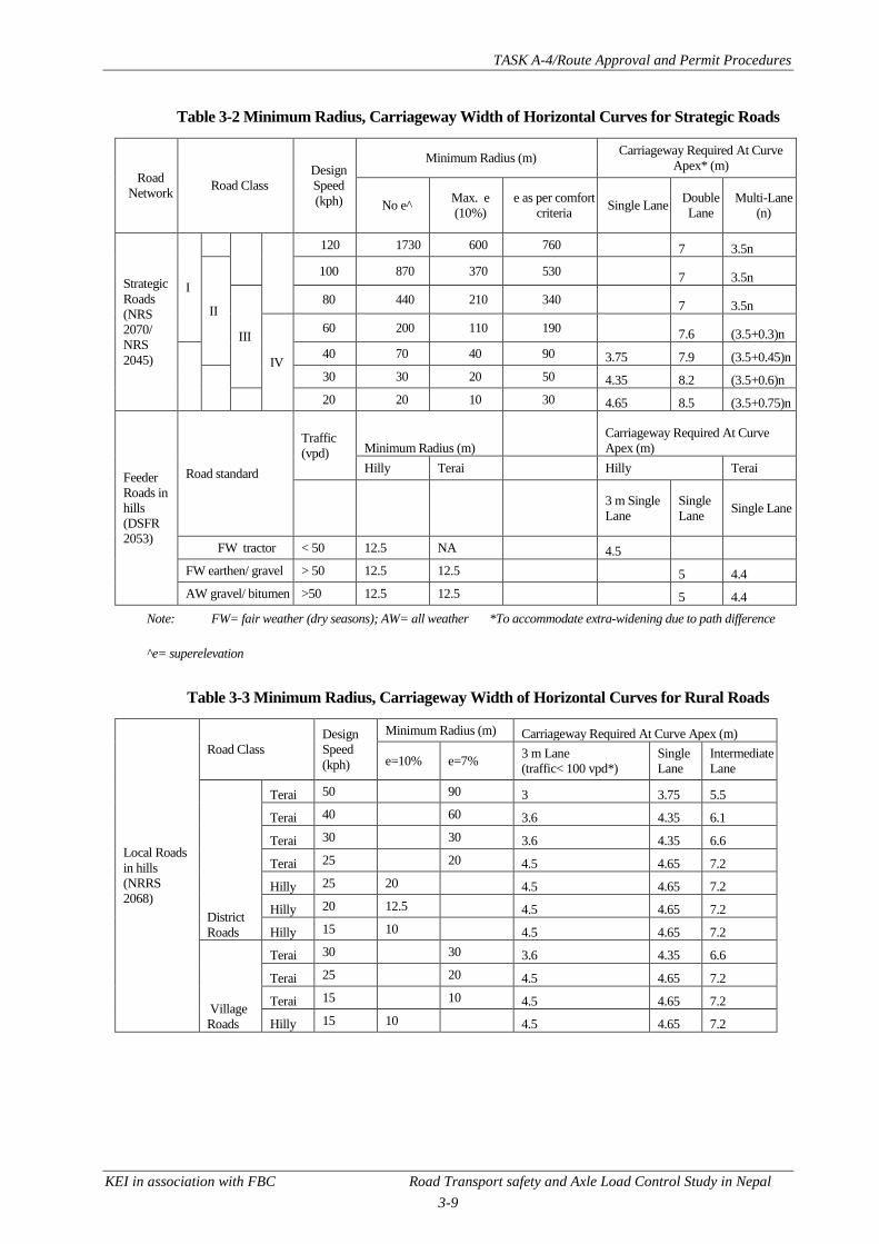
TASK A-4/Route Approval and Permit Procedures
KEI in association with FBC Road Transport safety and Axle Load Control Study in Nepal
3-9
Table 3-2 Minimum Radius, Carriageway Width of Horizontal Curves for Strategic Roads
Road
Network Road Class
Design
Speed
(kph)
Minimum Radius (m) Carriageway Required At Curve
Apex* (m)
No e^ Max. e
(10%)
e as per comfort
criteria Single Lane
Double
Lane
Multi-Lane
(n)
Strategic
Roads
(NRS
2070/
NRS
2045)
I
120 1730 600 760 7 3.5n
II
100 870 370 530 7 3.5n
III
80 440 210 340 7 3.5n
IV
60 200 110 190 7.6 (3.5+0.3)n
40 70 40 90 3.75 7.9 (3.5+0.45)n
30 30 20 50 4.35 8.2 (3.5+0.6)n
20 20 10 30 4.65 8.5 (3.5+0.75)n
Feeder
Roads in
hills
(DSFR
2053)
Road standard
Traffic
(vpd) Minimum Radius (m)
Carriageway Required At Curve
Apex (m)
Hilly Terai Hilly Terai
3 m Single
Lane
Single
Lane Single Lane
FW tractor < 50 12.5 NA 4.5
FW earthen/ gravel > 50 12.5 12.5 5 4.4
AW gravel/ bitumen >50 12.5 12.5 5 4.4
Note: FW= fair weather (dry seasons); AW= all weather *To accommodate extra-widening due to path difference
^e= superelevation
Table 3-3 Minimum Radius, Carriageway Width of Horizontal Curves for Rural Roads
Local Roads
in hills
(NRRS
2068)
Road Class
Design
Speed
(kph)
Minimum Radius (m) Carriageway Required At Curve Apex (m)
e=10% e=7% 3 m Lane
(traffic< 100 vpd*)
Single
Lane
Intermediate
Lane
District
Roads
Terai 50 90 3 3.75 5.5
Terai 40 60 3.6 4.35 6.1
Terai 30 30 3.6 4.35 6.6
Terai 25 20 4.5 4.65 7.2
Hilly 25 20 4.5 4.65 7.2
Hilly 20 12.5 4.5 4.65 7.2
Hilly 15 10 4.5 4.65 7.2
Village
Roads
Terai 30 30 3.6 4.35 6.6
Terai 25 20 4.5 4.65 7.2
Terai 15 10 4.5 4.65 7.2
Hilly 15 10 4.5 4.65 7.2

TASK A-4/Route Approval and Permit Procedures
KEI in association with FBC Road Transport safety and Axle Load Control Study in Nepal
3-10
Table 3-4 Minimum Radius, Carriageway Width of Horizontal Curves for Urban Roads
Urban
Roads
(NURS
2068)
Design
Speed
(kph)
Minimum Radius (m) Carriageway Required At Curve Apex (m)
e=7 % e=4% Local Street
(3 m) Single Lane Intermediate Lane Double Lane
80 230 265 3 3.75 5.7 7.6
60 130 150 3 3.75 5.8 7.6
50 90 105 3 3.75 5.9 7.9
30 30 40 3.6 4.35 6.6 8.5
(3) Hairpin Bends in Hilly Roads
Hairpin bends (very sharp bends) are provided in hilly roads to negotiate road alignment that reverse
its direction owing to difficulty to avoid sharp bends at locations where the direction of the road
reverses. The route assessment team should note the hairpin bends where applicable will follow the
geometric details outlined in Table 3-5.
Table 3-5 Hairpin Bends Design Parameters
Strategic Roads
(NRS 2070, NRS
2045)
Feeder Roads in
hills (DSFR
2053)
Local Roads (NRRS 2068)
District Road Village Road
Minimum design speed (kph) 20 20* NA NA
Minimum curve radius (m) 15 15* 12.5 10
Minimum length of transition curve (m) 15 15 15 15
Max longitudinal gradient 4% 5% 4% 4%
Maximum super elevation 10% 10% 10% 10%
Minimum gap between successive hairpins (m) 60 100 100 100
Minimum roadway width at the apex of the curve (m)
Carriageway
Strategic
Roads (NRS
2070, NRS
2045)
Feeder Roads
in hills
(DSFR 2053)
Local Roads (NRRS 2068)
District Road Village Road
Single lane -3.75 m carriageway 7.5^ 7.5 6.25 5
Single lane- 3.0 m carriageway 5.5 5
Double lane 8.5
Multi-lane (N lane) 5.75
Note: * This parameter is not specified in DSFR 2053 and figure shown is as per NRS 2070.
Roadway includes the carriageway (where vehicle travels) and shoulders but excludes the side-drains, passing zones and
laybys.NA= not available or not specified .^ Figure is as per NRS 2045, not specified in NRS 2070.

TASK A-4/Route Approval and Permit Procedures
KEI in association with FBC Road Transport safety and Axle Load Control Study in Nepal
3-11
(4) Gradients
Various types of vehicles can climb road for up to certain gradients and also the distance that they can
traverse without losing speed significantly vary owing to diverse power capability of different
vehicles. The speed reduction for heavy vehicles along grades is particularly significant beyond
certain span (known as critical length) in road alignment design. Where the road section in grade
exceeds the critical length, either the road alignment design is adjusted or climbing lanes as illustrated
in found. Are provided to allow lighter vehicles to pass heavy vehicles along the grade section.
Figure 3.3 Climbing Lanes Provided on a Two-lane Highway
Source: Geometric Design of Highways and Streets2001; American Association of State Highways & Transportation Officials,
USA
Road alignments along various network will generally be limited to the maximum gradients shown in
Table 3-6 as per their respective design standards.

TASK A-4/Route Approval and Permit Procedures
KEI in association with FBC Road Transport safety and Axle Load Control Study in Nepal
3-12
Table 3-6 Maximum Gradients Applicable in Various Road Networks
Design
Speed
(kph)
Strategic Roads (NRS
2070, NRS 2045)
Feeder Roads (DSFR
2053)
Local Roads (NRRS 2068)
District Road Village Road
Maximum
Gradients (%)
Critical
Length (m)
Maximum
Gradients (%)
Critical
Length
(m)
Maximum
Gradients (%)
Critical
Length
(m)
Maximum
Gradients (%)
Critical
Length
(m)
15 12%- hills 150
20 12% 150 12 150 12%- hills 150
25 12% 150 12 150 12% - hills 150
30 10% 150 10 150 7% -Terai 150
40 9% 200 9 200
50 8% 250 8% 250 7% - Terai 250
60 7% 300 7 300
80 6% 400
100 5% 450 5 450
Based on Error! Reference source not found., all types of vehicles that commonly ply in Nepal can
traverse through the maximum grades specified in Table 3-6 in general but light vehicles such as cars,
vans and motor-cycles cannot traverse over very steep grades for long distance owing to their lower
gradeability compared with heavy and four wheel drive vehicles.
High gradient sections (more than 9%) along a route that traverse through earthen or gravel road
significantly impact pavement deterioration during monsoon periods. In turn, grades often dictate the
choice of pavement surface to provide (e.g. chip seal for short section of grade less than 2% or asphalt
concrete if grade is more than 5%).
(5) Pavement Condition
The condition of pavement will influence navigation along a route including road safety during
maneuvers. For example, poor pavement significantly impacts pavement damage over bridges,
culverts, etc., as well as stability of heavy vehicles. Heavy vehicles tend to take additional space when
the pavement condition worsen. In addition, light vehicles with lower ground clearance cannot
navigate unpaved roads as such roads are often poorly maintained in Nepal with deep undulation
created laterally by the wheels of heavy vehicles and farm tractors that traverse such roads and such
undulation can be severe during the monsoon seasons. It is imperative that the Route Selection
Committee assess the condition of the pavement to determine the type of vehicles that can access the
route or to apply restrictions to ensure safe travel.

TASK A-4/Route Approval and Permit Procedures
KEI in association with FBC Road Transport safety and Axle Load Control Study in Nepal
3-13
Figure 3.4 Deep Undulation Created in Poorly Maintained Road in Nepal
While it is not reasonable to expect the Route Selection Committee to conduct pavement condition
surveys, it is important for the committee above to be knowledgeable about the common form of
pavement condition surveys that are conducted in Nepal and the method adopted by road agencies to
evaluate pavement condition.
The condition of pavement in Nepal is usually assessed through two form of surveys (i) road
roughness and (ii) surface distress index (SDI). Roughness surveys quantitatively measures the
pavement undulations and correlates it to interpret the pavement condition. It measures the
cumulative surface undulations using a vehicle mounted bump integrator attached to the wheel or
axle of the survey vehicle traversing the road surveyed. The cumulative vertical movement is
converted to the international roughness index (IRI) in mm per km and DoR adopts the following
correlation to interpret pavement condition.
Table 3-7 Pavement Evaluation based on IRI
IRI Pavement evaluation
<3.5 mm/ km Good condition
3.5 ~ 8.5 mm/km Fair condition
>8.5 mm/ km Poor condition
In reality, the correlation of IRI values with the pavement condition varies with different types of
pavement surfaces and construction. Nevertheless, IRI indicates the need for pavement rehabilitation
and reconstruction. For example, IRI value of 7.9 and more than 13 for a surface dressed pavement
will trigger the need for rehabilitation and reconstruction, respectively. SDI surveys in Nepal involve
visual inspection of the characteristics of pavement damage shown in Table 3-8 and are conducted by
a pair of trained highway engineers walking-over and drive-through the road to be surveyed.

TASK A-4/Route Approval and Permit Procedures
KEI in association with FBC Road Transport safety and Axle Load Control Study in Nepal
3-14
Table 3-8 Characteristics of Pavement Damage Assessed during SDI Surveys
Pavement Damage Characteristics Unpaved Roads Paved Roads
Stripping/ bleeding/ raveling No Yes
Cracking (longitudinal, transverse, alligator and
block)
No Yes
Edge damage No Yes
Shoulder step No Yes
Camber loss Yes No
Rutting Yes Yes
Corrugations Yes No
Potholes Yes Yes
Gravel loss Yes No
All of the pavement characteristics above covering 10% of the survey sample are quantified and then
added to generate a numerical index or SDI that range from 0 to 5. Pavement condition is then
assessed by correlating the resulting SDI as follows.
Table 3-9 Pavement Evaluation based on SDI
SDI Pavement evaluation
0 ~ 1.7 Good condition
1.8 ~ 3.0 Fair condition
3.1~ 5.0 Poor condition Trigger for Pavement Remedial Acton
% of the sample Action
If 20% have SDI = 5 Reconstruction
10 – 30 % have SDI =4 Rehabilitation
20 – 30 % have SDI =3 Resealing with local patching
20 – 30 % have SDI =2
SDI index are also useful indicator for maintenance intervention as shown in Table 3-9. In recent
days, SDI surveys have been conducted using video footage of the pavement surface through CCTV
cameras fitted beneath the survey vehicle with GPS tracking.
The Route Selection Committee should compile whatever details that is available regarding pavement
condition of the roads that form the new route from the concerned agencies. However, it should be
noted that pavement condition survey evaluation are mostly only available for strategic roads under
DoR jurisdiction.
Therefore, the committee will need to assess the pavement condition mostly following test runs along
the route. It can evaluate the pavement condition based on its own judgment adopting some or all of
the same defect characteristics as adopted for SDI assessment. In particular, it should note the
following points.
i. Assess suitability of the pavement for all vehicles or specific vehicles. For example, heavy
vehicles may need to be restricted on earthen or graveled roads that are narrow when the
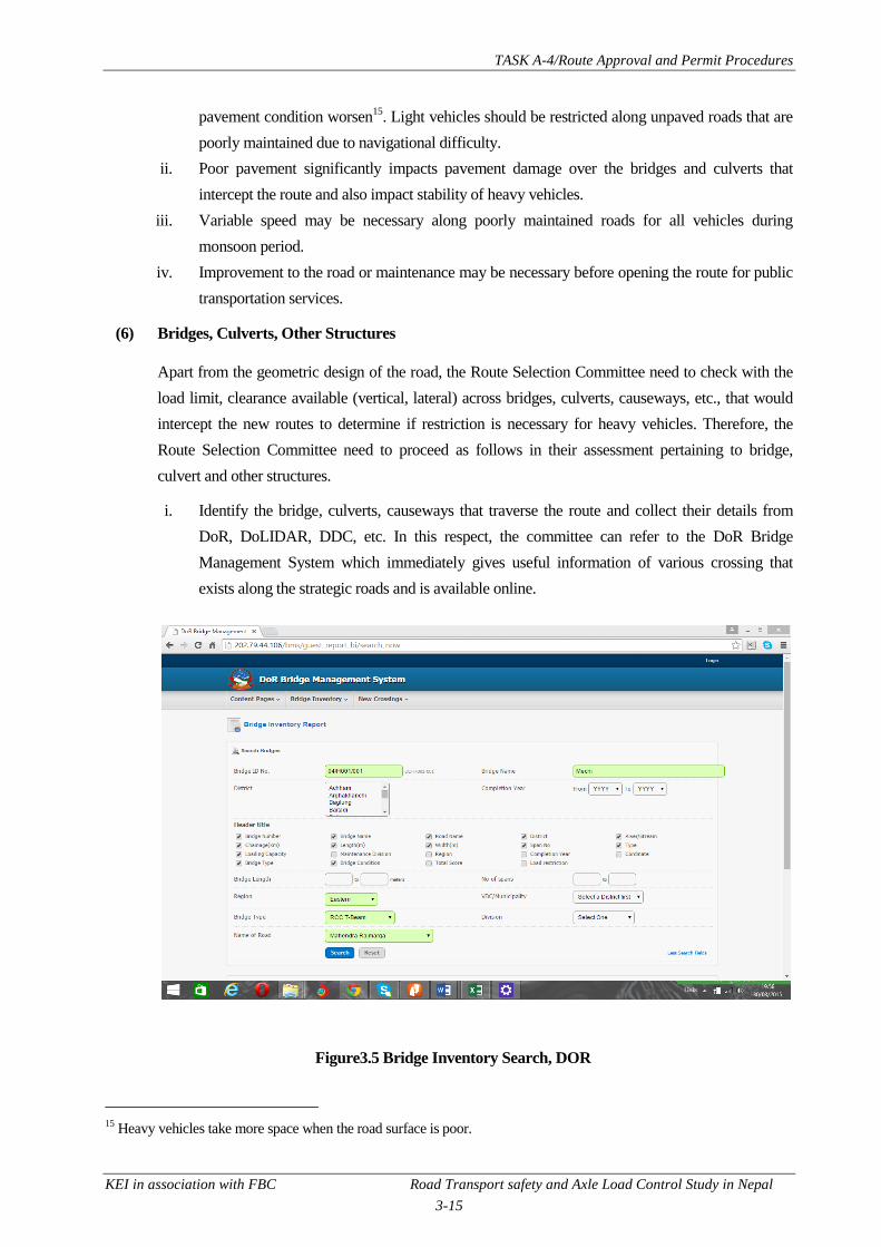
TASK A-4/Route Approval and Permit Procedures
KEI in association with FBC Road Transport safety and Axle Load Control Study in Nepal
3-15
pavement condition worsen15
. Light vehicles should be restricted along unpaved roads that are
poorly maintained due to navigational difficulty.
ii. Poor pavement significantly impacts pavement damage over the bridges and culverts that
intercept the route and also impact stability of heavy vehicles.
iii. Variable speed may be necessary along poorly maintained roads for all vehicles during
monsoon period.
iv. Improvement to the road or maintenance may be necessary before opening the route for public
transportation services.
(6) Bridges, Culverts, Other Structures
Apart from the geometric design of the road, the Route Selection Committee need to check with the
load limit, clearance available (vertical, lateral) across bridges, culverts, causeways, etc., that would
intercept the new routes to determine if restriction is necessary for heavy vehicles. Therefore, the
Route Selection Committee need to proceed as follows in their assessment pertaining to bridge,
culvert and other structures.
i. Identify the bridge, culverts, causeways that traverse the route and collect their details from
DoR, DoLIDAR, DDC, etc. In this respect, the committee can refer to the DoR Bridge
Management System which immediately gives useful information of various crossing that
exists along the strategic roads and is available online.
Figure3.5 Bridge Inventory Search, DOR
15
Heavy vehicles take more space when the road surface is poor.

TASK A-4/Route Approval and Permit Procedures
KEI in association with FBC Road Transport safety and Axle Load Control Study in Nepal
3-16
ii. If the details of the bridge, culverts along the route are incomplete, missing or simply not
available, gather whatever details that is available from the concerned agencies themselves to
confirm the following details.
iii. Maximum load limit applicable along the individual bridges, culverts, causeways. From a
safety point of view, access along these structures should be limited to vehicles whose gross
vehicle weight is 90% of the posted load limit. These details should be ascertained from the
concerned agencies or through consultation with structural/ bridge engineers.
iv. Cross-section (carriageway, footpath, kerb-barrier, etc.) and clearance (lateral, vertical)
available. These details will be useful to assess if heavy vehicles are restricted owing to their
larger dimension or whether two way traffic movements is feasible as often single-lane bridge
often intercept intermediate or two lane roads in Nepal16.
v. Condition of these structures for which the bridge condition surveys conducted by DoR can be
useful resources.
a. Confirm the vertical clearance available at overpass, signs, gantry signs, aerial utility
cables, etc., and the lateral clearance to roadside furniture, poles, etc.
b. Check with Nepal Electricity Authority about vertical clearance necessary to high voltage
lines and confirm that this comply along the route during the trial runs.
c. Refine the missing information from the trial runs through the route.
To assist in their desk study prior to test runs along the route, Figure 3.6 to Figure 3.8 illustrates some
of the standard cross-sections of ridges that can exist along the routes that traverse through strategic
roads in Nepal. The route assessment teams should however confirm the actual cross-section from the
concerned authorities and site inspection.
Figure 3.6 Typical Cross-section of a Two-lane RCC Bridge (Arch)
Courtesy: Road Maintenance & Development Project (IDA Cr. 3293), DoR
16
This was done to reduce cost but recently DoR has adopted the policy of providing only bridges and culverts that are at
least of intermediate lane to avoid costly investment in the future when the road is widened.

TASK A-4/Route Approval and Permit Procedures
KEI in association with FBC Road Transport safety and Axle Load Control Study in Nepal
3-17
Figure 3.7Typical Cross-section of a Single-lane Truss Bridge with Footpaths (30 m span)
Courtesy: Road Maintenance & Development Project (IDA Cr. 3293), DoR
Figure 3.8 Typical Cross-section of a Single-lane Truss Bridge without Footpaths (30 m span)
Courtesy: Road Maintenance & Development Project (IDA Cr. 3293), DoR

TASK A-4/Route Approval and Permit Procedures
KEI in association with FBC Road Transport safety and Axle Load Control Study in Nepal
3-18
Figure 3.9 Typical Cross-section of a Pipe Culvert on Single-lane Road
Courtesy: Road Connectivity Sector I Project (ADB Grant 0051-NEP), DoR
Typically, the following clearance, design loads is adopted on bridges, culverts and other structures.
Table 3-10 Clearance, Design Loading Required
Structure/vehicle
Clearance
Design Loading Vertical Lateral from Kerb
without
footpath
with footpath*
RCC bridges in
municipalities, industrial
areas
4.75 m, 400 mm clear
gap
25 mm -
urban
25 mm – urban
150 mm – rural
Single lane IRC Class AA17/
two lane of IRC Class A18
RCC bridges in highways,
other areas
Single lane IRC Class AA,
two lane of IRC Class A or
AASHTO HS 20-44 19
Overhead wires 7 m, 500 mm clear gap
Barrier kerb 150 mm
Overpass, signs, etc. 400 mm clear gap
Other non-rigid overhead
obstructions (e.g. trees,
etc.)
500 mm clear gap
Semi-trailer multi-axle
trucks
(ISO 40 foot or longer)
Gap with other
vehicles
Lateral from kerb/ outer edge of
shoulder
1.2 m 0.6 m
*Denotes lateral clearance measured from the footpath kerb.
17
IRC Class AA load corresponds to the most severe case between a 70 MT track vehicle and a 20 MT seven-axle wheeled vehicle.
18IRC Class A corresponds to a train of eight-axle vehicles having a GVW of 55.4 MT travelling with specified gap.
19AASHTO HS 20-44 correspond to a uniformly distributed load of 9.3 KN/m and a concentrated load of 80 KN for bending and 115.7
KN shear.

TASK A-4/Route Approval and Permit Procedures
KEI in association with FBC Road Transport safety and Axle Load Control Study in Nepal
3-19
Courtesy: Nepal Bridge Standard -2067; DoR
Figure 3.10 Standard Lateral and Vertical Clearances in Bridges
3.1.4 Assessing Route Accessibility based on Vehicle Dimensions, Operational Capability
As per the previous discussion, roads along the route that are designed as per the standard applicable
(strategic, local, urban) can generally accommodate the largest vehicle that can be expected in such
roads. However, it is important to bear in mind that various roads will actually have geometry that do
not comply with the standard requirements owing to space constraints (in urban built-up areas, rural
ribbon developments, etc.). The Route Selection Committee thus needs to take into consideration the
dimensional requirement, steering capability into consideration in order to determine the type of
vehicles to permit or restrict based on travel safety, preserved road assets (pavement, bridges,
culverts, causeways) once it is able to review the road designs if available or following trial runs.
Table 3-11 illustrates the capacity, dimension of various types of vehicles in the models commonly
found in Nepal.
Table 3-11 Capacity, Dimension of Various Vehicles Commonly Plying in Nepal
Type of
Vehicle/
Configurati
on
Max engine
output (Hp)
Minimum
Turning
Radius (m)
Max
speed
(kph)
Maximum
GVW (MT)
Vehicle Dimension (mm) Ground
Clearanc
e (mm) L WB B H
Multi-axle
trucks (42'
semi-
trailers )
243 hp @
2000 rpm 7.0 86 49 8903 3890 2550 3332 272
Multi-axle
rigid trucks
189 hp @
2400 rpm 10 73 25 8163 3880 3235 3235 306
Trucks
(two axle)
136 hp @
2400 rpm 7.2 88 16.2 8163 4540 2434 3645 303
High
Capacity
170 hp @
2000 rpm 9.2 95 12.5 11085 5820 2500 2836 267

TASK A-4/Route Approval and Permit Procedures
KEI in association with FBC Road Transport safety and Axle Load Control Study in Nepal
3-20
Bus
(seats> 55)
Bus (25-55
seats)
132 hp @
2800 rpm 8.5 96 16.2 12000 6320 3350 2836 263
Minibus
(15- 25
seats)
101 hp @
2800 rpm 6.2 107.5 6.52 6870 3400 2200 2865 276
Micro-bus
108 hp @
3600 rpm 6.2 98 3 5380 3110 1880 2285 185
Three
wheeler
(SAFA
tempo)=
8.5 hp @ 3800
rpm 7.0 45 1.65 3480 2270 1482 1600 140
Cars
86 hp @ 5400
rpm 4.8 158 1.51 4275 2600 1760 1530 169
4WD
217 hp @
4600 rpm 7.3 176 3.5 5140 3075 1995 1940 221
Motorcycle
11 hp @ 7500
rpm
113
2095 1340 796 1100 167
Average
farm
tractor=
66 hp @ 2200
rpm 3.6 26 2.5 4690 4159 2050 2810 445
Note: GVW =gross vehicle weight MT= metric tonnes WB= wheelbase L=length B= breadth H=height
hp= horse power rpm= revolutions per minute
As shown in
Table 3-11, high capacity buses and standard buses comprise the largest size vehicles in the country
whereas obviously the semi-trailer trucks and the multi-axle rigid trucks carry the highest gross
vehicle weight. Consequently, these multi-axle trucks and standard two-axe trucks have the
significant axle-loads that needs to be controlled in order to preserve the road pavement.
As discussed previously, all the vehicles commonly plying in Nepal can negotiate all horizontal
curves that are in compliance with the minimum radius prescribed in applicable design standards
shown in Table 3-2 to Table 3-4. However it is important to note that there may be many sections of
the road along the route that where there are horizontal curves that are tighter than the prescribed
minimum. The Route Selection Committee needs to relate the specific narrow curves, intersection
turning radius that actually existing along the route with reference to
Table 3-11. On the same note, all types of vehicles commonly plying in Nepalese roads (refer Error!
Reference source not found.) can generally traverse road upgrades that are within the prescribed
maximum gradient applicable in Table 3-6but light-vehicles, especially, three wheelers and
motorcycles, find it difficult to sustain through such high grades for considerable length owing to
much lower power that these vehicles have comparatively.
Access to different types of vehicles may also be restricted if the carriageway at the apex of
intersection corners, horizontal curves or sharp hair-pins (in hilly roads) is insufficient to
accommodate the extra-widening that is necessary in these areas as discussed previously. Table

TASK A-4/Route Approval and Permit Procedures
KEI in association with FBC Road Transport safety and Axle Load Control Study in Nepal
3-21
3-12illustrates the width of the carriageway that should be available to accommodate vehicles at
turnings. The carriageway width shown for two-way movement in case of semi-trailer truck
corresponds to the width required to pass a semi-trailer and a standard two-axle rigid truck as
requirement to provision for two semi-trailers is unnecessary and very rare in Nepal.
Table 3-12 Carriageway Width Required to Accommodate Turning
Vehicle Type
Required carriageway width at the apex of
the Horizontal Curve, Intersection
Turning, Hairpin Bends
Vehicle Dimension (mm)
L WB B H Urban
single
Lane
Urban
Two-way
Strategic/
Local
Single
Lane
Strategic/
Local
Two-way
Average 42' Semi-
trailer Trucks 6.8 11.3 6.8 11.3
18,034 3,619
2,519 3,386
Average Multi-axle
rigid trucks 3 7 3 7
7,062 4,080 2,408 3,218
Average Two-axle
Trucks 3.4 7.1 3.5 7.4
6,835 3,884
2,321 3,070
Average High
Capacity Bus 3.9 8.5 4.0 8.8
11,524 5,554
2,547 2,836
Average Bus 3.1 6.7 3.3 6.9
9,113 4,843
2,480 2,836
Average Minibus 3.1 6.7 3.3 6.9
6,870 3,400
2,200 2,865
Average Micro-bus 2.6 5.7 2.8 5.9
5,380 3,110
1,880 2,285
Average Three
Wheeler (SAFA
tempo) 1.9 4.2 2.0 4.5
3,480 2,270
1,482 1,600
Average Cars 2.9 6.2 3.0 6.4
3,951 2,482 1,708 1,485
Average 4WD 2.8 6.0 2.9 6.3
4,824 2,896
1,869 1,896
Average
Motorcycles
2,095 1,340
796 1,100
Average Farm
Tractors 4.0 8.4 4.1 8.7
4,100 3,536
1,864 2,768
Taking the carriageway width stipulated inTable 3-12 as the reference, it is also possible to determine
whether specific vehicle can access an existing or turning aligned at different angles using template
similar to that shown in Figure 3.11 reproduced in a transparent slide on a scale for various types of
vehicles. By superimposing these template over the plan of the road turning along the route, one can
easily assess access to vehicle of particular interest which would be the heavy vehicles.

TASK A-4/Route Approval and Permit Procedures
KEI in association with FBC Road Transport safety and Axle Load Control Study in Nepal
3-22
Figure 3.11 Sample Turning Template for Bus
Source: Geometric Design of Highways and Streets2001; American Association of State Highways & Transportation Officials,
USA
Therefore, the Route Selection Committee should in addition to the previous steps, proceed as
follows during desk study and trial runs to determine whether to allow or restrict specific vehicles
based on alignment, turning geometry and vehicle capacity.
i. Confirm CWY available, especially along the bridges, culverts to assess if access for heavy
vehicles such as the semi-trailers can be granted.
ii. Check the loading limit applicable along the bridges, culverts as recommended earlier in
Section 3.1.4 and determine if certain heavy vehicles should be restricted.
iii. Compare the grade including the span involved along the route with respect to gradeability of
various vehicles listed in Error! Reference source not found.. If grades existing along the
routes exceed that listed in the table above, restrict those type of public vehicles. In the case of
private vehicles, while it is not feasible to restrict them, the Committee can advise the public
against using inappropriate vehicles to travel along the route in question. Usually, motorcycles,
tempos, high capacity buses will automatically be restricted in accessing high upgrades
spanning for a long stretch of the road.
iv. Assess accessibility to different vehicles, particularly the heavy vehicles, at the various turning
(intersections, curves, hairpins) in the design plan with reference to Table 3-12. Where these
turnings intersect are at an angle other than a right angle, determine if these are adequate using
the turning path template developed for various types of vehicles.

TASK A-4/Route Approval and Permit Procedures
KEI in association with FBC Road Transport safety and Axle Load Control Study in Nepal
3-23
a. If either the turning radius, width of the carriageway provided at the turning is
inadequate, recommend land acquisition to improve the intersection or the bend as
applicable, to ensure access to all vehicles.
b. If improvement is not feasible, ascertain the type of vehicle that can have access and
issue permit accordingly.
3.1.5 Route Inspection and Test Runs
Following the desk study to identify the suitability of the route in terms of roadworthiness,
accessibility that can be accorded to all vehicles or specific one based on geometrical, terrain
constraints as outlined in the previous sections, it will be necessary for the Route Selection
Committee to physically inspect the route as well as conduct test runs along it to confirm the desk
study findings. In this respect, the Committee should proceed as follows.
i. Drive along the route in various types of public vehicles and observe in the checklist the
following items.
a. Pavement type and condition visually including the degree of undulations, pot-holes
b. Condition and type of shoulder available
c. Sharp turns, intersection approaches and available carriageway width at the apex of these
locations
d. Roadside landuse (built-up, school areas, industrial corridor, forest areas, etc.)
e. Condition, geometry, loading limit of bridges and cross-drains
f. Presence of lateral protection (safety barriers) at the valley side against steep vertical
drops more than 3 m deep in hill roads
g. Presence of blind corners especially in hill roads (e.g. sharp curves, hairpins that are
convex towards valleyside, vegetation obstruction, etc.)
h. Presence of passing bays in the case of single-lane roads including their location to assess
if they are positioned to be inter-visible for safety
i. Steep gradients available and visibility constraints at summits
j. Period when visibility is restricted along the route due to weather condition and seasonal
changes (e.g. misty conditions during monsoons at hill roads that experience heavy
rainfalls, winter fog during the early morning and evening, etc.). It may not be feasible to
gather this information during all test runs but this information can be collected through
interaction with the local community.
k. Location of ribbon developments, bazaars, roadside amenities, etc., along the route to
establish potential bus stops
l. Observe carriageway, footpaths available at ribbon development, bazars, etc.
m. Assess accessibility, navigation ease and comfort while travelling along the route in
the test vehicle. In this respect, the Committee should note the speed of travel, time taken
to complete the route, etc.

TASK A-4/Route Approval and Permit Procedures
KEI in association with FBC Road Transport safety and Axle Load Control Study in Nepal
3-24
n. Return back and refine the desk assessment regarding selecting the route for public
transport or opening the route subject to certain restrictions such as
o. Allow only 4WD transport services only for the time being
p. Allow freight transport by farm tractors only for the time being
q. Restrict public transportation during certain period of the day or certain period during
specific season
r. Speed limit to adopt or variable speed limit to adopt for certain period of time based
safety consideration
s. Trigger road maintenance and/or improvement necessary to facilitate smooth transport
services as well as road safety for all type of public transport
t. Enforce load limit along the route to safeguard bridge and cross-drain structures
u. Prohibit vehicles beyond certain dimension owing to width constraints at bridges and
cross-drains.
v. Modify the route path or mitigate to minimize traffic conflicts and adverse impact to
certain land use such as residential, school or areas with significant number of
pedestrians and cyclists.
3.1.6 Certifying the Route
After confirming the test runs and refining the desk assessment, the committee should finalise its
assessment and make it decision whether to open the route. If it decides that it is justifiable to select
the route or open the route subject to certain restriction, the committee should publish the route for
public information.
TASK A-4/Route Approval and Permit Procedures
KEI in association with FBC Road Transport safety and Axle Load Control Study in Nepal
4-1
CHAPTER 4 ROUTE PERMITTING
Route permitting is the broad means of regulating public transport services including its
administration, monitoring, coordination, policy directions to ensure safe, reliable and effective public
transport services in Nepal and follows after the route assessment and fixing for new routes. The
following sub-section discusses about how the existing provisions and possible recommendation for
improvement in regulating public transport services in Nepal.
4.1 CURRENT SITUATION
Currently, DoTM administers the route permits for all public transport services in Nepal as per the
provisions set in the MVTMA 1993 and MVTMR 1997. In Nepal, transport operators need permits
to operate their service along the DoTM designated routes subject to the maximum fare that the
department stipulates from time to time. DoTM is institutionally weak in effectively guiding,
regulating transport operators as envisaged in the act and regulation despite good provisions. Given
this state of affairs, permits are issued ad-hoc in Nepal instead being guided by scientific mechanism.
Even though MVTMR 1997 clearly requires a transport operator to abide by the schedule prescribed
by the ZTMO issuing its permit, to date operators such directives is missing and therefore operators
fix schedules, arrange fleet to cater to their passenger demand best on their best judgement and
experience. There are no service obligations imposed (e.g. minimum, maximum number of daily trips
to satisfy) that passenger transport operators need to abide to maintain their permits. While provisions
related to route permits were highlighted earlier in Section 1.2, these are once again illustrated in
Table 4-1.
Table 4-1 Route Permit Provisions in MVTMA 1993 and MVTMR 1997
MVTMA 1993 MVTMR 1997
1. Passenger transport routes are defined as follows:
Local route (less than 25 km)
Short route (25 – 100 km)
Medium route (100- 250 km)
Long routes (more than 250 km)
1. New permit along different route to replace
exisiting permit require concurrence from the
concerned ZTMO that issued the existing
permit.
2. Various types of vehicles are generally grouped as
heavy; medium and light vehicles. Bus can operate
during (a) day or/and (b) night time. Permits for
passenger vehicles offering the following level of
services are issued.
Direct service
Experss service
Normal service
2. Stipulates the vehicle seating capacity, seating
size, internal dimesnsion of aisle, ceiling height,
doors, etc. and vehicle age-linit for the
passenger transport offering the following
service.
Direct bus service;
Express bus service
Normal bus service

TASK A-4/Route Approval and Permit Procedures
KEI in association with FBC Road Transport safety and Axle Load Control Study in Nepal
4-2
3. Documents to submit
• Prescribed fee
• Valid insurance cover (driver, vehicle crew,
security , third party)
• Valid vehicle inspection certificate
• Valid vehicle registration
certificate
3. Only bus can operrate in both day and night.
4. Permit are valid four months at a time and renewal. 4. Microbus operating on long routes are restricted
within a maximum of 300 km.
5. ZTMO can issue replacement permit to replace an
existing permit if the permit holder applies for the
same prior to the expiry of the existing permit.
5. Passenger transport operators need to maintain
their schedule prescuned by their ZTMO in
normal condition. However, this provision in not
enforced owing to DoTM inability to provide
operators such guide.
6. ZTMO can issue multi route permit to an existing
permit holder if such action does not adversely
impact the existing transport services in the area
concerned.
6. If a permit holder need to use another route
before expiry of the existing permit, a new permit
can be issued upon applicant for the same.
7. ZTMO can deny permit after due consultation with
the area TMC if (a) the existing services deemed
adequate for the prevailing demand; (b) adverse
environmental impact expected if permit issued or
(c) other reasons.
7. Public passenger services plying along medium
and long –distance routes should comply with the
standard presribed in the government gazette.
8. ZTMO can deny permit for vehicles that are non-
compliant with the prescribed standard for the
medium and long routes to accord due comfort and
security to passengers and vehicle crew.
8. Route permits shall be renewed upon receipt of
application for the same
9. ZTMO can issue intermittent permit valid for seven
days upon application for the same if a permit
holder need to use another route due to special
circumstances.
10. All transport operators need to be listed in DoTM‟s
roster prior to being granted route permits.
11. ZTMO can suspend an existing permit upon formal
request if the vehicle cannot be operated four
months following a road crash or other cause after
necessary vertification of the facts.
12. Government can suspend any permit of any vehicle
for up to one month if the vehicle is not operated to
the public deteriment.

TASK A-4/Route Approval and Permit Procedures
KEI in association with FBC Road Transport safety and Axle Load Control Study in Nepal
4-3
Based on DoTM data, there was a total of 443 short to long –distance routes and 47 freight routes
established all over the country till January 2015.. Within Kathmandu Valley, there are tentatively
102 routes20
plying from various locations of the valley.
Almost all the public transport services are run by individual private owners in large number but the
routes are collectively allocated and managed through individual associations that exists all over the
country. However, a few passenger transport services is managed through companies (e.g. Sajha
Yatayat in Kathmandu Valley and Manjushree Yatayat, Makalu, Agni, etc., offering medium to long
distance bus services across the country).
The numerous individual private passenger transport operators acquire membership in their district or
area based associations (referred to as committees in Nepal) even though it is not mandatory to
acquire membership to operate transport services in Nepal. Similarly, truck entrepreneurs acquire
membership in truck committees within their development region or district. At the national level,
both of these type of transport operators are affiliated with their federations i.e. Federation of
Nepalese National Transport Entrepreneurs (FNNTE) and Federation of Truck Transport
Entrepreneurs Nepal (FFTEN) based in Kathmandu. Through their district based associations and
federations, transport entrepreneurs assist DoTM and in many instances can exert considerable
influence to serve their interests.
From the existing scenario and the operating regime, it is clear that effective mechanism for DoTM to
effect the various provisions and scientific tools to ensure the various permit provisioned in the rules
and regulation is lacking. In addition, re-organisation of the routes and introduction of various
models of operation that are available in public transportation should be considered for application in
Nepal. While a detailed analysis of route re-organisation is outside the scope of this study, some of
these aspects is presented in the subsequent section. Most of the emphasis to improve route permit
administration in the subsequent concentrate on some of the most pressing areas that can be
immediately introduced in Nepal.
4.2 RATIONALISING THE LOCAL, SHORT, MEDIUM AND LONG ROUTES
As pointed out in Section 4.1, MVTMA 1992 classifies routes for public passenger transport as
follows.
Local route (less than 25 km)
Short route (25 – 100 km)
Medium route (100- 250 km)
Long routes (more than 250 km)
20
Based on survey from Kathmandu Sustainable Urban Transport Project (ADB Loan/Grant 2656/01212-NEP) that are
subject to change following verification with DoTM records.

TASK A-4/Route Approval and Permit Procedures
KEI in association with FBC Road Transport safety and Axle Load Control Study in Nepal
4-4
Only buses (seating 26- 56) can operate during day or/and night service according to the time of
operation. All public passenger transport services can offer the following quality of service as
provisioned in MVTMA 1992.
Direct service
Express service
Normal service
MVTMR 1997 has outlined the seating capacity; internal dimensions (seating, aisle, doors), seating
configuration, emergency provisions (fire extinguishers, first aids), etc., and vehicle age that direct,
express or local services within any routes must comply for different size of passenger vehicles.
Microbus with seating capacity up to 14 are restricted to operate only up to 300 km which implies
that these vehicles can operate on long routes that lie within this threshold limit.
The existing demarcation of local, short, medium and long routes therefore appear to ensure that
public transport vehicles having the commensurate standards and amenities ply along the Nepalese
roads. These demarcation also appear to restricts certain types of vehicle that can qualify to operate in
long routes (e.g. MVTMR 1997 prohibits microbus (seating up to 14) to operate beyond 300 km.
These policies are consistent with the general practice in public transportation as illustrated below.
• Smaller minibus are typically used.
Figure 4.1 Appropriate Vehicle Size for Public Passenger Transport
Offers high vehicle
capacity to cope
with very high
passenger demand.
Offers comfort
required for long
distance travel.
Suited for informal
services, demand
responsive services

TASK A-4/Route Approval and Permit Procedures
KEI in association with FBC Road Transport safety and Axle Load Control Study in Nepal
4-5
In addition, the fees for all types and stage of route permits (new, renewals, route change, intermittent
and multi) are applied based on the nature of transport (passengers or freight), vehicle size (seating or
payload capacity) and distance involved except for buses and minibuses (heavy and medium
vehicles21
as defined in MVTMA 1992) plying in Kathmandu Valley as per MVTMR 1997. Within
Kathmandu Valley, a flat permit fee for medium and heavy vehicles that is nearly equal to the
maximum fee applicable for medium and heavy vehicles (i.e. long routes that are more than 701 km)
is applied for medium and heavy vehicles. Therefore, the permit fee within Kathmandu Valley
(which has the maximum traffic levels including public transport vehicles) appear to positively
discriminate in favour of smaller public vehicles with seating capacity 5 to 14 that possibly requires
revisiting.
Based on the fact above and except for revising the permit fee for light passenger vehicles to apply
within Kathmandu Valley, the basic approach to allocating routes of various distances (local, short,
medium and long routes) along with stipulation of the particular types of vehicles permitted to
operate within these routes and quality of service (local, direct and express) appear to be logical
despite the fact that regulators in other countries apply different approach (e.g. stage carriage, contract
carriage in India and Pakistan, complete de-regulation in UK, etc.) for regulating public transport
services. What appears to be necessary at this stage is to review if the distance range that currently
applies for local, short, medium and long –routes in the current development of road network, re-
allocate the appropriate type of public passenger vehicle to use the three range of routes. These issues
is discussed below for more elaboration.
As part of another task (Task A2: Safe Vehicle Guidelines), the classification of public passenger
transport vehicles were reviewed and recommend parallel to this study. The classification for public
passenger vehicles that is recommended in the Safe Vehicle Guideline is illustrated again in Figure
4.1 as it is relevant to rationalization of the passenger transport routes.
21
Heavy vehicles include bus, truck, tractors, construction equipment (dozers, dumper, cranes, rollers, etc.) and medium
vehicles include minibus, mini-trucks, SUV (jeeps), pick-up, van, small crane, tankers, smaller roller, etc.

TASK A-4/Route Approval and Permit Procedures
KEI in association with FBC Road Transport safety and Axle Load Control Study in Nepal
4-6
Bus Service Routes
Long Routes
Medium Routes
Local Routes
Standard BUS
(SB)
Deluxe bus
(DLX)
AC Deluxe
Bus ACX
Mini BusMicro
Bus
Direct Bus
Service
Normal Bus
Service
Short Routes Night Bus
Service
Day Bus
Service
Operating
Distance and
Purpose
Time of the Day
Standard of the Service
Service Comfort level
Type I
Type II
Type III
Type IV
Bus Types
Special Service purpose
Jeep/Van
Express Bus
Service
Figure 4.2 Proposed Classification of Public Passenger Transport Vehicles
Source: Task A2: Safe Vehicle Guidelines (draft); RTS & ALC Study; NIRTTP DoTM Component (IDA H863); KEI in
association with FBC; June 2015.
As shown in Figure 4.2, keeping in view the varying requirements and uses of public passenger
vehicles, all of the bus sub-mode are categorized into Type I, Type II, Type III and Type IV based on
their construction as shown in Table 4-2.
Table 4-2 Description of the Type Category Recommended for Bus Sub-mode
Bus Type Operating purpose
Bus Type I Route type: Local Routes
Time of the day: Daytime Service
Comfort level: All Comfort Level
Service standard: Express, Normal Bus Service
Bus Type II Route type: Short, Medium and Long routes
Time of the day: Night and Day Service
Comfort level: All Comfort Level
Service standard: Direct Bus Service
Bus Type III Route type: Short, Medium and Long routes
Time of the day: Daytime Service
Comfort level: All Comfort Level
Service standard: Direct and Normal Bus Service
Bus Type IV
(Buses of special
purpose)
Route type: Local Routes
Time of the day: Daytime Service
Comfort level: All Comfort Level
Service standard: Direct and Normal Bus Service

TASK A-4/Route Approval and Permit Procedures
KEI in association with FBC Road Transport safety and Axle Load Control Study in Nepal
4-7
Mini Bus and Micro Bus Route type: Local, Short and Medium Route
Time of the day: Daytime Service
Comfort level: All Comfort Level
Service standard: Direct and Normal Bus Service
Jeep/Van Route type: Local, Short and Medium Route
Time of the day: Daytime Service
Comfort level: Not Applicable
Service standard: Not applicable
Tempo (Three wheelers) Route type: Local Route
Time of the day: Daytime Service
Comfort level: Not applicable
Service standard: Not applicable
Source: Task A2: Safe Vehicle Guidelines (draft); RTS & ALC Study; NIRTTP DoTM Component (IDA H863); KEI in
association with FBC; June 2015.
As indicated in the Table 4-2, all the sub-modes of bus can offer two quality of service, (i) direct bus
and (ii) normal bus service. The existing quality of service corresponding to “express bus service”
been dropped as there was ambiguity with “direct bus services” defined in MVTMA 1992.
Similarly, it is recommended to prohibit both minibus and microbus on long routes, confine them to
day time (as is currently applicable) but can offer any comfort level.
Beyond these vehicle classification, quality of service, type of construction, level of comfort that
align with the various routes, it is necessary to revisit the distance range that is prescribed for the
various routes for public passenger transport. Table 4-3 shows the tentative length up to which the
street network in a selected number of major cities of Nepal currently extends based on both
observation in Google Earth®22
and map published in 2014 Strategic Road Network Statistics23
. The
distance shown do not necessarily limit within the municipal border but rather on extent of the built-
up area that one observe visually.
Table 4-3 Tentative Extent of the Street Networks in Selected Cities of Nepal
City Tentative Alignment Tentative Distance (km)
Kathmandu (Thankot – Koteshwor) East- West 15.7
Kathmandu (Budhanilkhantha)–
Ekantakuna (Lalitpur) North – South 16.2
Kathmandu – Lalitpur Ring Road Roughly circular 28
Thankot (Kathmandu) – Sallaghari
(Bhaktapur) East –West 21.5
Pokhara (Bijayapur Bridge – Bindebasini) North – South 8.8
Pokhara (Pardi – Bijayapur Bridge) East –West 7.8
22
Google Earth is a registered trademark of the satellite maps available online owned by Google Inc. USA. 23
GoN DoR annual publication.

TASK A-4/Route Approval and Permit Procedures
KEI in association with FBC Road Transport safety and Axle Load Control Study in Nepal
4-8
City Tentative Alignment Tentative Distance (km)
Pokhara (Bijayapur Bridge – Kuvinde,
municipal border) South -West 16.4
Biratnagar North –South 12.4
Biratnagar East- West 4
Biratnagar Ring Road
(ongoing full development) Roughly Circular 42
Birgunj North –South 9
Birgunj East- West 8
Bhairahawa North- South 9
Source: Consultant‟s observation based on inspection in Google Earth®.
Based on inference from Table 4-3, it can be assumed that the current limit of denoting local routes to
within 25 km appear reasonable to cover the likely distance that cities currently exists or may expand
to in the future with exception to the case for Kathmandu Valley and Biratnagar Ring Road when
fully developed. It will not be conducive from regulatory point of view to expand the limit of short
route beyond the current 25 km limit despite the fact that cities in Nepal are growing. Owing to
jurisdictional constraint that can potentially emerge between neighbouring municipalities and
following the administrative boundary effected by the federal structure the country will likely
undergo, it is also important to limit the local route to lie within the limit of individual municipalities.
The current range of the short to long routes is also recommended to remain as it continuous to fulfill
the requirement for public passenger transport as well as be consistent with the prevailing regulation
for route permits. The maximum limit of 250 km for medium routes is still reasonable as it tentatively
represent a travel time of roughly six and four hours of travel in respectively, the hill and terai (plains)
roads of Nepal based on the average travel speed which is appropriate maximum limit that minibus
or microbus should be allowed. An exception to this rule is the use of sport utility vehicles or jeeps
for passenger transport to the newly constructed earthen, low rural hills road that are too narrow or
geometry is poor where jeeps should be permitted to ply along the long routes till the time that the hill
road in question is widened or improved to permit buses to ply safely. At that stage, jeeps can be
restricted for the long routes. The following is thus recommended for application of the local to long
routes in Nepal.
Table 4-4 Recommended Range, Type of Vehicle Applicable for Routes
Routes Distance Limit Vehicle Permitted to Ply
Local routes ≤ 25 km, within municipal
border or district border,
whichever is less
All
Short routes 25 – 100 km Bus, minibus, microbus, four
wheel drive (jeeps)

TASK A-4/Route Approval and Permit Procedures
KEI in association with FBC Road Transport safety and Axle Load Control Study in Nepal
4-9
Routes Distance Limit Vehicle Permitted to Ply
Medium routes 100 -250 km Bus, minibus, microbus, jeeps
Long routes ≥250 km Bus, jeeps (only at narrow,
poor geometry in the hills)
Jeeps to be prohibited on long
routes once the hill road is
improved, widened to permit
buses to ply safely.
4.3 THEORETICAL MODELS FOR PERMIT MONITORING, DEMAND ASSESSMENT
One of the problem that DoTM is currently facing while regulating public transport vehicles is lack of
mechanism to scientifically monitor the number of permits and assess demand-supply pertaining to
public passenger transport. It is important to note that it is the expected number of daily trips in terms
of bus, minibus and microbus that should be taken as the controlling threshold by which individual
transport operator need to be allocated permits. Once the expected daily trips is about to exhausted,
additional route permits should be stopped. This aspect is discussed in subsequent chapter pertaining
to public urban transport.
Comprehensive demand analysis for public transport is quite complex; require population census and
employs various surveys (origin-destination, vehicle occupancy, traffic and public transport counts,
household surveys, etc.). Each of these surveys or combination of them generate trends, statistics,
etc., that can help the analyst to determine the ridership of public transport services along a route. In
developed countries, data such as average daily trips per capita, trip purpose (home to work, home to
shop, home to school) are also for cities or areas that are particular in that country and are adopted to
analyse for demand analysis in other cities or areas that are similar in nature. Some theoretical models
that be applied in demand analysis is discussed below.
4.3.1 Four Step Travel Forecasting
The four step travel forecasting method is popularly used to forecast travel (or passenger demand if
for public transportation analysis). The four step travel forecast sequentially calculates the anticipated
trips, distribute it between origins and destinations, assign trips to various vehicle modes and lastly
assign along the road routes. The analysis involve the following four aspects of the trip forecast
which is why it is called the four step travel forecasting method.
Trip generation
Trip distribution
Modal split
Route assignment

TASK A-4/Route Approval and Permit Procedures
KEI in association with FBC Road Transport safety and Axle Load Control Study in Nepal
4-10
Trip generation is the first step of travel forecast and involves extrapolation of total trips in an area
that can result owing to the virtue of the land development involved. The total trips can either be trip
production (trips originating from home or origin of a non-home based trips) or trip attraction (trips
that do not start or end from home). Examples of trip productions home to work, home to shop trips,
shop to home, office to home trips. Similarly, trip attractions are non-home end trips of a home-based
trip or destination of a non-home-based trip. Examples of trip attractions are shopping from home
trips, office from home trips, office to shop trips.
Trip distribution follows trip generation and matches the origin and destination of trips and develop
a trip matrix that align the trips from a particular origin to a particular destination. The gravity model
is the most widely used model to generate the trip matrix over an area and is given below.
Where,
Modal split analysis follows trip distribution and this step assigns the trip matrix from one zone to
another into the different transport modes based on public choice in the area concerned (e.g. 70% by
car and motorcycle, 25% by bus, 5% by walking). The resulting matrix from this analysis is a matrix
showing the number of different modes traveling from one zone to another. This analysis may
simply involve assumption of the percentage of trips from each zonal pair using best judgement based
on factors involved such as in-vehicle time, walking time, waiting time and in-vehicle time (for
public passenger transport) that can be simply „skimmed‟ through the road and public transport
network for each origin- destination pair and ultimately developing a modal trip matrix. In other
cases, utility concept is adopted where utility of each mode is calculated based on the attributes
involved for this mode. Attributes of a mode can be cost; in vehicle time involved; wait and walk
time for public passenger transport; the number of interchanges needed between modes. The utility
for mode m is first calculated using the following formula.
Where,

TASK A-4/Route Approval and Permit Procedures
KEI in association with FBC Road Transport safety and Axle Load Control Study in Nepal
4-11
The modal split is then calculated using the multinomial logit model below.
Where,
The route assignment is the final step in the travel forecasting method after model choice analysis.
The trips are ultimately assigned along the routes between the origins and destinations. The capacity
restrained assignment is commonly adopted and involve assigning the trips in steps. There are two
technique of loading the trips at each of the steps, (i) proportionally and (ii) incrementally. In the
proportional method, a portion of the trips is loaded to every origin- destination zone pair that has the
shortest travel time at each step. In the incremental method, all the trips are loaded to a subset of the
origin- destination zone pairs along at each step. Regardless of which method of trip loading adopted,
the travel time is recalculated after each loading of trips using speed-versus-volume curve and trips is
assigned to the shortest route at the next step of loading. This process of loading the trips between all
zone pair or subset of zone pair is repeated till all the trips is assigned. The multipath probabilistic
assignment assigns trips based on probability of choosing each of the several routes based on the
relative attraction of each route (measured according to travel time and cost). Figure 4.3 illustrates a
version of the four step method that was adopted in Japan for a land development project.

TASK A-4/Route Approval and Permit Procedures
KEI in association with FBC Road Transport safety and Axle Load Control Study in Nepal
4-12
Figure 4.3 Example of the Four Step Travel Forecasting Model Adopted in Japan
(Adopted from: LRT- BRT & Bus Transport Planning; Y. Naruse/JICA Expert; 2014)
From the above description, the four step travel forecasting is quite challenging and requires expertise
to use it with confidence. Moreover, it requires data such as demographic census, parameters (e.g. trip
generation rates, trip purpose, other parameters pertaining to other analysis models, etc.), which
precludes its use for passenger demand analysis in Nepal. However, trip rates newly updated in 2012
are available for Kathmandu Valley under the JICA funded traffic survey for the Kathmandu Valley
Master Plan.
4.3.2 Tamin’s Trip Distribution Model –cum- Modal Choice from Passenger Counts
This research was conducted in Indonesia using case studies based in Bandung, Indonesia and the
main aim was to identify a low-cost demand analysis method which was not too data hungry nor
complex. In this research, the gravity model was combined with the multi-nominal logit model and
was calibrated from passenger counts and other simple zonal planning data. The model was tested
using the 1988 Public Transport Survey conducted in Bandung. However this model use complex
mathematical formulation that require familiarity with statistics and therefore is not suitable for
DoTM to use.

TASK A-4/Route Approval and Permit Procedures
KEI in association with FBC Road Transport safety and Axle Load Control Study in Nepal
4-13
4.3.3 Simple Steps to Calculate the Number of Buses Required, Route Allocation
Embarq: Bus Karo which is a guideline on bus planning and operations have recommended on the
following steps to assist cities to calculate the total number of buses required and to allocate them to
the routes.
First identify the strategic public transport corridors in the city.
Next, collect mobility data
Finally, analyse the above data to pick routes and develop a service plan
Amongst the above three points, the most important aspect is step 1 which will rely on best
professional judgement in most cases. However, for a thorough picture, it is recommended to follow
the procedure described below.
(1) Step 1: Identifying Public Transport Corridors
If the City already has an existing public transport service
If the City already has an existing public transportation, identifying potential public transport corridor
is relatively easy. The goal in this case is to provide a more reliable, comfortable and safer bus
service. The following procedure should be followed:
Collect existing data: Collect existing data on population, major arterials, roads, location of the
central business district, key commercial areas, education centers, industrial areas, shopping
areas, recreational areas, etc.
Pick existing or historic bus routes in eh city for analysis. In most cases, existing bus routes are
the one with the highest demand. Collect other data such as frequency, occupancy and transfer
location for these routes.
Study the city‟s road network
If the City does not have public transport service
In this case the best way to determine passenger demand is to calculate the total informal transport
users (para-transit, tempos, SAFA, shared taxis, etc.). In this case it is harder to find out the origin and
destination patterns. Select a list of strategic locations in the city to conducts surveys which can be
areas with high densities of informal transport supply, high demand like railway stations, bus stations,
commercial centres, industrial areas, etc. These surveys should take place with the minimum
resources and time.
(2) Step 2: Collecting the Mobility Data
If the City has an existing public transport service
Collect the following information from surveys.
i) Bus occupancy; hourly counts at boarding and alighting
ii) Through passengers while riding the bus for at least one entire trip of the route.
iii) The travel time of the route from start to finish.
iv) From the above details, determine the peak load point along the route.
v) Review the on-board volume over a 12 to 16 hour period at the peak locations and loads at
informal public transport to identify where the highest passenger demand occurs.

TASK A-4/Route Approval and Permit Procedures
KEI in association with FBC Road Transport safety and Axle Load Control Study in Nepal
4-14
vi) Finally, extrapolate the time of the day having the highest traffic (vehicle traffic+ NMT traffic+
IPT based on the 12- 16 hour count.
If the City does not have an existing public transport service
The data collection effort for these cases is similar to that for cities that has an existing public
transport services. In this case, proceed as follows.
i) Survey the strategic locations to count the number of informal transport vehicles and occupancy
per hour. Count the occupancy in broad terms such as empty, one quarter, half, three quarters and
full.
ii) Count also the pedestrians and cyclists during the counts above as these groups are the first one
to shift to bus if the service is reliable and good.
iii) Count also the pedestrians, cyclists and informal passenger transport to allow for fleet size and
bus.
iv) Inquire with the driver of the informal transport about the most frequently travelled routes.
v) From the review of the roadside conditions at each location over the 12 -16 hour period,
determine the location where the peak passenger volume on the informal passenger transport
occurs.
(3) Step 3: Analysis
1) Hourly Bus Frequency
To calculate the hourly bus frequency, use the formula below.
Peak or off-peak ridership measurements can be calculated through an analysis of the load profiles.
Bus occupancy will vary based on the maximum passenger capacity of the buses plying the route.
2) Load Profile of a Route
The survey data should be tabulated to allow for easy comparison between segments of a transit
route. For example, Table 4-5 shows the following facts.
Travel time was 70 minutes for the entire route or 73 minutes from the time of arrival at the
first station.
A total of 129 passengers were transported
The first and last stations had the highest number of boarding and alighting but the middle
stops had the highest through passengers.
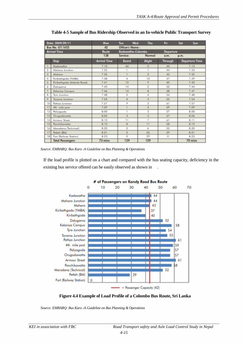
TASK A-4/Route Approval and Permit Procedures
KEI in association with FBC Road Transport safety and Axle Load Control Study in Nepal
4-15
Table 4-5 Sample of Bus Ridership Observed in an In-vehicle Public Transport Survey
Source: EMBARQ: Bus Karo -A Guideline on Bus Planning & Operations
If the load profile is plotted on a chart and compared with the bus seating capacity, deficiency in the
existing bus service offered can be easily observed as shown in .
Figure 4.4 Example of Load Profile of a Colombo Bus Route, Sri Lanka
Source: EMBARQ: Bus Karo -A Guideline on Bus Planning & Operations

TASK A-4/Route Approval and Permit Procedures
KEI in association with FBC Road Transport safety and Axle Load Control Study in Nepal
4-16
3) Total Bus Travel Time
The total bus travel time can be calculated by using the following formula.
The above cycle time includes the bus travel time, dwell time at bus stops and a turn-around terminal
time at the bus depot.
The bus run time reflects the time that elapses between the first station departing and arriving at the
last station. It takes into account the traffic delays and variability in the corridor.
The terminal time varies depending on the length of the bus route. If the routes are shorter than an
hour in total duration, the terminal time may require 10 minutes of terminal time. In contrast, if the
route length is more than 20 minutes. These values are however simply estimates but the actual times
will depend on the efficiency of the system.
4) Fleet Size Calculation
The following formula calculates the total fleet size that is necessary to play along a bus route or
transit route. The fleet size is based on the number of buses that is required to run services at a set
frequency.
Transport operators should conduct load profiles throughout the entire day of their operations to
determine the peak hour and off-peak hour ridership along their route. Table 4-6 illustrates the trip
details that was observed during different time period for a bus route. This example shows that there
was 300 passengers during the peak hour period while there were a minimum of 180 passengers
during the off-peak period.
Table 4-6 Sample of Bus Trips Observed
Source: EMBARQ: Bus Karo -A Guideline on Bus Planning & Operations

TASK A-4/Route Approval and Permit Procedures
KEI in association with FBC Road Transport safety and Axle Load Control Study in Nepal
4-17
The simple procedure discussed above can be adopted by DoTM for demand assessment provided
that the department conducts the surveys required. In the case of Kathmandu Valley, the resource
required for the surveys may be prohibitive. DoTM can start by concentrating on the most critical
routes and gradually cover for other routes in the Valley.
5) Minimum Service Warranty
The minimum service warranty attaches minimum requirements that public passenger transport must
strictly adhere to in terms of schedules, deviation allowed in these stated schedules and how often
such deviation in the stated schedule is permitted. This model works when there is a regulated
environment and the regulator is institutionally capable. The transport operator is provided a contract
performance that requires it to adhere to minimum service warranty to maintain its services. This
model is adopted by the Public Transport Victoria (PTV) to contract the metropolitan and regional
bus services in in Melbourne, Australia and include the following requirements.
No timetable service can operate early at any point on their routes
Not more than 5% of the services on any day or 10% on any route can operate more than 5
minutes late
99% of the scheduled services on any day should be operating and completed
Transport operators and regulators can adopt the following means to monitor adherence to these
service requirements.
1. Employ site bus inspectors to monitor adherence in real time. For this purpose, transport
operators can utility their control room or utilize their route controllers in the case of large
operations. These individuals can monitor the level of service on routes and can take remedial
action if problems occur. To assist in these task, the inspectors can easily monitor in real-time
using modern technologies such as two way radio contact with the drivers and vehicle tracking
systems (GPS device being the most popular).
2. Mandate the transport operator to maintain record punctuality and reliability of at least 5 % of
their timetable services and to forward them to the regulator each month (e.g. PTV use this
policy).
3. Regulators can make random audits of the services (e.g. PTV adopt this mechanism, MVTMA
1992 has the provision and this authority vested to transport inspectors).
4. Regulators can also collect customer satisfaction surveys making sure that the survey captures
both the users and non-users of public transportation services.
Operator‟s performance regime provides monetary incentives for reducing disruption below agreed
target level or penalty if exceeded.
The minimum service warranty is a tools to monitor and ensure that public transport services operate
as mandated rather than a tool to assess the passenger demand. However, by ensuring that the
transport service operate at the prescribed schedule, the daily number of trips of an operator is closely
maintained or checked. If the daily trips is attached to a transport operator, it in effect makes it easy to
keep tap of the threshold limit that particular routes can handled provided that there is an estimate of

TASK A-4/Route Approval and Permit Procedures
KEI in association with FBC Road Transport safety and Axle Load Control Study in Nepal
4-18
the daily trips that can be permitted or accommodated for the route in question. While even the
current act and regulation in Nepal authorizes DoTM to enforce these provisions, it is necessary for
the department to estimate the passenger demand for all the routes, use the corresponding demand as
the maximum threshold against which permit will be allocated and appoint transport inspectors to
monitor the adherence of the prescribed minimum service warranty.
4.3.4 Practical Aspects Affecting Route Allocation
The result of inappropriate or ad-hoc route allocation to passenger transport services or permitting
can often result in the following consequences.
Routes often duplicates with one another while there is poor or absence of any services in some
of the routes.
There is weak interchange between bus and para-transit (informal transport services).
The transport services become inefficient owing to route duplication with over-supply at the
various stops. Management of the transport interchange also becomes chaotic.
The spatial distribution and location of bus stops that are provided may not be optimal and affects
the number of boarding passengers that can be carried along the route. This is because the spatial
aspect of passenger demand, person capacity must be stated for a location (typically the stop with
the maximum loading point), not for a route or a street as a whole.
While the adoption of the appropriate size and type of public passenger vehicle along the local, short,
medium and long routes as defined in the law and some modification has been recommend as
discussed in Sub-section 4.2, it is recognized that the newly constructed rural roads in the hilly areas
that are unpaved and managed through the DoLIDAR do not accord safe access to buses, four wheel
drive or jeeps will continue to be the viable option till the time when these roads are improved to the
paved standard as well as in terms of geometry.
The following are practical aspects that affects route allocation for public passenger transport in
general.
1. There is no sound mechanism or yardstick (e.g. threshold number of daily trips along a route)
that DoTM currently employs to effectively regulate route permits in Nepal. The department
however is cognizant of this fact and this study is envisaged to equip or shed knowledge about
the means to introduce a scientific tool to control permits along various routes.
2. Passenger transport routes in Nepalese cities are established ad-hoc without consideration to the
road network and its hierarchy involved. The result from this practice is that feeder and trunk
routes are not optimally planned to operate at maximum efficiency. As result of poor
organization of passenger transport routes, bus stops are also inappropriately established and
appear to be dictated from simple yardstick of according a stop at a pre-defined interval.
3. Public passenger vehicles are often inappropriately assigned to various routes without
consideration to the geometry and road conditions. This problem is particularly evident in
Nepalese cities and result in traffic congestion. Smaller public vehicles such as minibuses and

TASK A-4/Route Approval and Permit Procedures
KEI in association with FBC Road Transport safety and Axle Load Control Study in Nepal
4-19
microbuses are inappropriate to ply along long routes. Similarly, microbuses and SAFA tempos
are permitted to ply along the major roads and arterials in Kathmandu Valley that are otherwise
suited for service using buses. The service thus suffers from inefficiency owing to low vehicle
capacity or route capacity from smaller size vehicles along these thoroughfares. Both minibuses
and microbuses are recommended to be limited only up to the medium routes as discussed in
Sub-section 4.2.
4. The routes for the passenger transport vehicles are often poorly planned with duplication between
vehicle modes that operate on fixed route (e.g. bus) and informally (e.g. paratransit such as
microbus, SAFA tempos). There is weak interchange between these two form of service that
have diverse operation and vehicle capacity.
5. Transport operators manage their own schedule and fleet based on their best knowledge while
DoTM does not or is institutionally weak in monitoring the various services. However, it is
important to adopt sound principal of monitoring schedules, fleet management, system efficiency
and loading pattern as discussed previously in Sub-section 4.3.3. The department should also
pro-actively appoint transport inspectors that is provisioned in MVTMA 1992 and start random
site audits of the transport services within their jurisdictional area.
4.3.5 Bus Stop Planning, Integration with Cycle and Pedestrian Routes
The judicial location of bus stops affects the patronage if they are not easily accessible by walking or
within the tolerable distance that public in the area find it acceptable to access public transport service
in lieu of private transport or taxies. While there is no planning to construct cycle lanes in Nepalese
cities, it is envisaged that cities particularly in Kathmandu, Pokhara will develop such dedicated lanes
in the nook and corner of these cities in the future. Already, there is government directive on
according universal accessibility to all public transport services and facilities, public offices, libraries,
road facilities, etc., that all state agencies in Nepal must gradually abide to make these accessible to
persons with disabilities. Therefore, the concept of integrating the bus stops to potential cycle tracks
and routes in Nepalese cities and provision of attachment to fix cycles into the transport vehicles will
promote multimodal transport.
In the more advanced version, there could be vacant space allocated towards the back of a low-floor
high capacity shuttle bus in Kathmandu Valley where cyclist could keep their cycle and alight at their
onward journey. These will also lend well to promote sustainable urban transport in lieu of private
vehicle transport. The following provisions are rational basis to spatially plan bus stops and also
integrate cycle and pedestrian routes or facilities.
1. As far as possible the bus stops should be located at the far side of the intersection while care
should be taken not to locate along a curve but on the straight and wise section of the road for
maximum visibility.

TASK A-4/Route Approval and Permit Procedures
KEI in association with FBC Road Transport safety and Axle Load Control Study in Nepal
4-20
2. Stops for different type of vehicles (e.g. bus, minibus, microbus, SAFA tempos) should be
located at different location except at the interchange between feeder and trunk service in the
urban areas.
3. Stops should generally be located at the following interval but care should be taken that the
visibility as well as easy convenience to major land development, cycle and pedestrian tracks,
lane, etc., and point of interest is maintained.
Tempo, SAFA - 200 m interval
Bus - 1 km interval
Mini-bus, Microbus, Bus - 400 – 600 km interval in CBD areas
4. Stops must be linked or conveniently located to pedestrian lanes and must be preferably designed
as indented laybys.
5. Development of innovative bus stop layout such as queue jump layby24 (see Figure 4.5) to
promote public transport should be piloted for potential expansion in other areas of Nepalese
cities. These lanes can also be permitted for cyclist to promote cycling as well.
Figure 4.5 Queue Jump Indented Bus Layby
Courtesy: "Queue Jump - Continued Lane" by Andrew Bossi - Own work. Licensed under CC BY-SA 3.0 via Wikimedia
Commons - https://commons.wikimedia.org/wiki/File:Queue_Jump_-_Continued_Lane.png#/media/File:Queue_Jump_-
_Continued_Lane.png
6. The local community must be consulting before deciding where to locate the bus stops beyond
the requirement given above.
24
A queue jump bus layby involve an indented layby starting at the near side of an intersection and ending at the far side
as shown in Figure 4.5.
TASK A-4/Route Approval and Permit Procedures
KEI in association with FBC Road Transport safety and Axle Load Control Study in Nepal
4-21
4.3.6 Promoting Public Passenger Transport Routes
Promotion of public passenger transport routes in lieu of private vehicle is increasingly adopted to
enhance sustainable urban transport globally. There are various policies that can assist in promoting
these transport services and these are given below.
1. Develop a public passenger transport route that is re-structured to reflect the road network
hierarchy with appropriate size of public vehicles assigned along the routes.
2. Conveniently locate bus stops at major land development, offices, business district, retails,
recreational centres, etc., apart from abiding to the prescribed interval criteria for stop placement.
3. Construct or provide bus lane or counter-flow lanes along wide one-way streets and confine entry
to these counter-flow lanes to buses only along the major thoroughfares of the cities. These
dedicated facilities provide preferential access to bus to increase their mobility as against private
vehicles.
4. Apply congestion charging during entry to the CBD or city core for private vehicles.
5. Increase tax and duties for import of private vehicles but provide tax break to promote public
passenger transport.
6. Explore introducing premium bus services and low floor high capacity buses in the cities with
high passenger demand. The premium bus service can potentially provide more amenities such
as free WIFI connection, kiosk/TV display, space provision for wheel-chair users, use of
automatic ticketing including transfers, etc.
4.4 APPLYING AND ASSESSING FOR ROUTE PERMITS
Transport entrepreneurs who want to operate public transport services on a new route will apply for a
permit to the ZTMO having jurisdiction as per the existing rules and regulation.
Operators who directly apply for a permit and route selection at the same time will need to apply at
DoTM and attach the recommendation from the TMC concerned. In the latter case, the entire process
of route assessment, its selection and permitting will take place at the same time including formation
of a Route Permit Committee discussed before. The Route Selection Committee will comprise of the
following individuals at DoTM.
Director - Chairman
Mechanical engineer - Member Secretary
Section Officer - Member
Traffic Police - Member
Highway engineer (DoLIDAR, DoR) - Member
The Committee will thus select the route and notify the public. Following notification about the new
route, the ZTMO concerned will commence the route permit administration process but it is
important that the route selection is conducted on a fast-track so that the permit process does not get

TASK A-4/Route Approval and Permit Procedures
KEI in association with FBC Road Transport safety and Axle Load Control Study in Nepal
4-22
delayed unnecessarily, inconveniencing the applicant. The permit administration will follow the
following process as illustrated in Figure 4.6.
The permit certificate that is issued to public passenger transport should be modified to include the
following information in order to improve route permitting, assist DoTM to monitor the operations of
individual operators while closely keeping tab on the maximum number of trips (threshold limit) that
is established for individual routes. The maximum threshold should be established for a particular
route adopting any of the passenger demand analysis models described in the previous chapter or
another simplified method discussed in the next chapter.
Name of the route, routes:
Type and capacity of the seating
Number of stops, terminal points
Maximum and minimum trips to provide
As discussed in the previous section, DoTM should introduce more effective monitoring tools to
assist in regulating the public passenger transport. The following measures should be introduced in
DoTM to effect these changes.
1. Appoint and depute transport inspectors all over the country. These individuals should closely
monitor public transport operations through random audits, surveillance by utilizing the CCTV
cameras installed in various cities (e.g. Kathmandu Valley). For this purpose it may be necessary
for DoTM to liaise with the Metropolitan Traffic Police Office in Kathmandu to access these
cameras or lease a communication connection with the office.
2. Explore the feasibility of using GPS tracking to monitor the operation of public transport
vehicles. In this respect, it is worthwhile to note that DoTM is currently planning to enforce GPS
devices in all public transport vehicles as condition for issuing a permit.

TASK A-4/Route Approval and Permit Procedures
KEI in association with FBC Road Transport safety and Axle Load Control Study in Nepal
4-23
Figure 4.6 Steps to Permit
Regardless of what is shown in the steps above, it is recommended to maintain the mandatory
requirement of acquiring DoTM‟s approval at the centre before issuing the permit for night buses
through the ZTMO.

TASK A-4/Route Approval and Permit Procedures
KEI in association with FBC Road Transport safety and Axle Load Control Study in Nepal
5-1
CHAPTER 5 ARRANGEMENTS OF ROUTES IN THE URBAN AREAS
Routes in the urban areas offers more complexities with more public passenger transport services
plying around various locations. Currently, routes are established randomly within the urban areas
(Kathmandu Valley being the most chronic area) with demand- supply unmatched and weak
regulation on the use of appropriate transport vehicles for catering to the passenger demand. The
following discussed on measures necessary to reform the routes and the public passenger transport
services in the urban areas.
5.1 RE-ASSIGN PERMITS TO TALLY VEHICLE SIZE ACCORDING TO THE ROUTE
The size of the public passenger transport vehicle on a route should reflect the importance of the route
in terms of ridership, hierarchy of the road concerned carriageway available and the traffic congestion
that prevails. However, all forms of transport services, size, etc., currently operate throughout a
particular city of the country without any regards, planning about efficiency and equitable service that
these transport can offer to the public concerned. Therefore, it is thus important first to re-assign the
public transport vehicles according to the size of the road available and its importance. Thus larger
and higher capacity buses should be reassigned to the most important, major roads and highways
having higher passenger demand while progressively smaller vehicles such as mini-buses are
assigned to run along the collector roads or next hierarch of roads within the urban areas. Ultimately,
the smallest public vehicles such as the micro-buses and tempos (e.g. SAFAs in Kathmandu Valley,
Basantis in the eastern Terai, etc.) should be re-assigned to the inner streets and local access.
Figure 5.1 Safa Tempo Figure 5.2 Basanti
There is a rationale behind this approach as passenger demand in heavy throughout the day in the
busy locations of an urban area in Nepal and smaller size vehicles cannot adequately fulfil the
passenger demand without increasing their fleet, thereby worsening the traffic congestion.
For example, assume that there is demand for 100 passengers along a major route. For this demand, it
would require at least 10 SAFA tempos running full capacity (occupancy 10) whereas the same
passenger demand can easily be transported using two standard bus with a 55 seat capacity assuming
at full occupancy.

TASK A-4/Route Approval and Permit Procedures
KEI in association with FBC Road Transport safety and Axle Load Control Study in Nepal
5-2
Re-assignment of high as well as standard capacity buses along the major roads is also conducive to
operate through routes where there are few stops and terminals are located at the fringe of the urban
area rather than in the city core or inside the urban area. Traffic congestion along the major routes is
also reduced owing to reduced traffic as well as less lane occupation, bus holding in the CBD or city
core.
On the other hand, smaller transport vehicles are more efficient, appropriate in the lower category of
roads that are narrow mitigating potential road-blocks on these streets and are more compatible with
the street environment owing to lower speeds, tighter navigation capability, etc.
Figure 5.3 An Example of Primary and Secondary Routes
Source: Draft Final Report- Kathmandu Sustainable Urban Transport Project (ADB TA 7243-REG); 2010
The approach discussed here is adopted for the urban public transport restructuring proposed under
Kathmandu Sustainable Urban Transport Project (ADB Loan/Grant 2656/0212-NEP SF). This
project plans to restructure the urban transport routes into a three tier hierarchy- (i) primary; (ii)
secondary and (iii) tertiary and operate bus of capacity commensurate with the hierarchy of the routes
Primary
Secondary
S
Secondary

TASK A-4/Route Approval and Permit Procedures
KEI in association with FBC Road Transport safety and Axle Load Control Study in Nepal
5-3
i.e. high capacity in the primary routes and progressively lower capacity buses into the two other tier
routes. While urban structure in other urban areas of Nepal will not be as complex as in Kathmandu
Valley, the principle discussed here in applicable everywhere and is recommended for route re-
structuring.
Therefore, the following procedure is recommended for re-assigning the transport vehicles to the
routes.
1. Re-assign highest capacity buses appropriate for the city size (standard and high capacity buses
or just standard bus or standard and mini-bus) along the major roads that have high passenger
demand and are appropriate to be act as through-routes. (Refer to Sub-section 5.2 below
regarding re-defining the routes). These routes will correspond to the modified version of Type I
to II category of passenger transport (inter-urban transport services) offering deluxe and AC
deluxe comfort as proposed in the previous discussion.
2. Assign mini-buses (or mini-buses and micro-buses or microbus only depending on the size of the
city) to run along the next tier of roads (e.g. collector, distributors). These routes should(i)
directly link the urban outskirts with the city Centre having a relatively lower passenger demand;
(ii) provide feeder services between outlying locations and primary route interchange or (iii)
provide inter-urban links between points not adequately served by the primary route. Based on
vehicle classification proposed, these services will be of Type III category in terms of vehicle
classification.
3. Assign microbus and tempos (or tempos only depending on the size of the city) to operate in the
inner streets and local accesses linking with interchange to the secondary routes above and
internally as well. These tertiary routes correspond to the Type III category.
The only challenge behind this approach is how to encourage existing transport operators that are
running smaller vehicles to reassign to the minor streets, inner streets, internal roads, local access, etc.
This could be in the form of cross-subsidy to the operator to encourage them to provide service along
these routes.
This could be in the form of cross-subsidy to the operator to encourage them to provide service along
these routes if the new routes are loss making ones. DoTM can compensate the operators on the loss
from their new assigned route (calculated as the difference between the collection made per km and
the actual cost of operation incurred per km. Alternatively, a set of routes comprising both the
profitable as well as the loss making routes could be granted to the smaller vehicle operators as a way
of offsetting any loss. However, the success behind these concepts in Nepal is still unclear and will
need to be piloted.
5.2 UPDATE THE URBAN ROUTES
Prior to re-assigning appropriate public transport vehicles to the urban routes discussed in the
previous sub-section, it is important to review and define the routes systematically to be compatible

TASK A-4/Route Approval and Permit Procedures
KEI in association with FBC Road Transport safety and Axle Load Control Study in Nepal
5-4
with the passenger demand they can cater with the carriageway geometry that is conducive for such
demand. Figure 5.4 illustrates the steps involved in defining the urban routes for public passenger
transport.
Figure 5.4 Establishing, Re-assigning Urban Routes
Except for Kathmandu Valley, the urban road network in most cities in Nepal have expanded around
highways that are oriented roughly east-west or north- south (e.g. Birgunj, Biratnagar, Pokhara, etc.).
Therefore, for small Nepalese cities, the primary route may comprise only the highway or main road
running through them with the other tier of routes intercepting them.
While restructuring the urban routes, the following should be considered as well to optimize use of
the public passenger services.

TASK A-4/Route Approval and Permit Procedures
KEI in association with FBC Road Transport safety and Axle Load Control Study in Nepal
5-5
i. Have the routes (of same hierarchy or other) intersect one another to make it more convenient
for passengers to embark/disembark, achieve better occupancy and better integration with all
sub-modes of public transportation.
ii. Avoid different routes running parallel to one another to avoid unhealthy competition and
oversupply.
iii. Minimise the right turns to minimize congestion.
iv. Plan for different stops for different routes hierarchy.
v. Provide stops at the far side of intersections on the straight section where there is adequate
visibility
Figure 5.5 Example of Different Route Hierarchies and Interchange between them
The urban routes need to be regularly updated as new land develops, roads improve and new trip
generators, attractors develop over time. For example, it would be necessary to review the routes after
specific portion of the roads widen or upgrade to higher class to be conducive for inclusion in primary
route. Likewise, there may be modal shift from private vehicles to public transport services following
road improvement and enhancedquality of service or as result of policy promoting urban public
transportation (e.g. higher taxes and duties for private vehicles, imposition of high congestion charge
in the major urban network or city core, etc.). The existing hierarchy of routes should then be
reviewed and the new trip generator and attraction centres suitably linked.
Primary route
Secondary route
Tertiary route
Interchange

TASK A-4/Route Approval and Permit Procedures
KEI in association with FBC Road Transport safety and Axle Load Control Study in Nepal
5-6
5.3 DEVELOP INSTITUTIONAL STRUCTURE OF OPERATION
Operation of urban public passenger transport services requires management through a company
structure owing to the complexity involved, particularly in major cities. This would require the huge
number of individual operators running few fleet to merge together or collaborate so that they could
manage the public transport services efficiently, offer new fleet and service facilities (e.g. premium
service) with their enhanced financial strength. In the end, these company managed transport operator
can run in a more business-like approach while providing higher quality of service for passengers.
5.4 SCIENTIFIC MEANS TO CONTROL PERMITS
In order to operate urban public transport efficiently, DoTM is constantly exploring means to
scientifically control the issue of permits for public transport services. The re-assignment of routes
and institutional re-organization of the transport operators also comprise scientific means to better
regulate permits. In addition to these measures, a discussion on the following interventions is given
below.
5.4.1 Stagger Transport Services to Different Time
Under this approach, some of the transport operators are assigned permit to operate on specific period
of time (e.g. off-peak period, Saturdays, public holidays) to avoid over-supply situation, if it exists.
However, this approach works well only if the transport operator is running in the form of a company
rather than individual operators or if some of incentive is provided (e.g. cross-subsidy from the
government) to the operator involved. Alternatively, ZTMO can issue new permits under fresh
operator to operate in different time slot with no provision for cross-subsidy. However, the benefit
from this exercise is not always ensured.
5.4.2 Restraining against Capacity
Under MVTA 1993, ZTMO can deny new permits or permit renewals if the authorities have reason
to believe that severe traffic congestion, result in over-supply of transport services. Under this
approach, it would be prudent and scientific to assess when to stop issuing permits using the capacity
of the road along the route as the threshold point.

TASK A-4/Route Approval and Permit Procedures
KEI in association with FBC Road Transport safety and Axle Load Control Study in Nepal
5-7
Table 5-1 Design Capacities (in PCUs/day) of Different Types of Strategic Roads
S. N.
Category
Plain
Rolling
Mountainous
and Steep
Low
curvatu
re (0-50
deg/km)
High
curvature
(>50
deg/km)
Low
curvature
(0-100
deg/km)
High
curvature
(>100
deg/km)
Low
curvature
(0-200
deg/km)
High
curvature
(>200
deg/km)
1 Single Lane
Road (3.75 m)
with good
quality
shoulders (≥ 1 m
wide)
2000 1900 1800 1700 1600 1400
2 Intermediate
Lane Road
(5.5m) with
good quality
shoulders (≥ 1 m
wide)
6000 5800 5700 5600 5200 4500
3 Double Lane
Road (7 m) with
good quality
shoulders (≥1 m
)
15000 12500 11000 10000 7000 5000
4 Four Lane Road
with a median 3
m minimum
40000 35000 32500 30000 25000 20000
PCU = passenger car unit Source: Nepal Road Standard -2070; DoR.
Table 5-2 Design Capacities (both directions) of Different Road Types
vpd (PCUs/d)
District Road(Core network) Village Road
Hill Terai Hill Terai
200 (400)
400 (800)
100 (200)
200 (400)
Source: Nepal Rural Road Standard, 2055; DoLIDAR

TASK A-4/Route Approval and Permit Procedures
KEI in association with FBC Road Transport safety and Axle Load Control Study in Nepal
5-8
Table 5-3 Design Capacities of Different Types of Urban Roads
No. of Lanes
(width)
Traffic Flow
Direction
Capacities in PCUs per hour for various traffic conditions
Roads without
frontage access, no
standing vehicles and
nominal cross traffic
Roads without frontage
access, no standing
vehicle and high
capacity intersections
Roads with free
frontage access,
parked vehicles and
heavy cross traffic
2 – lane (7– 7.5m) One way
Two way
2400
1500
1500
1200
1200
750
3-lane (10.5m) One way 3600 2500 2000
4-lane (14.0m) One way
Two way
4800
4000
3000
2500
2400
2000
6-lane (21.0m) One way*
Two way
3600
6000
2500
4200
2200
3600
Source: Nepal Urban Road Standard, 2068; DUDBC
The corresponding peak hourly traffic for different roads can be approximately assumed to be 10% of
the values shown in the above tables. It will be necessary to determine the existing traffic through
particular route through traffic count survey. Alternatively, permits may be staggered to other time
slot (off-peak) if the only the existing traffic exceeds or is nearing hourly capacity at particular period
(e.g. peak AM and PM periods).
5.4.3 At Different Locations
The option of relocating route permit at different locations when there is saturation in the supply of
service other than re-assignment as discussed previously is not recommended owing to difficulty in
administrating these type of such operations in Nepalese context.
5.4.4 Combinations of Different Vehicles
Adoption of a mix of different mix of vehicles along routes is not recommended as it runs
contradictory to the principle of re-assignment of routes according to the type of road, passenger
demand commensurate with the throughput capacity of the transport vehicles discussed in Sub-
section 5.1 previously.
5.5 THRESHOLD CRITERIA RECOMMENDED FOR PUBLIC PASSENGER TRANSPORT
ROUTE
DoTM is constantly facing the pressing need to fix the maximum number of permits for each route in
order to regulate the routes and avoid over supply of public passenger transport services. As discussed
previously, the department has identified the need for developing a scientific basis in arriving at a
threshold limit to the number of permits to allow on particular route. In essence, assessing the
maximum number of permits for particular routes for public passenger transport requires application
of public transport demand analysis. But public transport demand analysis, particularly for planning
purpose is expensive and time consuming for developing countries and particularly DoTM to adopt
and therefore a low-cost, simple method for assessment is necessary.

TASK A-4/Route Approval and Permit Procedures
KEI in association with FBC Road Transport safety and Axle Load Control Study in Nepal
5-9
To estimate the maximum number of permits that can be issued to a particular public passenger
transport route, it is necessary to first forecast or collect information on the passenger demand.
Literature regarding the procedure that the concerned transport authorities in neighbouring countries
adopt is not available. Therefore the following simplified criteria is proposed for DoTM to adopt as
illustrated in Figure 5.6. The activities involved in each of these steps is discussed in the subsequent
sections.
Figure 5.6 Sequence of Activities to Adopt for Establishing Threshold for Passenger Transport
5.5.1 Data Collection
First collect data on traffic counts along the routes from which it is possible to extract indirectly the
passenger movements. In this respect, DoTM can collect the annual traffic count data that is available
from DoR within strategic roads. Similarly, DoTM can gather whatever count data that is available
from other agencies such as DoLIDAR and municipalities. DoTM should also collect passenger trip
data from few projects (e.g. JICA surveys for Kathmandu Master Plan Study, Sindhuli – Bardibas
Road Project, etc.) in this respect.
It is most probable that count data along all the routes will not be available and therefore DoTM
should also gather as much information on the following through FNNTE25 and other operators.
Total number of trips daily
Type of vehicle operated
Schedule followed in daily operation such as frequency of trips, fleet size, time taken per trip
25
FNNTE= Federation of Nepalese National Transport Entrepreneurs

TASK A-4/Route Approval and Permit Procedures
KEI in association with FBC Road Transport safety and Axle Load Control Study in Nepal
5-10
5.5.2 Demand Analysis
Discussion on some travel forecasting models were discussed in Sub-section 4.3. Amongst these the
simple approach discussed in Sub-section 4.3.3 prescribed by EMBARQ can be adopted to monitor
passenger demand. Another simplified version is given below.
From the data collected, estimate the current passenger demand as follows.
i. From the traffic count, extract the daily passenger movement by mode assuming their average
occupancy. Assume an average vehicle occupancy based on observation and discussion with
the transport operators. There are a few project led data that have compiled these data within
Kathmandu Valley (e.g. Kathmandu Sustainable Urban Transport Project, JICA surveys for
Kathmandu Valley Master Plan Study, etc.) to refine this parameter. For example, the average
occupancy of public transport vehicles during the peak hour in 2009 based on the occupancy
survey conducted at few locations in Kathmandu under the ADB PPTA26
Study of Kathmandu
Sustainable Urban Transport Project were as follows.
Taxis - 1.5 passengers
Three-wheelers (tempos, SAFA) - 9.2 passengers
Microbus - 14 passengers
Minibus - 26.4 passengers
Bus - 33.1 passengers
a. The vehicle occupancy during the peak hour will be higher than the corresponding figure
during the other period. This can be assessed from inference with the transport
entrepreneurs or DoTM may be in the position to assume this from its experience and
observation.
b. If the data is available from the transport operator, then the current passenger demand in
terms of daily trips by each mode of transport is readily available.
c. For new routes, the daily passenger movement can be assumed from the design capacity of
the road involved along the route since the capacity will curtail the number of buses that
can practically ply at one time along the route. Calculate the daily passenger movement on
the route from the following formula.
d. Where, vph = vehicle per hour
26
PPTA = project preparatory technical assistance

TASK A-4/Route Approval and Permit Procedures
KEI in association with FBC Road Transport safety and Axle Load Control Study in Nepal
5-11
e. The mix composition in the above formula is the percentage of the total traffic that
comprise of the public transport vehicle in question.
f. All the daily passenger from different public transport are added together to arrive at the
total passenger movements daily.
g. The next step is to assume a schedule for operation of public passenger transport. While
this can be quite extensive, it is recommended to adopt a simplified approach. Therefore,
estimate the travel time for each trip, its turnaround time27, the frequency of service to
adopt, period of operations, etc. These data can be collected from discussion with FNNTE
and the transport operators.
ii. Add additional time to the vehicle running time to include the time of stoppage (at
intersections, delays, lunch, snack stops, etc.) to arrive at the travel time taken per trip.
iii. Estimate the number of trips feasible using the following formula.
5.5.3 Estimating the Maximum Threshold for Permits
The maximum number of trips daily that is feasible will be controlling mechanism for establishing
the maximum threshold for route permits. In other words, the number of permits to issue will be
based on close monitoring of the trips provided by the existing permits and deciding when to stop
issuing new permits when the number of trips is about to exceed the threshold number of trips. In this
respect, DoTM‟s new registration and permit requirement for all public transport vehicles to be fitted
with GIS28
devices can help to monitor the actual movements of these vehicles along the route which
is very encouraging.
As DoTM gains more experience with the intricacies involved in scheduling and public transport
demand analysis, it can employ more advanced method to determine the maximum threshold for
permits. Apart from establishing the maximum threshold for permits, the department needs to
establish performance threshold to evaluate public transport services in order to regulate them so that
they are running efficiently, sustainably and to curtail permits for operators who are not compliant
with the performance thresholds. Therefore, DoTM needs to monitor -monitor the performance of
operators through comparison of the operator‟s performance thresholds that includes (i) assessment of
punctuality of services evaluated by % change in time arrival at monitored points along the route; (ii)
27
The turnaround time is the taken by a public passenger transport to stop at its destination and start its next trip and
includes the time taken for vehicle maintenance, check, refueling, inspection, passenger disembarking and embarking at
the terminal, etc., prior to the journey. 28
GIS= geographical information system
TASK A-4/Route Approval and Permit Procedures
KEI in association with FBC Road Transport safety and Axle Load Control Study in Nepal
5-12
assessment of reliability of services evaluated by proportion of the scheduled timetable that were
actually delivered.
An example performance threshold that can be established can be as follows.
i. No timetable service operate early at any point on their routes
ii. No more than 5% of the services on any day or 10% on any route operates more than 5
minutes late
iii. 99% of the scheduled services on any day operate and are completed
As a practical means to compile these data, the department can mandate (a) operators to record and
maintain punctuality, reliability of their services for at least 5 % of their scheduled services and
forwarding them to the department each month; (b) department can also make random audits of
services and conduct customer satisfaction surveys (user and non-users of public transport services).
A system of providing monetary incentives to operators performing for reducing the target level of
service disruption or penalty if exceeded should be considered by the department in the future as a
powerful tool to regulate permits.
If a particular transport operator is operating in contravention with the permit rules and compliance,
the existing permit can be curtailed after reimbursing a certain amount to the operator as adopted in
India‟s Central Motor Vehicle Act 1988 as given below.
Amount reimbursed if route permit curtailed is
Where, Y=length/area curtailed in the existing permit;
A= compensation applicable for each vehicle curtailed subject to a minimum compensation;
R= total length/area of the permit