1
6 5 5 5 5 4 5 3 3 5 7 5 9 5 6 4 6 6 6 5 7 8 5 6 2 2 2 6 4 4 5 5 5 6 5 5 8 6 6 7 8 7 7 6 6 7 8 7 5 6 5 5 6 4 5 7 5 7 5 5 0 9 0 4 3 5 4 5 4 1 3 5 5 5 2 4 7 6 4 5 8 4 6 5 5 5 5 3998 000 3998 000 3999 000 3999 000 4000 000 4000 000 4001 000 4001 000 4002 000 4002 000 4003 000 4003 000 4004 000 4004 000 4005 000 4005 000 4006 000 4006 000 4007 000 4007 000 4008 000 4008 000 4009 000 4009 000 4010 000 4010 000 4011 000 4011 000 4012 000 4012 000 106°7'30"W 106°7'30"W 106°5'0"W 106°5'0"W 106°2'30"W 106°2'30"W 106°60'0"W 106°60'0"W 36°7'30"N 36°7'30"N 36°10'0"N 36°10'0"N 36°12'30"N 36°12'30"N 36°15'0"N 36°15'0"N 399 000 399 000 400 000 400 000 401 000 401 000 402 000 402 000 403 000 403 000 404 000 404 000 405 000 405 000 406 000 406 000 407 000 407 000 408 000 408 000 409 000 409 000 410 000 410 000 Geologic Map of the Lyden 7.5 - minute quadrangle 1:24,000 Base from U.S .Geological S urvey 1984, from photographs taken 1976 and field checked in 1976. Map edited in 1984 1927 North American datum, UTM projection -- zone 13N 1000- meter Universal Transverse Mercator grid, zone 13, shown in red CONTOUR INTERVAL 20 FEET NATIONAL GEODETIC VERTICAL DATUM OF 1929 C hili C hili Lyden Lyden E l R ito E l R ito Velarde Velarde C himayo C himayo Medanales Medanales O jo C a lie nte O jo C a lie nte Taos Junction Taos Junction San Juan Pueblo San Juan Pueblo DRAFT by Daniel J. Koning May 2004 Magnetic Declination October 2003 10º 11' E ast At Map Center NMBGMR OF-GM 83 New Mexico Bureau of Geology New Mexico Tech 801 Leroy Place Socorro, NM 87801-4796 [505] 835-5420 http://geoinfo.nmt.edu This and other maps are available in PDF format from: http://geoinfo.nmt.edu/statemap or contact: NMBGMR Publications -- [505] 835-5410 NMBGMR Geologic Information Center -- [505] 835-5145 0.4 0 0.4 0.8 1.2 0.2 Miles 0.4 0 0.4 0.8 1.2 0.2 K ilometers This work was performed under the S TATE MAP component of the US GS National C ooperative G eologic Mapping P rogram. F unding for geological mapping was provided by the U.S . Geological S urvey and the New Mexico Bureau of Geology and Mineral R esources, a division of New Mexico Tech. A geologic map displays information on the distribution, nature, orientation, and age relationships of rock and deposits and the occurrence of structural features. Geologic and fault contacts are irregular surfaces that form boundaries between different types or ages of units. Data depicted on this geologic quadrangle map may be based on any of the following: reconnaissance field geologic mapping, compilation of published and unpublished work, and photogeologic interpretation. Locations of contacts are not surveyed, but are plotted by interpretation of the position of a given contact onto a topographic base map; therefore, the accuracy of contact locations depends on the scale of mapping and the interpretation of the geologist(s). Any enlargement of this map could cause misunderstanding in the detail of mapping and may result in erroneous interpretations. Site-specific conditions should be verified by detailed surface mapping or subsurface exploration. Topographic and cultural changes associated with recent development may not be shown. Cross sections are constructed based upon the interpretations of the author made from geologic mapping, and available geophysical, and subsurface (drillhole) data. Cross-sections should be used as an aid to understanding the general geologic framework of the map area, and not be the sole source of information for use in locating or designing wells, buildings, roads, or other man-made structures. The map has not been reviewed according to New Mexico Bureau of Geology and Mineral Resources standards. The contents of the report and map should not be considered final and complete until reviewed and published by the New Mexico Bureau of Geology and Mineral Resources. The views and conclusions contained in this document are those of the authors and should not be interpreted as necessarily representing the official policies, either expressed or implied, of the State of New Mexico, or the U.S. Government. COMMENTS TO MAP USERS This draft geologic map was produced from scans of hand-drafted originals from the author(s). It is being distributed in this form because of the demand for current geologic mapping in this important area. The final release of this map will be made following peer review and redrafting in color using NMBGMR cartographic standards. The final product will be made available on the internet as a PDF file and in a GIS format. MAPPED TEPHRAS Fine white ash; generally altered to clay; may contain up to 5% biotites that are commonly altered as to have a dendritic or corroded appearance. Where not altered, the ash has a silty texture and feels gritty. These ashes are not sufficiently distinct in the field to correlate across the quadrangle. The ashes may correlate with the Pojoaque White Ash series to the southeast. Probable Lava Creek B Ash -- This ash is present in a medium to thick, tabular bed continuous for 10s of meters; very thin to laminated, internal bedding. The bed is composed of a slightly ashy very fine to medium sand, with local 5-10 cm of relatively pure ash. Chemical analyses on this ash are pending. A Cross-section line endpoint Interbed of fluvial sediment (Chama-El Rito Member) within the Ojo Caliente sandstone. These are commonly mud or clay beds. Greenish very fine to fine sand and silty sand. Commonly found interbedded within the Ojo Caliente Sandstone. g g cb cb Lower coarse white ash bed of the Vallito white ash zone (see unit descriptions). Fine white ash beds of the Vallito white ash zone; tic marks denote successively higher beds which were correlated by elevation; "u" stands for non-correlated beds; see unit descriptions for more details. Medium to thick, calcium carbonate-cemented beds found in the southwest corner of the quadrangle. These are generally mixed to varying extent with very fine to fine sand, and may be ashy. Interpreted as freshwater limestone by May (1980). Fault scarps interpreted in the Servilleta Basalt capping Black Mesa. Landslide head scarp and arrows denoting approximate translation direction. u PLIOC. PLEISTOCENE MIOCENE OLIGOCENE late early Blancan Irvingtonian Hemphil- lian Claren- donian Barstovian Hemming- fordian Arikareean Orellan Whitneyan middle late early early 5.3 11.2 16.4 23.8 28.5 33.7 0 5 10 15 20 25 30 Time (Ma) middle late HOLO- CENE Rancholabrean 570 Qam Qe Qayh Qayi ? 1 Qayl Qt4 Pennsyl- vanian 285 320 Pzu Tto 0.01 ? ? Qt3 Qt2 Qt1 Qpl Qao Ttci Ttc Ttoi Qtgh QTa Tg & Tsb QTa Ttcgf Ttcge ? ? Correlation of Units EXPLANATION OF MAP SYMBOLS ? 70 07-320 Beds that dip less than 2 degrees. Geologic contact - Solid where exposed; dashed where aproximately located; dotted where concealed beneath younger alluvium, labels immediately adjacent to dots identify the two buried units; queried where uncertain. Normal fault - Solid where exposed; dashed where approximately located; dotted where concealed; queried where uncertain. Ball and bar are on downthrown block. Number by arrow denotes the location and value of fault dip measurement. JM = faults from May (1980) whech were not field checked by the author. Monocline -- line is approximately located in the middle of the steepest dips of the beds, dashed where approximately located; arrows denote dip direction. Strike and dip of bedding; number in front of dash is dip magnitude, number behind dash is dip azimuth. Tto Ttbu Mono-directional paleocurrent measurement - Solid ball on vector is located at measurement location. Primarily measured using clast imbrication (abbreviated as "i") and 3-dimensionall trough cross- stratification (abbreviated as "tx"). Different lengths of the vector is proportional to the number of measurements at a site. In the case of clast imbrication, this proportion reflects bins of clast measurements of: 0-5 (abbreviated as "i"), 5-10 (abbreviated as "2i"), 10-15 (abbreviated as "3i"), 15-20 (abbreviated as "4i"), and20-25 (abbreviated as "5i"). Paleocurrent azimuth value is listed next to the vector. 270 Bi-directional paleocurrent measurement - Solid ball on vector is located at measurement location. Primarily measured using channel trends (abbreviated as "c") or the trend of a single channel margin (abbreviated as "cm"), with some use of basal channel grooves ("gr") and 2-dimensional trough cross- stratification ("tx"). Although bi-directional, only one arrow head is depicted showing authors' preferred direction; this preference is based on surrounding mono-directional paleocurrent data and source area considerations. Different lengths of vector is proportional to number of measurements at a site -- top, upper middle, lower middle, and lower vectors reflect one, two, three, and four measurements, respectively. Paleocurrent azimuth value and type of data (e.g., "c" for channels) is also listed next to the vector. cross-stratification (xs), and clast imbrication (i). 270 gr 2cm 2 cm, tx 3c, cm Eolian cross-stratification dip direction - Solid ball on vector is located at the measurement location. The vectors depict the dip azimuth of eolian foresets that are sloping 20 degrees or greater. Different lengths of the vector is proportional to the number of measurements at a site -- top, upper middle, lower middle, and lower vectors reflect one, two, three, and four measurements, respectively. The azimuth value is listed next to vector. tx 2i 3i 4i 270 w w w w Syncline - showing trace and plunge of inferred crest line; dashed where approximate. symbol denotes faults very likely related to Quaternary landslide activity. JM DESCRIPTION OF MAP UNITS ANTHROGENIC DEPOSITS af Artificial fill (recent) – Compacted sediment, consisting primarily of sand, used as highway fill. This includes some very large dumps or piles of sand that may be looose. QUATERNARY AEOLIAN DEPOSITS Qe Aeolian sand deposits (middle to late Pleistocene and Holocene) – Yellowish brown to light yellowish brown (10YR 5-6/4) silty very fine- to fine-grained sand and fine to medium sand. This unit is generally massive and overlies Pleistocene and Holocene alluvial deposits, the basalt of Black Mesa, and the Ojo Caliente Sandstone. Correlates in part to unit Qe of Koning (2002) and Koning and Manley (2003); in the latter the unit is the type locality of the Española Formation of Galusha and Blick (1971). The Española Formation is reported to contain Rancholabrean-age (approximately 10-300 ka; Tedford et al., 1987) fossils that include Canis dirus, Equus, Bison, and ?Camelops (Galusha and Blick, 1971, p. 80-81). Dethier and Reneau (1995, table 1) report a radiocarbon date of 19 ka from eolian sand (probably this unit) east of Española. On this quadrangle, the unit clearly overlies upper Holocene deposits so it is also late Holocene in age. The age of this unit may extend into the middle or perhaps early Pleistocene. Pleistocene deposits locally possess well-developed top soils with calcic horizons (up to stage III carbonate morphology. Loose to weakly consolidated and 1-3 m thick. Qe Qayi Eolian sediment overlying unit Qayi (upper Holocene) – The eolian sediment is commonly in isolated, discontinuous low dunes approximately 0.5-1.0 m tall. Sand is very pale brown to yellowish brown to light yellowish brown (10YR 7/3; 10YR 5-6/4), fine-upper to medium-upper, well to moderately sorted, subrounded, and similar in composition to the Ojo Caliente Sandstone of the Tesuque Formation. Loose. Qe Qayh Eolian sediment overlying unit Qayh (upper Holocene) – The eolian sediment is commonly in isolated, discontinuous low dunes approximately 0.5-1.0 m tall. Sand is very pale brown to yellowish brown to light yellowish brown (10YR 7/3; 10YR 5-6/4), fine-upper to medium-upper, well to moderately sorted, subrounded, and similar in composition to the Ojo Caliente Sandstone of the Tesuque Formation. Loose. Qe Tto Eolian sediment overlying the Ojo Caliente Sandstone (upper Holocene) – Eolian sediment that mantles the Ojo Caliente Sandstone in the west and northeast pats of the quadrangle. Dunes are not common. The sand is similar to the Ojo Caliente Sandstone, but loose and commonly redder. QUATERNARY LANDSLIDE DEPOSITS Qls Landslide deposits (Holocene to middle(?) Pleistocene) – Slumped sediment bodies consisting of units Tto, Ttcge, and Ttcgf (see descriptions for these units), in addition to sediment of lithosome A and the Cejita Member that was not differentiated. Individual landslide lobes are interpreted on the east slope of Black Mesa, and identified by subscripts of a, c, d, e, and f (i.e., Qls a , Qls c , Qls d , Qls e , Qls f ). Head scarps at the heads of these landslides are prominently arcuate. Landslides are marked by their hummocky topography, tensile fractures, and, in some places, recent faults and fault-scarps in their upper reaches. The recent faults are relatively planar, and most (probably all) are related to Quaternary mass movement processes. Landslides differentiated as Qls a and Qls c seem to lack such faults. Sediment that has been subjected to such mass wasting commonly has deformed and contorted bedding and local fracturing. Most of the movement associated with these landslides probably occurred as gradual slumping over relatively long time periods (10 2 – 10 4 year time scales). Basal shear planes have not been observed. Moderately to weakly consolidated. Thickness unknown. Qlsb Basalt flow blocks or extensive, large blocks of basaltic talus involved in landslides (middle Pleistocene to Holocene) – This unit includes large, relatively intact blocks of basalt flows in addition to areas of extensive fractured basalt that has formed large talus blocks; down-dropped and transported as part of a landslide or other mass-wasting process. QUATERNARY ALLUVIUM Qam Modern alluvium (less than approximately 20 years old) – Sand and gravel that occupies active arroyos. Sand is generally planar-laminated or in planar-very thin beds. Gravel is in very thin to thin, lenticular to broadly lenticular beds. Texture composition of the sediment reflects the source area (Chama-El Rito Member versus Ojo Caliente Sandstone of the Tesuque Formation versus gravelly Quaternary terrace deposits). No soil development, and none to sparse vegetative cover. Loose. Thickness not known, but in small to intermediate arroyos probably only a few meters thick. Qayl Younger alluvium occupying a low topographic position in valley bottoms (approximately 20-100 years old) – Sand and gravel that occupy floodplains or slightly elevated (less than 2 m) areas adjacent to active arroyos. Sand is generally planar-laminated or in planar-very thin beds. Gravel is in very thin to thin, lenticular to broadly lenticular beds. Texture composition of the sediment reflects the source area (Chama-El Rito Member versus Ojo Caliente Sandstone of the Tesuque Formation versus gravelly Quaternary terrace deposits). Loose. Sparse vegetative cover and very weak to no soil development. Age is based on conversation with local residents and information on USGS topographic maps (such as the stipple pattern). Thickness not known but probably only 1-2 m. Qayi Younger alluvium occupying an intermediate topographic position in valley bottoms (50-200? years old) – This unit occupies an intermediate position in valleys between that of units Qayh and Qayl. Its sediment is similar to these other two units, and in many areas it may represent Qayh that has been beveled by stream erosion. Where exposures are sufficient to verify this beveling, particularly exposures that conclusively show a lack of an inset relationship between the two units, such units were then called Qayh. In most places, however, exposures are too poor to reveal potential buttress unconformities. Soil development is marked by a 10-20 cm thick Bw horizon but no apparent calcic horizon. Generally its surface is covered by grass and shrubs. 1-3 m thick. Age not well-constrained. Qayh Younger alluvium occupying a high topographic position in valley bottoms (Holocene, greater than 100 years old) – Sand and gravel that form low, stable terrace deposits on the floors of valleys or arroyos. It is composed of sand with subordinate pebbly sand and sandy pebbles. Sand is planar-laminated or massive. Sand is mostly fine to medium-grained, pink to very pale brown to light yellowish brown (10-7.5YR 7/4 and 10YR 6/4), subrounded, well sorted, and arkosic. Medium to very coarse sand is generally associated with gravely beds, and are subrounded, poorly to moderately sorted, and rich in volcanic lithic grains. Gravel is generally very fine to very coarse pebbles with minor cobbles. It is in very thin to medium, lenticular to broadly lenticular beds. Gravel is clast-supported, subrounded, and poorly sorted. Texture and composition of the sediment reflects the source area (Chama-El Rito Member versus Ojo Caliente Sandstone of the Tesuque Formation versus gravelly Quaternary terrace deposits). Top soils are marked by a thin (5-10 cm-thick) A horizon underlain by a Bw horizon (20-40 cm) underlain by a very weak calcic horizon (up to Stage II carbonate morphology but generally less developed) that generally is less than 50 cm thick. Moderate or strong buried soil deposits are not observed. Possibly correlative deposits in the Rio Tesuque valley bottom (southeast of this quadrangle) are interpreted to have ceased aggrading between 800 to 2,000 years ago (Miller and Wendorf, 1958). 2- 7 m thick. Qao Older alluvium (middle to upper Pleistocene) – Sandy gravel generally deposited by tributaries to the Rio Ojo Caliente. Qtgh High-level gravel deposits (middle to upper Pleistocene) – Sandy gravel preserved on the tops of ridges. These are only 1-2 m thick and their relationships with current drainages is uncertain. This unit correlates with Qtg in the Medanales quadrangle to the west. TERRACE DEPOSITS OF RIO OJO CALIENTE Four prominent terrace deposits along the Rio Ojo Caliente are recognized. These are generally underlain by 4-6 m of sandy cobbles and pebbles deposited by an axial Rio Ojo Caliente. Gravel are clast-supported, rounded, poorly sorted, and includes up to 10% boulders. The sand is fine to very coarse, poorly sorted, rounded to subrounded, and rich in lithic grains. Very coarse pebbles and cobbles have about subequal quartzite and volcanic clasts, but very fine to coarse pebbles commonly are dominated by felsic to intermediate volcanic rocks. Minor granite, basalt, and vein quartz are also present. Sand is generally planar-laminated. Gravel beds are up to 50 cm thick, commonly vague, and lenticular to channel-shaped (internal very thin to thin, planar beds are locally present in the medium to thick beds). West of the Rio Ojo Caliente, the axial river sediment may be overlain by up to 12 m of sediment interpreted to be largely deposited from tributary drainages, with some interbedding by axial river sediment. This sediment largely consists of sand and volcanic pebbles reworked from the Ojo Caliente Sandstone and Chama-El Rito Members of the Tesuque Formation. Below, the terrace deposits associated with the Rio Ojo Caliente are listed, and their differences and age interpretations briefly discussed. Qtu Non-correlated terrace deposits of the Rio Ojo Caliente (Upper to lower Pleistocene) – Sandy gravel terrace deposits at various levels that did not appear to correlate with the main four terrace levels. Generally less than 5 m thick. Qt4 Lowest terrace deposit of the Rio Ojo Caliente (Upper Pleistocene) – This terrace deposit is noted for being very thick in the southern part of the quadrangle (up to 18 m) and for having scattered basaltic boulders (1-3% of gravel) whose maximum size is about 80 x 40-70 cm (a and b axes). However, in the northern quadrangle the deposit is generally 4-6 m thick and lacks basalt boulders. This deposit may correlate to the 26-35 m-high terrace of Dethier and Reneau (1995, fig. 2), which has an inferred age of 40-70 ka based on amino-acid ratios of fossil gastropods (Dethier and McCoy, 1993). Qt3 Lower-middle of the Rio Ojo Caliente (Upper to middle Pleistocene) – A terrace deposit whose thickness is variable. Near the northern quadrangle boundary, the deposit is as thin as 3 m and appears to be a strath terrace. South of Cañada Abeque, the terrace deposit is much thicker (7-15 m). Locally near the central part of the quadrangle, there appears to be three distinctive strath levels associated with this terrace (subscripted a, b, c – higher to lower – to form labels of Qt3 a , Qt3 b , Qt3 c ) each separated by heights of 4-6 m. Qtc3 a appears to be a strath terrace. Qtc3 b and Qtc3 c share the same fill because at one location a gravel bed extends over both straths. This terrace may correlate to the 43-50 m- high terrace of Dethier and Reneau (1995, fig. 2), which has an inferred age of 70-130 ka based on amino-acid ratios of fossil gastropods (Dethier and McCoy, 1993). Qt2 Upper-middle terrace deposit of the Rio Ojo Caliente (Middle Pleistocene) – This terrace deposit is very discontinuous in the southern part of the quadrangle, probably due to erosion. However, it forms a prominent, broad terrace near the mouth of Cañada Ancha. Here the axial river sediment is up to 6 m thick, and is overlain by about 12 m of sediment reworked from the Chama-El Rito and Ojo Caliente members of the Tesuque Formation to the west. This terrace may correlate to the 82-93 m-high terrace of Dethier and Reneau (1995, fig. 2), which has an inferred age of 250-400 ka based on amino-acid ratios of fossil gastropods (Dethier and McCoy, 1993). Qt1 Upper terrace deposit of the Rio Ojo Caliente (Middle Pleistocene) – This terrace deposit is found in isolated patches west of the Rio Ojo Caliente between Cañada Ancha and Cañada de los Alamos. It is up to 18 m thick. This terrace is noteworthy in that it probably contains the Lava Creek B ash, although positive identification is still pending. This ash is present in a single medium to thick, tabular bed continuous for 10s of meters; this bed may have very thin to laminated, internal bedding. The bed is composed of a slightly ashy very fine to medium sand, with local 5-10 cm lenses of relatively pure ash which were sampled. The Lava Creek B ash has an Ar-Ar age of 620 ka (Sarna-Wojcicki et al., 1987), and the restriction of this ash to a single bed in the terrace deposit strongly suggests that it was fluvially reworked and deposited immediately after 620 ka. PLIOCENE SEDIMENTARY AND VOLCANIC ROCKS QTa Alluvium below and above Servilleta Basalt derived from the north (Pliocene, possibly Quaternary) – On the north side of Black Mesa, in the hangingwall of the Black Mesa fault, is alluvium composed of pebbly sand and sandy pebbles. This is generally observed overlying the Servilleta Basalt, but in one exposure in the immediate hangingwall of the Black Mesa fault is approximately 4-7 m of this unit. Beds are very thin to thin, lenticular to planar. The sand is very pale brown (10YR 7/2-3), fine to very coarse, subrounded to rounded, and poorly sorted. The fine to medium-lower sand is arkosic, but coarser sand is dominated by volcanic lithic grains. 10% of the gravel are cobbles (20 x 15 cm maxiumum clast size, a x b axes). The gravel is generally pebbles that are moderately sorted and subrounded to rounded. These pebbles are >95% felsic to intermediate volcanic rocks, with the remainder being quartzite and granite. Locally in the exposure beneath the basalt, half the pebbles are altered to a yellowish color. Weakly consolidated. This sediment is interpreted to have been derived from the north from reworking of Miocene volcaniclastic sediment. About 9 of this sediment overlies the basalt. Tsb Servilleta Basalt – Very dark gray to gray (N 3/- 5/) basalt. Basalt consists of abundant plagioclase with 1-2% olivine. Basalt is locally massive and dense, with 10-30% vesicular zones (especially near the top of the unit). This unit is very hard and is responsible for the preservation of Black Mesa as a topographic feature. Most of this lava is olivine tholeiite (Dungan et al., 1984). Northeast of the map area, several samples of this unit have been dated by the 40 Ar/ 39 Ar technique at 2.7-3.7 Ma (Appelt, 1998). In the study area, one sample gave an 40 Ar/ 39 Ar age of 3.65 ± 0.09 Ma (A.W. Laughlin et al., unpublished report for Los Alamos National Laboratory, 1993), and one returned a K-Ar age of 2.78 ± 0.44 Ma (Manley, 1976a and 1976b). 5-12 m thick. Tg Pliocene alluvium below the Servilleta Basalt – Generally 3 m of sandy gravel, interbedded with subordinate floodplain deposits, unconformably overlie the underlying Tesuque Formation beneath the Servilleta Basalt. The gravel are rounded, poorly sorted, clast-supported, and composed of subequal pebbles and cobbles. Clast count (n=81) gives: 42% quartzite (including 2 bluish gray clasts probably from Cerro Azul), 16% granite, 9% white, coarse, quartzose sandstone (similar to that found in Paleozoic strata by Jicarita Peak east of the town of Penasco), 7% Pilar Phyllite, 7% vein quartz, 5% greenish Paleoic sandstone, 5% basalt and basaltic andesite, 2% foliated amphibolite, 2% gray, aphanitic siliceous rock, 1% Paleozoic limestone, 1% epidote-rich rock, 1% mylonite, 1% rhyolite, and 1% biotite gneiss. The floodplain depsoits are pale yellow (2.5Y 7/3) silt and very fine sand, with minor beds of mudstone. Some of this unit is rich in intermediate to felsic volcanic clasts, which probably represent local input from unit QTa. Unit represents a relatively powerful fluvial system sourced in the Penasco Embayment and possibly the southern San Luis Basin (the latter is still under investigation). It probably shortly pre-dates the Servilleta Basalt because there is not a well-developed soil (i.e., no calcic soil with greater than stage II carbonate morphology nor is there an argillic horizon) on its top. This unit underlies all of the basalt on the map. It is 1-6 m thick on the western rim of Black Mesa, and generally not thick enough to map. On the eastern rim of Black Mesa, the deposit is slightly thicker (7 m where measured at one location 1.5 km northwest of Lyden), but prevelant landslides make determination of thickness difficult. MIOCENE SEDIMENTARY ROCKS TESUQUE FORMATION The Tesuque Formation was proposed by Spiegel and Baldwin (1963) for Miocene basin fill sediment, primarily pinkish-tan silty arkosic sandstone, deposited in the Rio Grande rift near Santa Fe. Galusha and Blick (1971) later subdivided the Tesuque Formation into several members, the pertinent ones for this quadrangle being the Chama-El Rito, and Ojo Caliente Sandstone Members. Later, Manley (1976a, 1977, 1979) proposed the Cejita Member. Age control for these units were obtained from published dates of tephra found within them in addition to fossil data. In general, the units exposed on this quadrangle probably range in age from 15-5 Ma. Geochronologic investigations of the tephras are currently underway, and will later refine the ages listed for the units below. The Cejita Member is interbedded with very minor alluvial slope facies (lithosome A of Cavazza, 1986) on the eastern slopes of Black Mesa. The Cejita Member is composed of floodplain deposits of silt to very fine to fine sand interbedded with sandy pebble channel beds. The gravel of the Cejita Member is dominated by quartzite and Paleozoic limestone, sandstone, and siltstone. It appears similar to overlying Pliocene gravel, and often the two are hard to distinguish unless there is an angular unconformity exposed between them. Locally interbedded within the Cejita Member in the upper part of the slope on eastern Black Mesa, lithosome A consists of pinkish silt and silty very fine to fine sand with minor beds of pebble-conglomerate. The latter is dominated by granite, and was derived from the granite-cored Sangre de Cristo Mountains south of Truchas Peaks. In this lithosome A unit, a horse tooth was collected that was identified as dinohyppus mexicanus by Gary Morgan of the New Mexico Museum of Natural History. This species had a relatively short age range of 4.8-5.5 Ma (Gary Morgan, written communication, 2004), and this gives an approximate age for both the Cejita Member and lithosome A on the upper part of the eastern slope of Black Mesa. These units were not mapped due to difficulties involving prevalent landslide blocks and poor exposure. Ttcgf Cieneguilla member of Leininger (1982), fluvial facies (upper Miocene) – On the upper west slope of Black Mesa is a fluvial unit that lies below the angular unconformity with Pliocene gravel deposits. This sediment is primarily light yellowish brown to light brown (7.5-10YR 6/4) to very pale brown (10YR 7/3). It consists of very fine- to coarse-grained sand and silty sand. The sand is subrounded to rounded, moderately to well sorted, and composed of quartz, 20-25% pinkish potassium feldspar, and 15-20% lithic grains of volcanic detritus, chert and colored quartz, and mafic grains. Much of the sand is similar to the Ojo Caliente Sandstone, and probably was reworked from it. Beds are medium to thick and tabular. In addition to the sand are 5-25% planar-laminated to very thin to thin beds of claystone, mudstone and siltstone; these have a color of brown to light brown (7.5YR 5-6/4) and very pale brown to light yellowish brown (10YR 7/3-6/4). Near Vallito Peak are very minor thin, lenticular beds of pebbly sandstone. Pebbles are subrounded, moderately sorted, and very fine to fine. A clast count of 171 pebbles gave: 26% intermediate to felsic volcanic rocks, 25% greenish Paleozoic sandstone and siltstone, 23% vein quartz, 18% quartzite, 1% Pilar Phyllite, and 1% chert. Moderately consolidated and non-cemented except for strong cementation of 1-5% of the sediment (generally very fine to fine sandstone beds). This unit was initially part of the Chamita Formation, but the Chamita Formation is proving not to be mappable everywhere in the Española Basin so the author proposes abandoning it (Koning, 2003; Koning et al., in press). Furthermore, the gravel and general sedimentologic features of this unit appear to be similar to that of the lower, finer Cieneguilla member of Leininger (1982). However, the nomenclature of this member is problematic because of the Cieneguilla Basanite member southwest of Santa Fe. Once investigation of this unit is completed northeast of the study area, the author will probably assign a new member-rank name to it and the underlying Ttcge. This sediment is interpreted to have been deposited on a low-sloping basin floor by a relatively low- energy fluvial system sourced in the Picuris Mountains and southern San Luis Basin, as further discussed in Koning et al. (in press). It appears to project approximately close to an interval of Cejita Member on the west slope Black Mesa (2 km north-northeast of the south tip of the mesa). In the Cejita Member at that location, a black ash was found that may correlate to the lowermost tephra found in the Chamita Lower Tuffaceous Zone (Koning et al., in press). In addition, fossils found in fluvial interbeds along the west slope of Black Mesa (presumably this unit and the Cejita Member) are most consistent with an early Hemphillian North American Land Mammal Age (Tedford and Barghoorn, 1993), which spans approximately 7-9 Ma (Tedford et al., 1987). The lack of Peralta tuff suggests that this unit pre-dates ~ 7 Ma (age discussed in McIntosh and Quade, 1995). The Chamita Lower Tuffaceous Zone is thought to be 8-8.5 Ma (McIntosh and Quade, 1995). Thus, I interpret the age of this unit to be 7-9 Ma. Measured thickness is 24-27 m. Ttcge Cieneguilla member of Leininger (1982), eolian-rich facies (upper Miocene) – Thick, tabular beds of fluvial sand interbedded with greater than roughly 20% eolian sand. The base of this unit approximately coincides with a 1-2 m-thick, laterally extensive bed of ashy very fine sandstone to ash (the second-highest bed of the Vallito white ash zone). However, near Vallito Peak up to 4 m of fluvial sediment (silty very fine to fine sand) underlies this ashy bed. The fluvial sand is pale brown to very pale brown (10YR 6-7/3), very fine to medium, subrounded, and moderately to well sorted. The sand has about subequal pinkish potassium feldspar compared to lithic grains (the latter has both greenish quartz and volcanic grains). The fluvial sediment may also be massive, and tends to be well consolidated. Locally, there are sparse medium to thick, tabular beds of siltstone and silty very fine to fine sandstone. The interpreted eolian sand is either cross-stratified, massive, or in medium to thick and tabular beds. This sand is fine-upper to medium-lower, rounded, and well sorted. It is composed of non-colored quartz with approximately 10-20% pinkish potassium feldspar and 10-20% lithic grains (mafic and volcanic grains plus chert and green- to red-colored quartz). Some of the sand is medium-lower to coarse-upper. Where the texture is just fine to medium sand, it is difficult to assess whether the sand in the medium to thick, tabular beds is eolian or fluvially reworked eolian. However, the generally pure sandy texture of these tabular beds is different from the definitively fluvial sediment of unit Ttcgf and fluvial interbeds in the underlying Ojo Caliente Sandstone (Ttc i ), mostly because they lack silt and are less red in color. This unit is 90-120 m thick and represents a mixing of eolian and fluvial deposition. Primary eolian deposition is indicated by cross-stratified sand, of whose foresets mostly face east, but the tabular beds may represent eolian sand sheets at the edge of a dune field. This eolian sediment was fluvially reworked and probably mixed somewhat with sediment derived from the southern San Luis Basin and Picuris Mountains to the north. In contrast to earlier work by Galusha and Blick (1971) and May (1980), I am not convinced of an unconformity at the base of the unit. For example, I have not observed any corresponding soils, sharp contacts, or angular unconformities suggesting a hiatus in deposition. Furthermore, the confirmed presence of cross-stratified eolian sand throughout this unit indicates that eolian deposition continued, at least sporadically, since the time of deposition of the Ojo Caliente Sandstone. This unit was initially part of the Chamita Formation, but the Chamita Formation is proving not to be mappable everywhere in the Española Basin so the author proposes abandoning it (Koning, 2003; Koning et al., in press). Except for the lack of gravel, this unit is grossly similar to the lower, finer part of the Cieneguilla member of Leininger (1982), which also contains interbeds of eolian sand. The lower half to two-thirds of this unit contains the Vallito white ash zone (except for the lower coarse white ash bed of this zone). Thus, the age range of this unit corresponds with that of this ash zone and slightly post-dates it. My estimated age range is 8.5-11.7 Ma. This eolian-rich unit of the Cieneguilla member interfingers laterally with the Ojo Caliente Sandstone. Southwest of Vallito Peak by 4.0-4.1 km, in an area of many landslide deposits, what appears to be the second-highest ash of the Vallito White Ash series (based on thickness and appearance) is within cross-stratified Ojo Caliente Sandstone and the base of the eolian-rich beds of the Cieneguilla member has climbed higher up-section (approximately 65-70 m higher than near Vallito Peak). On the north-northwest slope of Black Mesa 6 km northeast of Vallito Peak (Plate 12;May, 1980, Koning, 2004), a 2 m-thick, slightly ashy, greenish very fine to fine sand thick ash appears to project to the VWAZ based on available attitudes. However, here this ashy sand is overlain by approximately 40-50 m of Ojo Caliente Sandstone. Based on these field-based ash correlations, the eolian-rich beds of the Cieneguilla member interfinger laterally with, and perhaps downwind of, the Ojo Caliente Sandstone in the Velarde graben. Similar interfingering of the Ojo Caliente Sandstone and Cieneguilla member has also been noted near the Picuris Mountains to the north (Leininger, 1982; Dungan et al., 1984. Tto, Tto i Ojo Caliente Member of the Tesuque Formation (middle to upper Miocene) –Extensively cross-stratified sand. Sand is generally very pale brown (10YR 8/2 to 7/3) to white (10YR 8/1), fine-upper to coarse-lower in grain size, subrounded to rounded (minor subangular), and moderately to well sorted. The sand is composed of quartz with 12-18% pinkish potassium feldspar grains, 10-15% lithic grains of volcanic detritus, mafics, chert and red- to green-colored quartz. Cross-stratification is tangential, with some exposures showing trough-cross-stratification. Unit coarsens from a fine- upper and medium-lower sand upwards to a medium-lower to coarse-lower sand. Furthermore, foreset heights increase upwards in the unit from approximately 1-2 m to over 7 m. Lower part of member exhibits medium to thick, tabular to irregular zones of strong cementation by calcium carbonate; these occupy an estimated 1-10% of the sediment volume. A stratigraphic section on the western slope of Black Mesa gives a thickness of 210 m May (1980). However, cross-section A-A’, which ties into a similar-trending cross- section in the Velarde quadrangle to the east, suggests a thickness of 500-530 m (Koning, 2004, in press). Locally, the unit label on the map carries an "i" subscript (e.g., Tto i ). This is used to signify where the Ojo Caliente Sandstone is likely interbedded with or within the Chama-El Rito Member. The Ojo Caliente Sandstone represents a vast erg or sand dune field. Early in its deposition, the sand dune field appears to have been restricted to an approximately 4 km-wide band that perhaps trended northeast. This interpretation is based on the observation of fluvial Chama-El Rito sediment grading laterally into this unit from both the north and south (as is also suggested in the map by May, 1980). Higher in this member, however, fluvial interbeds are relatively rare; in addition, cross-stratification is taller higher in the unit. The Ojo Caliente Member on this quadrangle is above a series of ashes in the underlying Chama-El Rito member that may correlate with the Pojoaque White Ash series to the southeast of Espanola (positive identification is still pending). Preliminary investigation of the Pojoqaque White Ash series suggests that it may be as young as 13-12 Ma (Andrei Wojcicki, written communication,, 2004), although an Ar-Ar date yielded an age of 13.7 Ma (Izett and Obradovich, 2001). Thus, the Ojo Caliente Member appears to post-date 12-14 Ma. The minimum age of the Ojo Caliente Member largely lies below or within the Vallito ash zone, which may be 9.0-11.8 Ma. Ttco Interbedded Ojo Caliente Sandstone Chama-El Rito Member), Tesuque Formation (middle to upper Miocene) – Please see descriptions of the Ojo Caliente Sandstone and Chama-El Rito Member. This unit is designated for areas where Ojo Caliente Sandstone interbeds exceed 20% volume. The age of this unit is equivalent to the upper Chama-El Rito member and lowermost Ojo Caliente member, that is, about 13-15 Ma. Ttc, Ttc i ) e n e c o i M e l d d i m ( n o i t a m r o F e u q u s e T , r e b m e M o t i R l E - a m a h C Fluvial deposits of fine to medium sand and subordinate silt, mud, and clay. These are interbedded with minor (generally less than 5% by volume in the middle and southern parts of the quadrangle) coarser channel deposits of volcanic gravel and sand. The sand in the finer sediment is generally pink to very pale brown (7.5YR 7/3-4), with minor reddish yellow (7.5YR 6/6), and in very thin to thick, tabular to broadly lenticular beds. Sand grains are subrounded (minor subangular), well sorted, and composed of quartz with 15- 25% pinkish potassium feldspar grains and 10-15% lithic grains of mafic minerals, intermediate to felsic volcanic detritus, and chert plus green- to red-colored quartz(?). Clay and mud beds are commonly very thin to medium and tabular, and have a color of light brown (7.5YR 6/4) to reddish brown (5YR 5/4). The coarser channel sediment is light brownish gray to pale brown (10YR 6/ 2-3) and composed of fine-upper to very coarse-upper sand and gravel. The sand in the coarser channel sediment is subrounded, moderately to poorly sorted, and a volcanic-rich lithic arenite (medium to very coarse sand is almost all volcanic grains). The gravel is generally pebbles with minor cobbles, clast-supported, subrounded, and moderately to poorly sorted. Clasts are composed of intermediate to felsic volcanic flow rocks with 10-25% volcanic tuff, 0.5-5% vesicular basalt, and less than 10% quartzite and granite. 1-3% clasts of Amalia tuff are also observed. Coarser channel deposits are in tabular to broadly lenticular channel complexes up to 5 m thick, but generally 0.5-2.0 m thick, and locally fine-upward. Within these channel complexes, beds are very thin to medium, lenticular to broadly lenticular to channel-shaped. There is also planar-bedding in the sand fraction, in addition to minor cross- stratification. Channels have scoured to very slightly scoured bases with up to 70 cm of relief. The tops of the channels are commonly gradational with overlying finer sediment. There is a notable gradation in clast size from north to south in this quadrange: from boulder-size near the northern quadrangle boundary to very coarse pebble size near the southern boundary. Paleoflow indicators indicate a southwest to southeast flow direction. In addition to an increase in the maximum clast size to the north, the amount of siltstone decreases northwards and coarse channel abundance increases to an estimated 10-15%. Locally, the coarse channel complexes may be weakly to strongly cemented by calcium carbonate. Generally, however, the sediment is non-cemented and weakly to moderately consolidated. There are sparse beds of fluvially reworked ash in thin to medium, laterally extensive beds that have been mapped within the Chama-El Rito Member. In the southwest corner of the quadrangle, there are mapped white beds 30- 60 cm thick that are strongly indurated by calcium carbonate. These beds generally consist of very fine to fine sand that appeared to be mixed with ash in hand-sample. These beds were interpreted to represent freshwater limestone deposited on a basin floor by May (1980), who inspected samples of these beds more closely with a microscope. The base of this member is not exposed on this quadrangle, so its thickness is uncertain. May (1984) estimates a thickness of 450-550(?) m. Locally on the map, this unit carries a subscript of "i" (Ttc i ). This is used to denote where the author believes a certain interval to be interbedded with or within Ojo Caliente Sandstone. Where this is the case, the unit commonly is composed of very fine-lower to medium-lower sand and silty sand, with minor claystone beds and very minor very fine to medium pebble beds. Sand is generally in medium to thick, tabular to lenticular beds. Clay is in very thin to thick, tabular to broadly lenticular beds. Pebbly beds are thin to medium and lenticular, and associated with fine- to very coarse-grained, volcanic-rich sand. Outside of these very sparse pebbly beds, the sand is pink to light brown (7.5YR 6-7/4), subrounded, high-moderately to low-well sorted, and composed of quartz, 12-18% pinkish potassium feldspar, and 10-15% lithic grains of mafic minerals, volcanic detritus, and chert or red- to green-colored quartz. Local mm- scale rip-ups of clay are present in the sand beds. Clay beds are commonly 5YR 5/4 or 7.5YR 6/4. Moderately consolidated and generally not cemented by calcium carbonate. A given interval is generally 1-12 m thick. On the map, interbeds of this unit that are too thin to show as polygons are depicted as lines labeled "cb." As discussed in the Medanales quadrangle (Koning et al., 2004), much of the fine sediment may be fluvially reworked eolian sand blown in from the southwest(?). However, in this quadrangle, especially in the southwest corner, there seems to be much mixing of arkosic sand with volcanic lithic- rich sand in the fine- to medium-sand-size fraction. Perhaps the discrete coarse channels are becoming less confined to the south and mixing significantly with fluvially reworked eolian sand sheets. Sediment of the Chama-El Rito is interpreted to have been deposited on a south-sloping alluvial-slope (stream-flow dominated) piedmont. Ekas et al. (1984) intereprets the Chama-el Rito Member as being deposited on a south-sloping distal alluvial fan. However, it is probably more correct to say distal alluvial slope because the sediment shares more affinities with an alluvial slope compared with an alluvial fan (see Smith, 2001, and Kuhle and Smith, 2001 for discussion of alluvial slopes). In particular, the Chama-El Rito Member contains coarse deposits in distinct channel-form geometries surrounded by the aforementioned finer sediment, similar to what is seen in the Skull Ridge Member alluvial slope environment to the east (Kuhle and Smith, 2001). The Chama-El Rito Member also lacks the tabular, planar-bedded couplets of relatively coarse- and fine-grained sediment diagnostic of sheetflood deposits, which themselves are characteristic of alluvial fans (Bull, 1972; Blair, 1987 and 1999; and Blair and McPherson, 1994). Thus, the depositional environment of the Chama- El Rito Member is interpreted to be one of a medial to distal alluvial slope that was subject to deposition of fine-grained sand eolian sheets, the latter of which were fluvially reworked and mixed with volcaniclastic sediment. The Chama-El Rito Member has been assigned an approximate age of 11- 18 Ma. The upper age limit is based on fossil data (Tedford and Barghoorn, 1993), K-Ar dates on reworked volcanic clasts (Ekas et al., 1984), and overlying basalt flows and cross-cutting dikes (Dethier et al., 1986). A minimum age of ~12 Ma is preferred by May (1984) because that is the minimum age of the Cordito(?) Member. Aldrich and Dethier (1990) argue that this unit pre-dates 12.4 Ma, which is a K-Ar age of a lava flow immediately above the upper Ojo Caliente Sandstone contact at one locality 3 km west of the town of Hernandez (see also Dethier and Manley, 1985). The lower age limit is supported by fossil data (Tedford and Barghoorn, 1993) and correlation with the Cordito Member of the Los Pinos Formation, which has an age range of 18-12 Ma (May, 1984). K-Ar dates of a basalt bomb (15.3 ± 0.4 Ma) near the volcanic center at El Rito (Ekas et al., 1984) is consistent with this age range. In the upper part of the Chama-El Rito Member, in the extreme southwest corner of the quadrangle, are a series of closely spaced, fine white ashes that appear similar to the Pojoaque White Ash series southeast of Española. Preliminary investigation of the Pojoqaque White Ash series suggests that it may be as young as 13-12 Ma (Andrei Wojcicki, written communication,, 2004), although an Ar-Ar date yielded an age of 13.7 Ma (Izett and Obradovich, 2001). Thus, the upper part of the Chama-El Rito member may extend to 12 Ma. SUBSURFACE UNIT DEPICTED ONLY ON CROSS-SECTION Pzu Undivided Paleozoic strata (Mississippian to Permian) – Limestone, sandstone, siltstone, and shale. TEPHRASVallito white ash zone (VWAZ) Along the exposed, western slopes of central Black Mesa are five white ash beds that cover a stratigraphic interval of 90-100 m (Plate 12). The upper four beds consist of fine, commonly altered ashes that are medium to thick and laterally continuous. Of these four, the lowest bed is by far the thickest (up to 4.3 m) and the most laterally extensive; this bed becomes progressively more reworked with silt and sand northwards and marked the base of the Chamita Formation in the stratigraphic scheme developed by May (1980). Below these upper four ashes, the lowermost ash bed is very discontinuous and consists of fine to coarse, consolidated white ash, ~ 25% pinkish to grayish volcanic lithic fragments, and 3% biotite. The coarse white ash found in the lowermost bed is visually identical to that of the CWAZ, and stratigraphic relations depicted in cross-section D-D’ of Koning et al. (fig. 3) suggest that the VWAZ may occupy a similar stratigraphic position as CWAZ to the south. If so, the age range of the VWAZ would be comparable to the CWAZ at 9.0-11.8 Ma. Perhaps the upper four beds of the VWAZ are finer-grained lateral equivalents to the CWAZ, but no chemical analyses have been conducted to evaluate this hypothesis due to the general alteration of these ashes. Fine white ashes in the Chama-El Rito and Ojo Caliente Sandstone Members of the Tesuque Formation, undifferentiated Medium to thick, tabular to lensoidal, white beds of fine white ash with generally 0- 3% biotite. Although some beds are gritty-textured and not altered, most are greasy and very likely altered. These look similar to, and may correlate with, the Pojoaque White Ash series southeast of Española. This speculation is currently under investigation.

DESCRIPTION OF MAP UNITS - New Mexico Bureau of ... Lava Creek B Ash -- This ash is present in a medium to thick, tabular bed continuous for 10s of meters; very thin to laminated,

Embed Size (px)

Citation preview

6

5

55

5

4

5

3

3 5

7

5

9

5

64

66

6

57

8

5

6

2

2 2

6

4

4

5

5

5

6

5

5

8

6 6

7

8

7

7

6

6

7 8

7

5

6

55

6

4

5

7

5

7

5

50

9

0

4

3

5

4

5

4

1

3

5

55

2

4

7

64

5

84

6

5

5

5

5

3998000 3998000

3999000 3999000

4000000 4000000

4001000 4001000

4002000 4002000

4003000 4003000

4004000 4004000

4005000 4005000

4006000 4006000

4007000 4007000

4008000 4008000

4009000 4009000

4010000 4010000

4011000 4011000

4012000 4012000

106°7'30"W

106°7'30"W

106°5'0"W

106°5'0"W

106°2'30"W

106°2'30"W

106°60'0"W

106°60'0"W

36°7'30"N

36°7'30"N

36°10'0"N

36°10'0"N

36°12'30"N

36°12'30"N

36°15'0"N

36°15'0"N

399000

399000

400000

400000

401000

401000

402000

402000

403000

403000

404000

404000

405000

405000

406000

406000

407000

407000

408000

408000

409000

409000

410000

410000

G eologic Map of the Lyden 7.5 - minute quadrangle

1:24,000

B ase from U.S .G eological S urvey 1984, from photographs taken 1976 and field checked in 1976.Map edited in 1984 1927 North American datum, UT M projection -- zone 13N1000- meter Universal T ransvers e Mercator grid, zone 13, shown in red

C ONT OUR INT E R V AL 20 F E E T

NATIONAL G E ODE T IC VE R TIC AL DATUM OF 1929

C hiliC hili

LydenLyden

E l R itoE l R ito

V elardeV elarde

C himayoC himayo

MedanalesMedanales

Ojo C alienteOjo C aliente T aos J unctionT aos J unction

S an J uan P uebloS an J uan P ueblo

DRAFT

byDaniel J . K oning

May 2004Magnetic Declination

October 200310º 11' E ast

At Map C enter

NMB G MR OF -G M 83

New Mexico Bureau of GeologyNew Mexico Tech801 Leroy Place

Socorro, NM 87801-4796

[505] 835-5420http://geoinfo.nmt.edu

This and other maps are available in PDF format from:http://geoinfo.nmt.edu/statemap

or contact:NMBGMR Publications -- [505] 835-5410

NMBGMR Geologic Information Center -- [505] 835-5145

0.4 0 0.4 0.8 1.20.2 Miles

0.4 0 0.4 0.8 1.20.2 K ilometers

T his work was performed under the S T AT E MAP component of the US G S National C ooperative G eologic Mapping P rogram. F unding for geological mapping was provided by the U.S . G eological S urvey and the New Mexico B ureau of G eology and Mineral R esources , a divis ion of New Mexico T ech.

A geologic map displays information on the distribution, nature, orientation, and age relationships of rock and deposits and the occurrence of structural features. Geologic and fault contacts are irregular surfaces that form boundaries between di�erent types or ages of units. Data depicted on this geologic quadrangle map may be based on any of the following: reconnaissance �eld geologic mapping, compilation of published and unpublished work, and photogeologic interpretation. Locations of contacts are not surveyed, but are plotted by interpretation of the position of a given contact onto a topographic base map; therefore, the accuracy of contact locations depends on the scale of mapping and the interpretation of the geologist(s). Any enlargement of this map could cause misunderstanding in the detail of mapping and may result in erroneous interpretations. Site-speci�c conditions should be veri�ed by detailed surface mapping or subsurface exploration. Topographic and cultural changes associated with recent development may not be shown.

Cross sections are constructed based upon the interpretations of the author made from geologic mapping, and available geophysical, and subsurface (drillhole) data. Cross-sections should be used as an aid to understanding the general geologic framework of the map area, and not be the sole source of information for use in locating or designing wells, buildings, roads, or other man-made structures.

The map has not been reviewed according to New Mexico Bureau of Geology and Mineral Resources standards. The contents of the report and map should not be considered �nal and complete until reviewed and published by the New Mexico Bureau of Geology and Mineral Resources. The views and conclusions contained in this document are those of the authors and should not be interpreted as necessarily representing the o�cial policies, either expressed or implied, of the State of New Mexico, or the U.S. Government.

COMMENTS TO MAP USERS

This draft geologic map was produced from scans of hand-drafted originals from the author(s). It is being distributed in this form because of the demand for current geologic mapping in this important area. The �nal release of this map will be made following peer review and redrafting in color using NMBGMR cartographic standards. The �nal product will be made available on the internet as a PDF �le and in a GIS format.
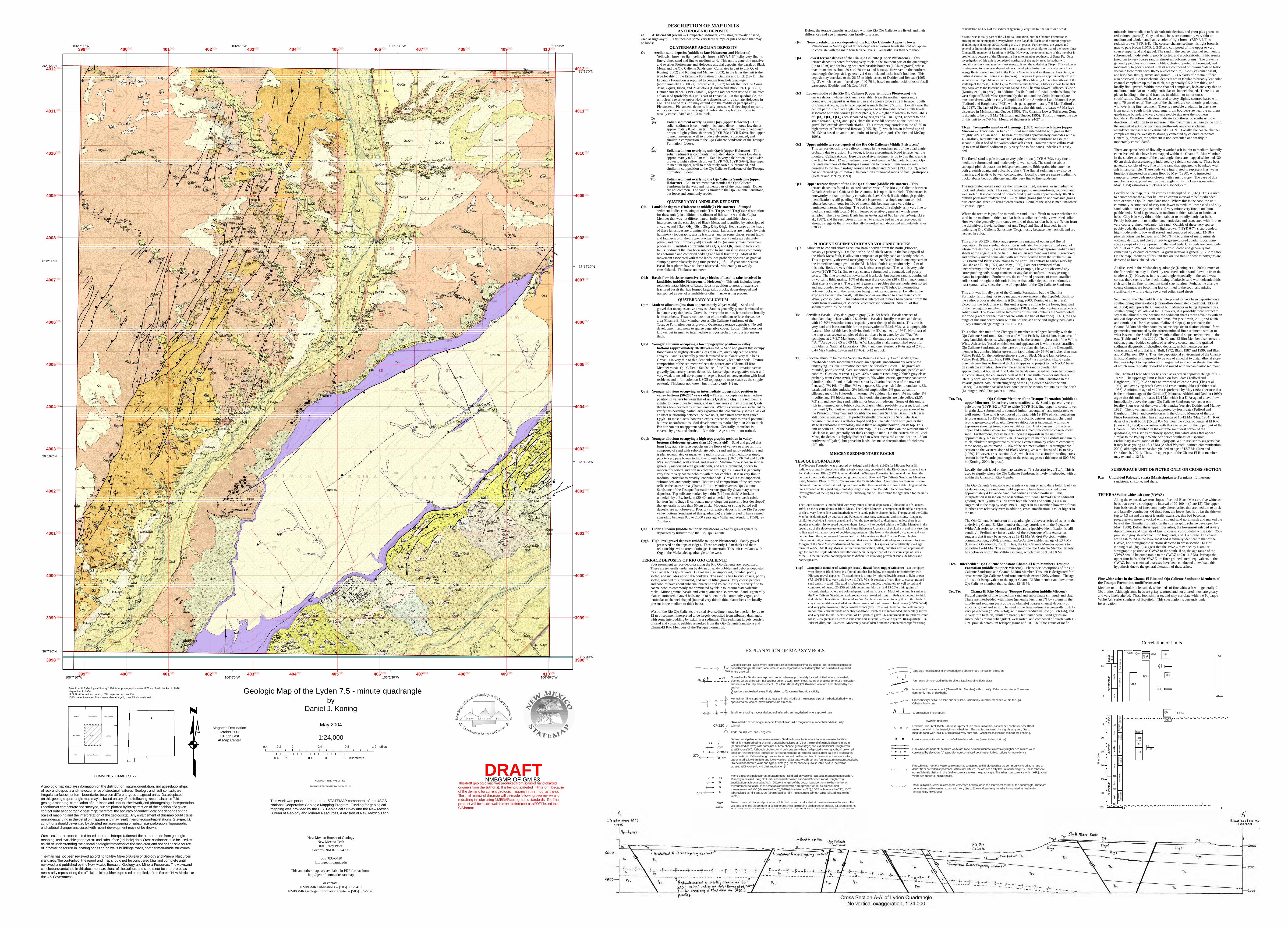
MAPPED TEPHRAS

Fine white ash; generally altered to clay; may contain up to 5% biotites that are commonly altered as to have a dendritic or corroded appearance. Where not altered, the ash has a silty texture and feels gritty. These ashes are not su�ciently distinct in the �eld to correlate across the quadrangle. The ashes may correlate with the Pojoaque White Ash series to the southeast.

Probable Lava Creek B Ash -- This ash is present in a medium to thick, tabular bed continuous for 10s of meters; very thin to laminated, internal bedding. The bed is composed of a slightly ashy very �ne to medium sand, with local 5-10 cm of relatively pure ash. Chemical analyses on this ash are pending.

A Cross-section line endpoint

Interbed of �uvial sediment (Chama-El Rito Member) within the Ojo Caliente sandstone. These are commonly mud or clay beds.

Greenish very �ne to �ne sand and silty sand. Commonly found interbedded within the Ojo Caliente Sandstone.g g

cbcb

Lower coarse white ash bed of the Vallito white ash zone (see unit descriptions).

Fine white ash beds of the Vallito white ash zone; tic marks denote successively higher beds which were correlated by elevation; "u" stands for non-correlated beds; see unit descriptions for more details.

Medium to thick, calcium carbonate-cemented beds found in the southwest corner of the quadrangle. These are generally mixed to varying extent with very �ne to �ne sand, and may be ashy. Interpreted as freshwater limestone by May (1980).

Fault scarps interpreted in the Servilleta Basalt capping Black Mesa.

Landslide head scarp and arrows denoting approximate translation direction.

u

PLIO

C.PL

EIST

OCE

NE

MIO

CEN

EO

LIG

OCE

NE

late

early

Blan

can

Irvin

gton

ian

Hem

phil-

lian

Clar

en-

doni

anBa

rsto

vian

Hem

min

g-fo

rdia

nA

rikar

eean

Ore

llan

Whi

tney

an

mid

dle

late

early

early

5.3

11.2

16.4

23.8

28.5

33.7

0

5

10

15

20

25

30

Tim

e (M

a)

mid

dle

late

HO

LO-

CEN

E

Ranc

hola

brea

n

570

QamQeQayh

Qayi

?

1

Qayl

Qt4

Pennsyl-vanian

285

320

Pzu

Tto

0.01

? ?

Qt3

Qt2

Qt1

Qpl

Qao

Ttci

TtcTtoi

Qtgh

QTa

Tg & TsbQTa

Ttcgf

Ttcge? ?

Correlation of UnitsEXPLANATION OF MAP SYMBOLS

?

70

07-320

Beds that dip less than 2 degrees.

Geologic contact - Solid where exposed; dashed where aproximately located; dotted where concealed beneath younger alluvium, labels immediately adjacent to dots identify the two buried units; queried where uncertain.

Normal fault - Solid where exposed; dashed where approximately located; dotted where concealed; queried where uncertain. Ball and bar are on downthrown block. Number by arrow denotes the location and value of fault dip measurement. JM = faults from May (1980) whech were not �eld checked by the author.

Monocline -- line is approximately located in the middle of the steepest dips of the beds, dashed where approximately located; arrows denote dip direction.

Strike and dip of bedding; number in front of dash is dip magnitude, number behind dash is dip azimuth.

TtoTtbu

Mono-directional paleocurrent measurement - Solid ball on vector is located at measurement location. Primarily measured using clast imbrication (abbreviated as "i") and 3-dimensionall trough cross-strati�cation (abbreviated as "tx"). Di�erent lengths of the vector is proportional to the number of measurements at a site. In the case of clast imbrication, this proportion re�ects bins of clast measurements of: 0-5 (abbreviated as "i"), 5-10 (abbreviated as "2i"), 10-15 (abbreviated as "3i"), 15-20 (abbreviated as "4i"), and20-25 (abbreviated as "5i"). Paleocurrent azimuth value is listed next to the vector.

270

Bi-directional paleocurrent measurement - Solid ball on vector is located at measurement location. Primarily measured using channel trends (abbreviated as "c") or the trend of a single channel margin (abbreviated as "cm"), with some use of basal channel grooves ("gr") and 2-dimensional trough cross-strati�cation ("tx"). Although bi-directional, only one arrow head is depicted showing authors' preferred direction; this preference is based on surrounding mono-directional paleocurrent data and source area considerations. Di�erent lengths of vector is proportional to number of measurements at a site -- top, upper middle, lower middle, and lower vectors re�ect one, two, three, and four measurements, respectively. Paleocurrent azimuth value and type of data (e.g., "c" for channels) is also listed next to the vector.cross-strati�cation (xs), and clast imbrication (i).

270

gr2cm2 cm, tx

3c, cm

Eolian cross-strati�cation dip direction - Solid ball on vector is located at the measurement location. The vectors depict the dip azimuth of eolian foresets that are sloping 20 degrees or greater. Di�erent lengths of the vector is proportional to the number of measurements at a site -- top, upper middle, lower middle, and lower vectors re�ect one, two, three, and four measurements, respectively. The azimuth value is listed next to vector.

tx2i

3i

4i

270

ww

ww

Syncline - showing trace and plunge of inferred crest line; dashed where approximate.

symbol denotes faults very likely related to Quaternary landslide activity.

JM

DESCRIPTION OF MAP UNITSANTHROGENIC DEPOSITS

af Artificial fill (recent) – Compacted sediment, consisting primarily of sand, used as highway fill. This includes some very large dumps or piles of sand that may be looose.

QUATERNARY AEOLIAN DEPOSITSQe Aeolian sand deposits (middle to late Pleistocene and Holocene) –

Yellowish brown to light yellowish brown (10YR 5-6/4) silty very fine- to fine-grained sand and fine to medium sand. This unit is generally massive and overlies Pleistocene and Holocene alluvial deposits, the basalt of Black Mesa, and the Ojo Caliente Sandstone. Correlates in part to unit Qe of Koning (2002) and Koning and Manley (2003); in the latter the unit is the type locality of the Española Formation of Galusha and Blick (1971). The Española Formation is reported to contain Rancholabrean-age (approximately 10-300 ka; Tedford et al., 1987) fossils that include Canisdirus, Equus, Bison, and ?Camelops (Galusha and Blick, 1971, p. 80-81).Dethier and Reneau (1995, table 1) report a radiocarbon date of 19 ka from eolian sand (probably this unit) east of Española. On this quadrangle, the unit clearly overlies upper Holocene deposits so it is also late Holocene in age. The age of this unit may extend into the middle or perhaps early Pleistocene. Pleistocene deposits locally possess well-developed top soils with calcic horizons (up to stage III carbonate morphology. Loose to weakly consolidated and 1-3 m thick.

QeQayi Eolian sediment overlying unit Qayi (upper Holocene) – The

eolian sediment is commonly in isolated, discontinuous low dunes approximately 0.5-1.0 m tall. Sand is very pale brown to yellowish brown to light yellowish brown (10YR 7/3; 10YR 5-6/4), fine-upper to medium-upper, well to moderately sorted, subrounded, and similar in composition to the Ojo Caliente Sandstone of the Tesuque Formation. Loose.

QeQayh Eolian sediment overlying unit Qayh (upper Holocene) – The

eolian sediment is commonly in isolated, discontinuous low dunes approximately 0.5-1.0 m tall. Sand is very pale brown to yellowish brown to light yellowish brown (10YR 7/3; 10YR 5-6/4), fine-upper to medium-upper, well to moderately sorted, subrounded, and similar in composition to the Ojo Caliente Sandstone of the Tesuque Formation. Loose.

QeTto Eolian sediment overlying the Ojo Caliente Sandstone (upper

Holocene) – Eolian sediment that mantles the Ojo Caliente Sandstone in the west and northeast pats of the quadrangle. Dunes are not common. The sand is similar to the Ojo Caliente Sandstone, but loose and commonly redder.

QUATERNARY LANDSLIDE DEPOSITSQls Landslide deposits (Holocene to middle(?) Pleistocene) – Slumped

sediment bodies consisting of units Tto, Ttcge, and Ttcgf (see descriptions for these units), in addition to sediment of lithosome A and the Cejita Member that was not differentiated. Individual landslide lobes are interpreted on the east slope of Black Mesa, and identified by subscripts of a, c, d, e, and f (i.e., Qlsa, Qlsc, Qlsd, Qlse, Qlsf). Head scarps at the heads of these landslides are prominently arcuate. Landslides are marked by their hummocky topography, tensile fractures, and, in some places, recent faults and fault-scarps in their upper reaches. The recent faults are relatively planar, and most (probably all) are related to Quaternary mass movement processes. Landslides differentiated as Qlsa and Qlsc seem to lack such faults. Sediment that has been subjected to such mass wasting commonly has deformed and contorted bedding and local fracturing. Most of the movement associated with these landslides probably occurred as gradual slumping over relatively long time periods (102 – 104 year time scales).Basal shear planes have not been observed. Moderately to weakly consolidated. Thickness unknown.

Qlsb Basalt flow blocks or extensive, large blocks of basaltic talus involved in landslides (middle Pleistocene to Holocene) – This unit includes large, relatively intact blocks of basalt flows in addition to areas of extensive fractured basalt that has formed large talus blocks; down-dropped and transported as part of a landslide or other mass-wasting process.

QUATERNARY ALLUVIUMQam Modern alluvium (less than approximately 20 years old) – Sand and

gravel that occupies active arroyos. Sand is generally planar-laminated or in planar-very thin beds. Gravel is in very thin to thin, lenticular to broadly lenticular beds. Texture composition of the sediment reflects the source area (Chama-El Rito Member versus Ojo Caliente Sandstone of the Tesuque Formation versus gravelly Quaternary terrace deposits). No soil development, and none to sparse vegetative cover. Loose. Thickness not known, but in small to intermediate arroyos probably only a few meters thick.

Qayl Younger alluvium occupying a low topographic position in valley bottoms (approximately 20-100 years old) – Sand and gravel that occupy floodplains or slightly elevated (less than 2 m) areas adjacent to active arroyos. Sand is generally planar-laminated or in planar-very thin beds. Gravel is in very thin to thin, lenticular to broadly lenticular beds. Texture composition of the sediment reflects the source area (Chama-El Rito Member versus Ojo Caliente Sandstone of the Tesuque Formation versus gravelly Quaternary terrace deposits). Loose. Sparse vegetative cover and very weak to no soil development. Age is based on conversation with local residents and information on USGS topographic maps (such as the stipple pattern). Thickness not known but probably only 1-2 m.

Qayi Younger alluvium occupying an intermediate topographic position in valley bottoms (50-200? years old) – This unit occupies an intermediate position in valleys between that of units Qayh and Qayl. Its sediment is similar to these other two units, and in many areas it may represent Qayhthat has been beveled by stream erosion. Where exposures are sufficient to verify this beveling, particularly exposures that conclusively show a lack of an inset relationship between the two units, such units were then called Qayh. In most places, however, exposures are too poor to reveal potential buttress unconformities. Soil development is marked by a 10-20 cm thick Bw horizon but no apparent calcic horizon. Generally its surface is covered by grass and shrubs. 1-3 m thick. Age not well-constrained.

Qayh Younger alluvium occupying a high topographic position in valley bottoms (Holocene, greater than 100 years old) – Sand and gravel that form low, stable terrace deposits on the floors of valleys or arroyos. It is composed of sand with subordinate pebbly sand and sandy pebbles. Sand is planar-laminated or massive. Sand is mostly fine to medium-grained, pink to very pale brown to light yellowish brown (10-7.5YR 7/4 and 10YR 6/4), subrounded, well sorted, and arkosic. Medium to very coarse sand is generally associated with gravely beds, and are subrounded, poorly to moderately sorted, and rich in volcanic lithic grains. Gravel is generally very fine to very coarse pebbles with minor cobbles. It is in very thin to medium, lenticular to broadly lenticular beds. Gravel is clast-supported, subrounded, and poorly sorted. Texture and composition of the sediment reflects the source area (Chama-El Rito Member versus Ojo Caliente Sandstone of the Tesuque Formation versus gravelly Quaternary terrace deposits). Top soils are marked by a thin (5-10 cm-thick) A horizon underlain by a Bw horizon (20-40 cm) underlain by a very weak calcic horizon (up to Stage II carbonate morphology but generally less developed) that generally is less than 50 cm thick. Moderate or strong buried soil deposits are not observed. Possibly correlative deposits in the Rio Tesuque valley bottom (southeast of this quadrangle) are interpreted to have ceased aggrading between 800 to 2,000 years ago (Miller and Wendorf, 1958). 2-7 m thick.

Qao Older alluvium (middle to upper Pleistocene) – Sandy gravel generally deposited by tributaries to the Rio Ojo Caliente.

Qtgh High-level gravel deposits (middle to upper Pleistocene) – Sandy gravel preserved on the tops of ridges. These are only 1-2 m thick and their relationships with current drainages is uncertain. This unit correlates with Qtg in the Medanales quadrangle to the west.

TERRACE DEPOSITS OF RIO OJO CALIENTE Four prominent terrace deposits along the Rio Ojo Caliente are recognized.These are generally underlain by 4-6 m of sandy cobbles and pebbles deposited by an axial Rio Ojo Caliente. Gravel are clast-supported, rounded, poorly sorted, and includes up to 10% boulders. The sand is fine to very coarse, poorly sorted, rounded to subrounded, and rich in lithic grains. Very coarse pebbles and cobbles have about subequal quartzite and volcanic clasts, but very fine to coarse pebbles commonly are dominated by felsic to intermediate volcanic rocks. Minor granite, basalt, and vein quartz are also present. Sand is generally planar-laminated. Gravel beds are up to 50 cm thick, commonly vague, and lenticular to channel-shaped (internal very thin to thin, planar beds are locally present in the medium to thick beds).

West of the Rio Ojo Caliente, the axial river sediment may be overlain by up to 12 m of sediment interpreted to be largely deposited from tributary drainages, with some interbedding by axial river sediment. This sediment largely consists of sand and volcanic pebbles reworked from the Ojo Caliente Sandstone and Chama-El Rito Members of the Tesuque Formation.

Below, the terrace deposits associated with the Rio Ojo Caliente are listed, and their differences and age interpretations briefly discussed.

Qtu Non-correlated terrace deposits of the Rio Ojo Caliente (Upper to lower Pleistocene) – Sandy gravel terrace deposits at various levels that did not appear to correlate with the main four terrace levels. Generally less than 5 m thick.

Qt4 Lowest terrace deposit of the Rio Ojo Caliente (Upper Pleistocene) – Thisterrace deposit is noted for being very thick in the southern part of the quadrangle (up to 18 m) and for having scattered basaltic boulders (1-3% of gravel) whose maximum size is about 80 x 40-70 cm (a and b axes). However, in the northern quadrangle the deposit is generally 4-6 m thick and lacks basalt boulders. This deposit may correlate to the 26-35 m-high terrace of Dethier and Reneau (1995, fig. 2), which has an inferred age of 40-70 ka based on amino-acid ratios of fossil gastropods (Dethier and McCoy, 1993).

Qt3 Lower-middle of the Rio Ojo Caliente (Upper to middle Pleistocene) – A terrace deposit whose thickness is variable. Near the northern quadrangle boundary, the deposit is as thin as 3 m and appears to be a strath terrace. South of Cañada Abeque, the terrace deposit is much thicker (7-15 m). Locally near the central part of the quadrangle, there appears to be three distinctive strath levels associated with this terrace (subscripted a, b, c – higher to lower – to form labels of Qt3a, Qt3b, Qt3c) each separated by heights of 4-6 m. Qtc3a appears to be a strath terrace. Qtc3b and Qtc3c share the same fill because at one location a gravel bed extends over both straths. This terrace may correlate to the 43-50 m-high terrace of Dethier and Reneau (1995, fig. 2), which has an inferred age of 70-130 ka based on amino-acid ratios of fossil gastropods (Dethier and McCoy, 1993).

Qt2 Upper-middle terrace deposit of the Rio Ojo Caliente (Middle Pleistocene) –This terrace deposit is very discontinuous in the southern part of the quadrangle, probably due to erosion. However, it forms a prominent, broad terrace near the mouth of Cañada Ancha. Here the axial river sediment is up to 6 m thick, and is overlain by about 12 m of sediment reworked from the Chama-El Rito and Ojo Caliente members of the Tesuque Formation to the west. This terrace may correlate to the 82-93 m-high terrace of Dethier and Reneau (1995, fig. 2), which has an inferred age of 250-400 ka based on amino-acid ratios of fossil gastropods (Dethier and McCoy, 1993).

Qt1 Upper terrace deposit of the Rio Ojo Caliente (Middle Pleistocene) – This terrace deposit is found in isolated patches west of the Rio Ojo Caliente between Cañada Ancha and Cañada de los Alamos. It is up to 18 m thick. This terrace is noteworthy in that it probably contains the Lava Creek B ash, although positive identification is still pending. This ash is present in a single medium to thick, tabular bed continuous for 10s of meters; this bed may have very thin to laminated, internal bedding. The bed is composed of a slightly ashy very fine to medium sand, with local 5-10 cm lenses of relatively pure ash which were sampled. The Lava Creek B ash has an Ar-Ar age of 620 ka (Sarna-Wojcicki et al., 1987), and the restriction of this ash to a single bed in the terrace deposit strongly suggests that it was fluvially reworked and deposited immediately after 620 ka.

PLIOCENE SEDIMENTARY AND VOLCANIC ROCKSQTa Alluvium below and above Servilleta Basalt derived from the north (Pliocene,

possibly Quaternary) – On the north side of Black Mesa, in the hangingwall of the Black Mesa fault, is alluvium composed of pebbly sand and sandy pebbles.This is generally observed overlying the Servilleta Basalt, but in one exposure in the immediate hangingwall of the Black Mesa fault is approximately 4-7 m of this unit. Beds are very thin to thin, lenticular to planar. The sand is very pale brown (10YR 7/2-3), fine to very coarse, subrounded to rounded, and poorly sorted. The fine to medium-lower sand is arkosic, but coarser sand is dominated by volcanic lithic grains. 10% of the gravel are cobbles (20 x 15 cm maxiumum clast size, a x b axes). The gravel is generally pebbles that are moderately sorted and subrounded to rounded. These pebbles are >95% felsic to intermediate volcanic rocks, with the remainder being quartzite and granite. Locally in the exposure beneath the basalt, half the pebbles are altered to a yellowish color. Weakly consolidated. This sediment is interpreted to have been derived from the north from reworking of Miocene volcaniclastic sediment. About 9 of this sediment overlies the basalt.

Tsb Servilleta Basalt – Very dark gray to gray (N 3/- 5/) basalt. Basalt consists of abundant plagioclase with 1-2% olivine. Basalt is locally massive and dense, with 10-30% vesicular zones (especially near the top of the unit). This unit is very hard and is responsible for the preservation of Black Mesa as a topographic feature. Most of this lava is olivine tholeiite (Dungan et al., 1984). Northeast of the map area, several samples of this unit have been dated by the 40Ar/39Artechnique at 2.7-3.7 Ma (Appelt, 1998). In the study area, one sample gave an 40Ar/39Ar age of 3.65 ± 0.09 Ma (A.W. Laughlin et al., unpublished report for Los Alamos National Laboratory, 1993), and one returned a K-Ar age of 2.78 ± 0.44 Ma (Manley, 1976a and 1976b). 5-12 m thick.

Tg Pliocene alluvium below the Servilleta Basalt – Generally 3 m of sandy gravel, interbedded with subordinate floodplain deposits, unconformably overlie the underlying Tesuque Formation beneath the Servilleta Basalt. The gravel are rounded, poorly sorted, clast-supported, and composed of subequal pebbles and cobbles. Clast count (n=81) gives: 42% quartzite (including 2 bluish gray clasts probably from Cerro Azul), 16% granite, 9% white, coarse, quartzose sandstone (similar to that found in Paleozoic strata by Jicarita Peak east of the town of Penasco), 7% Pilar Phyllite, 7% vein quartz, 5% greenish Paleoic sandstone, 5% basalt and basaltic andesite, 2% foliated amphibolite, 2% gray, aphanitic siliceous rock, 1% Paleozoic limestone, 1% epidote-rich rock, 1% mylonite, 1% rhyolite, and 1% biotite gneiss. The floodplain depsoits are pale yellow (2.5Y 7/3) silt and very fine sand, with minor beds of mudstone. Some of this unit is rich in intermediate to felsic volcanic clasts, which probably represent local input from unit QTa. Unit represents a relatively powerful fluvial system sourced in the Penasco Embayment and possibly the southern San Luis Basin (the latter is still under investigation). It probably shortly pre-dates the Servilleta Basalt because there is not a well-developed soil (i.e., no calcic soil with greater than stage II carbonate morphology nor is there an argillic horizon) on its top. This unit underlies all of the basalt on the map. It is 1-6 m thick on the western rim of Black Mesa, and generally not thick enough to map. On the eastern rim of Black Mesa, the deposit is slightly thicker (7 m where measured at one location 1.5 km northwest of Lyden), but prevelant landslides make determination of thickness difficult.

MIOCENE SEDIMENTARY ROCKS

TESUQUE FORMATIONThe Tesuque Formation was proposed by Spiegel and Baldwin (1963) for Miocene basin fill sediment, primarily pinkish-tan silty arkosic sandstone, deposited in the Rio Grande rift near Santa Fe. Galusha and Blick (1971) later subdivided the Tesuque Formation into several members, the pertinent ones for this quadrangle being the Chama-El Rito, and Ojo Caliente Sandstone Members.Later, Manley (1976a, 1977, 1979) proposed the Cejita Member. Age control for these units were obtained from published dates of tephra found within them in addition to fossil data. In general, the units exposed on this quadrangle probably range in age from 15-5 Ma. Geochronologic investigations of the tephras are currently underway, and will later refine the ages listed for the units below.

The Cejita Member is interbedded with very minor alluvial slope facies (lithosome A of Cavazza, 1986) on the eastern slopes of Black Mesa. The Cejita Member is composed of floodplain deposits of silt to very fine to fine sand interbedded with sandy pebble channel beds. The gravel of the Cejita Member is dominated by quartzite and Paleozoic limestone, sandstone, and siltstone. It appears similar to overlying Pliocene gravel, and often the two are hard to distinguish unless there is an angular unconformity exposed between them. Locally interbedded within the Cejita Member in the upper part of the slope on eastern Black Mesa, lithosome A consists of pinkish silt and silty very fine to fine sand with minor beds of pebble-conglomerate. The latter is dominated by granite, and was derived from the granite-cored Sangre de Cristo Mountains south of Truchas Peaks. In this lithosome A unit, a horse tooth was collected that was identified as dinohyppus mexicanus by Gary Morgan of the New Mexico Museum of Natural History. This species had a relatively short age range of 4.8-5.5 Ma (Gary Morgan, written communication, 2004), and this gives an approximate age for both the Cejita Member and lithosome A on the upper part of the eastern slope of Black Mesa. These units were not mapped due to difficulties involving prevalent landslide blocks and poor exposure.

Ttcgf Cieneguilla member of Leininger (1982), fluvial facies (upper Miocene) – On the upper west slope of Black Mesa is a fluvial unit that lies below the angular unconformity with Pliocene gravel deposits. This sediment is primarily light yellowish brown to light brown (7.5-10YR 6/4) to very pale brown (10YR 7/3). It consists of very fine- to coarse-grained sand and silty sand. The sand is subrounded to rounded, moderately to well sorted, and composed of quartz, 20-25% pinkish potassium feldspar, and 15-20% lithic grains of volcanic detritus, chert and colored quartz, and mafic grains. Much of the sand is similar to the Ojo Caliente Sandstone, and probably was reworked from it. Beds are medium to thick and tabular. In addition to the sand are 5-25% planar-laminated to very thin to thin beds of claystone, mudstone and siltstone; these have a color of brown to light brown (7.5YR 5-6/4) and very pale brown to light yellowish brown (10YR 7/3-6/4). Near Vallito Peak are very minor thin, lenticular beds of pebbly sandstone. Pebbles are subrounded, moderately sorted, and very fine to fine. A clast count of 171 pebbles gave: 26% intermediate to felsic volcanic rocks, 25% greenish Paleozoic sandstone and siltstone, 23% vein quartz, 18% quartzite, 1% Pilar Phyllite, and 1% chert. Moderately consolidated and non-cemented except for strong

cementation of 1-5% of the sediment (generally very fine to fine sandstone beds).

This unit was initially part of the Chamita Formation, but the Chamita Formation is proving not to be mappable everywhere in the Española Basin so the author proposes abandoning it (Koning, 2003; Koning et al., in press). Furthermore, the gravel and general sedimentologic features of this unit appear to be similar to that of the lower, finer Cieneguilla member of Leininger (1982). However, the nomenclature of this member is problematic because of the Cieneguilla Basanite member southwest of Santa Fe. Once investigation of this unit is completed northeast of the study area, the author will probably assign a new member-rank name to it and the underlying Ttcge. This sediment is interpreted to have been deposited on a low-sloping basin floor by a relatively low-energy fluvial system sourced in the Picuris Mountains and southern San Luis Basin, as further discussed in Koning et al. (in press). It appears to project approximately close to an interval of Cejita Member on the west slope Black Mesa (2 km north-northeast of the south tip of the mesa). In the Cejita Member at that location, a black ash was found that may correlate to the lowermost tephra found in the Chamita Lower Tuffaceous Zone (Koning et al., in press). In addition, fossils found in fluvial interbeds along the west slope of Black Mesa (presumably this unit and the Cejita Member) are most consistent with an early Hemphillian North American Land Mammal Age (Tedford and Barghoorn, 1993), which spans approximately 7-9 Ma (Tedford et al., 1987). The lack of Peralta tuff suggests that this unit pre-dates ~ 7 Ma (age discussed in McIntosh and Quade, 1995). The Chamita Lower Tuffaceous Zone is thought to be 8-8.5 Ma (McIntosh and Quade, 1995). Thus, I interpret the age of this unit to be 7-9 Ma. Measured thickness is 24-27 m.

Ttcge Cieneguilla member of Leininger (1982), eolian-rich facies (upper Miocene) – Thick, tabular beds of fluvial sand interbedded with greater than roughly 20% eolian sand. The base of this unit approximately coincides with a 1-2 m-thick, laterally extensive bed of ashy very fine sandstone to ash (the second-highest bed of the Vallito white ash zone). However, near Vallito Peak up to 4 m of fluvial sediment (silty very fine to fine sand) underlies this ashy bed.

The fluvial sand is pale brown to very pale brown (10YR 6-7/3), very fine to medium, subrounded, and moderately to well sorted. The sand has about subequal pinkish potassium feldspar compared to lithic grains (the latter has both greenish quartz and volcanic grains). The fluvial sediment may also be massive, and tends to be well consolidated. Locally, there are sparse medium to thick, tabular beds of siltstone and silty very fine to fine sandstone.

The interpreted eolian sand is either cross-stratified, massive, or in medium to thick and tabular beds. This sand is fine-upper to medium-lower, rounded, and well sorted. It is composed of non-colored quartz with approximately 10-20% pinkish potassium feldspar and 10-20% lithic grains (mafic and volcanic grains plus chert and green- to red-colored quartz). Some of the sand is medium-lower to coarse-upper.

Where the texture is just fine to medium sand, it is difficult to assess whether the sand in the medium to thick, tabular beds is eolian or fluvially reworked eolian.However, the generally pure sandy texture of these tabular beds is different from the definitively fluvial sediment of unit Ttcgf and fluvial interbeds in the underlying Ojo Caliente Sandstone (Ttci), mostly because they lack silt and are less red in color.

This unit is 90-120 m thick and represents a mixing of eolian and fluvial deposition. Primary eolian deposition is indicated by cross-stratified sand, of whose foresets mostly face east, but the tabular beds may represent eolian sand sheets at the edge of a dune field. This eolian sediment was fluvially reworked and probably mixed somewhat with sediment derived from the southern San Luis Basin and Picuris Mountains to the north. In contrast to earlier work by Galusha and Blick (1971) and May (1980), I am not convinced of an unconformity at the base of the unit. For example, I have not observed any corresponding soils, sharp contacts, or angular unconformities suggesting a hiatus in deposition. Furthermore, the confirmed presence of cross-stratified eolian sand throughout this unit indicates that eolian deposition continued, at least sporadically, since the time of deposition of the Ojo Caliente Sandstone.

This unit was initially part of the Chamita Formation, but the Chamita Formation is proving not to be mappable everywhere in the Española Basin so the author proposes abandoning it (Koning, 2003; Koning et al., in press).Except for the lack of gravel, this unit is grossly similar to the lower, finer part of the Cieneguilla member of Leininger (1982), which also contains interbeds of eolian sand. The lower half to two-thirds of this unit contains the Vallito white ash zone (except for the lower coarse white ash bed of this zone). Thus, the age range of this unit corresponds with that of this ash zone and slightly post-dates it. My estimated age range is 8.5-11.7 Ma.

This eolian-rich unit of the Cieneguilla member interfingers laterally with the Ojo Caliente Sandstone. Southwest of Vallito Peak by 4.0-4.1 km, in an area of many landslide deposits, what appears to be the second-highest ash of the Vallito White Ash series (based on thickness and appearance) is within cross-stratified Ojo Caliente Sandstone and the base of the eolian-rich beds of the Cieneguilla member has climbed higher up-section (approximately 65-70 m higher than near Vallito Peak). On the north-northwest slope of Black Mesa 6 km northeast of Vallito Peak (Plate 12; May, 1980, Koning, 2004), a 2 m-thick, slightly ashy, greenish very fine to fine sand thick ash appears to project to the VWAZ based on available attitudes. However, here this ashy sand is overlain by approximately 40-50 m of Ojo Caliente Sandstone. Based on these field-based ash correlations, the eolian-rich beds of the Cieneguilla member interfinger laterally with, and perhaps downwind of, the Ojo Caliente Sandstone in the Velarde graben. Similar interfingering of the Ojo Caliente Sandstone and Cieneguilla member has also been noted near the Picuris Mountains to the north (Leininger, 1982; Dungan et al., 1984.

Tto, Ttoi Ojo Caliente Member of the Tesuque Formation (middle to upper Miocene) –Extensively cross-stratified sand. Sand is generally very pale brown (10YR 8/2 to 7/3) to white (10YR 8/1), fine-upper to coarse-lower in grain size, subrounded to rounded (minor subangular), and moderately to well sorted. The sand is composed of quartz with 12-18% pinkish potassium feldspar grains, 10-15% lithic grains of volcanic detritus, mafics, chert and red- to green-colored quartz. Cross-stratification is tangential, with some exposures showing trough-cross-stratification. Unit coarsens from a fine-upper and medium-lower sand upwards to a medium-lower to coarse-lower sand. Furthermore, foreset heights increase upwards in the unit from approximately 1-2 m to over 7 m. Lower part of member exhibits medium to thick, tabular to irregular zones of strong cementation by calcium carbonate; these occupy an estimated 1-10% of the sediment volume. A stratigraphic section on the western slope of Black Mesa gives a thickness of 210 m May (1980). However, cross-section A-A’, which ties into a similar-trending cross-section in the Velarde quadrangle to the east, suggests a thickness of 500-530 m (Koning, 2004, in press).

Locally, the unit label on the map carries an "i" subscript (e.g., Ttoi). This is used to signify where the Ojo Caliente Sandstone is likely interbedded with or within the Chama-El Rito Member.

The Ojo Caliente Sandstone represents a vast erg or sand dune field. Early in its deposition, the sand dune field appears to have been restricted to an approximately 4 km-wide band that perhaps trended northeast. This interpretation is based on the observation of fluvial Chama-El Rito sediment grading laterally into this unit from both the north and south (as is also suggested in the map by May, 1980). Higher in this member, however, fluvial interbeds are relatively rare; in addition, cross-stratification is taller higher in the unit.

The Ojo Caliente Member on this quadrangle is above a series of ashes in the underlying Chama-El Rito member that may correlate with the Pojoaque White Ash series to the southeast of Espanola (positive identification is still pending). Preliminary investigation of the Pojoqaque White Ash series suggests that it may be as young as 13-12 Ma (Andrei Wojcicki, written communication,, 2004), although an Ar-Ar date yielded an age of 13.7 Ma (Izett and Obradovich, 2001). Thus, the Ojo Caliente Member appears to post-date 12-14 Ma. The minimum age of the Ojo Caliente Member largely lies below or within the Vallito ash zone, which may be 9.0-11.8 Ma.

Ttco Interbedded Ojo Caliente Sandstone Chama-El Rito Member), Tesuque Formation (middle to upper Miocene) – Please see descriptions of the Ojo Caliente Sandstone and Chama-El Rito Member. This unit is designated for areas where Ojo Caliente Sandstone interbeds exceed 20% volume. The age of this unit is equivalent to the upper Chama-El Rito member and lowermost Ojo Caliente member, that is, about 13-15 Ma.

Ttc, Ttci – )enecoiM elddim( noitamroF euquseT ,rebmeM otiR lE-amahC Fluvial deposits of fine to medium sand and subordinate silt, mud, and clay. These are interbedded with minor (generally less than 5% by volume in the middle and southern parts of the quadrangle) coarser channel deposits of volcanic gravel and sand. The sand in the finer sediment is generally pink to very pale brown (7.5YR 7/3-4), with minor reddish yellow (7.5YR 6/6), and in very thin to thick, tabular to broadly lenticular beds. Sand grains are subrounded (minor subangular), well sorted, and composed of quartz with 15-25% pinkish potassium feldspar grains and 10-15% lithic grains of mafic

minerals, intermediate to felsic volcanic detritus, and chert plus green- to red-colored quartz(?). Clay and mud beds are commonly very thin to medium and tabular, and have a color of light brown (7.5YR 6/4) to reddish brown (5YR 5/4). The coarser channel sediment is light brownish gray to pale brown (10YR 6/ 2-3) and composed of fine-upper to very coarse-upper sand and gravel. The sand in the coarser channel sediment is subrounded, moderately to poorly sorted, and a volcanic-rich lithic arenite (medium to very coarse sand is almost all volcanic grains). The gravel is generally pebbles with minor cobbles, clast-supported, subrounded, and moderately to poorly sorted. Clasts are composed of intermediate to felsic volcanic flow rocks with 10-25% volcanic tuff, 0.5-5% vesicular basalt, and less than 10% quartzite and granite. 1-3% clasts of Amalia tuff are also observed. Coarser channel deposits are in tabular to broadly lenticular channel complexes up to 5 m thick, but generally 0.5-2.0 m thick, and locally fine-upward. Within these channel complexes, beds are very thin to medium, lenticular to broadly lenticular to channel-shaped. There is also planar-bedding in the sand fraction, in addition to minor cross-stratification. Channels have scoured to very slightly scoured bases with up to 70 cm of relief. The tops of the channels are commonly gradational with overlying finer sediment. There is a notable gradation in clast size from north to south in this quadrange: from boulder-size near the northern quadrangle boundary to very coarse pebble size near the southern boundary. Paleoflow indicators indicate a southwest to southeast flow direction. In addition to an increase in the maximum clast size to the north, the amount of siltstone decreases northwards and coarse channel abundance increases to an estimated 10-15%. Locally, the coarse channel complexes may be weakly to strongly cemented by calcium carbonate. Generally, however, the sediment is non-cemented and weakly to moderately consolidated.

There are sparse beds of fluvially reworked ash in thin to medium, laterally extensive beds that have been mapped within the Chama-El Rito Member. In the southwest corner of the quadrangle, there are mapped white beds 30-60 cm thick that are strongly indurated by calcium carbonate. These beds generally consist of very fine to fine sand that appeared to be mixed with ash in hand-sample. These beds were interpreted to represent freshwater limestone deposited on a basin floor by May (1980), who inspected samples of these beds more closely with a microscope. The base of this member is not exposed on this quadrangle, so its thickness is uncertain.May (1984) estimates a thickness of 450-550(?) m.

Locally on the map, this unit carries a subscript of "i" (Ttci). This is used to denote where the author believes a certain interval to be interbedded with or within Ojo Caliente Sandstone. Where this is the case, the unit commonly is composed of very fine-lower to medium-lower sand and silty sand, with minor claystone beds and very minor very fine to medium pebble beds. Sand is generally in medium to thick, tabular to lenticular beds. Clay is in very thin to thick, tabular to broadly lenticular beds.Pebbly beds are thin to medium and lenticular, and associated with fine- to very coarse-grained, volcanic-rich sand. Outside of these very sparse pebbly beds, the sand is pink to light brown (7.5YR 6-7/4), subrounded, high-moderately to low-well sorted, and composed of quartz, 12-18% pinkish potassium feldspar, and 10-15% lithic grains of mafic minerals, volcanic detritus, and chert or red- to green-colored quartz. Local mm-scale rip-ups of clay are present in the sand beds. Clay beds are commonly 5YR 5/4 or 7.5YR 6/4. Moderately consolidated and generally not cemented by calcium carbonate. A given interval is generally 1-12 m thick. On the map, interbeds of this unit that are too thin to show as polygons are depicted as lines labeled "cb."

As discussed in the Medanales quadrangle (Koning et al., 2004), much of the fine sediment may be fluvially reworked eolian sand blown in from the southwest(?). However, in this quadrangle, especially in the southwest corner, there seems to be much mixing of arkosic sand with volcanic lithic-rich sand in the fine- to medium-sand-size fraction. Perhaps the discrete coarse channels are becoming less confined to the south and mixing significantly with fluvially reworked eolian sand sheets.

Sediment of the Chama-El Rito is interpreted to have been deposited on a south-sloping alluvial-slope (stream-flow dominated) piedmont. Ekas et al. (1984) intereprets the Chama-el Rito Member as being deposited on a south-sloping distal alluvial fan. However, it is probably more correct to say distal alluvial slope because the sediment shares more affinities with an alluvial slope compared with an alluvial fan (see Smith, 2001, and Kuhle and Smith, 2001 for discussion of alluvial slopes). In particular, the Chama-El Rito Member contains coarse deposits in distinct channel-form geometries surrounded by the aforementioned finer sediment, similar to what is seen in the Skull Ridge Member alluvial slope environment to the east (Kuhle and Smith, 2001). The Chama-El Rito Member also lacks the tabular, planar-bedded couplets of relatively coarse- and fine-grained sediment diagnostic of sheetflood deposits, which themselves are characteristic of alluvial fans (Bull, 1972; Blair, 1987 and 1999; and Blair and McPherson, 1994). Thus, the depositional environment of the Chama-El Rito Member is interpreted to be one of a medial to distal alluvial slope that was subject to deposition of fine-grained sand eolian sheets, the latter of which were fluvially reworked and mixed with volcaniclastic sediment.

The Chama-El Rito Member has been assigned an approximate age of 11-18 Ma. The upper age limit is based on fossil data (Tedford and Barghoorn, 1993), K-Ar dates on reworked volcanic clasts (Ekas et al., 1984), and overlying basalt flows and cross-cutting dikes (Dethier et al., 1986). A minimum age of ~12 Ma is preferred by May (1984) because that is the minimum age of the Cordito(?) Member. Aldrich and Dethier (1990) argue that this unit pre-dates 12.4 Ma, which is a K-Ar age of a lava flow immediately above the upper Ojo Caliente Sandstone contact at one locality 3 km west of the town of Hernandez (see also Dethier and Manley, 1985). The lower age limit is supported by fossil data (Tedford and Barghoorn, 1993) and correlation with the Cordito Member of the Los Pinos Formation, which has an age range of 18-12 Ma (May, 1984). K-Ar dates of a basalt bomb (15.3 ± 0.4 Ma) near the volcanic center at El Rito (Ekas et al., 1984) is consistent with this age range. In the upper part of the Chama-El Rito Member, in the extreme southwest corner of the quadrangle, are a series of closely spaced, fine white ashes that appear similar to the Pojoaque White Ash series southeast of Española. Preliminary investigation of the Pojoqaque White Ash series suggests that it may be as young as 13-12 Ma (Andrei Wojcicki, written communication,, 2004), although an Ar-Ar date yielded an age of 13.7 Ma (Izett and Obradovich, 2001). Thus, the upper part of the Chama-El Rito member may extend to 12 Ma.

SUBSURFACE UNIT DEPICTED ONLY ON CROSS-SECTION

Pzu Undivided Paleozoic strata (Mississippian to Permian) – Limestone, sandstone, siltstone, and shale.

TEPHRASVallito white ash zone (VWAZ)Along the exposed, western slopes of central Black Mesa are five white ash beds that cover a stratigraphic interval of 90-100 m (Plate 12). The upper four beds consist of fine, commonly altered ashes that are medium to thick and laterally continuous. Of these four, the lowest bed is by far the thickest (up to 4.3 m) and the most laterally extensive; this bed becomes progressively more reworked with silt and sand northwards and marked the base of the Chamita Formation in the stratigraphic scheme developed by May (1980). Below these upper four ashes, the lowermost ash bed is very discontinuous and consists of fine to coarse, consolidated white ash, ~ 25% pinkish to grayish volcanic lithic fragments, and 3% biotite. The coarse white ash found in the lowermost bed is visually identical to that of the CWAZ, and stratigraphic relations depicted in cross-section D-D’ of Koning et al. (fig. 3) suggest that the VWAZ may occupy a similar stratigraphic position as CWAZ to the south. If so, the age range of the VWAZ would be comparable to the CWAZ at 9.0-11.8 Ma. Perhaps the upper four beds of the VWAZ are finer-grained lateral equivalents to the CWAZ, but no chemical analyses have been conducted to evaluate this hypothesis due to the general alteration of these ashes.

Fine white ashes in the Chama-El Rito and Ojo Caliente Sandstone Members of the Tesuque Formation, undifferentiated Medium to thick, tabular to lensoidal, white beds of fine white ash with generally 0-3% biotite. Although some beds are gritty-textured and not altered, most are greasy and very likely altered. These look similar to, and may correlate with, the Pojoaque White Ash series southeast of Española. This speculation is currently under investigation.