Embed Size (px)
Citation preview

GROUND ROBOTICS RESEARCH CENTER
UNIVERSITY OF MICHIGAN 2350 HAYWARD STREET 2250 G.G. BROWN ANN ARBOR, MI 48109-2125 PHONE: 734 936-0378 FAX 734 763-5700
http://grrc.engin.umich.edu/
1
GRRC Technical Report 2009-03
Detection and Avoidance of Pedestrians:
Review of Existing Literature
Author: Rachael Bis
Advisors: Prof. Huei Peng
Prof. Galip Ulsoy
Date of completion: April 27, 2009

-2-
-3-
Table of Contents
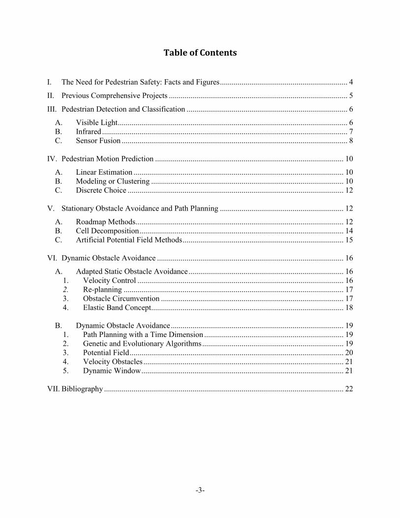
I. The Need for Pedestrian Safety: Facts and Figures ................................................................. 4
II. Previous Comprehensive Projects ........................................................................................... 5
III. Pedestrian Detection and Classification .................................................................................. 6
A. Visible Light ..................................................................................................................... 6 B. Infrared ............................................................................................................................. 7
C. Sensor Fusion ................................................................................................................... 8
IV. Pedestrian Motion Prediction ................................................................................................ 10
A. Linear Estimation ........................................................................................................... 10
B. Modeling or Clustering .................................................................................................. 10 C. Discrete Choice .............................................................................................................. 12
V. Stationary Obstacle Avoidance and Path Planning ............................................................... 12
A. Roadmap Methods.......................................................................................................... 12 B. Cell Decomposition ........................................................................................................ 14 C. Artificial Potential Field Methods .................................................................................. 15
VI. Dynamic Obstacle Avoidance ............................................................................................... 16
A. Adapted Static Obstacle Avoidance ............................................................................... 16 1. Velocity Control ......................................................................................................... 16
2. Re-planning ................................................................................................................ 17 3. Obstacle Circumvention ............................................................................................. 17
4. Elastic Band Concept.................................................................................................. 18
B. Dynamic Obstacle Avoidance ........................................................................................ 19 1. Path Planning with a Time Dimension ....................................................................... 19
2. Genetic and Evolutionary Algorithms ........................................................................ 19 3. Potential Field ............................................................................................................. 20 4. Velocity Obstacles ...................................................................................................... 21 5. Dynamic Window ....................................................................................................... 21
VII. Bibliography .......................................................................................................................... 22

-4-
I. The Need for Pedestrian Safety: Facts and Figures
In the United States in 2006 a total of 4,784 pedestrians were killed in traffic accidents.
Because a larger percentage of Americans use private vehicles than walk, or use public
transportation, compared to people in many countries in the European Union and around the
world, less attention is given in the U.S. to pedestrian safety than in these more pedestrian-
friendly countries. In addition, though numerous efforts have been made to improve vehicle
passenger safety (air bags, crumple zones, etc.), little has been done to protect pedestrians. A few
luxury vehicles boast infrared cameras to help the driver detect deer and pedestrians on dark
roads, but these cameras do nothing to actively avoid a collision. Sensors such as rear view
cameras and ultrasound devices may alert a driver to a pedestrian behind the vehicle, but the vast
majority of pedestrian collisions occur when the vehicle is moving forward, so such
improvements do little to improve pedestrian safety. While pedestrians were involved in just
over 1% of all traffic accidents in 2006, these vulnerable road users accounted for over 12% of
all traffic fatalities.
Most of the accidents in which pedestrians were involved took place at night in urban
areas under normal weather conditions. In almost half of all fatal pedestrian crashes alcohol was
involved, usually on the part of the pedestrian. [1]
Motor vehicle collisions are the leading cause of fatal accidents and one of the leading
causes of non-fatal (but still damage or injury causing) accidents in the Army. Although the
Army is making a decided effort to decrease the number of fatalities from traffic mishaps, 65%
of accident-related Army fatalities were still from driving accidents in 2006. Under the
assumption that the same percentage of these accidents involves pedestrians as in civilian
statistics, increased pedestrian safety would greatly benefit the Army and save the lives of many
soldiers. [2]
A much larger percentage of traffic accidents in Europe and other nations involve
pedestrians than in the United States. This is unsurprising given the greater percentage of
pedestrians in many other countries, especially low income countries, compared to most of the
US. The World Bank reports that globally, more than 0.76 million pedestrians are killed in traffic
accidents each year, 35% of which are children. [3]

-5-
These statistics show the dire need to increase pedestrian safety, but also point to the
specific scenarios (e.g. at night in urban areas) where targeted pedestrian safety improvements
would benefit the most people.
II. Previous Comprehensive Projects
From 2000 until 2005, the European Union partnered with industry to fund vulnerable
road user (VRU) protection projects. The first project, Preventive Safety for Unprotected Road
Users (PROTECTOR), took place from 2000 until 2003. The focus of this project was to develop
visible light based pedestrian detection systems that could asses risk and, if necessary, alert the
driver. The project used a system based approach to locate and identify pedestrians, track them
and determine the risk of a collision. One notable aspect of this project was the use of over forty
minutes of real-world traffic video to test the algorithms. While the researches admit that
considerably more work needs to be done on the system, they did make many technological
gains [4].
PROTECTOR‘s successor, Sensors and System Architecture for Vulnerable Road Users
Protection (SAVE-U) 2002-2005, built on some of the research from PROTECTOR but greatly
enhanced the pedestrian detection and tracking system by adding a network of radar sensors and
an infrared camera to the visible light sensor. The SAVE -U system uses multi-level sensor
fusion in order to initially reduce the amount of image processing necessary by identifying
regions of interest (ROIs) with the radar and, later the sensor fusion produces data to positively
identify VRUs for tracking and characteristic determination. [5]
Finally, the DARPA sponsored Grand and Urban Challenges have spurred the production
of a number of practical tools for autonomous vehicle navigation and control. The Urban
Challenge, in particular, required the development of autonomous vehicles that could follow
traffic laws, interact safely and correctly with other vehicles and navigate in an urban
environment in the same manner that a human driver would. While this challenge did not directly
involve any sort of pedestrian avoidance or protection, the technology that was developed is a
very good compliment to a pedestrian protection system. [6]

-6-
III. Pedestrian Detection and Classification
Researchers have developed an astonishing number of methods for pedestrian detection
that use different sensors (or sets of sensors) with varying degrees of success. The most common
methods are to use either visible light or infrared sensors – alone or in stereo pairs – or to pair
light sensors with a range finder, such as RADAR, sonar or a laser scanner.
A. Visible Light
Visible light appears to be a logical method for pedestrian detection. Such cameras are
common, relatively inexpensive and visible light is the means by which a human driver would
detect and avoid pedestrians. However, extracting information from the images can be a
complex, time consuming and inexact task and, although many methods for detecting pedestrians
have been developed, no single method stands out as superior under all conditions.
Locating pedestrians based on the unique shape or features of a human is widespread
method of pedestrian detection. Papageorgiou and Poggio [7] use Haar wavelet features
classified via a Support Vector Machine (SVM) to locate faces, people and cars in visible light
images. Their system was integrated with a stereo obstacle detection system for use with the
DaimlerChrysler Urban Traffic Assistant (UTA). While this system was able to detect
pedestrians with 90% accuracy and a low false positive rate, it has a relatively slow operating
speed as the entire image must be searched. This technique combined with another sensor (that
could locate ROIs, described later) would be faster and possibly even more accurate. Havasi et al
[8] use the symmetry of human legs to locate humans in an image with a 96.5% classification
rate. However, if only a single camera is available, the accuracy of this technique will be
compromised as it is unable to detect people who are moving directly towards the camera or
whose legs are obscured by garments or bags. Abramson and Steux [9] use the diagonal
orientation of human legs to find people in a single image, albeit with a higher rate of false
positives then Havasi et al or Papageorgiou and Poggio.
Another common technique is to use the stereo disparity in the visible light images from
two cameras to locate pedestrians. Gandhi and Trivedi [10] use a pair of omni directional

-7-
cameras to locate obstacles in front of and to the side of a vehicle. Grubb et al [11] use stereo
vision to locate obstacles and then obstacle size and SVMs to classify the obstacles as
pedestrians. With careful calibration between the two cameras, both of these techniques can
greatly reduce processing time needed to find pedestrians in a scene.
Finally, some researches have used the periodic motion of a pedestrians gait to identify
the pedestrian. Niyogi and Adelson [12] look for a characteristic ―braided‖ pattern from the
movement of humans, from this they can identify individuals based on their distinctive gait.
Cutler and Davis [13] use periodic motion to classify moving objects from both static and
moving cameras. For a calibrated camera, this technique could be used to determine the speed at
which a pedestrian is moving which would be useful when avoiding collisions.
Once a potential pedestrian is located in an image, most researches use additional
algorithms to verify the nature of the potential pedestrians. Munder and Gavrila [14] looked at
multiple feature-classifier combinations; comparing Haar Wavelets and local receptive fields
(LRF) as well Support Vector Machines (SVMs), feed-forward networks and k-nearest neighbor
classifiers to find combinations of classifiers that reliably detect pedestrians. They determined
that a combination of SVMs with LRF worked best, though a boosted cascade of Haar Wavelets
produced competitive results at a much lower computational cost.
B. Infrared
Both near and far infrared (NIR and FIR) sensors have been used for pedestrian detection
and classification. Infrared sensors, especially FIR, reduce much of the complexity of visible
light images as they separate warm objects from neutral temperature background clutter. Humans
and the engine blocks of moving vehicles are usually the warmest objects in any environment
likely to be encountered by vehicles. However, under extremely warm conditions, infrared
sensors can lose some to all of their sensing capability as there is little difference between a
human‘s body heat and the background temperature.
Infrared sensors are superior to visible light cameras when operating at night or under
other low light conditions. FIR requires no illumination and the generally cooler nighttime
temperatures increase the contrast between a warm human and the background environment. FIR
also does not get ‗dazzled‘ or washed out by approaching head lights or other sudden change in
lighting the way human eyes or visible light cameras do. While infrared cameras are usually

-8-
more expensive then visible light cameras the cost has decreased considerably over the years, to
the point that some luxury vehicles are starting to offer FIR imaging [15].
One common method of pedestrian detection with infrared cameras is by human shape
recognition. Broggi et al [16] use a single frame from an infrared camera to locate pedestrians by
looking for symmetric, warm shapes with certain aspect ratios and comparing the shapes to 3D
models. The author‘s are able to speed up processing time by ignoring pedestrians in the
background of an image if a pedestrian has already been detected in the foreground of that same
region. However, this system is not able to detect pedestrians that are not in one of the modeled
orientations, which, without a completely comprehensive model library, will limit the systems
ability to detect pedestrians. Xu et al [17] use SVM to locate pedestrian‘s heads or bodies in the
images from a single night vision camera. They then track the pedestrian using mean shift
tracking and Kalman filter prediction. The flexibility of detecting either heads or bodies helps to
lessen the error that can be caused by pedestrians wearing insulated clothing which changes the
shape of a pedestrian ―hot spot‖ in an infrared image. Meis et al [18] use simple pixel
classification for head detection in addition to body classification in order to improve precision.
The majority of undetected pedestrians are missed because the pedestrian is so far away that the
head is too small for detection. Given that a pedestrian at such a distance is probably not in
immediate danger, this failure is probably preferable to a high rate of false positives.
Another method that is becoming more common is to detect pedestrians in infrared
videos by locating motion that is inconsistent with the background. Liu and Fujimura [19] use
stereo infrared cameras to detect obstacles and then examine motion that is independent from the
background in order to classify obstacles as pedestrians. This method could be combined with
the more traditional shape/texture based detection for better pedestrian identification.
C. Sensor Fusion
Sensor fusion has been used frequently and with a great deal of success. The combination
of sensors that collect data from different spectrums is usually able to locate pedestrians more
consistently, accurately and with significantly less computational cost then a single type of
sensor. The combinations of sensors increase the equipment cost but greatly enhance that
reliability of a system. Almost every autonomous vehicle that has been developed to the point of
life-like testing has utilized multiple sensors and sensor fusion for navigation [6].
-9-
As previously mentioned, a frequent paring of sensors is a range sensor with a light
sensor. The range sensor is used to detect obstacles, the locations of which are then mapped to
the light based images as regions of interest (ROIs). By focusing on the ROIs, the amount of
image processing needed for pedestrian detection is greatly reduced and the system can respond
more quickly and with greater accuracy. Range sensors can also be used to calibrate pedestrian
size when pedestrian detection is done via shape recognition. Milch and Behrens [20] use
RADAR and vision to identify potential pedestrians and verify their nature using statistical shape
models. Fang et al [21] use visible light and FIR to find and inspect ROIs and also suggest new
features for segmentation which take advantage of the distinctive properties of FIR. Scheunert et
al [22] use an active laser scanner for ROI identification in an infrared image from a passive
camera. They then combine the sensor information via parallel Kalman filters in order to sense
and track multiple objects. LIDAR was used by Szarvas et al [23] to find ROIs in visible light
images which were then analyzed with convolution neural networks to classify images of
pedestrians.
Other researchers have used a combination of infrared and visible sensors. This
combination creates a system that is reliable in a larger range of environments. Information can
be collected from both sensors under normal conditions while in low light conditions the infrared
camera provides the majority of the information and in extreme weather environments the visible
light camera would be the main source of data.
Han and Bhanu [24] use color and infrared video to extract human silhouettes from a
scene using image registration; silhouette extraction is often a precursor step to human
recognition via gait identification. While the infrared video generally provides better human
silhouettes, it is occasionally unreliable because the temperature of parts of the human body
became close to that of the surrounding environment. The combination of the two methods
produces a better silhouette then color and infrared video separately.

-10-
IV. Pedestrian Motion Prediction
Predicting the motion of a pedestrian or another obstacle can be a challenging task.
Methods for predicting pedestrian behavior are dependent upon the intended application
scenario. For instance, a control system for a quickly moving vehicle on a straight road would
only have the option to slow or stop the vehicle to avoid pedestrians and would therefore only
require a simple description about the projected path of the pedestrian – if and when the path was
projected into the road. On the other hand, a control system for a robot navigating around a less
structured environment, such as a parking lot, might need to plan a path around multiple moving
people and would thus need to make more detailed and long term predictions about the future
motion of the people. However, given that a large percentage of pedestrians involved in
accidents are inebriated, one wonders about the accuracy of detailed models presumably based
on sober subjects.
A. Linear Estimation
Linear estimators track an obstacle for a few sensor cycles to determine the obstacle‘s
velocity. Future movement is predicted to continue at the same speed and direction as the
previously recorded motion.
Tsuji et al [25] estimate the relative movement vector, between the pedestrian and the
vehicle, based on principle component analysis. As the vehicle is, in this case, confined to a road
lane where motion planning will consist only of speed changes along the road, elaborate motion
prediction models for the vehicle to navigate around are not necessary. In addition, for vehicles
traveling at high speeds the time between identification of a pedestrian and a possible collision
are not usually long enough for the pedestrian to significantly change his or her speed or
direction.
B. Modeling or Clustering
Modeling or clustering methods are two stage learning techniques. Motion patterns are
learned during the first, observational, stage – this stage can be performed once and the results

-11-
used repeatedly during operation. Later the motion of new obstacles is predicted based on which
pattern it resembles.
Large et al [26] use a two stage motion predictor; the first stage monitors moving
obstacles in a predefined environment and classifies the results into clusters of typical motion
patterns. The second stage estimates the future motion of new obstacles based on the cluster with
the maximum likelihood of the obstacle‘s initial movements. While this method is useful for a
limited, predefined environment, it would not be useful for a vehicle that whose location was less
constrained.
Bennewitz et al [27] learn typical motion patterns of people using an EM-algorithm to
cluster trajectories. Kalman filtering is used to track each person in the environment. During
operation, the robot detects people and predicts where they will go, based on the learned motion
patterns, and then moves to avoid the persons projected path. Again, this method is very useful in
a limited, known environment, but would not be of much use for a vehicle that was in an
unknown environment.
Zhu [28] uses Hidden Markov Models to computationally classify the motion of moving
obstacles as constant velocity, random motion or intentional motion. Wakim et al [29] also use a
Hidden Markov Model but with the four motion states: run, jog, walk and static. Wakim et al
then use the current state to estimate future movement and changes in state. These methods
classify different, but usually overlapping, aspects of the obstacles motion. A method that
combines these two aspects would probably be better able to accurately and repeatably recognize
and define motion.
Schulz et al [30] track multiple moving obstacles using motion models and sample-based
Joint Probabilistic Data Association Filters, which do not require a Gaussian distribution, to
associate detected features with tracked obstacles. While the filtering process produces some
delay, this technique allows for even partially occluded obstacles to be tracked.
Shimizu and Poggio [31] use Haar wavelet features from sequences of images of walking
people walking to train SVMs to estimate the walking direction of people. The actual estimation
of walking direction can be performed with a single image which is useful if the subject becomes
occluded in a later frame or if the system loses track of the person.

-12-
C. Discrete Choice
Antonini et al [32] propose a discrete choice model to predict a pedestrian‘s future speed
and direction based on data gathered from video of actual pedestrians. This model assumes that
most pedestrians move directly toward their destination with predictable changes in speed or
direction. Antonini and Bierlaire [33] later update their model to take pedestrian interaction into
consideration. The discrete choice models are based on data collected from a specific
environment and are likely to be less applicable to other environments. For instance, a model
based on the behavior of pedestrians walking across a parking lot – were the pedestrians will
generally proceed directly to a goal location, as shown in [32] — is not likely to accurately
predict the behavior of pedestrians approaching an intersection where they will often drastically
deviate from there present course to cross the street or turn a corner.
V. Stationary Obstacle Avoidance and Path Planning
There are two main types of configuration space path planers, topological and metric.
Topological path planning uses previously known landmarks to direct a vehicle. As the
environment assumed for this project is not well enough know for the vehicle to navigate via
landmarks, this review will focus on metric path planning, which can easily be broken down into
sub goals for short term path planning.
There are numerous types of metric path planners, the most common of these, that are
applicable for pedestrian avoidance with limited knowledge of the environment, are roadmap,
cell decomposition and artificial potential field methods. Roadmap and cell decomposition path
planners generally consist of two stages, representing the environment in configuration space and
then an algorithm to determine the best path or roadmap through that space.
A. Roadmap Methods
There are several frequently utilized roadmap representation methods. Using the
generalized Voronoi diagram, points are found that are equidistant from nearby obstacles. A path
along these points, directed towards the goal location, is an extremely conservative means of
-13-
obstacle avoidance. Ó‘Dúnlaing and Yap [34] described the method of retracting free space into
a Voronoi diagram where the vehicle is a disc. Latombe [35] gives a good general description of
the Voronoi diagram algorithm and possible variations. Choset and Burdick [36] define the
hierarchical generalized Voronoi diagram and show how it can be used for exploration of an
unknown environment.
Overholt et al [37] expand on the concept of the Voronoi diagram and to produce
Voronoi classifiers and regions. These classifiers play the same role in Overholt et al‘s method
that obstacles play in the more traditional Voronoi method (i.e. the Voronoi diagram is produced
so that all points forming the path are equidistant from the classifiers). However, instead of using
the Voronoi diagram as a path, the authors use it to separate configuration space into Voronoi
regions. Within these regions a robot‘s trajectory is determined by the classifier. The regions and
classifiers are iteratively determined to ensure that a robot starting at any location will end up at
the goal.
Unlike the Voronoi diagram, which maximizes the path‘s distance from obstacles, a
Visibility graph (or shortest-path roadmap) creates a path that hugs the vertices of obstacles in
order to find the shortest path from the starting location to the goal. As the name alludes, a
Visibility graph creates path segments from a vertex of an obstacle to all other obstacle vertices
that are visible from the initial vertex. The path planning algorithm will then select the shortest
set of segments to reach the goal. Nilsson first introduced this idea in 1969 [38]. Both
Edelsbrunner [39] and Latombe [35] provide a thorough description. Oommen et al [40] use
visibility graphs for robot navigation in an unexplored environment. Through repeated
exploration, the robot builds a visibility map of the environment using its sensors after which, it
can navigate through the environment without sensors, assuming that all obstacles are permanent
and stationary.
After the roadmap is created using one of these methods, or the countless other methods
mentioned in literature, a variety of algorithms exist with which to find the best route along the
roadmap to the goal. The choice of these algorithms depends greatly on the amount and
reliability of the information available to the path planner. Dijkstra‘s algorithm works by finding
the lowest cost path from the initial state to a signal state, assuming that all path costs are non
negative. This algorithm does not require a heuristic function to predict the cost from future
states to the goal state. Urdiales et al [41] use Dijkstra‘s algorithm to find the shortest path within

-14-
a multi-level path planning algorithm. Qin et al [42] use a particle swarm optimization algorithm
after Dijkstra‘s algorithm to find an optimal path.
A*, which is an extension of Dijkstra‘s algorithm, is often considered one of the best
general planners. However to use A*, the path planner must have an admissible heuristic
function to estimate (without overestimating) the cost to move from every state to the goal state.
As the heuristic function is often not available for unexplored territory, this algorithm, while
powerful, is limited in its application and can often only be used for path planning in the local
region of an unknown environment. Alexopoulos and Griffin [43] use a variation of A* to find
the shortest-time collision free path among stationary obstacles and collision free path among
moving obstacles, assuming that the obstacles display only linear, constant velocity movement.
Oriolo et al [44] use iterative applications of A* to generate local paths in an unknown
environment. This method requires the robot to stop periodically to collect information about its
surroundings and update its world map.
Gilbert and Johnson [45] reformat the path planning problem into an optimal control
problem which takes into account both the orientation and the velocity of the robot. They apply
their method to the case of a robot manipulator, but the same technique could be used for finding
or selecting a path in configuration space that balances the need to avoid obstacles with the
ability to quickly reach the goal location.
B. Cell Decomposition
The environment can be also be broken down, via cell decomposition, into a grid of
either regular or irregular elements. Depending on the technique used to create the grid, this
method can be referred to as fixed, adaptive, approximate variable-cell or Quadtree cell
decomposition, certainty grids or occupancy grids. For basic fixed cell decomposition, a
Cartesian grid is superimposed on the environment. Grid elements are considered occupied if an
obstacle resides in any part of the grid element; the path planning algorithm finds a path through
unoccupied cells. Lozano-Perez [46] uses cell decomposition for automatic planning of
manipulator movement. Moravec and Elfes [47] use wide angle sonar to map an area and
classify regions as empty, occupied or unknown. They use multiple, overlapping sensor readings
to create a higher resolution map from lower resolution sonar measurements. Thrun [48] uses
data from multiple robots to create two- or three-dimensional maps using occupancy grids.

-15-
Jigong et al [49] use cell decomposition along with LGODAM to plan a path while avoiding
stationary obstacles and obstacle traps.
For irregular grids, if an obstacle falls in part of a grid element, that element is divided up
into smaller and smaller segments until each segment is either fully occupied by an obstacle or
completely free. Zhu and Latombe [50] use constraint reformulation with hierarchical
approximate cell decomposition to reduce the amount of area that contains a mix of occupied and
unoccupied space. They also modify the planner to take advantage of information about
previously made mistakes.
C. Artificial Potential Field Methods
Potential Field planners create a field or a gradient throughout the environment based on
an attractive force exerted by the goal location and a localized repulsive force created by
obstacles that should be avoided. The robot is then treated as a point under the influence of this
field and is smoothly guided to the goal. O. Khatib [51] first introduces the artificial potential
field concept and uses it to control a manipulator in a complex environment. Borenstein and
Koren [52] produce a virtual force field by combining certainty grids with an artificial potential
field. However, this proves to oversimplify complex arrangements of obstacles and they revise
their method to form the Vector Field Histogram [57], explained later. Hwang and Ahuja [53]
determine how to reach a goal by searching a global graph for the shortest path, a local planner
then uses the potential field to avoid obstacles and optimize the path in real time. If the local path
proves to be un-navigable, then the global planner determines the shortest detour. The use of a
global path reduces the usefulness of this technique for navigation in unknown environments.
Montano and Asensio [54] create an artificial potential field using a 3D laser range rotating
sensor and show its usefulness on basic tasks such as avoiding obstacles or following walls.
Their paper provides a good discussion of the dynamic robot model used in their algorithm.
Batavia and Nourbakhsh [55] use a grid-based global potential field to perform the planning and
navigation of a personal robot. To create the global potential field, they take terrain type, whether
or not the area has been explored and obstacle proximity into account. The ability to consider the
risk of navigating through unexplored terrain in order to shorten a path makes this algorithm
useful for partially known terrain.

-16-
M. Khatib et al [56] introduce the rotation and task potential fields, which they refer to as
the extended potential field. The rotation potential field takes the vehicles orientation into
account when calculating an obstacle‘s repulsive field. In this way, a vehicle traveling parallel to
an obstacle would not suffer from the same repulsion as a vehicle directly approaching an
obstacle. The task potential field allows the vehicle to ignore the repulsive fields of an obstacle
that it will not be approaching while completing its tasks.
Borenstein and Koren [57] introduce a variation on the artificial potential field method
and the occupancy grid method; the Vector Field Histogram. The vector field histogram uses
polar coordinates to prevent the vehicle from assuming trajectories that will approach obstacles
while directing it to the goal. This method allows vehicles to be directed down narrow corridors
or between close obstacles, when this is the shortest path, a path that is usually avoided with
traditional potential field methods. Later, Ulrich and Borenstein introduce VHF+ [58], to
improve reliability and smooth the robot trajectories, and VHF* [59], a combination of VHF+
and A*, to deal with traps that arise from typical short term planning methods.
VI. Dynamic Obstacle Avoidance
The ability to avoid moving obstacles is necessary for robots that must perform tasks in
environments that contain vehicles, people or other non-stationary objects. Dynamic obstacle
avoidance, while navigating to a goal, is a rapidly growing field due to the increasing number of
situations where mobile robots or other autonomous systems are present. Numerous papers and a
few books have been published on this subject; however no single method appears to be
universally preferred, perhaps due in part to the wide variety of environments and applications
for which autonomous or semi-autonomous robots are being used.
A. Adapted Static Obstacle Avoidance
1. Velocity Control
One of the simplest forms of motion planning in a dynamic environment involves
generating a path among any static obstacles using traditional path planning algorithms (see the
previous section on static path planning) and then modifying the robot‘s velocity along that path,

-17-
in real-time, to avoid dynamic obstacles. While this method is often successful at reaching the
goal without encountering an obstacle, it cannot be guaranteed to find a time optimal path and in
certain situations proves unable to avoid the dynamic obstacles. It does, however, reduce the
computational time needed to determine a path for the robot as dynamic obstacles that do not
intersect the pre-planned path can be ignored and obstacles that do intersect the path need only
be located a short time in advance and considered only in terms of speed adjustment.
Kant and Zucker [60] present this method and use modified velocity profiles along an
original static path which was generated via a visibility graph approach. Lee and Lee [61], and
Fujimura and Samet [62] also use a combination of velocity control along a visibility graph
generated path.
2. Re-planning
Another method that uses static obstacles involves planning a path, using a very fast
algorithm, around static obstacles and the present location of dynamic obstacle (treating the
dynamic obstacle as temporarily static). As time progresses new paths are planned to take into
account any change in the environment. While these paths are not always optimal, due to the
continuous re-planning, they are well suited for environments where dynamic obstacles move
infrequently or only small distances, such as an office where a chair may be shifted or a drawer
opened. Konolige [63] uses a gradient field to locally evaluate paths and determine if they are
obstacle free. Oriolo et al [64] generate local paths within an explored area while building a
global map. This technique can easily be scaled to include more and different sensors. Fujimori
et al [65] use adaptive navigation to detect and avoid obstacles in real time while respecting the
dynamic limitations of the robot. However, as noted in the paper, restrictive and unrealistic
conditions must be placed on the robot and obstacles to achieve navigation and collision
avoidance. A more generalized version of this algorithm without such restrictions would have to
be developed in order for it to be of practical use.
3. Obstacle Circumvention
Zhuang et al [66] use a path planner with a Visibility graph-like obstacle avoidance
scheme to follow a very direct path to a goal. A robot, under this algorithm, follows a straight
path to a goal (without any static obstacle pre-planning). When the algorithm detects an object
-18-
within the current planning window the algorithm determines if it is a static or dynamic obstacle.
If the obstacle is static, the algorithm plots sub-goal(s) to allow the robot to efficiently
circumnavigate the obstacle and return to its original path. If the obstacle is dynamic then the
algorithm uses auto-regression to predict the obstacles future position and the robot
circumnavigates that position, updating its path in real time.
While this method does not always find a time or distance optimal path, no global
knowledge is required which drastically reduces computation time. The short-term planning
limit also makes the path planner more flexible for unknown and poorly know obstacle
dynamics. However, modifications would have to be made to adapt the planner for uncertainty in
the location of immediate obstacles.
4. Elastic Band Concept
Elastic bands, as proposed by Quinlan and Khatib [67], are intended to close the gap
between path pre-planning and obstacle avoidance. As such, they can convert a path that is
planned around stationary obstacles and which contains discontinuities and other actions that are
kinematically or dynamically impossible for the robot to accomplish into a smooth path that the
robot can navigate. This is done by considering the path as an elastic band acted on by two
forces, a contraction force that removes slack from the path and a repellant force that moves the
path away from obstacles. To reduce computation, the elastic band can be considered as a series
of overlapping ‗bubbles‘ of free space centered on the path. In this way only the open area
around the path needs to be considered when re-planning instead of all of configuration space.
The elastic bands also allows the robot to avoid moving obstacles in real time, as the repellant
force from the obstacles will push the path away collision causing trajectories.
The elastic band concept is similar to the artificial potential field method in that it
considers obstacles as producing a repellant force that is used to direct the robot away from the
obstacles. However, the global pre-planning limits the use of elastic bands in unknown
environments. Elastic bands applied in conjunction with a ―bug‖ obstacle avoidance algorithm
would produce a smoother, safer path without the need for pre-planning.

-19-
B. Dynamic Obstacle Avoidance
1. Path Planning with a Time Dimension
Fraichard [68] presents a way to plan trajectories in a dynamic workspace which he
entitles the ‗state-time space‘ approach. If the current position of all static and dynamic obstacles
and the velocity and acceleration of all dynamic obstacles is fully know before navigation, three
dimensional path planners can plot an obstacle free path through ‗state-time space,‘ in which the
environment at each time step is treated as a two dimensional plane with time as a third
dimension. Depending on the path planning algorithm used with this method, an optimal path to
the goal (if one exists) can be guaranteed to be found.
However, the limitations on this method make it difficult to apply to real-world scenarios.
While, as previously mentioned, methods exits to predict future (specifically) human movement
none of these methods has nearly the certainty of performance that would be needed in order to
use the ‗state-time space‘ approach to its fullest advantage. In addition, the cost is prohibitive to
completely up-date the path as changes in the velocity of obstacles are detected in the three-
dimensional world.
Kindel et al [69] apply kinematic and dynamic constraints to the robot space-time
planning and apply their results to an experimental robot with an overhead vision system. Their
method is effective only for static obstacles and moving obstacles with a constant, linear
velocity.
Yu and Su [70] use a variation of ‗state-time space‘ planning but limit the region of
planning by focusing on ―observation space,‖ the area that the robot can sense, and ―work space‖
the obstacles that are close to the robot. They also make extensive use of path repair algorithms
to deal with dynamic obstacles and the inability to completely predict their future movement.
2. Genetic and Evolutionary Algorithms
Wang et al [71] use genetic algorithms to generate a path around static obstacles and the
predicted collision points of dynamic obstacles based on a polygon representation of the
obstacles. They reduce the calculation time needed for off-line planning and path re-calculation
by considering only the vertices of obstacles using vertex++.
Xiao et al [72,73] develop and revise the Evolutionary Planner/ Navigator (EP/N). This
planner/navigator can utilize specific environment knowledge to enhance its path planning

-20-
performance. The planner/navigator‘s ability to self tune for a given environment is valuable;
however the need to repeatedly navigate through the environment in order to accomplish the
tuning reduces the usefulness for unknown environments.
Han et al [74] use genetic search algorithms to generate a goal directed dynamic path.
Their use of a cost function instead of global optimization decreases computational time and
allow for efficient, real-time navigation. Sugihara and Smith [75] use a genetic algorithm for
path and trajectory planning. Their method is suitable for pre-planning as well as real-time
motion planning.
3. Potential Field
The potential field method of obstacle avoidance, described by Borenstein and Koren
[52] in the previous section on static obstacle avoidance, can be adapted for dynamic obstacle
avoidance. O. Khatib [51] in his initial artificial potential field paper surmises that a combination
of high level (global) path planning with low level (local goal) planning could allow a
manipulator to avoid moving obstacles.
Malik [76], on the other hand, develops the concept of the Extrapolated Potential Field,
which predicts an obstacle‘s path and uses a time and distance weighting scheme to generate a
path, for the robot to the goal, which avoids all obstacles. Similar to the static potential field
planners, this method is usually quite fast at generating a path but will often miss potentially
shorter routes between obstacles that are close together. As Borenstein and Koren mentioned for
the static case, this type of planner is also subject to oscillation and can run into problems with
local minima when confronted with a combination of static and dynamic obstacles.
The Linear Programming Navigation gradient method (LPN) was originally developed
for static obstacles by Konolige [63], but Farinelli and Iocchi [77] modify this method for
environments with dynamic obstacles. The LPN method uses numerical artificial potential fields
that take both intrinsic (situational) and adjacency (movement) costs into account to compute a
gradient using a generalization of the wavefront algorithm. The dynamic variation (LPN-DE)
computes the projected motion of the obstacle and increases the weight of the region where the
obstacle is predicted to travel to account for future movement.

-21-
4. Velocity Obstacles
Fiorini and Shiller [78] develop, and Fiorini and Shiller [79] and Shiller et al [80] expand
upon the notion of the velocity obstacle. Velocity obstacles are a first-order method of motion
planning that use robot and obstacle velocities directly to avoid collisions in time-varying
environments. This method computes a collision cone of robot velocities that will lead to
probable collisions with an obstacle, based on the obstacle‘s current (and in later works)
projected velocity. The velocity obstacle method takes the dynamic constraints of the robot into
consideration to narrow down the field of potential robot velocities. However, the shape and
dynamics of the obstacle must be well known in order for this method to be effective.
In later papers, Large et al [81] adapt the velocity obstacle concept to account for risk and
long obstacles (such as hallway walls).
Yamamoto et al [82] apply the velocity obstacle concept to situations more likely to be
encountered in the real world including obstacles that change velocity during sensor cycles and
they also introduce the idea of a collision distance index to prioritize the avoidance of obstacles
that are closer (and thus pose a more imminent threat) to the robot.
5. Dynamic Window
The dynamic window approach, which can also be used as a simplifying adaptation on
other algorithms, reduces the complexity of path planning by only considering velocities that the
robot can reach safely within a short time interval. Using this method, all of the safe and
reachable velocities of the robot make up the dynamic window, which is represented in velocity
space. On its own, the Dynamic Window Method is best suited for static environments or
environments that have few, slowly moving dynamic obstacles. However, it can be a very
powerful tool when combined with other algorithms.
Fox et al [83] use the dynamic window approach to account for the robot‘s dynamic
constraints and applied the algorithm to their robot RHINO. Brock and O. Khatib [84] propose
the global dynamic window approach to combine path planning with real-time obstacle
avoidance in order safely navigate in a dynamic environment while approaching a goal.
-22-
VII. Bibliography
1. ―Traffic Safety Facts: 2006 Data, Pedestrians.‖ NHTSA’s National Center for Statistics
and
Analysis. 2007. 12 March 2008
<http://www.nhtsa.dot.gov/portal/site/nhtsa/menuitem.dfedd570f698cabbbf30811060008
a0c>
2. Army News Services. ―Army Sees 20-Percent Reduction in Accident Fatalities.‖ Veteran
News and Information Services. 16 Jan. 2006. 12 March 2008
<http://www.vnis.com/story.cfm?textnewsid=2244>
3. [Online]. Available: http://www.worldbank.org/html/fpd/transport/roads/safety.htm
4. Gavrila, D.M.; Giebel, J., Munder, S., "Vision-based pedestrian detection: the
PROTECTOR system," Intelligent Vehicles Symposium, 2004 IEEE , vol., no., pp. 13-18
June 2004
5. Töns, M., Doerfler, R., Meinecke, M., Obojski, M.A., ―Radar Sensors and Sensor
Platform used for Pedestrian Protection in the EC-funded project SAVE-U,‖ Intelligent
Vehicles Symposium, 2004 IEEE vol., no., pp. 813-818, June 2004
6. [Online]. Available: http://www.darpa.mil/GRANDCHALLENGE
7. Papageorgiou, C. and Poggio, T., ―A trainable system for object detection,‖ International
Journal on Computer Vision, vol. 38, pp. 15, 2000.
8. Havasi, L., Szlávik, Z., and Szirányi T.,―Pedestrian detection using derived third-order
symmetry of legs,‖ Proceedings of the International Conference Computer Vision
Graph., 2004.
9. Abramson, Y.; Steux, B., "Hardware-friendly pedestrian detection and impact
prediction," Intelligent Vehicles Symposium, 2004 IEEE , vol., no., pp. 590-595, 14-17
June 2004
10. Gandhi, T.; Trivedi, M.M., "Vehicle mounted wide FOV stereo for traffic and pedestrian
detection," Image Processing, 2005. ICIP 2005. IEEE International Conference on ,
vol.2, no., pp. II-121-4, 11-14 Sept. 2005
11. Grubb, G.; Zelinsky, A.; Nilsson, L.; Rilbe, M., "3D vision sensing for improved
pedestrian safety," Intelligent Vehicles Symposium, 2004 IEEE , vol., no., pp. 19-24, 14-
17 June 2004

-23-
12. Niyogi, S.A.; Adelson, E.H., "Analyzing and recognizing walking figures in XYT,"
Computer Vision and Pattern Recognition, 1994. Proceedings CVPR '94., 1994 IEEE
Computer Society Conference on , vol., no., pp.469-474, 21-23 Jun 1994
13. Cutler, R.; Davis, L.S., "Robust real-time periodic motion detection, analysis, and
applications," Pattern Analysis and Machine Intelligence, IEEE Transactions on , vol.22,
no.8, pp.781-796, Aug 2000
14. Munder, S.; Gavrila, D.M., "An Experimental Study on Pedestrian Classification,"
Pattern Analysis and Machine Intelligence, IEEE Transactions on , vol.28, no.11,
pp.1863-1868, Nov. 2006
15. [Online]. Available:
http://www.bmwusa.com/Standard/Content/Vehicles/2008/5/535xiSedan/Features_and_S
pecs/535xiSedanPkgsandOptions.aspx
16. Broggi, A.; Fascioli, A.; Carletti, M.; Graf, T.; Meinecke, M., "A multi-resolution
approach for infrared vision-based pedestrian detection," Intelligent Vehicles Symposium,
2004 IEEE , vol., no., pp. 7-12, 14-17 June 2004
17. Xu, F.; Liu X.; Fujimura, K., "Pedestrian detection and tracking with night vision,"
Intelligent Transportation Systems, IEEE Transactions on , vol.6, no.1, pp. 63-71, March
2005
18. Meis, U.; Oberlander, M.; Ritter, W., "Reinforcing the reliability of pedestrian detection
in far-infrared sensing," Intelligent Vehicles Symposium, 2004 IEEE , vol., no., pp. 779-
783, 14-17 June 2004
19. Liu, X.; Fujimura, K., "Pedestrian detection using stereo night vision," Vehicular
Technology, IEEE Transactions on , vol.53, no.6, pp. 1657-1665, Nov. 2004
20. Milch, S.; Behrens, M., Pedestrian Detection With Radar and Computer Vision [online]
Available: http://www.smart-microwave-sensors.de/Pedestrian_Detection.pdf.
21. Fang, Y.; Yamada, K.; Ninomiya, Y.; Horn, B.; Masaki, I., "Comparison between
infrared-image-based and visible-image-based approaches for pedestrian detection,"
Intelligent Vehicles Symposium, 2003. Proceedings. IEEE , vol., no., pp. 505-510, 9-11
June 2003
22. Scheunert, U.; Cramer, H.; Fardi, B.; Wanielik, G., "Multi sensor based tracking of
pedestrians: a survey of suitable movement models," Intelligent Vehicles Symposium,
2004 IEEE , vol., no., pp. 774-778, 14-17 June 2004
23. Szarvas, M.; Yoshizawa, A.; Yamamoto, M.; Ogata, J., "Pedestrian detection with
convolutional neural networks," Intelligent Vehicles Symposium, 2005. Proceedings.
IEEE , vol., no., pp. 224-229, 6-8 June 2005

-24-
24. Han, J., Bhanu, B., ―Detecting Moving Humans Using Color and Infrared Video,‖ IEEE
Conference on Multisensor Fusion and Integration for Intelligent Systems, 2003.
25. Tsuji, T.; Hattori, H.; Watanabe, M.; Nagaoka, N., "Development of night-vision
system," Intelligent Transportation Systems, IEEE Transactions on , vol.3, no.3, pp. 203-
209, Sep 2002
26. Large, F.; Vasquez, D.; Fraichard, T.; Laugier, C., "Avoiding cars and pedestrians using
velocity obstacles and motion prediction," Intelligent Vehicles Symposium, 2004 IEEE ,
vol., no., pp. 375-379, 14-17 June 2004
27. Bennewitz, M.; Burgard, W.; Thrun, S., "Adapting navigation strategies using motions
patterns of people," Robotics and Automation, 2003. Proceedings. ICRA '03. IEEE
International Conference on , vol.2, no., pp. 2000-2005 vol.2, 14-19 Sept. 2003
28. Zhu, Q., "Hidden Markov model for dynamic obstacle avoidance of mobile robot
navigation," Robotics and Automation, IEEE Transactions on , vol.7, no.3, pp.390-397,
Jun 1991
29. Wakim, C.F.; Capperon, S.; Oksman, J., "A Markovian model of pedestrian behavior,"
Systems, Man and Cybernetics, 2004 IEEE International Conference on , vol.4, no., pp.
4028-4033 vol.4, 10-13 Oct. 2004
30. Schulz, D.; Burgard, W.; Fox, D.; Cremers, A.B., "Tracking multiple moving objects
with a mobile robot," Computer Vision and Pattern Recognition, 2001. CVPR 2001.
Proceedings of the 2001 IEEE Computer Society Conference on , vol.1, no., pp. I-371-I-
377 vol.1, 2001
31. Shimizu, H.; Poggio, T., "Direction estimation of pedestrian from multiple still images,"
Intelligent Vehicles Symposium, 2004 IEEE , vol., no., pp. 596-600, 14-17 June 2004
32. Antonini, G.; Venegas, S.; Thiran, J.P.; Bierlaire, M., ―A discrete choice pedestrian
behavior model for pedestrian detection in visual tracking systems,‖ Proceedings on
Advanced Concepts in Intelligent Vision Systems. Brussels, Belgium, Sep. 2004
33. Antonini, G.; Bierlaire, M ―Capturing interactions in pedestrian walking behavior in a
discrete choice framework,‖ Transportation Research, Part B, vol. 40, pp. 667, 2006.
34. O‘D´unlaing, C. and Yap, C. K. (1982). A retraction method for planning the motion of a
disc. Journal of Algorithms, 6, 104–111.
35. Latombe, J. C., Robot Motion Planning Boston: Kluwer, 1991.
36. Choset, H.; Burdick, J., ―Sensor-based exploration: The hierarchical generalized Voronoi
graph,‖ International Journal of Robotics Research, vol. 19, no. 2, pp. 96-125, 2000

-25-
37. Overholt,J.;Hudas, G.; Fiorani, G.; Skalny, M.; Tucker, A., ―Dynamic waypoint
navigation using
voronoi classifier methods‖, U.S. Army RDECOM-TARDEC Robotics Mobility
Laboratory, Warren MI 48397-5000, 2004.
38. Nilsson, N.J, ―A mobile automaton: an application of artificial intelligence techniques,‖
Proceedings IJCAI-I, Washington, DC, 1969.
39. Edelsbrunner, H., Algorithms in Combinatorial Geometry. Springer-Verlag, Berlin,
Heidelberg, New York, London, Paris, Tokyo, 1988. Berlin, Heidelberg, New York,
London, Paris, Tokyo, 1988.
40. Oommen, B.; Iyengar, S.; Rao, N.; Kashyap, R., "Robot navigation in unknown terrains
using learned visibility graphs. Part I: The disjoint convex obstacle case," Robotics and
Automation, IEEE Journal of [legacy, pre - 1988] , vol.3, no.6, pp. 672-681, Dec 1987
41. Urdiales, C.; Bandera, A.; Arrebola, F.; Sandoval, F., "Multi-level path planning
algorithm for autonomous robots," Electronics Letters , vol.34, no.2, pp.223-224, 22 Jan
1998
42. Qin, Y.; Sun, D.; Li, N.; CenY., "Path planning for mobile robot using the particle swarm
optimization with mutation operator," Machine Learning and Cybernetics, 2004.
Proceedings of 2004 International Conference on , vol.4, no., pp. 2473-2478 vol.4, 26-29
Aug. 2004
43. Alexopoulos, C.; Griffin, P.M., "Path planning for a mobile robot," Systems, Man and
Cybernetics, IEEE Transactions on , vol.22, no.2, pp.318-322, Mar/Apr 1992
44. Oriolo, G.; Ulivi, G.; Vendittelli, M., "Real-time map building and navigation for
autonomous robots in unknown environments," Systems, Man, and Cybernetics, Part B,
IEEE Transactions on, vol.28, no.3, pp.316-333, Jun 1998
45. Gilbert, E.; Johnson, D., "Distance functions and their application to robot path planning
in the presence of obstacles," Robotics and Automation, IEEE Journal of [legacy, pre -
1988] , vol.1, no.1, pp. 21-30, Mar 1985
46. Lozano-Perez, T., ―Automatic planning of manipulator transfer movements,‖ Systems,
Man and Cybernetics, IEEE Transactions on, vol. 11, pp. 681-698, 1981.
47. Moravec, H.; Elfes, A., "High resolution maps from wide angle sonar," Robotics and
Automation. Proceedings. 1985 IEEE International Conference on , vol.2, no., pp. 116-
121, Mar 1985
48. Thrun, S., ―A probabilistic online mapping algorithm for teams of mobile robots,‖
International Journal of Robotics Research, 20(5): 335-363, 2001.
-26-
49. Li Jigong,; Yiwei, Feng; Chaoqun, Zhu, "A Novel Path Planning Method Based on
Certainty Grids Map For Mobile Robot," Chinese Control Conference, 2007. CCC 2007.
pp.185-188, July 26 2007-June 31 2007
50. Zhu, D.J.; Latombe, J.-C., "New heuristic algorithms for efficient hierarchical path
planning ," Robotics and Automation, IEEE Transactions on , vol.7, no.1, pp.9-20, Feb
1991
51. Khatib, O., "Real-time obstacle avoidance for manipulators and mobile robots," Robotics
and Automation. Proceedings. 1985 IEEE International Conference on , vol.2, no., pp.
500-505, Mar 1985
52. Borenstein, J.; Koren, Y., "Real-time obstacle avoidance for fact mobile robots," Systems,
Man and Cybernetics, IEEE Transactions on , vol.19, no.5, pp.1179-1187, Sep/Oct 1989
53. Hwang, Y.K.; Ahuja, N., "A potential field approach to path planning," Robotics and
Automation, IEEE Transactions on , vol.8, no.1, pp.23-32, Feb 1992
54. Montano, L.; Asensio, J.R., "Real-time robot navigation in unstructured environments
using a 3D laser rangefinder," Intelligent Robots and Systems, 1997. IROS '97.,
Proceedings of the 1997 IEEE/RSJ International Conference on , vol.2, no., pp.526-532
vol.2, 7-11 Sep 1997
55. Batavia, P.; Nourbakhsh, I., "Path Planning for the Cye Robot," Proceedings of IROS
2000, Vol. 1, October, 2000, pp. 15 - 20.
56. Khatib, M., Jaouni, H., Chatila, R., Laumod, J.P., "Dynamic Path Modification for Car-
Like Nonholonomic Mobile Robots," IEEE Int. Conf. on Robotics and Automation,
Albuquerque, USA, 1997.
57. Borenstein, J.; Koren, Y., "The vector field histogram-fast obstacle avoidance for mobile
robots," Robotics and Automation, IEEE Transactions on , vol.7, no.3, pp.278-288, Jun
1991
58. Ulrich, I.; Borenstein, J., "VFH+: reliable obstacle avoidance for fast mobile robots,"
Robotics and Automation, 1998. Proceedings. 1998 IEEE International Conference on ,
vol.2, no., pp.1572-1577 vol.2, 16-20 May 1998
59. Ulrich, I.; Borenstein, J., "VFH*: local obstacle avoidance with look-ahead verification,"
Robotics and Automation, 2000. Proceedings. ICRA '00. IEEE International Conference
on , vol.3, no., pp.2505-2511 vol.3, 2000
60. Kant, K. and Zucker, S. W. (1986). ―Toward efficient trajectory planning: The path-
velocity decomposition,‖ International Journal of Robotics Research, 5(3): 72-89.

-27-
61. Lee, B., and Lee, C. 1987. ―Collision-free motion planning of two robots,‖ Systems, Man
and Cybernetics, IEEE Transactions on 17(1):21-32.
62. Fujimura, K., and Samet, H. 1993. ―Planning a time-minimal motion among moving
obstacles,‖ Algorithmica 10:41-63.
63. Konolige, K., "A gradient method for real time robot control," Intelligent Robots and
Systems, 2000. (IROS 2000). Proceedings. 2000 IEEE/RSJ International Conference on ,
vol.1, no., pp.639-646 vol.1, 2000
64. Oriolo, G.; Ulivi, G.; Vendittelli, M., "Real-time map building and navigation for
autonomous robots in unknown environments," Systems, Man, and Cybernetics, Part B,
IEEE Transactions on, vol.28, no.3, pp.316-333, Jun 1998
65. Fujimori, A.; Nikiforuk, P.N.; Gupta, M.M., "Adaptive navigation of mobile robots with
obstacle avoidance," Robotics and Automation, IEEE Transactions on , vol.13, no.4,
pp.596-601, Aug 1997
66. Zhuang, H.; Li, H.; Du S., "Real-time Path Planning of Mobile Robots in Dynamic
Uncertain Environment," Intelligent Control and Automation, 2006. WCICA 2006. The
Sixth World Congress on, vol.2, no., pp. 8886-8891, 21-23 June 2006
67. Quinlan, S.; Khatib, O., "Elastic bands: connecting path planning and control," Robotics
and Automation, 1993. Proceedings., 1993 IEEE International Conference on , vol., no.,
pp.802-807 vol.2, 2-6 May 1993
68. Fraichard, T., ―Trajectory Planning Amidst Moving Obstacles: Path-Velocity
Decomposition Revisited,‖ Journal of the Brazilian Computer Society [online]. 1998, vol.
4, no. 3 [cited 2008-03-13].
69. Kindel, R.; Hsu, D.; Latombe, J.-C.; Rock, S., "Kinodynamic motion planning amidst
moving obstacles," Robotics and Automation, 2000. Proceedings. ICRA '00. IEEE
International Conference on , vol.1, no., pp.537-543 vol.1, 2000
70. Yu, H.; Su, T., "A destination driven navigator with dynamic obstacle motion
prediction," Robotics and Automation, 2001. Proceedings 2001 ICRA. IEEE
International Conference on , vol.3, no., pp. 2692-2697 vol.3, 2001
71. Wang Y.; Sillitoe, I.P.W.; Mulvaney, D.J., "Mobile Robot Path Planning in Dynamic
Environments," Robotics and Automation, 2007 IEEE International Conference on , vol.,
no., pp.71-76, 10-14 April 2007
72. Xiao, J., ―Evolutionary planner/navigator in a mobile robot environment,‖ Handbook of
Evolutionary Computation, , New York: Oxford Univ. Press and Institute of Physics,
1997

-28-
73. Xiao, J.; Michalewicz, Z.; Zhang, L., ―Evolutionary planner/navigator: Operator
performance and self-tuning,‖ Proceedings 3rd IEEE International Conference
Evolutionary Computation Nagoya, Japan, pp. 366-371, May 1996.
74. Han, W.; Baek, S.; Kuc, T,, "Genetic algorithm based path planning and dynamic
obstacle avoidance of mobile robots," Systems, Man, and Cybernetics, 1997.
'Computational Cybernetics and Simulation'., 1997 IEEE International Conference on ,
vol.3, no., pp.2747-2751 vol.3, 12-15 Oct 1997
75. Sugihara, K.; Smith, J., ``Genetic Algorithms for Adaptive Planning of Path and
Trajectory of a Mobile Robot in 2D terrains'', IEICE Transactions Information and
Systems, vol. E82-D, no. 1, pp. 309--316, Jan. 1999.
76. Malik, W., ―Motion planning of mobile robot in dynamic environment using potential
field and roadmap based planner,‖ Electronic Thesis [online] Available:
http://txspace.tamu.edu/handle/1969.1/338?mode=full Texas A&M University, August
2003
77. Farinelli, A.; Iocchi, L., ―Planning trajectories in dynamic environments using a gradient
method.‖ In Proceedings of RoboCup Symposium (Padua, Italy, 2003).
78. Fiorini, P.; Shiller, Z., "Motion planning in dynamic environments using the relative
velocity paradigm," Robotics and Automation, 1993. Proceedings., 1993 IEEE
International Conference on , vol., no., pp.560-565 vol.1, 2-6 May 1993
79. Fiorini, P.;Shiller, Z., ―Motion planning in dynamic environments using velocity
obstacles. International Journal of Robotics Research, 17(7):760-772, July 1998
80. Shiller, Z.; Large, F.; Sekhavat, S., "Motion planning in dynamic environments: obstacles
moving along arbitrary trajectories," Robotics and Automation, 2001. Proceedings 2001
ICRA. IEEE International Conference on , vol.4, no., pp. 3716-3721 vol.4, 2001
81. Large, F.; Sekhavat, S.; Shiller, Z.; Laugier, C., "Towards real-time global motion
planning in a dynamic environment using the NLVO concept," Intelligent Robots and
System, 2002. IEEE/RSJ International Conference on , vol.1, no., pp. 607-612 vol.1,
2002
82. Yamamoto, M.; Shimada, M.; Mohri, A., "Online navigation of mobile robot under the
existence of dynamically moving multiple obstacles," Assembly and Task Planning,
2001, Proceedings of the IEEE International Symposium on , vol., no., pp.13-18, 2001
83. Fox, D.; Burgard, W.; Thrun, S., "The dynamic window approach to collision
avoidance," Robotics & Automation Magazine, IEEE , vol.4, no.1, pp.23-33, Mar 1997

-29-
84. Brock, O.; Khatib, O., "High-speed navigation using the global dynamic window
approach," Robotics and Automation, 1999. Proceedings. 1999 IEEE International
Conference on , vol.1, no., pp.341-346 vol.1, 1999.


![ExperienceModelingandAnalyzingMedicalProcesses: …laser.cs.umass.edu/techreports/10-058.pdf · Wilson Mertens Baystate Regional Cancer ... [3,4], In-Patient Blood Transfusion](https://img.pdfslide.net/doc/110x75/5aede2147f8b9a585f90e255/experiencemodelingandanalyzingmedicalprocesses-lasercsumassedutechreports10-058pdfwilson.jpg)


![Virtual Vehicle Systems Simulation - University of …arc.engin.umich.edu/events/archive/annual/conf00/smid.pdfVirtual Vehicle Systems Simulation †1 =_Te\Qb 1‘‘b_QSX Y^ BUQ\˛DY]U](https://img.pdfslide.net/doc/110x75/5b0475c77f8b9a8c688db337/virtual-vehicle-systems-simulation-university-of-arcenginumichedueventsarchiveannualconf00smidpdfvirtual.jpg)