Embed Size (px)
Citation preview
Digital IndiaWorkshop on Geo-Informatics
by <Telangana> SeMTMr. Akhilesh Kumar Meghwal
- 30 March 2016
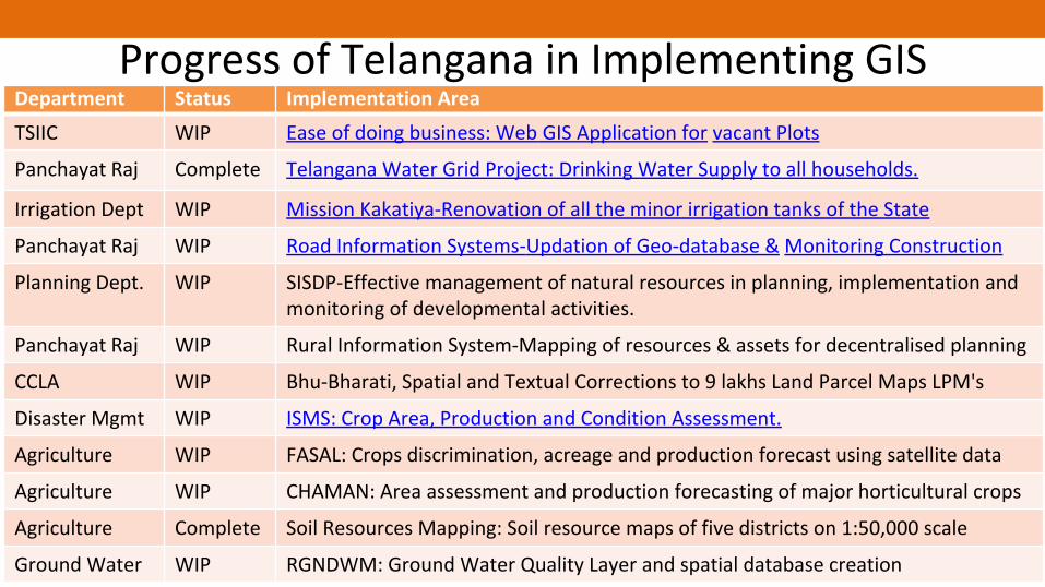
Progress of Telangana in Implementing GISDepartment Status Implementation AreaTSIIC WIP Ease of doing business: Web GIS Application for vacant Plots
Panchayat Raj Complete Telangana Water Grid Project: Drinking Water Supply to all households.
Irrigation Dept WIP Mission Kakatiya-Renovation of all the minor irrigation tanks of the State
Panchayat Raj WIP Road Information Systems-Updation of Geo-database & Monitoring Construction
Planning Dept. WIP SISDP-Effective management of natural resources in planning, implementation and monitoring of developmental activities.
Panchayat Raj WIP Rural Information System-Mapping of resources & assets for decentralised planning
CCLA WIP Bhu-Bharati, Spatial and Textual Corrections to 9 lakhs Land Parcel Maps LPM's
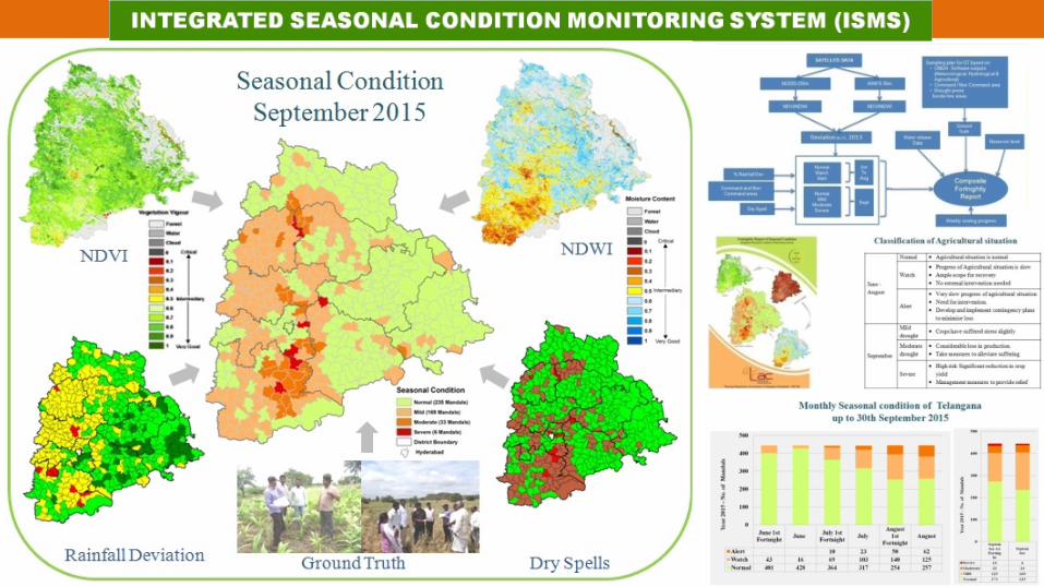
Disaster Mgmt WIP ISMS: Crop Area, Production and Condition Assessment.
Agriculture WIP FASAL: Crops discrimination, acreage and production forecast using satellite data
Agriculture WIP CHAMAN: Area assessment and production forecasting of major horticultural crops
Agriculture Complete Soil Resources Mapping: Soil resource maps of five districts on 1:50,000 scale
Ground Water WIP RGNDWM: Ground Water Quality Layer and spatial database creation

GIS Application on Telangana State Industrial Infrastructure1 TRAC Supports TSIIC, in providing the spatial
information of vacant plots and infrastructure
to the Prospective Entrepreneurs for ease of doing
business in Telangana State.
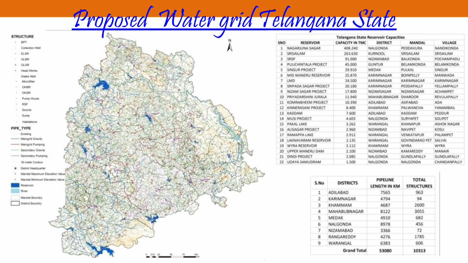
Proposed Water grid Telangana State

Web Interface ofTank Interface System
Tank Information SystemMission Kakatiya - Tank Information System
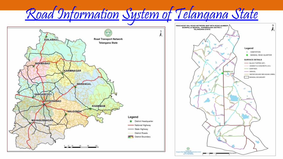
Road Information System of Telangana State1

Progress of Telangana in Implementing GISDepartment Status Implementation AreaTSIIC WIP Ease of doing business: Web GIS Application for vacant Plots
Panchayat Raj Complete Telangana Water Grid Project: Drinking Water Supply to all households.
Irrigation Dept WIP Mission Kakatiya-Renovation of all the minor irrigation tanks of the State
Panchayat Raj WIP Road Information Systems-Updation of Geo-database & Monitoring Construction
Planning Dept. WIP SISDP-Effective management of natural resources in planning, implementation and monitoring of developmental activities.
Panchayat Raj WIP Rural Information System-Mapping of resources & assets for decentralised planning
CCLA WIP Bhu-Bharati, Spatial and Textual Corrections to 9 lakhs Land Parcel Maps LPM's
Disaster Mgmt WIP ISMS: Crop Area, Production and Condition Assessment.
Agriculture WIP FASAL: Crops discrimination, acreage and production forecast using satellite data
Agriculture WIP CHAMAN: Area assessment and production forecasting of major horticultural crops
Agriculture Complete Soil Resources Mapping: Soil resource maps of five districts on 1:50,000 scale
Ground Water WIP RGNDWM: Ground Water Quality Layer and spatial database creation

Telangana GIS Implementation Stage• Coordination mechanism among Departments, proposed.• GIS framework was proposed to be developed under SSDI,
not implemented• No integration among the available GIS applications• SeMT Team has provided consulting support on – MAUD & GHMC City Planning/Building Approval System,– Fibre Grid & Water Grid

GIS Plans / Goals of Telangana
• Smart City Monitoring System: City Planning/ Building Approvals using satellite maps
• On-field Tracking of works/implementation of schemes• GIS based planning for Government Schemes, eg. Water
Grid, Fibre Grid etc.• Asset Mapping for effective decentralized planning.
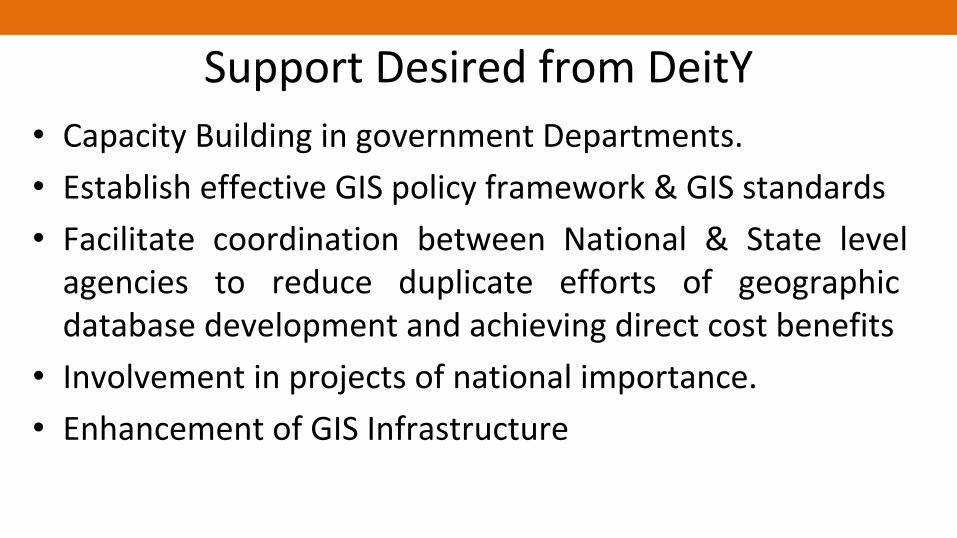
Support Desired from DeitY• Capacity Building in government Departments.• Establish effective GIS policy framework & GIS standards• Facilitate coordination between National & State level
agencies to reduce duplicate efforts of geographic database development and achieving direct cost benefits
• Involvement in projects of national importance.• Enhancement of GIS Infrastructure

Thank You