Embed Size (px)
Citation preview

921 SW Washington Street, Suite 468, Portland, OR 97205 • tel 503.224.6974 • fax 503.227.3679 • www.angeloplanning.com
Date: January 30, 2009
To: Don Otterman, City Manager
From: Frank Angelo
Re: City of North Plains Proposed Urban Reserve Areas - Revised
This memorandum has been prepared to reflect the comments received at the January 20th work session with the North Plains City Council. In addition we have received information from Johnson Reid on future industrial and commercial land needs in North Plains to the year 2035. Information on the 2060 industrial and commercial land needs is expected at a later date. The figures in the January 14, 2009 memorandum have been updated. However, much of the information regarding population forecasts and residential land needs remains the same and is repeated below.
Background
As you requested, Angelo Planning Group (APG) has reviewed the Urban Reserve Areas (URAs) originally proposed by the city in September 2008 (see Attachment 1). As the map illustrates, there are three main areas surrounding the city where Urban Reserve Areas are suggested: Northwest (1,224 acres), East (2,366 acres) and South (1,823 acres). The total land area of these three proposed areas equals approximately 5,413 acres. This figure compares to the city’s existing land area of approximately 700 acres. The city of Hillsboro has also released a map showing their suggested URAs which overlap with North Plains aspirations in the East and South areas (see Attachment 2).
Population Forecast and Residential Land Needs
We began our review of these areas by looking back at the Urban Growth Boundary (UGB) expansion that began in 2000 and was acknowledged by the Land Conservation and Development Commission (LCDC) in 2002. At that time the city brought approximately 149 acres into the UGB which included both future residential and non-residential lands. In projecting population growth, the city used a 4.5 percent annual growth rate to determine the city’s future land needs. For purposes of our analysis on potential future URAs for North Plains, we continued to use that growth rate (4.5 percent annually) to project the population growth to 2035 and 2060. However, 4.5 percent is an aggressive rate of growth. Therefore, we developed a forecast using a 4.5 percent annual growth rate between 2022 and 2035 then dropping to a 3 percent annual growth rate between 2036 and 2060. Both growth rates could still be considered aggressive over such a long period of time. For the immediate purpose of expressing North Plain’s aspirations for future URAs these rates, and the resulting land demand these rates produce, could be considered as a baseline case to be refined as more information becomes available. The resulting population forecast, using the 2000 population of 1,605 as a base, is shown below in Table 1.
page 2
921 SW Washington Street, Suite 468, Portland, OR 97205 • tel 503.224.6974 • fax 503.227.3679 • www.angeloplanning.com
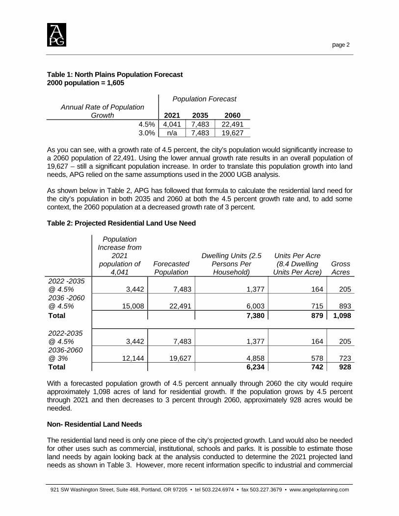
Table 1: North Plains Population Forecast 2000 population = 1,605
Population Forecast Annual Rate of Population
Growth 2021 2035 2060 4.5% 4,041 7,483 22,491 3.0% n/a 7,483 19,627
As you can see, with a growth rate of 4.5 percent, the city’s population would significantly increase to a 2060 population of 22,491. Using the lower annual growth rate results in an overall population of 19,627 – still a significant population increase. In order to translate this population growth into land needs, APG relied on the same assumptions used in the 2000 UGB analysis.
As shown below in Table 2, APG has followed that formula to calculate the residential land need for the city’s population in both 2035 and 2060 at both the 4.5 percent growth rate and, to add some context, the 2060 population at a decreased growth rate of 3 percent.
Table 2: Projected Residential Land Use Need
Population Increase from
2021 population of
4,041 Forecasted Population
Dwelling Units (2.5 Persons Per Household)
Units Per Acre (8.4 Dwelling
Units Per Acre) Gross Acres
2022 -2035 @ 4.5% 3,442 7,483 1,377 164 2052036 -2060 @ 4.5% 15,008 22,491 6,003 715 893Total 7,380 879 1,098 2022-2035 @ 4.5% 3,442 7,483 1,377 164 2052036-2060 @ 3% 12,144 19,627 4,858 578 723Total 6,234 742 928 With a forecasted population growth of 4.5 percent annually through 2060 the city would require approximately 1,098 acres of land for residential growth. If the population grows by 4.5 percent through 2021 and then decreases to 3 percent through 2060, approximately 928 acres would be needed.
Non- Residential Land Needs
The residential land need is only one piece of the city’s projected growth. Land would also be needed for other uses such as commercial, institutional, schools and parks. It is possible to estimate those land needs by again looking back at the analysis conducted to determine the 2021 projected land needs as shown in Table 3. However, more recent information specific to industrial and commercial

page 3
921 SW Washington Street, Suite 468, Portland, OR 97205 • tel 503.224.6974 • fax 503.227.3679 • www.angeloplanning.com
land needs to 2035 has been provided by Johnson Reid. This information has been inserted into Table 4 below and replaces information from the city’s periodic review work conducted in 2002.
Table 3: 2021 Projected Summary of Expansion Needs for all Land Uses Taken from: City of North Plains Response to Remand Order Periodic Review Work Tasks 1-5, October 2002
Land Use Category Net Acres Gross Acres Percentages of Net Commercial 6.25 7.8 5.2% Industrial 0.00 0.0 0.0% Institutional 10.00 12.5 8.4% Schools 10.00 12.5 8.4% Residential 64.00 80.0 53.4% Neighborhood Parks 2.60 3.3 2.2% Community Parks 2.40 3.0 2.0% Municipal Parks 20.00 25.0 16.7% Greenway Parks 4.50 5.6 3.8% Total 119.75 149.69
By applying the non-commercial/industrial percentages to the future (2035/2060) population estimates the total land need (residential and non-residential) can be estimated as shown in Table 4 below.
Table 4: Projected Summary of Expansion Needs for all Land Uses (2035 and 2060)
2035 Population 7,483 (4.5%)
2060 Population 22,491 (4.5%)
Total
Land Use Category Net Acres Gross Acres Net Acres Gross Acres Net Acres Gross Acres
Commercial 113.70* 142.10* N/A** N/A** 113.70 142.10Industrial 99.20* 124.00* N/A** N/A** 99.20 124.00Institutional 25.80 32.25 112.31 140.39 138.27 172.84Schools 25.80 32.25 112.31 140.39 138.27 172.84Residential 164.00 205.00 714.00 893.00 879.00 1098.00Neighborhood Parks 6.76 8.45 29.42 36.77 36.21 45.27Community Parks 6.14 7.68 26.74 33.43 32.92 41.15Municipal Parks 51.29 64.11 223.29 279.12 274.89 343.62Greenway Parks 11.67 14.59 50.81 63.51 62.55 78.19Total 504.36 630.43 1,268.88 1,586.61 1,775.01 2,218.01
*Industrial and Commercial acreages are from Johnson Reid January, 2009 Economic Opportunities Analysis Report. The “Medium Growth” forecast for these categories is used in Table 4. **N/A = information Not Available as of January 28, 2009

page 4
921 SW Washington Street, Suite 468, Portland, OR 97205 • tel 503.224.6974 • fax 503.227.3679 • www.angeloplanning.com
Table 4: Projected Summary of Expansion Needs for all Land Uses (2035 and 2060) (Continued)
2035, Population 7,483 (4.5%)
2060, Population 19,627 (3%)
Total
Land Use Category Net Acres Gross Acres Net Acres Gross Acres Net Acres
Gross Acres
Commercial 113.70* 142.10* N/A** N/A** 113.70 142.10Industrial 99.20* 124.00* N/A** N/A** 99.20 124.00Institutional 25.80 32.25 90.92 113.65 116.72 145.90Schools 25.80 32.25 90.92 113.65 116.72 145.90Residential 164.00 205.00 578.00 723.00 742.00 928.00Neighborhood Parks 6.76 8.45 23.81 29.77 30.57 38.21Community Parks 6.14 7.68 21.65 27.06 27.79 34.74Municipal Parks 51.29 64.11 180.76 225.95 232.05 290.06Greenway Parks 11.67 14.59 41.13 51.41 52.80 66.00Total 504.36 603.43 1,027.19 1,287.49 1,531.55 1,914.91
*Industrial and Commercial acreages are from Johnson Reid January, 2009 Economic Opportunities Analysis Report. The “Medium Growth” forecast for these categories is used in Table 4. **N/A = information Not Available as of January 28, 2009
As you can see, for 2060 the estimated total land need, with a population growth rate held constant at 4.5 percent, is approximately 2,218 and, for the split growth rate, 1,915 acres. Both of these estimates are substantially less than the 5,413 acres originally identified by the city in September 2008. These figures do not include any acreage assumptions in the Commercial or Industrial land use categories for the 2035 to 2060 period. When figures are available from Johnson Reid for that period the tables will need to be updated. At the same time, the acreage estimates for Parks (all categories) are large and may be overestimated.
Based on the land use projections estimated in Table 4 above, we have suggested a reduced area for future Urban Reserve Area planning (see Attachment 3) from the area suggested by the city in September 2008. The revised map in Attachment 3 includes a total of 2,136 acres divided between the Northwest, East and South areas surrounding the city. While this acreage figure is somewhat less than the acreage required to meet the more aggressive growth rate (4.5% over the entire planning period) it is sufficient to meet the lower growth rate assumptions. This smaller URA expansion also eliminates the overlap between Hillsboro and North Plains URAs (see Attachment 4). The 2,136 total does not include the 309 acres devoted to Pumpkin Ridge Golf Course that the city has indicated a desire to include inside any future URAs. The 309 acres have not been counted towards the inventory of future land needs for the categories noted above and it is assumed that the golf course will remain with the same use in the URA.
Thank you for the opportunity to assist the city of North Plains with reviewing options for future URAs. I look forward to discussing this with you further in the coming weeks. If you have any questions or need additional information I can be reached at 503-227-3664 or by email at [email protected].
page 5
921 SW Washington Street, Suite 468, Portland, OR 97205 • tel 503.224.6974 • fax 503.227.3679 • www.angeloplanning.com
Attachments:
Attachment 1: North Plains Proposed Urban Reserve Areas (2008)
Attachment 2: North Plains and Hillsboro Proposed Urban Reserve and UGB Areas (2008)
Attachment 3: North Plains Alternative Urban Reserve Areas (2009)
Attachment 4: North Plains and Hillsboro Alternative Urban Reserve and UGB Areas (2009)

East: 2296 acres
South: 1823 acres
Northwest: 1224 acres
North Plains
Golf Course: 309 acres
0 0.5 10.25 Miles
LegendNorth Plains City LimitsUrban Growth Boundary
North Plains Proposed URAsEastNorthwestSouth
TaxlotsGolf Course ParcelFreewaysMajor StreetsStreams
Attachment 1: North Plains Proposed Urban Reserve Areas (2008)
4
Existing City UGB: 697 acres

East: 2296 acresSouth: 1823 acres
Northwest: 1224 acres
Hillsboro
North Plains
Golf Course: 309 acres
0 0.5 10.25 Miles
LegendCity boundaries
North Plains City LimitsHillsboro City LimitsUrban Growth Boundary
North Plains Proposed URAsEastNorthwestSouth
Hillsboro proposed URAs & UGB AreasHillsboro Proposed UGB - IndustrialHillsboro Proposed UGB - ResidentialHillsboro UR Aspiration - IndustrialHillsboro UR Aspiration - Residential
TaxlotsGolf Course ParcelFreewaysMajor StreetsStreams
Attachment 2: North Plains and Hillsboro Proposed Urban Reserve and UGB Areas (2008)
4
Existing City UGB: 697 acres

Northwest: 899 acres
South: 675 acresEast: 562 acres
North Plains
Golf Course: 309 acres
0 0.5 10.25 Miles
LegendNorth Plains City LimitsUrban Growth Boundary
North Plains Proposed URAsEastNorthwestSouth
TaxlotsGolf Course ParcelFreewaysMajor StreetsStreams
Attachment 3: North Plains Alternative Urban Reserve Areas (2009)
4
Existing City UGB: 697 acres
Non-Residential Use Reserve
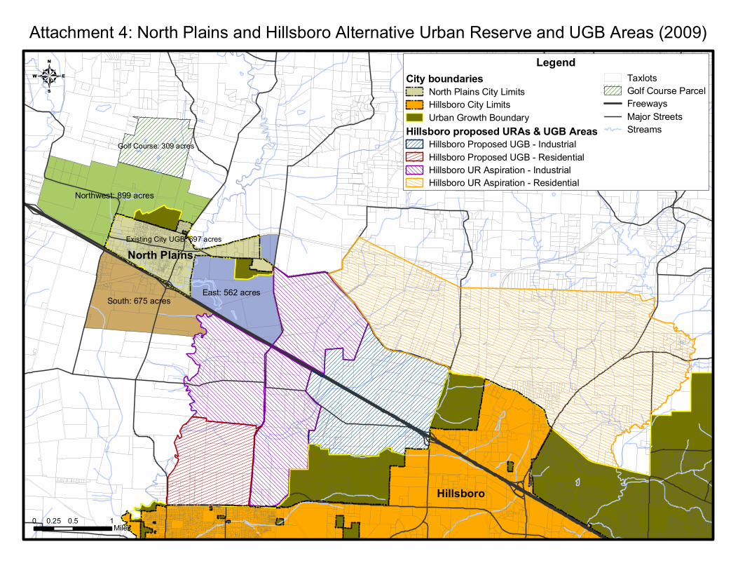
Northwest: 899 acres
South: 675 acresEast: 562 acres
Hillsboro
North Plains
Golf Course: 309 acres
0 0.5 10.25 Miles
LegendCity boundaries
North Plains City LimitsHillsboro City LimitsUrban Growth Boundary
Hillsboro proposed URAs & UGB AreasHillsboro Proposed UGB - IndustrialHillsboro Proposed UGB - ResidentialHillsboro UR Aspiration - IndustrialHillsboro UR Aspiration - Residential
TaxlotsGolf Course ParcelFreewaysMajor StreetsStreams
Attachment 4: North Plains and Hillsboro Alternative Urban Reserve and UGB Areas (2009)
4
Existing City UGB: 697 acres