Embed Size (px)
Citation preview
Dunoon (Potentially Vulnerable Area 11/07)
Local Plan District
Clyde and Loch Lomond
Local authority Main catchment
Argyll and Bute Council Cowal / Clyde Sealochs coastal
Ob
jec
tive
s
Su
mm
ary
of flo
od
ing
imp
ac
ts
Objectives have been set by SEPA and agreed with flood risk management authorities. These are the aims for managing local flood risk. The objectives have been grouped in three main ways: by reducing risk, avoiding increasing risk or accepting risk by maintaining current levels of management.
Many organisations, such as Scottish Water and energy companies, actively maintain and manage their own assets including their risk from flooding. Where known, these actions are described here. Scottish Natural Heritage and Historic Environment Scotland work with site owners to manage flooding where appropriate at designated environmental and/or cultural heritage sites. These actions are not detailed further in the Flood Risk Management Strategies.
Summary of objectives to manage flooding
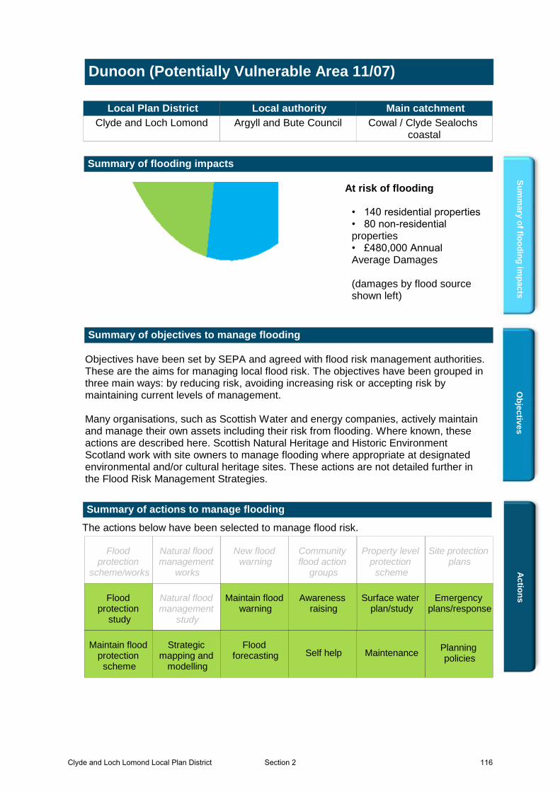
Summary of flooding impacts
• 140 residential properties• 80 non-residential properties• £480,000 Annual Average Damages (damages by flood source shown left)
At risk of flooding
Ac
tion
s
The actions below have been selected to manage flood risk.
Summary of actions to manage flooding
Maintain flood warning
Site protection plans
MaintenanceSelf helpMaintain flood
protection scheme
Strategic mapping and
modelling
Flood forecasting
Emergency plans/response
Community flood action
groups
Awareness raising
Planning policies
Surface water plan/study
New flood warning
Property level protection
scheme
Natural flood management
works
Natural flood management
study
Flood protection
scheme/works
Flood protection
study
Flood protection
study
Surface water plan/study
Planning policies
Awareness raising
Emergency plans/response
Flood forecasting
Strategic mapping and
modelling
Maintain flood protection
scheme
Self help Maintenance
Maintain flood warning
Clyde and Loch Lomond Local Plan District 116Section 2
Dunoon (Potentially Vulnerable Area 11/07)
Local Plan District Local authority Main catchment Clyde and Loch Lomond Argyll and Bute Council Cowal / Clyde Sealochs
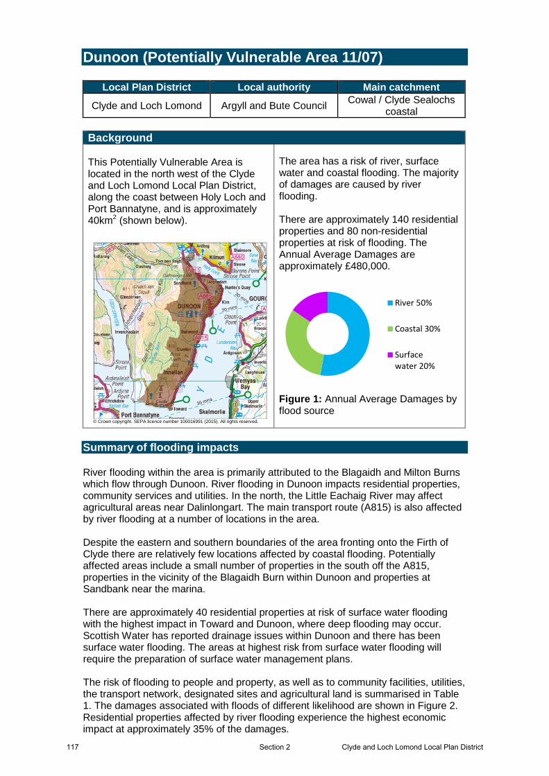
coastal Background This Potentially Vulnerable Area is located in the north west of the Clyde and Loch Lomond Local Plan District, along the coast between Holy Loch and Port Bannatyne, and is approximately 40km2 (shown below).
© Crown copyright. SEPA licence number 100016991 (2015). All rights reserved.
The area has a risk of river, surface water and coastal flooding. The majority of damages are caused by river flooding. There are approximately 140 residential properties and 80 non-residential properties at risk of flooding. The Annual Average Damages are approximately £480,000.
River 50%
Coastal 30%
Surfacewater 20%
Figure 1: Annual Average Damages by flood source
Summary of flooding impacts River flooding within the area is primarily attributed to the Blagaidh and Milton Burns which flow through Dunoon. River flooding in Dunoon impacts residential properties, community services and utilities. In the north, the Little Eachaig River may affect agricultural areas near Dalinlongart. The main transport route (A815) is also affected by river flooding at a number of locations in the area. Despite the eastern and southern boundaries of the area fronting onto the Firth of Clyde there are relatively few locations affected by coastal flooding. Potentially affected areas include a small number of properties in the south off the A815, properties in the vicinity of the Blagaidh Burn within Dunoon and properties at Sandbank near the marina. There are approximately 40 residential properties at risk of surface water flooding with the highest impact in Toward and Dunoon, where deep flooding may occur. Scottish Water has reported drainage issues within Dunoon and there has been surface water flooding. The areas at highest risk from surface water flooding will require the preparation of surface water management plans. The risk of flooding to people and property, as well as to community facilities, utilities, the transport network, designated sites and agricultural land is summarised in Table 1. The damages associated with floods of different likelihood are shown in Figure 2. Residential properties affected by river flooding experience the highest economic impact at approximately 35% of the damages.
117 Clyde and Loch Lomond Local Plan DistrictSection 2

Within this Potentially Vulnerable Area it is estimated that climate change will increase the number of residential properties at risk of flooding from approximately 140 to 260 and the number of non-residential properties from approximately 80 to 150. The location of the impacts of flooding is shown in Figure 3. Most of impacts are within Dunoon with flooding to people, non-residential properties, community facilities and utilities. The A815 floods both north and south of Dunoon. History of flooding River flooding from the Milton Burn has been recorded in Dunoon on the 9 August 2004 and 28 October 1996. Also within Dunoon, Scottish Water have reported drainage issues.
Clyde and Loch Lomond Local Plan District 118Section 2
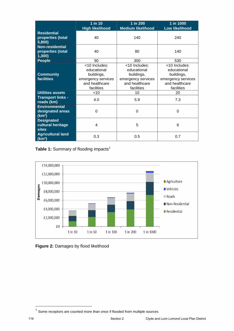
1 in 10 1 in 200 1 in 1000 High likelihood Medium likelihood Low likelihood Residential properties (total 5,800)
40 140 240
Non-residential properties (total 1,300)
40 80 140
People 90 300 530
Community facilities
<10 Includes: educational buildings,
emergency services and healthcare
facilities
<10 Includes: educational buildings,
emergency services and healthcare
facilities
<10 Includes: educational buildings,
emergency services and healthcare
facilities Utilities assets <10 10 20 Transport links - roads (km) 4.0 5.9 7.3
Environmental designated areas (km²)
0 0 0
Designated cultural heritage sites
4 5 6
Agricultural land (km²) 0.3 0.5 0.7
Table 1: Summary of flooding impacts1
Figure 2: Damages by flood likelihood
1 Some receptors are counted more than once if flooded from multiple sources
119 Clyde and Loch Lomond Local Plan DistrictSection 2
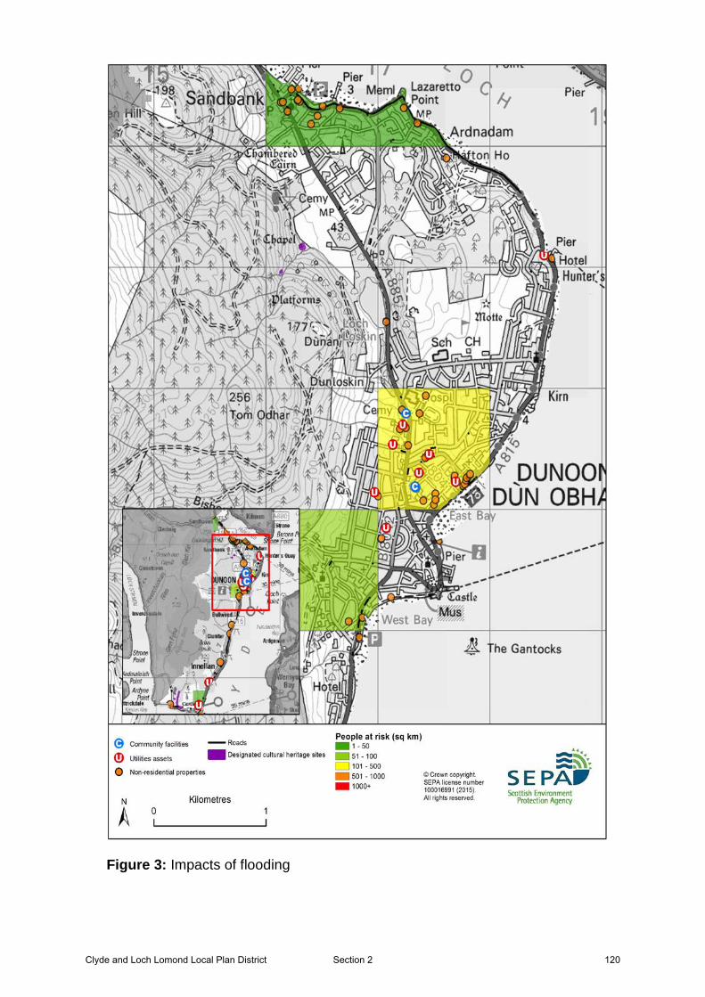
Figure 3: Impacts of flooding
Clyde and Loch Lomond Local Plan District 120Section 2

Objectives provide a common goal and shared ambition for managing floods. These objectives have been set by SEPA and agreed with flood risk management authorities following consultation. They were identified through an assessment of the underlying evidence of the causes and impacts of flooding. Target areas have been set to focus actions; they do not necessarily correspond to areas at risk in SEPA’s flood map. The objectives below have been set for Dunoon Potentially Vulnerable Area.
Objectives to manage flooding in Potentially Vulnerable Area 11/07
Accept that current and future significant flood risks in the Kilbride Road and
Crochan Road area are being managed appropriately
Indicators:
• 20 residential properties• £35,000 Annual Average Damages
Objective ID: 11005
Target area:
Image found and displayed.
©Crown copyright. All rights reserved. SEPA lic.no. 100016991 (2015)
Reduce the risk of Milton Burn flooding to residential properties in Dunoon
Indicators:
• 60 residential properties• £130,000 Annual Average Damages
Objective ID: 11006
Target area:
Image found and displayed.
©Crown copyright. All rights reserved. SEPA lic.no. 100016991 (2015)
121 Clyde and Loch Lomond Local Plan DistrictSection 2
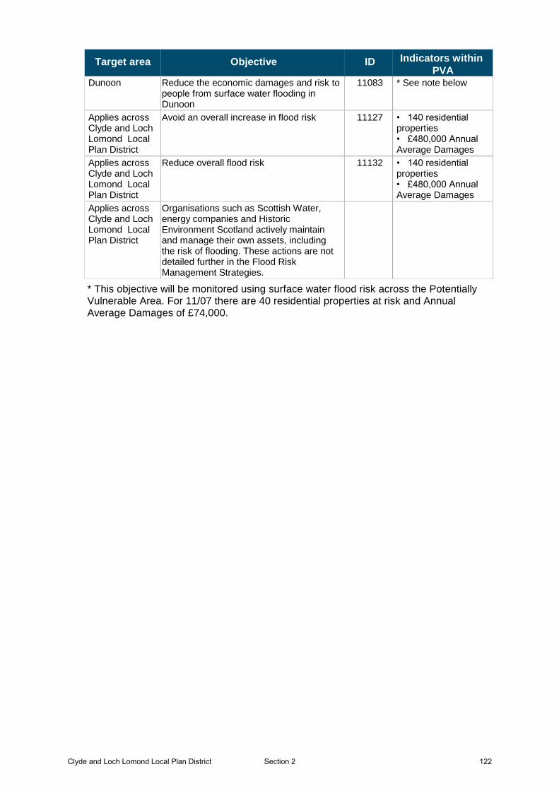
Target area Objective ID Indicators within
PVADunoon 11083 * See note belowReduce the economic damages and risk to
people from surface water flooding in Dunoon
Applies across Clyde and Loch Lomond Local Plan District
11127 • 140 residential properties• £480,000 Annual Average Damages
Avoid an overall increase in flood risk
Applies across Clyde and Loch Lomond Local Plan District
11132 • 140 residential properties• £480,000 Annual Average Damages
Reduce overall flood risk
Applies across Clyde and Loch Lomond Local Plan District
Organisations such as Scottish Water, energy companies and Historic Environment Scotland actively maintain and manage their own assets, including the risk of flooding. These actions are not detailed further in the Flood Risk Management Strategies.
* This objective will be monitored using surface water flood risk across the Potentially Vulnerable Area. For 11/07 there are 40 residential properties at risk and Annual Average Damages of £74,000.
Clyde and Loch Lomond Local Plan District 122Section 2
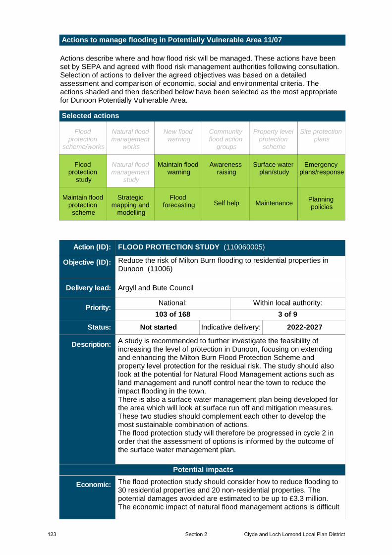
Actions describe where and how flood risk will be managed. These actions have been set by SEPA and agreed with flood risk management authorities following consultation. Selection of actions to deliver the agreed objectives was based on a detailed assessment and comparison of economic, social and environmental criteria. The actions shaded and then described below have been selected as the most appropriate for Dunoon Potentially Vulnerable Area.
Selected actions
Actions to manage flooding in Potentially Vulnerable Area 11/07
Maintain flood warning
Site protection plans
MaintenanceSelf helpMaintain flood
protection scheme
Strategic mapping and
modelling
Flood forecasting
Emergency plans/response
Community flood action
groups
Awareness raising
Planning policies
Surface water plan/study
New flood warning
Property level protection
scheme
Natural flood management
works
Natural flood management
study
Flood protection
scheme/works
Flood protection
study
Flood protection
study
Surface water plan/study
Planning policies
Awareness raising
Emergency plans/response
Flood forecasting
Strategic mapping and
modelling
Maintain flood protection
scheme
Self help Maintenance
Maintain flood warning
A study is recommended to further investigate the feasibility of increasing the level of protection in Dunoon, focusing on extending and enhancing the Milton Burn Flood Protection Scheme and property level protection for the residual risk. The study should also look at the potential for Natural Flood Management actions such as land management and runoff control near the town to reduce the impact flooding in the town.There is also a surface water management plan being developed for the area which will look at surface run off and mitigation measures. These two studies should complement each other to develop the most sustainable combination of actions.The flood protection study will therefore be progressed in cycle 2 in order that the assessment of options is informed by the outcome of the surface water management plan.
Argyll and Bute Council
Not started Indicative delivery: 2022-2027
Action (ID): FLOOD PROTECTION STUDY (110060005)
Description:
Objective (ID):
Delivery lead:
Status:
Reduce the risk of Milton Burn flooding to residential properties in Dunoon (11006)
103 of 168 3 of 9
National: Within local authority:Priority:
The flood protection study should consider how to reduce flooding to 30 residential properties and 20 non-residential properties. The potential damages avoided are estimated to be up to £3.3 million. The economic impact of natural flood management actions is difficult
Potential impacts
Economic:
123 Clyde and Loch Lomond Local Plan DistrictSection 2
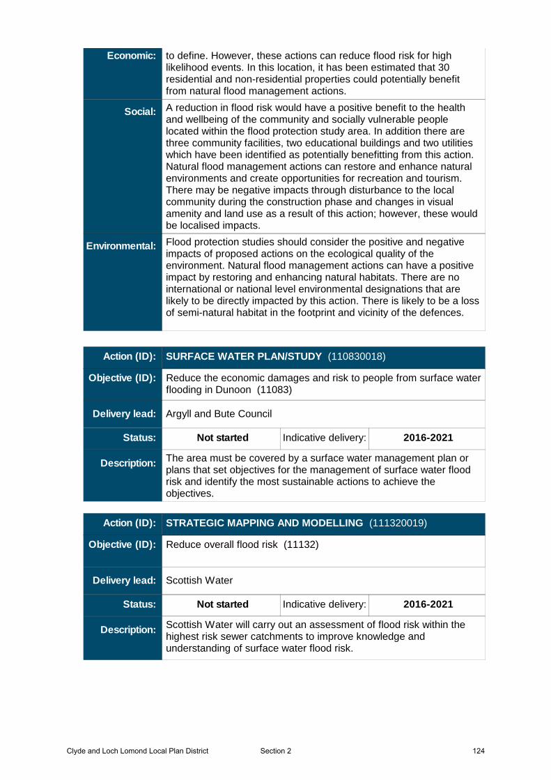
A reduction in flood risk would have a positive benefit to the health and wellbeing of the community and socially vulnerable people located within the flood protection study area. In addition there are three community facilities, two educational buildings and two utilities which have been identified as potentially benefitting from this action. Natural flood management actions can restore and enhance natural environments and create opportunities for recreation and tourism. There may be negative impacts through disturbance to the local community during the construction phase and changes in visual amenity and land use as a result of this action; however, these would be localised impacts.
Flood protection studies should consider the positive and negative impacts of proposed actions on the ecological quality of the environment. Natural flood management actions can have a positive impact by restoring and enhancing natural habitats. There are no international or national level environmental designations that are likely to be directly impacted by this action. There is likely to be a loss of semi-natural habitat in the footprint and vicinity of the defences.
to define. However, these actions can reduce flood risk for high likelihood events. In this location, it has been estimated that 30 residential and non-residential properties could potentially benefit from natural flood management actions.
Economic:
Social:
Environmental:
The area must be covered by a surface water management plan or plans that set objectives for the management of surface water flood risk and identify the most sustainable actions to achieve the objectives.
Argyll and Bute Council
Not started Indicative delivery: 2016-2021
Action (ID): SURFACE WATER PLAN/STUDY (110830018)
Description:
Objective (ID):
Delivery lead:
Status:
Reduce the economic damages and risk to people from surface water flooding in Dunoon (11083)
Scottish Water will carry out an assessment of flood risk within the highest risk sewer catchments to improve knowledge and understanding of surface water flood risk.
Scottish Water
Not started Indicative delivery: 2016-2021
Action (ID): STRATEGIC MAPPING AND MODELLING (111320019)
Description:
Objective (ID):
Delivery lead:
Status:
Reduce overall flood risk (11132)
Clyde and Loch Lomond Local Plan District 124Section 2
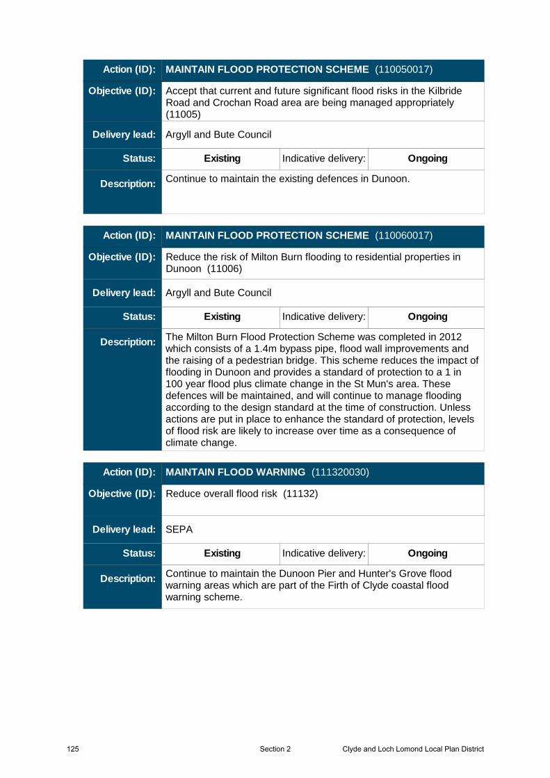
Continue to maintain the existing defences in Dunoon.
Argyll and Bute Council
Existing Indicative delivery: Ongoing
Action (ID): MAINTAIN FLOOD PROTECTION SCHEME (110050017)
Description:
Objective (ID):
Delivery lead:
Status:
Accept that current and future significant flood risks in the Kilbride Road and Crochan Road area are being managed appropriately (11005)
The Milton Burn Flood Protection Scheme was completed in 2012 which consists of a 1.4m bypass pipe, flood wall improvements and the raising of a pedestrian bridge. This scheme reduces the impact of flooding in Dunoon and provides a standard of protection to a 1 in 100 year flood plus climate change in the St Mun's area. These defences will be maintained, and will continue to manage flooding according to the design standard at the time of construction. Unless actions are put in place to enhance the standard of protection, levels of flood risk are likely to increase over time as a consequence of climate change.
Argyll and Bute Council
Existing Indicative delivery: Ongoing
Action (ID): MAINTAIN FLOOD PROTECTION SCHEME (110060017)
Description:
Objective (ID):
Delivery lead:
Status:
Reduce the risk of Milton Burn flooding to residential properties in Dunoon (11006)
Continue to maintain the Dunoon Pier and Hunter's Grove flood warning areas which are part of the Firth of Clyde coastal flood warning scheme.
SEPA
Existing Indicative delivery: Ongoing
Action (ID): MAINTAIN FLOOD WARNING (111320030)
Description:
Objective (ID):
Delivery lead:
Status:
Reduce overall flood risk (11132)
125 Clyde and Loch Lomond Local Plan DistrictSection 2
The Scottish Flood Forecasting Service is a joint initiative between SEPA and the Met Office that produces daily, national flood guidance statements which are issued to Category 1 and 2 Responders. The service also provides information which allows SEPA to issue flood warnings, giving people a better chance of reducing the impact of flooding on their home or business. For more information please visit SEPA’s website.
SEPA
Existing Indicative delivery: Ongoing
Action (ID): FLOOD FORECASTING (111320009)
Description:
Objective (ID):
Delivery lead:
Status:
Reduce overall flood risk (11132)
Everyone is responsible for protecting themselves and their property from flooding. Property and business owners can take simple steps to reduce damage and disruption to their homes and businesses should flooding happen. This includes preparing a flood plan and flood kit, installing property level protection, signing up to Floodline and Resilient Communities initiatives, and ensuring that properties and businesses are insured against flood damage.
—
Existing Indicative delivery: Ongoing
Action (ID): SELF HELP (111320011)
Description:
Objective (ID):
Delivery lead:
Status:
Reduce overall flood risk (11132)
SEPA and the responsible authorities have a duty to raise public awareness of flood risk. Improved awareness of flood risk and actions that prepare individuals, homes and businesses for flooding can reduce the overall impact.SEPA will engage with the community through local participation in national initiatives, including partnership working with Neighbourhood Watch Scotland. In addition, SEPA will engage with local authorities and community resilience groups where possible.Local authorities will be undertaking additional awareness raising activities. Further details will be set out in the Local FRM Plan.
Responsible authorities
Existing Indicative delivery: Ongoing
Action (ID): AWARENESS RAISING (111320013)
Description:
Objective (ID):
Delivery lead:
Status:
Reduce overall flood risk (11132)
Clyde and Loch Lomond Local Plan District 126Section 2
Local authorities have a duty to assess watercourses and carry out clearance and repair works where such works would substantially reduce flood risk. They produce schedules of clearance and repair works and make these available for public inspection. Scottish Water undertake inspection and repair on the public sewer network. Asset owners and riparian landowners are responsible for the maintenance and management of their own assets including those which help to reduce flood risk.
Argyll & Bute Council, asset / land managers
Existing Indicative delivery: Ongoing
Action (ID): MAINTENANCE (111320007)
Description:
Objective (ID):
Delivery lead:
Status:
Reduce overall flood risk (11132)
Providing an emergency response to flooding is the responsibility of many organisations, including local authorities, the emergency services and SEPA. Effective management of an emergency response relies on emergency plans that are prepared under the Civil Contingencies Act 2004 by Category 1 and 2 Responders. The emergency response by these organisations is co-ordinated through regional and local resilience partnerships. This response may be supported by the work of voluntary organisations.
Category 1 and 2 Responders
Existing Indicative delivery: Ongoing
Action (ID): EMERGENCY PLANS/RESPONSE (111320014)
Description:
Objective (ID):
Delivery lead:
Status:
Reduce overall flood risk (11132)
Scottish Planning Policy and accompanying Planning Advice Notes set out Scottish Ministers’ priorities for the operation of the planning system and for the development and use of land. In terms of flood risk management, the policy supports a catchment-scale approach to sustainable flood risk management and aims to build the resilience of our cities and towns, encourage sustainable land management in our rural areas, and to address the long-term vulnerability of parts of our coasts and islands. Under this approach, new development in areas with medium to high likelihood of flooding should be avoided. For further information on the application of national planning policies see Annex 2.
Planning authority
Existing Indicative delivery: Ongoing
Action (ID): PLANNING POLICIES (111270001)
Description:
Objective (ID):
Delivery lead:
Status:
Avoid an overall increase in flood risk (11127)
Reduce overall flood risk (11132)
127 Clyde and Loch Lomond Local Plan DistrictSection 2