Embed Size (px)
Citation preview
Stirling (Raploch and Riverside) (Potentially Vulnerable
Area 09/07)
Local Plan District
Forth
Local authority Main catchment
Stirling Council Stirling coastal
Ob
jec
tive
s
Su
mm
ary
of flo
od
ing
imp
ac
ts
Objectives have been set by SEPA and agreed with flood risk management authorities. These are the aims for managing local flood risk. The objectives have been grouped in three main ways: by reducing risk, avoiding increasing risk or accepting risk by maintaining current levels of management.
Many organisations, such as Scottish Water and energy companies, actively maintain and manage their own assets including their risk from flooding. Where known, these actions are described here. Scottish Natural Heritage and Historic Environment Scotland work with site owners to manage flooding where appropriate at designated environmental and/or cultural heritage sites. These actions are not detailed further in the Flood Risk Management Strategies.
Summary of objectives to manage flooding
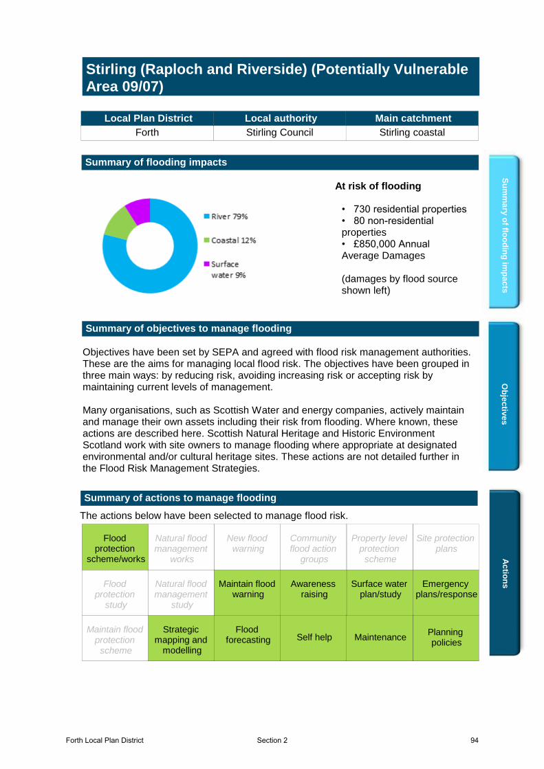
Summary of flooding impacts
• 730 residential properties• 80 non-residential properties• £850,000 Annual Average Damages (damages by flood source shown left)
At risk of flooding
Ac
tion
s
The actions below have been selected to manage flood risk.
Summary of actions to manage flooding
Maintain flood warning
Site protection plans
MaintenanceSelf helpMaintain flood
protection scheme
Strategic mapping and
modelling
Flood forecasting
Emergency plans/response
Community flood action
groups
Awareness raising
Planning policies
Surface water plan/study
New flood warning
Property level protection
scheme
Natural flood management
works
Natural flood management
study
Flood protection
scheme/works
Flood protection
study
Flood protection
scheme/works
Surface water plan/study
Planning policies
Awareness raising
Emergency plans/response
Flood forecasting
Strategic mapping and
modelling
Self help Maintenance
Maintain flood warning
Forth Local Plan District 94Section 2
Stirling (Raploch and Riverside) (Potentially Vulnerable Area 09/07)
Local Plan District Local authority Main catchment
Forth Stirling Council Stirling coastal
Background
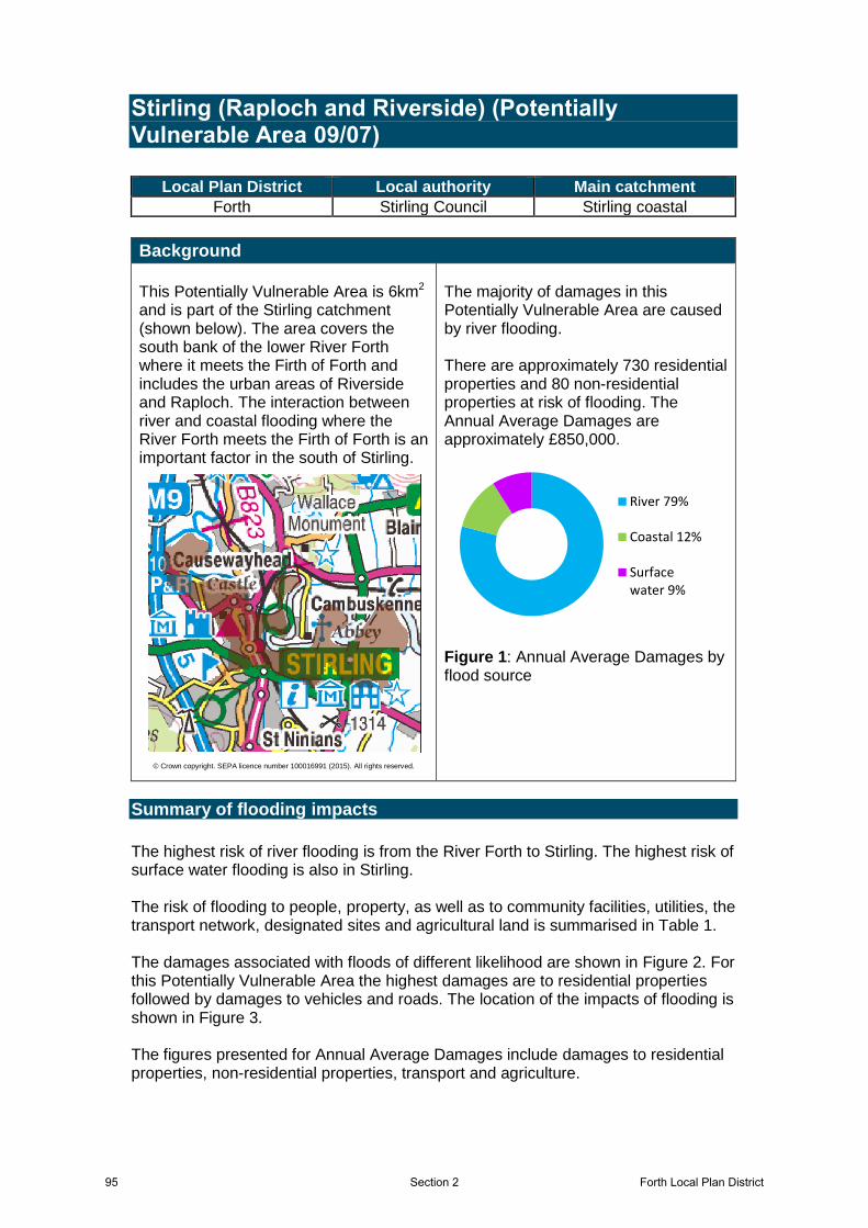
This Potentially Vulnerable Area is 6km2 and is part of the Stirling catchment (shown below). The area covers the south bank of the lower River Forth where it meets the Firth of Forth and includes the urban areas of Riverside and Raploch. The interaction between river and coastal flooding where the River Forth meets the Firth of Forth is an important factor in the south of Stirling.
© Crown copyright. SEPA licence number 100016991 (2015). All rights reserved.
The majority of damages in this Potentially Vulnerable Area are caused by river flooding. There are approximately 730 residential properties and 80 non-residential properties at risk of flooding. The Annual Average Damages are approximately £850,000.
Figure 1: Annual Average Damages by flood source
Summary of flooding impacts
The highest risk of river flooding is from the River Forth to Stirling. The highest risk of surface water flooding is also in Stirling. The risk of flooding to people, property, as well as to community facilities, utilities, the transport network, designated sites and agricultural land is summarised in Table 1. The damages associated with floods of different likelihood are shown in Figure 2. For this Potentially Vulnerable Area the highest damages are to residential properties followed by damages to vehicles and roads. The location of the impacts of flooding is shown in Figure 3. The figures presented for Annual Average Damages include damages to residential properties, non-residential properties, transport and agriculture.
River 79%
Coastal 12%
Surfacewater 9%
95 Forth Local Plan DistrictSection 2
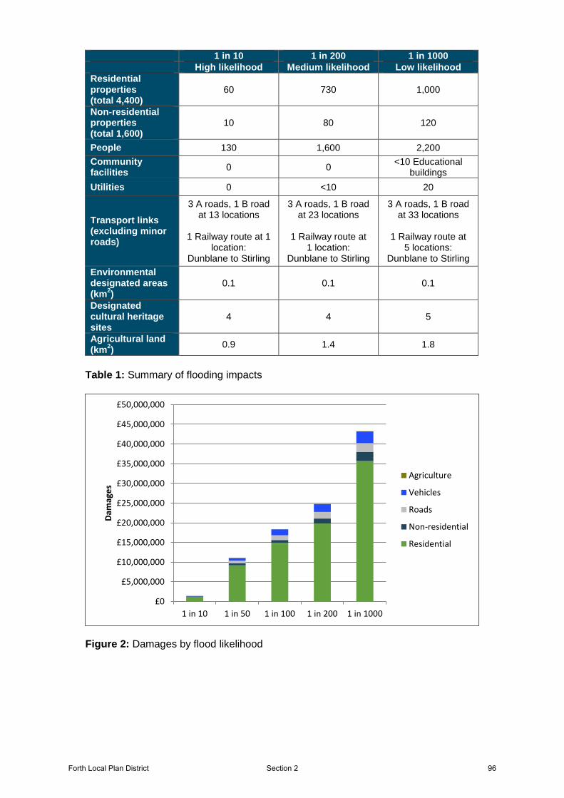
1 in 10 1 in 200 1 in 1000
High likelihood Medium likelihood Low likelihood
Residential properties (total 4,400)
60 730 1,000
Non-residential properties (total 1,600)
10 80 120
People 130 1,600 2,200
Community facilities
0 0 <10 Educational
buildings
Utilities 0 <10 20
Transport links (excluding minor roads)
3 A roads, 1 B road at 13 locations
1 Railway route at 1
location: Dunblane to Stirling
3 A roads, 1 B road at 23 locations
1 Railway route at
1 location: Dunblane to Stirling
3 A roads, 1 B road at 33 locations
1 Railway route at
5 locations: Dunblane to Stirling
Environmental designated areas (km
2)
0.1 0.1 0.1
Designated cultural heritage sites
4 4 5
Agricultural land (km
2)
0.9 1.4 1.8
Table 1: Summary of flooding impacts
Figure 2: Damages by flood likelihood
£0
£5,000,000
£10,000,000
£15,000,000
£20,000,000
£25,000,000
£30,000,000
£35,000,000
£40,000,000
£45,000,000
£50,000,000
1 in 10 1 in 50 1 in 100 1 in 200 1 in 1000
Dam
age
s
Agriculture
Vehicles
Roads
Non-residential
Residential
Forth Local Plan District 96Section 2
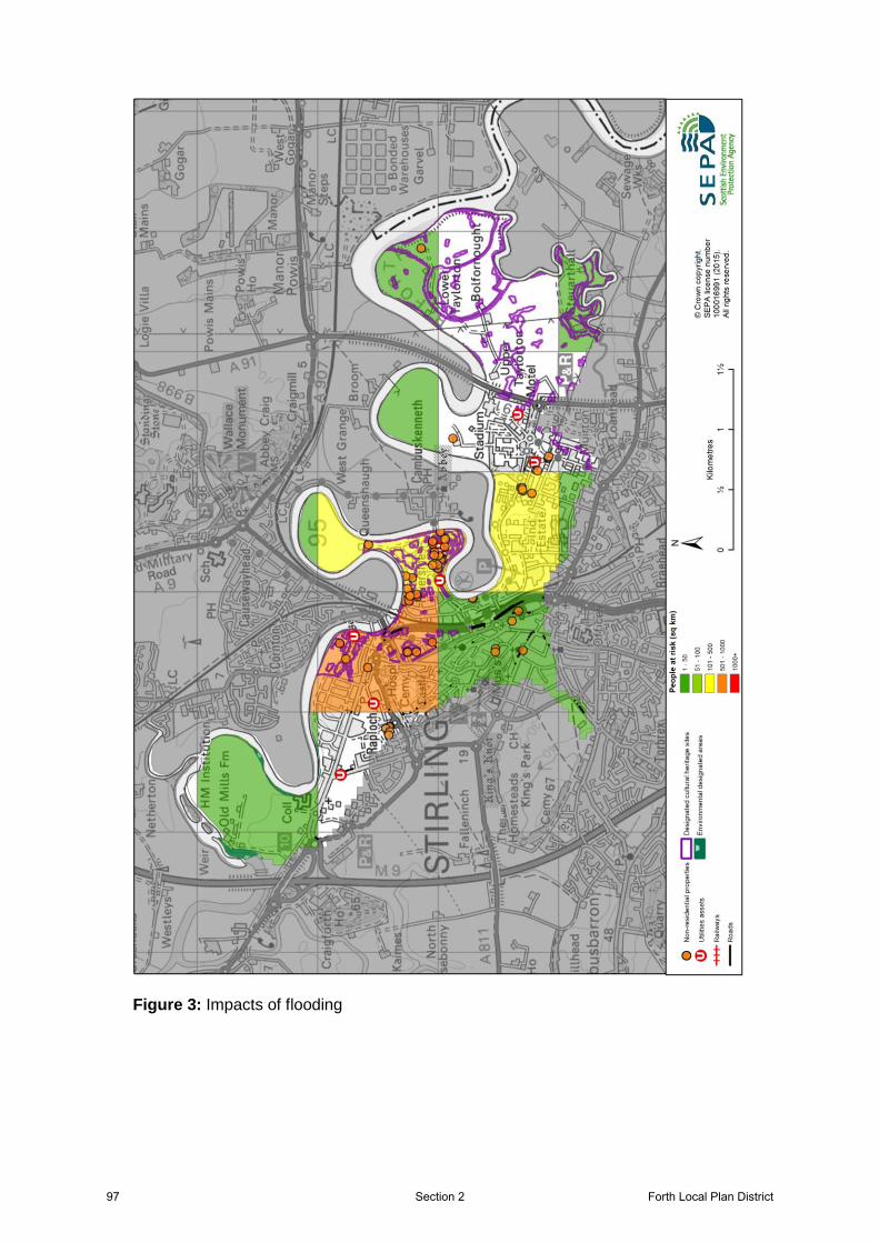
Figure 3: Impacts of flooding
97 Forth Local Plan DistrictSection 2
History of flooding
The following significant floods have been recorded in this area:
14 December 2006: Flooding from the River Forth in Stirling affected properties and roads in Riverside and resulted in an emergency respite centre being set up. The highest river level recorded at the SEPA gauging station on the River Forth at Craigforth was in December 2006, where the river level reached 3.97m above normal levels.
January 1993: Properties and roads in Riverside and Bridgehaugh were flooded and residents rescued from flats at Abbeymill.
1908: Significant flooding in Stirling area (Riverside and Bridgehaugh).
Forth Local Plan District 98Section 2
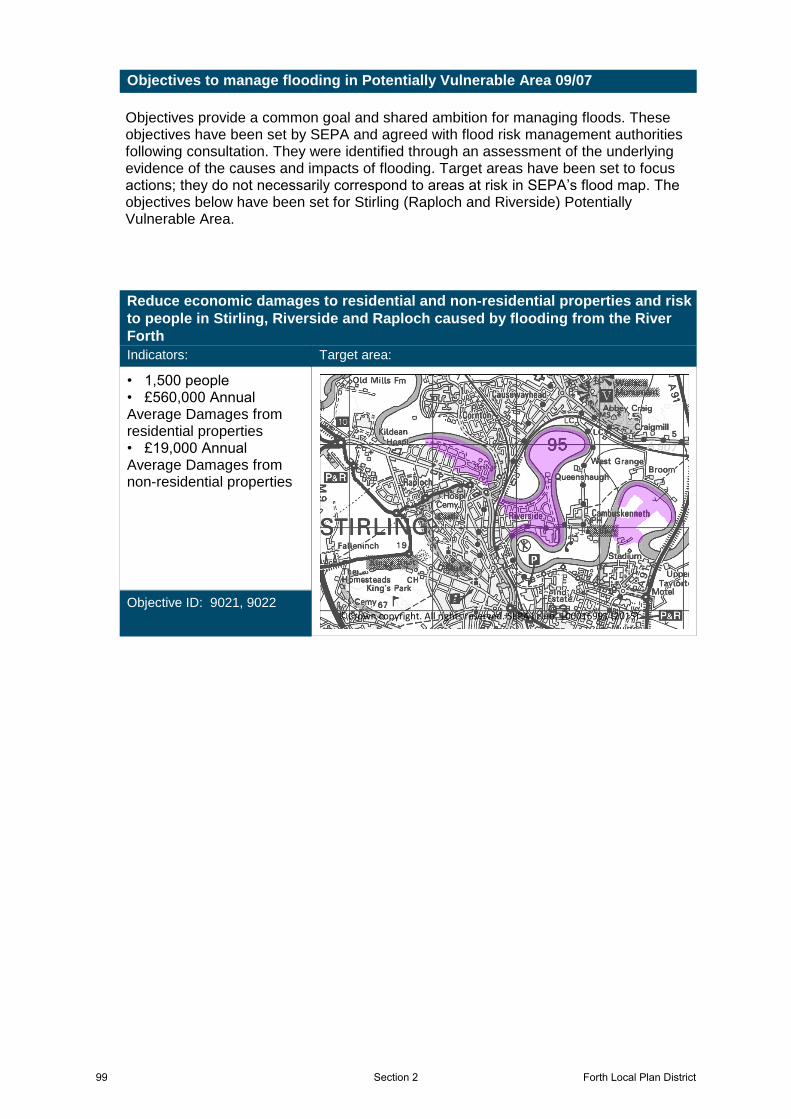
Objectives provide a common goal and shared ambition for managing floods. These objectives have been set by SEPA and agreed with flood risk management authorities following consultation. They were identified through an assessment of the underlying evidence of the causes and impacts of flooding. Target areas have been set to focus actions; they do not necessarily correspond to areas at risk in SEPA’s flood map. The objectives below have been set for Stirling (Raploch and Riverside) Potentially Vulnerable Area.
Objectives to manage flooding in Potentially Vulnerable Area 09/07
Reduce economic damages to residential and non-residential properties and risk
to people in Stirling, Riverside and Raploch caused by flooding from the River
Forth
Indicators:
• 1,500 people• £560,000 Annual Average Damages from residential properties• £19,000 Annual Average Damages from non-residential properties
Objective ID: 9021, 9022
Target area:
Image found and displayed.
©Crown copyright. All rights reserved. SEPA lic.no. 100016991 (2015)
99 Forth Local Plan DistrictSection 2
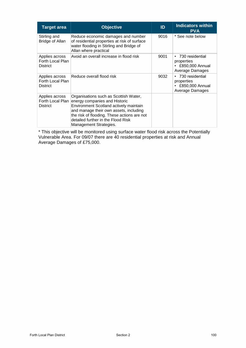
Target area Objective ID Indicators within
PVAStirling and Bridge of Allan
9016 * See note belowReduce economic damages and number of residential properties at risk of surface water flooding in Stirling and Bridge of Allan where practical
Applies across Forth Local Plan District
9001 • 730 residential properties• £850,000 Annual Average Damages
Avoid an overall increase in flood risk
Applies across Forth Local Plan District
9032 • 730 residential properties• £850,000 Annual Average Damages
Reduce overall flood risk
Applies across Forth Local Plan District
Organisations such as Scottish Water, energy companies and Historic Environment Scotland actively maintain and manage their own assets, including the risk of flooding. These actions are not detailed further in the Flood Risk Management Strategies.
* This objective will be monitored using surface water flood risk across the Potentially Vulnerable Area. For 09/07 there are 40 residential properties at risk and Annual Average Damages of £75,000.
Forth Local Plan District 100Section 2
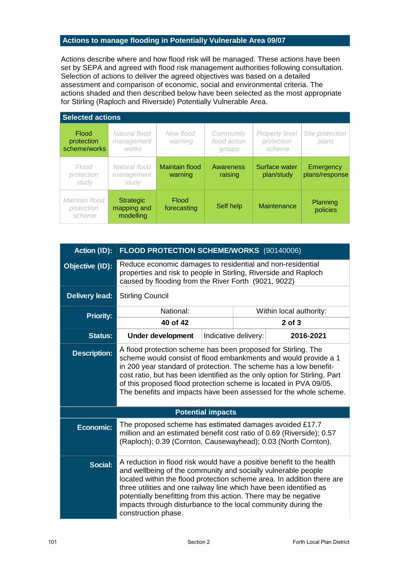
Actions describe where and how flood risk will be managed. These actions have been set by SEPA and agreed with flood risk management authorities following consultation. Selection of actions to deliver the agreed objectives was based on a detailed assessment and comparison of economic, social and environmental criteria. The actions shaded and then described below have been selected as the most appropriate for Stirling (Raploch and Riverside) Potentially Vulnerable Area.
Selected actions
Actions to manage flooding in Potentially Vulnerable Area 09/07
Maintain flood warning
Site protection plans
MaintenanceSelf helpMaintain flood
protection scheme
Strategic mapping and
modelling
Flood forecasting
Emergency plans/response
Community flood action
groups
Awareness raising
Planning policies
Surface water plan/study
New flood warning
Property level protection
scheme
Natural flood management
works
Natural flood management
study
Flood protection
scheme/works
Flood protection
study
Flood protection
scheme/works
Surface water plan/study
Planning policies
Awareness raising
Emergency plans/response
Flood forecasting
Strategic mapping and
modelling
Self help Maintenance
Maintain flood warning
A flood protection scheme has been proposed for Stirling. The scheme would consist of flood embankments and would provide a 1 in 200 year standard of protection. The scheme has a low benefit-cost ratio, but has been identified as the only option for Stirling. Part of this proposed flood protection scheme is located in PVA 09/05. The benefits and impacts have been assessed for the whole scheme.
Stirling Council
Under development Indicative delivery: 2016-2021
Action (ID): FLOOD PROTECTION SCHEME/WORKS (90140006)
Description:
Objective (ID):
Delivery lead:
Status:
Reduce economic damages to residential and non-residential properties and risk to people in Stirling, Riverside and Raploch caused by flooding from the River Forth (9021, 9022)
40 of 42 2 of 3
National: Within local authority:Priority:
A reduction in flood risk would have a positive benefit to the health and wellbeing of the community and socially vulnerable people located within the flood protection scheme area. In addition there are three utilities and one railway line which have been identified as potentially benefitting from this action. There may be negative impacts through disturbance to the local community during the construction phase.
The proposed scheme has estimated damages avoided £17.7 million and an estimated benefit cost ratio of 0.69 (Riverside); 0.57 (Raploch); 0.39 (Cornton, Causewayhead); 0.03 (North Cornton).
Potential impacts
Economic:
Social:
101 Forth Local Plan DistrictSection 2
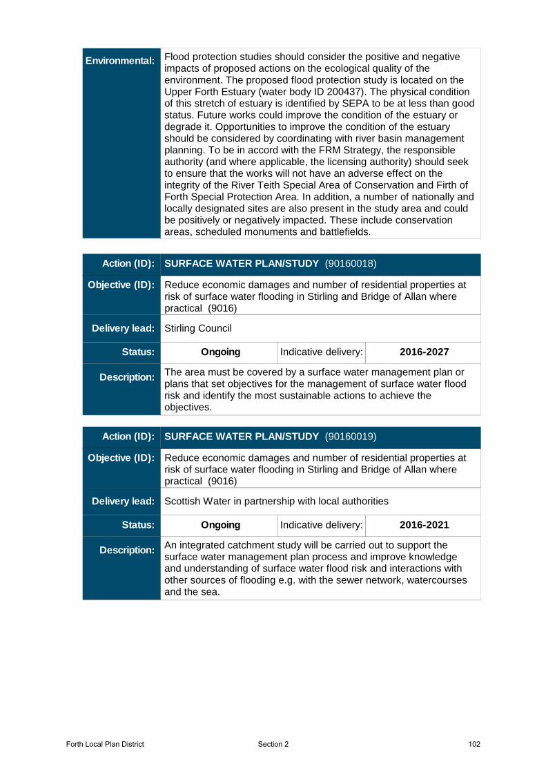
Flood protection studies should consider the positive and negative impacts of proposed actions on the ecological quality of the environment. The proposed flood protection study is located on the Upper Forth Estuary (water body ID 200437). The physical condition of this stretch of estuary is identified by SEPA to be at less than good status. Future works could improve the condition of the estuary or degrade it. Opportunities to improve the condition of the estuary should be considered by coordinating with river basin management planning. To be in accord with the FRM Strategy, the responsible authority (and where applicable, the licensing authority) should seek to ensure that the works will not have an adverse effect on the integrity of the River Teith Special Area of Conservation and Firth of Forth Special Protection Area. In addition, a number of nationally and locally designated sites are also present in the study area and could be positively or negatively impacted. These include conservation areas, scheduled monuments and battlefields.
Environmental:
The area must be covered by a surface water management plan or plans that set objectives for the management of surface water flood risk and identify the most sustainable actions to achieve the objectives.
Stirling Council
Ongoing Indicative delivery: 2016-2027
Action (ID): SURFACE WATER PLAN/STUDY (90160018)
Description:
Objective (ID):
Delivery lead:
Status:
Reduce economic damages and number of residential properties at risk of surface water flooding in Stirling and Bridge of Allan where practical (9016)
An integrated catchment study will be carried out to support the surface water management plan process and improve knowledge and understanding of surface water flood risk and interactions with other sources of flooding e.g. with the sewer network, watercourses and the sea.
Scottish Water in partnership with local authorities
Ongoing Indicative delivery: 2016-2021
Action (ID): SURFACE WATER PLAN/STUDY (90160019)
Description:
Objective (ID):
Delivery lead:
Status:
Reduce economic damages and number of residential properties at risk of surface water flooding in Stirling and Bridge of Allan where practical (9016)
Forth Local Plan District 102Section 2
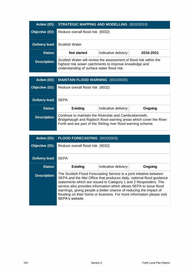
Scottish Water will review the assessment of flood risk within the highest risk sewer catchments to improve knowledge and understanding of surface water flood risk.
Scottish Water
Not started Indicative delivery: 2016-2021
Action (ID): STRATEGIC MAPPING AND MODELLING (90320019)
Description:
Objective (ID):
Delivery lead:
Status:
Reduce overall flood risk (9032)
Continue to maintain the Riverside and Cambuskenneth, Bridgehaugh and Raploch flood warning areas which cover the River Forth and are part of the Stirling river flood warning scheme.
SEPA
Existing Indicative delivery: Ongoing
Action (ID): MAINTAIN FLOOD WARNING (90320030)
Description:
Objective (ID):
Delivery lead:
Status:
Reduce overall flood risk (9032)
The Scottish Flood Forecasting Service is a joint initiative between SEPA and the Met Office that produces daily, national flood guidance statements which are issued to Category 1 and 2 Responders. The service also provides information which allows SEPA to issue flood warnings, giving people a better chance of reducing the impact of flooding on their home or business. For more information please visit SEPA’s website.
SEPA
Existing Indicative delivery: Ongoing
Action (ID): FLOOD FORECASTING (90320009)
Description:
Objective (ID):
Delivery lead:
Status:
Reduce overall flood risk (9032)
103 Forth Local Plan DistrictSection 2
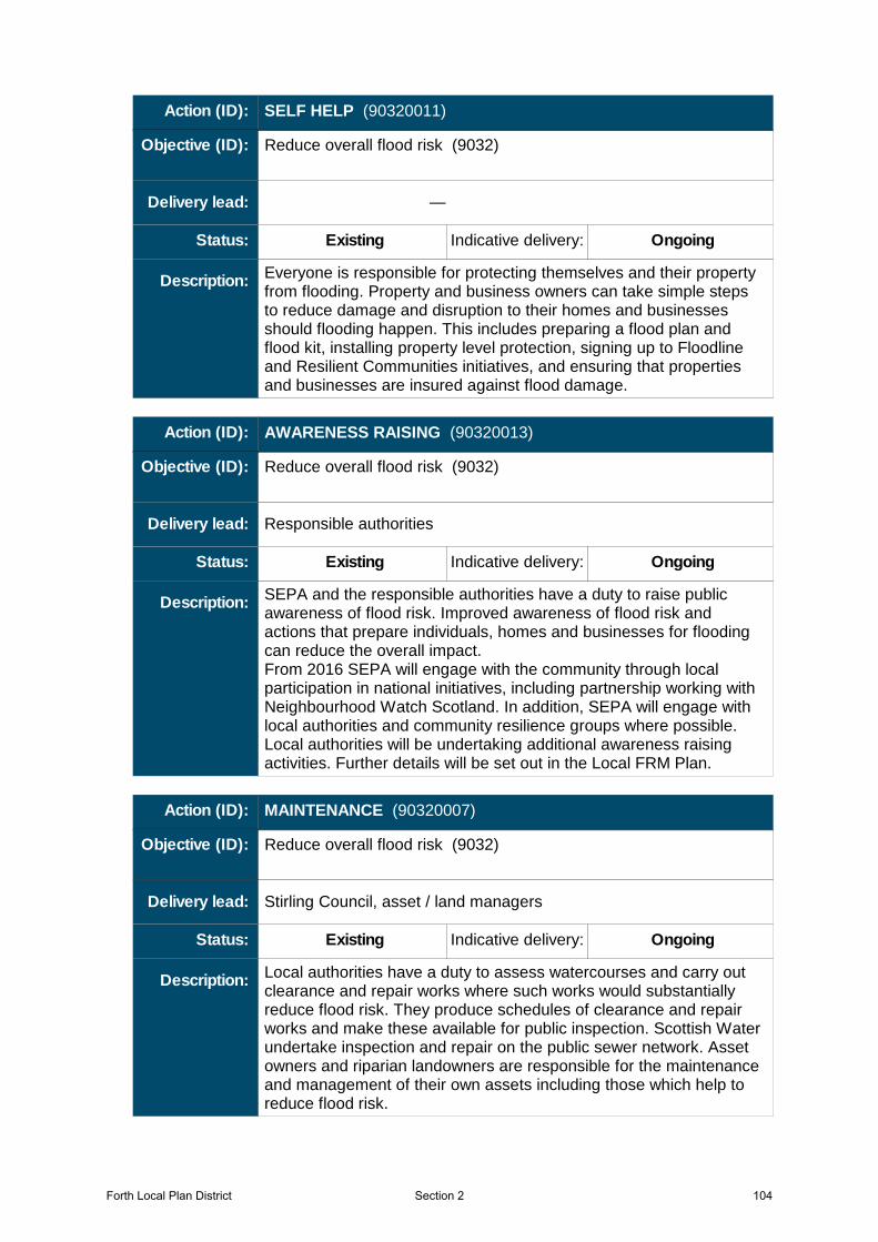
Everyone is responsible for protecting themselves and their property from flooding. Property and business owners can take simple steps to reduce damage and disruption to their homes and businesses should flooding happen. This includes preparing a flood plan and flood kit, installing property level protection, signing up to Floodline and Resilient Communities initiatives, and ensuring that properties and businesses are insured against flood damage.
—
Existing Indicative delivery: Ongoing
Action (ID): SELF HELP (90320011)
Description:
Objective (ID):
Delivery lead:
Status:
Reduce overall flood risk (9032)
SEPA and the responsible authorities have a duty to raise public awareness of flood risk. Improved awareness of flood risk and actions that prepare individuals, homes and businesses for flooding can reduce the overall impact.From 2016 SEPA will engage with the community through local participation in national initiatives, including partnership working with Neighbourhood Watch Scotland. In addition, SEPA will engage with local authorities and community resilience groups where possible.Local authorities will be undertaking additional awareness raising activities. Further details will be set out in the Local FRM Plan.
Responsible authorities
Existing Indicative delivery: Ongoing
Action (ID): AWARENESS RAISING (90320013)
Description:
Objective (ID):
Delivery lead:
Status:
Reduce overall flood risk (9032)
Local authorities have a duty to assess watercourses and carry out clearance and repair works where such works would substantially reduce flood risk. They produce schedules of clearance and repair works and make these available for public inspection. Scottish Water undertake inspection and repair on the public sewer network. Asset owners and riparian landowners are responsible for the maintenance and management of their own assets including those which help to reduce flood risk.
Stirling Council, asset / land managers
Existing Indicative delivery: Ongoing
Action (ID): MAINTENANCE (90320007)
Description:
Objective (ID):
Delivery lead:
Status:
Reduce overall flood risk (9032)
Forth Local Plan District 104Section 2
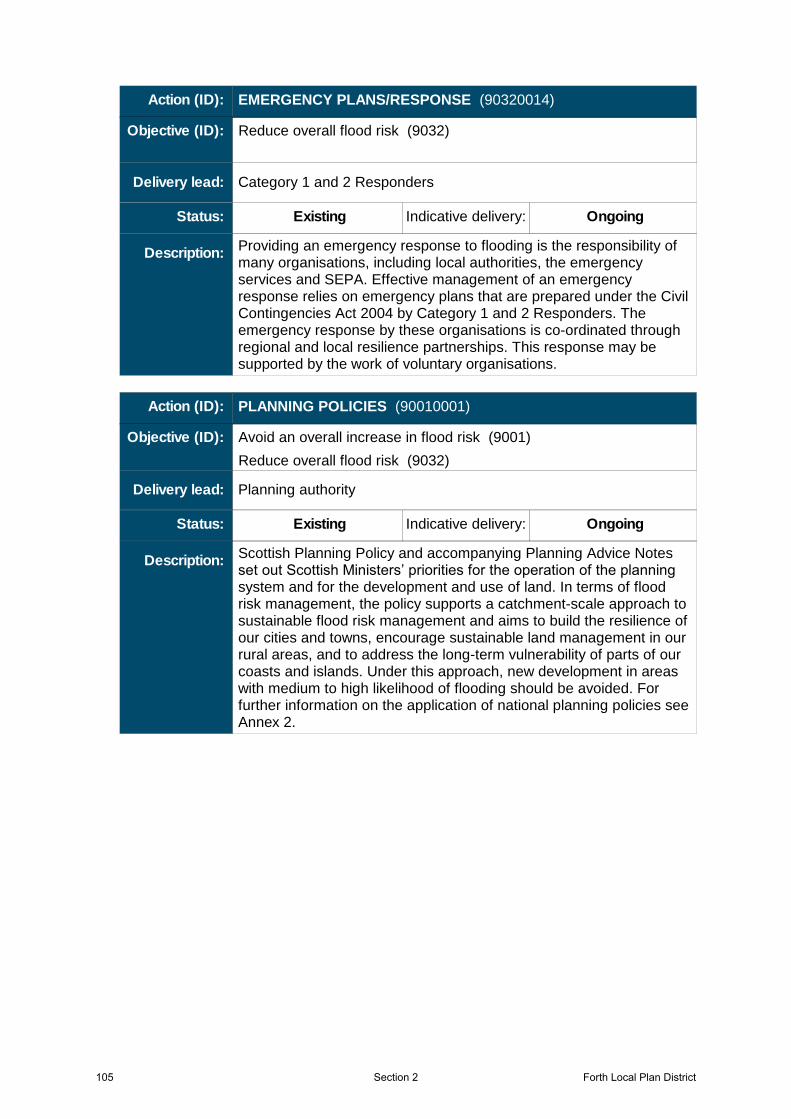
Providing an emergency response to flooding is the responsibility of many organisations, including local authorities, the emergency services and SEPA. Effective management of an emergency response relies on emergency plans that are prepared under the Civil Contingencies Act 2004 by Category 1 and 2 Responders. The emergency response by these organisations is co-ordinated through regional and local resilience partnerships. This response may be supported by the work of voluntary organisations.
Category 1 and 2 Responders
Existing Indicative delivery: Ongoing
Action (ID): EMERGENCY PLANS/RESPONSE (90320014)
Description:
Objective (ID):
Delivery lead:
Status:
Reduce overall flood risk (9032)
Scottish Planning Policy and accompanying Planning Advice Notes set out Scottish Ministers’ priorities for the operation of the planning system and for the development and use of land. In terms of flood risk management, the policy supports a catchment-scale approach to sustainable flood risk management and aims to build the resilience of our cities and towns, encourage sustainable land management in our rural areas, and to address the long-term vulnerability of parts of our coasts and islands. Under this approach, new development in areas with medium to high likelihood of flooding should be avoided. For further information on the application of national planning policies see Annex 2.
Planning authority
Existing Indicative delivery: Ongoing
Action (ID): PLANNING POLICIES (90010001)
Description:
Objective (ID):
Delivery lead:
Status:
Avoid an overall increase in flood risk (9001)
Reduce overall flood risk (9032)
105 Forth Local Plan DistrictSection 2