Embed Size (px)
Citation preview
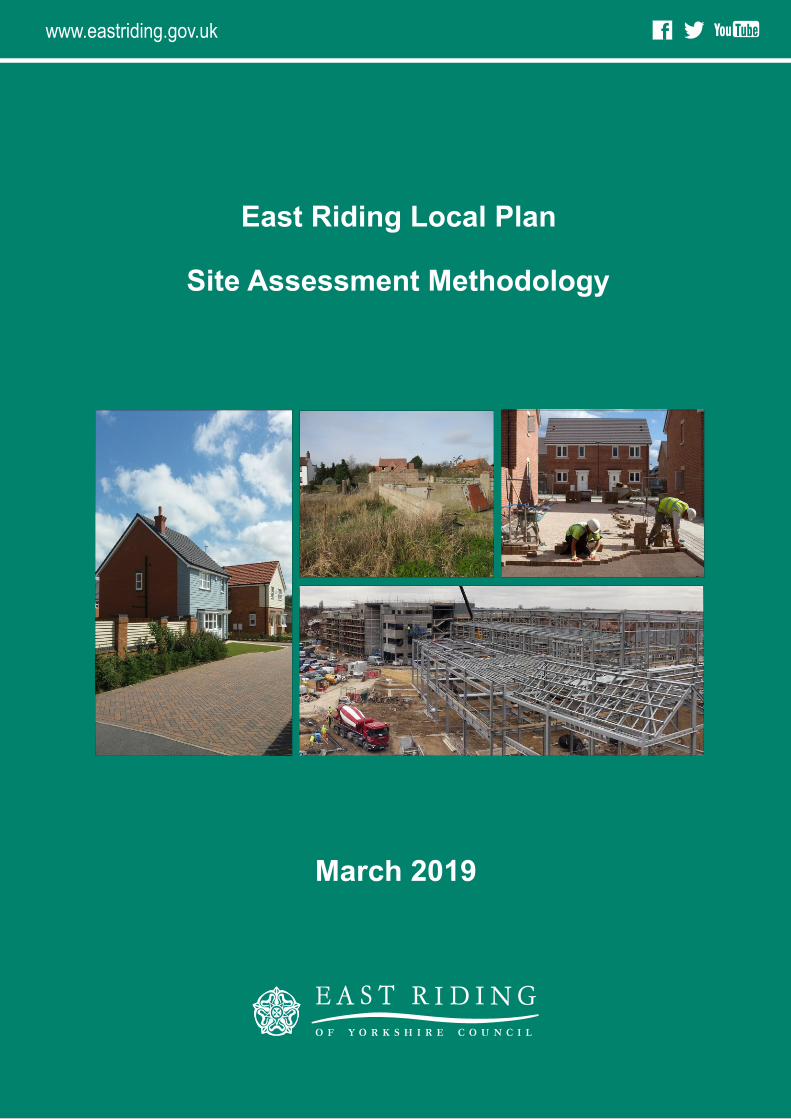
March 2019
East Riding Local Plan
f You Tube
www.eastriding.gov.uk
f You Tube
Site Assessment Methodology
www.eastriding.gov.uk
Contents
East Riding of Yorkshire Council I
Introduction ................................................................................................................. 1
Purpose .............................................................................................................................. 1
Stage 1 Initial Assessment and Site Exclusion .......................................................... 4
Question 1 Conformity with the settlement network .................................................. 4
Question 2 Biodiversity and Geological Value ............................................................... 6
Question 3 Flood Risk & Coastal Change ....................................................................... 8
Question 4 Heritage Assets ............................................................................................. 9
Stage 2 Detailed Site Specific Considerations......................................................... 12
Question 5 Greenfield and previously developed land (PDL) .................................... 12
Question 6 Accessibility by Public Transport .............................................................. 14
Question 7 Accessibility by Walking and Cycling ........................................................ 15
Question 8 Flood Risk ..................................................................................................... 17
Question 9 Settlement Vision ....................................................................................... 19
Question 10 Biodiversity and Geological Value ........................................................... 20
Question 11 Wildlife and Natural Environment .......................................................... 22
Question 12 Heritage Assets ......................................................................................... 24
Question 13 Built Character .......................................................................................... 27
Question 14 Landscape Character ................................................................................ 29
Question 15 Air Quality ................................................................................................. 31
Question 16 Agricultural Land ...................................................................................... 32
Question 17 Groundwater ............................................................................................. 33
Question 18 Compatibility with neighbouring uses .................................................... 34
Question 19 Contaminated land ................................................................................... 36
Question 20 Mineral resources ...................................................................................... 37
Question 21 Renewable and low carbon energy .......................................................... 38
Question 22 Publicly Accessible Open Space .............................................................. 39
Question 23 School capacity .......................................................................................... 41
Question 24 Utilities infrastructure capacity ............................................................... 42
Question 25 Highway network capacity ....................................................................... 43
Question 26 Wider non-road transport network ........................................................ 44
Question 27 Community facilities ................................................................................. 45
Question 28 Town centre vitality and viability ............................................................ 46
Question 29 Regeneration or economic benefits ........................................................ 48
Question 30 Meeting housing needs ............................................................................. 49
Stage 3 Deliverability ................................................................................................. 51
Contents
II East Riding of Yorkshire Council
Question 31 Insurmountable constraints ..................................................................... 51
Question 32 Ownership and market constraints ......................................................... 52
Question 33 Deliverability ............................................................................................. 53
Using the Site Assessment Methodology ................................................................. 54
Introduction
East Riding of Yorkshire Council 1
Introduction This document sets out the process that East Riding of Yorkshire Council will follow to assess
and compare the suitability of potential development sites. It replaces the previously adopted
Site Assessment Methodology (updated January 2014) and will be used to assess sites that
have been submitted to the Council for inclusion within the Local Plan review of the
Allocations Document (including undeveloped allocations in the existing plan). The Allocations
Document is one of a number of documents that make up the East Riding Local Plan and
allocates sites for development (such as housing, retail, or industry) or protection (e.g. open
space or land for transport schemes).
The Site Assessment Methodology has undergone review to ensure it is applicable to a range
of proposed land uses and takes into account the revised National Planning Policy Framework
(NPPF) (2018). It has been prepared to ensure that it satisfies the requirements of
Sustainability Appraisal (SA), which seeks to assess how potential sites perform against a range
of economic, social, and environmental objectives. The SA’s objectives were updated through
the May 2018 SA Scoping Report and, where appropriate, the questions in this document have
been updated to reflect the revised objectives. Further explanations of the SA requirements
are available on the Council’s website1.
This methodology was published in draft for public consultation alongside the revised Local
Plan Review Options Paper (November 2018). Where relevant revisions were made to take
into account consultation responses received.
Purpose
The methodology will be used to assess all potential sites, including:
Sites that have been suggested by the general public, landowners, developers and
planning agents, both before and during the preparation of the Allocations Document
review;
Sites that are allocated in the existing Allocations Document where development has
not commenced;
Sites that have been identified through other studies such as the Council's Town
Centres & Retail Study, Employment Land Review and Strategic Housing Land
Availability Assessment (SHLAA); and
Other sites the Council believes merit consideration.
1 http://www.eastriding.gov.uk/environment/planning-and-building-control/east-riding-local-plan/sa-sea/
Introduction
2 East Riding of Yorkshire Council
Site Assessments
A total of 33 questions (with guidance notes) will be used to assess the potential impact of
each proposed development site. These have been split into three specific stages:
Stage 1: Initial Assessment and Site Exclusion
Stage 2: Detailed Site Specific Considerations
Stage 3: Deliverability
Whilst most questions apply to all the potential uses being considered in the Allocations
Document, some questions relate to a specific use. For example, the capacity of schools will
only be relevant when assessing proposed housing sites and does not need to be considered
for other types of development. Therefore, the guidance notes set out the uses that the
question applies to and the scoring range that should be used.
Site assessments will be undertaken for each site using information obtained from a variety of
sources, including:
Studies and reports published by the Council and other agencies, for example the East
Riding of Yorkshire Landscape Character Assessment (2018);
Information from site surveys, for example photos and site measurements;
Documentation submitted by those promoting the site for inclusion in the Allocations
Document review; and
Where appropriate, information gained through discussions with those promoting the
site, any relevant consultee (e.g. Natural England) and the local community.
In most instances sites will be assessed individually, however, there may be cases where it is
desirable to consider an alternative site boundary. This might result in larger sites being split,
or a combination of two or more sites being assessed together, where it would result in
benefits against a number of the assessment questions.
Assessments will take account of the best available information. The key sources of evidence
that will be used to appraise sites are highlighted within the guidance notes for each question.
New or updated sources of information that become available following the publication of
this Site Assessment Methodology will be taken into account. This may include additional
information that mitigates a negative effect.
Every effort has been made to include all the important issues that should be taken into
account when considering the location of new development. However, other factors that are
perhaps only relevant to individual sites or small groups of sites may become apparent during
the assessment process. If any such issues arise as part of the site assessments they will also
be taken into account and weighted accordingly.
Introduction
East Riding of Yorkshire Council 3
Contact Details
For further information on this document or the Allocations Document please contact: Forward Planning - East Riding of Yorkshire Council County Hall, Beverley, HU17 9BA E-mail: [email protected] Tel: 01482 391743
Stage 1 Initial Assessment and Site Exclusion
4 East Riding of Yorkshire Council
Stage 1 Initial Assessment and Site Exclusion
Stage 1 represents an initial ‘sieving’ exercise, which seeks to dismiss at an early stage all those
sites that have a significant constraint to development. Sites will be assessed to determine
whether they conform to the proposed development plan settlement network and overall
strategy for locating development, as well as a number of key environmental considerations.
At the time of writing the development plan is that set out in the Local Plan Strategy
Document, Allocations Document and Bridlington Town Centre Area Action Plan. In time
Stage 1 will consider the settlement network and overall strategy set out in the Local Plan
Review.
Sites will only be dismissed where a constraint is identified and considered so significant that
development would not be appropriate. All other sites will be carried forward for assessment
against relevant questions in Stages 2 and 3 of this methodology.
Question 1 Conformity with the settlement network
Would the use for the site be appropriate when considered against the settlement's place in the Strategy Document settlement network or the overall strategy for locating development?
Approach to assessment for all uses:
Yes No
A settlement network is established in the Strategy Document, which is used to determine
the scale and distribution of new development across the East Riding. It identifies those
settlements, in particular the towns and larger villages, where the majority of housing
development is to be located as well as other uses such as offices, retail, and community
facilities. This includes Carnaby, Kelleythorpe and Tokenspire Industrial Estates which are
close to Bridlington, Driffield and Beverley respectively. Whilst they are detached from the
main built up area, they are identified as being important for contributing to the economic
role of these settlements.
In addition, four Key Employment Sites are identified as part of the settlement network at
Hedon Haven, Humber Bridgehead (Hessle), Melton and Capitol Park (Goole). These provide
significant opportunities for employment development and are of vital importance to achieving
the economic growth aspirations of the East Riding.
Therefore, only sites that are either within or adjacent to a settlement or other strategically
important location will be assessed. In certain instances sites that are not directly adjacent to
the settlement boundary, but still well-related to the built-up area, will be included where
they have potential to deliver significant sustainability or community benefits. The term
Stage 1 Initial Assessment and Site Exclusion
East Riding of Yorkshire Council 5
adjacent refers to sites that lie next to or are well related to the development limit as defined
by the Strategy Document and it is reasonable to consider them as a possible extension to
the urban boundary. The latter may include sites that are detached from the development
limit by a small field boundary or an area of open space (e.g. playing field). Sites that are some
distance from a settlement (for example separated by several fields) are unlikely to be
considered appropriate for allocation through the methodology. The NPPF also highlights the
potential role in planning for new settlements. Whilst opportunities for any new settlement
within the East Riding would be considered through revision to the Local Plan Settlement
Network, the site allocations would be assessed.
The Strategy Document includes guidance that will be relevant when considering the
distribution of development for a range of different uses. This includes:
Housing: The Strategy Document provides an indicative target for house building in the East
Riding and sets out the scale and distribution of housing across its settlement network. The
size and number of new housing allocations required in a particular settlement will depend
upon both the number of homes proposed for the settlement in the Strategy Document and
the number of new homes that already have a planning permission. Delivery against this target
is monitored annually through the Council’s Annual Monitoring Report. The Local Plan review
will consider how many houses need to be provided in the future and any changes to its
distribution across the settlement network.
Employment: The Strategy Document seeks to strengthen and contribute to the growth of
the East Riding economy by facilitating proposals that would meet wider economic objectives.
This has been informed by an Employment Land Review which identifies the need to allocate
sites for employment uses in key locations throughout the East Riding. The Employment Land
Review outlines the total amount of employment land required to accommodate forecast job
growth. Its recommendations have been incorporated into the Strategy Document, which
also considers those strategic and other employment sites that should be safeguarded for
employment uses, recognising that these are important for future economic growth. The
Local Plan review will be informed by a new Employment Land Review, which will identify the
need for new employment land within the East Riding.
Town Centre uses: The Strategy Document sets out a hierarchy of town centres providing
the framework for considering the overall scale and type of new town centre development.
It has been informed by the East Riding Town Centres and Retail Study, which provides an
assessment of retail provision, shopping patterns, and 'health checks' for the larger towns. In
particular, it sets out an estimate of future retail spend in different towns which has been
translated into a requirement for new floorspace. The Local Plan review will be informed by
a new Town Centres, Retail and Leisure Study, which will identify the need for new town
centre developments within the East Riding.
Stage 1 Initial Assessment and Site Exclusion
6 East Riding of Yorkshire Council
Transport: The Strategy Document seeks to protect and enhance the overall role and
function of the Strategic Transport Network within East Riding. A number of transport
schemes and interventions are identified in the Council's Local Transport Plan2, which covers
the period 2015-2029, and it is important that these schemes are safeguarded through the
Local Plan. In addition, there may be other appropriate schemes that have been identified in
evidence base studies, for example a feasibility study, or by neighbouring local transport
authorities. These might be important in supporting the wider delivery of the Council’s
aspirations, for example the North of Hull Park and Ride.
Sites should be dismissed if their use is not appropriate to their location within
the Strategy Document settlement network or if the proposed use is not
appropriate in relation to the strategy for locating development.
OR
Proposed sites for transport use will be dismissed if they are not needed for a
specific transport scheme to deliver the strategy set out in the Council’s Local
Transport Plan or where appropriate, a neighbouring authority’s Local Transport
Plan or the wider aspirations of the Council.
Question 2 Biodiversity and Geological Value
Would development cause a significant adverse effect on an international or national site of biodiversity or geological value?
Approach to assessment for all uses:
Yes No
The NPPF sets out policies on the protection of biodiversity and geological conservation through the planning system, which is supplemented by national Planning Practice Guidance (PPG).
The key principles of this guidance are that planning policies should avoid, mitigate or compensate for harm and should seek ways to conserve, enhance and restore biodiversity and geological diversity. It identifies that appropriate weight should be attached to sites that are designated as being of international and national importance.
Internationally designated sites are the most important sites for biodiversity. They are afforded significant weight and are legally protected. It is important that local planning authorities ensure that this legal protection is not prejudiced.
2 http://www2.eastriding.gov.uk/council/plans-and-policies/other-plans-and-policies-information/transport/local-transport-plan/
Stage 1 Initial Assessment and Site Exclusion
East Riding of Yorkshire Council 7
International sites comprise:
Special Protection Areas (SPA) Special Areas of Conservation (SAC) Ramsar Sites Candidate SPAs, SACs and Ramsar sites
Habitats Regulations
Under Article 6 of the Habitats Directive, an assessment is required where a plan is likely to
give rise to significant effects upon certain internationally designated sites. This includes SACs
designated under the Habitats Directive for their habitats and/or species of European
importance and SPAs designated under the Conservation of Wild Birds Directive for rare
migratory bird species and internationally important wetlands.
As a consequence, the Council will need to prepare a Habitats Regulation Assessment
Screening Report to identify the likely impacts of any preferred development site and consider
whether these impacts are likely to be significant. Where deemed necessary through a
screening report, a full Habitats Regulation Assessment will need to be carried out for a
preferred development site. This will involve a detailed assessment of the impact that
development may have to determine whether there will be adverse effects on the integrity of
the designated biodiversity site. The requirement to consider the need for an Appropriate
Assessment is set out under Article 6(3) and (4) of the EU Habitats Directive 92/43/EEC.
Any site that would cause a significant adverse effect on an international designation will be dismissed at this stage.
Nationally designated sites are also legally protected. Under the Wildlife and Countryside Act 1981 (as amended) local planning authorities must take reasonable steps to further the conservation and enhancement of their special features. They comprise:
Sites of Special Scientific Interest (SSSI) National Nature Reserves (NNR)
National planning policy identifies that development should not normally be allowed where it is likely to have an adverse effect on a SSSI. An exception should only be made when the benefits of the development would clearly outweigh the impacts that it is likely to have on the features of the site.
Any site that would cause a significant adverse effect on a national designation will be dismissed at this stage.
The Council is required to consult Natural England over any site that may impact upon an international or national designation and their comments, alongside the Council’s Sustainable Development team, will be critical in considering whether or not a site causes a significant adverse effect and should be dismissed. Natural England have created an Impact Risk Zones
Stage 1 Initial Assessment and Site Exclusion
8 East Riding of Yorkshire Council
(England) tool3 to make rapid initial assessments of the potential risks posed by development proposals to: SSSIs, SACs, SPAs and Ramsar sites. They define zones around each site which reflect the particular sensitivities of the features for which it is designated and indicate the types of development proposal which could potentially have adverse impacts. It is likely that any proposed development site that falls within an international or nationally designated site would have a significant adverse effect.
Should it appear likely that a site is to be dismissed, those promoting the site will be offered the opportunity to provide evidence to demonstrate that development will not have a detrimental effect upon the protected site. Such evidence may be provided through an ecological assessment of the site. In exceptional circumstances, sites which have a significant adverse effect may not be discounted at this stage if it can be demonstrated the development is of over-riding public importance and that there are no other suitable sites available.
Question 3 Flood Risk & Coastal Change
Would the development be unsuitable because of its location in the functional floodplain or an area at risk from coastal erosion?
Approach to assessment for all uses:
Yes No
The NPPF sets out a risk-based approach, including a Sequential Test, which aims to ensure that development proposals are steered away from high flood risk areas as far as possible. Areas of flood risk are mapped by the Environment Agency, supplemented by the Council’s Strategic Flood Risk Assessment, and classified into the following Flood Zones:
Flood Zone 1: Low Probability Flood Zone 2: Medium Probability Flood Zone 3a: High Probability Flood Zone 3b: The Functional Floodplain
The Council has prepared a Strategic Flood Risk Assessment, which maps the extent of the Flood Zones within the East Riding. This will be used to determine whether a proposed development site is located within the Functional Floodplain. The PPG confirms that development should not be permitted in the Functional Floodplain, unless it is for ‘essential infrastructure’ or a ‘water-compatible’ use).4 Therefore, inappropriate sites in the Functional Floodplain will be discounted at Stage 1.
The risk from coastal erosion is also an important consideration and the Council has monitored erosion rates along the East Riding coast since 1951. As a general guide, the rate of erosion is 1 to 1.5 metres per year between Barmston and Atwick, and 1.5 to 2 metres per year between Hornsea and Kilnsea. This information has been used in preparing the
3 https://naturalengland-defra.opendata.arcgis.com/datasets/sssi-impact-risk-zones-england 4 PPG Paragraph: 067 Reference ID: 7-067-20140306
Stage 1 Initial Assessment and Site Exclusion
East Riding of Yorkshire Council 9
Shoreline Management Plan (SMP)5 to assess where the cliff is likely to be in 25, 50, and 100 years’ time. In line with the NPPF, the Council has used the SMP to identify Coastal Change Management Areas (CCMA), which are areas 'likely to be affected by physical changes to the coast’.
Within the CCMA, the Strategy Document restricts development to temporary commercial uses, provided it can be demonstrated that these would contribute to the local economy or help to improve the East Riding’s tourism offer. It also requires that the risk to the development can be mitigated throughout its intended lifespan. Therefore, sites within the CCMA will be discounted at this stage, unless they are for a temporary, commercial (tourism-related) use.
Sites in the Functional Floodplain (unless promoted for ‘essential infrastructure’ and ‘water-compatible’ uses) and in the Coastal Change Management Area (unless promoted for a temporary, commercial use) will be dismissed at this stage.
Question 4 Heritage Assets
Would the development cause substantial harm to a nationally designated heritage asset?
Approach to assessment for all uses:
Yes No
The NPPF recognises that the historic environment is an irreplaceable resource and should be conserved, in a manner appropriate to its significance. It highlights that the significance of any heritage asset should be considered alongside the impact that new development would have on that asset.
The aim is to conserve heritage assets in a manner appropriate to their significance by ensuring that:
Decisions are based on the nature, extent and level of that significance, investigated to a degree proportionate to the importance of the heritage asset;
Wherever possible, heritage assets are put to an appropriate and viable use that is consistent with their conservation;
The positive contribution of such heritage assets to local character and sense of place is recognised and valued; and
5 https://www.gov.uk/government/publications/shoreline-management-plans-smps/shoreline-management-plans-smps
Stage 1 Initial Assessment and Site Exclusion
10 East Riding of Yorkshire Council
Consideration of the historic environment is integrated into planning policies, promoting place-shaping.
It seeks to ensure that policies and decisions concerning the historic environment:
Recognise that heritage assets are a non-renewable resource;
Take account of the wider social, cultural, economic and environmental benefits of heritage conservation; and
Recognise that intelligently managed change may sometimes be necessary if heritage assets are to be maintained for the long term.
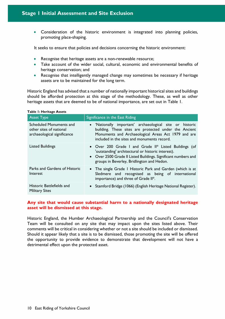
Historic England has advised that a number of nationally important historical sites and buildings should be afforded protection at this stage of the methodology. These, as well as other heritage assets that are deemed to be of national importance, are set out in Table 1.
Table 1: Heritage Assets
Asset Type Significance in the East Riding
Scheduled Monuments and other sites of national archaeological significance
‘Nationally important’ archaeological site or historic building. These sites are protected under the Ancient Monuments and Archaeological Areas Act 1979 and are included in the sites and monuments record.
Listed Buildings Over 200 Grade I and Grade II* Listed Buildings (of 'outstanding' architectural or historic interest).
Over 2500 Grade II Listed Buildings. Significant numbers and groups in Beverley, Bridlington and Hedon.
Parks and Gardens of Historic Interest
The single Grade 1 Historic Park and Garden (which is at Sledmere and recognised as being of international importance) and three of Grade II*.
Historic Battlefields and Military Sites
Stamford Bridge (1066) (English Heritage National Register).
Any site that would cause substantial harm to a nationally designated heritage asset will be dismissed at this stage.
Historic England, the Humber Archaeological Partnership and the Council's Conservation Team will be consulted on any site that may impact upon the sites listed above. Their comments will be critical in considering whether or not a site should be included or dismissed. Should it appear likely that a site is to be dismissed, those promoting the site will be offered the opportunity to provide evidence to demonstrate that development will not have a detrimental effect upon the protected asset.
Stage 1 Initial Assessment and Site Exclusion
East Riding of Yorkshire Council 11
Stage 1 Outcome: To identify all potential development sites that:
Would be appropriate when considered against the settlement’s place in the Strategy Document settlement network or the strategy for locating development;
Would not cause a significant adverse effect on an international or national environmental designation;
Would not be unsuitable due to the site’s vulnerability to flood risk or coastal erosion; and
Would not cause substantial harm to a nationally designated heritage asset.
Those sites that are not identified do not represent sustainable locations for development and will be excluded from further assessment.
Stage 2 Detailed Site Specific Considerations
12 East Riding of Yorkshire Council
Stage 2 Detailed Site Specific Considerations
The aim of this stage is to assess all the sites that were not dismissed in stage 1 against a number of detailed site-specific factors. These relate to a variety of social, economic and environmental issues that are relevant to achieving sustainable development within the East Riding. Each question sets out an approach to assessment that identifies how a site should be scored based on the following broad range:
(+++) Significant positive benefits would result from the development of the site.
(++) Positive benefit
(+) Minor positive benefit.
(0) Neutral / no effects can be identified, or existing features could be retained on-site.
(-) Minor negative effect.
(--) Negative effect
(---) Significant negative effects would result from the development of the site.
The result of the Stage 2 assessment will be a series of positive or negative marks recorded against each question for all sites, which will enable comparisons to be made between sites. Sites that are assessed as having a positive impact across a large number of questions will, in general, be the most suitable for development. However, where a significant adverse effect (---) is identified, and there is no reasonable opportunity for this impact to be reduced, then it is possible that the site may be considered inappropriate for development.
A site will only be dismissed if the constraint is deemed so significant that it could prevent development from taking place. Those promoting the site, as well as any relevant consultee(s), will be notified to enable potential mitigation or alternative measures to be considered. Any measures identified will be assessed to determine whether they would have an impact against other questions in the SAM. This will include the Stage 3 assessment to determine if it would affect the viability of a potential development site. Where mitigation measures are required and a number of sites are identified as having the same impact against a particular question, greater weight may be given to those sites that require no mitigation or alternative measures.
Question 5 Greenfield and previously developed land (PDL)
Does the site contain previously developed land (PDL), greenfield land or a mix of both?
Approach to site assessment for all uses:
Mixed: > 75% PDL: (+++)
Mixed: 50 – 74% PDL: (++)
Mixed: 25 – 49% PDL: (+)
Mixed < 24% PDL: (0)
Wholly greenfield land (100%) (-)
Stage 2 Detailed Site Specific Considerations
East Riding of Yorkshire Council 13
The NPPF prioritises the effective use of land through the re-use of PDL (or brownfield land) over the use of undeveloped land (greenfield land). Therefore, the Strategy Document seeks to bring vacant and underused previously developed land and buildings back into beneficial use.
This question scores sites highly where they would result in the re-use of previously developed land. However, other questions within this methodology will help to determine whether such sites are ultimately suitable for development.
A definition of previously developed land has been set out by the government and includes land which is or was occupied by a permanent structure. Examples of previously developed land includes the following uses:
Residential land, hostels, old people's homes etc, but excluding gardens; Community buildings (including health, schools, religious buildings); Leisure and recreational buildings (sports halls, museums, cinemas, hotels); Employment land including offices, storage and warehousing; Retailing (inc. shops, garages, pubs, restaurants); Utilities and transport (including highways, car parks, railways); Vacant and/or derelict land and buildings (except those formerly used for agriculture
or forestry); and Defence land and buildings (including airfields, barracks).
Examples of greenfield sites includes:
Agricultural land (including orchards, nurseries);
Agricultural buildings (including vacant buildings);
Woodland and forestry;
Outdoor recreation (including playing fields, parks, sports grounds, golf courses);
Allotments;
Private residential gardens in built up areas; and
Urban land not previously developed (including amenity areas).
Sites will be scored according to the proportion of previously developed land that they contain. Those sites that are wholly previously developed receive the highest score whilst those that are wholly greenfield receive the lowest.
Stage 2 Detailed Site Specific Considerations
14 East Riding of Yorkshire Council
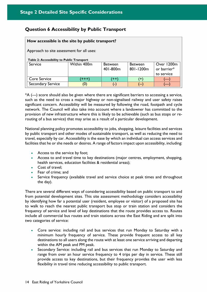
Question 6 Accessibility by Public Transport
How accessible is the site by public transport?
Approach to site assessment for all uses:
Table 2: Accessibility to Public Transport
Service Within 400m Between 401-800m
Between 801-1200m
Over 1200m or barrier* to service
Core Service (+++) (++) (+) (---) Secondary Service (0) (-) (--) (---)
*A (---) score should also be given where there are significant barriers to accessing a service, such as the need to cross a major highway or non-signalised railway and user safety raises significant concern. Accessibility will be measured by following the road, footpath and cycle network. The Council will also take into account where a landowner has committed to the provision of new infrastructure where this is likely to be achievable (such as bus stops or re-routing of a bus service) that may arise as a result of a particular development.
National planning policy promotes accessibility to jobs, shopping, leisure facilities and services by public transport and other modes of sustainable transport, as well as reducing the need to travel, especially by car. Accessibility is the ease by which an individual can access services and facilities that he or she needs or desires. A range of factors impact upon accessibility, including:
Access to the service by foot; Access to and travel time to key destinations (major centres, employment, shopping,
health services, education facilities & residential areas); Cost of travel; Fear of crime; and Service frequency (available travel and service choice at peak times and throughout
the day).
There are several different ways of considering accessibility based on public transport to and from potential development sites. This site assessment methodology considers accessibility by identifying how far a potential user (resident, employee or visitor) of a proposed site has to walk to reach the nearest public transport bus stop or train station and considers the frequency of service and level of key destinations that the route provides access to. Routes include all commercial bus routes and train stations across the East Riding and are split into two categories of service:
Core service: including rail and bus services that run Monday to Saturday with a minimum hourly frequency of service. These provide frequent access to all key destinations to all users along the route with at least one service arriving and departing within the AM peak and PM peak.
Secondary Service: including rail and bus services that run Monday to Saturday and range from over an hour service frequency to 4 trips per day in service. These still provide access to key destinations, but their frequency provides the user with less flexibility in travel time reducing accessibility to public transport.
Stage 2 Detailed Site Specific Considerations
East Riding of Yorkshire Council 15
Distances of between 400m and 1200m are regarded as 'easy walking distances'6. Taking this into account, the site assessments will consider the accessibility of potential development sites to bus stops and railway stations based on whether they are within a 400 metre walk (approximately 5 minutes), 800 metre walk (10 minutes) or 1,200 metre walk (15 minutes).
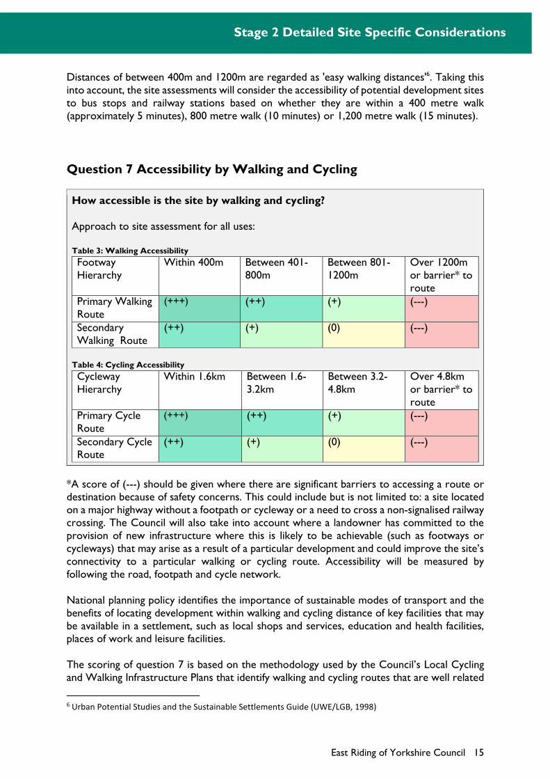
Question 7 Accessibility by Walking and Cycling
How accessible is the site by walking and cycling?
Approach to site assessment for all uses:
Table 3: Walking Accessibility
Footway Hierarchy
Within 400m Between 401-800m
Between 801-1200m
Over 1200m or barrier* to route
Primary Walking Route
(+++) (++) (+) (---)
Secondary Walking Route
(++) (+) (0) (---)
Table 4: Cycling Accessibility
Cycleway Hierarchy
Within 1.6km Between 1.6-3.2km
Between 3.2-4.8km
Over 4.8km or barrier* to route
Primary Cycle Route
(+++) (++) (+) (---)
Secondary Cycle Route
(++) (+) (0) (---)
*A score of (---) should be given where there are significant barriers to accessing a route or destination because of safety concerns. This could include but is not limited to: a site located on a major highway without a footpath or cycleway or a need to cross a non-signalised railway crossing. The Council will also take into account where a landowner has committed to the provision of new infrastructure where this is likely to be achievable (such as footways or cycleways) that may arise as a result of a particular development and could improve the site’s connectivity to a particular walking or cycling route. Accessibility will be measured by following the road, footpath and cycle network.
National planning policy identifies the importance of sustainable modes of transport and the benefits of locating development within walking and cycling distance of key facilities that may be available in a settlement, such as local shops and services, education and health facilities, places of work and leisure facilities.
The scoring of question 7 is based on the methodology used by the Council’s Local Cycling and Walking Infrastructure Plans that identify walking and cycling routes that are well related
6 Urban Potential Studies and the Sustainable Settlements Guide (UWE/LGB, 1998)
Stage 2 Detailed Site Specific Considerations
16 East Riding of Yorkshire Council
to key facilities within the East Riding. These plans consider the Department for Transport’s Propensity to Cycle Tool (PCT) and the Walking Route Audit Tool to prepare maps showing primary and secondary walking and cycling routes and key destinations within settlements. The infrastructure plans focus on the Haltemprice settlements, Principal Towns, Towns and Rural Service Centres, as identified by the Adopted Local Plan.
The defining requirements of each category are described below:
Primary walking and cycling routes are generally busy urban shopping and business areas, and main pedestrian routes, linking interchanges between different modes of transport, such as railway and bus stations. Primary routes have access to a wide variety of key destinations.
Secondary walking and cycling routes are medium usage routes through local areas feeding into primary routes, local shopping centres, schools and industrial centres. Secondary routes have access to a number of local key destinations.
As referred to above, distances of between 400m and 800m are regarded as 'easy walking distances'. For such distances, people would be expected to walk rather than use the car, cycle or public transport. The Chartered Institution of Highways Transportation (CIHT) Providing for Journeys on Foot (2000) advises that the mean average length for walking journeys is approximately 1 km. Cycling has the potential to substitute for short car trips. The CIHT suggest the mean average length for cycling journeys is approximately 4 km, but journeys up to three times these distances are not uncommon for regular commuters. The National Travel Survey undertaken by the Department for Transport (2013) indicates average trips by cycle have increased by 12% from 6.4 miles in 1995 to 7.1 miles in 2013.
Taking into account the above guidance, the site assessments will consider a residents propensity to walk or cycle by analysing the accessibility of potential development sites based on whether they are within a 400 metre walk (approximately 5 minutes), 800 metre walk (10 minutes) or 1,200 metre walk (15 minutes) distance from primary or secondary routes. Similarly distances of 1,600 metres (approximately 5 minutes cycle), 3,200 metres (10 minutes) and 4,800 metres (15 minutes) will be used to assess the potential for cycling.
Sites within the shortest walking and cycling distances to primary routes will receive the highest score. The assessment should put the site in a single category. For example a site within 800m of a primary route that is also within 400m of a secondary route should be given a score of (++). This should be noted in the assessment commentary.
Stage 2 Detailed Site Specific Considerations
East Riding of Yorkshire Council 17
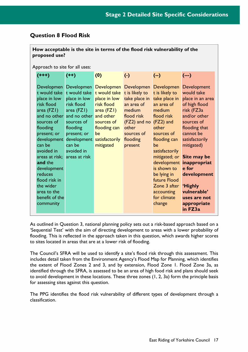
Question 8 Flood Risk
How acceptable is the site in terms of the flood risk vulnerability of the proposed use?
Approach to site for all uses:
(+++)
Development would take place in low risk flood area (FZ1) and no other sources of flooding present; or development can be avoided in areas at risk; and the development reduces flood risk in the wider area to the benefit of the community
(++)
Development would take place in low risk flood area (FZ1) and no other sources of flooding present; or development can be avoided in areas at risk
(0)
Development would take place in low risk flood area (FZ1) and other sources of flooding can be satisfactorily mitigated
(-)
Development is likely to take place in an area of medium flood risk (FZ2) and no other sources of flooding present
(--)
Development is likely to take place in an area of medium flood risk (FZ2) and other sources of flooding can be satisfactorily mitigated; or development is shown to be lying in future Flood Zone 3 after accounting for climate change
(---)
Development would take place in an area of high flood risk (FZ3a and/or other sources of flooding that cannot be satisfactorily mitigated)
Site may be inappropriate for development
‘Highly vulnerable’ uses are not appropriate in FZ3a
As outlined in Question 3, national planning policy sets out a risk-based approach based on a ‘Sequential Test’ with the aim of directing development to areas with a lower probability of flooding. This is reflected in the approach taken in this question, which awards higher scores to sites located in areas that are at a lower risk of flooding.
The Council’s SFRA will be used to identify a site’s flood risk through this assessment. This includes detail taken from the Environment Agency’s Flood Map for Planning, which identifies the extent of Flood Zones 2 and 3, and by extension, Flood Zone 1. Flood Zone 3a, as identified through the SFRA, is assessed to be an area of high food risk and plans should seek to avoid development in these locations. These three zones (1, 2, 3a) form the principle basis for assessing sites against this question.
The PPG identifies the flood risk vulnerability of different types of development through a classification.
Stage 2 Detailed Site Specific Considerations
18 East Riding of Yorkshire Council
They are: Essential infrastructure (e.g. essential transport infrastructure routes, wind turbines); Highly vulnerable uses (e.g. emergency services stations required to operational
during flooding, basement dwellings, caravans and mobile homes for permanent residential use);
More vulnerable uses (e.g. hospitals, residential care homes, houses, holiday caravans);
Less vulnerable uses (e.g. shops, takeaways, cafes, offices, general industry, waste treatment); and
Water-compatible development (e.g. docks, marinas, sand and gravel working, water-based recreation).
A more comprehensive list of uses within the different classifications is provided in the PPG.7 Most development types are compatible in the three zones, subject to the Exception Test (see below). Only ‘highly vulnerable’ development, such as caravans, basement dwellings, police, ambulance and fire stations, is not permitted where this would take place in FZ3a.
The NPPF requires consideration of the impacts of climate change, particularly in respect of flood risk. Information on the likely extent of Flood Zone 3 after allowing for the effects of climate change is incorporated into the SFRA. This output, whilst qualified in the SFRA, is useful in determining whether a development site may be at a future risk of flooding.
The SFRA also identifies whether a site is potentially at risk from ‘other’ sources of flooding including surface water, groundwater, reservoirs and canals. For surface water flooding, the SFRA identifies high, medium, low and very low risk areas at a detailed level. In terms of groundwater, information is only available at a strategic scale (1km square grid) and this has limitations for considering site specific risk. For reservoir risk, the SFRA takes the Environment Agency’s Reservoir Flood Maps to show the area of inundation as a result of a breach failure. The maps do not show the likelihood or probability of reservoir failure. For canal risk, some existing models reported in the SFRA may provide evidence though more specific information may be required in some instances.
Where sites are proposed for allocation on sites that are in areas of high risk, additional evidence will be required to ensure that flood risk would not present a significant constraint, demonstrated through a site specific Flood Risk Assessment. This should follow guidance in the SFRA and relevant national planning policy guidance. Where appropriate, a detailed assessment of all sources of flood risk, whether design or residual, should be included to ensure that the potential risk to life can be safely managed over the lifetime of the development.
For Essential Infrastructure developments in Flood Zone 3a, development should be designed to be safe and operational in times of flood (see Table 3 of PPG).
Sites at high risk of flooding may be inappropriate for development.
7 Paragraph: 066 Reference ID: 7-066-20140306
Stage 2 Detailed Site Specific Considerations
East Riding of Yorkshire Council 19
Depending on the flood zone, certain developments would require the application of the 'Exception Test'. This would be required for ‘highly vulnerable’ uses in Flood Zone 2, and for ‘more vulnerable’ and ‘essential infrastructure’ uses in Flood Zone 3a. In these cases it must be demonstrated that:
1. The development provides wider sustainability benefits to the community that outweigh the flood risk. These may relate the need to avoid social and economic blight or because of restrictive national designations, such as landscape, heritage or nature conservation designations, which prevent development on lower risk sites; and
2. The development will be safe for its lifetime taking account of the vulnerability of its users, without increasing flood risk elsewhere, and, where possible, will reduce flood risk overall.
The Exception Test is not incorporated into this assessment process but satisfying the test, principally through a site-specific flood risk assessment, will be required where a site in a high risk area is proposed for allocation. Site-specific flood risk assessments should follow the guidance in the SFRA and relevant national planning policy guidance and, where appropriate, include a detailed breach assessment to ensure that the potential risk to life can be safely managed over the lifetime of the development.
Question 9 Settlement Vision
Would the development help achieve the vision for the settlement as set out in the Strategy Document?
Approach to site assessment for all uses:
(+++)
Development would support the delivery of the Strategy Document vision and sub-area policies
(0)
Development is likely to have no impact on the delivery of the Strategy Document vision and sub-area policies
(---)
Development would undermine the delivery of the Strategy Document vision and sub-area policies
Site may be inappropriate for development
The Strategy Document incorporates a vision for the East Riding and its main settlements, which highlights the type of changes that will take place. It also sets out a number of sub-area and settlement policies that help guide development in particular parts of the district. This includes a description of the special character of the East Riding and how it effects the distribution of new development, such as specific regeneration priorities, important environmental assets and economic opportunities. These set out the strategic direction for growth within different parts of the East Riding.
It is important that new development sites would actively contribute to the delivery of the strategy's vision and sub-area policies. Therefore, a positive weighting will be applied where a
Stage 2 Detailed Site Specific Considerations
20 East Riding of Yorkshire Council
potential development site can be seen to support the relevant vision, sub-area and settlement policies. This might reflect a particular policy objective that has been developed for the settlement in the Strategy Document, for example a large greenfield site that would be poorly connected to the town centre could potentially have a detrimental impact if the settlement’s vision focuses on the regeneration of key town centre sites. Whereas, a site well related to a town centre and public transport services that promotes higher densities may support this vision.
Question 10 Biodiversity and Geological Value
Would development affect a site of biodiversity or geological value or affect legally protected species?
Approach to site assessment for all uses:
(+++)
Existing features and species could be conserved / retained. These would be enhanced and/or new features incorporated into the proposal. Effects are associated with national and regional sites and BAP species
(+)
Existing features and species could be conserved / retained. These would be enhanced and/or new features incorporated into the proposal. Effects are associated with local sites
(0)
No effect / existing features could be conserved or retained and no new features created
(-)
Features and species unlikely to be retained in their entirety. Any significant impacts can be mitigated. Effects are associated with local sites and species that are not afforded legal protection
(--)
Features and species unlikely to be retained in their entirety. Any significant impacts can be mitigated (e.g. by translocation of a legally protected species). Effects are associated with protected species, regional or national sites
(---)
Features and species unlikely to be retained. No satisfactory mitigation measures possible
Site may be inappropriate for development
Sites of biodiversity and geological interest have a fundamental role to play in meeting overall national biodiversity targets, contributing to the quality of life, well-being of the community, and sustainability objectives. National planning policy identifies that these sites, which can be greenfield or previously developed, should be conserved and enhanced. Where development does take place it should seek to retain and incorporate features into the development of a site.
Question 2 identifies those sites that are of international or national biodiversity or geological value, which will be considered by this question alongside other local sites. Whilst local sites do not have the same level of protection as nationally or internationally designated sites, they
Stage 2 Detailed Site Specific Considerations
East Riding of Yorkshire Council 21
are important to ensure the impacts of a potential development site are fully considered. These local sites include:
Local Nature Reserves (LNR); Regionally Important Geological Sites (RIGS), which are gradually being replaced with
Local Geological Sites; Local Wildlife Sites, formerly known as Sites of Importance for Nature Conservation
(SINCS); and Priority Habitats, as designated in the UK Biodiversity Action Plan.
In addition, sites may have populations of internationally or nationally protected species that receive statutory protection under a range of legislative provisions. This could include sites that are not currently designated for their biodiversity or geological value. The two main pieces of legislation protecting wildlife species are Part I of the Wildlife and Countryside Act 1981 and the Habitats Regulations. Furthermore, some animals are protected under their own legislation (for example the Protection of Badgers Act, 1992). Natural England provides information on protected sites, including Biodiversity Action Plan habitats. Information on locally designated sites and protected species is held by the North and East Yorkshire Ecological Data Centre. Examples of sites that may contain protected species are those containing woodland (badgers, bats), old buildings (bats), ponds (great crested newts and other amphibians) and ditches, rivers and canals (otters and water voles).
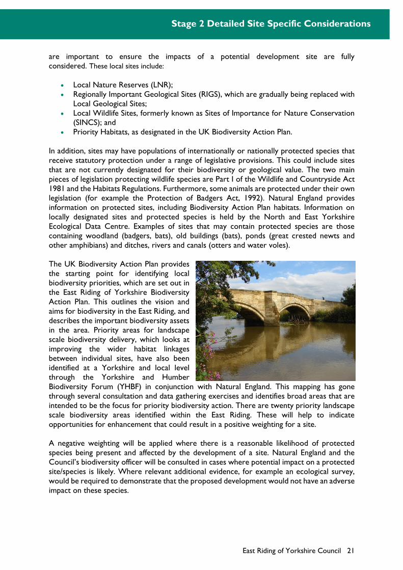
The UK Biodiversity Action Plan provides the starting point for identifying local biodiversity priorities, which are set out in the East Riding of Yorkshire Biodiversity Action Plan. This outlines the vision and aims for biodiversity in the East Riding, and describes the important biodiversity assets in the area. Priority areas for landscape scale biodiversity delivery, which looks at improving the wider habitat linkages between individual sites, have also been identified at a Yorkshire and local level through the Yorkshire and Humber Biodiversity Forum (YHBF) in conjunction with Natural England. This mapping has gone through several consultation and data gathering exercises and identifies broad areas that are intended to be the focus for priority biodiversity action. There are twenty priority landscape scale biodiversity areas identified within the East Riding. These will help to indicate opportunities for enhancement that could result in a positive weighting for a site.
A negative weighting will be applied where there is a reasonable likelihood of protected species being present and affected by the development of a site. Natural England and the Council’s biodiversity officer will be consulted in cases where potential impact on a protected site/species is likely. Where relevant additional evidence, for example an ecological survey, would be required to demonstrate that the proposed development would not have an adverse impact on these species.
Stage 2 Detailed Site Specific Considerations
22 East Riding of Yorkshire Council
Question 11 Wildlife and Natural Environment
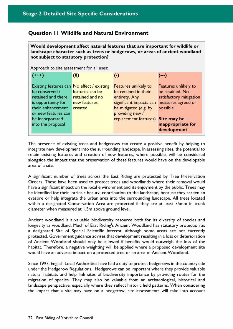
Would development affect natural features that are important for wildlife or landscape character such as trees or hedgerows, or areas of ancient woodland not subject to statutory protection?
Approach to site assessment for all uses:
(+++)
Existing features can be conserved / retained and there is opportunity for their enhancement or new features can be incorporated into the proposal
(0)
No effect / existing features can be retained and no new features created
(-)
Features unlikely to be retained in their entirety. Any significant impacts can be mitigated (e.g. by providing new / replacement features)
(---)
Features unlikely to be retained. No satisfactory mitigation measures agreed or possible
Site may be inappropriate for development
The presence of existing trees and hedgerows can create a positive benefit by helping to integrate new development into the surrounding landscape. In assessing sites, the potential to retain existing features and creation of new features, where possible, will be considered alongside the impact that the preservation of these features would have on the developable area of a site.
A significant number of trees across the East Riding are protected by Tree Preservation Orders. These have been used to protect trees and woodlands where their removal would have a significant impact on the local environment and its enjoyment by the public. Trees may be identified for their intrinsic beauty, contribution to the landscape, because they screen an eyesore or help integrate the urban area into the surrounding landscape. All trees located within a designated Conservation Area are protected if they are at least 75mm in trunk diameter when measured at 1.5m above ground level.
Ancient woodland is a valuable biodiversity resource both for its diversity of species and longevity as woodland. Much of East Riding's Ancient Woodland has statutory protection as a designated Site of Special Scientific Interest, although some areas are not currently protected. Government guidance advises that development resulting in a loss or deterioration of Ancient Woodland should only be allowed if benefits would outweigh the loss of the habitat. Therefore, a negative weighting will be applied where a proposed development site would have an adverse impact on a protected tree or an area of Ancient Woodland.
Since 1997, English Local Authorities have had a duty to protect hedgerows in the countryside under the Hedgerow Regulations. Hedgerows can be important where they provide valuable natural habitats and help link sites of biodiversity importance by providing routes for the migration of species. They may also be valuable from an archaeological, historical and landscape perspective, especially where they reflect historic field patterns. When considering the impact that a site may have on a hedgerow, site assessments will take into account

Stage 2 Detailed Site Specific Considerations
East Riding of Yorkshire Council 23
whether it would be possible to maintain the hedgerow. A negative weighting will be applied if the development would lead to the loss, fragmentation or isolation of an existing hedgerow.
A positive score would be given where a potential site contributes towards an increase and enhancement in the level of natural features on a site. For example positive scores could include the addition of woodland cover (particularly were they are of a substantial scale that provides carbon sink benefits), improvement to the management of existing trees, woods and associated habitats. Examples and case studies of such initiatives are available online at Heywoods8.
The Council’s Landscape and Conservation Unit, and where necessary Natural England, will be consulted if there is a possibility that a potential development site could affect trees, hedgerows or an ancient woodland, including those that are not currently subject to any statutory control.
8 http://heywoods.org.uk
Stage 2 Detailed Site Specific Considerations
24 East Riding of Yorkshire Council
Question 12 Heritage Assets
Would development affect a heritage asset?
Approach to site assessment for all uses:
(+++)
Development would result in a significant enhancement of an existing heritage asset
(+)
Development would result in minor enhancement (e.g. existing features of significance can be retained and there are some opportunities for their enhancement)
(0)
Development unlikely to have a harmful impact upon a heritage asset. Existing features can be retained
(-)
Development likely to have a harmful impact upon those elements which contribute to the significance of a heritage asset. Features unlikely to be retained in their entirety. Any significant impacts can be mitigated
(---)
Development likely to have a harmful impact upon those elements which contribute to the significance of a heritage asset. Features unlikely to be retained. No satisfactory mitigation measures possible
Site may be inappropriate for development
As outlined in Question 4, national planning policy highlights that heritage assets can contribute to the sustainability of an area and promote a sense of place. It highlights that the significance of a heritage asset should be considered alongside the impact that new development would have on that asset.
The potential impact of a proposed development site upon a range of heritage assets, which includes all assets listed in both tables 1 (p. 9) and 5, will be assessed.
Table 5: Heritage assets in the East Riding
Type of Asset
Scheduled
Monuments
The East Riding has around 350 such sites, including numerous Neolithic and Bronze Age funerary sites, Iron Age remains, a number of deserted medieval villages, and crop-mark sites.
Listed Buildings
Over 200 Grade I and Grade II* Listed Buildings (of 'outstanding' architectural or historic interest). These include several notable churches (such as Beverley and Howden Minsters) and significant country houses (including Sledmere House, Burton Constable Hall and Burton Agnes Hall).
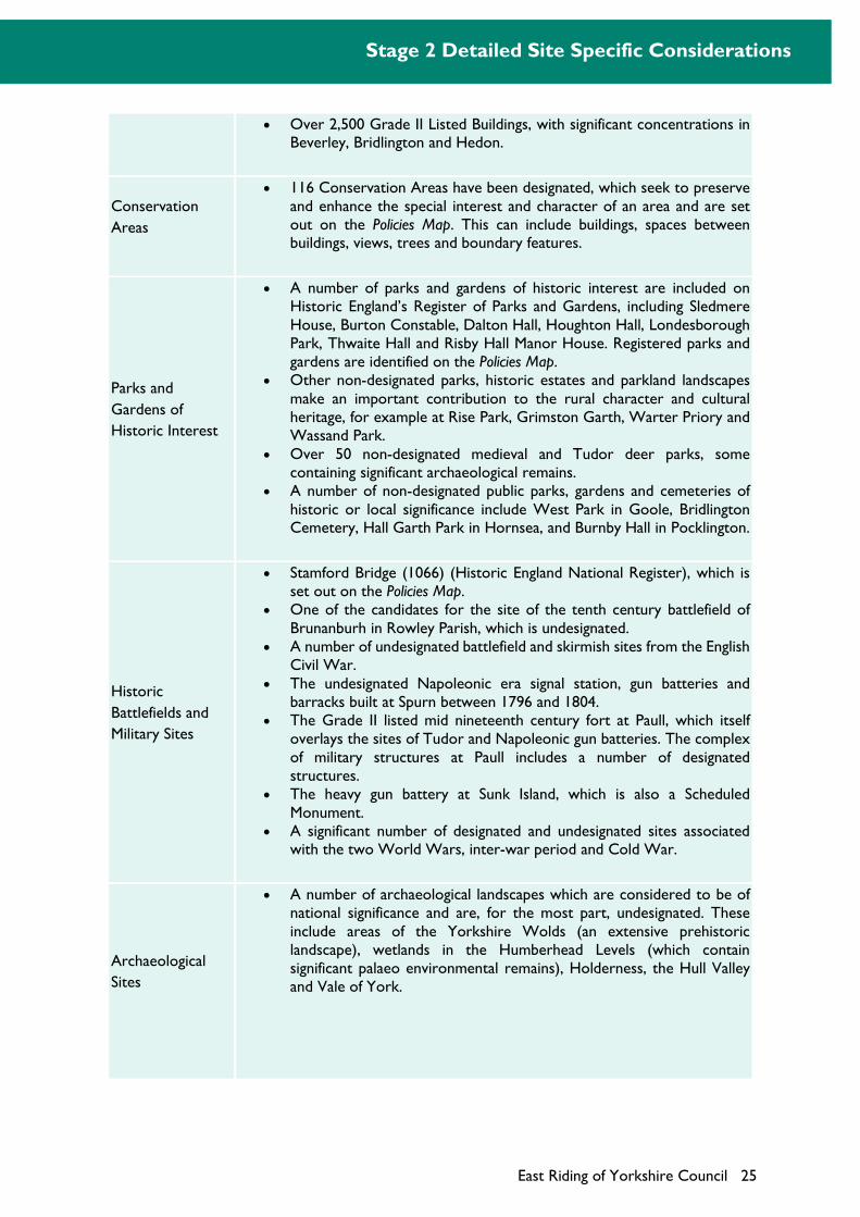
Stage 2 Detailed Site Specific Considerations
East Riding of Yorkshire Council 25
Over 2,500 Grade II Listed Buildings, with significant concentrations in Beverley, Bridlington and Hedon.
Conservation
Areas
116 Conservation Areas have been designated, which seek to preserve and enhance the special interest and character of an area and are set out on the Policies Map. This can include buildings, spaces between buildings, views, trees and boundary features.
Parks and
Gardens of
Historic Interest
A number of parks and gardens of historic interest are included on Historic England’s Register of Parks and Gardens, including Sledmere House, Burton Constable, Dalton Hall, Houghton Hall, Londesborough Park, Thwaite Hall and Risby Hall Manor House. Registered parks and gardens are identified on the Policies Map.
Other non-designated parks, historic estates and parkland landscapes make an important contribution to the rural character and cultural heritage, for example at Rise Park, Grimston Garth, Warter Priory and Wassand Park.
Over 50 non-designated medieval and Tudor deer parks, some containing significant archaeological remains.
A number of non-designated public parks, gardens and cemeteries of historic or local significance include West Park in Goole, Bridlington Cemetery, Hall Garth Park in Hornsea, and Burnby Hall in Pocklington.
Historic
Battlefields and
Military Sites
Stamford Bridge (1066) (Historic England National Register), which is set out on the Policies Map.
One of the candidates for the site of the tenth century battlefield of Brunanburh in Rowley Parish, which is undesignated.
A number of undesignated battlefield and skirmish sites from the English Civil War.
The undesignated Napoleonic era signal station, gun batteries and barracks built at Spurn between 1796 and 1804.
The Grade II listed mid nineteenth century fort at Paull, which itself overlays the sites of Tudor and Napoleonic gun batteries. The complex of military structures at Paull includes a number of designated structures.
The heavy gun battery at Sunk Island, which is also a Scheduled Monument.
A significant number of designated and undesignated sites associated with the two World Wars, inter-war period and Cold War.
Archaeological
Sites
A number of archaeological landscapes which are considered to be of national significance and are, for the most part, undesignated. These include areas of the Yorkshire Wolds (an extensive prehistoric landscape), wetlands in the Humberhead Levels (which contain significant palaeo environmental remains), Holderness, the Hull Valley and Vale of York.
Stage 2 Detailed Site Specific Considerations
26 East Riding of Yorkshire Council
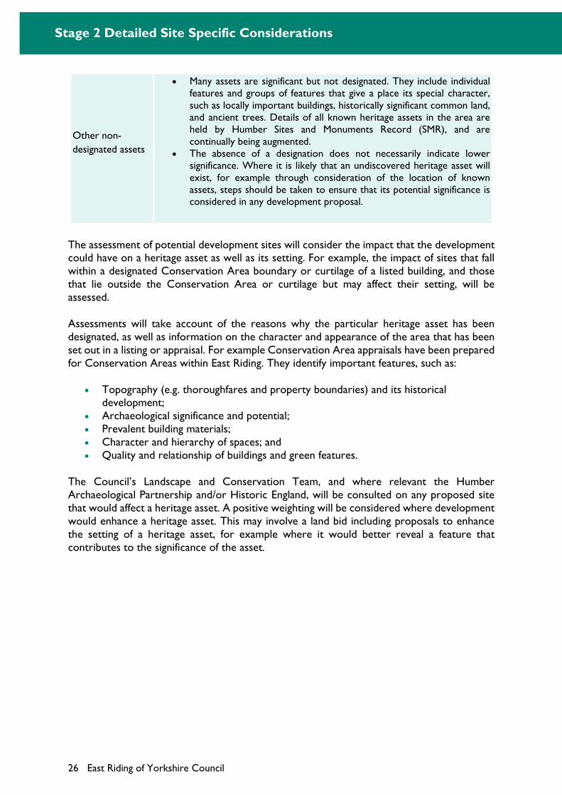
Other non-
designated assets
Many assets are significant but not designated. They include individual features and groups of features that give a place its special character, such as locally important buildings, historically significant common land, and ancient trees. Details of all known heritage assets in the area are held by Humber Sites and Monuments Record (SMR), and are continually being augmented.
The absence of a designation does not necessarily indicate lower significance. Where it is likely that an undiscovered heritage asset will exist, for example through consideration of the location of known assets, steps should be taken to ensure that its potential significance is considered in any development proposal.
The assessment of potential development sites will consider the impact that the development could have on a heritage asset as well as its setting. For example, the impact of sites that fall within a designated Conservation Area boundary or curtilage of a listed building, and those that lie outside the Conservation Area or curtilage but may affect their setting, will be assessed.
Assessments will take account of the reasons why the particular heritage asset has been designated, as well as information on the character and appearance of the area that has been set out in a listing or appraisal. For example Conservation Area appraisals have been prepared for Conservation Areas within East Riding. They identify important features, such as:
Topography (e.g. thoroughfares and property boundaries) and its historical development;
Archaeological significance and potential; Prevalent building materials; Character and hierarchy of spaces; and Quality and relationship of buildings and green features.
The Council’s Landscape and Conservation Team, and where relevant the Humber Archaeological Partnership and/or Historic England, will be consulted on any proposed site that would affect a heritage asset. A positive weighting will be considered where development would enhance a heritage asset. This may involve a land bid including proposals to enhance the setting of a heritage asset, for example where it would better reveal a feature that contributes to the significance of the asset.
Stage 2 Detailed Site Specific Considerations
East Riding of Yorkshire Council 27
Question 13 Built Character
Would development affect the existing built character of the settlement?
Approach to site assessment for all uses:
(+++)
Development would result in significant enhancement (e.g. through redevelopment of a derelict or rundown area)
(+)
Development could result in an enhancement (e.g. through the sensitive development of an infill site or vacant building)
(0)
Development unlikely to have an effect / effect very minor
(-)
Development could detract from the existing built character. Existing, important features unlikely to be retained in their entirety. Any significant impacts can be mitigated
(---)
Development could cause a significant detraction from the existing built character (e.g. development would result in the coalescence of two separate settlements). Features unlikely to be retained. No satisfactory mitigation measures possible
Site may be inappropriate for development
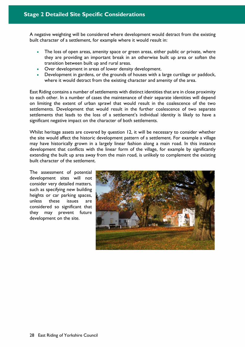
It is important that potential sites for development would support the built character, appearance and quality of all settlements within the East Riding. Assessments will consider the current role and function of a site, for example amenity space or a vacant plot, and whether or not this would be affected by new development. This will take account of a site’s existing quality (e.g. is it well maintained or derelict) and function (e.g. is it a valuable amenity space or a plot which is screened by existing development and has no public access). The impact could take a variety of forms and a positive weighting will be applied where developments would lead to an improvement in the overall quality of the streetscape, for example through the:
Removal or conversion of a derelict/vacant site or building; or
Removal of an existing eyesore or unsightly building.
Stage 2 Detailed Site Specific Considerations
28 East Riding of Yorkshire Council
A negative weighting will be considered where development would detract from the existing built character of a settlement, for example where it would result in:
The loss of open areas, amenity space or green areas, either public or private, where they are providing an important break in an otherwise built up area or soften the transition between built up and rural areas.
Over development in areas of lower density development. Development in gardens, or the grounds of houses with a large curtilage or paddock,
where it would detract from the existing character and amenity of the area.
East Riding contains a number of settlements with distinct identities that are in close proximity to each other. In a number of cases the maintenance of their separate identities will depend on limiting the extent of urban sprawl that would result in the coalescence of the two settlements. Development that would result in the further coalescence of two separate settlements that leads to the loss of a settlement’s individual identity is likely to have a significant negative impact on the character of both settlements.
Whilst heritage assets are covered by question 12, it will be necessary to consider whether the site would affect the historic development pattern of a settlement. For example a village may have historically grown in a largely linear fashion along a main road. In this instance development that conflicts with the linear form of the village, for example by significantly extending the built up area away from the main road, is unlikely to complement the existing built character of the settlement.
The assessment of potential development sites will not consider very detailed matters, such as specifying new building heights or car parking spaces, unless these issues are considered so significant that they may prevent future development on the site.
Stage 2 Detailed Site Specific Considerations
East Riding of Yorkshire Council 29
Question 14 Landscape Character
Would the development impact on the visual amenity or character of the natural landscape?
Approach to site assessment for all uses:
(+++)
Low Sensitivity: Characteristics of landscape are robust and are able to accommodate development without significant character change; thresholds for significant change are very high. The development would relate well to the landscape character
(+)
Low-medium sensitivity: Characteristics of landscape are resilient to change and are able to absorb development in many situations without significant character change; thresholds for significant change are high. Many aspects of the development would relate to landscape character
(0)
Development is not located within the natural landscape, by being within a built up area or an area which consists entirely of man-made landscape features. The development would not affect the natural landscape
(-)
Medium-high sensitivity: Characteristics of landscape are vulnerable to change and development can be absorbed only in limited situations without significant character change; thresholds for significant change are low. Few aspects of the development would relate to landscape character
(---)
High sensitivity: Characteristics of landscape are very vulnerable to change and are unable to accommodate development without significant character change; thresholds for significant change are very low. The development conflicts directly with landscape character
Site may be inappropriate for development
National planning policy highlights the importance of protecting and enhancing valued landscapes and identifies the need to recognise the intrinsic character and beauty of the countryside. The Council has prepared a Landscape Character Assessment Update 20189 to help inform judgements on the possible impact that development may have on the landscape. This describes and classifies the landscapes of East Riding into 23 different landscape types. It also makes judgements on the quality and value of the landscape, as well as its sensitivity, susceptibility and capacity to accommodate new development. The Landscape Character Assessment, which has been supplemented by a more detailed analysis of the landscape and townscape surrounding the larger settlements, will be used to assess the impacts of potential development sites.
9 East Riding Landscape Character Assessment Update 2018
Stage 2 Detailed Site Specific Considerations
30 East Riding of Yorkshire Council
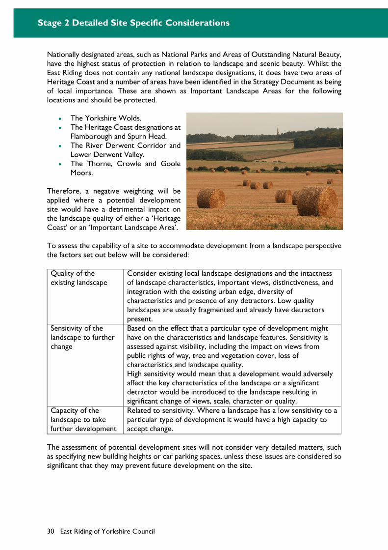
Nationally designated areas, such as National Parks and Areas of Outstanding Natural Beauty, have the highest status of protection in relation to landscape and scenic beauty. Whilst the East Riding does not contain any national landscape designations, it does have two areas of Heritage Coast and a number of areas have been identified in the Strategy Document as being of local importance. These are shown as Important Landscape Areas for the following locations and should be protected.
The Yorkshire Wolds. The Heritage Coast designations at
Flamborough and Spurn Head. The River Derwent Corridor and
Lower Derwent Valley. The Thorne, Crowle and Goole
Moors.
Therefore, a negative weighting will be applied where a potential development site would have a detrimental impact on the landscape quality of either a ‘Heritage Coast’ or an ‘Important Landscape Area’.
To assess the capability of a site to accommodate development from a landscape perspective the factors set out below will be considered:
Quality of the existing landscape
Consider existing local landscape designations and the intactness of landscape characteristics, important views, distinctiveness, and integration with the existing urban edge, diversity of characteristics and presence of any detractors. Low quality landscapes are usually fragmented and already have detractors present.
Sensitivity of the landscape to further change
Based on the effect that a particular type of development might have on the characteristics and landscape features. Sensitivity is assessed against visibility, including the impact on views from public rights of way, tree and vegetation cover, loss of characteristics and landscape quality. High sensitivity would mean that a development would adversely affect the key characteristics of the landscape or a significant detractor would be introduced to the landscape resulting in significant change of views, scale, character or quality.
Capacity of the landscape to take further development
Related to sensitivity. Where a landscape has a low sensitivity to a particular type of development it would have a high capacity to accept change.
The assessment of potential development sites will not consider very detailed matters, such as specifying new building heights or car parking spaces, unless these issues are considered so significant that they may prevent future development on the site.
Stage 2 Detailed Site Specific Considerations
East Riding of Yorkshire Council 31
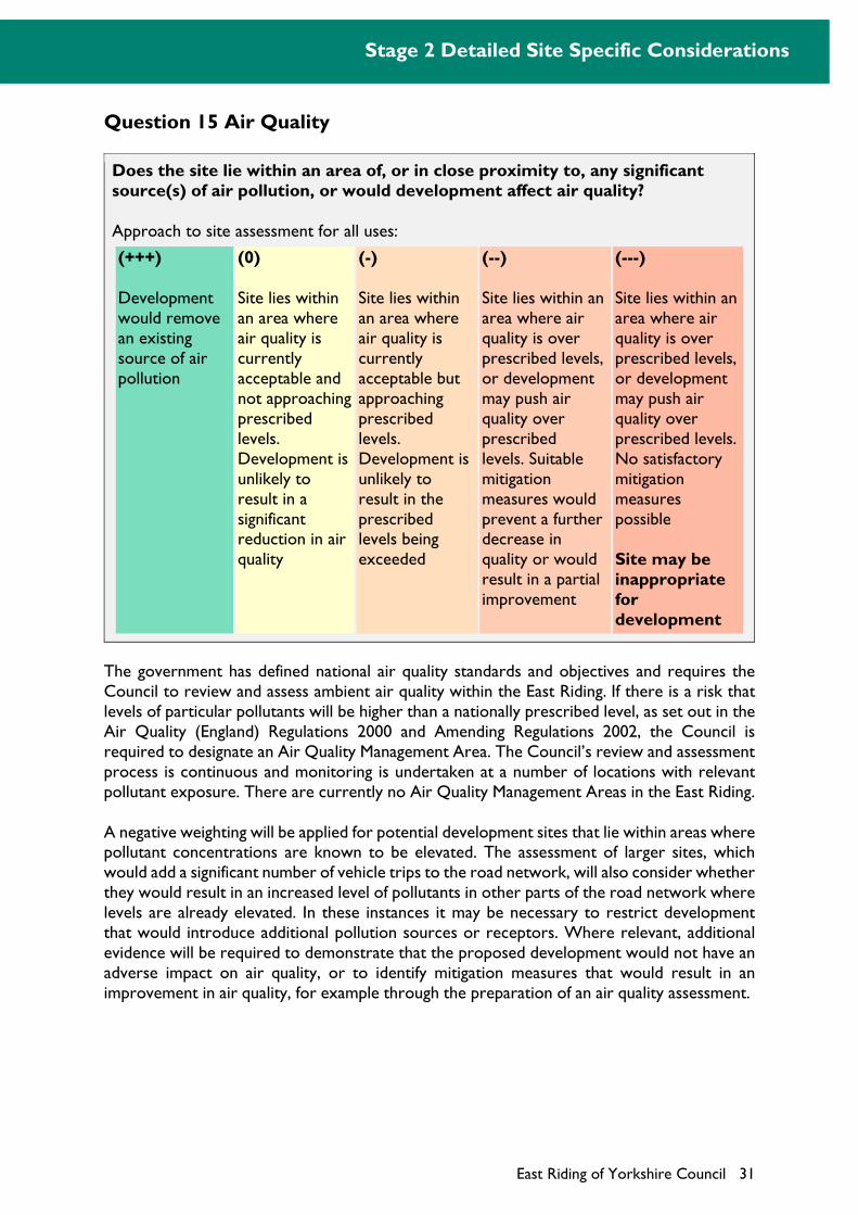
Question 15 Air Quality
Does the site lie within an area of, or in close proximity to, any significant source(s) of air pollution, or would development affect air quality?
Approach to site assessment for all uses:
(+++)
Development would remove an existing source of air pollution
(0)
Site lies within an area where air quality is currently acceptable and not approaching prescribed levels. Development is unlikely to result in a significant reduction in air quality
(-)
Site lies within an area where air quality is currently acceptable but approaching prescribed levels. Development is unlikely to result in the prescribed levels being exceeded
(--)
Site lies within an area where air quality is over prescribed levels, or development may push air quality over prescribed levels. Suitable mitigation measures would prevent a further decrease in quality or would result in a partial improvement
(---)
Site lies within an area where air quality is over prescribed levels, or development may push air quality over prescribed levels. No satisfactory mitigation measures possible
Site may be inappropriate for development
The government has defined national air quality standards and objectives and requires the Council to review and assess ambient air quality within the East Riding. If there is a risk that levels of particular pollutants will be higher than a nationally prescribed level, as set out in the Air Quality (England) Regulations 2000 and Amending Regulations 2002, the Council is required to designate an Air Quality Management Area. The Council’s review and assessment process is continuous and monitoring is undertaken at a number of locations with relevant pollutant exposure. There are currently no Air Quality Management Areas in the East Riding.
A negative weighting will be applied for potential development sites that lie within areas where pollutant concentrations are known to be elevated. The assessment of larger sites, which would add a significant number of vehicle trips to the road network, will also consider whether they would result in an increased level of pollutants in other parts of the road network where levels are already elevated. In these instances it may be necessary to restrict development that would introduce additional pollution sources or receptors. Where relevant, additional evidence will be required to demonstrate that the proposed development would not have an adverse impact on air quality, or to identify mitigation measures that would result in an improvement in air quality, for example through the preparation of an air quality assessment.
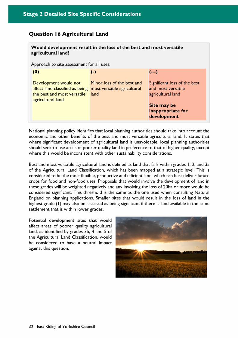
Stage 2 Detailed Site Specific Considerations
32 East Riding of Yorkshire Council
Question 16 Agricultural Land
Would development result in the loss of the best and most versatile agricultural land?
Approach to site assessment for all uses:
(0)
Development would not affect land classified as being the best and most versatile agricultural land
(-)
Minor loss of the best and most versatile agricultural land
(---)
Significant loss of the best and most versatile agricultural land
Site may be inappropriate for development
National planning policy identifies that local planning authorities should take into account the economic and other benefits of the best and most versatile agricultural land. It states that where significant development of agricultural land is unavoidable, local planning authorities should seek to use areas of poorer quality land in preference to that of higher quality, except where this would be inconsistent with other sustainability considerations.
Best and most versatile agricultural land is defined as land that falls within grades 1, 2, and 3a of the Agricultural Land Classification, which has been mapped at a strategic level. This is considered to be the most flexible, productive and efficient land, which can best deliver future crops for food and non-food uses. Proposals that would involve the development of land in these grades will be weighted negatively and any involving the loss of 20ha or more would be considered significant. This threshold is the same as the one used when consulting Natural England on planning applications. Smaller sites that would result in the loss of land in the highest grade (1) may also be assessed as being significant if there is land available in the same settlement that is within lower grades.
Potential development sites that would affect areas of poorer quality agricultural land, as identified by grades 3b, 4 and 5 of the Agricultural Land Classification, would be considered to have a neutral impact against this question.
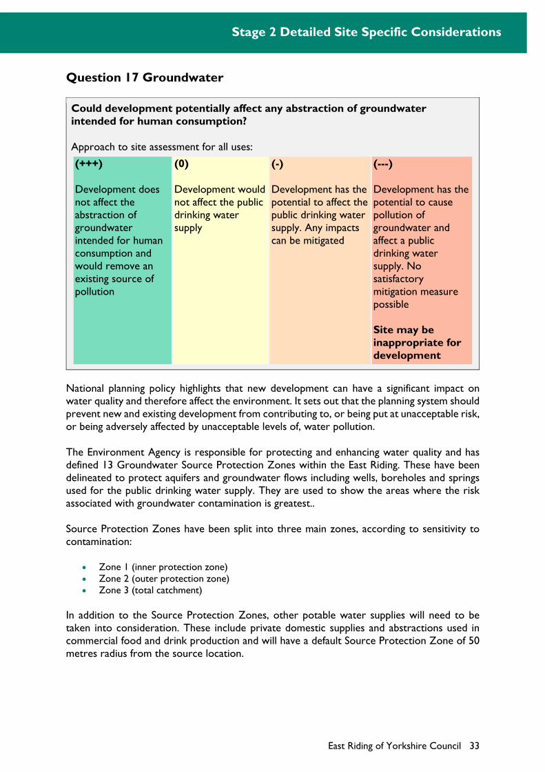
Stage 2 Detailed Site Specific Considerations
East Riding of Yorkshire Council 33
Question 17 Groundwater
Could development potentially affect any abstraction of groundwater intended for human consumption?
Approach to site assessment for all uses:
(+++)
Development does not affect the abstraction of groundwater intended for human consumption and would remove an existing source of pollution
(0)
Development would not affect the public drinking water supply
(-)
Development has the potential to affect the public drinking water supply. Any impacts can be mitigated
(---)
Development has the potential to cause pollution of groundwater and affect a public drinking water supply. No satisfactory mitigation measure possible
Site may be inappropriate for development
National planning policy highlights that new development can have a significant impact on water quality and therefore affect the environment. It sets out that the planning system should prevent new and existing development from contributing to, or being put at unacceptable risk, or being adversely affected by unacceptable levels of, water pollution.
The Environment Agency is responsible for protecting and enhancing water quality and has defined 13 Groundwater Source Protection Zones within the East Riding. These have been delineated to protect aquifers and groundwater flows including wells, boreholes and springs used for the public drinking water supply. They are used to show the areas where the risk associated with groundwater contamination is greatest..
Source Protection Zones have been split into three main zones, according to sensitivity to contamination:
Zone 1 (inner protection zone) Zone 2 (outer protection zone) Zone 3 (total catchment)
In addition to the Source Protection Zones, other potable water supplies will need to be taken into consideration. These include private domestic supplies and abstractions used in commercial food and drink production and will have a default Source Protection Zone of 50 metres radius from the source location.
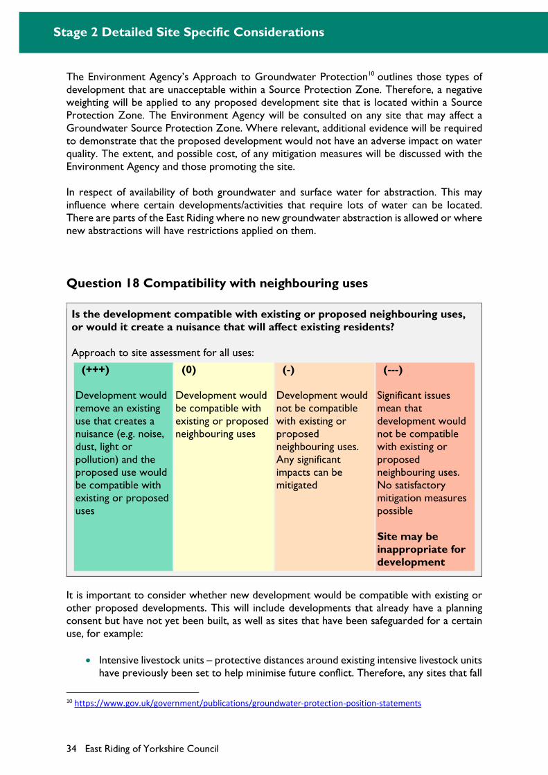
Stage 2 Detailed Site Specific Considerations
34 East Riding of Yorkshire Council
The Environment Agency’s Approach to Groundwater Protection10 outlines those types of development that are unacceptable within a Source Protection Zone. Therefore, a negative weighting will be applied to any proposed development site that is located within a Source Protection Zone. The Environment Agency will be consulted on any site that may affect a Groundwater Source Protection Zone. Where relevant, additional evidence will be required to demonstrate that the proposed development would not have an adverse impact on water quality. The extent, and possible cost, of any mitigation measures will be discussed with the Environment Agency and those promoting the site.
In respect of availability of both groundwater and surface water for abstraction. This may influence where certain developments/activities that require lots of water can be located. There are parts of the East Riding where no new groundwater abstraction is allowed or where new abstractions will have restrictions applied on them.
Question 18 Compatibility with neighbouring uses
Is the development compatible with existing or proposed neighbouring uses, or would it create a nuisance that will affect existing residents?
Approach to site assessment for all uses:
(+++)
Development would remove an existing use that creates a nuisance (e.g. noise, dust, light or pollution) and the proposed use would be compatible with existing or proposed uses
(0)
Development would be compatible with existing or proposed neighbouring uses
(-)
Development would not be compatible with existing or proposed neighbouring uses. Any significant impacts can be mitigated
(---)
Significant issues mean that development would not be compatible with existing or proposed neighbouring uses. No satisfactory mitigation measures possible
Site may be inappropriate for development
It is important to consider whether new development would be compatible with existing or other proposed developments. This will include developments that already have a planning consent but have not yet been built, as well as sites that have been safeguarded for a certain use, for example:
Intensive livestock units – protective distances around existing intensive livestock units have previously been set to help minimise future conflict. Therefore, any sites that fall
10 https://www.gov.uk/government/publications/groundwater-protection-position-statements
Stage 2 Detailed Site Specific Considerations
East Riding of Yorkshire Council 35
within 800m of an Intensive Livestock Unit will be assessed in terms of any potential adverse impacts. This will be reduced to 400m for rural locations and villages.
Uses that are subject to a Health and Safety Executive defined consultation distance – the Health and Safety Executive has identified over 70 sites (and consultation distances) involving hazardous installations within the East Riding. Therefore, advice will be sought from the Executive on the suitability of any proposed development site that falls within a defined consultation distance.
Electricity pylons – National Grid’s Development near overhead lines (2008) and A Sense of Place: design guidelines for development near high voltage overhead lines (2005) provide guidance on the affect and constraints of high voltage overhead power lines that cross development sites. It identifies that whilst overhead lines present an amenity constraint to development, they do not necessarily prevent development, providing sufficient buffers are provided.
Ministry of Defence sites – two safeguarding zones, where the Ministry of Defence expects to be consulted on certain applications, have been identified within the East Riding. These are:
1. Cowden (South of Hornsea) – no need to consult on residential proposals 2. Leconfield (North of Beverley) – need to consult on proposals involving the
erection of buildings exceeding 15.2m (the average 2 storey residential property is approximately 9m high) or 45.7m depending upon the location within the safeguarding zone.
The potential risks posed by identified hazardous installations, such as pipelines and Liquified Petroleum Gas (LPG) facilities, will also be considered.
In addition to the compatibility of different uses, site assessments will take account of any localised nuisance or amenity impacts, for example noise, light, dust or odour, which would result from the proposed development. Noise and light pollution are a typical type of pollution, which can affect a resident’s quality of life. These impacts are particularly important for rural areas, which are relatively tranquil. Therefore, site assessments will consider if a proposed development site is located close to an existing use(s) that would create a nuisance or amenity impact. This is particularly important for sensitive developments such as housing, hospitals or schools. The types of uses that may create a nuisance or amenity impact includes:
Sewage treatment works can cause both an odour and noise nuisance and Yorkshire Water will be consulted on any sites that lie near to a sewage treatment works.
Main roads or motorway corridors can result in both noise and light pollution. Waste transfer or household recycling facilities can create an odour nuisance. Industrial units, especially general industry, can result in noise, vibration, odour, fumes,
smoke, soot, ash, dust or grit, which creates a detrimental impact on the amenity of an area.
The potential amenity impacts of a proposed development site on the wider settlement will also be considered. This could include instances where development would significantly increase the levels of traffic through a town or village centre in order to access a particular service or facility, for example an industrial estate, or a part of the strategic road network.
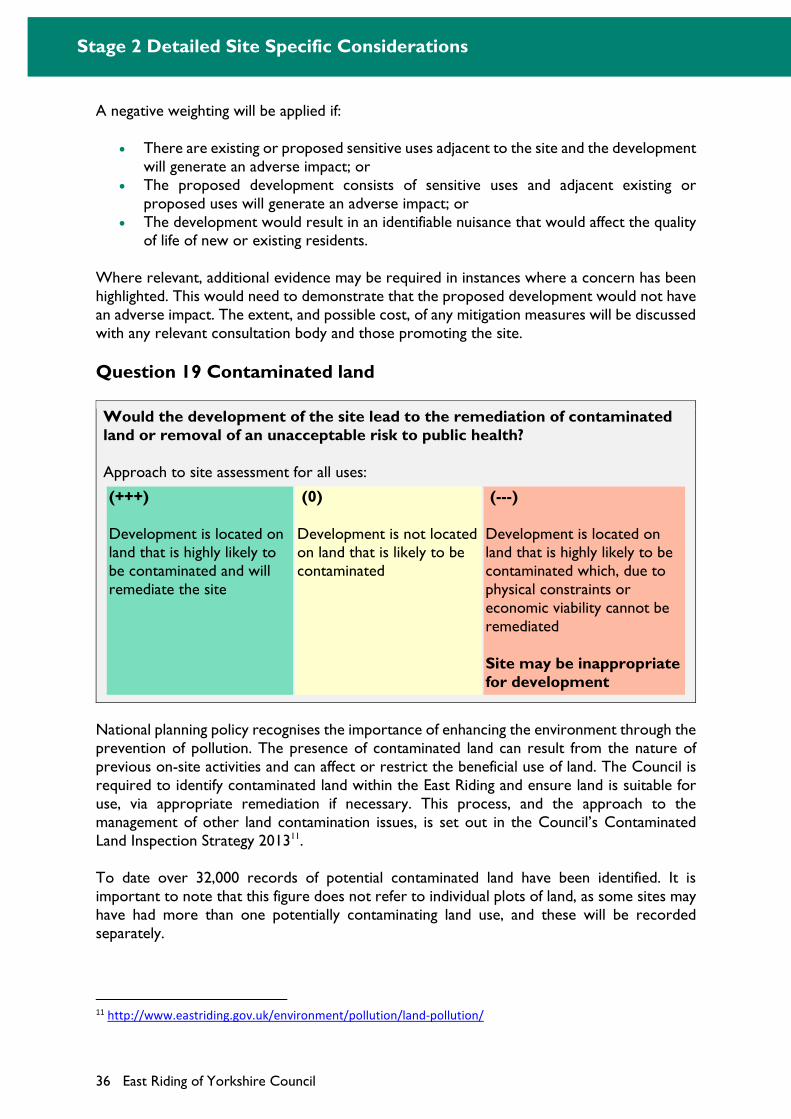
Stage 2 Detailed Site Specific Considerations
36 East Riding of Yorkshire Council
A negative weighting will be applied if:
There are existing or proposed sensitive uses adjacent to the site and the development will generate an adverse impact; or
The proposed development consists of sensitive uses and adjacent existing or proposed uses will generate an adverse impact; or
The development would result in an identifiable nuisance that would affect the quality of life of new or existing residents.
Where relevant, additional evidence may be required in instances where a concern has been highlighted. This would need to demonstrate that the proposed development would not have an adverse impact. The extent, and possible cost, of any mitigation measures will be discussed with any relevant consultation body and those promoting the site.
Question 19 Contaminated land
Would the development of the site lead to the remediation of contaminated land or removal of an unacceptable risk to public health?
Approach to site assessment for all uses:
(+++)
Development is located on land that is highly likely to be contaminated and will remediate the site
(0)
Development is not located on land that is likely to be contaminated
(---)
Development is located on land that is highly likely to be contaminated which, due to physical constraints or economic viability cannot be remediated
Site may be inappropriate for development
National planning policy recognises the importance of enhancing the environment through the prevention of pollution. The presence of contaminated land can result from the nature of previous on-site activities and can affect or restrict the beneficial use of land. The Council is required to identify contaminated land within the East Riding and ensure land is suitable for use, via appropriate remediation if necessary. This process, and the approach to the management of other land contamination issues, is set out in the Council’s Contaminated Land Inspection Strategy 201311.
To date over 32,000 records of potential contaminated land have been identified. It is important to note that this figure does not refer to individual plots of land, as some sites may have had more than one potentially contaminating land use, and these will be recorded separately.
11 http://www.eastriding.gov.uk/environment/pollution/land-pollution/
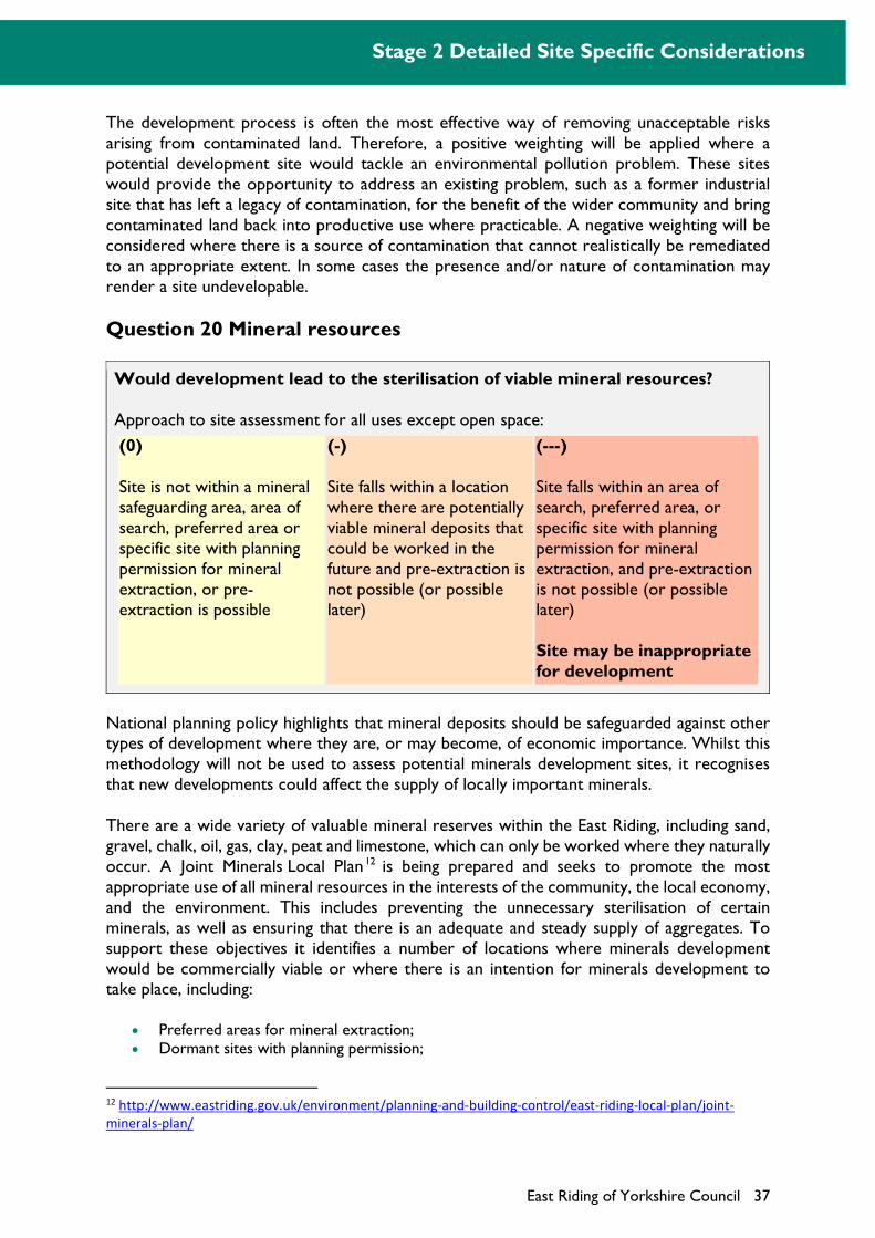
Stage 2 Detailed Site Specific Considerations
East Riding of Yorkshire Council 37
The development process is often the most effective way of removing unacceptable risks arising from contaminated land. Therefore, a positive weighting will be applied where a potential development site would tackle an environmental pollution problem. These sites would provide the opportunity to address an existing problem, such as a former industrial site that has left a legacy of contamination, for the benefit of the wider community and bring contaminated land back into productive use where practicable. A negative weighting will be considered where there is a source of contamination that cannot realistically be remediated to an appropriate extent. In some cases the presence and/or nature of contamination may render a site undevelopable.
Question 20 Mineral resources
Would development lead to the sterilisation of viable mineral resources?
Approach to site assessment for all uses except open space:
(0)
Site is not within a mineral safeguarding area, area of search, preferred area or specific site with planning permission for mineral extraction, or pre-extraction is possible
(-)
Site falls within a location where there are potentially viable mineral deposits that could be worked in the future and pre-extraction is not possible (or possible later)
(---)
Site falls within an area of search, preferred area, or specific site with planning permission for mineral extraction, and pre-extraction is not possible (or possible later)
Site may be inappropriate for development
National planning policy highlights that mineral deposits should be safeguarded against other types of development where they are, or may become, of economic importance. Whilst this methodology will not be used to assess potential minerals development sites, it recognises that new developments could affect the supply of locally important minerals.
There are a wide variety of valuable mineral reserves within the East Riding, including sand, gravel, chalk, oil, gas, clay, peat and limestone, which can only be worked where they naturally occur. A Joint Minerals Local Plan 12 is being prepared and seeks to promote the most appropriate use of all mineral resources in the interests of the community, the local economy, and the environment. This includes preventing the unnecessary sterilisation of certain minerals, as well as ensuring that there is an adequate and steady supply of aggregates. To support these objectives it identifies a number of locations where minerals development would be commercially viable or where there is an intention for minerals development to take place, including:
Preferred areas for mineral extraction; Dormant sites with planning permission;
12 http://www.eastriding.gov.uk/environment/planning-and-building-control/east-riding-local-plan/joint-
minerals-plan/
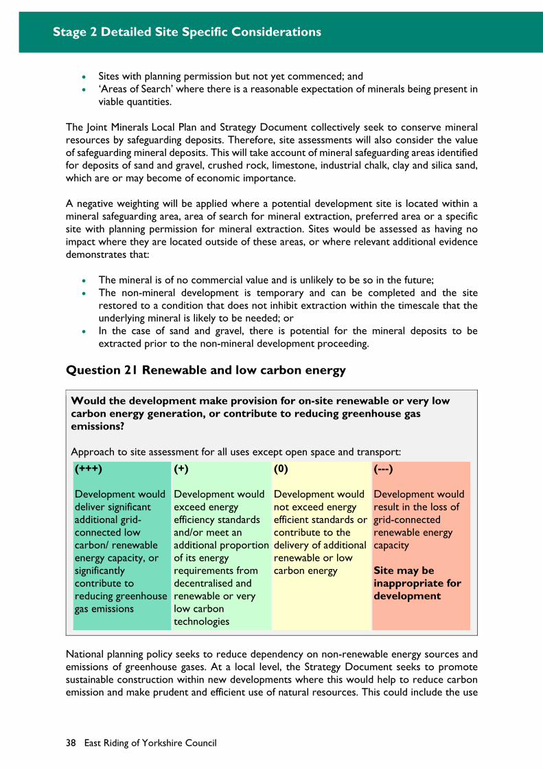
Stage 2 Detailed Site Specific Considerations
38 East Riding of Yorkshire Council
Sites with planning permission but not yet commenced; and ‘Areas of Search’ where there is a reasonable expectation of minerals being present in
viable quantities.
The Joint Minerals Local Plan and Strategy Document collectively seek to conserve mineral resources by safeguarding deposits. Therefore, site assessments will also consider the value of safeguarding mineral deposits. This will take account of mineral safeguarding areas identified for deposits of sand and gravel, crushed rock, limestone, industrial chalk, clay and silica sand, which are or may become of economic importance.
A negative weighting will be applied where a potential development site is located within a mineral safeguarding area, area of search for mineral extraction, preferred area or a specific site with planning permission for mineral extraction. Sites would be assessed as having no impact where they are located outside of these areas, or where relevant additional evidence demonstrates that:
The mineral is of no commercial value and is unlikely to be so in the future; The non-mineral development is temporary and can be completed and the site
restored to a condition that does not inhibit extraction within the timescale that the underlying mineral is likely to be needed; or
In the case of sand and gravel, there is potential for the mineral deposits to be extracted prior to the non-mineral development proceeding.
Question 21 Renewable and low carbon energy
Would the development make provision for on-site renewable or very low carbon energy generation, or contribute to reducing greenhouse gas emissions?
Approach to site assessment for all uses except open space and transport:
(+++)
Development would deliver significant additional grid-connected low carbon/ renewable energy capacity, or significantly contribute to reducing greenhouse gas emissions
(+)
Development would exceed energy efficiency standards and/or meet an additional proportion of its energy requirements from decentralised and renewable or very low carbon technologies
(0)
Development would not exceed energy efficient standards or contribute to the delivery of additional renewable or low carbon energy
(---)
Development would result in the loss of grid-connected renewable energy capacity
Site may be inappropriate for development
National planning policy seeks to reduce dependency on non-renewable energy sources and emissions of greenhouse gases. At a local level, the Strategy Document seeks to promote sustainable construction within new developments where this would help to reduce carbon emission and make prudent and efficient use of natural resources. This could include the use
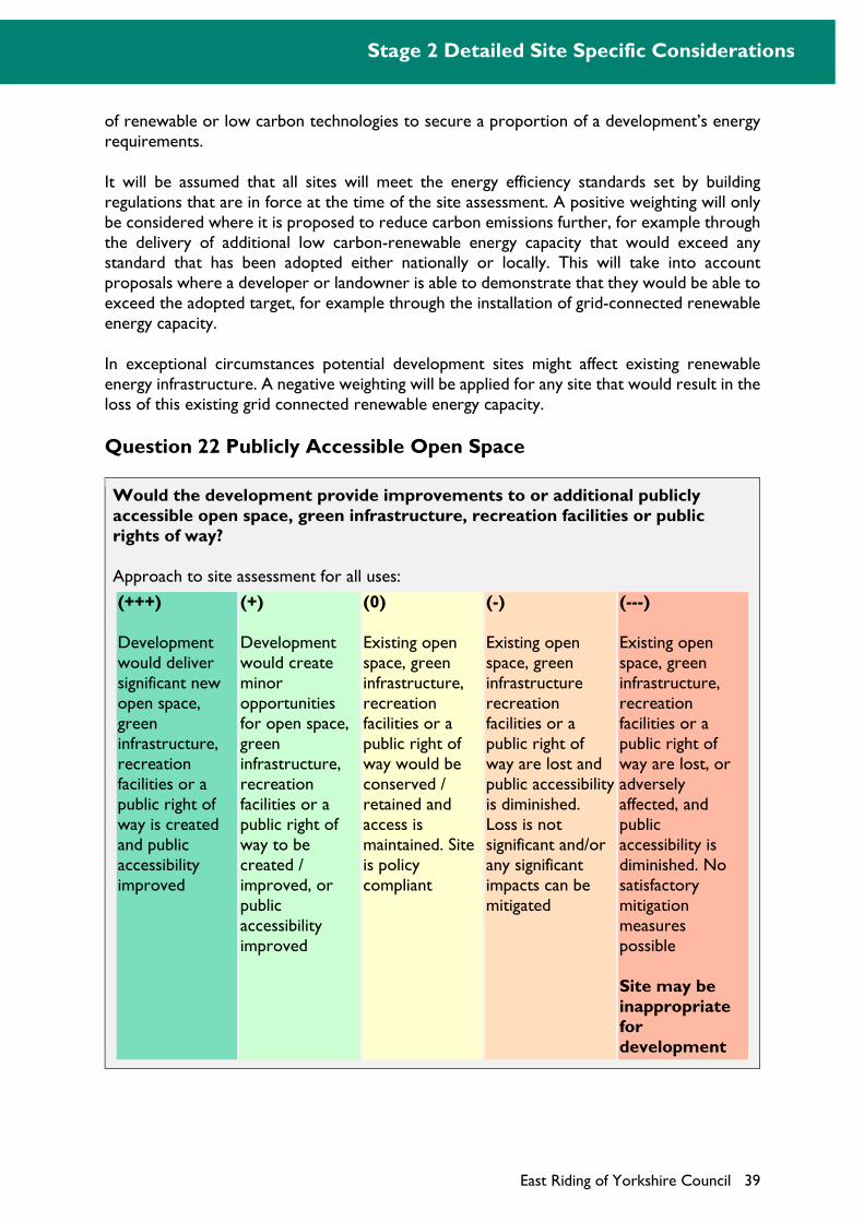
Stage 2 Detailed Site Specific Considerations
East Riding of Yorkshire Council 39
of renewable or low carbon technologies to secure a proportion of a development’s energy requirements.
It will be assumed that all sites will meet the energy efficiency standards set by building regulations that are in force at the time of the site assessment. A positive weighting will only be considered where it is proposed to reduce carbon emissions further, for example through the delivery of additional low carbon-renewable energy capacity that would exceed any standard that has been adopted either nationally or locally. This will take into account proposals where a developer or landowner is able to demonstrate that they would be able to exceed the adopted target, for example through the installation of grid-connected renewable energy capacity.
In exceptional circumstances potential development sites might affect existing renewable energy infrastructure. A negative weighting will be applied for any site that would result in the loss of this existing grid connected renewable energy capacity.
Question 22 Publicly Accessible Open Space
Would the development provide improvements to or additional publicly accessible open space, green infrastructure, recreation facilities or public rights of way?
Approach to site assessment for all uses:
(+++)
Development would deliver significant new open space, green infrastructure, recreation facilities or a public right of way is created and public accessibility improved
(+)
Development would create minor opportunities for open space, green infrastructure, recreation facilities or a public right of way to be created / improved, or public accessibility improved
(0)
Existing open space, green infrastructure, recreation facilities or a public right of way would be conserved / retained and access is maintained. Site is policy compliant
(-)
Existing open space, green infrastructure recreation facilities or a public right of way are lost and public accessibility is diminished. Loss is not significant and/or any significant impacts can be mitigated
(---)
Existing open space, green infrastructure, recreation facilities or a public right of way are lost, or adversely affected, and public accessibility is diminished. No satisfactory mitigation measures possible
Site may be inappropriate for development
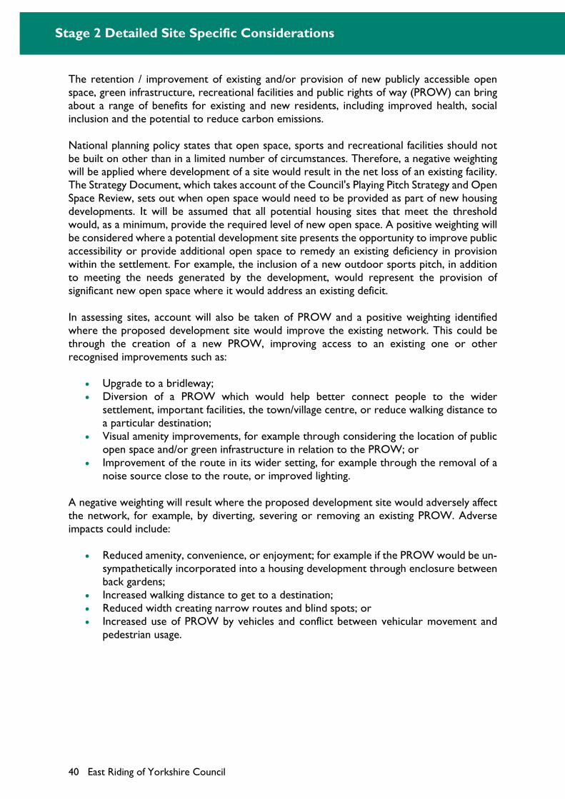
Stage 2 Detailed Site Specific Considerations
40 East Riding of Yorkshire Council
The retention / improvement of existing and/or provision of new publicly accessible open space, green infrastructure, recreational facilities and public rights of way (PROW) can bring about a range of benefits for existing and new residents, including improved health, social inclusion and the potential to reduce carbon emissions.
National planning policy states that open space, sports and recreational facilities should not be built on other than in a limited number of circumstances. Therefore, a negative weighting will be applied where development of a site would result in the net loss of an existing facility. The Strategy Document, which takes account of the Council's Playing Pitch Strategy and Open Space Review, sets out when open space would need to be provided as part of new housing developments. It will be assumed that all potential housing sites that meet the threshold would, as a minimum, provide the required level of new open space. A positive weighting will be considered where a potential development site presents the opportunity to improve public accessibility or provide additional open space to remedy an existing deficiency in provision within the settlement. For example, the inclusion of a new outdoor sports pitch, in addition to meeting the needs generated by the development, would represent the provision of significant new open space where it would address an existing deficit.
In assessing sites, account will also be taken of PROW and a positive weighting identified where the proposed development site would improve the existing network. This could be through the creation of a new PROW, improving access to an existing one or other recognised improvements such as:
Upgrade to a bridleway; Diversion of a PROW which would help better connect people to the wider
settlement, important facilities, the town/village centre, or reduce walking distance to a particular destination;
Visual amenity improvements, for example through considering the location of public open space and/or green infrastructure in relation to the PROW; or
Improvement of the route in its wider setting, for example through the removal of a noise source close to the route, or improved lighting.
A negative weighting will result where the proposed development site would adversely affect the network, for example, by diverting, severing or removing an existing PROW. Adverse impacts could include:
Reduced amenity, convenience, or enjoyment; for example if the PROW would be un-sympathetically incorporated into a housing development through enclosure between back gardens;
Increased walking distance to get to a destination; Reduced width creating narrow routes and blind spots; or Increased use of PROW by vehicles and conflict between vehicular movement and
pedestrian usage.
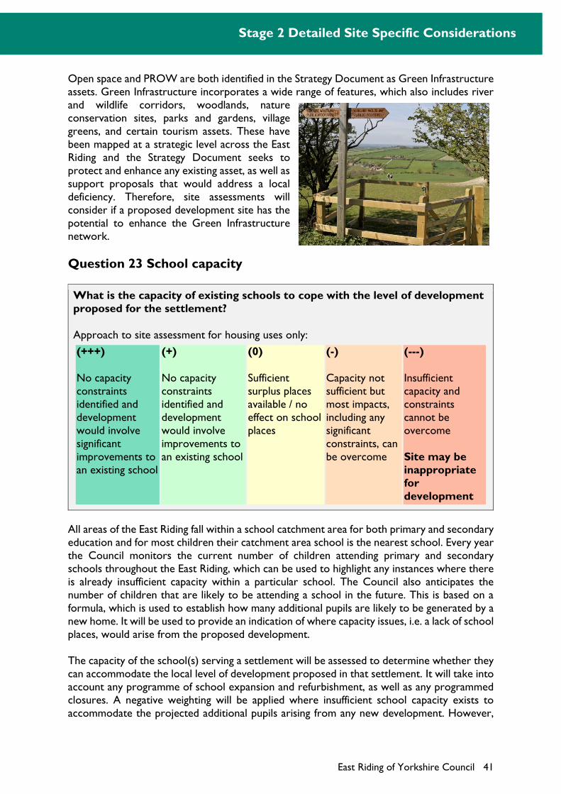
Stage 2 Detailed Site Specific Considerations
East Riding of Yorkshire Council 41
Open space and PROW are both identified in the Strategy Document as Green Infrastructure assets. Green Infrastructure incorporates a wide range of features, which also includes river and wildlife corridors, woodlands, nature conservation sites, parks and gardens, village greens, and certain tourism assets. These have been mapped at a strategic level across the East Riding and the Strategy Document seeks to protect and enhance any existing asset, as well as support proposals that would address a local deficiency. Therefore, site assessments will consider if a proposed development site has the potential to enhance the Green Infrastructure network.
Question 23 School capacity
What is the capacity of existing schools to cope with the level of development proposed for the settlement?
Approach to site assessment for housing uses only:
(+++)
No capacity constraints identified and development would involve significant improvements to an existing school
(+)
No capacity constraints identified and development would involve improvements to an existing school
(0)
Sufficient surplus places available / no effect on school places
(-)
Capacity not sufficient but most impacts, including any significant constraints, can be overcome
(---)
Insufficient capacity and constraints cannot be overcome
Site may be inappropriate for development
All areas of the East Riding fall within a school catchment area for both primary and secondary education and for most children their catchment area school is the nearest school. Every year the Council monitors the current number of children attending primary and secondary schools throughout the East Riding, which can be used to highlight any instances where there is already insufficient capacity within a particular school. The Council also anticipates the number of children that are likely to be attending a school in the future. This is based on a formula, which is used to establish how many additional pupils are likely to be generated by a new home. It will be used to provide an indication of where capacity issues, i.e. a lack of school places, would arise from the proposed development.
The capacity of the school(s) serving a settlement will be assessed to determine whether they can accommodate the local level of development proposed in that settlement. It will take into account any programme of school expansion and refurbishment, as well as any programmed closures. A negative weighting will be applied where insufficient school capacity exists to accommodate the projected additional pupils arising from any new development. However,
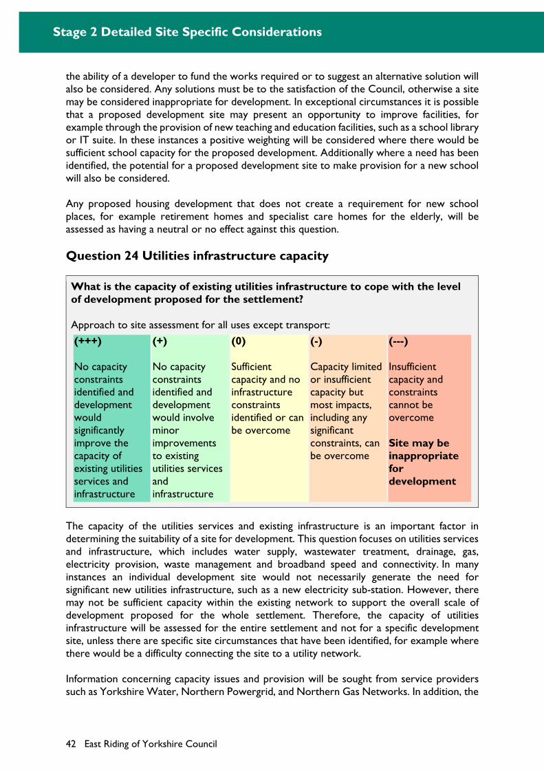
Stage 2 Detailed Site Specific Considerations
42 East Riding of Yorkshire Council
the ability of a developer to fund the works required or to suggest an alternative solution will also be considered. Any solutions must be to the satisfaction of the Council, otherwise a site may be considered inappropriate for development. In exceptional circumstances it is possible that a proposed development site may present an opportunity to improve facilities, for example through the provision of new teaching and education facilities, such as a school library or IT suite. In these instances a positive weighting will be considered where there would be sufficient school capacity for the proposed development. Additionally where a need has been identified, the potential for a proposed development site to make provision for a new school will also be considered.
Any proposed housing development that does not create a requirement for new school places, for example retirement homes and specialist care homes for the elderly, will be assessed as having a neutral or no effect against this question.
Question 24 Utilities infrastructure capacity
What is the capacity of existing utilities infrastructure to cope with the level of development proposed for the settlement?
Approach to site assessment for all uses except transport:
(+++)
No capacity constraints identified and development would significantly improve the capacity of existing utilities services and infrastructure
(+)
No capacity constraints identified and development would involve minor improvements to existing utilities services and infrastructure
(0)
Sufficient capacity and no infrastructure constraints identified or can be overcome
(-)
Capacity limited or insufficient capacity but most impacts, including any significant constraints, can be overcome
(---)
Insufficient capacity and constraints cannot be overcome
Site may be inappropriate for development
The capacity of the utilities services and existing infrastructure is an important factor in determining the suitability of a site for development. This question focuses on utilities services and infrastructure, which includes water supply, wastewater treatment, drainage, gas, electricity provision, waste management and broadband speed and connectivity. In many instances an individual development site would not necessarily generate the need for significant new utilities infrastructure, such as a new electricity sub-station. However, there may not be sufficient capacity within the existing network to support the overall scale of development proposed for the whole settlement. Therefore, the capacity of utilities infrastructure will be assessed for the entire settlement and not for a specific development site, unless there are specific site circumstances that have been identified, for example where there would be a difficulty connecting the site to a utility network.
Information concerning capacity issues and provision will be sought from service providers such as Yorkshire Water, Northern Powergrid, and Northern Gas Networks. In addition, the
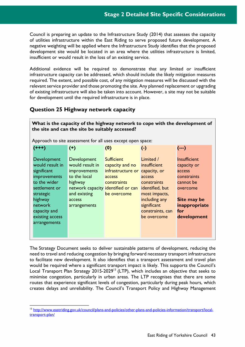
Stage 2 Detailed Site Specific Considerations
East Riding of Yorkshire Council 43
Council is preparing an update to the Infrastructure Study (2014) that assesses the capacity of utilities infrastructure within the East Riding to serve proposed future development. A negative weighting will be applied where the Infrastructure Study identifies that the proposed development site would be located in an area where the utilities infrastructure is limited, insufficient or would result in the loss of an existing service.
Additional evidence will be required to demonstrate that any limited or insufficient infrastructure capacity can be addressed, which should include the likely mitigation measures required. The extent, and possible cost, of any mitigation measures will be discussed with the relevant service provider and those promoting the site. Any planned replacement or upgrading of existing infrastructure will also be taken into account. However, a site may not be suitable for development until the required infrastructure is in place.
Question 25 Highway network capacity
What is the capacity of the highway network to cope with the development of the site and can the site be suitably accessed?
Approach to site assessment for all uses except open space:
(+++)
Development would result in significant improvements to the wider settlement or strategic highway network capacity and existing access arrangements
(+)
Development would result in improvements to the local highway network capacity and existing access arrangements
(0)
Sufficient capacity and no infrastructure or access constraints identified or can be overcome
(-)
Limited / insufficient capacity, or access constraints identified, but most impacts, including any significant constraints, can be overcome
(---)
Insufficient capacity or access constraints cannot be overcome
Site may be inappropriate for development
The Strategy Document seeks to deliver sustainable patterns of development, reducing the need to travel and reducing congestion by bringing forward necessary transport infrastructure to facilitate new development. It also identifies that a transport assessment and travel plan would be required where a significant transport impact is likely. This supports the Council’s Local Transport Plan Strategy 2015-202913 (LTP), which includes an objective that seeks to minimise congestion, particularly in urban areas. The LTP recognises that there are some routes that experience significant levels of congestion, particularly during peak hours, which creates delays and unreliability. The Council’s Transport Policy and Highway Management
13 http://www.eastriding.gov.uk/council/plans-and-policies/other-plans-and-policies-information/transport/local-transport-plan/
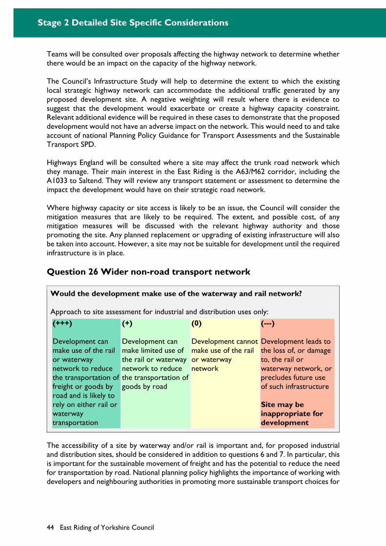
Stage 2 Detailed Site Specific Considerations
44 East Riding of Yorkshire Council
Teams will be consulted over proposals affecting the highway network to determine whether there would be an impact on the capacity of the highway network.
The Council’s Infrastructure Study will help to determine the extent to which the existing local strategic highway network can accommodate the additional traffic generated by any proposed development site. A negative weighting will result where there is evidence to suggest that the development would exacerbate or create a highway capacity constraint. Relevant additional evidence will be required in these cases to demonstrate that the proposed development would not have an adverse impact on the network. This would need to and take account of national Planning Policy Guidance for Transport Assessments and the Sustainable Transport SPD.
Highways England will be consulted where a site may affect the trunk road network which they manage. Their main interest in the East Riding is the A63/M62 corridor, including the A1033 to Saltend. They will review any transport statement or assessment to determine the impact the development would have on their strategic road network.
Where highway capacity or site access is likely to be an issue, the Council will consider the mitigation measures that are likely to be required. The extent, and possible cost, of any mitigation measures will be discussed with the relevant highway authority and those promoting the site. Any planned replacement or upgrading of existing infrastructure will also be taken into account. However, a site may not be suitable for development until the required infrastructure is in place.
Question 26 Wider non-road transport network
Would the development make use of the waterway and rail network?
Approach to site assessment for industrial and distribution uses only:
(+++)
Development can make use of the rail or waterway network to reduce the transportation of freight or goods by road and is likely to rely on either rail or waterway transportation
(+)
Development can make limited use of the rail or waterway network to reduce the transportation of goods by road
(0)
Development cannot make use of the rail or waterway network
(---)
Development leads to the loss of, or damage to, the rail or waterway network, or precludes future use of such infrastructure
Site may be inappropriate for development
The accessibility of a site by waterway and/or rail is important and, for proposed industrial and distribution sites, should be considered in addition to questions 6 and 7. In particular, this is important for the sustainable movement of freight and has the potential to reduce the need for transportation by road. National planning policy highlights the importance of working with developers and neighbouring authorities in promoting more sustainable transport choices for

Stage 2 Detailed Site Specific Considerations
East Riding of Yorkshire Council 45
the movement of freight along routes that could be critical to widening transport choices for both passengers and freight.
There may be opportunities, for industrial and distribution sites, to make use of waterways (e.g. ports) and rail (e.g. freight). In assessing sites, account will be taken, and positive weighting identified, where there is evidence that the development can connect and make use of non-road transport networks. Conversely, proposed development sites will receive a negative weighting where existing networks would be lost, damaged or precluded from future use.
Question 27 Community facilities
Would development result in the loss of any existing or proposed community facility or would it contribute to the construction of a new facility?
Approach to site assessment for all uses:
(+++)
New community facility, or an improved existing facility, is proposed and is viable and sustainable
(0)
New community facility is proposed but is not viable or sustainable, no new facility is proposed or no facilities would be lost
(-)
Development would involve loss of an existing community facility or proposed (e.g. allocated) facility that may still be required. Any significant impacts can be mitigated
(---)
Development would involve loss of an existing well used community facility or proposed (e.g. allocated) facility that is still required. No satisfactory mitigation (e.g. a suitable and viable replacement facility) measures possible
Site may be inappropriate for development
The importance of retaining community facilities, especially in rural areas, is highlighted within national planning policy. Site assessments will consider whether a suggested development site would affect any existing or proposed community services or facilities. It focuses on local community facilities, or social infrastructure, and does not consider infrastructure issues relating to open space, schools, utilities or highway capacity and access arrangements which are considered separately in questions 22, 23, 24 and 25.
In certain instances proposals for new development may include the provision of a new facility, for example a new community hall or health facility, or make provision to enhance an existing
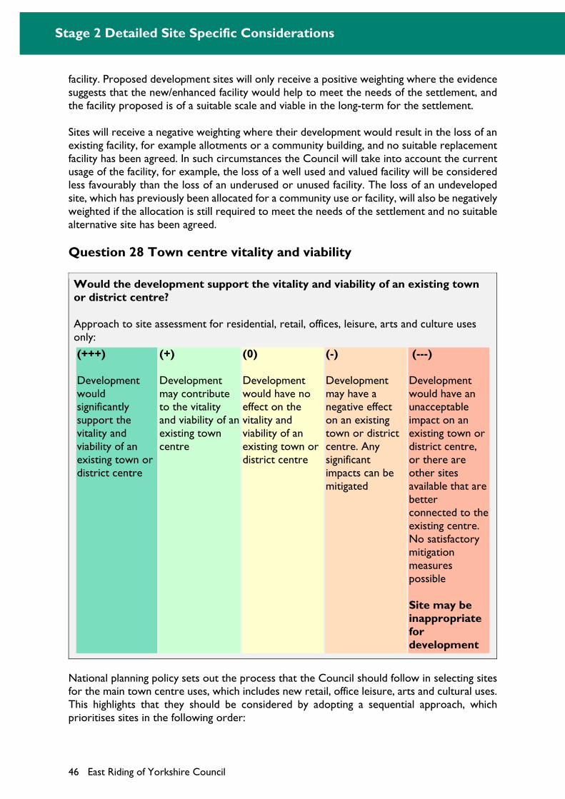
Stage 2 Detailed Site Specific Considerations
46 East Riding of Yorkshire Council
facility. Proposed development sites will only receive a positive weighting where the evidence suggests that the new/enhanced facility would help to meet the needs of the settlement, and the facility proposed is of a suitable scale and viable in the long-term for the settlement.
Sites will receive a negative weighting where their development would result in the loss of an existing facility, for example allotments or a community building, and no suitable replacement facility has been agreed. In such circumstances the Council will take into account the current usage of the facility, for example, the loss of a well used and valued facility will be considered less favourably than the loss of an underused or unused facility. The loss of an undeveloped site, which has previously been allocated for a community use or facility, will also be negatively weighted if the allocation is still required to meet the needs of the settlement and no suitable alternative site has been agreed.
Question 28 Town centre vitality and viability
Would the development support the vitality and viability of an existing town or district centre?
Approach to site assessment for residential, retail, offices, leisure, arts and culture uses only:
(+++)
Development would significantly support the vitality and viability of an existing town or district centre
(+)
Development may contribute to the vitality and viability of an existing town centre
(0)
Development would have no effect on the vitality and viability of an existing town or district centre
(-)
Development may have a negative effect on an existing town or district centre. Any significant impacts can be mitigated
(---)
Development would have an unacceptable impact on an existing town or district centre, or there are other sites available that are better connected to the existing centre. No satisfactory mitigation measures possible
Site may be inappropriate for development
National planning policy sets out the process that the Council should follow in selecting sites for the main town centre uses, which includes new retail, office leisure, arts and cultural uses. This highlights that they should be considered by adopting a sequential approach, which prioritises sites in the following order:
Stage 2 Detailed Site Specific Considerations
East Riding of Yorkshire Council 47
Locations in an existing town or district centre Edge-of-centre locations (within 300 metres of the primary shopping area and 500m
for all other town centre uses), with preference given to sites that are or will be well-connected to the centre
Out-of-centre sites (more than 300 meters from the primary shopping centre and 500m for all other town centre uses), with preference given to sites which are or will be well served by a choice of means of transport and which are closest to the centre and have a higher likelihood of forming links with the centre
This approach will be taken into account when assessing sites and a negative weighting applied if there are other more suitable sites available. For example proposed sites in an out-of-centre location may be considered inappropriate for development if there is sufficient available land within the existing centre or in an edge-of-centre location.
National planning policy also identifies that the impacts of proposed locations for development should be considered. It highlights that the Council should ensure that any proposed edge-of-centre or out-of-centre sites would not have an unacceptable impact on an existing town or district centre, or any other centres that fall within the catchment of the potential development. It also recognises that residential development often plays an important role in ensuring the vitality of centres.
The Council’s Town Centres and Retail and Leisure Study14 will provide the basis for assessing the potential impact of proposed development sites. It sets out a hierarchy of centres in the East Riding, as well as outlining the need for new retail development within each centre. Where relevant additional evidence would be required to demonstrate that the proposed development would not have an adverse impact on an existing town or district centre.
14 http://www.eastriding.gov.uk/environment/planning-and-building-control/east-riding-local-plan/town-centres-and-retail-study/
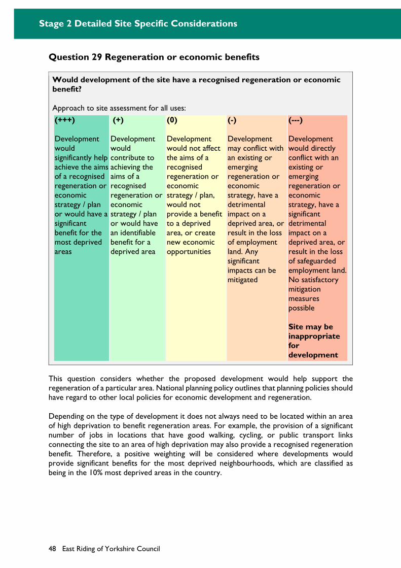
Stage 2 Detailed Site Specific Considerations
48 East Riding of Yorkshire Council
Question 29 Regeneration or economic benefits
Would development of the site have a recognised regeneration or economic benefit?
Approach to site assessment for all uses:
(+++)
Development would significantly help achieve the aims of a recognised regeneration or economic strategy / plan or would have a significant benefit for the most deprived areas
(+)
Development would contribute to achieving the aims of a recognised regeneration or economic strategy / plan or would have an identifiable benefit for a deprived area
(0)
Development would not affect the aims of a recognised regeneration or economic strategy / plan, would not provide a benefit to a deprived area, or create new economic opportunities
(-)
Development may conflict with an existing or emerging regeneration or economic strategy, have a detrimental impact on a deprived area, or result in the loss of employment land. Any significant impacts can be mitigated
(---)
Development would directly conflict with an existing or emerging regeneration or economic strategy, have a significant detrimental impact on a deprived area, or result in the loss of safeguarded employment land. No satisfactory mitigation measures possible
Site may be inappropriate for development
This question considers whether the proposed development would help support the regeneration of a particular area. National planning policy outlines that planning policies should have regard to other local policies for economic development and regeneration.
Depending on the type of development it does not always need to be located within an area of high deprivation to benefit regeneration areas. For example, the provision of a significant number of jobs in locations that have good walking, cycling, or public transport links connecting the site to an area of high deprivation may also provide a recognised regeneration benefit. Therefore, a positive weighting will be considered where developments would provide significant benefits for the most deprived neighbourhoods, which are classified as being in the 10% most deprived areas in the country.
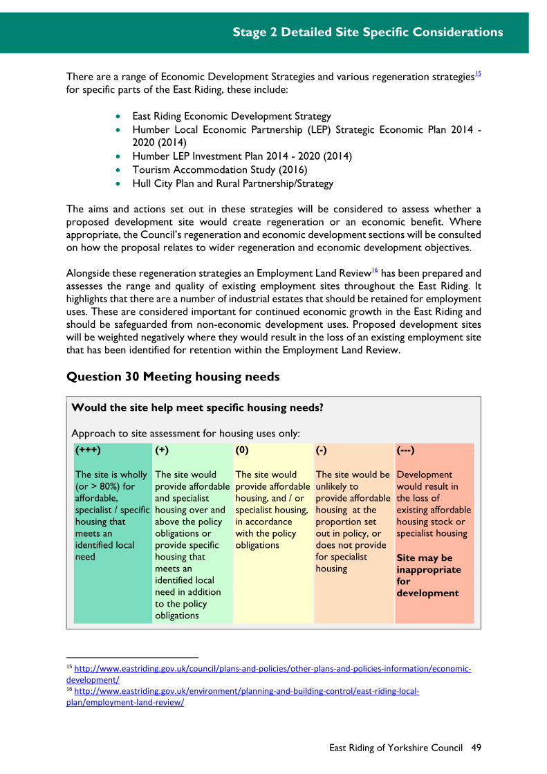
Stage 2 Detailed Site Specific Considerations
East Riding of Yorkshire Council 49
There are a range of Economic Development Strategies and various regeneration strategies15 for specific parts of the East Riding, these include:
East Riding Economic Development Strategy
Humber Local Economic Partnership (LEP) Strategic Economic Plan 2014 - 2020 (2014)
Humber LEP Investment Plan 2014 - 2020 (2014)
Tourism Accommodation Study (2016)
Hull City Plan and Rural Partnership/Strategy
The aims and actions set out in these strategies will be considered to assess whether a proposed development site would create regeneration or an economic benefit. Where appropriate, the Council’s regeneration and economic development sections will be consulted on how the proposal relates to wider regeneration and economic development objectives.
Alongside these regeneration strategies an Employment Land Review16 has been prepared and assesses the range and quality of existing employment sites throughout the East Riding. It highlights that there are a number of industrial estates that should be retained for employment uses. These are considered important for continued economic growth in the East Riding and should be safeguarded from non-economic development uses. Proposed development sites will be weighted negatively where they would result in the loss of an existing employment site that has been identified for retention within the Employment Land Review.
Question 30 Meeting housing needs
Would the site help meet specific housing needs?
Approach to site assessment for housing uses only:
(+++)
The site is wholly (or > 80%) for affordable, specialist / specific housing that meets an identified local need
(+)
The site would provide affordable and specialist housing over and above the policy obligations or provide specific housing that meets an identified local need in addition to the policy obligations
(0)
The site would provide affordable housing, and / or specialist housing, in accordance with the policy obligations
(-)
The site would be unlikely to provide affordable housing at the proportion set out in policy, or does not provide for specialist housing
(---)
Development would result in the loss of existing affordable housing stock or specialist housing
Site may be inappropriate for development
15 http://www.eastriding.gov.uk/council/plans-and-policies/other-plans-and-policies-information/economic-
development/ 16 http://www.eastriding.gov.uk/environment/planning-and-building-control/east-riding-local-
plan/employment-land-review/
Stage 2 Detailed Site Specific Considerations
50 East Riding of Yorkshire Council
National planning policy seeks to improve the affordability of housing where there is an identified affordable housing need and provide specialist accommodation for groups of people with specific needs (such as purpose-built accommodation for the elderly or students). Types of specialist accommodation may include, but is not limited to, extra care units, accommodation for people with disabilities and student residencies. Improving housing affordability and the delivery of specialist housing to meet local needs are key objectives for the Council and are also important sustainability objectives.
This question seeks to give a positive weighting to those sites that help deliver the specific housing needs of the East Riding where this would exceed the policy requirement set out in the Strategy Document. Specific housing would include custom build, self build and community led housing.
The level and nature of housing need in the East Riding varies significantly and potential sites should reflect such need in the locality. This should reflect the East Riding Housing Strategy 201717 which identifies older people as a key group within the East Riding that have specific needs. The latest Strategic Housing Market Assessment, Housing Strategy and, where relevant, information provided by the Council’s Housing Strategy and Development Team, will be used to assess whether specific housing needs are being met.
National planning policy identifies that affordable housing should not normally be sought for residential developments that are not major developments. Major developments are defined as 10 or more dwellings or sites of 0.5 hectares or more, for housing purposes. Where a proposed development site falls below this threshold it will be assumed that it would not contribute towards the delivery of affordable housing and would result in a neutral score unless affordable or specialist units were proposed.
Stage 2 Outcome: To assess and weigh all the sites that have progressed from stage 1 against a detailed range of social, environmental and economic indicators. Those sites that are subject to a significant constraint may be deemed inappropriate for development if mitigation is not possible or practicable.
17 http://www2.eastriding.gov.uk/council/plans-and-policies/other-plans-and-policies-information/housing-
strategy/housing-strategy-and-policy/
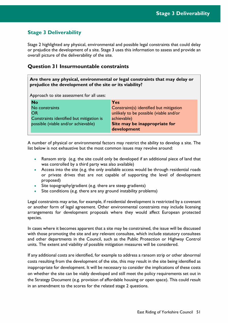
Stage 3 Deliverability
East Riding of Yorkshire Council 51
Stage 3 Deliverability
Stage 2 highlighted any physical, environmental and possible legal constraints that could delay or prejudice the development of a site. Stage 3 uses this information to assess and provide an overall picture of the deliverability of the site.
Question 31 Insurmountable constraints
Are there any physical, environmental or legal constraints that may delay or prejudice the development of the site or its viability?
Approach to site assessment for all uses:
No No constraints OR Constraints identified but mitigation is possible (viable and/or achievable)
Yes Constraint(s) identified but mitigation unlikely to be possible (viable and/or achievable) Site may be inappropriate for development
A number of physical or environmental factors may restrict the ability to develop a site. The list below is not exhaustive but the most common issues may revolve around:
Ransom strip (e.g. the site could only be developed if an additional piece of land that was controlled by a third party was also available)
Access into the site (e.g. the only available access would be through residential roads or private drives that are not capable of supporting the level of development proposed)
Site topography/gradient (e.g. there are steep gradients) Site conditions (e.g. there are any ground instability problems)
Legal constraints may arise, for example, if residential development is restricted by a covenant or another form of legal agreement. Other environmental constraints may include licensing arrangements for development proposals where they would affect European protected species.
In cases where it becomes apparent that a site may be constrained, the issue will be discussed with those promoting the site and any relevant consultee, which include statutory consultees and other departments in the Council, such as the Public Protection or Highway Control units. The extent and viability of possible mitigation measures will be considered.
If any additional costs are identified, for example to address a ransom strip or other abnormal
costs resulting from the development of the site, this may result in the site being identified as
inappropriate for development. It will be necessary to consider the implications of these costs
on whether the site can be viably developed and still meet the policy requirements set out in
the Strategy Document (e.g. provision of affordable housing or open space). This could result
in an amendment to the scores for the related stage 2 questions.
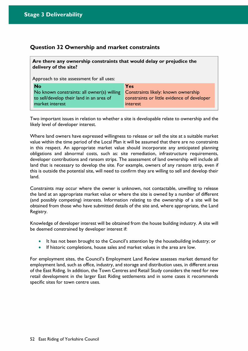
Stage 3 Deliverability
52 East Riding of Yorkshire Council
Question 32 Ownership and market constraints
Are there any ownership constraints that would delay or prejudice the delivery of the site?
Approach to site assessment for all uses:
No No known constraints: all owner(s) willing to sell/develop their land in an area of market interest
Yes Constraints likely: known ownership constraints or little evidence of developer interest
Two important issues in relation to whether a site is developable relate to ownership and the likely level of developer interest.
Where land owners have expressed willingness to release or sell the site at a suitable market value within the time period of the Local Plan it will be assumed that there are no constraints in this respect. An appropriate market value should incorporate any anticipated planning obligations and abnormal costs, such as: site remediation, infrastructure requirements, developer contributions and ransom strips. The assessment of land ownership will include all land that is necessary to develop the site. For example, owners of any ransom strip, even if this is outside the potential site, will need to confirm they are willing to sell and develop their land.
Constraints may occur where the owner is unknown, not contactable, unwilling to release the land at an appropriate market value or where the site is owned by a number of different (and possibly competing) interests. Information relating to the ownership of a site will be obtained from those who have submitted details of the site and, where appropriate, the Land Registry.
Knowledge of developer interest will be obtained from the house building industry. A site will be deemed constrained by developer interest if:
It has not been brought to the Council’s attention by the housebuilding industry; or
If historic completions, house sales and market values in the area are low.
For employment sites, the Council’s Employment Land Review assesses market demand for employment land, such as office, industry, and storage and distribution uses, in different areas of the East Riding. In addition, the Town Centres and Retail Study considers the need for new retail development in the larger East Riding settlements and in some cases it recommends specific sites for town centre uses.
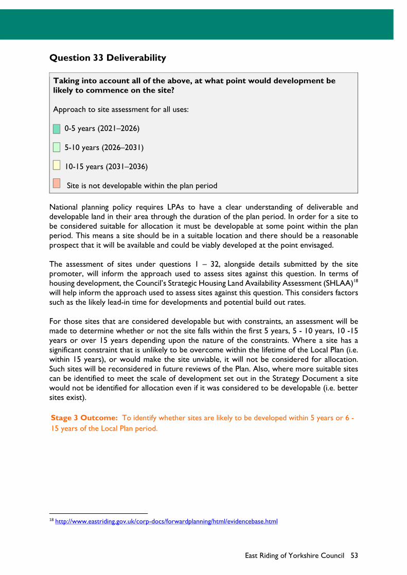
East Riding of Yorkshire Council 53
Question 33 Deliverability
Taking into account all of the above, at what point would development be likely to commence on the site?
Approach to site assessment for all uses:
0-5 years (2021–2026)
5-10 years (2026–2031)
10-15 years (2031–2036)
Site is not developable within the plan period
National planning policy requires LPAs to have a clear understanding of deliverable and developable land in their area through the duration of the plan period. In order for a site to be considered suitable for allocation it must be developable at some point within the plan period. This means a site should be in a suitable location and there should be a reasonable prospect that it will be available and could be viably developed at the point envisaged.
The assessment of sites under questions 1 – 32, alongside details submitted by the site promoter, will inform the approach used to assess sites against this question. In terms of housing development, the Council’s Strategic Housing Land Availability Assessment (SHLAA)18 will help inform the approach used to assess sites against this question. This considers factors such as the likely lead-in time for developments and potential build out rates.
For those sites that are considered developable but with constraints, an assessment will be made to determine whether or not the site falls within the first 5 years, 5 - 10 years, 10 -15 years or over 15 years depending upon the nature of the constraints. Where a site has a significant constraint that is unlikely to be overcome within the lifetime of the Local Plan (i.e. within 15 years), or would make the site unviable, it will not be considered for allocation. Such sites will be reconsidered in future reviews of the Plan. Also, where more suitable sites can be identified to meet the scale of development set out in the Strategy Document a site would not be identified for allocation even if it was considered to be developable (i.e. better sites exist).
Stage 3 Outcome: To identify whether sites are likely to be developed within 5 years or 6 -
15 years of the Local Plan period.
18 http://www.eastriding.gov.uk/corp-docs/forwardplanning/html/evidencebase.html
Using the Site Assessment Methodology
54 East Riding of Yorkshire Council
Using the Site Assessment Methodology
The Site Assessment Methodology will be used by the Council to assess all proposed development sites, but could also be used by the local community, landowners, agents and other interested parties to assess a specific site. It will help to identify those proposed development sites that have the greatest potential to deliver environmental, economic and social benefits for the local community.
Table 6 outlines how an individual site assessment would be reported. It will be used to explain why a particular outcome has been identified against each question. However, it is important to note that the methodology is a tool to help identify those factors that may influence the allocation of a site for new development. As such it does not produce a final definitive score for an individual site.
The site assessments will also inform the preparation of a Sustainability Appraisal report for the Allocations Document, which will identify each site’s performance against a range of environmental, social and economic objectives. Both the site assessments and Sustainability Appraisal report are important sources of evidence that will help to identify whether a site should be included in the Allocations Document.
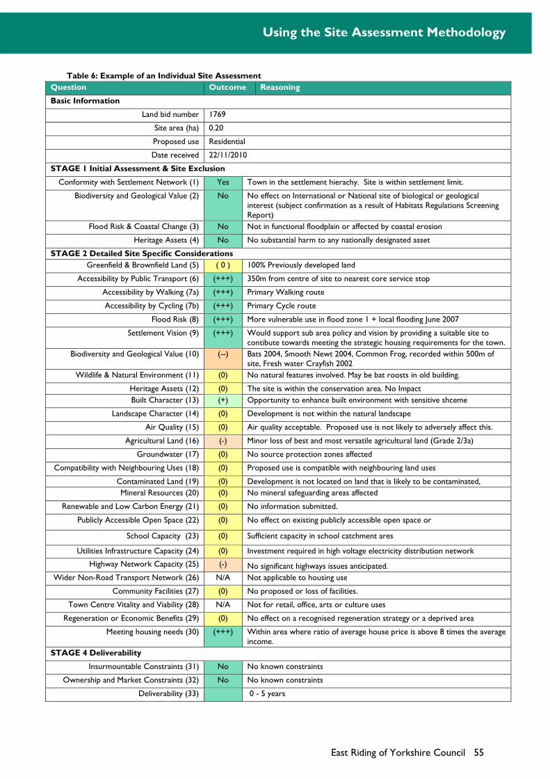
Using the Site Assessment Methodology
East Riding of Yorkshire Council 55
Table 6: Example of an Individual Site Assessment
Question Outcome Reasoning
Basic Information
Land bid number 1769
Site area (ha) 0.20
Proposed use Residential
Date received 22/11/2010
STAGE 1 Initial Assessment & Site Exclusion
Conformity with Settlement Network (1) Yes Town in the settlement hierachy. Site is within settlement limit.
Biodiversity and Geological Value (2) No No effect on International or National site of biological or geological interest (subject confirmation as a result of Habitats Regulations Screening Report)
Flood Risk & Coastal Change (3) No Not in functional floodplain or affected by coastal erosion
Heritage Assets (4) No No substantial harm to any nationally designated asset
STAGE 2 Detailed Site Specific Considerations
Greenfield & Brownfield Land (5) ( 0 ) 100% Previously developed land
Accessibility by Public Transport (6) (+++) 350m from centre of site to nearest core service stop
Accessibility by Walking (7a) (+++) Primary Walking route
Accessibility by Cycling (7b) (+++) Primary Cycle route
Flood Risk (8) (+++) More vulnerable use in flood zone 1 + local flooding June 2007
Settlement Vision (9) (+++) Would support sub area policy and vision by providing a suitable site to contibute towards meeting the strategic housing requirements for the town.
Biodiversity and Geological Value (10) (--) Bats 2004, Smooth Newt 2004, Common Frog, recorded within 500m of site, Fresh water Crayfish 2002
Wildlife & Natural Environment (11) (0) No natural features involved. May be bat roosts in old building.
Heritage Assets (12) (0) The site is within the conservation area. No Impact
Built Character (13) (+) Opportunity to enhance built environment with sensitive shceme
Landscape Character (14) (0) Development is not within the natural landscape
Air Quality (15) (0) Air quality acceptable. Proposed use is not likely to adversely affect this.
Agricultural Land (16) (-) Minor loss of best and most versatile agricultural land (Grade 2/3a)
Groundwater (17) (0) No source protection zones affected
Compatibility with Neighbouring Uses (18) (0) Proposed use is compatible with neighbouring land uses
Contaminated Land (19) (0) Development is not located on land that is likely to be contaminated,
Mineral Resources (20) (0) No mineral safeguarding areas affected
Renewable and Low Carbon Energy (21) (0) No information submitted.
Publicly Accessible Open Space (22) (0) No effect on existing publicly accessible open space or
School Capacity (23) (0) Sufficient capacity in school catchment ares
Utilities Infrastructure Capacity (24) (0) Investment required in high voltage electricity distribution network
Highway Network Capacity (25) (-) No significant highways issues anticipated.
Wider Non-Road Transport Network (26) N/A Not applicable to housing use
Community Facilities (27) (0) No proposed or loss of facilities.
Town Centre Vitality and Viability (28) N/A Not for retail, office, arts or culture uses
Regeneration or Economic Benefits (29) (0) No effect on a recognised regeneration strategy or a deprived area
Meeting housing needs (30) (+++) Within area where ratio of average house price is above 8 times the average income.
STAGE 4 Deliverability
Insurmountable Constraints (31) No No known constraints
Ownership and Market Constraints (32) No No known constraints
Deliverability (33)
0 - 5 years
Using the Site Assessment Methodology
56 East Riding of Yorkshire Council

East Riding ofYorkshire Council will, on request provide this
document in braille or
If English is not your first language and you would like a translation
of this document, please telephone
large print.
01482 393939.