Embed Size (px)
Citation preview
Evidence for scale-dependent topographic controls on wildfirespread
NICHOLAS A. POVAK,1,2,� PAUL F. HESSBURG,2 AND R. BRION SALTER2
1Oak Ridge Institute for Science and Education (ORISE), 100 ORAUWay, Oak Ridge, Tennessee 37830 USA2USDA Forest Service, Pacific Northwest Research Station, Wenatchee Forestry Sciences Laboratory, 1133 N. Western Avenue,
Wenatchee, Washington 98801 USA
Citation: Povak, N. A., P. F. Hessburg, and R. B. Salter. 2018. Evidence for scale-dependent topographic controls onwildfire spread. Ecosphere 9(10):e02443. 10.1002/ecs2.2443
Abstract. Wildfire ecosystems are thought to be self-regulated through pattern–process interactionsbetween ignition frequency and location, and patterns of burned and recovering vegetation. Yet, recentincreases in the frequency of large wildfires call into question the application of self-organization theory tolandscape resilience. Topography represents a stable bottom-up template upon which fire interacts as both aphysical and an ecological process. However, it is unclear how topographic control changes geographicallyand across spatial scales. We analyzed fire perimeter and topography data from 16 Bailey ecoregions acrossthe State of California to identify spatial correspondence between ecoregional fire event and topographicpatch size distributions. We found both sets of distributions followed a power-law form and were statisticallysimilar across several orders of magnitude, for most ecoregions. As a direct test of topographic controls on fireevent perimeters, we used a paired t-test across ~11,000 fires to identify differences in topographic attributesat fire boundaries versus fire interiors. Statistical significance was determined using 500 iterations of a neutrallandscape model. Level of topographic control varied significantly by ecoregion and across topographic fea-tures. For example, north–south aspect breaks, valley bottoms, and roads showed a consistently high degreeof spatial control on wildfire perimeters. Topographic controls were most pronounced in mountainous ecore-gions and were least influential in arid regions. Ridgetops provided a low-level control across all ecoregions.Spatial control was strongest for small (100–102 ha) to medium (103–104 ha) fire sizes, suggesting that controlswere scale-dependent rather than scale-invariant. Roads were the dominant control across all ecoregions;however, removing roads from the analyses had no significant effect on the overall role of topography onwildfire extinguishment in this analysis. This result suggested that certain topographic settings show strongspatial control on fire growth, despite the presence of roads. Our results support the observation that both bot-tom-up and top-down factors constrain fire sizes and that there are likely scaling regions within fire size distri-butions wherein the dominance of these spatial controls varies. Human influences on fire spread may eitherdiminish or enhance the role of some bottom-up and top-down factors, adding further complexity.
Key words: biophysical; complexity; disturbance; fire; landscape ecology; Scaling; self-organize; self-organizedcriticality; Topography.
Received 9 May 2018; revised 23 July 2018; accepted 23 August 2018. Corresponding Editor: Franco Biondi.Copyright: Published 2018. This article is a U.S. Government work and is in the public domain in the USA. Ecospherepublished by Wiley Periodicals, Inc. on behalf of Ecological Society of America. This is an open access article under theterms of the Creative Commons Attribution License, which permits use, distribution and reproduction in any medium,provided the original work is properly cited.� E-mail: [email protected]
❖ www.esajournals.org 1 October 2018 ❖ Volume 9(10) ❖ Article e02443
INTRODUCTION
Wildfire is the dominant disturbance agent inmost western U.S. forests and rangelands. Priorto Euro-American settlement, patterns of forestand rangeland successional conditions emergedfrom interactions among wildfires, past burnseverity patterns, biophysical environments, andvegetation regrowth. The resulting abundance,dispersion, and patch sizes of various succes-sional conditions generally fell within a pre-dictable range of variability (Taylor and Skinner1998, Landres et al. 1999, Heyerdahl et al. 2001,Hessburg and Agee 2003, Veblen 2003).
In addition to sculpting successional conditions,historical wildfires provided a constantly evolvingpatchwork of burned and recovering patches thatalternatively constrained and facilitated fire flowon the landscape. Overall, fires reduced forestedarea, thinned forests, and reduced surface fuels,which created a patchwork of landscape memo-ries—conditions that, for a time, influence thegrowth and severity of future fires (Peterson 2002,Prichard et al. 2017). Patterns of biophysical envi-ronments added other positive and negative feed-back to the landscape by means of spatialvariability in insolation, gradients of edaphic envi-ronments, orographic effects, natural barriers towildfire spread (e.g., rock, water, ice, bareground), and the timing and distribution of igni-tions (Beaty and Taylor 2001, McKenzie et al.2006, Kellogg et al. 2008). Occasionally, large devi-ations in vegetation patterns occurred after verylarge weather-driven fire events, but systems gen-erally rebounded to prior ranges of seral stage andfuel conditions (Nonaka and Spies 2005), unlessthere was a significant long-term change in cli-matic forcing (Keane et al. 2009). In this way, mul-ti-scaled feedback—interacting with recurrentdisturbances over space and time—resulted infairly predictable ranges of vegetation successionand fuel conditions, which yielded self-regulatingand self-organizing property of these systems.
In recent years, however, increases in the sizeand severity of western wildfires have led some toquestion the resilience of landscapes to future wild-fires and other large disturbances (Stephens 2005,Westerling et al. 2006, Miller et al. 2009). Landmanagement practices, including fire suppression,timber harvesting, land conversion to agriculture,development of extensive road networks, and
livestock grazing have altered disturbance regimes,fuels, and vegetation patterns within many west-ern U.S. landscapes (Ful�e et al. 1997, Taylor andSkinner 1998, Hessburg and Agee 2003, Hessburget al. 2005). Across large portions of the West,forested area has increased, forests are morehomogenous in their structure and composition,forests are denser with a large proportion of stemsin small size classes, and they are more prone toactive and passive crown fire (Stephens and Lawr-ence 2005, Fry and Stephens 2006, Perry et al.2011). Furthermore, trends in increased areaburned are motivated by a warming climate, sig-naled by longer fire seasons, warmer winters,reduced mountain snowpack, earlier snowmeltand run-off, prolonged periods of intense drought,warmer mean annual and summer temperatures,and changes in the timing, amount, and distribu-tion of precipitation (Westerling et al. 2006, Jollyet al. 2015). Thus, recent increased wildfire activitymay be indicative of the breakdown in pattern–process linkages that historically maintained self-regulation in fire-adapted systems and that thedominance and degree of bottom-up and top-down spatial control on fire spread and extinguish-ment are not functioning as they have previously.Patterns of wildfire event size distributions
(FSD) have been used to infer ecosystem-levelproperties across the United States and elsewhere(Malamud et al. 1998, 2005, Ricotta et al. 2001,Boer et al. 2008). A key feature observed in manystudies is the presence of power-law behavior inFSDs spanning several orders of magnitude. Theparameters of observed distributions ostensiblymatch closely with those from simulated wildfirelandscapes. By extension, researchers have for-warded a now popular theory on the origins ofpower-law behavior in natural wildfire systemstermed self-organized criticality (SOC). Self-orga-nized criticality theory holds that wildfire systems(1) are self-organized, where controls on firespread rely on feedback between internal pro-cesses—ignition frequency and location, vegetation(e.g., fuel) regrowth, and its spatial patterning, (2)are scale-invariant, such that processes controllingsmall fires are the same as those controlling largeones, (3) build toward a critical state where fires ofany size can result, and (4) interactions amonginternal system components lead to scale-invariantpatterns and system-level behavior (i.e., the wholeis greater than the sum of its parts; Turcotte 1999).
❖ www.esajournals.org 2 October 2018 ❖ Volume 9(10) ❖ Article e02443
POVAK ET AL.
The simplicity of the rules governing simulatedfires has been extended to natural wildfire sys-tems, which suggests that the self-regulation, andby extension, the resilience in wildfire systems, is afundamental and stable system property. How-ever, recent evidence suggests that the negativefeedback of past fires are variable, decay over time,and can fail under extreme weather conditions(H�eon et al. 2014, Parks et al. 2015, 2018b, Hol-singer et al. 2016), which has led some to questionthe importance of other feedback within the sys-tem in conferring resilience to wildfire systems.
Recent research has sought to identify the rolesof top-down (exogenous) and bottom-up(endogenous) factors on wildfire spread acrossvarious fire-adapted ecosystems, both in the Uni-ted States and across the globe. Results fromthese studies suggest that complex interactionsexist between bottom-up and top-down forcings,each of which can exert varying degrees of domi-nance over space and through time. Bottom-upfactors generally include (1) the ignition source,ignition density, and spatial distribution, (2) fueltypes, amounts, and spatial arrangements, and(3) topography, which interacts with fire behav-ior and vegetation patterns. Top-down factorsare those that emanate from without, but whichcondition vegetation and fuel patterns acrosslarge areas. These include broad geomorphic andgeologic conditions, long-term climatic patterns,and weather conditions (Parks et al. 2012).
Wildfire is at once a physical and an ecologicalprocess that operates across spatial scales. At finescales (e.g., an individual flame), combustion is afunction of the presence of an ignition source, avail-able fuel, and adequate oxygen. At larger spatialscales, fires are governed by long-term climate, fireweather, patterns of surface and canopy fuels, andpatterns of past disturbances and topography, all ofwhich can contribute to fire severity and the likeli-hood of fire spread in a given area (Moritz et al.2005). These factors are not independent of oneanother, but are highly interactive, co-dependentand correlated over space and time, making gener-alizations of observed relationships difficult.
Of these factors, topography represents themost stable template upon which vegetation(and fuels) dynamics, climate, weather, and firemay respond. Regional fire history studies havehelped elucidate the role topography plays inspatially varying fire-return intervals (Beaty and
Taylor 2001, Heyerdahl et al. 2001). For instance,north slopes generally have lower levels of solarradiation and are therefore cooler, moister, andmore productive than neighboring southerlyslopes, which can lead to more extended fire-return intervals than their southerly counter-parts, and higher fire severity. At fine scales,topographic features such as cold-air drainagescan create microclimates where fire behavior canchange markedly (Whiteman et al. 2001).Wind patterns are also influenced by topogra-
phy during a fire (Sugihara 2006). Diurnal patternsof upslope and up valley winds can accelerate firespread and drive severity patterns. Channeling ofwind flow into canyons and other natural chim-neys can greatly increase the speed and severity offires. In rugged topography, wind patterns aremore complex and less predictable lending touncertainty in short-term wind patterns. Topogra-phy also directly facilitates fire spread throughconvective pre-heating of fuels upslope from aflaming front, or it can provide barriers to spreadwhere headwalls, scree slopes, or rock outcropsexist. These features can also create fire refugia,where extended fire-free periods create uniquelydurable vegetation patterns on the landscape(Camp et al. 1997, Krawchuk et al. 2016).Thus, topography can influence wildfire spread
and extinguishment directly by driving windflow patterns, providing physical barriers tospread, and influencing convective heating dur-ing a wildfire event, and also indirectly by influ-encing long-term climate, vegetation, and fuels.Given the potential influence of topography on
wildfire spread, we sought concrete statistical evi-dence for the degree and spatial scales of topo-graphic controls on wildfire sizes. We analyzedfire perimeter and topography data from 16 Baileyecoregions across the State of California to identifyspatial correspondence between ecoregional fireevent (FSDs) and topographic patch size distribu-tions (PSDs). We first fit power-law models toecoregional FSDs and topographic PSDs (sensuMoritz et al. 2011). Topographic patches includednorth and south aspect patches, and those of rid-getops and valley bottoms. We then statisticallycompared ecoregional FSDs and PSDs to identifyspatial correspondence between them.As a more direct measure of topographic con-
trol, we compared topographic features at fireboundaries and within fire interiors for ~11,000
❖ www.esajournals.org 3 October 2018 ❖ Volume 9(10) ❖ Article e02443
POVAK ET AL.
fires, and used neutral landscape modeling totest the null hypothesis of no difference in topo-graphic influence at fire boundaries and withinfire interiors. A significant difference would indi-cate topographic controls on fire extinguishment.We further hypothesized that roads were alsobarriers to fire spread, directly through the dis-ruption of fuel continuity, and indirectly throughtheir use during fire suppression.
We used a multi-regional and multi-scaledassessment approach to evaluate topographicalcontrols on wildfire extinguishment to ask thequestions: (1) Are drivers of fire extinguishmentscale invariant? (2) Are topographic controlsdominant across all fire sizes? (3) Are all topo-graphic features equally influential? and (4) Docontrols from topography vary by ecoregion?
METHODS
Study area descriptionThe State of California is comprised of 16 Bai-
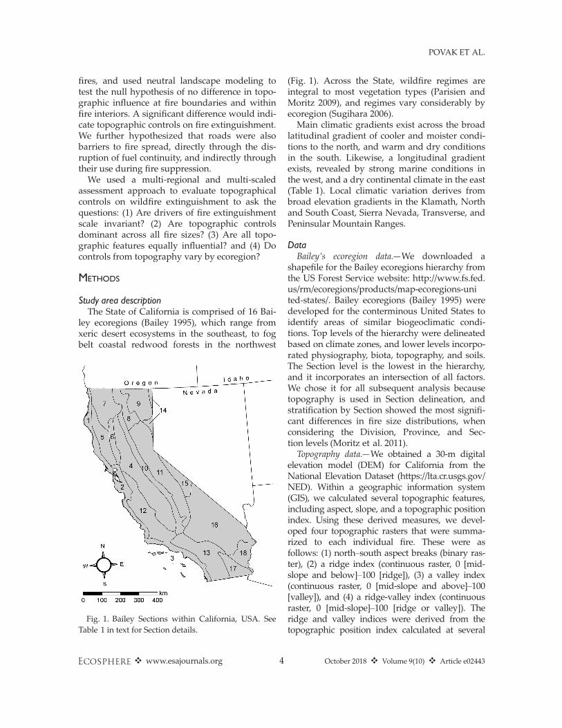
ley ecoregions (Bailey 1995), which range fromxeric desert ecosystems in the southeast, to fogbelt coastal redwood forests in the northwest
(Fig. 1). Across the State, wildfire regimes areintegral to most vegetation types (Parisien andMoritz 2009), and regimes vary considerably byecoregion (Sugihara 2006).Main climatic gradients exist across the broad
latitudinal gradient of cooler and moister condi-tions to the north, and warm and dry conditionsin the south. Likewise, a longitudinal gradientexists, revealed by strong marine conditions inthe west, and a dry continental climate in the east(Table 1). Local climatic variation derives frombroad elevation gradients in the Klamath, Northand South Coast, Sierra Nevada, Transverse, andPeninsular Mountain Ranges.
DataBailey’s ecoregion data.—We downloaded a
shapefile for the Bailey ecoregions hierarchy fromthe US Forest Service website: http://www.fs.fed.us/rm/ecoregions/products/map-ecoregions-united-states/. Bailey ecoregions (Bailey 1995) weredeveloped for the conterminous United States toidentify areas of similar biogeoclimatic condi-tions. Top levels of the hierarchy were delineatedbased on climate zones, and lower levels incorpo-rated physiography, biota, topography, and soils.The Section level is the lowest in the hierarchy,and it incorporates an intersection of all factors.We chose it for all subsequent analysis becausetopography is used in Section delineation, andstratification by Section showed the most signifi-cant differences in fire size distributions, whenconsidering the Division, Province, and Sec-tion levels (Moritz et al. 2011).Topography data.—We obtained a 30-m digital
elevation model (DEM) for California from theNational Elevation Dataset (https://lta.cr.usgs.gov/NED). Within a geographic information system(GIS), we calculated several topographic features,including aspect, slope, and a topographic positionindex. Using these derived measures, we devel-oped four topographic rasters that were summa-rized to each individual fire. These were asfollows: (1) north–south aspect breaks (binary ras-ter), (2) a ridge index (continuous raster, 0 [mid-slope and below]–100 [ridge]), (3) a valley index(continuous raster, 0 [mid-slope and above]–100[valley]), and (4) a ridge-valley index (continuousraster, 0 [mid-slope]–100 [ridge or valley]). Theridge and valley indices were derived from thetopographic position index calculated at several
Fig. 1. Bailey Sections within California, USA. SeeTable 1 in text for Section details.
❖ www.esajournals.org 4 October 2018 ❖ Volume 9(10) ❖ Article e02443
POVAK ET AL.
spatial scales (annular neighborhoods with 250-,500-, and 1000-m outer radii). Aspect breaks wereresampled to 60 and 90 m resolutions.
The statewide DEMwas further used to developtopographic patches of continuous aspect, slope,and curvature. Aspect patches were developed byclassifying the continuous aspect raster into north(270–90), south, and flat topographies, which wereconverted to polygons in the GIS. The same wasdone for slope (flat, 0%; shallow, 0–30%; steep,>30%) and curvature (flat, concave, and convex).
Road data.—A 2012 TIGER (topologically inte-grated geographic encoding and referencing) digi-tal roads shapefile was downloaded for the entireState of California (https://www.census.gov/geo/maps-data/data/tiger-line.html). The shapefile wasthen converted to a 90-m binary raster (1 = road,0 = no road) for further processing.
Wildfire perimeter atlas.—We used an atlas ofgeoreferenced fire perimeters for California, forthe years 1950–2012, accessed from the CaliforniaDepartment of Forestry and Fire Protection’s Fireand Resource Assessment Program (CDF-FRAP2012, http://frap.fire.ca.gov/data/frapgismaps-subset). A total of 10,800 fire perimeters, ranging insize from 1 to 100,000 ha, were included in thedatabase and used in analysis.
Statistical analysesComparison of scaling regions of topographic patch
and fire size distributions.—Inverse cumulative dis-tribution functions (iCDFs) were developed from(1) wildfire size distributions and (2) the topo-graphic patches for each ecoregion. Power-law(Pareto) models were fit to both sets of distribu-tions following the methods of Clauset et al.(2009), where maximum-likelihood estimation(MLE) was used to identify the best-fittingpower-law model to all patches larger than aminimum patch size, and 2500 Monte Carlo sim-ulations of the best-fitting model were run toassess significance of the model fit (Kolmogorov-Smirnov [KS] test, P > 0.1).We then used a two-sample KS test to identify
the range of fire event sizes and topographic patchsizes where the two distributions were not signifi-cantly different. From a previous analysis (Moritzet al. 2011), we fit power-law models to ecore-gional fire event size distributions using the meth-ods of Clauset et al. (2009). A minimum fire size(i.e., x-min) was identified for each distribution,where the power-law model fit to all larger fires.In the current assessment, we used these x-minvalues as a starting point for identifying coherenceamong fire and topography distributions. All fires
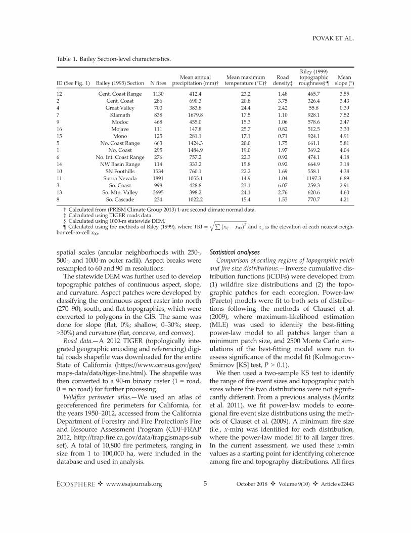
Table 1. Bailey Section-level characteristics.
ID (See Fig. 1) Bailey (1995) Section N firesMean annual
precipitation (mm)†Mean maximumtemperature (°C)†
Roaddensity‡
Riley (1999)topographicroughness§,¶
Meanslope (°)
12 Cent. Coast Range 1130 412.4 23.2 1.48 465.7 3.552 Cent. Coast 286 690.3 20.8 3.75 326.4 3.434 Great Valley 700 383.8 24.4 2.42 55.8 0.397 Klamath 838 1679.8 17.5 1.10 928.1 7.529 Modoc 468 455.0 15.3 1.06 578.6 2.4716 Mojave 111 147.8 25.7 0.82 512.5 3.3015 Mono 125 281.1 17.1 0.71 924.1 4.915 No. Coast Range 663 1424.3 20.0 1.75 661.1 5.811 No. Coast 295 1484.9 19.0 1.97 369.2 4.046 No. Int. Coast Range 276 757.2 22.3 0.92 474.1 4.1814 NW Basin Range 114 333.2 15.8 0.92 664.9 3.1810 SN Foothills 1534 760.1 22.2 1.69 558.1 4.3811 Sierra Nevada 1891 1055.1 14.9 1.04 1197.3 6.893 So. Coast 998 428.8 23.1 6.07 259.3 2.9113 So. Mtn. Valley 3695 398.2 24.1 2.76 620.6 4.608 So. Cascade 234 1022.2 15.4 1.53 770.7 4.21
† Calculated from (PRISM Climate Group 2013) 1-arc second climate normal data.‡ Calculated using TIGER roads data.§ Calculated using 1000-m statewide DEM.¶ Calculated using the methods of Riley (1999), where TRI ¼
ffiffiffiffiffiffiffiffiffiffiffiffiffiffiffiffiffiffiffiffiffiffiffiffiffiffiffiffiffiPxij � x00� �2q
and xij is the elevation of each nearest-neigh-bor cell-to-cell x00.
❖ www.esajournals.org 5 October 2018 ❖ Volume 9(10) ❖ Article e02443
POVAK ET AL.
and topographic patches were censored to includeonly patches within the range of patches abovethe x-min value for the ecoregion. We thensequentially clipped fires and topographic patchesfrom the right tail of their respective distributionsuntil a non-significant KS test (P > 0.05) was iden-tified. This was repeated for aspect, slope, and cur-vature topographic patch types.
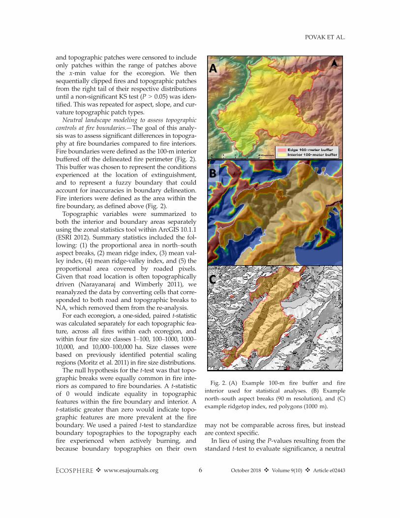
Neutral landscape modeling to assess topographiccontrols at fire boundaries.—The goal of this analy-sis was to assess significant differences in topogra-phy at fire boundaries compared to fire interiors.Fire boundaries were defined as the 100-m interiorbuffered off the delineated fire perimeter (Fig. 2).This buffer was chosen to represent the conditionsexperienced at the location of extinguishment,and to represent a fuzzy boundary that couldaccount for inaccuracies in boundary delineation.Fire interiors were defined as the area within thefire boundary, as defined above (Fig. 2).
Topographic variables were summarized toboth the interior and boundary areas separatelyusing the zonal statistics tool within ArcGIS 10.1.1(ESRI 2012). Summary statistics included the fol-lowing: (1) the proportional area in north–southaspect breaks, (2) mean ridge index, (3) mean val-ley index, (4) mean ridge-valley index, and (5) theproportional area covered by roaded pixels.Given that road location is often topographicallydriven (Narayanaraj and Wimberly 2011), wereanalyzed the data by converting cells that corre-sponded to both road and topographic breaks toNA, which removed them from the re-analysis.
For each ecoregion, a one-sided, paired t-statisticwas calculated separately for each topographic fea-ture, across all fires within each ecoregion, andwithin four fire size classes 1–100, 100–1000, 1000–10,000, and 10,000–100,000 ha. Size classes werebased on previously identified potential scalingregions (Moritz et al. 2011) in fire size distributions.
The null hypothesis for the t-test was that topo-graphic breaks were equally common in fire inte-riors as compared to fire boundaries. A t-statisticof 0 would indicate equality in topographicfeatures within the fire boundary and interior. At-statistic greater than zero would indicate topo-graphic features are more prevalent at the fireboundary. We used a paired t-test to standardizeboundary topographies to the topography eachfire experienced when actively burning, andbecause boundary topographies on their own
may not be comparable across fires, but insteadare context specific.In lieu of using the P-values resulting from the
standard t-test to evaluate significance, a neutral
Fig. 2. (A) Example 100-m fire buffer and fireinterior used for statistical analyses. (B) Examplenorth–south aspect breaks (90 m resolution), and (C)example ridgetop index, red polygons (1000 m).
❖ www.esajournals.org 6 October 2018 ❖ Volume 9(10) ❖ Article e02443
POVAK ET AL.
modeling approach was used to assess signifi-cant differences between boundary and interiortopographies for each topographic feature, ecore-gion, and fire size class combination. Neutralmodeling was favored over traditional t-testP-values due to the potential for spurious resultsrelated to the large differences in area covered byinterior versus boundary areas. The neutral mod-eling proceeded as follows: (1) A t-statistic wascalculated for observed fires for each topographicfeature, ecoregion, and fire size class combina-tion as described above (e.g., ridgetop topogra-phy for fires between 100 and 1000 ha within theSouthern Cascades), (2) each fire was then ran-domly moved within its membership ecoregion,(3) each topographic feature was summarized tothe boundary and interior regions, and (4) apaired t-statistic was calculated for each neutralmodel iteration. This process was repeated 500times. The observed t-statistic from Step 1 wasthen compared to the distribution of t-statisticsfrom the neutral model iterations from Step 4,and a P-value was calculated as the proportionof times a randomized t-statistic was greater thanor equal to the observed t-statistic. Significancewas assessed at P ≤ 0.05. Random fire place-ments was restricted such that fire polygonscould not intersect water bodies, rock, snow, ice,or other non-burnable surfaces.
All statistical analyses were conducted in the Rstatistical software (R Core Team 2018).
RESULTS
Power-law model fits to topographic patch sizesPower-law models provided good fits to the
topographic patch data, in all ecoregions but theNorth Coast (P = 0.09; Fig. 3). Power-law shapeparameters (aka, iCDF slope) varied between�0.72 and �1.07 (Fig. 3). Values <�1 (i.e., steepiCDF slopes) indicated that smaller patches weremost influential to the shape of the power law:values = �1 indicated equal influence of largerand smaller patches, and values >�1 (i.e., shal-low iCDF slopes) indicated that larger patcheswere somewhat more influential.
Comparisons between topographic and fire patchsize distributions
Correspondence between topographic and fireevent PSDs was found across all ecoregions, but
the spatial extent of these relationships varied byecoregion and by topographic feature (Fig. 4). Cor-respondence between fire event and aspect PSDswas identified for medium fire sizes in five of 16ecoregions, medium and large fires in nine of 16ecoregions, and large fires in two of 16 ecoregions(Fig. 4). Results for slope patches were similar toaspect, but fewer large fires corresponded withslope PSDs (Appendix S1: Fig. S1). Curvature PSDscorresponded least well with fire size distributions,correspondence was generally found for only smalland medium patch sizes, but correspondence washigh for the Central Valley, and Basin and Rangeecoregions (Appendix S1: Fig. S2). This resultedfrom the fact that curvature patches represented afiner scale dissection of topography as comparedto aspect and slope patches, which resulted infewer larger patches and steeper iCDF shapeparameters for curvature PSDs.
Neutral landscape modelingEvidence for topographic control on fire extin-
guishment was strongest for north–south aspectbreaks (Fig. 5), valley bottoms (Appendix S1:Fig. S4), ridges and valleys combined(Appendix S1: Fig. S7), and roads (Appendix S1:Fig. S8). In general, ecoregions that exhibited thestrongest topographic control on fire extinguish-ment included the Sierra Nevada, Sierra NevadaFoothills, Klamath, North Coast, North CoastRange, Central Coast Range, and SouthernMountain Valley. Sierra Nevada and Klamathecoregions were the steepest, most rugged, andare among the most fire active of all Californiaecoregions (Table 1). The Southern MountainValley had the highest frequency of fires, andmoderately high ruggedness and steepness. TheNorthern Coast Range ecoregion was among thesteepest of ecoregions, but was only moderatelyrugged. The North Coast and Central Coast hadfairly low ruggedness and steepness (Table 1).Topographic control on fire spread was great-
est in the small (100–102 ha) and middle fire sizeranges (102–104 ha), but this was not the case forall ecoregions (Fig. 5; Appendix S1: Figs. S4–S8).In ecoregions where valley bottoms exhibited ahigh degree of spatial control on wildfire perime-ters, the highest control tended to occur in the102–103 ha fire event size class (e.g., CentralCoast, Central Valley, North Coast Range, North-ern Interior Coast Range, Central Coast Range,
❖ www.esajournals.org 7 October 2018 ❖ Volume 9(10) ❖ Article e02443
POVAK ET AL.
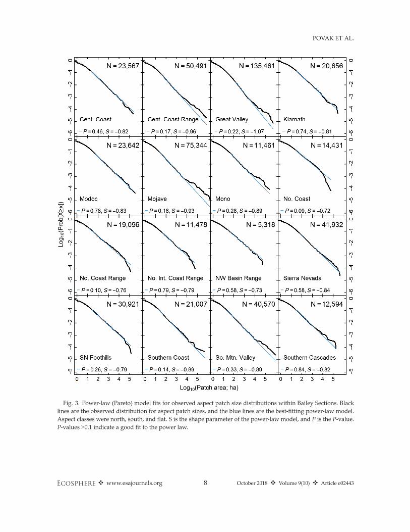
Fig. 3. Power-law (Pareto) model fits for observed aspect patch size distributions within Bailey Sections. Blacklines are the observed distribution for aspect patch sizes, and the blue lines are the best-fitting power-law model.Aspect classes were north, south, and flat. S is the shape parameter of the power-law model, and P is the P-value.P-values >0.1 indicate a good fit to the power law.
❖ www.esajournals.org 8 October 2018 ❖ Volume 9(10) ❖ Article e02443
POVAK ET AL.
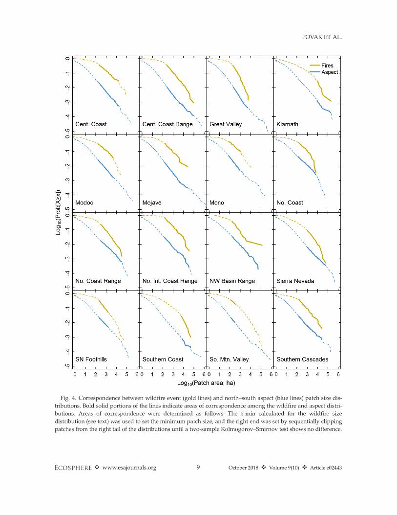
Fig. 4. Correspondence between wildfire event (gold lines) and north–south aspect (blue lines) patch size dis-tributions. Bold solid portions of the lines indicate areas of correspondence among the wildfire and aspect distri-butions. Areas of correspondence were determined as follows: The x-min calculated for the wildfire sizedistribution (see text) was used to set the minimum patch size, and the right end was set by sequentially clippingpatches from the right tail of the distributions until a two-sample Kolmogorov–Smirnov test shows no difference.
❖ www.esajournals.org 9 October 2018 ❖ Volume 9(10) ❖ Article e02443
POVAK ET AL.
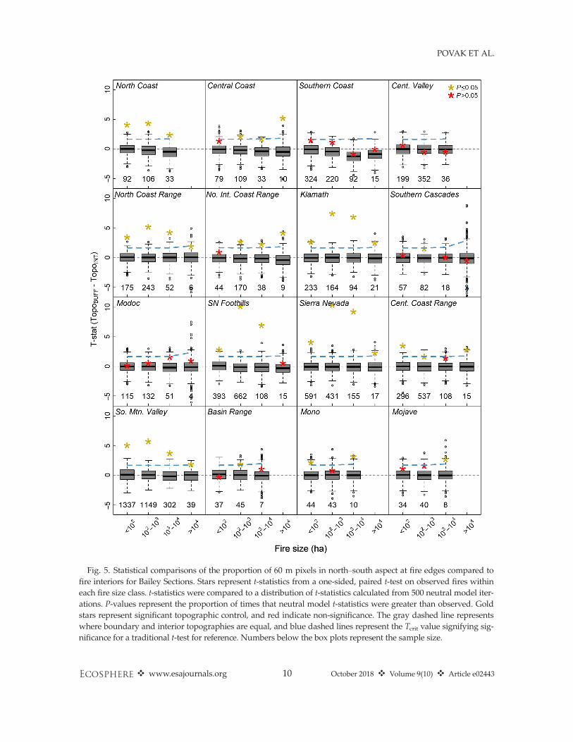
Fig. 5. Statistical comparisons of the proportion of 60 m pixels in north–south aspect at fire edges compared tofire interiors for Bailey Sections. Stars represent t-statistics from a one-sided, paired t-test on observed fires withineach fire size class. t-statistics were compared to a distribution of t-statistics calculated from 500 neutral model iter-ations. P-values represent the proportion of times that neutral model t-statistics were greater than observed. Goldstars represent significant topographic control, and red indicate non-significance. The gray dashed line representswhere boundary and interior topographies are equal, and blue dashed lines represent the Tcrit value signifying sig-nificance for a traditional t-test for reference. Numbers below the box plots represent the sample size.
❖ www.esajournals.org 10 October 2018 ❖ Volume 9(10) ❖ Article e02443
POVAK ET AL.
Klamath, and Sierra Nevada Foothills). North–south aspect breaks were more influential to theextinguishment of small- to medium-sized fires.Topography exhibited the least control on largefires across all ecoregions and for all topographicfeatures (Fig. 5; Appendix S1: Figs. S4–S8).
Consistent with what we expected, ridgetopsexhibited little control on fire extinguishment(Appendix S1: Fig. S6). Ridgetop environmentsare those where the compression of wind flow isoften the greatest, regardless of initial velocities.Removing the influence of roads on the ridgetopassessment did not influence this result. However,when ridges and valleys were combined, evidencefor topographic control increased for most ecore-gions, largely influenced by inclusion of valleybottom environments (Appendix S1: Fig. S7).
Roads had the most consistent association withfire boundaries across all ecoregions and for mostfire size classes (Appendix S1: Fig. S8). Control onfire extinguishment by roads was generally stron-gest for 102–104 ha fire sizes. Removing roadedpixels from the topographic features generally ledto slightly higher significance for valley bottoms(Appendix S1: Fig. S5) and slightly lower signifi-cance for north–south aspect breaks (Appendix S1:Fig. S3); however, trends were similar between theanalyses with and without roaded pixels.
The level of overlap among roads and topo-graphic features varied across ecoregion. Roadsintersected with aspect breaks disproportionatelyin coastal and coastal range ecoregions and inother densely populated regions such as theGreat Valley (Appendix S1: Fig. S9). In general,roads did not intersect with valleys and ridge-tops, but where there was disproportionate inter-section, it was more pronounced on mid-slopes(e.g., lower valley bottom and ridgetop scores;Appendix S1: Fig. S9); that is, most roads werenot located in valley bottom or ridgetop patches.
DISCUSSION
Several studies have either identified oralluded to a role for topography in shaping firepatterns across the western United States, forboth historical (Taylor and Skinner 1998, Beatyand Taylor 2001, Heyerdahl et al. 2001, Iniguezet al. 2008, Kellogg et al. 2008, Flatley et al. 2011,Krawchuk et al. 2016) and contemporary wild-fires (Rollins et al. 2002, Narayanaraj and
Wimberly 2011, Parks et al. 2012, Holsinger et al.2016). Our contribution to this literature was asfollows: (1) to analyze a large number of fires(>10,000 perimeters), across a relatively long timeperiod (1950–2012), including mixed landownerships, over broad environmental gradi-ents, (2) to take a multi-scaled approach to con-trasting topographic controls across fire sizes,and (3) to compare the influence of several differ-ent topographic features on fire growth andextinguishment.We found direct empirical support for topo-
graphic controls on wildfire extinguishmentacross California, and the strength of control var-ied by ecoregion, topographic feature, and firesize. Topography exerted the greatest control inmountainous regions, and as expected, controlswere strongest for small- to medium-sized fires,and weakest for large events.Wildfire systems are complex and adaptive,
composed of many interacting components, thatwhen combined, promote non-linear responsesto inputs, feedback between the system and theenvironment, establishment of lagged systemmemories, where past disturbances influencefuture behavior, and emergent behavior. Suchsystems are intrinsically difficult to study giventhese properties, and past efforts have relied oncomparisons of natural systems with computersimulations (Malamud et al. 1998, 2005, Moritzet al. 2005). Within the SOC literature, cellularautomata models with simple guiding principleswere found to produce fire size distributionssimilar to those of natural fire regimes, and fromthese, authors ascribed mechanistic properties tonatural systems. Specifically, authors comparedslope parameters from power-law distributionsobserved across a wide range of simulations andglobal fire regimes to conclude a universal mech-anism (i.e., SOC) for scale-invariant patterns.Such patterns resulted only from factors endoge-nous to the system (i.e., spatial patterns of fueland ignitions) and required no fine-tuning ofparameters. Under SOC, processes that governedmodel behavior at fine scales also operated atlarge scales, thus leading to scale-invariantpower-law behavior. The simplicity of the SOCmodel has carried over into other natural andsocial systems (Turcotte 1989, 1999, Bak 2013).Previous studies have called into question the
claim of scale invariance across fire size
❖ www.esajournals.org 11 October 2018 ❖ Volume 9(10) ❖ Article e02443
POVAK ET AL.
distributions (Ricotta et al. 2001, Boer et al. 2008,Moritz et al. 2011, O’Donnell et al. 2014), suggest-ing process domains may exist where dominantcontrols vary by event size. We first sought toidentify common scaling regions among wildfireevent and topographic PSDs to provide indirectevidence of a role for topography as a bottom-updriver of fire regimes across the state. The surpris-ing similarity in the distributions across severalorders of magnitude suggested that topographymay be a main contributing factor to observedscaling behavior in wildfire distributions (Moritzet al. 2011). Accordingly, topographic PSDs them-selves exhibited power-law behavior across manyorders of magnitude. Boer et al. (2008) found simi-lar scaling behavior between fire event sizes andthe magnitude of weather events during burnperiods in Australian forests. The authors sug-gested that a variety of factors acted upon firespread and that their relative effects and interac-tions varied across scales. They concluded thatexogenous forcings may be most influential forlarger fires where scale invariance is expressed,which represented the majority of area burned.Our analyses focused on topographic effects, yetwe found results similar to Boer et al. (2008), butfor a bottom-up rather than top-down forcing fac-tor. While bottom-up factors in wildfire systemsare generally thought to contribute to local-scaleheterogeneity in fire patterns, our findings suggestthey may play a more prominent role, even at lar-ger spatial scales (Figs. 3, 4). These findings sug-gest that interactions among terrestrial andmeteorological systems may jointly influencewildfire spread across a middle-numbers scalingregion. Both studies indicate that fuel patternsalone cannot describe observed scale invariance infire size distributions, as previously suggested(Malamud et al. 1998, Ricotta et al. 2001, Moritzet al. 2005). Alternative mechanisms that incorpo-rate bottom-up and top-down factors should befurther investigated (McKenzie and Kennedy2012).
We next looked for statistical evidence forbottom-up controls on fire spread and extinguish-ment to directly test the proposition of scale-dependent topographic controls, similar toprevious studies (Narayanaraj and Wimberly2011, Holsinger et al. 2016). We found that wherecontrol was exerted, the strength of control wasdependent upon fire size, with greatest controls on
small to medium fire sizes (Fig. 5; Appendix S1:Figs. S3–S8). The lack of control for the largest firesmatched the prevailing understanding of wildfiresystems. Large fires are generally driven exoge-nously by extreme weather events, endogenouslyby large-scale fuel continuity (i.e., contagion), orby both (Keane et al. 2002, Westerling et al. 2006,Flatley et al. 2011, Stephens et al. 2014, Jolly et al.2015). Regardless of the mechanism, large fires areexamples of a breakdown in pattern–process link-ages, where the dominance of spatial controlsshifts to a smaller number of driving factors. Fea-tures, such as topography, fuel reduction treat-ments, and past fires, appear to be less effective atcontrolling large fires burning under extreme fireweather conditions (Parisien et al. 2011, Stephenset al. 2014). Small fires generally occur undermoderate-fire weather conditions, where firespread is inhibited and/or initial attack is success-ful. Topography was shown to exert control onthese fires in some circumstances, but not others.Spatial controls can be somewhat random anddependent upon the proximity of ignitions to vari-ous impediments to fire spread. However, interac-tions among other landscape components aregenerally not exhibited for small fires. Medium-sized fires (102–104 ha) are generally associatedwith scaling behavior in California ecosystems(Moritz et al. 2011). These fires generally burn forseveral days and experience a range of biophysicalconditions, given their size. At this scale, interac-tions among weather, the biophysical environ-ment, past disturbances (fuel succession), andtheir interactions contribute to fire patterns. Ourresults suggest a role for topography in mediatingfine- and mesoscale wildfires. In some ecoregions,including the Sierra Nevada, Sierra Nevada Foot-hills, Klamath, Central Coast, and Coast Rangessections, topographic control was strongest forthese fires, depending on the topographic feature.The strength of topographic constraints on fire
spread may be dependent on top-down factorstoo, such as climatic gradients, which can influ-ence tree growth and wood decomposition, avail-ability of fuels to promote fire growth, andlongevity of previous burns to inhibit fire spread(Parisien and Moritz 2009); that is, exogenoustop-down forcing likely mediates the overall con-tribution of bottom-up factors on shaping firepatterns. By partitioning the State of Californiainto ecoregions, we directly compared the effect
❖ www.esajournals.org 12 October 2018 ❖ Volume 9(10) ❖ Article e02443
POVAK ET AL.
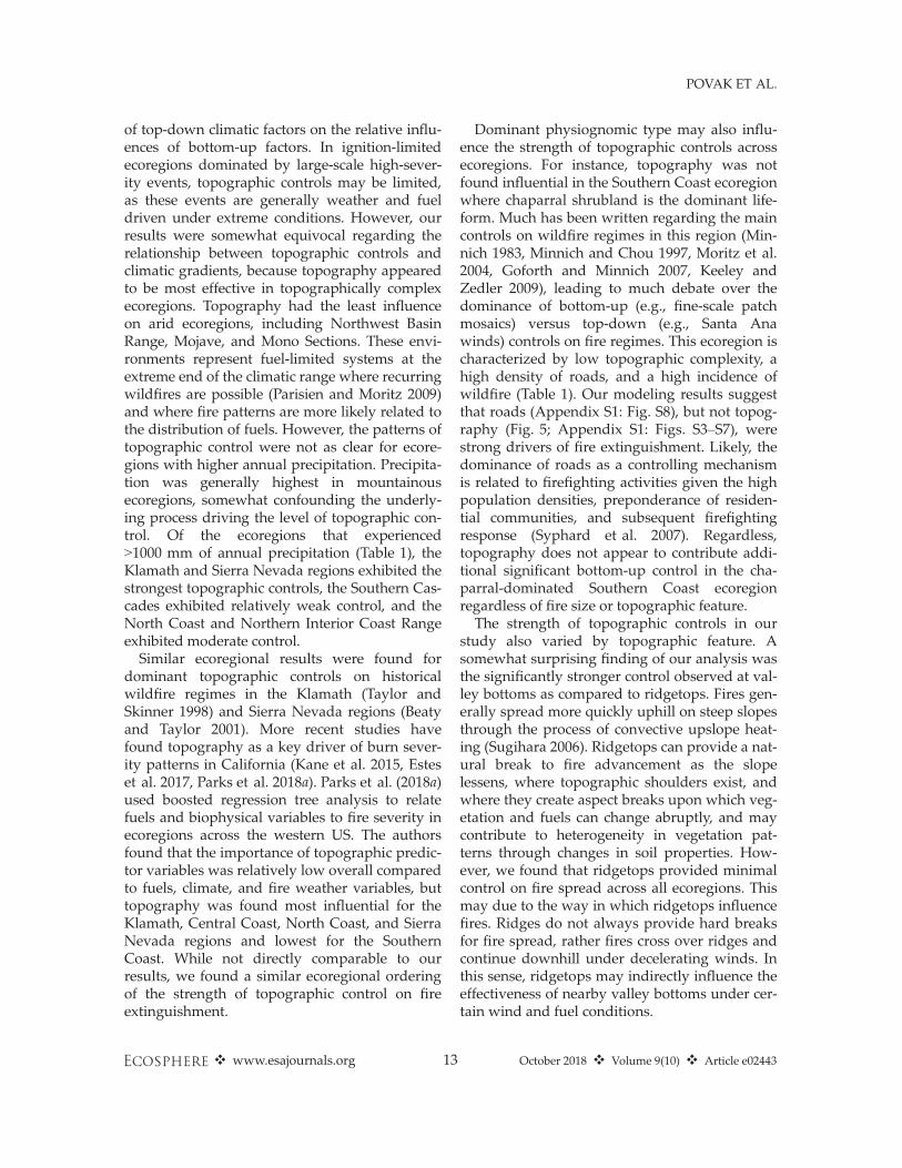
of top-down climatic factors on the relative influ-ences of bottom-up factors. In ignition-limitedecoregions dominated by large-scale high-sever-ity events, topographic controls may be limited,as these events are generally weather and fueldriven under extreme conditions. However, ourresults were somewhat equivocal regarding therelationship between topographic controls andclimatic gradients, because topography appearedto be most effective in topographically complexecoregions. Topography had the least influenceon arid ecoregions, including Northwest BasinRange, Mojave, and Mono Sections. These envi-ronments represent fuel-limited systems at theextreme end of the climatic range where recurringwildfires are possible (Parisien and Moritz 2009)and where fire patterns are more likely related tothe distribution of fuels. However, the patterns oftopographic control were not as clear for ecore-gions with higher annual precipitation. Precipita-tion was generally highest in mountainousecoregions, somewhat confounding the underly-ing process driving the level of topographic con-trol. Of the ecoregions that experienced>1000 mm of annual precipitation (Table 1), theKlamath and Sierra Nevada regions exhibited thestrongest topographic controls, the Southern Cas-cades exhibited relatively weak control, and theNorth Coast and Northern Interior Coast Rangeexhibited moderate control.
Similar ecoregional results were found fordominant topographic controls on historicalwildfire regimes in the Klamath (Taylor andSkinner 1998) and Sierra Nevada regions (Beatyand Taylor 2001). More recent studies havefound topography as a key driver of burn sever-ity patterns in California (Kane et al. 2015, Esteset al. 2017, Parks et al. 2018a). Parks et al. (2018a)used boosted regression tree analysis to relatefuels and biophysical variables to fire severity inecoregions across the western US. The authorsfound that the importance of topographic predic-tor variables was relatively low overall comparedto fuels, climate, and fire weather variables, buttopography was found most influential for theKlamath, Central Coast, North Coast, and SierraNevada regions and lowest for the SouthernCoast. While not directly comparable to ourresults, we found a similar ecoregional orderingof the strength of topographic control on fireextinguishment.
Dominant physiognomic type may also influ-ence the strength of topographic controls acrossecoregions. For instance, topography was notfound influential in the Southern Coast ecoregionwhere chaparral shrubland is the dominant life-form. Much has been written regarding the maincontrols on wildfire regimes in this region (Min-nich 1983, Minnich and Chou 1997, Moritz et al.2004, Goforth and Minnich 2007, Keeley andZedler 2009), leading to much debate over thedominance of bottom-up (e.g., fine-scale patchmosaics) versus top-down (e.g., Santa Anawinds) controls on fire regimes. This ecoregion ischaracterized by low topographic complexity, ahigh density of roads, and a high incidence ofwildfire (Table 1). Our modeling results suggestthat roads (Appendix S1: Fig. S8), but not topog-raphy (Fig. 5; Appendix S1: Figs. S3–S7), werestrong drivers of fire extinguishment. Likely, thedominance of roads as a controlling mechanismis related to firefighting activities given the highpopulation densities, preponderance of residen-tial communities, and subsequent firefightingresponse (Syphard et al. 2007). Regardless,topography does not appear to contribute addi-tional significant bottom-up control in the cha-parral-dominated Southern Coast ecoregionregardless of fire size or topographic feature.The strength of topographic controls in our
study also varied by topographic feature. Asomewhat surprising finding of our analysis wasthe significantly stronger control observed at val-ley bottoms as compared to ridgetops. Fires gen-erally spread more quickly uphill on steep slopesthrough the process of convective upslope heat-ing (Sugihara 2006). Ridgetops can provide a nat-ural break to fire advancement as the slopelessens, where topographic shoulders exist, andwhere they create aspect breaks upon which veg-etation and fuels can change abruptly, and maycontribute to heterogeneity in vegetation pat-terns through changes in soil properties. How-ever, we found that ridgetops provided minimalcontrol on fire spread across all ecoregions. Thismay due to the way in which ridgetops influencefires. Ridges do not always provide hard breaksfor fire spread, rather fires cross over ridges andcontinue downhill under decelerating winds. Inthis sense, ridgetops may indirectly influence theeffectiveness of nearby valley bottoms under cer-tain wind and fuel conditions.
❖ www.esajournals.org 13 October 2018 ❖ Volume 9(10) ❖ Article e02443
POVAK ET AL.
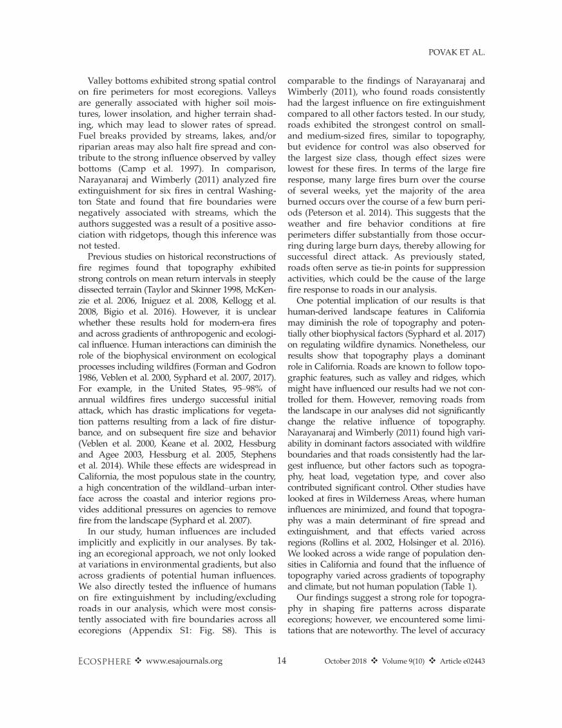
Valley bottoms exhibited strong spatial controlon fire perimeters for most ecoregions. Valleysare generally associated with higher soil mois-tures, lower insolation, and higher terrain shad-ing, which may lead to slower rates of spread.Fuel breaks provided by streams, lakes, and/orriparian areas may also halt fire spread and con-tribute to the strong influence observed by valleybottoms (Camp et al. 1997). In comparison,Narayanaraj and Wimberly (2011) analyzed fireextinguishment for six fires in central Washing-ton State and found that fire boundaries werenegatively associated with streams, which theauthors suggested was a result of a positive asso-ciation with ridgetops, though this inference wasnot tested.
Previous studies on historical reconstructions offire regimes found that topography exhibitedstrong controls on mean return intervals in steeplydissected terrain (Taylor and Skinner 1998, McKen-zie et al. 2006, Iniguez et al. 2008, Kellogg et al.2008, Bigio et al. 2016). However, it is unclearwhether these results hold for modern-era firesand across gradients of anthropogenic and ecologi-cal influence. Human interactions can diminish therole of the biophysical environment on ecologicalprocesses including wildfires (Forman and Godron1986, Veblen et al. 2000, Syphard et al. 2007, 2017).For example, in the United States, 95–98% ofannual wildfires fires undergo successful initialattack, which has drastic implications for vegeta-tion patterns resulting from a lack of fire distur-bance, and on subsequent fire size and behavior(Veblen et al. 2000, Keane et al. 2002, Hessburgand Agee 2003, Hessburg et al. 2005, Stephenset al. 2014). While these effects are widespread inCalifornia, the most populous state in the country,a high concentration of the wildland–urban inter-face across the coastal and interior regions pro-vides additional pressures on agencies to removefire from the landscape (Syphard et al. 2007).
In our study, human influences are includedimplicitly and explicitly in our analyses. By tak-ing an ecoregional approach, we not only lookedat variations in environmental gradients, but alsoacross gradients of potential human influences.We also directly tested the influence of humanson fire extinguishment by including/excludingroads in our analysis, which were most consis-tently associated with fire boundaries across allecoregions (Appendix S1: Fig. S8). This is
comparable to the findings of Narayanaraj andWimberly (2011), who found roads consistentlyhad the largest influence on fire extinguishmentcompared to all other factors tested. In our study,roads exhibited the strongest control on small-and medium-sized fires, similar to topography,but evidence for control was also observed forthe largest size class, though effect sizes werelowest for these fires. In terms of the large fireresponse, many large fires burn over the courseof several weeks, yet the majority of the areaburned occurs over the course of a few burn peri-ods (Peterson et al. 2014). This suggests that theweather and fire behavior conditions at fireperimeters differ substantially from those occur-ring during large burn days, thereby allowing forsuccessful direct attack. As previously stated,roads often serve as tie-in points for suppressionactivities, which could be the cause of the largefire response to roads in our analysis.One potential implication of our results is that
human-derived landscape features in Californiamay diminish the role of topography and poten-tially other biophysical factors (Syphard et al. 2017)on regulating wildfire dynamics. Nonetheless, ourresults show that topography plays a dominantrole in California. Roads are known to follow topo-graphic features, such as valley and ridges, whichmight have influenced our results had we not con-trolled for them. However, removing roads fromthe landscape in our analyses did not significantlychange the relative influence of topography.Narayanaraj and Wimberly (2011) found high vari-ability in dominant factors associated with wildfireboundaries and that roads consistently had the lar-gest influence, but other factors such as topogra-phy, heat load, vegetation type, and cover alsocontributed significant control. Other studies havelooked at fires in Wilderness Areas, where humaninfluences are minimized, and found that topogra-phy was a main determinant of fire spread andextinguishment, and that effects varied acrossregions (Rollins et al. 2002, Holsinger et al. 2016).We looked across a wide range of population den-sities in California and found that the influence oftopography varied across gradients of topographyand climate, but not human population (Table 1).Our findings suggest a strong role for topogra-
phy in shaping fire patterns across disparateecoregions; however, we encountered some limi-tations that are noteworthy. The level of accuracy
❖ www.esajournals.org 14 October 2018 ❖ Volume 9(10) ❖ Article e02443
POVAK ET AL.
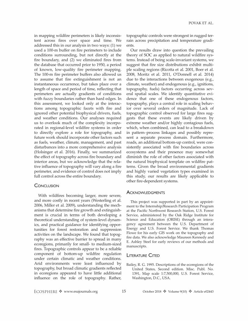
in mapping wildfire perimeters is likely inconsis-tent across fires over space and time. Weaddressed this in our analysis in two ways: (1) weused a 100-m buffer on fire perimeters to includeconditions surrounding, but not directly at thefire boundary, and (2) we eliminated fires fromthe database that occurred prior to 1950, a periodof known, low-quality fire perimeter mapping.The 100-m fire perimeter buffers also allowed usto assume that fire extinguishment is not aninstantaneous occurrence, but takes place over alength of space and period of time, reflecting thatperimeters are actually gradients of conditionswith fuzzy boundaries rather than hard edges. Inthis assessment, we looked only at the interac-tions among topographic facets with fire andignored other potential biophysical drivers, fuels,and weather conditions. Our analyses requiredus to overlook much of the complexity incorpo-rated in regional-level wildfire systems in orderto directly explore a role for topography, andfuture work should incorporate other factors suchas fuels, weather, climate, management, and pastdisturbances into a more comprehensive analysis(Holsinger et al. 2016). Finally, we summarizedthe effect of topography across fire boundary andinterior areas, but we acknowledge that the rela-tive influence of topography will vary along a fireperimeter, and evidence of control does not implyfull control across the entire boundary.
CONCLUSION
With wildfires becoming larger, more severe,and more costly in recent years (Westerling et al.2006, Miller et al. 2009), understanding the mech-anisms that determine fire growth and extinguish-ment is crucial in terms of both developing atheoretical understanding of system-level dynam-ics, and practical guidance for identifying oppor-tunities for forest restoration and suppressionactivities on the landscape. We found that topog-raphy was an effective barrier to spread in manyecoregions, primarily for small- to medium-sizedfires. Topographic controls appear to be a reliablecomponent of bottom-up wildfire regulationunder certain climatic and weather conditions.Arid environments were least influenced bytopography, but broad climatic gradients reflectedin ecoregions appeared to have little additionalinfluence on the role of topography. Rather,
topographic controls were strongest in rugged ter-rain across precipitation and temperature gradi-ents.Our results draw into question the prevailing
theory of SOC as applied to natural wildfire sys-tems. Instead of being scale-invariant systems, wesuggest that fire size distributions exhibit multi-ple scaling regions (Ricotta et al. 2001, Boer et al.2008, Moritz et al. 2011, O’Donnell et al. 2014)due to the interactions between exogenous (e.g.,climate, weather) and endogenous (e.g., ignitions,topography, fuels) factors occurring across sev-eral spatial scales. We identify quantitative evi-dence that one of these endogenous factors,topography, plays a central role in scaling behav-ior over several orders of magnitude. Lack oftopographic control observed for large fires sug-gests that these events are likely driven byextreme weather and/or highly contagious fuels,which, when combined, can lead to a breakdownin pattern–process linkages and possibly repre-sent a separate process domain. Furthermore,roads, an additional bottom-up control, were con-sistently associated with fire boundaries acrossecosystems and their presence may somewhatdiminish the role of other factors associated withthe natural biophysical template on wildfire pat-terns. Given the broad environmental gradientsand highly varied vegetation types examined inthis study, our results are likely applicable toother fire-dependent systems.
ACKNOWLEDGMENTS
This project was supported in part by an appoint-ment to the Internship/Research Participation Programat the Pacific Northwest Research Station, U.S. ForestService, administered by the Oak Ridge Institute forScience and Education (ORISE) through an intera-gency agreement between the U.S. Department ofEnergy and U.S. Forest Service. We thank ThomasFlowe for his early GIS work on the topography andfire data. We also acknowledge Maureen Kennedy andE. Ashley Steel for early reviews of our methods andmanuscripts.
LITERATURE CITED
Bailey, R. G. 1995. Descriptions of the ecoregions of theUnited States, Second edition. Misc. Publ. No.1391, Map scale 1:7,500,000, U.S. Forest Service,Washington, D.C., USA.
❖ www.esajournals.org 15 October 2018 ❖ Volume 9(10) ❖ Article e02443
POVAK ET AL.

Bak, P. 2013. How nature works: the science of self-organized criticality. Springer Science & BusinessMedia, New York, New York, USA.
Beaty, R. M., and A. H. Taylor. 2001. Spatial and tem-poral variation of fire regimes in a mixed coniferforest landscape, Southern Cascades, California,USA. Journal of Biogeography 28:955–966.
Bigio, E. R., T. W. Swetnam, and C. H. Baisan. 2016.Local-scale and regional climate controls on histori-cal fire regimes in the San Juan Mountains, Color-ado. Forest Ecology and Management 360:311–322.
Boer, M. M., R. J. Sadler, R. A. Bradstock, A. M. Gill,and P. F. Grierson. 2008. Spatial scale invariance ofsouthern Australian forest fires mirrors the scalingbehaviour of fire-driving weather events. Land-scape Ecology 23:899–913.
Camp, A., C. Oliver, P. Hessburg, and R. Everett. 1997.Predicting late-successional fire refugia pre-datingEuropean settlement in the Wenatchee Mountains.Forest Ecology and Management 95:63–77.
CDF-FRAP (California Department of Forestry - FireResource and Assessment Program). 2012. Califor-nia statewide fire history 1906–2012.
Clauset, A., C. R. Shalizi, and M. E. J. Newman. 2009.Power-law distributions in empirical data. SIAMReview 51:661–703.
ESRI. 2012. ArcGIS Desktop 10.1.1. EnvironmentalSystems Research Institute, Redlands, California,USA.
Estes, B. L., E. E. Knapp, C. N. Skinner, J. D. Miller,and H. K. Preisler. 2017. Factors influencing fireseverity under moderate burning conditions in theKlamath Mountains, northern California, USA.Ecosphere 8:e01794.
Flatley, W. T., C. W. Lafon, and H. D. Grissino-Mayer.2011. Climatic and topographic controls on pat-terns of fire in the southern and central Appala-chian Mountains, USA. Landscape Ecology 26:195–209.
Forman, R. T. T., and M. Godron. 1986. Landscapeecology. John Wiley & Sons Inc, New York, NewYork, USA.
Fry, D. L., and S. L. Stephens. 2006. Influence ofhumans and climate on the fire history of a pon-derosa pine-mixed conifer forest in the southeast-ern Klamath Mountains, California. Forest Ecologyand Management 223:428–438.
Ful�e, P. Z., Covington W. Wallace, and Margaret M.Moore. 1997. Determining reference conditions forecosystem management of southwestern pon-derosa pine forests. Ecological Applications 7:895–908.
Goforth, B. R., and R. A. Minnich. 2007. Evidence,exaggeration, and error in historical accounts of
chaparral wildfires in California. Ecological Appli-cations 17:779–790.
H�eon, J., D. Arseneault, and M.-A. Parisien. 2014.Resistance of the boreal forest to high burn rates.Proceedings of the National Academy of Sciencesof the United States of America 111:13888–13893.
Hessburg, P. F., and J. K. Agee. 2003. An environmen-tal narrative of Inland Northwest United States for-ests, 1800–2000. Forest Ecology and Management178:23–59.
Hessburg, P. F., J. K. Agee, and J. F. Franklin. 2005. Dryforests and wildland fires of the inland NorthwestUSA: contrasting the landscape ecology of the pre-settlement and modern eras. Forest Ecology andManagement 211:117–139.
Heyerdahl, E. K., L. B. Brubaker, and J. K. Agee. 2001.Spatial controls of historical fire regimes: a multi-scale example from the Interior West, USA. Ecol-ogy 82:660–678.
Holsinger, L., S. A. Parks, and C. Miller. 2016. Weather,fuels, and topography impede wildland fire spreadin western US landscapes. Forest Ecology andManagement 380:59–69.
Iniguez, J. M., T. W. Swetnam, and S. R. Yool. 2008.Topography affected landscape fire history pat-terns in southern Arizona, USA. Forest Ecologyand Management 256:295–303.
Jolly, W. M., M. A. Cochrane, P. H. Freeborn, Z. A. Hol-den, T. J. Brown, G. J. Williamson, and D. M. J. S.Bowman. 2015. Climate-induced variations in glo-bal wildfire danger from 1979 to 2013. NatureCommunications 6:7537.
Kane, V. R., J. A. Lutz, C. A. Cansler, N. A. Povak, D. J.Churchill, D. F. Smith, J. T. Kane, and M. P. North.2015. Water balance and topography predict fireand forest structure patterns. Forest Ecology andManagement 338:1–13.
Keane, R., K. Ryan, T. Veblen, C. Allen, J. Logan, andB. Hawkes. 2002. Cascading effects of fire exclusionin Rocky Mountain ecosystems: a literature review.Gen. Tech. Rep. RMRS-GTR-91. USDA ForestService, Rocky Mountain Research Station, FortCollins, Colorado, USA.
Keane, R. E., P. F. Hessburg, P. B. Landres, and F. J.Swanson. 2009. The use of historical range andvariability (HRV) in landscape management. ForestEcology and Management 258:1025–1037.
Keeley, J. E., and P. H. Zedler. 2009. Large, high-inten-sity fire events in southern California shrublands:debunking the fine-grain age patch model. Ecologi-cal Applications 19:69–94.
Kellogg, L.-K. B., D. McKenzie, D. L. Peterson, and A.E. Hessl. 2008. Spatial models for inferring topo-graphic controls on historical low-severity fire in
❖ www.esajournals.org 16 October 2018 ❖ Volume 9(10) ❖ Article e02443
POVAK ET AL.
the eastern Cascade Range of Washington, USA.Landscape Ecology 23:227–240.
Krawchuk, M. A., S. L. Haire, J. Coop, M.-A. Parisien,E. Whitman, G. Chong, and C. Miller. 2016. Topo-graphic and fire weather controls of fire refugia inforested ecosystems of northwestern North Amer-ica. Ecosphere 7:e01632.
Landres, P. B., P. Morgan, and F. J. Swanson. 1999.Overview of the use of natural variability conceptsin managing ecological systems. Ecological Appli-cations 9:1179–1188.
Malamud, B. D., J. D. A. Millington, and G. L. W.Perry. 2005. Characterizing wildfire regimes in theUnited States. Proceedings of the National Acad-emy of Sciences 102:4694–4699.
Malamud, B. D., G. Morein, and D. L. Turcotte. 1998.Forest fires: an example of self-organized criticalbehavior. Science 281:1840–1842.
McKenzie, D., A. E. Hessl, and L.-K. B. Kellogg. 2006.Using neutral models to identify constraints onlow-severity fire regimes. Landscape Ecology21:139–152.
McKenzie, D., and M. C. Kennedy. 2012. Power lawsreveal phase transitions in landscape controls offire regimes. Nature Communications 3:726.
Miller, J. D., H. D. Safford, M. Crimmins, and A. E.Thode. 2009. Quantitative evidence for increasingforest fire severity in the Sierra Nevada and South-ern Cascade Mountains, California and Nevada,USA. Ecosystems 12:16–32.
Minnich, R. A. 1983. Fire Mosaics in Southern Califor-nia and Northern Baja California. Science219:1287–1294.
Minnich, R. A., and Y.-H. Chou. 1997. Wildland firepatch dynamics in the chaparral of southern Cali-fornia and northern Baja California. InternationalJournal of Wildland Fire 7:221–248.
Moritz, M. A., P. F. Hessburg, and N. A. Povak. 2011.Native fire regimes and landscape resilience. Pages51–86 in The landscape ecology of fire. Springer,Dordrecht, The Netherlands.
Moritz, M. A., J. E. Keeley, E. A. Johnson, and A. A.Schaffner. 2004. Testing a basic assumption ofshrubland fire management: How important is fuelage? Frontiers in Ecology and the Environment2:67–72.
Moritz, M. A., M. E. Morais, L. A. Summerell, J. M.Carlson, and J. Doyle. 2005. Wildfires, complexity,and highly optimized tolerance. Proceedings of theNational Academy of Sciences of the United Statesof America 102:17912–17917.
Narayanaraj, G., and M. C. Wimberly. 2011. Influencesof forest roads on the spatial pattern of wildfireboundaries. International Journal of Wildland Fire20:792–803.
Nonaka, E., and T. A. Spies. 2005. Historical range ofvariability in landscape structure: a simulationstudy in Oregon, USA. Ecological Applications15:1727–1746.
O’Donnell, A. J., M. M. Boer, W. L. McCaw, and P. F.Grierson. 2014. Scale-dependent thresholds in thedominant controls of wildfire size in semi-aridsouthwest Australia. Ecosphere 5:1–13.
Parisien, M.-A., and M. A. Moritz. 2009. Environmentalcontrols on the distribution of wildfire at multiplespatial scales. Ecological Monographs 79:127–154.
Parisien, M.-A., S. A. Parks, M. A. Krawchuk, M. D.Flannigan, L. M. Bowman, and M. A. Moritz. 2011.Scale-dependent controls on the area burned in theboreal forest of Canada, 1980—2005. EcologicalApplications 21:789–805.
Parks, S. A., L. M. Holsinger, C. Miller, and C. R. Nel-son. 2015. Wildland fire as a self-regulating mecha-nism: the role of previous burns and weather inlimiting fire progression. Ecological Applications25:1478–1492.
Parks, S. A., L. M. Holsinger, M. H. Panunto, W. M.Jolly, S. Z. Dobrowski, and G. K. Dillon. 2018a.High-severity fire: evaluating its key drivers andmapping its probability across western US forests.Environmental Research Letters 13:044037.
Parks, S. A., M.-A. Parisien, and C. Miller. 2012. Spatialbottom-up controls on fire likelihood vary acrosswestern North America. Ecosphere 3:1–20.
Parks, S. A., M.-A. Parisien, C. Miller, L. M. Holsinger,and L. S. Baggett. 2018b. Fine-scale spatial climatevariation and drought mediate the likelihood ofreburning. Ecological Applications 28:573–586.
Perry, D. A., P. F. Hessburg, C. N. Skinner, T. A. Spies,S. L. Stephens, A. H. Taylor, J. F. Franklin, B.McComb, and G. Riegel. 2011. The ecology ofmixed severity fire regimes in Washington, Ore-gon, and Northern California. Forest Ecology andManagement 262:703–717.
Peterson, G. D. 2002. Contagious disturbance, ecologi-cal memory, and the emergence of landscape pat-tern. Ecosystems 5:329–338.
Peterson, D. A., E. J. Hyer, J. R. Campbell, M. D.Fromm, J. W. Hair, C. F. Butler, and M. A. Fenn.2014. The 2013 Rim Fire: implications for predict-ing extreme fire spread, pyroconvection, andsmoke emissions. Bulletin of the American Meteo-rological Society 96:229–247.
Prichard, S. J., C. S. Stevens-Rumann, and P. F. Hess-burg. 2017. Tamm Review: shifting global fireregimes: lessons from reburns and research needs.Forest Ecology and Management 396:217–233.
PRISM Climate Group. 2013. PRISM Climate Data.Oregon State University. http://prism.oregonstate.edu, Created 10 July 2012.
❖ www.esajournals.org 17 October 2018 ❖ Volume 9(10) ❖ Article e02443
POVAK ET AL.
R Core Team. 2018. R: A language and environmentfor statistical computing. R Foundation for Statisti-cal Computing, Vienna, Austria.
Ricotta, C., et al. 2001. Self-organized criticality ofwildfires ecologically revisited. Ecological Model-ling 141:307–311.
Riley, S. J. 1999. Index that quantifies topographicheterogeneity. Intermountain Journal of sciences5:23–27.
Rollins, M. G., P. Morgan, and T. Swetnam. 2002.Landscape-scale controls over 20th century fireoccurrence in two large Rocky Mountain (USA)wilderness areas. Landscape Ecology 17:539–557.
Stephens, S. L. 2005. Forest fire causes and extent onUnited States Forest Service lands. InternationalJournal of Wildland Fire 14:213–222.
Stephens, S. L., and R. W. Lawrence. 2005. Federal for-est-fire policy in the United States. EcologicalApplications 15:532–542.
Stephens, S. L., et al. 2014. Temperate and borealforest mega-fires: characteristics and challenges.Frontiers in Ecology and the Environment 12:115–122.
Sugihara, N. G. 2006. Fire in California’s ecosystems.University of California Press, Berkeley, California,USA.
Syphard, A. D., J. E. Keeley, A. H. Pfaff, and K. Fer-schweiler. 2017. Human presence diminishes theimportance of climate in driving fire activity across
the United States. Proceedings of the NationalAcademy of Sciences 14:13750–13755.
Syphard, A. D., V. C. Radeloff, J. E. Keeley, T. J. Haw-baker, M. K. Clayton, S. I. Stewart, and R. B. Ham-mer. 2007. Human influence on California fireregimes. Ecological Applications 17:1388–1402.
Taylor, A. H., and C. N. Skinner. 1998. Fire history andlandscape dynamics in a late-successional reserve,Klamath Mountains, California, USA. Forest Ecol-ogy and Management 111:285–301.
Turcotte, D. L. 1989. Fractals in geology and geophysics.Pages 171–196 in D. L. Turcotte, editor. Fractals ingeophysics. Birkh€auser, Basel, Switzerland.
Turcotte, D. L. 1999. Self-organized criticality. Reportson Progress in Physics 62:1377.
Veblen, T. T. 2003. Historic range of variability ofmountain forest ecosystems: concepts and applica-tions. Forestry Chronicle 79:223–226.
Veblen, T. T., T. Kitzberger, and J. Donnegan. 2000. Cli-matic and human influences on fire regimes inponderosa pine forests in the Colorado FrontRange. Ecological Applications 10:1178–1195.
Westerling, A. L., H. G. Hidalgo, D. R. Cayan, and T.W. Swetnam. 2006. Warming and earlier springincrease Western U.S. Forest Wildfire Activity.Science 313:940–943.
Whiteman, C. D., S. Zhong, W. J. Shaw, J. M. Hubbe,X. Bian, and J. Mittelstadt. 2001. Cold pools in theColumbia basin. Weather and Forecasting 16:432–447.
SUPPORTING INFORMATION
Additional Supporting Information may be found online at: http://onlinelibrary.wiley.com/doi/10.1002/ecs2.2443/full
❖ www.esajournals.org 18 October 2018 ❖ Volume 9(10) ❖ Article e02443
POVAK ET AL.