Embed Size (px)
Citation preview

Completed Studies
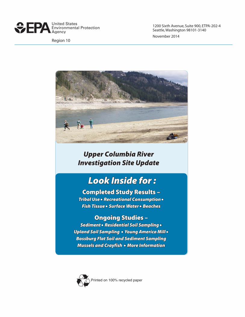
Upper Columbia River Investigation Site Update
Region 10 November 2014
The U.S. Environmental Protection Agency is studying pollution in the Upper Columbia River from the U.S./Canada border to the Grand Coulee Dam including Lake Roosevelt. The Trail smelter, which is owned by Teck and located on the Columbia River approximately 10 miles north of the U.S./Canada border, historically discharged millions of tons of metals-laden slag and liquid wastes into the Columbia River. Metal particulates were released from the smelter smoke stack.
The study includes human use surveys and fish, river sediment, beach sediment, river water, and soil studies to determine where and how much people, plants and animals may be exposed to pollution. These and other studies are all part of the Remedial Investigation/Feasibility Study. The RI/FS includes the human health and the ecological risk assessments. All of the studies are being funded by Teck.
Superfund risk assessments determine if pollution at a site is likely to cause harm to people or the environment. Human health risk assessments estimate how much pollution people are exposed to from the site and what the potential for harm (risk) may be.
The ecological risk assessment evaluates the likelihood that harmful environmental effects may occur from pollution. Together, the risk assessments determine the potential need for cleanup.
Under Superfund, risks to people must be very low, otherwise cleanup alternatives are considered which will reduce the risks. EPA has worked with the National Park Service to survey where, how often, and how long people swim, camp, wade in the water, play on the beach or eat fish. EPA has also worked with the Confederated Tribes of the Colville Indian Reservation (CCT) to survey residents and determine how they use the river, the land, and its resources for food and other purposes. The Spokane Tribe of Indians has provided EPA with information representing traditional tribal practices.
The EPA also sampled soil at residential properties between Northport and the Canadian border. These soils may have been polluted by the Trail smelter or the former LeRoi smelter in Northport, WA. Our goal is to understand whether metals are present at levels of concern and what cleanup, if any, may be necessary to make sure residents and visitors are protected from pollution.
Confederated Tribes of the Colville Reservation
Tribal Use Survey (2012)CCT and EPA designed a survey to learn how people on the Colville Reservation may be exposed to pollution through their use of plants, animals, soil, sediment, or water.
People were interviewed about subsistence or tribal cultural practices including hunting, fishing, gathering, and using other environmental resources from the Upper Columbia River site and surrounding area. Results of the survey will be used in the human health risk assessment.
Recreational Consumption and Resource Use Survey (2012)
The National Park Service in coordination with EPA, the State of Washington, the CCT, the Spokane Tribe of Indians, and Teck, collected information from visitors about their recreational use of the Upper Columbia River, as well as how much fish they ate.
The EPA will combine the survey results and other sampling data in a comprehensive human health risk assessment to estimate risks from eating fish or plants, or ingesting sediment on a beach.
2
Upper Columbia River Investigation Site Update
Completed Studies
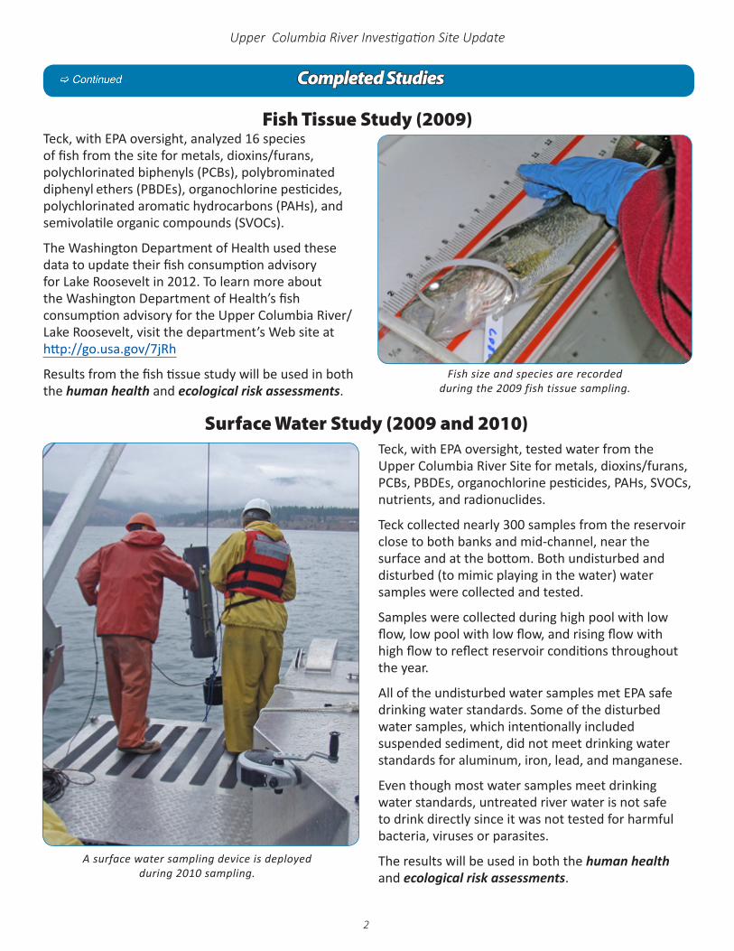
A surface water sampling device is deployed during 2010 sampling.
Teck, with EPA oversight, analyzed 16 species of fish from the site for metals, dioxins/furans, polychlorinated biphenyls (PCBs), polybrominated diphenyl ethers (PBDEs), organochlorine pesticides, polychlorinated aromatic hydrocarbons (PAHs), and semivolatile organic compounds (SVOCs).
The Washington Department of Health used these data to update their fish consumption advisory for Lake Roosevelt in 2012. To learn more about the Washington Department of Health’s fish consumption advisory for the Upper Columbia River/Lake Roosevelt, visit the department’s Web site athttp://go.usa.gov/7jRh
Results from the fish tissue study will be used in both the human health and ecological risk assessments.
Fish size and species are recorded during the 2009 fish tissue sampling.
Fish Tissue Study (2009)
Surface Water Study (2009 and 2010)Teck, with EPA oversight, tested water from the Upper Columbia River Site for metals, dioxins/furans, PCBs, PBDEs, organochlorine pesticides, PAHs, SVOCs, nutrients, and radionuclides.
Teck collected nearly 300 samples from the reservoir close to both banks and mid-channel, near the surface and at the bottom. Both undisturbed and disturbed (to mimic playing in the water) water samples were collected and tested.
Samples were collected during high pool with low flow, low pool with low flow, and rising flow with high flow to reflect reservoir conditions throughout the year.
All of the undisturbed water samples met EPA safe drinking water standards. Some of the disturbed water samples, which intentionally included suspended sediment, did not meet drinking water standards for aluminum, iron, lead, and manganese.
Even though most water samples meet drinking water standards, untreated river water is not safe to drink directly since it was not tested for harmful bacteria, viruses or parasites.
The results will be used in both the human health and ecological risk assessments.
3
Upper Columbia River Investigation Site Update
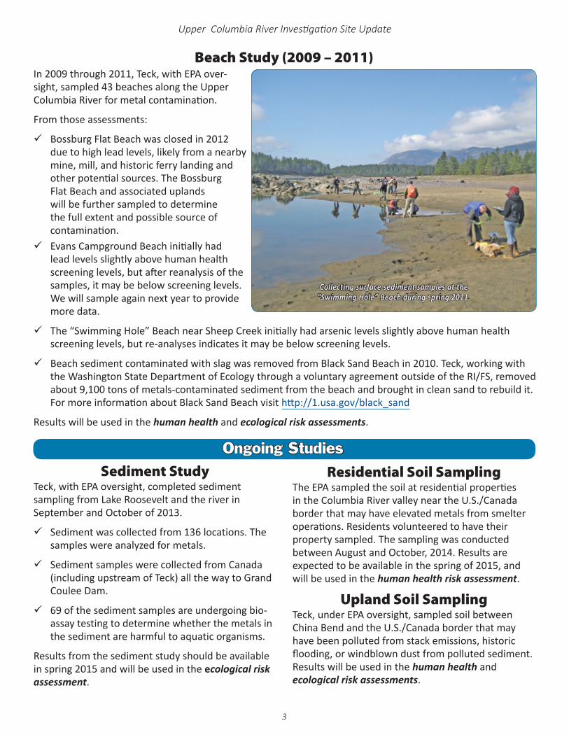
Collecting surface sediment samples at the “Swimming Hole” Beach during spring 2011.
In 2009 through 2011, Teck, with EPA over-sight, sampled 43 beaches along the Upper Columbia River for metal contamination.
From those assessments:
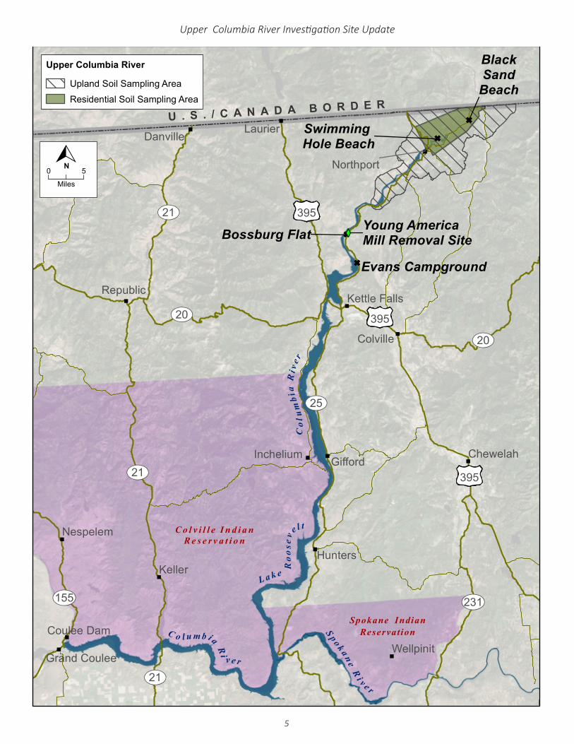
99 Bossburg Flat Beach was closed in 2012 due to high lead levels, likely from a nearby mine, mill, and historic ferry landing and other potential sources. The Bossburg Flat Beach and associated uplands will be further sampled to determine the full extent and possible source of contamination.99 Evans Campground Beach initially had
lead levels slightly above human health screening levels, but after reanalysis of the samples, it may be below screening levels. We will sample again next year to provide more data.
99 The “Swimming Hole” Beach near Sheep Creek initially had arsenic levels slightly above human health screening levels, but re-analyses indicates it may be below screening levels.
99 Beach sediment contaminated with slag was removed from Black Sand Beach in 2010. Teck, working with the Washington State Department of Ecology through a voluntary agreement outside of the RI/FS, removed about 9,100 tons of metals-contaminated sediment from the beach and brought in clean sand to rebuild it. For more information about Black Sand Beach visit http://1.usa.gov/black_sand
Results will be used in the human health and ecological risk assessments.
Beach Study (2009 – 2011)
Ongoing StudiesSediment Study
Teck, with EPA oversight, completed sediment sampling from Lake Roosevelt and the river in September and October of 2013.
9 Sediment was collected from 136 locations. The samples were analyzed for metals.
9 Sediment samples were collected from Canada (including upstream of Teck) all the way to Grand Coulee Dam.
9 69 of the sediment samples are undergoing bio-assay testing to determine whether the metals in the sediment are harmful to aquatic organisms.
Results from the sediment study should be available in spring 2015 and will be used in the ecological risk assessment.
Residential Soil SamplingThe EPA sampled the soil at residential properties in the Columbia River valley near the U.S./Canada border that may have elevated metals from smelter operations. Residents volunteered to have their property sampled. The sampling was conducted between August and October, 2014. Results are expected to be available in the spring of 2015, and will be used in the human health risk assessment.
Upland Soil Sampling Teck, under EPA oversight, sampled soil between China Bend and the U.S./Canada border that may have been polluted from stack emissions, historic flooding, or windblown dust from polluted sediment. Results will be used in the human health and ecological risk assessments.
R:\COLUMBIARIVER_401715\MAPDOCUMENTS\2013\COLUMBIARIVER_FACTMAP_14PT.MXD AYOST 10/24/2014 9:23:34 PM
GF
GF
GF
GF
"
"
"
"
"
"
"
"
"
"
"
"
"
"
"
"
"
"
"
"
"
"
"
"
XY
U . S . / C A N A D A B O R D E R
Col
um
bia
Ri v
e r
S p o k an eR
i v e r
C o l u m b i a
Ri
v e r
L a k e
Ro
ose
vel t
Evans Campground
BlackSand
Beach
Swimming Hole Beach
Bossburg Flat
C o l v i l l e I n d i a nR e s e r v a t i o n
Spokane IndianReservation
Chewelah
Colville
Coulee Dam
Danville
Gifford
Grand Coulee
HuntersKeller
Kettle Falls
Laurier
Nespelem
Northport
Republic
Wellpinit
Inchelium "
Young AmericaMill Removal Site
UV21
UV21
UV155
UV20
UV231
UV21
UV20
UV25
£395
£395
£395
Upper Columbia River
Upland Soil Sampling Area
Residential Soil Sampling Area
M
0 5
lesi
N
4
Upper Columbia River Investigation Site Update
Ongoing Studies
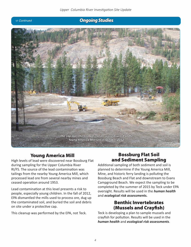
Young America Mill High levels of lead were discovered near Bossburg Flat during sampling for the Upper Columbia River RI/FS. The source of the lead contamination was tailings from the nearby Young America Mill, which processed lead ore from several nearby mines and ceased operation around 1953.
Lead contamination at this level presents a risk to people, especially young children. In the fall of 2012, EPA dismantled the mills used to process ore, dug up the contaminated soil, and buried the soil and debris on site under a protective cap.
This cleanup was performed by the EPA, not Teck.
The cap over the contamination is constructed at the Young America Mill site in October 2012.
Bossburg Flat Soil and Sediment Sampling
Additional sampling of both sediment and soil is planned to determine if the Young America Mill, Mine, and historic ferry landing is polluting the Bossburg Beach and Flat and downstream to Evans Campground Beach. We expect the sampling to be completed by the summer of 2015 by Teck under EPA oversight. Results will be used in the human health and ecological risk assessments.
Benthic Invertebrates (Mussels and Crayfish)
Teck is developing a plan to sample mussels and crayfish for pollution. Results will be used in the human health and ecological risk assessments.
R:\COLUMBIARIVER_401715\MAPDOCUMENTS\2013\COLUMBIARIVER_FACTMAP_14PT.MXD AYOST 10/24/2014 9:23:34 PM
GF
GF
GF
GF
"
"
"
"
"
"
"
"
"
"
"
"
"
"
"
"
"
"
"
"
"
"
"
"
XY
U . S . / C A N A D A B O R D E R
Col
um
bia
Ri v
e r
S p o k an eR
i v e r
C o l u m b i a
Ri
v e r
L a k e
Ro
ose
vel t
Evans Campground
BlackSand
Beach
Swimming Hole Beach
Bossburg Flat
C o l v i l l e I n d i a nR e s e r v a t i o n
Spokane IndianReservation
Chewelah
Colville
Coulee Dam
Danville
Gifford
Grand Coulee
HuntersKeller
Kettle Falls
Laurier
Nespelem
Northport
Republic
Wellpinit
Inchelium "
Young AmericaMill Removal Site
UV21
UV21
UV155
UV20
UV231
UV21
UV20
UV25
£395
£395
£395
Upper Columbia River
Upland Soil Sampling Area
Residential Soil Sampling Area
M
0 5
lesi
N
5
Upper Columbia River Investigation Site Update
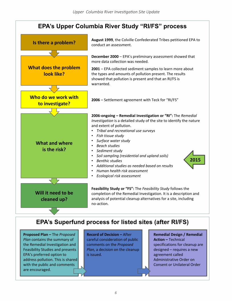
2006 – Settlement agreement with Teck for “RI/FS”
Feasibility Study or “FS”: The Feasibility Study follows the completion of the Remedial Investigation. It is a description and analysis of potential cleanup alternatives for a site, including no‐action.
2006‐ongoing – Remedial Investigation or “RI”: The Remedial Investigation is a detailed study of the site to identify the nature and extent of pollution.• Tribal and recreational use surveys• Fish tissue study• Surface water study• Beach studies• Sediment study• Soil sampling (residential and upland soils)• Benthic studies• Additional studies as needed based on results• Human health risk assessment• Ecological risk assessment
August 1999, the Colville Confederated Tribes petitioned EPA to conduct an assessment.
December 2000 – EPA’s preliminary assessment showed that more data collection was needed.
2001 – EPA collected sediment samples to learn more about the types and amounts of pollution present. The results showed that pollution is present and that an RI/FS is warranted.
EPA’s Upper Columbia River Study “RI/FS” process
EPA’s Superfund process for listed sites (after RI/FS)
Record of Decision – After careful consideration of public comments on the Proposed Plan, a decision on the cleanup is issued.
Remedial Design / Remedial Action – Technical specifications for cleanup are designed – requires a new agreement called Administrative Order on Consent or Unilateral Order
Will it need to be cleaned up?
What and where is the risk?
Who do we work withto investigate?
What does the problemlook like?
Is there a problem?
2015
Proposed Plan – The Proposed Plan contains the summary of the Remedial Investigation and Feasibility Studies and presents EPA’s preferred option to address pollution. This is shared with the public and comments are encouraged.
6
Upper Columbia River Investigation Site Update
7
Upper Columbia River Investigation Site Update
For More Information ¾ Official records and other documents from the Upper Columbia River study are located at the EPA Regional
Office in Seattle: ¾ EPA Region 10 Superfund Records Center
1200 Sixth Avenue, Suite 900, ECL-076, Seattle, WA 98101 ¾ Please call 1-800-424-4372, ext. 4494 or 206-553-4494 to make an appointment.
Information RepositoriesFor your convenience, information about this project is also available at seven locations throughout the project area. Each location has the same information, including full copies of draft and final technical documents, fact sheets, and other information about the site. Before you visit a location, please call ahead for business hours:
¾ Northport: Northport Town Hall, 315 Summit St., (509) 732-4450
¾ Colville: Colville Public Library, 195 S. Oak Street, (509) 684-6620
¾ Inchelium: Inchelium Tribal Resource Center, 12 Community Loop, (509) 634-2791
¾ Nespelem: Office of Environmental Trust, Bldg. #2, Colville Confederated Tribes, 1 Colville(509) 634-2413
¾ Grand Coulee: Grand Coulee Library, 225 Federal Street(509) 633-0972
¾ Wellpinit: Spokane Tribe Department of Natural Resources, 6290 B Ford-Wellpinit Road (509) 258-7709 ext. 13
¾ Spokane: Spokane Library, 906 W. Main(509) 444-5336
Technical documents and additional information about the study can be found online at http://yosemite.epa.gov/R10/cleanup.nsf/sites/upperc
¾ Citizens for a Clean Columbia: http://cleancolumbia.org
¾ Teck’s project site: www.ucr-rifs.com
¾ Lake Roosevelt Forum: www.lrf.org
To sign up for emails about the Upper Columbia River study, please contactKay Morrison, Community Involvement [email protected] or call 1-800-424-4372 ext. 8321 or 206-553-8321.
Following are other contacts for this project:
9 Laura Buelow, Upper Columbia River Project Manager [email protected] 376-5466 or 1-800-424-4372 ext. 65466.
9 Matt WilkeningUpper Columbia River Project Manager [email protected] 378-5760 or 1-800-424-4372 ext. 85760.
7 TDD or TTY users, please call 1-800-877-8339 and give the operator Kay Morrison’s phone number.
Contacts
Printed on 100% recycled paper
1200 Sixth Avenue, Suite 900, ETPA-202-4Seattle, Washington 98101-3140
November 2014Region 10
Upper Columbia River Investigation Site Update
Look Inside for :Completed Study Results –
Tribal Use • Recreational Consumption • Fish Tissue • Surface Water • Beaches
Ongoing Studies –Sediment • Residential Soil Sampling •
Upland Soil Sampling • Young America Mill •Bossburg Flat Soil and Sediment SamplingMussels and Crayfish • More Information