Embed Size (px)
Citation preview

VOLUNTARY REMEDIATION PROGRAM
FINAL COMPLIANCE STATUS REPORT
FORMER IMPERIAL CLEANERS 1233B ALPHARETTA HIGHWAY ROSWELL, FULTON COUNTY, GEORGIA HSI SITE NO. 10690 Prepared for Submission to:
Georgia Environmental Protection Division Hazardous Waste Management Branch Suite 1066, East Tower 2 Martin Luther King Jr. Drive Atlanta, Georgia 30334 Prepared by:
Amec Foster Wheeler Environment & Infrastructure, Inc. 2677 Buford Highway Atlanta, Georgia 30324 (404) 873-4761
November 12, 2015
Amec Foster Wheeler Project No. 6305-05-0319


Amec Foster Wheeler Environment & Infrastructure, Inc.
Project No. 6305-05-0319 Compliance Status Report, Former Imperial Cleaners, Roswell, Georgia i November 12, 2015
TABLE OF CONTENTS
1.0 INTRODUCTION ................................................................................................................................ 3
1.1 PROPERTY DESCRIPTION ................................................................................................................... 3 1.2 REGULATORY BACKGROUND .............................................................................................................. 4
1.2.1 Pre-HSI Listing ........................................................................................................................ 5 1.2.2 Post-HSI Listing ....................................................................................................................... 5 1.2.3 CAP Implementation ................................................................................................................ 6 1.2.4 VRP Implementation ................................................................................................................ 7 1.2.5 M&M Plan Implementation ...................................................................................................... 7
2.0 PURPOSE .......................................................................................................................................... 8
3.0 DESCRIPTION OF THE RELEASE SOURCE .................................................................................. 9
3.1 SOURCE OF RELEASE ................................................................................................................. 9 3.2 REGULATED SUBSTANCE RELEASED FROM THE SOURCE ................................................... 9 3.3 CHRONOLOGY OF THE RELEASE............................................................................................... 9 3.4 DESCRIPTION OF THE SOURCE ............................................................................................... 10
4.0 SITE SETTING ................................................................................................................................. 11
4.1 SITE SPECIFIC GEOLOGY .................................................................................................................. 11 4.2 SITE SPECIFIC HYDROGEOLOGY ....................................................................................................... 13
4.2.1 Hydraulic conductivity ............................................................................................................ 14 4.2.2 Vertical Hydraulic Gradient .................................................................................................... 15 4.2.3 Groundwater flow Direction ................................................................................................... 15
5.0 DELINEATION OF SOIL CONTAMINATION .................................................................................. 17
5.1 ANALYTICAL PARAMETERS AND RATIONALE FOR SELECTION ........................................... 17 5.2 SAMPLING AND ANALYSIS PROCEDURES .............................................................................. 17
5.2.1 Sampling Equipment and Collection Techniques .................................................................. 17 5.2.2 Soil Sample Handling and Preservation Techniques ............................................................ 17 5.2.3 Equipment Decontamination Procedures .............................................................................. 17 5.2.4 Chain-of-Custody Procedures ............................................................................................... 18 5.2.5 Laboratory Analytical Procedures .......................................................................................... 18
5.2.5.1 Standard Analytical Methods ............................................................................................. 18 5.2.5.2 Quality Assurance/Quality Control Procedures .................................................................. 18
5.3 BACKGROUND SOIL CONCENTRATIONS ................................................................................ 18 5.4 SUMMARY OF PERTINENT SOIL DATA ..................................................................................... 18
6.0 HORIZONTAL AND VERTICAL EXTENT OF GROUNDWATER CONTAMINATION ................... 24
6.1 ANALYTICAL PARAMETERS SELECTED .................................................................................. 24 6.2 GROUNDWATER MONITORING WELL LOCATIONS, AND INSTALLATION AND
CONSTRUCTION METHODS ................................................................................................................. 24 6.2.1 Type of Well Casing Material................................................................................................. 25 6.2.2 Description of Well Intake Design ......................................................................................... 25
6.2.2.1 Screen Slot Size and Length .............................................................................................. 25 6.2.2.2 Filter Pack Materials and Length ....................................................................................... 25 6.2.2.3 Method of Filter Pack Emplacement .................................................................................. 25 6.2.2.4 Surface Seal ...................................................................................................................... 26 6.2.2.5 Well Development Methods and Procedures .................................................................... 26
6.3 SAMPLING AND ANALYSIS PROCEDURES .............................................................................. 26 6.3.1 Groundwater Elevation .......................................................................................................... 27 6.3.2 Well Evacuation Procedures ................................................................................................. 27 6.3.3 Groundwater Sampling, Handling and Preservation ............................................................. 27 6.3.4 Decontamination Procedures ................................................................................................ 27 6.3.5 Laboratory Analytical Techniques .......................................................................................... 28
6.3.5.1 Analytical Procedures ........................................................................................................ 28

Amec Foster Wheeler Environment & Infrastructure, Inc.
Project No. 6305-05-0319 Compliance Status Report, Former Imperial Cleaners, Roswell, Georgia ii November 12, 2015
6.3.5.2 Quality Control Samples .................................................................................................... 28 6.3.5.3 Chain-of-Custody Procedures ............................................................................................ 28
6.4 BACKGROUND GROUNDWATER QUALITY .............................................................................. 28 6.5 SUMMARY OF GROUNDWATER TESTING RESULTS.............................................................. 28 6.6 SUMMARY OF SURFACE WATER TESTING RESULTS ............................................................ 33
7.0 SUMMARY OF REMEDIAL MEASURES COMPLETED TO DATE ............................................... 34
7.1 ENHANCED FLUID RECOVERY ................................................................................................. 34 7.2 FULTON COUNTY SOIL REMOVAL ...................................................................................................... 34
8.0 RISK REDUCTION STANDARDS ................................................................................................... 35
8.1 SOIL CRITERIA ............................................................................................................................ 35 8.2 GROUNDWATER CRITERIA ....................................................................................................... 36
9.0 EXPOSURE PATHWAYS ................................................................................................................ 38
9.1 SOIL CRITERIA ................................................................................................................................ 38 9.2 GROUNDWATER CRITERIA ............................................................................................................... 39 9.3 SOURCE.......................................................................................................................................... 41 9.4 SURFACE WATER ............................................................................................................................ 41 9.5 VAPOR INTRUSION .......................................................................................................................... 42
10.0 CONCLUSIONS ........................................................................................................................... 43
LIST OF APPENDICES
APPENDIX A - TAX PARCELS AND LEGAL DESCRIPTION APPENDIX B - FIGURES APPENDIX C - TABLES APPENDIX D - LABORATORY RESULTS (JUNE 2015 SAMPLING EVENT) APPENDIX E - BORING LOGS APPENDIX F - COMPUTER MODELING APPENDIX G - RISK REDUCTION STANDARDS APPENDIX H - DRAFT ENVIRONMENTAL COVENANT
LIST OF FIGURES
FIGURE 1 - SITE LOCATION MAP FIGURE 2 - SITE AND VICINITY AERIAL PHOTOGRAPH FIGURE 3 - VRP PROPERTY BOUNDARY SURVEY FIGURE 4 - PARCEL 2 PROPERTY BOUNDARY SURVEY FIGURE 5 - PARCEL 2 PHOTOGRAPHS FIGURE 6 - CROSS SECTION A-A’ FIGURE 7 - CROSS SECTION B-B’ FIGURE 8 - SOIL TESTING RESULTS AND DELINEATION
FIGURE 9 - CUMULATIVE GROUNDWATER TESTING RESULTS AND DELINEATION FIGURE 10 - POTENTIOMETRIC SURFACE MAP
LIST OF TABLES
TABLE 1 - MONITORING WELL DATA, 6/27/14 TABLE 2 - SUMMARY OF SLUG TEST DATA TABLE 3 - SUMMARY OF SOIL TESTING RESULTS TABLE 4 - SUMMARY OF GROUNDWATER/SURFACE WATER TESTING RESULTS TABLE 5 - SUMMARY OF NATURAL ATTENTUATION PARAMETERS IN GROUNDWATER TABLE 6 - SOIL LEACHABILITY TESTING RESULTS TABLE 7 - SUMMARY OF SOIL AND GROUNDWATER RISK REDUCTION STANDARDS

Amec Foster Wheeler Environment & Infrastructure, Inc.
Project No. 6305-05-0319 Compliance Status Report, Former Imperial Cleaners, Roswell, Georgia 3 November 12, 2015
1.0 INTRODUCTION
The former Imperial Cleaners was located at 1233B Alpharetta Highway in the northernmost
tenant space of the former Kingscreek Shopping Center (Shopping Center) in the city limits of
Roswell, Fulton County, Georgia. Refer to Figure 1 in Appendix B
Soil and groundwater impacts were discovered resulting in a Hazardous Site Inventory (HSI)
listing in 2001. The HSI listing describes a 9.11-acre site within the Shopping Center that
encompasses all of tax parcel 12-1993-0450-063-5. However, the release impacts tax parcels
12-1993-0450-063-5 and 12-1993-0450-062-7 as shown on Figure A-1 in Appendix A (the
“subject site” or “site”).
1.1 PROPERTY DESCRIPTION
The portion of the Shopping Center that encompassed the former cleaners and was enrolled in
the Voluntary Remediation Program (VRP) as a 3.935-acre parcel. A Site and Vicinity Aerial
Photograph (Figure 2) shows the Shopping Center property and the VRP Parcel boundary as
described in the VRP Application.
The Shopping Center property was acquired from PM, Ltd. in January 2014 by the Fulton County
Board of Education (BOE). PM Ltd. is a Georgia Limited Partnership with Wright Management,
Inc. as its sole general partner. Partnership shares of PM Ltd. are held in trusts which are
managed by SunTrust Bank as Trustee. These trusts were established under the will of William
Wright for the benefit of his widow, his two children and their descendants. Title was held this way
by PM Ltd. from 1986 until the Shopping Center was acquired by Fulton County in a
condemnation action in 2014.
Fulton County BOE has demolished the Shopping Center and redeveloped a 14.359-acre
property into the Esther Jackson Elementary School. The BOE subdivided its property to
separate the area of soil and groundwater impacts from the school site into a 2.767-acre property
(“Parcel 2”) which was regraded as an undeveloped vacant lot. Parcel 2 is subsumed within the
boundaries of the HSI site and the VRP property as shown on Figure 3. The remaining acreage
comprising the listed HSI site is designated Parcel 1 in this Final CSR as shown on Figure 4.
Parcel 2 will be subject to activity and use limitations per an Environment Covenant to be filed by
BOE. The covenant will include prohibitions on residential use and groundwater extraction and a

Amec Foster Wheeler Environment & Infrastructure, Inc.
Project No. 6305-05-0319 Compliance Status Report, Former Imperial Cleaners, Roswell, Georgia 4 November 12, 2015
restriction that any structure built on Parcel 2 must be evaluated for vapor intrusion risk and, if
warranted, constructed with a vapor mitigation system.
It is documented in this Final CSR that the 2.767-acre property (Parcel 2) encompasses all soil
and groundwater impacts. A legal Description and Survey Plat (Figure A-2) for the VRP
property, along with the Tax Map showing the various properties in relation to tax parcels 12-
1993-0450-063-5 and 12-1993-0450-062-7 (Figure A-1), are provided in Appendix A
1.2 REGULATORY BACKGROUND
On January 5, 2001, the Georgia Environmental Protection Division (EPD) listed the site on the
HSI due to the detection of tetrachloroethene (PCE) in soil and vinyl chloride (VC) in groundwater.
PCE, cis-1,2-dichloroethene (cis-1,2-DCE) and trans-1,2-dichloroethene (trans-1,2-DCE) were
also found in groundwater. From 2001 to 2010, PM, Ltd. submitted several documents to EPD
presenting the results of various investigations to characterize the geologic and hydrogeologic
conditions and to assess the presence, concentrations, and limits of releases of constituents to
site soils, groundwater, surface water and air. These documents include a previous Compliance
Status Report (CSR) and a Revised CSR, a Corrective Action Plan (CAP) for Groundwater with
subsequent amendments and revisions and periodic groundwater monitoring reports prepared in
accordance with the approved CAP.
On October 14, 2010, an application to the Georgia Voluntary Remediation Program (VRP) was
submitted by Amec Foster Wheeler (through its predecessor AMEC Environment & Infrastructure,
Inc.) on behalf of PM, Ltd. On November 10, 2011, EPD issued a letter accepting the property
into the VRP. The approved plan included periodic groundwater monitoring along with computer
modeling.
In association with the condemnation by the Fulton County BOE, a Monitoring and Maintenance
(M&M) Plan was authorized by EPD in a letter dated February 5, 2014 as a replacement for the
VRP semi-annual groundwater reports.
Fulton County BOE proceeded to redevelop Parcel 1 with a school building, surrounding paved
parking and landscaped areas. Parcel 2 was graded and partially fenced. See Figure 5 for a
recent photograph of Parcel 2.

Amec Foster Wheeler Environment & Infrastructure, Inc.
Project No. 6305-05-0319 Compliance Status Report, Former Imperial Cleaners, Roswell, Georgia 5 November 12, 2015
This Final CSR summarizes assessment activities conducted at the site since it was listed on the
HSI and documents compliance with regulatory standards under the VRP appropriate for delisting
of the site from the HSI.
1.2.1 Pre-HSI Listing
Imperial Cleaners was a tenant dry cleaning business located in Suite B, at the northern end of
the Shopping Center and operated on site between 1991 and 2000. Another dry cleaner at the
same location operated on site as early as 1986. In 2000, the dry cleaner operations terminated
at the Shopping Center and the dry cleaning machine and related equipment were removed from
the building. The dry cleaner was the subject of two environmental assessments conducted by
Boykin & Associates (Boykin) in March 1993 and Environmental Corporation of America (ECA) in
June and July, 2000. The results of these assessments identified PCE and several of its
breakdown products in soil and groundwater on site.
Based on the soil and groundwater testing results, on August 15, 2000, PM Ltd. notified the
Georgia Environmental Protection Division (GA-EPD), pursuant to Hazardous Site Response Act
(HSRA) requirements, of the presence of a release to soil and groundwater at the Shopping
Center property.
1.2.2 Post-HSI Listing
The site was placed on the HSI on January 5, 2001 as a Class II site, designated as HSI Site
Number 10690. Following the listing of the site on the HSI, Amec Foster Wheeler (through its
predecessors LAW Engineering and Environmental Services, Inc. and MACTEC Engineering &
Consulting, Inc.) conducted additional assessments to delineate the soil and groundwater
contamination at the site. Groundwater sampling and testing was performed by Amec Foster
Wheeler in 2001, 2002, 2005 and 2006.
Amec Foster Wheeler prepared a previous CSR for the subject site which was submitted to the
GA-EPD on behalf of PM Ltd. on August 9, 2002. The previous CSR was revised on the basis of
EPD comments in August 2005. The soil was certified in compliance with Type 4 risk reduction
standards (RRS) in the previous CSR. EPD accepted the Type 4 soil RRS of 1,200 µg/kg in a
letter dated June 26, 2009 (See Appendix G).

Amec Foster Wheeler Environment & Infrastructure, Inc.
Project No. 6305-05-0319 Compliance Status Report, Former Imperial Cleaners, Roswell, Georgia 6 November 12, 2015
1.2.3 CAP Implementation
A Corrective Action Plan (CAP) and a Revised CAP were submitted in 2005 and 2006,
respectively. A CAP for a program of monitored natural attenuation (MNA) was approved by EPD
on January 11, 2007 to include quarterly groundwater monitoring events and semi-annual reports.
The approved CAP required monitoring on a quarterly basis in six wells (MW-2, MW-4, MW-5,
MW-7, MW-11 and MW-12) and three surface water sampling locations (SW-1, SW-2 and SW-3)
with the results reported to EPD semi-annually for a period of at least two years. The EPD later
requested in a letter dated September 9, 2008 that the two deep wells on site (MW-3 and DW-1)
also be included in the monitoring program.
On February 20, 2009 EPD issued a letter which requested more extensive soil delineation and
assessment of groundwater conditions in the area beneath the building because it was suspected
to be a potential source area.
In response to EPD’s February 2009 letter, an Amendment to the Corrective Action Plan for
Groundwater, dated March 20, 2009, was submitted which proposed additional soil and
groundwater testing to be conducted within the former dry cleaner space following the tenant,
Tuesday Morning, vacating the building. Deferment of the ninth quarterly monitoring event was
also proposed until after the installation of the new wells. EPD approved the amendment in a
letter dated June 26, 2009.
In August 2009, Amec Foster Wheeler installed nine soil test borings (SB-20 through SB-28)
inside the vacated Tuesday Morning tenant space, three of which were converted to groundwater
monitoring wells (MW-13 through MW-15). Soil testing from the borings identified concentrations
of PCE which were consistent with previous findings and all results were below the established
Type 4 RRS of 1,200 µg/kg. Groundwater testing from the three interior wells identified only very
low concentrations of PCE and its breakdown products in one of the three wells. No VOCs were
detected in MW-14, located upgradient of MW-7. Only very low VOC concentrations were
detected in MW-13, upgradient of MW-2. The groundwater concentrations were significantly
below those detected outside the building and were not indicative of an ongoing source of PCE
contamination underneath the building. The results of this assessment were included in the Semi-
Annual Groundwater Monitoring Report dated October 15, 2009.
Following its review of the report, EPD issued a letter dated February 15, 2010 which requested
additional soil sampling and testing in the area outside the building, surrounding MW-7 where the

Amec Foster Wheeler Environment & Infrastructure, Inc.
Project No. 6305-05-0319 Compliance Status Report, Former Imperial Cleaners, Roswell, Georgia 7 November 12, 2015
highest groundwater impacts had been consistently recorded. The purpose of this testing was to
attempt to locate the source of the groundwater contamination in this area even though previous
testing conducted in this area (1993, 2000 and 2001) had identified only low concentrations of
PCE in soil. EPD also requested additional analysis of natural attenuation parameters in
groundwater and predictive modeling of the groundwater plume. Soil testing from the borings
identified concentrations of PCE which were consistent with previous findings and all below the
established Type 4 RRS of 1,200 µg/kg.
1.2.4 VRP Implementation
Eight quarterly monitoring events in 2012 and 2013 were performed under the approved VRP
scope which included the following activities:
1. Sampling and testing of shallow monitoring wells MW-2, MW-4R, MW-5, MW-7, MW-11R, MW-12, point of demonstration well MW-16, and deep wells MW-3 and DW-1.
2. Evaluation of natural attenuation parameters for use in groundwater fate and transport modeling.
3. Sampling and testing of surface water samples SW-1, SW-2 and SW-3 and stream flow gauging.
4. Fate and transport model calculations to point of demonstration well MW-16 and to Hog Wallow Creek.
Groundwater monitoring and fate and transport modeling results demonstrated that the migration
of the contaminant plume will not occur beyond Hog Wallow Creek and will not result in an
exceedance of Georgia in-stream water quality standards in the creek.
1.2.5 M&M Plan Implementation
Under the M&M Plan the following activities were approved:
1. Performance of three groundwater monitoring events in June 2014, December 2014 and June 2015.
2. Testing of five existing monitoring wells for the June 2014 and December 2014 events: DW-1, MW-2, MW-7, MW-4R and MW-11R.
3. Testing of all remaining wells for the June 2015 event: MW-4R, MW-5, and MW-12 (MW-11R was dry and all other wells had been destroyed during site redevelopment).
4. Testing of three surface water samples for the June 2015 event.
5. Preparation of an annual report for the 2014 events.
6. Preparation of a final CSR after the June 2015 event.
The approved M&M Plan has been fully implemented and this document represents the Final
CSR for the site.
Amec Foster Wheeler Environment & Infrastructure, Inc.
Project No. 6305-05-0319 Compliance Status Report, Former Imperial Cleaners, Roswell, Georgia 8 November 12, 2015
2.0 PURPOSE
This Final CSR has been prepared on behalf of PM, Ltd. for the former Imperial Cleaners site
located in Roswell, Fulton County, Georgia. A Voluntary Investigation and Remediation Plan
(VIRP) and VRP Application were submitted for this site on October 14, 2010 and EPD
accepted the site into the VRP by letter dated November 10, 2011. Since that time, the VIRP
was implemented and the work was summarized in semi-annual progress reports submitted to
EPD from May 2012 through August 2013. A revised scope of work was implemented under an
approved Monitoring and Maintenance (M&M) Plan and was completed as of the June 2015
sampling event. PM, Ltd. is submitting the required Final CSR documenting compliance with
the provisions, purposes, standards, and policies of the VRP and certifying compliance with
applicable cleanup standards.

Amec Foster Wheeler Environment & Infrastructure, Inc.
Project No. 6305-05-0319 Compliance Status Report, Former Imperial Cleaners, Roswell, Georgia 9 November 12, 2015
3.0 DESCRIPTION OF THE RELEASE SOURCE
Results of soil and groundwater assessment activities indicate a release of a regulated
substance in soil and groundwater, as defined by Rule 391-3-19-.02(2) of HSRA. This section
of the Final CSR provides a description of the source of the release, as required by Rule 391-3-
19-.06(3)(b)1 of HSRA. Note that much of the assessment work conducted at the site has been
presented in a previous CSR dated August 9, 2002, a Revised CSR dated August 31, 2005,
VRP Progress Reports submitted between May 2012 and August 2013 and an M&M Plan in
June 2014.
3.1 SOURCE OF RELEASE
Information obtained to date and documented in subsequent sections of this report indicate the
source of the release at the site is the dry cleaning business formerly located at the northern
end of the Shopping Center building (Parcel 2). Between 1991 and 2000, this facility operated
as Imperial Cleaners. We understand that another dry cleaner operated at this location as early
as 1986; however, details are not available.
3.2 REGULATED SUBSTANCE RELEASED FROM THE SOURCE
The regulated substances identified in soil at the site are tetrachloroethene (CAS No. 127-18-
4), trichloroethene (CAS No. 79-01-6), acetone (CAS No. 67-64-1) and toluene (CAS No. 108-
88-3).
The regulated substances identified in groundwater at the site are tetrachloroethene (CAS No.
127-18-4), trichloroethene (CAS No. 79-01-6), 1,2-dichloroethene (CAS No. 253-32-3302), vinyl
chloride (CAS No. 75-01-4) and toluene (CAS No. 108-88-3).
Chloroform was detected in MW-3 and MW-9, south and southwest of the former dry cleaner
during Amec Foster Wheeler’s 2001 assessment. The chloroform detected is believed to be
related to a leaking water line located behind the Shopping Center building that was in the process
of being replaced at the time. As such, chloroform is not a regulated substance associated with
the release. No chloroform was detected in any well during subsequent sampling events.
3.3 CHRONOLOGY OF THE RELEASE
Specific information regarding the chronology of the release is not available. Dry cleaners were
in operation at the subject site for approximately 15 years, from 1986 to 2000.

Amec Foster Wheeler Environment & Infrastructure, Inc.
Project No. 6305-05-0319 Compliance Status Report, Former Imperial Cleaners, Roswell, Georgia 10 November 12, 2015
3.4 DESCRIPTION OF THE SOURCE
Based on the information obtained during the assessments at the Kingscreek Shopping Center,
two potential source areas of soil contamination were identified: one area outside the back door
of the facility (most likely related to a condensate discharge line) and another small area within
the building in the vicinity of the former dry cleaning machine located in the rear portion of the
former Imperial Cleaners tenant space. Other suspected source areas were not identified based
on evidence of chemical handling, observed staining or soil testing results.
The source of groundwater contamination is thought to be the area of soil contamination
located immediately outside the back door of the former Imperial Cleaners. Soil testing results
obtained within the former dry cleaner indicated that PCE concentrations dropped to below
laboratory detection levels above the water table in the area of the former dry cleaning machine
(where elevated soil concentrations were detected) and significant groundwater impacts were
not identified in three wells located within the former dry cleaner space. Significant PCE, TCE
and DCE concentrations were detected in groundwater just outside the back door of the facility,
adjacent to a condensate discharge line (MW-7 and nearby MW-2). The soil and groundwater
sampling results are consistent with a possible discharge of PCE-contaminated water from the
rear of the dry cleaner’s space.

Amec Foster Wheeler Environment & Infrastructure, Inc.
Project No. 6305-05-0319 Compliance Status Report, Former Imperial Cleaners, Roswell, Georgia 11 November 12, 2015
4.0 SITE SETTING
Understanding the site setting is important in evaluating the fate and transport of contaminants
in the subsurface.
4.1 SITE SPECIFIC GEOLOGY
Subsurface conditions were characterized by a total of 16 groundwater monitoring wells, 16
direct-push borings, 12 mechanically augered soil test borings and 13 hand auger borings
installed on the site during the course of the various assessments conducted by Boykin, ECA
and Amec Foster Wheeler. During the installation of the hand auger and direct-push borings by
Amec Foster Wheeler, continuous soil samples were obtained at two or four-foot intervals.
During installation of Amec Foster Wheeler’s drilled soil borings and monitoring wells, two-feet
long soil samples were obtained at five-foot intervals using the standard penetration test and a
split spoon sampling device.
The site is located in the Piedmont Geologic Region of the Appalachian Province in an area
underlain by late Precambrian to early Paleozoic bedrock of the Powers Ferry Formation which
is part of the Sandy Springs Group (McConnell and Abrams, 1984). The Powers Ferry
Formation in the area of the site is mapped as consisting of gneiss, mica schist and
amphibolite. The residual soils present in this geologic area have been formed by the in-place
chemical and physical weathering of the parent rock types. Weathering is facilitated by
fractures, joints, and by the presence of less resistant rock types. The typical residual soil
profile consists of clayey soils near the ground surface, transitioning to sandy silts and silty
sands that generally become harder with depth to the top of parent rock.
The subject site is located within a south-trending stream valley, typical of the surrounding area.
This valley is occupied by Hog Wallow Creek which parallels the eastern boundary of the site.
The original topography of the site sloped east toward Hog Wallow Creek. During construction
of the Shopping Center, the western portion of the site was cut into the slope and the eastern
portion was filled to level the ground surface. The depth to bedrock and the thickness of the
overlying material (either fill material, alluvial sediment or residual soil) varies significantly at the
site, depending on the depth of fill and the proximity to the valley bottom. Refer to cross-
section Figures 6 and 7 and boring logs in Appendix E. Rock is exposed within the creek bed
of Hog Wallow Creek and was found at a maximum depth of approximately 37 feet in MW-3.
Amec Foster Wheeler Environment & Infrastructure, Inc.
Project No. 6305-05-0319 Compliance Status Report, Former Imperial Cleaners, Roswell, Georgia 12 November 12, 2015
The soil test borings generally encountered a significant amount of fill soil which consisted of
silty fine to medium sand with small rock fragments. Undisturbed virgin soils, including both
alluvial sediments and residual soils, were encountered at depths ranging from less than one
foot to 24 feet. The presence of fill behind (east of) the Shopping Center building is consistent
with filling this area during site development, within the flood plain of Hog Wallow Creek located
near the northeastern corner of the Shopping Center. MW-8, installed in the western portion of
the Shopping Center, did not encounter fill material as this area of the site had been cut into the
original ground slope. Immediately beyond the Shopping Center’s rear driveway, the land
surface dropped off sharply to Hog Wallow Creek or the creek’s flood plain, accounting for a
thin layer of alluvium encountered in several borings in the eastern portion of the site.
Partially weathered rock was encountered at depths ranging from 10 to 25 feet below ground
surface in the area near the building. The partially weathered rock was generally characterized
as silty fine to coarse sand which exhibited standard penetration resistances of greater than
100 blows per foot. Bedrock is distinguished from the overlying partially weathered rock by its
greater density, generally resulting in hollow-stem auger refusal. The contact between the
bedrock and the overlying partially weathered rock is gradational and was selected as the depth
of auger refusal. The rock/partially weathered rock contact, as defined by auger refusal, was
encountered in several borings installed by Amec Foster Wheeler at depths ranging up to 37
feet below ground surface. The depth to rock was shallowest along the creek and west of the
building where cuts had been made in the original ground slope. Rock was deepest under part
of the building and to the east where significant filling had occurred.
The rock/partially weathered rock contact occurred at the highest elevation in the northern
portion of the site, near MW-6, and at the lowest elevation in the eastern portion of the site, in
the vicinity of Hog Wallow Creek. The rock elevation data indicates a general downward
sloping of the rock surface from west to east, toward the creek, paralleling the original
topography. Rock outcroppings form the creek bottom along the stretch of creek behind the
former dry cleaner space.
Rock core samples obtained from monitoring well MW-3 indicate that the underlying bedrock on
site consists predominantly of interlayered muscovite-biotite gneiss and hornblende amphibolite
(see Appendix E for well logs). The rock obtained from MW-3 tended to alternate between
highly weathered amphibolite and lightly weathered gneiss. The rock core recovered during the
initial ten-foot coring run consisted primarily of lightly to highly weathered gray, muscovite-

Amec Foster Wheeler Environment & Infrastructure, Inc.
Project No. 6305-05-0319 Compliance Status Report, Former Imperial Cleaners, Roswell, Georgia 13 November 12, 2015
biotite gneiss which exhibited numerous fractures. However, the first core run exhibited a
recovery of only 30%, indicating that much of the material was too highly weathered to remain
intact. The pattern of weathering observed in MW-3 was also evident during the drilling of DW-
1, MW-6, MW-7, MW-13, MW-14, MW-15 and MW-16 which were extended into rock using an
air hammer. Although core samples were not obtained, substantial variations in the hardness
of the rock were noted during air hammer advancement. MW-8 was terminated at auger
refusal at a depth of 20 feet. Difficult drilling conditions were noted in the lower 10 feet of this
boring as partially weathered rock alternated between thin layers of relatively hard material and
thicker layers of softer, more highly weathered material.
Significant fracturing was noted in relatively shallow rock in MW-3. These fractures tended to
be small in scale and their orientations were widely distributed. The relatively random
distribution of fracture orientations indicates that numerous intersections of fracture planes are
likely. The presence of a layer of highly weathered rock and large numbers of randomly
oriented fractures with numerous intersections indicates that flow through the rock would likely
replicate flow through a porous medium. Under such conditions, it is very unlikely that a
preferred flow direction would be established as a result of the rock structure. Therefore,
groundwater within the fractured rock is expected to flow in a direction similar to the
groundwater above the top of rock.
Because original grain boundaries and pore-space relationships within the rocks of the Atlanta
area have been altered through metamorphic recrystallization, the primary permeability of the
local bedrock is very low. Groundwater flow through the bedrock aquifer occurs primarily
through fractures in the bedrock. Groundwater recharge to fractured bedrock occurs primarily
through seepage of precipitation through the overlying mantle of residual material. In parts of
the site, the groundwater table lies beneath the top of rock, which could potentially alter
groundwater flow patterns depending on fracture orientation. However, due to the highly
fractured nature of the shallow rock, as observed in MW-3, groundwater flow is expected to
follow a path similar to that within the soil overburden.
4.2 SITE SPECIFIC HYDROGEOLOGY
Hog Wallow Creek is a tributary of Big Creek, which is located approximately one mile south of
the site. Big Creek enters the Chattahoochee River approximately two miles south of the
subject site.

Amec Foster Wheeler Environment & Infrastructure, Inc.
Project No. 6305-05-0319 Compliance Status Report, Former Imperial Cleaners, Roswell, Georgia 14 November 12, 2015
4.2.1 Hydraulic conductivity
As presented in the 2005 Revised CSR, slug tests were performed in three wells on site to
evaluate hydraulic conductivity. The three wells were selected on the basis of the type of media
in which they were screened. MW-3 was screened in rock, MW-8 was screened in residual
soil/partially weathered rock and MW-9 was screened across the boundaries of fill, alluvium and
residuum. The slug tests were performed by lowering a solid “slug” into each well and
measuring the recovery rate of the water within the well (slug in). After the water level within
the well had stabilized, the slug was removed and the recharge rate was measured (slug out).
The hydraulic conductivities calculated from the slug test data are summarized in Table 2.
The slug test results indicate hydraulic conductivities at the site of 9x10⁻⁵ cm/sec in the
fill/alluvial soil, 2 to 6x10⁻⁵ cm/sec in the residual soil and 20 to 30x10-5 cm/sec within the upper
portion of the bedrock aquifer.
Based on the groundwater elevation data, the horizontal groundwater gradient within the shallow
portion of the aquifer on site appears to be relatively consistent at approximately 4.0%. This value
was utilized for the purpose of calculating the groundwater flow rate.
The hydraulic conductivity values obtained from the slug tests performed at the site are equivalent
to approximately 0.06 to 0.58 ft/day. The deep well, MW-3, exhibited a somewhat higher
hydraulic conductivity; however, the difference between this well and MW-8 was relatively minor
(less than one order of magnitude). As it appears that the bulk of the groundwater contaminant
plume occurs within the zone of fill soil behind the Shopping Center building, the slug-in hydraulic
conductivity value measured for MW-9, which was screened primarily in fill and alluvium, was
utilized in the calculation of groundwater flow velocity. This hydraulic conductivity (0.27 ft/day) is
also between the values exhibited by the strata within the highest (rock) and lowest (residuum)
values measured on site.
Effective porosity was assumed to be 15% (Applied Hydrology, C.W. Fetter, 1994). The formula
used to calculate the groundwater flow rate is as follows (Applied Hydrology, C.W. Fetter, 1994):
Velocity = K i ne where: K = hydraulic conductivity (feet per day) = 0.27 ft/day i = hydraulic gradient (feet per foot) = 0.04 ft/ft ne = effective porosity (unitless) = 0.15

Amec Foster Wheeler Environment & Infrastructure, Inc.
Project No. 6305-05-0319 Compliance Status Report, Former Imperial Cleaners, Roswell, Georgia 15 November 12, 2015
Based on the data input, an estimated groundwater velocity of 0.072 feet/day, or approximately 26
feet/year was calculated. We note, however, that PCE does not migrate at the same rate as
groundwater and also is diluted as it migrates. This is evidenced by the substantial drop off in
contaminant concentrations in wells located in the vicinity of Hog Wallow Creek, located
approximately 100 feet from the suspected source area.
4.2.2 Vertical Hydraulic Gradient
The vertical hydraulic gradient at the site was calculated by comparing groundwater elevations
within the deep well DW-1 and shallow well MW-7 located adjacent to one another near the
building. Comparison of groundwater elevations from these two wells indicates an upward
hydraulic gradient of approximately 0.30 ft/ft in June 2014. Such conditions are not unexpected
in the vicinity of a surface water body such as Hog Wallow Creek, which is shown by the data to
act as a groundwater discharge zone.
A stronger upward hydraulic gradient would be expected in the area closer to the creek as the
creek acts as a local groundwater discharge area. The lack of a significant downward vertical
hydraulic gradient reduces the chance for dissolved contamination to migrate downward
through the water column or beyond the creek alignment. This effect is evidenced by the lack
of significant levels of PCE or its breakdown constituents within the deep groundwater of MW-3
or DW-1 and the lack of contamination in MW-12 on the opposite side of the creek from the
Shopping Center.
4.2.3 Groundwater flow Direction
The monitoring wells were surveyed to determine their elevations relative to the National
Geodetic Vertical Datum (NGVD). During each groundwater monitoring event, the depth to
groundwater from the top of each well casing was measured by Amec Foster Wheeler in all
monitoring wells on site. The water level data for June 27, 2014, along with well construction
data are tabulated in Table 1. The groundwater depths were used to develop the groundwater
elevation contours presented on the attached potentiometric surface map (see Figure 7). This
sampling event was the last to be conducted prior to the destruction of most of the wells on site
during site redevelopment by Fulton County and the pattern is consistent with all other sampling
events.
The groundwater elevations and the interpreted flow direction indicate that groundwater flow
across the site is generally eastward across the portion of the Shopping Center property where

Amec Foster Wheeler Environment & Infrastructure, Inc.
Project No. 6305-05-0319 Compliance Status Report, Former Imperial Cleaners, Roswell, Georgia 16 November 12, 2015
the dry cleaner was located. Although minor variations in depth to water and groundwater flow
direction have been observed over time, groundwater flow has been consistently in an easterly
direction toward Hog Wallow Creek. Groundwater in this region typically discharges into creeks
or impoundments that lie in topographically low areas and is expected to discharge to Hog
Wallow Creek located along the eastern boundary of the site. No other obvious variations in
the local geologic conditions were identified which would be expected to cause changes in the
groundwater flow direction in the area.

Amec Foster Wheeler Environment & Infrastructure, Inc.
Project No. 6305-05-0319 Compliance Status Report, Former Imperial Cleaners, Roswell, Georgia 17 November 12, 2015
5.0 DELINEATION OF SOIL CONTAMINATION
Some of the data referenced in this Final CSR was obtained in the early stages of the
assessment by Boykin during their March, 1993 assessment. Additional samples were
collected in June and July, 2000 by ECA. Most of the soil samples referenced in this Final CSR
were collected by Amec Foster Wheeler between May 2001 and March 2010. Refer to Figure 8
for boring locations and Table 3 for a summary of laboratory data, along with the following
discussion.
5.1 ANALYTICAL PARAMETERS AND RATIONALE FOR SELECTION
The soil samples obtained in the initial stages of the assessment were analyzed for VOCs (SW-
846 Test Method 8260B) based upon the presence of a dry cleaning facility located within the
Kingscreek Shopping Center.
5.2 SAMPLING AND ANALYSIS PROCEDURES
5.2.1 Sampling Equipment and Collection Techniques
Soil samples from the auger drilled soil borings were collected using a steel split-spoon
sampling device and the standard penetration test method. Samples from direct-push borings
were collected by driving a steel tube, lined with a polyethylene sleeve, into the soil. The sleeve
was then removed and the soil from the appropriate depth interval was collected. Soil samples
from hand auger borings were collected using a stainless steel hand auger.
5.2.2 Soil Sample Handling and Preservation Techniques
Limited information is available regarding the sampling techniques employed during the Boykin
and ECA assessments conducted in 1993 and 2000. The samples collected by Amec Foster
Wheeler were removed from the sampling device and placed in clean sample containers
supplied by the laboratory. Clean latex gloves were worn during all sampling activities and the
gloves were then discarded. Following sample collection, the samples were maintained on ice
in a cooler until they were transferred to the laboratory. Soil samples were collected in
accordance with SW-846 Sampling Methods 5030 and 5035.
5.2.3 Equipment Decontamination Procedures
Soil sampling tools and equipment, including drill rigs, augers and split spoons were
decontaminated by steam cleaning prior to beginning work on the site. During drilling
operations, only clean augers were used in each borehole. Split spoons, Geoprobe sampling

Amec Foster Wheeler Environment & Infrastructure, Inc.
Project No. 6305-05-0319 Compliance Status Report, Former Imperial Cleaners, Roswell, Georgia 18 November 12, 2015
tubes and hand augers were decontaminated prior to the collection of each soil sample using
non-phosphate detergent, isopropyl alcohol and deionized water. During direct-push sampling,
new polyethylene sleeves were used within the sampling tube for each sample collected. Clean
latex gloves were used during the collection of all soil samples. Gloves were changed prior to
the collection of each soil sample.
5.2.4 Chain-of-Custody Procedures
All samples collected by Amec Foster Wheeler were logged on a chain-of-custody form that
was signed by Amec Foster Wheeler’s field representative and the laboratory representative
upon release of the samples to the laboratory. Copies of the chains-of-custody for the Boykin
and ECA samples were not available.
5.2.5 Laboratory Analytical Procedures
5.2.5.1 Standard Analytical Methods
Following delivery to the laboratory, the soil samples were analyzed for VOCs using SW-846
Test Method 8260B.
5.2.5.2 Quality Assurance/Quality Control Procedures
Quality control samples were prepared and analyzed during the assessment. These included a
duplicate soil sample, trip blanks, and a rinse blank. The trip blanks were provided by the
laboratory and consisted of 40-ml vials filled with water. Results of the duplicate, rinse blank
and trip blank analyses are included in the laboratory reports. Results of Surrogate analyses
are also included in the laboratory reports. Backup QA/QC data for these samples are included
in Appendix C. No irregularities were identified by the QA/QC sampling program.
5.3 BACKGROUND SOIL CONCENTRATIONS
Because the compounds detected in soil (PCE, TCE, acetone and toluene) are not naturally
occurring substances, naturally occurring background conditions on the affected portion of the
site were assumed to be below laboratory detection limits.
5.4 SUMMARY OF PERTINENT SOIL DATA
Since 2001, Amec Foster Wheeler has conducted extensive soil sampling and testing, both
within and outside of the former dry cleaner space. The regulated substances identified in soil
at the site are tetrachloroethene (CAS No. 127-18-4), trichloroethene (CAS No. 79-01-6),
acetone (CAS No. 67-64-1) and toluene (CAS No. 108-88-3). As detailed in the Revised CSR,

Amec Foster Wheeler Environment & Infrastructure, Inc.
Project No. 6305-05-0319 Compliance Status Report, Former Imperial Cleaners, Roswell, Georgia 19 November 12, 2015
based on the results of the soil sampling and testing conducted by Amec Foster Wheeler,
delineation of the lateral and vertical extent of contamination has been completed. Laboratory
results from all soil samples analyzed are summarized on Table 3.
Dry cleaners have reportedly operated on site from approximately 1986 until 2000. The former
dry cleaner was the subject of two environmental assessments prior to Amec Foster Wheeler’s
involvement at the site in 2001. Amec Foster Wheeler conducted a series of investigations in
2001 and 2002, prior to the submission of the original CSR. Additional assessment has been
conducted in response to comments received from the EPD. The results of all soil testing
activities conducted on site are summarized in Table 3 and on Figure 8.
The first assessment was conducted by Boykin in March 1993 and included the installation of
four hand auger borings outside the building (designated B-1 through B-4, see Figure 3 for
locations). PCE was detected in each of these soil samples at concentrations ranging from 20
to 260 micrograms per kilogram (µg/kg). The highest concentrations were detected just outside
the back door of the dry cleaner in boring B-1. Other VOCs were not detected in soil during this
assessment.
In June and July, 2000 Environmental Corporation of America (ECA) performed additional
environmental assessment at the site. This assessment was conducted at approximately the
time that Imperial Cleaners was vacating the building. ECA installed a total of six soil test
borings on the site (designated SB-1 through SB-6, see Figure 3 for locations). Borings SB-1
through SB-3 were drilled soil test borings located outside the building in the rear parking area
and driveway of the Shopping Center. Borings SB-1 and SB-2 were intended to be converted
to groundwater monitoring wells. However, SB-1 encountered refusal above the water table
and was terminated. Boring SB-2, was advanced to below the groundwater table and
converted to monitoring well MW-2. A shallow (1-foot deep) soil sample was collected from SB-
3. ECA also installed three hand auger borings within the dry cleaner’s space (SB-4 through
SB-6) to assess shallow soil conditions in the immediate vicinity of the dry cleaning equipment.
PCE concentrations were detected in shallow soils within the building, with the highest
concentration at 7,700 µg/kg detected in SB-6, located immediately adjacent to the former dry
cleaning machine.
The results of the first two sampling events indicated that a notifiable release to soil, as defined
under HSRA had occurred at the site. A release to groundwater was also identified as

Amec Foster Wheeler Environment & Infrastructure, Inc.
Project No. 6305-05-0319 Compliance Status Report, Former Imperial Cleaners, Roswell, Georgia 20 November 12, 2015
discussed in Section 6.0. On August 15, 2000, PM Ltd. submitted a release notification
package to the Georgia EPD. On January 5, 2001, the site was listed on the Hazardous Site
Inventory (HSI Site No. 10690) for releases to both soil and groundwater.
Following the site’s listing on the HSI, Amec Foster Wheeler was requested by PM Ltd. to
conduct additional assessment at the site prior to the renovation of the then vacant Imperial
Cleaners tenant space. This work initially included the installation of five Geoprobe borings
within the building to begin the soil contamination delineation process.
In May 2001, five direct-push probe soil borings (GP-1 through GP-5) were installed on the
subject site to further assess the extent and concentration of soil contamination. One boring,
GP-5, was located by the former dry cleaning machine, adjacent to ECA boring SB-6, which
had previously exhibited the highest PCE concentrations. This boring was extended to probe
refusal and sampled throughout to allow vertical profiling of the soil contamination in the
suspected source area. The remaining borings were spaced just outside of this area.
Three additional soil test borings (MW-3, SB-7 and SB-8) were installed by Amec Foster Wheeler
outside the building to further investigate the extent of soil contamination and attempt to identify
the source of the groundwater contamination. MW-3 was located in the rear driveway of the
Shopping Center, in an area interpreted to be downgradient of the former dry cleaner. This boring
was converted to a deep groundwater monitoring well to attempt to provide vertical delineation of
the extent of groundwater impact. Boring SB-7 was located just outside the rear door of the
former dry cleaner in an area of stained and corroded pavement. This stained area was believed
to be related to a condensate discharge line which exited the building at this location. This boring
was intended to characterize the vertical distribution of soil contamination in this area and evaluate
it as a possible source of groundwater contamination and was extended to auger refusal, which
occurred several feet above the water table. Boring SB-8 was located in the grassy area
northeast of the parking lot and was intended to provide lateral delineation of soil contamination in
this area.
Soil samples were collected at five-foot intervals above the top of rock using a split-spoon
sampling device and the standard penetration test method. One sample each from borings MW-3
and SB-8 were selected for laboratory testing. All of the samples collected from SB-7 were tested
in order to characterize the vertical distribution of contamination within this boring as this area had
been identified as a potential source area. With the exception of the uppermost sample, PCE was

Amec Foster Wheeler Environment & Infrastructure, Inc.
Project No. 6305-05-0319 Compliance Status Report, Former Imperial Cleaners, Roswell, Georgia 21 November 12, 2015
detected throughout the depth of SB-7. VOCs were not detected in SB-8. Very low levels of PCE
were detected in MW-3.
In March 2002, Amec Foster Wheeler installed a series of four additional soil test borings (MW-6,
MW-8, MW-9 and MW-10) in an attempt to complete the lateral delineation of contamination at
the site. These borings were then converted to groundwater monitoring wells. MW-6 was located
in the parking area north of the former dry cleaner. MW-8 was located in the main Shopping
Center parking lot, west of the former dry cleaner. MW-9 was located in the rear driveway of the
Shopping Center and MW-10 was located along Hog Wallow Creek, east of the former dry
cleaner, near the bottom of the fill slope.
MW-6, MW-8, and MW-9 were drilled using a truck-mounted drill rig and were extended to a
depth approximately five feet below the water table. In the case of MW-6, an air hammer
attachment was necessary to extend the boring below the top of rock. MW-8 was terminated at
the top of rock. Soil samples were collected at five-foot intervals using a split-spoon sampler and
the standard penetration test method. MW-10 was located adjacent to Hog Wallow Creek and
was installed using a hand auger. The two-foot sample was collected as the only soil sample
above the water table from this boring. The shallowest sample from each of these borings was
selected for laboratory testing.
Following the receipt of the soil testing results from MW-6 through MW-10, Amec Foster
Wheeler installed two additional hand auger borings to continue the lateral delineation of soil
contamination. HA-1 and HA-2 were both installed along Hog Wallow Creek. HA-1 was
located in the vicinity of MW-11, while HA-2 was located adjacent to MW-5. VOCs were not
detected in either of the samples tested.
At the request of EPD, in July 2005 two additional soil delineation samples were collected along
Hog Wallow Creek in the areas downgradient of Borings B-2 and B-4. HA-3 was located
downgradient of B-2, while HA-4 was located downgradient of B-4. Chlorinated VOCs were not
detected in either of the samples tested. However, acetone and toluene were detected in HA-3,
located near the creek, downgradient of boring B-3.
No obvious source of either the acetone or toluene has been identified and neither compound
had previously been detected in either soil or groundwater on site. Acetone is commonly
detected as a false positive due to laboratory contamination. Laboratory representatives indicated
that no evidence of laboratory induced contamination was evident and that the acetone detected
Amec Foster Wheeler Environment & Infrastructure, Inc.
Project No. 6305-05-0319 Compliance Status Report, Former Imperial Cleaners, Roswell, Georgia 22 November 12, 2015
may be an artifact of the sample preservation method as sodium bisulfate has been shown to
react with certain soils to produce acetone.
Toluene had not been previously detected in soil on site and does not appear to be related to the
dry cleaner release. The extent of the toluene contamination has been delineated to the south,
west and north by existing borings. Boring HA-3, in which the toluene was detected, was located
near Hog Wallow Creek. The eastward extent of the toluene in soil is limited by the creek, as the
creek bottom is the top of rock in this area.
Between January 2006 and August 2009, eight probe borings (SB-10 through SB-17) and nine
auger drilled soil test borings (SB-20 through SB-28) were installed inside the building. The
purpose of these borings was to further attempt to identify the source of the release or any
remaining source materials. The borings were extended to probe or auger refusal. Three of
the auger borings were then extended into rock and converted to monitoring wells as discussed
in Section 6.3.
PCE was the only chlorinated VOC detected in the 36 soil samples tested during these two
phases of the assessment. No other degradation products of PCE were detected in soil.
These findings were generally consistent with previous soil testing results obtained from the
site. The highest PCE concentrations were detected in the western portion of the former dry
cleaner space. None of the soil samples tested exhibited PCE concentrations in excess of the
site-specific Type 4 RRS of 1,200 µg/kg approved for the site in associated with the 2005
Revised CSR. Acetone was the only other constituent detected, at concentrations below its
approved RRS. As discussed in Section 3.3. Groundwater testing conducted within the
building had failed to identify higher groundwater impacts upgradient of MW-2 and MW-7.
At EPD’s request, in March 2010, six more soil test borings (SB-29 through SB-34) were
installed around MW-7 to again try to search for a specific source for the groundwater impacts
identified in MW-7. SB-29 through SB-31 were installed closest to MW-7, while SB-32 through
SB-34 were located farther out from MW-7. The plan was to test soil samples from the inner
ring of borings and, if warranted by the initial findings, test additional samples from the outer
ring of borings. The borings were extended to probe refusal which was encountered just below
the water table. The laboratory testing results again identified PCE as the only chlorinated VOC
detected in the nine soil samples tested, at concentrations well below the Type 4 RRS. Two

Amec Foster Wheeler Environment & Infrastructure, Inc.
Project No. 6305-05-0319 Compliance Status Report, Former Imperial Cleaners, Roswell, Georgia 23 November 12, 2015
samples also exhibited acetone, at concentrations well below its approved RRS. These
findings were generally consistent with previous soil testing results obtained from the site.
The soil testing results obtained from this area were consistent with the findings of the previous
soil assessments and did not identify an obvious source of groundwater contamination.
Based on the results of the soil sampling and testing conducted by Amec Foster Wheeler,
delineation of the lateral and vertical extent of contamination was completed in 2010.
Amec Foster Wheeler Environment & Infrastructure, Inc.
Project No. 6305-05-0319 Compliance Status Report, Former Imperial Cleaners, Roswell, Georgia 24 November 12, 2015
6.0 HORIZONTAL AND VERTICAL EXTENT OF GROUNDWATER CONTAMINATION
Groundwater assessment activities on site were initiated by ECA in July 2000 with the
installation of a groundwater monitoring well (MW-2). A second well (MW-1) was planned at
that time, but auger refusal was encountered above the water table and the boring was
abandoned. Amec Foster Wheeler continued the assessment in July 2001 with the installation
of a deep groundwater monitoring well (MW-3) and two shallow wells (MW-4 and MW-5).
Seven additional wells (MW-6 through MW-12) were installed in March, April and June 2002.
Another deep well (DW-1) was installed in March 2006 to investigate deep water conditions in
the source area. Replacement wells (MW-4R, MW-11R and MW-12R) were installed in 2007.
Three wells (MW-13 through MW-15) were installed in August 2009 to investigate groundwater
conditions beneath the building. One well (MW-16) was installed in October 2012 as a
demonstration well to characterize groundwater conditions between MW-7 and MW-11R for
modeling.
The activities conducted by Amec Foster Wheeler addressed the vertical and horizontal extent
of groundwater contamination on the site. Since listing on the HSI in 2001, Amec Foster
Wheeler has performed the following groundwater monitoring events:
• 5 events as part of site characterization and previous CSR preparation in 2001, 2002 and 2005;
• 13 events as part of CAP implementation between 2007 and 2010;
• 8 events as part of VRP implementation in 2012 and 2013; and
• 3 events as part of the M&M Plan implementation in 2014 and 2015.
The laboratory report for the most recent event in June 2015 is attached in Appendix D. The
laboratory reports for all other sampling events were submitted in prior reports.
6.1 ANALYTICAL PARAMETERS SELECTED
Based on the presence of a dry cleaning facility in the area under study, the groundwater
samples collected were analyzed for VOCs (SW-846 Method 8260 or 8260B).
6.2 GROUNDWATER MONITORING WELL LOCATIONS, AND INSTALLATION AND CONSTRUCTION METHODS
The locations of the groundwater monitoring wells are shown on Figure 9. See Table 1 for a
summary of well construction details and Appendix E for boring logs. Please note that no
boring logs were available for boring SB-1 and MW-2 installed by ECA.
Amec Foster Wheeler Environment & Infrastructure, Inc.
Project No. 6305-05-0319 Compliance Status Report, Former Imperial Cleaners, Roswell, Georgia 25 November 12, 2015
6.2.1 Type of Well Casing Material
Monitoring wells MW-2 and MW-4 through MW-16 consist of two-inch diameter, Schedule 40
PVC well casing and screen with threaded joints. The deep Type III wells, MW-3 and DW-1
consist of an inner two-inch diameter PVC casing within an outer six-inch casing which had
previously been grouted into place at auger refusal depth. The borings were extended through
the outer casing an additional 15 feet prior to installation of the inner casing. Monitoring wells
MW-4, MW-5, MW-10, MW-11 and MW-12 originally consisted of one-inch diameter PVC
casing installed within hand auger borings located in the vicinity of Hog Wallow Creek. This
well installation method was employed because difficult terrain along the creek precluded the
use of a drill rig. No PVC cement was utilized during well construction. MW-4, MW-5, MW-11
and MW-12 were later replaced with 2-inch diameter wells installed using a hand auger.
6.2.2 Description of Well Intake Design
6.2.2.1 Screen Slot Size and Length
Each of the wells on site was constructed with 0.01-inch factory slotted PVC well screen.
Monitoring wells MW-2, MW-6, MW-7, MW-8, MW-9, MW-13, MW-14, MW-15 and MW-16
utilized a ten-foot screen length which spanned the water table. Monitoring wells DW-1 and
MW-3 utilized a five-foot screen length, with the top of the screen installed below the water
table. Monitoring wells MW-4, MW-5, MW-10, MW-11 and MW-12 utilized a five-foot screen
length which spanned the water table.
6.2.2.2 Filter Pack Materials and Length
Washed 20/30 sieve size quartz sand was used to create the filter pack around the well screen
in each of the wells. The sand generally extended to a height of approximately two feet above
the top of the screen. In the shallow wells located near Hog Wallow Creek, the shallow depth
of water necessitated the use of less sand above the screen.
6.2.2.3 Method of Filter Pack Emplacement
The sand pack in the drilled wells was placed around the screen by pouring the sand through
the hollow-stem augers while simultaneously raising the augers to prevent bridging of the sand
within the borehole. Sand was placed around the hand augered well screens by pouring the
sand around the well screen from the surface. The filter pack was then sealed from above with
an approximate two-foot layer of hydrated bentonite clay. Again, the shallow depth to water in
the hand augered wells necessitated the use of less bentonite above the sand pack.

Amec Foster Wheeler Environment & Infrastructure, Inc.
Project No. 6305-05-0319 Compliance Status Report, Former Imperial Cleaners, Roswell, Georgia 26 November 12, 2015
6.2.2.4 Surface Seal
The drilled wells were grouted to within approximately six inches of the ground surface and
capped with lockable well caps. These wells were then topped with flush mount steel covers
(Type II well construction). Well construction for the deep Type III well, MW-3 and DW-1,
consisted of a six-inch diameter outer casing which was grouted into place to isolate the upper
portion of the aquifer. The casing was then reamed out and the inner well drilled and
completed as described above. The hand augered wells were sealed with grout from the top of
the bentonite seal to the ground surface.
6.2.2.5 Well Development Methods and Procedures
Following installation, the monitoring wells were developed to remove fine grained formation
materials. Development of the well installed by ECA reportedly consisted of removing at least
five well volumes of water. Development of the wells installed by Amec Foster Wheeler was
conducted by bailing with clean disposable polyethylene bailers and polypropylene rope.
During well development, the pH, temperature and conductivity of the water were measured
after each volume of water was removed. Development continued until the three parameters
stabilized. A minimum of five well volumes of water were removed from each well.
6.3 SAMPLING AND ANALYSIS PROCEDURES
Monitoring well MW-2 was sampled by ECA in July 2000. Monitoring wells MW-3, MW-4 and
MW-5 were sampled by Amec Foster Wheeler in July, 2001. Monitoring wells MW-6, MW-7,
MW-8, MW-9 and MW-10 were sampled by Amec Foster Wheeler in March, 2002, MW-11 was
sampled by Amec Foster Wheeler in April, 2002 and MW-12 was sampled by Amec Foster
Wheeler in June 2002. The groundwater samples collected by Amec Foster Wheeler in 2001
and 2002 were submitted to ASI in Norcross, Georgia for chemical analysis.
All of the monitoring wells were resampled by Amec Foster Wheeler in 2005. The groundwater
samples collected by Amec Foster Wheeler in 2005 were submitted to Analytical Environmental
Services (AES) in Atlanta, Georgia. The samples were analyzed for VOCs using SW-846 Test
Method 8260B.
From 2007 to 2010, 13 quarterly groundwater monitoring events were conducted at the site in
accordance with the approved CAP. The first seven events included the following six wells:
MW-2, MW-4, MW-5, MW-7, MW-11 and MW-12. At EPD’s request, the two deep wells were
added, beginning with the November 2008 event. Upon the site’s acceptance into the VRP, an

Amec Foster Wheeler Environment & Infrastructure, Inc.
Project No. 6305-05-0319 Compliance Status Report, Former Imperial Cleaners, Roswell, Georgia 27 November 12, 2015
additional 8 quarterly monitoring events were conducted in 2012 and 2013 for the eight well
network. Upon acceptance of the M&M Plan, three final monitoring events were conducted in
2014 and 2015. The last of these events, conducted in June 2015, included only MW-4R, MW-
5 and MW-12 adjacent to the creek as MW-11R was dry and BOE construction activities had
destroyed the remaining wells.
6.3.1 Groundwater Elevation
Groundwater levels were measured in each well from the top of the well casing. As discussed
in Section 5.3, a level survey was conducted to measure the geodetic elevation of the top of
each well casing.
6.3.2 Well Evacuation Procedures
During Amec Foster Wheeler’s groundwater monitoring events, the wells were purged until the
temperature, pH and conductivity of the groundwater stabilized. A minimum of three well
volumes of water were removed during well purging. The field parameters measured during
well development and purging were included in the previously submitted Groundwater
Monitoring Reports and VRP Progress Reports.
6.3.3 Groundwater Sampling, Handling and Preservation
During Amec Foster Wheeler’s 2001 and 2002 assessments, groundwater samples were
collected using new, disposable high density polyethylene (HDPE) bailers. All bailers were
discarded immediately after use. During the 2005 sampling event, disposable Teflon bailers
were used for sample collection. Subsequent sampling events utilized a peristaltic pump and
Teflon-lined tubing for sample collection via the “straw method”. Clean latex gloves were worn
during all development and sampling activities and were changed between each well location.
Samples were collected and poured into clean glass 40 ml vials, supplied by the laboratory.
The bottles contained hydrochloric acid as a preservative. Following sample collection, the
bottles were stored on ice in a cooler until they were transferred to the laboratory. The samples
were maintained under chain-of-custody control from the time they were collected until they
were relinquished to the laboratory.
6.3.4 Decontamination Procedures
Decontamination procedures consisted of the use of clean, unused disposable bailers, rope
and/or tubing at each sampling location. Latex gloves were also worn and changed between

Amec Foster Wheeler Environment & Infrastructure, Inc.
Project No. 6305-05-0319 Compliance Status Report, Former Imperial Cleaners, Roswell, Georgia 28 November 12, 2015
each sampling location. Bailers were disposed of after each use. No equipment was used to
sample more than one well.
6.3.5 Laboratory Analytical Techniques
6.3.5.1 Analytical Procedures
Following delivery to the laboratory, the groundwater samples were analyzed for VOCs. The
samples collected by ECA were analyzed using SW-846 Test Method 8260 while those
collected by Amec Foster Wheeler were analyzed using SW-846 Test Method 8260B.
6.3.5.2 Quality Control Samples
The groundwater samples were maintained under chain-of-custody control and submitted to
ASI for testing. One duplicate groundwater sample was submitted for testing for quality control
purposes. Trip blanks prepared by the laboratory were also submitted for testing. According to
laboratory representatives, QA/QC was conducted in accordance with the laboratory analysis
selected, EPA Test Method 8260B.
6.3.5.3 Chain-of-Custody Procedures
The collected samples were maintained on ice and under chain-of-custody control from the time
of collection until they were released to the laboratory. The chain-of-custody records
documenting the transfer of the samples to the laboratory are included in the laboratory reports
in Appendix C.
6.4 BACKGROUND GROUNDWATER QUALITY
Groundwater monitoring wells MW-6, MW-8, MW-9, MW-10 and MW-12 are located outside
the contaminant plume and represent background conditions at the subject site. Because the
compounds in question, PCE, TCE, DCE and vinyl chloride are not naturally occurring
substances, naturally occurring background conditions at the subject site were assumed to be
below laboratory detection limits.
6.5 SUMMARY OF GROUNDWATER TESTING RESULTS
Refer to Figure 9 for the locations of groundwater monitoring wells, along with the following
discussion. Also refer to Figures 6 and 7 for cross sections with groundwater testing results.
In July, 2000, ECA performed an Environmental Site Investigation in the surrounding area of the
former Imperial Cleaners facility to explore the potential for a release from the dry cleaning facility.

Amec Foster Wheeler Environment & Infrastructure, Inc.
Project No. 6305-05-0319 Compliance Status Report, Former Imperial Cleaners, Roswell, Georgia 29 November 12, 2015
ECA initially installed four soil borings (SB-1 through SB-4) around and within the dry cleaning
facility which was just being vacated at that time. One soil boring, SB-2, was extended below the
groundwater table and converted to a groundwater monitoring well (MW-2). Boring SB-1 was also
intended to be converted to a well (MW-1), but auger refusal was encountered above the water
table and the boring was discontinued. ECA collected a groundwater sample from MW-2 and
analyzed it for VOCs. The laboratory results identified PCE, TCE, DCE and vinyl chloride in the
groundwater sample at concentrations above the laboratory detection limits.
Subsequent monitoring events indicated that MW-2 represented one of the source area wells as
indicated by the higher concentrations of PCE and other chlorinated VOCs (CVOCs), breakdown
products of PCE. PCE concentrations in MW-2 peaked at 2,700 µg/L in September 2006 and
have decreased significantly since that time. Concentrations of the PCE breakdown products
TCE, DCE and vinyl chloride have fluctuated over time, but have also decreased significantly
since monitoring began. These results indicate that significant natural attenuation is occurring in
the area around MW-2.
In August, 2001, Amec Foster Wheeler installed three monitoring wells (MW-3 through MW-5) at
the subject site. MW-3 was a deep Type III well located behind and downgradient of the former
dry cleaner. This well was intended to evaluate whether deep groundwater within the rock had
been impacted by the release from the former dry cleaner. MW-4 and MW-5 were located near
Hog Wallow Creek to attempt to define the downgradient extent of the plume. Groundwater
samples from each well were collected and analyzed for VOCs. The laboratory results identified
PCE and cis-1,2-DCE in the groundwater sample collected from MW-4 at concentrations of 3 and
10 µg/l, respectively. Chloroform was detected in the deep well, MW-3, at a concentration of 10
µg/l. The chloroform was thought to be related to the use of potable water during rock coring, and
is not related to the reported release. Neither PCE nor any of its breakdown products were
detected in MW-3. VOCs were not detected in MW-5.
Subsequent monitoring of MW-4 (replaced by MW-4R in July 2007) has sporadically identified
very low concentrations of CVOCs. Cis-1,2-DCE is the only VOC detected in this well since
February 2012. MW-5 has exhibited two detections of cis-1,2-DCE, at concentrations just above
the detection limit.
Regular monitoring of MW-3 began in 2008. With the exception of one detection of a low level
of PCE in March 2010, VOCs have not been detected in this well. The results obtained from the

Amec Foster Wheeler Environment & Infrastructure, Inc.
Project No. 6305-05-0319 Compliance Status Report, Former Imperial Cleaners, Roswell, Georgia 30 November 12, 2015
deep well, MW-3, indicate that the groundwater contamination does not extend to the deeper
portion of the aquifer and that the groundwater contamination has been vertically delineated.
In March, 2002, Amec Foster Wheeler installed five additional monitoring wells (MW-6, MW-7,
MW-8, MW-9 and MW-10) on the site to attempt to delineate the lateral extent of groundwater
contamination. MW-6 was installed in the parking lot north of the former dry cleaner. MW-7 was
located just outside the back door of the former dry cleaner and was intended to investigate
groundwater conditions in this potential source area. MW-8 was located in the front parking lot of
the Shopping Center, northwest of the former dry cleaner. MW-9 was located in the rear driveway
of the Shopping Center, southwest of the former dry cleaner. MW-10 was located along Hog
Wallow Creek, near the upstream boundary of the Shopping Center property.
Groundwater samples from these five wells were collected and analyzed for VOCs. Of the five
wells installed, only one, MW-7 exhibited VOCs related to the former dry cleaning operations.
MW-7 was located just outside the rear door of the former dry cleaners. Chloroform was detected
in MW-9, southwest of the former dry cleaners. The chloroform detected is believed to be related
to a leaking water line located behind the Shopping Center building. This water line was in the
process of being replaced at the time of Amec Foster Wheeler’s assessment.
Because no PCE or breakdown products were detected in MW-6, MW-8, MW-9 and MW-10 and
these wells were determined to be located outside of the plume, they were not included in future
sampling events. MW-7 was regularly sampled during the quarterly monitoring events beginning
in 2007. Data from this well also indicated this was a source area well and it exhibited the highest
CVOC concentrations on the site. CVOC concentrations were observed to generally rise over
time between 2007 and June 2010 when the PCE concentration peaked at 4,800 µg/L. PCE
breakdown products were also observed to peak at that time. Since 2010, CVOC concentrations
have generally decreased, although with some fluctuations. Although natural attenuation is
observed at this location, subsurface conditions are different from those observed at MW-2,
resulting in slower breakdown of CVOCs (see Table 5).
In April 2002, Amec Foster Wheeler installed monitoring well MW-11 along the western bank of
Hog Wallow Creek. This well was installed in the area interpreted to be directly downgradient
of the source of the groundwater contamination, based on the March 2002 groundwater
elevation data. Low levels of PCE and its breakdown products were detected in MW-11. MW-
11 was replaced with MW-11R in July 2007. The well boring was terminated on rock, just

Amec Foster Wheeler Environment & Infrastructure, Inc.
Project No. 6305-05-0319 Compliance Status Report, Former Imperial Cleaners, Roswell, Georgia 31 November 12, 2015
below the water table. As a result, this well has been dry during several of the quarterly
monitoring events. Low concentrations of several CVOCs were identified in MW-11/11R during
the first several monitoring events. A notable increase in CVOC concentrations was observed
in this well, beginning in 2010, although the concentrations tended to fluctuate significantly from
one event to another.
In order to confirm that the creek represented the horizontal delineation of groundwater
contamination downgradient of the suspected source area, Amec Foster Wheeler obtained
permission from the adjacent property owner, Mr. Maxwell Thomas, to install an additional well
on the eastern bank of Hog Wallow Creek in April 2002. Based on the local hydrogeology and
Amec Foster Wheeler’s experience, Hog Wallow Creek was expected to act as a discharge
zone for shallow groundwater in the site vicinity. MW-12 was located in the area downgradient
of the former dry cleaner, across the creek to the east of MW-11. VOCs were not detected in
MW-12. MW-12 has been included in the quarterly monitoring program from it outset. No
CVOCs have been detected in this well, confirming that Hog Wallow Creek acts as a natural
drainage boundary.
At the request of EPD, in August 2009, Amec Foster Wheeler installed three additional
monitoring wells inside the former dry cleaner tenant space. The purpose of the new wells was
to collect groundwater data from within the suspected source area. The locations for
monitoring wells MW-13 and MW-14 were selected on the basis of their locations with respect
to former operations within the building and because they were located immediately upgradient
of the two on-site wells which have exhibited groundwater impacts (MW-2 and MW-7). MW-13
was installed between monitoring well MW-2 and the former location of the dry cleaning
machinery. MW-14 was installed inside the former dry cleaner, in an area interpreted to be
directly upgradient of monitoring well MW-7. MW-15 was installed as an upgradient well near
the northwest corner of the former dry cleaner tenant space.
These three borings were extended 8 to 12 feet into rock from their refusal depths using an air
hammer attachment to the drill rig to allow the borings to be extended sufficiently below the
water table for well installation.
The groundwater testing results obtained from the newly installed wells inside the building
identified only low concentrations of PCE and two of its degradation products (TCE and cis-1,2-
DCE) in MW-13 located immediately downgradient of the former dry cleaning machinery.

Amec Foster Wheeler Environment & Infrastructure, Inc.
Project No. 6305-05-0319 Compliance Status Report, Former Imperial Cleaners, Roswell, Georgia 32 November 12, 2015
VOCs were not detected in either MW-14 or MW-15. The VOC concentrations detected in MW-
13 were well below those previously encountered in either MW-2 or MW-7, located just outside
the building. Based on these findings, these wells were not resampled in subsequent
monitoring events.
In October, 2012, again at EPD’s request, MW-16 was installed in the area downgradient of
MW-7 and upgradient of MW-11R to monitor conditions immediately downgradient of the
suspected source area. Results from this well indicated the presence of PCE and its
breakdown products at concentrations consistently between those observed in MW-7 and MW-
11R. The highest CVOC concentrations were observed during the initial sampling event.
Subsequent events showed a general decline in CVOC concentrations over the next seven
sampling events. The relative concentrations of PCE and its breakdown products indicate
increased natural attenuation in this area compared to the area around MW-7 as would be
expected as contaminants migrate.
The final three groundwater monitoring events were conducted on a semi-annual basis under
the provisions of the Groundwater Monitoring and Maintenance Plan. The first two of these
sampling events included monitoring wells MW-2, MW-4R, MW-7, MW-11R and DW-1. The
final sampling event, conducted in June 2015, included MW-5, MW-4R and MW-12 as the only
wells on site that had not been destroyed by construction activities.
The results of these monitoring events documented significantly reduced CVOC concentrations
in the source area, particularly in MW-2, compared to historic concentrations.
CVOC concentrations in MW-7 were consistently higher than those observed in MW-2, but PCE
concentrations remained below historic highs. Although PCE degradation in MW-7 was not as
apparent as observed in MW-2, significant increases in TCE and DCE concentrations,
particularly in the final sampling event for this well were noted, indicating increased degradation
rates.
MW-4R exhibited low concentrations of cis-DCE during these last sampling events. The cis-
DCE concentrations were well below the applicable RRS and no other CVOCs were detected in
this well.
MW-11R, because of its location and the depth to rock, was dry on several occasions, including
the last event, and could not always be sampled. When it was sampled, CVOCs were identified

Amec Foster Wheeler Environment & Infrastructure, Inc.
Project No. 6305-05-0319 Compliance Status Report, Former Imperial Cleaners, Roswell, Georgia 33 November 12, 2015
at relatively low concentrations, with evidence of significant PCE degradation. The CVOC
concentrations in MW-11R remained at least two orders of magnitude below the maximum
allowable concentrations to maintain compliance with in-stream water quality standards.
The sentinel wells MW-5 and MW-12R were sampled during the final event. CVOCs were not
detected in MW-12R, consistent with all previous data. Cis-1,2-DCE was detected in MW-5 just
above the reporting limit (but well below its MCL and Type 1 RRS) during the June 2015
sampling event. This compound had been previously detected at a similar concentration in
MW-5 during the October 2012 sampling event.
6.6 SUMMARY OF SURFACE WATER TESTING RESULTS
During the July 2001 sampling event, Amec Foster Wheeler collected surface water samples
from two locations along Hog Wallow Creek to evaluate potential impact to the surface water
from the groundwater plume. SW-1 was collected near the upstream boundary of the site and
was intended as a background sample location for comparison purposes. The second surface
water sample, SW-2, was collected just downstream of monitoring well MW-4. VOCs were not
detected in the surface water samples.
In July 2005 another round of surface water sampling was completed which included a third
sample collected from the area between MW-11 and MW-12, directly downgradient of the
former dry cleaner. No VOCs were detected in this surface water sampling event.
Between March 2007 and October 2013, surface water samples were collected during each of
the groundwater monitoring events and again during the final monitoring event in June 2015.
No chlorinated VOCs were detected in the surface water during these monitoring events.
Styrene was detected in all three samples, including the upstream sample, during the March
2010 event. However, this compound is not related to any cleaning products and it was
apparent from the findings that it was related to an off-site release. It was never detected
during subsequent sampling events. VOCs have not been detected in surface water during any
of the subsequent sampling events.

Amec Foster Wheeler Environment & Infrastructure, Inc.
Project No. 6305-05-0319 Compliance Status Report, Former Imperial Cleaners, Roswell, Georgia 34 November 12, 2015
7.0 SUMMARY OF REMEDIAL MEASURES COMPLETED TO DATE
7.1 ENHANCED FLUID RECOVERY
As detailed in the September 2007 and March 2008 Semi-Annual Groundwater Monitoring
Reports, in accordance with the October 2006 CAP, three Enhanced Fluid Recovery (EFR)
events were conducted at the subject site on June 13, 2007, August 7, 2007 and December 17,
2007. Each event consisted of a 24-hour high vacuum extraction event utilizing two extraction
points, MW-2 and MW-7. These are the two wells located closest to the area of the release
and the two wells on site which have exhibited the highest VOC impacts.
A fourth 24-hour EFR event was conducted at the site in 2010. In addition to extraction from
MW-2 and MW-7, this EFR event also included two wells (MW-13 and MW-14) located inside
the building. Although only very low concentrations of chlorinated VOCs had previously been
detected in groundwater from the wells inside the building, these interior wells were included in
the last EFR event to aid in the removal of soil vapors contained within the vadose zone
beneath the building. The four EFR events resulted in the cumulative removal of approximately
950 gallons of water and 7.52 pounds of CVOCs.
7.2 FULTON COUNTY SOIL REMOVAL
PM, Ltd. is aware that the Fulton County BOE engaged Contour Engineering to oversee the soil
remediation on Parcel 2, including the removal of soil exceeding residential RRS and
confirmation sampling. PM, Ltd. has not yet received documentation of this activity from BOE.

Amec Foster Wheeler Environment & Infrastructure, Inc.
Project No. 6305-05-0319 Compliance Status Report, Former Imperial Cleaners, Roswell, Georgia 35 November 12, 2015
8.0 RISK REDUCTION STANDARDS
The subject site is located in Roswell, Georgia in an area which is primarily a mixture of
commercial and residential properties. The property immediately east of the former Shopping
Center in the area adjacent to the contaminant plume consists of undeveloped property owned
by Mr. Maxwell Thomas. Hog Wallow Creek forms the boundary between the Shopping Center
property and the Thomas property. Farther to the east is a residential development. The areas
north and west of the Shopping Center are commercially developed while the area south and
southeast are occupied by the recently developed school property.
Groundwater sampling conducted between 2000 and 2015 detected PCE and its breakdown
products in groundwater beneath the site. Chloroform was also detected in groundwater in two
wells in 2001 and 2002, although it is not thought to constitute a release nor be related to the
release from the former dry cleaner. This compound is commonly detected in potable water as
a result of municipal water treatment. In both instances in which chloroform was detected,
potable water sources were identified which could have impacted the wells. Chloroform was
not detected in any well during subsequent sampling events. Groundwater is not currently
utilized on the site.
As described in 391-3-19-.06(4)(a), once the extent of regulated substances in soil and
groundwater have been delineated, a comparison against Risk Reduction Standard (RRS)
criteria must be made. RRS are based on property use (residential or non-residential) and
certain site-specific factors. As defined under HSRA, “a non-residential property means any
real property not currently being used for human habitation or other purposes with a similar
potential for human exposure, at which activities have been or are being conducted that can be
categorized in one of the 1987 Standard Industrial Classification (SIC) major groups 01-97
inclusive (except for the four digit codes 4941, 8051, 8059, 8062-3, 8069, 8211, 8221-2, 8351,
8661, and 9223)”. As such, the site falls within the definition of non-residential property.
Therefore, the Former Imperial Cleaners site may certify compliance with residential or non-
residential RRS criteria.
8.1 SOIL CRITERIA
Amec Foster Wheeler calculated both residential and non-residential Risk Reduction Standards
for constituents detected in soil. Type 1, 2, 3 and 4 RRS were calculated for PCE and TCE
using default exposure assumptions (see Appendix G). As summarized on Table 7, Parcel 2

Amec Foster Wheeler Environment & Infrastructure, Inc.
Project No. 6305-05-0319 Compliance Status Report, Former Imperial Cleaners, Roswell, Georgia 36 November 12, 2015
satisfies Type 1-4 RRS criteria calculated for potential exposure to soil for TCE, acetone and
toluene.
On Parcel 1 near its boundary with Parcel 2, soil samples from HA-1, MW-8 and MW-9 did not
detect VOCs as depicted on Figure 8. As such, Parcel 1 satisfies Type 1 RRS for soil.
In order to evaluate the potential for VOCs to leach from the contaminated soils and impact
groundwater, in 2003 two samples were collected from beneath the former dry cleaner where
elevated VOC concentrations were detected. LCH-1 was collected from the location of GP-3-4,
near the northern wall of the building. LCH-2 was collected from the location of GP-5-16,
adjacent to the former dry cleaning equipment. GP-5-16 exhibited a PCE concentration of
1,200 µg/kg, the highest concentration detected during Amec Foster Wheeler’s soil testing.
The samples were tested for leachability using the Synthetic Precipitation Leaching Procedure
(SPLP). The results of the leachability tests, along with the total VOC concentrations measured
in these areas are presented in Table 7.
The total VOC analyses indicated PCE was present at these locations at concentrations of 650
and 1,200 µg/kg in GP-4-4 and GP-5-16, respectively. PCE was the only compound detected
in these samples in the total VOC analyses. The SPLP test results indicated that VOCs did not
leach from the soil above the laboratory detection limits of 0.2 mg/l.
As a result of the leachability testing results, GA-EPD approved a Type 4 RRS for PCE of 1,200
µg/kg for the site. Parcel 2 satisfies Type 4 RRS criterial for PCE in soil.
8.2 GROUNDWATER CRITERIA
Amec Foster Wheeler also calculated RRS for the constituents detected in groundwater on site.
Again the Type 1, 2, 3 and 4 RRS criteria were derived using default exposure assumptions.
HSRA RRS criteria for groundwater for the site-specific regulated substances are summarized
in Table 7 with the highest concentration of each substance. Complete RRS calculations are
presented in Appendix G.
Based on the groundwater samples obtained from MW-2 and MW-7, Parcel 2 does not comply
with any of the Type 1-4 groundwater RRS for PCE, TCE or vinyl chloride. Parcel 2 will comply
with Type 5 RRS upon execution of the Environmental Covenant.
Based on the groundwater samples obtained from MW-8, MW-9 and MW-12R, Parcel 1
complies with Type 1 RRS for groundwater.

Amec Foster Wheeler Environment & Infrastructure, Inc.
Project No. 6305-05-0319 Compliance Status Report, Former Imperial Cleaners, Roswell, Georgia 37 November 12, 2015
Of the 16 wells installed at the site, groundwater quality in only two wells (MW-2 and MW-7)
exceeded the non-residential RRS. These wells were within 50 feet of each other and were
surrounded by wells which comply with Type 2 and Type 4 RRS. As such, the out-of-
compliance portion of the plume is demonstrated to be small and contained on the 2.767-acre
Parcel 2 as depicted on Figure 4.

Amec Foster Wheeler Environment & Infrastructure, Inc.
Project No. 6305-05-0319 Compliance Status Report, Former Imperial Cleaners, Roswell, Georgia 38 November 12, 2015
9.0 EXPOSURE PATHWAYS
The risk to human health and the environmental is directly related to the potential for receptors
to be exposed to contamination. Exposure pathways are the means by which regulated
substances migrate from a source to a point of contact with humans and/or the environment.
An examination of the following potential exposure pathways and receptors was conducted for
the site.
• Potential exposure to regulated constituents in soil;
• Potential exposure to regulated constituents in groundwater;
• Potential exposure to regulated constituents in surface water;
• Potential exposure to regulated constituents due to vapor intrusion from impacted soil or groundwater.
9.1 SOIL CRITERIA
The potential for direct exposure of commercial workers to impacted soil at the site is
incomplete as soil concentrations are below the approved direct exposure risk reduction
standards for construction workers and utility workers in the event that ground-disturbing
activities are performed in the future.
Both residential and non-residential Risk Reduction Standards (RRS) for constituents detected
in soil were calculated. Type 1, 2, 3 and 4 RRS were calculated for PCE, TCE, acetone and
toluene using default exposure assumptions. As shown in Appendix G, the site satisfies all
RRS criteria calculated for potential exposure to soil for TCE, acetone and toluene. The HSRA
Type 1 through Type 4 RRS criteria for soil for the regulated substances are shown in Table 7
along with the highest concentration detected and the corresponding sample location.
The maximum concentration of PCE detected in soil between 2001 and 2006 was 1,200 µg/kg.
This concentration is well below the direct contact RRS of 16,000 µg/kg. Only one other
sample collected by another consultant during an earlier assessment in 2000 reported a higher
concentration of PCE in soil (7,700 µg/kg) which was also below the direct contact RRS. Amec
Foster Wheeler resampled soils in that same area on three separate occasions and was not
able to replicate the previous elevated finding. Based on the data collected, the area of higher
impact has been attenuated such that VOCs are no longer present at such elevated
concentrations as those observed in 2000.

Amec Foster Wheeler Environment & Infrastructure, Inc.
Project No. 6305-05-0319 Compliance Status Report, Former Imperial Cleaners, Roswell, Georgia 39 November 12, 2015
In order to evaluate the potential for VOCs to leach from the contaminated soils and impact
groundwater, in 2003 two samples were collected from the beneath the former dry cleaner
where PCE concentrations were detected up to 1,200 µg/kg (the maximum concentration ever
detected by Amec Foster Wheeler). The samples were tested for leachability using the
Synthetic Precipitation Leaching Procedure (SPLP, see Table 6). As a result of the leachability
testing results, GA-EPD approved a Type 4 RRS for PCE of 1,200 µg/kg for the site.
Based on these results, soil on Parcel 2 was determined to be in compliance with Type 4 RRS
prior to its acquisition by Fulton County. EPD accepted the Type 4 RRS in a letter dated June
26, 2009.
As a conservative measure, it has been reported that Fulton County decided to remove
impacted soils from the area of the former dry cleaner during its redevelopment of the property.
Following demolition of the structures on site and preliminary grading, impacted soils in the area
of the former dry cleaner were excavated and disposed of in early 2015, according to Mr. Ken
Jacobs, Construction Manager for Hogan Construction. Additional details regarding this
removal are not known and PM, Ltd. has not been supplied with the data regarding the soil
removal.
On the basis of the site’s compliance with Type 4 RRS for soil at a minimum, and in conjunction
with the proposed filing of an Environmental Covenant (Appendix H) restricting use of Parcel 2
for non-residential purposes, Parcel 2 will be in compliance with a Type 5 RRS and the soil
exposure pathway is no longer complete.
9.2 GROUNDWATER CRITERIA
As detailed in the Revised CSR, a water usage survey was previously conducted for the area
surrounding the site to identify active drinking water sources in the site vicinity. The nearest
domestic drinking water well was located approximately 0.8 miles from the site. This well
location along a tributary of Hog Wallow Creek, upstream of the subject site, will not be
impacted by the release. No active domestic drinking water wells are located downgradient
within one mile of the site. Another unconfirmed domestic drinking water well in the general
vicinity of the site was located approximately 1.5 miles to the southeast across both Hog
Wallow Creek and across Big Creek along Grimes Bridge Road. The regional groundwater
flow in this area is toward the Chattahoochee River to the south. Therefore, this well is located
sidegradient of the regional groundwater flow path and separated from the site by two drainage

Amec Foster Wheeler Environment & Infrastructure, Inc.
Project No. 6305-05-0319 Compliance Status Report, Former Imperial Cleaners, Roswell, Georgia 40 November 12, 2015
divides, Hog Wallow Creek and Big Creek. As stated previously, only the shallow groundwater
at the subject site has been affected by the release and there is an upward hydraulic gradient in
the area of the release. The Grimes Bridge Road well is set within the bedrock aquifer, at a
depth of over 300 feet. In addition, it is located across both Hog Wallow Creek and Big Creek
from the site, both of which would serve as barriers to prevent the migration of shallow
groundwater from the site to this well. Based on research, no drinking water wells have been
identified which could be impacted by the release from the site.
The City of Roswell obtains much of its water from the Fulton County municipal water system,
although it also maintains a surface water intake on Big Creek, located just upstream from the
confluence with Hog Wallow Creek. Because the City of Roswell intake on Big Creek is located
upstream from the Hog Wallow Creek confluence, there is no potential for impact to the surface
water intake.
Previous groundwater testing results (Figure 9, Table 4) as well as groundwater fate and
transport modeling results (Appendix F) indicate that migration of groundwater will be limited to
the area of the site located between the former dry cleaner and Hog Wallow Creek. Lateral
migration of impacted groundwater off the former Shopping Center property has not been
identified in the past and is not predicted in the future based on site hydrogeology and
groundwater modeling results.
RRS were calculated for the constituents detected in groundwater on site. Again the Type 1, 2,
3 and 4 RRS criteria were derived using site default exposure assumptions (Table 7 and
Appendix G). Based on the groundwater samples obtained from MW-2 and MW-7, Parcel 2
does not comply with any of the type 1-4 groundwater RRS for PCE, TCE or vinyl chloride.
Parcel 2 currently meets Type 4 RRS for cis-1,2-dichloroethene and trans-1,2-dichloroethene.
Although groundwater conditions are not currently in compliance with applicable Type 1-4 RRS,
there is no use of groundwater for drinking and the risk to human health and the environment
posed by the groundwater on site is negligible. Parcel 2 will comply with Type 5 RRS upon
execution of the Environmental Covenant using institutional controls. Further, the condition of
the groundwater on site is expected to improve over time due to the natural attenuation of
regulated constituents as observed in on-site wells in recent sampling events.
Long-term groundwater monitoring and groundwater fate and transport modeling have
demonstrated the groundwater conditions will not exceed Georgia in-stream water quality
Amec Foster Wheeler Environment & Infrastructure, Inc.
Project No. 6305-05-0319 Compliance Status Report, Former Imperial Cleaners, Roswell, Georgia 41 November 12, 2015
standards or drinking water standards within 1,000 feet downgradient of the current extent of
the plume (Appendix F). As such, the site is in compliance with appropriate groundwater
criteria under the VRP.
For these reasons, the groundwater exposure pathway is also incomplete. Also, the proposed
filing of an Environmental Covenant (Appendix H) will restrict the use of groundwater on the
site.
9.3 SOURCE
Concentrations of dissolved VOCs in groundwater are all well below the aqueous solubilities for
the various compounds detected on site. No evidence of highly contaminated soils indicative of
a potential free product condition has been identified and, reportedly, impacted soils from the
source area have been removed by the BOE. The concentrations of PCE detected in
groundwater from MW-7 historically have been slightly in excess of 1% of the aqueous solubility
of PCE during some of the monitoring events. However, the PCE concentration detected in the
most recent December 2014 event was well below the historic maximum and no direct
indications of a dense non-aqueous phase liquid (DNAPL) condition have been observed.
9.4 SURFACE WATER
On-site groundwater discharges into Hog Wallow Creek located along the site’s eastern
boundary. VOCs have not been detected in surface water samples tested or in groundwater
across the creek from the site. Because the creek acts as a groundwater discharge feature for
shallow groundwater in the area, VOCs in groundwater are not expected to migrate beyond the
creek and impact other properties. Testing of deep groundwater on the site has exhibited no
detections of contaminants in the last ten sampling events. Therefore, groundwater impacts
are confined to the upper portion of the aquifer. In addition, a vertically upward hydraulic
gradient has been measured on site near the source area. This upward gradient will reduce the
tendency of dissolved constituents to migrate into the deeper portions of the groundwater.
As detailed in the VRP Application, Amec Foster Wheeler has modeled the fate and transport of
VOCs in the groundwater on site and the potential impact of regulated constituents in
groundwater on the surface water quality of Hog Wallow Creek (Appendix F). The mixing of
impacted groundwater and surface water in Hog Wallow Creek was calculated based on
groundwater testing data and measured hydrogeologic conditions on site. Amec Foster
Wheeler calculated maximum allowable concentrations of VOCs in MW-11R that would still be

Amec Foster Wheeler Environment & Infrastructure, Inc.
Project No. 6305-05-0319 Compliance Status Report, Former Imperial Cleaners, Roswell, Georgia 42 November 12, 2015
protective of applicable in-stream water quality standards. These calculations were
conservatively based on anticipated low flow conditions within Hog Wallow Creek. The
modeling results indicated that the CVOC concentrations in MW-11R are at least approximately
two orders of magnitude below the predicted maximum allowable concentration. In addition,
the maximum allowable VOC concentrations in MW-11R are well below the maximum VOC
concentrations historically detected anywhere on site, including the source area. Table F1
illustrates the historic groundwater data from MW-11/11R compared to the maximum allowable
concentrations in this well to maintain compliance with in-stream water quality standards.
As detailed in the Semi-Annual VRP Progress Reports, groundwater fate and transport
modelling indicates that the anticipated CVOC concentrations discharging to Hog Wallow Creek
will remain well below the acceptable concentrations (see Appendix F for the most recent model
results).
The field-observed concentrations of COCs dissolved in groundwater at the site, the results of
the analytical groundwater fate and transport model for the VOCs in question and the results of
the analytical model of mixing between the impacted water and surface water in Hog Wallow
Creek show that in-stream water quality standards are not exceeded currently, and are not
predicted to be exceeded in the future. Therefore, the surface water exposure pathway is
incomplete.
9.5 VAPOR INTRUSION
Recent site development has eliminated the potential for vapor intrusion into buildings as the
Shopping Center building has been demolished and there are no structures associated with the
school that are located in the vicinity of the groundwater plume on Parcel 2. According to the
proposed Environmental Covenant (Appendix H), any new structures on the site must be
evaluated for vapor intrusion risk and, if warranted, the risk must be controlled. Therefore, the
vapor intrusion exposure pathway is no longer considered complete.

Amec Foster Wheeler Environment & Infrastructure, Inc.
Project No. 6305-05-0319 Compliance Status Report, Former Imperial Cleaners, Roswell, Georgia 43 November 12, 2015
10.0 CONCLUSIONS
Based on the findings of assessment activities and the results of corrective action, the following
conclusions are presented:
• The extent of soil impacts has been horizontally and vertically delineated to Type 1 RRS
within the boundaries of the 2.767-acre Parcel 2 property.
• The extent of groundwater impacts has been horizontally and vertically delineated to
Type 1 RRS within the boundaries of the 2.767-acre Parcel 2 property.
• Soil conditions are certified in compliance with Type 4 RRS on the Parcel 2 property.
• Exposure pathways are currently incomplete for soil, groundwater, surface water and
vapors.
• An Environmental Covenant will be implemented upon agreement with EPD so that
future site use will maintain incomplete exposure pathways.
The 9.11-acre HSI site (Parcel 1 and Parcel 2) listed in the EPD’s HSI site summary will be
eligible for delisting because Parcel 1 is in compliance with Type 1 RRS and Parcel 2 will be in
compliance with Type 5 RRS upon filing of the Environmental Covenant using institutional
controls.

Amec Foster Wheeler Environment & Infrastructure, Inc.
Project No. 6305-05-0319 Compliance Status Report, Former Imperial Cleaners, Roswell, Georgia 44 November 12, 2015
REFERENCES
Cressler, C.W., C.J. Thurmond, and W.G. Hester, 1983, Groundwater in the Greater Atlanta
Region, Georgia; Georgia Geologic Survey Information Circular 63
Fetter, C.W., Applied Hydrogeology, third edition, 1994; Macmillan Publishing Company, New York McConnell, K.I., and C.E. Abrams, 1984, Geology of the Greater Atlanta Region; Georgia Geologic Survey Bulletin 96

APPENDIX A
TAX PARCELS AND LEGAL DESCRIPTION

LEGAL DESCRIPTION All that tract or parcel of land lying and being in Land Lots 449 and 450 of the 1st District, 2nd Section City of Roswell, Fulton County, Georgia as shown on a survey prepared for P. M. Properties by Bush-Steed and Boyd, Inc. Land Surveyors, dated 4/20/81, and more particularly described as follows. Beginning at a point located at the intersection of the easterly right-of-way of Thomas Drive and the southern right-of-way of Alpharetta Street (U.S. Highway No. 19) running along said right of way North 56 degrees 28 minutes East, 571.4 feet, thence North 56 degrees 19 minutes East, 213.4 feet to an iron pin which marks the True Point of Beginning, thence leaving said right of way, running South 39 degrees 52 minutes East, 150.0 feet to an iron pin, thence South 85 degrees 24 minutes East, 223.0 feet to the centerline of Hog Wallow Creek, thence South 8 degrees 48 minutes West, 488.2 feet along the center line of Hog Wallow Creek, thence, thence South 47 degrees 20 minutes West, 60.1 feet along the center line of Hog Wallow Creek, thence leaving said creek centerline, North 39 degrees 45 minutes West, 218.0 feet, thence South 56 degrees 15 minutes West, 12.0 feet, thence North 33 degrees 45 minutes East, 440.0 feet, thence North 56 degrees 28 minutes East, 20.0 feet, thence North 56 degrees 19 minutes, 213.4 feet to the Point of Beginning, said parcel containing 3.935 acres, more or less.
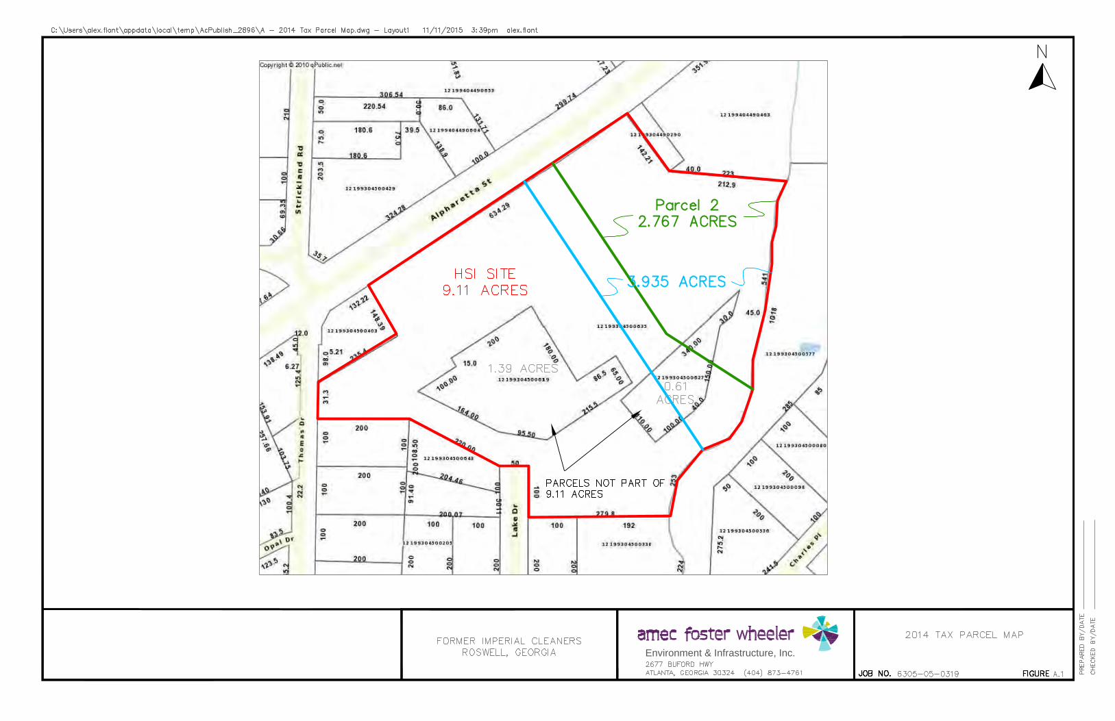
Environment & Infrastructure, Inc.

VRP
PROPERTY
3.935 Ac

APPENDIX B
FIGURES
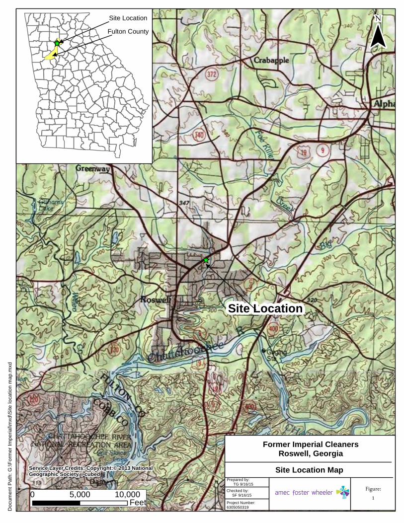
_̂
Service Layer Credits: Copyright:© 2013 NationalGeographic Society, i-cubed
¯
0 5,000 10,000Feet
Docu
ment
Path:
G:\F
ormer
Impe
rial\m
xd\S
ite lo
catio
n map
.mxd
_̂
Site LocationFulton County
Site Location
Prepared by: TG 9/16/15 Figure:
1Checked by: SF 9/16/15Project Number:6305050319
Site Location Map
Former Imperial CleanersRoswell, Georgia

FORMERKING'S CREEK
SHOPPINGCENTER
BOUNDARY
3.935-ACREBOUNDARY
FORMERIMPERIALCLEANERS
DEMOLISHEDPROPERTY REDEVELOPED
Amec Foster Wheeler
Environment & Infrastructure, Inc.

VRP
PROPERTY
3.935 Ac
PARCEL 2
2.767 Ac


Environment & Infrastructure, Inc.

A'A
Amec Foster Wheeler
Environment & Infrastructure, Inc.
FORMER IMPERIAL CLEANERS
ROSWELL, GEORGIA
CROSS SECTION A-A'

B'B
Amec Foster Wheeler
Environment & Infrastructure, Inc.
FORMER IMPERIAL CLEANERS
ROSWELL, GEORGIA
CROSS SECTION B-B'

SOIL TESTING
RESULTS AND DELINEATION
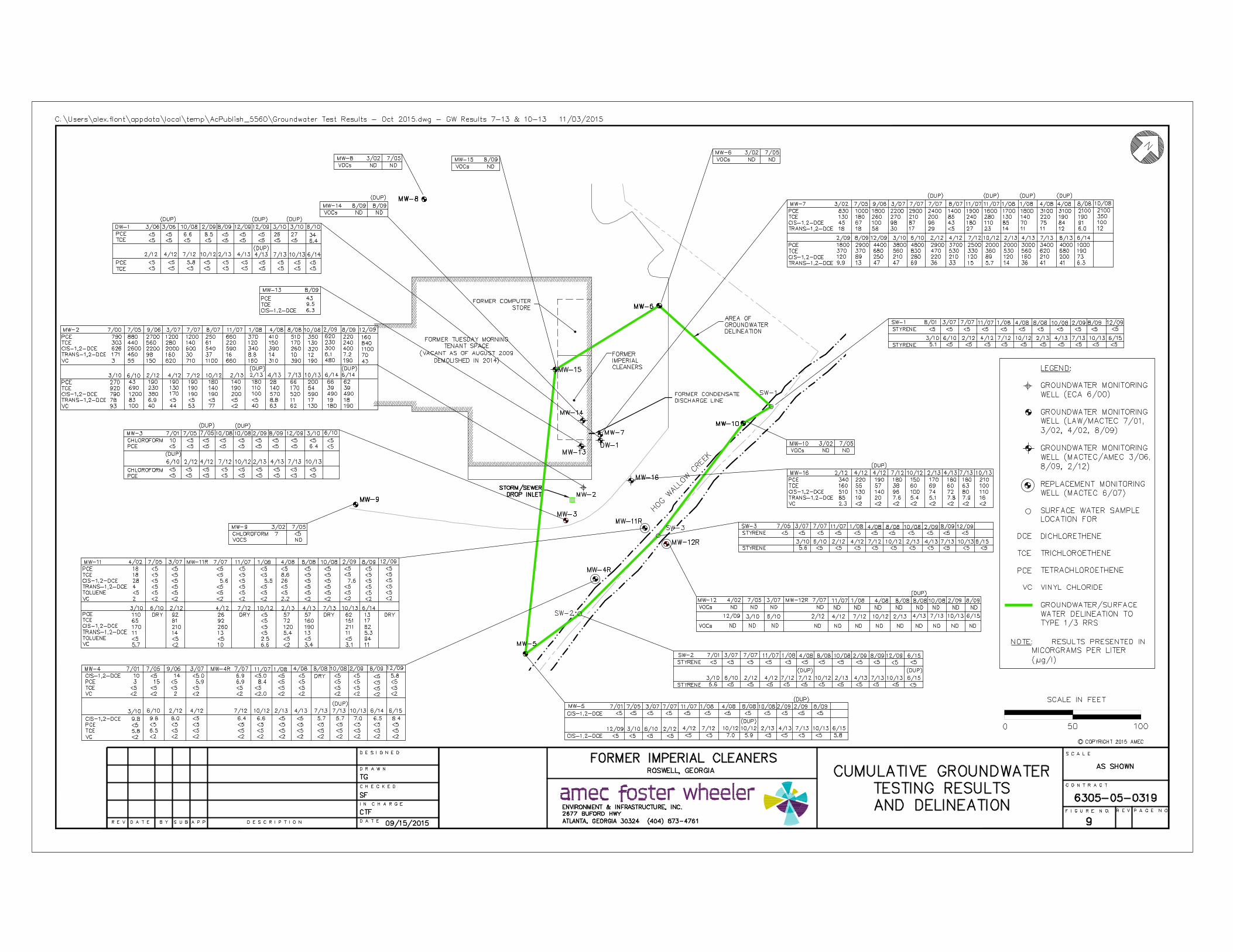
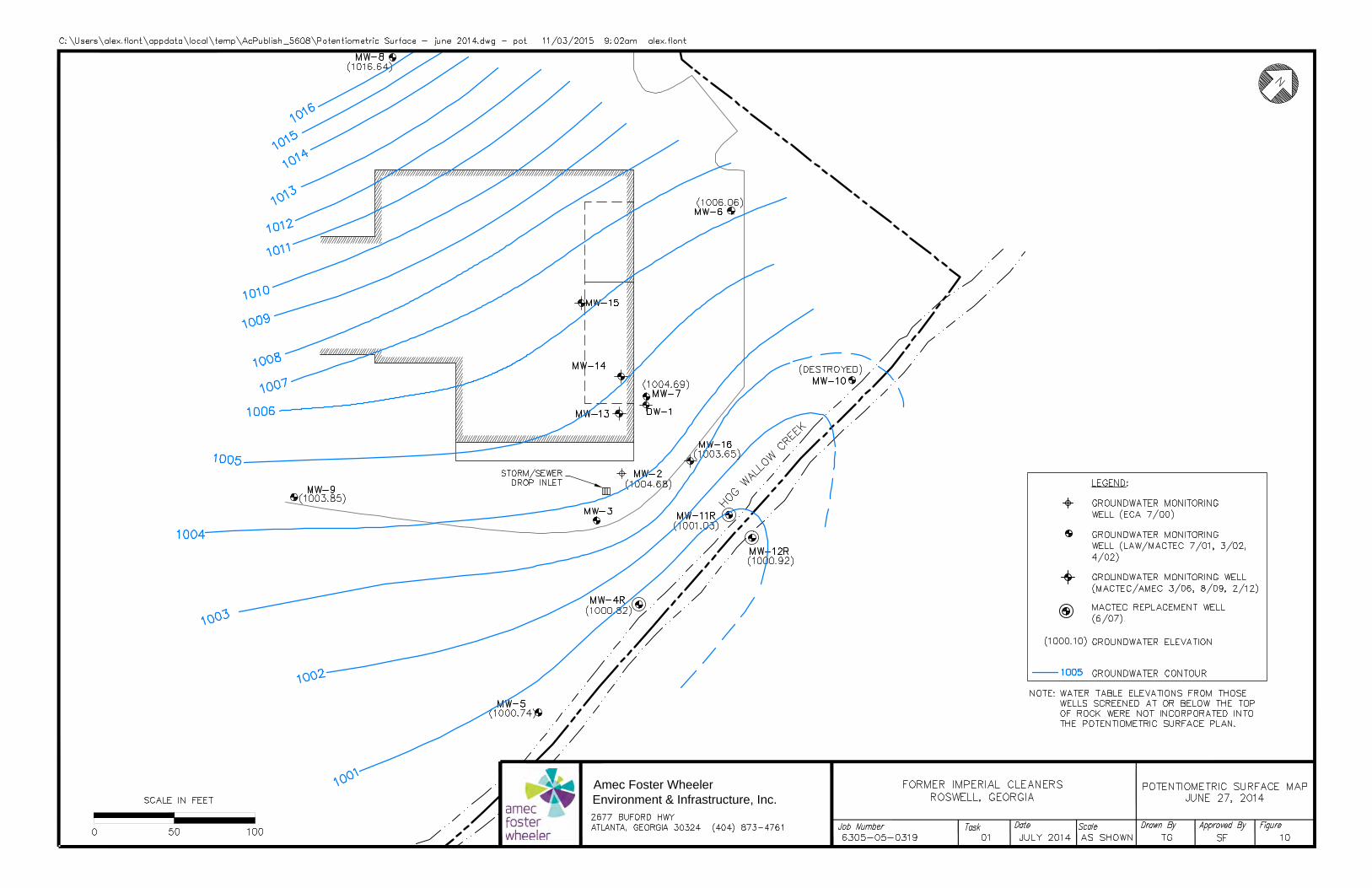
Amec Foster Wheeler
Environment & Infrastructure, Inc.

APPENDIX C
TABLES

Amec Foster Wheeler Environment & Infrastructure, Inc. Project No. 6305-05-0319 Compliance Status Report, Former Imperial Cleaners, Roswell, Georgia November 2, 2015
TABLE 1 – MONITORING WELL DATA, 6/27/14
Well No. Well Depth, BGS, Ft.
Screened Interval, Ft.
Ground Surface
Elevation, Ft.
Top of Casing
Elevation, Ft.
Depth to Water,
TOC Ft.
Water Table
Elevation, Ft.
Material Monitored
MW-2 24 14 - 24 1027.15 1026.80 22.12 1004.68 Soil MW-3 52 47 - 52 1026.99 1026.83 24.06 1002.77 Bedrock
MW-4R 7.25 5 - 8 1006.87 1009.62 8.80 1000.82 Soil MW-5 6 4 – 7 1005.06 1007.51 6.73 1000.78 Soil MW-6 33 23 – 33 1030.35 1030.08 24.02 1006.06 Soil MW-7 33 23 -33 1029.91 1029.59 24.90 1004.69 Transitional
Zone MW-8 21 11 - 21 1029.96 1029.61 12.97 1016.64 Soil MW-9 30 20 - 30 1027.69 1027.44 22.87 1004.57 Soil
MW-11R 5.5 3 – 5.5 1005.32 1006.12 5.09 1001.03 Soil
MW-12R 5.5 3 – 5.5 1003.57 1004.82 3.90 1000.92 Soil MW-16 33 23 – 33 1029.08 1028.69 25.04 1003.65 Transitional
Zone DW-1 55.5 50.5 – 55.5 1029.76 1029.46 24.47 1004.99 Bedrock BGS - Below Ground Surface TOC - Top of Casing

Amec Foster Wheeler Environment & Infrastructure, Inc. Project No. 6305-05-0319 Compliance Status Report, Former Imperial Cleaners, Roswell, Georgia November 2, 2015
TABLE 2 – SUMMARY OF SLUG TEST DATA
Well No. Hydraulic Conductivity,
cm/sec (Slug-In)
Hydraulic Conductivity, cm/sec
(Slug-Out) Strata Measured
MW-3 20.05x10⁻⁵ 30.08x10⁻⁵ Fractured Rock
MW-8 2.140x10⁻⁵ 6.553x10⁻⁵ Residual Soil/Partially Weathered Rock
MW-9 9.396x10⁻⁵ 9.194x10⁻⁵ Fill, Alluvial Soil, Residual Soil
cm/sec – centimeters per second
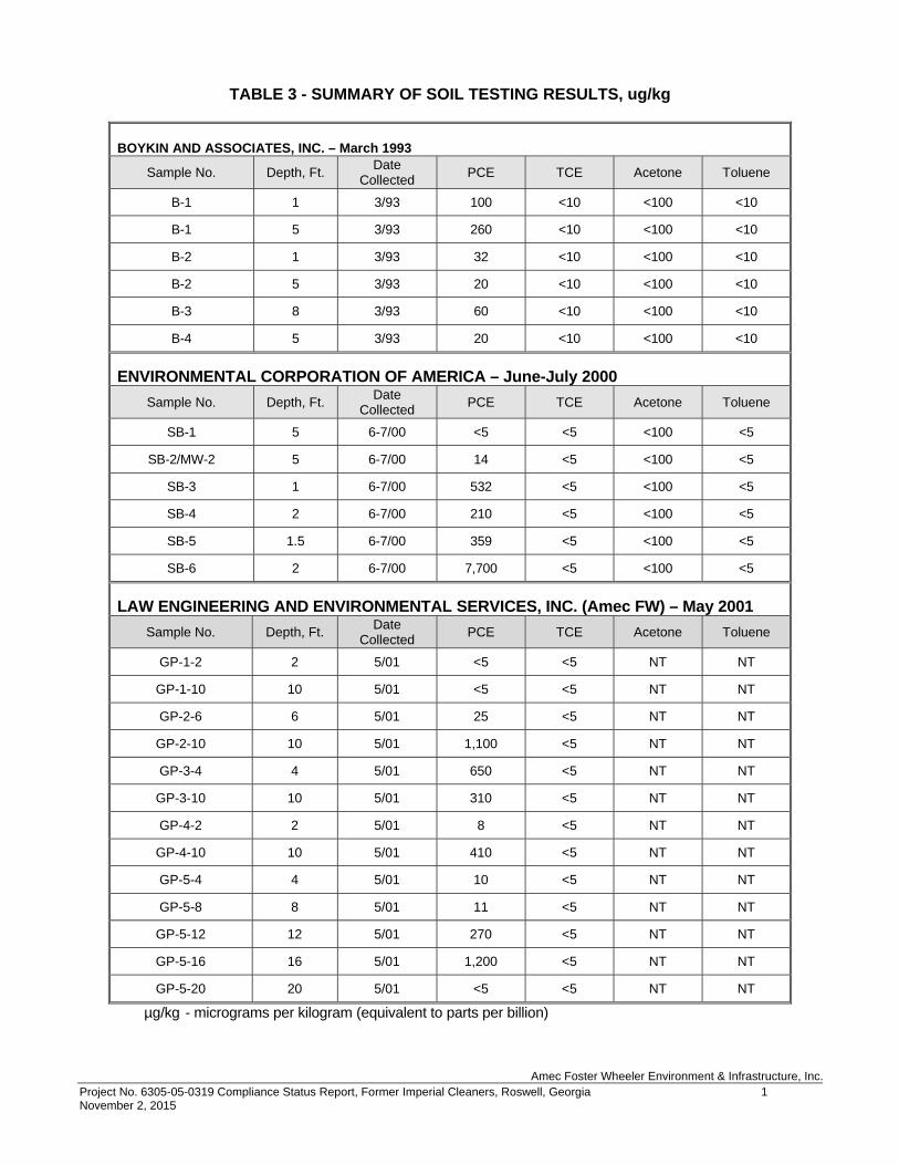
Amec Foster Wheeler Environment & Infrastructure, Inc. Project No. 6305-05-0319 Compliance Status Report, Former Imperial Cleaners, Roswell, Georgia 1 November 2, 2015
TABLE 3 - SUMMARY OF SOIL TESTING RESULTS, ug/kg
BOYKIN AND ASSOCIATES, INC. – March 1993
Sample No. Depth, Ft. Date Collected PCE TCE Acetone Toluene
B-1 1 3/93 100 <10 <100 <10 B-1 5 3/93 260 <10 <100 <10 B-2 1 3/93 32 <10 <100 <10 B-2 5 3/93 20 <10 <100 <10 B-3 8 3/93 60 <10 <100 <10 B-4 5 3/93 20 <10 <100 <10
ENVIRONMENTAL CORPORATION OF AMERICA – June-July 2000
Sample No. Depth, Ft. Date Collected PCE TCE Acetone Toluene
SB-1 5 6-7/00 <5 <5 <100 <5 SB-2/MW-2 5 6-7/00 14 <5 <100 <5
SB-3 1 6-7/00 532 <5 <100 <5 SB-4 2 6-7/00 210 <5 <100 <5 SB-5 1.5 6-7/00 359 <5 <100 <5 SB-6 2 6-7/00 7,700 <5 <100 <5
LAW ENGINEERING AND ENVIRONMENTAL SERVICES, INC. (Amec FW) – May 2001
Sample No. Depth, Ft. Date Collected PCE TCE Acetone Toluene
GP-1-2 2 5/01 <5 <5 NT NT GP-1-10 10 5/01 <5 <5 NT NT GP-2-6 6 5/01 25 <5 NT NT
GP-2-10 10 5/01 1,100 <5 NT NT GP-3-4 4 5/01 650 <5 NT NT
GP-3-10 10 5/01 310 <5 NT NT GP-4-2 2 5/01 8 <5 NT NT
GP-4-10 10 5/01 410 <5 NT NT GP-5-4 4 5/01 10 <5 NT NT GP-5-8 8 5/01 11 <5 NT NT
GP-5-12 12 5/01 270 <5 NT NT GP-5-16 16 5/01 1,200 <5 NT NT GP-5-20 20 5/01 <5 <5 NT NT
µg/kg - micrograms per kilogram (equivalent to parts per billion)

Amec Foster Wheeler Environment & Infrastructure, Inc. Project No. 6305-05-0319 Compliance Status Report, Former Imperial Cleaners, Roswell, Georgia 2 November 2, 2015
TABLE 3 - SUMMARY OF SOIL TESTING RESULTS, ug/kg (Continued)
LAW ENGINEERING AND ENVIRONMENTAL SERVICES, INC. (Amec FW) – August 2001
Sample No. Depth, Ft. Date Collected PCE TCE Acetone Toluene
SB-7 5 8/01 <5.9 <5.9 <120 <5.9 SB-7 10 8/01 110 <5.9 <120 <5.9 SB-7 15 8/01 260 <6.3 <130 <6.3 SB-7 20 8/01 84 <6.1 <120 <6.1 SB-7 25 8/01 10 6.5 <120 <5.8 SB-8 5 8/01 <7.1 <7.1 <140 <7.1 MW-3 5 8/01 7.0 <5.7 <110 <5.7
LAW ENGINEERING AND ENVIRONMENTAL SERVICES, INC. (Amec FW) – March 2002
Sample No. Depth, Ft. Date Collected PCE TCE Acetone Toluene
MW-6 5 3/02 <6.1 <6.1 <120 <6.1 MW-8 5 3/02 <5.6 <5.6 <110 <5.6 MW-9 5 3/02 <6.1 <6.1 <120 <6.1 MW-10 2 3/02 <6.2 <6.2 <120 <6.2 HA-1 2 4/02 <6.9 <6.9 <140 <6.9 HA-2 2 4/02 <5.9 <5.9 <120 <5.9
MACTEC ENGINEERING AND CONSULTING, INC. (Amec FW) – July 2005
Sample No. Depth, Ft. Date Collected PCE TCE Acetone Toluene
HA-3 2 7/05 <3.6 <3.6 150 13 HA-4 2 7/05 <7.8 <7.8 <160 <7.8 HA-5 1 7/05 8.5 <5.5 <110 <5.5
HA-5 (Dup) 1 7/05 6.9 <5.5 <110 <5.5 HA-5 3 7/05 20 <5.2 <100 <5.2
µg/kg - micrograms per kilogram (equivalent to parts per billion)

Amec Foster Wheeler Environment & Infrastructure, Inc. Project No. 6305-05-0319 Compliance Status Report, Former Imperial Cleaners, Roswell, Georgia 3 November 2, 2015
TABLE 3 - SUMMARY OF SOIL TESTING RESULTS, ug/kg (Continued)
MACTEC ENGINEERING AND CONSULTING, INC. (Amec FW) – JANUARY 2006
Sample No. Depth, Ft. Date Collected PCE TCE Acetone Toluene
SB-10 4 1/06 34 <6.3 <130 <6.3 SB-11 12 1/06 55 <5.3 <110 <5.3 SB-11 16 1/06 77 <6.1 <110 <6.1 SB-11 20 1/06 930 7.8 <120 <6.1 SB-12 8 1/06 34 <6.5 <130 <6.5 SB-12 16 1/06 230 <7.2 <140 <7.2 SB-12 20 1/06 21 <6.3 <130 <6.3 SB-13 8 1/06 41 <6.2 <120 <6.2 SB-13 12 1/06 100 <6.6 <130 <6.6 SB-13 16 1/06 640 <5.8 <120 <5.8 SB-16 8 1/06 <6.3 <6.3 <130 <6.3 SB-16 12 1/06 530 <6.0 <120 <6.0 SB-16 16 1/06 130 <6.3 <130 <6.3 SB-17 8 1/06 9 <7.4 <110 <7.4 SB-17 12 1/06 730 <6.5 <130 <6.5 SB-17 16 1/06 390 <7.1 <140 <7.1
µg/kg - micrograms per kilogram (equivalent to parts per billion)

Amec Foster Wheeler Environment & Infrastructure, Inc. Project No. 6305-05-0319 Compliance Status Report, Former Imperial Cleaners, Roswell, Georgia 4 November 2, 2015
TABLE 3 - SUMMARY OF SOIL TESTING RESULTS, ug/kg (Continued)
MACTEC ENGINEERING AND CONSULTING, INC. (Amec FW) – AUGUST 2009
Sample No. Depth, Ft. Date Collected PCE TCE Acetone Toluene
SB-21-20 20 8/09 <5.0 <7.3 <150 <7.3 SB-22-2.5 2.5 8/09 16 <6.3 <130 <6.3 SB-22-7.5 7.5 8/09 38 <4.9 <98 <4.9
SB-22-12.5 12.5 8/09 180 <5.4 <110 <5.4 SB-23-2 2 8/09 11 <5.8 <120 <5.8
SB-23-7.5 7.5 8/09 6.2 <5.8 <120 <5.8 SB-23-12.5 12.5 8/09 37 <5.3 <110 <5.3
SB-24-2 2 8/09 <5.0 <5.7 <110 <5.7 SB-24-5 5 8/09 5.5 <4.8 <96 <4.8
SB-24-7.5 7.5 8/09 13 <5.9 <120 <5.9 SB-25-2.5 2.5 8/09 <4.8 <4.8 <96 <4.8 SB-25-7.5 7.5 8/09 <5.4 <5.4 <110 <5.4
SB-25-12.5 12.5 8/09 390 <4.9 <98 <4.9 SB-26-5 5 8/09 35 <5.9 <120 <5.9
SB-26-17.5 17.5 8/09 <4.8 <4.8 <96 <4.8 SB-26-17.5 Ft. (Dup) 17.5 8/09 <5.0 <5.0 <100 <5.0
SB-27-12.5 12.5 8/09 960 <4.8 <96 <4.8 SB-28-12.5 12.5 8/09 240 <5.9 <120 <5.9
SB-28-12.5 Ft. (Dup) 12.5 8/09 200 <5.9 <120 <5.9 SB-28-20 20 8/09 1,100 <4.6 <93 <4.6
MACTEC ENGINEERING AND CONSULTING, INC. (Amec FW) – MARCH 2010 Sample No. Depth, Ft. Date
Collected PCE TCE Acetone Toluene SB-29 2 3/10 <7.3 <7.3 <150 <7.3 SB-29 12 3/10 48 <6.2 <120 <6.2 SB-29 20 3/10 180 <7.0 150 <7.0 SB-30 2 3/10 <7.5 <7.5 <150 <7.5 SB-30 12 3/10 440E <8.1 <160 <8.1 SB-30 20 3/10 230 <7.7 <150 <7.7 SB-31 2 3/10 <6.0 <6.0 <120 <6.0 SB-31 12 3/10 <6.8 <6.8 <140 <6.8 SB-31 20 3/10 49 <7.8 <160 <7.8
µg/kg - micrograms per kilogram (equivalent to parts per billion)

Amec Foster Wheeler Environment & Infrastructure, Inc. Project No. 6305-05-0319 Compliance Status Report, Former Imperial Cleaners, Roswell, Georgia 1 November 2, 2015
TABLE 4 – SUMMARY OF GROUNDWATER/SURFACE WATER TESTING, g/l Well No. Sampling Date PCE TCE Trans-1,2-DCE Cis-1,2-DCE Vinyl
Chloride Chloroform Styrene
MW-2
7/00 7/8/05
9/11/06 3/21/07 7/3/07
8/17/07 11/07
1/18/08 4/29/08 8/15/08 10/28/08 2/27/09 8/19/09 12/16/09 3/30/10 6/30/10 2/9/12
4/19/12 7/18/12 10/17/12
2/8/13 2/8/13(dup)
4/18/13 7/26/13 10/16/13 6/27/14
6/27/14 (dup) 12/15/14 6/30/15
790 880 2700 1200 1200 250 660 370 410 510 350 620 220 160 270 43
190 190 190 180 140 180 28 66
200 66 62 43
Destroyed
303 440 560 280 140 61
220 120 150 170 130 230 240 840 920 690 230 130 190 140 190 110 140 170 54 39 39 57
Destroyed
171 450 98
160 30 37 16 8.8 14 10 12 6.1 7.2 70 78 83 6.9 <5 <5 <5 <5 <5 8.8 11 17 19 18
110 Destroyed
626 2600 2200 2000 600 540 590 340 390 260 320 300 400
1100 790
1200 380 170 190 190 200 100 570 520 590 490 490 440
Destroyed
3 55 150 620 710
1100 660 160 310 390 190 480 190 43 93 100 40 47 53 77 <2 40 63 62 130 180 190 22
Destroyed
<2 <5 <5 <5 <5 <5 <5 <5 <5 <5 <5 <5 <5 <5 <5 <5 <5 <5 <5 <5 <5 <5 <5 <5 <5 <5 <5 <5
Destroyed
<2 <5 <5 <5 <5 <5 <5 <5 <5 <5 <5 <5 <5 <5 <5 <5 <5 <5 <5 <5 <5 <5 <5 <5 <5 <5 <5 <5
Destroyed
MW-3
8/15/01 7/13/05 10/28/08
10/28/08(dup) 2/27/09 8/19/09 12/16/09 3/30/10 6/30/10
6/30/10 (dup) 2/8/12
4/19/12 7/18/12 10/17/12
2/7/13 4/18/13 7/26/13 10/15/13 6/30/15
<2 <5 <5 <5 <5 <5 <5 6.4 <5 <5 <5 <5 <5 <5 <5 <5 <5 <5
Destroyed
<2 <5 <5 <5 <5 <5 <5 <5 <5 <5 <5 <5 <5 <5 <5 <5 <5 <5
Destroyed
<2 <5 <5 <5 <5 <5 <5 <5 <5 <5 <5 <5 <5 <5 <5 <5 <5 <5
Destroyed
<2 <5 <5 <5 <5 <5 <5 <5 <5 <5 <5 <5 <5 <5 <5 <5 <5 <5
Destroyed
<2 <2 <2 <2 <2 <2 <2 <2 <2 <2 <2 <2 <2 <2 <2 <2 <2 <2
Destroyed
10 <5 <5 <5 <5 <5 <5 <5 <5 <5 <5 <5 <5 <5 <5 <5 <5 <5
Destroyed
<2 <5 <5 <5 <5 <5 <5 <5 <5 <5 <5 <5 <5 <5 <5 <5 <5 <5
Destroyed
MW-4 8/15/01 7/13/05 9/11/06 3/21/07
3 15 <5 5.9
<2 <5 <5 <5
<2 <5 <5 <5
10 <5 14 <5
<2 <2 2
<2
<2 <5 <5 <5
<2 <5 <5 <5

Amec Foster Wheeler Environment & Infrastructure, Inc. Project No. 6305-05-0319 Compliance Status Report, Former Imperial Cleaners, Roswell, Georgia 2 November 2, 2015
TABLE 4 – SUMMARY OF GROUNDWATER/SURFACE WATER TESTING, g/l Well No. Sampling Date PCE TCE Trans-1,2-DCE Cis-1,2-DCE Vinyl
Chloride Chloroform Styrene
MW-4R
7/3/07 11/07
1/18/08 4/29/08 8/15/08 10/28/08 2/27/09 8/19/09 12/16/09 3/30/10 6/30/10 2/8/12 2/8/12
4/19/12 7/18/12 10/17/12
2/8/13 4/19/13 7/25/13
7/25/13 (dup) 8/15/13 6/27/14 12/15/14 6/30/015
6.9 8.4 <5 <5
No Sample <5 <5 <5 5.8 <5 <5 <5 <5 <5 <5 <5 <5 <5 <5 <5 <5 <5 <5 <5
<5 <5 <5 <5 No
Sample <5 <5 <5 <5 5.8 6.5 <5 <5 <5 <5 <5 <5 <5 <5 <5 <5 <5 <5 <5
<5 <5 <5 <5
No Sample <5 <5 <5 <5 <5 <5 <5 <5 <5 <5 <5 <5 <5 <5 <5 <5 <5 <5 <5
6.9 <5 <5 <5
No Sample <5 <5 <5 <5 9.8 9.8 <5 8.0 <5 6.4 6.6 <5 <5 5.7 5.7 7.0 6.5 6.4 8.4
<2 <2 <2 <2
No Sample <2 <2 <2 <2 <2 <2 <2 <2 <2 <2 <2 <2 <2 <2 <2 <2 <2 <2 <2
<5 <5 <5 <5
No Sample <5 <5 <5 <5 <5 <5 <5 <5 <5 <5 <5 <5 <5 <5 <5 <5 <5 <5 <5
<5 <5 <5 <5
No Sample <5 <5 <5 <5 <5 <5 <5 <5 <5 <5 <5 <5 <5 <5 <5 <5 <5 <5 <5
MW-5
8/15/01 7/8/05
3/21/07 7/3/07 11/07
1/18/08 4/29/08 8/15/08 10/28/08 2/27/09
2/27/09 (dup) 8/19/09 12/16/09 3/30/10 6/30/10 2/9/12
4/19/12 7/18/12 10/17/12
10/17/12 (dup) 2/8/13
4/19/13 7/26/13 10/16/13 6/30/15
<2 <5 <5 <5 <5 <5 <5 <5 <5 <5 <5 <5 <5 <5 <5 <5 <5 <5 <5 <5 <5 <5 <5 <5 <5
<2 <5 <5 <5 <5 <5 <5 <5 <5 <5 <5 <5 <5 <5 <5 <5 <5 <5 <5 <5 <5 <5 <5 <5 <5
<2 <5 <5 <5 <5 <5 <5 <5 <5 <5 <5 <5 <5 <5 <5 <5 <5 <5 <5 <5 <5 <5 <5 <5 <5
<2 <5 <5 <5 <5 <5 <5 <5 <5 <5 <5 <5 <5 <5 <5 <5 <5 <5 7.0
5.9(dup) <5 <5 <5 <5 5.8
<2 <2 <2 <2 <2 <2 <2 <2 <2 <2 <2 <2 <2 <2 <2 <2 <2 <2 <2 <2 <2 <2 <2 <2 <2
<2 <5 <5 <5 <5 <5 <5 <5 <5 <5 <5 <5 <5 <5 <5 <5 <5 <5 <5 <5 <5 <5 <5 <5 <5
<2 <5 <5 <5 <5 <5 <5 <5 <5 <5 <5 <5 <5 <5 <5 <5 <5 <5 <5 <5 <5 <5 <5 <5 <5
MW-6 3/14/02 7/8/05
<2 <5
<2 <5
<2 <5
<2 <5
<2 <5
<2 <5
<2 <5

Amec Foster Wheeler Environment & Infrastructure, Inc. Project No. 6305-05-0319 Compliance Status Report, Former Imperial Cleaners, Roswell, Georgia 3 November 2, 2015
TABLE 4 – SUMMARY OF GROUNDWATER/SURFACE WATER TESTING, g/l Well No. Sampling Date PCE TCE Trans-1,2-DCE Cis-1,2-DCE Vinyl
Chloride Chloroform Styrene
MW-7
3/14/02 7/8/05
9/11/06 3/21/07 7/3/07
7/3/07 (dup) 8/17/07 11/07
11/07 (dup) 1/18/08
1/18/08 (dup) 4/29/08
4/29/08 (dup) 8/15/08 10/28/08 2/27/09 8/19/09 12/16/09 3/30/10 6/30/10 2/9/12
4/19/12 7/18/12 10/17/12
2/7/13 4/18/13 7/26/13 8/16/13 6/27/14 12/15/14
12/15/14 (dup) 6/30/015
830 1000 1800 2200 2900 2400 1400 1900 1600 1700 1800 3100 3100 2100 2100 1800 2900 4400 3800 4800 2900 3700 2500 2000 2000 3000 3400 4000 1000 2500 2900
Destroyed
130 180 260 270 210 200 85
240 280 130 140 220 190 190 350 370 370 680 560 830 470 530 330 360 530 560 620 680 190 940 960
Destroyed
18 18 58 30 37 29 <5 27 23 14 11 11 12 6 12 9.9 13 47 47 69 36 33 15 5.7 14 36 41 41 6.3 50 60
Destroyed
45 67 100 98 87 96 43 180 110 85 70 75 84 91 100 120 89 250 210 280 220 210 120 89 120 160 210 200 73 410 410
Destroyed
<2 <2 <2 <2 <2 <2 <2 <2 <2 <2 <2 <2 <2 <2 <2 <2 <2 <2 <2 <2 <2 <2 <2 <2 <2 <2 <2 <2 <2 <2 <2
Destroyed
<2 <5 <5 <5 <5 <5 <5 <5 <5 <5 <5 <5 <5 <5 <5 <5 <5 <5 <5 <5 <5 <5 <5 <5 <5 <5 <5 <5 <5 <5 <5
Destroyed
<5 <5 <5 <5 <5 <5 <5 <5 <5 <5 <5 <5 <5 <5 <5 <5 <5 <5 <5 <5 <5 <5 <5 <5 <5 <5 <5 <5 <5 <5 <5
Destroyed
MW-8 3/14/02 7/8/05
<2 <5
<2 <5
<2 <5
<2 <5
<2 <2
<2 <5
<2 <5
MW-9 3/14/02 7/8/05
<2 <5
<2 <5
<2 <5
<2 <5
<2 <2
7 <5
<2 <5
MW-10 3/14/02 7/8/05
<2 <5
<2 <5
<2 <5
<2 <5
<2 <5
<2 <5
<2 <5
MW-11 4/4/02 7/8/05
3/21/07
18 <5 <5
18 <5 <5
4 <5 <5
28 <5 <5
2 <2 <2
<2 <5 <5
<2 <5 <5

Amec Foster Wheeler Environment & Infrastructure, Inc. Project No. 6305-05-0319 Compliance Status Report, Former Imperial Cleaners, Roswell, Georgia 4 November 2, 2015
TABLE 4 – SUMMARY OF GROUNDWATER/SURFACE WATER TESTING, g/l Well No. Sampling Date PCE TCE Trans-1,2-DCE Cis-1,2-DCE Vinyl
Chloride Chloroform Styrene
MW-11R
7/3/07 11/07
1/18/08 4/29/08 8/15/08 10/28/08 2/27/09 8/19/09 12/16/09 3/30/10 6/30/10 2/8/12
4/19/12 7/18/12 10/17/12
2/8/13 4/19/13 7/25/13 10/15/13 6/27/14 12/15/14 6/30/015
<5 <5 <5 <5 <5 <5 <5 <5 <5 110
No Sample 92 26
No Sample <5 57 57
No Sample 62 13 72
No Sample
<5 <5 <5 8.6 <5 <5 <5 <5 <5 65 No
Sample 81 92 No
Sample <5 72
160 No
Sample 151 17 83 No
Sample
<5 <5 <5 <5 <5 <5 <5 <5 <5 11
No Sample 14 13
No Sample <5 5.4 13
No Sample 11 5.3 14
No Sample
5.6 <5 5.5 26 <5 <5 7.6 <5 <5 170
No Sample 210 260
No Sample <5 120 190
No Sample 211 62 150
No Sample
<2 <2 <2 2.2 <2 <2 <2 <2 <2 5.7
No Sample <2 10
No Sample 6.6 <2 3.4
No Sample 3.1 11 <2
No Sample
<5 <5 <5 <5 <5 <5 <5 <5 <5 <5
No Sample <5 <5
No Sample <5 <5 <5
No Sample <5 <5 <5
No Sample
<2 <5 <5 <5 <5 <5 <5 <5 <5 <5
No Sample <5 <5
No Sample <5 <5 <5
No Sample <5 <5 <5
No Sample
MW-12 6/12/02 7/13/05 3/21/07
<2 <5 <5
<2 <5 <5
<2 <5 <5
<2 <5 <5
<2 <2 <2
<2 <5 <5
<2 <5 <5
MW-12R
7/3/07 11/07
1/18/08 4/29/08 8/15/08 10/28/08 2/27/09 8/19/09 12/16/09 3/30/10 6/30/10 2/8/12
4/19/12 7/18/12 10/17/12
2/8/13 4/19/13 7/26/13 10/15/13 6/30/15
<5 <5 <5 <5 <5 <5 <5 <5 <5 <5 <5 <5 <5 <5 <5 <5 <5 <5 <5 <5
<5 <5 <5 <5 <5 <5 <5 <5 <5 <5 <5 <5 <5 <5 <5 <5 <5 <5 <5 <5
<5 <5 <5 <5 <5 <5 <5 <5 <5 <5 <5 <5 <5 <5 <5 <5 <5 <5 <5 <5
<5 <5 <5 <5 <5 <5 <5 <5 <5 <5 <5 <5 <5 <5 <5 <5 <5 <5 <5 <5
<2 <2 <2 <2 <2 <2 <2 <2 <2 <2 <2 <2 <2 <2 <2 <2 <2 <2 <2 <2
<5 <5 <5 <5 <5 <5 <5 <5 <5 <5 <5 <5 <5 <5 <5 <5 <5 <5 <5 <5
<5 <5 <5 <5 <5 <5 <5 <5 <5 <5 <5 <5 <5 <5 <5 <5 <5 <5 <5 <5
DW-1
3/22/06 10/28/08 2/27/09 8/19/09 12/16/09
12/16/09 (dup) 3/30/10
3/30/10 (dup) 6/30/10 2/9/12
4/19/12 7/18/12 10/17/12
2/7/13 4/18/13
4/18/13(dup) 7/26/13 10/15/13 6/27/14 12/15/14 6/30/15
<5 6.6 8.5 <5 <5 <5 26 27 34 <5 <5 5.8 <5 <5 <5 <5 <5 <5 <5 <5
Destroyed
<5 <5 <5 <5 <5 <5 <5 <5 6.4 <5 <5 <5 <5 <5 <5 <5 <5 <5 <5 <5
Destroyed
<5 <5 <5 <5 <5 <5 <5 <5 <5 <5 <5 <5 <5 <5 <5 <5 <5 <5 <5 <5
Destroyed
<5 <5 <5 <5 <5 <5 <5 <5 <5 <5 <5 <5 <5 <5 <5 <5 <5 <5 <5 <5
Destroyed
<2 <2 <2 <2 <2 <2 <2 <2 <2 <2 <2 <2 <2 <2 <2 <2 <2 <2 <2 <2
Destroyed
<5 <5 <5 <5 <5 <5 <5 <5 <5 <5 <5 <5 <5 <5 <5 <5 <5 <5 <5 <5
Destroyed
<5 <5 <5 <5 <5 <5 <5 <5 <5 <5 <5 <5 <5 <5 <5 <5 <5 <5 <5 <5
Destroyed
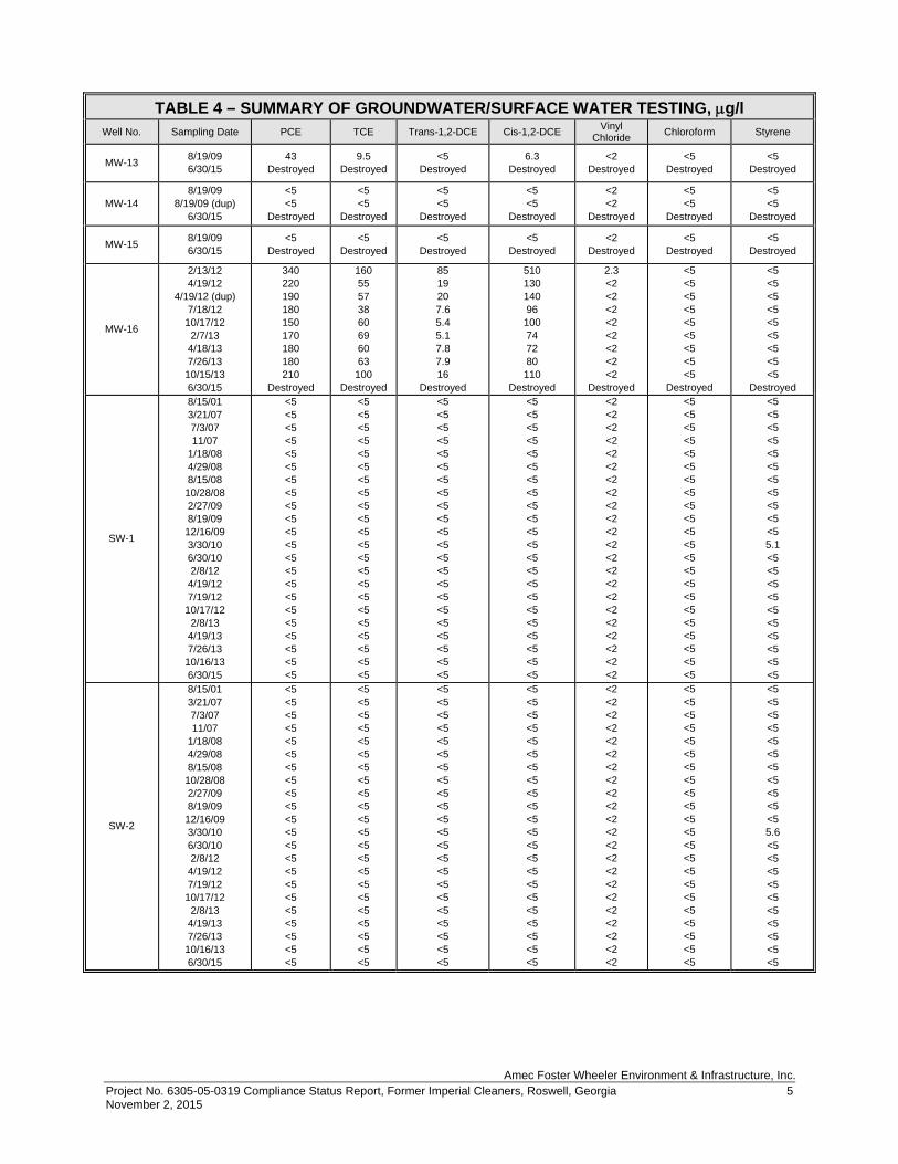
Amec Foster Wheeler Environment & Infrastructure, Inc. Project No. 6305-05-0319 Compliance Status Report, Former Imperial Cleaners, Roswell, Georgia 5 November 2, 2015
TABLE 4 – SUMMARY OF GROUNDWATER/SURFACE WATER TESTING, g/l Well No. Sampling Date PCE TCE Trans-1,2-DCE Cis-1,2-DCE Vinyl
Chloride Chloroform Styrene
MW-13 8/19/09 6/30/15
43 Destroyed
9.5 Destroyed
<5 Destroyed
6.3 Destroyed
<2 Destroyed
<5 Destroyed
<5 Destroyed
MW-14 8/19/09
8/19/09 (dup) 6/30/15
<5 <5
Destroyed
<5 <5
Destroyed
<5 <5
Destroyed
<5 <5
Destroyed
<2 <2
Destroyed
<5 <5
Destroyed
<5 <5
Destroyed
MW-15 8/19/09 6/30/15
<5 Destroyed
<5 Destroyed
<5 Destroyed
<5 Destroyed
<2 Destroyed
<5 Destroyed
<5 Destroyed
MW-16
2/13/12 4/19/12
4/19/12 (dup) 7/18/12 10/17/12
2/7/13 4/18/13 7/26/13 10/15/13 6/30/15
340 220 190 180 150 170 180 180 210
Destroyed
160 55 57 38 60 69 60 63
100 Destroyed
85 19 20 7.6 5.4 5.1 7.8 7.9 16
Destroyed
510 130 140 96 100 74 72 80 110
Destroyed
2.3 <2 <2 <2 <2 <2 <2 <2 <2
Destroyed
<5 <5 <5 <5 <5 <5 <5 <5 <5
Destroyed
<5 <5 <5 <5 <5 <5 <5 <5 <5
Destroyed
SW-1
8/15/01 3/21/07 7/3/07 11/07
1/18/08 4/29/08 8/15/08 10/28/08 2/27/09 8/19/09 12/16/09 3/30/10 6/30/10 2/8/12
4/19/12 7/19/12 10/17/12
2/8/13 4/19/13 7/26/13 10/16/13 6/30/15
<5 <5 <5 <5 <5 <5 <5 <5 <5 <5 <5 <5 <5 <5 <5 <5 <5 <5 <5 <5 <5 <5
<5 <5 <5 <5 <5 <5 <5 <5 <5 <5 <5 <5 <5 <5 <5 <5 <5 <5 <5 <5 <5 <5
<5 <5 <5 <5 <5 <5 <5 <5 <5 <5 <5 <5 <5 <5 <5 <5 <5 <5 <5 <5 <5 <5
<5 <5 <5 <5 <5 <5 <5 <5 <5 <5 <5 <5 <5 <5 <5 <5 <5 <5 <5 <5 <5 <5
<2 <2 <2 <2 <2 <2 <2 <2 <2 <2 <2 <2 <2 <2 <2 <2 <2 <2 <2 <2 <2 <2
<5 <5 <5 <5 <5 <5 <5 <5 <5 <5 <5 <5 <5 <5 <5 <5 <5 <5 <5 <5 <5 <5
<5 <5 <5 <5 <5 <5 <5 <5 <5 <5 <5 5.1 <5 <5 <5 <5 <5 <5 <5 <5 <5 <5
SW-2
8/15/01 3/21/07 7/3/07 11/07
1/18/08 4/29/08 8/15/08 10/28/08 2/27/09 8/19/09 12/16/09 3/30/10 6/30/10 2/8/12
4/19/12 7/19/12 10/17/12
2/8/13 4/19/13 7/26/13 10/16/13 6/30/15
<5 <5 <5 <5 <5 <5 <5 <5 <5 <5 <5 <5 <5 <5 <5 <5 <5 <5 <5 <5 <5 <5
<5 <5 <5 <5 <5 <5 <5 <5 <5 <5 <5 <5 <5 <5 <5 <5 <5 <5 <5 <5 <5 <5
<5 <5 <5 <5 <5 <5 <5 <5 <5 <5 <5 <5 <5 <5 <5 <5 <5 <5 <5 <5 <5 <5
<5 <5 <5 <5 <5 <5 <5 <5 <5 <5 <5 <5 <5 <5 <5 <5 <5 <5 <5 <5 <5 <5
<2 <2 <2 <2 <2 <2 <2 <2 <2 <2 <2 <2 <2 <2 <2 <2 <2 <2 <2 <2 <2 <2
<5 <5 <5 <5 <5 <5 <5 <5 <5 <5 <5 <5 <5 <5 <5 <5 <5 <5 <5 <5 <5 <5
<5 <5 <5 <5 <5 <5 <5 <5 <5 <5 <5 5.6 <5 <5 <5 <5 <5 <5 <5 <5 <5 <5

Amec Foster Wheeler Environment & Infrastructure, Inc. Project No. 6305-05-0319 Compliance Status Report, Former Imperial Cleaners, Roswell, Georgia 6 November 2, 2015
TABLE 4 – SUMMARY OF GROUNDWATER/SURFACE WATER TESTING, g/l Well No. Sampling Date PCE TCE Trans-1,2-DCE Cis-1,2-DCE Vinyl
Chloride Chloroform Styrene
SW-3
7/8/05 3/2107 7/3/07 11/07
1/18/08 4/29/08 8/15/08 10/28/08 2/27/09 8/19/09 12/16/09 3/30/10 6/30/10 2/8/12
4/19/12 7/19/12 10/17/12
2/8/13 4/19/13 7/26/13 10/16/13
10/16/13 (dup) 6/30/15
<5 <5 <5 <5 <5 <5 <5 <5 <5 <5 <5 <5 <5 <5 <5 <5 <5 <5 <5 <5 <5 <5 <5
<5 <5 <5 <5 <5 <5 <5 <5 <5 <5 <5 <5 <5 <5 <5 <5 <5 <5 <5 <5 <5 <5 <5
<5 <5 <5 <5 <5 <5 <5 <5 <5 <5 <5 <5 <5 <5 <5 <5 <5 <5 <5 <5 <5 <5 <5
<5 <5 <5 <5 <5 <5 <5 <5 <5 <5 <5 <5 <5 <5 <5 <5 <5 <5 <5 <5 <5 <5 <5
<2 <2 <2 <2 <2 <2 <2 <2 <2 <2 <2 <2 <2 <2 <2 <2 <2 <2 <2 <2 <2 <2 <2
<5 <5 <5 <5 <5 <5 <5 <5 <5 <5 <5 <5 <5 <5 <5 <5 <5 <5 <5 <5 <5 <5 <5
<5 <5 <5 <5 <5 <5 <5 <5 <5 <5 <5 5.6 <5 <5 <5 <5 <5 <5 <5 <5 <5 <5 <5
μg/l - micrograms per liter

Amec Foster Wheeler Environment & Infrastructure, Inc. Project No. 6305-05-0319 Compliance Status Report, Former Imperial Cleaners, Roswell, Georgia 1 November 2, 2015
TABLE 5 – SUMMARY OF NATURAL ATTENUATION PARAMETERS IN GROUNDWATER
Well No. Sampling Date pH
Specific Conductivity
mS/cm Turbidity
NTU Dissolved Oxygen
mg/L
Oxidation-Reduction Potential
mV
MW-2
3/30/10 6/30/10 2/9/12
4/19/12 7/18/12
10/17/12 2/8/13
4/18/13 7/26/13
10/16/13
5.71 5.90 6.00 6.16 6.04 6.25 6.01 5.76 5.69 5.60
0.287 0.910 0.366 0.339 0.343 0.388 0.375 0.315 0.214 0.273
168 7.8 9.4
13.2 56.8 256 38.7 13.4 0.0 4.0
6.00 2.02 2.33 0.18 0.46 0.51 0.11 0.00 0.40 0.56
270 -39 -42 -36 -51 -82 -77 -54 -11 -19
MW-5
3/30/10 6/30/10 2/9/12
4/19/12 7/18/12
10/17/12 2/8/13
4/19/13 7/26/13
10/16/13
5.68 5.29 5.51 5.25 5.37 5.24 5.27 4.83 5.38 4.38
0.198 1.32
0.678 0.095 0.122 0.080 0.111 0.149 0.175 0.101
11 10.2 8.7
11.2 7.9 8.2 6.7 0.4 0.8 6.9
6.71 1.53 1.1 0.0 0.0 0.0
0.29 0.82 1.35 1.63
157 98
117 132 188 261 193 97 39
124
MW-7
3/30/10 6/30/10 2/9/12
4/19/12 7/18/12
10/17/12 2/8/13
4/18/13 7/26/13
10/16/13
4.81 4.80 4.78 5.18 5.07 5.03 4.96 4.35 4.86 4.50
0.231 0.191 0.178 0.272 0.219 0.144 0.155 0.148 0.237 0.205
2.91 10.4 8.7 8.6 6.9 7.1 7.3 9.4 3.7 7.7
4.64 2.32 1.18 0.0 0.0 0.0 0.0
0.28 1.85 0.55
479 331 341 368 307 274 327 409 313 229
mg/l - milligrams per liter (parts per million) μg/l - micrograms per liter (parts per billion) mS/cm - microSiemens per centimeter mV - millivolts NTU - Nephelometric Turbidity Units

Amec Foster Wheeler Environment & Infrastructure, Inc. Project No. 6305-05-0319 Compliance Status Report, Former Imperial Cleaners, Roswell, Georgia 2 November 2, 2015
TABLE 5 – SUMMARY OF NATURAL ATTENUATION PARAMETERS IN GROUNDWATER (Continued)
Well No. Sampling
Date Alkalinity
mg/L Sulfide mg/L
Ferrous Iron mg/L
Methane μg/l
Ethene μg/l
Ethane μg/l
Chloride mg/l
Nitrate mg/l
Nitrite mg/l
Sulfate mg/l
MW-2
3/30/10 6/30/10 2/9/12
4/19/12 7/18/12
10/18/12 2/8/13
4/18/13 7/26/13
10/16/13
102 103 141 96.8 113 112 179 132 78.0 106
<2.0 <2.0 <2.0 <2.0 <2.0 <2.0 <2.0 <2.0 <2.0 <2.0
27.0 33.4 74.8 42.1 44.6
0.678 79.9 44.6 15.8 24.4
1400 1100 2300 2300 3000 140
4700 490 600
1600
11 10 30 36 42 <7 63 21 13 28
<9 <9 <9 <9 <9 <9 <9 <9 <9 <9
NT 11 6.4 7.7 6.7 6.9 7.4 9.0 9.6 6.3
NT <0.25 <0.25 <0.25 <0.25 <0.25 <0.25 <0.25 <0.25 <0.25
NT <0.25 <0.25 <0.25 <0.25 <0.25 <0.25 <0.25 <0.25 <0.25
NT 6.8 3.0
<1.0 <1.0 1.4
<1.0 8.8 5.4 6.3
MW-5
3/30/10 6/30/10 2/9/12
4/19/12 7/18/12
10/17/12 2/8/13 4/9/13
7/26/13 10/16/13
45.5 32.8 21.1 22.3 21.5 12.5 28.9 32.8 80.8 25.1
<2.0 <2.0 <2.0 <2.0 <2.0 <2.0 <2.0 <2.0 <2.0 <2.0
1.40 1.38 0.23 0.65
0.422 <0.10 1.15
0.808 3.20
0.342
21 44 7
130 18 <4 65 11 86 60
<7 <7 <7 <7 <7 <7 <7 <7 <7 <7
<9 <9 <9 <9 <9 <9 <9 <9 <9 <9
NT 15 31 17 13 12 35 21 19 12
NT 0.71
<0.25 0.78 1.4 2.0
<0.25 <0.25 <0.25 0.93
NT <0.25 <0.25 <0.25 <0.50 <0.25 <0.25 <0.25 <0.25 <0.25
NT 4.8 9.7 2.5
<2.0 1.0 9.0 24 9.4 1.1
MW-7
3/30/10 6/30/10 2/9/12
4/19/12 7/18/12
10/17/12 2/8/13
4/18/13 7/26/13
10/16/13
15.0 15.9 10.4
<10.0 12.7
<10.0 17.0 20.0 15.1 19.6
<2.0 <2.0 <2.0 <2.0 <2.0 <2.0 <2.0 <2.0 <2.0 <2.0
<0.10 <0.10 <0.10 <0.10 <0.10 <0.10 <0.10 <0.10 <0.10 <1.0
5.0 14 15 <4 <4 16 <4 <4 11 20
<7 <7 <7 <7 <7 <7 <7 <7 <7 <7
<9 <9 <9 <9 <9 <9 <9 <9 <9 <9
NT 24 20 20 17 12 22 22 25 21
NT 4.7 5.1 5.4 4.7 2.3 3.6 6.9
<0.25 7.6
NT <0.25 <0.25 <0.25 <1.2
<0.25 <0.25 <0.25 <0.25 <0.25
NT 15 11 8.2 14 19 21 12 16 13
mg/l - milligrams per liter (parts per million) μg/l - micrograms per liter (parts per billion)

Amec Foster Wheeler Environment & Infrastructure, Inc. Project No. 6305-05-0319 Compliance Status Report, Former Imperial Cleaners, Roswell, Georgia November 2, 2015
TABLE 6 – SOIL LEACHABILITY TESTING RESULTS
Constituent GP-3-4 / LCH-1 GP-5-16 / LCH-2
Total VOC Result, μg/kg
SPLP Result, mg/l
Total VOC Result, μg/kg
SPLP Result, mg/l
PCE 650 <0.2 1,200 <0.2 TCE <5 <0.2 <5 <0.2
Cis-1,2-DCE <5 <0.2 <5 <0.2 Trans-1,2-
DCE <5 <0.2 <5 <0.2 Vinyl Chloride <5 <0.2 <5 <0.2
μ/kg - micrograms per kilogram mg/l - milligrams per liter

Amec Foster Wheeler Environment & Infrastructure, Inc. Project No. 6305-05-0319 Compliance Status Report, Former Imperial Cleaners, Roswell, Georgia November 2, 2015
TABLE 7 – SUMMARY OF SOIL AND GROUNDWATER RISK REDUCTION STANDARDS
SOIL
Regulated Substance
Highest Concentration,
µg/kg
Location Type 1 RRS
Criteria, µg/kg (Residential
Default)
Type 2 RRS Criteria, µg/kg (Residential Calculated)
Type 3 RRS Criteria, µg/kg
(Non-Residential
Default)
Type 4 RRS Criteria, µg/kg
(Non-Residential Calculated)
Tetrachloroethene 1,200* SB-6 500 170 500 1,200 Trichloroethene 7.8 SB-11 500 36 500 37
Acetone 150 HA-3 400,000 33,000 400,000 190,000 Toluene 13 HA-3 100,000 14,000 100,000 72,000 Cis-1,2-
Dichloroethene <5 NA 7,000 410 7,000 1,200 Trans-1,2-
Dichloroethene <5 NA 10,000 590 10,000 940 Vinyl Chloride <5 NA 200 14 200 22
GROUNDWATER
Regulated Substance
Highest Concentration,
μg/l 3/30/10
Location
Type 1 RRS Criteria, µg/l (Residential
Default)
Type 2 RRS Criteria, µg/l (Residential Calculated)
Type 3 RRS Criteria, µg/l
(Non-Residential
Default)
Type 4 RRS Criteria, µg/l
(Non-Residential Calculated)
Tetrachloroethene 4,800 MW-7 5 19 5 98 Trichloroethene 830 MW-2 5 1 5 5.2
Cis-1,2-Dichloroethene 280 MW-2 70 31 70 200
Trans-1,2-Dichloroethene 83 MW-2 100 32 100 160
Vinyl Chloride 100 MW-2 2 1.1 2 3.3 µg/kg - micrograms per kilogram (equivalent to parts per billion) µg/L - micrograms per liter (equivalent to parts per billion) NA - Not applicable as compounds have not been detected on site * - A higher concentration was detected during an early assessment but could not be duplicated by
subsequent intense sampling. Note - Shaded values indicate compliance with RRS

APPENDIX D
LABORATORY RESULTS
July 07, 2015
Dear Order No:
RE:
Analytical Environmental Services, Inc. received samples on for the analyses presented in following report.
FAX:TEL:
8
No problems were encountered during the analyses. Additionally, all results for the associated
Quality Control samples were within EPA and/or AES established limits. Any discrepancies
associated with the analyses contained herein will be noted and submitted in the form of a
project Case Narrative.
AES’ certifications are as follows:
-NELAC/Florida Certification number E87582 for analysis of Environmental Water,
soil/hazardous waste, and Drinking Water Microbiology, effective 07/01/15-06/30/16.
-AIHA-LAP, LLC Laboratory ID: 100671 for Industrial Hygiene samples (Organics,
Inorganics), Environmental Lead (Paint, Soil, Dust Wipes, Air), and Environmental
Microbiology (Fungal) Direct Examination, effective until 09/01/15.
These results relate only to the items tested. This report may only be reproduced in full.
If you have any questions regarding these test results, please feel free to call.
(404) 873-4761(404) 817-0183
Project Manager
1506U51
Steve FoleyAMEC E&I, Inc. - Plasters2677 Buford Highway NEAtlanta GA 30324
Imperial Cleaners
Tara Esbeck
6/30/2015 1:56:00 PM
Steve Foley:
Page 1 of 23

Page 2 of 23

1506U51-001
7-Jul-15Date:Analytical Environmental Services, Inc
Analyses Date AnalyzedDilution
FactorBatchIDUnitsQual
Reporting
LimitResult
Client:
Groundwater
6/30/2015 11:00:00 AM
MW-5
Matrix:
Collection Date:
Client Sample ID:
Imperial Cleaners
AMEC E&I, Inc. - Plasters
Lab ID:
Project Name:
Analyst
(SW5030B)TCL VOLATILE ORGANICS SW8260B
1,1,1-Trichloroethane BRL 5.0 ug/L 209810 1 07/07/2015 05:01 MD
1,1,2,2-Tetrachloroethane BRL 5.0 ug/L 209810 1 07/07/2015 05:01 MD
1,1,2-Trichloroethane BRL 5.0 ug/L 209810 1 07/07/2015 05:01 MD
1,1-Dichloroethane BRL 5.0 ug/L 209810 1 07/07/2015 05:01 MD
1,1-Dichloroethene BRL 5.0 ug/L 209810 1 07/07/2015 05:01 MD
1,2,4-Trichlorobenzene BRL 5.0 ug/L 209810 1 07/07/2015 05:01 MD
1,2-Dibromo-3-chloropropane BRL 5.0 ug/L 209810 1 07/07/2015 05:01 MD
1,2-Dibromoethane BRL 5.0 ug/L 209810 1 07/07/2015 05:01 MD
1,2-Dichlorobenzene BRL 5.0 ug/L 209810 1 07/07/2015 05:01 MD
1,2-Dichloroethane BRL 5.0 ug/L 209810 1 07/07/2015 05:01 MD
1,2-Dichloropropane BRL 5.0 ug/L 209810 1 07/07/2015 05:01 MD
1,3-Dichlorobenzene BRL 5.0 ug/L 209810 1 07/07/2015 05:01 MD
1,4-Dichlorobenzene BRL 5.0 ug/L 209810 1 07/07/2015 05:01 MD
2-Butanone BRL 50 ug/L 209810 1 07/07/2015 05:01 MD
2-Hexanone BRL 10 ug/L 209810 1 07/07/2015 05:01 MD
4-Methyl-2-pentanone BRL 10 ug/L 209810 1 07/07/2015 05:01 MD
Acetone BRL 50 ug/L 209810 1 07/07/2015 05:01 MD
Benzene BRL 5.0 ug/L 209810 1 07/07/2015 05:01 MD
Bromodichloromethane BRL 5.0 ug/L 209810 1 07/07/2015 05:01 MD
Bromoform BRL 5.0 ug/L 209810 1 07/07/2015 05:01 MD
Bromomethane BRL 5.0 ug/L 209810 1 07/07/2015 05:01 MD
Carbon disulfide BRL 5.0 ug/L 209810 1 07/07/2015 05:01 MD
Carbon tetrachloride BRL 5.0 ug/L 209810 1 07/07/2015 05:01 MD
Chlorobenzene BRL 5.0 ug/L 209810 1 07/07/2015 05:01 MD
Chloroethane BRL 10 ug/L 209810 1 07/07/2015 05:01 MD
Chloroform BRL 5.0 ug/L 209810 1 07/07/2015 05:01 MD
Chloromethane BRL 10 ug/L 209810 1 07/07/2015 05:01 MD
cis-1,2-Dichloroethene 5.8 5.0 ug/L 209810 1 07/07/2015 05:01 MD
cis-1,3-Dichloropropene BRL 5.0 ug/L 209810 1 07/07/2015 05:01 MD
Cyclohexane BRL 5.0 ug/L 209810 1 07/07/2015 05:01 MD
Dibromochloromethane BRL 5.0 ug/L 209810 1 07/07/2015 05:01 MD
Dichlorodifluoromethane BRL 10 ug/L 209810 1 07/07/2015 05:01 MD
Ethylbenzene BRL 5.0 ug/L 209810 1 07/07/2015 05:01 MD
Freon-113 BRL 10 ug/L 209810 1 07/07/2015 05:01 MD
Isopropylbenzene BRL 5.0 ug/L 209810 1 07/07/2015 05:01 MD
m,p-Xylene BRL 5.0 ug/L 209810 1 07/07/2015 05:01 MD
Methyl acetate BRL 5.0 ug/L 209810 1 07/07/2015 05:01 MD
Methyl tert-butyl ether BRL 5.0 ug/L 209810 1 07/07/2015 05:01 MD
Methylcyclohexane BRL 5.0 ug/L 209810 1 07/07/2015 05:01 MD
Methylene chloride BRL 5.0 ug/L 209810 1 07/07/2015 05:01 MD
o-Xylene BRL 5.0 ug/L 209810 1 07/07/2015 05:01 MD
Qualifiers: * Value exceeds maximum contaminant level
BRL Below reporting limit
H Holding times for preparation or analysis exceeded
N Analyte not NELAC certified
B Analyte detected in the associated method blank
E Estimated (value above quantitation range)
S Spike Recovery outside limits due to matrix
Narr See case narrative
NC Not confirmed
< Less than Result value
> Greater than Result value J Estimated value detected below Reporting LimitPage 3 of 23
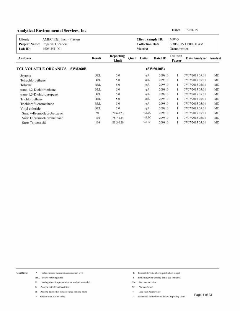
1506U51-001
7-Jul-15Date:Analytical Environmental Services, Inc
Analyses Date AnalyzedDilution
FactorBatchIDUnitsQual
Reporting
LimitResult
Client:
Groundwater
6/30/2015 11:00:00 AM
MW-5
Matrix:
Collection Date:
Client Sample ID:
Imperial Cleaners
AMEC E&I, Inc. - Plasters
Lab ID:
Project Name:
Analyst
(SW5030B)TCL VOLATILE ORGANICS SW8260B
Styrene BRL 5.0 ug/L 209810 1 07/07/2015 05:01 MD
Tetrachloroethene BRL 5.0 ug/L 209810 1 07/07/2015 05:01 MD
Toluene BRL 5.0 ug/L 209810 1 07/07/2015 05:01 MD
trans-1,2-Dichloroethene BRL 5.0 ug/L 209810 1 07/07/2015 05:01 MD
trans-1,3-Dichloropropene BRL 5.0 ug/L 209810 1 07/07/2015 05:01 MD
Trichloroethene BRL 5.0 ug/L 209810 1 07/07/2015 05:01 MD
Trichlorofluoromethane BRL 5.0 ug/L 209810 1 07/07/2015 05:01 MD
Vinyl chloride BRL 2.0 ug/L 209810 1 07/07/2015 05:01 MD
Surr: 4-Bromofluorobenzene 94 70.6-123 %REC 209810 1 07/07/2015 05:01 MD
Surr: Dibromofluoromethane 102 78.7-124 %REC 209810 1 07/07/2015 05:01 MD
Surr: Toluene-d8 108 81.3-120 %REC 209810 1 07/07/2015 05:01 MD
Qualifiers: * Value exceeds maximum contaminant level
BRL Below reporting limit
H Holding times for preparation or analysis exceeded
N Analyte not NELAC certified
B Analyte detected in the associated method blank
E Estimated (value above quantitation range)
S Spike Recovery outside limits due to matrix
Narr See case narrative
NC Not confirmed
< Less than Result value
> Greater than Result value J Estimated value detected below Reporting LimitPage 4 of 23

1506U51-002
7-Jul-15Date:Analytical Environmental Services, Inc
Analyses Date AnalyzedDilution
FactorBatchIDUnitsQual
Reporting
LimitResult
Client:
Groundwater
6/30/2015 11:45:00 AM
MW-4R
Matrix:
Collection Date:
Client Sample ID:
Imperial Cleaners
AMEC E&I, Inc. - Plasters
Lab ID:
Project Name:
Analyst
(SW5030B)TCL VOLATILE ORGANICS SW8260B
1,1,1-Trichloroethane BRL 5.0 ug/L 209810 1 07/07/2015 04:37 MD
1,1,2,2-Tetrachloroethane BRL 5.0 ug/L 209810 1 07/07/2015 04:37 MD
1,1,2-Trichloroethane BRL 5.0 ug/L 209810 1 07/07/2015 04:37 MD
1,1-Dichloroethane BRL 5.0 ug/L 209810 1 07/07/2015 04:37 MD
1,1-Dichloroethene BRL 5.0 ug/L 209810 1 07/07/2015 04:37 MD
1,2,4-Trichlorobenzene BRL 5.0 ug/L 209810 1 07/07/2015 04:37 MD
1,2-Dibromo-3-chloropropane BRL 5.0 ug/L 209810 1 07/07/2015 04:37 MD
1,2-Dibromoethane BRL 5.0 ug/L 209810 1 07/07/2015 04:37 MD
1,2-Dichlorobenzene BRL 5.0 ug/L 209810 1 07/07/2015 04:37 MD
1,2-Dichloroethane BRL 5.0 ug/L 209810 1 07/07/2015 04:37 MD
1,2-Dichloropropane BRL 5.0 ug/L 209810 1 07/07/2015 04:37 MD
1,3-Dichlorobenzene BRL 5.0 ug/L 209810 1 07/07/2015 04:37 MD
1,4-Dichlorobenzene BRL 5.0 ug/L 209810 1 07/07/2015 04:37 MD
2-Butanone BRL 50 ug/L 209810 1 07/07/2015 04:37 MD
2-Hexanone BRL 10 ug/L 209810 1 07/07/2015 04:37 MD
4-Methyl-2-pentanone BRL 10 ug/L 209810 1 07/07/2015 04:37 MD
Acetone BRL 50 ug/L 209810 1 07/07/2015 04:37 MD
Benzene BRL 5.0 ug/L 209810 1 07/07/2015 04:37 MD
Bromodichloromethane BRL 5.0 ug/L 209810 1 07/07/2015 04:37 MD
Bromoform BRL 5.0 ug/L 209810 1 07/07/2015 04:37 MD
Bromomethane BRL 5.0 ug/L 209810 1 07/07/2015 04:37 MD
Carbon disulfide BRL 5.0 ug/L 209810 1 07/07/2015 04:37 MD
Carbon tetrachloride BRL 5.0 ug/L 209810 1 07/07/2015 04:37 MD
Chlorobenzene BRL 5.0 ug/L 209810 1 07/07/2015 04:37 MD
Chloroethane BRL 10 ug/L 209810 1 07/07/2015 04:37 MD
Chloroform BRL 5.0 ug/L 209810 1 07/07/2015 04:37 MD
Chloromethane BRL 10 ug/L 209810 1 07/07/2015 04:37 MD
cis-1,2-Dichloroethene 8.4 5.0 ug/L 209810 1 07/07/2015 04:37 MD
cis-1,3-Dichloropropene BRL 5.0 ug/L 209810 1 07/07/2015 04:37 MD
Cyclohexane BRL 5.0 ug/L 209810 1 07/07/2015 04:37 MD
Dibromochloromethane BRL 5.0 ug/L 209810 1 07/07/2015 04:37 MD
Dichlorodifluoromethane BRL 10 ug/L 209810 1 07/07/2015 04:37 MD
Ethylbenzene BRL 5.0 ug/L 209810 1 07/07/2015 04:37 MD
Freon-113 BRL 10 ug/L 209810 1 07/07/2015 04:37 MD
Isopropylbenzene BRL 5.0 ug/L 209810 1 07/07/2015 04:37 MD
m,p-Xylene BRL 5.0 ug/L 209810 1 07/07/2015 04:37 MD
Methyl acetate BRL 5.0 ug/L 209810 1 07/07/2015 04:37 MD
Methyl tert-butyl ether BRL 5.0 ug/L 209810 1 07/07/2015 04:37 MD
Methylcyclohexane BRL 5.0 ug/L 209810 1 07/07/2015 04:37 MD
Methylene chloride BRL 5.0 ug/L 209810 1 07/07/2015 04:37 MD
o-Xylene BRL 5.0 ug/L 209810 1 07/07/2015 04:37 MD
Qualifiers: * Value exceeds maximum contaminant level
BRL Below reporting limit
H Holding times for preparation or analysis exceeded
N Analyte not NELAC certified
B Analyte detected in the associated method blank
E Estimated (value above quantitation range)
S Spike Recovery outside limits due to matrix
Narr See case narrative
NC Not confirmed
< Less than Result value
> Greater than Result value J Estimated value detected below Reporting LimitPage 5 of 23

1506U51-002
7-Jul-15Date:Analytical Environmental Services, Inc
Analyses Date AnalyzedDilution
FactorBatchIDUnitsQual
Reporting
LimitResult
Client:
Groundwater
6/30/2015 11:45:00 AM
MW-4R
Matrix:
Collection Date:
Client Sample ID:
Imperial Cleaners
AMEC E&I, Inc. - Plasters
Lab ID:
Project Name:
Analyst
(SW5030B)TCL VOLATILE ORGANICS SW8260B
Styrene BRL 5.0 ug/L 209810 1 07/07/2015 04:37 MD
Tetrachloroethene BRL 5.0 ug/L 209810 1 07/07/2015 04:37 MD
Toluene BRL 5.0 ug/L 209810 1 07/07/2015 04:37 MD
trans-1,2-Dichloroethene BRL 5.0 ug/L 209810 1 07/07/2015 04:37 MD
trans-1,3-Dichloropropene BRL 5.0 ug/L 209810 1 07/07/2015 04:37 MD
Trichloroethene BRL 5.0 ug/L 209810 1 07/07/2015 04:37 MD
Trichlorofluoromethane BRL 5.0 ug/L 209810 1 07/07/2015 04:37 MD
Vinyl chloride BRL 2.0 ug/L 209810 1 07/07/2015 04:37 MD
Surr: 4-Bromofluorobenzene 91.9 70.6-123 %REC 209810 1 07/07/2015 04:37 MD
Surr: Dibromofluoromethane 98.9 78.7-124 %REC 209810 1 07/07/2015 04:37 MD
Surr: Toluene-d8 105 81.3-120 %REC 209810 1 07/07/2015 04:37 MD
Qualifiers: * Value exceeds maximum contaminant level
BRL Below reporting limit
H Holding times for preparation or analysis exceeded
N Analyte not NELAC certified
B Analyte detected in the associated method blank
E Estimated (value above quantitation range)
S Spike Recovery outside limits due to matrix
Narr See case narrative
NC Not confirmed
< Less than Result value
> Greater than Result value J Estimated value detected below Reporting LimitPage 6 of 23

1506U51-003
7-Jul-15Date:Analytical Environmental Services, Inc
Analyses Date AnalyzedDilution
FactorBatchIDUnitsQual
Reporting
LimitResult
Client:
Groundwater
6/30/2015 12:50:00 PM
MW-12
Matrix:
Collection Date:
Client Sample ID:
Imperial Cleaners
AMEC E&I, Inc. - Plasters
Lab ID:
Project Name:
Analyst
(SW5030B)TCL VOLATILE ORGANICS SW8260B
1,1,1-Trichloroethane BRL 5.0 ug/L 209810 1 07/07/2015 05:25 MD
1,1,2,2-Tetrachloroethane BRL 5.0 ug/L 209810 1 07/07/2015 05:25 MD
1,1,2-Trichloroethane BRL 5.0 ug/L 209810 1 07/07/2015 05:25 MD
1,1-Dichloroethane BRL 5.0 ug/L 209810 1 07/07/2015 05:25 MD
1,1-Dichloroethene BRL 5.0 ug/L 209810 1 07/07/2015 05:25 MD
1,2,4-Trichlorobenzene BRL 5.0 ug/L 209810 1 07/07/2015 05:25 MD
1,2-Dibromo-3-chloropropane BRL 5.0 ug/L 209810 1 07/07/2015 05:25 MD
1,2-Dibromoethane BRL 5.0 ug/L 209810 1 07/07/2015 05:25 MD
1,2-Dichlorobenzene BRL 5.0 ug/L 209810 1 07/07/2015 05:25 MD
1,2-Dichloroethane BRL 5.0 ug/L 209810 1 07/07/2015 05:25 MD
1,2-Dichloropropane BRL 5.0 ug/L 209810 1 07/07/2015 05:25 MD
1,3-Dichlorobenzene BRL 5.0 ug/L 209810 1 07/07/2015 05:25 MD
1,4-Dichlorobenzene BRL 5.0 ug/L 209810 1 07/07/2015 05:25 MD
2-Butanone BRL 50 ug/L 209810 1 07/07/2015 05:25 MD
2-Hexanone BRL 10 ug/L 209810 1 07/07/2015 05:25 MD
4-Methyl-2-pentanone BRL 10 ug/L 209810 1 07/07/2015 05:25 MD
Acetone BRL 50 ug/L 209810 1 07/07/2015 05:25 MD
Benzene BRL 5.0 ug/L 209810 1 07/07/2015 05:25 MD
Bromodichloromethane BRL 5.0 ug/L 209810 1 07/07/2015 05:25 MD
Bromoform BRL 5.0 ug/L 209810 1 07/07/2015 05:25 MD
Bromomethane BRL 5.0 ug/L 209810 1 07/07/2015 05:25 MD
Carbon disulfide BRL 5.0 ug/L 209810 1 07/07/2015 05:25 MD
Carbon tetrachloride BRL 5.0 ug/L 209810 1 07/07/2015 05:25 MD
Chlorobenzene BRL 5.0 ug/L 209810 1 07/07/2015 05:25 MD
Chloroethane BRL 10 ug/L 209810 1 07/07/2015 05:25 MD
Chloroform BRL 5.0 ug/L 209810 1 07/07/2015 05:25 MD
Chloromethane BRL 10 ug/L 209810 1 07/07/2015 05:25 MD
cis-1,2-Dichloroethene BRL 5.0 ug/L 209810 1 07/07/2015 05:25 MD
cis-1,3-Dichloropropene BRL 5.0 ug/L 209810 1 07/07/2015 05:25 MD
Cyclohexane BRL 5.0 ug/L 209810 1 07/07/2015 05:25 MD
Dibromochloromethane BRL 5.0 ug/L 209810 1 07/07/2015 05:25 MD
Dichlorodifluoromethane BRL 10 ug/L 209810 1 07/07/2015 05:25 MD
Ethylbenzene BRL 5.0 ug/L 209810 1 07/07/2015 05:25 MD
Freon-113 BRL 10 ug/L 209810 1 07/07/2015 05:25 MD
Isopropylbenzene BRL 5.0 ug/L 209810 1 07/07/2015 05:25 MD
m,p-Xylene BRL 5.0 ug/L 209810 1 07/07/2015 05:25 MD
Methyl acetate BRL 5.0 ug/L 209810 1 07/07/2015 05:25 MD
Methyl tert-butyl ether BRL 5.0 ug/L 209810 1 07/07/2015 05:25 MD
Methylcyclohexane BRL 5.0 ug/L 209810 1 07/07/2015 05:25 MD
Methylene chloride BRL 5.0 ug/L 209810 1 07/07/2015 05:25 MD
o-Xylene BRL 5.0 ug/L 209810 1 07/07/2015 05:25 MD
Qualifiers: * Value exceeds maximum contaminant level
BRL Below reporting limit
H Holding times for preparation or analysis exceeded
N Analyte not NELAC certified
B Analyte detected in the associated method blank
E Estimated (value above quantitation range)
S Spike Recovery outside limits due to matrix
Narr See case narrative
NC Not confirmed
< Less than Result value
> Greater than Result value J Estimated value detected below Reporting LimitPage 7 of 23

1506U51-003
7-Jul-15Date:Analytical Environmental Services, Inc
Analyses Date AnalyzedDilution
FactorBatchIDUnitsQual
Reporting
LimitResult
Client:
Groundwater
6/30/2015 12:50:00 PM
MW-12
Matrix:
Collection Date:
Client Sample ID:
Imperial Cleaners
AMEC E&I, Inc. - Plasters
Lab ID:
Project Name:
Analyst
(SW5030B)TCL VOLATILE ORGANICS SW8260B
Styrene BRL 5.0 ug/L 209810 1 07/07/2015 05:25 MD
Tetrachloroethene BRL 5.0 ug/L 209810 1 07/07/2015 05:25 MD
Toluene BRL 5.0 ug/L 209810 1 07/07/2015 05:25 MD
trans-1,2-Dichloroethene BRL 5.0 ug/L 209810 1 07/07/2015 05:25 MD
trans-1,3-Dichloropropene BRL 5.0 ug/L 209810 1 07/07/2015 05:25 MD
Trichloroethene BRL 5.0 ug/L 209810 1 07/07/2015 05:25 MD
Trichlorofluoromethane BRL 5.0 ug/L 209810 1 07/07/2015 05:25 MD
Vinyl chloride BRL 2.0 ug/L 209810 1 07/07/2015 05:25 MD
Surr: 4-Bromofluorobenzene 91.2 70.6-123 %REC 209810 1 07/07/2015 05:25 MD
Surr: Dibromofluoromethane 103 78.7-124 %REC 209810 1 07/07/2015 05:25 MD
Surr: Toluene-d8 107 81.3-120 %REC 209810 1 07/07/2015 05:25 MD
Qualifiers: * Value exceeds maximum contaminant level
BRL Below reporting limit
H Holding times for preparation or analysis exceeded
N Analyte not NELAC certified
B Analyte detected in the associated method blank
E Estimated (value above quantitation range)
S Spike Recovery outside limits due to matrix
Narr See case narrative
NC Not confirmed
< Less than Result value
> Greater than Result value J Estimated value detected below Reporting LimitPage 8 of 23

1506U51-004
7-Jul-15Date:Analytical Environmental Services, Inc
Analyses Date AnalyzedDilution
FactorBatchIDUnitsQual
Reporting
LimitResult
Client:
Surface Water
6/30/2015 10:05:00 AM
SW-1
Matrix:
Collection Date:
Client Sample ID:
Imperial Cleaners
AMEC E&I, Inc. - Plasters
Lab ID:
Project Name:
Analyst
(SW5030B)TCL VOLATILE ORGANICS SW8260B
1,1,1-Trichloroethane BRL 5.0 ug/L 209810 1 07/07/2015 05:48 MD
1,1,2,2-Tetrachloroethane BRL 5.0 ug/L 209810 1 07/07/2015 05:48 MD
1,1,2-Trichloroethane BRL 5.0 ug/L 209810 1 07/07/2015 05:48 MD
1,1-Dichloroethane BRL 5.0 ug/L 209810 1 07/07/2015 05:48 MD
1,1-Dichloroethene BRL 5.0 ug/L 209810 1 07/07/2015 05:48 MD
1,2,4-Trichlorobenzene BRL 5.0 ug/L 209810 1 07/07/2015 05:48 MD
1,2-Dibromo-3-chloropropane BRL 5.0 ug/L 209810 1 07/07/2015 05:48 MD
1,2-Dibromoethane BRL 5.0 ug/L 209810 1 07/07/2015 05:48 MD
1,2-Dichlorobenzene BRL 5.0 ug/L 209810 1 07/07/2015 05:48 MD
1,2-Dichloroethane BRL 5.0 ug/L 209810 1 07/07/2015 05:48 MD
1,2-Dichloropropane BRL 5.0 ug/L 209810 1 07/07/2015 05:48 MD
1,3-Dichlorobenzene BRL 5.0 ug/L 209810 1 07/07/2015 05:48 MD
1,4-Dichlorobenzene BRL 5.0 ug/L 209810 1 07/07/2015 05:48 MD
2-Butanone BRL 50 ug/L 209810 1 07/07/2015 05:48 MD
2-Hexanone BRL 10 ug/L 209810 1 07/07/2015 05:48 MD
4-Methyl-2-pentanone BRL 10 ug/L 209810 1 07/07/2015 05:48 MD
Acetone BRL 50 ug/L 209810 1 07/07/2015 05:48 MD
Benzene BRL 5.0 ug/L 209810 1 07/07/2015 05:48 MD
Bromodichloromethane BRL 5.0 ug/L 209810 1 07/07/2015 05:48 MD
Bromoform BRL 5.0 ug/L 209810 1 07/07/2015 05:48 MD
Bromomethane BRL 5.0 ug/L 209810 1 07/07/2015 05:48 MD
Carbon disulfide BRL 5.0 ug/L 209810 1 07/07/2015 05:48 MD
Carbon tetrachloride BRL 5.0 ug/L 209810 1 07/07/2015 05:48 MD
Chlorobenzene BRL 5.0 ug/L 209810 1 07/07/2015 05:48 MD
Chloroethane BRL 10 ug/L 209810 1 07/07/2015 05:48 MD
Chloroform BRL 5.0 ug/L 209810 1 07/07/2015 05:48 MD
Chloromethane BRL 10 ug/L 209810 1 07/07/2015 05:48 MD
cis-1,2-Dichloroethene BRL 5.0 ug/L 209810 1 07/07/2015 05:48 MD
cis-1,3-Dichloropropene BRL 5.0 ug/L 209810 1 07/07/2015 05:48 MD
Cyclohexane BRL 5.0 ug/L 209810 1 07/07/2015 05:48 MD
Dibromochloromethane BRL 5.0 ug/L 209810 1 07/07/2015 05:48 MD
Dichlorodifluoromethane BRL 10 ug/L 209810 1 07/07/2015 05:48 MD
Ethylbenzene BRL 5.0 ug/L 209810 1 07/07/2015 05:48 MD
Freon-113 BRL 10 ug/L 209810 1 07/07/2015 05:48 MD
Isopropylbenzene BRL 5.0 ug/L 209810 1 07/07/2015 05:48 MD
m,p-Xylene BRL 5.0 ug/L 209810 1 07/07/2015 05:48 MD
Methyl acetate BRL 5.0 ug/L 209810 1 07/07/2015 05:48 MD
Methyl tert-butyl ether BRL 5.0 ug/L 209810 1 07/07/2015 05:48 MD
Methylcyclohexane BRL 5.0 ug/L 209810 1 07/07/2015 05:48 MD
Methylene chloride BRL 5.0 ug/L 209810 1 07/07/2015 05:48 MD
o-Xylene BRL 5.0 ug/L 209810 1 07/07/2015 05:48 MD
Qualifiers: * Value exceeds maximum contaminant level
BRL Below reporting limit
H Holding times for preparation or analysis exceeded
N Analyte not NELAC certified
B Analyte detected in the associated method blank
E Estimated (value above quantitation range)
S Spike Recovery outside limits due to matrix
Narr See case narrative
NC Not confirmed
< Less than Result value
> Greater than Result value J Estimated value detected below Reporting LimitPage 9 of 23

1506U51-004
7-Jul-15Date:Analytical Environmental Services, Inc
Analyses Date AnalyzedDilution
FactorBatchIDUnitsQual
Reporting
LimitResult
Client:
Surface Water
6/30/2015 10:05:00 AM
SW-1
Matrix:
Collection Date:
Client Sample ID:
Imperial Cleaners
AMEC E&I, Inc. - Plasters
Lab ID:
Project Name:
Analyst
(SW5030B)TCL VOLATILE ORGANICS SW8260B
Styrene BRL 5.0 ug/L 209810 1 07/07/2015 05:48 MD
Tetrachloroethene BRL 5.0 ug/L 209810 1 07/07/2015 05:48 MD
Toluene BRL 5.0 ug/L 209810 1 07/07/2015 05:48 MD
trans-1,2-Dichloroethene BRL 5.0 ug/L 209810 1 07/07/2015 05:48 MD
trans-1,3-Dichloropropene BRL 5.0 ug/L 209810 1 07/07/2015 05:48 MD
Trichloroethene BRL 5.0 ug/L 209810 1 07/07/2015 05:48 MD
Trichlorofluoromethane BRL 5.0 ug/L 209810 1 07/07/2015 05:48 MD
Vinyl chloride BRL 2.0 ug/L 209810 1 07/07/2015 05:48 MD
Surr: 4-Bromofluorobenzene 91.5 70.6-123 %REC 209810 1 07/07/2015 05:48 MD
Surr: Dibromofluoromethane 101 78.7-124 %REC 209810 1 07/07/2015 05:48 MD
Surr: Toluene-d8 105 81.3-120 %REC 209810 1 07/07/2015 05:48 MD
Qualifiers: * Value exceeds maximum contaminant level
BRL Below reporting limit
H Holding times for preparation or analysis exceeded
N Analyte not NELAC certified
B Analyte detected in the associated method blank
E Estimated (value above quantitation range)
S Spike Recovery outside limits due to matrix
Narr See case narrative
NC Not confirmed
< Less than Result value
> Greater than Result value J Estimated value detected below Reporting LimitPage 10 of 23

1506U51-005
7-Jul-15Date:Analytical Environmental Services, Inc
Analyses Date AnalyzedDilution
FactorBatchIDUnitsQual
Reporting
LimitResult
Client:
Surface Water
6/30/2015 10:10:00 AM
SW-2
Matrix:
Collection Date:
Client Sample ID:
Imperial Cleaners
AMEC E&I, Inc. - Plasters
Lab ID:
Project Name:
Analyst
(SW5030B)TCL VOLATILE ORGANICS SW8260B
1,1,1-Trichloroethane BRL 5.0 ug/L 209810 1 07/07/2015 06:11 MD
1,1,2,2-Tetrachloroethane BRL 5.0 ug/L 209810 1 07/07/2015 06:11 MD
1,1,2-Trichloroethane BRL 5.0 ug/L 209810 1 07/07/2015 06:11 MD
1,1-Dichloroethane BRL 5.0 ug/L 209810 1 07/07/2015 06:11 MD
1,1-Dichloroethene BRL 5.0 ug/L 209810 1 07/07/2015 06:11 MD
1,2,4-Trichlorobenzene BRL 5.0 ug/L 209810 1 07/07/2015 06:11 MD
1,2-Dibromo-3-chloropropane BRL 5.0 ug/L 209810 1 07/07/2015 06:11 MD
1,2-Dibromoethane BRL 5.0 ug/L 209810 1 07/07/2015 06:11 MD
1,2-Dichlorobenzene BRL 5.0 ug/L 209810 1 07/07/2015 06:11 MD
1,2-Dichloroethane BRL 5.0 ug/L 209810 1 07/07/2015 06:11 MD
1,2-Dichloropropane BRL 5.0 ug/L 209810 1 07/07/2015 06:11 MD
1,3-Dichlorobenzene BRL 5.0 ug/L 209810 1 07/07/2015 06:11 MD
1,4-Dichlorobenzene BRL 5.0 ug/L 209810 1 07/07/2015 06:11 MD
2-Butanone BRL 50 ug/L 209810 1 07/07/2015 06:11 MD
2-Hexanone BRL 10 ug/L 209810 1 07/07/2015 06:11 MD
4-Methyl-2-pentanone BRL 10 ug/L 209810 1 07/07/2015 06:11 MD
Acetone BRL 50 ug/L 209810 1 07/07/2015 06:11 MD
Benzene BRL 5.0 ug/L 209810 1 07/07/2015 06:11 MD
Bromodichloromethane BRL 5.0 ug/L 209810 1 07/07/2015 06:11 MD
Bromoform BRL 5.0 ug/L 209810 1 07/07/2015 06:11 MD
Bromomethane BRL 5.0 ug/L 209810 1 07/07/2015 06:11 MD
Carbon disulfide BRL 5.0 ug/L 209810 1 07/07/2015 06:11 MD
Carbon tetrachloride BRL 5.0 ug/L 209810 1 07/07/2015 06:11 MD
Chlorobenzene BRL 5.0 ug/L 209810 1 07/07/2015 06:11 MD
Chloroethane BRL 10 ug/L 209810 1 07/07/2015 06:11 MD
Chloroform BRL 5.0 ug/L 209810 1 07/07/2015 06:11 MD
Chloromethane BRL 10 ug/L 209810 1 07/07/2015 06:11 MD
cis-1,2-Dichloroethene BRL 5.0 ug/L 209810 1 07/07/2015 06:11 MD
cis-1,3-Dichloropropene BRL 5.0 ug/L 209810 1 07/07/2015 06:11 MD
Cyclohexane BRL 5.0 ug/L 209810 1 07/07/2015 06:11 MD
Dibromochloromethane BRL 5.0 ug/L 209810 1 07/07/2015 06:11 MD
Dichlorodifluoromethane BRL 10 ug/L 209810 1 07/07/2015 06:11 MD
Ethylbenzene BRL 5.0 ug/L 209810 1 07/07/2015 06:11 MD
Freon-113 BRL 10 ug/L 209810 1 07/07/2015 06:11 MD
Isopropylbenzene BRL 5.0 ug/L 209810 1 07/07/2015 06:11 MD
m,p-Xylene BRL 5.0 ug/L 209810 1 07/07/2015 06:11 MD
Methyl acetate BRL 5.0 ug/L 209810 1 07/07/2015 06:11 MD
Methyl tert-butyl ether BRL 5.0 ug/L 209810 1 07/07/2015 06:11 MD
Methylcyclohexane BRL 5.0 ug/L 209810 1 07/07/2015 06:11 MD
Methylene chloride BRL 5.0 ug/L 209810 1 07/07/2015 06:11 MD
o-Xylene BRL 5.0 ug/L 209810 1 07/07/2015 06:11 MD
Qualifiers: * Value exceeds maximum contaminant level
BRL Below reporting limit
H Holding times for preparation or analysis exceeded
N Analyte not NELAC certified
B Analyte detected in the associated method blank
E Estimated (value above quantitation range)
S Spike Recovery outside limits due to matrix
Narr See case narrative
NC Not confirmed
< Less than Result value
> Greater than Result value J Estimated value detected below Reporting LimitPage 11 of 23

1506U51-005
7-Jul-15Date:Analytical Environmental Services, Inc
Analyses Date AnalyzedDilution
FactorBatchIDUnitsQual
Reporting
LimitResult
Client:
Surface Water
6/30/2015 10:10:00 AM
SW-2
Matrix:
Collection Date:
Client Sample ID:
Imperial Cleaners
AMEC E&I, Inc. - Plasters
Lab ID:
Project Name:
Analyst
(SW5030B)TCL VOLATILE ORGANICS SW8260B
Styrene BRL 5.0 ug/L 209810 1 07/07/2015 06:11 MD
Tetrachloroethene BRL 5.0 ug/L 209810 1 07/07/2015 06:11 MD
Toluene BRL 5.0 ug/L 209810 1 07/07/2015 06:11 MD
trans-1,2-Dichloroethene BRL 5.0 ug/L 209810 1 07/07/2015 06:11 MD
trans-1,3-Dichloropropene BRL 5.0 ug/L 209810 1 07/07/2015 06:11 MD
Trichloroethene BRL 5.0 ug/L 209810 1 07/07/2015 06:11 MD
Trichlorofluoromethane BRL 5.0 ug/L 209810 1 07/07/2015 06:11 MD
Vinyl chloride BRL 2.0 ug/L 209810 1 07/07/2015 06:11 MD
Surr: 4-Bromofluorobenzene 90.8 70.6-123 %REC 209810 1 07/07/2015 06:11 MD
Surr: Dibromofluoromethane 99.2 78.7-124 %REC 209810 1 07/07/2015 06:11 MD
Surr: Toluene-d8 107 81.3-120 %REC 209810 1 07/07/2015 06:11 MD
Qualifiers: * Value exceeds maximum contaminant level
BRL Below reporting limit
H Holding times for preparation or analysis exceeded
N Analyte not NELAC certified
B Analyte detected in the associated method blank
E Estimated (value above quantitation range)
S Spike Recovery outside limits due to matrix
Narr See case narrative
NC Not confirmed
< Less than Result value
> Greater than Result value J Estimated value detected below Reporting LimitPage 12 of 23

1506U51-006
7-Jul-15Date:Analytical Environmental Services, Inc
Analyses Date AnalyzedDilution
FactorBatchIDUnitsQual
Reporting
LimitResult
Client:
Surface Water
6/30/2015 10:15:00 AM
SW-3
Matrix:
Collection Date:
Client Sample ID:
Imperial Cleaners
AMEC E&I, Inc. - Plasters
Lab ID:
Project Name:
Analyst
(SW5030B)TCL VOLATILE ORGANICS SW8260B
1,1,1-Trichloroethane BRL 5.0 ug/L 209810 1 07/07/2015 06:35 MD
1,1,2,2-Tetrachloroethane BRL 5.0 ug/L 209810 1 07/07/2015 06:35 MD
1,1,2-Trichloroethane BRL 5.0 ug/L 209810 1 07/07/2015 06:35 MD
1,1-Dichloroethane BRL 5.0 ug/L 209810 1 07/07/2015 06:35 MD
1,1-Dichloroethene BRL 5.0 ug/L 209810 1 07/07/2015 06:35 MD
1,2,4-Trichlorobenzene BRL 5.0 ug/L 209810 1 07/07/2015 06:35 MD
1,2-Dibromo-3-chloropropane BRL 5.0 ug/L 209810 1 07/07/2015 06:35 MD
1,2-Dibromoethane BRL 5.0 ug/L 209810 1 07/07/2015 06:35 MD
1,2-Dichlorobenzene BRL 5.0 ug/L 209810 1 07/07/2015 06:35 MD
1,2-Dichloroethane BRL 5.0 ug/L 209810 1 07/07/2015 06:35 MD
1,2-Dichloropropane BRL 5.0 ug/L 209810 1 07/07/2015 06:35 MD
1,3-Dichlorobenzene BRL 5.0 ug/L 209810 1 07/07/2015 06:35 MD
1,4-Dichlorobenzene BRL 5.0 ug/L 209810 1 07/07/2015 06:35 MD
2-Butanone BRL 50 ug/L 209810 1 07/07/2015 06:35 MD
2-Hexanone BRL 10 ug/L 209810 1 07/07/2015 06:35 MD
4-Methyl-2-pentanone BRL 10 ug/L 209810 1 07/07/2015 06:35 MD
Acetone BRL 50 ug/L 209810 1 07/07/2015 06:35 MD
Benzene BRL 5.0 ug/L 209810 1 07/07/2015 06:35 MD
Bromodichloromethane BRL 5.0 ug/L 209810 1 07/07/2015 06:35 MD
Bromoform BRL 5.0 ug/L 209810 1 07/07/2015 06:35 MD
Bromomethane BRL 5.0 ug/L 209810 1 07/07/2015 06:35 MD
Carbon disulfide BRL 5.0 ug/L 209810 1 07/07/2015 06:35 MD
Carbon tetrachloride BRL 5.0 ug/L 209810 1 07/07/2015 06:35 MD
Chlorobenzene BRL 5.0 ug/L 209810 1 07/07/2015 06:35 MD
Chloroethane BRL 10 ug/L 209810 1 07/07/2015 06:35 MD
Chloroform BRL 5.0 ug/L 209810 1 07/07/2015 06:35 MD
Chloromethane BRL 10 ug/L 209810 1 07/07/2015 06:35 MD
cis-1,2-Dichloroethene BRL 5.0 ug/L 209810 1 07/07/2015 06:35 MD
cis-1,3-Dichloropropene BRL 5.0 ug/L 209810 1 07/07/2015 06:35 MD
Cyclohexane BRL 5.0 ug/L 209810 1 07/07/2015 06:35 MD
Dibromochloromethane BRL 5.0 ug/L 209810 1 07/07/2015 06:35 MD
Dichlorodifluoromethane BRL 10 ug/L 209810 1 07/07/2015 06:35 MD
Ethylbenzene BRL 5.0 ug/L 209810 1 07/07/2015 06:35 MD
Freon-113 BRL 10 ug/L 209810 1 07/07/2015 06:35 MD
Isopropylbenzene BRL 5.0 ug/L 209810 1 07/07/2015 06:35 MD
m,p-Xylene BRL 5.0 ug/L 209810 1 07/07/2015 06:35 MD
Methyl acetate BRL 5.0 ug/L 209810 1 07/07/2015 06:35 MD
Methyl tert-butyl ether BRL 5.0 ug/L 209810 1 07/07/2015 06:35 MD
Methylcyclohexane BRL 5.0 ug/L 209810 1 07/07/2015 06:35 MD
Methylene chloride BRL 5.0 ug/L 209810 1 07/07/2015 06:35 MD
o-Xylene BRL 5.0 ug/L 209810 1 07/07/2015 06:35 MD
Qualifiers: * Value exceeds maximum contaminant level
BRL Below reporting limit
H Holding times for preparation or analysis exceeded
N Analyte not NELAC certified
B Analyte detected in the associated method blank
E Estimated (value above quantitation range)
S Spike Recovery outside limits due to matrix
Narr See case narrative
NC Not confirmed
< Less than Result value
> Greater than Result value J Estimated value detected below Reporting LimitPage 13 of 23

1506U51-006
7-Jul-15Date:Analytical Environmental Services, Inc
Analyses Date AnalyzedDilution
FactorBatchIDUnitsQual
Reporting
LimitResult
Client:
Surface Water
6/30/2015 10:15:00 AM
SW-3
Matrix:
Collection Date:
Client Sample ID:
Imperial Cleaners
AMEC E&I, Inc. - Plasters
Lab ID:
Project Name:
Analyst
(SW5030B)TCL VOLATILE ORGANICS SW8260B
Styrene BRL 5.0 ug/L 209810 1 07/07/2015 06:35 MD
Tetrachloroethene BRL 5.0 ug/L 209810 1 07/07/2015 06:35 MD
Toluene BRL 5.0 ug/L 209810 1 07/07/2015 06:35 MD
trans-1,2-Dichloroethene BRL 5.0 ug/L 209810 1 07/07/2015 06:35 MD
trans-1,3-Dichloropropene BRL 5.0 ug/L 209810 1 07/07/2015 06:35 MD
Trichloroethene BRL 5.0 ug/L 209810 1 07/07/2015 06:35 MD
Trichlorofluoromethane BRL 5.0 ug/L 209810 1 07/07/2015 06:35 MD
Vinyl chloride BRL 2.0 ug/L 209810 1 07/07/2015 06:35 MD
Surr: 4-Bromofluorobenzene 95 70.6-123 %REC 209810 1 07/07/2015 06:35 MD
Surr: Dibromofluoromethane 99.5 78.7-124 %REC 209810 1 07/07/2015 06:35 MD
Surr: Toluene-d8 107 81.3-120 %REC 209810 1 07/07/2015 06:35 MD
Qualifiers: * Value exceeds maximum contaminant level
BRL Below reporting limit
H Holding times for preparation or analysis exceeded
N Analyte not NELAC certified
B Analyte detected in the associated method blank
E Estimated (value above quantitation range)
S Spike Recovery outside limits due to matrix
Narr See case narrative
NC Not confirmed
< Less than Result value
> Greater than Result value J Estimated value detected below Reporting LimitPage 14 of 23
1506U51-007
7-Jul-15Date:Analytical Environmental Services, Inc
Analyses Date AnalyzedDilution
FactorBatchIDUnitsQual
Reporting
LimitResult
Client:
Aqueous
6/30/2015
DUP
Matrix:
Collection Date:
Client Sample ID:
Imperial Cleaners
AMEC E&I, Inc. - Plasters
Lab ID:
Project Name:
Analyst
(SW5030B)TCL VOLATILE ORGANICS SW8260B
1,1,1-Trichloroethane BRL 5.0 ug/L 209810 1 07/07/2015 06:58 MD
1,1,2,2-Tetrachloroethane BRL 5.0 ug/L 209810 1 07/07/2015 06:58 MD
1,1,2-Trichloroethane BRL 5.0 ug/L 209810 1 07/07/2015 06:58 MD
1,1-Dichloroethane BRL 5.0 ug/L 209810 1 07/07/2015 06:58 MD
1,1-Dichloroethene BRL 5.0 ug/L 209810 1 07/07/2015 06:58 MD
1,2,4-Trichlorobenzene BRL 5.0 ug/L 209810 1 07/07/2015 06:58 MD
1,2-Dibromo-3-chloropropane BRL 5.0 ug/L 209810 1 07/07/2015 06:58 MD
1,2-Dibromoethane BRL 5.0 ug/L 209810 1 07/07/2015 06:58 MD
1,2-Dichlorobenzene BRL 5.0 ug/L 209810 1 07/07/2015 06:58 MD
1,2-Dichloroethane BRL 5.0 ug/L 209810 1 07/07/2015 06:58 MD
1,2-Dichloropropane BRL 5.0 ug/L 209810 1 07/07/2015 06:58 MD
1,3-Dichlorobenzene BRL 5.0 ug/L 209810 1 07/07/2015 06:58 MD
1,4-Dichlorobenzene BRL 5.0 ug/L 209810 1 07/07/2015 06:58 MD
2-Butanone BRL 50 ug/L 209810 1 07/07/2015 06:58 MD
2-Hexanone BRL 10 ug/L 209810 1 07/07/2015 06:58 MD
4-Methyl-2-pentanone BRL 10 ug/L 209810 1 07/07/2015 06:58 MD
Acetone BRL 50 ug/L 209810 1 07/07/2015 06:58 MD
Benzene BRL 5.0 ug/L 209810 1 07/07/2015 06:58 MD
Bromodichloromethane BRL 5.0 ug/L 209810 1 07/07/2015 06:58 MD
Bromoform BRL 5.0 ug/L 209810 1 07/07/2015 06:58 MD
Bromomethane BRL 5.0 ug/L 209810 1 07/07/2015 06:58 MD
Carbon disulfide BRL 5.0 ug/L 209810 1 07/07/2015 06:58 MD
Carbon tetrachloride BRL 5.0 ug/L 209810 1 07/07/2015 06:58 MD
Chlorobenzene BRL 5.0 ug/L 209810 1 07/07/2015 06:58 MD
Chloroethane BRL 10 ug/L 209810 1 07/07/2015 06:58 MD
Chloroform BRL 5.0 ug/L 209810 1 07/07/2015 06:58 MD
Chloromethane BRL 10 ug/L 209810 1 07/07/2015 06:58 MD
cis-1,2-Dichloroethene BRL 5.0 ug/L 209810 1 07/07/2015 06:58 MD
cis-1,3-Dichloropropene BRL 5.0 ug/L 209810 1 07/07/2015 06:58 MD
Cyclohexane BRL 5.0 ug/L 209810 1 07/07/2015 06:58 MD
Dibromochloromethane BRL 5.0 ug/L 209810 1 07/07/2015 06:58 MD
Dichlorodifluoromethane BRL 10 ug/L 209810 1 07/07/2015 06:58 MD
Ethylbenzene BRL 5.0 ug/L 209810 1 07/07/2015 06:58 MD
Freon-113 BRL 10 ug/L 209810 1 07/07/2015 06:58 MD
Isopropylbenzene BRL 5.0 ug/L 209810 1 07/07/2015 06:58 MD
m,p-Xylene BRL 5.0 ug/L 209810 1 07/07/2015 06:58 MD
Methyl acetate BRL 5.0 ug/L 209810 1 07/07/2015 06:58 MD
Methyl tert-butyl ether BRL 5.0 ug/L 209810 1 07/07/2015 06:58 MD
Methylcyclohexane BRL 5.0 ug/L 209810 1 07/07/2015 06:58 MD
Methylene chloride BRL 5.0 ug/L 209810 1 07/07/2015 06:58 MD
o-Xylene BRL 5.0 ug/L 209810 1 07/07/2015 06:58 MD
Qualifiers: * Value exceeds maximum contaminant level
BRL Below reporting limit
H Holding times for preparation or analysis exceeded
N Analyte not NELAC certified
B Analyte detected in the associated method blank
E Estimated (value above quantitation range)
S Spike Recovery outside limits due to matrix
Narr See case narrative
NC Not confirmed
< Less than Result value
> Greater than Result value J Estimated value detected below Reporting LimitPage 15 of 23

1506U51-007
7-Jul-15Date:Analytical Environmental Services, Inc
Analyses Date AnalyzedDilution
FactorBatchIDUnitsQual
Reporting
LimitResult
Client:
Aqueous
6/30/2015
DUP
Matrix:
Collection Date:
Client Sample ID:
Imperial Cleaners
AMEC E&I, Inc. - Plasters
Lab ID:
Project Name:
Analyst
(SW5030B)TCL VOLATILE ORGANICS SW8260B
Styrene BRL 5.0 ug/L 209810 1 07/07/2015 06:58 MD
Tetrachloroethene BRL 5.0 ug/L 209810 1 07/07/2015 06:58 MD
Toluene BRL 5.0 ug/L 209810 1 07/07/2015 06:58 MD
trans-1,2-Dichloroethene BRL 5.0 ug/L 209810 1 07/07/2015 06:58 MD
trans-1,3-Dichloropropene BRL 5.0 ug/L 209810 1 07/07/2015 06:58 MD
Trichloroethene BRL 5.0 ug/L 209810 1 07/07/2015 06:58 MD
Trichlorofluoromethane BRL 5.0 ug/L 209810 1 07/07/2015 06:58 MD
Vinyl chloride BRL 2.0 ug/L 209810 1 07/07/2015 06:58 MD
Surr: 4-Bromofluorobenzene 91.3 70.6-123 %REC 209810 1 07/07/2015 06:58 MD
Surr: Dibromofluoromethane 105 78.7-124 %REC 209810 1 07/07/2015 06:58 MD
Surr: Toluene-d8 110 81.3-120 %REC 209810 1 07/07/2015 06:58 MD
Qualifiers: * Value exceeds maximum contaminant level
BRL Below reporting limit
H Holding times for preparation or analysis exceeded
N Analyte not NELAC certified
B Analyte detected in the associated method blank
E Estimated (value above quantitation range)
S Spike Recovery outside limits due to matrix
Narr See case narrative
NC Not confirmed
< Less than Result value
> Greater than Result value J Estimated value detected below Reporting LimitPage 16 of 23
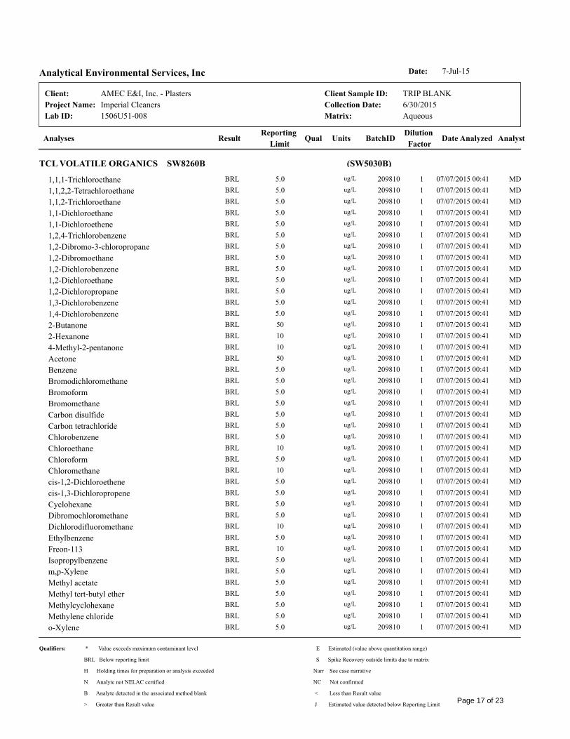
1506U51-008
7-Jul-15Date:Analytical Environmental Services, Inc
Analyses Date AnalyzedDilution
FactorBatchIDUnitsQual
Reporting
LimitResult
Client:
Aqueous
6/30/2015
TRIP BLANK
Matrix:
Collection Date:
Client Sample ID:
Imperial Cleaners
AMEC E&I, Inc. - Plasters
Lab ID:
Project Name:
Analyst
(SW5030B)TCL VOLATILE ORGANICS SW8260B
1,1,1-Trichloroethane BRL 5.0 ug/L 209810 1 07/07/2015 00:41 MD
1,1,2,2-Tetrachloroethane BRL 5.0 ug/L 209810 1 07/07/2015 00:41 MD
1,1,2-Trichloroethane BRL 5.0 ug/L 209810 1 07/07/2015 00:41 MD
1,1-Dichloroethane BRL 5.0 ug/L 209810 1 07/07/2015 00:41 MD
1,1-Dichloroethene BRL 5.0 ug/L 209810 1 07/07/2015 00:41 MD
1,2,4-Trichlorobenzene BRL 5.0 ug/L 209810 1 07/07/2015 00:41 MD
1,2-Dibromo-3-chloropropane BRL 5.0 ug/L 209810 1 07/07/2015 00:41 MD
1,2-Dibromoethane BRL 5.0 ug/L 209810 1 07/07/2015 00:41 MD
1,2-Dichlorobenzene BRL 5.0 ug/L 209810 1 07/07/2015 00:41 MD
1,2-Dichloroethane BRL 5.0 ug/L 209810 1 07/07/2015 00:41 MD
1,2-Dichloropropane BRL 5.0 ug/L 209810 1 07/07/2015 00:41 MD
1,3-Dichlorobenzene BRL 5.0 ug/L 209810 1 07/07/2015 00:41 MD
1,4-Dichlorobenzene BRL 5.0 ug/L 209810 1 07/07/2015 00:41 MD
2-Butanone BRL 50 ug/L 209810 1 07/07/2015 00:41 MD
2-Hexanone BRL 10 ug/L 209810 1 07/07/2015 00:41 MD
4-Methyl-2-pentanone BRL 10 ug/L 209810 1 07/07/2015 00:41 MD
Acetone BRL 50 ug/L 209810 1 07/07/2015 00:41 MD
Benzene BRL 5.0 ug/L 209810 1 07/07/2015 00:41 MD
Bromodichloromethane BRL 5.0 ug/L 209810 1 07/07/2015 00:41 MD
Bromoform BRL 5.0 ug/L 209810 1 07/07/2015 00:41 MD
Bromomethane BRL 5.0 ug/L 209810 1 07/07/2015 00:41 MD
Carbon disulfide BRL 5.0 ug/L 209810 1 07/07/2015 00:41 MD
Carbon tetrachloride BRL 5.0 ug/L 209810 1 07/07/2015 00:41 MD
Chlorobenzene BRL 5.0 ug/L 209810 1 07/07/2015 00:41 MD
Chloroethane BRL 10 ug/L 209810 1 07/07/2015 00:41 MD
Chloroform BRL 5.0 ug/L 209810 1 07/07/2015 00:41 MD
Chloromethane BRL 10 ug/L 209810 1 07/07/2015 00:41 MD
cis-1,2-Dichloroethene BRL 5.0 ug/L 209810 1 07/07/2015 00:41 MD
cis-1,3-Dichloropropene BRL 5.0 ug/L 209810 1 07/07/2015 00:41 MD
Cyclohexane BRL 5.0 ug/L 209810 1 07/07/2015 00:41 MD
Dibromochloromethane BRL 5.0 ug/L 209810 1 07/07/2015 00:41 MD
Dichlorodifluoromethane BRL 10 ug/L 209810 1 07/07/2015 00:41 MD
Ethylbenzene BRL 5.0 ug/L 209810 1 07/07/2015 00:41 MD
Freon-113 BRL 10 ug/L 209810 1 07/07/2015 00:41 MD
Isopropylbenzene BRL 5.0 ug/L 209810 1 07/07/2015 00:41 MD
m,p-Xylene BRL 5.0 ug/L 209810 1 07/07/2015 00:41 MD
Methyl acetate BRL 5.0 ug/L 209810 1 07/07/2015 00:41 MD
Methyl tert-butyl ether BRL 5.0 ug/L 209810 1 07/07/2015 00:41 MD
Methylcyclohexane BRL 5.0 ug/L 209810 1 07/07/2015 00:41 MD
Methylene chloride BRL 5.0 ug/L 209810 1 07/07/2015 00:41 MD
o-Xylene BRL 5.0 ug/L 209810 1 07/07/2015 00:41 MD
Qualifiers: * Value exceeds maximum contaminant level
BRL Below reporting limit
H Holding times for preparation or analysis exceeded
N Analyte not NELAC certified
B Analyte detected in the associated method blank
E Estimated (value above quantitation range)
S Spike Recovery outside limits due to matrix
Narr See case narrative
NC Not confirmed
< Less than Result value
> Greater than Result value J Estimated value detected below Reporting LimitPage 17 of 23

1506U51-008
7-Jul-15Date:Analytical Environmental Services, Inc
Analyses Date AnalyzedDilution
FactorBatchIDUnitsQual
Reporting
LimitResult
Client:
Aqueous
6/30/2015
TRIP BLANK
Matrix:
Collection Date:
Client Sample ID:
Imperial Cleaners
AMEC E&I, Inc. - Plasters
Lab ID:
Project Name:
Analyst
(SW5030B)TCL VOLATILE ORGANICS SW8260B
Styrene BRL 5.0 ug/L 209810 1 07/07/2015 00:41 MD
Tetrachloroethene BRL 5.0 ug/L 209810 1 07/07/2015 00:41 MD
Toluene BRL 5.0 ug/L 209810 1 07/07/2015 00:41 MD
trans-1,2-Dichloroethene BRL 5.0 ug/L 209810 1 07/07/2015 00:41 MD
trans-1,3-Dichloropropene BRL 5.0 ug/L 209810 1 07/07/2015 00:41 MD
Trichloroethene BRL 5.0 ug/L 209810 1 07/07/2015 00:41 MD
Trichlorofluoromethane BRL 5.0 ug/L 209810 1 07/07/2015 00:41 MD
Vinyl chloride BRL 2.0 ug/L 209810 1 07/07/2015 00:41 MD
Surr: 4-Bromofluorobenzene 92.1 70.6-123 %REC 209810 1 07/07/2015 00:41 MD
Surr: Dibromofluoromethane 95.3 78.7-124 %REC 209810 1 07/07/2015 00:41 MD
Surr: Toluene-d8 103 81.3-120 %REC 209810 1 07/07/2015 00:41 MD
Qualifiers: * Value exceeds maximum contaminant level
BRL Below reporting limit
H Holding times for preparation or analysis exceeded
N Analyte not NELAC certified
B Analyte detected in the associated method blank
E Estimated (value above quantitation range)
S Spike Recovery outside limits due to matrix
Narr See case narrative
NC Not confirmed
< Less than Result value
> Greater than Result value J Estimated value detected below Reporting LimitPage 18 of 23

Page 19 of 23

7-Jul-15Date:Analytical Environmental Services, Inc
Client:
BatchID:Workorder:
Project Name:ANALYTICAL QC SUMMARY REPORT
Imperial Cleaners
1506U51
AMEC E&I, Inc. - Plasters
209810
RPT Limit QualAnalyte Result SPK value SPK Ref Val %REC Low Limit High Limit RPD Ref Val %RPD RPD Limit
SampleType: BatchID: Analysis Date: Seq No:TestCode: 209810MBLK 07/06/2015TCL VOLATILE ORGANICS SW8260B
Units: Prep Date:Sample ID: Client ID: Run No:ug/L 07/06/2015 295399MB-209810
6298301
1,1,1-Trichloroethane 5.0BRL
1,1,2,2-Tetrachloroethane 5.0BRL
1,1,2-Trichloroethane 5.0BRL
1,1-Dichloroethane 5.0BRL
1,1-Dichloroethene 5.0BRL
1,2,4-Trichlorobenzene 5.0BRL
1,2-Dibromo-3-chloropropane 5.0BRL
1,2-Dibromoethane 5.0BRL
1,2-Dichlorobenzene 5.0BRL
1,2-Dichloroethane 5.0BRL
1,2-Dichloropropane 5.0BRL
1,3-Dichlorobenzene 5.0BRL
1,4-Dichlorobenzene 5.0BRL
2-Butanone 50BRL
2-Hexanone 10BRL
4-Methyl-2-pentanone 10BRL
Acetone 50BRL
Benzene 5.0BRL
Bromodichloromethane 5.0BRL
Bromoform 5.0BRL
Bromomethane 5.0BRL
Carbon disulfide 5.0BRL
Carbon tetrachloride 5.0BRL
Chlorobenzene 5.0BRL
Chloroethane 10BRL
Chloroform 5.0BRL
Chloromethane 10BRL
Qualifiers:
J Estimated value detected below Reporting Limit
BRL Below reporting limit H Holding times for preparation or analysis exceeded
N Analyte not NELAC certified
B Analyte detected in the associated method blank
E Estimated (value above quantitation range)
S Spike Recovery outside limits due to matrix
< Less than Result value> Greater than Result value
R RPD outside limits due to matrix
Rpt Lim Reporting LimitPage 20 of 23

7-Jul-15Date:Analytical Environmental Services, Inc
Client:
BatchID:Workorder:
Project Name:ANALYTICAL QC SUMMARY REPORT
Imperial Cleaners
1506U51
AMEC E&I, Inc. - Plasters
209810
RPT Limit QualAnalyte Result SPK value SPK Ref Val %REC Low Limit High Limit RPD Ref Val %RPD RPD Limit
SampleType: BatchID: Analysis Date: Seq No:TestCode: 209810MBLK 07/06/2015TCL VOLATILE ORGANICS SW8260B
Units: Prep Date:Sample ID: Client ID: Run No:ug/L 07/06/2015 295399MB-209810
6298301
cis-1,2-Dichloroethene 5.0BRL
cis-1,3-Dichloropropene 5.0BRL
Cyclohexane 5.0BRL
Dibromochloromethane 5.0BRL
Dichlorodifluoromethane 10BRL
Ethylbenzene 5.0BRL
Freon-113 10BRL
Isopropylbenzene 5.0BRL
m,p-Xylene 5.0BRL
Methyl acetate 5.0BRL
Methyl tert-butyl ether 5.0BRL
Methylcyclohexane 5.0BRL
Methylene chloride 5.0BRL
o-Xylene 5.0BRL
Styrene 5.0BRL
Tetrachloroethene 5.0BRL
Toluene 5.0BRL
trans-1,2-Dichloroethene 5.0BRL
trans-1,3-Dichloropropene 5.0BRL
Trichloroethene 5.0BRL
Trichlorofluoromethane 5.0BRL
Vinyl chloride 2.0BRL
Surr: 4-Bromofluorobenzene 046.24 50.00 92.5 70.6 123
Surr: Dibromofluoromethane 046.32 50.00 92.6 78.7 124
Surr: Toluene-d8 050.18 50.00 100 81.3 120
Qualifiers:
J Estimated value detected below Reporting Limit
BRL Below reporting limit H Holding times for preparation or analysis exceeded
N Analyte not NELAC certified
B Analyte detected in the associated method blank
E Estimated (value above quantitation range)
S Spike Recovery outside limits due to matrix
< Less than Result value> Greater than Result value
R RPD outside limits due to matrix
Rpt Lim Reporting LimitPage 21 of 23

7-Jul-15Date:Analytical Environmental Services, Inc
Client:
BatchID:Workorder:
Project Name:ANALYTICAL QC SUMMARY REPORT
Imperial Cleaners
1506U51
AMEC E&I, Inc. - Plasters
209810
RPT Limit QualAnalyte Result SPK value SPK Ref Val %REC Low Limit High Limit RPD Ref Val %RPD RPD Limit
SampleType: BatchID: Analysis Date: Seq No:TestCode: 209810LCS 07/06/2015TCL VOLATILE ORGANICS SW8260B
Units: Prep Date:Sample ID: Client ID: Run No:ug/L 07/06/2015 295399LCS-209810
6298300
1,1-Dichloroethene 5.062.28 50.00 125 64.2 137
Benzene 5.053.14 50.00 106 72.8 128
Chlorobenzene 5.042.25 50.00 84.5 72.3 126
Toluene 5.054.40 50.00 109 74.9 127
Trichloroethene 5.051.46 50.00 103 70.5 134
Surr: 4-Bromofluorobenzene 048.37 50.00 96.7 70.6 123
Surr: Dibromofluoromethane 046.89 50.00 93.8 78.7 124
Surr: Toluene-d8 052.32 50.00 105 81.3 120
RPT Limit QualAnalyte Result SPK value SPK Ref Val %REC Low Limit High Limit RPD Ref Val %RPD RPD Limit
SampleType: BatchID: Analysis Date: Seq No:TestCode: 209810MS 07/07/2015TCL VOLATILE ORGANICS SW8260B
Units: Prep Date:Sample ID: Client ID: Run No:ug/L 07/06/2015 2953991506U17-001AMS
6298996
1,1-Dichloroethene 50703.4 500.0 141 60.5 156
Benzene 50580.6 500.0 116 70 135
Chlorobenzene 50444.6 500.0 88.9 70.5 132
Toluene 50594.1 500.0 119 70.5 137
Trichloroethene 501968 500.0 1378 118 71.8 139
Surr: 4-Bromofluorobenzene 0444.6 500.0 88.9 70.6 123
Surr: Dibromofluoromethane 0477.3 500.0 95.5 78.7 124
Surr: Toluene-d8 0524.8 500.0 105 81.3 120
RPT Limit QualAnalyte Result SPK value SPK Ref Val %REC Low Limit High Limit RPD Ref Val %RPD RPD Limit
SampleType: BatchID: Analysis Date: Seq No:TestCode: 209810MSD 07/07/2015TCL VOLATILE ORGANICS SW8260B
Units: Prep Date:Sample ID: Client ID: Run No:ug/L 07/06/2015 2953991506U17-001AMSD
6298997
1,1-Dichloroethene 50615.6 20500.0 123 60.5 156 703.4 13.3
Benzene 50548.5 20500.0 110 70 135 580.6 5.69
Qualifiers:
J Estimated value detected below Reporting Limit
BRL Below reporting limit H Holding times for preparation or analysis exceeded
N Analyte not NELAC certified
B Analyte detected in the associated method blank
E Estimated (value above quantitation range)
S Spike Recovery outside limits due to matrix
< Less than Result value> Greater than Result value
R RPD outside limits due to matrix
Rpt Lim Reporting LimitPage 22 of 23

7-Jul-15Date:Analytical Environmental Services, Inc
Client:
BatchID:Workorder:
Project Name:ANALYTICAL QC SUMMARY REPORT
Imperial Cleaners
1506U51
AMEC E&I, Inc. - Plasters
209810
RPT Limit QualAnalyte Result SPK value SPK Ref Val %REC Low Limit High Limit RPD Ref Val %RPD RPD Limit
SampleType: BatchID: Analysis Date: Seq No:TestCode: 209810MSD 07/07/2015TCL VOLATILE ORGANICS SW8260B
Units: Prep Date:Sample ID: Client ID: Run No:ug/L 07/06/2015 2953991506U17-001AMSD
6298997
Chlorobenzene 50415.1 20500.0 83.0 70.5 132 444.6 6.86
Toluene 50551.0 20500.0 110 70.5 137 594.1 7.53
Trichloroethene 501834 20500.0 1378 91.2 71.8 139 1968 7.02
Surr: 4-Bromofluorobenzene 0459.0 0500.0 91.8 70.6 123 444.6 0
Surr: Dibromofluoromethane 0490.2 0500.0 98.0 78.7 124 477.3 0
Surr: Toluene-d8 0540.6 0500.0 108 81.3 120 524.8 0
Qualifiers:
J Estimated value detected below Reporting Limit
BRL Below reporting limit H Holding times for preparation or analysis exceeded
N Analyte not NELAC certified
B Analyte detected in the associated method blank
E Estimated (value above quantitation range)
S Spike Recovery outside limits due to matrix
< Less than Result value> Greater than Result value
R RPD outside limits due to matrix
Rpt Lim Reporting LimitPage 23 of 23
APPENDIX E
BORING LOGS

o 10 20 30 40 )0 60 70 80 90 100
D SOIL CLASSIFICATION L E SAMPLES PL(%) NM(%) LL(%)E E L N-COUNT Ql G . Ql
P AND REMARKS G EI T ~ FINES (%)D
T E V E YH SEE KEY SHEET FOR EXPLANAnON OF N P '" '" '" • SPT (bpf)N '"E(ft) SYMBOLS AND ABBREVIATIONS USED BELOW. D (ft) E ~ N "E
T '" 10 20 30 40 50 60 70 80 90 100f- 0 ASPHALT and base.
FILL - Finn to stiff red brown micaceous fine to mediumsandy SILT.
· .
- 5 - '- -~· . SS 3-3-4 Il
(N=7)
· .
- 10 - .- -
~· .SS 5-5-5
f-- (N=lO)
· .
- 15 - .'r-- - RSS 6-6-8 "f- (N=14)
- 20 - .. <r-- - RSS 4-4-5 •f- (N=9)
~r
.' ...RESIDUAL - Medium dense gray silty medium to coarse '. '. .:-:,-- 25 - SAND. -
r.x ~'. ,:-: SS 5-4-6.:.':': '-- (N=lO)
.:.:..:....:.. I:::",:.'.",:
- 30 Auger refusal at 30 feet. -
I
----
- 35 - -
Roller Cone Bit. Refusal at 37 feet.
Core Run No. I37 - 47feet
- 40 - Recovery: 30% -RQD: 33%Rock Type: Lightly to heavily weathered gray
muscovite-biotite gneiss with several high angle fractures.
'-- 45 -
THIS RECORD IS A REASONABLE INTERPRETATION OFSUBSURFACE CONDITIONS AT THE EA"PLORATIONLOCATION. SUBSURFACE CONDITIONS AT OTHERLOCAnONS AND AT OTHER TIMES MAY DIFFER.II\TTERFACES BEWEEN STRATA ARE APPROXIMATE.TRANSITIONS BETWEEN STRATA MAYBE GRADUAL.
6MACTECPAGE 1 OF 2
MW-3Imperial CleanersAtlanta, GeorgiaAugust 7,20016305-05-0319
BORING NO.:PROJECT:LOCATION:DRILLED:PROJECT NO.:
MACTEC-Jimmy OglesbyCME-75Hollow Stem Auger/Core Drill8 inches/4 inchesType III well installed. Stabilized groundwater depth22.80 feet on 8/23/01.
DRILLER:EQUIPMENT:METHOD:HOLEDIA.:REMARKS:

o I0 20 30 40 50 60 70 80 90 100
D SOIL CLASSIFICATION SAMPLESE L E PL(%) NM(%) LL(%)
P AND REMARKS E L I N-COUNT ~ 0 ~
T G E D T A. FINES (%)
H E V Ey
N N P ~~~ • SPT (bpf)
- ~dD (ft) T E 1;; -g ~
- N '" 10 20 30 40 50 60 70 80 90 100
Core Run No.2I-
47-52 feetRecovery: 100%RQD: 21%
- 50 - Rock Type: Lightly weathered grey muscovite-biotite gneiss. -
Boring terminated at 52 feet...:.. .:.-
- 55 - - -
- 60 - - -
"I- 65 - I- -
- 70 - - -
I- 75 - ,..... -
- 80 - - -
I
- 85 - I- -
I- 90
DRILLER: OglesbyEQUIPMENT: CME 75METHOD: Hollow Stem Auger/Core DrillHOLE DIA.: 8"/4"REMARKS: Type III well installed. Stabilized groundwater depth
22.80 feet on 8/23/01.
BORING NO:PROJECT:
MW-3Imperial Cleaners
LAWLAWGIBB Group Member J....
DRILLED: August 7, 2001PROJECT No: 12110-1-0013 PAGE 2 OF 2SEE KEY SHEET FOR EXPLANATION OF SYMBOLS
AND ABBREVIATIONS USED ABOVE.

a 10 20 30 40 50 60 70 80 90 100
D SOIL CLASSIFICAnON SAMPLES PL(%)E L E NM(%) LL(%)
P AND REMARKS E L I N-COUNT Ql 0 ""T
G E D T • FINES (%)
HE V E YN N P \0 \0 \0 • SPT (bpi)
- (~)D (ft) T E '"C "E'" "N l"1 10 20 30 40 50 60 70 80 90 ]Oi1FILL - Red-brown micaceous silty fine to medium SAND..'. :'.
".: " ~. :. :.:'......
:",::,:,::.. :.' :.'.; ..... :.:.:..
ALLUVIAL - Grey clayey fine to coarse SAND. :t:~.'
": ..
.. ::
~ 5 - .. :,'
Hand auger refusal.
- ]0 - - -
- ]5 - - -
~ 20 - f- -
- 25 - - -
- 30 - - -
_.
~ 35 - f- - •.
I
f- 40 - - -
- 45
DRILLER: FoleyEQUIPMENT: Hand AugerMETHOD:HOLE DIA.: 411
REMARKS: Type I groundwater monitoring well installed.BORING NO: MW-4PROJECT: Imperial Cleaners
LAWLAWGIBB Group Member J...
DRILLED: August 14, 2001PROJECT No: 12110-1-0013 PAGE 1 OF 1SEE KEY SHEET FOR EXPLANATION OF SYMBOLS
AND ABBREVIATIONS USED ABOVE,

o 10 20 30 40 50 60 70 80 90 100
D SOIL CLASSIFICATION SAMPLESE L E PL(%) NM(%) LL(%)
P AND REMARKS E L I N-COUNT "" 0 ""T G E D T .... FINES (%)
H E V E YN N P \0 \0 \0 • SPT(bpf)
- (~)D (ft) T E ""0 "E'" ~ '" 10 20 30 40 50 60 70 80 90 100
ALLUVIAL - Light brown silty fine SAND, ' ,
I I':::.:. :.:"."
:":'1'::
~:.'
-Grey-browntogreyclaYeY firie tocoarseSAND,
- - - - : ".. .... ..
f- 5 - r- -.. ..
.Y~".. ..
-Hand augerrefUsaC
- - - - - - - - -.. ..,,;,;. ,.:..:.
- 10 - -
- 15 - - -
f- 20 - - -
- 25 - - -
- 30 - c-- -
.
- -
f- 35 - f- -
I
- 40 - - -
L- 45
DRlLLER: FoleyEQUIPMENT: Hand AugerMETHOD:HOLEDIA.: 4"REMARKS: Type 1 groundwater monitoring well installed,
BORING NO:PROJECT:
MW-5Imperial Cleaners
LAWLAWGIBB Group Member Ia..
DRILLED: August 14, 2001PROJECT No: 12110-1-0013 PAGE 1 OF 1SEE KEY SHEET FOR EXPLANATION OF SYMBOLS
AND ABBREVIATIONS USED ABOVE,

SOIL CLASSIFICATIONAND REMARKS
DEPTH
- (~) -t---;--;;cnTT...."..,~:-:T-;:;-;-;;~------------'ASPHALT and BASE
FILL - Firm red-brown slightly micaceous fine sandySILT.
L E SAMPLES PL(%) NM(%) LL(%)E L I N-COUNT ~ 0 ~
G E D T ~ ~ \0 ... FINES(%)E V E Y ~ 11 'EN N P - N M • SPT (bpf)D (ft) T E .BmL
%REC 10 20 30 40 50 60 70 80 90 100
..
.<: <:'-.: ....
Medium dense brown to tan slightly micaceous silty"- 5 - fine SAND.
RESIDUAL - Dark red fine sandy CLAY with graymicaceous PWR fragments,
'- ]0 -
' ..~-
<-- SS ~
-
5-4-4(N=8)
10-11-10(N = 21)
1\\
50/6"
17-16-1 I(N =27)
- SS ~
~
- SS ~
./;
T
1:?'·:
.~..
.~ ..'.
"- 20 -t--;------;<'--;--;-;:"""---:--=--,----;-----..,.-,--,---:---.fl~LLL:;~(L. 4Auger refusal at 20 feet. Boring advanced into rockusing air hanlmer attachment.
"- 15 -
'- 25 -
f- 30 -
"-
"-
-
-
:.. ...... .' .... ..
." ..
.. .. ...'.. .. ...... ..." ..: :.. : ....
"...'.. ..
,.' ..:.. .'
.. .. ...'.. ..." ."
- Boringterminatedat'38 feeC--
- -
...JoVlL- 45 -L -L_--.J_o I 0 20 30 40 50 60 70 80 90 100
SEE KEY SHEET FOR E:A"PLANATION OF SYMBOLSAND ABBREVIATIONS USED ABOVE.
PAGE 1 OF 1March 4, 200212110-1-0013
MW-6Imperial Cleaners
LAWLAWGIBB Group Member J...
BORING NO:PROJECT:LOCATION:DRILLED:PROJECT NO:
PiedmontCME75Hollow Stem Auger/Air Hammer8"/4"Type II monitoring well installed. Stabilized groundwatedepth 24.58 feet.
DRILLER:EQUIPMENT:METHOD:HOLEDIA,:REMARKS:

FILL - Stiff to very stiff red-brown slightly micaceousfme sandy SILT,
L E SAMPLES PL(%) NM(%) LL(%)E L I N·COUNT ~ 0 ~
G E D T~ ~ '" ... FINES (%)
E V E Y~
-0
~N P "N("oJ • SPT (bpi)
D (ft) T E ..RQQ.%REC 10 20 30 40 50 60 70 80 90 100
".':'" , ,
',I- - SS t>< 6-9-9r-- (N = 18)
" , .'+ - SS ~ 7-10-LJf--' (N =21)
I~~
tx:1- - SS 7-7-7I'--' (N= ]4)
',- - SS ~ 6-7-9(N = 16)
SOIL CLASSIFICATIONAND REMARKS
DEPTH
~ (g) +--,;c;nuAT'F:::::i"""'~c;r;----------ASPHALT and BASE
- 20 -
~ ]5 -
I- 10 -
I- 5 -
RESIDUAL - Medium dense brown clayey silty fineI- 25 - SAND,
Auger refusal at 28 feet.
Boring advanced into rock using air hammerattachment.
- 30 -
Gray micaceous medium to coarse SAND andpartially weathered rock.
Boring terminated at 33 feet.
...... :...::
::::'\-':::'/:-:.:.'::'::.:':::.';',', ::.:.:',..; .....
- SS ~
- ss 2
4-5-8(N= 13)
50/3"
iJ
~
I-
~I
"2~b 35 -
1eoP'i!!l.0
1;;::~....l_ 40 _;;::o....i~"-l
~::3o"'1- 45 -'- -l..__L
-
-
10 20 30 40 50 60 70 80 90 100
SEE KEY SHEET FOR EXPLANATION OF SYMBOLSAI\1J) ABBREVIATIONS USED ABOVE,
PAGE 1 OF 1March 4, 200212110-1-0013
MW-7Imperial Cleaners
LAWLAWGIBB Group Member J...
BORING NO:PROJECT:LOCATION:DRILLED:PROJECT NO:
PiedmontCME75Hollow Stem Auger/Air Hammer811 /4"Type II monitoring well installed, Stabilized groundwatedepth 25.26 feet.
DRILLER:EQU]PMENT:METHOD:HOLE DIA.:REMARKS:

SOIL CLASSIFICATIONAND REMARKS
DEPTH
f- (~) -+-.....--r:;rr;;c.;-T~-:;-r;7=----------ASPHALT and BASERESIDUAL - Very dense light brown to dark graymicaceous fme to medium SAND and partiallyweathered rock.
L EE LG EE VND (ft)
SAMPLES PL(%) NM(%) LL(%)
] N-COUNT ~ 0 ~
D T ~ ~ ~ ... FINES (%)E Y - "" ""P ~ " ~
N-C'! ('lj • SPT (bpf)
T E .R@.%REC ]0 20 30 40 50 60 70 80 90 100
~
" "
.........
.' .
:',..',
:'"
.',
:>;....
'\. .:.l :
.': .',
r-l--+--I-+--+--1---+--1--+-1 ....
;::.E:::.,.1.-.. "
1-+-f--1-+-1--1--+--l--1---J>:~ >:c..::...;;;;;.:..=..
50/4"
] 8-38-27(N = 65)
i--
-
-
-
-
":",:,'.:.::", ':>.:':...... .
<:.<.:/?:f-'.:.,' :
..:....:~...:..::.:'::<:.:.::'::'
':.:.}.':':::'~':
Boring tenninated at 21 feet.
- ]0 -
- 20 -
f- 5 -
f- ]5 -
f- 25 - f- -
f- 30 - f- -
I- -
- -
'" -!2~I- 35 -
§<Ii
~I~~- 40 -c:>...:i;:;1UJc..~
8"'L. 45 --'-- --L_--..L
o 10 20 30 40 50 60 70 80 90 100
SEE KEY SHEET FOR EXPLANAnON OF SYMBOLSAl'-.TD ABBREVIATIONS USED ABOVE.
PAGE 1 OF 1March 5, 200212110-1-0013
MW-8Imperial Cleaners
LAWLAWGIBB Group Member J...
BORING NO:PROJECT:LOCATION:DRILLED:PROJECT NO:
PiedmontCME75Hollow Stem Auger8"Type 1I monitoring well installed. Stabilized groundwaterdepth] 4.52 feet.
DRILLER:EQUIPMENT:METHOD:HOLEDIA.:REMARKS:
- -
'"~$~ 35 -
bl?a:i<Q
0,;:;.:;;:-1 _ 40 _c::l?.J~W0..;g-1oVl '- 45 -'- --L_----L
o J0 20 30 40 50 60 70 80 90 J00
_~ SEEXEY--SHEEIEOREXPLANATIOJ'LQESYMBOLS .AND ABBREVIATIONS USED ABOVE.
PAGE 1 OF 1March 5, 200212110-1-0013
MW-9Imperial Cleaners
LAWLAWGIBB Group Member J....
BORING NO:PROJECT:LOCATION:DRILLED:PROJECT NO:
PiedmontCME75Hollow Stem Auger8"Type II monitoring well installed. Stabilized groundwatedepth 22. 15 feet. -
DRILLER:EQUIPMENT:METHOD:HOLEDIA.:REMARKS:

o 10 20 30 40 50 60 70 80 90 J00
D SOIL CLASSIFICATION SAMPLES PL(%) NM(%)E L E LL(%)
P AND REMARKS E L I N-CQUNT 0 0 0
T G E D T ;" '" ... FINES (%)'"H E V E Y~ 11 ~N N P '" • SPT (bpf)
f- (g)D (ft) T E ..BQ!l.
%REC 10 20 30 40 50 60 70 80 90 100FilL - Red-brown micaceous silty fine to medium
<:·:l>:r~·: !ill !illSAND.
:': ":' ~:'.: :~::'..
ALLUVIAL - Gray-brown clayey fine to coarse :.:\~.SAND. :.:.: %/' .. ..
Hand auger refusal at 3.5 feet.:.:... ~
f- 5 - e- -
I- 10 - I- -
f- 15 - e- -
I- 20 - e- -
f- 25 - I- -
I- 30 - I- -
1
I- 35 - e- -
I
I- 40 - f- -
I- 45
SEE KEY SHEET FOR EXPLANATION OF SYMBOLSAND ABBREVIATIONS USED ABOVE.
DRlLLER:EQUIPMENT:METHOD:HOLEDIA.:REMARKS:
Steve FoleyHand Auger
4"Type I monitoring well installed. Stabilized groundwaterdepth 5.15 feet below TOC.
BORING NO:PROJECT:LOCATION:DRILLED:PROJECT NO:
MW-10Imperial Cleaners
March 14, 20021211 0-1-0013
LAW·LAWGIBB Group Member .ia..
PAGE 1 OF 1

o 10 20 30 40 50 60 70 80 90 I 00
--'oVl
DSOIL CLASSIFICATION SAMPLES PL(%)
E L E NM(%) LL(%)
P AND REMARKS E L I N-COUNT ~ 0 .~
T G E D T ~ '" A FINES (%)
'"H E V E Y '" ~cN N P - '" • SPT (bpf)
(ft) D (ft) T E ..!.lillL- 0 %REC 10 20 30 40 50 60 70 80 90 100
ALLUVIAL - Brown clayey medium to coarse 0:.:.).~'11II !II
SAND,i::'::::;'~
"
"
Hand auger refusal at 3 feet. :::..:=~
l- S - I- -
- 10 - - -
I- IS - I- -
- 20 - I- -
I- 25 - I- -
- 30 - - -
,I- 35 - I- -
1
I- 40 - - -
I- 45
SEE KEY SHEET FOR EXPLANATION OF SYMBOLSAND ABBREVIATIONS USED ABOVE,
PAGE 1 OF 1April 4, 200212110-1-0013
MW-llImperial Cleaners
LAWLAWGIBB Group Member J...
BORING NO:PROJECT:LOCATION:DRILLED:PROJECT NO:
4"Type I monitoring well installed. Stabilized groundwaterdepth 5.80 feet below TOe,
Steve FoleyHand Auger
DRILLER:EQUIPMENT:METHOD:HOLE DIA,:REMARKS:

Hand auger refusal at 6 feet.
100
LL(%)~
PL(%) NM(%)~ G
A FINES (%)
• SPT (bpi)
10 20 30 40 50 60 70 80 90
~ IJII!I
r-+-t_+--+-I_-!--+-I_-!-~i:li:~I::':':'
N-COUNT
SAMPLES1.DENT
-
ELEV
~ SOIL CLASSIFICAnON LP AND REMARKS ET GH E
N
_ (~) -r-AT"i'"""i'Tur:;.,-n::::::-::::-:;-:::-:=-====--=-=-::-:-----k,.."D..,..J- (ft)ALLUVIAL - Brown clayey medium to coarse V~/»··.SAND. ~
~~I~I- 5 -
I- 10 - I- -
I- 15 - I- -
'- 20 -I- _
- 25 - - -
I- 30 - I- -
" I
~ '- 35 -;:::f-<Cl0<Q
SI:;:
-<....l - 40 -;:;:0....l
~"-l0..
~::30tIJ '- 45
I- -
- -
o 10 20 30 40 50 60 70 80 90 100
SEE KEY SHEET FOR EXPLANAnON OF SYMBOLSAND ABBREVIATIONS USED ABOVE.
PAGE 1 OF 1
MW-12Imperial Cleaners
June 12,200212110-1-0013
LAWLAWGIBB Group Member J....
BORING NO:PROJECT:LOCATION:DRILLED:PROJECT NO:
4"Type I monitoring well installed. Stabilized groundwaterdepth 4.91 feet below TOC.
Steve FoleyHand Auger
DRlLLER:EQUIPMENT:METHOD:HOLEDIA.:REMARKS:

o 10 20 30 40 50 60 70 80 90 100
D SOIL CLASSIFICATION L E SAMPLES PL(%) NM(%) LL(%)
E E L N-COUNT ~ 0 ~
AND REMARKS IP G E D
T A FINES(%)T E V E Y
~H SEE KEY SHEET FOR EXPLANATION OF N P ~ '" • SPT (bpI)N ""(ft) SYMBOLS AND ABBREVIATIONS USED BELOW. D (ft) T E ~
~ ~10 20 30 40 50 60 70 80 90 100
I- 0 ASPHALT and base.
FILL - Firm to stiff red brown micaceous fine to mediumsandy SILT with some gravel.
· . rx 4SS 3-3-4
I- 5 - '.f- - I'- (N=7)
· .
>--.. SS IX 4-4-4
I- 10 - :'- - "- (N = 8)
· .
t>< •.. SS 6-6-6- 15 - . f- - I'-- (N= 12)
'.
J
SS t>< 5-3-2I- 20 - .f- - I'-- (N=5)
· .
· .
.t: ~' ..
X ~SS 2-2-3 I----,.... 25 - '- - "- (N=5)· . I---r--X -RESIDUAL - Very dense yellow brown to dark gray slightly -,
micaceous fine to coarse SAND with partially weathered .... SS 50/2"
rock fragments. '-'
<:~I::.'.:'::::
SS 27-50/3"I- 30 - - -
Auger refusal at 30.5 feet.Core Run NO.1
I 30.5 - 37.5 feetRecovery: 84%RQD:7%Rock Type: Lightly to heavily weathered gray
I- 35 -muscovite-biotite gneiss.
f- -
Core Run No.237.5 - 47.5 feetRecovery: 95%-I- 40 - RQD: 33%Rock Type: Lightly weathered gray muscovite-biotite gneiss.
f- --
L.. 45
.SOILTEST'BORING RECORDDRILLER:EQUIPMENT:METHOD:HOLEDlA.:REMARKS:
MACTECeME-54Hollow Stem Auger/Core Drill8 inches/4 inchesType III well installed. Outer casing grouted at 30.5 feet.Stabilized groundwater depth 24.03 on 3/31/06.
IBORING NO.:PROJECT:LOCATION:DRILLED:PROJECT NO.:
DW-lImperial CleanersAtlanta, GeorgiaMarch 15,20066305~05-0319 PAGE 1 OF 2
THIS RECORD IS A REASONABLE INTERPRETAT10N OFSUBSURFACE CONDITIONS AT THE EXPLORATIONLOCATION. SUBSURFACE CONDITIONS AT OTHERLOCATlONS AND AT OTHER TIMES MAY DIFFER.INTERFACES BEWEEN STRATA ARE APPROXIMATE.TRANSITIONS BETWEEN STRATA MAY BE GRADUAL.
6MACTEC

o 10 20 30 40 50 60 70 80 90 100
D SOIL CLASSIFICATION L E SAMPLES PL(%) NM(%) LL(%)
E E L N-COUNT ~ 0 ~
P AND REMARKS G EI T ... FINES (%)D
T E V E YH SEE KEY SHEET FOR EXPLANATION OF N P ~ '0 ~ • SPT (bpi)N -0 'E(ft) SY1v!BOLS AND ABBREVIATIONS USED BELOW. D (ft) T E - ~ M
10 20 30 40 50 60 70 80 90 100r-- 45
Core Run No.347.5 - 55.5 feetRecovery: 100%
f- 50 - RQD: 63% - -Rock type: Lightly weathered to fresh gray muscovite-biotite
gneiss
::::,§(,
- 55 - - - iiiBoring tenninated at 55.5 feet.
- 60 - f- -
- 65 - f- -
- 70 - '. I- -
- 75 - - -
- 80 - f- -
f- 85 - - -
~ 90
THIS RECORD IS A REASONABLE INTERPRETATION OFSUBSURFACE CONDITIONS AT THE EXPLORATIONLOCATION. SUBSURFACE CONDITIONS AT OTHERLOCATIONS AND AT OTHER TIMES MAY DIFFER.INTERFACES BEWEEN STRATA ARE APPRO)"''IMATE.TRANSITIONS BETWEEN STRATA MAY BE GRADUAL.
6MACTEC
DRILLER:EQUIPMENT:METHOD:HOLEDIA.:REMARKS:
MACTECCME-54Hollow Stem Auger/Core Drill8 inches/4 inchesType III well installed. Outer casing grouted at 30.5 feet.Stabilized groundwater depth 24.03 on 3/31/06.
BORING NO.:PROJECT:LOCATION:DRILLED:PROJECT NO.:
DW-1Imperial CleanersAtlanta, GeorgiaMarch 15, 20066305-05-0319 PAGE 2 OF 2

100
LL(%)~
NM(%)o
PL(%)~
1/
A FINES (%)
• SPT (bpt)
10 20 30 40 50 60 70 80 90
10 20 30 40· 50 60 70 80 90 100
/1II
o
9-9-7(N=16)
50/2"
9-8-8(N= 16)
4-6-6(N= 12)
6-4-5(N=9)
6-8-6(N= 14)
5-5-5(N = 10)
5-4-7(N= 11)
5-8-8(N= 16)
4-5-5(N= 10)
6-9-12(N =21)
N-CQUNTTYP \o\o~
E rIl ~ ~
SAlv.1PLESIDENT
SS X
SS ~
SS X'--
SS Z
~
SS X'--
~SS V\'-'
SS ~
~ss V\'-'
- SS Z
-
-
-
-
-
-
ELEV
(ft)
I--
LEGEND
:::'\':::::~':
::.:::~.. :':::.
..::.\:.;::::?:~
..::,:\.:.::~:::
'::;::.:.:.(.'.'
:::.:~:~:.>}:
.:::.<:~:{?-". ::.
·:.;·>:·:·:r
..::.\..::.:'}:~
SOlI., CLASSIFICATIONAND REMARKS
SEE KEY SHEET FOR EXPLANATION OFSYMBOLS AND ABBREVIATIONS USED BELOW.
FILL - Loose to medium dense red brown to brown fine tomedium SAND with rock fragments.
Partially weathered ROCK. Gray muscovite biotite gneiss.
ALLUVIUM - Very stiffbrown clayey fine SAND.
RESIDUAL - Very dense brown and gray micaceousmedium to coarse SAND.
h.CONCRETE
-]0-
DEPTH
(ft)
- 0
- 25 -
- 5 -
- 20 -
e-- 15 -
b~- 30 r:oCD
~Ir-<--'l-e::ocriB:jl- 35 -+~===-~:-:"T:-;-;;:?r::-:::------------Boring tenninated at 35 feet.
~--'u
~c..::E;; - 40 -
§CDIenUJI---'oen _ 45 -L -L_-!L
DRILLER:EQUIPMENT:METHOD:HOLEDIA.:REMARKS:
Piedmont Environmental DrillingDeitrichHollow Stem Auger/Air Hammer8 inchesType II monitoring well installed. Stabilized grounwaterdepth 27.60 feet.
BORING NO.:PROJECT:LOCATION:DRILLED:PROJECT NO.:
SB-20/J'vIW-13Imperial CleanersRoswell, GAAugust 12, 20096305-05-0319 PAGE 1 OF 1
THIS RECORD IS A REASONABLE INTERPRETATION OFSUBSURFACE CONDITIONS AT THE EXPLORATIONLOCATION. SUBSURFACE CONDITIONS AT OTHERLOCATIONS AND AT OTHER TIMES MAY DIFFER.INTERFACES BEV-'EEN STRATA ARE APPROXIMATE.TRANSITIONS BETWEEN STRATA MAY BE GRADUAL.
6MACTEC

PL(%) NM(%) LL(%)'i!I 0 'i!I
.... FINES (%)
• SPT (bpf)
10 20 30 40 50 60 70 80 90 100
10 20 30 40 50 60 70 80 90 100o
'cl'?:~:~:::
1-+-I-+--t--1--+-I-+---t-j:\~ ::::....~ ...
;'b
-
-
I-
L E SAMPLESE L I N-COUNTG E D TE V E I' ;:,N P '" '"N "C
~D (ft) T E ;:
.'::. : : :.:'.
'.' '.:: ss R 5-9-10'. : :::. (N= 19).... '-'
':.
~'.
':'" ::-:- - SS 8-9-9'. (N= 18)
'. '.. " ~ : :.:'.
~.' SS 5-5-7'. '.' .'. (N= 12).:', : :.:',
.' R.'..../:1- ss 5-6-5..... -
(N= 11)'. f--'
'. ::. ........,"
: :::. ss ~ 6-7-7':. (N=14)
'. .," ::.'
Z::....:..: ':::.1- - SS 5-6-7"
(N= 13)' .
'. ',: .:.::. :x..... ..' SS 9-5-6.' '-' (N= 11)
'.' .:...... : '.:'. :x- SS 4-5-11
:\.:~:(::::': '--' (N= 16)
::::.\.::.:}: ss :x 11-11-23
:::: '-' (N=34)'. .' .:...
:x<:::.:','.:::.- SS 50/0"
'--'
.!.
-
SOJL CLASSIFICATIONAND REMARKS
SEE KEY SHEET FOR EXPLANATION OFSYMBOLS AND ABBREVIATIONS USED BELOW.
CONCRETEFILL - Medium dense red brown to brown micaceous siltyfine to medium SAND.
DEPTH
(ft)
I- 0
- 5 -
f- 10 -
f- 15 -
I- 25 +-A""u-g-eJ-'r-efu..-sa"'"1.""'P""a-rt"'"ia"IJ,-y-w-ea""';th'e-re""'d,-R""O=C;;,K;-.------
f- 20 +-;RE=S""ID"'"U""'AL"-;---"'D-en-s-e"-to-v-e-ry-d'en-s-e-or-a-ng-e'b-ro-w-n""';t-o-g-ra-y---+~~tmicaceous fine to coarse SAND.
0:::or.r.i:i1 - 35 -+-;B~0-n""'·n-g"-te-n-m;-·n-at-ed""a-t-;:3-;:-5-;:fe-e"-t. -----------
~....lU....l
~~"-:E;; - 40 -
~oa:lI-
'"t.:.lI....l(5"'f- 45 -J.. -J..__L..
THIS RECORD IS A REASONABLE INTERPRETATION OFSUBSURFACE CONDITIONS AT THE EXPLORATIONLOCATION. SUBSURFACE CONDITIONS AT OTHERLOCATIONS AND AT OTHER TIMES MAY DIFFER.INTERFACES BEWEEN STRATA ARE APPROXIMATE.TRANSITIONS BETWEEN STRATA MAY BE GRADUAL.
~MACTEC
DRll...LER:EQUIPMENT:METHOD:HOLE DlA.:REMARKS:
Piedmont Environmental DrillingDeitrichHollow Stem AugerlAir Hammer8 inchesType nmonitoring weB installed. Stabilized grounwaterdepth 27.28 feet.
BORING NO.:PROJECT:LOCATION:DRILLED:PROJECT NO.:
SB-22/MW-14Imperial CleanersRoswell, GAAugust 13, 20096305-05-0319 PAGE 1 OF 1
LL(%)o
NM(%)o
PL(%)o
....:',. :'",II ,I:
....:'".' .
....
... FINES (%)
• SPT(bpf)
10 20 30 40 50 60 70 80 90 100
o 10 20 30 40 50 60 70 80 90 100
-
SAMPLESI N-CQUNT
D TYEP '" '" ~
N "0 "ET E ~
~ '"
SS ~ 7-9-9(N= 18)
- SS ~ 7-8-8(N= 16)
SS R 7-9-11'---' (N=20)
- SS ~ 6-9-11I'- (N=20)
SS ~ 15-50/5"
- SS R 27-40-35I'- (N=75)
SS ~ 29-38-42(N = 80)
- SS tx 8-50/5"I'-
SS ~ 50/5"
- SS R 45-50/1"I'-
-
r- -
L EE LG EE VND (ft)
. .. "
,", ','.
.,'", :""; : ", :. :~'.
. ".: :::" ',.:...:."::".:. :.:'.
..... ', .;
SOIL CLASSIFICATIONAND REMARKS
RESIDUAL - Very dense orange brown to gray micaceoussilty fine to coarse SAND with partially weathered rockfragments at depth..
- 5 -
DEPTH SEE KEY SHEET FOR EXPLANATION OF(ft) SYMBOLS AND ABBREVlATIONS USED BELOW.
r- 0 -+--:C;::-;O~N:;-;C;:;;RE~,o;;;T~E;---------------j""",,:,r-"'<;'1
FILL - Red brown micaceous silty fine to medium SAND. ./> :::.:
:«:):.... -: :::
::::.::<:/:r-
r- 25 -
r- 15 -
r- 10 -
r- 20 -
5t:! r- 30 - Auger refusal. Partially weathered ROCK.coS90,
~§tzi
G§ - 35 Boring tenninated at 35 feel.~
d-l::s0::::::::;;;;r- 40 -
~0::oco~
'""-l~
-l
i5"''- 45 J.. -'-__'-
DRILLER:EQUIPMENT:METHOD:HOLE DlA.:REMARKS:
Piedmont Environmental DrillingDeitrichHollow Stem Auger/Air I-Iammer8 inchesType II monitoring well installed. Stabilized grounwaterdepth 26.10 feel.
BORING NO.:PROJECT:LOCATION:DRILLED:PROJECT NO.:
SB-26/MW-15Imperial CleanersRoswell, GAAugust 14, 20096305-05-0319 PAGE 1 OF 1
THIS RECORD IS A REASONABLE INTERPRETATION OFSUBSURFACE CONDITIONS AT THE EXPLORATIONLOCATION. SUBSURFACE CONDITIONS AT OTHERLOCATIONS AND AT OTHER TIMES MAY DIFFER.INTERFACES BE\VEEN STRATA ARE APPROXIMATE.TRANSITIONS BETWEEN STRATA MAY BE GRADUAL.
6MACTEC

':'.'.', :.:..". "
::\<:'/:
R SOIL CLASSIFICATJON L
~ AND REMARKS ~H E
N
(ft) -+-~;:;r;;nT"T~ +-.._D~- 0 _ CONCRETE ;,:,'.'::':"
FILL - Red-brown to brown micaceous silty fine to mediumSAND with rock fragments,
ELEV
(ft)
SAMPLES PL(%) NM(%) LL(%)
I N-COUNT ~ 0 ~
D T ... FINES(%)E Y
N P ~eo\o • SPT(bpf)
T E ~"O"O
"' '" .... 10 20 30 40 60- N <""I 50 70 80 90 100
- 5 -
- 10
1-+--+--+---+-1-+-+----+-+-15
I---r-l--I--I-+-+--l-+---I--IIO
- 15 - - - 1-+--+---+-1-+--+--+-+-+---115
--- 20 - I- - 1---r-+--+-+-+-+-l--1---I--I20
- 25 -I - - 1-+--+---+-1-+--+--+-+-+---125
..
f.- 30 - - - 1-+-+--+-1-+--+--+-+-+---130
I- -
I- -~551- 35 -
§<Ii
'"61
::::j§- 40 -...i«:ffi~..Ja0'''_ 45 -'- ---L__L
1-++--+-1-+--+-1--1---1--135
f-+-t--l--l--l-+--+--+--I--I40
o 10 20 30 40 50 60 70 80 90 100
DRILLER: ESN SoutheastEQUIPMENT: GeoprobeMETHOD: Direct PushHOLE DlA.: 1.5"REMARKS: No groundwater encountered.
BORING NO: GP-1PROJECT: Imperial Cleaners
LAWLAWGIBB Group Member J....
DRILLED: May 21, 2001PROJECT No: 12110-1-0013 PAGE 1 OF 1SEE KEY SHEET FOR EXPLANATION OF SYMBOLS
AND ABBREVIATIONS USED ABOVE.

L E SAMPLES PL(%) NM(%) LL(%)E L I N-COUNT 'Il 0 ~
G E D T ... FINES (%)E V E YN N P ~eoeo • SPT (bpf)D (ft) T E -t;]"E
--N M ]0 20 30 40 50 60 70 80 90 100·p'·~·~·"':d·::·
SOIL CLASSIFICATIONAND REMARKS
DEPTH
,- (g) -+-"""",,;:;r;;~:;=----------------J.~dfCONCRETE
1col
I
: FILL - Red-brown to brown micaceous silty fine to mediumSAND with rock fragments.
,:-.. :. :.::..:.. :.:.:',:..... :.'
e- 5 - - 1--+--+-+-1-+--1-+--1---1---15
...... ::.-.::,:,,:,/,
.,:.:.:::..:.::. - 1--+--i--+--+----jf---1--+-1-+--110
e- 15 - I- - 1--+-+-+-1--1--+-+-+---1--115
e- 20 - I- - 1-+--+-+-+-+--+-1-+-+--120
- 25 .....! - 1--+--+-+-1--1--+-+-+---1--125
e- 30 - - 1--+--j--+--+----jf---1--+-1-+--130
-
-
-
1-+-+-+-1-+--+--1-+-+--135
f--t--I----'f-+--+---J--l--+---J.---140
..J
5'" - 45 -'- -L._~
o 10 20 30 40 50 60 70 80 90 100
DRlLLER: ESN SoutheastEQUIPMENT: GeoprobeMETHOD: Direct PushHOLE DIA.: 1.5"REMARKS: No groundwater encountered.
BORING NO: GP-2PROJECT: Imperial Cleaners
PAGE 1 OF 1
LAWLAWGIBB Group Member .£.
DRILLED: May 21, 2001PROJECT No: 12110-1-0013SEE KEY SHEET FOR EXPLANATION OF SYMBOLS
AND ABBREVIATIONS USED ABOVE.
NM(%) LL(%)o ~
PL(%)~
... FINES (%)
• SPT (bpf)
10 20 30 40 50 60 70 80 90 100
J--+--l--I--I--+--+-l-.J--l-.--j 10
1-+-+~--1-+-+-++-+-15
N-COUNTTyP \o\o~E ~-g-e
N <'\
SAMPLESID
·ENT
-
-
ELEV
(ft)
LEGEND
SOIL CLASSIFICATIONAND REMARKS
DEPTH
(ft)~ 0 +7CYOThNTrC'l5RE"i"i'i"TEc---------------+..;,"":;.•".,·.::""'•.:...J:-~
FILL - Red-brown to brown micaceous silty fine to mediumSAND with rock fragments.
f- 5 -
I- 10 -I-;. - - - - - -- - Boring terminated at 10 feet.
f- 15 - I- - 1--+--1--I---!--1-+-I--1--I--115
f- 20 - I- - 1--+-+-+---+--+---'1--1--1--\.--120
f- 25 - f- - 1-+--+-1--+-++-+-1-+--125
f- 30 - I- - 1--+-+-+---+--+-1--1--1--\.--130
I- _
I- -!2
~f- 35 -f0-g~III5:;:1
-<....1
§f- 40 -
....i«02~~ .....1(5""- 45 -'- --L_-l_
f--+---j-+--+---1I-+--+-I-+-~35
1--+-+-1--1--+-1--1--1--1---140
o 10 20 30 40 50 60 70 80 90 100
DRILLER: ESN SoutheastEQillPMENT: GeoprobeMETHOD: Direct PushHOLE DIA.: 1.5"REMARKS: No groundwater encountered.
BORING NO: GP-3PROJECT: Imperial Cleaners
PAGE 1 OF 1
LAWLAWGIBB Group Member l&
DRILLED: May 21, 2001PROJECT No: 12110-1-0013SEE KEY SHEET FOR EXPLANATION OF SYMBOLS
AND ABBREVIATIONS USED ABOVE.

. PL (%) NM (%) LL (%)~ 0 0
.. FINES (%)
• SPT(bpf)
10 20 30 40 50 60 70 80 90 100
N-COUNTTYPE
SAMPLESIDENT
' .. :.
SOIL CLASSIFICATIONAND REMARKS
DEPTH
L EE LG EE VN
'" _ (~) +--;C""O"N.,C""RE=T,...E--------------+.;,~.\.-~-:~..-\..I- (ft)
FILL - Red-brown to brown micaceous silty fine to medium ::; ;..:: :::.:.: SAND with rock fragments.
: :.
- 5 - -
-
1--+---+--+-+-+---1-+--+--+-15
1-+--+--+-+--+--+-+-1-+--110
- 15 - - - r-+--+-+-+-I-+--+--I-+--I15
- 20 - - - 1-+-+-~-t---+-!-+--+-I--I20
- 25 - - - 1-+--+--+-+-+--+-+-+--+--125
\i
- 30 - I- - 1-+--+-1--1--+-1--1--1--+--130
t- -
I- -
1-+-t-+-+-1--I---I--1--I----I35
1-+--+-+-+--+--+-+-1-+--140
..Jorill- 45 -'- -L__Lo 10 20 30 40 50 60 70 80 90 100
DRILLER: ESN SoutheastEQUIPMENT: GeoprobeMETHOD: Direct PushHOLE DIA.: 1.5"REMARKS: No groundwater encountered.
BORING NO: GP-4PROJECT: Imperial Cleaners
LAWLAWGIBB Group Member J...
DRILLED: May 21, 2001PROJECT No: 12110-1-0013 PAGE 1 OFISEE KEY SHEET FOR EXPLANATION OF SYMBOLS
AND ABBREVIATIONS USED ABOVE.
LL(%)~
PL(%)Q!I
NM(%)o
... FINES (%)
• SPT(bpf)
10 20 30 40 50 60 70 80 90 100
TYP ;0\0;0E tn]-e
N l"'">
N-COUNTSAMPLES
IDENT
ELEV
(ft)
~ SOIL CLASSIFICATION LP AND REMARKS ET GH E
N
I- (~) +-rv""';n;='M"""----------,----------J-,."...,..,D.,.."...JCONCRETE··:·;."·::~.;:·
I- 5 -
FILL - Red-brown to brown micaceous silty fine to mediumSAND with rock fragments.
:.: ..:.:.:',
.: ::.:.::: :. '.:',
" ',,:..: ... : ....;.::.~:..~. :<1- t-+-+-+-+-l--t--l--l--I----15.:.:.::.:.::'; " ~.:. :.:'.
'- 10 -
I- 15 - .::.....:.:.:... .
.... :.:..:.::.
-
-
r--r--t-I-+--+-II-+-+-l---j 10
1--t---t---t-+---I----J-,~~-l--1----115
- 20 -+"""';';";"""""...-----n---~ __::~.."___,_-....,,....-----k ...:.I.;.,;.....j..:.:,.:j•. ...:..~~UAL - Brown micaceous silty fine to medium .::::: :.-~: ::::
::.,:" :,::
- 1--t--t--t-t--1--+--l--I---l----120
- 25 - - - t--t--t----t-t--1--+--l--I---l----125
I- 30 - I- - 1--t--t--t-t--1--+--l-.J----l--J 30
I- -
- -
~;:;;1- 35 -
§IJ:i
'"~'_I- 40 t'5~
~:§.oJ
5"''- 45 -l.. -L_.--JL
1-+-t-t--+-+-I-+-+-IL---135
1--+--+-1-+--+-11-+--+--1--140
o 10 20 30 40 50 60 70 80 90 J00
DRILLER: ESN SoutheastEQUIPMENT: GeoprobeMETHOD: Direct PushHOLE D1A.: 1.5"REMARKS: Geoprobe refusal at 22 feet. No groundwater encountered.
BORING NO: GP-SPROJECT: Imperial Cleaners
LAWLAWGIBB Group Member J...
DRILLED: May 21, 2001PROJECT No: 12110-1-0013 PAGE 1 OF 1SEE KEY SHEET FOR EXPLANATION OF SYMBOLS
AND ABBREVIATIONS USED ABOVE.

L E SAMPLES PL(%) NM(%) LL(%)E L I N-COUNT ~ 0 ~
G E D T A FINES (%)E V E YN N P ;;0\0\"0 • SPT (bpf)D (ft) T E en ] "E
C'l '" 10 20 30 40 50 60 70 80 90 100
· .'.
· .
'- - tx 5· .
SS 5-6-8
IT'.
I'--
· .'.
.1- -~
10· .
'. SS 5-3-4 4I'--
· .'.
'. .1- -
~15· .
SS 6-4-5 I
· .
SOIL CLASSIFICATIONAND REMARKS
DEPTH
I- 15 -
I- 10 -
I- 5 -
I- (~) -!---;-;;=.,-;-;;;---,-;:;--;-;:;;:;-------------l__JASPHALT and BASEFILL - Firm to stiff red-brown slightly micaceous fine tomedium sandy SILT.
ALLUVIAL - Grey clayey medium SAND. r", .I- 25 +-;;-;::;m:mA.-,-;::==~>=:;-;::=--.-:-=-,;:-_=:_:_o;,....-4· :..;>",;.,:;.)'?'4
RESIDUAL - Very dense red and brown clayey silty SAND. ?~<: ::~.:
'- 20 - ..... -:- -
-
~
ss 6
SS ~
3-3-4
5-7-50/3
1-++--+--1-+-+-1-+--+--1--120
h Grey micaceous medium to coarse SAND and partiallyI \ weathered rock.
:.':: ,:"f
Auger refusal at 27.5 feet.
I- 30 - I- .- 1-+-f--l-+-+-f--l-+-+-l30
I- -S2~ I- 35 -I-<(:)C)
<0
GI;:;
jI- 40 -§
~~::lo<',,- 45 ....L -.L_---l...
-
I--I--I--I--+-+-+--l--+--l----i 35
1-+-+-1-+-+-+-1-+-+---140
o 10 20 30 40 50 60 70 80 90 100
DRILLER: OglesbyEQUIPMENT: CME 75METHOD: Hollow Stem AugerHOLEDIA.: 8"REMARKS: Auger refusal at 27.5 feet. No groundwater encountered.
BORING NO:PROJECT:
SB-7Imperial Cleaners
LAWLAWGIBB Group Member .ia..
DRILLED: August 7, 2001PROJECT No: 12110-1-0013 PAGE 1 OF 1SEE KEY SHEET FOR EXPLANATION OF SYMBOLS
AND ABBREVIATIONS USED ABOVE.
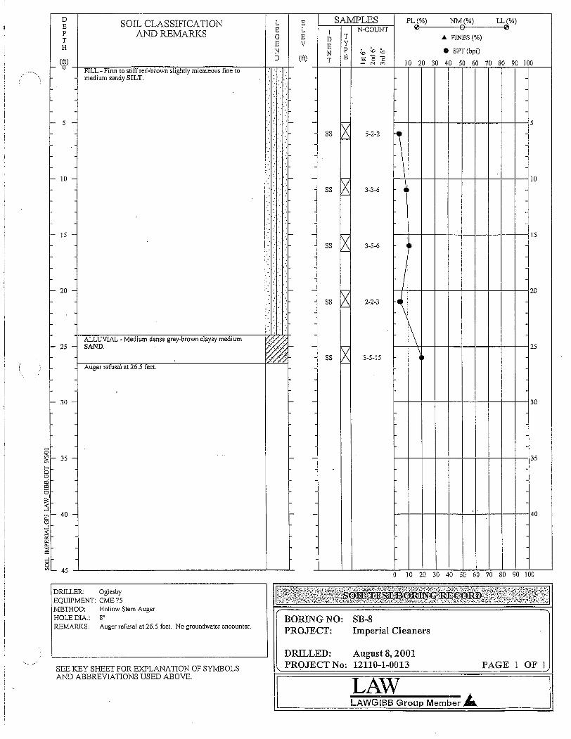
LL(%)~
SOIL CLASSIFICATIONAND REMARKS
DEPTH
L E SAMPLES PL (%) NM (%)ELI N-COUNT ~ 0
~ ~ ~ ~ ... FINES (%)
N N P \0 \0 \0 • SPT (bpt)
I- (ftO) _h'"""'-----r;,---;-:-::~_:_::;_=-.,....,,...,.,__---.,...--.,,_---..j..,.,."TD...,....I- (ft) _t-_T-+_E+--=~:.....:.]:...:.:."E~_T--T--=;~~2i:'-~:........!:::-~~~~---l'" '" 10 20 30 40 50 60 70 80 90 100FILL - Finn to stiff red-brown slightly micaceous fine to ..medium sandy SILT.
I- 5 - ... 'f--- - .......,
S5 IXI'-'
5-2-21--1-+-1--1--1-+-+-+--+----'15
- 10 - '" .-:- - "SS X
'--'
I-\-I--+-+-+-+--+-+-I--l-.....j 10
3-3-6
f--- 15 - .. 'f--- 1-+--1--1--I--I--I-+-+-+-----i 15
3-5-6
- 20 - -"XS5'--'
2-2-3
Ir-_.++---t----t----t---+--+--l--l--l--120
\
ALLUVIAL - Medium dense grey-brown clayey mediumI- 25 - SAND.
Auger refusal at 26.5 feet.
- fviSS 1/\
I'--3-5-15
\1-+....l-+-,-+-+-+-+--I-+-+----'l25~
I- 30 - - - 1-+--1--1--I--I--I-+-+-+-----i30
g!!:! f--- 35 -0-
I-<§a:l!:90
I:<:-<....l
0:: I- 40 -0
~LLl
'"~:::l0
'" '- 45
- -
- -
1-+-+-+-+-+-1-+--+--+--135
1---t--t---t-+-+4-+-+-+--I40
o 10 20 30 40 50 60 70 80 90 100
DRILLER: OglesbyEQUIPMENT: CME 75METHOD: Hollow Stem AugerHOLE DIA.: 8"REMARKS: Auger refusal at 26.5 feet. No groundwater encounter.
BORING NO:PROJECT:
SB-8Imperial Cleaners
LAWLAWGIBB Group Member J...
DRILLED: August 8, 2001PROJECT No: 12110-1-0013 PAGE 1 OF 1SEE KEY SHEET FOR EXPLANATION OF SYJ:vffiOLS
AND ABBREVIATIONS USED ABOVE.

o 10 20 30 40 50 60 70 80 90 100
D SOIL CLASSIFICATION L E SAI'v1PLES PL(%) NM(%) LL(%)
E E L N-COUNT ~ 0 ~
AND REMARKS IP G E D T .... FINES (%)T E V E YH SEE KEY SHEET FOR EXPLANATION OF N P '" '" ;" • SPT (bpf)N ." 1:(ft) SYMBOLS AND ABBREVIATIONS USED BELOW. D (ft) T E ~ c"i '" 10 20 30 40 50 60 70 80 90 100
I- 0 CONCRETE~
.,,', "
FILL - Red brown micaceous silty fine to medium SAND."
: ....· '....'.
.... . .· ' ...:.... : ....· .. ....
'.
r><Boring terminated at 4 feet. SSI- 5 - - - I'--' 5
,... IO - - - IO
- 15 - I- - 15
I- 20 - I- - 20
/)
,- 25 - I- - 25
I- 30 - - - 30
I- 35 - - - 35
- 40 - I- - 40
,... 45
DRILLER:EQUIPMENT:METHOD:HOLEDIA.:REMARKS:
MACTEC-Paul GazzoHand AugerHand Auger3 inches BORING NO.:
PROJECT:LOCATION:DRILLED:PROJECT NO.:
SB-10Imperial CleanersAtlanta, GeorgiaJanuary 27,20066305-05-0319 PAGE 1 OF 1
TillS RECORD IS A REASONABLE INTERPRETATION OFSUBSURFACE CONDITIONS AT THE EXPLORATIONLOCATION. SUBSURFACE CONDITIONS AT OTHERLOCATIONS AND AT OTHER TIMES MAY DIFFER.INTERFACES BEWEEN STRATA ARE APPROXIMATE.TRANSITIONS BETWEEN STRATA MAY BE GRADUAL.
IlMACTEC

SAMPLES PL(%) NM(%) LL(%)
I N-COUNT 0 0 0
D T ... FINES (%)YE P ~ '" '" • SPT (bpf)N "C
~T E - .::i10 20 30 40 50 60 70 80 90 100
L EE LG EE VND (ft)
SOIL CLASSIFICATIONAND REMARKS
DEPTH SEE KEY SHEET FOR EXPLANATION OF
(ft) Sl'MBOLS AND ABBREVIATIONS USED BELOW.
I- 0 -+--C"""O"'N'"'"C"=R"""E=T=E:;:---------------l-........--=,!-
FILL - Red brown micaceous silty fine to medium SAND. 1-:':. :: :;.:
I- 5 -
k--SS [X- "--' f--+-f--j-+-+-+-+--+--l--l5
.... : ....:
"',.:. ::.
..... "
" .:.
I-+-!--I-+-+-!--I:-+-+-I 15
1-+-!--f-+-+-I--I-+--I---I20
f--I--I--+--I--I--I--I-+-+- 10
SS txI'--
SS txI'--'
-
SS txI'--'
SS tx- I'--'
1-::" ",
" .;',
....... ::.'-- 'r::
::: .:·f::· .. :.<:
'.:-' " ::::
RESIDUAL - Brown micaceous silty fine to mediumI- 20 -I-.. SAND.
Geoprobe refusal at 20 feet.
I- 15 -
',' : .',
." .." .:.. " .:
I- 10 -
I- 25 - - f--I--I--+--I--I--I--If-+-+- 25
I-<
§I- 30 m
!'::i- f--l---l-+--+-+-+-+-+--l- 30
-+-0::o~I- 35 -
~...lU
~2we-:;E~I- 40 z2oClI-<[2I-<...lo"'l- 45 -L ...l..__L
-
-
1--f--I--l--I--I--I--I--I--1--j 35
1--+-f--j-+-I--l-+--+-+----l40
o 10 20 30 40 50 60 70 80 90 100
DRILLER:EQUIPMENT:METHOD:HOLEDIA.:REMARKS:
ATLAS GeoSamplingGeoProbeDirect Push2 inchesGeoprobe refusal at 20 feet. No groundwaterencountered.
BORING NO.:PROJECT:LOCATION:DRILLED:PROJECT NO.:
SB-11Imperial CleanersAtlanta, GeorgiaJanuary 27, 20066305-05-0319 PAGE 1 OF 1
TillS RECORD IS A REASONABLE INTERPRETATION OFSUBSURFACE CONDITIONS AT THE EXPLORATIONLOCATION. SUBSURFACE CONDITIONS AT OTHERLOCATIONS AND AT OTHER TIMES MAY DIFFER.INTERFACES BEWEEN STRATA ARE APPROXIMATE.TRANSITIONS BETWEEN STRATA MAYBE GRADUAL.
'MACTEC

DEPTH(ft)
~ 0
SOIL CLASSIFICATIONAND REMARKS
SEE KEY SHEET FOR EXPLANATION OFSYMBOLS AND ABBREVIATIONS USED BELOW.
CONCRETEFILL - Red brown micaceous silty fine to medium SAND.
L EE LG EE VND (ft)
SAMPLES PL(%) NM(%) LL(%)N·COUNT ~ 0 ~
I T ~ FINES(%)DYE P '" '" '" • SPT (bpf)N "'" ~E ~
~T 10 20 30 40 50 60 70 80 90 100
~ 5 -
- 10 -
I- 15 -
RESIDUAL - Red brown silty fine SAND.
Geoprobe refusal at 18 feet.
'" .
'". "
'.-::,'
.:.:.' .. [:::·:.···:·1-·.-·.
...... ;'.
':.'
" " . .I." '.' :.'. I·'.
I:.··· ..·I:·::~r·· 1: .. 1 ::'-
I:,.
::::.~ .. l?
~
SS X- ~
ss txI'-'-
ss txr--
SS ~I'-'
1--+--+-1--1--+--1--+-1-----jf----j5
1--1--+--1--1--1--1--1--1--1---1 10
1--1--1-+--+-1-+-+-+--+-"': 15
I- 20 -
I- 25 -
'"g!Q...\-<
§~ 30 -'"'"6
I~-<,...l
f- -
f- -
1--1--+--1--+-1--1--1--1--1---120
1--1--11-+--+-1-+-+--1--+- 25
1--I--1-----11--1--!--1-----11--I--I--'-I30
Q:;o~- 35 -Ul
~.-lU
:;2~~0- 40 -
§'"\-<~.-l5"'I- 45 -L -l..__J....
1-+-1-+--1--1--1--+-+--+-135
1--+-+-j-+--1--1--I--I--I---140
o 10 20 30 40 50 60 70 80 90 100
THIS RECORD IS A REASONABLE INTERPRETATION OFSUBSURFACE CONDITIONS AT THE EXPLORATIONLOCATION. SUBSURFACE CONDITIONS AT OTHERLOCATIONS AND AT OTHER TIMES MAY DIFFER.INTERFACES BEWEEN STRATA ARE APPROXIMATE.TRANSITIONS BETWEEN STRATA MAY BE GRADUAL.
6MACTEC
DRILLER:EQUIPMENT:METHOD:HOLEDIA.:REMARKS:
ATLAS GeoSamplingGeoProbeDirect Push2 inchesGeoprobe refusal at 18 feel. No groundwaterencountered.
BORING NO.:PROJECT:LOCATION:DRILLED:PROJECT NO.:
SB-12Imperial CleanersAtlanta, GeorgiaJanuary 27, 20066305-05-0319 PAGE 1 OF 1

SOIL CLASSIFICATION L E SAMPLES PL(%) NM(%) LL(%)D'""
0'""
E E L I N-COUNT
P AND REMARKS G E D T A FINES (%)T E V E Y
N P "" "" "" • SPT (bpf)H SEE KEY SHEET FOR EXPLANATION OF N "" 1:D (ft) E <=(ft) SYMBOLS AND ABBREVIATIONS USED BELOW. T - N "" 10 20 30 40 50 60 70 80 90 100f- 0 ~CONCRETE
FILL - Red brown micaceous silty fine to medium SAND. .. . ...
'...... :. .:::.
"
'.'
l><. ,',
SS::. .:. :::'f- - I'-' 5f- 5 -':.'.
: .;:.. . .. "
::.:.::
X: ':', SS!<--'
1::":' ')f- - 10f- 10 - I::.. :.::''.'....:..
l><:
,:',.. " SS
'.' I'-.' ..: '.
.. "
[.:::-->. ':'::.f- - 15- 15 -.. /.
RESIDUAL - Brown silty fine to medium SAND.1<:.:>:::~.: ss X!<--'
. ' ..:. ~. :'·it· l><:....:
SS':',:. - I'- 20f- 20 Geoprobe refusal at 20 feet.
25f- 25 - f- -
'"~~
'"I-<30§f- 30 - - -
I:ciCQ
(3I
~-<...:I
~-
0
35~f- 35 - - -r.LlZ-<r.Ll...:IU...:I-<2r.Ll
~40~f- 40 - f- -
z20CQ
I-<Vlr.LlI-<...:I(3
40 60 70 80 90 100Vl,- 45
0 10 20 30 50
DRILLER:EQUIPMENT:METHOD:HOLEDIA.:REMARKS:
ATLAS GeoSamplingGeoProbeDirect Push2 inchesGeoprobe refusal at 20 feet. No groundwaterencountered.
BORING NO.:PROJECT:LOCATION:DRILLED:PROJECT NO.:
SB-13Imperial CleanersAtlanta, GeorgiaJanuary 28, 20066305-05-0319
1('-,,(.,
<,'
PAGE 1 OF 1THIS RECORD IS A REASONABLE INTERPRETATION OFSUBSURFACE CONDITIONS AT THE EXPLORATIONLOCATION. SUBSURFACE CONDITIONS AT OTHERLOCATIONS AND AT OTHER TIMES MAY DIFFER.INTERFACES BEWEEN STRATA ARE.APPROA'IMATE.TRANSITIONS BETWEEN STRATA MAy BE GRADUAL.
'MACTEC

o 10 20 30 40 50 60 70 80 90 100
D SOIL CLASSIFICATION L E SAMPLES PL(%) NM(%) LL(%)
E E L N-COUNT ~ 0 ~
AND REMARKS IP G E D T ... FINES (%)T E V E YH SEE KEY SHEET FOR EXPLANATION OF N P '" '" '" • SPT (bpt)N " "E(ft) SYMBOLS AND ABBREVIATIONS USED BELOW, D (ft) T E - N '" 10 20 30 40 50 60 70 80 90 100- 0 CONCRETE
~
FILL - Red brown micaceous silty fine to medium SAND. .,
:'. "
........., .
" ". ,
':::.:'" c::·:._ SS Xl- S - - <-: 5
.'........ "::'," ',:',, . '.
'. , .~...... '.:, SS
, . I'--'
f- 10 - ::': ~ ~>: '}:I- - 10
::::.~.:>. <. ss t><.....
I::.' :,'.:::-. I'--'.. ,'
RESIDUAL - Red brown silty fine to medium SAND,-- ..
,... 15 - ':."'.:', :;":1- - R 15..... "
SS
Geoprobe refusal at 16 feet.I'--'
f- 20 - I- - 20
- 25 --,
I- - 25
I- 30 - - - 30..
I
-I- 35 - - - 35
- 40 - - - 40
- 45
THIS RECORD IS A REASONABLE INTERPRETATION OFSUBSURFACE CONDITIONS AT THE EXPLORATIONLOCATION, SUBSURFACE CONDITIONS AT OTHERLOCATIONS AND AT OTHER TIMES MAY DIFFER,INTERFACES BEWEEN STRATA ARE APPROXIMATE,TRANSITIONS BETWEEN STRATA MAYBE GRADUAL,
l.·:>·
-"?:SOlLTEST:;BORINGRECORD :"-'-' .
6MACTEC
DRILLER:EQUIPMENT:METHOD:HOLEDIA,:REMARKS:
ATLAS GeoSamplingGeoProbeDirect Push2 inchesGeoprobe refusal at 16 feet. No groundwaterencountered,
BORING NO.:PROJECT:LOCATION:DRILLED:PROJECT NO.:
SB-16Imperial CleanersAtlanta, GeorgiaJanuary 28, 20066305-05-0319 PAGE 1 OF 1
I

SAMPLES PL(%) NM(%) LL(%)N-COUNT ~ 0 ~
I T ... FINES (%)DYE P '" '" '" • SPT (bpf)N " ~T E - N
20 30 40 50 60 70 80 90 10010
L EE LG EE VND (ft)
SOIL CLASSIFICATIONAND REMARKS
DEPTH SEE KEY SHEET FOR EXPLANATION OF(ft) SYMBOLS AND ABBREVIATIONS USED BELOW.
'- 0 i~C~O~N~C~R~E['TP'EL=~~==-=~::;;;;:;;;';;;;;;=1~TrFILL - Red brown micaceous silty fine to medium SAND. ..:: c. :. :::.
:..... ','
. ',.:;. "<:':...',' ....
" . ::. :::.'- 5 -
'- 10 -
SS XI'--'
1--1--+--I--I--+-I-+--+---+---i5
1--1--+--I--I--+-I-+--+---+---i 10
:.: .. :..:.'.:::.":'" .
RESIDUAL - Brown slightly micaceous silty fine to mediumf- IS - SAND.
Geoprobe refusal at 16 feet.
..... :'.
- VSS A
L--'
1--1--+--I--1--+-I--t--t---t----i IS
f- 20 - I- - I--l--I-.j--+--+-t--+--+---il---i 20
t- 25 - I- - 1---I--+-f-+--+-+-1--+--t----125
I- -
I- -
I- -
'0
~f-<
§- 30 a:ia:l
~I§-gj - 35 -LLlZi::id--1-0:
~0..:E;;1- 40 -z§a:lf-<
~f-<--1o"''- 45 -l. -l..__L
I-+-+-j-+-+-+-j--t-+---i 30
I--+--+-+-+-+-+-+--t-+---i 35
1---I--+-If-+--+-+-If-+-+---140
o 10 20 30 40 50 60 70 80 90 lOa
DRILLER:EQUIPMENT:METHOD:HOLE DlA.:REMARKS:
ATLAS GeoSamplingGeoProbeDirect Push2 inchesGeoprobe refusal at 16 feet. No groundwaterencountered.
I'BORING NO.:PROJECT:LOCATION:DRILLED:PROJECT NO.:
SB-17Imperial CleanersAtlanta, GeorgiaJanuary 28, 20066305-05-0319 PAGE 1 OF 1
THIS RECORD IS A REASONABLE INTERPRETATION OFSUBSURFACE CONDITIONS AT THE EXPLORATIONLOCATION. SUBSURFACE CONDITIONS AT OTHERLOCATIONS AND AT OTHER TIMES MAY DIFFER.INTERFACES BEWEEN STRATA ARE APPROXIMATE.TRANSITIONS BETWEEN STRATA MAYBE GRADUAL.
~MACTEC

L E SAMPLES PL(%) NM(%) LL(%)~ 0 ~E L I N-COUNT
G E D T A FINES (%)E V E Y
P ;<, ;<, ;<, • SPT (bpf)N N '0
~D (ft) E ~
~T 10 20 30 40 50 60 70 80 90 100
" ".:; : .::... [X" . ,.. SS 5-5-5
l~...... :. .::. '--' (N= 10)"
'" <--~
...."
"
~,::,', ::'\- - SS 12-14-]4 5" (N = 28) I',:.... "" :
~.; .... ::.'
" SS 6-8-10
!','
"" " (N= 18)
': " ~ ,,:',"
',''" :::::1- - SS X 7-6-6 10:.::. "::', (N= 12)
.:.SS X 6-6-8 ,
: (N=]4)';',: :. ',:',"
':.: " "
.. : ',:',"""'". . '. ~
ss 6 6-8-9 ]5':,'.:." '::,1- -,'," : :::.
~(N= 17)
" SS 5-8-8: " ::: (N= ]6).: .... : :.:',
""
',':
~..... : :.:',
'-::f- SS 5-5-6 20-(N=11) 1\::::\<.: /: '--
'"
~:::: :: ~. :::::ss 8-9-]2 It-: (N=2]) --" " --:.
~t----':>:':::':
:' t--:::':1- SS 5-]4-50/1" r-. _5--:. f--'....
SOIL CLASSIFICATIONAND REMARKS
DEP
~ SEE KEY SHEET FOR EXPLANATION OF(ft) SYMBOLS AND ABBREVJATIONS USED BELOW,
'- 0 i:::!C~02]N~CSR~E~'T!JEL~=='==::::;:~==;=':~=-====~~TtFILL - Lose to medium dense red brown to brownmicaceous silty fine to medium SAND with rockfragments,
I- 20 -
RESIDUAL - Very dense orange brown to brown micaceousI- 25 - silty fine to mediulj1 SAND,
Auger refusal at 26 feel.
f- ]0 -
I- 5 -
I- ]5 -
- ~-I--+-l---l--+----1f--t-+--+--130
I- -
f- -
~
c..ocr.i::;1- 35 -
~-lU
:;;!@it:;1- 40 -;z@oCIlIC/)
~I-loC/)L- 45 -l -'-__.L-
1-+--1--1-+-+--+--1-+-+--135
1--I--I--i-+-+-+---1-+-+-I40
o 10 20 30 40 50 60 70 80 90 100
DRILLER:EQUIPMENT:METHOD:HOLEDJA,:REMARKS:
Piedmont Environmental DrillingDeitrichHonow Stem Auger8 inchesNo groundwater encountered,
BORING NO.:PROJECT:LOCATION:DRILLED:PROJECT NO.:
SB-21Imperial CleanersRoswell, GAAugust 13, 20096305-05-0319 PAGE 1 OF 1
THIS RECORD IS A REASONABLE INTERPRETATION OFSUBSURFACE CO!\1J)mONS AT THE EXPLORATIONLOCATION. SUBSURFACE CONDmONS AT OTHERLOCATIONS AND AT OTHER TIMES MAY DIFFER.INTERFACES BEWEEN STRATA ARE APPROXIMATE,TRANSITIONS BETWEEN STRATA MAY BE GRADUAL,
ITMACTEC

I- 20 - Auger refusal at19.5 feet.
SA1v.I:PLES PL(%) NM(%) LL(%)N-CQUNT ~ 0 (ll
I T A FINES(%)D YE P '" '" '" • SPT(bpf)N ."
~E ~ t=
T N10 20 30 40 50 60 70 80 90 100
SS, .
'f- - SS, .
SS, .
'.
.- - SS, ,
SS..
. 'I- - SS..
/
ll-I--I--r--__
-I--
t-_�iH-+--t----,I-+--+-t-+-l15
I---I--tt-+---+--I-+--+---I-+---i 5
t--HH-t-+--t---f--t--t--I---IIO
~ 8-8-9(N= 17)
X 8-10-11"- (N =21)
X 3-5-8"- (N = 13)
~ 4-5-9(N= 14)
R 7-9-10f--' (N= 19)
X 4-5-7'--' (N= 12)
X 4-4-9'--' (N = 13)
~ 7-50/2"
SS
SS-
L EE LG EE VND (ft)
~ ..,, .
'.
SOIL CLASSIFICATIONAND REMARKS
SEE KEY SHEET FOR EXPLANATION OFSYMBOLS AND ABBREVIATIONS USED BELOW,
CONCRETEFILL - Red brown to brown micaceous fine to mediumsandy SILT.
RESIDUAL - Very dense brown to gray micaceous mediumto coarse SAND.
DEpTH(ft)
f- 0
- 5 -
- 10 -
f- 15 -
I- 25 - - - 1----+--1-+--+---1,..--1--+-1---1--125
'- - 1----+--1-+--+---1,..--1--+-1---1--1 30
f- -
f- -
c::o
~f- 35~ ~'"....JU....J
~~0- 40 -
~olXl
f;;'"f-doon _ 45 -'- --1.-_---1_
1-+-1--t-+--f---If-+--t--t--l35
1-+-1--t-+--f---If-+--t--t--l40
o 10 20 30 40 50 60 70 80 90 100
THIS RECORD IS A REASONABLE INTERPRETATION OFSUBSURFACE CONDITIONS AT THE EXPLORATIONLOCATION. SUBSURFACE CONDITIONS AT OTHERLOCATIONS AND AT OTHER TIMES MAY DIFFER.INTERFACES BEWEEN STRATA ARE APPROXIMATE.TRANSITIONS BETWEEN STRATA 1vlAY BE GRADUAL.
'MACTEC
DRILLER:EQUIPMENT:METHOD:HOLEDIA.:REMARKS:
Piedmont Environmental DrillingDeitrichHollow Stem Auger8 inchesNo groundwater encountered,
BORING NO.:PROJECT:LOCATION:DRILLED:PROJECT NO::
SB-23Imperial CleanersRoswell, GAAugust 13, 20096305-05-0319 PAGE 1 OF 1

.: .... :.:.:..
LL(%)'i!I
NM(%)o
PL(%)'i!I
~ FlNES(%)
• SPT (bpf)
10 20 30 40 50 60 70 80 90 100
1--I-~.l.__-+_+--I--+_+--I----1---i 57'
1-..-+-'-I-+--+-If-+--+-I-l1O
7-9-9(N= 18)
7·7-7(N= 14)
N·COUNT
5-7-6(N = 13)
4-4-6(N = 10)
4-5-7(N= 12)
4-16-14(N = 30)
32-50-3(N=53)
SAMPLESIDENT
rvss 1\'--'
"""'xSS'--
SS X'--
_ SS ~
SS ~
SS X~
~_ ss 1/\f---'
-
ELEV
(ft)
LEGEND
.:.: " ~.. :. :.:',.. "
::::.:..:>.':::::......
" .;
.:.:.: ....;.. ::::-
SOIL CLASSIFICATIONAND REMARKS
SEE KEY SHEET FOR EXPLANATION OFSYMBOLS AND ABBREVIATIONS USED BELOW.
FlLL - Medium dense red brown to brown micaceous siltyfine to medium SAND.
h.CONCRETE
DEPTH(ft)
f- 0
- 10 -
- 5 -
.; .. :....:.::.
. ..:.
.; ::.
f- 15 -I--;RE=S""'ID""U.,-,AL;-;-.--;V..,e-ry-d,--e-ns-e-gr-a-y'br-ow-:::n-:-m-,--ic-:-ac-eo-:-u-s-,si:;"71ty----;:-fin-:e-;"to,.-----b+H-coarse SAND. ':,<.:::':
f- 20 -Auger refusal at 19 feet.
- - 1--+-I-+--+-1-+--+-i--+--I20
f- 25 - - - 1--+--I-+--+-1-+--+-i--+--I25
- 1-+-+-+-+--+-1-+--+-1---130
f-
eotI:i~f- 35 -
~
d:;;l
~;:;;;- 40 -
~o<Ilt;L:l
'""'....15CI'l_ 45 ~------------------~---I.-
-
-
1--1--+-+--+-1---+---+-+--1----135
1----1--+--1--1----1-+--+.....,..1---+--140
o 10 20 30 40 50 60 70 80 90 100
THIS RECORD IS A REASONABLE INTERPRETATION OFSUBSURFACE CONDITIONS AT THE EXPLORATIONLOCATION. SUBSURFACE CONDITIONS AT OTHERLOCATIONS AND AT OTHER TllVlES MAY DIFFER.INTERFACES BEWEEN STRATA ARE APPROXIMATE.TRANSITIONS BETV.,rEEN STRATA MAY BE GRADUAL.
'MACTEC
DRlLLER:EQUIPMENT:METHOD:HOLEDIA.:REMARKS:
Piedmont Environmental DrillingDeitrichHollow Stem Auger8 inchesNo groundwater encountered.
BORING NO.:PROJECT:LOCATION:DRILLED:PROJECT NO.:
SB-24Imperial CleanersRoswell, GAAugust 13,20096305-05-0319 PAGE 1 OF 1

I.
1----I--<1IH-+--+-f---t--+-t-+-15
~r--t--f"--I---'--- _
1-+--+-+--!--I--+-I-+--F"".15
1-4-+-+-1'----+-+--+-+---1'---110
1-+-+-l-+-+-l--f--t----i---l20
)( 6-6-8'- (N= 14)
t>< 7-6-9F- (N = 15)
~ 6-7-7f--' (N=14)
tx 3-5-8f--' (N= 13)
rx 3-4-4F- (N=8)
~ 18-50/4"
IX 5014"I'-
SS
SS
SS
SS
SS
_ SS
-
_ SS
-
L E SAMPLES PL(%) NM(%) LL(%)~ 0 ~E L I N-CQUNT
G E D T .... FINES(%)E v E Y
~P '" '" • SPT(bpf)N N " 1:(ft) E ~D T N '" 10 20 30 40 50 60 70 80 90 100
SOn., CLASSIFICATIONAND REMARKS
RESIDUAL - Very dense gray and brown micaceous fine tocoarse SAND.
.... : ....;
..... :: .:',
DEP
T SEE KEY SHEET FOR EXPLANATION OF(~) SYMBOLS AND ABBREVIATIONS USED BELOW.
- 0 i:JC~O~N~C~RE~T~E['==:;===::==~::~~~;;:;:;=:=::~haFILL - Red brown to brown micaceous silty fine to medium <:.: :..;: :::.:SAND. . .. -: :::
:::::>::.~: 'r::\::~} -?::~..... : :::':' :,' ':',",:::.:. :::......: :::::~: ::-:~.~: '/::....: :::::~:.:::.-;: ::~::I-.....: :::........:.:.: " ~::. ::::...... :.'
- 15 - ;t;-..... : .:.
iii,;~ 20 -l--A"'-u-g-el-·r-;efu~s-a~la""-t~20;;-fi""'·e-:et-.------------r-"'""""'-'4-
I- 10 -
~ 5 -
~ 25 - ~ - 1-+---1--+--+-1-+-+-+-+--125
~ - 1---I--1--I-+--+-I-+--+-t~ 30
I- -
- -;:;::otzi[ijl- 35 -~<.a...lu...l<:02<.a0-::;;;1- 40 -
~oalI-<C/)
~...l
5C/) '- 45 ...l.---------"""7"----------'---L..
1-+--+-+--!-+-+-I-+-+--135
I---+--+-j--j--j--j-+--+---i- 40
o 10 20 30 40 50 60 70 80 90 100
THIS RECORD IS A REASONABLE INTERPRETATION OFSUBSURFACE CONDITIONS AT THE EXPLORATIONLOCATION. SUBSURFACE CONDITIONS AT OTHERLOCATIONS AND AT OTHER TIMES MAY DIFFER.INTERFACES BEWEEN STRATA ARE APPROXIMATE.TRANSITIONS BETWEEN STRATA MAY BE GRADUAL.
6MACTEC
DRILLER:EQUIPMENT:METHOD:HOLEDIA.:REMARKS:
PiedmoIit Environmental DrillingDeitrichHollow Stem Auger8 inchesNo groundwater encountered.
BORING NO.:PROJECT:LOCATION:DRILLED:PROJECT NO.:
SB-25Imperial CleanersRoswell, GAAugust 14, 20096305-05-0319 PAGE 1 OF 1
~O
f--H~-+--t-t--\-+-+-+---j5
/f-"--1--t-+-+-+-+-i--j--j 10
L E SAMPLES PL(%) NM(%) LL(%)E L N-COUNT ~ 0 ~
IG E 0 T • FINES (%)E V E Y
;"N P '" '" • SPT (bpf)
(ft)N E ~ 1! ~D T N
10 20 30 40 50 60 70 80 90 100
" " :":: ". : :::.
j,--
'" SS ~ 6-8-8" /:.... : (N = 16)
"" :?- ~'::' "
: - SS 7-8-9(N = 17)
'.: '}:':.: : tx' , SS 8-8-10',: ::. I'---' (N = 18)
":
•... :
" '/:- tx"'-- SS 5-5-8
" " : (N= 13)I'-'
'" '::~::
~:
SS 7-6-9(N = 15)
'" "
.. : : :.:',
~- SS 9-14-19: '.:'. (N = 33)....
j,--"
::~:: SS IX 50/2".. :"
f-
"" ::.
~.... : :.:',
":':t- - SS 50/1 "
"'" '::',
'::' "":.:',
"" ;.:.
" : ..
SOIL CLASSIFICATIONAND REMARKS
Auger refusal at 23 feet.
DEPTH SEE KEY SHEET FOR EXPLANATION OF(ft) SYMBOLS AND ABBREVIATIONS USED BELOW,
I- 0 i~C~O~N~C~RE~TE~=:;~~~~~~~~~;=:1=.YTrFILL - Red brown micaceous silty fine to medium SAND,
I- 10 -
I- 5 -
t- 20 '-
- 15 -+--;RE~S;-;;IDr;;U"'AL';T"",,_ D"'e:::n-::se:-;t=-o:::ve=ry::-:d:;:;e:::ns=e-;:o=ra::-ng:::::e:-ib=ro:::w;;;:n~to-;:gr;;:;::;;ay-;---tfi::'tmicaceous silty fine to coarse SAND,
I- 25 - t- - I---I--+--I--t--i-+--+-I--t----j 25
t- - 1--1--+-I-+--I--i-+--+--i-J 30
I- -
I- -
~
c.,o<IiGl- 35 -
~t.ll-lU
~t.llc.,:;E;1- 40 z02oPlI-[ijI-l
is00,- 45 -1.. -'-__'-
1-+--+-I--+-+--+-t-j----j--j35
f--\--I--+-1--I-+--+-+--1-140
o 10 20 30 40 50 60 70 80 90 100
THIS RECORD IS A REASONABLE INTERPRETATION OFSUBSURFACE CONDITIONS AT THE EXPLORATIONLOCATION, SUBSURFACE CONDITIONS AT OTHERLOCATIONS AND AT OTHER TIMES MAY DIFFER,INTERFACES BEWEEN STRATA ARE APPROXIMATE.TRANSITIONS BETWEEN STRATA MAY BE GRADUAL,
.MACTEC
DRILLER:EQUIPMENT:METHOD:HOLE DlA,:REMARKS:
Piedmont Environmental DrillingDeitrichHollow Stem Auger8 inchesNo groundwater encountered,
BORLNGNO.:PROJECT:LOCATION:DRILLED:PROJECT NO.:
SB-27Imperial CleanersRoswell, GAAugust 14, 20096305-05-0319 PAGE 1 OF 1

DEPTH
(ft)
I- 0
SOIL CLASSIFICATIONAND REMARKS
SEE KEY SHEET FOR EA'PLANATION OFSYMBOLS AND ABBREVIATIONS USED BELOW.
CONCRETE
L EE LG EE VND (ft)
SAMPLES PL(%) NM(%) LL(%)N-COUNT 0 0 0
I T .... FINES (%)D YE P ~ "" "" • SPT (bpf)N~
"0
~T E ;;i10 20 30 40 50 60 70 80 90 100
FILL - Red brown micaceous silty fine to medium SANDwith rock fragments.
f- 5 -
I- 10 -
I- 15 -
RESIDUAL - Dense to very dense brown to gray micaceous- 20 - medium to coarse SAND.
.....: :::.... ; ......';',",:. :::.
...... :.-::.', :.:. ';::.":'. ",:. :::......: :::
" .:. ',"
ss tx 7-11-14I'- (N=25)
- SS R 6-8-9I'--' (N= 17)
SS R 8-8-9I'--' (N= 17)
I--
- ss IX 3-5-6I'- (N= II)
SS ~ 6-6-10(N=16)
- SS ~ 7-12-10(N=22)
SS R 6-7-10I'--' (N= 17)
- SS ~ 10-15-9(N=24)
SS R 5015"I'--'
I'1--Hft--+-+-j--j--+--+-+--I5
1--e--+-t---I--!--1--1--l---I--I1O
1--+-:8-+---t-+--+-+--+-1--I15
1\I-+-++:d::--+-l-+--+-I-+---j 20r--r-1--1--
r--r-~~
- 25 - - - 1-+-+----'1-+--+--1-+-+-4--125
- - 1--1--+-4-+--1--1--4-+--1--130
I-
~
c..o<Zi[;11- 35 -
~Ul....lU
~C2Ulc..;E;;1- 40 -
~o"lt;UlI....la"'~ 45 -l.. -L__L
-
-
1---l--+-t---1--+-I--1--l---I- 35
1--1-+-+-+--1-+-4-+--1-- 40
o 10 20 30 40 50 60 70 80 90 100
THIS RECORD IS A REASONABLE INTERPRETATION OFSUBSURFACE CONDITIONS AT THE EXPLORATIONLOCATION. SUBSURFACE CONDITIONS AT OTHERLOCATIONS AND AT OTHER TIMES MAY DIFFER.INTERFACES BEWEEN STRATA ARE APPROXIMATE.TRANSITIONS BETWEEN STRATA MAYBE GRADUAL.
6MACTECPAGE 1 OF 1
SB-28Imperial CleanersRoswell, GAAugust 14, 20096305-05-0319
BORING NO.:PROJECT:LOCATION:DRILLED:PROJECT NO.:
Piedmont Environmental DrillingDeitrichHollow Stem Auger8 inchesNo groundwater encountered.
DRILLER:EQUIPMENT:METHOD:HOLE DlA.:REMARKS:

D SOIL CLASSIFICATION L E SAMPLES PL(%) NM(%) LL(%)
E _.I\ND REMARKS E L J N-CQUNT ~ 0 ~
P G E TT E V
D Y... FINES (%)
H SEE KEY SHEET FOR EXPLANATION OF NE P ~ '" '" • SPT (bpI)N "C
(ft) SYMBOLS AND ABBREVIATIONS USED BELOW. 0 (ft) E v.~
"EOT
..,f- 0
10 20 30 40 50 60 70 80 90 100h.ASPHALT
FILL - Red brown micaceous fine to medium sandy SILT.
I- 5 -
f- 10 -
I- 15 -
f- 20 -
RESIDUAL - Brown to gray slightly medium to coarseSAND.
I- 25 -
'.
I- - 5
...... - I 0
'.
'. .1- - 15
- - 20'.
'. .' ' .'. :
'.::::.; :~'." .
.'',,' ':.:.:'/:>.- - 25':':
Probe refusal at 26 feel.
I- - f--+--t--f-+--I--!--t--f-+----i 30
I- -
I- -
c::o,,;:;11- 35 -
~~....lU
<l~c..;;<~I- 40 -z2o<Il
~~::::1o"'l- 45 -L -L__L
1-+-l--l-+-l--l--I--l--J..---...I35
1-+-l--l--I--I--.J--I--l--J..---...I40
o 10 20 30 40 50 60 70 80 90 100
THIS RECORD IS A REASONABLE INTERPRETATION OFSUBSURFACE CONDITIONS AT THE EXPLORATIONLOCATION. SUBSURFACE CONDITlONS AT OTHERLOCATIONS AND AT OTHER TiMES MAY DIFFER.INTERFACES BEWEEN STRATA ARE APPROXIMATE.TRANSITJONS BETWEEN STRATA MAY BE GRADUAL.
BORING NO.:PROJECT:LOCATION:DRILLED:PROJECT NO.:
DRILLER:EQUIPMENT:METHOD:HOLEDIA.:REMARKS:
Atlas GeoSamplingPower Probe 9100 VTRDirect Push2 inchesGroundwater encountered at approximately 24 feel.
\'.......
SB-29Imperial CleanersRoswell, GAMarch 29,20106305-05-0319
6MACTECPAGE 1 OF 1

D SOIL CLASSIFICATION L E S.Alv.I:PLES PL(%) NM(%) LL(%)
E AND REMARKS E L I N-CQUNT ~ 0 ~
P G E TT E V
D Y... FINES (%)
EH SEE KEY SHEET FOR EXPLANATION OF N P G '0 G • SPT (bpf)N "(ft) SYMBOLS AND ABBREVIATIONS USED BELOW. D (ft) E ~ " "E
T ..., ....,
f- 010 20 30 40 50 60 70 80 90 100
hASPHALTFILL - Red-brown micaceous fine to medium sandy SILT.
1- 5 -
f- 10 -
1- 15 -
- 20 -
I- -
'.'1- -
'.:1- -
1--+--1---1--1-1-+-+-+-+--15
I-+-f--I--I-+--l--+-+-+--j 10
1-+-+-1--1-+-+-+--1-+--115
1-+-1--+--+-11--+--+-+-+--120
1- 25 -
RESIDUAL - Brown (0 gray slightly medium to coarseSAND.
Probe refusal at 26 feet.
....:::.:: :~:.:
}~,,;~ - f---t--f-+--+-1--I--1--1--l--125
I- -
I-
1-++-+----1--1-+--1---1--1---130
I- -
1- -
;;.:orJ:i511- 35 -
~~u~
~0..::E;f- 40 zC2oo:lf-<
'"!==....Jo"''- 45 -L ---L__L
f---f--+--l-+-+----'I--I--1--1- 35
I-+-f--I--I-+--l--+-+-+-- 40
o 10 20 30 40 50 60 70 80 90 100
I'.'. ;;: i .••·;:···;'::. :i;S()II.?;rEST~~OR:rNG::REGORD::<':··,·.i""··, '.'.,.. - ," .....~. ,
DRJlLER:EQUIPMENT:METHOD:HOLEDIA.:REMARKS:
Atlas GeoSamplingPower Probe 9100 VTRDirect Push2 inchesGroundwater encountered at approximately 24 feet.
BORING NO.:PROJECT:LOCATION:DRILLED:PROJECT NO.:
SB-30Imperial CleanersRoswell, GAMarch 29,20106305-05-0319 PAGE 1 OF 1
THlS RECORD IS A REASONABLE INTERPRETATION OFSUBSURFACE CONDITIONS AT THE EXPLORATIONLOCATION. SUBSURFACE CONDITIONS AT OTHERLOCATIONS AND AT OTHER TIMES MAY DIFFER.INTERFACES BEWEEN STRATA ARE APPROXIMATE.TRANSITIONS RET\VEF.N STRATA MAY BE GRADUAL
IlMACTEC J

DEPTH(ft)
I- 0
SOIL CLASSIFICATIONAND REMARKS
SEE KEY SHEET FOR EXPLANATION OFS)'MBOLS AND ABBREVIATIONS USED BELOW.
hASPHALT
LEGEND
E SAMPLES PL(%) NM(%) LL(%)L I N-COUNT ~ 0 ~
E D T ... FINES (%)V E Y
~P '" '" • SPT (bpi)N "0
(ft) E ~"E
T ..-,10 20 30 40 50 60 70 80 90 100
FILL - Red brown micaceous fine to medium sandy SILT,
'- 5 - .",,' ':'- - f-+--+-l--I1-+-+--1--+-1----j5
I- 10 - I- - 1-+-+-1-+-+-+-1-+-+-110
I- 15 - ,,';' ,''- - 1--I---l-+--I--II--+-l--I--+-I15
I- 20 - :: ',,', ':'- - 1---1--+-+-+-+-+-+--1-+--120
'- 25 +-;~"...A-;~_rg_'....,U::-AL-.,.--_B-=ro-=w-;:n_t_o _gr_a_
y
_SI_ig_h_tlY_l_n_ed_iu_m_to_c_o_ar_se .j..:••"-;:.::~••~i:....j+--:Probe refusal at 25 feel.
- I--t--I--I--I-+-+--!--l--.J--- 25
1-+-1--l-j--+-+--+-+-f--I30
I- -
;;::ou:iG:)I- 35 -
~...lU
:;t~~;;1- 40 -
~o<:lli-<riJf...lo"'I- 45 -'- -..L__L
1---+-+-+-+-+-+-+-+-+--135
1--t--+-+-+-+-I--1---l--I~40
o 10 20 30 40 50 60 70 80 90 100
THIS RECORD IS A REASONABLE INTERPRETATION OFSUBSURFACE COI\'DlTJONS AT THE EXPLORATIONLOCATION, SUBSURFACE CONDITIONS AT OTHERLOCATIONS AND AT OTHER TIMES MAY DIFFER,INTERFACES BEVI'EEN STRATA ARE APPROXIMATE,TR AN<:1TlnN<: 'RFTWl='FN STRATA MAY RF GRAnl JAI
BORING NO.:PROJECT:LOCATION:DRILLED:PROJECT NO.:
JPAGE 1 OF 1
SB-31Imperial CleanersRoswell, GAMarch 29,20106305-05-0319
6MACTEC
1···.:·.··.;:,.····. ",.,',Atlas GeoSamp1ingPower Probe 9100 VTRDirect Push2 inchesGroundwater encountered at approximately 24 feel.
DRILLER:EQUIPMENT:METHOD:HOLEDIA,:REMARKS:

D SOIL CLASSIFICATION L E SAMPLES PL(%) NM(%) LL(%)
E AND REMARKS E L JN-CQUNT ~ 0 ~
P G E TT E V
D Y• FINES (%)
H SEE KEY SHEET FOR EXPLANATION OF NE P '" '" ~
(ft) SYMBOLS AND ABBREVIATIONS USED BELOW, D (ft) N E v, " ~• SPT (bpI)
T N
- 0JO 20 30 40 50 60 70 80 90 100
ASPHALTFILL - Red brown micaceous fine to medium sandy SILT,
I- 5 -
- 10 -
I- 15 -
- 20 -
'. '
.' ': .. ':'-
-
': ':,', -:1-
-
-
-
-
1-+-1--+-1-+-+-+-1-+----110
1--+---'1--+--+----11---1--+-+-+-115
1-+-1-+-+--1-+--+-1-+---120
RESIDUAL - Brown slightly medium to coarse SAND.
o
~;1~I- 25 -!-""';P"r""';ob;-e-r-;ef'""us-a'la-:t-;:;2'75"fe-e'--t. p2.:.;+ -
I--
1--+-+-+-I-+--+-.J--1--J--J25
- - 1-++-1--\-+--+-+-1---1----130
I- -
I- -
~
eocr.iG'll- 35 -
~Lll....lU....l-<~Llle-:;;;~I- 40 as~o:lf-o
~....lo",,- 45 -L -L__L
1-+-+-+--+----+-1--1---1--1----135
t-+--+-1-+-+-f-+--l--J.--140
o 10 20 30 40 50 60 70 80 90 100
THIS RECORD IS A REASONABLE INTERPRETATION OFSUBSURFACE CONDITIONS AT THE EXPLORATIONLOCATION. SUBSURFACE CONDITIONS AT OTHERLOCATIONS AND AT OTHER TJIvlES MAY DIFFER.INTERFACES BE\VEEN STRATA ARE APPROXIMATE.TRANSlTlONS BETWEEN STRATA MAY BE GRADUAL.
6MACTEC
DRll..LER:EQUIPMENT:METHOD:HOLE DIA.:REMARKS:
Atlas GeoSamplingPower Probe 9100 VTRDirect Push2 inchesGroundwater encountered at approximately 24 feet.
BORING NO.:PROJECT:LOCATION:DRILLED:PROJECT NO.:
SB-32Imperial CleanersRoswell, GAMarch 29,20106305-05-0319 PAGE 1 OF 1

D SOlL CLASSIFICATION L E SAMPLES PL(%) NM(%) LL(%)E .A.ND REMARKS E L I N-CQUNT Ql 0 Qlp G E TT E V
D Y~ FINES (%)
H SEE KEY SHEET FOR EXPLANATION OF NE P (" '0 '0 • SPT (bpf)N "0
(ft) SYMBOLS AND ABBREVIATIONS USED BELOW. D (ft) E ~ c "ET <', <"
- 010 20 30 40 50 60 70 80 90 100
ASPHALTFILL - Red brown micaceous fine to medium sandy SILT.
- 5 -
- 10 -
f- 15 -
- 20 -
RESIDUAL - Brown to gray slightly medium to coarseSAND.
_ 25 - Orange-brown to gray micaceous slightly fine to mediumSAND.Probe refusal at 26 feel.
- -
- -
'1- -
'. I- -
" ::::::
'" ',::.. ,
-
f---f--If--l--I-+--+-l-+-1---l5
1--1--+-11-+-+,-+-+--1--+-110
f-+-I-+-+-I-+-+-I'-----1-----1I5
1--I--+-1--+--+-I-+--+-+----l20
1--f--If--+-+-+--!--1--f--I---j25
~
0..o..nG)- 35 -
~u.l-lU
<!~0..;.;;;f- 40 z;;::oCIl!-rnu.l!--lorn - 45
-
-
-
-
-
1--1-+-1-+--+'-+-+--1--+-130
1-+--+-1--+-+--+-1--1-+---135
1--1-+--+-1--1--1--1---+-1----140
o 10 20 30 40 50 60 70 80 90 100
THIS RECORD IS A REASONABLE INTERPRETATION OFSUBSURFACE CONDITIONS AT THE EXPLORATIONLOCATION. SUBSURFACE CONDITIONS AT OTHERLOCATIONS AND AT OTHER TIMES MAY DIFFER.INTERFACES BEVolEEN STRATA ARE APPROXIMATE.TRANSITIONS BETWEEN STRATA MAY BE GRADUAL.
6MACTEC
DRILLER:EQUIPMENT:METHOD:HOLEDJA.:REMARKS:
Atlas GeoSamplingPower Probe 9]00 VIRDirect Push2 inchesGroundwater encountered at approximately 24 feel.
BORING NO.:PROJECT:LOCATION:DRILLED:PROJECT NO.:
SB-33hnperial CleanersRoswell, GAMarch 29,20106305-05-0319 PAGE 1 OF 1

D SOli. CLASSlFICATION L E SAM:PLES PL(%) NM(%) LL(%)
E AND REMARKS E L I N-CQUNT 'ill 0 'ill
P G E D T .A FINES (%)T E V E YH SEE KEY SHEET FOR EXPLANATION OF N P '" '" '" • SPT (bpf)N ."
(ft) SYMBOLS AND ABBREVIATIONS USED BELOW. D (ft) 'E u. ,!;i "ET .....
I- 010 20 30 40 50 60 70 80 90 100
,-,ASPHALTRESIDUAL - Red brown micaceous fine to medium sandySILT.
(
- 5 -
I-- 10 -
I-- J5 -
I-- 20 -
RESIDUAL - Brown slightly medium (0 coarse SAND.
'.
- - 5
'.1- - J0
'.
.1- - I 5
'. - - 20
.:::.~:.:..;.:.::?.' "
'.:
.:.:::':{:'- 25
I- - 1--t--+-+--1--I--II-+-+---!~ 30
I- -
..... -
~
"oui~I- 35 z«'",..,u
~<>::L:.l
~;1-- 40 -
~oP'l
b;'"f-<,..,<5tn<- 45 -L --l.__L
1--I---f-+-+-+-1-4--I--I1--135
1--1--1--1-+--+--1--1-+--+----140
a 10 20 30 40 50 60 70 80 90 100
DRJLLER:EQUIPMENT:METHOD:HOLEDIA,:REMARKS:
Atlas GeoSarnplingPower Probe 9100 VTRDirect Push:2 inchesGroundwater encountered at approximately 24 feet.
BORlNGNO.:PROJECT:LOCATION:DRILLED:PROJECT NO.:
SB-34Imperial CleanersRoswell, GAMarch 29,20106305-05-0319 PAGE 1 OF 1
THIS RECORD IS A REASONABLE INTERPRETATION OFSUBSURFACE CONDJTlONS AT THE EXPLORATIONLOCATION. SUBSURFACE COf.-TDITIONS AT OTHERLOCATIONS AND AT OTHER TIMES MAY DIFFER.INTERFACES BEWEEN STRATA ARE APPROXIMATE.TRANSITIONS BETWEEN STRATA MAY BE GRADUAL.
6MACTEC


APPENDIX F
COMPUTER MODELING

Amec Foster Wheeler Environment & Infrastructure, Inc.
Project No. 6305-05-0319 Compliance Status Report, Former Imperial Cleaners, Roswell, Georgia 1 November 2, 2015
CONTAMINANT FATE AND TRANSPORT MODELING
An analysis of groundwater fate and transport was presented in the 4th Semi-Annual Groundwater
Monitoring Report, dated May 14, 2010 to estimate the time required to achieve compliance with
applicable RRS and in the VRP Application to model the potential for regulated constituents in
groundwater to impact Hog Wallow Creek located downgradient of the former dry cleaner. AMEC
utilized the BIOCHLOR software to model the fate and transport of impacted groundwater on site.
BIOCHLOR utilizes a combination of site specific data and literature values to determine the
various physical properties of the plume and the migration potential of chlorinated VOC
constituents. The purpose of the modeling is to predict the migration pattern of a chlorinated
solvent plume where no engineering controls or source area reduction measures have been
implemented and monitored natural attenuation (MNA) is the groundwater remedial option. The
VRP application also included calculations of surface water flow for Hog Wallow Creek to
determine the input of regulated constituents from the on-site plume necessary to result in
exceedance of applicable Georgia In-Stream Water Quality standards for the constituents of
concern (COCs).
In its November 10, 2011 Comment Letter regarding the VRP Application, EPD issued several
comments which requested alterations to the input parameters such as VOC source area
concentrations, model run duration and plume dispersivity values.
The model was updated utilizing the requested input parameters, including the June 2010
monitoring data, which contained the highest PCE concentration in MW-7 measured to date as
the source concentration. The simulation time was also begun on that date and the modeling
period extended for a duration of 25 years. By the end of the 25-year period, steady state
conditions had been achieved in MW-11R. In addition, a Y-dispersivity coefficient near zero was
selected to provide a uniform concentration across the plume front and allow a more conservative
estimate of VOC input to the creek to be made. Changing these input factors resulted in a more
conservative estimate for VOC migration into the creek. The resulting VOC concentrations could
then be compared to the maximum allowable COC concentrations that ensure compliance with
the In-stream Water Quality Standards.

Amec Foster Wheeler Environment & Infrastructure, Inc.
Project No. 6305-05-0319 Compliance Status Report, Former Imperial Cleaners, Roswell, Georgia 2 November 2, 2015
In addition, a “point of demonstration” well (MW-16) was installed between MW-7 and MW-11R
in February 2012 and included in subsequent groundwater monitoring events. These data were
incorporated into the model as well to help refine the model inputs.
The model was re-run utilizing the revised input VOC concentrations and start date and the results
of the updated analysis were presented in the May and November 2012 VRP Progress Reports.
In addition, the retardation factor calculated for PCE was utilized for other constituents as it
provided a better fit with the observed monitoring data. The results of the updated model runs,
with the EPD requested changes to the input parameters, indicated that COC concentrations in
MW-11R were predicted to remain well below the maximum allowable concentrations as
summarized in Table 1. The model was run again with updated field observation values for MW-
7, MW-16 and MW-11R. As a conservative measure, the source area concentration from June
2010 was retained, although the concentration in MW-7 has decreased since that time.
EPD required that the stream flow be gauged on a monthly basis over a period of at least six
months during the expected dry part of the year to determine a reasonable low-flow value for Hog
Wallow Creek. The results of the stream flow gauging indicated the flow varied from a high of
approximately 1.9 cubic feet per second (cfs) in May 2012 to a low of approximately 0.37 cfs in
October 2012. The lowest of these values, 0.37 cfs, was measured following an extended dry
spell and likely represents a low-level flow condition for Hog Wallow Creek. This value also
closely corresponds to the previously assumed value of 0.38 cfs estimated for the site using 7Q10
minimum flow data for area streams.
The maximum allowable concentrations of COCs at MW-11R protective of in-stream water quality
standards have been updated to reflect the measured low flow conditions for the creek. As shown
on Table F1, the COC concentrations detected to date in MW-11R have remained well below the
maximum allowable concentrations.

Amec Foster Wheeler Environment & Infrastructure, Inc.
Project No. 6305-05-0319 Compliance Status Report, Former Imperial Cleaners, Roswell, Georgia 3 November 2, 2015
Table F1 - Maximum allowable concentrations of COCs at MW-11R protective of in-stream water quality standards, parameter C1
COC Q1 (cfs) Q2 = Q3 = 7Q10 (cfs)
C2 (µg/L)
Maximum Allowable
Concentration at MW-11R
C1 (µg/L)
Maximum Predicted
Concentration at MW-11R
(µg/L)
June 2014 Measured
Concentration at MW-11R
(µg/L)
In-stream Criteria (µg/L)
PCE 0.000131915 0.37 3.297875 9,250 1,395 72 3.3
TCE 0.000131915 0.37 30.0280197 84,220 686 83 30
DCE 0.000131915 0.37 10001.2399 28,805,000 299 164 10,000
VC 0.000131915 0.37 2.39529868 6,710 23 <2 2.4
Q1 - Flow rate of impacted groundwater entering the stream segment (ft3/sec) Q2 - Measured low flow in the stream immediately upgradient of the Site (ft3/sec) Q3 - Measured low flow in the stream immediately downgradient of the Site; Q3 = Q2 since Q2>>Q1 C1 - Dissolved concentration of COC in groundwater (in µg/L) represented by MW-11R. C2 - Resulting concentration of COC in the stream after mixing (in µg/L)
The modeling results are consistent with the groundwater monitoring data obtained at the site.
To date, no chlorinated VOC impacts to surface water have been detected on site since
monitoring began, as predicted by the model. The highest VOC concentrations measured in MW-
11R remain several orders of magnitude below the maximum allowable concentrations that would
be protective of the surface water. As indicated in Table F1, after extending the model run to the
point at which steady state conditions are achieved in MW-11R (approximately 25 years), the
predicted VOC concentrations in MW-11R all remain well below the maximum allowable
concentrations that would be protective of the surface water.

Amec Foster Wheeler Environment & Infrastructure, Inc.
Project No. 6305-05-0319 Compliance Status Report, Former Imperial Cleaners, Roswell, Georgia 4 November 2, 2015
BIOCHLOR OUTPUT SHEETS


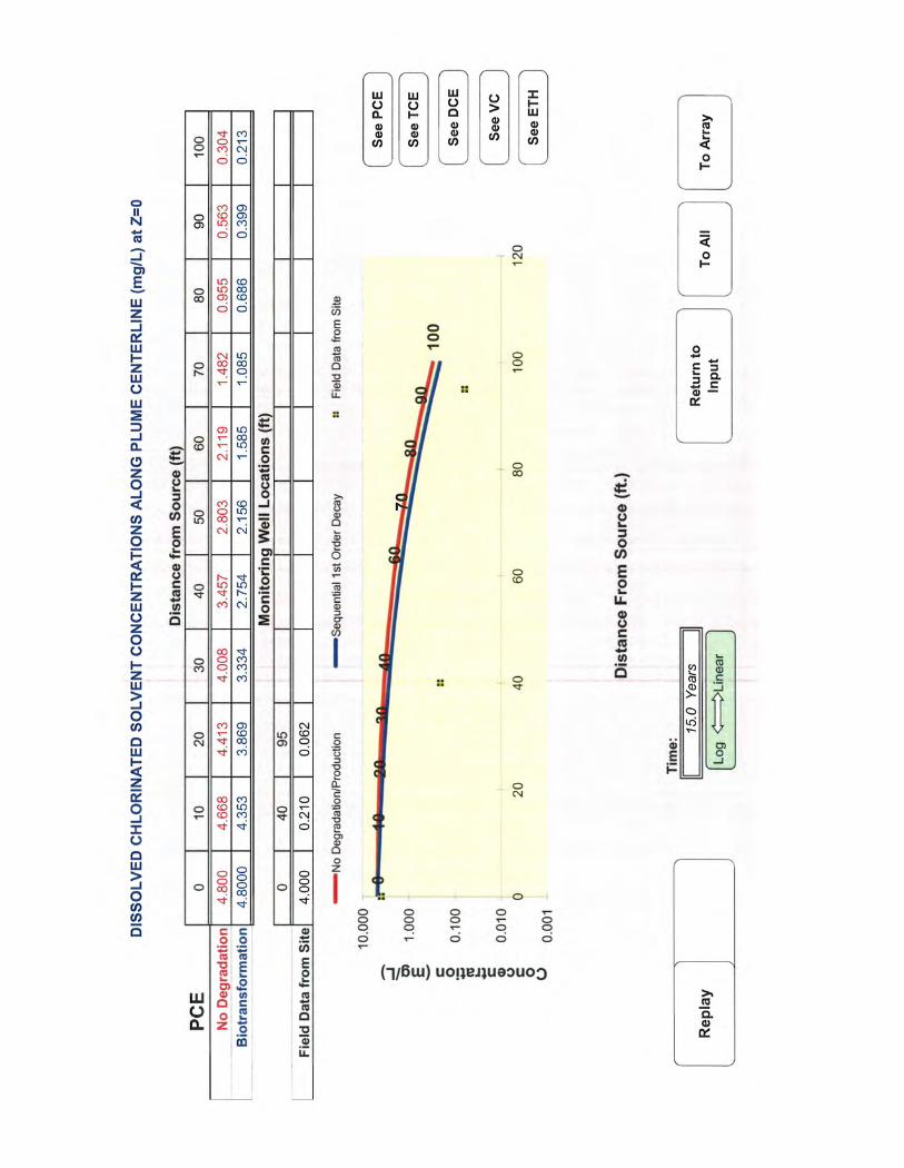


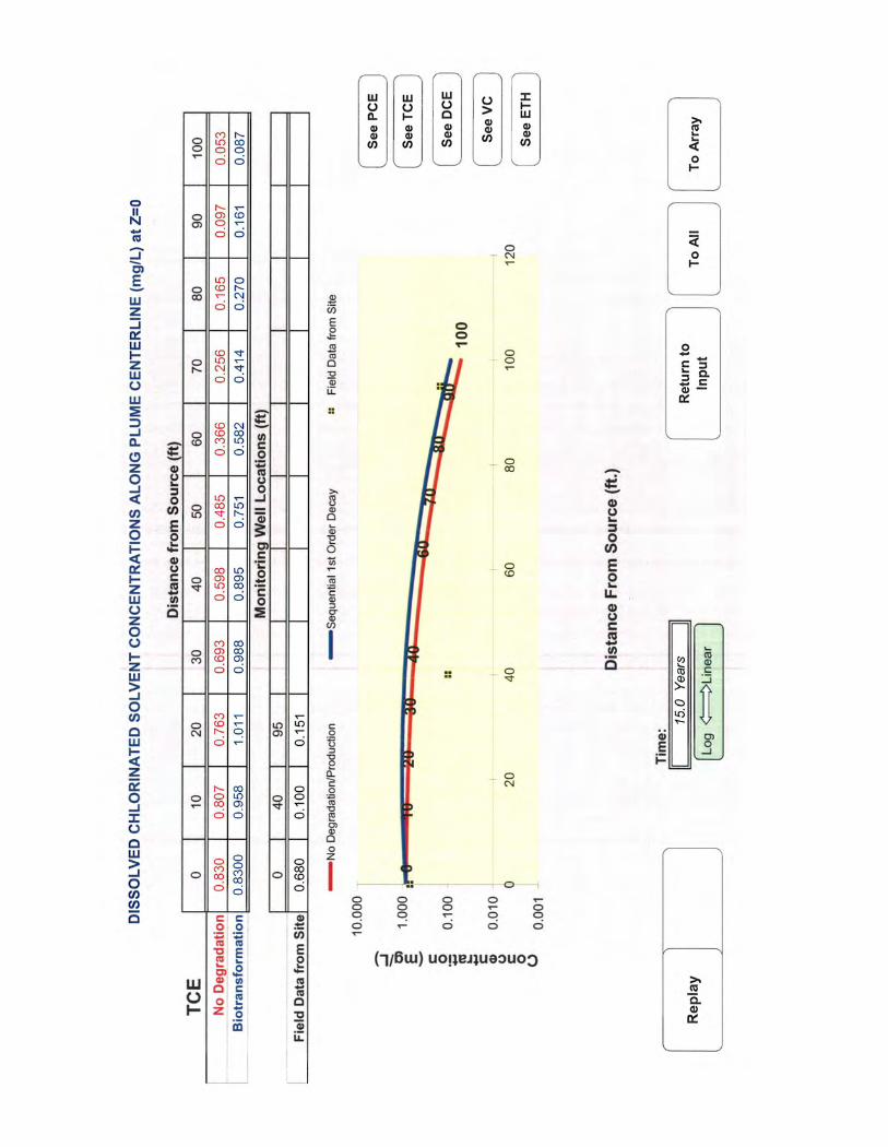

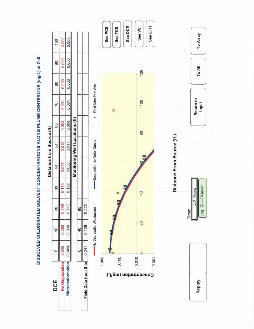


APPENDIX G
RISK REDUCTION STANDARDS

Table B-3
Type 1 and Type 3 Soil RRS, mg/kg
Risk-Based Risk-Based Subsurface Surface
Volatilization HSRA Type I HSRA Type I Type 1 Soil Overall Soil Soil Soil
PARAMETER Factor Soil Criteria Appendix I Value Groundwater RRS GW RRS x 100 Number 1 Noncarcinogenic Carcinogenic Type 1 RRS Type 1 RRS Noncarcinogenic Carcinogenic Type 3 RRS Type 3 RRS Type 3 RRS
(m3/kg) (mg/kg) (a) (mg/kg) (b) (mg/L) (c) (mg/kg) (mg/kg) (d) (mg/kg) (e) (mg/kg) (f) (mg/kg) (g) (mg/kg) (h) (mg/kg) (e) (mg/kg) (f) (mg/kg) (g) (mg/kg) (i) (mg/kg) (j)
Volatile Organic Compounds (VOCs)
Acetone 6.7E+03 ND 2.7E+00 4.0E+00 4.0E+02 4.0E+02 1.9E+05 ND 1.9E+05 4.0E+02 2.6E+05 ND 2.6E+05 4.0E+02 4.0E+02
cis-1,2-Dichloroethene 2.7E+03 ND 5.3E-01 7.0E-02 7.0E+00 7.0E+00 1.3E+03 ND 1.3E+03 7.0E+00 4.1E+03 ND 4.1E+03 7.0E+00 7.0E+00
Tetrachloroethene 2.7E+03 ND 1.8E-01 5.0E-03 5.0E-01 5.0E-01 1.4E+02 3.2E+02 1.4E+02 5.0E-01 1.5E+02 4.1E+02 1.5E+02 5.0E-01 5.0E-01
Toluene 5.6E+03 ND 1.4E+01 1.0E+00 1.0E+02 1.0E+02 2.2E+04 ND 2.2E+04 1.0E+02 3.2E+04 ND 3.2E+04 1.0E+02 1.0E+02
trans-1,2-Dichloroethene 2.8E+03 ND 5.3E-01 1.0E-01 1.0E+01 1.0E+01 2.2E+02 ND 2.2E+02 1.0E+01 2.4E+02 ND 2.4E+02 1.0E+01 1.0E+01
Trichloroethene 2.5E+03 ND 1.3E-01 5.0E-03 5.0E-01 5.0E-01 6.7E+00 1.9E+01 6.7E+00 5.0E-01 7.1E+00 2.5E+01 7.1E+00 5.0E-01 5.0E-01
Vinyl chloride 5.8E+02 ND 4.0E-02 2.0E-03 2.0E-01 2.0E-01 7.9E+01 3.6E+00 3.6E+00 2.0E-01 8.5E+01 5.1E+00 5.1E+00 2.0E-01 2.0E-01
Notes:
(a) Table 2, Appendix III of HSRA regulations
(b) Appendix I of HSRA regulations. Value is the soil concentration that triggers notification requirements.
(c) Table 1, Appendix III of HSRA regulations. For those substances not listed, reporting limit used as the Type I groundwater RRS.
(d) Value is the highest of the Appendix I value and the groundwater RRS x 100.
(e) THI x BW x ATn x 365days/year
EF x ED x [(1/RfDi x (1/VF + 1/PEF) x InhR) + (1/RfDo x Irs x CF)]
(f) TR x BW x ATc x 365days/year
EF x ED x [(SFi x (1/VF + 1/PEF) x InhR) + (SFo x Irs x CF)]
(g) Minimum of noncarcinogenic and carcinogenic concentrations.
(h) Minimum concentration of Number 1 and Type 1 RRS.
(i) Maximum concentration of Number 1 and HSRA Type 1 Soil Criteria.
(j) Minimum concentration of the risk-based soil Type 3 RRS and the subsurface soil Type 3 RRS.
RL Reporting Limit
RRS Risk Reduction Standard
GW Groundwater
ND Not Determined - Can not be calculated
Residential Nonresidential
Exposure Parameters Type 1 Type 3 Unit
Total Hazard Index (THI) 1 1 unitless
Target Risk (TR) 1.E-05 1.E-05 unitless
Target Risk (TR) WOE - C 1.E-04 1.E-04
Body Weight (BW) 70 70 kg
Averaging Time, Carcinogen (ATc) 70 70 yrs
Averaging Time, Noncarcinogen (ATn) 30 25 yrs
Exposure Duration (ED) 30 25 yrs
Exposure Frequency (EF) 350 250 days/yr
Soil Ingestion Rate (IRs) 114 50 mg/day
Air Inhalation Rate (InhR) 15 20 m3/day
Particulate Emission Factor (PEF) 4.63E+09 4.63E+09 m3/kg
Conversion Factor (CF) 1.E-06 1.E-06 kg/mg
Volatilization Factor (VF) Chemical-specificChemical-specific m3/kg
Residential Type 1
Risk-Based
Nonresidential Type 3
Risk-Based
1 of 9
UPDATED/DATE: LWC 5/1/2012
CHECKED/DATE: LMS 5/3/2012

Table B-2
Toxicity Values
Oral Inhalation Oral Inhalation Source for
PARAMETER (RfDo) (RfDi) (SFo) (SFi) Weight of Chronic
(mg/kg/day) (mg/kg/day) (mg/kg/day)-1 (mg/kg/day)-1 Evidence RfDs and SFs
Volatile Organic Compounds (VOCs)Acetone 9.0E-01 8.9E+00 ND ND NA IRIS, ATSDR
cis-1,2-Dichloroethene 2.0E-03 ND ND ND NA IRIS
Tetrachloroethene 6.0E-03 1.1E-02 2.1E-03 9.1E-04 B IRIS
Toluene 8.0E-02 1.4E+00 ND ND D IRIS
trans-1,2-Dichloroethene 2.0E-02 1.7E-02 ND ND NA IRIS,PPRTV
Trichloroethene 5.0E-04 5.7E-04 5.0E-02 1.4E-02 A IRIS
Vinyl chloride 3.0E-03 2.9E-02 7.2E-01 1.5E-02 A IRIS
SOURCES: EPA Regional Screening Level Table, November 2011.
IRIS Integrated Risk Information System
PPRTV Provisional Peer Reviewed Toxicity Values
ATSDR Agency for Toxic Substances and Disease Registry
ND No Data
NA Not Available
Chronic Reference Dose Cancer Slope Factor
Page 2 of 9UPDATED/DATE: LWC 5/1/2012
CHECKED/DATE: LMS 5/3/2012

Table B-1
Type 1 through Type 4 Ground Water RRS, mg/L
Type 1/ Type 3 (mg/L) Type 2 Overall Type 4 Overall
Oral Inhalation Oral Inhalation Source for Chronic Adult Child Overall Residential Overall Nonresidential
Parameter (mg/kg/day) (mg/kg/day) (mg/kg/day)-1 (mg/kg/day)-1 Rfds and CSFs Noncarcinogenic Carcinogenic Noncarcinogenic Carcinogenic Noncarcinogenic Carcinogenic IW IW
Volatile Organic Compounds (VOCs)
Acetone 9.0E-01 8.9E+00 ND ND IRIS, ATSDR 4.0E+00 2.2E+01 ND 8.0E+00 ND 8.0E+00 8.0E+00 4.6E+01 ND 4.6E+01 4.6E+01
cis-1,2-Dichloroethene 2.0E-03 ND ND ND IRIS 7.0E-02 7.3E-02 ND 3.1E-02 ND 3.1E-02 7.0E-02 2.0E-01 ND 2.0E-01 2.0E-01
Tetrachloroethene 6.0E-03 1.1E-02 2.1E-03 9.1E-04 IRIS 5.0E-03 6.0E-02 1.3E-01 1.9E-02 2.0E-01 1.9E-02 1.9E-02 9.8E-02 2.6E-01 9.8E-02 9.8E-02
Toluene 8.0E-02 1.4E+00 ND ND IRIS 1.0E+00 2.3E+00 ND 8.8E-01 ND 8.8E-01 1.0E+00 5.2E+00 ND 5.2E+00 5.2E+00
trans-1,2-Dichloroethene 2.0E-02 1.7E-02 ND ND IRIS,PPRTV 1.0E-01 1.1E-01 ND 3.2E-02 ND 3.2E-02 1.0E-01 1.6E-01 ND 1.6E-01 1.6E-01
Trichloroethene 5.0E-04 5.7E-04 4.6E-02 1.4E-02 IRIS 5.0E-03 3.4E-03 7.3E-03 1.0E-03 1.2E-02 1.0E-03 5.0E-03 5.2E-03 1.5E-02 5.2E-03 5.2E-03
Vinyl chloride 3.0E-03 2.9E-02 7.2E-01 1.5E-02 IRIS 2.0E-03 7.2E-02 1.1E-03 2.6E-02 2.2E-03 1.1E-03 2.0E-03 1.5E-01 3.3E-03 3.3E-03 3.3E-03
Equation 2 (Noncarcinogens): Equation 1 (Carcinogens):
IRIS Integrated Risk Information System THI x BW x AT x 365days/year TR x BW x AT x 365days/year
ATSDR - Agency for Toxic Substances and Disease Registry, 2011. C = -------------------------------------------------------------------- C = ------------------------------------------------------
IRIS - Integrated Risk Information System, USEPA. EF x ED x [(1/RfDi x K x IRa) + (1/RfDo x IRw)] EF x ED x [(SFi x K x IRa) + (SFo x IRw)]
PPRTV - Provisional Peer Reviewed Toxicity Values, USEPA.
Where: Type 2 Adult Type 2 Parameters Child Type 4 Industrial Worker Parameters
ND Toxicity values not available THI = Target Hazard Index = 1 1 1
DL Detection limit BW = Body Weight = 70 kg 15 kg 70 kg
(a) Compound is not volatile in water. AT = Averaging Time = 30 years (noncarc.); 70 (carcinogens) 6 years (noncarc.); 70 (carcinogens) 25 years for noncarcinogens; 70 years for carc.
EF = Exposure Frequency = 350 days/year 350 days/year 250 day/year
ED = Exposure Duration = 30 years 6 years 25 year
RfDi = Inhalation Reference Dose = Chemical Specific
K = Volatilization Factor = 0.0005 x 1000 L/m3 = 0.5 L/m3 0.5 L/m3 0.5 L/m3
IRa = Inhalation Rate for Air = 20 m3/day 15 m3/day 20 m3/day
RfDo = Oral Reference Dose = Chemical Specific
IRw = Ingestion Rate for Water = 2 L/day 1 L/day 1 L/day
TR = Target Risk = 0.00001 0.00001 0.00001
SFo = Oral Cancer Slope Factor = Chemical Specific
SFi = Inhalation Cancer Slope Factor = Chemical Specific
Chronic Reference Dose Cancer Slope Factor
Chemical Specific Chemical Specific
Chemical Specific Chemical Specific
Type 2 Standard (mg/L)Type 2 Standard (mg/L) Type 4 (mg/L)
Industrial Worker
Chemical Specific Chemical Specific
Chemical Specific Chemical Specific
UPDATED/DATE: LWC 5/1/2012
CHECKED/DATE: LMS 5/3/2012

Table B-4
Soil to Ground water Leachability
Residential Industrial Worker Industrial Worker
Groundwater Pathway Groundwater Pathway Soil Groundwater Pathway Soil
Kd Koc Source H' Type 1/3 RRS Cw*20 Type 1/3 Cs Type 2 RRS Cw*20 Type 2 Cs Leaching Type 4 RRS Cw*20 Type 4 Cs Leaching
(L/kg) (1) (L/kg) (2) Øw Øa (unitless) Øw+Øa*H'/Þb (Cw, mg/L) (mg/kg) (Cw, mg/L) (mg/kg) Criteria (3) (Cw, mg/L) (mg/kg) Criteria (4)
Volatile Organic Compounds (VOCs)
Acetone 4.7E-03 2.4E+00 RSL 3.0E-01 1.3E-01 1.4E-03 2.0E-01 4.0E+00 8.0E+01 1.6E+01 8.0E+00 1.6E+02 3.3E+01 3.3E+01 4.6E+01 9.1E+02 1.9E+02 1.9E+02
cis-1,2-Dichloroethene 7.9E-02 4.0E+01 RSL 3.0E-01 1.3E-01 1.7E-01 2.1E-01 7.0E-02 1.4E+00 4.1E-01 3.1E-02 6.3E-01 1.8E-01 4.1E-01 2.0E-01 4.1E+00 1.2E+00 1.2E+00
Tetrachloroethene 1.9E-01 9.5E+01 RSL 3.0E-01 1.3E-01 7.2E-01 2.6E-01 5.0E-03 1.0E-01 4.5E-02 1.9E-02 3.8E-01 1.7E-01 1.7E-01 9.8E-02 2.0E+00 8.9E-01 8.9E-01
Toluene 4.7E-01 2.3E+02 RSL 3.0E-01 1.3E-01 2.7E-01 2.2E-01 1.0E+00 2.0E+01 1.4E+01 8.8E-01 1.8E+01 1.2E+01 1.4E+01 5.2E+00 1.0E+02 7.2E+01 7.2E+01
trans-1,2-Dichloroethene 7.9E-02 4.0E+01 RSL 3.0E-01 1.3E-01 1.7E-01 2.1E-01 1.0E-01 2.0E+00 5.9E-01 3.2E-02 6.4E-01 1.9E-01 5.9E-01 1.6E-01 3.2E+00 9.4E-01 9.4E-01
Trichloroethene 1.2E-01 6.1E+01 RSL 3.0E-01 1.3E-01 4.0E-01 2.3E-01 5.0E-03 1.0E-01 3.6E-02 1.0E-03 2.1E-02 7.3E-03 3.6E-02 5.2E-03 1.0E-01 3.7E-02 3.7E-02
Vinyl chloride 4.3E-02 2.2E+01 RSL 3.0E-01 1.3E-01 1.1E+00 3.0E-01 2.0E-03 4.0E-02 1.4E-02 1.1E-03 2.1E-02 7.2E-03 1.4E-02 3.3E-03 6.5E-02 2.2E-02 2.2E-02
NA Not Available
ND No Data Available
RSL EPA Regional Screening Level
HSDB Toxnet Hazardous Substances Data Base
1. Kd values taken from USEPA Regional Screening Table User's Guide.
2. Koc values taken from the EPA RSL Chemical-specific Parameters Supporting Table November 2011 unless otherwise noted. Kd = Koc * foc where foc equals 0.002.
3. Residential leaching value is the higher of the values based on the Type 1 and Type 2 groundwater RRS.
4. Non-residential leaching value is the higher of the values based on Type 3 and Type 4 groundwater RRS.
Øw Water-filled soil porosity = 0.3 (L/L)
Øa Air-filled soil porosity = 0.13 (L/L)
H' Dimensionless Henry Law Constant (HLC x 41) (unitless)
Þb Dry soil bulk density = 1.5 kg/L
RRS Risk Reduction Standard
Cw Target Leachate Concentration (mg/L)
Cs Screening Level in soil (mg/kg)
Page 4 of 9UPDATED/DATE: LWC 5/1/12
CHECKED/DATE: LMS 5/3/2012

Table B-5
Type 2 Soil RRS, mg/kg
Risk-Based Overall
Volatilization Residential Soil Type 2 RRS
PARAMETER Factor Leaching DAF=20 Noncarcinogenic Carcinogenic Noncarcinogenic Carcinogenic Type 2 RRS DAF=20
(m3/kg) (mg/kg) (mg/kg) (a) (mg/kg) (b) (mg/kg) (a) (mg/kg) (b) (mg/kg) (c) (mg/kg) (d)
Volatile Organic Compounds (VOCs)
Acetone 6.7E+03 3.3E+01 3.3E+04 ND 1.6E+05 ND 3.3E+04 3.3E+01
cis-1,2-Dichloroethene 2.7E+03 4.1E-01 1.6E+02 ND 1.5E+03 ND 1.6E+02 4.1E-01
Tetrachloroethene 2.7E+03 1.7E-01 3.0E+01 3.3E+02 1.1E+02 2.4E+02 3.0E+01 1.7E-01
Toluene 5.6E+03 1.4E+01 3.6E+03 ND 1.9E+04 ND 3.6E+03 1.4E+01
trans-1,2-Dichloroethene 2.8E+03 5.9E-01 4.7E+01 ND 1.7E+02 ND 4.7E+01 5.9E-01
Trichloroethene 2.5E+03 3.6E-02 1.4E+00 1.9E+01 5.0E+00 1.4E+01 1.4E+00 3.6E-02
Vinyl chloride 5.8E+02 1.4E-02 1.6E+01 3.4E+00 6.0E+01 2.8E+00 2.8E+00 1.4E-02
Notes:
RRS Risk Reduction Standard
ND Not Determined - Can not be calculated
(a) THI x BW x ATn x 365days/year
EF x ED x [(1/RfDi x (1/VF + 1/PEF) x InhR) + (1/RfDo x Irs x CF)]
(b) TR x BW x ATc x 365days/year
EF x ED x [(SFi x (1/VF + 1/PEF) x InhR) + (SFo x Irs x CF)]
(c) Minimum of noncarcinogenic and carcinogenic concentrations.
(d) Minimum concentration of Leaching Value and Risk-based Value.
Residential Child Residential Adult
Exposure Parameters Type 2 Type 2
Total Hazard Index (THI) 1 1
Target Risk (TR) 1.E-05 1.E-05
Body Weight (BW) 15 70
Averaging Time, Carcinogen (ATc) 70 70
Averaging Time, Noncarcinogen (ATn) 6 30
Exposure Duration (ED) 6 30
Exposure Frequency (EF) 350 350
Soil Ingestion Rate (IRs) 200 100
Air Inhalation Rate (InhR) 15 20
Particulate Emission Factor (PEF) 4.63E+09 4.63E+09
Conversion Factor (CF) 1.E-06 1.E-06
Volatilization Factor (VF) Chemical-specific Chemical-specific
Risk-Based Risk-Based
Residential Child Residential Adult
5 of 9UPDATED/DATE: LWC 5/1/2012
CHECKED/DATE: LMS 5/3/2012

Table B-6
Type 4 Soil RRS, mg/kg
Default Industrial Worker
Nonresidential Risk-Based Overall
Volatilization Leaching Soil IW Type 4 RRS
PARAMETER Factor DAF=20 Noncarcinogenic Carcinogenic IW Type 4 RRS DAF=20
(m3/kg) (mg/kg) (mg/kg) (a) (mg/kg) (b) (mg/kg) (c) (mg/kg) (d)
Volatile Organic Compounds (VOCs)
Acetone 6.7E+03 1.9E+02 2.6E+05 ND 2.6E+05 1.9E+02
cis-1,2-Dichloroethene 2.7E+03 1.2E+00 4.1E+03 ND 4.1E+03 1.2E+00
Tetrachloroethene 2.7E+03 8.9E-01 1.5E+02 4.1E+02 1.5E+02 8.9E-01
Toluene 5.6E+03 7.2E+01 3.2E+04 ND 3.2E+04 7.2E+01
trans-1,2-Dichloroethene 2.8E+03 9.4E-01 2.4E+02 ND 2.4E+02 9.4E-01
Trichloroethene 2.5E+03 3.7E-02 7.1E+00 2.5E+01 7.1E+00 3.7E-02
Vinyl chloride 5.8E+02 2.2E-02 8.5E+01 5.1E+00 5.1E+00 2.2E-02
Notes:
RRS Risk Reduction Standard
ND Not Determined - Can not be calculated
(a) THI x BW x ATn x 365days/year
EF x ED x [(1/RfDi x (1/VF + 1/PEF) x InhR) + (1/RfDo x Irs x CF)]
(b) TR x BW x ATc x 365days/year
EF x ED x [(SFi x (1/VF + 1/PEF) x InhR) + (SFo x Irs x CF)]
(c) Minimum of noncarcinogenic and carcinogenic concentrations.
(d) Minimum concentration of Leaching Value and Risk-based Value.
Industrial Worker
Exposure Parameters Type 4 Unit
Total Hazard Index (THI) 1 unitless
Target Risk (TR) 1.E-05 unitless
Body Weight (BW) 70 kg
Averaging Time, Carcinogen (ATc) 70 yrs
Averaging Time, Noncarcinogen (ATn) 25 yrs
Exposure Duration (ED) 25 yrs
Exposure Frequency (EF) 250 days/yr
Soil Ingestion Rate (IRs) 50 mg/day
Air Inhalation Rate (InhR) 20 m3/day
Particulate Emission Factor (PEF) 4.63E+09 m3/kg
Conversion Factor (CF) 1.E-06 kg/mg
Volatilization Factor (VF) Chemical-specific m3/kg
Risk-Based
Industrial Worker
6 of 9UPDATED/DATE: LWC 5/1/2012
CHECKED/DATE: LMS 5/3/2012

Table B-7
Type 4 Soil RRS, mg/kg
Construction Worker
Nonresidential Risk-Based Overall
Volatilization Leaching Soil CW Type 4 RRS
PARAMETER Factor DAF=20 Noncarcinogenic Carcinogenic CW Type 4 RRS DAF=20
(m3/kg) (mg/kg) (mg/kg) (a) (mg/kg) (b) (mg/kg) (c) (mg/kg) (d)
Volatile Organic Compounds (VOCs)
Acetone 6.7E+03 1.9E+02 2.9E+05 ND 2.9E+05 1.9E+02
cis-1,2-Dichloroethene 2.7E+03 1.2E+00 1.2E+03 ND 1.2E+03 1.2E+00
Tetrachloroethene 2.7E+03 8.9E-01 2.9E+02 1.9E+04 2.9E+02 8.9E-01
Toluene 5.6E+03 7.2E+01 3.1E+04 ND 3.1E+04 7.2E+01
trans-1,2-Dichloroethene 2.8E+03 9.4E-01 4.6E+02 ND 4.6E+02 9.4E-01
Trichloroethene 2.5E+03 3.7E-02 1.4E+01 1.1E+03 1.4E+01 3.7E-02
Vinyl chloride 5.8E+02 2.2E-02 1.6E+02 1.9E+02 1.6E+02 2.2E-02
Notes:
RRS Risk Reduction Standard
ND Not Determined - Can not be calculated
(a) THI x BW x ATn x 365days/year
EF x ED x [(1/RfDi x (1/VF + 1/PEF) x InhR) + (1/RfDo x Irs x CF)]
(b) TR x BW x ATc x 365days/year
EF x ED x [(SFi x (1/VF + 1/PEF) x InhR) + (SFo x Irs x CF)]
(c) Minimum of noncarcinogenic and carcinogenic concentrations.
(d) Minimum concentration of Leaching Value and Risk-based Value.
Construction Worker
Exposure Parameters Type 4 Unit
Total Hazard Index (THI) 1 unitless
Target Risk (TR) 1.E-05 unitless
Body Weight (BW) 70 kg
Averaging Time, Carcinogen (ATc) 70 yrs
Averaging Time, Noncarcinogen (ATn) 1 yrs
Exposure Duration (ED) 1 yrs
Exposure Frequency (EF) 125 days/yr
Soil Ingestion Rate (IRs) 330 mg/day
Air Inhalation Rate (InhR) 20 m3/day
Particulate Emission Factor (PEF) 4.63E+09 m3/kg
Conversion Factor (CF) 1.E-06 kg/mg
Volatilization Factor (VF) Chemical-specific m3/kg
Risk-Based
Construction Worker
7 of 9UPDATED/DATE: LWC 5/2/2012
CHECKED/DATE: LMS 5/3/2012

Table B-8
Type 4 Soil RRS, mg/kg
Utility Worker
Nonresidential Risk-Based Overall
Volatilization Leaching Soil UW Type 4 RRS
PARAMETER Factor DAF=20 Noncarcinogenic Carcinogenic UW Type 4 RRS DAF=20
(m3/kg) (mg/kg) (mg/kg) (a) (mg/kg) (b) (mg/kg) (c) (mg/kg) (d)
Volatile Organic Compounds (VOCs)
Acetone 6.7E+03 1.9E+02 1.5E+06 ND 1.5E+06 1.9E+02
cis-1,2-Dichloroethene 2.7E+03 1.2E+00 6.2E+03 ND 6.2E+03 1.2E+00
Tetrachloroethene 2.7E+03 8.9E-01 1.4E+03 3.8E+03 1.4E+03 8.9E-01
Toluene 5.6E+03 7.2E+01 1.5E+05 ND 1.5E+05 7.2E+01
trans-1,2-Dichloroethene 2.8E+03 9.4E-01 2.3E+03 ND 2.3E+03 9.4E-01
Trichloroethene 2.5E+03 3.7E-02 6.8E+01 2.2E+02 6.8E+01 3.7E-02
Vinyl chloride 5.8E+02 2.2E-02 7.9E+02 3.7E+01 3.7E+01 2.2E-02
Notes:
RRS Risk Reduction Standard
ND Not Determined - Can not be calculated
(a) THI x BW x ATn x 365days/year
EF x ED x [(1/RfDi x (1/VF + 1/PEF) x InhR) + (1/RfDo x Irs x CF)]
(b) TR x BW x ATc x 365days/year
EF x ED x [(SFi x (1/VF + 1/PEF) x InhR) + (SFo x Irs x CF)]
(c) Minimum of noncarcinogenic and carcinogenic concentrations.
(d) Minimum concentration of Leaching Value and Risk-based Value.
Utility Worker
Exposure Parameters Type 4 Unit
Total Hazard Index (THI) 1 unitless
Target Risk (TR) 1.E-05 unitless
Body Weight (BW) 70 kg
Averaging Time, Carcinogen (ATc) 70 yrs
Averaging Time, Noncarcinogen (ATn) 25 yrs
Exposure Duration (ED) 25 yrs
Exposure Frequency (EF) 25 days/yr
Soil Ingestion Rate (IRs) 330 mg/day
Air Inhalation Rate (InhR) 20 m3/day
Particulate Emission Factor (PEF) 4.63E+09 m3/kg
Conversion Factor (CF) 1.E-06 kg/mg
Volatilization Factor (VF) Chemical-specific m3/kg
Risk-Based
Utility Worker
8 of 9UPDATED/DATE: LWC 5/2/2012
CHECKED/DATE: LMS 5/3/2012

Summary of Soil RRS
Type 1 RRS Type 2 RRS Type 3 RRS Type 3 RRS Type 4 RRS IW Type 4 RRS CW Type 4 RRS UW Selected Lowest of Lowest of Type 4 Selected Selected Lowest ofLowest of Type 4 Selected
PARAMETER DAF of 20 Surface Subsurface DAF of 20 DAF of 20 DAF of 20 Residential Source Type 3 Nonresidential Source Residential Source Type 3 Nonresidential Source
mg/kg mg/kg mg/kg mg/kg mg/kg mg/kg mg/kg Surface Subsurface
Volatile Organic Compounds (VOCs)
Acetone 4.0E+02 3.3E+01 4.0E+02 4.0E+02 1.9E+02 1.9E+02 1.9E+02 4.0E+02 Type 1 4.0E+02 1.1E+01 4.0E+02 Type 3 4.0E+02 Type 1 4.0E+02 #REF! #REF! #REF! 4.0E+02 4.0E+02
cis-1,2-Dichloroethene 7.0E+00 4.1E-01 7.0E+00 7.0E+00 1.2E+00 1.2E+00 1.2E+00 7.0E+00 Type 1 7.0E+00 2.1E-01 7.0E+00 Type 3 7.0E+00 Type 1 7.0E+00 #REF! #REF! #REF! 7.0E+00 7.0E+00
Tetrachloroethene 5.0E-01 1.7E-01 5.0E-01 5.0E-01 8.9E-01 8.9E-01 8.9E-01 5.0E-01 Type 1 5.0E-01 2.1E-01 5.0E-01 Type 3 5.0E-01 Type 1 5.0E-01 #REF! #REF! #REF! 5.0E-01 5.0E-01
Toluene 1.0E+02 1.4E+01 1.0E+02 1.0E+02 7.2E+01 7.2E+01 7.2E+01 1.0E+02 Type 1 1.0E+02 2.6E+01 1.0E+02 Type 3 1.0E+02 Type 1 1.0E+02 #REF! #REF! #REF! 1.0E+02 1.0E+02
trans-1,2-Dichloroethene 1.0E+01 5.9E-01 1.0E+01 1.0E+01 9.4E-01 9.4E-01 9.4E-01 1.0E+01 Type 1 1.0E+01 1.6E-01 1.0E+01 Type 3 1.0E+01 Type 1 1.0E+01 #REF! #REF! #REF! 1.0E+01 1.0E+01
Trichloroethene 5.0E-01 3.6E-02 5.0E-01 5.0E-01 3.7E-02 3.7E-02 3.7E-02 5.0E-01 Type 1 5.0E-01 7.6E-03 5.0E-01 Type 3 5.0E-01 Type 1 5.0E-01 #REF! #REF! #REF! 5.0E-01 5.0E-01
Vinyl chloride 2.0E-01 1.4E-02 2.0E-01 2.0E-01 2.2E-02 2.2E-02 2.2E-02 2.0E-01 Type 1 2.0E-01 2.4E-03 2.0E-01 Type 3 2.0E-01 Type 1 2.0E-01 #REF! #REF! #REF! 2.0E-01 2.0E-01
DAF of 1 DAF of 20
Non-Residential
Page 9 of 9UPDATED/DATE: LWC 5/2/2012
CHECKED/DATE: LMS 5/3/2012


APPENDIX H
DRAFT ENVIRONMENTAL COVENANT

PGDOCS\6387492
After Recording Return to:
Georgia Environmental Protection Division
2 Martin Luther King Jr. Drive, SW
Suite 1054
Atlanta, Georgia 30334
Environmental Covenant
This instrument is an Environmental Covenant executed pursuant to the Georgia Uniform
Environmental Covenants Act, OCGA § 44-16-1, et seq. This Environmental Covenant subjects the
Property identified below to the activity and/or use limitations specified in this document. The effective
date of this Environmental Covenant shall be the date upon which the fully executed Environmental
Covenant has been recorded in accordance with OCGA § 44-16-8(a).
Fee Owner of Property/Grantor: Fulton County Board of Education
786 Cleveland Avenue, SW
Atlanta, Georgia 30315
Grantee/Holder: PM, Ltd.
Wright Management, Inc.
c/o SunTrust Bank, Agent
Privately Held Investments
303 Peachtree Street, Suite 2600
Atlanta, Georgia 30303
Attn: Nancy Shannon
Grantee/Entity with State of Georgia
express power to enforce: Department of Natural Resources
Environmental Protection Division
2 Martin Luther King Jr. Drive, SE
Suite 1054 East Tower
Atlanta, Georgia 30334
Other Parties with interest in the Property: __________________________
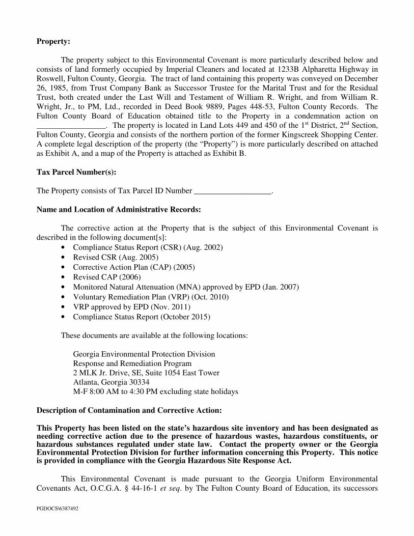
PGDOCS\6387492
Property:
The property subject to this Environmental Covenant is more particularly described below and
consists of land formerly occupied by Imperial Cleaners and located at 1233B Alpharetta Highway in
Roswell, Fulton County, Georgia. The tract of land containing this property was conveyed on December
26, 1985, from Trust Company Bank as Successor Trustee for the Marital Trust and for the Residual
Trust, both created under the Last Will and Testament of William R. Wright, and from William R.
Wright, Jr., to PM, Ltd., recorded in Deed Book 9889, Pages 448-53, Fulton County Records. The
Fulton County Board of Education obtained title to the Property in a condemnation action on
_________________. The property is located in Land Lots 449 and 450 of the 1st District, 2nd Section,
Fulton County, Georgia and consists of the northern portion of the former Kingscreek Shopping Center.
A complete legal description of the property (the “Property”) is more particularly described on attached
as Exhibit A, and a map of the Property is attached as Exhibit B.
Tax Parcel Number(s):
The Property consists of Tax Parcel ID Number ___________________.
Name and Location of Administrative Records:
The corrective action at the Property that is the subject of this Environmental Covenant is
described in the following document[s]:
• Compliance Status Report (CSR) (Aug. 2002)
• Revised CSR (Aug. 2005)
• Corrective Action Plan (CAP) (2005)
• Revised CAP (2006)
• Monitored Natural Attenuation (MNA) approved by EPD (Jan. 2007)
• Voluntary Remediation Plan (VRP) (Oct. 2010)
• VRP approved by EPD (Nov. 2011)
• Compliance Status Report (October 2015)
These documents are available at the following locations:
Georgia Environmental Protection Division
Response and Remediation Program
2 MLK Jr. Drive, SE, Suite 1054 East Tower
Atlanta, Georgia 30334
M-F 8:00 AM to 4:30 PM excluding state holidays
Description of Contamination and Corrective Action:
This Property has been listed on the state’s hazardous site inventory and has been designated as needing corrective action due to the presence of hazardous wastes, hazardous constituents, or hazardous substances regulated under state law. Contact the property owner or the Georgia Environmental Protection Division for further information concerning this Property. This notice is provided in compliance with the Georgia Hazardous Site Response Act.
This Environmental Covenant is made pursuant to the Georgia Uniform Environmental
Covenants Act, O.C.G.A. § 44-16-1 et seq. by The Fulton County Board of Education, its successors

PGDOCS\6387492
and assigns, PM, and the State of Georgia, Department of Natural Resources, Environmental Protection
Division (hereinafter “EPD”), its successors and assigns. This Environmental Covenant is required
because of a past release of Tetrachloroethene, Trichloroethene, Cis-1,2-Dichloroethene, Trans-1,2-
Dichloroethene, Vinyl Chloride, Chloroform, Acetone and Toulene (“constituents”) occurred on the
Property. Each of the constituents is a “regulated substance” as defined under the Georgia Hazardous
Site Response Act, O.C.G.A. § 12-8-90 et seq., and the rules promulgated thereunder (hereinafter
“HSRA” and “Rules”, respectively). The Corrective Action consists of institutional controls limiting the
type of use of the Property; mitigation of risk, if any, from indoor air vapor intrusion; and the prohibition
on the use or extraction of groundwater beneath the Property for drinking water or for any other non-
remedial purposes to protect human health and the environment.
Grantor, Fulton County Board of Education (hereinafter “Board”), hereby binds Grantor, its
successors and assigns to the activity and use restriction(s) for the Property identified herein and grants
such other rights under this Environmental Covenant in favor of PM, and EPD until such time as,
pursuant to Section 11, this Environmental Covenant is terminated or to the extent modified thereunder..
EPD shall have full right of enforcement of the rights conveyed under this Environmental Covenant
pursuant to HSRA, O.C.G.A. § 12-8-90 et seq., and the rules promulgated thereunder. Failure to timely
enforce compliance with this Environmental Covenant or the use or activity limitations contained herein
by any person shall not bar subsequent enforcement by such person and shall not be deemed a waiver of
the person’s right to take action to enforce any non-compliance. Nothing in this Environmental
Covenant shall restrict EPD from excising any authority under applicable law.
The Board makes the following declaration as to limitations, restrictions, and uses to which the
Property may be put and specifies that such declarations shall constitute covenants to run with the land,
pursuant to O.C.G.A. § 44-16-5(a); is perpetual, unless modified or terminated pursuant to the terms of
this Covenant pursuant to O.C.G.A. § 44-16-9; and shall be binding on all parties and all persons
claiming under them, including all current and future owners of any portion of or interest in the Property
(hereinafter “Owner”). Should a transfer or sale of the Property occur before such time as this
Environmental Covenant has been amended or revoked then said Environmental Covenant shall be
binding on the transferee(s) or purchaser(s).
The Environmental Covenant shall inure to the benefit of PM, EPD, the Board, and their
respective successors and assigns, and shall be enforceable by the Director, or his agents or assigns, PM,
or its successors and assigns, and other party(ies), as provided for in O.C.G.A. § 44-16-11, in a court of
competent jurisdiction.
Activity and/or Use Limitation(s)
1. Registry. Pursuant to O.C.G.A. § 44-16-12, this Environmental Covenant and any amendment or
termination thereof, may be contained in EPD’s registry for environmental covenants. 2. Notice. The Owner of the Property must give thirty (30) days advance written notice to EPD of the
Owner’s intent to convey any interest in the Property. No conveyance of title, easement, lease, or other interest in the Property shall be consummated by the Owner without adequate and complete provision for continued monitoring, operation, and maintenance of the Corrective Action. The Owner of the Property must also give thirty (30) days advance written notice to EPD of the Owner’s intent to change the use of the Property, apply for building permit(s), or propose any site work inconsistent with the activity and use limitations set forth herein.
PGDOCS\6387492
3. Notice of Limitation in Future Conveyances. Each instrument hereafter conveying an interest in the Property subject to this Environmental Covenant shall contain a notice of the activity and use limitations set forth in this Environmental Covenant and shall provide the recorded location of the Environmental Covenant.
4. Periodic Reporting. Annually, by no later than July 31st following the effective date of this
Environmental Covenant, the Owner shall submit to EPD an Annual Report certifying nonresidential use of the Property and also documenting that the Property is in compliance with the activity and use limitations in this Environmental Covenant.
5. Activity and Use Limitation. The Property shall be used only for non-residential uses, as defined in
Section 391-3-19-.02 of the Rules and defined in and allowed under Fulton County’s zoning regulations as of the date of this Environmental Covenant. Any residential use on the Property shall be prohibited. Any activity on the Property that may result in the release or exposure to the regulated substances that were contained as part of the Corrective Action, or create a new exposure pathway, is prohibited. In addition, prior to building any structure on the Property, a qualified professional shall evaluate the potential risk and/or hazard for the intrusion of vapors and, if warranted, an engineered vapor intrusion (“VI”) mitigation system shall be designed and installed. No soil exceeding the Type 1 risk reduction standard removed from the Property may be used as fill material at another site.
6. Groundwater Limitation. The use or extraction of groundwater beneath the Property for drinking
water or for any other non-remedial use shall be prohibited. 7. Right of Access. In addition to any rights already possessed by EPD and the access being provided
PM under an express easement, the Owner shall allow authorized representatives of EPD the right to enter the Property and inspect records at reasonable times to evaluate and determine compliance with the Corrective Action; take samples; and to determine compliance with this Environmental Covenant.
8. Recording of Environmental Covenant and Proof of Notification. Within thirty (30) days after the
date of the Director’s signature, the Owner shall file this Environmental Covenant with the Recorders of Deeds for each County in which the Property is located, and send a file stamped copy of this Environmental Covenant to EPD within thirty (30) days of recording. Within that time period, the Owner shall also send a file-stamped copy to each of the following: (1) PM, (2) each person holding a recorded interest in the Property subject to the covenant, (3) each person in possession of the real property subject to the covenant, (4) each municipality, county, consolidated government; or other unit of local government in which real property subject to the covenant is located, and (5) each owner in fee simple whose property abuts the property subject to the Environmental Covenant.
9. Termination or Modification. The Environmental Covenant shall remain in full force and effect in
accordance with O.C.G.A. § 44-5-60, unless and until the Director determines that the Property is in compliance with the applicable Risk Reduction Standards, as defined in Georgia Rules of Hazardous Site Response (Rules) Section 391-3-19-.07 whereupon the Environmental Covenant may be amended or revoked in accordance with Section 391-3-19-08(7) of the Rules and O.C.G.A. § 44-16-1 et seq.
10. Severability. If any provision of this Environmental Covenant is found to be unenforceable in any
respect, the validity, legality, and enforceability of the remaining provisions shall not in any way be
affected or impaired.
11. No Property Interest Created in EPD. This Environmental Covenant does not in any way create any
interest by EPD in the Property that is subject to the Environmental Covenant. Furthermore, the act

PGDOCS\6387492
of approving this Environmental Covenant does not in any way create any interest by EPD in the
Property in accordance with O.C.G.A. § 44-16-3(b). Representations and Warranties.
Grantor hereby represents and warrants to the other signatories hereto:
a) That the Grantor has the power and authority to enter into this Environmental Covenant, to grant
the rights and interests herein provided and to carry out all obligations hereunder;
b) That the Grantor is the sole owner of the Property and holds fee simple title which is free, clear
and unencumbered;
c) That the Grantor has identified all other parties that hold any interest (e.g., encumbrance) in the
Property and notified such parties of the Grantor’s intention to enter into this Environmental
Covenant;
d) That this Environmental Covenant will not materially violate, contravene, or constitute a material
default under any other agreement, document or instrument to which Grantor is a party, by which
Grantor may be bound or affected;
e) That the Grantor has served each of the people or entities referenced in Activity 8 above with an
identical copy of this Environmental Covenant in accordance with O.C.G.A. § 44-16-4(d).
f) That this Environmental Covenant will not materially violate or contravene any zoning law or
other law regulating use of the Property; and
g) That this Environmental Covenant does not authorize a use of the Property that is otherwise
prohibited by a recorded instrument that has priority over the Environmental Covenant.
Notices.
Any document or communication required to be sent pursuant to the terms of this Environmental Covenant
shall be sent to the following persons:
Georgia Environmental Protection Division Branch Chief
Land Protection Branch
2 Martin Luther King Jr. Drive SE
Suite 1054 East Tower
Atlanta, Georgia 30334
PM Ltd.
Wright Management, Inc.
c/o SunTrust Bank, Agent
Privately Held Investments
303 Peachtree Street, Suite 2600
Atlanta, Georgia 30308

PGDOCS\6387492
Grantor has caused this Environmental Covenant to be executed pursuant to The Georgia Uniform
Environmental Covenants Act, on the _____ day of _____________, 2015.
GRANTOR: Signed, sealed and delivered The Fulton County Board of Education
in the presence of:
By: ________________________________________ Name: __________________________________ ___________________________ Title: __________________________________ Unofficial Witness
WITNESS: Notary Public By: My Commission Expires: Name:
Dated: Notary Seal
GRANTEE/HOLDER: Signed, sealed and delivered PM LTD.
in the presence of:
By: Name: ____________________________________ __________________________ Title: ____________________________________
Unofficial Witness
WITNESS: Notary Public By: My Commission Expires: Name: Dated: Notary Seal

PGDOCS\6387492
GRANTEE/ENTITY WITH
EXPRESS POWER TO ENFORCE:
Signed, sealed and delivered STATE OF GEORGIA,
in the presence of: DEPARTMENT OF RESOURCES,
ENVIRONMENTAL PROTECTION DIVISION
By:
Name:
________________________ Title:
Unofficial Witness
WITNESS: Notary Public By: My Commission Expires: Name: Dated: Notary Seal

PGDOCS\6387492
EXHIBIT A
LEGAL DESCRIPTION
[TO BE ADDED ONCE SEPARATE PARCEL IS ESTABLISHED.]

PGDOCS\6387492
EXHIBIT B
Area Map


Know what's
Dial 811Or Call 800-282-7411