Embed Size (px)
Citation preview

U.S. Army Corps Galveston District of Engineers Southwestern Division
Houston Ship Channel Expansion Channel Improvement Project, Harris, Chambers and
Galveston Counties, Texas
Final Integrated Feasibility Report–Environmental Impact Statement
APPENDIX P-2
MITIGATION PLAN FOR WETLAND HABITAT
November 2019
Contents Background .......................................................................................................................... 4
Objectives ............................................................................................................................ 4
Site Selection Criteria ........................................................................................................ 12
3.1 Placement Areas ............................................................................................................. 12
3.2 Mitigation Area .............................................................................................................. 12
Site Protection Instruments ................................................................................................ 13
Baseline Information and Impacts ..................................................................................... 13
5.1 E2 Clinton PA ................................................................................................................ 13
5.2 Beltway 8 PA ................................................................................................................. 14
5.3 Rosa Allen Expansion .................................................................................................... 16
5.4 Direct Impacts ................................................................................................................ 18
5.4.1 E2 Clinton PA ......................................................................................................... 18
5.4.2 Beltway 8 PA .......................................................................................................... 19
5.4.3 Rosa Allen Extension PA........................................................................................ 19
5.5 Indirect Impacts .............................................................................................................. 20
5.5.1 E2 Clinton PA ......................................................................................................... 20
5.5.2 Beltway 8 PA .......................................................................................................... 20
5.5.3 Rosa Allen Extension PA........................................................................................ 21
Determination of Credits.................................................................................................... 21
Proposed Method of Mitigation ......................................................................................... 21
References .......................................................................................................................... 23
LIST OF FIGURES
Figure 1 Proposed Placement Areas E2 Clinton, Beltway 8 and Rosa Allen Extension ........ 8 Figure 2 Proposed E2 Clinton Placement Area ......................................................................... 9 Figure 3 Proposed Beltway 8 Placement Area ......................................................................... 10 Figure 4 Proposed Rosa Allen Extension Placement Area...................................................... 11 LIST OF TABLES
Table 1: Habitat Suitability Index Models Reviewed ................................................................ 5 Table 2 Habitat Model, Parameter, Description, and Data Source ......................................... 6 Table 3 IHGM Values for E2 Clinton Placement Area ........................................................... 14 Table 4 HSI Values for Beltway 8 Placement Area ................................................................. 15 Table 5 IHGM Values for Beltway 8 Placement Area............................................................. 16 Table 6 IHGM Values for Beltway 8 Placement Area............................................................. 18 Table 7 Mitigation Requirements (Habitat Units and Functional Capacity Units).............. 20

ATTACHMENTS
1. C2 Clinton Field Data and HSI and IHGM Calculations 2. Beltway 8 Field Data and HSI and IHGM Calculations

BACKGROUND
Implementation of the National Economic Development Plan (NED) for the Houston Ship Channel (HSC) Expansion Channel Improvement Project (ECIP) would permanently impact approximately 71.9 acres of wetlands located in the three proposed placement areas (PA): E2 Clinton PA – approximately 8.7 acres of wetlands; Beltway 8 PA – approximately 24 acres of wetlands; and Rosa Allen Expansion – approximately 40.8 acres. The exact acreage of wetland impacts may change because the specific dredged material management plan (DMMP) that would provide for the placement of dredged material during construction (“new work”) and provide for long term periodic incremental maintenance of the channel improvements has not yet been fully developed. The DMMP would be accomplished during the post-ADM phase. However, wetland review of impacts and their function and services for mitigation would be conducted for any changes and/or additional PA.
The Locally Preferred Plan (LPP) includes the NED and would not impact any additional wetlands other than those of the NED because the additional sections of the LPP would be offshore. The approximately 5.7 acres of tidal wetlands along the upper HSC north and west of Morgans Point would be avoided. The existing PAs after each fill cycle periodically creates wetlands because the fill after dewatering is generally not leveled after each fill cycle. The wetlands within these PAs are temporary until next fill cycle, which is typical of the operations of these PAs. Any wetlands within a proposed three PA are to be mitigated prior to their use as per the following rules and regulations.
The USACE Civil Works CECW-PC Memorandum for Implementation Guidance for Section 2036(a) of the Water Resources Development Act of 2007 (WRDA 07) - Mitigation for Fish and Wildlife and Wetlands Losses, dated 31 August 2009, reiterates mitigation requirements for any report being submitted to Congress for approval, but also adds the requirement for mitigation plans to comply with the mitigation standards and policies of the USACE Regulatory Program including specific mitigation plan components. The memo is applicable to Civil Works water resources projects that require specific authorization. The content and structure of this Draft Mitigation Plan are being developed to meet the requirements for Regulatory Program compensatory mitigation plans in 33 CFR 332.4(c).
The functional habitat modeling for this Draft Mitigation Plan has been conducted to identify the range of potential mitigation amounts associated with the varying habitat quality among the sites to aid the mitigation planning process in the next planning phase. This Draft Mitigation Plan would be updated at the end of the post-ADM planning phase to revise the impact and mitigation amounts with changes driven by the project refinement and more detailed mitigation site planning.
OBJECTIVES
The primary objective of the mitigation project is to replace the significant net losses of wetland function and services that would be impacted during the construction of the three proposed PAs shown in Figures 1, 2, 3, and 4. Specifically, the U.S. Army Corps of Engineers (USACE) Galveston District use the interim hydrogeomorphic models (IHGM) to determine wetland functions and services for mitigation (USACE 2008). The USACE Civil Works policy
requires a certified model such as a Habitat Suitability Index Model (HSI) to determine habitat units for their mitigation. Therefore, for mitigation purposes, two different methodologies were used to determine the functions and services of the impacted wetlands. One to be able to use mitigation banks in the USACE Galveston District and the other for Civil Works policy requirements.
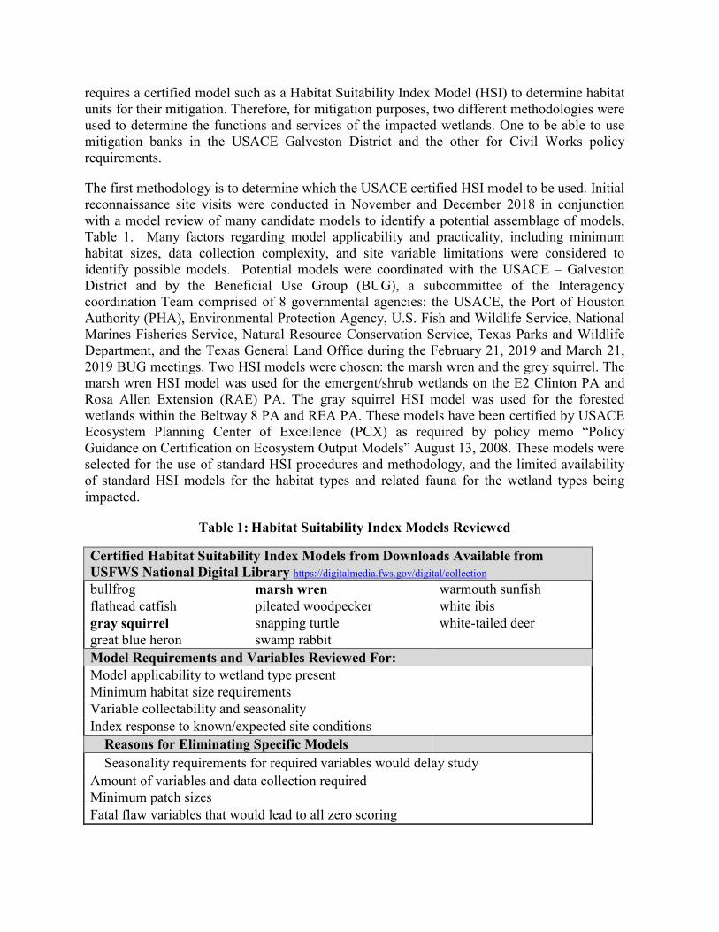
The first methodology is to determine which the USACE certified HSI model to be used. Initial reconnaissance site visits were conducted in November and December 2018 in conjunction with a model review of many candidate models to identify a potential assemblage of models, Table 1. Many factors regarding model applicability and practicality, including minimum habitat sizes, data collection complexity, and site variable limitations were considered to identify possible models. Potential models were coordinated with the USACE – Galveston District and by the Beneficial Use Group (BUG), a subcommittee of the Interagency coordination Team comprised of 8 governmental agencies: the USACE, the Port of Houston Authority (PHA), Environmental Protection Agency, U.S. Fish and Wildlife Service, National Marines Fisheries Service, Natural Resource Conservation Service, Texas Parks and Wildlife Department, and the Texas General Land Office during the February 21, 2019 and March 21, 2019 BUG meetings. Two HSI models were chosen: the marsh wren and the grey squirrel. The marsh wren HSI model was used for the emergent/shrub wetlands on the E2 Clinton PA and Rosa Allen Extension (RAE) PA. The gray squirrel HSI model was used for the forested wetlands within the Beltway 8 PA and REA PA. These models have been certified by USACE Ecosystem Planning Center of Excellence (PCX) as required by policy memo “Policy Guidance on Certification on Ecosystem Output Models” August 13, 2008. These models were selected for the use of standard HSI procedures and methodology, and the limited availability of standard HSI models for the habitat types and related fauna for the wetland types being impacted.
Table 1: Habitat Suitability Index Models Reviewed
Certified Habitat Suitability Index Models from Downloads Available from USFWS National Digital Library https://digitalmedia.fws.gov/digital/collection bullfrog marsh wren warmouth sunfish flathead catfish pileated woodpecker white ibis gray squirrel snapping turtle white-tailed deer great blue heron swamp rabbit Model Requirements and Variables Reviewed For: Model applicability to wetland type present Minimum habitat size requirements Variable collectability and seasonality Index response to known/expected site conditions
Reasons for Eliminating Specific Models Seasonality requirements for required variables would delay study Amount of variables and data collection required Minimum patch sizes
Fatal flaw variables that would lead to all zero scoring

The other methodology is the IHGM developed by the U.S. Army Corps of Engineers – Galveston District to determine function and services requirements for mitigation throughout the Galveston District. The riverine herbaceous/shrub IHGM was used for the C2 Clinton PA and to the emergent RAE wetlands and the riverine forested IHGM model was used for the forested wetlands within the Beltway 8 PA and RAE forested wetlands. The IHGM models are in the process of being approved by USACE PCX for appropriate use to determine functions and services of their appropriate wetland type. The Galveston District has been using the IHGM models for determining the functions and services for wetland mitigation purposes since September 2008. For comparison purposed the Table 2 lists the model, parameter, short description of the parameter, and the data source used to for each parameter. The field data for Beltway 8 was collected March 14 – 18, 2019 and E2 Clinton was collected March 19, 2019.
Table 2 Habitat Model, Parameter, Description, and Data Source
Model Parameter Description Source HSI Grey Squirrel SIV1 % hard mast trees Field Data SIV2 number hard mast tree species Field Data SIV3 % tree canopy cover Field Data SIV4 % tree canopy cover Field Data SIV5 mean DBH of Overstory Trees Field Data HSI Marsh Wren SIV1 Growth form emergent hydrophytes Field Data SIV2 % emergent herbaceous Field Data SIV3 mean water depth Field Data SIV4 % woody vegetation Field Data IHGM herbaceous Vdur Duration of Flooding Field Data Vfreq Frequency of Flooding FEMA floodplain data Vtopo Topography Field Data Vwood % tree canopy cover Field Data Vmid % Midstory Field Data Vherb % herbaceous Field Data Vdetritus % area of with A or O horizon Field Data Vredox Redoximorphic process Field Data Vsorpt Soil type Field Data Vconnect Connectivity to other habitat types Aerials and Field Data IHGM Forested Vdur Duration of Flooding Field Data Vfreq Frequency of Flooding FEMA floodplain data Vtopo Topography Field Data Vcwd Coarse Woody Debris Field Data Vwood % tree canopy cover Field Data Vtree % hard mast trees Field Data Vrich number hard mast trees Field Data Vbasal mean basal area of trees/acre Field Data Vdensity mean number trees/acre Field Data Vmid % Midstory Field Data Vherb % herbaceous Field Data

Vdetritus % area of with A or O horizon Field Data Vredox Redoximorphic process Field Data Vsorpt Soil type Field Data Vconnect Connectivity to other habitat types Aerials and Field Data

Figure 1 Proposed Placement Areas E2 Clinton, Beltway 8 and Rosa Allen Extension

Figure 2 Proposed E2 Clinton Placement Area

Figure 3 Proposed Beltway 8 Placement Area

Figure 4 Proposed Rosa Allen Extension Placement Area

SITE SELECTION CRITERIA
3.1 Placement Areas
The E2 Clinton PA and Beltway 8 sites are currently owned by Port of Houston Authority (PHA) and purchased specifically for the PHA use such as new PAs or other activities such as new wharf facilities, warehouses, offices, etc. The majority of the RAE PA is owned by PHA and any of the adjacent vacant land property is unoccupied and available for purchase, it would be acquired, but if occupied with a structure, it would be avoided and not acquired. The details would be part of the DMMP that would be accomplished during the post-ADM phase. The C2 Clinton tract was acquired in the 1940’s specifically for use as a PA and has been used as a PA and as a barrow area. The Beltway 8 tract was acquired in the 1940’s after the site was abandoned and remediated from its original purpose as an ammunition depot. Rosa Allen Extension was acquired in the 1940’s specifically for use as a PA. The three sites meet the PHA criteria of being large enough to receive the proposed fill, located in the upper section of the HSC, being adjacent or nearby with direct access to the HSC, and outside of the 1 percent annual chance Federal Emergency Management Agency (FEMA) floodplain. The three sites have little to no development, are reasonably level, with road access, and are owned or mostly owned by PHA. No other sites within the middle to western end of the HSC are reasonably available. The western end HSC is highly developed with refineries, warehouses, docks, and subdivisions. There are no other areas that meet the required acreage, adjacency, and reasonable costs, and have little to no development.
3.2 Mitigation Area
Do to the high costs of land purchase, construction, maintenance, and monitoring wetlands, permittee creation of wetlands is expensive and time consuming. Also, the preferred method of mitigation is to use wetland mitigation banking 33 CFR Part 332-Compensatory Mitigation for Losses of Aquatic Resources, “…the environmentally preferable compensatory mitigation may be provided through mitigation banks…” There are several wetland banks in the area that would be able to compensate for the proposed wetland mitigation, specifically the Harris County Flood Control District (HCFCD) Greens Bayou Mitigation Bank and the HCFCD Umbrella Mitigation Bank that is pending. The wetlands within the three proposed placement areas would be within primary service areas of both banks and has credits available for forested and emergent wetlands. The wetlands within the three proposed placement areas would be within the secondary service area of several other banks: Gin City and Katy-Cypress. However, Gin City only has credits available for forested wetlands and Katy-Cypress is currently out of emergent wetlands, but is in the process to generating additional emergent wetland credits. New wetland mitigation banks and existing credits are dependent on existing market flux. A review of the wetlands within each PA would occur during the Preconstruction Engineering (PED) planning phase. After the PED review and approved funding, it is planned that wetland credits would be purchased within the primary service area of an approved mitigation bank.

SITE PROTECTION INSTRUMENTS
Wetlands for the three sites would be mitigated at an approved mitigation bank using the function and services developed by the IHGM methodology per USACE – Galveston District. The long-term site protection of the mitigated wetlands would be the responsibility of the approved mitigation bank.
BASELINE INFORMATION AND IMPACTS
5.1 E2 Clinton PA
E2 Clinton is located approximately 1.5 miles north of the HSC and is mostly open pasture that in the past has used as a fill and barrow area, Figures 1 and 2. It has several barns and other farm buildings on the southern end of the property and an approximately 5-acre barrow pit located on the north side. E2 Clinton PA is approximately 76 acres is size (Figure 2). The barrow pit is currently overgrown with invasive vegetation and the pasture is either over grazed and/or routinely mowed. Site visits observed approximately 9 acres of wetlands on the site located within the barrow pit and scattered throughout the open pasture. Only the approximately 5 acre wetland located in the bottom of the barrow pit met the acreage requirement (≥1 acre) and having the habitat emergent hydrophytes growth form (cattails, cordgrasses, bulrushes, etc.) of the marsh wren HSI model. The rest of the wetlands were located within an open pasture that was mowed or overgrazed. The result of the marsh wren HSI model for approximately 5 acre wetland is 3.0 habitat units (HU). The rest of the wetlands HSI model value is zero because they do not have appropriate growth form and/or are less than 1 acre.
The only 5 of the estimated 10 wetlands on the E2 Clinton tract were reviewed using the IHGM emergent/shrub wetlands model because of time restraints and that entire E2 Clinton tract would be reviewed in more detailed during the post-ADM phase. The results of five IHGM model values are in the Table 3 with the Functional Capacity Units (FCU) value needed mitigation for each service for all of the wetlands located within E2 Clinton using the average of the Functional Capacity Index (FCI) values times total estimated wetland acreage. This estimate is conservative in that it should overestimate the service values because the smaller the acreage should decrease chance that the Vdur (duration of flooding) would decrease. The field data and calculations for each of the five wetlands are attached.
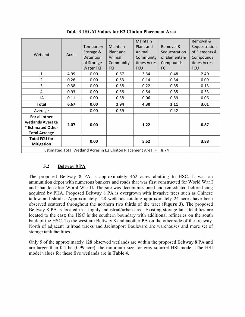
Table 3 IHGM Values for E2 Clinton Placement Area
Wetland Acres
Temporary Storage & Detention of Storage Water FCI
Maintain Plant and Animal Community FCI
Maintain Plant and Animal Community times Acres FCU
Removal & Sequestration of Elements & Compounds FCI
Removal & Sequestration of Elements & Compounds times Acres FCU
1 4.99 0.00 0.67 3.34 0.48 2.40 2 0.26 0.00 0.53 0.14 0.34 0.09 3 0.38 0.00 0.58 0.22 0.35 0.13 4 0.93 0.00 0.58 0.54 0.35 0.33
1A 0.11 0.00 0.58 0.06 0.59 0.06 Total 6.67 0.00 2.94 4.30 2.11 3.01
Average 0.00 0.59 0.42 For all other
wetlands Average * Estimated Other
Total Acreage
2.07 0.00 1.22 0.87
Total FCU for Mitigation 0.00 5.52 3.88
Estimated Total Wetland Acres in E2 Clinton Placement Area = 8.74
5.2 Beltway 8 PA
The proposed Beltway 8 PA is approximately 462 acres abutting to HSC. It was an ammunition depot with numerous bunkers and roads that was first constructed for World War I and abandon after World War II. The site was decommissioned and remediated before being acquired by PHA. Proposed Beltway 8 PA is overgrown with invasive trees such as Chinese tallow and shrubs. Approximately 128 wetlands totaling approximately 24 acres have been observed scattered throughout the northern two thirds of the tract (Figure 3). The proposed Beltway 8 PA is located in a highly industrial/urban area. Existing storage tank facilities are located to the east; the HSC is the southern boundary with additional refineries on the south bank of the HSC. To the west are Beltway 8 and another PA on the other side of the freeway. North of adjacent railroad tracks and Jacintoport Boulevard are warehouses and more set of storage tank facilities.
Only 5 of the approximately 128 observed wetlands are within the proposed Beltway 8 PA and are larger than 0.4 ha (0.99 acre), the minimum size for gray squirrel HSI model. The HSI model values for these five wetlands are in Table 4.
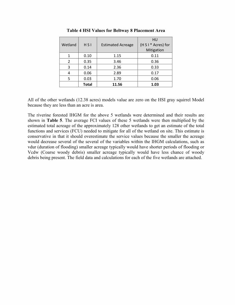
Table 4 HSI Values for Beltway 8 Placement Area
Wetland H S I Estimated Acreage HU
(H S I * Acres) for Mitigation
1 0.10 1.15 0.11 2 0.35 3.46 0.36 3 0.14 2.36 0.33 4 0.06 2.89 0.17 5 0.03 1.70 0.06 Total 11.56 1.03
All of the other wetlands (12.38 acres) models value are zero on the HSI gray squirrel Model because they are less than an acre is area.
The riverine forested IHGM for the above 5 wetlands were determined and their results are shown in Table 5. The average FCI values of these 5 wetlands were then multiplied by the estimated total acreage of the approximately 128 other wetlands to get an estimate of the total functions and services (FCU) needed to mitigate for all of the wetland on site. This estimate is conservative in that it should overestimate the service values because the smaller the acreage would decrease several of the several of the variables within the IHGM calculations, such as vdur (duration of flooding) smaller acreage typically would have shorter periods of flooding or Vcdw (Coarse woody debris) smaller acreage typically would have less chance of woody debris being present. The field data and calculations for each of the five wetlands are attached.

Table 5 IHGM Values for Beltway 8 Placement Area
Wetland Acres
Temporary Storage & Detention of Storage Water FCI
Maintain Plant and
Animal Community
FCI
Maintain Plant and
Animal Community times Acres
FCU
Removal & Sequestration of Elements &
Compounds FCI
Removal & Sequestration of Elements
& Compounds times Acres
FCU
1 1.15 0 0.49 0.5635 0.55 0.6325 2 3.46 0 0.56 1.9376 0.51 1.7646 3 2.36 0 0.56 1.3216 0.61 1.4396 4 2.89 0 0.61 1.7629 0.51 1.4739 5 1.7 0 0.52 0.884 0.6 1.02
Total 11.56 0 2.74 6.47 2.78 6.33 Average 0 0.55 0.56
For all other wetlands Average * Estimated Other Total Acreage
0 6.79 6.89
Total FCU for Mitigation 0 13.26 13.22
Estimated Total Acres of Other
Wetlands 12.38 Estimated Total Wetland Acres in Beltway 8 Placement Area = 23.94
5.3 Rosa Allen Expansion
RAE is located adjacent Allen Genoa Road approximately 0.25 mile south of State Highway 225. The southern half along Allen Genoa Road has a section of vacant land owned by others. The upper section of REA is an abandoned parking lot and storage area. Along the northeastern boundary is another section of vacant land owned by others. The southeastern boundary has a section of land owned by others and is used for utility and pipeline corridor. The RAE has two drainage ditches. One divides the upper and lower sections RAE and has a detention area. The other drainage ditch drains the existing Rosa Allen PA and flows between the adjacent vacant land along Allen Genoa Road owned by others and the land owned by PHA. The upper section also has a barrow area that is now a pond. The eastern part of the lower section has an area that has been used as a fill and barrow area and is associated with possible salt operations. The rest of the lower section is overgrown Chinese tallow (Triadica sebifera) forest with sections of emergent wetlands along the southern edge adjacent to the

utility and pipeline. During the site visit, no hard mast trees were observed within the forested wetlands, just Chinese tallow trees and shrubs.
Because of the recent addition of this site as a PA by the ongoing draft DMMP, time was only available to conduct a one day site visit to review the desk-top estimates of the wetland boundaries and to determine their types. The observed wetlands were similar to the wetlands observed at E2 Clinton and Beltway 8 PAs and the observations at these two PAs were used to estimate the function and services of the REA wetlands. There are only two emergent wetlands that are larger than 1 acre, Table 6. This wetland has similar attributes to approximately 5-acre wetland within E2 Clinton with bulrushes instead of cattails. Because of time restraints, the HSI value for Marsh Wren calculated for the 5-acre wetland (HSI 0.6) was used to calculate the replacement value for Marsh Wren at the REA emergent wetlands is 1.4 HU (HSI*acres; 0.6*2.41).
The average values of the Beltway 8 PA were used to calculate the grey squirrel HSI for forested wetlands at REM. The average HSI value (0.206) for the five wetlands at Beltway 8 was used to calculate the replacement grey squirrel HU (HSI *acres; 0.206*35.7) of 7.35. The average FCI IHGM values for Beltway 8 PA were used to calculate the FCU values needed for REM mitigation: Temporary Storage & Detention of Storage Water = 0; Maintain Plant and Animal Community = 19.6 (0.55*35.7); and Removal & Sequestration of Elements & Compounds = 14.3 (0.4*35.7).

Table 6 IHGM Values for Rosa Allen Expansion Area
Forested Wetlands HSI Model
IHGM Model FCU FCU FCU
Grey Squirrel Riverine Forested
Temporary Storage &
Detention of Storage Water
Maintain Plant and Animal Community times Acres
Removal & Sequestration of
Elements & Compounds times
Acres 1 27.7 2 8.1
Total 35.7 0.206 Values needed For
Mitigation HU = 7.39 0 19.6 14.3
Emergent Wetlands Marsh
Wren Riverine Herbaceous/Shrub
Temporary Storage &
Detention of Storage Water
Maintain Plant and Animal Community times Acres
Removal & Sequestration of
Elements & Compounds times
Acres 1 0.75 -* 2 0.13 -* 3 0.09 -* 4 0.20 -* 5 0.37 -* 6 0.94 -* 7 1.07 0.6 8 1.34 0.8 9 0.15 -*
Total 5.04 Values needed For
Mitigation HU = 1.4 0 15.2 11.1
* Wetlands smaller than 1 acre have a zero habitat for Marsh Wren
5.4 Direct Impacts
5.4.1 E2 Clinton PA
The entire 76 acres of the proposed E2 Clinton PA would be impacted. The existing barns, farm buildings, and shrubs within the borrow area would be removed. Berms would be built around the edges of the site using the existing material within the site. The specific details would be part of the DMMP that has not yet been fully developed, but would be accomplished during the post-ADM phase. The preliminary plans is to place the dredge pipelines in the channel of Hunting Bayou from HSC to upstream of the railroad tracks bridge and west across land owned by PHA, the pipeline and utility easements to E2 Clinton PA. Three HU credits would be needed. However, all of the observed wetlands, approximately 9 acres, would be filled and mitigated using an approved mitigation bank to mitigate for the following functions and services: Temporary Storage & Detention of Storage Water FCU = 0; Maintain Plant and

Animal Community FCU = 5.52; and Removal & Sequestration of Elements & Compounds FCU = 3.88.
5.4.2 Beltway 8 PA
The entire 462 acres of the proposed Beltway 8 PA would be impacted. The existing bunkers, roads, vegetation (trees and shrubs) would be removed. Berms would be built around the edges of the site using the existing material within the site. The specific details would be part of the DMMP that has not yet been developed, but would be accomplished during the post-ADM phase. Since the Beltway 8 PA is adjacent to HSC, the dredge pipelines would be placed directly on the property. However, all of the observed approximately 24 acres of wetlands would be filled and mitigated using an approved mitigation bank. Approximately 3 HU credits would be needed. However, all of the observed wetlands, approximately 24 acres, would be filled and mitigated using an approved mitigation bank to mitigate for the following functions and services: Temporary Storage & Detention of Storage Water FCU = 0; Maintain Plant and Animal Community FCU = 13.28; and Removal & Sequestration of Elements & Compounds FCU = 11.28.
5.4.3 Rosa Allen Extension PA
The entire 138 acres of the proposed RAE PA would be impacted. The existing parking lot and storage area would be removed. The pond and ditches within the detention area would be filled. Berms would be built around the edges of the site using the existing material within the site. The specific details would be part of the DMMP that has not yet been developed, but would be accomplished during the post-ADM phase. Preliminary plans are to extend the existing dredge pipelines to the adjacent Rosa Allen PA to the Rosa Allen Extension PA. Approximately 16 HU units would be needed. However, all of the observed approximately 41 acres of wetlands would be filled and mitigated using an approved mitigation bank to mitigate for the following function and services: Temporary Storage & Detention of Storage Water FCU = 0; Maintain Plant and Animal Community FCU = 34.8; and Removal & Sequestration of Elements & Compounds FCU = 25.4.
Table 7 lists the total HU determined (15.6 HU) and the total functions and services FCU needed to be mitigated at an approved bank: Temporary Storage & Detention of Storage Water FCU = 0; Maintain Plant and Animal Community FCU = 52.91; and Removal & Sequestration of Elements & Compounds FCU = 40.08.

Table 7 Mitigation Requirements (Habitat Units and Functional Capacity Units)
HSI HU IHGM FCU
Placement Area Marsh Wren
Grey Squirrel
Temporary Storage & Detention of Storage Water
Maintain Plant and Animal Community FCI times Acres
Removal & Sequestration of Elements & Compounds FCI times Acres
C2 Clinton Emergent 3.0 - 0 5.52 3.88 Beltway 8 Forest - 3.4 0 13.28 11.28 Rosa Allen Extension Emergent 7.9 0 19.6 14.3 Forest 1.4 0 15.2 11.1 subtotal 4.4 11.3
Total HUs 15.7 0 53.33 40.56
5.5 Indirect Impacts
5.5.1 E2 Clinton PA
The indirect impacts by construction and filling of the proposed E2 Clinton PA are minimal. The site has been used in the past as a fill site. It is mostly open pasture. Raising the berms around the proposed site would be a minor impact to the area. The site is already higher than the existing roads: Holland Avenue and 19th Avenue. Higher berms would not overall change the existing aesthetics along these roadways. Holland Avenue, and PA are located to the west. Nineteenth Street, a double set of railroad tracks, an electrical sub-station, and subdivision located to the south with the nearest house over 350 feet away from the property boundary. Pipeline and electrical easement are located to the west with open field on the other side of the easements. A warehouse complex is located to the north. During construction, there would be increased noise and filling of the PA would take several weeks. During this time the operations would have increase noise, lighting, and traffic. After the filling and decanting of the dredged material, the site would be leveled out and may be used again as open pasture. No increase in runoff is expected after the site has been filled. During the filling operations any rainfall would be held back and be part of the decanting process that requires specific discharge standards.
5.5.2 Beltway 8 PA
The indirect impacts by construction and filling of the proposed Beltway 8 PA are minimal. The site is currently an abandon ammunition depot located within a highly industrial area. After the site has been filled and leveled, the site is proposed to be developed as a warehouse dock facility. During construction, there would be increased noise and filling of the PA that would take several weeks. During this time the operations would have increase noise, lighting, and traffic. No increase in runoff is expected after the site has been filled. During the filling operations any rainfall would be held back and be part of the decanting process that requires specific discharge standards. When the site is developed as a warehouse dock facility, the
appropriate drainage and permitting would be conducted. It is expected that an increase in traffic, noise, and pollution associated with the new development would occur.
5.5.3 Rosa Allen Extension PA
The indirect impacts by construction and filling of the proposed RAE PA are minimal. The site is currently an abandon parking lot, open storage area, and overgrown Chinese tallow forest with emergent wetlands along the southern boundary. During construction, there would be increased noise and filling of the PA that would take several weeks. During this time the operations would have increase noise, lighting, and traffic. No increase in runoff is expected after the site has been filled. During the filling operations any rainfall would be held back and be part of the decanting process that requires specific discharge standards. Along Allen Genoa Road the raised berm would be observed and not overall change the existing aesthetics.
DETERMINATION OF CREDITS
The USACE Galveston District’s riverine herbaceous/shrub IHGM was used for the C2 Clinton PA and to the emergent RAE wetlands and the riverine forested IHGM model were used for the forested wetlands within the Beltway 8 PA and RAE forested wetlands. The results of the models are shown in Table 7. At an approved mitigation bank the following function and services would be purchased:
• Temporary Storage & Detention of Storage Water FCU = 0; • Maintain Plant and Animal Community FCU = 53.33; and • Removal & Sequestration of Elements & Compounds FCU = 40.56.
Since each of the proposed PA are outside of the 1% annual chance of flooding (100-year floodplain), the temporary storage & detention of storage water model value is zero. The calculations of the other two functions for the wetlands observed in E2 Clinton and Beltway 8 are attached. Because of the recent addition of REA as a PA by the ongoing draft DMMP, time was only available to conduct a one day site visit to review the desk-top estimates of the wetland boundaries and to determine their types. The observed wetlands were similar to the wetlands observed at E2 Clinton and Beltway 8 PAs in that they were heavily dominated by Chinese tallow, and the observations at these two PAs were used to estimate the function and services of the REA wetlands.
PROPOSED METHOD OF MITIGATION
The CECW-P Memorandum, Implementation Guidance for the Water Resources Development Act of 2007 – Section 2036(c) Wetlands Mitigation, dated November 6, 2008 required Civil Works projects to first consider the use of available mitigation banks in the Primary Service area for mitigating wetland impacts. Mitigation banks that have their primary service within the location of three proposed PAs would be used to purchase credits for all mitigation for the wetland impacts. Using a primary service area reduces the number of credits needed for mitigation and is generally is located in the same watershed. Using a secondary service area requires 1.5 times the number of required credits and is generally located in another watershed. Using a mitigation bank transfer the responsibility of creation, maintenance, ecological

performance, monitoring, and long-term management to bank. Mitigation banks do the following (Reppert, 1992):
• Consolidate small wetland losses into a larger area, increasing the ecological value. • Wetlands are normally established in advance, eliminating the lag time between loss
and replacement • Greater planning effort to establish a more thorough, ecologically sensitive wetland
design, maintenance, and monitoring design • Make for faster permit processing and decision-making and provide economies of time
and money • Provide a more formal and lasting arrangement for the preservation and maintenance.
Costs of purchasing wetland credits vary from $40,000 to $47,000 per credit and can widely vary between banks and time of purchase. For the approximately 94 credits needed for the three proposed PA, the cost would vary from approximately $3.7 to $4.4 million.
The cost to create wetlands to replace the function and services loss also varies. A wetland mitigation feasibility report for the cost of construction of 13.4 acres of forested and emergent wetlands estimated $3.6 million or $263,955/acre (URS, 2015). These costs did not include the land purchase, design of mitigation site, maintenance and long-term monitoring. Assuming the optimal FCI of 1.0 for the constructed wetlands of each acre, it would take 53 acres to replace the functions and services or approximately $14 million only for construction. Purchasing credits from an approved mitigation bank is a preferred approach to replacing the function and services of the impacted wetlands of the three proposed PAs.
Several banks have been contacted to determine if credits are immediately available. Currently, there are no credits available. However, new banks come on line with service areas within the proposed new PAs. Discussion with Harris County Flood Control District has several mitigation banks coming on line in the near future. Their bank representatives have stated that they will work with PHA to resolve the issues of available mitigation credits. If negotiations with Harris County Flood Control District fail, the PHA will negotiate purchase credits at another bank such as Gin City, Katy-Cypress, or any new mitigation bank that may come on line.

REFERENCES
Reppert, R. 1992. National Wetland Mitigation Banking Study. Wetlands Mitigation Banking Concepts. Institute for Water Resources Support Center. USACE. Alexandria, Virginia 22315. IWR Report 92-WMB-1.
URS. 2015. RG&E RARP Station 255. Wetland Mitigation Feasibility Analysis and Design.
U.S. Corps of Engineers (USACE). 2008. Memorandum: All SWG Regulatory Branch Personnel. Subject: SWG-Standard Operating Procedures (SOP); Using HGM to Determine Potential Wetland Function and the Appropriate Compensatory Mitigation for Unavoidable Wetland Impacts.