Embed Size (px)
Citation preview

Baker Khudeira Resource Star Ltd - Marrakai EL 24614 Final Report
1
FINAL REPORT
MARRAKAI EL 24614
Baker Khudeira
2012
Baker Khudeira Resource Star Ltd - Marrakai EL 24614 Final Report
2
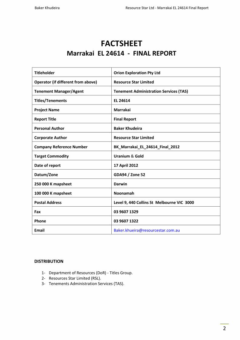
FACTSHEET Marrakai EL 24614 - FINAL REPORT
Titleholder Orion Exploration Pty Ltd
Operator (if different from above) Resource Star Limited
Tenement Manager/Agent Tenement Administration Services (TAS)
Titles/Tenements EL 24614
Project Name Marrakai
Report Title Final Report
Personal Author Baker Khudeira
Corporate Author Resource Star Limited
Company Reference Number BK_Marrakai_EL_24614_Final_2012
Target Commodity Uranium & Gold
Date of report 17 April 2012
Datum/Zone GDA94 / Zone 52
250 000 K mapsheet Darwin
100 000 K mapsheet Noonamah
Postal Address Level 9, 440 Collins St Melbourne VIC 3000
Fax 03 9607 1329
Phone 03 9607 1322
Email [email protected]
DISTRIBUTION
1- Department of Resources (DoR) - Titles Group.
2- Resources Star Limited (RSL).
3- Tenements Administration Services (TAS).
Baker Khudeira Resource Star Ltd - Marrakai EL 24614 Final Report
3
TABLE OF CONTENTS
Page
1.0 Introduction 4
2.0 Tenement Details 4
3.0 Location and Access 7
4.0 Regional Geology and Mineralisation 7
5.0 Project Geology 9
6.0 Previous Exploration 11
7.0 Work Carried Out during the Period 11
7.1 Airborne Geophysics 11
7.2 Mapping & Sampling 15
8.0 Exploration Potential 16
8.1 Uranium 16
8.2 Gold 16
References
18
LIST OF FIGURES
Figure 1 Marrakai Uranium Project Location 5
Figure 2 Geological setting and known mineral sites 6
Figure 3 Interpreted Pine Creek Stratigraphic Sequence 8
Figure 4 Project Interpreted Geology 10
Figure 5 Detailed Aeromagnetic Image 12
Figure 6 Uranium Channel Radiometric Image 13
Figure 7 Geological Interpretation & Radiometrics Combined 14
Figure 8 2010 Sample Locations 15
LIST OF TABLES
Table 1 Tenement Details 4

Baker Khudeira Resource Star Ltd - Marrakai EL 24614 Final Report
4
1.0 INTRODUCTION
This final report outlines the work completed for the Marrakai Uranium Project for the
last 6 years, the Marrakai Exploration Licence was granted on 2/12/2005
and relinquished on 20/12/2011 the Marrakai EL 24614 held by Resource Star Limited’s
100% owned subsidiary Orion Exploration Pty Ltd, and it covers an area of 20 km2.
The work undertaken has been planned to be systematic in nature, given the broad
nature of the prospectivity indicated by regional information which suggests the
potential for both gold and uranium anomalism first, with potential structural controls.
The Project is situated approximately 65 km SE of Darwin in the Northern Territory
(Fig 1). Geologically located toward the western edge of the body of the Pine Creek
Orogen, the region hosts the northern end of north-northwest trending Pine Creek
Shear Zone, and includes a number of uranium, gold and copper prospects (Fig 2).
2.0 TENEMENT DETAILS
Orion Exploration Pty Ltd (a wholly owned subsidiary of Resource Star Ltd) was granted
the exploration licence in 2005. Tenement details are presented in Table 1.
Table 1 - Tenement Details
Tenement
Registered Holder
Beneficial Holder
Date
Granted
Date
Surrender
Area
EL 24614 Orion Exploration Resource Star Ltd 2/12/05 20/12/11 20 km2

Baker Khudeira Resource Star Ltd - Marrakai EL 24614 Final Report
5
Figure 1 - Marrakai Uranium Project Location and Topography

Baker Khudeira Resource Star Ltd - Marrakai EL 24614 Final Report
6
Figure 2 - Regional Geological Setting
showing the location of EL 24614 at the northern end of the regional
Pine Creek Shear Zone and known mineral occurrences
Baker Khudeira Resource Star Ltd - Marrakai EL 24614 Final Report
7
3.0 LOCATION AND ACCESS
The Marrakai Project is located to the east of the Adelaide River about 65 km SE of Darwin
and 12 km east of the Stuart Highway. Access to the project area from the highway is by the
formed but unsealed Marrakai Road and then by pastoral tracks across a clay soil plain.
The project area contains area of low rocky rises and areas of clay soils.
Access is straightforward during the dry season but difficult during the wet.
4.0 REGIONAL GEOLOGY AND MINERALISATION
The project area is located within the Pine Creek Inlier, a Mid-Proterozoic orogen that hosts
a number of major uranium, gold and base metals deposits (Fig 2). Regional deformation
and metamorphism took place during the Barramundi Orogeny (1860-1850 Ma)
followed by widespread felsic intrusive activity. This igneous activity was characterised by
the emplacement of granite batholiths which produced thermal metamorphic aureoles in
the country rocks, overprinting regional metamorphic mineral assemblages.
The major Alligator River Uranium Field that includes the Ranger, Narbalek and Jabiluka
deposits is in the northeast of the Pine Creek Inlier. The smaller deposits of the South
Alligator Valley Mineral Field are situated to the northeast of Pine Creek.
The Pine Creek Orogen consists of Palaeoporoterozoic metasedimentary rocks that overlie
a gneissic and granitic basement outcropping in two domes northwest of the region near
the town of Batchelor. Uranium and polymetallic mineralisation is present within the
Palaeoproterozoic sediments that surround the domes, and is associated with major faults
and shears. This geosynclinal sequence was intruded by granitic plutons that are also of
Palaeoproterozoic age.
The Pine Creek Orogen was folded and regionally metamorphosed to chlorite facies
between 1870 and 1900 Ma. Two major phases of deformation pre-date the granitoid
intrusions. The first phase produced bedding-concordant fabrics and breccia zones.
The second phase produced north to northwest trending folds that vary from open and
upright to overturned and isoclinals. The folding was accompanied by the development of
a penetrative axial plane slatey cleavage.
Gold mineralisation occurs in two main structural settings; in quartz vein sets that are
parallel or sub-parallel to the axial plane cleavage, and in bedding parallel saddle reef
position quartz veins. Many of the deposits are located on anticlinal crests. Stockwork,
fault related, and stratiform gold mineralisation are also present in the region.
Uranium mineralisation is considered to have arisen from fluids remobilising the ore out of
enriched source rocks, although it is still unclear as to whether these originated from the
granitic basement material and/or uranium-bearing detrital minerals held within the
platform cover sandstones (Lally & Bajwah, 2006). However, precipitation of the uranium is
thought to have occurred by redox reaction when the oxidised fluids came into contact with
the overlying sediments.

Baker Khudeira Resource Star Ltd - Marrakai EL 24614 Final Report
8
This promoted the deposition of uranite where any lithological, structural or tectonic
weaknesses effectively acted as chemical and physical traps for ore accumulation
(eg. Lally, 2002; Lally & Bajwah, 2006; Lambert & Mckay, 2006).
A schematic diagram showing the Pine Creek stratigraphy is presented in Fig 3.
Recent discoveries associated with the Hayes Creek Fault Zone emphasise the importance of
structure in the final localisation of potentially economic uranium mineralisation.
Figure 3 - Schematic diagram of Pine Creek Stratigraphy

Baker Khudeira Resource Star Ltd - Marrakai EL 24614 Final Report
9
5.0 PROJECT GEOLOGY
The Marrakai project area is within the Paleoproterozoic Pine Creek Geosyncline,
and contains sediments of the Finnis River Group, the South Alligator Group,
and the Mount Partridge Group. Outcrop occurs along low rises above a plain that contains
areas of residual gravel and sand that comprise a Cainozoic duricrust surface and broad
alluvium rich in black clays and silt. The alluvial areas in the west of the tenement are part of
the Adelaide River flood plain and cover abandoned river channels.
The large alluvial channel in the northeast drains a substantial area to the east.
The project area is situated at the northern end of the Pine Creek Shear Zone.
A major northwest trending fault related to this zone passes through the tenement and a
parallel fault is just to the south. Another regionally significant fault, the northeast trending
Giants Reef Fault, is four kilometres to the northwest of the tenement.
A number of smaller northeast to east-northeast trending faults dislocate the Proterozoic
sequence, which is interpreted to comprise four fault separated blocks within the project
area.
The sequence is folded along north trending axes that are spaced about 750 m apart and
along which zones of brecciation and quartz veining have developed.
The geological interpretation of the project (Fig 4) shows areas of alluvium and floodplain
overlain. The Proterozoic geological succession is summarised in the legend.
The majority of the units contain similar lithologies, which, in conjunction with the
discontinuous outcrop, has led to significantly varying interpretations of the geology within
the project area.

Baker Khudeira Resource Star Ltd - Marrakai EL 24614 Final Report
10
Figure 4 - Marrakai Project
Interpreted geology and regional uranium channel data.
Uranium channel radiometric image of the project area, processed from data collected by
regional surveys flown at 200 m line spacing and a height of 60m between 1987 and 1999.
A north trending anomalous area is present in the south of the project area. It has a length
of about 1.5 km and a peak value of about 20 eppm U1.
Two smaller anomalies are present about one kilometre to the east. The larger anomaly is
largely over an area of north draining alluvium that is surrounded by low rises of Gerowie
Tuff and Koolpin Formation. High spots within the anomaly appear to be over outcrops of
the Ella Creek Member of the Koolpin Formation. Koolpin Formation rocks also appear to
be associated with the smaller anomalies to the east.
1 Equivalent parts per million uranium; interpreted from radiometric data rather than chemical
analysis. Results should be regarded as approximations only.
Baker Khudeira Resource Star Ltd - Marrakai EL 24614 Final Report
11
6.0 PREVIOUS URANIUM EXPLORATION
Previous exploration within the project area has been carried out by Kakadu Resources Ltd
(“Kakadu”) and Aztec Mining Company Ltd (“Aztec”). Kakadu carried out geological mapping
and collected about fifteen stream sediment BLEG samples and fifty rock chip samples
between 1987 and 1990 from the present tenement area.
The BLEG samples, although widely spaced, indicated the presence of anomalous gold in the
area, by returning values up to 8ppb Au.
The rock chip sampling returned results of 0.6g/t and 1.1g/t Au respectively from brecciated
chert and a ferruginous lens in the Ella Creek Member of the Koolpin Formation. About 700
m south of the tenement, a rock chip sample from the Koolpin Formation returned 2.0g/t
Au.
Aztec explored the area from 1991 to 1993. It also carried out stream sediment and rock
sampling (six stream sediment BLEG, about forty -40# stream sediment,
and five rock samples were collected). No anomalous results were obtained.
7.0 WORK CARRIED OUT
A major review of exploration strategy, potential and prioritisation of all Resource Star Ltd’s
Northern Territory prospects was finalised. CSA Global Pty Ltd,
who undertook the study, identified the RSL’s Edith River Project as the highest priority
target, and work on Marrakai has fitted in around work at Edith River as a ‘tier two’ project
with grass roots prospectivity.
The airborne geophysics, incorporating multi-spectral radiometrics and aeromagnetics,
was flown processed and interpreted, and a subsequent ground exploration program has
been completed, incorporating systematic soil / pit sampling, mapping and selective rock
chip sampling.
7.1 Airborne Geophysics
A program of detailed, low-level airborne geophysical surveying has been completed over
the entire tenement. A total of 200 line-km was flown for both multi-spectral radiometrics
and magnetics at 200 m line-spacing and a 60 m flight height. The work was undertaken by
GPX Surveys using a 32 litre NaI detector crystal.
Initial processing and interpretation of the data (Figs 5 to 7) has significantly improved
resolution, in particular better defining the structural disruption of the sedimentary units.
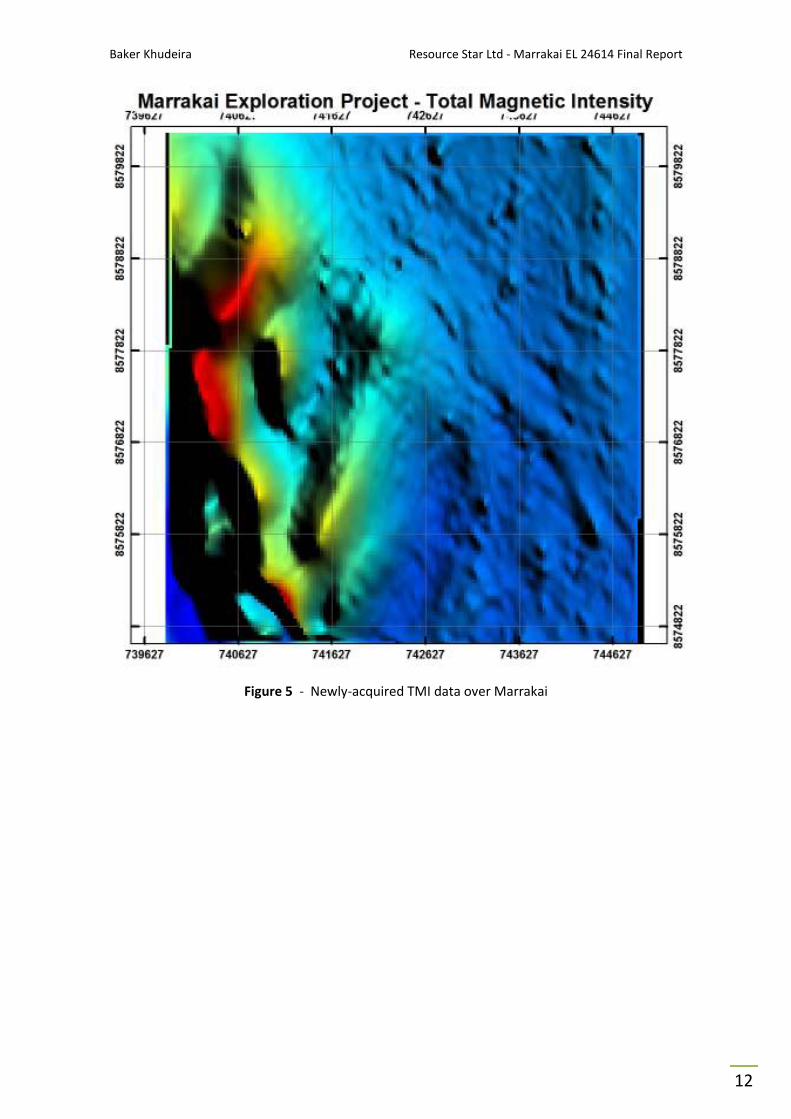
Baker Khudeira Resource Star Ltd - Marrakai EL 24614 Final Report
12
Figure 5 - Newly-acquired TMI data over Marrakai
Baker Khudeira Resource Star Ltd - Marrakai EL 24614 Final Report
13
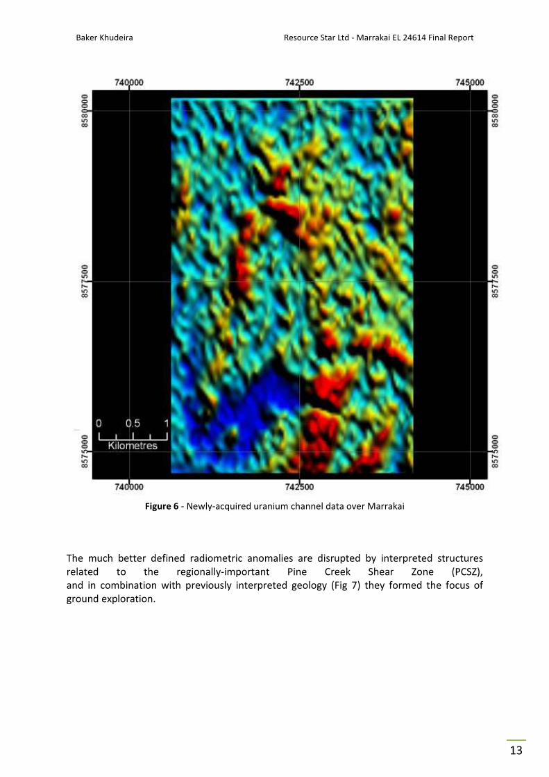
Figure 6 - Newly-acquired uranium channel data over Marrakai
The much better defined radiometric anomalies are disrupted by interpreted structures
related to the regionally-important Pine Creek Shear Zone (PCSZ),
and in combination with previously interpreted geology (Fig 7) they formed the focus of
ground exploration.

Baker Khudeira Resource Star Ltd - Marrakai EL 24614 Final Report
14
Figure 7 - Overlay image of the Marrakai Project
Uranium channel data overlain on interpreted geology.
Interpreted structural features appear to be confirmed and potential new disruptions are visible.

Baker Khudeira Resource Star Ltd - Marrakai EL 24614 Final Report
15
7.2 Surface Sampling
Figure 8 - 2010 Systematic Sampling of EL24614
showing sample locations, and features of interest generated by airborne geophysical survey
The detailed airborne geophysics has confirmed the potential prospectivity of the whole
lease for structurally-associated gold or uranium mineralisation, with deformation and
potential host units throughout the whole area. As such it was decided to complete
systematic reconnaissance sampling over the whole tenement taking such samples as
appropriate to the local conditions - with 66 rock-chip, surface soil or shallow pit sampling
depending on the extent of erosion or cover.
This sampling has been completed as shown on satellite imagery in Fig 8, but the analytical
results are not yet available.
Baker Khudeira

Baker Khudeira Resource Star Ltd - Marrakai EL 24614 Final Report
16
8.0 EXPLORATION POTENTIAL
The Marrakai Project is situated at the northern end of the Pine Creek Shear Zone (PCSZ)
and is prospective for uranium, gold, and iron mineralisation. It has never been
systematically explored, despite the fact that it is only 15 km from the Woodcutters Zn-Pb
mine, 30 km from the Rum Jungle U and polymetallic mines, is within the Pine Creek Shear
zone, and contains the same stratigraphy and structures as the major gold mines of the Pine
Creek region.
8.1 Uranium
The project area is also prospective for uranium mineralisation. The mineralisation within
the Rum Jungle Mineral Field to the southwest occurs within Mount Partridge Group
sediments, mainly within the Whites Formation, which is a calcareous and carbonaceous,
pyritic argillite. In general, the uranium mineralisation is associated with shearing and
brecciation. Within the Marrakai project area, the Koolpin Formation,
A pyritic carbonaceous shale, is a similar unit and a potential host for similar mineralisation.
The faults within the area may have provided pathways for mineralizing fluids and the
project is within a region that hosts numerous uranium deposits and occurrences.
The uranium anomalies depicted on Figure -7 are within an area of the tenement that
contains Koolpin Formation rocks. The anomalies can be considered to have located a target
area that has the potential to contain significant uranium mineralisation.
8.2 Gold
The location of the project area within the Pine Creek Shear Zone and the rock units within
it make it a prospective location for gold mineralisation. It is unlikely that outcropping
mineralisation has been missed, as quartz veined and brecciated outcrops have been
sampled by previous explorers. However, the stream sediment sampling that was carried
out is unlikely to have been effective in the testing of the area, as outcrop only covers less
than half of the tenement, the drainage is poorly defined, and the sample density was low.
In addition, the faults, with which gold mineralisation may be associated, are largely under
alluvial cover, much of which is likely to have been derived from outside the tenement.
The iron and sulphide rich composition of the Koolpin Formation makes it a favourable host
for gold mineralisation (at the 0.94 Moz Cosmo Howley deposit, about 75 km to the south,
the mineralisation is within a sulphidic iron formation, carbonaceous mudstone,
and mudstone unit of the Koolpin Formation). The other formations within the project area
are also prospective, the Wildman Siltstone being the host formation at the Toms Gully
Mine, the Mount Bonnie Formation the host at the 0.5 Moz Woolwonga deposit, and some
of the Brocks Creek-Zapopan deposits are described as being within or marginal to the
Gerowie Tuff.

Baker Khudeira Resource Star Ltd - Marrakai EL 24614 Final Report
17
Locally, the Maureen and Maureen Extended gold prospects, which are respectively located
7 km and 10 km to the south of the project area, are within the Koolpin Formation.
From 1986 to 1990, Kennecott Exploration (Australia) Ltd conducted extensive exploration
which located gold mineralisation at the Maureen and Maureen Extended prospects to the
south of the licence area. The gold mineralisation was detected by heavy-mineral
(pan concentrate) stream sediment and rock chip sampling and was confirmed by later bulk
cyanide leach (BCL) sampling. Extensive costeaning and drilling (mostly by reverse
circulation) was completed at Maureen prospect with a smaller program at Maureen
Extended prospect.
Early sampling also located the Heathers gold anomaly within the present licence area with
BCL values to 2.45 ppb and follow up rock chip values of 0.02 ppm Au; the location of this
prospect appears to coincide with an area of chert and banded iron formation of the
Koolpin Formation associated with the domal structure and the northwest-southeast fault in
the centre of the licence area. This may represent an extension of the Noonamah Fault.
Mineral Resources Corporation conducted gold exploration in the early part of 1986 on the
west part of EL 24614. First pass stream sediment sampling has outlined five isolated
anomalous gold values. Of the total 102 samples collected, the highest gold value obtained
was 9.08 ppb. Two mineralised zones trending NNW were recognized in the field.
The western zone is centred upon the Koolpin Formation which is composed of
carbonaceous and ferruginous argillaceous sediments. Gold values up to 2 ppm have been
obtained from iron rich lenses. BCL gold anomalies were delineated on the major NNW
trending fault.
Baker Khudeira Exploration Manager
M: + 61 449 011 801 || T: + 61 3 9607 1322 || F: + 61 3 9607 1329
Resource Star Limited www.resourcestar.com.au [ASX:RSL]
Level 9 - 440 Collins Street Melbourne VIC 3000 AUSTRALIA

Baker Khudeira Resource Star Ltd - Marrakai EL 24614 Final Report
18
REFERENCES
AJ Hosking and Associates Pty Ltd., 1994 - Exploration Licence 8157 Adelaide River,
First Annual Report - for year ending 05/10/94, Northern Territory Gold Mines NL, Open File Report,
DME CR1994/0893.
Ahmad, M, Wygralak A.S, Ferenczi P.A., 1999 - Geold Deposits of the Northern Territory,
Northern Territory Geological Survey, Department of Mines and Energy, Report 11.
Continental Resource Management Pty Ltd, 2008 - Independent Geologist’s Report for inclusion in
Prospectus, Resource Star Limited ASX release 7 July 2008.
Gandara, D., 2008 - Prospect Review, Iron Ore Licences, Northern Territory EL’s 24391, 24614
and 24432. Internal report by CSA Global Pty Ltd for Resource Star Limited. Report No. R234.2008.
Holden D., 1989 - Annual Report for Exploration Licence 4915 – Marrakai Northern Territory,
Kakadu Resources Ltd, Open File Report, DME CR1989/0779.
Ormsby W, R., 1993 - Final Report on Exploration Licence 7306 Adelaide River Area NT -
1st
May 1991 to 14th
Sept 1993, Aztec Mining Company Ltd, Open File Report, DME CR1993/0786.
Mineral Resources Corporation., 1988 - Interim Report, Marrakai Prospect - Northern Territory,
Open File Report, DME CR1988/0253.
Wipf, H., 2007 - Annual Report: Exploration Licence EL24614 Marrakai Project (CSA Australia Pty Ltd).