Embed Size (px)
Citation preview

Freshwater Atlas Warehouse Model Specification - v1.3
Prepared for The Crown Registry and Geographic Base Branch
of the Integrated Land Management Bureau
Ministry of Agriculture and Lands
Prepared by Refractions Research Inc.
#300 – 1207 Douglas Street Victoria, BC
www.refractions.net
Document Tracking Version: 3
Last Updated: June 19, 2008
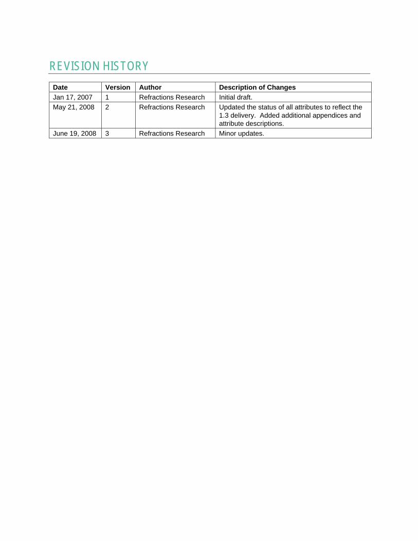
REVISION HISTORY Date Version Author Description of Changes Jan 17, 2007 1 Refractions Research Initial draft. May 21, 2008 2 Refractions Research Updated the status of all attributes to reflect the
1.3 delivery. Added additional appendices and attribute descriptions.
June 19, 2008 3 Refractions Research Minor updates.
Freshwater Atlas - Warehouse Model Specification Page i
CONTENTS
1 Introduction ....................................................................................................................... 1 1.1 Purpose .................................................................................................................... 1 1.2 Scope ....................................................................................................................... 1 1.3 Assumptions .............................................................................................................. 1
2 Definitions ......................................................................................................................... 2
3 Data Specifications ............................................................................................................ 5 3.1 Data Extents .............................................................................................................. 5 3.2 Data Contents ........................................................................................................... 6 3.3 Data Precision ........................................................................................................... 7 3.4 Coordinate System .................................................................................................... 7 3.5 Data Directionality ..................................................................................................... 7
4 Layer Specifications .......................................................................................................... 9 4.1 Layers ....................................................................................................................... 9
4.1.1 Linear Layers ................................................................................................................................ 9 4.1.2 Point Layers ................................................................................................................................ 10 4.1.3 Polygon Layers ............................................................................................................................ 11 4.1.4 Non-spatial Layers ....................................................................................................................... 13
4.2 Linear Layer Descriptions .......................................................................................... 14 4.2.1 Coastline SP ............................................................................................................................... 14 4.2.2 Stream Network SP ..................................................................................................................... 15 4.2.3 Linear Boundary SP ..................................................................................................................... 16 4.2.4 Watershed Boundary SP .............................................................................................................. 17 4.2.5 Route SP .................................................................................................................................... 18
4.3 Point Layer Descriptions ........................................................................................... 18 4.3.1 Obstruction SP ............................................................................................................................ 18 4.3.2 Named Point Feature SP .............................................................................................................. 19 4.3.3 Stream Direction SP .................................................................................................................... 20
4.4 Polygon Layer Descriptions ....................................................................................... 20 4.4.1 Lake Poly .................................................................................................................................... 20 4.4.2 River Poly ................................................................................................................................... 21 4.4.3 Wetland Poly ............................................................................................................................... 23 4.4.4 Manmade Waterbody Poly ............................................................................................................ 24 4.4.5 Glacier Poly ................................................................................................................................ 25 4.4.6 Watershed Group Poly ................................................................................................................. 27 4.4.7 Watershed Feature ...................................................................................................................... 27 4.4.8 Nth Order Watershed Poly ........................................................................................................... 29 4.4.9 Named Watershed Poly ................................................................................................................ 31

Freshwater Atlas - Warehouse Model Specification Page 2
4.4.10 Island Poly .............................................................................................................................. 31 4.4.11 Bay and Channel Poly ............................................................................................................. 32
4.5 Non-Spatial Layer Descriptions ................................................................................. 33 4.5.1 Edge Type Cds ............................................................................................................................ 33 4.5.2 Waterbody Type Cds ................................................................................................................... 33 4.5.3 Waterbody 20k 50k ...................................................................................................................... 33 4.5.4 Stream 20k 50k ........................................................................................................................... 34
5 Appendix A - Feature Codes ............................................................................................ 35
6 Appendix B – Controlling Routes ...................................................................................... 37
7 Appendix C – Blue Line Key, Watershed Key, and Freshwater Atlas Watershed Code ........ 39 7.1 How the Attributes are Calculated .............................................................................. 39 7.2 How the Attributes are Attached to Arcs ..................................................................... 39 7.3 How the Attributes are Attached to Arcs - Delimiters ................................................... 41 7.4 How the Attributes are Attached to Arcs – Coastline Arcs ........................................... 42
8 Appendix D – Related Documents .................................................................................... 43 8.1 Feature Naming ........................................................................................................ 43 8.2 Routes ..................................................................................................................... 43 8.3 Freshwater Atlas Watershed Code (Hierarchical Keys) ............................................... 44 8.4 Order & Magnitude ................................................................................................... 44 8.5 20k – 50k Conflation ................................................................................................. 44 8.6 Watershed Boundary Generation & Fundamental Watersheds ..................................... 44 8.7 Stream Elevation ...................................................................................................... 45

Freshwater Atlas - Warehouse Model Specification Page 3
FIGURESFigure 1: Primary/Secondary Example ....................................................................................... 2
Figure 2: Delimiter Example ....................................................................................................... 3
Figure 3: Bank Example .............................................................................................................. 3
Figure 4: Designated Headwater Example .................................................................................. 3
Figure 5: Freshwater Atlas Regions ............................................................................................ 5
Figure 6: Lake and River Controlling Route ............................................................................. 37
Figure 7: Wetland Controlling Routes ...................................................................................... 38
Figure 8: Attribute Blue Line Key Example ............................................................................. 40
Figure 9: Delimiters and bl_key, ws_key, cwb_ws_code ......................................................... 41

Freshwater Atlas - Warehouse Model Specification Page 4
TABLESTable 1: Definitions .................................................................................................................... 2
Table 2: Linear Layers ................................................................................................................. 9
Table 3: Point Layers ................................................................................................................. 10
Table 4: Polygon Layers ............................................................................................................ 11
Table 5: Non-spatial Layers ....................................................................................................... 13
Table 6: Feature Code Attribute Table ..................................................................................... 35
Table 7: Format of Hierarchical Keys ....................................................................................... 44

Freshwater Atlas - Warehouse Model Specification Page 1
1 INTRODUCTION
1.1 PURPOSE This document is intended to outline the geometry and attribute model for the Freshwater Atlas Version 1.3 data load into the SDE in a generally readable format. The SDE Oracle logical model approved by ILMB defines the official model and is the absolute definition for the Freshwater Atlas SDE model.
This document also specifies the data that will be loaded into the model with the SDE load scheduled for release July 2, 2008.
1.2 SCOPE This document includes the following:
• Descriptions of all layers, geometries and attributes of the Freshwater Atlas, Version 1.3.
The document does not include:
• Information on the source of the Freshwater Atlas data.
• Detailed information on how the attributes were derived or computed.
• Information on manual or automated modification made to the geometries.
1.3 ASSUMPTIONS • The document is intended only to outline the specifications for the Version 1.3
Freshwater Atlas Data Load.
Freshwater Atlas - Warehouse Model Specification Page 2
2 DEFINITIONS
Table 1: Definitions
Term Definition
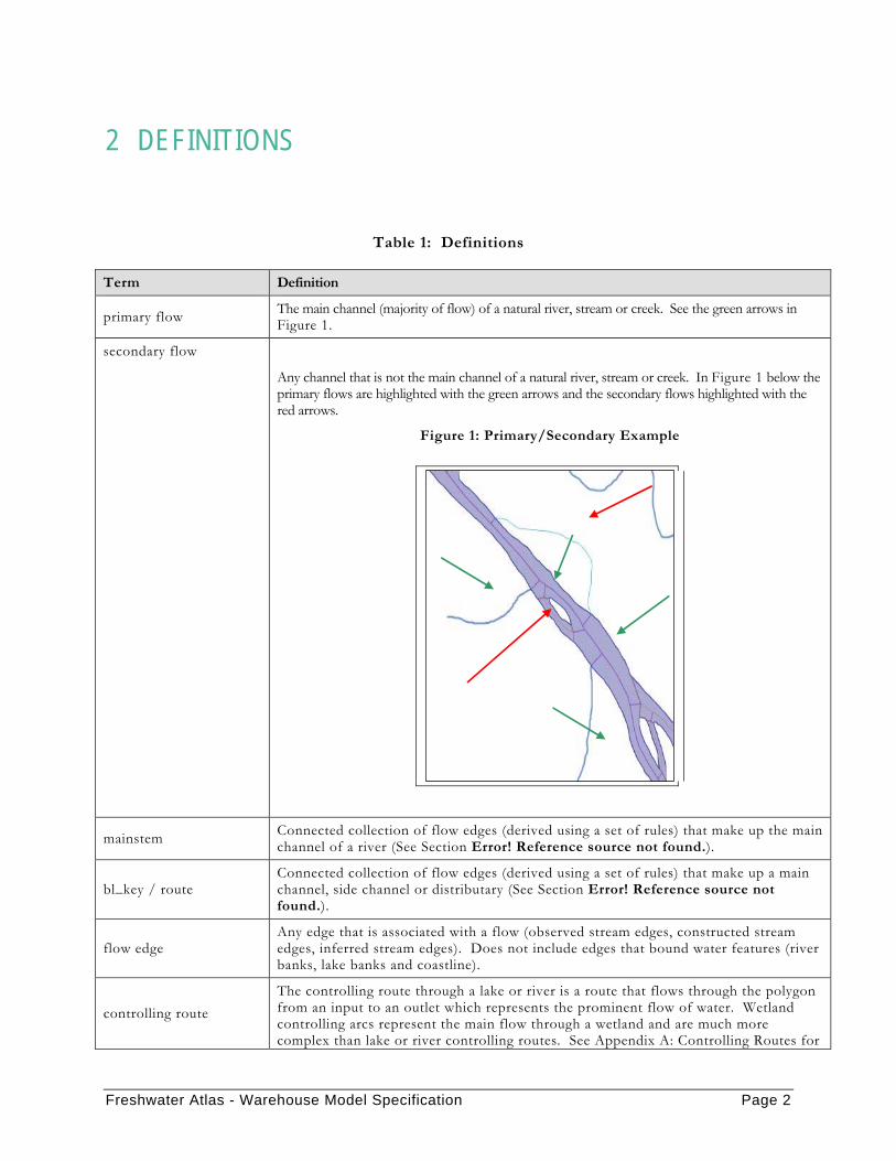
primary flow The main channel (majority of flow) of a natural river, stream or creek. See the green arrows in Figure 1.
secondary flow
Any channel that is not the main channel of a natural river, stream or creek. In Figure 1 below the primary flows are highlighted with the green arrows and the secondary flows highlighted with the red arrows.
Figure 1: Primary/Secondary Example
mainstem Connected collection of flow edges (derived using a set of rules) that make up the main channel of a river (See Section Error! Reference source not found.).
bl_key / route Connected collection of flow edges (derived using a set of rules) that make up a main channel, side channel or distributary (See Section Error! Reference source not found.).
flow edge Any edge that is associated with a flow (observed stream edges, constructed stream edges, inferred stream edges). Does not include edges that bound water features (river banks, lake banks and coastline).
controlling route The controlling route through a lake or river is a route that flows through the polygon from an input to an outlet which represents the prominent flow of water. Wetland controlling arcs represent the main flow through a wetland and are much more complex than lake or river controlling routes. See Appendix A: Controlling Routes for

Freshwater Atlas - Warehouse Model Specification Page 3
more information.
delimiter
Any edge that delimits water from water (lake from river, river from ocean, river from river, lake from lake, etc). In Figure 2 below the delimiters are highlighted in red.
Figure 2: Delimiter Example
bank
Any edge that delimits water from land (lake bank, river bank, wetland bank, etc) as shown in Figure 3 (the banks are highlighted in red).
Figure 3: Bank Example
TRIM Terrain Resource Information Mapping – Program to produce digital maps for the province of BC. (http://srmwww.gov.bc.ca/bmgs/baseline_atlas/)
TRIM 1 Original mapping of the province of BC (1:20k scale) completed in December 1996.
TRIM II A program to update the original TRIM data to new specifications.
designated headwater Designated headwaters are linework added to lakes and double line rivers to identify that routes/mainstems should not be pushed upstream of the waterbody.

Freshwater Atlas - Warehouse Model Specification Page 4
Figure 4: Designated Headwater Example
Designated headwaters are added for two reasons:
• The lake represents where ‘the majority of the water flows from’. None of the tributaries of the lake represent significant flow.
• Naming reasons – the lake is the known to be the headwaters of the named stream flowing out of the lake.
BMGS Base Mapping and Geomatic Services (http://srmwww.gov.bc.ca/bmgs/)

Freshwater Atlas - Warehouse Model Specification Page 5
3 DATA SPECIFICATIONS
3.1 DATA EXTENTS The data provided in Freshwater Atlas Version 1.3 includes data within British Columbia for all regions. Extra-jurisdictional data will not be provided for this version of the Freshwater Atlas. The figure below shows the extents of each of the five Freshwater Atlas regions and extra-jurisdictional data.
Figure 5: FRESHWATER ATLAS Regions
Freshwater Atlas contains a BC Border feature, which provides linework “defining” the BC Border (from the perspective of Freshwater Atlas). This border is not the official surveyed BC border. Rather, it was derived from various data sources purely in order to provide a well-defined provincial polygon which could be used to close off other Freshwater Atlas features, as a convenient approximation:
• The southern border was created using the ends of the streams along the border as mapped by TRIM. The border line is formed by connecting stream ends in sequence.
Freshwater Atlas - Warehouse Model Specification Page 6
• The eastern border through the Rockies (the Great Divide) is derived from the generated watershed boundary edges.
• The north-eastern border north of the Great Divide is the eastern edges of the 1:20K mapsheet tiles from TRIM.
• The northern border is the northern edges of the 1:20K mapsheet tiles from TRIM.
• The Alaska border is the scanned boundary from the 1:50K MYLAR mapsheets, extracted from the 1:50K Watershed Atlas.
In most areas the Freshwater Atlas generated watersheds were clipped to or closed by the segments of Freshwater Atlas BC Border. However, along the Great Divide the opposite is the case – the Freshwater Atlas BC Border was derived from the computed watershed boundaries.
3.2 DATA CONTENTS The data delivery will include the following Freshwater Atlas features:
• Stream Network
• Waterbodies
• Obstructions
• Bays, Channels, Named Points
• Islands
• Named Points
• Watershed Polygons
• Coastline
The data delivery will not include the following features:
• Elevation data on anything other than the stream network (as per client decision)
• Glaciers (These have not changed since the 1.2 version)
• Watershed Group Polygons (These have not been regenerated for the 1.3 delivery)
Freshwater Atlas - Warehouse Model Specification Page 7
3.3 DATA PRECISION All edges will meet the following precision requirements:
• will not collapse when snapped to a 10−3m grid.
• will not produce invalid, or complex geometries when snapped to a 10−3m grid.
In addition the stream network will not contain any interior intersections when snapped to a 10−3m grid.
The ordinates are provided as double precision values.
All integer types refer to signed 32-bit integers.
3.4 COORDINATE SYSTEM The data will be delivered in the BC Albers projection defined as follows:
• Central meridian: 126.0 degrees
• Standard parallel 1: 50.0 degrees
• Standard parallel 2: 58.5 degrees
• Latitude of origin: 45 degrees
• Reference System: NAD83 (North American Datum 1983)
All data will be provided as 2-D (x,y) values.
3.5 DATA DIRECTIONALITY The following directionality rules apply to all arcs:
• All flow arcs are directionalized upstream (from sink to source).
• Lake and double line river banks are directionalized in the same direction as their controlling route (upstream from sink to source).
• Coastline arcs are directionalized using the right hand rule (“right hand in the feature you are bounding”); therefore coastal islands are directionalized clockwise.
• Wetland banks are directionalized in the same direction as their controlling route.
• Delimiters are directionalized based on the controlling route.

Freshwater Atlas - Warehouse Model Specification Page 8
• Provincial and international boundary arcs are undirectionalized.

Freshwater Atlas - Warehouse Model Specification Page 9
4 LAYER SPECIFICATIONS
4.1 LAYERS The SDE contains the following layers. Some of these layers will be delivered as multiple files; one file per watershed group. Other layers will be delivered as a single file for the entire province.
The column “version” indicates with which release the data was populated. A value of “N” indicates the data has not been delivered and thus is not populated in the LRDW.
4.1.1 Linear Layers
Table 2: Linear Layers
Layer Name Shapefile Name
Type Description VERSION
Coastline SP WSG_CST Line
Contains all coastline edges including marine islands and the mainland coast. Does not contain multipart geometries.
1.3
Stream Network SP WSG_SS Line
Contains only flow network arcs (observed, inferred and constructed flows). Contains no banks, coast or watershed boundary arcs. Does not contain multipart geometries.
1.3
Linear Boundary SP WSG_LB Line
Contains all bank edges (of rivers, lakes and wetlands), delimiter edges, glacier edges and administrative boundary edges. Does not contain multipart geometries.
Glacier edges - 1.2 Other edges - 1.3

Freshwater Atlas - Warehouse Model Specification Page 10
Layer Name Shapefile Name
Type Description VERSION
Watershed Boundary SP WSG_WB Line
Contains all principal and non-principal watershed boundary lines. Does not contain multipart geometries.
1.3
Route SP N/A Line
Contains route geometries. Combines all flow network arcs with the same blue line key into a single multi-geometry with distance attribution.
N
4.1.2 Point Layers
Table 3: Point Layers
Layer Name Shapefile Name
Type Description Version
Obstructions SP WSG_PNT Point
Contains water obstacles (rapids, falls, artificial waterfalls, etc). This does not contain multipart geometries.
1.3
Named Point Feature SP cst_points Point
Contains point features (both fresh and coastal) and associated names. This does not contain multipart geomtries.
1.3
Stream Direction SP str_dir Point
Directional arrowheads for use with web mapping applications only. Arrowheads are in various sizes for scale dependant display. Arrowhead orientation is based on the vertex order of the referenced
N

Freshwater Atlas - Warehouse Model Specification Page 11
Layer Name Shapefile Name
Type Description Version
linear element.
4.1.3 Polygon Layers
Table 4: Polygon Layers
Layer Name Shapefile Name
Type Description Version
Lake Poly WSG_LW Polygon
Contains all lake polygons for the province. Does not contain multipart geometries.
1.3
River Poly WSG_RW Polygon
Contains all double line river polygons for the province. Does not contain multipart geometries.
1.3
Wetland Poly WSG_WW Polygon
Contains all wetland polygons for the province. Does not contain multipart geometries.
1.3
Manmade Waterbody Poly WSG_MW Polygon
Contains all manmade waterbody polygons including reservoirs and canals. Does not contain multipart geometries.
1.3
Watershed Group Poly WSG_GP Multi-Polygon
Contains polygons delimiting the watershed group boundary which is a collection of drainage basins. In-land groups will contain a single polygon, coastal groups may contain multiple polygons (one for each island) i.e., this is a multipart polygon feature.
1.2

Freshwater Atlas - Warehouse Model Specification Page 12
Layer Name Shapefile Name
Type Description Version
Watersheds Poly WSG_PWSH Polygon
Contains all polygons generated from fundamental watershed boundary lines. A fundamental watershed boundary line is a watershed boundary line that bounds two unit polygons with different Freshwater Atlas watershed codes or is identified as isolated.
1.3
Nth Order Watershed Poly WSG_WSH Polygon
Maximal watershed polygons of Nth order plus all remaining unit watershed polygons and double line river, and lake polygons necessary to create a non-overlapping province wide dataset. This layer mimics the 1:50K 3rd order watershed coverage polygon layer.
N
Island Poly cst_islands Polygon
Contains all island polygons. Islands may overlap as there are islands within islands.
1.3
Bay and Channel Poly cst_polygons Polygon
Contains bay and channel (fresh and coastal) features and associated names.
1.3
Glacier Poly glaciers Polygon Contains glaciers and ice masses as polygons.
1.2
Named Watersheds Poly wsh_named Polygon
Contains all named river watershed polygons. There
1.2

Freshwater Atlas - Warehouse Model Specification Page 13
Layer Name Shapefile Name
Type Description Version
are approximately 12,000 named streams in BC.
4.1.4 Non-spatial Layers
Table 5: Non-spatial Layers
Layer Name Shapefile Name Description Version
Edge Type Cds edge_codes Contains the type codes with an English description used to categorize linear features.
1.2
Waterbody Type Cds wb_codes Contains all waterbody type codes and an English description.
1.2
Waterbody 20k 50k 20k50k_wbs
Contains all primary and secondary matches between 1:20K and 1:50K waterbody polygons.
1.3
Stream 20k 50k 20k50k_streams Contains all primary and secondary matches between 1:20K and 1:50K stream edges.
1.3

Freshwater Atlas - Warehouse Model Specification Page 14
4.2 LINEAR LAYER DESCRIPTIONS
4.2.1 Coastline SP
ATTRIBUTE NAME version DESCRIPTION LINEAR FEATURE ID 1.3 A unique numeric identifier used to link the arc to the database. GEOMETRY 1.3 ArcSDE spatial column: coordinates defining the features. OBJECTID 1.3 Populated by SDE. LENGTH METRE 1.3 The length in meters of the linear object
FEATURE CODE 1.3 The MOEP standard numeric code to identify the type of feature represented by the spatial data.
FEATURE SOURCE 1.3 The source of the arc; where the feature was obtained or modified.
EDGE TYPE 1.3 The numeric code used by the Freshwater Atlas to identify the various types of water network linear features.
BLUE LINE KEY 1.3
Uniquely identifies a single flow line such that a main channel and a secondary channel with the same watershed code would have different blue line keys (the Fraser River and all side channels have different blue line keys).
CWB WATERSHED CODE 1.3
A 143 character code derived using a hierarchy coding scheme. Approximately identifies where a particular stream is located within the province.
WATERSHED KEY 1.3
A key that identifies a stream system (for example the Fraser River mainstem and all its side channels the same watershed key). There is a 1:1 match between a watershed key and watershed code. The watershed key will match the blue line key for the mainstem.
WATERSHED GROUP CODE 1.3 The watershed group code the feature is contained within.
WATERSHED GROUP ID 1.3 A unique numeric key representing the watershed group code.
LOCAL WATERSHED CODE N
A 143 character code similar to the Freshwater Atlas watershed code that further subdivides remnant polygons to provide an approximate location along the mainstem.
DOWNSTREAM ROUTE MEASURE 1.3
The distance along the route from the mouth of the route to the feature. This distance is measured from the mouth of the containing route to the downstream end of the feature.

Freshwater Atlas - Warehouse Model Specification Page 15
4.2.2 Stream Network SP
ATTRIBUTE NAME version DESCRIPTION
LINEAR FEATURE ID 1.3 A unique numeric identifier used to link the arc to the database.
GEOMETRY 1.3
ArcSDE spatial column: coordinates defining the features. Note: version 1.3 has x,y,z values where z represents the refined elevation.
OBJECTID 1.3 Populated by SDE. LENGTH METRE 1.3 The length in meters of the linear object
FEATURE CODE 1.3 The MOEP standard numeric code to identify the type of feature represented by the spatial data.
FEATURE SOURCE 1.3 The source of the arc; where the feature was obtained or modified.
EDGE TYPE 1.3 The numeric code used by the Freshwater Atlas to identify the various types of water network linear features.
BLUE LINE KEY 1.3
Uniquely identifies a single flow line such that a main channel and a secondary channel with the same watershed code would have different blue line keys (the Fraser River and all side channels have different blue line keys).
CWB WATERSHED CODE 1.3
A 143 character code derived using a hierarchy coding scheme. Approximately identifies where a particular stream is located within the province.
WATERSHED KEY 1.3
A key that identifies a stream system (for example the Fraser River mainstem and all its side channels the same watershed key). There is a 1:1 match between a watershed key and watershed code. The watershed key will match the blue line key for the mainstem.
WATERSHED GROUP CODE 1.3 The watershed group code the feature is contained within.
WATERSHED GROUP ID 1.3 A unique numeric key representing the watershed group
code.
GNIS ID 1.3 The BCGNIS (BC Geographical Names Information System) feature id.
GNIS NAME 1.3
The BCGNIS (BC Geographical Names Information System) name associated with the GNIS feature id (an English name was used where available, otherwise another language was selected).
STREAM ORDER 1.3 The calculated modified Strahler order. STREAM MAGNITUDE 1.3 The calculated magnitude.
WATERBODY KEY 1.3 The waterbody key of the waterbody the edge is contained within.
BLUE LINE KEY 50K 1.3 The best matched blue line key from the 1:50K Watershed
Freshwater Atlas - Warehouse Model Specification Page 16
ATTRIBUTE NAME version DESCRIPTION Atlas.
WATERSHED CODE 50K 1.3 The hierarchical identifier from the 1:50K Watershed Atlas
associated with the blue line key 50k. WATERSHED KEY 50K 1.3 The 50K watershed key associated with the blue line key
50K from the 1:50K Watershed Atlas. WATERSHED GROUP CODE 50K 1.3 The 50K group code associated with the 50K blue line key
from the 1:50K Watershed Atlas.
GRADIENT N The gradient of the stream. How the gradient is defined is to be determined.
LOCAL WATERSHED CODE 1.3
A 143 character code similar to the Freshwater Atlas watershed code that further subdivides remnant polygons to provide an approximate location along the mainstem.
DOWNSTREAM ROUTE MEASURE 1.3
The distance along the route from the mouth of the route to the feature. This distance is measured from the mouth of the containing route to the downstream end of the feature.
LEFT RIGHT TRIBUTARY N Describes which side of the local mainstem this tributary
enters on. Valid values are: left or right
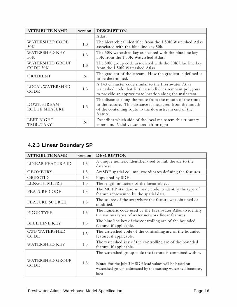
4.2.3 Linear Boundary SP
ATTRIBUTE NAME version DESCRIPTION
LINEAR FEATURE ID 1.3 A unique numeric identifier used to link the arc to the database.
GEOMETRY 1.3 ArcSDE spatial column: coordinates defining the features. OBJECTID 1.3 Populated by SDE. LENGTH METRE 1.3 The length in meters of the linear object
FEATURE CODE 1.3 The MOEP standard numeric code to identify the type of feature represented by the spatial data.
FEATURE SOURCE 1.3 The source of the arc; where the feature was obtained or modified.
EDGE TYPE 1.3 The numeric code used by the Freshwater Atlas to identify the various types of water network linear features.
BLUE LINE KEY 1.3 The blue line key of the controlling arc of the bounded feature, if applicable.
CWB WATERSHED CODE 1.3 The watershed code of the controlling arc of the bounded
feature, if applicable.
WATERSHED KEY 1.3 The watershed key of the controlling arc of the bounded feature, if applicable.
WATERSHED GROUP CODE 1.3
The watershed group code the feature is contained within. Note: For the July 31st SDE load values will be based on watershed groups delineated by the existing watershed boundary lines.
Freshwater Atlas - Warehouse Model Specification Page 17
ATTRIBUTE NAME version DESCRIPTION WATERSHED GROUP ID 1.3 A unique numeric key representing the watershed group
code. WATERBODY KEY 1.3 The waterbody key of the waterbody the edge bounds.
LOCAL WATERSHED CODE N
A 143 character code similar to the Freshwater Atlas watershed code that further subdivides remnant polygons to provide an approximate location along the mainstem.
DOWNSTREAM ROUTE MEASURE N
The distance along the route from the mouth of the route to the feature. This distance is measured from the mouth of the containing route to the downstream end of the feature.
4.2.4 Watershed Boundary SP
ATTRIBUTE NAME version DESCRIPTION WATERSHED BOUNDARY ID 1.3 A unique numeric identifier used to link the arc to the
database. GEOMETRY 1.3 ArcSDE spatial column: coordinates defining the features. OBJECT ID 1.3 Populated by SDE. LENGTH METRE 1.3 The length in meters of the linear object.
FEATURE CODE 1.3 The MOEP standard numeric code to identify the type of feature represented by the spatial data.
FEATURE SOURCE 1.3 The source of the arc; where the feature was obtained or modified.
EDGE TYPE 1.3 The numeric code used by the Freshwater Atlas to identify the various types of water network linear features.
BLUE LINE KEY RIGHT N The blue line key of watershed to the right of this edge.
BLUE LINE KEY LEFT N The blue line key of the watershed to the left of this edge. CWB WATERSHED CODE RIGHT N The watershed code of the watershed to the right of this
edge. CWB WATERSHED CODE LEFT N The watershed code of the watershed to the left of this
edge. LOCAL WATERSHED CODE RIGHT N The local watershed code of the watershed to the right of
this edge. LOCAL WATERSHED CODE LEFT N The local watershed code of the watershed to the left of
this edge. WATERSHED KEY RIGHT N The watershed key of the stream to the right of this edge.
WATERSHED KEY LEFT N The watershed key of the stream to the left of this edge.
WATERSHED GROUP CODE 1.3 The watershed group code the feature is contained within.
WATERSHED GROUP ID 1.3 A unique numeric key representing the watershed group
code.

Freshwater Atlas - Warehouse Model Specification Page 18
4.2.5 Route SP
ATTRIBUTE NAME version DESCRIPTION ROUTE ID N A unique identifier. GEOMETRY N ArcSDE spatial column: coordinates defining the features. OBJECTID N Populated by SDE.
FEATURE CODE N The MOEP standard numeric code to identify the type of feature represented by the spatial data.
LENGTH METRE N The length of the geometry feature (in meters).
BLUE LINE KEY N
Uniquely identifies a single flow line such that a main channel and a secondary channel with the same watershed code would have different blue line keys (the Fraser River and all side channels have different blue line keys).
CWB WATERSHED CODE N
A 143 character code derived using a hierarchy coding scheme. Approximately identifies where a particular stream is located within the province.
WATERSHED KEY N
A key that identifies a stream system (for example the Fraser River mainstem and all its side channels the same watershed key). There is a 1:1 match between a watershed key and watershed code. The watershed key will match the blue line key for the mainstem.
4.3 POINT LAYER DESCRIPTIONS
4.3.1 Obstruction SP
ATTRIBUTE NAME version DESCRIPTION OBSTRUCTION ID 1.3 Unique key representing the point. GEOMETRY 1.3 ArcSDE spatial column: coordinates defining the features OBJECTID 1.3 Populated by SDE.
FEATURE CODE 1.3 The MOEP standard numeric code to identify the type of feature represented by the spatial data.
FEATURE SOURCE 1.3 The source of the arc; where the feature was obtained or modified.
GNIS ID 1.3 The BCGNIS (BC Geographical Names Information System) feature id associated with the feature.
GNIS NAME 1.3
The BCGNIS (BC Geographical Names Information System) name associated with the GNIS feature id (an English name was used where available, otherwise another language was selected).
OBSTRUCTION TYPE 1.3 String representing the type of obstacle (Rapid, Fall, Dam etc.).
Freshwater Atlas - Warehouse Model Specification Page 19
ATTRIBUTE NAME version DESCRIPTION
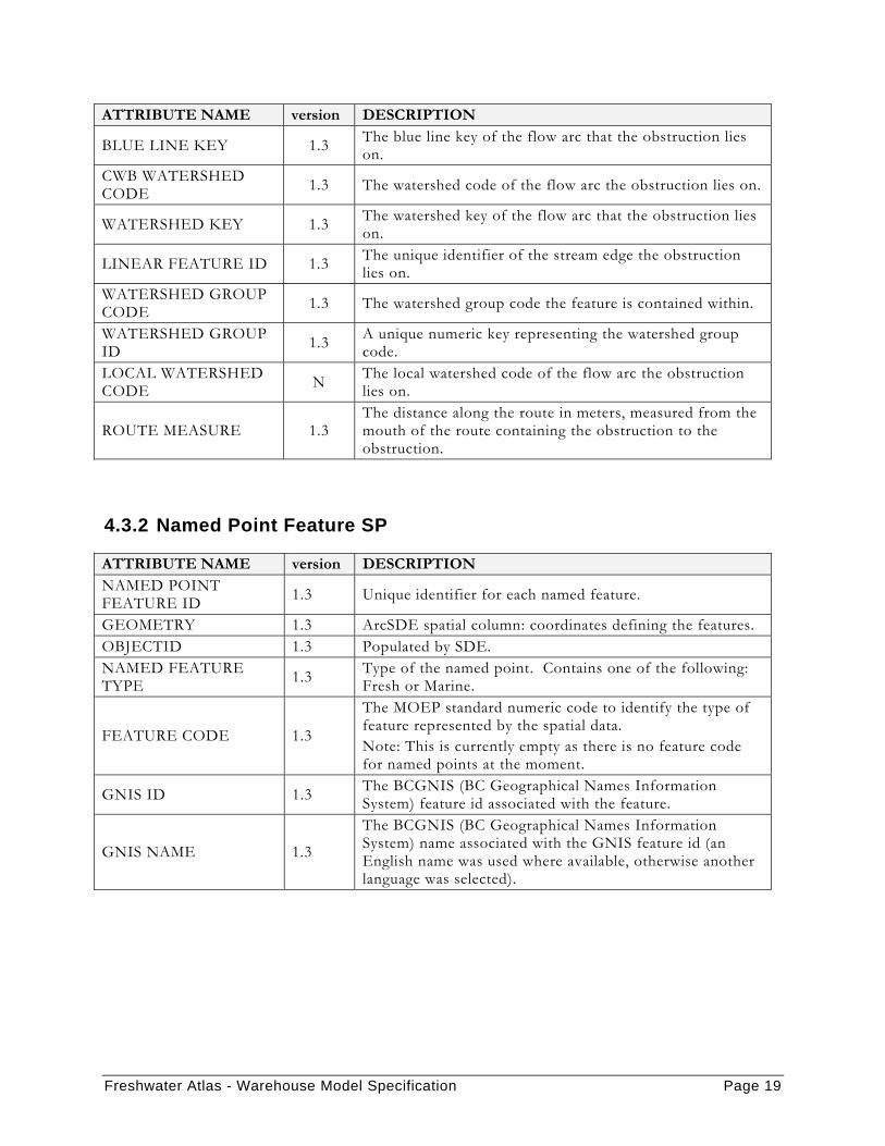
BLUE LINE KEY 1.3 The blue line key of the flow arc that the obstruction lies on.
CWB WATERSHED CODE 1.3 The watershed code of the flow arc the obstruction lies on.
WATERSHED KEY 1.3 The watershed key of the flow arc that the obstruction lies on.
LINEAR FEATURE ID 1.3 The unique identifier of the stream edge the obstruction lies on.
WATERSHED GROUP CODE 1.3 The watershed group code the feature is contained within.
WATERSHED GROUP ID 1.3 A unique numeric key representing the watershed group
code. LOCAL WATERSHED CODE N The local watershed code of the flow arc the obstruction
lies on.
ROUTE MEASURE 1.3 The distance along the route in meters, measured from the mouth of the route containing the obstruction to the obstruction.
4.3.2 Named Point Feature SP
ATTRIBUTE NAME version DESCRIPTION NAMED POINT FEATURE ID 1.3 Unique identifier for each named feature.
GEOMETRY 1.3 ArcSDE spatial column: coordinates defining the features. OBJECTID 1.3 Populated by SDE. NAMED FEATURE TYPE 1.3 Type of the named point. Contains one of the following:
Fresh or Marine.
FEATURE CODE 1.3
The MOEP standard numeric code to identify the type of feature represented by the spatial data. Note: This is currently empty as there is no feature code for named points at the moment.
GNIS ID 1.3 The BCGNIS (BC Geographical Names Information System) feature id associated with the feature.
GNIS NAME 1.3
The BCGNIS (BC Geographical Names Information System) name associated with the GNIS feature id (an English name was used where available, otherwise another language was selected).
Freshwater Atlas - Warehouse Model Specification Page 20
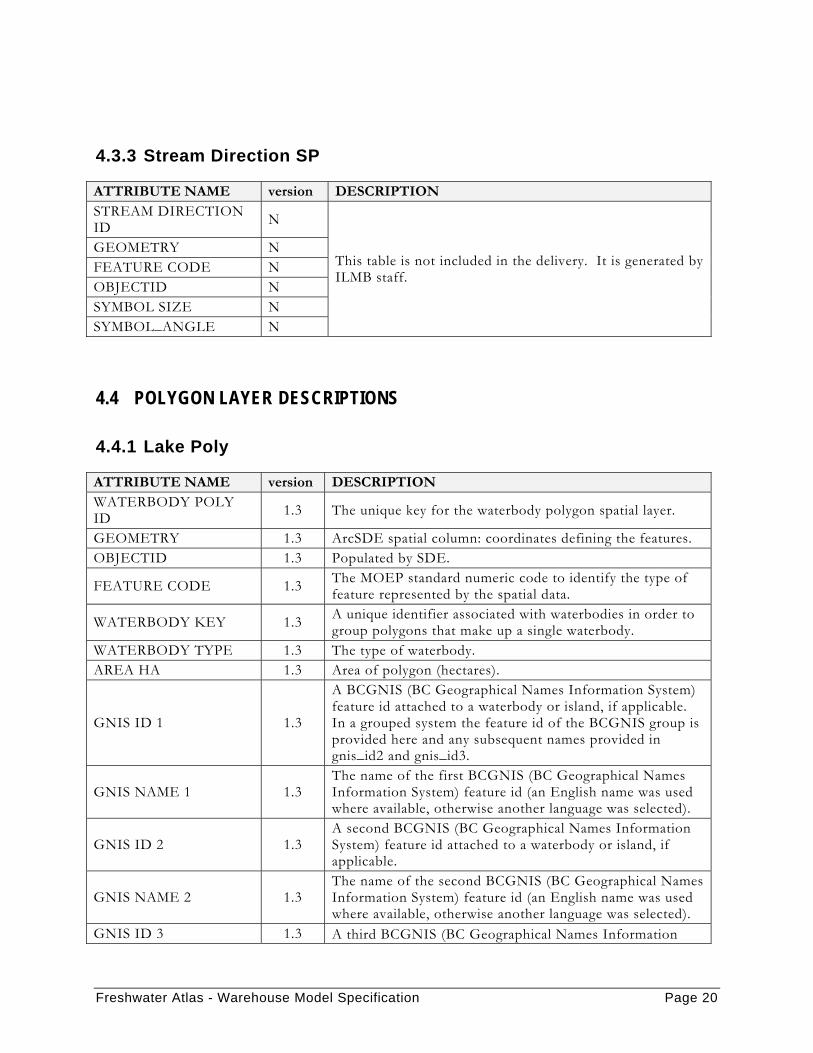
4.3.3 Stream Direction SP
ATTRIBUTE NAME version DESCRIPTION STREAM DIRECTION ID N
This table is not included in the delivery. It is generated by ILMB staff.
GEOMETRY N FEATURE CODE N OBJECTID N SYMBOL SIZE N SYMBOL_ANGLE N
4.4 POLYGON LAYER DESCRIPTIONS
4.4.1 Lake Poly
ATTRIBUTE NAME version DESCRIPTION WATERBODY POLY ID 1.3 The unique key for the waterbody polygon spatial layer.
GEOMETRY 1.3 ArcSDE spatial column: coordinates defining the features. OBJECTID 1.3 Populated by SDE.
FEATURE CODE 1.3 The MOEP standard numeric code to identify the type of feature represented by the spatial data.
WATERBODY KEY 1.3 A unique identifier associated with waterbodies in order to group polygons that make up a single waterbody.
WATERBODY TYPE 1.3 The type of waterbody. AREA HA 1.3 Area of polygon (hectares).
GNIS ID 1 1.3
A BCGNIS (BC Geographical Names Information System) feature id attached to a waterbody or island, if applicable. In a grouped system the feature id of the BCGNIS group is provided here and any subsequent names provided in gnis_id2 and gnis_id3.
GNIS NAME 1 1.3 The name of the first BCGNIS (BC Geographical Names Information System) feature id (an English name was used where available, otherwise another language was selected).
GNIS ID 2 1.3 A second BCGNIS (BC Geographical Names Information System) feature id attached to a waterbody or island, if applicable.
GNIS NAME 2 1.3 The name of the second BCGNIS (BC Geographical Names Information System) feature id (an English name was used where available, otherwise another language was selected).
GNIS ID 3 1.3 A third BCGNIS (BC Geographical Names Information

Freshwater Atlas - Warehouse Model Specification Page 21
ATTRIBUTE NAME version DESCRIPTION System) feature id attached to a waterbody or island, if applicable.
GNIS NAME 3 1.3 The name of the third BCGNIS (BC Geographical Names Information System) feature id (an English name was used where available, otherwise another language was selected).
CWB WATERSHED CODE 1.3 The watershed code of the controlling route through the
waterbody. WATERSHED GROUP CODE 1.3 The watershed group code the feature is contained within.
WATERSHED GROUP ID 1.3 A unique numeric key representing the watershed group
code.
BLUE LINE KEY 1.3 The blue line key of the controlling route through the waterbody.
WATERSHED KEY 1.3 The watershed key of the controlling route through the waterbody.
LOCAL WATERSHED CODE N The local watershed code associated with the waterbody.
WATERBODY KEY 50K 1.3
The 'best' matched waterbody from the 1:50K Watershed Atlas. In cases where there are multiple matches to features in the 1:50K watershed atlas the match with the greatest overlapping area was used.
WATERSHED GROUP CODE 50K 1.3 The group code from the 1:50K Watershed Atlas associated
with the waterbody key 50k. WATERBODY KEY GROUP CODE 50K 1.3 The waterbody key 50K with the group code 50K
concatenated. WATERSHED CODE 50K 1.3 The 1:50K Watershed Atlas watershed code associated with
the waterbody key 50K.
4.4.2 River Poly
ATTRIBUTE NAME version DESCRIPTION WATERBODY POLY ID 1.3 The unique key for the waterbody polygon spatial layer.
GEOMETRY 1.3 ArcSDE spatial column: coordinates defining the features. OBJECTID 1.3 Populated by SDE.
FEATURE CODE 1.3 The MOEP standard numeric code to identify the type of feature represented by the spatial data.
WATERBODY KEY 1.3 A unique identifier associated with waterbodies in order to group polygons that make up a single waterbody.
WATERBODY TYPE 1.3 The type of waterbody. AREA HA 1.3 Area of polygon (hectares).
GNIS ID 1 N A BCGNIS (BC Geographical Names Information System) feature id attached to a waterbody or island, if applicable. In a grouped system the feature id of the BCGNIS group is
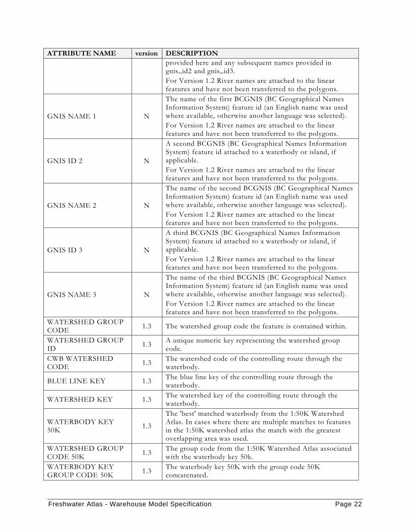
Freshwater Atlas - Warehouse Model Specification Page 22
ATTRIBUTE NAME version DESCRIPTION provided here and any subsequent names provided in gnis_id2 and gnis_id3. For Version 1.2 River names are attached to the linear features and have not been transferred to the polygons.
GNIS NAME 1 N
The name of the first BCGNIS (BC Geographical Names Information System) feature id (an English name was used where available, otherwise another language was selected). For Version 1.2 River names are attached to the linear features and have not been transferred to the polygons.
GNIS ID 2 N
A second BCGNIS (BC Geographical Names Information System) feature id attached to a waterbody or island, if applicable. For Version 1.2 River names are attached to the linear features and have not been transferred to the polygons.
GNIS NAME 2 N
The name of the second BCGNIS (BC Geographical Names Information System) feature id (an English name was used where available, otherwise another language was selected). For Version 1.2 River names are attached to the linear features and have not been transferred to the polygons.
GNIS ID 3 N
A third BCGNIS (BC Geographical Names Information System) feature id attached to a waterbody or island, if applicable. For Version 1.2 River names are attached to the linear features and have not been transferred to the polygons.
GNIS NAME 3 N
The name of the third BCGNIS (BC Geographical Names Information System) feature id (an English name was used where available, otherwise another language was selected). For Version 1.2 River names are attached to the linear features and have not been transferred to the polygons.
WATERSHED GROUP CODE 1.3 The watershed group code the feature is contained within.
WATERSHED GROUP ID 1.3 A unique numeric key representing the watershed group
code. CWB WATERSHED CODE 1.3 The watershed code of the controlling route through the
waterbody.
BLUE LINE KEY 1.3 The blue line key of the controlling route through the waterbody.
WATERSHED KEY 1.3 The watershed key of the controlling route through the waterbody.
WATERBODY KEY 50K 1.3
The 'best' matched waterbody from the 1:50K Watershed Atlas. In cases where there are multiple matches to features in the 1:50K watershed atlas the match with the greatest overlapping area was used.
WATERSHED GROUP CODE 50K 1.3 The group code from the 1:50K Watershed Atlas associated
with the waterbody key 50k. WATERBODY KEY GROUP CODE 50K 1.3 The waterbody key 50K with the group code 50K
concatenated.
Freshwater Atlas - Warehouse Model Specification Page 23
ATTRIBUTE NAME version DESCRIPTION WATERSHED CODE 50K 1.3 The 1:50K Watershed Atlas watershed code associated with
the waterbody key 50K. LOCAL WATERSHED CODE N The local watershed code associated with the waterbody.
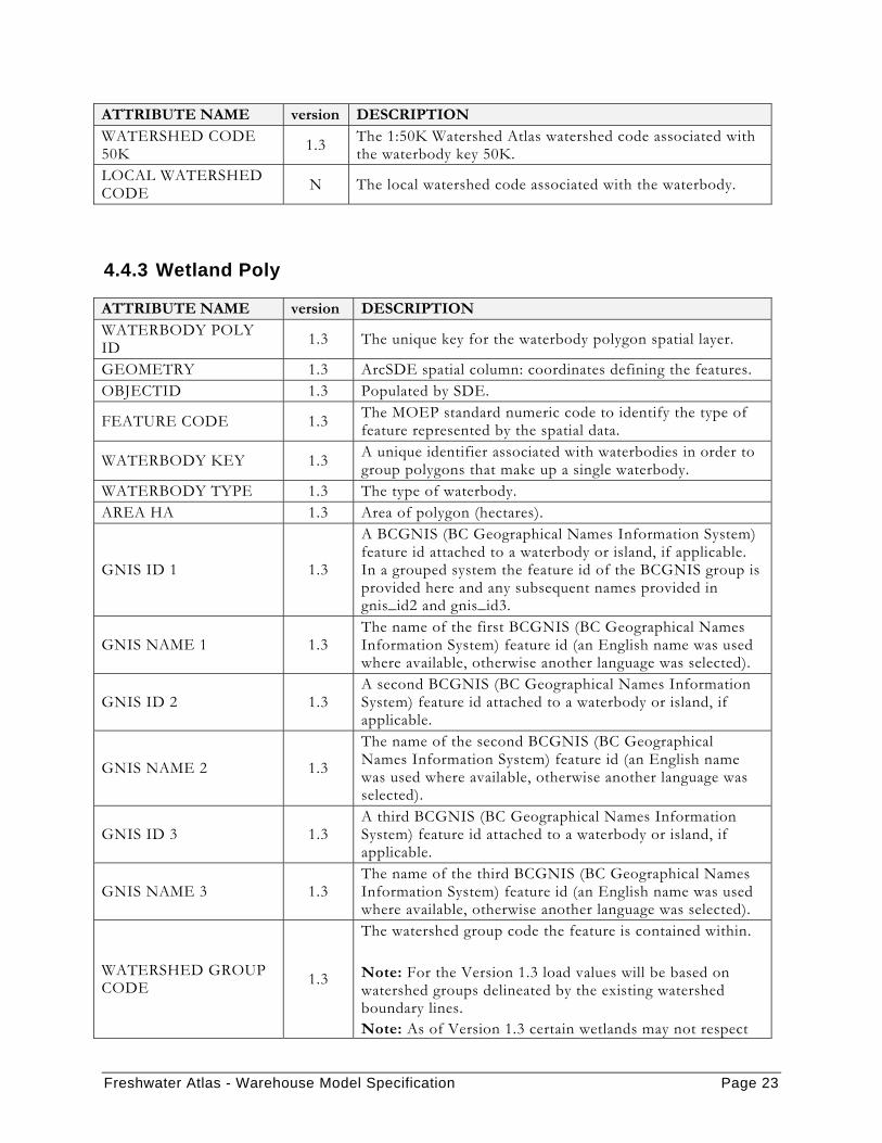
4.4.3 Wetland Poly
ATTRIBUTE NAME version DESCRIPTION WATERBODY POLY ID 1.3 The unique key for the waterbody polygon spatial layer.
GEOMETRY 1.3 ArcSDE spatial column: coordinates defining the features. OBJECTID 1.3 Populated by SDE.
FEATURE CODE 1.3 The MOEP standard numeric code to identify the type of feature represented by the spatial data.
WATERBODY KEY 1.3 A unique identifier associated with waterbodies in order to group polygons that make up a single waterbody.
WATERBODY TYPE 1.3 The type of waterbody. AREA HA 1.3 Area of polygon (hectares).
GNIS ID 1 1.3
A BCGNIS (BC Geographical Names Information System) feature id attached to a waterbody or island, if applicable. In a grouped system the feature id of the BCGNIS group is provided here and any subsequent names provided in gnis_id2 and gnis_id3.
GNIS NAME 1 1.3 The name of the first BCGNIS (BC Geographical Names Information System) feature id (an English name was used where available, otherwise another language was selected).
GNIS ID 2 1.3 A second BCGNIS (BC Geographical Names Information System) feature id attached to a waterbody or island, if applicable.
GNIS NAME 2 1.3
The name of the second BCGNIS (BC Geographical Names Information System) feature id (an English name was used where available, otherwise another language was selected).
GNIS ID 3 1.3 A third BCGNIS (BC Geographical Names Information System) feature id attached to a waterbody or island, if applicable.
GNIS NAME 3 1.3 The name of the third BCGNIS (BC Geographical Names Information System) feature id (an English name was used where available, otherwise another language was selected).
WATERSHED GROUP CODE 1.3
The watershed group code the feature is contained within. Note: For the Version 1.3 load values will be based on watershed groups delineated by the existing watershed boundary lines. Note: As of Version 1.3 certain wetlands may not respect
Freshwater Atlas - Warehouse Model Specification Page 24
ATTRIBUTE NAME version DESCRIPTION boundaries due to wetland integration. Various adjacent wetlands were merged which may now be crossing boundaries.
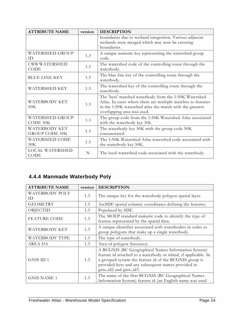
WATERSHED GROUP ID 1.3 A unique numeric key representing the watershed group
code. CWB WATERSHED CODE 1.3 The watershed code of the controlling route through the
waterbody.
BLUE LINE KEY 1.3 The blue line key of the controlling route through the waterbody.
WATERSHED KEY 1.3 The watershed key of the controlling route through the waterbody.
WATERBODY KEY 50K 1.3
The 'best' matched waterbody from the 1:50K Watershed Atlas. In cases where there are multiple matches to features in the 1:50K watershed atlas the match with the greatest overlapping area was used.
WATERSHED GROUP CODE 50K 1.3 The group code from the 1:50K Watershed Atlas associated
with the waterbody key 50k. WATERBODY KEY GROUP CODE 50K 1.3 The waterbody key 50K with the group code 50K
concatenated. WATERSHED CODE 50K 1.3 The 1:50K Watershed Atlas watershed code associated with
the waterbody key 50K. LOCAL WATERSHED CODE N The local watershed code associated with the waterbody.
4.4.4 Manmade Waterbody Poly
ATTRIBUTE NAME version DESCRIPTION WATERBODY POLY ID 1.3 The unique key for the waterbody polygon spatial layer.
GEOMETRY 1.3 ArcSDE spatial column: coordinates defining the features. OBJECTID 1.3 Populated by SDE.
FEATURE CODE 1.3 The MOEP standard numeric code to identify the type of feature represented by the spatial data.
WATERBODY KEY 1.3 A unique identifier associated with waterbodies in order to group polygons that make up a single waterbody.
WATERBODY TYPE 1.3 The type of waterbody. AREA HA 1.3 Area of polygon (hectares).
GNIS ID 1 1.3
A BCGNIS (BC Geographical Names Information System) feature id attached to a waterbody or island, if applicable. In a grouped system the feature id of the BCGNIS group is provided here and any subsequent names provided in gnis_id2 and gnis_id3.
GNIS NAME 1 1.3 The name of the first BCGNIS (BC Geographical Names Information System) feature id (an English name was used

Freshwater Atlas - Warehouse Model Specification Page 25
ATTRIBUTE NAME version DESCRIPTION where available, otherwise another language was selected).
GNIS ID 2 1.3 A second BCGNIS (BC Geographical Names Information System) feature id attached to a waterbody or island, if applicable.
GNIS NAME 2 1.3 The name of the second BCGNIS (BC Geographical Names Information System) feature id (an English name was used where available, otherwise another language was selected).
GNIS ID 3 1.3 A third BCGNIS (BC Geographical Names Information System) feature id attached to a waterbody or island, if applicable.
GNIS NAME 3 1.3 The name of the third BCGNIS (BC Geographical Names Information System) feature id (an English name was used where available, otherwise another language was selected).
WATERSHED GROUP CODE 1.3
The watershed group code the feature is contained within. Note: For Version 1.3 SDE load values will be based on watershed groups delineated by the existing watershed boundary lines.
WATERSHED GROUP ID 1.3 A unique numeric key representing the watershed group
code. CWB WATERSHED CODE 1.3 The watershed code of the controlling route through the
waterbody.
BLUE LINE KEY 1.3 The blue line key of the controlling route through the waterbody.
WATERSHED KEY 1.3 The watershed key of the controlling route through the waterbody.
WATERBODY KEY 50K 1.3
The 'best' matched waterbody from the 1:50K Watershed Atlas. In cases where there are multiple matches to features in the 1:50K watershed atlas the match with the greatest overlapping area was used.
WATERSHED GROUP CODE 50K 1.3 The group code from the 1:50K Watershed Atlas associated
with the waterbody key 50k. WATERBODY KEY GROUP CODE 50K 1.3 The waterbody key 50K with the group code 50K
concatenated. WATERSHED CODE 50K 1.3 The 1:50K Watershed Atlas watershed code associated with
the waterbody key 50K. LOCAL WATERSHED CODE N The local watershed code associated with the waterbody.
4.4.5 Glacier Poly
ATTRIBUTE NAME version DESCRIPTION WATERBODY POLY ID 1.2 The unique key for the waterbody polygon spatial layer.
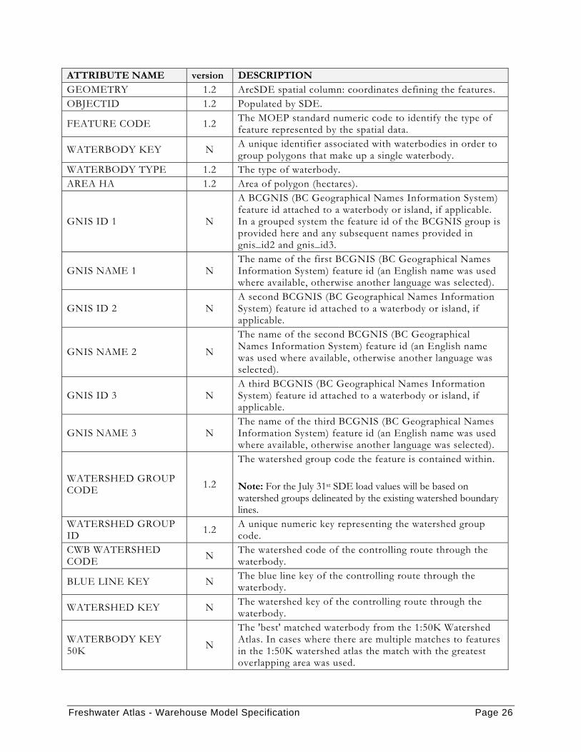
Freshwater Atlas - Warehouse Model Specification Page 26
ATTRIBUTE NAME version DESCRIPTION GEOMETRY 1.2 ArcSDE spatial column: coordinates defining the features. OBJECTID 1.2 Populated by SDE.
FEATURE CODE 1.2 The MOEP standard numeric code to identify the type of feature represented by the spatial data.
WATERBODY KEY N A unique identifier associated with waterbodies in order to group polygons that make up a single waterbody.
WATERBODY TYPE 1.2 The type of waterbody. AREA HA 1.2 Area of polygon (hectares).
GNIS ID 1 N
A BCGNIS (BC Geographical Names Information System) feature id attached to a waterbody or island, if applicable. In a grouped system the feature id of the BCGNIS group is provided here and any subsequent names provided in gnis_id2 and gnis_id3.
GNIS NAME 1 N The name of the first BCGNIS (BC Geographical Names Information System) feature id (an English name was used where available, otherwise another language was selected).
GNIS ID 2 N A second BCGNIS (BC Geographical Names Information System) feature id attached to a waterbody or island, if applicable.
GNIS NAME 2 N
The name of the second BCGNIS (BC Geographical Names Information System) feature id (an English name was used where available, otherwise another language was selected).
GNIS ID 3 N A third BCGNIS (BC Geographical Names Information System) feature id attached to a waterbody or island, if applicable.
GNIS NAME 3 N The name of the third BCGNIS (BC Geographical Names Information System) feature id (an English name was used where available, otherwise another language was selected).
WATERSHED GROUP CODE 1.2
The watershed group code the feature is contained within. Note: For the July 31st SDE load values will be based on watershed groups delineated by the existing watershed boundary lines.
WATERSHED GROUP ID 1.2 A unique numeric key representing the watershed group
code. CWB WATERSHED CODE N The watershed code of the controlling route through the
waterbody.
BLUE LINE KEY N The blue line key of the controlling route through the waterbody.
WATERSHED KEY N The watershed key of the controlling route through the waterbody.
WATERBODY KEY 50K N
The 'best' matched waterbody from the 1:50K Watershed Atlas. In cases where there are multiple matches to features in the 1:50K watershed atlas the match with the greatest overlapping area was used.
Freshwater Atlas - Warehouse Model Specification Page 27
ATTRIBUTE NAME version DESCRIPTION WATERSHED GROUP CODE 50K N The group code from the 1:50K Watershed Atlas associated
with the waterbody key 50k. WATERBODY KEY GROUP CODE 50K N The waterbody key 50K with the group code 50K
concatenated. WATERSHED CODE 50K N The 1:50K Watershed Atlas watershed code associated with
the waterbody key 50K. LOCAL WATERSHED CODE N The local watershed code associated with the waterbody.
4.4.6 Watershed Group Poly
ATTRIBUTE NAME version DESCRIPTION WATERSHED GROUP ID 1.2 A unique numeric key representing the watershed group
code. WATERSHED GROUP CODE 1.2 The four character watershed group code, e.g. ADMS
(Adams River), ALBN (Alberni Inlet). WATERSHED GROUP NAME 1.2 The name of the watershed group.
GEOMETRY 1.2
ArcSDE spatial column: coordinates defining the features. Note: For the July 31st SDE load values will be based on watershed groups delineated by the existing watershed boundary lines.
OBJECTID 1.2 Populated by SDE.
FEATURE CODE 1.2 The MOEP standard numeric code to identify the type of feature represented by the spatial data.
AREA HA 1.2 The area of the polygon in hectares.
4.4.7 Watershed Feature
ATTRIBUTE NAME version DESCRIPTION WATERSHED FEATURE ID 1.3 A unique identifier for each watershed in the layer.
GEOMETRY 1.3
Note: For Version 1.3 the polygons in this field will be derived from fundamental watershed boundary lines, delimiters, coastline and administrative boundaries. A fundamental watershed boundary line is a watershed boundary line that bounds two unit polygons with different Freshwater Atlas watershed codes or is identified as isolated.
OBJECTID 1.3 Populated by SDE. FEATURE CODE 1.3 The MOEP standard numeric code to identify the type of

Freshwater Atlas - Warehouse Model Specification Page 28
ATTRIBUTE NAME version DESCRIPTION feature represented by the spatial data.
AREA HA 1.3 Area of the watershed, in hectares.
WATERSHED ORDER 1.3 The maximum order of the watershed key associated with the watershed polygon.
WATERSHED MAGNITUDE 1.3 The maximum magnitude of the watershed key associated
with the watershed polygon. LOCAL WATERSHED ORDER 1.3 The order associated with the local watershed code.
LOCAL WATERSHED MAGNITUDE 1.3 The magnitude associated with the local watershed code.
GNIS ID 1 N The first BCGNIS (BC Geographical Names Information System) feature id associated with the watershed key of the watershed.
GNIS NAME 1 N The first BCGNIS (BC Geographical Names Information System) name associated with the watershed key of the watershed.
GNIS ID 2 N The second BCGNIS (BC Geographical Names Information System) feature id associated with the watershed key of the watershed.
GNIS NAME 2 N The second BCGNIS (BC Geographical Names Information System) name associated with the watershed key of the watershed.
GNIS ID 3 N The third BCGNIS (BC Geographical Names Information System) feature id associated with the watershed key of the watershed.
GNIS NAME 3 N The third BCGNIS (BC Geographical Names Information System) name associated with the watershed key of the watershed.
WATERBODY ID N If the watershed is made up of a lake or river, this field will contain the waterbody id associated with that waterbody, otherwise it will be null.
WATERBODY KEY 1.3
If the fundamental watershed overlaps one or more significant lakes or rivers, this field contains the waterbody key associated with the waterbody that has the largest intersecting area with the watershed. Otherwise it is -l.
CWB WATERSHED CODE 1.3 The 143 character watershed code associated with the
watershed polygon.
LOCAL WATERSHED CODE 1.3
A 143 character code similar to the Freshwater Atlas watershed code that further subdivides remnant polygons to provide an approximate location along the mainstem.
WATERSHED KEY 1.3
The watershed key associated with the watershed polygon (and watershed code). (If the watershed_code is like ‘999-999999-…’, indicating an isolated watershed, then -1 is used as the watershed key).
WATERSHED GROUP CODE 1.3 The watershed group code associated with the polygon.

Freshwater Atlas - Warehouse Model Specification Page 29
ATTRIBUTE NAME version DESCRIPTION WATERSHED GROUP ID 1.3 A unique numeric key representing the watershed group
code.
RIVER AREA N Area of double line rivers within the watershed, in hectares.
LAKE AREA N Area of lakes within the watershed, in hectares. WETLAND AREA N Area of wetland within the watershed, in hectares.
MANMADE AREA N Area of manmade features within the watershed, in hectares.
GLACIER AREA N Area of glacier within the watershed, in hectares. AVERAGE ELEVATION N The average elevation of the watershed.
AVERAGE SLOPE N The average slope of the watershed.
ASPECT NORTH N The percentage of the watershed that has an aspect within 45 degrees of north, ie. an aspect between 315 and 45 degrees.
ASPECT SOUTH N The percentage of the watershed that has an aspect within 45 degrees of south, ie. an aspect between 135 and 225 degrees.
ASPECT EAST N The percentage of the watershed that has an aspect within 45 degrees of east, ie. an aspect between 45 and 135 degrees.
ASPECT WEST N The percentage of the watershed that has an aspect within 45 degrees of west, ie. an aspect between 225 and 315 degrees.
ASPECT FLAT N The percentage of the watershed with no discernable aspect, ie. the flat land.
4.4.8 Nth Order Watershed Poly
ATTRIBUTE NAME version DESCRIPTION WATERSHED ID N A unique identifier for each watershed in the layer.
GEOMETRY N
Note: For the July31st SDE load the polygons in this field will be derived from principal watershed boundary lines, delimiters, coastline and administrative boundaries. A principal watershed boundary lines is a watershed boundary lines that bounds two unit polygons with different Freshwater Atlas watershed codes or is identified as isolated.
OBJECTID N Populated by SDE.
FEATURE CODE N The MOEP standard numeric code to identify the type of feature represented by the spatial data.
AREA HA N Area of the watershed, in hectares.
WATERSHED ORDER N The maximum order of the watershed key associated with the watershed polygon.

Freshwater Atlas - Warehouse Model Specification Page 30
ATTRIBUTE NAME version DESCRIPTION WATERSHED MAGNITUDE N The maximum magnitude of the watershed key associated
with the watershed polygon. LOCAL WATERSHED ORDER N The order associated with the local watershed code.
LOCAL WATERSHED MAGNITUDE N The magnitude associated with the local watershed code.
GNIS ID 1 N The first BCGNIS (BC Geographical Names Information System) feature id associated with the watershed key of the watershed.
GNIS NAME 1 N The first BCGNIS (BC Geographical Names Information System) name associated with the watershed key of the watershed.
GNIS ID 2 N The second BCGNIS (BC Geographical Names Information System) feature id associated with the watershed key of the watershed.
GNIS NAME 2 N The second BCGNIS (BC Geographical Names Information System) name associated with the watershed key of the watershed.
GNIS ID 3 N The third BCGNIS (BC Geographical Names Information System) feature id associated with the watershed key of the watershed.
GNIS NAME 3 N The third BCGNIS (BC Geographical Names Information System) name associated with the watershed key of the watershed.
WATERBODY ID N If the watershed is made up of a lake or river, this field will contain the waterbody id associated with that waterbody, otherwise it will be null.
WATERBODY KEY N If the watershed is made up of a lake or river, this field will contain the waterbody key associated with that waterbody, otherwise it will be null.
CWB WATERSHED CODE N The 143 character watershed code associated with the
watershed polygon.
LOCAL WATERSHED CODE N
A 143 character code similar to the Freshwater Atlas watershed code that further subdivides remnant polygons to provide an approximate location along the mainstem.
WATERSHED KEY N The watershed key associated with the watershed polygon (and watershed code).
WATERSHED GROUP CODE N The watershed group code associated with the polygon.
WATERSHED GROUP ID N A unique numeric key representing the watershed group
code.

Freshwater Atlas - Warehouse Model Specification Page 31
4.4.9 Named Watershed Poly
ATTRIBUTE NAME version DESCRIPTION NAMED WATERSHED ID 1.2 A unique identifier for each watershed in the layer.
GEOMETRY 1.2 Note: There is some risk involved for the July31 SDE load. Some large named watersheds (Fraser River) may be too large to generate or be useful.
OBJECTID 1.2 Populated by SDE.
FEATURE CODE 1.2 The MOEP standard numeric code to identify the type of feature represented by the spatial data.
AREA HA 1.2 Area of the watershed, in hectares. BLUE LINE KEY 1.2 The blue line key associated with the named stream.
GNIS ID 1.2 The BCGNIS (BC Geographical Names Information System) feature id associated with the watershed.
GNIS NAME 1.2
The BCGNIS (BC Geographical Names Information System) name associated with the GNIS feature id (an English name was used where available, otherwise another language was selected).
STREAM ORDER 1.2 The maximum order associated with the watershed key of the named stream.
STREAM MAGNITUDE 1.2 The maximum magnitude associated with the watershed key of the named stream.
WATERSHED KEY 1.2 The watershed key associated with the named stream. CWB WATERSHED CODE 1.2 The watershed code associated with the named stream.
4.4.10 Island Poly
ATTRIBUTE NAME version DESCRIPTION ISLAND ID 1.3 ISLAND ID is a unique identifier for each feature. GEOMETRY 1.3 ArcSDE spatial column: coordinates defining the features.OBJECTID 1.3 Populated by SDE. AREA HA 1.3 Area of the island, in hectares.
FEATURE CODE 1.3 The MOEP standard numeric code to identify the type of feature represented by the spatial data.
ISLAND TYPE 1.3 ISLAND TYPE contains one of "Fresh, Marine or Marine/Fresh"
GNIS ID 1 1.3 The BCGNIS (BC Geographical Names Information System) feature id.
GNIS NAME 1 1.3 The name of the first BCGNIS (BC Geographical Names Information System) feature id (an English name was used

Freshwater Atlas - Warehouse Model Specification Page 32
ATTRIBUTE NAME version DESCRIPTION where available, otherwise another language was selected).
GNIS ID 2 1.3 A second BCGNIS (BC Geographical Names Information System) feature id
GNIS NAME 2 1.3
The name of the second BCGNIS (BC Geographical Names Information System) feature id (an English name was used where available, otherwise another language was selected).
GNIS ID 3 1.3 A third BCGNIS (BC Geographical Names Information System) feature id attached
GNIS NAME 3 1.3 The name of the third BCGNIS (BC Geographical Names Information System) feature id (an English name was used where available, otherwise another language was selected).
CWB WATERSHED CODE 1.3
To be populated with the watershed code of the island for coastal islands; and the most downstream watershed code of bounding features for interior islands. Vancouver Island is the exception with the resolution to be determined.
LOCAL WATERSHED CODE N
4.4.11 Bay and Channel Poly
ATTRIBUTE NAME version DESCRIPTION BAY AND CHANNEL ID 1.3 Unique identifier for each feature.
GEOMETRY 1.3 ArcSDE spatial column: coordinates defining the features. OBJECTID 1.3 Populated by SDE. AREA HA 1.3 Area of the bay or channel, in hectares.
FEATURE CODE 1.3 The MOEP standard numeric code to identify the type of feature represented by the spatial data.
BAY CHANNEL TYPE 1.3 BAY CHANNEL TYPE contains one of the following: Fresh Bay, Fresh Channel, Marine Bay, or Marine Channel.
GNIS ID 1.3 The BCGNIS (BC Geographical Names Information System) feature id associated with the named bay or channel.
GNIS NAME 1.3
The BCGNIS (BC Geographical Names Information System) name associated with the GNIS feature id (an English name was used where available, otherwise another language was selected).

Freshwater Atlas - Warehouse Model Specification Page 33
4.5 NON-SPATIAL LAYER DESCRIPTIONS
4.5.1 Edge Type Cds
ATTRIBUTE NAME version DESCRIPTION
EDGE TYPE 1.2 The numeric code used by the Freshwater Atlas to identify the various types of water network linear features.
EDGE DESCRIPTION 1.2 A plain English description of the type code.
4.5.2 Waterbody Type Cds
ATTRIBUTE NAME version DESCRIPTION
WATERBODY TYPE 1.2 The type of waterbody. Possible values include: L, R, W, X, G.
WATERBODY DESCRIPTION 1.2 Contains a plain English description of the waterbody type.
4.5.3 Waterbody 20k 50k
ATTRIBUTE NAME version DESCRIPTION WATERBODIES_20K_50K_ID 1.3 A unique identifier populated by the database. WATERBODY ID 20K 1.3 The 20k waterbody id matched to the 50k feature.
WATERBODY KEY 20K 1.3 The 20k waterbody key matched to a 50k key feature.
WATERSHED GROUP CODE 20K 1.3 The watershed group of the 20k waterbody feature.
WATERSHED GROUP ID 20K 1.3 A unique numeric key representing the 20k
watershed group code. WATERBODY TYPE 20K 1.3 The type of 20k waterbody feature. WATERBODY KEY 50K 1.3 The 50k waterbody key of the matched waterbody. WATERSHED GROUP CODE 50K 1.3 The 50k watershed group code of the matched
waterbody. WATERBODY TYPE 50K 1.3 The type of the matched 50k waterbody.
MATCH TYPE 1.3 A string identifying the type of match. One of 'Primary', indicating the best match, or 'X-Ref', indicating cross reference or secondary match.
CWB WATERSHED CODE 20K 1.3 The controlling route of the matched 20k
waterbody.
WATERSHED CODE 50K 1.3 The controlling route of the matched 50k waterbody.
LOCAL WATERSHED CODE 20K N The local watershed code associated with the 20k
waterbody.
Freshwater Atlas - Warehouse Model Specification Page 34
4.5.4 Stream 20k 50k
ATTRIBUTE NAME version DESCRIPTION STREAMS_20K_50K_ID 1.3 A unique identifier populated by the database. LINEAR FEATURE ID 20K 1.3 The edge id used to link to a unique line in the 1:20K
stream network. BLUE LINE KEY 20K 1.3 The blue line key associated with the 20k edge. WATERSHED KEY 20K 1.3 The watershed key associated with the 20k edge. CWB WATERSHED CODE 20K 1.3 The watershed code associated with the 20k edge.
WATERSHED GROUP CODE 20K 1.3 The watershed group code associated with the 20k edge.
WATERSHED GROUP ID 20K 1.3 A unique numeric key representing the 20k watershed
group code. BLUE LINE KEY 50K 1.3 The best matched 50k blue line key. WATERSHED KEY 50K 1.3 The watershed key for the best matched 50k blue line key. WATERSHED CODE 50K 1.3 The 50k watershed code of the best matched 50k blue line
key. WATERSHED GROUP CODE 50K 1.3 The watershed group code of the best matched 50k blue
line key.
MATCH TYPE 1.3 A string identifying the type of match. One of 'Primary', indicating the best match, or 'X-Ref', indicating cross reference or secondary match.
Freshwater Atlas - Warehouse Model Specification Page 35
5 APPENDIX A - FEATURE CODES
The following table describes the valid values for the feature code attributes.
Table 6: Feature Code Attribute Table
Feature Code Description AP09200000 Dump AP90300100 Mine – Tailing Pond EA26700110 Settling Basin – Sewage FA02650000 Boundary (International) GA03950000 Canal GA08800110 Ditch GA24850000 River/Stream – Definite GA24850140 River/Stream – Indefinite GA24850150 River/Stream – Intermittent GB11350110 Flooded Land – Inundated GB15300000 Lake – Definite GB15300130 Lake – Indefinite GB15300140 Lake – Intermittent GB24300000 Reservoir – Definite GB90100000 Reservoir – Indefinite GB90100110 Reservoir – Intermittent GC17100000 Marsh GC30050000 Swamp GE14850000 Island – Definite GG05800000 Coastline – Definite WA11410000 Flow Connectors – Inferred WA17100000 Frequently Flooded Land WA21100111 Construction Line – Coastline WA23111110 Construction Line – Lakeshore WA24111110 Construction Line – Main Flow WA24111111 Construction Line – Lake Arm WA24111120 Construction Line – Main Connector WA24111130 Construction Line – Secondary Flow WA24111140 Construction Line – Segment Delimiter WA24111150 Construction Line – Secondary WA24111160 Construction Line – River Delimiter WA24111170 Construction Line – Flow Inferred WA24111180 Construction Line – Subsurface Flow WA24111190 Construction Line – Flow Connector WA24200110 Double-Line Blueline – Right Bank

Freshwater Atlas - Warehouse Model Specification Page 36
WA24200120 Double-Line Blueline – Right WA24200130 Double-Line Blueline – Left Bank WA24200140 Double-Line Blueline – Left WA24220110 Island in River – Right Bank WA24220120 Island in River – Right Bank Shared with Wetland WA24220130 Island in River – Left Bank WA24220140 Island in River – Left Bank Shared with Wetland WA25100110 Watershed Boundary – Major WA25100120 Watershed Boundary – Minor WA25100140 Watershed Boundary – (att) operator modified or added HOL GA08450110 Dam – Beaver GA23500110 Rapids GA90002110 Falls GA98450000 Dam HB27550000 Sinkhole GA10450200 Artificial Waterfall GA10450300 Flattened Waterfall

Freshwater Atlas - Warehouse Model Specification Page 37
6 APPENDIX B – CONTROLLING ROUTES
A controlling route is a route that flows through a river or lake polygon from an input to an outlet which represents the prominent flow of water.
The image on the right of Figure 6 shows the controlling arc of the lake highlighted in red. The image on the left shows the controlling routes of the two double-line river waterbodies highlighted in red.
Figure 6: Lake and River Controlling Route
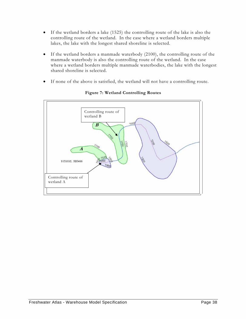
The controlling route through a wetland is much more complex than lake and river controlling routes. In the data deliveries there remain some wetlands without a controlling route. These wetlands will have a value in the “code_issue” attribute of the polygon (label point) layer.
For this purpose, a wetland is defined as the merging of all wetland polygons with the same wb_key. The rules for wetland controlling routes are as follows (see Figure 7 for an example):
• If there is a 1050 or 1150 in the wetland, the route associated with these edges is the controlling route.
• If the wetland borders a double line river (shared 1835, 1875, 1925, 1975), the controlling route of the double line river is also the controlling route of the wetland. In the case where a wetland borders multiple double-line rivers, the double-line river with the longest shared shoreline is selected.
• If there is a 1200, 1300, 1400 or 2000 in the wetland, the route associated with these edges is the controlling route.
Freshwater Atlas - Warehouse Model Specification Page 38
• If the wetland borders a lake (1525) the controlling route of the lake is also the controlling route of the wetland. In the case where a wetland borders multiple lakes, the lake with the longest shared shoreline is selected.
• If the wetland borders a manmade waterbody (2100), the controlling route of the manmade waterbody is also the controlling route of the wetland. In the case where a wetland borders multiple manmade waterbodies, the lake with the longest shared shoreline is selected.
• If none of the above is satisfied, the wetland will not have a controlling route.
Figure 7: Wetland Controlling Routes
B
A
Controlling route of wetland A
Controlling route of wetland B
Freshwater Atlas - Warehouse Model Specification Page 39
7 APPENDIX C – BLUE LINE KEY, WATERSHED KEY, AND FRESHWATER ATLAS WATERSHED CODE
7.1 HOW THE ATTRIBUTES ARE CALCULATED The blue line key and watershed key are defined as follows:
1. The blue line key is a unique key for identifying a single flow channel. As such, in a braided system the main channel will have a different blue line key from the secondary channels.
2. The watershed key is used to identify entire rivers (the Fraser River, its distributaries and side channels); therefore, the main channel and secondary channels of a braided system will have the same watershed key.
These attributes are also associated with coastline edges (codes 100 and 150) - see “How the Attributes are Attached to Arcs – Coastline Arcs” below.
The Freshwater Atlas watershed code is defined as follows:
1. The Freshwater Atlas watershed code is a 143 digit hierarchical key applied to flow arcs in the same way as the watershed key. In a braided system, the main channel and secondary channels have the same Freshwater Atlas watershed code. The format of this key is:
xxx-xxxxxx-xxxxxx-xxxxxx- … -xxxxxx
20 levels
For more information on how this key is computed, refer to the Hierarchical Key documentation.
7.2 HOW THE ATTRIBUTES ARE ATTACHED TO ARCS For all flow arcs, the blue line key, watershed key, and Freshwater Atlas watershed code attributes are defined as described above.
Freshwater Atlas - Warehouse Model Specification Page 40
For lakes, rivers and wetland banks the arcs are encoded with the blue line key, watershed key, and Freshwater Atlas watershed code of the controlling route of the waterbody. In cases of shared banks the order of precedence is lake, river and wetland.
For provincial boundary arcs that bound waterbodies, the arcs are encoded with the blue line key, watershed key, and Freshwater Atlas watershed code of the controlling route of this bounded waterbody.
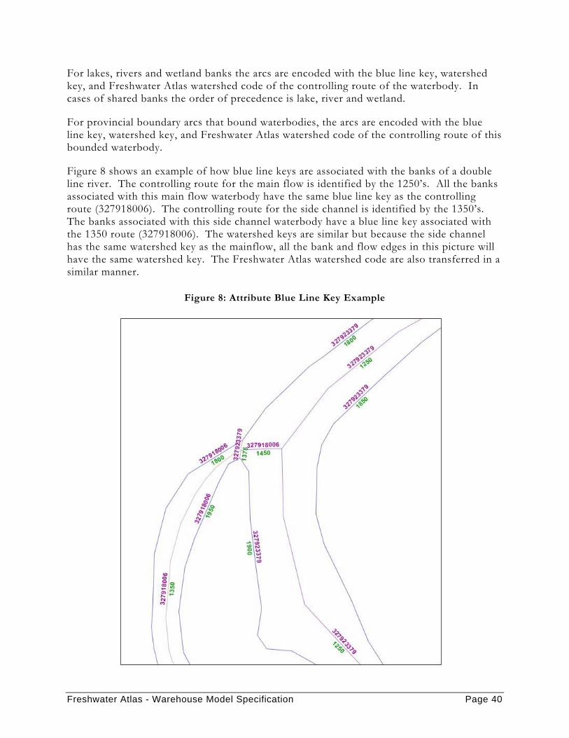
Figure 8 shows an example of how blue line keys are associated with the banks of a double line river. The controlling route for the main flow is identified by the 1250’s. All the banks associated with this main flow waterbody have the same blue line key as the controlling route (327918006). The controlling route for the side channel is identified by the 1350’s. The banks associated with this side channel waterbody have a blue line key associated with the 1350 route (327918006). The watershed keys are similar but because the side channel has the same watershed key as the mainflow, all the bank and flow edges in this picture will have the same watershed key. The Freshwater Atlas watershed code are also transferred in a similar manner.
Figure 8: Attribute Blue Line Key Example
Freshwater Atlas - Warehouse Model Specification Page 41
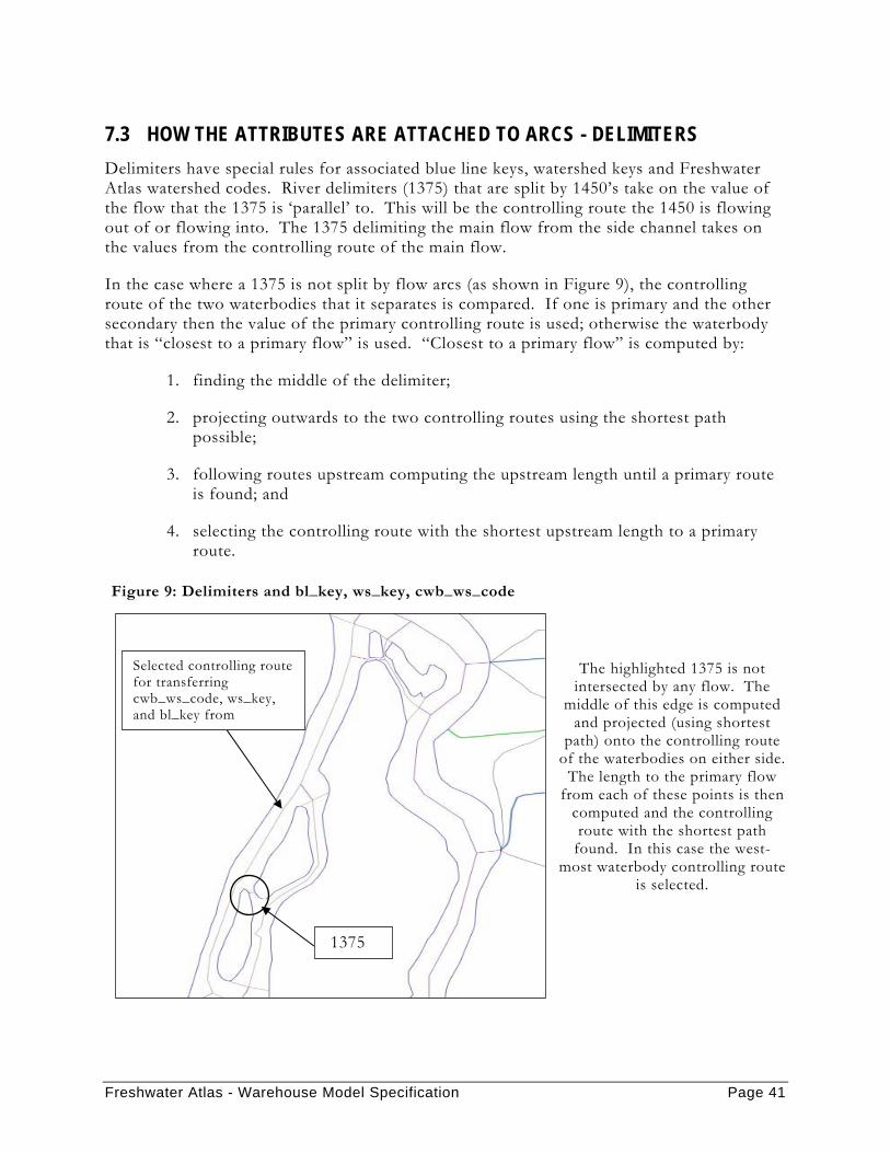
7.3 HOW THE ATTRIBUTES ARE ATTACHED TO ARCS - DELIMITERS Delimiters have special rules for associated blue line keys, watershed keys and Freshwater Atlas watershed codes. River delimiters (1375) that are split by 1450’s take on the value of the flow that the 1375 is ‘parallel’ to. This will be the controlling route the 1450 is flowing out of or flowing into. The 1375 delimiting the main flow from the side channel takes on the values from the controlling route of the main flow.
In the case where a 1375 is not split by flow arcs (as shown in Figure 9), the controlling route of the two waterbodies that it separates is compared. If one is primary and the other secondary then the value of the primary controlling route is used; otherwise the waterbody that is “closest to a primary flow” is used. “Closest to a primary flow” is computed by:
1. finding the middle of the delimiter;
2. projecting outwards to the two controlling routes using the shortest path possible;
3. following routes upstream computing the upstream length until a primary route is found; and
4. selecting the controlling route with the shortest upstream length to a primary route.
Figure 9: Delimiters and bl_key, ws_key, cwb_ws_code
The highlighted 1375 is not intersected by any flow. The
middle of this edge is computed and projected (using shortest
path) onto the controlling route of the waterbodies on either side.
The length to the primary flow from each of these points is then
computed and the controlling route with the shortest path
found. In this case the west-most waterbody controlling route
is selected.
Selected controlling route for transferring cwb_ws_code, ws_key, and bl_key from
1375

Freshwater Atlas - Warehouse Model Specification Page 42
7.4 HOW THE ATTRIBUTES ARE ATTACHED TO ARCS – COASTLINE ARCS A watershed key, blue line key and Freshwater Atlas watershed code will be attached to coastline arcs as well in accordance with the way hierarchical keys are computed.
All coastal islands with the exception of Vancouver Island will have a unique blue line key, and Freshwater Atlas watershed code. Vancouver Island will have two blue line keys and two Freshwater Atlas watershed codes; one for the eastern side of the island and one for the western side of the island. The watershed key for all coastal islands will be the same as the blue line key.
The mainland coastline will have four blue line keys and Freshwater Atlas watershed codes: one for the Washington coastline, one for the Alaskan coastline, one for the southern BC coastline and one for the northern BC coastline. The watershed key for the mainland coastline will be the same as the blue line key.
For example, the Freshwater Atlas watershed code for the southern portion of the BC Mainland will be:
• 900 – 000000 – 000000 – 000000 - … - 000000
The Freshwater Atlas watershed code for SaltSpring Island will be:
• 925 – 303570 – 000000 – 000000 - … - 000000

Freshwater Atlas - Warehouse Model Specification Page 43
8 APPENDIX D – RELATED DOCUMENTS
8.1 FEATURE NAMING The features in the Freshwater Atlas were named by matching the the Freshwater Atlasfeatures with the BCGNIS (British Columbia Geographical Names Information System) and TRIM Toponymy datasets.
The following documents outline the processing completed to name the the Freshwater Atlas Features.
• Process Summary for the TRIM Toponymy BCGnis Linking Process (2003-08-Toponymy-Process.doc)
• Water Body Toponym Matching (WaterBodyToponymMatching.doc)
• Stream Toponym Matching (StreamToponymMatching.doc)
• Named Stream Snaking Technical Documentation (SnakingNamedStreams.doc)
• Bay Name Matcher (Bay Name Matcher Technical Documentation.doc)
• Point Name Matcher (Point Name Matcher Technical Documentation.doc)
• Island Name Matcher (Island Name Matcher Technical Documentation.doc)
• Obstacle Processing Technical Documentation (Trim Obstacle Processing for CWB.doc)
8.2 ROUTES Assigning routes to the Freshwater Atlas datasets is a complex automated and manual process. The automated processing is described in the following documents:
• Mainstemming Technical Documentation (Mainstems.doc)
• Route Generation Technical Documentation (CWB Routing Documentation.doc)
• Route Building (routing.doc)
Freshwater Atlas - Warehouse Model Specification Page 44
8.3 FRESHWATER WATERSHED CODE (HIERARCHICAL KEYS) Freshwater Atlas Watershed Codes (hierarchical keys) are associated with every route and can be used to perform approximate upstream/downstream queries without traversing the stream network. The format of these keys has changed from the old TRIM Watershed Atlas hierarchical keys. The new hierarchical keys are a 143 character string formatted as shown in Table 7:
Table 7: Format of Hierarchical Keys
xxx - xxxxxx - xxxxxx - xxxxxx - xxxxxx - xxxxxx … xxxxxx
h1 - h2 - h3 - h4 - h5 - h6 … h21
Further information can be found in the following document:
• Hierarchical Key Technical Documentation (HKeys.doc)
8.4 ORDER & MAGNITUDE Information on the computation of modified strahlar order and magnitude on the stream network can be found in the following document:
• Order and Magnitude Technical Documentation (OrderMagnitude.doc)
8.5 20K – 50K CONFLATION In order to preserve a large legacy database containing various habitat and inventory information, the 1:50 000 Watershed Atlas (WSA) was conflated with the 1:20 000 BC data. Further information on this processes can be found here:
• Water Body Conflation (WaterBodyConflationTechnicalDocumentation.doc)
• Waterbody – Waterbody Matching Post Processor (PostProcessor.doc)
• Matching 1:20k Streams With 1:50k Streams (jcs_matching2.doc)
8.6 WATERSHED BOUNDARY GENERATION & FUNDAMENTAL WATERSHEDS Further information on the generation of watershed boundary lines and fundamental watersheds can be found in these documents:
• Watershed Boundary Generation Process Flow (CWB.1.2.WatershedBoundaryProcess.rev2.doc)
Freshwater Atlas - Warehouse Model Specification Page 45
• Watershed Boundary Drainage ID Requirements (CWB.1.2.WatershedDrainageIDRequirements.rev4.doc)
• WaterBug Watershed Boundary Generator Technical Design (CWB.1.2.WaterBugDesign.rev1.doc)
• CWBHOL Data Store Design (CWB-HOL.DataStoreDesign.rev2.doc)
• Isolated Watershed Identification Technical Documentation (IsolatedWatershedTechnicalDocumentation.doc)
• Fundamental Watersheds (Freshwater Atlasv1.3-FW.TechnicalSpecification.v0.3.doc)
8.7 STREAM ELEVATION Further information on the computation of refined elevation on the stream network can be found in this document:
• Stream Elevation (SE) Generation Technical Specification (Freshwater Atlasv1.3-SE.TechnicalSpecification.v07.doc)
• Stream Elevation (SE) Technical Issues (Freshwater Atlasv1.3-SE.TechnicalIssues.v0.8.doc)