Embed Size (px)
Citation preview
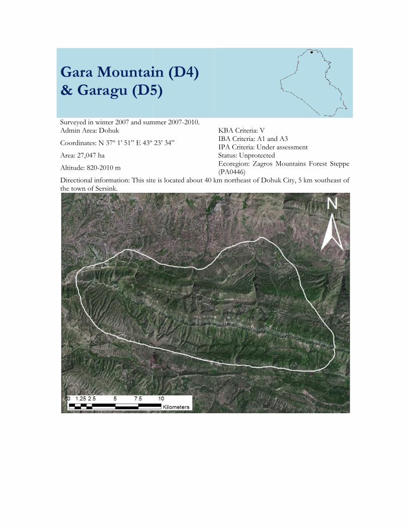
Gara Mountain (D4)& Garagu (D5
Surveyed in winter 2007 and summer 200Admin Area: Dohuk
Coordinates: N 37º 1’ 51” E 43º 23’ 34
Area: 27,047 ha
Altitude: 820-2010 m
Directional information: This site is located about 40 km northeast of Dthe town of Sersink.
Gara Mountain (D4) D5)
summer 2007-2010. KBA Criteria: V IBA Criteria: A1 and A3 IPA Criteria: Under assessment
Coordinates: N 37º 1’ 51” E 43º 23’ 34”
Status: Unprotected Ecoregion: Zagros Mountains (PA0446)
This site is located about 40 km northeast of Dohuk City, 5 km southeast of
Under assessment
Forest Steppe
k City, 5 km southeast of
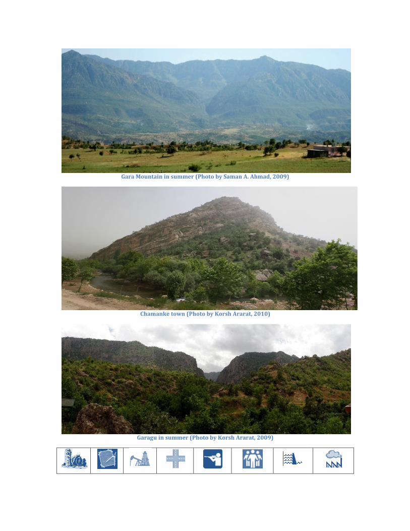
Gara Mountain in summer (Photo by Saman A. Ahmad, 2009)
Chamanke town (Photo by Korsh Ararat, 2010)
Garagu
Gara Mountain in summer (Photo by Saman A. Ahmad, 2009)
Chamanke town (Photo by Korsh Ararat, 2010)
Garagu in summer (Photo by Korsh Ararat, 2009)
Site Description: Gara Mountain (D4) is a mountainous area with an elevation of approximately 2023 m. The slopes are dominated by oak Quercus sp. forests. The town of Chamanke, featuring valleys and farmlands is located within the western edge of the delineated site. The Mani Maze Stream flowing near Chamanke is used as a source of water by the villages of Meze, Baramuinke, Kharinke and Bebad Islam and for the Shirin bottled water factory in Chamanke. The bottled water is sold in Dohuk, Erbil and Sulaimani Governorates. The site is a popular tourist destination for residents of the nearby city of Dohuk. The towns of Tajilka and Ashawa are located in the northwest, where there are two streams (both former water quality sampling sites). Air temperature is low because of high elevation and plant shading on Gara Mountain. Ashawa is a public resort. One of Saddam Hussein’s former palaces is located inside the western edge of the delineation, and according to media reports in 2012 there is interest in developing the palace as a tourist site.
Garagu (D5) consists of a gorge, with a stream flowing through it, in a rocky part area of the Gara Range. The area is primarily covered by oak forest and a few Platanus trees. The villages of Garagu, Babire, Kani Balar, Kala Shikho and Warmel are nearby. It is a popular picnicking site. The following sub-sites were surveyed here:
Sub-Site Code Sub-Site Name Nearest Town Coordinates
North East
D4 Gara Mountain Sarsink 37 0 39 43 21 54
D5 Garagu Garagu-Swaratoka 37 1 51 43 23 34
Key Biodiversity Area Criteria
Notes
V. Vulnerability Criteria: Presence of Critically Endangered and Endangered species – presence of a single individual or Vulnerable species – 30 individuals or 10 pairs. Neurergus crocatus Observed and photographed at Garagu. Important Bird Area Criteria Observation made 2007-2010. Unless stated otherwise
numbers are estimates based on extrapolations using area/transect counts and area of known habitat. (see methodology on p. XX).
A1. Globally threatened species
Breeding Wintering/Passage Egyptian Vulture Neophron percnopterus (Summer visitor)
1 pair (count, 2009)
A3. Biome-restricted species
Mediterranean biome Breeding Wintering/Passage Masked Shrike Lanius nubicus (Summer visitor)
25 pairs (2009-2010)
Sombre Tit Poecile lugubris (Resident)
60 pairs (2007, 2009 and 2010)
Western Rock Nuthatch Sitta neumayer (Resident)
170 pairs (2008-2010)
Eastern Black-eared Wheatear Oenanthe melanoleuca (Summer visitor)
150 pairs (2007 and 2010)
Black-headed Bunting Emberiza melanocephala (Summer visitor)
350 pairs (2007, 2009 and 2010)
Additional Important Bird Observations: A total of 60 species was observed during the surveys. In addition to those in the table four Irano-Turanian and one Eurasian Steppe and Desert biome-restricted species were breeding (Table XX) but these did not trigger inclusion under criterion A3. Other Important Fauna Mammals, Reptiles, and other Fauna: Data were collected only in 2010. Significant mammals reported by locals at the site were Syrian Brown Bear Ursus arctos syriacus. Significant reptile found at the site was Anatolian Lizard Apathya cappadocica urmiana. A significant amphibian found at the site was the globally Vulnerable new Neurergus crocatus. Fish: No fish samples were collected. Plants & Habitats This site contains about 215 plant species. Two waypoints were surveyed in two key habitat types in the area:
1. Mountain Forest Vegetation-Oak Forest (medium and high) (N 37º 01’ 52” E 43º 23’ 30”), which is dominated by Quercus aegilops, Q. infectoria, Acer monspessulanum, Pistacia eurycarpa, and Juniperus oxycedrus (trees); Prunus microcarpa, P. amygdalus, and Rhus coriaria (shrubs); Silybum marianum, Trifolium spp., Vicia villosa, and V. tenuifolia (herbs); Poa bulbosa and Aegilops spp. (grasses).
2. Mountain Forest Vegetation-Mountain Riverine Forest (N 37º 01’ 52” E 43º 23’ 41”), dominated by Platanus orientalis, Populus alba, and Juglans regia, (trees); Rubus sanctus (shrub); Nasturtium officinale and Mentha longifolia (herbs). Other characteristic species include Hedera helix, Rubus caesius, R. occidentalis, and Rumex spp.
The ecological condition was very disturbed, with an ecological scale of four (especially near the stream). The slope is between moderate (6-14°) and steep (27-45°). The site is located in the Zagros mountain range, where the geology is siltstone and sandstone, and the soil type is sandy clay. The non-vegetated cover was 15% in the forest area and about 60% near the streams. Conservation Issues: Human activities in the form of tourism and pollution are the highest threats. Compared to the large area of the delineation, agriculture is not extensive and is mainly concentrated near Ashawa and Tajilka town and the valleys near the stream, so it is given a high threat only. There are small dams on both these streams, forming small lakes that have impacted the ecological conditions of the area and likely affect water quality and the habitat, possibly increasing erosion and changing water flows that in turn may affect the stream fauna. At Ashawa sampling site, where water comes from a spring on Gara Mountain, there is a village above producing a source of organic pollution in the form of sewage. Picnicking near the Mani Maze stream is also polluting the stream and the land, through discarded garbage. There are landmines in the Chamanke area. Road construction has occurred over a large part of the valley in Amadiya during the last three years and transportation corridors (e.g. dirt road leading to the picnic site of Mani Maze stream south of the delineated area), and is assessed as a high threat. Medium threats to the area include development of housing, and hunting, which could eventually become higher if not controlled systematically. Residential and commercial development is generally

only a low threat as the only houses were in the surrounding villages and no housing development was noted during the survey. Many endemic and rare plant species are present and give it special priority as a potential protected area. Recommendations: It is strongly recommended that trash and recycling services be extended to this site, in addition to signs and education programs on the need to keep the environment and water clean. Regulations to limit and/or better manage agriculture and grazing as well as recreational use of the area are also highly recommended. The removal of minefields is also strongly recommended.